b stakeholder engagement - south east coastal group · b stakeholder engagement ... b.3.1 key...
TRANSCRIPT
����������� ������������ ������������������������ ������������ �����������
�
�
�
B Stakeholder Engagement
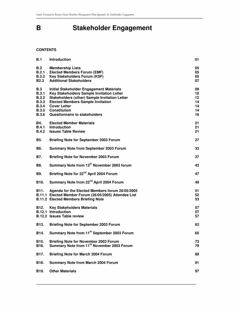
CONTENTS
B.1 Introduction 01 B.2 Membership Lists 05 B.2.1 Elected Members Forum (EMF) 05 B.2.2 Key Stakeholders Forum (KSF) 05 B2.3 Additional Stakeholders 07 B.3 Initial Stakeholder Engagement Materials 09 B.3.1 Key Stakeholders Sample Invitation Letter 10 B.3.2 Stakeholders (other) Sample Invitation Letter 12 B.3.3 Elected Members Sample Invitation 14 B.3.4 Cover Letter 14 B.3.5 Constitution 14 B.3.6 Questionnaire to stakeholders 16 B4. Elected Member Materials 21 B.4.1 Introduction 21 B.4.2 Issues Table Review 21 B5. Briefing Note for September 2003 Forum 27 B6. Summary Note from September 2003 Forum 33 B7. Briefing Note for November 2003 Forum 37 B8. Summary Note from 13th November 2003 forum 43 B9. Briefing Note for 22nd April 2004 Forum 47 B10. Summary Note from 22nd April 2004 Forum 49 B11. Agenda for the Elected Members forum 26/05/2005 51 B.11.1 Elected Member Forum (26/05/2005) Attendee List 52 B.11.2 Elected Members Briefing Note 53 B12. Key Stakeholders Materials 57 B.12.1 Introduction 57 B.12.2 Issues Table review 57 B13. Briefing Note for September 2003 Forum 63 B14. Summary Note from 11th September 2003 Forum 65 B15. Briefing Note for November 2003 Forum 73 B16. Summary Note from 11th November 2003 Forum 79 B17. Briefing Note for March 2004 Forum 89 B18. Summary Note from March 2004 Forum 91 B19. Other Materials 97
����������� ������������ ������������������������ ������������ �����������
�
�
�
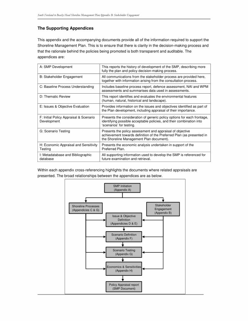
The Supporting Appendices
This appendix and the accompanying documents provide all of the information required to support the Shoreline Management Plan. This is to ensure that there is clarity in the decision-making process and that the rationale behind the policies being promoted is both transparent and auditable. The appendices are:
A: SMP Development This reports the history of development of the SMP, describing more fully the plan and policy decision-making process.
B: Stakeholder Engagement All communications from the stakeholder process are provided here, together with information arising from the consultation process.
C: Baseline Process Understanding Includes baseline process report, defence assessment, NAI and WPM assessments and summarises data used in assessments.
D: Thematic Review This report identifies and evaluates the environmental features (human, natural, historical and landscape).
E: Issues & Objective Evaluation
Provides information on the issues and objectives identified as part of the Plan development, including appraisal of their importance.
F: Initial Policy Appraisal & Scenario Development
Presents the consideration of generic policy options for each frontage, identifying possible acceptable policies, and their combination into ‘scenarios’ for testing.
G: Scenario Testing Presents the policy assessment and appraisal of objective achievement towards definition of the Preferred Plan (as presented in the Shoreline Management Plan document).
H: Economic Appraisal and Sensitivity Testing
Presents the economic analysis undertaken in support of the Preferred Plan.
I: Metadatabase and Bibliographic database
All supporting information used to develop the SMP is referenced for future examination and retrieval.
Within each appendix cross-referencing highlights the documents where related appraisals are presented. The broad relationships between the appendices are as below.
Stakeholder Engagement(Appendix B)
Shoreline Processes(Appendicies C & G)
SMP Initiation(Appendix A)
Issue & Objective Definition
(Appendicies D & E)
Scenario Definition(Appendix F)
Scenario Testing(Appendix G)
Economics & Sensitivities(Appendix H)
Policy Appraisal report(SMP Document)

����������� ������������ ������������������������ ������������ �����������
�
�
�

����������� ������������ ������������������������ ������������ �����������
�
�
�
���
��� ����������
Four main groups were involved in the SMP development:
1. the Client Steering Group (CSG) 2. an Elected Members Forum (EMF) 3. a Key Stakeholders Forum (KSF) 4. Other Stakeholders.
1. See Appendix A for details 2. The involvement of Elected Members in the process of proposal development reflects the
"Cabinet" style approach to decision making operating in many local authorities. Politicians are involved from the beginning, thereby reducing the likelihood that the policies will not be approved by the planning authorities. They were involved through a Forum, building trust and understanding between Elected Members, the Client Steering Group and Key Stakeholders.
3. The Key Stakeholder Forum (KSF) acts as focal point for discussion and consultation through development of the project. The membership of the group should provide representation of the primary interests within the study area, ensuring consideration of all interests during review of issues. Inclusion of this group offers a more participatory process. This group was involved through workshops. The incorporation of this group provides direct feedback and information to the Consultant, and acts as a focal point for the consultation process. It is also possible to adopt more of a partnership approach to the KSF, by developing a collaborative decision-making forum. Under this approach certain responsibilities normally held by the Client Steering Group (CSG) may be shared by the KSF in order to increase the level of stakeholder ownership of the final decisions.
4. Other Stakeholders: There will always be large numbers of individuals and organisations who are likely to be affected by the decisions of the project. It is unlikely to ever be practical to involve all these stakeholders on one of the three groups outlined above, therefore there will remain a group of 'Other Stakeholders'. This group will be contacted directly by the project developers but will not be involved in its development, other than at the very start and as consultees on the draft decisions.
����������� ������������ ������������������������ ������������ �����������
�
�
�
���
Table B1.1 Summary of the Stakeholder Strategy
Stage of Plan Preparation
Activity Dates Purpose of stakeholder involvement Stakeholders involved
Method of involvement Information Sent
Initial Stakeholder contact
July to September 2003
• Inform interested parties that an SMP is being prepared (on behalf of Defra and relevant local authorities)
• Segregate the interested parties into three groups (Elected Members, Key Stakeholders and Stakeholders)
• Request information from interested parties
• Gather views on issues relating to the SMP coast
• Elected Members
• Key Stakeholders
• Stakeholders
Letter and Questionnaire (different letters sent to different groups) Follow-up telephone calls
See B3 for sample letter and questionnaire.
Stage 1: SMP Scope
Initial Elected Members and Key Stakeholders Forum held
September 2003 • Check that all relevant issues have been included
• Review the features identified • Check that the benefits identified are
correct and that we have included all beneficiaries
• Check that the objectives are a good representation of the requirements of the beneficiaries
• Elected Members
• Key Stakeholders
Power point presentation Round-table meeting
Draft Issues Table
September 2003 EMF and KSF members asked to: • Check that all relevant issues have been
included • Review the features identified • Check that the benefits identified are
correct and that we have included all beneficiaries
• Check that the objectives are a good representation of the requirements of the beneficiaries
• Elected Members
• Key Stakeholders
Draft Issues Table and accompanying note sent via email and/or by post
See Section B4 for Issues Table
Stage 2: Assessments to support policy
Draft Issues and Objectives Table
November 2003 EMF and KSF members asked to: • Check objectives set and ranking • Review information prior to meeting
• Elected Members
• Key Stakeholders
Draft Issues and Objectives Table sent as part of briefing note by email and/or post
See Section B4 for Briefing note
����������� ������������ ������������������������ ������������ �����������
�
�
�
���
Stage of Plan Preparation
Activity Dates Purpose of stakeholder involvement • Stakeholders involved
Method of involvement Information Sent
Second Elected Members and Key Stakeholders Forum
November 2003 The objectives of the forum were to establish: • The vision(s) of the various stakeholders
for the whole SMP shoreline over each epoch
• Any ‘overriding drivers’ for directing future policy, and specific future policy options that the stakeholders wish to see tested
• Agree the benefits • Areas of agreement and conflict i.e. main
flood and erosion risks • Potential scope for compromise and
acceptance of future change
• Elected Members
• Key Stakeholders
Briefing note sent out prior to meeting explaining role of meeting. Meeting involved a formal presentation followed by a number of round-table discussion sessions. Summary note sent out following meeting summarising key conclusions.
See Section B4 for forum summary note
Planning Officers Meeting
February 2004 • That implementation of policies is not
based solely upon engineering solutions
but through the control of development
via the planning process.
• Planning officers
• CSG
Briefing note sent out prior to meeting explaining role of meeting. Meeting involved a formal presentation followed by a discussion with the planners
See Section B4 for letter and briefing note.
Stage 3: Policy Development
Elected Members Forum
April 2004 • EMF and KSF members were presented with the policy options examined
• Discussion on proposed policy appropriateness
• EMF and KSF members were invited to take a role in steering policy decisions along the coast.
• Areas of agreement and conflict i.e. main flood and erosion risks
• Potential scope for compromise and acceptance of future change
• Elected Members
• Key Stakeholders
Briefing note sent out prior to meeting explaining work to date on developing policies and role of meeting. Meeting involved a formal presentation followed by a number of round-table discussion sessions.
See Section B4 for Briefing note and forum summary note
Stage 4: Public Examination
Public Consultation
January to April 2005
• To make stakeholders aware of the draft plan • To provide stakeholders with opportunities for
support and objection and moving to resolve differences
Wider public Distribution of summary pamphlet and SMP document made available for viewing.
-
����������� ������������ ������������������������ ������������ �����������
�
�
�
���
Stage of Plan Preparation
Activity Dates Purpose of stakeholder involvement Stakeholders involved
Method of involvement Information Sent
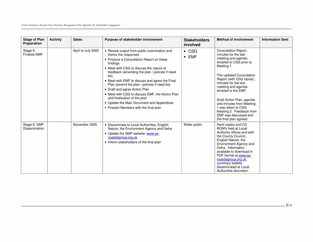
Stage 5: Finalise SMP
April to July 2005 • Review output from public examination and theme the responses
• Produce a Consultation Report on these findings
• Meet with CSG to discuss the nature of feedback (amending the plan / policies if need be)
• Meet with EMF to discuss and agree the Final Plan (amend the plan / policies if need be)
• Draft and agree Action Plan • Meet with CSG to discuss EMF, the Action Plan
and finalisation of the plan • Update the Main Document and Appendices • Present Members with the final plan
• CSG • EMF
Consultation Report, minutes for the last meeting and agenda emailed to CSG prior to Meeting 1. The updated Consultation Report (with CSG inputs), minutes for the last meeting and agenda emailed to the EMF. Draft Action Plan, agenda and minutes from Meeting 1 was taken to CSG Meeting 2. Feedback from EMF was discussed and the final plan agreed.
Stage 6: SMP Dissemination
November 2005 • Disseminate to Local Authorities, English Nature, the Environment Agency and Defra
• Update the SMP website: www.se-coastalgroup.org.uk
• Inform stakeholders of the final plan
Wider public Hard copies and CD ROM’s held at Local Authority offices and with the County Council, English Nature, the Environment Agency and Defra. Information available to download in PDF format at www.se-coastalgroup.org.uk, summary leaflets disseminated at Local Authorities discretion.
-
����������� ������������ ��������������������� ���� ������������ �����������
�
�
�
���
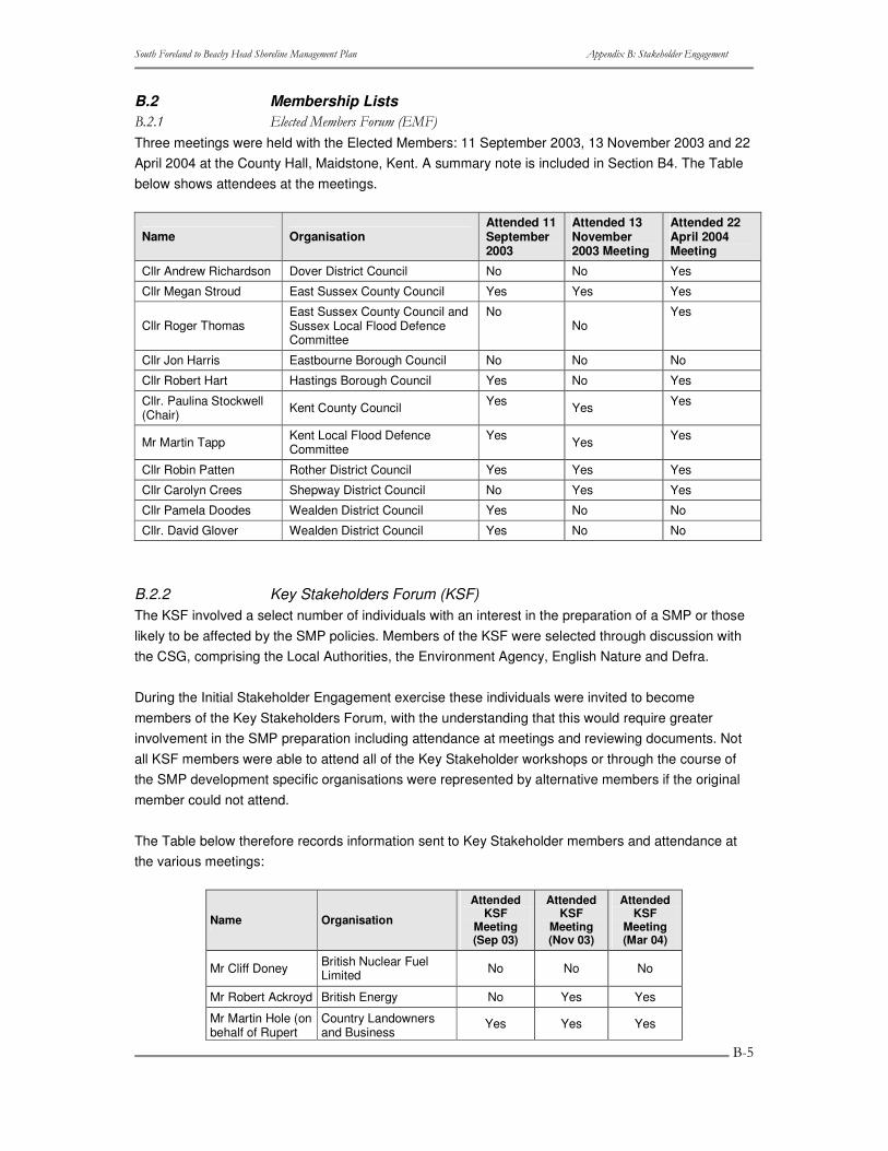
B.2 Membership Lists ����� ��� ��� �!�������"���#�
Three meetings were held with the Elected Members: 11 September 2003, 13 November 2003 and 22 April 2004 at the County Hall, Maidstone, Kent. A summary note is included in Section B4. The Table below shows attendees at the meetings.
Name Organisation Attended 11 September 2003
Attended 13 November 2003 Meeting
Attended 22 April 2004 Meeting
Cllr Andrew Richardson Dover District Council No No Yes
Cllr Megan Stroud East Sussex County Council Yes Yes Yes
Cllr Roger Thomas East Sussex County Council and Sussex Local Flood Defence Committee
No No
Yes
Cllr Jon Harris Eastbourne Borough Council No No No
Cllr Robert Hart Hastings Borough Council Yes No Yes
Cllr. Paulina Stockwell (Chair) Kent County Council Yes Yes Yes
Mr Martin Tapp Kent Local Flood Defence Committee
Yes Yes Yes
Cllr Robin Patten Rother District Council Yes Yes Yes
Cllr Carolyn Crees Shepway District Council No Yes Yes
Cllr Pamela Doodes Wealden District Council Yes No No
Cllr. David Glover Wealden District Council Yes No No
B.2.2 Key Stakeholders Forum (KSF) The KSF involved a select number of individuals with an interest in the preparation of a SMP or those likely to be affected by the SMP policies. Members of the KSF were selected through discussion with the CSG, comprising the Local Authorities, the Environment Agency, English Nature and Defra.
During the Initial Stakeholder Engagement exercise these individuals were invited to become members of the Key Stakeholders Forum, with the understanding that this would require greater involvement in the SMP preparation including attendance at meetings and reviewing documents. Not all KSF members were able to attend all of the Key Stakeholder workshops or through the course of the SMP development specific organisations were represented by alternative members if the original member could not attend.
The Table below therefore records information sent to Key Stakeholder members and attendance at the various meetings:
Name Organisation
Attended KSF
Meeting (Sep 03)
Attended KSF
Meeting (Nov 03)
Attended KSF
Meeting (Mar 04)
Mr Cliff Doney British Nuclear Fuel Limited No No No
Mr Robert Ackroyd British Energy No Yes Yes
Mr Martin Hole (on behalf of Rupert
Country Landowners and Business
Yes Yes Yes
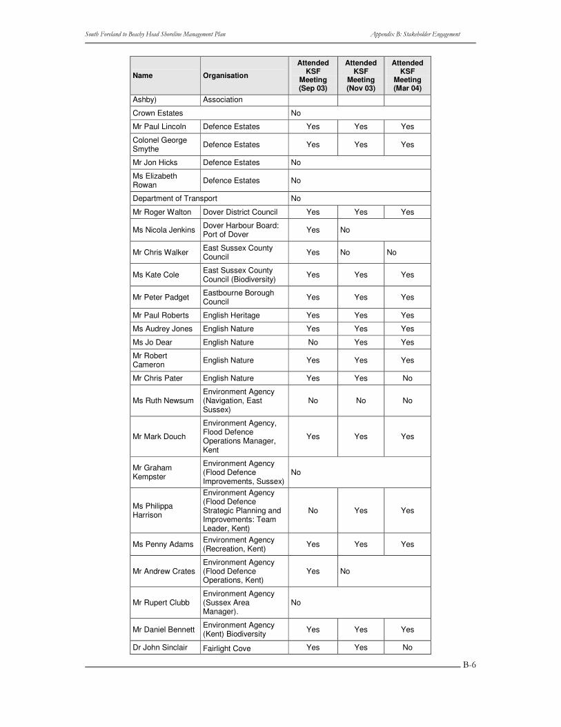
����������� ������������ ��������������������� ���� ������������ �����������
�
�
�
��
Name Organisation
Attended KSF
Meeting (Sep 03)
Attended KSF
Meeting (Nov 03)
Attended KSF
Meeting (Mar 04)
Ashby) Association
Crown Estates No
Mr Paul Lincoln Defence Estates Yes Yes Yes
Colonel George Smythe Defence Estates Yes Yes Yes
Mr Jon Hicks Defence Estates No
Ms Elizabeth Rowan Defence Estates No
Department of Transport No
Mr Roger Walton Dover District Council Yes Yes Yes
Ms Nicola Jenkins Dover Harbour Board: Port of Dover Yes No
Mr Chris Walker East Sussex County Council Yes No No
Ms Kate Cole East Sussex County Council (Biodiversity) Yes Yes Yes
Mr Peter Padget Eastbourne Borough Council Yes Yes Yes
Mr Paul Roberts English Heritage Yes Yes Yes
Ms Audrey Jones English Nature Yes Yes Yes
Ms Jo Dear English Nature No Yes Yes
Mr Robert Cameron English Nature Yes Yes Yes
Mr Chris Pater English Nature Yes Yes No
Ms Ruth Newsum Environment Agency (Navigation, East Sussex)
No No No
Mr Mark Douch
Environment Agency, Flood Defence Operations Manager, Kent
Yes Yes Yes
Mr Graham Kempster
Environment Agency (Flood Defence Improvements, Sussex)
No
Ms Philippa Harrison
Environment Agency (Flood Defence Strategic Planning and Improvements: Team Leader, Kent)
No Yes Yes
Ms Penny Adams Environment Agency (Recreation, Kent) Yes Yes Yes
Mr Andrew Crates Environment Agency (Flood Defence Operations, Kent)
Yes No
Mr Rupert Clubb Environment Agency (Sussex Area Manager).
No
Mr Daniel Bennett Environment Agency (Kent) Biodiversity Yes Yes Yes
Dr John Sinclair Fairlight Cove Yes Yes No
����������� ������������ ��������������������� ���� ������������ �����������
�
�
�
��
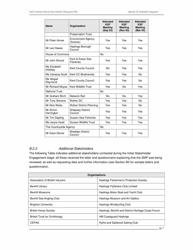
Name Organisation
Attended KSF
Meeting (Sep 03)
Attended KSF
Meeting (Nov 03)
Attended KSF
Meeting (Mar 04)
Preservation Trust
Mr Peter Aimes Environment Agency (Sussex) Yes Yes Yes
Mr Les Hawes Hastings Borough Council Yes Yes Yes
House of Commons No
Mr John Stroud Kent & Essex Sea Fisheries Yes Yes Yes
Ms Elizabeth Holliday Kent County Council No Yes Yes
Ms Vanessa Scott Kent CC Biodiversity Yes Yes No
Ms Abigail Raymond Kent County Council Yes Yes No
Mr Richard Moyse Kent Wildlife Trust Yes No Yes
National Trust No
Mr Graham Birch Network Rail No No Yes
Mr Tony Stevens Rother DC Yes Yes No
Mr Nick Waite Rother District Planning Yes Yes No
Mr Simon Herrington
Shepway District Council Yes Yes Yes
Mr Tim Dapling Sussex Sea Fisheries Yes Yes Yes
Ms Janyis Hyatt Sussex Wildlife Trust Yes Yes Yes
The Countryside Agency No
Mr Dave Glover Wealden District Council Yes Yes Yes
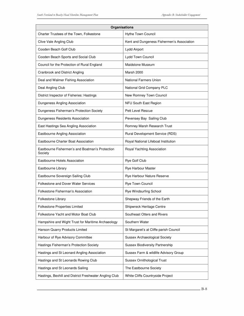
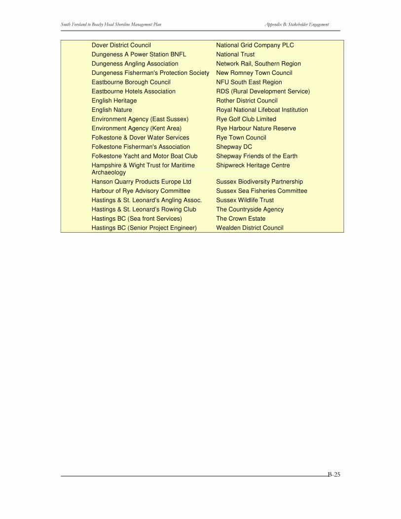
B.2.3 Additional Stakeholders The following Table indicates additional stakeholders contacted during the Initial Stakeholder Engagement stage: all these received the letter and questionnaire explaining that the SMP was being reviewed, as well as requesting data and further information (see Section B3 for sample letters and questionnaire).
Organisations
Association of British Insurers Hastings Fishermen’s Protection Society
Bexhill Library Hastings Flyfishers Club Limited
Bexhill Museums Hastings Motor Boat and Yacht Club
Bexhill Sea Angling Club Hastings Museum and Art Gallery
Brighton University Hastings Windsurfing Club
British Horse Society Hastings, Bexhill and District Heritage Coast Forum
British Trust for Ornithology HM Coastguard Hastings
CEFAS Hythe and Saltwood Sailing Club
����������� ������������ ��������������������� ���� ������������ �����������
�
�
�
���
Organisations
Charter Trustees of the Town, Folkestone Hythe Town Council
Clive Vale Angling Club Kent and Dungeness Fishermen’s Association
Cooden Beach Golf Club Lydd Airport
Cooden Beach Sports and Social Club Lydd Town Council
Council for the Protection of Rural England Maidstone Museum
Cranbrook and District Angling Marsh 2000
Deal and Walmer Fishing Association National Farmers Union
Deal Angling Club National Grid Company PLC
District Inspector of Fisheries: Hastings New Romney Town Council
Dungeness Angling Association NFU South East Region
Dungeness Fisherman’s Protection Society Pett Level Rescue
Dungeness Residents Association Pevensey Bay Sailing Club
East Hastings Sea Angling Association Romney Marsh Research Trust
Eastbourne Angling Association Rural Development Service (RDS)
Eastbourne Charter Boat Association Royal National Lifeboat Institution
Eastbourne Fishermen’s and Boatman’s Protection Society
Royal Yachting Association
Eastbourne Hotels Association Rye Golf Club
Eastbourne Library Rye Harbour Master
Eastbourne Sovereign Sailing Club Rye Harbour Nature Reserve
Folkestone and Dover Water Services Rye Town Council
Folkestone Fisherman’s Association Rye Windsurfing School
Folkestone Library Shepway Friends of the Earth
Folkestone Properties Limited Shipwreck Heritage Centre
Folkestone Yacht and Motor Boat Club Southeast Otters and Rivers
Hampshire and Wight Trust for Maritime Archaeology Southern Water
Hanson Quarry Products Limited St Margaret’s at Cliffe parish Council
Harbour of Rye Advisory Committee Sussex Archaeological Society
Hastings Fisherman’s Protection Society Sussex Biodiversity Partnership
Hastings and St Leonard Angling Association Sussex Farm & wildlife Advisory Group
Hastings and St Leonards Rowing Club Sussex Ornithological Trust
Hastings and St Leonards Sailing The Eastbourne Society
Hastings, Bexhill and District Freshwater Angling Club White Cliffs Countryside Project
����������� ������������ ��������������������� ���� ������������ �����������
�
�
�
���
��� ������� ���������� ���������� ���������
The Initial Stakeholder Engagement ‘pack’ sent out included:
1. An invitation letter: three variations of the invitation letter were produced and sent to the following categories of stakeholders (although it should be noted that there were a few duplications of the organisations being represented at both the Key Stakeholder and Elected Member level): o Members of the Key Stakeholder Forum. o Members of the Elected Members Forum. o Other stakeholders to whom a formal approach should be made. They are considered
to be aware but not be familiar with SMP process. This could include: the general public, individual landowners and small businesses.
2. A summary leaflet that was based on the original SMP. 3. A questionnaire which requested basic contact details, the organisations interests and
concerns with the coastline and the review of the SMP as well as whether they held or could provide any data/information.
����������� ������������ ��������������������� ���� ������������ �����������
�
�
�
���
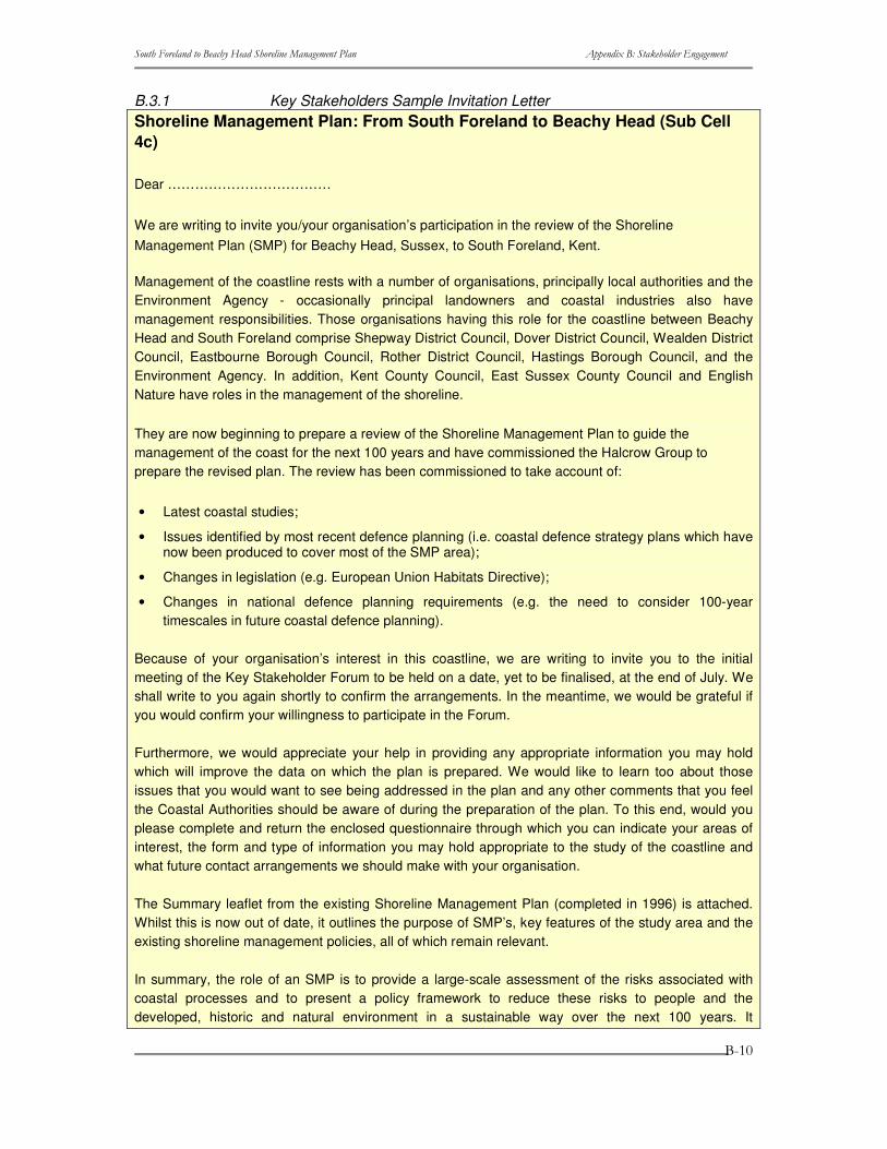
B.3.1 Key Stakeholders Sample Invitation Letter Shoreline Management Plan: From South Foreland to Beachy Head (Sub Cell 4c)
Dear ………………………………
We are writing to invite you/your organisation’s participation in the review of the Shoreline Management Plan (SMP) for Beachy Head, Sussex, to South Foreland, Kent.
Management of the coastline rests with a number of organisations, principally local authorities and the Environment Agency - occasionally principal landowners and coastal industries also have management responsibilities. Those organisations having this role for the coastline between Beachy Head and South Foreland comprise Shepway District Council, Dover District Council, Wealden District Council, Eastbourne Borough Council, Rother District Council, Hastings Borough Council, and the Environment Agency. In addition, Kent County Council, East Sussex County Council and English Nature have roles in the management of the shoreline.
They are now beginning to prepare a review of the Shoreline Management Plan to guide the management of the coast for the next 100 years and have commissioned the Halcrow Group to prepare the revised plan. The review has been commissioned to take account of:
• Latest coastal studies;
• Issues identified by most recent defence planning (i.e. coastal defence strategy plans which have now been produced to cover most of the SMP area);
• Changes in legislation (e.g. European Union Habitats Directive);
• Changes in national defence planning requirements (e.g. the need to consider 100-year timescales in future coastal defence planning).
Because of your organisation’s interest in this coastline, we are writing to invite you to the initial meeting of the Key Stakeholder Forum to be held on a date, yet to be finalised, at the end of July. We shall write to you again shortly to confirm the arrangements. In the meantime, we would be grateful if you would confirm your willingness to participate in the Forum.
Furthermore, we would appreciate your help in providing any appropriate information you may hold which will improve the data on which the plan is prepared. We would like to learn too about those issues that you would want to see being addressed in the plan and any other comments that you feel the Coastal Authorities should be aware of during the preparation of the plan. To this end, would you please complete and return the enclosed questionnaire through which you can indicate your areas of interest, the form and type of information you may hold appropriate to the study of the coastline and what future contact arrangements we should make with your organisation.
The Summary leaflet from the existing Shoreline Management Plan (completed in 1996) is attached. Whilst this is now out of date, it outlines the purpose of SMP’s, key features of the study area and the existing shoreline management policies, all of which remain relevant.
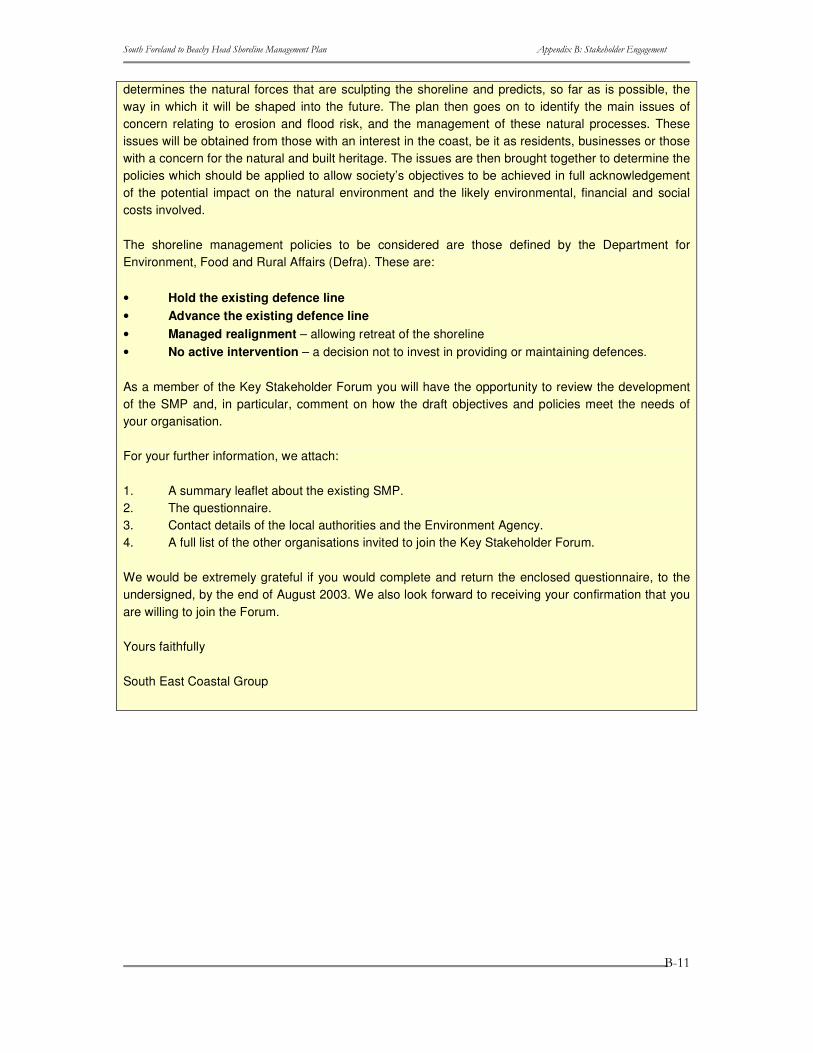
In summary, the role of an SMP is to provide a large-scale assessment of the risks associated with coastal processes and to present a policy framework to reduce these risks to people and the developed, historic and natural environment in a sustainable way over the next 100 years. It
����������� ������������ ��������������������� ���� ������������ �����������
�
�
�
����
determines the natural forces that are sculpting the shoreline and predicts, so far as is possible, the way in which it will be shaped into the future. The plan then goes on to identify the main issues of concern relating to erosion and flood risk, and the management of these natural processes. These issues will be obtained from those with an interest in the coast, be it as residents, businesses or those with a concern for the natural and built heritage. The issues are then brought together to determine the policies which should be applied to allow society’s objectives to be achieved in full acknowledgement of the potential impact on the natural environment and the likely environmental, financial and social costs involved.
The shoreline management policies to be considered are those defined by the Department for Environment, Food and Rural Affairs (Defra). These are:
• Hold the existing defence line • Advance the existing defence line • Managed realignment – allowing retreat of the shoreline • No active intervention – a decision not to invest in providing or maintaining defences.
As a member of the Key Stakeholder Forum you will have the opportunity to review the development of the SMP and, in particular, comment on how the draft objectives and policies meet the needs of your organisation.
For your further information, we attach:
1. A summary leaflet about the existing SMP. 2. The questionnaire. 3. Contact details of the local authorities and the Environment Agency. 4. A full list of the other organisations invited to join the Key Stakeholder Forum.
We would be extremely grateful if you would complete and return the enclosed questionnaire, to the undersigned, by the end of August 2003. We also look forward to receiving your confirmation that you are willing to join the Forum.
Yours faithfully
South East Coastal Group
����������� ������������ ��������������������� ���� ������������ �����������
�
�
�
����
B.3.2 Stakeholders (other) Sample Invitation Letter Shoreline Management Plan - From South Foreland to Beachy Head(Sub cell 4c)
Dear ……………………………….
We are writing to ask if you will participate in the consultation for the preparation of the Revised Shoreline Management Plan (SMP) for the coast between Beachy Head, Sussex, and South Foreland, Kent.
The South East Coastal Group has commissioned the Halcrow Group to prepare the revised plan to cover the next 100-years. The Coastal Group members comprise organisations with responsibilities related to management of coastal defences between Beachy Head and South Foreland. These organisations are Shepway District Council, Dover District Council, Wealden District Council, Eastbourne Borough Council, Rother District Council, Hastings Borough Council, the Environment Agency, Kent County Council, East Sussex County Council and English Nature. The SMP review has been commissioned to take account of:
• Latest coastal studies;
• Issues identified by most recent defence planning (i.e. coastal defence strategy plans which have now been produced to cover most of the SMP area);
• Changes in legislation (e.g. European Union Habitats Directive);
• Changes in national defence planning requirements (e.g. the need to consider 100-year timescales in future coastal defence planning).
The Summary leaflet from the existing Shoreline Management Plan (completed in 1996) is attached. Whilst this is now out of date, it outlines the purpose of SMP’s, key features of the study area and the existing shoreline management policies, all of which remain relevant.
The coastline of England and Wales is undergoing constant change from the effects of waves and tidal currents. The amount of physical change depends on the degree of exposure of each length of coast and the predominant geology. These change processes have usually taken place over long historical periods and many examples exist where settlements have been lost through erosion or where former coastal villages are now landlocked because of coastal build up.
Another influence on the development of the coastline has been the human intervention throughout the ages, particularly in attempts to arrest the effect of erosion or flooding at particular locations. In many cases this has taken place without an acknowledgement of the effect on other locations up and down the coast of carrying out these works.
Whilst these changes continue to take place, social, economic and environmental pressures are increasing in the coastal zone. People enjoy living by and visiting the coast and the pressure for more housing is ever present. As international trade increases, so does the demand for port space and associated coastal-based industry. Such development often places stress on natural coastal habitats that are often unique and of national and international importance.
The purpose of a Shoreline Management Plan is to provide a large-scale assessment of the risks associated with coastal processes and to present a policy framework to reduce these risks to people

����������� ������������ ��������������������� ���� ������������ �����������
�
�
�
����
and the developed, historic and natural environment in a sustainable way. It determines the natural forces that are sculpting the shoreline and predicts, so far as it is possible, the way in which it will be shaped into the future. The plan then goes on to identify the main issues of concern relating to erosion and flooding risks, and management of these natural processes. These issues will be obtained from those with an interest in the coast, be it as residents, businesses or those with a concern for the natural and built heritage. The issues are then brought together to determine the policies, for the next 100 years, which should be applied to allow society’s objectives to be achieved in full acknowledgement of the potential impact on the natural environment and the likely environmental, financial and social costs involved.
The shoreline management policies to be considered are those defined by the Department for Environment, Food and Rural Affairs (Defra). These policies are:
• Hold the existing defence line • Advance the existing defence line • Managed realignment – allowing retreat of the shoreline • No active intervention – a decision not to invest in providing or maintaining defences.
From this analysis a preferred policy for each length of coast is proposed and, once again, it will be important to gauge the response from the community.
As you have an interest in this coastline, we would appreciate your help in providing any appropriate information that you may hold and will improve the data on which the plan is prepared. We would like to learn about those issues that you would want to see being addressed in the plan and any other comments that you feel the Coastal Authorities should be aware of during the preparation of the plan. For these reasons we attach:
1. A summary leaflet about the existing SMP. 2. The questionnaire. 3. Contact details of the local authorities and the Environment Agency. 4. A full list of other organisations contacted.
We would be extremely grateful if you would complete and return the enclosed questionnaire, to the undersigned, before the end of August 2003.
Yours faithfully
South East Coastal Group
����������� ������������ ��������������������� ���� ������������ �����������
�
�
�
����
B.3.3 Elected Members Sample Invitation: Cover Letter Dear ………………………….
Shoreline Management Plan - From South Foreland to Beachy Head(Sub cell 4c) Elected Members Forum
Please find attached details of the above forum, which you are invited to join, and an invitation to attend its first meeting on the evening of Thursday 11th September 2003 at the Russell Hotel, Maidstone.
Yours sincerely
South East Coastal Group
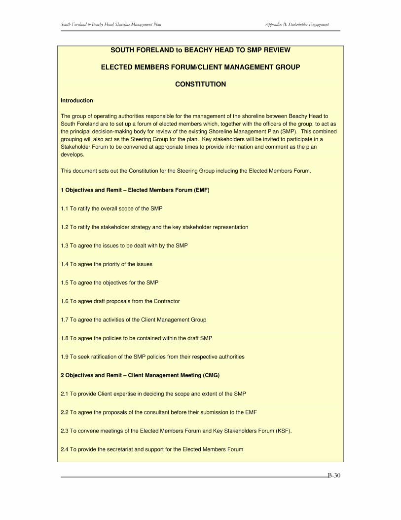
B.3.4 Constitution Shoreline Management Plan - From South Foreland to Beachy Head(Sub cell 4c) Elected Members Forum
CONSTITUTION
Introduction
The group of operating authorities responsible for the management of the shoreline between Beachy Head to South Foreland are to set up a forum of elected members which, together with the officers of the group, to act as the principal decision-making body for review of the existing Shoreline Management Plan (SMP). This combined grouping will also act as the Steering Group for the plan. Key stakeholders will be invited to participate in a Stakeholder Forum to be convened at appropriate times to provide information and comment as the plan develops.
This document sets out the Constitution for the Steering Group including the Elected Members Forum.
1. Objectives and Remit - Elected Members Forum (EMF)
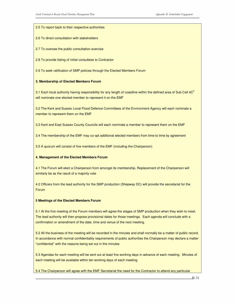
1.1 To ratify the overall scope of the SMP. 1.2 To ratify the stakeholder strategy and the key stakeholder representation. 1.3 To agree the issues to be dealt with by the SMP. 1.4 To agree the priority of the issues. 1.5 To agree the objectives for the SMP. 1.6 To agree draft proposals from the Contractor. 1.7 To agree the activities of the Client Management Group. 1.8 To agree the policies to be contained within the draft SMP. 1.9 To seek ratification of the SMP policies from their respective authorities. 2. Objectives and Remit
����������� ������������ ��������������������� ���� ������������ �����������
�
�
�
����
2.1 To provide Client expertise in deciding the scope and extent of the SMP. 2.2 To agree the proposals of the consultant before their submission to the EMF. 2.3 To convene meetings of the Elected Members Forum and Key Stakeholders Forum (KSF). 2.4 To provide the secretariat and support for the Elected Members Forum. 2.5 To report back to their respective authorities. 2.6 To direct consultation with stakeholders. 2.7 To oversee the public consultation exercise. 2.8 To provide listing of initial consultees to Contractor. 2.9 To seek ratification of SMP policies through the Elected Members Forum. 3. Membership of Elected Members Forum
3.1 Each local authority having responsibility for any length of coastline within the defined area of Sub Cell 4C1 will nominate one elected member to represent it on the EMF.
3.2 The Kent and Sussex Local Flood Defence Committees of the Environment Agency will each nominate a member to represent them on the EMF.
3.3 Kent and East Sussex County Councils will each nominate a member to represent them on the EMF.
3.4 The membership of the EMF may co-opt additional elected members from time to time by agreement.
3.5 A quorum will consist of five members of the EMF (including the Chairperson). 4. Management of the Elected Members Forum
4.1 The Forum will elect a Chairperson from amongst its membership. Replacement of the Chairperson will similarly be as the result of a majority vote.
4.2 Officers from the lead authority for the SMP production (Shepway DC) will provide the secretariat for the Forum.
5. Meetings of the Elected Members Forum
5.1 At the first meeting of the Forum members will agree the stages of SMP production when they wish to meet. The lead authority will then propose provisional dates for those meetings. Each agenda will conclude with a confirmation or amendment of the date, time and venue of the next meeting.
5.2 All the business of the meeting will be recorded in the minutes and shall normally be a matter of public record. In accordance with normal confidentiality requirements of public authorities the Chairperson may declare a matter “confidential” with the reasons being set out in the minutes.
5.3 Agendas for each meeting will be sent out at least five working days in advance of each meeting. Minutes of each meeting will be available within ten working days of each meeting.
5.4 The Chairperson will agree with the EMF Secretariat the need for the Contractor to attend any
������������������������������������������������������
������������������������������������������������ �!��"#�$��� �%�������� �&�����'���� �(��)*������
��*�+���,��������-�
����������� ������������ ��������������������� ���� ������������ �����������
�
�
�
���
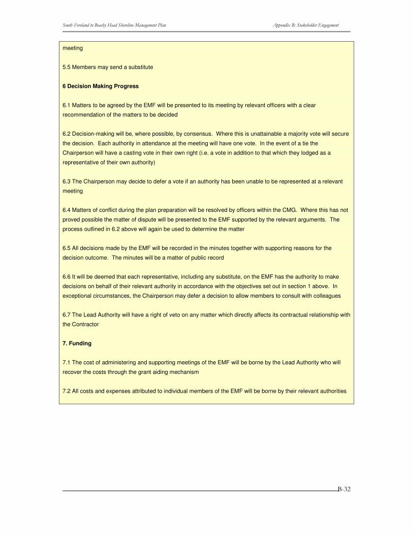
particular meeting. 5.5 Members may send a substitute. 6. Decision making process
6.1 Matters to be agreed by the EMF will be presented to its meeting by relevant officers with a clear recommendation of the matters to be decided.
6.2 Decision-making will be, where possible, by consensus. Where this is unattainable a majority vote will secure the decision. Each authority in attendance at the meeting will have one vote. In the event of a tie the Chairperson will have a casting vote in their own right (i.e. a vote in addition to that which they lodged as a representative of their own authority).
6.3 The Chairperson may decide to defer a vote if an authority has been unable to be represented at a relevant meeting.
6.4 Matters of conflict during the plan preparation will be resolved by officers within the CMG. Where this has not proved possible the matter of dispute will be presented to the EMF supported by the relevant arguments. The process outlined in 6.2 above will again be used to determine the matter.
6.5 All decisions made by the EMF will be recorded in the minutes together with supporting reasons for the decision outcome. The minutes will be a matter of public record.
6.6 It will be deemed that each representative, including any substitute, on the EMF has the authority to make decisions on behalf of their relevant authority in accordance with the objectives set out in section 1 above. In exceptional circumstances, the Chairperson may defer a decision to allow members to consult with colleagues.
6.7 The Lead Authority will have a right of veto on any matter which directly affects its contractual relationship with the Contractor.
7. Funding
7.1 The cost of administering and supporting meetings of the EMF will be borne by the Lead Authority who will recover the costs through the grant aiding mechanism.
7.2 All costs and expenses attributed to individual members of the EMF will be borne by their relevant authorities.
B.3.5 Questionnaire to stakeholders FIRST REVIEW OF THE SOUTH FORELAND TO BEACHY HEAD SHORELINE MANAGEMENT PLAN
Please answer the following questions and return the completed questionnaire by ……………………. to Halcrow, Burderop Park, Swindon, Wiltshire SN4 0QD, who are the consultants undertaking the review of the Shoreline Management Plan on behalf of the 4c Sub-Cell of the South East Coastal Group.
I would appreciate your return of the questionnaire even if you do not wish to comment on the Shoreline Management Plan.
CONTACT DETAILS
1 Name of your organisation or business
2 Address

����������� ������������ ��������������������� ���� ������������ �����������
�
�
�
���
3 Name of contact
4 Position in organisation
5 Address if different from 2
6 Telephone No
7 Fax No.
8 E-mail address
9 Will you be attending the meeting of the Key Stakeholder Forum planned for 11th Sept 2003?
INFORMATION
Please let me know if you hold any of the following information, if so, in what format it is held and if you are willing to make it available to the Project Team.
Format Availability Description (Please give brief details in the space provided. If there is insufficient space, please continue on a separate sheet of paper labelled with the question number.)
Hard Copy
Digital Yes No
10 A map of your premises, site(s) or showing your area of interest
………………………………………………………...
………………………………………………………...
11 Any information or data about local coastal processes including photographs
………………………………………………………...
………………………………………………………...
12 Study reports about coastal processes
………………………………………………………...
………………………………………………………...
13 Flooding and erosion events
………………………………………………………...
………………………………………………………...
14 Design and construction of existing coastal defences
………………………………………………………...
………………………………………………………...
15 Reports relating to the natural environment and ecology
………………………………………………………...
………………………………………………………...

����������� ������������ ��������������������� ���� ������������ �����������
�
�
�
����
16 Reports relating to the built environment
………………………………………………………...
………………………………………………………...
17 Land use mapping
………………………………………………………...
………………………………………………………...
18 Coastal Industries
………………………………………………………...
………………………………………………………...
19 Ports and harbours
………………………………………………………...
………………………………………………………...
20 Agriculture
………………………………………………………...
………………………………………………………...
21 Tourism and Amenity Usage of the Coast
………………………………………………………...
………………………………………………………...
22 Inshore Fisheries ………………………………………………………...
………………………………………………………...
COMMENT 23 Is your organisation or business affected by the risk of coastal flooding or erosion? If so, please give brief details including any significant historic events.
…………………………………………………………………………………..
…………………………………………………………………………………..
24 What are the main issues relating to the way in which the coastline is managed and which you want to see being dealt with in the plan?
…………………………………………………………………………………..
…………………………………………………………………………………..
25 What objectives do you have for the future of your interest in the coast?
…………………………………………………………………………………..
…………………………………………………………………………………..
26 Do you have any views on the way in which the existing defences have had an impact on the way in which the coastline has developed?

����������� ������������ ��������������������� ���� ������������ �����������
�
�
�
����
…………………………………………………………………………………..
…………………………………………………………………………………..
27 Do you have any views on changes which should be made to the existing coastal defences? What effect do you think this would have?
…………………………………………………………………………………..
…………………………………………………………………………………..
28 Do you have any other comments which you would like to be taken into account during the revision of the existing Shoreline Management Plan?
…………………………………………………………………………………..
…………………………………………………………………………………..
Thank you for your time in completing this questionnaire.

����������� ������������ ��������������������� ���� ������������ �����������
�
�
�
���
����������� ������������ ��������������������� ���� ������������ �����������
�
�
�
����
B.4 Elected Members Materials B.4.1 Introduction Below are a series of documents that were issued to the Elected Members prior to each of the forums and the minutes that were circulated thereafter.
B.4.2 Issues Table Review Background
Shoreline Management Plans
The purpose of a Shoreline Management Plan (SMP) is to provide a large-scale assessment of the risks associated with coastal processes and to present a policy framework with the aim of reducing these risks to people and the developed, historic and natural environment in a sustainable way.
Underpinning the SMP is an understanding of the natural processes that are sculpting the shoreline, which is used to predict, so far as it is possible, the way in which the shoreline evolve in the future.
Following the coastal process assessments, the plan then identifies the main issues of concern relating to current/future erosion and flooding risks and their management. These issues are obtained from those with an interest in the coast, the stakeholders. The issues are then rationalised to define ‘objectives’ for the future management of the shoreline. The objectives are than ranked, based upon their scale and importance.
These objectives will then be used to develop sustainable management policies, for the next 100 years.
Revision of the existing SMP
Shepway District Council, on behalf of the South East Coastal Group, has commissioned the Halcrow Group to prepare the revised SMP to cover shoreline management for the next 100 years. The Coastal Group members with responsibilities related to management of coastal defences between Beachy Head and South Foreland are Dover District Council, Shepway District Council, Wealden District Council, Rother District Council, Hastings Borough Council, Eastbourne Borough Council, the Environment Agency, Kent County Council, East Sussex County Council and English Nature. The SMP review has been commissioned to take account of:
• Latest coastal studies; • Issues identified by most recent defence planning (i.e. coastal defence strategy
plans which have now been produced to cover most of the SMP area); • Changes in legislation (e.g. European Union Habitats Directive); • Changes in national defence planning requirements (e.g. the need to consider 100-
year timescales in future coastal defence planning). As part of this process, shoreline management issues have now been identified, and are presented in this report for review by Key Stakeholders.
Objective Setting
����������� ������������ ��������������������� ���� ������������ �����������
�
�
�
����
Approach
The SMP policy appraisal process needs to be guided by a set of relevant objectives that apply to each SMP area. These objectives fulfil two roles; firstly, they help inform the development of policy options, secondly, they help provide a focus for consensus amongst the SMP stakeholders and the various issues, sometimes conflicting, that are raised during the process of plan formulation.
The approach used focuses on the “benefits” or “services” (termed as benefits) that a feature (e.g. a harbour) contributes to a location, a region or the nation. This focus on benefits helps clarify why a feature on the coast may or may not require protection. This understanding of why a feature is important to stakeholders, either locally or nationally, helps ensure the process is transparent.
The key steps in this approach are set out below.
Step one - the Stakeholders: Identify all those parties who are stakeholders in the SMP. Decide how they are to be involved in the SMP development process, and issue initial Stakeholder materials.
Step two - the Baseline: Using all available data and stakeholder feedback and given the coastal process understanding (both short and long term), identify the character of the area and the features present.
Step three - Identify Benefits: define the benefits of each feature identified in Step 2. Identify what benefits that feature actually offers in terms of Flood and Coastal Defence (e.g. recreation, economic health, regeneration, historic value along the coast etc.) and who receives the benefits.
Step four – Examine the benefits systematically using a series of questions:
• At what scales (spatial/temporal) is the benefit important? • Is there enough of the benefit? • Importance of the benefit at the SMP scale or greater? • Can the benefit be substituted?
Step five – Identify rank of each objective based on answers to these four questions.
Current Position
We are currently approaching the end of Step three, having identified (in draft) the features of importance along the Beachy Head to South Foreland shoreline and defined the benefits of those features. This has been developed from the Stakeholder feedback received and review of existing reports.
The tables provided at the end of this report present the issues as identified to data. These are described under the following headings:
����������� ������������ ��������������������� ���� ������������ �����������
�
�
�
����
• Location: A discrete point on the coast or a length of coastline between two defined points.
• Feature: Something tangible that provides a service to society in one form or another or, more simply, benefits certain aspects of society by its very existence.
• Issue associated with Feature: Issues will occur where either the aspirations of Stakeholders conflict or where a feature is at risk from flooding or erosion. Grouped or categorised under the three main themes: Technical; Environmental; or Socio-economic
• Flood and Coastal Defence (FCD) issue? Identifies whether the feature, and its associated issues, of direct relevance to flood and coastal defence management.
• Affect Policy? If a FCD issues, this identifies whether the issue would affect the choice of policy or if it relates to implementation of the policy?
• Why is issue important? Identifies the actual tangible benefits of the feature.
• Who are the beneficiaries? Defines who actually benefits from the feature in question.
Stakeholder Meetings September 2003
The meetings on Thursday 11 September are important in providing a detailed review of these draft issues. Only once feedback has been gained from the Key Stakeholders Forum and Elected Members Forum will the issues be finalised and Stage four started.
A large section of these meetings is given over to the discussion and agreement of these issues. If possible, we would ask that you review the issues before the meeting to ensure that all shoreline management issues that you are aware of are accurately reflected, so omissions/inaccuracies can be raised at the meeting.
What next?
Prioritising Objectives
Once the issues are finalised, we will move on to the definition of ‘benefit objectives’ and examining each benefit through the four key questions (Step four) to identify the priority of each objective (Step five).
Each issue will have an associated objective that will relate to both the feature and its benefits. For each of these the following four questions will be reviewed:
• At what scales (spatial/temporal) is the benefit important? If the feature were lost tomorrow, at what (spatial) scale would there be an impact? Also, is the feature, or benefit, of finite temporal importance (i.e. less than 100 years?).
• Is there enough of the benefit? Scarcity of the benefit at the scale at which it is important.
• Importance of the benefit at the SMP scale or greater? If the feature were lost
����������� ������������ ��������������������� ���� ������������ �����������
�
�
�
����
tomorrow, what would the impact be?
• Can the benefit be substituted? Can the benefit can be replaced at the appropriate scale.
Based on the answers to these questions, a priority, or rank, will then be set for each objective in relation to its importance to shoreline management planning.
It is clearly critical that the ranking of objectives is correct, as this will directly affect the selection of shoreline management policies in the next stage of SMP development. As such, we will be having a second meeting of both the Key Stakeholders Forum and Elected Members Forum once this step has been undertaken, to review the objectives and priorities defined.
We will also take the opportunity during the September meetings to review the approach to objective ranking, and receive comments from Stakeholders on how they feel the four key questions should be answered for the various issues present in this area (e.g. nature conservation, commercial interests, housing, recreation, etc.).
Completion of the SMP
Once the ranked objectives have been set they will be used, together with the coastal process understanding, to appraise future shoreline management policies. The generic policy options, as defined by the Department for Environment, Food and Rural Affairs (Defra), are:
• Hold the existing defence line
• Advance the existing defence line
• Managed realignment – allowing retreat of the shoreline
• No active intervention – a decision not to invest in providing or maintaining defences.
Once draft policies have been identified, and combined to form possible scenarios for future management of the entire Beachy Head to South Foreland shoreline, there will be further meetings of the Key Stakeholders Forum and Elected Members Forum to review the scenarios before their sustainability is appraised to finalise the preferred long-term policy scenario. These meetings are likely to be held in Spring 2004.
Information Sources
Stakeholder Questionnaire Responses Bexhill Library Hastings Fishermen’s Protection Society Bexhill Museums House of Commons - Nigel Waterson MP Cooden Beach Golf Club House of Commons - The Rt. Hon. Michael
Howard, QC, MP Defence Estates/Army Training Estate Kent & Essex Sea Fisheries Committee Defra (FCD) Kent Wildlife Trust DEFRA Sea Fisheries Inspectorate Lydd Town Council Department of Transport Marsh 2000
����������� ������������ ��������������������� ���� ������������ �����������
�
�
�
����
Dover District Council National Grid Company PLC Dungeness A Power Station BNFL National Trust Dungeness Angling Association Network Rail, Southern Region Dungeness Fisherman's Protection Society New Romney Town Council Eastbourne Borough Council NFU South East Region Eastbourne Hotels Association RDS (Rural Development Service) English Heritage Rother District Council English Nature Royal National Lifeboat Institution Environment Agency (East Sussex) Rye Golf Club Limited Environment Agency (Kent Area) Rye Harbour Nature Reserve Folkestone & Dover Water Services Rye Town Council Folkestone Fisherman's Association Shepway DC Folkestone Yacht and Motor Boat Club Shepway Friends of the Earth Hampshire & Wight Trust for Maritime Archaeology
Shipwreck Heritage Centre
Hanson Quarry Products Europe Ltd Sussex Biodiversity Partnership Harbour of Rye Advisory Committee Sussex Sea Fisheries Committee Hastings & St. Leonard’s Angling Assoc. Sussex Wildlife Trust Hastings & St. Leonard’s Rowing Club The Countryside Agency Hastings BC (Sea front Services) The Crown Estate Hastings BC (Senior Project Engineer) Wealden District Council

����������� ������������ ��������������������� ���� ������������ �����������
�
�
�
���
����������� ������������ ��������������������� ���� ������������ �����������
�
�
�
���
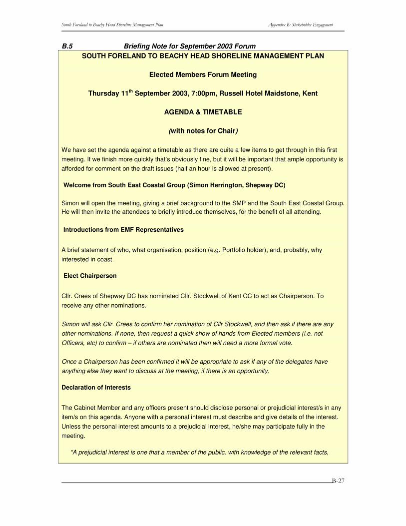
B.5 Briefing Note for September 2003 Forum SOUTH FORELAND TO BEACHY HEAD SHORELINE MANAGEMENT PLAN
Elected Members Forum Meeting
Thursday 11th September 2003, 7:00pm, Russell Hotel Maidstone, Kent
AGENDA & TIMETABLE
(with notes for Chair)
We have set the agenda against a timetable as there are quite a few items to get through in this first meeting. If we finish more quickly that’s obviously fine, but it will be important that ample opportunity is afforded for comment on the draft issues (half an hour is allowed at present).
Welcome from South East Coastal Group (Simon Herrington, Shepway DC)
Simon will open the meeting, giving a brief background to the SMP and the South East Coastal Group. He will then invite the attendees to briefly introduce themselves, for the benefit of all attending.
Introductions from EMF Representatives
A brief statement of who, what organisation, position (e.g. Portfolio holder), and, probably, why interested in coast.
Elect Chairperson
Cllr. Crees of Shepway DC has nominated Cllr. Stockwell of Kent CC to act as Chairperson. To receive any other nominations.
Simon will ask Cllr. Crees to confirm her nomination of Cllr Stockwell, and then ask if there are any other nominations. If none, then request a quick show of hands from Elected members (i.e. not Officers, etc) to confirm – if others are nominated then will need a more formal vote.
Once a Chairperson has been confirmed it will be appropriate to ask if any of the delegates have anything else they want to discuss at the meeting, if there is an opportunity.
Declaration of Interests
The Cabinet Member and any officers present should disclose personal or prejudicial interest/s in any item/s on this agenda. Anyone with a personal interest must describe and give details of the interest. Unless the personal interest amounts to a prejudicial interest, he/she may participate fully in the meeting.
“A prejudicial interest is one that a member of the public, with knowledge of the relevant facts,
����������� ������������ ��������������������� ���� ������������ �����������
�
�
�
����
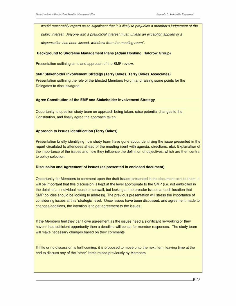
would reasonably regard as so significant that it is likely to prejudice a member's judgement of the
public interest. Anyone with a prejudicial interest must, unless an exception applies or a
dispensation has been issued, withdraw from the meeting room”.
Background to Shoreline Management Plans (Adam Hosking, Halcrow Group)
Presentation outlining aims and approach of the SMP review.
SMP Stakeholder Involvement Strategy (Terry Oakes, Terry Oakes Associates)
Presentation outlining the role of the Elected Members Forum and raising some points for the Delegates to discuss/agree.
Agree Constitution of the EMF and Stakeholder Involvement Strategy
Opportunity to question study team on approach being taken, raise potential changes to the Constitution, and finally agree the approach taken.
Approach to issues identification (Terry Oakes)
Presentation briefly identifying how study team have gone about identifying the issue presented in the report circulated to attendees ahead of the meeting (sent with agenda, directions, etc). Explanation of the importance of the issues and how they influence the definition of objectives, which are then central to policy selection.
Discussion and Agreement of Issues (as presented in enclosed document)
Opportunity for Members to comment upon the draft issues presented in the document sent to them. It will be important that this discussion is kept at the level appropriate to the SMP (i.e. not embroiled in the detail of an individual house or seawall, but looking at the broader issues at each location that SMP policies should be looking to address). The previous presentation will stress the importance of considering issues at this ‘strategic’ level. Once issues have been discussed, and agreement made to changes/additions, the intention is to get agreement to the issues.
If the Members feel they can’t give agreement as the issues need a significant re-working or they haven’t had sufficient opportunity then a deadline will be set for member responses. The study team will make necessary changes based on their comments.
If little or no discussion is forthcoming, it is proposed to move onto the next item, leaving time at the end to discuss any of the ‘other’ items raised previously by Members.
����������� ������������ ��������������������� ���� ������������ �����������
�
�
�
����
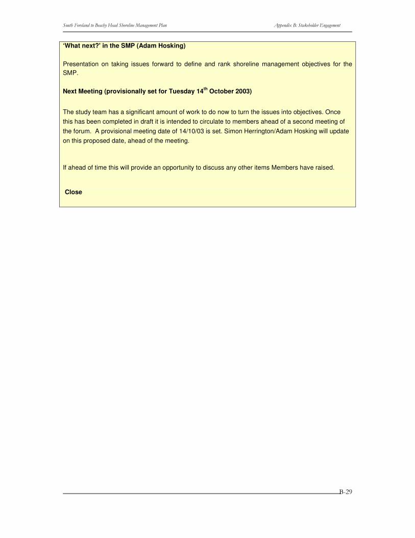
‘What next?' in the SMP (Adam Hosking)
Presentation on taking issues forward to define and rank shoreline management objectives for the SMP.
Next Meeting (provisionally set for Tuesday 14th October 2003)
The study team has a significant amount of work to do now to turn the issues into objectives. Once this has been completed in draft it is intended to circulate to members ahead of a second meeting of the forum. A provisional meeting date of 14/10/03 is set. Simon Herrington/Adam Hosking will update on this proposed date, ahead of the meeting.
If ahead of time this will provide an opportunity to discuss any other items Members have raised.
Close
����������� ������������ ��������������������� ���� ������������ �����������
�
�
�
���
SOUTH FORELAND to BEACHY HEAD TO SMP REVIEW
ELECTED MEMBERS FORUM/CLIENT MANAGEMENT GROUP
CONSTITUTION
Introduction
The group of operating authorities responsible for the management of the shoreline between Beachy Head to South Foreland are to set up a forum of elected members which, together with the officers of the group, to act as the principal decision-making body for review of the existing Shoreline Management Plan (SMP). This combined grouping will also act as the Steering Group for the plan. Key stakeholders will be invited to participate in a Stakeholder Forum to be convened at appropriate times to provide information and comment as the plan develops.
This document sets out the Constitution for the Steering Group including the Elected Members Forum.
1 Objectives and Remit – Elected Members Forum (EMF)
1.1 To ratify the overall scope of the SMP
1.2 To ratify the stakeholder strategy and the key stakeholder representation
1.3 To agree the issues to be dealt with by the SMP
1.4 To agree the priority of the issues
1.5 To agree the objectives for the SMP
1.6 To agree draft proposals from the Contractor
1.7 To agree the activities of the Client Management Group
1.8 To agree the policies to be contained within the draft SMP
1.9 To seek ratification of the SMP policies from their respective authorities
2 Objectives and Remit – Client Management Meeting (CMG)
2.1 To provide Client expertise in deciding the scope and extent of the SMP
2.2 To agree the proposals of the consultant before their submission to the EMF
2.3 To convene meetings of the Elected Members Forum and Key Stakeholders Forum (KSF).
2.4 To provide the secretariat and support for the Elected Members Forum
����������� ������������ ��������������������� ���� ������������ �����������
�
�
�
����
2.5 To report back to their respective authorities
2.6 To direct consultation with stakeholders
2.7 To oversee the public consultation exercise
2.8 To provide listing of initial consultees to Contractor
2.9 To seek ratification of SMP policies through the Elected Members Forum
3. Membership of Elected Members Forum
3.1 Each local authority having responsibility for any length of coastline within the defined area of Sub Cell 4C2
will nominate one elected member to represent it on the EMF
3.2 The Kent and Sussex Local Flood Defence Committees of the Environment Agency will each nominate a
member to represent them on the EMF
3.3 Kent and East Sussex County Councils will each nominate a member to represent them on the EMF
3.4 The membership of the EMF may co-opt additional elected members from time to time by agreement
3.5 A quorum will consist of five members of the EMF (including the Chairperson)
4. Management of the Elected Members Forum
4.1 The Forum will elect a Chairperson from amongst its membership. Replacement of the Chairperson will
similarly be as the result of a majority vote
4.2 Officers from the lead authority for the SMP production (Shepway DC) will provide the secretariat for the
Forum
5 Meetings of the Elected Members Forum
5.1 At the first meeting of the Forum members will agree the stages of SMP production when they wish to meet.
The lead authority will then propose provisional dates for those meetings. Each agenda will conclude with a
confirmation or amendment of the date, time and venue of the next meeting.
5.2 All the business of the meeting will be recorded in the minutes and shall normally be a matter of public record.
In accordance with normal confidentiality requirements of public authorities the Chairperson may declare a matter
“confidential” with the reasons being set out in the minutes
5.3 Agendas for each meeting will be sent out at least five working days in advance of each meeting. Minutes of
each meeting will be available within ten working days of each meeting
5.4 The Chairperson will agree with the EMF Secretariat the need for the Contractor to attend any particular
����������� ������������ ��������������������� ���� ������������ �����������
�
�
�
����
meeting
5.5 Members may send a substitute
6 Decision Making Progress
6.1 Matters to be agreed by the EMF will be presented to its meeting by relevant officers with a clear
recommendation of the matters to be decided
6.2 Decision-making will be, where possible, by consensus. Where this is unattainable a majority vote will secure
the decision. Each authority in attendance at the meeting will have one vote. In the event of a tie the
Chairperson will have a casting vote in their own right (i.e. a vote in addition to that which they lodged as a
representative of their own authority)
6.3 The Chairperson may decide to defer a vote if an authority has been unable to be represented at a relevant
meeting
6.4 Matters of conflict during the plan preparation will be resolved by officers within the CMG. Where this has not
proved possible the matter of dispute will be presented to the EMF supported by the relevant arguments. The
process outlined in 6.2 above will again be used to determine the matter
6.5 All decisions made by the EMF will be recorded in the minutes together with supporting reasons for the
decision outcome. The minutes will be a matter of public record
6.6 It will be deemed that each representative, including any substitute, on the EMF has the authority to make
decisions on behalf of their relevant authority in accordance with the objectives set out in section 1 above. In
exceptional circumstances, the Chairperson may defer a decision to allow members to consult with colleagues
6.7 The Lead Authority will have a right of veto on any matter which directly affects its contractual relationship with
the Contractor
7. Funding
7.1 The cost of administering and supporting meetings of the EMF will be borne by the Lead Authority who will
recover the costs through the grant aiding mechanism
7.2 All costs and expenses attributed to individual members of the EMF will be borne by their relevant authorities
����������� ������������ ��������������������� ���� ������������ �����������
�
�
�
����
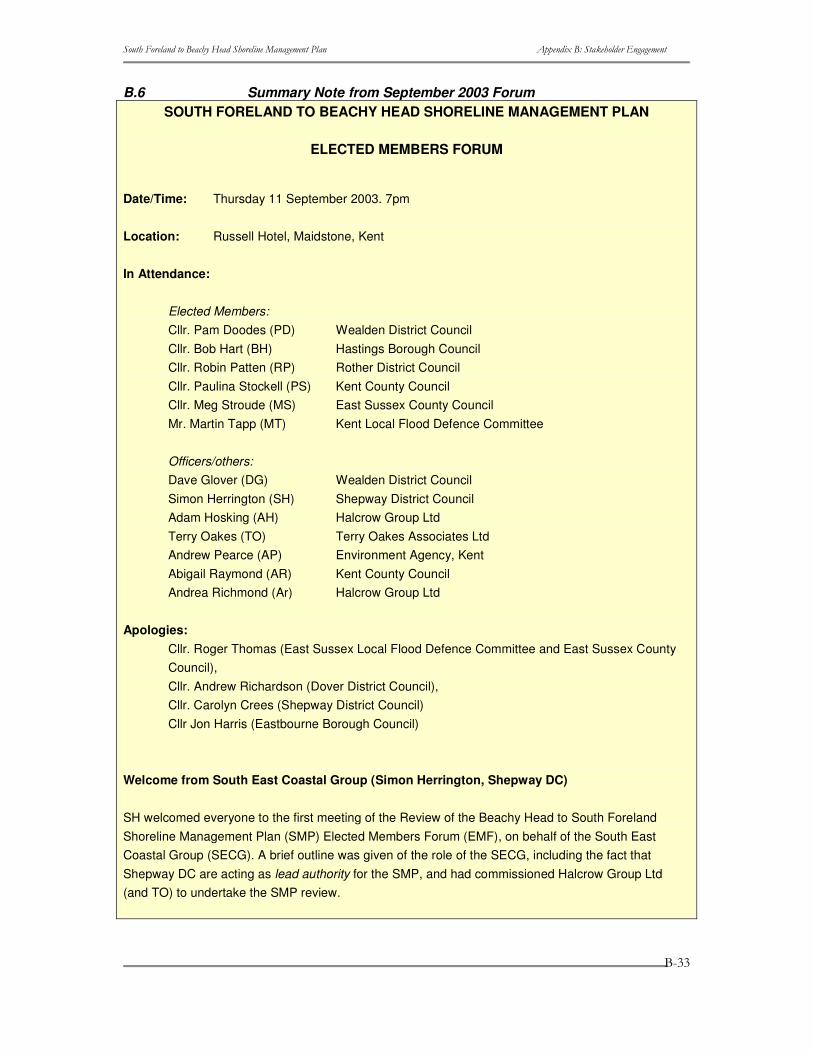
B.6 Summary Note from September 2003 Forum SOUTH FORELAND TO BEACHY HEAD SHORELINE MANAGEMENT PLAN
ELECTED MEMBERS FORUM
Date/Time: Thursday 11 September 2003. 7pm
Location: Russell Hotel, Maidstone, Kent
In Attendance:
Elected Members: Cllr. Pam Doodes (PD) Wealden District Council Cllr. Bob Hart (BH) Hastings Borough Council Cllr. Robin Patten (RP) Rother District Council Cllr. Paulina Stockell (PS) Kent County Council Cllr. Meg Stroude (MS) East Sussex County Council Mr. Martin Tapp (MT) Kent Local Flood Defence Committee Officers/others: Dave Glover (DG) Wealden District Council Simon Herrington (SH) Shepway District Council Adam Hosking (AH) Halcrow Group Ltd Terry Oakes (TO) Terry Oakes Associates Ltd Andrew Pearce (AP) Environment Agency, Kent Abigail Raymond (AR) Kent County Council Andrea Richmond (Ar) Halcrow Group Ltd
Apologies: Cllr. Roger Thomas (East Sussex Local Flood Defence Committee and East Sussex County Council), Cllr. Andrew Richardson (Dover District Council), Cllr. Carolyn Crees (Shepway District Council) Cllr Jon Harris (Eastbourne Borough Council)
Welcome from South East Coastal Group (Simon Herrington, Shepway DC)
SH welcomed everyone to the first meeting of the Review of the Beachy Head to South Foreland Shoreline Management Plan (SMP) Elected Members Forum (EMF), on behalf of the South East Coastal Group (SECG). A brief outline was given of the role of the SECG, including the fact that Shepway DC are acting as lead authority for the SMP, and had commissioned Halcrow Group Ltd (and TO) to undertake the SMP review.
����������� ������������ ��������������������� ���� ������������ �����������
�
�
�
����
Introductions from EMF Representatives and other attendees
All attendees introduced themselves with details of organisation and role. Cllr. Stroude reported that she was deputising for Cllr. Thomas (ESCC)
Declaration of Interests
None declared
Background to Shoreline Management Plans (SMP)
A short presentation on the role and aims of SMPs, and outlined the programme for completion for the Review of the Beachy Head to South Foreland SMP.
Stakeholder Involvement Strategy
A short presentation on the approach on the participation of stakeholders in the SMP, including the role of the Client Management Group and Key Stakeholders Forum, and constitution of the Elected Members Forum (EMF).
Elect Chairperson
Cllr. Crees of Shepway DC had nominated Cllr. Stockell to be Chair. No other nominations received. Cllr. Stockell unanimously elected Chairperson.
Constitution of the EMF and Stakeholder Involvement Strategy
Agreed
Approach to issues identification
A short presentation on the approach adopted to identification of issues in the SMP, as presented in the draft Issues Table document circulated ahead of the meeting.
Discussion and Agreement of Issues
The Elected Members questioned why they had not received the issues table in full but merely their ‘section/area’. The purpose for this was to focus the Elected Members on their area of interest. After some discussion it was agreed that a full table would be sent to each Elected Member.
Revised table to be sent to Elected Members, this will include the Key Stakeholders comments. Elected Members comments are requested for the end of September 2003.
'What next?' in the SMP
Presentation: The next steps in SMP development, including finalizing the issues and setting
����������� ������������ ��������������������� ���� ������������ �����������
�
�
�
����
objectives for their management
Next Meeting?
13th November 2003 suggested
Aim of meeting: to review ranked objectives. Document with this work to be circulated 2 weeks ahead of meeting, for review
Any Other Business?
• At what stage are the public engaged? The wider public would be engaged following the preparation of the draft SMP. A wide consultation at the start of the project had involved around 170 organisations.
• If any issues required further resolution, it was agreed that this may necessitate additional meetings.
• A copy of the presentation for each Elected Member was requested.

����������� ������������ ��������������������� ���� ������������ �����������
�
�
�
���
����������� ������������ ��������������������� ���� ������������ �����������
�
�
�
���
B.7 Briefing Note for November 2003 Forum SOUTH FORELAND TO BEACHY HEAD SHORELINE MANAGEMENT PLAN
ELECTED MEMBERS FORUM
Date/Time: 13 November 2003
Location: County Hall, Maidstone, Kent
Aim of the meeting
Future defence policies for this shoreline need to be driven by the stakeholders: it is your SMP. Therefore, the aim of the Key Stakeholders Forum (KSF) and Elected Members Forum (EMF) meetings on 13th November (during the day and evening respectively) is to involve the stakeholders in the setting of future shoreline management policies through bringing together an understanding of the issues, the risks, and an appreciation of each other’s viewpoints. This will use the draft Extended Issues Table, included in Appendix A, which includes all issues identified within the SMP area, the associated benefits, an objective for each feature/ benefit and a theme-specific rank.
This stage of decision-making is, however, just one more step in the process. This meeting is aimed at directing those policies and ideals that are to be developed into scenarios and tested; it should not be viewed as defining the final preferred policies themselves. These will be established through the testing process, reviewed against objectives, and then discussion at subsequent KSF and EMF meetings (February/ March 2004), all of which are crucial to achievement of an appropriate sustainable long term plan.
Meeting Objectives
The objectives of this meeting are to establish:
• The vision(s) of the various stakeholders for the whole SMP shoreline over each epoch, i.e. the next 20 years, 50 years, and 100 plus years;
• Any ‘overriding drivers’ for directing future policy, and specific future policy options that the stakeholders wish to see tested;
• Areas of agreement and conflict; • Potential scope for compromise and acceptance of future change.
This all needs to come from the stakeholders to direct the development of future policy, through consideration of the information provided prior to, and at, the meeting.
Agenda for the EMF Meeting
Meeting Start
Introductions and Apologies
Minutes of Last Meeting
����������� ������������ ��������������������� ���� ������������ �����������
�
�
�
����
Introduction and presentation of the activities to date.
Introduction to meeting and recap of the role of the EMF. Summary of work undertaken to date and present position.
Presentation of the risks and baseline scenarios.
Overview of the extent of potential risk and illustration of how the coast would look under the two baseline cases: ‘no active intervention’, e.g. letting defences fail and/or the coastline to evolve naturally and ‘maintain present management’, e.g. retaining all existing defences.
Review of Key Stakeholders Meeting discussions.
The outcomes of detailed consideration of possible future management scenarios for the SMP coastline by the members of the Key Stakeholders Forum (earlier in the day) will be summarised for review and discussion by the Elected Members.
Group discussion of key policy drivers.
Further to review of KSF outcomes, opportunity for Elected Members to outline their views on the key drivers of shoreline management policy for the next century, and identify areas where policy changes could/should be considered. This will also provide opportunity to make comments on the objectives circulated as part of this document.
Any other Business.
Next Meeting
Set provisional date for next meeting of EMF.
Meeting Close
The Extended Issues Table
Introduction and present position
The Issues Table has been developed to ensure transparency within the SMP process and to ensure that all issues along the SMP shoreline have been correctly identified.
Development of the Table has involved 5 key steps (which were explained further in the Draft Issues Table report distributed in September):
Step 1 – Stakeholder Engagement;
Step 2 - the Baseline;
Step 3 - Identify Benefits;
Step 4 – Examine the Benefits;
Step 5 – Identify Rank.
A Draft Issues Table was discussed at the EMF and KSF meetings on 11 September 2003, at which stakeholders/members were asked to:
����������� ������������ ��������������������� ���� ������������ �����������
�
�
�
����
• Review the features identified; • Check that all relevant issues have been included; • Check that the benefits identified are correct and that we have included all
beneficiaries; • Check that the objectives are a good representation of the requirements of the
beneficiaries. All comments received on the day and in subsequent correspondence, have now been reviewed and incorporated into the Table.
Since distribution of the Draft Issues Table, work has been undertaken on completing Steps 4 and 5 of the Table development:
Step 4 – Examine the Benefits: Each benefit has been assessed systematically at the SMP scale (as opposed to focusing upon the local scale) using a series of questions:
• At what scales (spatial/temporal) is the benefit important? • Importance of the benefit, i.e. the impact if this feature/benefit was lost tomorrow? • Is there enough of the benefit? • Can the benefit be substituted?
Step 5 – Identify Rank: Using the answers to the above four questions, a comparative ranking has been generated specific to each ‘theme’ (i.e. comparing the relative importance of different environmental areas, rather than, for example, comparing nature conservation with housing). This ranking is not intended as a mechanism to prioritise decisions, but is there to help fully understand the issues that have been raised and aid in the policy development.
Studies have also been carried out to evaluate the impact of coastal defences on coastal behaviour and assess potential vulnerability of the coast, assuming a ‘no active intervention’ case. These will be presented at the Meeting. Summary statements from these assessments are included in Appendix B of this report.
Methodology applied in assessing features/benefits
The development of an appropriate methodology has involved the input from an expert panel including representatives from Environment Agency, Local Authority Planning Departments, English Nature (national and regional), English Heritage and Halcrow. It has been recognized that it is not possible to compare different types of features, e.g. environment site with housing, therefore a number of themes have been developed and the ranking is specific to each theme.
• Housing (H); • Commercial and agricultural property (C); • Infrastructure (roads, pipelines etc.) (I); • Recreation (R); • Natural environment (E); • Landscape (L); • Heritage (A).
Scale
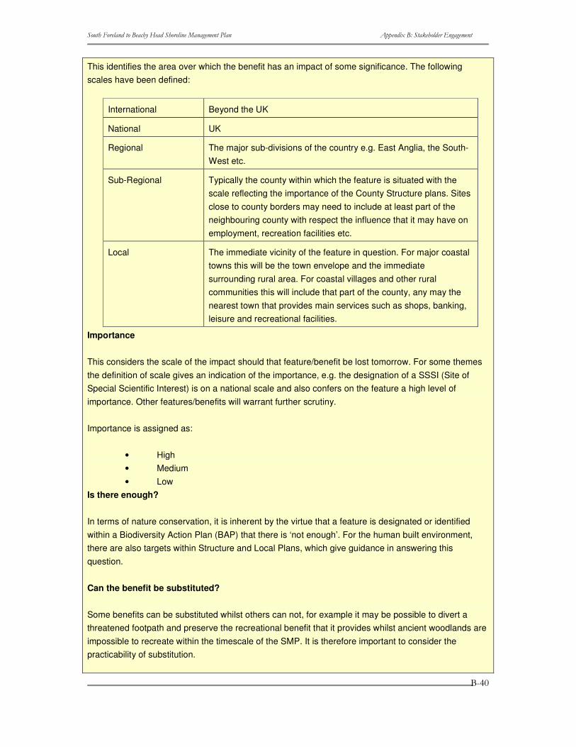
����������� ������������ ��������������������� ���� ������������ �����������
�
�
�
���
This identifies the area over which the benefit has an impact of some significance. The following scales have been defined:
International Beyond the UK
National UK
Regional The major sub-divisions of the country e.g. East Anglia, the South-West etc.
Sub-Regional Typically the county within which the feature is situated with the scale reflecting the importance of the County Structure plans. Sites close to county borders may need to include at least part of the neighbouring county with respect the influence that it may have on employment, recreation facilities etc.
Local The immediate vicinity of the feature in question. For major coastal towns this will be the town envelope and the immediate surrounding rural area. For coastal villages and other rural communities this will include that part of the county, any may the nearest town that provides main services such as shops, banking, leisure and recreational facilities.
Importance
This considers the scale of the impact should that feature/benefit be lost tomorrow. For some themes the definition of scale gives an indication of the importance, e.g. the designation of a SSSI (Site of Special Scientific Interest) is on a national scale and also confers on the feature a high level of importance. Other features/benefits will warrant further scrutiny.
Importance is assigned as:
• High • Medium • Low
Is there enough?
In terms of nature conservation, it is inherent by the virtue that a feature is designated or identified within a Biodiversity Action Plan (BAP) that there is ‘not enough’. For the human built environment, there are also targets within Structure and Local Plans, which give guidance in answering this question.
Can the benefit be substituted?
Some benefits can be substituted whilst others can not, for example it may be possible to divert a threatened footpath and preserve the recreational benefit that it provides whilst ancient woodlands are impossible to recreate within the timescale of the SMP. It is therefore important to consider the practicability of substitution.
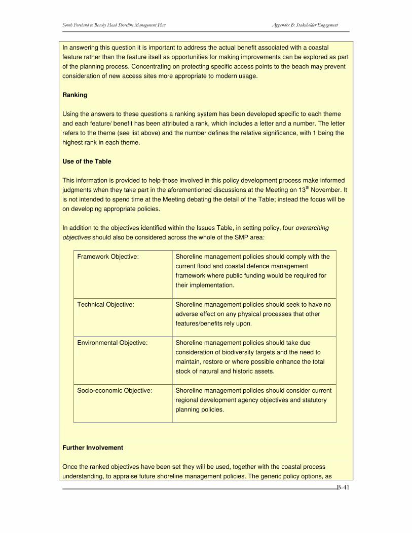
����������� ������������ ��������������������� ���� ������������ �����������
�
�
�
����
In answering this question it is important to address the actual benefit associated with a coastal feature rather than the feature itself as opportunities for making improvements can be explored as part of the planning process. Concentrating on protecting specific access points to the beach may prevent consideration of new access sites more appropriate to modern usage.
Ranking
Using the answers to these questions a ranking system has been developed specific to each theme and each feature/ benefit has been attributed a rank, which includes a letter and a number. The letter refers to the theme (see list above) and the number defines the relative significance, with 1 being the highest rank in each theme.
Use of the Table
This information is provided to help those involved in this policy development process make informed judgments when they take part in the aforementioned discussions at the Meeting on 13th November. It is not intended to spend time at the Meeting debating the detail of the Table; instead the focus will be on developing appropriate policies.
In addition to the objectives identified within the Issues Table, in setting policy, four overarching objectives should also be considered across the whole of the SMP area:
Framework Objective: Shoreline management policies should comply with the current flood and coastal defence management framework where public funding would be required for their implementation.
Technical Objective: Shoreline management policies should seek to have no adverse effect on any physical processes that other features/benefits rely upon.
Environmental Objective: Shoreline management policies should take due consideration of biodiversity targets and the need to maintain, restore or where possible enhance the total stock of natural and historic assets.
Socio-economic Objective: Shoreline management policies should consider current regional development agency objectives and statutory planning policies.
Further Involvement
Once the ranked objectives have been set they will be used, together with the coastal process understanding, to appraise future shoreline management policies. The generic policy options, as
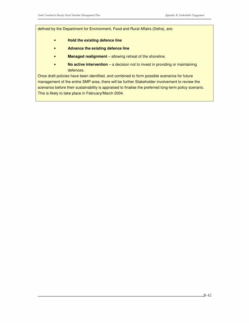
����������� ������������ ��������������������� ���� ������������ �����������
�
�
�
����
defined by the Department for Environment, Food and Rural Affairs (Defra), are:
• Hold the existing defence line
• Advance the existing defence line
• Managed realignment – allowing retreat of the shoreline.
• No active intervention – a decision not to invest in providing or maintaining defences.
Once draft policies have been identified, and combined to form possible scenarios for future management of the entire SMP area, there will be further Stakeholder involvement to review the scenarios before their sustainability is appraised to finalise the preferred long-term policy scenario. This is likely to take place in February/March 2004.

����������� ������������ ��������������������� ���� ������������ �����������
�
�
�
����
B.8 Summary Note from 13th November 2003 Forum SOUTH FORELAND TO BEACHY HEAD SHORELINE MANAGEMENT PLAN
ELECTED MEMBERS FORUM
Date/Time: 13 November 2003
Location: County Hall, Maidstone, Kent
In Attendance:
Elected Members:
Cllr Pauline Stockwell – Kent County Council (Chairman)
Cllr Carol Crees – Shepway DC
Martin Tapp – Kent Local Flood Defence Committee
Cllr Robin Patten – Rother DC
Cllr Meg Stroud – East Sussex CC
Others:
Abigail Raymond – Kent County Council
Chris Pater – English Nature
Simon Herrington – Shepway DC
Phillipa Harrison – Environment Agency
Andrea Richmond – Halcrow
Kevin Burgess – Halcrow
Apologies:
Cllr Roger Thomas,
Adam Hosking
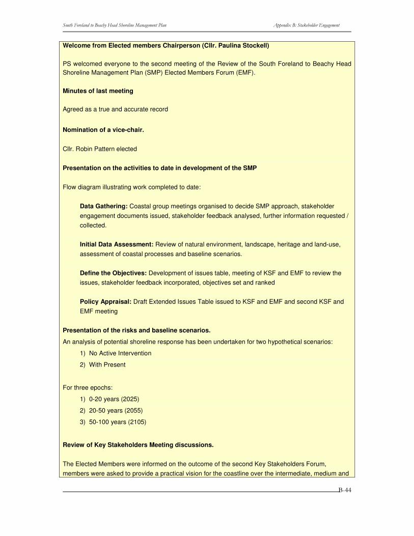
����������� ������������ ��������������������� ���� ������������ �����������
�
�
�
����
Welcome from Elected members Chairperson (Cllr. Paulina Stockell)
PS welcomed everyone to the second meeting of the Review of the South Foreland to Beachy Head Shoreline Management Plan (SMP) Elected Members Forum (EMF).
Minutes of last meeting
Agreed as a true and accurate record
Nomination of a vice-chair.
Cllr. Robin Pattern elected
Presentation on the activities to date in development of the SMP
Flow diagram illustrating work completed to date:
Data Gathering: Coastal group meetings organised to decide SMP approach, stakeholder engagement documents issued, stakeholder feedback analysed, further information requested / collected.
Initial Data Assessment: Review of natural environment, landscape, heritage and land-use, assessment of coastal processes and baseline scenarios.
Define the Objectives: Development of issues table, meeting of KSF and EMF to review the issues, stakeholder feedback incorporated, objectives set and ranked
Policy Appraisal: Draft Extended Issues Table issued to KSF and EMF and second KSF and EMF meeting
Presentation of the risks and baseline scenarios.
An analysis of potential shoreline response has been undertaken for two hypothetical scenarios:
1) No Active Intervention
2) With Present
For three epochs:
1) 0-20 years (2025)
2) 20-50 years (2055)
3) 50-100 years (2105)
Review of Key Stakeholders Meeting discussions.
The Elected Members were informed on the outcome of the second Key Stakeholders Forum, members were asked to provide a practical vision for the coastline over the intermediate, medium and
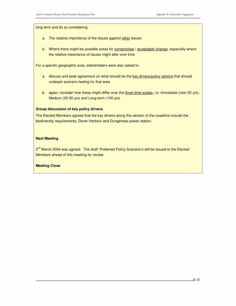
����������� ������������ ��������������������� ���� ������������ �����������
�
�
�
����
long term and do so considering:
a. The relative importance of the issues against other issues
b. Where there might be possible areas for compromise / acceptable change, especially where the relative importance of issues might alter over time
For a specific geographic area, stakeholders were also asked to:
a. discuss and seek agreement on what should be the key drivers/policy options that should underpin scenario testing for that area
b. again, consider how these might differ over the three time-scales, i.e. Immediate (next 20 yrs), Medium (20-50 yrs) and Long-term (100 yrs)
Group discussion of key policy drivers.
The Elected Members agreed that the key drivers along this section of the coastline include the biodiversity requirements, Dover Harbour and Dungeness power station.
Next Meeting
2nd March 2004 was agreed. The draft ‘Preferred Policy Scenario’s will be issued to the Elected Members ahead of this meeting for review.
Meeting Close

����������� ������������ ��������������������� ���� ������������ �����������
�
�
�
���
����������� ������������ ��������������������� ���� ������������ �����������
�
�
�
���
B.9 Briefing Note for 22nd April 2004 Forum SOUTH FORELAND TO BEACHY HEAD SHORELINE MANAGEMENT PLAN
Elected Members Forum Meeting
Thursday 22nd April 2004, 6:30pm,
Medway Room, County Hall, Maidstone, Kent
AGENDA
Welcome from South East Coastal Group
PS welcomed everyone to the first meeting of the Review of the South Foreland to Beachy Head Shoreline Management Plan (SMP) Elected Members Forum (EMF)
Introductions from EMF Representatives
A general introduction to the SMP, why the South Foreland to Beachy Head SMP is being updated, progress to date and the baseline coastal evolution scenarios i.e. No Active Intervention and With Present Management.
Background to SMPs and Progress to Date
A general introduction to the SMP, why the South Foreland to Beachy Head SMP is being updated, progress to date and the baseline coastal evolution scenarios i.e. No Active Intervention and With Present Management.
Review of role of the Elected Members Forum
An overview of the Elected members remit and what is expected from the members for this meeting.
Discussion and Agreement of Recommended Policies
A summary table of the 'Recommended Policies’ derived from work to date and consultations with the Key Stakeholders, Steering Group Meeting members are subject for your review. For background and clarification purposes an Extended Issues Table, this is being constantly revised. is attached as the Extended Issues Table has been a key source of information in developing policies
What happens next?
SMP development – the next stages
Next Meeting?
Date to be decided

����������� ������������ ��������������������� ���� ������������ �����������
�
�
�
����
����������� ������������ ��������������������� ���� ������������ �����������
�
�
�
����
B.10 Summary Note from 22nd April 2004 Forum SOUTH FORELAND TO BEACHY HEAD SHORELINE MANAGEMENT PLAN
Elected Members Forum Meeting
Thursday 22nd April 2004, 6:30pm,
Medway Room, County Hall, Maidstone, Kent
Introduction:
PS opened the meeting at 6.30pm and welcomed everyone to the Elected Members Forum, South Foreland to Beachy Head Shoreline Management Plan, meeting.
Each attendee introduced who they were and which organisation they were affiliated to.
Minutes
Agreed to be true and accurate from the last meeting.
Background to SMP’s and Progress to Date:
A general introduction to the SMP, why the South Foreland to Beachy Head SMP is being updated, progress to date and the baseline coastal evolution scenarios i.e. No Active Intervention and With Present Management.
Review of role of the Elected Members Forum
An overview of the Elected members remit and what is expected from the members for this meeting. The members decided that the purpose of the meeting was to agree the draft policies for public consultation (not formal agreement of the policies themselves).
Discussion and Agreement of Recommended Policies
Presentation of the recommended policies in a west to east direction, following coastal processes, along the study frontage, with gave a justification for the management option proposed. Each policy was then reviewed by the group
What happens next?
The consultation approach was outlined i.e. a letter/summary will be sent to all identified consultees, the full draft SMP would then be on deposit with the developing authorities for three months. There will be press releases to notify the public of the consultation exercise.

����������� ������������ ��������������������� ���� ������������ �����������
�
�
�
���
Next meeting:
Two dates were proposed for the end September 2004 for the next Elected Members Forum meeting, depending on internal consultation.
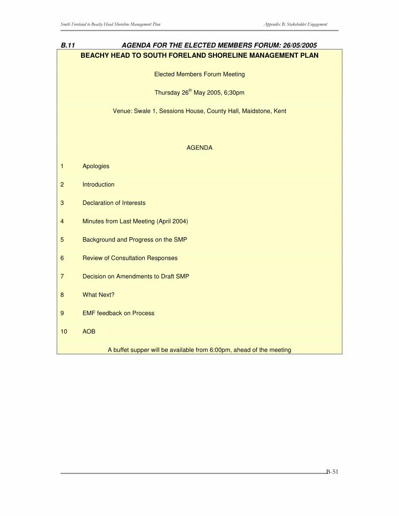
����������� ������������ ��������������������� ���� ������������ �����������
�
�
�
����
B.11 AGENDA FOR THE ELECTED MEMBERS FORUM: 26/05/2005 BEACHY HEAD TO SOUTH FORELAND SHORELINE MANAGEMENT PLAN
Elected Members Forum Meeting
Thursday 26th May 2005, 6;30pm
Venue: Swale 1, Sessions House, County Hall, Maidstone, Kent
AGENDA
1 Apologies
2 Introduction
3 Declaration of Interests
4 Minutes from Last Meeting (April 2004)
5 Background and Progress on the SMP
6 Review of Consultation Responses
7 Decision on Amendments to Draft SMP
8 What Next?
9 EMF feedback on Process
10 AOB
A buffet supper will be available from 6:00pm, ahead of the meeting
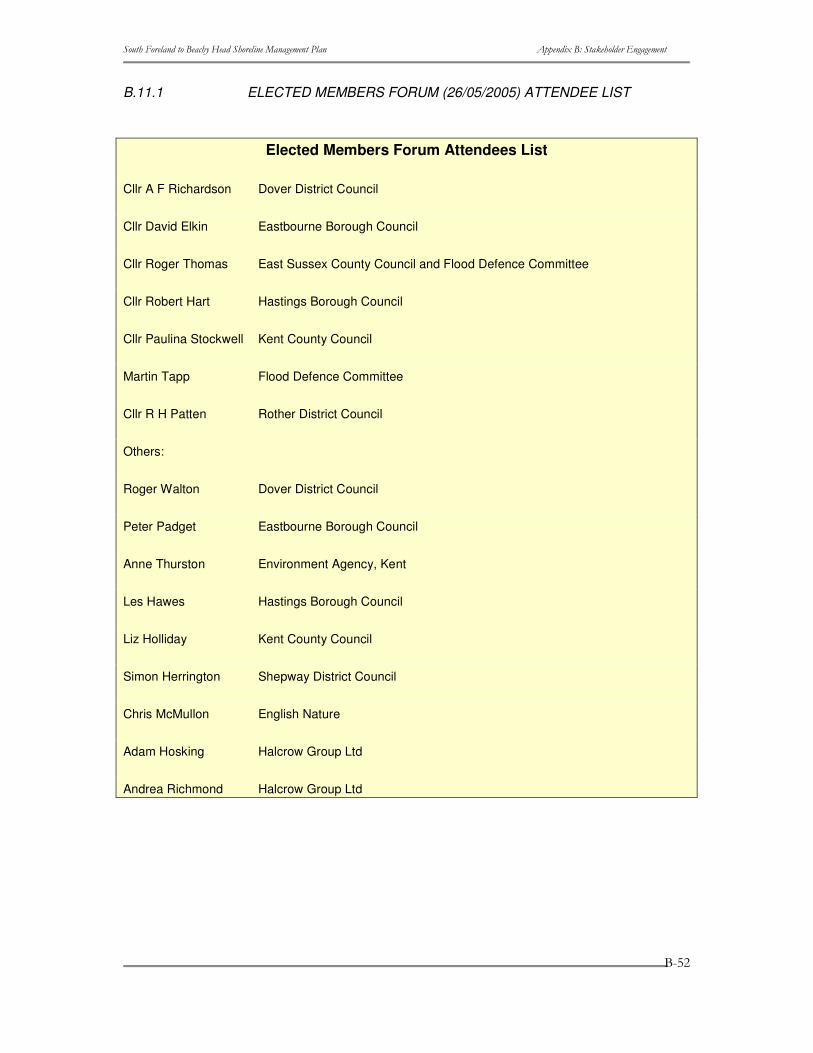
����������� ������������ ��������������������� ���� ������������ �����������
�
�
�
����
B.11.1 ELECTED MEMBERS FORUM (26/05/2005) ATTENDEE LIST
Elected Members Forum Attendees List
Cllr A F Richardson Dover District Council
Cllr David Elkin Eastbourne Borough Council
Cllr Roger Thomas East Sussex County Council and Flood Defence Committee
Cllr Robert Hart Hastings Borough Council
Cllr Paulina Stockwell Kent County Council
Martin Tapp Flood Defence Committee
Cllr R H Patten Rother District Council
Others:
Roger Walton Dover District Council
Peter Padget Eastbourne Borough Council
Anne Thurston Environment Agency, Kent
Les Hawes Hastings Borough Council
Liz Holliday Kent County Council
Simon Herrington Shepway District Council
Chris McMullon English Nature
Adam Hosking Halcrow Group Ltd
Andrea Richmond Halcrow Group Ltd
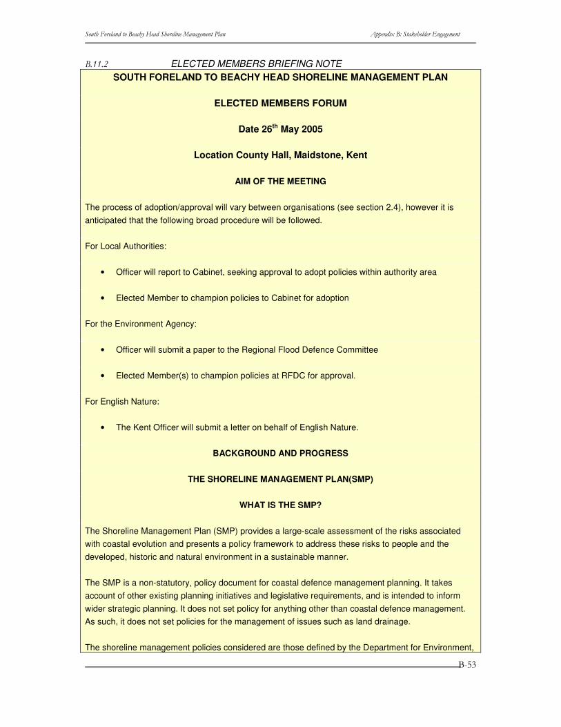
����������� ������������ ��������������������� ���� ������������ �����������
�
�
�
����
������ ELECTED MEMBERS BRIEFING NOTE�SOUTH FORELAND TO BEACHY HEAD SHORELINE MANAGEMENT PLAN
ELECTED MEMBERS FORUM
Date 26th May 2005
Location County Hall, Maidstone, Kent
AIM OF THE MEETING
The process of adoption/approval will vary between organisations (see section 2.4), however it is anticipated that the following broad procedure will be followed.
For Local Authorities:
• Officer will report to Cabinet, seeking approval to adopt policies within authority area
• Elected Member to champion policies to Cabinet for adoption
For the Environment Agency:
• Officer will submit a paper to the Regional Flood Defence Committee
• Elected Member(s) to champion policies at RFDC for approval.
For English Nature:
• The Kent Officer will submit a letter on behalf of English Nature.
BACKGROUND AND PROGRESS
THE SHORELINE MANAGEMENT PLAN(SMP)
WHAT IS THE SMP?
The Shoreline Management Plan (SMP) provides a large-scale assessment of the risks associated with coastal evolution and presents a policy framework to address these risks to people and the developed, historic and natural environment in a sustainable manner.
The SMP is a non-statutory, policy document for coastal defence management planning. It takes account of other existing planning initiatives and legislative requirements, and is intended to inform wider strategic planning. It does not set policy for anything other than coastal defence management. As such, it does not set policies for the management of issues such as land drainage.
The shoreline management policies considered are those defined by the Department for Environment,
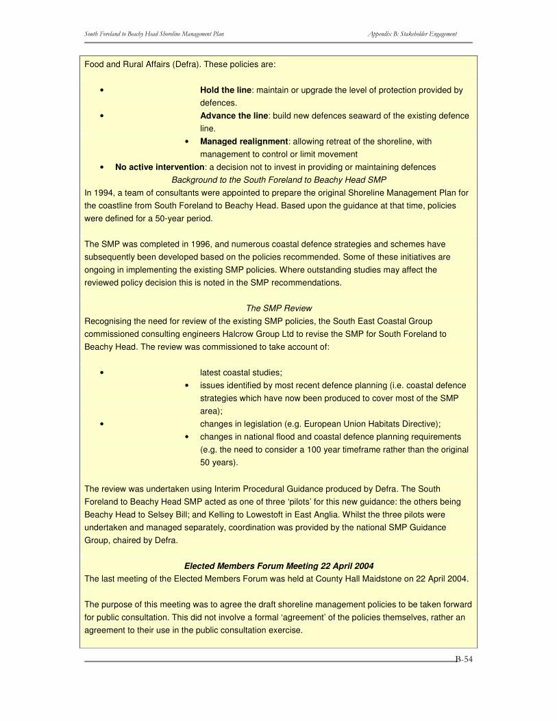
����������� ������������ ��������������������� ���� ������������ �����������
�
�
�
����
Food and Rural Affairs (Defra). These policies are:
• Hold the line: maintain or upgrade the level of protection provided by defences.
• Advance the line: build new defences seaward of the existing defence line.
• Managed realignment: allowing retreat of the shoreline, with management to control or limit movement
• No active intervention: a decision not to invest in providing or maintaining defences Background to the South Foreland to Beachy Head SMP
In 1994, a team of consultants were appointed to prepare the original Shoreline Management Plan for the coastline from South Foreland to Beachy Head. Based upon the guidance at that time, policies were defined for a 50-year period.
The SMP was completed in 1996, and numerous coastal defence strategies and schemes have subsequently been developed based on the policies recommended. Some of these initiatives are ongoing in implementing the existing SMP policies. Where outstanding studies may affect the reviewed policy decision this is noted in the SMP recommendations.
The SMP Review Recognising the need for review of the existing SMP policies, the South East Coastal Group commissioned consulting engineers Halcrow Group Ltd to revise the SMP for South Foreland to Beachy Head. The review was commissioned to take account of:
• latest coastal studies; • issues identified by most recent defence planning (i.e. coastal defence
strategies which have now been produced to cover most of the SMP area);
• changes in legislation (e.g. European Union Habitats Directive); • changes in national flood and coastal defence planning requirements
(e.g. the need to consider a 100 year timeframe rather than the original 50 years).
The review was undertaken using Interim Procedural Guidance produced by Defra. The South Foreland to Beachy Head SMP acted as one of three ‘pilots’ for this new guidance: the others being Beachy Head to Selsey Bill; and Kelling to Lowestoft in East Anglia. Whilst the three pilots were undertaken and managed separately, coordination was provided by the national SMP Guidance Group, chaired by Defra.
Elected Members Forum Meeting 22 April 2004 The last meeting of the Elected Members Forum was held at County Hall Maidstone on 22 April 2004.
The purpose of this meeting was to agree the draft shoreline management policies to be taken forward for public consultation. This did not involve a formal ‘agreement’ of the policies themselves, rather an agreement to their use in the public consultation exercise.
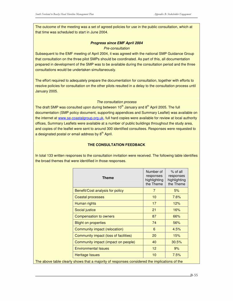
����������� ������������ ��������������������� ���� ������������ �����������
�
�
�
����
The outcome of the meeting was a set of agreed policies for use in the public consultation, which at that time was scheduled to start in June 2004.
Progress since EMF April 2004 Pre-consultation
Subsequent to the EMF meeting of April 2004, it was agreed with the national SMP Guidance Group that consultation on the three pilot SMPs should be coordinated. As part of this, all documentation prepared in development of the SMP was to be available during the consultation period and the three consultations would be undertaken simultaneously.
The effort required to adequately prepare the documentation for consultation, together with efforts to resolve policies for consultation on the other pilots resulted in a delay to the consultation process until January 2005.
The consultation process The draft SMP was consulted upon during between 10th January and 8th April 2005. The full documentation (SMP policy document, supporting appendices and Summary Leaflet) was available on the internet at www.se-coastalgroup.org.uk, full hard copies were available for review at local authority offices, Summary Leaflets were available at a number of public buildings throughout the study area, and copies of the leaflet were sent to around 300 identified consultees. Responses were requested to a designated postal or email address by 8th April.
THE CONSULTATION FEEDBACK
In total 133 written responses to the consultation invitation were received. The following table identifies the broad themes that were identified in those responses.
Theme
Number of responses highlighting the Theme
% of all responses highlighting the Theme
Benefit/Cost analysis for policy 7 5%
Coastal processes 10 7.6%
Human rights 17 12%
Social justice 21 16%
Compensation to owners 87 66%
Blight on properties 74 56%
Community impact (relocation) 6 4.5%
Community impact (loss of facilities) 20 15%
Community impact (impact on people) 40 30.5%
Environmental Issues 12 9%
Heritage Issues 10 7.5% The above table clearly shows that a majority of responses considered the implications of the
����������� ������������ ��������������������� ���� ������������ �����������
�
�
�
���
proposed policies to be a major obstacle to their acceptance.
A ‘Consultation Report’ summarising the feedback, both generic issues and Policy Unit specific has been prepared and was discussed at a Client Steering Group meeting on 15th April 2005. At that meeting the CSG agreed to a number of amendments to the draft plan in line with the consultation feedback, together with the results of some of the ongoing studies (as mentioned in section 2.1.2 above).
Importantly, the CSG identified that it was not in a position to make any amendments to the draft Plan on the grounds of issues such as ‘Property Blight’ or ‘Compensation to owners’ as these were outside of its control. However, these issues were highlighted to be raised with the national SMP guidance group.
Where the consultation responses, or ongoing studies, identified new information that affected policy decisions appropriate refinements to the draft policy have been suggested.
The locations where policies (or policy statements) are to be refined or changed are as follow:
• Hythe Ranges: to remain Hold for short term and Managed Realignment thereafter, on basis that there is a definite (MoD) need for the ranges in first epoch but unknown thereafter.
• Lydd Ranges: remain Managed Realignment but clarify that appropriate protection of MoD assets will be provided in first epoch (based upon a known short term need), but not necessarily by defences along current shoreline. Will clarify that this section includes Coastguard Cottages. In medium and long term a more substantial realignment will be promoted to realise conservation benefits, on an assumption that the MoD will not require the ranges in this timescale (currently only have short term need defined). The ongoing Coast Defence Strategy Study will resolve actual defence positions and standards of protection.
• Jury's Gap to The Suttons, Camber: currently some uncertainty over sustainability of options for this frontage, which are being investigated in the ongoing Coast Defence Strategy Review. However, propose to retain Hold as the recommended policy, but state that realignment might be necessary in order to achieve a sustainable coastline position, linked to potential further realignment on Lydd Ranges. The ongoing Strategy Study will further consider the issues associated with resolution of the appropriate management approach for this frontage, such that policy could change.
• Fairlight East (Sea Road): retain Managed Realignment for all three epochs, clarifying that the coast will naturally continue to retreat throughout the 100-year period this even with maintenance of the existing defence throughout its design life (the structure was not
����������� ������������ ��������������������� ���� ������������ �����������
�
�
�
���
designed to stop erosion, but limit it).
• Fairlight Central (Rockmead Road): Change policy to Hold in the short and medium term, with Managed Realignment in the long term. The Fairlight Scoping Study has demonstrated that a coast protection scheme may be economically viable and that it may be environmentally acceptable, pending further consideration through detailed review of the viability of a scheme. This work is ongoing, and the hold policy is recommended subject to the outcome of these detailed studies. It must also be recognised that central government funding for a hold policy is not guaranteed. There is a proposed change in policy in long term to Managed Realignment to recognise that hold is not the sustainable policy as the defence will disrupt alongshore drift; that sea level rise will make hold very difficult in long term; and realignment would reinstate the environmental interest. It must be recognised that the ongoing studies could change the policy recommendations for this frontage.
For all other frontages the policies and implications are recommended to remain unchanged from the draft SMP document (January 2005).
WHAT NEXT?
The SMP is to be adopted by the local authorities, formally approved by the Environment Agency/English Nature and agreed by Defra. It is important to ensure the SMP is recognised as a policy document and underline the Operating Authority’s commitment to monitor and review the plan. The method of formally adopting the SMP should be decided by each individual authority or organisation. The other partners listed above who are associated with ownership of the plan should make the other parties aware of their own arrangements.
B.12 Key Stakeholders Materials B.12.1 Introduction Below are a series of documents that were issued to the Key Stakeholders prior to each of the forums and the minutes that were circulated thereafter.
B.12.2 Issues Table review Background
The purpose of a Shoreline Management Plan (SMP) is to provide a large-scale assessment of the risks associated with coastal processes and to present a policy framework with the aim of reducing these risks to people and the developed, historic and natural environment in a sustainable way.
Underpinning the SMP is an understanding of the natural processes that are sculpting the shoreline, which is used to predict, so far as it is possible, the way in which the shoreline evolve in the future.
Following the coastal process assessments, the plan then identifies the main issues of concern
����������� ������������ ��������������������� ���� ������������ �����������
�
�
�
����
relating to current/future erosion and flooding risks and their management. These issues are obtained from those with an interest in the coast, the stakeholders. The issues are then rationalised to define ‘objectives’ for the future management of the shoreline. The objectives are than ranked, based upon their scale and importance.
These objectives will then be used to develop sustainable management policies, for the next 100 years.
Revision of the existing SMP
Shepway District Council, on behalf of the South East Coastal Group, has commissioned the Halcrow Group to prepare the revised SMP to cover shoreline management for the next 100 years. The Coastal Group members with responsibilities related to management of coastal defences between Beachy Head and South Foreland are Dover District Council, Shepway District Council, Wealden District Council, Rother District Council, Hastings Borough Council, Eastbourne Borough Council, the Environment Agency, Kent County Council, East Sussex County Council and English Nature. The SMP review has been commissioned to take account of:
• Latest coastal studies; • Issues identified by most recent defence planning (i.e. coastal defence strategy
plans which have now been produced to cover most of the SMP area); • Changes in legislation (e.g. European Union Habitats Directive); • Changes in national defence planning requirements (e.g. the need to consider 100-
year timescales in future coastal defence planning).
As part of this process, shoreline management issues have now been identified, and are presented in this report for review by Key Stakeholders.
Objective Setting
Approach
The SMP policy appraisal process needs to be guided by a set of relevant objectives that apply to each SMP area. These objectives fulfil two roles; firstly, they help inform the development of policy options, secondly, they help provide a focus for consensus amongst the SMP stakeholders and the various issues, sometimes conflicting, that are raised during the process of plan formulation.
The approach used focuses on the “benefits” or “services” (termed as benefits) that a feature (e.g. a harbour) contributes to a location, a region or the nation. This focus on benefits helps clarify why a feature on the coast may or may not require protection. This understanding of why a feature is important to stakeholders, either locally or nationally, helps ensure the process is transparent.
The key steps in this approach are set out below.
Step one - the Stakeholders: Identify all those parties who are stakeholders in the SMP. Decide how
����������� ������������ ��������������������� ���� ������������ �����������
�
�
�
����
they are to be involved in the SMP development process, and issue initial Stakeholder materials.
Step two - the Baseline: Using all available data and stakeholder feedback and given the coastal process understanding (both short and long term); identify the character of the area and the features present.
Step three - Identify Benefits: define the benefits of each feature identified in Step 2. Identify what benefits that feature actually offers in terms of Flood and Coastal Defence (e.g. recreation, economic health, regeneration, historic value along the coast etc.) and who receives the benefits.
Step four – Examine the benefits systematically using a series of questions:
• At what scales (spatial/temporal) is the benefit important? • Is there enough of the benefit? • Importance of the benefit at the SMP scale or greater? • Can the benefit be substituted?
Step five – Identify rank of each objective based on answers to these four questions.
Current Position
We are currently approaching the end of Step three, having identified (in draft) the features of importance along the Beachy Head to South Foreland shoreline and defined the benefits of those features. This has been developed from the Stakeholder feedback received and review of existing reports.
The tables provided at the end of this report present the issues as identified to data. These are described under the following headings:
• Location: A discrete point on the coast or a length of coastline between two defined points.
• Feature: Something tangible that provides a service to society in one form or another or, more simply, benefits certain aspects of society by its very existence.
• Issue associated with Feature: Issues will occur where either the aspirations of Stakeholders conflict or where a feature is at risk from flooding or erosion. Grouped or categorised under the three main themes: Technical; Environmental; or Socio-economic
• Flood and Coastal Defence (FCD) issue? Identifies whether the feature, and its associated issues, of direct relevance to flood and coastal defence management.
• Affect Policy? If a FCD issues, this identifies whether the issue would affect the choice of policy or if it relates to implementation of the policy?
• Why is issue important? Identifies the actual tangible benefits of the feature.
• Who are the beneficiaries? Defines who actually benefits from the feature in question.
����������� ������������ ��������������������� ���� ������������ �����������
�
�
�
��
Stakeholder Meetings September 2003
The meetings on Thursday 11 September are important in providing a detailed review of these draft issues. Only once feedback has been gained from the Key Stakeholders Forum and Elected Members Forum will the issues be finalised and Stage four started.
A large section of these meetings is given over to the discussion and agreement of these issues. If possible, we would ask that you review the issues before the meeting to ensure that all shoreline management issues that you are aware of are accurately reflected, so omissions/inaccuracies can be raised at the meeting.
What next?
Prioritising Objectives
Once the issues are finalised, we will move on to the definition of ‘benefit objectives’ and examining each benefit through the four key questions (Step four) to identify the priority of each objective (Step five).
Each issue will have an associated objective that will relate to both the feature and its benefits. For each of these the following four questions will be reviewed:
• At what scales (spatial/temporal) is the benefit important? If the feature were lost tomorrow, at what (spatial) scale would there be an impact? Also, is the feature, or benefit, of finite temporal importance (i.e. less than 100 years?).
• Is there enough of the benefit? Scarcity of the benefit at the scale at which it is important.
• Importance of the benefit at the SMP scale or greater? If the feature were lost tomorrow, what would the impact be?
• Can the benefit be substituted? Can the benefit can be replaced at the appropriate scale.
Based on the answers to these questions, a priority, or rank, will then be set for each objective in relation to its importance to shoreline management planning.
It is clearly critical that the ranking of objectives is correct, as this will directly affect the selection of shoreline management policies in the next stage of SMP development. As such, we will be having a second meeting of both the Key Stakeholders Forum and Elected Members Forum once this step has been undertaken, to review the objectives and priorities defined.
We will also take the opportunity during the September meetings to review the approach to objective ranking, and receive comments from Stakeholders on how they feel the four key questions should be answered for the various issues present in this area (e.g. nature conservation, commercial interests, housing, recreation, etc.).
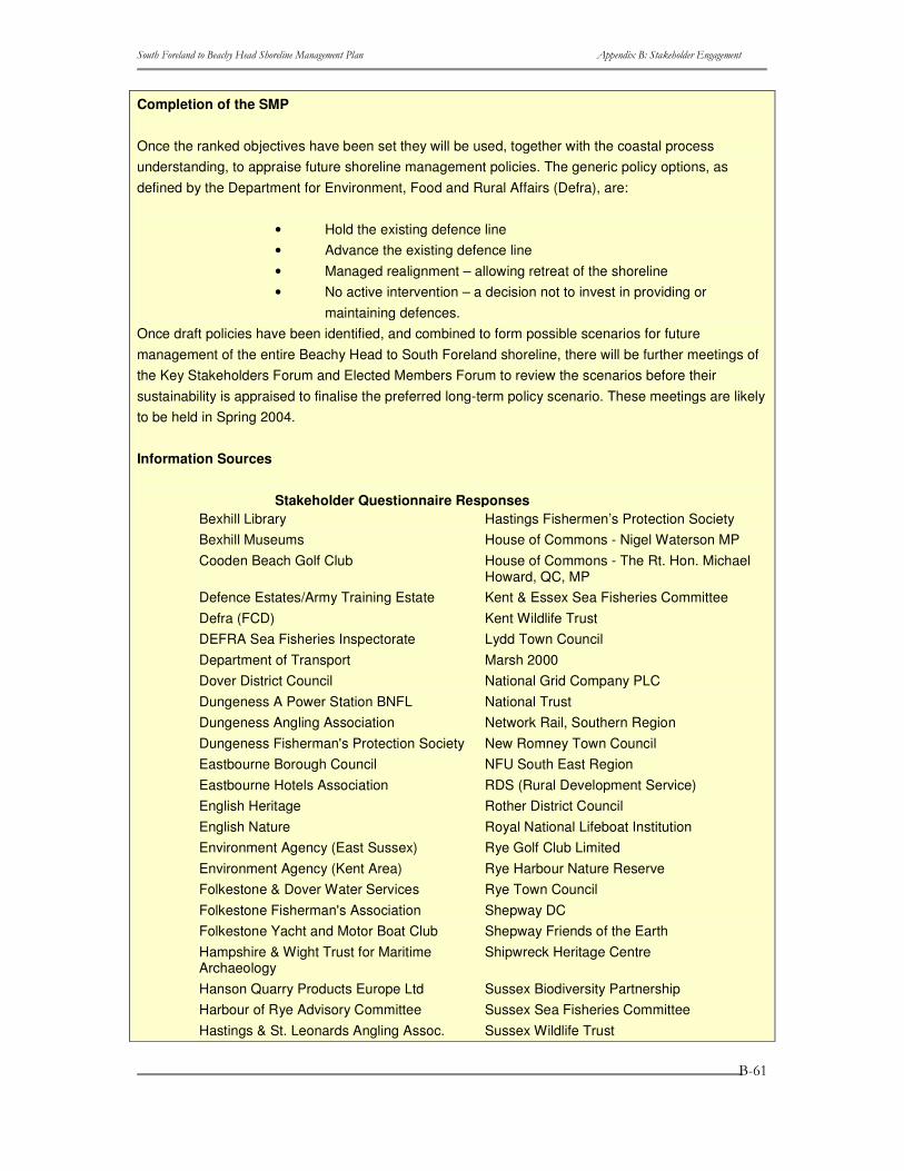
����������� ������������ ��������������������� ���� ������������ �����������
�
�
�
���
Completion of the SMP
Once the ranked objectives have been set they will be used, together with the coastal process understanding, to appraise future shoreline management policies. The generic policy options, as defined by the Department for Environment, Food and Rural Affairs (Defra), are:
• Hold the existing defence line • Advance the existing defence line • Managed realignment – allowing retreat of the shoreline • No active intervention – a decision not to invest in providing or
maintaining defences. Once draft policies have been identified, and combined to form possible scenarios for future management of the entire Beachy Head to South Foreland shoreline, there will be further meetings of the Key Stakeholders Forum and Elected Members Forum to review the scenarios before their sustainability is appraised to finalise the preferred long-term policy scenario. These meetings are likely to be held in Spring 2004.
Information Sources
Stakeholder Questionnaire Responses Bexhill Library Hastings Fishermen’s Protection Society Bexhill Museums House of Commons - Nigel Waterson MP Cooden Beach Golf Club House of Commons - The Rt. Hon. Michael
Howard, QC, MP Defence Estates/Army Training Estate Kent & Essex Sea Fisheries Committee Defra (FCD) Kent Wildlife Trust DEFRA Sea Fisheries Inspectorate Lydd Town Council Department of Transport Marsh 2000 Dover District Council National Grid Company PLC Dungeness A Power Station BNFL National Trust Dungeness Angling Association Network Rail, Southern Region Dungeness Fisherman's Protection Society New Romney Town Council Eastbourne Borough Council NFU South East Region Eastbourne Hotels Association RDS (Rural Development Service) English Heritage Rother District Council English Nature Royal National Lifeboat Institution Environment Agency (East Sussex) Rye Golf Club Limited Environment Agency (Kent Area) Rye Harbour Nature Reserve Folkestone & Dover Water Services Rye Town Council Folkestone Fisherman's Association Shepway DC Folkestone Yacht and Motor Boat Club Shepway Friends of the Earth Hampshire & Wight Trust for Maritime Archaeology
Shipwreck Heritage Centre
Hanson Quarry Products Europe Ltd Sussex Biodiversity Partnership Harbour of Rye Advisory Committee Sussex Sea Fisheries Committee Hastings & St. Leonards Angling Assoc. Sussex Wildlife Trust

����������� ������������ ��������������������� ���� ������������ �����������
�
�
�
���
Hastings & St. Leonards Rowing Club The Countryside Agency Hastings BC (Sea front Services) The Crown Estate Hastings BC (Senior Project Engineer) Wealden District Council
����������� ������������ ��������������������� ���� ������������ �����������
�
�
�
���
B.13 Briefing Note for September 2003 Forum SOUTH FORELAND TO BEACHY HEAD SHORELINE MANAGEMENT PLAN
Key Stakeholders Forum Meeting
Thursday 11th September 2003, 2:00pm, Russell Hotel Maidstone, Kent
AGENDA
Welcome from South East Coastal Group (Simon Herrington, Shepway DC)
Simon will open the meeting, giving a brief background to the SMP and the South East Coastal Group. He will then invite the attendees to briefly introduce themselves, for the benefit of all attending.
Introductions from KSF Representatives
A brief statement of who, what organisation, position (e.g. Portfolio holder), and, probably, why interested in coast.
Background to Shoreline Management Plans (Adam Hosking, Halcrow Group)
Presentation outlining aims and approach of the SMP review.
SMP Stakeholder Involvement Strategy (Terry Oakes, Terry Oakes Associates)
Presentation outlining the role of the Key Stakeholders Forum and raising some points for the delegates to discuss/agree.
Approach to issues identification (Terry Oakes)
Presentation briefly identifying how study team have gone about identifying the issue presented in the report circulated to attendees ahead of the meeting (sent with agenda, directions, etc). Explanation of the importance of the issues and how they influence the definition of objectives, which are then central to policy selection.
Break-out Session to Review Issues
Groups proposed on theme and location interests: Regional Environment, Regional Other, Area West, Area Central and Area East
Feedback from Group Leaders
Feedback on the issues (i.e. do they / do they not affect policy?) the features the issues relate to and why this feature is important (i.e. who are the beneficiaries?)
'What next?' in the SMP (Adam Hosking)
Presentation on taking issues forward to define and rank shoreline management objectives for the SMP.
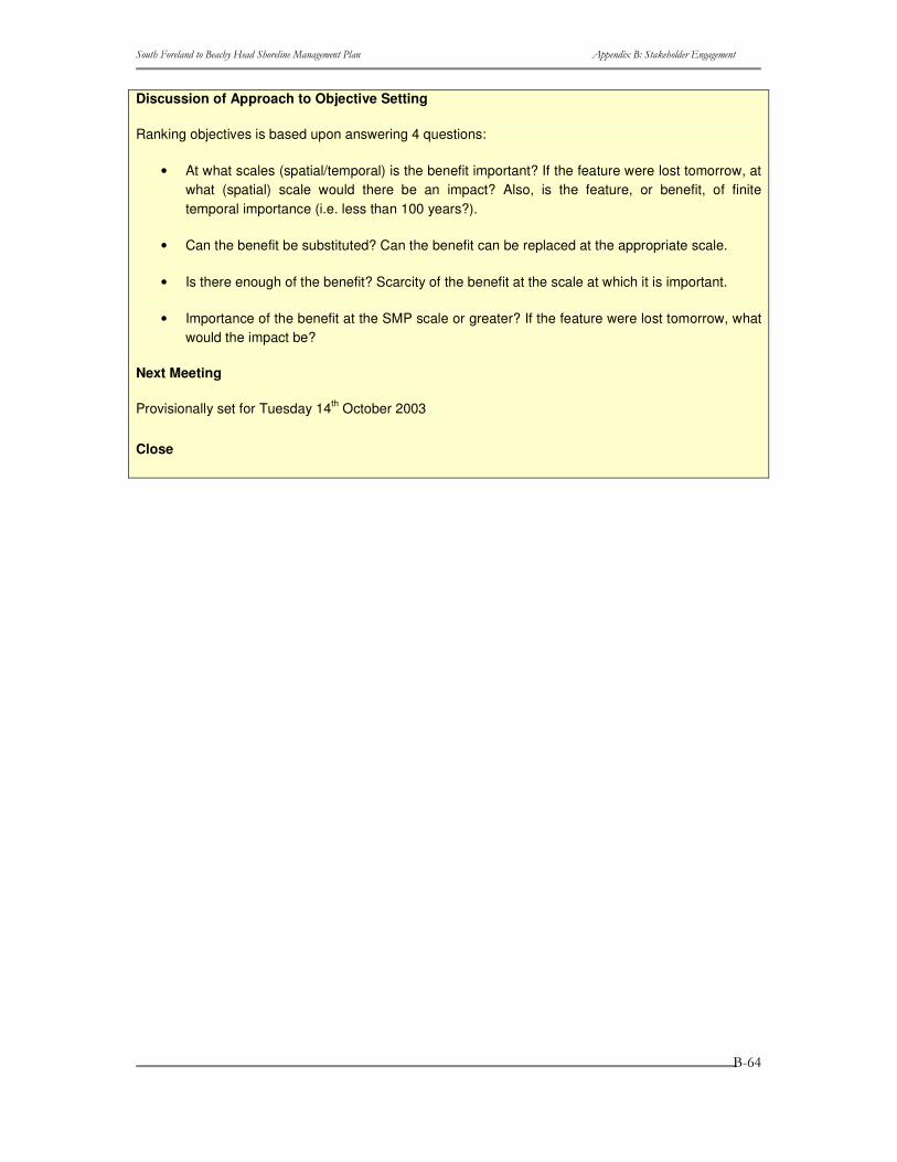
����������� ������������ ��������������������� ���� ������������ �����������
�
�
�
���
Discussion of Approach to Objective Setting
Ranking objectives is based upon answering 4 questions:
• At what scales (spatial/temporal) is the benefit important? If the feature were lost tomorrow, at what (spatial) scale would there be an impact? Also, is the feature, or benefit, of finite temporal importance (i.e. less than 100 years?).
• Can the benefit be substituted? Can the benefit can be replaced at the appropriate scale.
• Is there enough of the benefit? Scarcity of the benefit at the scale at which it is important.
• Importance of the benefit at the SMP scale or greater? If the feature were lost tomorrow, what would the impact be?
Next Meeting
Provisionally set for Tuesday 14th October 2003
Close
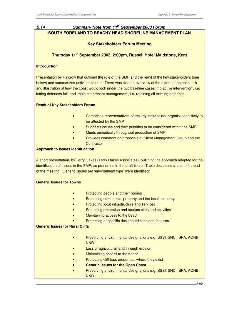
����������� ������������ ��������������������� ���� ������������ �����������
�
�
�
���
B.14 Summary Note from 11th September 2003 Forum SOUTH FORELAND TO BEACHY HEAD SHORELINE MANAGEMENT PLAN
Key Stakeholders Forum Meeting
Thursday 11th September 2003, 2:00pm, Russell Hotel Maidstone, Kent
Introduction
Presentation by Halcrow that outlined the role of the SMP and the remit of the key stakeholders (see below) and summarized activities to date. There was also an overview of the extent of potential risk and illustration of how the coast would look under the two baseline cases: ‘no active intervention’, i.e. letting defences fail, and ‘maintain present management’, i.e. retaining all existing defences.
Remit of Key Stakeholders Forum
• Comprises representatives of the key stakeholder organisations likely to be affected by the SMP
• Suggests issues and their priorities to be considered within the SMP • Meets periodically throughout production of SMP • Provides comment on proposals of Client Management Group and the
Contractor Approach to Issues Identification
A short presentation, by Terry Oakes (Terry Oakes Associates), outlining the approach adopted for the identification of issues in the SMP, as presented in the draft Issues Table document circulated ahead of the meeting. Generic issues per ‘environment type’ were identified:
Generic Issues for Towns
• Protecting people and their homes • Protecting commercial property and the local economy • Protecting local infrastructure and services • Protecting recreation and tourism sites and activities • Maintaining access to the beach • Protecting of specific designated sites and features
Generic Issues for Rural Cliffs
• Preserving environmental designations e.g. SSSI, SNCI, SPA, AONB, NNR
• Loss of agricultural land through erosion • Maintaining access to the beach • Protecting cliff tops properties, where they exist • Generic Issues for the Open Coast • Preserving environmental designations e.g. SSSI, SNCI, SPA, AONB,
NNR
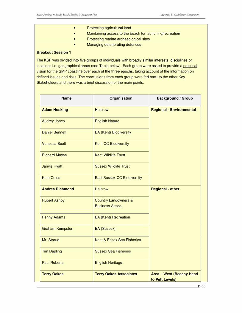
����������� ������������ ��������������������� ���� ������������ �����������
�
�
�
��
• Protecting agricultural land • Maintaining access to the beach for launching/recreation • Protecting marine archaeological sites • Managing deteriorating defences
Breakout Session 1
The KSF was divided into five groups of individuals with broadly similar interests, disciplines or locations i.e. geographical areas (see Table below). Each group were asked to provide a practical vision for the SMP coastline over each of the three epochs, taking account of the information on defined issues and risks. The conclusions from each group were fed back to the other Key Stakeholders and there was a brief discussion of the main points.
Name Organisation Background / Group
Adam Hosking Halcrow
Audrey Jones English Nature
Daniel Bennett EA (Kent) Biodiversity
Vanessa Scott Kent CC Biodiversity
Richard Moyse Kent Wildlife Trust
Janyis Hyatt Sussex Wildlife Trust
Kate Coles East Sussex CC Biodiversity
Regional - Environmental
Andrea Richmond Halcrow
Rupert Ashby Country Landowners & Business Assoc.
Penny Adams EA (Kent) Recreation
Graham Kempster EA (Sussex)
Mr. Stroud Kent & Essex Sea Fisheries
Tim Dapling Sussex Sea Fisheries
Paul Roberts English Heritage
Regional - other
Terry Oakes Terry Oakes Associates Area – West (Beachy Head to Pett Levels)

����������� ������������ ��������������������� ���� ������������ �����������
�
�
�
��
Rupert Clubb EA (Sussex) Regional
Les Hawes Hastings BC
Nick Waite Rother DC Planning
Dave Glover Wealden DC
Peter Padget Eastbourne BC
to Pett Levels)
Andrew Pearce EA (Kent) Regional
Ruth Newsum EA (Kent) Rye Harbour Master
Mark Douch EA (Kent) Floods
Cliff Doney British Nuclear Fuels
Jon Hickes MoD Defence Estates
Colonel George Smythe MoD Defence Estates
Liz Rowan MoD Defence Estates
Area – Central (Pett Levels to Hythe)
Simon Herrington Shepway DC (Construction)
Roger Walton Dover DC
Phillipa Harrison EA (Kent) Regional
Nicola Jenkins Dover Harbour Board
Abby Raymond Kent County Council
Area – East (Hythe to South Foreland)
Breakout Session 2
In the afternoon the KSF were asked to consider the different viewpoints highlighted from the morning session and seek a level of agreement on what should be the key drivers/policy options that need to underpin scenario testing for specific sections of coast. The conclusions of each group were fed back to the rest of the Key Stakeholders highlighting areas of agreement and conflict.
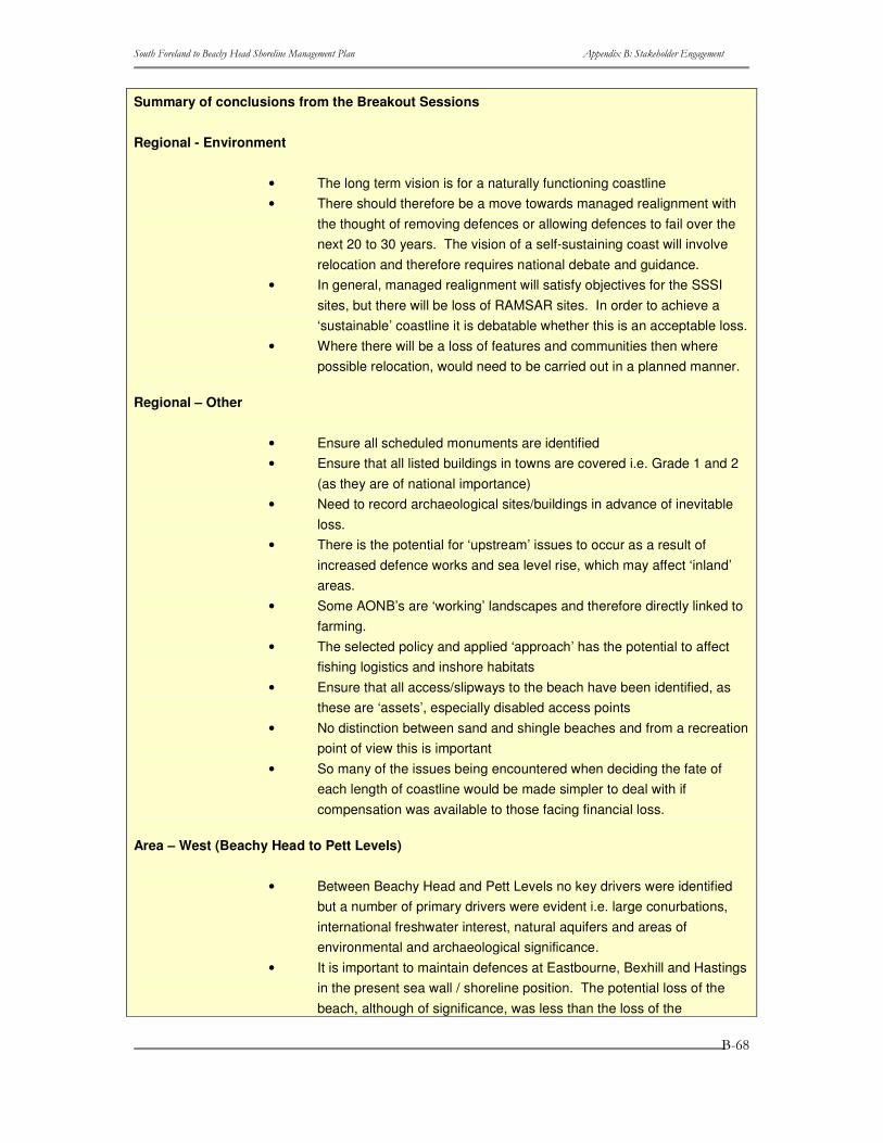
����������� ������������ ��������������������� ���� ������������ �����������
�
�
�
���
Summary of conclusions from the Breakout Sessions
Regional - Environment
• The long term vision is for a naturally functioning coastline • There should therefore be a move towards managed realignment with
the thought of removing defences or allowing defences to fail over the next 20 to 30 years. The vision of a self-sustaining coast will involve relocation and therefore requires national debate and guidance.
• In general, managed realignment will satisfy objectives for the SSSI sites, but there will be loss of RAMSAR sites. In order to achieve a ‘sustainable’ coastline it is debatable whether this is an acceptable loss.
• Where there will be a loss of features and communities then where possible relocation, would need to be carried out in a planned manner.
Regional – Other
• Ensure all scheduled monuments are identified • Ensure that all listed buildings in towns are covered i.e. Grade 1 and 2
(as they are of national importance) • Need to record archaeological sites/buildings in advance of inevitable
loss. • There is the potential for ‘upstream’ issues to occur as a result of
increased defence works and sea level rise, which may affect ‘inland’ areas.
• Some AONB’s are ‘working’ landscapes and therefore directly linked to farming.
• The selected policy and applied ‘approach’ has the potential to affect fishing logistics and inshore habitats
• Ensure that all access/slipways to the beach have been identified, as these are ‘assets’, especially disabled access points
• No distinction between sand and shingle beaches and from a recreation point of view this is important
• So many of the issues being encountered when deciding the fate of each length of coastline would be made simpler to deal with if compensation was available to those facing financial loss.
Area – West (Beachy Head to Pett Levels)
• Between Beachy Head and Pett Levels no key drivers were identified but a number of primary drivers were evident i.e. large conurbations, international freshwater interest, natural aquifers and areas of environmental and archaeological significance.
• It is important to maintain defences at Eastbourne, Bexhill and Hastings in the present sea wall / shoreline position. The potential loss of the beach, although of significance, was less than the loss of the
����������� ������������ ��������������������� ���� ������������ �����������
�
�
�
���
promenade, built sea front attractions and sustaining hinterland assets from flood and erosion risk.
• Allowing erosion to take place would see the loss of a substantial number of high quality residences, at Hooe and Pevensey Levels, to be lost within the short term. Residences within large conurbations would be lost in the medium term. This risk was deemed unacceptable.
• Significant environmental interests identified: Seaford to Beachy Head SSSI (chalk and greensand foreshore, chalk cliffs with geological and biological interest), Pevensey Levels SSSI and Ramsar site (extensive wetland, with internationally important bird and invertebrate interests, with vegetated shingle interest on the foreshore), Hasting Cliffs to Pett Beach SSSI (biological and geological interest, includes areas of woodland, heath, cliffs and vegetated shingle and Hastings Cliffs cSAC, within Hastings Cliffs to Pett Beach SSSI, (designated for its vegetated sea cliffs).
• It is important that communities are recognised but we don’t want our successors to be asking the same questions in 20 years time.
• We need to work out / formalise how we move from today to the long term. If we allow communities to retreat this involves planning issues and compensation issues.
• Further development should, in general, be prohibited within the zone shown to be at risk under the “Do Nothing” scenario.
• There was indecision over the policy for Hooe and Pevensey Levels, it was recognised that this was an area for realignment but implementing this could be difficult, expensive and the gain from doing so, could be potentially small. Despite the stakeholders recognising that it would probably become unsustainable to hold in the long term.
Area – Central (Pett Levels to Hythe)
• Between Hythe and Pett Levels Dungeness Power Station was identified as a key driver on this frontage and this therefore needs defending.
• There are significant environmental interests along this coast i.e. Rye Harbour SSSI (forms part of Dungeness to Pett Level SPA, Dungeness cSAC), Camber Sands and Rye Saltings SSSI, Dungeness SSSI (part of Dungeness to Pett Level SPA and Dungeness cSAC)- internationally important shingle foreland with associated habitats and Romney Warren SSSI (sand dune complex). It was recognised that these habitats should be maintained and where possible improved.
• Should managed realignment be implemented between Cliff End and Rye Terminal Groyne then a more detailed study into this area will be required, as we would be creating a new landscape. It is envisaged that this option would take place in the long-term, to tie in with the current scheme that is being implemented.
• There is uncertainty over how the coast will look and evolve and further

����������� ������������ ��������������������� ���� ������������ �����������
�
�
�
��
studies need to be carried out to improve our knowledge and understanding. Therefore would accept holding the line in the short to medium term, whilst further research is being carried out.
• Further development should, in general, be prohibited within the zone shown to be at risk under the “Do Nothing” scenario.
• There was indecision over implementing a policy for the stretch of coastline between Hythe and Romney Sands and Lydd Ranges and Camber Sands, it was recognised that this was an area for realignment but implementing this could be difficult, expensive and the gain from doing so, could be potentially small against the imminent flood inundation. The stakeholders recognised however that hold in the long term would become increasingly unsustainable and expensive.
Area – East (Hythe to South Foreland)
• Between South Foreland and Hythe two key drivers were identified (Dover Harbour and Samphire Hoe) as well as major infrastructure, commercial and residential properties. The defences to this frontage protect an important industrial area, communities, a tourism asset and vital infrastructure on which the town and country depend.
• Network Rail have commissioned a scheme of works that will protect their infrastructure for 50 years (hold the line)
• Folkestone Warren SSSI is of significant biological and geological interest.
• Dover (town and castle) is of significant archaeological importance. • Further development should, in general, be prohibited within the zone
shown to be at risk under the “Do Nothing” scenario.
General Discussion
• Over the next 20 years there should be no reduction in the present level of protection to communities but increased planning controls. However, the knock-on effect of this needs to be considered.
• Educating the public must start tomorrow. • Should we be allowing settlements to ‘roll back’ into adjacent areas? • There needs to be ‘buy in’ to the SMP process by local people • Need to think about what happens if communities want to self-fund a
defence measure in the future that may be at odds with processes. • There is a need to be consistent along the coast in terms of policy
evaluation • Need to ensure that development control aspects feed into the planning
process. • There is a willingness to accept change, e.g. loss of villages and town
properties, but this requires compensatory measures at both local planning and national government policy levels.
• There needs to be improved understanding of coastline with more modelling undertaken over the next 20 years.

����������� ������������ ��������������������� ���� ������������ �����������
�
�
�
���
• Extreme events (significant damage) could become more frequent in the future and ultimately change policy and public perception.
'What next?' in the SMP
• Finalise the issues table • Use process study to appraise potential future flooding and erosion
risks (over 20, 50 and 100 years) • Use ‘theme reviews’ to rank shoreline management objectives • Review by Stakeholders. • Policy Appraisal
Next Meeting
Provisionally set for Tuesday 14th October 2003
Close

����������� ������������ ��������������������� ���� ������������ �����������
�
�
�
���
����������� ������������ ��������������������� ���� ������������ �����������
�
�
�
���
B.15 Briefing Note for November 2003 Forum SOUTH FORELAND TO BEACHY HEAD SHORELINE MANAGEMENT PLAN
Key Stakeholders Forum Meeting
11th November 2003, 2:00pm, Salvation Army, Maidstone, Kent
Aim of the workshop
Future defence policies for this shoreline need to be driven by the stakeholders: it is your SMP. Therefore, the aim of the Key Stakeholders Forum (KSF) workshop on 13th November is to involve the stakeholders in the setting of future shoreline management policies through bringing together an understanding of the issues, the risks, and an appreciation of each other’s viewpoints. This will use the draft Extended Issues Table, included in Appendix A, which includes all issues identified within the SMP area, the associated benefits, an objective for each feature/ benefit and a theme-specific rank.
This stage of decision-making is, however, just one more step in the process. This workshop is aimed at directing those policies and ideals that are to be developed into scenarios and tested; it should not be viewed as defining the final preferred policies themselves. These will be established through the testing process, reviewed against objectives, and then discussion at a subsequent KSF workshop (February/ March 2004), all of which are crucial to achievement of an appropriate sustainable long term plan.
Workshop Objectives
The objectives of this Workshop are to establish:
• The vision(s) of the various stakeholders for the whole SMP shoreline over each epoch, i.e. the next 20 years, 50 years, and 100 plus years;
• Any ‘overriding drivers’ for directing future policy, and specific future policy options that the stakeholders wish to see tested;
• Areas of agreement and conflict; • Potential scope for compromise and acceptance of future change.
This all needs to come from the stakeholders to direct the development of future policy, through consideration of the information provided prior to, and at, the Workshop.
Agenda for the KSF Workshop
START
1. Introduction and presentation of the activities to date
Introduction to the day and review of the role of the KSF. Summary of work undertaken to date and present position.
2. Presentation of the risks and baseline scenarios.
Overview of the extent of potential risk and illustration of how the coast would look under the
����������� ������������ ��������������������� ���� ������������ �����������
�
�
�
���
two baseline cases: ‘no active intervention’, i.e. letting defences fail, and ‘maintain present management’, i.e. retaining all existing defences.
3. Breakout Session 1
The KSF will be divided into groups of individuals with broadly similar interests or disciplines (e.g. nature conservation, property, commerce etc.). Each group will be asked to provide a practical vision for the SMP coastline over each of the three epochs, taking account of the information on defined issues and risks. Each group will also be asked to consider possible areas for compromise and how accepting of change they can be, especially when considering how the importance of issues might change over time.
4. Group discussion of conclusions from Breakout Session 1 The conclusions of each group are to be fed back to the rest of the KSF. This will be followed
by discussion on key points to see where we have a degree of consensus and where conflict
exists between different groups.
LUNCH
5. Breakout Session 2
The KSF will be divided into different groups of individuals, with a mix of interests/disciplines in each. Each group will focus upon a separate section of the coast (nominally 5). Each group will be asked to consider the different viewpoints from the morning session and seek a level of agreement on what should be the key drivers/policy options that need to underpin scenario testing for that area. Again consideration needs to be given to any potential change in the issues over time.
6. Group discussion of conclusions from Breakout Session 2
The conclusions of each group are to be fed back to the rest of the KSF, highlighting areas of agreement and conflict. This will be followed by discussion to give an opportunity to others outside that particular group to add further comment.
7. Summing up
Discussion and summary of the main points arising from the day; areas of agreement and areas of conflict. We will not attempt to have resolution of all conflicts on the day – if necessary subsequent meetings with the interested parties may be required.
CLOSE
The Extended Issues Table
Introduction and present position
The Issues Table has been developed to ensure transparency within the SMP process and to ensure that all issues along the SMP shoreline have been correctly identified.
Development of the Table has involved 5 key steps (which were explained further in the Draft Issues
����������� ������������ ��������������������� ���� ������������ �����������
�
�
�
���
Table report distributed in September):
Step 1 – Stakeholder Engagement;
Step 2 - the Baseline;
Step 3 - Identify Benefits;
Step 4 – Examine the Benefits;
Step 5 – Identify Rank.
A Draft Issues Table was discussed at the KSF meeting on 11 September 2003, at which and members were asked to:
• Review the features identified; • Check that all relevant issues have been included; • Check that the benefits identified are correct and that we have included
all beneficiaries; • Check that the objectives are a good representation of the requirements
of the beneficiaries. All comments received on the day and in subsequent correspondence, have now been reviewed and incorporated into the Table.
Since distribution of the Draft Issues Table, work has been undertaken on completing Steps 4 and 5 of the Table development:
Step 4 – Examine the Benefits: Each benefit has been assessed systematically at the SMP scale (as opposed to focusing upon the local scale) using a series of questions:
• At what scales (spatial/temporal) is the benefit important? • Importance of the benefit, i.e. the impact is this feature/benefit was lost
tomorrow? • Is there enough of the benefit? • Can the benefit be substituted?
Step 5 – Identify Rank: Using the answers to the above four questions, a comparative ranking has been generated specific to each ‘theme’ (i.e. comparing the relative importance of different environmental areas, rather than, for example, comparing nature conservation with housing). This ranking is not intended as a mechanism to prioritise decisions, but is there to help fully understand the issues that have been raised and aid in the policy development.
Studies have also been carried out to evaluate the impact of coastal defences on coastal behavior and assess potential vulnerability of the coast, assuming a ‘no active intervention’ case. These will be presented at the Workshop. Summary statements from these assessments are included in Appendix B of this report.
����������� ������������ ��������������������� ���� ������������ �����������
�
�
�
��
Methodology applied in assessing features/benefits
The development of an appropriate methodology has involved the input from an expert panel including representatives from Environment Agency, Local Authority Planning Departments, English Nature (national and regional), English Heritage and Halcrow. It has been recognized that it is not possible to compare different types of features, e.g. environment site with housing, therefore a number of themes have been developed and the ranking is specific to each theme.
• Housing (H); • Commercial and agricultural property (C); • Infrastructure (roads, pipelines etc.) (I); • Recreation (R); • Natural environment (E); • Landscape (L); • Heritage (A).
Scale This identifies the area over which the benefit has an impact of some significance. The following scales have been defined:
International Beyond the UK
National UK
Regional The major sub-divisions of the country e.g. East Anglia, the South-West etc.
Sub-Regional Typically the county within which the feature is situated with the scale reflecting the importance of the County Structure plans. Sites close to county borders may need to include at least part of the neighbouring county with respect the influence that it may have on employment, recreation facilities etc.
Local The immediate vicinity of the feature in question. For major coastal towns this will be the town envelope and the immediate surrounding rural area. For coastal villages and other rural communities this will include that part of the county, any may the nearest town that provides main services such as shops, banking, leisure and recreational facilities.
Importance This considers the scale of the impact should that feature/benefit be lost tomorrow. For some themes the definition of scale gives an indication of the importance, e.g. the designation of a SSSI (Site of Special Scientific Interest) is on a national scale and also confers on the feature a high level of importance. Other features/benefits will warrant further scrutiny.
Importance is assigned as:
• High • Medium
����������� ������������ ��������������������� ���� ������������ �����������
�
�
�
��
• Low Is there enough? In terms of nature conservation, it is inherent by the virtue that a feature is designated or identified within a Biodiversity Action Plan (BAP) that there is ‘not enough’. For the human built environment, there are also targets within Structure and Local Plans, which give guidance in answering this question.
Can the benefit be substituted? Some benefits can be substituted whilst others can not, for example it may be possible to divert a threatened footpath and preserve the recreational benefit that it provides whilst ancient woodlands are impossible to recreate within the timescale of the SMP. It is therefore important to consider the practicability of substitution.
In answering this question it is important to address the actual benefit associated with a coastal feature rather than the feature itself as opportunities for making improvements can be explored as part of the planning process. Concentrating on protecting specific access points to the beach may prevent consideration of new access sites more appropriate to modern usage.
Ranking Using the answers to these questions a ranking system has been developed specific to each theme and each feature/ benefit has been attributed a rank, which includes a letter and a number. The letter refers to the theme (see list above) and the number defines the relative significance, with 1 being the highest rank in each theme.
Use of the Table This information is provided to help those involved in this policy development process make informed judgments when they take part in the aforementioned discussions at the Workshop on 13th November. It is not intended to spend time at the Workshop debating the detail of the Table; instead the focus will be on developing appropriate policies.
In addition to the objectives identified within the Issues Table, in setting policy, four overarching objectives should also be considered across the whole of the SMP area:
Framework Objective: Shoreline management policies should comply with the current flood and coastal defence management framework where public funding would be required for their implementation.
Technical Objective: Shoreline management policies should seek to have no adverse effect on any physical processes that benefits rely upon.
Environmental Objective: Shoreline management policies should take due consideration of biodiversity targets and the need to maintain, restore or where possible enhance the total
����������� ������������ ��������������������� ���� ������������ �����������
�
�
�
���
stock of natural and historic assets.
Socio-economic Objective: Shoreline management policies should consider current regional development agency objectives and statutory planning policies.
Further Involvement
Once the ranked objectives have been set they will be used, together with the coastal process understanding, to appraise future shoreline management policies. The generic policy options, as defined by the Department for Environment, Food and Rural Affairs (Defra), are:
• Hold the existing defence line • Advance the existing defence line • Managed realignment – allowing retreat of the shoreline. • No active intervention – a decision not to invest in providing or
maintaining defences. Once draft policies have been identified, and combined to form possible scenarios for future management of the entire SMP area, there will be further Stakeholder involvement to review the scenarios before their sustainability is appraised to finalise the preferred long-term policy scenario. This is likely to take place in February/March 2004.
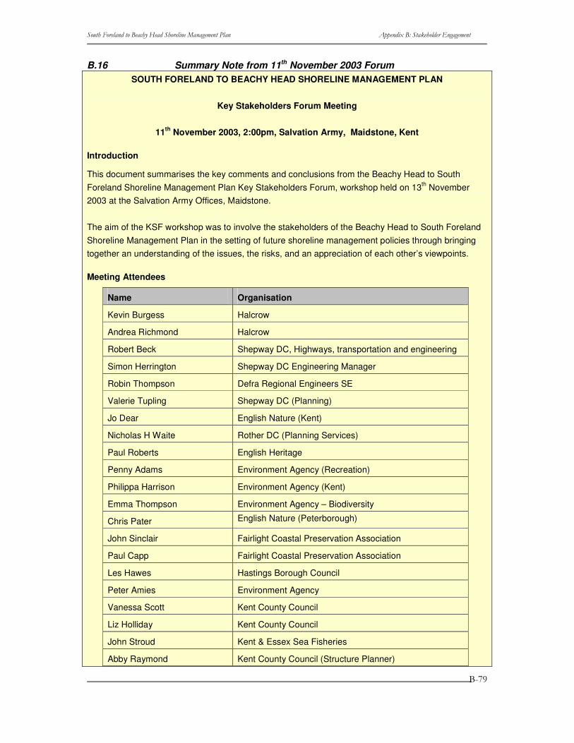
����������� ������������ ��������������������� ���� ������������ �����������
�
�
�
���
B.16 Summary Note from 11th November 2003 Forum SOUTH FORELAND TO BEACHY HEAD SHORELINE MANAGEMENT PLAN
Key Stakeholders Forum Meeting
11th November 2003, 2:00pm, Salvation Army, Maidstone, Kent
Introduction
This document summarises the key comments and conclusions from the Beachy Head to South Foreland Shoreline Management Plan Key Stakeholders Forum, workshop held on 13th November 2003 at the Salvation Army Offices, Maidstone.
The aim of the KSF workshop was to involve the stakeholders of the Beachy Head to South Foreland Shoreline Management Plan in the setting of future shoreline management policies through bringing together an understanding of the issues, the risks, and an appreciation of each other’s viewpoints.
Meeting Attendees
Name Organisation
Kevin Burgess Halcrow
Andrea Richmond Halcrow
Robert Beck Shepway DC, Highways, transportation and engineering
Simon Herrington Shepway DC Engineering Manager
Robin Thompson Defra Regional Engineers SE
Valerie Tupling Shepway DC (Planning)
Jo Dear English Nature (Kent)
Nicholas H Waite Rother DC (Planning Services)
Paul Roberts English Heritage
Penny Adams Environment Agency (Recreation)
Philippa Harrison Environment Agency (Kent)
Emma Thompson Environment Agency – Biodiversity
Chris Pater English Nature (Peterborough)
John Sinclair Fairlight Coastal Preservation Association
Paul Capp Fairlight Coastal Preservation Association
Les Hawes Hastings Borough Council
Peter Amies Environment Agency
Vanessa Scott Kent County Council
Liz Holliday Kent County Council
John Stroud Kent & Essex Sea Fisheries
Abby Raymond Kent County Council (Structure Planner)
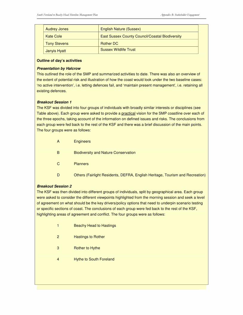
����������� ������������ ��������������������� ���� ������������ �����������
�
�
�
���
Audrey Jones English Nature (Sussex)
Kate Cole East Sussex County Council/Coastal Biodiversity
Tony Stevens Rother DC
Janyis Hyatt Sussex Wildlife Trust
Outline of day’s activities
Presentation by Halcrow This outlined the role of the SMP and summarized activities to date. There was also an overview of the extent of potential risk and illustration of how the coast would look under the two baseline cases: ‘no active intervention’, i.e. letting defences fail, and ‘maintain present management’, i.e. retaining all existing defences.
Breakout Session 1 The KSF was divided into four groups of individuals with broadly similar interests or disciplines (see Table above). Each group were asked to provide a practical vision for the SMP coastline over each of the three epochs, taking account of the information on defined issues and risks. The conclusions from each group were fed back to the rest of the KSF and there was a brief discussion of the main points. The four groups were as follows:
A Engineers
B Biodiversity and Nature Conservation
C Planners
D Others (Fairlight Residents, DEFRA, English Heritage, Tourism and Recreation)
Breakout Session 2 The KSF was then divided into different groups of individuals, split by geographical area. Each group were asked to consider the different viewpoints highlighted from the morning session and seek a level of agreement on what should be the key drivers/policy options that need to underpin scenario testing or specific sections of coast. The conclusions of each group were fed back to the rest of the KSF, highlighting areas of agreement and conflict. The four groups were as follows:
1 Beachy Head to Hastings
2 Hastings to Rother
3 Rother to Hythe
4 Hythe to South Foreland
����������� ������������ ��������������������� ���� ������������ �����������
�
�
�
����
Summary of conclusions from the Breakout Sessions
Breakout Session 1: Disciplines
Group A: Engineers
• We need to managing people and the loss of property.
• We need to change our acceptance and attitude towards flooding and erosion.
• Concentrated on dividing the objectives into 3 components:
(1) Major coastal towns
Do not abandon major coastal towns
Look into the relocation of residential and commercial properties.
Planners should take flood risk & flood warning, on housing, infrastructure, into account.
(2) Minor coastal towns
Tighter planning control needed in the 20-100 time periods
Immediate pressure on planning legislation to recognise future policy changes
No major developments put into those specific areas
Might extend defence works to stop outflanking
(+) 20 years a change in policy
Intelligent flood warning system set up
Education of insurance industry leading to new and more flexible insurance policies
Changes to the type of properties being built, i.e. more resilient to flooding
(3) Under developed areas
Initial thoughts were for No Active Intervention, then realised that some management is needed.
Initially aim for managed re-alignment, working towards No Active Intervention in the future.
����������� ������������ ��������������������� ���� ������������ �����������
�
�
�
����
• Over the next 20 years there should be no reduction in the present level of protection to communities but increased planning controls. However, the knock-on effect of this needs to be considered.
• We need to work out how we move from today to the long term. If we allow communities to retreat this involves planning issues and compensation issues.
• Importance of communities does not change over time.
Group B: Biodiversity and Nature Conservation
• Surprisingly they found that they were not at major conflict with Engineers (or indeed the other groups. In so much as there are also major socio-economic issues therefore the appropriate timescales for introducing such changes need to be carefully considered.
• Recognised that in some situations No Active Intervention is not practical.
• Need to look at changing policy approach long term.
• Identified Romney Marsh as a possible problem area: there is potential for habitat loss and relocation.
• Insist on NO development in areas where we want to make a policy change i.e. No Active Intervention.
• Produced maps in checking preferable policy. • In general, managed realignment will satisfy objectives for the SSSI sites. This will
be an acceptable loss as long as a ‘sustainable’ coastline is the overall aim. • Recognised that there will be a loss of features and communities but this is
acceptable if we progress to a more natural coastline, as this will improve landscape quality.
• There are significant habitats in this area, which are protected by the Habitat Regulations i.e. Pevensey Levels.
• It would be hoped to have a natural grading from saline to freshwater, i.e. moving towards a ‘no active intervention’ policy.
Group C: Planners
• The sense of ‘place’ is important in planning terms for example Folkestone (and other major towns) can not be readily recreated thus making them ‘key policy drivers’ for ‘Hold the Line’.
• Avoid loss of life.
• Recognised that there are key economic and social drivers i.e. Dover Harbour, Dungeness Power Station, large conurbations.
• Accepted the inevitability of losing smaller settlements – main thinking was that the
����������� ������������ ��������������������� ���� ������������ �����������
�
�
�
����
costs of defending these would be an unacceptable burden on the rest of the community.
• Important to start to build into the planning process the means by which people and assets from these vulnerable settlements should be relocated.
• Specific heritage features should be protected i.e. Dover Castle but it is not viable to saved or move everything.
• Further development should, in general, be prohibited within the zone shown to be at risk under the “Do Nothing” scenario. The potential erosion line needs to be incorporated into development plans to limited future development. Potential relocation areas should be identified within the Local Plans.
• Fully endorsed the policy of preventing development in the indicative flood plains. • Transport connections are fixed for 20 years but we need to start discussions now
regarding future transport planning. • Immediate planning control is needed so that no further developments are allowed
along a medium to long-term managed realigned coastline. Should raise awareness and look at the ‘effects’ on people i.e. blight, look at changing the type of property built etc.
• Could not see the scope to abandon major coastal towns, even at 100 year scale, there has to be an acceptance of change i.e. change the use of seafront properties?
• Provide a better flood warning service. • No Active Intervention is not ‘realistic’; we cannot simply walk away. It needs to be a
managed process of change and linked in with neighbouring frontages. • There is also high uncertainty over how the coast will look and evolve and further
studies need to be carried out to improve our knowledge and understanding. Therefore would accept holding the line in the short term, i.e. over the next 20 years, so that further research could be carried out.
Group D: Others
• A pre-requisite of realignment is to mitigate loss against the historic environment, residential and commercial properties etc. If this were in place than acceptance of change would be more viable.
• Greater penalties should apply against councils giving inadequate information in response to conveyance searches.
• The most major change that will affect everybody’s view is to produce social/government policy such that private individuals are compensated for loss. House insurance (if it is paid) only provides re building cost – nobody can buy another property for the insurance payout. This already applies in some European countries.
• Historic Assets are not re-creatable within the 100-year SMP period therefore record archaeological sites/buildings in advance of inevitable loss.
• Where possible mitigate impacts of a loss of ‘science’ by bore holing the environmental evidence.
• Where possible preserve archaeological remains in-situ but where not accept that some loss is inevitable.
• How do we value historic assets? Will the SMP tackle this? • Control houses falling into the sea – there must be a ‘term of responsibility’ i.e.
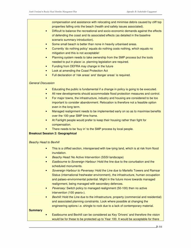
����������� ������������ ��������������������� ���� ������������ �����������
�
�
�
����
compensation and assistance with relocating and minimise debris caused by cliff top properties falling onto the beach (health and safety issues associated).
• Difficult to balance the recreational and socio-economic demands against the effects of defending the coast and its associated effects (as detailed in the baseline scenario summary introduction).
• Some small beach is better than none in heavily urbanised areas. • Currently ‘do nothing policy’ equals do nothing costs nothing, which equals no
mitigation and this is not acceptable! • Planning system needs to take ownership from the SMP process but the tools
needed to put in place i.e. planning legislation are required. • Funding from DEFRA may change in the future • Look at amending the Coast Protection Act • Full declaration of ‘risk areas’ and ‘danger areas’ is required.
General Discussion
• Educating the public is fundamental if a change in policy is going to be executed. • All new developments should accommodate flood protection measures and control. • For major towns, the infrastructure, industry and housing are considered to be too
important to consider abandonment. Relocation is therefore not a feasible option even in the long term.
• Managed realignment needs to be implemented early on so as to maximise benefits over the 100-year SMP time frame.
• At Fairlight people would prefer to keep their housing rather than fight for compensation.
• There needs to be ‘buy in’ to the SMP process by local people. Breakout Session 2: Geographical
Beachy Head to Bexhill
• This is a cliffed section, interspersed with low-lying land, which is at risk from flood inundation.
• Beachy Head: No Active Intervention (SSSI landscape) • Eastbourne to Sovereign Harbour: Hold the line due to the conurbation and the
scheduled monuments. • Sovereign Harbour to Pevensey: Hold the Line due to Martello Towers and Ramsar
Status (international freshwater environment), the infrastructure, human occupation and palaeo-environmental potential. Might in the future move towards managed realignment, being managed with secondary defences.
• Pevensey: Switch policy to managed realignment (50-100) then no active intervention (100 years+).
• Bexhill: Hold the Line due to the infrastructure, property (commercial and residential) and associated planning constraints. Look where possible at changing the engineering options i.e. shingle to rock due to a lack of contemporary material.
Summary • Eastbourne and Bexhill can be considered as Key ‘Drivers’ and therefore the vision
would be for these to be protected up to Year 100. It would be acceptable for there
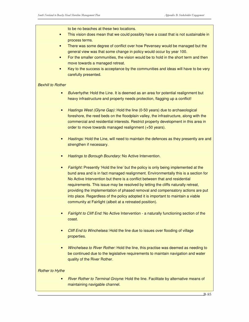
����������� ������������ ��������������������� ���� ������������ �����������
�
�
�
����
to be no beaches at these two locations. • This vision does mean that we could possibly have a coast that is not sustainable in
process terms. • There was some degree of conflict over how Pevensey would be managed but the
general view was that some change in policy would occur by year 100. • For the smaller communities, the vision would be to hold in the short term and then
move towards a managed retreat. • Key to the success is acceptance by the communities and ideas will have to be very
carefully presented.
Bexhill to Rother
• Bulverhythe: Hold the Line. It is deemed as an area for potential realignment but heavy infrastructure and property needs protection, flagging up a conflict!
• Hastings West (Glyne Gap): Hold the line (0-50 years) due to archaeological foreshore, the reed beds on the floodplain valley, the infrastructure, along with the commercial and residential interests. Restrict property development in this area in order to move towards managed realignment (+50 years).
• Hastings: Hold the Line, will need to maintain the defences as they presently are and strengthen if necessary.
• Hastings to Borough Boundary: No Active Intervention.
• Fairlight: Presently ‘Hold the line’ but the policy is only being implemented at the bund area and is in fact managed realignment. Environmentally this is a section for No Active Intervention but there is a conflict between that and residential requirements. This issue may be resolved by letting the cliffs naturally retreat, providing the implementation of phased removal and compensatory actions are put into place. Regardless of the policy adopted it is important to maintain a viable community at Fairlight (albeit at a retreated position).
• Fairlight to Cliff End: No Active Intervention - a naturally functioning section of the coast.
• Cliff End to Winchelsea: Hold the line due to issues over flooding of village properties.
• Winchelsea to River Rother: Hold the line, this practise was deemed as needing to be continued due to the legislative requirements to maintain navigation and water quality of the River Rother.
Rother to Hythe
• River Rother to Terminal Groyne: Hold the line. Facilitate by alternative means of maintaining navigable channel.
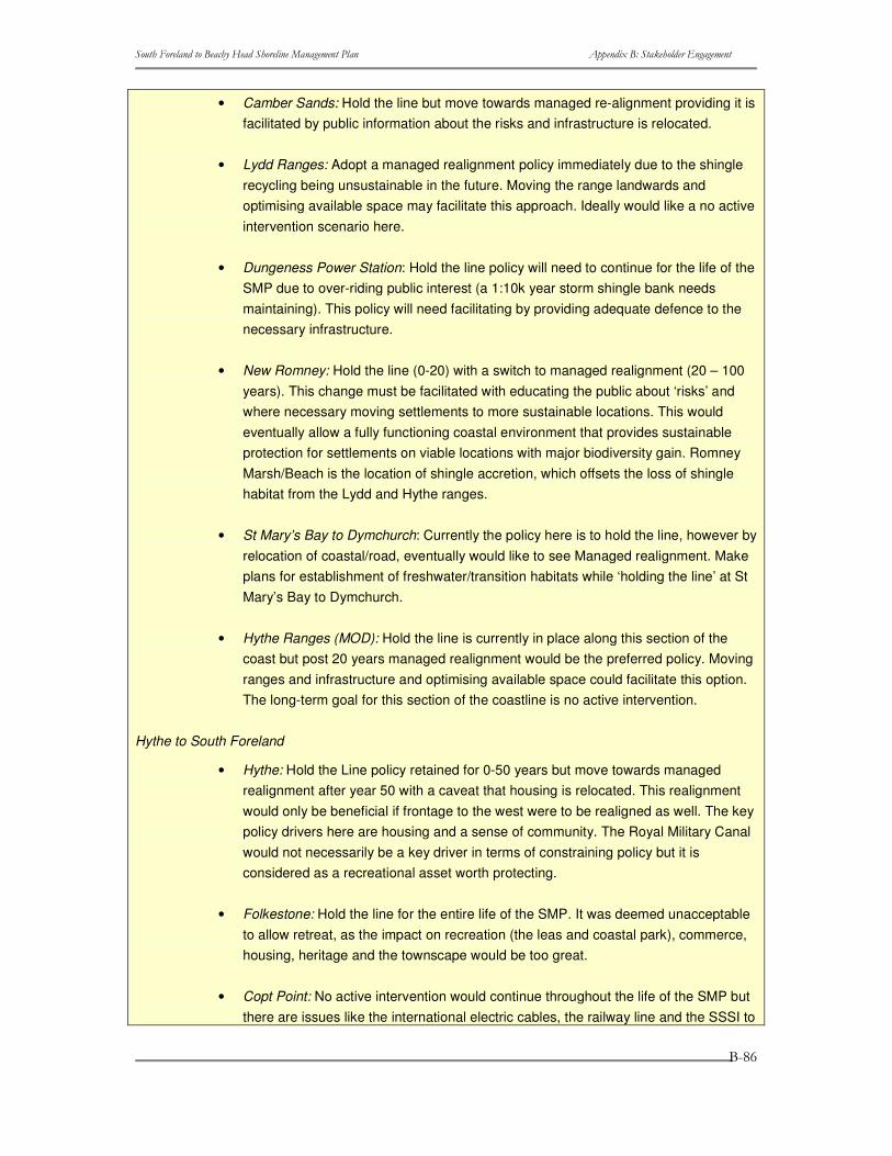
����������� ������������ ��������������������� ���� ������������ �����������
�
�
�
���
• Camber Sands: Hold the line but move towards managed re-alignment providing it is facilitated by public information about the risks and infrastructure is relocated.
• Lydd Ranges: Adopt a managed realignment policy immediately due to the shingle recycling being unsustainable in the future. Moving the range landwards and optimising available space may facilitate this approach. Ideally would like a no active intervention scenario here.
• Dungeness Power Station: Hold the line policy will need to continue for the life of the SMP due to over-riding public interest (a 1:10k year storm shingle bank needs maintaining). This policy will need facilitating by providing adequate defence to the necessary infrastructure.
• New Romney: Hold the line (0-20) with a switch to managed realignment (20 – 100 years). This change must be facilitated with educating the public about ‘risks’ and where necessary moving settlements to more sustainable locations. This would eventually allow a fully functioning coastal environment that provides sustainable protection for settlements on viable locations with major biodiversity gain. Romney Marsh/Beach is the location of shingle accretion, which offsets the loss of shingle habitat from the Lydd and Hythe ranges.
• St Mary’s Bay to Dymchurch: Currently the policy here is to hold the line, however by relocation of coastal/road, eventually would like to see Managed realignment. Make plans for establishment of freshwater/transition habitats while ‘holding the line’ at St Mary’s Bay to Dymchurch.
• Hythe Ranges (MOD): Hold the line is currently in place along this section of the coast but post 20 years managed realignment would be the preferred policy. Moving ranges and infrastructure and optimising available space could facilitate this option. The long-term goal for this section of the coastline is no active intervention.
Hythe to South Foreland
• Hythe: Hold the Line policy retained for 0-50 years but move towards managed realignment after year 50 with a caveat that housing is relocated. This realignment would only be beneficial if frontage to the west were to be realigned as well. The key policy drivers here are housing and a sense of community. The Royal Military Canal would not necessarily be a key driver in terms of constraining policy but it is considered as a recreational asset worth protecting.
• Folkestone: Hold the line for the entire life of the SMP. It was deemed unacceptable to allow retreat, as the impact on recreation (the leas and coastal park), commerce, housing, heritage and the townscape would be too great.
• Copt Point: No active intervention would continue throughout the life of the SMP but there are issues like the international electric cables, the railway line and the SSSI to
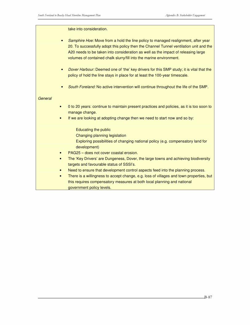
����������� ������������ ��������������������� ���� ������������ �����������
�
�
�
���
take into consideration.
• Samphire Hoe: Move from a hold the line policy to managed realignment, after year 20. To successfully adopt this policy then the Channel Tunnel ventilation unit and the A20 needs to be taken into consideration as well as the impact of releasing large volumes of contained chalk slurry/fill into the marine environment.
• Dover Harbour: Deemed one of ‘the’ key drivers for this SMP study; it is vital that the policy of hold the line stays in place for at least the 100-year timescale.
• South Foreland: No active intervention will continue throughout the life of the SMP.
General
• 0 to 20 years: continue to maintain present practices and policies, as it is too soon to manage change.
• If we are looking at adopting change then we need to start now and so by:
Educating the public Changing planning legislation Exploring possibilities of changing national policy (e.g. compensatory land for development)
• PAG25 – does not cover coastal erosion. • The ‘Key Drivers’ are Dungeness, Dover, the large towns and achieving biodiversity
targets and favourable status of SSSI’s. • Need to ensure that development control aspects feed into the planning process. • There is a willingness to accept change, e.g. loss of villages and town properties, but
this requires compensatory measures at both local planning and national government policy levels.

����������� ������������ ��������������������� ���� ������������ �����������
�
�
�
����
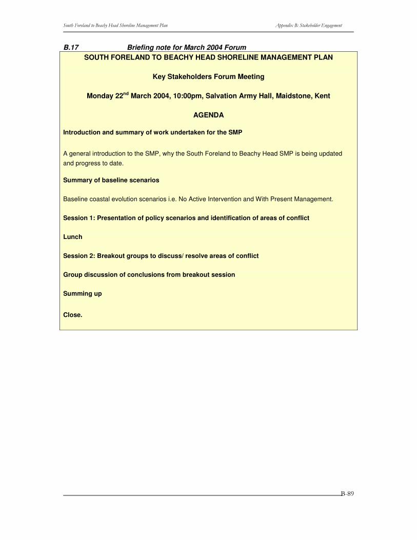
����������� ������������ ��������������������� ���� ������������ �����������
�
�
�
����
B.17 Briefing note for March 2004 Forum SOUTH FORELAND TO BEACHY HEAD SHORELINE MANAGEMENT PLAN
Key Stakeholders Forum Meeting
Monday 22nd March 2004, 10:00pm, Salvation Army Hall, Maidstone, Kent
AGENDA
Introduction and summary of work undertaken for the SMP
A general introduction to the SMP, why the South Foreland to Beachy Head SMP is being updated and progress to date.
Summary of baseline scenarios
Baseline coastal evolution scenarios i.e. No Active Intervention and With Present Management.
Session 1: Presentation of policy scenarios and identification of areas of conflict
Lunch
Session 2: Breakout groups to discuss/ resolve areas of conflict
Group discussion of conclusions from breakout session
Summing up
Close.

����������� ������������ ��������������������� ���� ������������ �����������
�
�
�
���
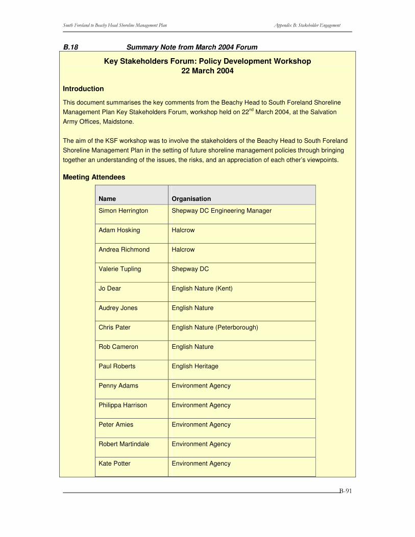
����������� ������������ ��������������������� ���� ������������ �����������
�
�
�
����
B.18 Summary Note from March 2004 Forum
Key Stakeholders Forum: Policy Development Workshop 22 March 2004
Introduction
This document summarises the key comments from the Beachy Head to South Foreland Shoreline Management Plan Key Stakeholders Forum, workshop held on 22nd March 2004, at the Salvation Army Offices, Maidstone.
The aim of the KSF workshop was to involve the stakeholders of the Beachy Head to South Foreland Shoreline Management Plan in the setting of future shoreline management policies through bringing together an understanding of the issues, the risks, and an appreciation of each other’s viewpoints.
Meeting Attendees
Name Organisation
Simon Herrington Shepway DC Engineering Manager
Adam Hosking Halcrow
Andrea Richmond Halcrow
Valerie Tupling Shepway DC
Jo Dear English Nature (Kent)
Audrey Jones English Nature
Chris Pater English Nature (Peterborough)
Rob Cameron English Nature
Paul Roberts English Heritage
Penny Adams Environment Agency
Philippa Harrison Environment Agency
Peter Amies Environment Agency
Robert Martindale Environment Agency
Kate Potter Environment Agency
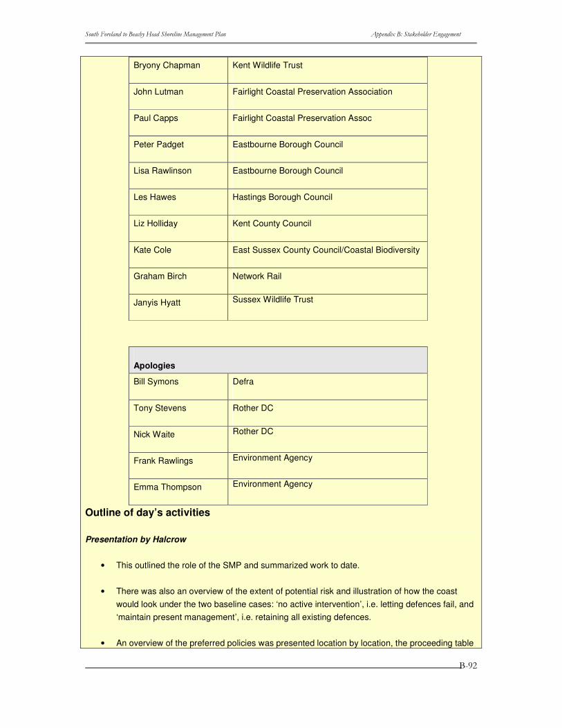
����������� ������������ ��������������������� ���� ������������ �����������
�
�
�
����
Bryony Chapman Kent Wildlife Trust
John Lutman Fairlight Coastal Preservation Association
Paul Capps Fairlight Coastal Preservation Assoc
Peter Padget Eastbourne Borough Council
Lisa Rawlinson Eastbourne Borough Council
Les Hawes Hastings Borough Council
Liz Holliday Kent County Council
Kate Cole East Sussex County Council/Coastal Biodiversity
Graham Birch Network Rail
Janyis Hyatt Sussex Wildlife Trust
Apologies
Bill Symons Defra
Tony Stevens Rother DC
Nick Waite Rother DC
Frank Rawlings Environment Agency
Emma Thompson Environment Agency
Outline of day’s activities
Presentation by Halcrow
• This outlined the role of the SMP and summarized work to date.
• There was also an overview of the extent of potential risk and illustration of how the coast would look under the two baseline cases: ‘no active intervention’, i.e. letting defences fail, and ‘maintain present management’, i.e. retaining all existing defences.
• An overview of the preferred policies was presented location by location, the proceeding table

����������� ������������ ��������������������� ���� ������������ �����������
�
�
�
����
summarises the preferred policies (shaded grey) and highlights key implications in policy promotion.
Comments
Comments made by the Key Stakeholders are summarised below, these will be taken to the Elected Members Forum and incorporated into further policy appraisal.
Location Policy Comments
Beachy Head NAI No comments (agreed)
Eastbourne Hold No comments (agreed)
Sovereign Harbour Hold Comments:
Boundary clarification required
Pevensey and Hooe Hold Comments:
Questioned why realignment was not an option, implications explained and accepted
Bexhill and Cooden Hold No comments (agreed)
Glyne Gap and Bulverhythe
Hold No comments (agreed)
Hastings Hold No comments (agreed)
Hastings Cliffs to Fairlight
NAI No comments (agreed)
Fairlight West NAI
Rockmead Road NAI
Fairlight Cove Realign
Comments:
Questioned why had Fairlight been divided into three units, explained that this was on technical grounds.
Felt that hold should be the preferred policy along the entire frontage
Fairlight Cove to Cliff End
NAI No comments (agreed)
Cliff End to Winchelsea
Hold (Short to Medium), Realign (Long term)
Comments:
Discussion about assets at risk and the need to ‘tie’ the frontage with its neighbouring one
Winchelsea Beach to Rye Harbour
Realign Comments:
This frontage should be tied into the
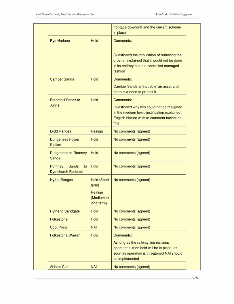
����������� ������������ ��������������������� ���� ������������ �����������
�
�
�
����
frontage downdrift and the current scheme in place
Rye Harbour Hold Comments:
Questioned the implication of removing the groyne, explained that it would not be done in its entirety but in a controlled managed fashion
Camber Sands Hold Comments:
Camber Sands is ‘valuable’ an asset and there is a need to protect it
Broomhill Sands to Jury’s
Hold Comments:
Questioned why this could not be realigned in the medium term, justification explained, English Nature wish to comment further on this
Lydd Ranges Realign No comments (agreed)
Dungeness Power Station
Hold No comments (agreed)
Dungeness to Romney Sands
Hold No comments (agreed)
Romney Sands to Dymchurch Redoubt
Hold No comments (agreed)
Hythe Ranges Hold (Short term)
Realign (Medium to long term)
No comments (agreed)
Hythe to Sandgate Hold No comments (agreed)
Folkestone Hold No comments (agreed)
Copt Point NAI No comments (agreed)
Folkestone Warren Hold Comments:
As long as the railway line remains operational then hold will be in place, as soon as operation is threatened NAI should be implemented
Abbots Cliff NAI No comments (agreed)
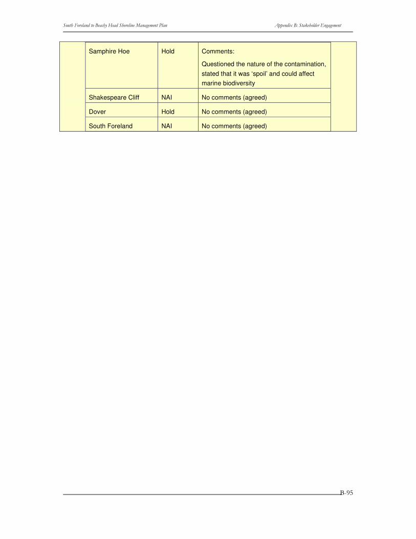
����������� ������������ ��������������������� ���� ������������ �����������
�
�
�
����
Samphire Hoe Hold Comments:
Questioned the nature of the contamination, stated that it was ‘spoil’ and could affect marine biodiversity
Shakespeare Cliff NAI No comments (agreed)
Dover Hold No comments (agreed)
South Foreland NAI No comments (agreed)

����������� ������������ ��������������������� ���� ������������ �����������
�
�
�
���
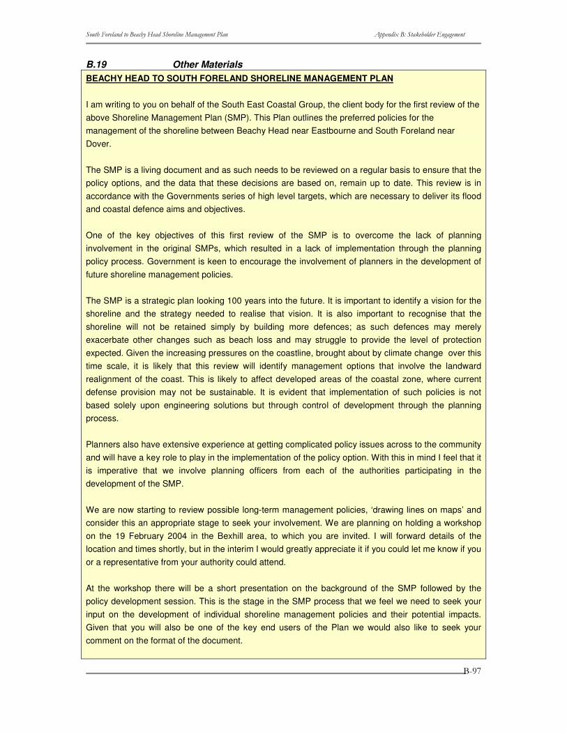
����������� ������������ ��������������������� ���� ������������ �����������
�
�
�
���
B.19 Other Materials BEACHY HEAD TO SOUTH FORELAND SHORELINE MANAGEMENT PLAN
I am writing to you on behalf of the South East Coastal Group, the client body for the first review of the above Shoreline Management Plan (SMP). This Plan outlines the preferred policies for the management of the shoreline between Beachy Head near Eastbourne and South Foreland near Dover.
The SMP is a living document and as such needs to be reviewed on a regular basis to ensure that the policy options, and the data that these decisions are based on, remain up to date. This review is in accordance with the Governments series of high level targets, which are necessary to deliver its flood and coastal defence aims and objectives.
One of the key objectives of this first review of the SMP is to overcome the lack of planning involvement in the original SMPs, which resulted in a lack of implementation through the planning policy process. Government is keen to encourage the involvement of planners in the development of future shoreline management policies.
The SMP is a strategic plan looking 100 years into the future. It is important to identify a vision for the shoreline and the strategy needed to realise that vision. It is also important to recognise that the shoreline will not be retained simply by building more defences; as such defences may merely exacerbate other changes such as beach loss and may struggle to provide the level of protection expected. Given the increasing pressures on the coastline, brought about by climate change over this time scale, it is likely that this review will identify management options that involve the landward realignment of the coast. This is likely to affect developed areas of the coastal zone, where current defense provision may not be sustainable. It is evident that implementation of such policies is not based solely upon engineering solutions but through control of development through the planning process.
Planners also have extensive experience at getting complicated policy issues across to the community and will have a key role to play in the implementation of the policy option. With this in mind I feel that it is imperative that we involve planning officers from each of the authorities participating in the development of the SMP.
We are now starting to review possible long-term management policies, ‘drawing lines on maps’ and consider this an appropriate stage to seek your involvement. We are planning on holding a workshop on the 19 February 2004 in the Bexhill area, to which you are invited. I will forward details of the location and times shortly, but in the interim I would greatly appreciate it if you could let me know if you or a representative from your authority could attend.
At the workshop there will be a short presentation on the background of the SMP followed by the policy development session. This is the stage in the SMP process that we feel we need to seek your input on the development of individual shoreline management policies and their potential impacts. Given that you will also be one of the key end users of the Plan we would also like to seek your comment on the format of the document.
����������� ������������ ��������������������� ���� ������������ �����������
�
�
�
����
As part of this process we have the commitment and involvement of an Elected Member Forum which is made up of elected members from each constituent authority. This forum is supported by the SMP steering group, which is an officer group with representatives from maritime authorities plus English Nature, the Environment Agency and Defra. A list of Steering Group Members is attached for your information and this identifies the representative from your authority.
If you would like to register your interest in attending the workshop or would like some more information please contact either your Steering Group representative or myself.
Yours sincerely,
Simon Herrington
Engineering Manager
Environment and Street Scene
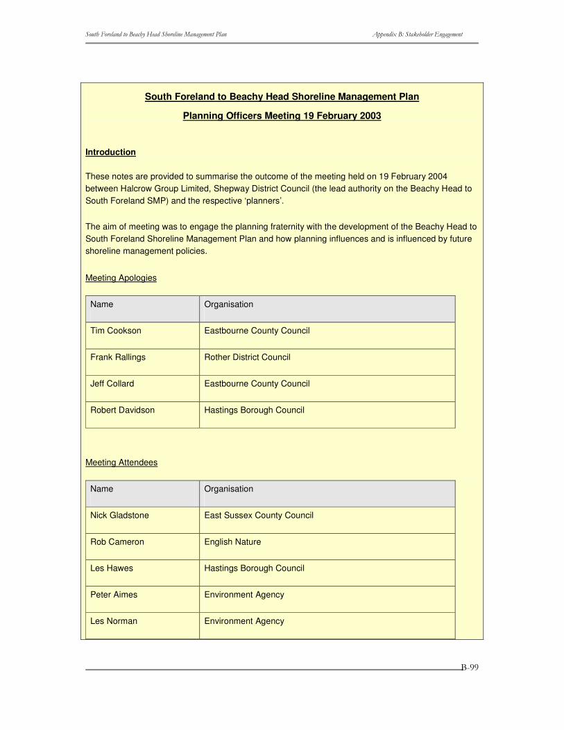
����������� ������������ ��������������������� ���� ������������ �����������
�
�
�
����
South Foreland to Beachy Head Shoreline Management Plan
Planning Officers Meeting 19 February 2003
Introduction
These notes are provided to summarise the outcome of the meeting held on 19 February 2004 between Halcrow Group Limited, Shepway District Council (the lead authority on the Beachy Head to South Foreland SMP) and the respective ‘planners’.
The aim of meeting was to engage the planning fraternity with the development of the Beachy Head to South Foreland Shoreline Management Plan and how planning influences and is influenced by future shoreline management policies.
Meeting Apologies
Name Organisation
Tim Cookson Eastbourne County Council
Frank Rallings Rother District Council
Jeff Collard Eastbourne County Council
Robert Davidson Hastings Borough Council
Meeting Attendees
Name Organisation
Nick Gladstone East Sussex County Council
Rob Cameron English Nature
Les Hawes Hastings Borough Council
Peter Aimes Environment Agency
Les Norman Environment Agency
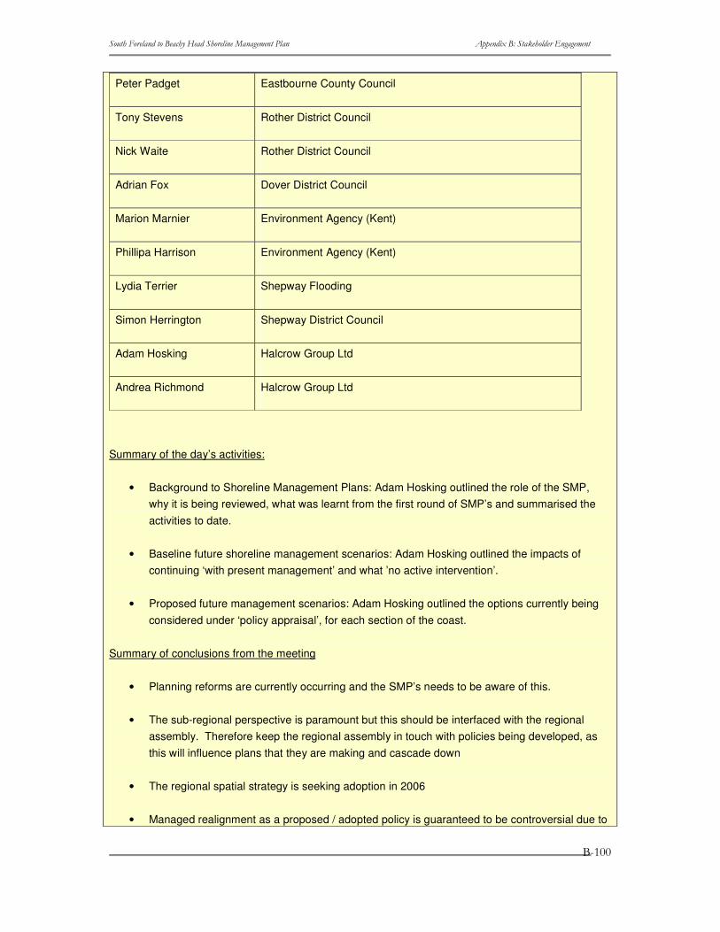
����������� ������������ ��������������������� ���� ������������ �����������
�
�
�
���
Peter Padget Eastbourne County Council
Tony Stevens Rother District Council
Nick Waite Rother District Council
Adrian Fox Dover District Council
Marion Marnier Environment Agency (Kent)
Phillipa Harrison Environment Agency (Kent)
Lydia Terrier Shepway Flooding
Simon Herrington Shepway District Council
Adam Hosking Halcrow Group Ltd
Andrea Richmond Halcrow Group Ltd
Summary of the day’s activities:
• Background to Shoreline Management Plans: Adam Hosking outlined the role of the SMP, why it is being reviewed, what was learnt from the first round of SMP’s and summarised the activities to date.
• Baseline future shoreline management scenarios: Adam Hosking outlined the impacts of continuing ‘with present management’ and what ’no active intervention’.
• Proposed future management scenarios: Adam Hosking outlined the options currently being considered under ‘policy appraisal’, for each section of the coast.
Summary of conclusions from the meeting
• Planning reforms are currently occurring and the SMP’s needs to be aware of this.
• The sub-regional perspective is paramount but this should be interfaced with the regional assembly. Therefore keep the regional assembly in touch with policies being developed, as this will influence plans that they are making and cascade down
• The regional spatial strategy is seeking adoption in 2006
• Managed realignment as a proposed / adopted policy is guaranteed to be controversial due to
����������� ������������ ��������������������� ���� ������������ �����������
�
�
�
��� �
associated ‘loss’ and ‘risk’.
• The main planning concerns are housing target rates ‘versus’ limited available land i.e. land that doesn’t carry any planning / development restrictions.
• Other concerns include: property and infrastructure loss, tourism being affected
• No compensation mechanism in place, which could be in the form of money or land, therefore the political acceptance of this is deemed as being unlikely.
• The Coastal Protection Act (1949) is pre-historic and needs revising
• It may be more cost effective to ‘hold the line’ than implement managed realignment.
• Policy appraisal – might be beneficial to open up to parish council scale.
• Beaches aren’t ‘free’ – it costs to keep them where they currently are.
• The SMP is specified in planning documents i.e. PPG25 & RPG9 but not ‘used’ in the capacity it should be maybe because it is a non-statutory document.
• Planners need to take ‘ownership’ for the SMP and not leave it ‘the engineers’!
• Formalised meetings between coastal groups (i.e. South-east Coastal Group) and planners could be beneficial, providing some of the discussion / presentation was tailored towards the planning fraternity.
• The SMP is not in the ‘top-ten’ reference documents that planners utilise.
• A document that is stylised in a ‘planning’ manner would potentially make it more appealing to planners.
General Summary
One of the key objectives of this first review of the SMP was the lack of planning involvement, which resulted in a lack of implementation through the planning policy process. Your attendance on the 19th February 2004 was the first step taken to remedy this situation and the issues arisen from this meeting will be fed back to DEFRA and contribute to SMP Procedural Guidance.