bishop’s stortford north - iema · hydrology, drainage & flooding ... 1.1.1 bishop’s...
TRANSCRIPT

BISHOP’S STORTFORD NORTH ENVIRONMENTAL STATEMENT NON TECHNICAL SUMMARY January 2013 The Bishop’s Stortford North Consortium

28135 Bishop’s Stortford North Non Technical Summary of the Environmental Statement
3 | 21
28135 Bishop’s Stortford North Non Technical Summary of the Environmental Statement
4 | 21
Contents Contents ............................................................................................ 4
1 Introduction ............................................................................... 5
2 Site Description ......................................................................... 5 The Site .......................................................................................... 5 Surrounding Area ........................................................................... 6
3 The Proposed Development ..................................................... 6 Planning Policy Context ................................................................. 6 Description of the Proposed Development ..................................... 6 Construction Programme ............................................................... 8
4 Alternatives ............................................................................... 9
5 Approach to EIA ...................................................................... 10 Assessment Methodology ............................................................ 10
6 Environmental Effects of the Proposed Development ............. 11 Socio Economic and Community Effects...................................... 11 Transportation .............................................................................. 12 Noise & Vibration ......................................................................... 13 Local Air Quality ........................................................................... 13 Landscape & Visual Assessment ................................................. 14 Ecology ........................................................................................ 15 Archaeology & Cultural Heritage .................................................. 16 Hydrology, Drainage & Flooding .................................................. 17 Services & Utilities ....................................................................... 17 Agriculture & Soils ........................................................................ 18
7 Cumulative Effects .................................................................. 19

28135 Bishop’s Stortford North Non Technical Summary of the Environmental Statement
5 | 21
1 Introduction 1.1.1 Bishop’s Stortford North Consortium (the Consortium – comprising Bovis Homes Limited, Taylor
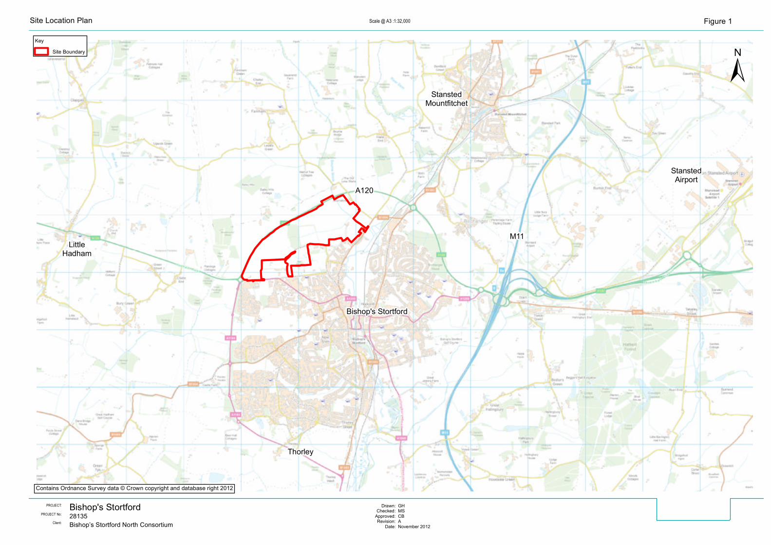
Wimpey UK Limited, Persimmon Homes Limited, Kier Homes Limited and The Fairfield Partnership) are seeking to obtain Outline Planning Permission for a residential led mixed-use development (hereafter referred to as the ‘Proposed Development’) on land to the north of Bishop’s Stortford in East Hertfordshire District. The Site, which is shown on Figures 1 and 2, is located to the north of the existing urban edge of Bishop’s Stortford and south of the A120 (Bishop’s Stortford Northern Bypass).
1.1.2 This Non-Technical Summary (NTS) provides a summary of an Environmental Statement (ES) that has been prepared to accompany the Outline Planning Application and reports the findings of an Environmental Impact Assessment (EIA) of the Proposed Development of the Site. The EIA has been undertaken in accordance with the Town and Country Planning (Environmental Impact Assessment) (England and Wales) Regulations 2011 (the ‘EIA Regulations’ 2011) which require that, in certain cases, development proposals should be examined to measure their likely significant environmental effects upon the environment and to identify what action should be taken to mitigate those effects.
1.1.3 The full detail of the assessment of likely significant environmental effects of the Proposed Development is presented in the ES, copies of which are available for viewing via the planning section of East Hertfordshire District Council (EHDC) website (www.eastherts.gov.uk) and at the Council offices. Alternatively, an electronic copy of the complete ES can be obtained from WSP Environment & Energy Ltd (Tel: 0207 314 5000) for £5.00. A hard copy can be obtained from the same contact at a cost of £380 (excluding postage and packaging).
2 Site Description
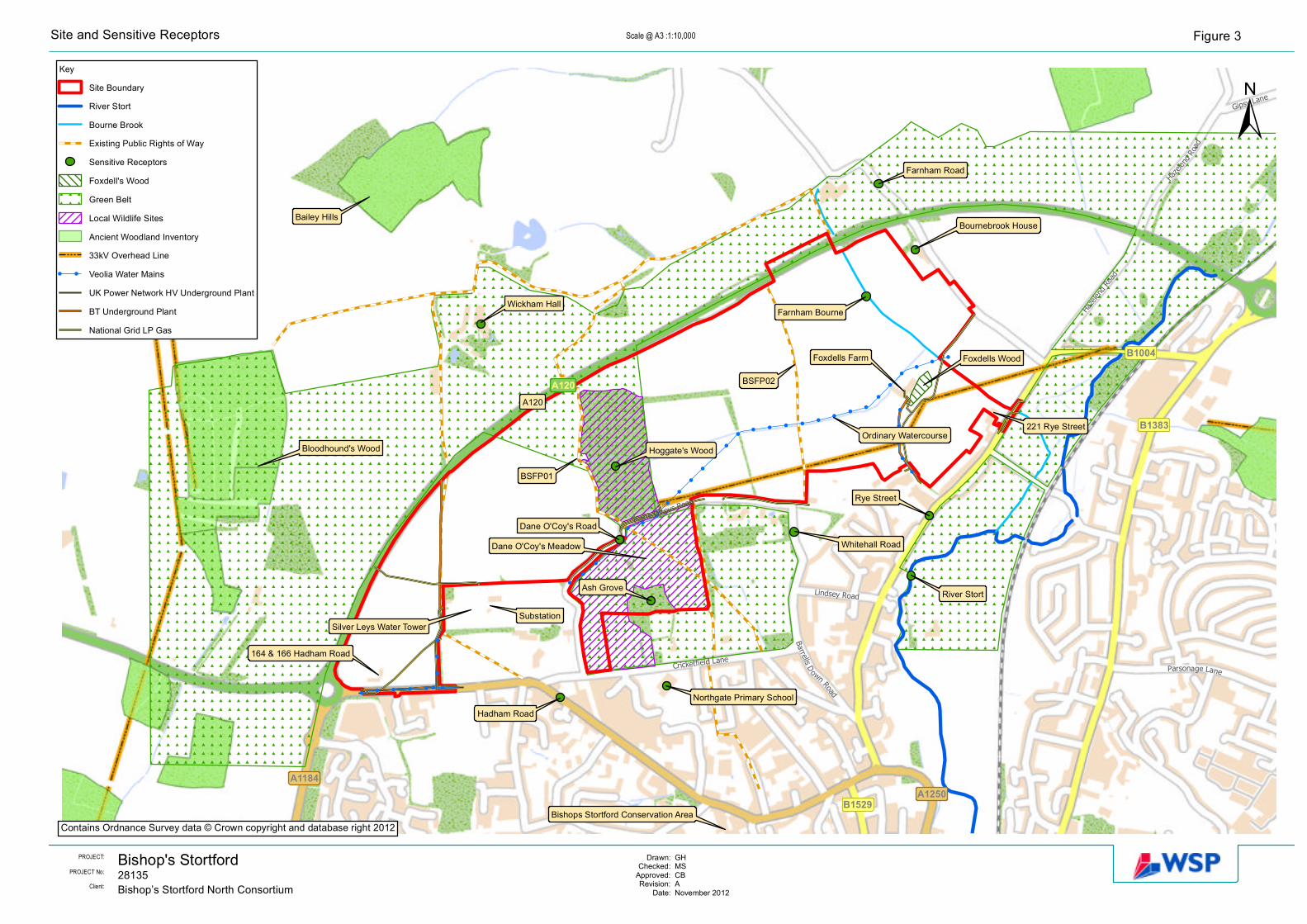
The Site 2.1.1 The Site, shown on Figure 1, extends to approximately 130 hectares (321 acres) and lies within the
administrative area of EHDC approximately 1km to the north of Bishop’s Stortford town centre and 3km to the west of the M11 motorway (Junction 8). The Site broadly extends to the A120 Bishop’s Stortford Northern Bypass to the north and west; Farnham Road to the east, and Rye Street, Dane O’Coys Road, Cricketfield Lane and Hadham Road to the south, as shown on Figure 2.
2.1.2 The Site comprises mainly agricultural land together with mature trees and hedgerows, woodland and wood pasture; Farnham Bourne (also known locally as ‘Bourne Brook’), its associated floodplain and an ordinary watercourse/drainage ditch. The Site includes a number of buildings associated with Foxdells Farm (the farmhouse and barn are Grade II listed1 and the farm is currently used as an Animal Rescue Centre), and three dwellings: 221 Rye Street; 164 and 166 Hadham Road. Part of the Site, comprising Hoggate’s Wood and land to the south of Dane O’Coys Road, is designated as being part of Green Belt land, which generally contains the town. Within the Green Belt land, Hoggate’s Wood and Dane O’Coys Meadow are also Local Wildlife Sites designated for their local nature conservation interest.
2.1.3 Two public footpaths (BS/FP001 and BS/FP002) and a public bridleway traverse the Site from north to south, linking the Site with the adjoining built-up area to the south and the wider countryside to the north.
2.1.4 Most of the Site is classified by the Environment Agency as being at low risk of flooding. However some land in the eastern part of the Site (near Farnham Bourne) is classified as being at a medium to high risk of flooding.
1 Listed Buildings are those placed on the list of buildings of 'special architectural or historic interest' compiled by the Secretary of State for Culture, Media and Sport under the Planning (Listed Buildings and Conservation Areas) Act 1990 (as amended), on advice from English Heritage. A Grade II listed building is considered to be of national importance and special interest.
Bishop's Stortford
M11
A120
Bishop's Stortford
StanstedMountfitchet
Thorley
LittleHadham
StanstedAirport
28135PROJECT No:PROJECT: GH
MSCBANovember 2012
Drawn:Checked:
Approved:Revision:
Date:Bishop’s Stortford North ConsortiumClient:
KeySite Boundary
±Scale @ A3 : Figure 1.11:32,000Site Location Plan
Contains Ordnance Survey data © Crown copyright and database right 2012

Bishop's Stortford28135PROJECT No:
PROJECT: GHMSCBANovember 2012
Drawn:Checked:
Approved:Revision:
Date:Bishop’s Stortford North ConsortiumClient:
KeySite Boundary
±Scale @ A3 : Figure 1.21:7,500Site Boundary Plan
Contains Ordnance Survey data © Crown copyright and database right 2012
Farnham Bourne
28135 Bishop’s Stortford North Non Technical Summary of the Environmental Statement
6 | 21
2.1.5 A number of services are present within the Site, including a water main that runs across the Site from the south west to the north-east, a series of underground electricity cables located in the western corner of the Site; and an overhead electricity cable line, which crosses the Site from Dane O’Coys Road to Foxdells Lane. In addition Silver Leys Water Tower and Reservoir and Bishop’s Stortford Electricity Sub Station are located off-site.
Surrounding Area
2.1.6 Surrounding the Site, the wider landscape is generally rural in character interspersed with settlements including Bishop’s Stortford, Stansted Mountfitchet, Farnham, Hazel End, Upwick Green and Little Hadham. There are also several large halls (including Wickham Hall and Hadham Hall), farmsteads and individual houses (such as Bournebrook and Partridges located to the east of the Site). The A120 Bishop’s Stortford Northern Bypass physically separates the Site from the wider rural countryside be-yond. Other major transport infrastructure in the locality includes the M11 motorway and Stansted Air-port which lie to the east of the Site.
2.1.7 Several sites designated for environmental management or nature conservation purposes are present within the vicinity of the Site, including:
Two Local Wildlife Sites (in addition to those located within the Site) - Bloodhounds Wood, locat-ed approximately 1km to the west of the Site; and Bailey Hills, an area of ancient woodland, lo-cated approximately 1km to the north-west of the Site;
Bishop’s Stortford Conservation Area2, located in Bishop’s Stortford town centre approximately 160m to the south of the Site beyond Cricketfield Lane;
Hockerill Street/ London Road/ Dunmow Road/ Stansted Road Air Quality Management Area (AQMA) approximately 1.5km south east of the Site, designated for the management of road traf-fic emissions in this location; and
Much of the surrounding land is designated Green Belt. Land inside the A120, other than Hog-gate’s Wood and the land south of Dane O’Coys Road, was omitted from the Green Belt when the boundaries were defined in the 1980s (as shown on Figure 3).
2.1.8 The above features and other environmental features are shown on Figure 3.
3 The Proposed Development
Planning Policy Context 3.1.1 The Planning Application is submitted in the context of Policies BIS 1, 3 and 8 of the East Hertfordshire
District Local Plan Second Review, (2007), through which EHDC has safeguarded the Site for long term residential development purposes.
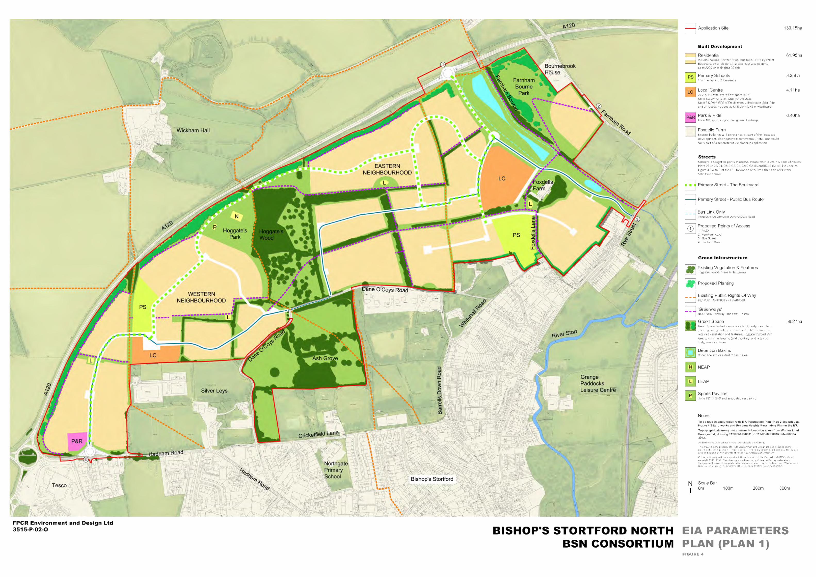
Description of the Proposed Development 3.1.2 The Proposed Development, as shown on Figure 4, comprises:
2 Conservation Areas are areas of 'special architectural or historic interest' designated under the Planning (Listed Buildings and Conservation Areas) Act 1990
Bishop's Stortford
# # # # # # # # # # # # # # # # # # # # # # # # # # # # # # # # # # # # # # # # # # # # # # # # # # # # # # # # # # # # # # # # # # # # # # # # # # # # # # # # # # # # # # # # # # # # # # # # # # # # # # # # # # # # # # # # # # # # # # # # # # # # # # # # # #
# # # # # # # # # # # # # # # # # # # # # # # # # # # # # # # # # # # # # # # # # # # # # # # # # # # # # # # # # # # # # # # # # # # # # # # # # # # # # # # # # # # # # # # # # # # # # # # # # # # # # # # # # # # # # # # # # # # # # # # # # # # # # # # # # #
# # # # # # # # # # # # # # # # # # # # # # # # # # # # # # # # # # # # # # # # # # # # # # # # # # # # # # # # # # # # # # # # # # # # # # # # # # # # # # # # # # # # # # # # # # # # # # # # # # # # # # # # # # # # # # # # # # # # # # # # # # # # # # # # # #
# # # # # # # # # # # # # # # # # # # # # # # # # # # # # # # # # # # # # # # # # # # # # # # # # # # # # # # # # # # # # # # # # # # # # # # # # # # # # # # # # # # # # # # # # # # # # # # # # # # # # # # # # # # # # # # # # # # # # # # # # # # # # # # # # #
# # # # # # # # # # # # # # # # # # # # # # # # # # # # # # # # # # # # # # # # # # # # # # # # # # # # # # # # # # # # # # # # # # # # # # # # # # # # # # # # # # # # # # # # # # # # # # # # # # # # # # # # # # # # # # # # # # # # # # # # # # # # # # # # # #
# # # # # # # # # # # # # # # # # # # # # # # # # # # # # # # # # # # # # # # # # # # # # # # # # # # # # # # # # # # # # # # # # # # # # # # # # # # # # # # # # # # # # # # # # # # # # # # # # # # # # # # # # # # # # # # # # # # # # # # # # # # # # # # # # #
# # # # # # # # # # # # # # # # # # # # # # # # # # # # # # # # # # # # # # # # # # # # # # # # # # # # # # # # # # # # # # # # # # # # # # # # # # # # # # # # # # # # # # # # # # # # # # # # # # # # # # # # # # # # # # # # # # # # # # # # # # # # # # # # # #
# # # # # # # # # # # # # # # # # # # # # # # # # # # # # # # # # # # # # # # # # # # # # # # # # # # # # # # # # # # # # # # # # # # # # # # # # # # # # # # # # # # # # # # # # # # # # # # # # # # # # # # # # # # # # # # # # # # # # # # # # # # # # # # # # #
# # # # # # # # # # # # # # # # # # # # # # # # # # # # # # # # # # # # # # # # # # # # # # # # # # # # # # # # # # # # # # # # # # # # # # # # # # # # # # # # # # # # # # # # # # # # # # # # # # # # # # # # # # # # # # # # # # # # # # # # # # # # # # # # # #
# # # # # # # # # # # # # # # # # # # # # # # # # # # # # # # # # # # # # # # # # # # # # # # # # # # # # # # # # # # # # # # # # # # # # # # # # # # # # # # # # # # # # # # # # # # # # # # # # # # # # # # # # # # # # # # # # # # # # # # # # # # # # # # # # #
# # # # # # # # # # # # # # # # # # # # # # # # # # # # # # # # # # # # # # # # # # # # # # # # # # # # # # # # # # # # # # # # # # # # # # # # # # # # # # # # # # # # # # # # # # # # # # # # # # # # # # # # # # # # # # # # # # # # # # # # # # # # # # # # # #
# # # # # # # # # # # # # # # # # # # # # # # # # # # # # # # # # # # # # # # # # # # # # # # # # # # # # # # # # # # # # # # # # # # # # # # # # # # # # # # # # # # # # # # # # # # # # # # # # # # # # # # # # # # # # # # # # # # # # # # # # # # # # # # # # #
# # # # # # # # # # # # # # # # # # # # # # # # # # # # # # # # # # # # # # # # # # # # # # # # # # # # # # # # # # # # # # # # # # # # # # # # # # # # # # # # # # # # # # # # # # # # # # # # # # # # # # # # # # # # # # # # # # # # # # # # # # # # # # # # # #
# # # # # # # # # # # # # # # # # # # # # # # # # # # # # # # # # # # # # # # # # # # # # # # # # # # # # # # # # # # # # # # # # # # # # # # # # # # # # # # # # # # # # # # # # # # # # # # # # # # # # # # # # # # # # # # # # # # # # # # # # # # # # # # # # #
# # # # # # # # # # # # # # # # # # # # # # # # # # # # # # # # # # # # # # # # # # # # # # # # # # # # # # # # # # # # # # # # # # # # # # # # # # # # # # # # # # # # # # # # # # # # # # # # # # # # # # # # # # # # # # # # # # # # # # # # # # # # # # # # # #
# # # # # # # # # # # # # # # # # # # # # # # # # # # # # # # # # # # # # # # # # # # # # # # # # # # # # # # # # # # # # # # # # # # # # # # # # # # # # # # # # # # # # # # # # # # # # # # # # # # # # # # # # # # # # # # # # # # # # # # # # # # # # # # # # #
# # # # # # # # # # # # # # # # # # # # # # # # # # # # # # # # # # # # # # # # # # # # # # # # # # # # # # # # # # # # # # # # # # # # # # # # # # # # # # # # # # # # # # # # # # # # # # # # # # # # # # # # # # # # # # # # # # # # # # # # # # # # # # # # # #
# # # # # # # # # # # # # # # # # # # # # # # # # # # # # # # # # # # # # # # # # # # # # # # # # # # # # # # # # # # # # # # # # # # # # # # # # # # # # # # # # # # # # # # # # # # # # # # # # # # # # # # # # # # # # # # # # # # # # # # # # # # # # # # # # #
# # # # # # # # # # # # # # # # # # # # # # # # # # # # # # # # # # # # # # # # # # # # # # # # # # # # # # # # # # # # # # # # # # # # # # # # # # # # # # # # # # # # # # # # # # # # # # # # # # # # # # # # # # # # # # # # # # # # # # # # # # # # # # # # # #
# # # # # # # # # # # # # # # # # # # # # # # # # # # # # # # # # # # # # # # # # # # # # # # # # # # # # # # # # # # # # # # # # # # # # # # # # # # # # # # # # # # # # # # # # # # # # # # # # # # # # # # # # # # # # # # # # # # # # # # # # # # # # # # # # #
# # # # # # # # # # # # # # # # # # # # # # # # # # # # # # # # # # # # # # # # # # # # # # # # # # # # # # # # # # # # # # # # # # # # # # # # # # # # # # # # # # # # # # # # # # # # # # # # # # # # # # # # # # # # # # # # # # # # # # # # # # # # # # # # # #
# # # # # # # # # # # # # # # # # # # # # # # # # # # # # # # # # # # # # # # # # # # # # # # # # # # # # # # # # # # # # # # # # # # # # # # # # # # # # # # # # # # # # # # # # # # # # # # # # # # # # # # # # # # # # # # # # # # # # # # # # # # # # # # # # #
# # # # # # # # # # # # # # # # # # # # # # # # # # # # # # # # # # # # # # # # # # # # # # # # # # # # # # # # # # # # # # # # # # # # # # # # # # # # # # # # # # # # # # # # # # # # # # # # # # # # # # # # # # # # # # # # # # # # # # # # # # # # # # # # # #
# # # # # # # # # # # # # # # # # # # # # # # # # # # # # # # # # # # # # # # # # # # # # # # # # # # # # # # # # # # # # # # # # # # # # # # # # # # # # # # # # # # # # # # # # # # # # # # # # # # # # # # # # # # # # # # # # # # # # # # # # # # # # # # # # #
# # # # # # # # # # # # # # # # # # # # # # # # # # # # # # # # # # # # # # # # # # # # # # # # # # # # # # # # # # # # # # # # # # # # # # # # # # # # # # # # # # # # # # # # # # # # # # # # # # # # # # # # # # # # # # # # # # # # # # # # # # # # # # # # # #
# # # # # # # # # # # # # # # # # # # # # # # # # # # # # # # # # # # # # # # # # # # # # # # # # # # # # # # # # # # # # # # # # # # # # # # # # # # # # # # # # # # # # # # # # # # # # # # # # # # # # # # # # # # # # # # # # # # # # # # # # # # # # # # # # #
# # # # # # # # # # # # # # # # # # # # # # # # # # # # # # # # # # # # # # # # # # # # # # # # # # # # # # # # # # # # # # # # # # # # # # # # # # # # # # # # # # # # # # # # # # # # # # # # # # # # # # # # # # # # # # # # # # # # # # # # # # # # # # # # # #
# # # # # # # # # # # # # # # # # # # # # # # # # # # # # # # # # # # # # # # # # # # # # # # # # # # # # # # # # # # # # # # # # # # # # # # # # # # # # # # # # # # # # # # # # # # # # # # # # # # # # # # # # # # # # # # # # # # # # # # # # # # # # # # # # #
# # # # # # # # # # # # # # # # # # # # # # # # # # # # # # # # # # # # # # # # # # # # # # # # # # # # # # # # # # # # # # # # # # # # # # # # # # # # # # # # # # # # # # # # # # # # # # # # # # # # # # # # # # # # # # # # # # # # # # # # # # # # # # # # # #
# # # # # # # # # # # # # # # # # # # # # # # # # # # # # # # # # # # # # # # # # # # # # # # # # # # # # # # # # # # # # # # # # # # # # # # # # # # # # # # # # # # # # # # # # # # # # # # # # # # # # # # # # # # # # # # # # # # # # # # # # # # # # # # # # #
# # # # # # # # # # # # # # # # # # # # # # # # # # # # # # # # # # # # # # # # # # # # # # # # # # # # # # # # # # # # # # # # # # # # # # # # # # # # # # # # # # # # # # # # # # # # # # # # # # # # # # # # # # # # # # # # # # # # # # # # # # # # # # # # # #
# # # # # # # # # # # # # # # # # # # # # # # # # # # # # # # # # # # # # # # # # # # # # # # # # # # # # # # # # # # # # # # # # # # # # # # # # # # # # # # # # # # # # # # # # # # # # # # # # # # # # # # # # # # # # # # # # # # # # # # # # # # # # # # # # #
# # # # # # # # # # # # # # # # # # # # # # # # # # # # # # # # # # # # # # # # # # # # # # # # # # # # # # # # # # # # # # # # # # # # # # # # # # # # # # # # # # # # # # # # # # # # # # # # # # # # # # # # # # # # # # # # # # # # # # # # # # # # # # # # # #
# # # # # # # # # # # # # # # # # # # # # # # # # # # # # # # # # # # # # # # # # # # # # # # # # # # # # # # # # # # # # # # # # # # # # # # # # # # # # # # # # # # # # # # # # # # # # # # # # # # # # # # # # # # # # # # # # # # # # # # # # # # # # # # # # #
# # # # # # # # # # # # # # # # # # # # # # # # # # # # # # # # # # # # # # # # # # # # # # # # # # # # # # # # # # # # # # # # # # # # # # # # # # # # # # # # # # # # # # # # # # # # # # # # # # # # # # # # # # # # # # # # # # # # # # # # # # # # # # # # # #
# # # # # # # # # # # # # # # # # # # # # # # # # # # # # # # # # # # # # # # # # # # # # # # # # # # # # # # # # # # # # # # # # # # # # # # # # # # # # # # # # # # # # # # # # # # # # # # # # # # # # # # # # # # # # # # # # # # # # # # # # # # # # # # # # #
# # # # # # # # # # # # # # # # # # # # # # # # # # # # # # # # # # # # # # # # # # # # # # # # # # # # # # # # # # # # # # # # # # # # # # # # # # # # # # # # # # # # # # # # # # # # # # # # # # # # # # # # # # # # # # # # # # # # # # # # # # # # # # # # # #
# # # # # # # # # # # # # # # # # # # # # # # # # # # # # # # # # # # # # # # # # # # # # # # # # # # # # # # # # # # # # # # # # # # # # # # # # # # # # # # # # # # # # # # # # # # # # # # # # # # # # # # # # # # # # # # # # # # # # # # # # # # # # # # # # #
# # # # # # # # # # # # # # # # # # # # # # # # # # # # # # # # # # # # # # # # # # # # # # # # # # # # # # # # # # # # # # # # # # # # # # # # # # # # # # # # # # # # # # # # # # # # # # # # # # # # # # # # # # # # # # # # # # # # # # # # # # # # # # # # # #
# # # # # # # # # # # # # # # # # # # # # # # # # # # # # # # # # # # # # # # # # # # # # # # # # # # # # # # # # # # # # # # # # # # # # # # # # # # # # # # # # # # # # # # # # # # # # # # # # # # # # # # # # # # # # # # # # # # # # # # # # # # # # # # # # #
# # # # # # # # # # # # # # # # # # # # # # # # # # # # # # # # # # # # # # # # # # # # # # # # # # # # # # # # # # # # # # # # # # # # # # # # # # # # # # # # # # # # # # # # # # # # # # # # # # # # # # # # # # # # # # # # # # # # # # # # # # # # # # # # # #
# # # # # # # # # # # # # # # # # # # # # # # # # # # # # # # # # # # # # # # # # # # # # # # # # # # # # # # # # # # # # # # # # # # # # # # # # # # # # # # # # # # # # # # # # # # # # # # # # # # # # # # # # # # # # # # # # # # # # # # # # # # # # # # # # #
# # # # # # # # # # # # # # # # # # # # # # # # # # # # # # # # # # # # # # # # # # # # # # # # # # # # # # # # # # # # # # # # # # # # # # # # # # # # # # # # # # # # # # # # # # # # # # # # # # # # # # # # # # # # # # # # # # # # # # # # # # # # # # # # # #
# # # # # # # # # # # # # # # # # # # # # # # # # # # # # # # # # # # # # # # # # # # # # # # # # # # # # # # # # # # # # # # # # # # # # # # # # # # # # # # # # # # # # # # # # # # # # # # # # # # # # # # # # # # # # # # # # # # # # # # # # # # # # # # # # #
# # # # # # # # # # # # # # # # # # # # # # # # # # # # # # # # # # # # # # # # # # # # # # # # # # # # # # # # # # # # # # # # # # # # # # # # # # # # # # # # # # # # # # # # # # # # # # # # # # # # # # # # # # # # # # # # # # # # # # # # # # # # # # # # # #
# # # # # # # # # # # # # # # # # # # # # # # # # # # # # # # # # # # # # # # # # # # # # # # # # # # # # # # # # # # # # # # # # # # # # # # # # # # # # # # # # # # # # # # # # # # # # # # # # # # # # # # # # # # # # # # # # # # # # # # # # # # # # # # # # #
# # # # # # # # # # # # # # # # # # # # # # # # # # # # # # # # # # # # # # # # # # # # # # # # # # # # # # # # # # # # # # # # # # # # # # # # # # # # # # # # # # # # # # # # # # # # # # # # # # # # # # # # # # # # # # # # # # # # # # # # # # # # # # # # # #
# # # # # # # # # # # # # # # # # # # # # # # # # # # # # # # # # # # # # # # # # # # # # # # # # # # # # # # # # # # # # # # # # # # # # # # # # # # # # # # # # # # # # # # # # # # # # # # # # # # # # # # # # # # # # # # # # # # # # # # # # # # # # # # # # #
# # # # # # # # # # # # # # # # # # # # # # # # # # # # # # # # # # # # # # # # # # # # # # # # # # # # # # # # # # # # # # # # # # # # # # # # # # # # # # # # # # # # # # # # # # # # # # # # # # # # # # # # # # # # # # # # # # # # # # # # # # # # # # # # # #
# # # # # # # # # # # # # # # # # # # # # # # # # # # # # # # # # # # # # # # # # # # # # # # # # # # # # # # # # # # # # # # # # # # # # # # # # # # # # # # # # # # # # # # # # # # # # # # # # # # # # # # # # # # # # # # # # # # # # # # # # # # # # # # # # #
# # # # # # # # # # # # # # # # # # # # # # # # # # # # # # # # # # # # # # # # # # # # # # # # # # # # # # # # # # # # # # # # # # # # # # # # # # # # # # # # # # # # # # # # # # # # # # # # # # # # # # # # # # # # # # # # # # # # # # # # # # # # # # # # # #
# # # # # # # # # # # # # # # # # # # # # # # # # # # # # # # # # # # # # # # # # # # # # # # # # # # # # # # # # # # # # # # # # # # # # # # # # # # # # # # # # # # # # # # # # # # # # # # # # # # # # # # # # # # # # # # # # # # # # # # # # # # # # # # # # #
# # # # # # # # # # # # # # # # # # # # # # # # # # # # # # # # # # # # # # # # # # # # # # # # # # # # # # # # # # # # # # # # # # # # # # # # # # # # # # # # # # # # # # # # # # # # # # # # # # # # # # # # # # # # # # # # # # # # # # # # # # # # # # # # # #
# # # # # # # # # # # # # # # # # # # # # # # # # # # # # # # # # # # # # # # # # # # # # # # # # # # # # # # # # # # # # # # # # # # # # # # # # # # # # # # # # # # # # # # # # # # # # # # # # # # # # # # # # # # # # # # # # # # # # # # # # # # # # # # # # #
# # # # # # # # # # # # # # # # # # # # # # # # # # # # # # # # # # # # # # # # # # # # # # # # # # # # # # # # # # # # # # # # # # # # # # # # # # # # # # # # # # # # # # # # # # # # # # # # # # # # # # # # # # # # # # # # # # # # # # # # # # # # # # # # # #
# # # # # # # # # # # # # # # # # # # # # # # # # # # # # # # # # # # # # # # # # # # # # # # # # # # # # # # # # # # # # # # # # # # # # # # # # # # # # # # # # # # # # # # # # # # # # # # # # # # # # # # # # # # # # # # # # # # # # # # # # # # # # # # # # #
# # # # # # # # # # # # # # # # # # # # # # # # # # # # # # # # # # # # # # # # # # # # # # # # # # # # # # # # # # # # # # # # # # # # # # # # # # # # # # # # # # # # # # # # # # # # # # # # # # # # # # # # # # # # # # # # # # # # # # # # # # # # # # # # # #
# # # # # # # # # # # # # # # # # # # # # # # # # # # # # # # # # # # # # # # # # # # # # # # # # # # # # # # # # # # # # # # # # # # # # # # # # # # # # # # # # # # # # # # # # # # # # # # # # # # # # # # # # # # # # # # # # # # # # # # # # # # # # # # # # #
# # # # # # # # # # # # # # # # # # # # # # # # # # # # # # # # # # # # # # # # # # # # # # # # # # # # # # # # # # # # # # # # # # # # # # # # # # # # # # # # # # # # # # # # # # # # # # # # # # # # # # # # # # # # # # # # # # # # # # # # # # # # # # # # # #
# # # # # # # # # # # # # # # # # # # # # # # # # # # # # # # # # # # # # # # # # # # # # # # # # # # # # # # # # # # # # # # # # # # # # # # # # # # # # # # # # # # # # # # # # # # # # # # # # # # # # # # # # # # # # # # # # # # # # # # # # # # # # # # # # #
# # # # # # # # # # # # # # # # # # # # # # # # # # # # # # # # # # # # # # # # # # # # # # # # # # # # # # # # # # # # # # # # # # # # # # # # # # # # # # # # # # # # # # # # # # # # # # # # # # # # # # # # # # # # # # # # # # # # # # # # # # # # # # # # # #
# # # # # # # # # # # # # # # # # # # # # # # # # # # # # # # # # # # # # # # # # # # # # # # # # # # # # # # # # # # # # # # # # # # # # # # # # # # # # # # # # # # # # # # # # # # # # # # # # # # # # # # # # # # # # # # # # # # # # # # # # # # # # # # # # #
# # # # # # # # # # # # # # # # # # # # # # # # # # # # # # # # # # # # # # # # # # # # # # # # # # # # # # # # # # # # # # # # # # # # # # # # # # # # # # # # # # # # # # # # # # # # # # # # # # # # # # # # # # # # # # # # # # # # # # # # # # # # # # # # # #
# # # # # # # # # # # # # # # # # # # # # # # # # # # # # # # # # # # # # # # # # # # # # # # # # # # # # # # # # # # # # # # # # # # # # # # # # # # # # # # # # # # # # # # # # # # # # # # # # # # # # # # # # # # # # # # # # # # # # # # # # # # # # # # # # #
# # # # # # # # # # # # # # # # # # # # # # # # # # # # # # # # # # # # # # # # # # # # # # # # # # # # # # # # # # # # # # # # # # # # # # # # # # # # # # # # # # # # # # # # # # # # # # # # # # # # # # # # # # # # # # # # # # # # # # # # # # # # # # # # # #
# # # # # # # # # # # # # # # # # # # # # # # # # # # # # # # # # # # # # # # # # # # # # # # # # # # # # # # # # # # # # # # # # # # # # # # # # # # # # # # # # # # # # # # # # # # # # # # # # # # # # # # # # # # # # # # # # # # # # # # # # # # # # # # # # #
# # # # # # # # # # # # # # # # # # # # # # # # # # # # # # # # # # # # # # # # # # # # # # # # # # # # # # # # # # # # # # # # # # # # # # # # # # # # # # # # # # # # # # # # # # # # # # # # # # # # # # # # # # # # # # # # # # # # # # # # # # # # # # # # # #
# # # # # # # # # # # # # # # # # # # # # # # # # # # # # # # # # # # # # # # # # # # # # # # # # # # # # # # # # # # # # # # # # # # # # # # # # # # # # # # # # # # # # # # # # # # # # # # # # # # # # # # # # # # # # # # # # # # # # # # # # # # # # # # # # #
# # # # # # # # # # # # # # # # # # # # # # # # # # # # # # # # # # # # # # # # # # # # # # # # # # # # # # # # # # # # # # # # # # # # # # # # # # # # # # # # # # # # # # # # # # # # # # # # # # # # # # # # # # # # # # # # # # # # # # # # # # # # # # # # # #
# # # # # # # # # # # # # # # # # # # # # # # # # # # # # # # # # # # # # # # # # # # # # # # # # # # # # # # # # # # # # # # # # # # # # # # # # # # # # # # # # # # # # # # # # # # # # # # # # # # # # # # # # # # # # # # # # # # # # # # # # # # # # # # # # #
# # # # # # # # # # # # # # # # # # # # # # # # # # # # # # # # # # # # # # # # # # # # # # # # # # # # # # # # # # # # # # # # # # # # # # # # # # # # # # # # # # # # # # # # # # # # # # # # # # # # # # # # # # # # # # # # # # # # # # # # # # # # # # # # # #
# # # # # # # # # # # # # # # # # # # # # # # # # # # # # # # # # # # # # # # # # # # # # # # # # # # # # # # # # # # # # # # # # # # # # # # # # # # # # # # # # # # # # # # # # # # # # # # # # # # # # # # # # # # # # # # # # # # # # # # # # # # # # # # # # #
# # # # # # # # # # # # # # # # # # # # # # # # # # # # # # # # # # # # # # # # # # # # # # # # # # # # # # # # # # # # # # # # # # # # # # # # # # # # # # # # # # # # # # # # # # # # # # # # # # # # # # # # # # # # # # # # # # # # # # # # # # # # # # # # # #
# # # # # # # # # # # # # # # # # # # # # # # # # # # # # # # # # # # # # # # # # # # # # # # # # # # # # # # # # # # # # # # # # # # # # # # # # # # # # # # # # # # # # # # # # # # # # # # # # # # # # # # # # # # # # # # # # # # # # # # # # # # # # # # # # #
# # # # # # # # # # # # # # # # # # # # # # # # # # # # # # # # # # # # # # # # # # # # # # # # # # # # # # # # # # # # # # # # # # # # # # # # # # # # # # # # # # # # # # # # # # # # # # # # # # # # # # # # # # # # # # # # # # # # # # # # # # # # # # # # # #
# # # # # # # # # # # # # # # # # # #
# # # # # # # # # # # # # # # # # # #
# # # # # # # # # # # # # # # # # # #
# # # # # # # # # # # # # # # # # # #
# # # # # # # # # # # # # # # # # # #
# # # # # # # # # # # # # # # # # # #
# # # # # # # # # # # # # # # # # # #
# # # # # # # # # # # # # # # # # # #
# # # # # # # # # # # # # # # # # # #
# # # # # # # # # # # # # # # # # # #
# # # # # # # # # # # # # # # # # # #
# # # # # # # # # # # # # # # # # # #
# # # # # # # # # # # # # # # # # # #
# # # # # # # # # # # # # # # # # # #
# # # # # # # # # # # # # # # # # # #
# # # # # # # # # # # # # # # # # # #
# # # # # # # # # # # # # # # # # # #
# # # # # # # # # # # # # # # # # # #
# # # # # # # # # # # # # # # # # # #
# # # # # # # # # # # # # # # # # # #
# # # # # # # # # # # # # # # # # # #
# # # # # # # # # # # # # # # # # # #
# # # # # # # # # # # # # # # # # # #
# # # # # # # # # # # # # # # # # # #
# # # # # # # # # # # # # # # # # # #
# # # # # # # # # # # # # # # # # # #
# # # # # # # # # # # # # # # # # # #
# # # # # # # # # # # # # # # # # # #
# # # # # # # # # # # # # # # # # # #
# # # # # # # # # # # # # # # # # # #
# # # # # # # # # # # # # # # # # # #
# # # # # # # # # # # # # # # # # # #
# # # # # # # # # # # # # # # # # # #
# # # # # # # # # # # # # # # # # # #
# # # # # # # # # # # # # # # # # # #
# # # # # # # # # # # # # # # # # # #
# # # # # # # # # # # # # # # # # # #
# # # # # # # # # # # # # # # # # # #
# # # # # # # # # # # # # # # # # # #
# # # # # # # # # # # # # # # # # # #
!! ! ! ! !!
!!
!
!
!
!
!
!
!
!
!
!
!
!
!
!
!
!! ! ! !
!!
!!
!
!
!
!!
!
!!
!!
!
Bournebrook House
Farnham Bourne
Rye Street
River Stort
Farnham Road
Hoggate's Wood
Dane O'Coy's Road
Ash Grove
A120
Wickham Hall
Hadham RoadNorthgate Primary School
Whitehall Road
Silver Leys Water TowerSubstation
Bloodhound's Wood
BSFP01
BSFP02
Foxdells Farm
Ordinary Watercourse
Bailey Hills
Bishops Stortford Conservation Area
Dane O'Coy's Meadow
221 Rye Street
164 & 166 Hadham Road
Foxdells Wood
A120
A1184A1250
B1004
B1383
B1529
Cricketfield Lane
Dane O'coys Road
Hazelen
d Road
Parsonage Lane
Barrells Down Road
Lindsey Road
Gipsy Lane
Hazele
nd Roa
d
28135PROJECT No:PROJECT: GH
MSCBANovember 2012
Drawn:Checked:
Approved:Revision:
Date:Bishop’s Stortford North ConsortiumClient:
KeySite BoundaryRiver StortBourne BrookExisting Public Rights of WaySensitive ReceptorsFoxdell's Wood
# # # #
# # # #
# # # # Green BeltLocal Wildlife SitesAncient Woodland Inventory33kV Overhead Line
! ! Veolia Water MainsUK Power Network HV Underground PlantBT Underground PlantNational Grid LP Gas
±Scale @ A3 : Figure 3.11:10,000Site and Sensitive Receptors
Contains Ordnance Survey data © Crown copyright and database right 2012
28135 Bishop’s Stortford North Non Technical Summary of the Environmental Statement
7 | 21
Residential Units (Use Class C3): Up to a maximum of 2,200 units, including affordable housing;
Construction of two ‘Local Centres’ which will occupy approximately 4.1 hectares of land. The Western Neighbourhood Local Centre is approximately 1.1 hectares and the Eastern Neighbour-hood Local Centre is approximately 3 hectares. The Local Centres will include up to 21,000 square metres (sqm) Gross External Area (GEA) Commercial floorspace (Use Class B1a, b and c offices and research/development) inclusive of (if required) a maximum of 3,000 sqm GEA for a healthcare facility (Use Class D1), retail floorspace (Use Class A1-A5) up to a maximum of 1,200 sqm GEA and the potential for other community/Cultural/Leisure Uses (Use Class D1-D2) if re-quired (floorspace to be agreed);
Construction of 2 primary schools comprising a 1 form entry (FE) school on approximately 1.25 hectares (Western Neighbourhood) and a 2 FE school on approximately 2 hectares (Eastern Neighbourhood);
Construction of 4 new /improved vehicular access points from, respectively, Hadham Road, A120, Rye Street and Farnham Road, including provision for pedestrians and cyclists as shown on the Means of Access Plans. There would be direct access on to Dane O’Coys Road for a lim-ited number of dwellings;
Laying out of a ‘Park and Ride’ facility for approximately 100 cars on 0.40 hectares of land locat-ed in the western neighbourhood;
Hard and soft landscaping/Public Realm and Open Space extending to about 58 hectares of Green Infrastructure spread over the whole Site, with formal provision for local areas for play, a neighbourhood area for play, allotments and playing pitches, and the construction of a changing facility. This also includes the extension of 2 existing gardens;
Site profiling, earthworks and the creation of acoustic attenuation measures;
Construction of internal footways, cycleways and highways;
Car Parking and cycle parking;
Creation of Sustainable Drainage Systems (SuDS) for the management of rainwater throughout the Site, including surface and underground attenuations together with swales (linear vegetated features) through the Site;
Installation of utility services, including the erection of foul water pumping stations; and
Demolition of 221 Rye Street and 164 and 166 Hadham Road.
3.1.3 The Site is divided into, respectively, ‘Eastern’ and ‘Western Neighbourhoods’ as shown on Figure 4. It is intended that the Proposed Development will be delivered in two phases (Phases 1 and 2), and that following the submission of this Outline Planning Application, a Full Planning Application will be submitted in 2013 for Phase 1 of the Proposed Development, which will comprise in large part the Western Neighbourhood (up to 850 dwellings, associated car parking, boundary and landscape treatments, estate roads, footpaths and cycle ways, green infrastructure, land profiling and earthworks and utilities installation). Phase 2 would comprise the remaining elements of the Proposed Development excluded from the Phase 1 Full Planning Application.
3.1.4 Building heights within the Proposed Development have been established in response to a combination of factors, including landform, design, visual prominence and place setting/context. The maximum height of the buildings will be 12m to ridge height from the proposed ground level.
3.1.5 The area between Phases 1 and 2 comprises land which is located within the Green Belt and includes the existing woodland areas (including Hoggate’s Wood) which will be retained and, together with Ash Grove, will form an integral part of the green infrastructure within the Proposed Development. Farnham Bourne Park in the eastern part of the Site and the various hedgerows will also be part of the green infrastructure provision.
28135 Bishop’s Stortford North Non Technical Summary of the Environmental Statement
8 | 21
3.1.6 The Outline Planning Application for the Proposed Development reserves all matters for later approval, with the exception of the means of access to the Site. To ensure that as the scheme evolves with the benefit of further approvals or reserved matters, the development remains the same as assessed within the EIA, ‘Development Parameters’ have therefore been defined.
3.1.7 The Development Parameters encompass the entirety of the Proposed Development (apart from means of access to the Site for which full details are provided) and define and fix the aspects of the Proposed Development capable of having significant environmental effects, including:
Planning Application Site boundary;
Land Uses - predominant ground floor uses along each of the principal streets and public realm areas to demonstrate the mixed use character of the Site;
Existing features to be retained, such as Foxdells Farm;
Vehicle Access and Circulation - the areas where the vehicular, cycle and pedestrian points of access to the Proposed Development will be taken from, which are fixed and not subject to devi-ation. The circulation routes within the Site are also indicated. The precise siting of the circulation routes themselves are not fixed, but will show that a route will be provided in the location shown;
Green Infrastructure and Open Space - the principal areas of public realm and also shows areas for the provision of public, communal or private spaces;
Demolition - the location of all existing buildings to be demolished within the Site.
Existing Levels - the existing site ground levels in metres AOD;
Proposed Levels - the proposed maximum finished site levels in metres AOD and any limits of deviation required; and
Noise Attenuation Bunding along the A120.
Construction Programme 3.1.8 Subject to the granting of Planning Permission and subsequent approval of conditions, construction of
the Proposed Development is assumed to commence in late 2013 and to be completed by 2020/2021.
3.1.9 Construction is assumed to include the following activities:
Enabling works, including, site preparation (excavation and grading), ground investigations, eco-logical works and protection of trees to be retained and removal of those to be lost;
Construction of substructures and provision of infrastructure, distributor and estate roads, foot-path/cycleway links, mains drainage and other services etc.;
Construction of buildings/groups of buildings, parking and other hard surfaced areas;
Diversion and under-grounding of utilities and installation of new service
Structural landscaping; and
Laying out and planting of the green infrastructure.
3.1.10 It is expected that construction will be, more or less, continuous throughout the programme. EHDC, by condition, will stipulate amongst other construction controls, the hours of work, and there is an expectation that a condition will be imposed requiring the submission and approval of a Construction Environmental Management Plan or similar. Any work outside the agreed hours will be subject to prior agreement with EHDC.
28135 Bishop’s Stortford North Non Technical Summary of the Environmental Statement
9 | 21
4 Alternatives
4.1.1 The EIA Regulations 2011 require that a developer provides an outline of the main alternatives considered. Throughout the design process for the Proposed Development, the environmental specialists and the project design team have worked together through an iterative design process to offset where possible, likely significant adverse environmental effects through the scheme design.
4.1.2 The main alternatives to the Proposed Development which have been considered by the Consortium comprise:
(i) The No Development Scenario
4.1.3 The ‘no development’ retains the Site in its current condition i.e. principally agricultural land, along with mature trees and hedgerows and some woodland pasture. Under this scenario, other than where development already exists, the Site would remain undeveloped. In this circumstance there would be no environmental effects other than as associated with the uses currently being carried out, however the current acknowledged housing needs of East Hertfordshire District, including Bishop’s Stortford, would not be met.
(ii) Alternative Sites
4.1.4 The Site has been safeguarded by EHDC for long term development through the development plan process, within which, and over a series of development plan reviews, a number of alternative development scenarios, options, and sites have been considered at various times since the mid 1980s to accommodate to meet the District’s housing needs/targets. However, no other alternative sites of a similar scale elsewhere within East Hertfordshire District have been found to have better environmental and sustainability credentials when compared to the Site. A similar outcome is emerging through the background work for the emerging District Plan. Accordingly, and taking into account consideration of other potential sites which has already been undertaken, the purposes of the safeguarding policy and the resolution of EHDC dated 10 December 2012 to release the Site for development, it is considered that there is no requirement to specifically consider alternative sites as part of the ES.
(iii) Design Evolution and Alternative Forms of the Proposed Development
4.1.5 Prior to the Proposed Development being formulated, detailed consideration was given to the existing environmental constraints and opportunities within and surrounding the Site and the adjoining areas, and what form and scale of Proposed Development could take. The EIA has therefore been an iterative process that has been undertaken in parallel with the design process and where practicable, measures to mitigate likely significant negative environmental effects have been incorporated into the design of the Proposed Development. This includes:
Retention of key landscape/wildlife features on-site such as Hoggate’s Wood and Dane O’Coys Meadow and provision of green infrastructure;
Incorporation of appropriate measures to encourage non-car modes of travel through provision of a Park and Ride facility and a network of pedestrian and cycle routes and bridleways;
Incorporation of Sustainable Drainage Systems (SUDS) to reduce rainwater runoff from the de-velopment and help reduce risk of flooding;
Provision of a buffer zone, incorporating a noise bund, alongside the boundary of the Site that adjoins the A120 to allow for provision of noise attenuation measures;
Provision of two primary schools to serve demand for education facilities;
Retention of Foxdells Farm Grade II listed buildings; and
Retention of the existing underground 132kv electricity lines on-site and placement of the exist-ing overhead power cable underground.
28135 Bishop’s Stortford North Non Technical Summary of the Environmental Statement
10 | 21
5 Approach to EIA 5.1.1 This NTS outlines the findings of the ES which presents an assessment of the potential for likely
significant environmental effects (both positive and negative) associated with the Proposed Development and identifies mitigation and enhancement measures to minimise any likely significant effects.
5.1.2 The Proposed Development is considered to constitute EIA development, which falls within Schedule 2 of the ‘EIA Regulations’ 2011 and is likely to have significant environmental effects due to its scale and nature. The Consortium has therefore commissioned WSP, CgMs, DLP Planning, FPCR Environment and Design, Kernon Countryside Consultants to undertake an EIA of the Proposed Development, the findings of which are presented in the ES and summarised in this NTS.
5.1.3 The scope of the EIA (to focus the content of the ES on those aspects of the environment likely to be significantly affected by the Proposed Development) was outlined in an EIA Scoping Report that was submitted to EHDC in July 2011. The scope of the EIA was agreed with EHDC where appropriate in consultation with various organisations including the Environment Agency.
5.1.4 The following main stages have been followed during the assessment:
Establishment of the existing / baseline environmental conditions at the Site;
Identification of planning policy context and applicable guidance for the Proposed Development;
Determination of criteria to assess/classify the level of any identified environmental effects aris-ing from the Proposed Development during construction and operation (once completed);
Identification, prediction and assessment of the likely significance of the environmental effects, both positive and negative, of the Proposed Development;
Identification of suitable mitigation, enhancement and monitoring measures to prevent, reduce or remedy any likely significant negative environmental effects;
Assessment of the significance of any residual effects remaining following the implementation of mitigation measures; and
Consideration of the potential environmental effects of the Proposed Development in combina-tion with environmental effects from other developments (referred to as ‘cumulative’ environmen-tal effects).
Assessment Methodology 5.1.5 Within the ES, the matrix in Table 1 was generally used to define the level of significance of effects,
both positive and negative effects. It is broadly accepted that the significance of effects reflects the relationship between the following two factors:
The actual change taking place to the environment (i.e. the 'magnitude' or severity of an effect); and
The sensitivity, importance or value of the affected resource or 'receptor' (such as people or wild-life).

28135 Bishop’s Stortford North Non Technical Summary of the Environmental Statement
11 | 21
Table 1 - Matrix for Determining the Significance of Effects
Sensitivity of Receptor/Receiving Environment to Change/Effect
High Medium Low Negligible
Mag
nitu
de
of
Cha
nge/
Effe
ct
High Major Moderate to Major
Minor to Moderate Negligible
Medium Moderate to Major Moderate Minor Negligible
Low Minor to Moderate Minor Negligible to
Minor Negligible
Negligible Negligible Negligible Negligible Negligible
5.1.6 The levels of significance shown in the above matrix are defined as:
Major positive or negative effect - where the Proposed Development would cause a substan-tial improvement (or deterioration) to the existing environment;
Moderate positive or negative effect - where the Proposed Development would cause a no-ticeable improvement (or deterioration) to the existing environment;
Minor positive or negative effect - where the Proposed Development would cause a barely perceptible improvement (or deterioration) to the existing environment; and
Negligible - where the Proposed Development would result in no discernible improvement or de-terioration to the existing environment.
6 Environmental Effects of the Proposed Development 6.1.1 The ES considers the likely significant environmental effects of the Proposed Development during
construction and once completed. Likely significant negative environmental effects have been avoided where possible and measures have been incorporated into the design of the Proposed Development to prevent, reduce and where possible offset any likely significant negative environmental effects and to provide enhancement opportunities.
6.1.2 The findings of the technical assessments presented within the ES, are summarised below. The term baseline is used to describe the existing conditions at the Site and in the surrounding area.
Socio Economic and Community Effects 6.1.3 The EIA incorporated an assessment of the likely significant social and economic effects resulting from
the Proposed Development, including the extent to which the Proposed Development is expected to deliver local housing requirements and its potential significant effects on population, employment, and social and community infrastructure.
6.1.4 An average of 418 jobs per year would likely be generated by the Proposed Development during the construction period. Whilst it may also be expected that local construction firms will benefit significantly from increasing demand for construction services, it is not expected that a significant number of workers will move in to the area. Workers travelling to the area will however benefit the local economy by spending money on food, drink and accommodation. Overall there is considered likely to be a minor to moderate positive effect.
6.1.5 Once completed, the Proposed Development will deliver a mix of different types, sizes and tenures of housing, including affordable housing. The provision of up to 2,200 new dwellings will likely make a
28135 Bishop’s Stortford North Non Technical Summary of the Environmental Statement
12 | 21
positive contribution towards meeting the recognised needs and demands within both East Hertfordshire District and more specifically Bishop’s Stortford. The increase in population linked with this housing provision will place increased burden on local services, however this will be reduced significantly through the provision of two additional primary schools on-site and provision of appropriate contributions to secondary education (minor positive effects) and local retail centres (minor to moderate positive effect) within the Proposed Development. Similarly there is scope to provide a health centre within the Proposed Development to meet increased demand (minor positive effect) if no alternative provision is made elsewhere within the town.
6.1.6 The employment space, once built out, could support approximately 1,200 jobs. The local centres and primary schools could support more than 100 jobs. Collectively, the employment effects associated with the operation of the Proposed Development will likely be minor/moderate to major and positive in the long term.
Transportation 6.1.7 The EIA included an assessment of the likely significant environmental effects on, and in the vicinity of,
the Site which could arise on the local and strategic transport networks and which are attributable to changes in predicted travel demand associated with the Proposed Development and other planned schemes in the vicinity. The baseline transport conditions have been established through both desk study and site assessments including pedestrian and cycle facilities, public transport services and traffic surveys. Traffic models have been prepared using the information collected to represent the existing situation to an acceptable level.
6.1.8 The Site is located where there are good existing pedestrian routes (including two public footpaths (BS/FP001 and BS/FP002) and a public bridleway that traverse the Site) and has potential for connectivity by walking, cycling and public transport to the local area. The existing road network performance assessment indicated that the local area does experience some congestion at peak hours particularly in the town centre and at the Little Hadham traffic signals.
6.1.9 Construction traffic flows associated with the Proposed Development have been predicted following best practice. The proximity of the Site to the A120 means that construction traffic movements will be concentrated on roads appropriate for construction vehicles and deliveries. No specific mitigation measures are required for the effects of construction traffic, however it is anticipated that a construction traffic routeing plan will be agreed with EHDC the highway authority by way of a planning condition prior to any construction commencing.
6.1.10 Once operational, the Proposed Development would generate additional person trips that could have a detrimental effect on the transport network. The existing public footpaths and bridleway that traverse the Site will be retained as part of the Proposed Development. In order to mitigate the effects of the Development on the transport network a number of measures are proposed as follows:
To cater for additional pedestrian movements, new controlled crossings will be provided at both the Hadham Road and Rye Street accesses;
In order to provide for journeys to and from the town centre and railway station without using a car, a bus service is proposed on a 15 minute frequency through the Proposed Development;
To ensure that the A120 continues to be attractive to traffic as a bypass, off-site highway improvements are proposed at the A120 / A1250 / A1184 Roundabout, A120 / B1383 Roundabout, Little Hadham (A120) Signalised Junction and M11 Junction 8; and
Alongside Travel Planning for the Site, a Smarter Choices campaign3 is also proposed to be funded by the Developer. This would comprise a coordinated campaign for the whole town that
3 Smarter Choice is a Department for Transport initiative to provide a framework of measures for promotion of more sustainable modes of travel, involving area-wide personal travel planning, travel awareness campaigns, promotion of cycling and walking, public transport information and marketing, travel planning for workplaces and schools.

28135 Bishop’s Stortford North Non Technical Summary of the Environmental Statement
13 | 21
has been proven in other locations to reduce peak hour car use by informing people of alternatives.
6.1.11 With the mitigation measures in place, trips from the Proposed Development by non-vehicle modes and public transport will be catered for and the likely residual effects of the Proposed Development will be negligible.
Noise & Vibration 6.1.12 The EIA included an assessment to determine the suitability of the Site for the proposed residential use
and to accommodate the proposed primary schools, and the impact of the construction and operation upon the existing and future sensitive receptors, in terms of both noise and vibration.
6.1.13 A noise survey confirmed that the existing daytime and night-time noise environment on and around the Site is, in the majority of instances, dominated by road traffic noise, particularly from the A120 bypass. In the western part of the Site, there is also intermittent noise from a pump associated with Silver Leys Water Tower and Reservoir site. Noise from distant aircraft movements was audible at times, but did not contribute to the measured noise levels.
6.1.14 During construction, it is predicted that some noise effects of potentially major significance could occur at the nearest dwellings and Foxdells Farm. However, such instances are likely to be limited to discrete activities and certain receptors only, and will be of limited duration. The majority of the works would be undertaken away from sensitive receptors, such that noise levels are likely to be lower than those predicted for the purposes of this assessment. Notwithstanding this, the works would be undertaken adopting best practicable means and in accordance with any controls imposed by EHDC by way of a planning condition. The same applies in terms of vibration during the construction works, although, even in terms of the worst case conditions assumed for the purposes of the assessment, vibration effects are predicted to be of low significance.
6.1.15 The assessment of noise from the road traffic generated by the Proposed Development affecting existing dwellings has found that negligible effects are predicted at the majority of dwellings. The exception to this are the two dwellings closest to the proposed Rye Street access, where it has been found that slightly higher noise levels are to be expected, which are considered to represent a likely minor negative effect. It has been found that with the erection of a 2.5m barrier along the Site’s eastern boundary at the side of 219 Rye Street, and along the boundary with the rear of 217 and 219 Rye Street, the predicted change in noise levels would likely be negligible.
6.1.16 Taking into account the setback distance of at least 25m between the A120 bypass and proposed dwellings and schools, together with the use of earth bunds and noise barriers, inherent within the design of the Proposed Development (see Figure 4), the relevant areas of the Site are considered suitable for proposed residential and educational development in noise terms. For those dwellings proposed nearest the A120 bypass, additional mitigation may be required (such as the use of acoustically treated passive ventilation units and the buildings themselves to screen the amenity areas), which will be considered during the detailed design stage.
6.1.17 Noise from the pump associated with Silver Leys Water Tower and Reservoir site was found to be a constraint to residential development on part of the western neighbourhood; however, this will be mitigated by the installation of an enclosure above the pump chamber (as agreed with Affinity Water, the body responsible for the Silver Leys Water Tower and Reservoir Site, and expected to be secured by planning condition), such that there will likely be negligible effect.
Local Air Quality 6.1.18 The EIA included an air quality assessment to determine the effects of the Proposed Development
during its construction and operation at selected sensitive receptors, in accordance with the relevant air quality legislation and objectives. In particular, it considered the effects of the Proposed Development on the Hockerill Street/London Road/Dunmow Road/Stansted Road Air Quality Management Area
28135 Bishop’s Stortford North Non Technical Summary of the Environmental Statement
14 | 21
(AQMA) (designated for the management of nitrogen dioxide emissions associated with road traffic in this location).
6.1.19 During the construction phase of the Proposed Development there is potential for dust and particulate matter (PM10) to be released from on-site construction activities, particularly during the earthworks phase. However, through good site practice and the implementation of the mitigation measures, washing and damping down haul routes, the effect of dust and PM10 releases will be reduced to negligible. Construction of the Proposed Development will also have associated traffic, for example Heavy Goods Vehicles. The effects of the construction phase on local air quality are considered likely to range from moderate negative to negligible, depending on the location of the receptor. As part of the mitigation measures, it is anticipated that a construction traffic routing plan will be secured by planning condition and agreed with EHDC and the highway authority prior to any construction commencing. The most effective mitigation will be achieved by ensuring that construction traffic does not pass along sensitive roads, such as residential roads.
6.1.20 Once the Proposed Development is fully operational, traffic associated with the Proposed Development is predicted to cause a negligible or small increase in nitrogen dioxide concentrations at the majority of existing assessment receptors and a medium increase at four receptors. A small decrease in concentrations is predicted at one receptor which will benefit from the slight realignment of Hadham Road for the access road into the Western Neighbourhood. The Proposed Development is also predicted to cause an imperceptible to no change in PM10 concentrations. Based on the above, the residual effects of the Proposed Development on air quality once operational are considered likely to be slight adverse to negligible for nitrogen dioxide and negligible to neutral for PM10.
6.1.21 In terms of the potential exposure of future occupants of the Proposed Development to air quality, the relevant national objectives for nitrogen dioxide and PM10 are predicted to be met across the Site and therefore the Site is considered suitable for residential development.
Landscape & Visual Assessment 6.1.22 The EIA included a landscape and visual assessment that identified and described the existing
landscape and visual conditions on the Site and in the surrounding area, and assessed the likely significant effects of the Proposed Development.
6.1.23 The Site lies on the northern urban edge of Bishop’s Stortford and is bounded to the north by the A120 (Bishop’s Stortford northern bypass) which provides separation from the wider rural countryside. The character of the Site is variable with the majority being areas of arable farmland lying to the east and west of Hoggate’s Wood. The western part of the Site fronts onto the A1250 Hadham Road to the south of which lies predominantly 20th century residential development. Further urbanising elements adjoining the Site include a visually prominent water tower, underground reservoir and telecommunications masts. A large Tesco Superstore lies in close proximity to the Site off Bishop’s Park Way. The eastern part of the Site is also strongly influenced by the settlement edge with properties fronting onto Rye Street having large rear gardens which abut the Site boundary. Hoggate’s Wood and land to the south of Dane O’Coys Road are designated Green Belt land and are safeguarded from inappropriate forms of development.
6.1.24 Notwithstanding this, the majority of the Site has been assessed as being of low to medium landscape sensitivity. Existing views of the Site from the surrounding area are relatively restricted owing to the rolling landform and the presence of existing woodland blocks and existing development. The A120 separates and effectively buffers the rural landscape within the Green Belt to the north and west from the urban edge.
6.1.25 Those features of significant landscape value, such as Hoggate’s Wood, woodland, hedgerows, trees and the two public rights of way extending across the Site, will be retained as part of the development. During construction, effects relate mostly to change in landscape character and some views as the arable farmland is altered and influenced through earthworks, the removal of a small number of trees and small sections of hedgerow (where access is required), demolition of the 3 buildings on-site (221 Rye Street, 164 and 166 Hadham Road), installation of a contractor compound(s), construction machinery and construction traffic. Mitigation such as the advance planting of vegetation, use of
28135 Bishop’s Stortford North Non Technical Summary of the Environmental Statement
15 | 21
hoarding around working areas and the control of material storage areas will be adopted to reduce these effects, however the likely residual effects will remain negligible to moderate adverse and temporary (for the duration of the construction works).
6.1.26 The Proposed Development has been carefully designed to address the landscape and visual issues that have been identified by the baseline analysis. As well as retaining significant landscape features, the Proposed Development provides approximately 58 hectares of green infrastructure (around 45% of the Site area), comprising a number of elements such as public open space, a landscape bund alongside the A120 bypass, SUDS, the planting of broadleaved woodland, hedgerows and native trees. The noise bund in particular will be landscaped to visually integrate and soften the Proposed Development when viewed from the countryside to the north and west of the A120.
6.1.27 It is considered that the change from a landscape characterised by mostly arable farmland with blocks of woodland to an urban area, would extend the character and influence of the built up areas of Bishop’s Stortford to the north as far as the A120. The A120 separates and effectively buffers the rural landscape within the Green Belt to the north and west from the urban edge and the Proposed Development would not result in any significant harm to the visual amenity or the openness of the Green Belt. The most significant effects will likely be for those residents with direct, close up views over the Site together with users of public rights of way which cross the Site. Overall, the introduction of an appropriately designed residential-led development would result in negligible to moderate adverse visual effects. The significance of these effects would reduce over time as the Proposed Development becomes established in the landscape and planting matures.
Ecology 6.1.28 The EIA included an assessment of the effects of the Proposed Development on habitats and species
during construction and operation.
6.1.29 No statutory sites of nature conservation interest are located within, directly adjacent to or within 2km of the Site. However, as shown on Figure 3 two non-statutory Local Wildlife Sites are located within the Site:
Hoggate’s Wood, an area of ancient, coppiced hornbeam woodland with diverse shrub and ground layers; and
Dane O’Coys Meadow, an area of species rich neutral grassland bound by mature woodland edges and hedgerows and surrounding a small area of remnant ancient woodland (known as ‘Ash Grove’).
6.1.30 The remainder of the Site comprises mostly large open arable fields bounded by hedgerows, together with mature trees, a number of veteran and near veteran trees, wood pasture and the two watercourses (Farnham Bourne and the ordinary watercourse). Several birds, mammals and other fauna are known to use the Site and its vicinity, including a small population of great crested newts, badgers, bats (known to roost in buildings within Foxdells Farm, 221 Rye Street and 164 and 166 Hadham Road), slow worms, various birds and invertebrates.
6.1.31 Whilst the majority of the habitats, vegetation and flora within the zone of influence are of limited ecological value, the features of greater value, such as Hoggate’s Wood and Dane O’Coys Meadow, will be retained within the Proposed Development.
6.1.32 Ecological effects considered to be potentially significant prior to the implementation of mitigation include those associated with direct habitat loss: the loss of small sections of hedgerows to enable access into the development, removal of some sections of linear woodland features and scrub, loss of arable fields (that provide habitat for wintering bird habitat), grassland field margins (which provide habitat for great crested newts, badgers and reptiles),small fields of semi improved grassland and buildings (221 Rye Street, 164 & 166 Hadham Road) currently supporting small roosts of bat species. Other potential effects during construction include the potential accidental loss or damage to retained habitats (e.g. through storage of construction materials or inappropriate selection of temporary compound locations) and potential injury of fauna.

28135 Bishop’s Stortford North Non Technical Summary of the Environmental Statement
16 | 21
6.1.33 The implementation of appropriate mitigation, including tree protection measures, the exclusion of species such as great crested newts from the construction site and ‘toolbox’ talks for construction workers (to increase awareness of ecological sensitivities) expected to be secured through planning conditions, will minimise the effects on ecological resources during the construction process from minor negative to minor positive. Furthermore, the creation of new open grassland, waterbodies and riverside habitat and planting of native woody shrub and tree species, which will be maintained in the long term, resulting in likely residual ecological effects ranging from neutral to minor positive.
6.1.34 Once operational, there is potential for disturbance to occur from residents/visitors and activities within the Proposed Development. This may include trampling and littering of habitats, effects of artificial lighting on bats and predation of birds by domestic cats introduced by residents of the Proposed Development. To mitigate such effects various measures will be secured through planning conditions and implemented, such as ensuring footpaths are appropriately signed and fenced where necessary, ensuring lighting is sensitively positioned, and distributing leaflets to encourage residents to keep domestic cats indoors at night time etc. With these measures in place there will likely be minor negative to neutral residual effects.
Archaeology & Cultural Heritage 6.1.35 The EIA included an assessment of the effects of the Proposed Development on archaeology and
heritage resources (such as listed buildings) during its construction and operation.
6.1.36 The Site is not part of, nor does it immediately adjoin, the Bishop’s Stortford Conservation Area, Registered Park or Registered Battlefield. However, Foxdells Farmhouse and Barn, located within the Site are listed buildings. Twelve other listed buildings and the Conservation Area are located within 0.5km of the Site. Archaeological surveys completed as part of the EIA have identified six main areas of Prehistoric and Roman settlement/activity within the Site along with areas of Prehistoric (approximately 450,000 BC to 43 AD) and later field systems.
6.1.37 During construction the primary effect of the Proposed Development on the archaeological resource will be from disturbance of remains during groundwork. This is likely to result in destruction of archaeological remains which is considered a direct, permanent, minor moderate negative effect prior to mitigation. However, by a process of excavation and recording of archaeological remains under controlled conditions (‘preservation by record’), the effect of the Proposed Development on archaeology will be reduced to minor negative.
6.1.38 No direct works are proposed to the listed buildings at Foxdells as part of the Proposed Development. Potential effects on these historic buildings, arising from dust, noise and visual intrusion on the setting of buildings, are considered likely to be of negligible to moderate negative significance. Whilst these effects can be reduced through the control of noise (e.g. through management of working hours and the use of temporary hoarding) and other such controls on the works, the residual effects are considered to be negligible to moderate negative. The effect of the Proposed Development on Bishop’s Stortford Conservation Area is considered likely to be negligible due to the extent of visual protection afforded to the Conservation Area and its setting arising from the existing urban form of Bishop’s Stortford.
6.1.39 Once built and operational, the effect of the Proposed Development will relate only to the setting of heritage resources, as all effects on archaeology will occur and be mitigated for as part of the construction works. The primary effect of the Proposed Development will be on Foxdells Farmhouse and Barn, together with other nearby listed buildings off-site including Dane O’Coys and those at Wickham Hall. As the existing Site is largely rural, and the Proposed Development would see a change in character from residential development of the Site, resulting in moderate negative to negligible effects on these buildings. These effects would be reduced to moderate-minor negative to negligible with mitigation (such as appropriate landscaping) in place. There will likely be a negligible effect on the other heritage assets, predominantly due to the distance and existing built development separating the assets from the Site.
28135 Bishop’s Stortford North Non Technical Summary of the Environmental Statement
17 | 21
Hydrology, Drainage & Flooding 6.1.40 The EIA included an assessment to determine the potential effects of the Proposed Development on
hydrology, drainage and flooding. The potential effects that were assessed included alteration of the drainage regime (and associated effects, including flood risk) and contamination of surface water.
6.1.41 A number of drainage ditches are located within the Site and Farnham Bourne (a tributary of the River Stort that is classified by the Environment Agency as a main river) and an ordinary watercourse are located within the eastern part of the Site. Most of the Site is classified by the Environment Agency as having a low risk of flooding, however existing areas of land in the eastern part of the Site (near Farnham Bourne) are considered to be at a medium to high risk of flooding.
6.1.42 During construction, there is potential for nearby watercourses, such as Farnham Bourne, to become contaminated for example through the accidental spillage of fuels. Drainage patterns may also be altered (due to the change in the surface treatment of the Site), which may lead to the potential for localised flooding. A Construction Environmental Management Plan (secured by planning condition), including best practice measures, such as temporary surface water management systems, will be implemented, following which there will likely be negligible effect on water resources and flood risk.
6.1.43 Once operational, there is potential for oil residues and other pollutants from vehicles to contaminate nearby surface water features as a result of surface water runoff and for the drainage regime to be affected. However, the Proposed Development incorporates a Surface Water Drainage Strategy, including SuDS, that will attenuate surface water runoff, regulate flows and volumes of surface water discharged to the Farnham Bourne and provide water quality and biodiversity enhancement. Surface water from the areas of built development within the Western and Eastern Neighbourhoods will convey directly or indirectly into the Farnham Bourne and the drainage for the two neighbourhoods will be hydraulically independent. No built development or ground raising will be located within areas at risk of flooding in order not to exacerbate flood risk on site or to offsite third parties. In summary, no likely significant residual effects in terms of hydrology, drainage or flood risk are anticipated during operation of the Proposed Development.
Services & Utilities 6.1.44 The EIA included an assessment of the effect of the Proposed Development on the existing services
and utility networks in the vicinity of the Site. The location and capacity of the existing utility networks was identified and an assessment was undertaken to determine the effect of the Proposed Development on services and utilities.
6.1.45 Most existing services, including water mains, foul water sewers, electric lines and telecommunications plant are located beneath the road network surrounding the Site. However, a number of services are present within the Site, including a water main, a series of underground electric cables located across the western corner of the Site; and an electric overhead cable line, which crosses the Site from Dane O’Coys Road to Foxdells Lane. In addition Silver Leys Water Tower and Reservoir and Bishop’s Stortford Electricity Sub Station are located off-site, close to the south of the western part of the Site.
6.1.46 The layout of the Proposed Development has been designed to avoid the existing underground electricity cables located within the Site, however the following services will be diverted during construction of the Proposed Development:
The existing water mains that crosses the Site;
The existing overhead electricity cables that cross the Site and underground cables located in Hadham Road and Rye Street;
Existing low pressure gas mains located beneath Hadham Road and Rye Street; and
Existing telecommunications located beneath Hadham Road and Rye Street.
6.1.47 Additional required service diversions will be agreed with the relevant operators as part of the mitigation for the Proposed Development, such there will likely be negligible effect on existing services and utilities infrastructure during construction.
28135 Bishop’s Stortford North Non Technical Summary of the Environmental Statement
18 | 21
6.1.48 Consultation has taken place with the relevant utility companies to determine the capacity of the existing infrastructure and its ability to serve the Proposed Development. This consultation has identified the following:
There is sufficient capacity at the Bishop’s Stortford Sewage Treatment Works operated by Thames Water to treat the volume of foul water that the Proposed Development will generate, provided the Proposed Development is connected into the existing network at an appropriate point;
The existing potable water infrastructure located in the vicinity of the Site (managed by Affinity Water) has sufficient capacity to meet the Proposed Development’s drinking water demands;
The UK Power Networks electricity network in the vicinity of the Site has sufficient capacity to meet the Proposed Development’s electricity demands;
The National Grid gas network in the vicinity of the Site has sufficient capacity to meet the Pro-posed Development’s gas demands; and
BT will carry out any necessary offsite works to serve the Proposed Development.
6.1.49 Although the utility companies have confirmed that there is capacity in their existing infrastructure to serve the Proposed Development, some mitigation is required in terms of service diversions that will be carried out during the construction phase. There will likely be negligible effect on services and utilities as a result of the Proposed Development.
Agriculture & Soils 6.1.50 The EIA included an assessment of the likely significant effect of the Proposed Development on
agriculture and soil resources. The majority of the Site is actively farmed at present, except for the land south of Dane O’Coys Road.
6.1.51 Most of the land around the boundary of Bishop’s Stortford is good or very good quality agricultural land (classified as being best and most versatile agricultural land). The Site mostly (around 68.5%, approximately 89ha) comprises very good and good quality agricultural land (as classified within the Agricultural Land Classification System as grades 2 and 3a). The rest of the Site comprises moderate quality agricultural land (Grade 3b) or non-agricultural land, mostly woodland.
6.1.52 The majority of the agricultural land is used by a farm business based at Wickham Hall. This business owns part of the Site and rents much of the rest. In total this business farms over 600 ha, 485 ha of which is located off-site to the north of the A120. Part of the Site is woodland and part is not farmed.
6.1.53 Construction of the Proposed Development will result in the loss of good and very good quality agricultural land which is considered to be of high sensitivity and a major negative and permanent effect. This is a worst case assessment assuming that all the land would come out of agricultural use during construction (including around 59 ha of the Site which will be kept in woodland or open land uses, where the land quality will therefore not be disturbed and could in theory, be restored to an agricultural use). When assessing such an effect, it needs to be considered in the context of the best and most versatile land in the wider area. Bishop’s Stortford is surrounded by land of generally similar high agricultural land quality and, as a result, any residential development of this magnitude elsewhere on the edge of Bishop’s Stortford would result in a negative effect of similar magnitude.
6.1.54 The effect on farm businesses is generally localised and transient. The active farm business occupying the majority of the Site will lose approximately 19% of the total land holding. It will however retain an extensive farming unit of 485 ha, and there will likely be a minor negative effect on its overall farming business, employment and use of capital equipment. Part of the Site is not actively farmed and there will be negligible agricultural effect on that part as a result.
6.1.55 Once in operation, the non-agricultural use of the Site has the potential to increase the risk of trespassing onto neighbouring agricultural land. The spread of such trespassing can affect the agricultural exploitation of adjacent land. However, the Proposed Development is contained by the
28135 Bishop’s Stortford North Non Technical Summary of the Environmental Statement
19 | 21
A120 bypass, which will act as a barrier between the completed development and adjacent farmland thereby reducing considerably the potential for trespass problems associated with the new community. Overall, therefore, this potential effect is considered to be minor negative.
7 Cumulative Effects 7.1.1 The ES included an assessment of the potential for cumulative environmental effects to arise from the
Proposed Development. Two types of cumulative effects were considered, effect interactions (i.e. different types of effects to the same sensitive receptor) and the combined effect of the Proposed Development and the following developments in the local area (identified on Figure 5 below). These schemes have been agreed with EHDC and included in the assessment of cumulative effects as they are the only schemes that could reasonably be presumed to go ahead and for which sufficient information was available for the assessment:
Old River Lane, Bishop’s Stortford – Planning Permission (EHDC refs. 3/10/1964/OP and 3/10/1965/LC) for mixed use development comprising retail, leisure, hotel, food and drink, residential, community uses at Old River Lane, Link Road, Water Lane, Bridge Street and Barrett Lane, Bishop's Stortford and flood mitigation measures on land north of Link Road, Bishop's Stortford;
Residential development of the Area of Special Restraint 5, close to the east of the Site on the opposite side of Farnham Road - identified in saved Policies BIS 3 and 8 of the East Hertfordshire District Local Plan (2007) and assumed to comprise approximately 400 dwellings; and
Residential development of the Goods Yard, to the south - also identified in the East Hertfordshire District Local Plan Second Review (2007) and The Goods Yard Development Brief (July 2011), assumed to comprise retail, hotel, office, residential (492 dwellings) development as well as open space and a link road.
Effect Interactions (The Proposed Development) 7.1.2 During construction, the majority of the interactive effects on nearby sensitive receptors will be
temporary in nature. The most significant effects will be upon farmland, where the loss of agricultural land has implications in terms of ecology and the loss of best and most versatile land and is considered likely to represent a minor negative to major negative effect. There will likely be negligible to moderate negative effects on nearby residents (from changes in air quality, noise and landscape and views) and also on views from the public rights of way within the Site. Effects on the setting of listed buildings at Foxdells Farm, Dane O’Coys and Wickham Hall are considered likely to be minor to moderate negative. The effects during the construction works will generally be temporary and intermittent, and a Construction Environmental Management Plan will be implemented to minimise and control any effects on the existing environment and on nearby sensitive receptors.
7.1.3 Once the Proposed Development is built the most significant long-term interactive effects relate to continued effects on views towards listed buildings at Foxdells Farm and Wickham Hall, where there will likely be minor negative and, moderate negative to negligible effects, respectively. There will be negligible effects on nearby residents (from changes in air quality, noise and landscape and views), but moderate negative to negligible effects on views from the public rights of way within the Site. Future occupants of the Proposed Development are expected to be subject to negligible to minor negative effects from noise and air quality associated with traffic from the A120 bypass, although these effects will be localised.
In-Combination Effects with the Proposed Development and Cumulative Schemes 7.1.4 The potential effects of the Proposed Development together with the three developments identified
above have also been assessed. Old River Lane and the Goods Yard are located more than 1km from the Proposed Development and therefore the potential for cumulative effects is reduced. A negligible
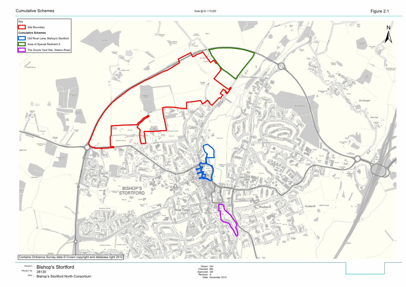
Bishop's Stortford28135PROJECT No:
PROJECT: GHMSCBANovember 2012
Drawn:Checked:
Approved:Revision:
Date:Bishop’s Stortford North ConsortiumClient:
KeySite Boundary
Cumulative SchemesOld River Lane, Bishop's StortfordArea of Special Restraint 5The Goods Yard Site, Station Road
±Scale @ A3 : Figure 2.11:15,000Cumulative Schemes
Contains Ordnance Survey data © Crown copyright and database right 2012
28135 Bishop’s Stortford North Non Technical Summary of the Environmental Statement
20 | 21
effect on traffic flows, and air quality and noise from road traffic during construction and operation is anticipated from these developments together with other committed developments in the local area.
7.1.5 Negative effects may occur should the construction phases of the developments, particularly the ASR5 Site and the Proposed Development, be concurrent, potentially increasing noise levels and changes in air quality from construction activities at certain sensitive receptors. A major positive cumulative effect on employment opportunities and a minor positive cumulative effect from enhancement of the local archaeological record may occur from development of the three schemes together with the Proposed Development.
7.1.6 A significant negative cumulative effect on ecology at the local level and a major negative effect on agricultural land are predicted from the combined development of the Proposed Development and of ASR5, which are both located on greenfield sites. In addition, a negative cumulative effect is predicted on views from some locations, including certain properties on Farnham Road and Rye Street and users of these roads. The cumulative effect on the local landscape character from these two developments is considered likely to be moderate negative in the first year, reducing to minor negative to moderate positive in the longer term as planting becomes established.
7.1.7 Significant positive cumulative effects will result once all the schemes considered are operational, through the provision of additional housing, employment opportunities, enhanced ecological habitats and improvements to surface water drainage through the implementation of SUDS.
The Bishop’s Stortford North Consortium Members
The Consultant Project Team