burnet woods overall district plan - home, … · burnet woods overall district plan ......
TRANSCRIPT

U N I V E R S I T Y O F C I N C I N N A T I
BURNET WOODS OVERALL DISTRICT PLAN
Nieho� Urban Studio Senior Planning Capstone Spring 2015
Raleigh PiersonOlivia Weir

U N I V E R S I T Y O F C I N C I N N A T I
Table of Contents
2
Abstract ............................................................................................... 3
Preliminary Analysis ......................................................................... 4
De�ning Our Users ............................................................................ 5
Preliminary Framework Plan ........................................................... 6
Case StudiesEast Bay Regional Parks District ......................................... 7Chicago Parks District ......................................................... 8
RecommendationsProgram Goals ...................................................................... 9Policy Objectives ................................................................ 10
Community Nodes .......................................................................... 11
Civic Assets ...................................................................................... 12
Commercial Nodes ......................................................................... 13
Greenspace Network ....................................................................... 14
Residential Clusters ......................................................................... 15
Future Concept Plan ....................................................................... 16
Conclusion ....................................................................................... 17
References and Bibliography .......................................................... 18

Abstract
Rethinking Burnet Woods park in Cincinnati, Ohio, to emphasize it as a healthy and resilient place required the exploration of an overall plan. As an overarching framework for the entirety of projects in this studio course, this project focuses on a conceptual plan for the entire district. �is includes four Uptown Consortium neighborhoods - Avondale, Cli�on, Corryville, and CUF - as well as other civic, commercial, environmental and residential stakeholders. Some of which include the University of Cincinnati, Cincinnati Zoo & Botanical Gardens, Cincinnati Children’s Hospital, and many others.
With direct stakeholder input, this project represents the visions of many populations and interests, from environmental preservation to economic development. Major project themes are connectivity of Burnet Woods to the rest of Cincinnati’s Park network, as well as three priority themes of civic engagement, commercial interest, and environmental needs. Recommendations related to potential programming and policy opportunities accompany this conceptual plan. All future recommendations are conceptual goals created through the �lter of four user groups: Children, Students, Professionals, and Elderly.
3

Preliminary Analysis
To begin the process of creating an overall district plan for Burnet Woods, we needed to perform preliminary analysis. First, we began with a perimeter site visit of the park. In doing so, we explored the external perceptions related to lighting, safety, scale, and other visual elements. �e analysis determined that entrances were not inviting, a lack of lighting encouraged misconceptions about safety, and the large scale of Burnet Woods did not have a cohesive relationship with the surrounding communities. �en, we ventured into the park to look at its assets and areas of improvement. One basic walk-through made it clear that signage was lacking and existing amenities were diverse, but were either in disrepair or not well advertised. Site photos below demonstrate the visual motivators for the future concept plan.
A�er visiting Burnet Woods, we decided to focus on the people surrounding it for multiple purposes. In order to rethink the park as a healthy and resilient place, the residents surrounding the park as well as its visitors were a primary focus for future growth. Demographic analysis, obtained from U.S. Census 2010 Data and 2006-2010 ACS Five-Year Estimates from the City of Cincinnati, provided the foundation the population we were to serve.
4
Trail SignagePhoto Credit: Raleigh Pierson, Jan. 19, 2015
Historic Bandstand under constructionPhoto Credit: Raleigh Pierson, Jan. 19, 2015

5
De�ning Our Users
�e demographic data de�ned our users by age and no other qualities. Children encompass those from zero to seventeen years old, students are eighteen to twenty-four years old, professionals are twenty-�ve to ��y-nine years old, and elderly include those ages sixty-�ve to eight-�ve and above.
Right is a graphical representation of the users by each neighborhood.
Part of the preliminary analysis called for a basic exploration into the psycho-dynamics of the users just a�er their de�nition. Some basic research included reading articles related to the public value of parks (1). Most of the user needs as well as what they valued in their lives came from the internal determinations. In other words, we used our knowledge gained over the past �ve years as students in the undergraduate Urban Planning program in our determinations.
�e graphical diagram to the right demonstrates some shared needs and values of each group, with all needing and valuing accessibility, a�ordability, cleanliness, and safety. It became our goal to provide these not only in the park but also in their communities.
Data Source: U.S. Census 2010 & 2006-2010 American Community Survey �ve-year estimates,http://www.cincinnati-oh.gov/planning/reports-data/census-demographics/

Preliminary Concept Plan
6
A�er the preliminary analysis phase was completed and our users were de�ned, a very preliminary concept plan was developed. �is would provide a transformation of our users from being broken down in students, young professionals, families, and elderly into children, students, professionals, and elderly. �e concepts established in this plan made way for future recommendations and illustrations of interconnecting relationships.
7
A�er the preliminary analysis phase and creating an initial framework plan, the next step in forming a concept plan was to �nd best practices and case studies. �e majority of park district best practices in management and programming were similar. Diversity in program opportunities is extremely important to the success of a park district. Ideal management of a park district needs to be thorough but relevant to the scale and scope of the parks and areas under its jurisdiction. Two park districts stood out in best management and programming practices, the East Bay Regional Parks District and the Chicago Parks District.
�e East Bay Regional Parks District (EBRPD) manages over 119,000 acres that includes 65 regional parks, recreation areas, wilderness, shorelines, preserves, and land bank areas. Although the scale of the district is much larger than the Cincinnati Parks jurisdiction, the most signi�cant �nd came in �scal policy aspect of the EBRPD (2). Measure WW awarded more than $10.7 million in 2014 to fund park and recreation projects a�er being approved by voters in 2008. Measure CC is a $12-per-year parcel tax passed by voters in the two counties that comprise the EBRPD. �is has already helped fund new trails and other improvements in 2014.
Case Studies: East Bay Regional Parks District

Case Studies: Chicago Parks District
�e Chicago Parks District manages over 8,400 acres of green space and has a wide range of programs that include but are not limited to Region & Program Administration; Aquatics; Athletics; Cultural, Arts, & Nature; Gymnastics; and Special Recreation. �e 2015 Annual Budget culminates to $448.6 million, with ��y-eight percent of the revenue generating from Chicago resident’s property taxes, as represented to the right. (3)
8
Spatial Comparison: University of Cincinnati & Burnet Woods to University of Chicago & Washington ParkMap Rendering: Olivia Weir Aerial images via Google MapsWashington Park Information: http://www.chicagoparkdistrict.com/parks/washington-park/#v8b78650uo
One park, Washington Park, within the Chicago Parks District stood out as a spatial comparison because of its proximity to an urban university campus and medical institution/campus. As compared to Washington Park in Chicago, Burnet Woods is more isolated from the university and UC Health because of a wider street network and other uses. It is also about 4.7 miles from the downtown while Washington Park is about 8.0 miles from downtown Chicago.
Data source: Chicago Parks District Budget Summaryhttp://www.chicagoparkdistrict.com/assets/1/23/2015_Budget_Summary_-_Ad-opted_Budget_12.12.14_-_Web1.pdf
9
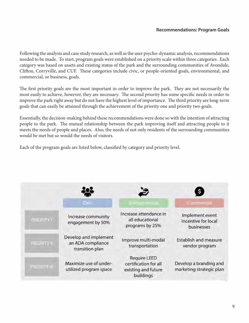
Following the analysis and case study research, as well as the user psycho-dynamic analysis, recommendations needed to be made. To start, program goals were established on a priority scale within three categories. Each category was based on assets and existing status of the park and the surrounding communities of Avondale, Cli�on, Corryville, and CUF. �ese categories include civic, or people-oriented goals, environmental, and commercial, or business, goals.
�e �rst priority goals are the most important in order to improve the park. �ey are not necessarily the most easily to achieve, however, they are necessary. �e second priority has some speci�c needs in order to improve the park right away but do not have the highest level of importance. �e third priority are long-term goals that can easily be attained through the achievement of the priority one and priority two goals.
Essentially, the decision-making behind these recommendations were done so with the intention of attracting people to the park. �e mutual relationship between the park improving itself and attracting people to it meets the needs of people and places. Also, the needs of not only residents of the surrounding communities would be met but so would the needs of visitors.
Each of the program goals are listed below, classi�ed by category and priority level.
Recommendations: Program Goals

Recommendations: Policy Objectives
In order to achieve the program goals, revenue generation would need to increase. �e 2015 approved operating budget update total for the City of Cincinnati’s Parks Department is $15,463,320, with about $7,627,960 going towards personnel services, $2,424,580 going towards employee bene�ts, $5,380,780 going towards other expenses, and $30,000 going to properties. �e City of Cincinnati has a 5.7 mills property tax rate for city operations for 2013 and 2014 (4). �is number was used for methodological purposes, or just to serve the purpose of being an example number for revenue generation.
Proposing a Special Improvement District with three bu�er areas would help o�set some of these departmental costs. Each bu�er area has a certain percentage of their property taxes that will be given directly to Cincinnati parks. �ose in the �rst bu�er area are in the closest proximity and would thereby have the highest percentage allocation, set at 12% in the example below. �e second bu�er area has an allocation of 10% and the third bu�er area has an allocation of 8%.
�e example below is the start of a conceptual approach. To determine the total revenue generated from this, the percentages will need to be applied to each resident within the three bu�er areas and then added together. Ultimately, any future revenue will be needed for the recommendations and projects proposed by the entire Spring 2015 Nieho� Studio.
10
Map Rendering: Raleigh PiersonCincinnati Property Tax Information Source: http://www.bizjournals.com/cincinnati/print-edition/2014/10/10/is-cincinnati-s-prop-erty-tax-rollback-squeezing.html?page=all

11
�e existing nodes, or places of activity, surrounding Burnet Woods are not as cohesive as desired. In fact, the street network and tra�c patterns contribute to such isolation. �e park is found at the center of the district, as seen in the conceptual maps below. Called out are recent, on-going, and/or future projects that can help eliminate the separate nature of the neighborhoods within the district.
Community Nodes
Civic Assets
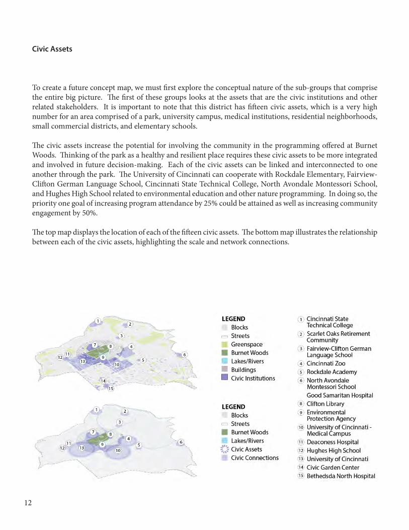
To create a future concept map, we must �rst explore the conceptual nature of the sub-groups that comprise the entire big picture. �e �rst of these groups looks at the assets that are the civic institutions and other related stakeholders. It is important to note that this district has ��een civic assets, which is a very high number for an area comprised of a park, university campus, medical institutions, residential neighborhoods, small commercial districts, and elementary schools.
�e civic assets increase the potential for involving the community in the programming o�ered at Burnet Woods. �inking of the park as a healthy and resilient place requires these civic assets to be more integrated and involved in future decision-making. Each of the civic assets can be linked and interconnected to one another through the park. �e University of Cincinnati can cooperate with Rockdale Elementary, Fairview-Cli�on German Language School, Cincinnati State Technical College, North Avondale Montessori School, and Hughes High School related to environmental education and other nature programming. In doing so, the priority one goal of increasing program attendance by 25% could be attained as well as increasing community engagement by 50%.
�e top map displays the location of each of the ��een civic assets. �e bottom map illustrates the relationship between each of the civic assets, highlighting the scale and network connections.
12
13
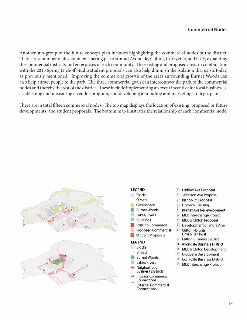
Another sub-group of the future concept plan includes highlighting the commercial nodes of the district. �ere are a number of developments taking place around Avondale, Cli�on, Corryville, and CUF, expanding the commercial districts and enterprises of each community. �e existing and proposed areas in combination with the 2015 Spring Nieho� Studio student proposals can also help diminish the isolation that exists today, as previously mentioned. Improving the commercial growth of the areas surrounding Burnet Woods can also help attract people to the park. �e three commercial goals can interconnect the park to the commercial nodes and thereby the rest of the district. �ese include implementing an event incentive for local businesses, establishing and measuring a vendor program, and developing a branding and marketing strategic plan.
�ere are in total ��een commercial nodes. �e top map displays the location of existing, proposed or future developments, and student proposals. �e bottom map illustrates the relationship of each commercial node.
Commercial Nodes

Greenspace Network
To address the environmental assets and needs of the district plan, it was important to take a look at the greenspace network. �is encompasses several parks, proposed redevelopments, and future streetscape improvements. Curbing the isolation of community nodes can be achieved through expanding the greenspace network. Furthermore, streetscape improvements will not only bridge the isolation gap throughout the district but will also improve multi-modal transportation, or the second priority environmental program goal.
�e top map highlights six parks, a few greenspaces, and parks that are intended for redevelopment according to the Cincinnati Parks Master Plan from 2007 (5). �e bottom map shows existing and proposed bike lanes as well as existing and proposed green streets. It also demonstrates the interconnections of the greenspace network surrounding Burnet Woods.
14

15
�e �nal sub-group of the future concept plan highlights the residential clusters. While there are only eight clusters as compared to the larger numbers of civic assets or commercial nodes, the residents of the district play one of the most crucial stakeholder roles. Without community residents being attracted to Burnet Woods, it will never be a healthy and resilient place. If we cannot attract residents, we can never hope to attract visitors from outside of the district.
Even though there are some commercial nodes, the majority of the district is comprised of residential areas. �ese areas, much like the rest of the district today, are not as cohesive as they could be in regards to community engagement. It is important to preserve the integrity of each neighborhood and embrace the di�erences among them, yet, bridging the gap between each of them can paint the picture of a beautiful future for Burnet Woods.
�e top map illustrates the existing and proposed residential clusters as well as the student proposals around the park. �e bottom map highlights the relationship between the existing clusters and proposals as well the connections between them.
Residential Clusters

Future Concept Plan
Finally, we come to the encompassing future concept plan. Within this plan, ideal growth of the interconnected and interdependent relationships between civic assets, commercial nodes, the greenspace network, and residential clusters is illustrated. �e 2015 Spring Nieho� Studio student projects are called out as they also create opportunities for Burnet Woods to transform into a healthy and resilient place.
A half-mile radius surrounding Burnet Woods focuses on student projects on the fringe of the park as well as within it. Moreover, it shows a smaller scale of the district plan that can experience immediate growth and potential for future change.
16

17
Rethinking Burnet Woods park in Cincinnati, Ohio, to emphasize it as a healthy and resilient place required the exploration of an overarching district plan. As every other student group focused on projects within the park and its immediate fringe areas, the overall district plan served as conceptual illustration for the interconnections of each project. Preliminary analysis came from research as well as personal observations, a combination that was relevant since almost the entire class is a resident within the set forth district. Gathering background information also came from neighborhood stakeholders in Avondale, Cli�on, Corryville, and CUF. It then concluded with pursuing case studies of best practices as well as spatial comparisons to Burnet Woods and its surrounding amenities.
De�ning users by age and determining the needs and values of children, students, professionals, and elderly then made way for district themes to evolve. �ree priority themes of civic engagement, commercial interest, and environmental needs were established to make recommendations for program goals and policy objectives. �e culmination of the civic assets, commercial nodes, greenspace network, and residential clusters into the future concept plan then resulted.
�e purpose of the district plan was to illustrate the existing and future relationships surrounding Burnet Woods. It came about with recommendations as well as graphical representations of interconnections and interdependencies. Moving forward, this district plan can provide context outside of the infrastructure or other tangible projects. Instead, it conceptualizes the intangible and highlights the potential for future growth in more than one dimension.
Conclusion

References and Bibliography
(1) Walker, Chris. “�e Public Value of Urban Parks.” Beyond Recreation: A Broader View of Urban Parks. Published by �e Urban Land Institute and �e Wallace Foundation, 2004. Accessed online February 24, 2015. http://www.wallacefoundation.org/knowledge-center/urban-parks/Documents/�e-Public-Value-of-Urban-Parks.pdf
(2) East Bay Regional Parks District. “Connecting Parks to People.” Community Report: 2014-2015. Accessed online February 24, 2015. http://www.ebparks.org/Assets/_Nav_Categories/About_Us/Community+Report+EBRPD+2014.pdf
(3) Chicago Parks District. “2015 Budget Summary.” Published online December 14, 2014. http://www.chicagoparkdistrict.com/assets/1/23/2015_Budget_Summary_-_Adopted_Budget_12.12.14_-_Web1.pdf
(4) Wetterich, Chris. “Is Cincinnati’s property tax rollback squeezing growth?” Cincinnati Business Courier. Published online on October 10, 2014. Accessed online April 12, 2014. http://www.bizjournals.com/cincinnati/print-edition/2014/10/10/is-cincinnati-s-property-tax-rollback-squeezing.html?page=all
(5) Human Nature, Inc. et. al. “Cincinnati Parks Master Plan.” Published by Human Nature, 2007. Accessed online January 24, 2015. http://www.uc.edu/cdc/urban_database/subregional/parks-master-plan.pdf
18