chapter 2 - strategic context - home - roads and maritime ... · gerringong to bomaderry princes...
TRANSCRIPT

Gerringong to Bomaderry Princes Highway upgrade – Route Options Development ReportNovember 2007Maunsell Australia Pty Ltd
Chapter 2 - Strategic context

Gerringong to Bomaderry Princes Highway upgrade – Route Options Development ReportNovember 2007Maunsell Australia Pty Ltd
Not used
Gerringong to Bomaderry Princes Highway upgrade – Route Options Development Report Page 7November 2007Maunsell Australia Pty Ltd
2.0 Strategic context
2.1 Introduction
The Princes Highway is the main north-south corridor between Sydney and the Illawarra and South Coast regions.It is a critical link for both passenger and freight transport and is a major route for tourism with significant peaks inholiday periods. The section of the highway from Gerringong to Bomaderry experiences a high rate of accidentswith seven fatalities occurring in 2003/04. The two lane undivided road has limited overtaking opportunities, manyjunctions with rural roads and private uncontrolled accesses.
On completion of the Oaks Flats to Dunmore project, planned for late 2009, this section of the Princes Highwaywill be the only section of two lane highway between Sydney and Nowra.
The NSW Government is committed to the investigation of this section of the Princes Highway to determine apreferred route. This commitment was further demonstrated recently by the NSW Treasurer in the 2007/08budget, when he announced further budget allocation of $3.4 million towards planning of this upgrade.
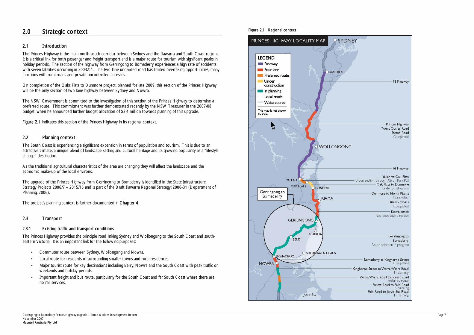
Figure 2.1 indicates this section of the Princes Highway in its regional context.
2.2 Planning context
The South Coast is experiencing a significant expansion in terms of population and tourism. This is due to anattractive climate, a unique blend of landscape setting and cultural heritage and its growing popularity as a “ lifestylechange” destination.
As the traditional agricultural characteristics of the area are changing they will affect the landscape and theeconomic make-up of the local environs.
The upgrade of the Princes Highway from Gerringong to Bomaderry is identified in the State InfrastructureStrategy Projects 2006/7 – 2015/16 and is part of the Draft Illawarra Regional Strategy: 2006-31 (Department ofPlanning, 2006).
The project’s planning context is further documented in Chapter 4.
2.3 Transport
2.3.1 Existing traffic and transport conditions
The Princes Highway provides the principle road linking Sydney and Wollongong to the South Coast and south-eastern Victoria. It is an important link for the following purposes:
• Commuter route between Sydney, Wollongong and Nowra.
• Local route for residents of surrounding smaller towns and rural residences.
• Major tourist route for key destinations including Berry, Nowra and the South Coast with peak traffic onweekends and holiday periods.
• Important freight and bus route, particularly for the South Coast and far South Coast where there areno rail services.
Figure 2.1 Regional context
Gerringong to Bomaderry Princes Highway upgrade – Route Options Development Report Page 8November 2007Maunsell Australia Pty Ltd
2.3.2 Existing traffic volumes
Traffic counts conducted in February 2007 recorded traffic flows at locations within the study area. These aresummarised in Table 2.1.
Table 2.1 Traffic volumes on the Princes Highway in February 2007
Highest weekday peak hour flow(vehicle/hour)Location
Northbound Southbound Total
Estimated 2007AADT*
(veh/day)
Princes Highway, north of FernStreet, Gerringong
800 800 1,600 20,700
Princes Highway, north ofTannery Road, Berry
400 350 750 11,500
Princes Highway, north ofCambewarra Road, Bomaderry
450 500 950 13,400
Source: Australasian Traffic Surveys, 2007
* AADT = average annual daily traffic
The highest traffic volumes were observed on the existing highway just north of Fern Street at Gerringong.
2.3.3 Daily variations
Analysis of the weekday traffic profiles on the highway at Gerringong (north of Fern Street) and Bomaderry (northof Cambewarra Road) shows that the AM peak period occurs between 8am and 9am and the PM peak periodoccurs between 4pm and 5pm. These peaks can be primarily attributed to commuter traffic.
However the daily profile of traffic on the Princes Highway in Berry (north of Tannery Road) does not show adistinct AM peak as traffic increases gradually from the morning to midday until reaching the PM peak between3pm and 5pm. The earlier afternoon peak may indicate school and commercial activity at these locations. Theweekend traffic counts show that the peak hour varied at different locations along the Princes Highway, but trafficvolumes remain consistent between 10am and 5pm on Saturdays and Sundays.
2.3.4 Seasonal variations
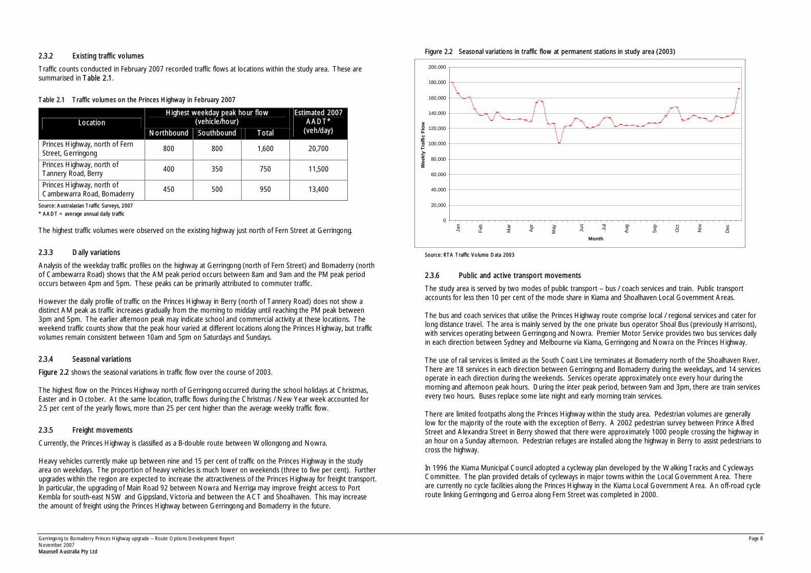
Figure 2.2 shows the seasonal variations in traffic flow over the course of 2003.
The highest flow on the Princes Highway north of Gerringong occurred during the school holidays at Christmas,Easter and in October. At the same location, traffic flows during the Christmas / New Year week accounted for2.5 per cent of the yearly flows, more than 25 per cent higher than the average weekly traffic flow.
2.3.5 Freight movements
Currently, the Princes Highway is classified as a B-double route between Wollongong and Nowra.
Heavy vehicles currently make up between nine and 15 per cent of traffic on the Princes Highway in the studyarea on weekdays. The proportion of heavy vehicles is much lower on weekends (three to five per cent). Furtherupgrades within the region are expected to increase the attractiveness of the Princes Highway for freight transport.In particular, the upgrading of Main Road 92 between Nowra and Nerriga may improve freight access to PortKembla for south-east NSW and Gippsland, Victoria and between the ACT and Shoalhaven. This may increasethe amount of freight using the Princes Highway between Gerringong and Bomaderry in the future.
Figure 2.2 Seasonal variations in traffic flow at permanent stations in study area (2003)
Source: RTA Traffic Volume Data 2003
2.3.6 Public and active transport movements
The study area is served by two modes of public transport – bus / coach services and train. Public transportaccounts for less then 10 per cent of the mode share in Kiama and Shoalhaven Local Government Areas.
The bus and coach services that utilise the Princes Highway route comprise local / regional services and cater forlong distance travel. The area is mainly served by the one private bus operator Shoal Bus (previously Harrisons),with services operating between Gerringong and Nowra. Premier Motor Service provides two bus services dailyin each direction between Sydney and Melbourne via Kiama, Gerringong and Nowra on the Princes Highway.
The use of rail services is limited as the South Coast Line terminates at Bomaderry north of the Shoalhaven River.There are 18 services in each direction between Gerringong and Bomaderry during the weekdays, and 14 servicesoperate in each direction during the weekends. Services operate approximately once every hour during themorning and afternoon peak hours. During the inter peak period, between 9am and 3pm, there are train servicesevery two hours. Buses replace some late night and early morning train services.
There are limited footpaths along the Princes Highway within the study area. Pedestrian volumes are generallylow for the majority of the route with the exception of Berry. A 2002 pedestrian survey between Prince AlfredStreet and Alexandra Street in Berry showed that there were approximately 1000 people crossing the highway inan hour on a Sunday afternoon. Pedestrian refuges are installed along the highway in Berry to assist pedestrians tocross the highway.
In 1996 the Kiama Municipal Council adopted a cycleway plan developed by the Walking Tracks and CyclewaysCommittee. The plan provided details of cycleways in major towns within the Local Government Area. Thereare currently no cycle facilities along the Princes Highway in the Kiama Local Government Area. An off-road cycleroute linking Gerringong and Gerroa along Fern Street was completed in 2000.
0
20,000
40,000
60,000
80,000
100,000
120,000
140,000
160,000
180,000
200,000
Jan
Feb
Mar
Apr
May Ju
n
Jul
Aug
Sep Oct
Nov
Dec
Month
Wee
kly
Traf
fic F
low
Gerringong to Bomaderry Princes Highway upgrade – Route Options Development Report Page 9November 2007Maunsell Australia Pty Ltd
There is unmarked on-road cycle route provision on the Princes Highway between Berry and Bomaderry (withinthe Shoalhaven Local Government Area). This route connects with on-road cycle routes in Bomaderry on MerooRoad and Bolong Road.
2.3.7 Crash analysis
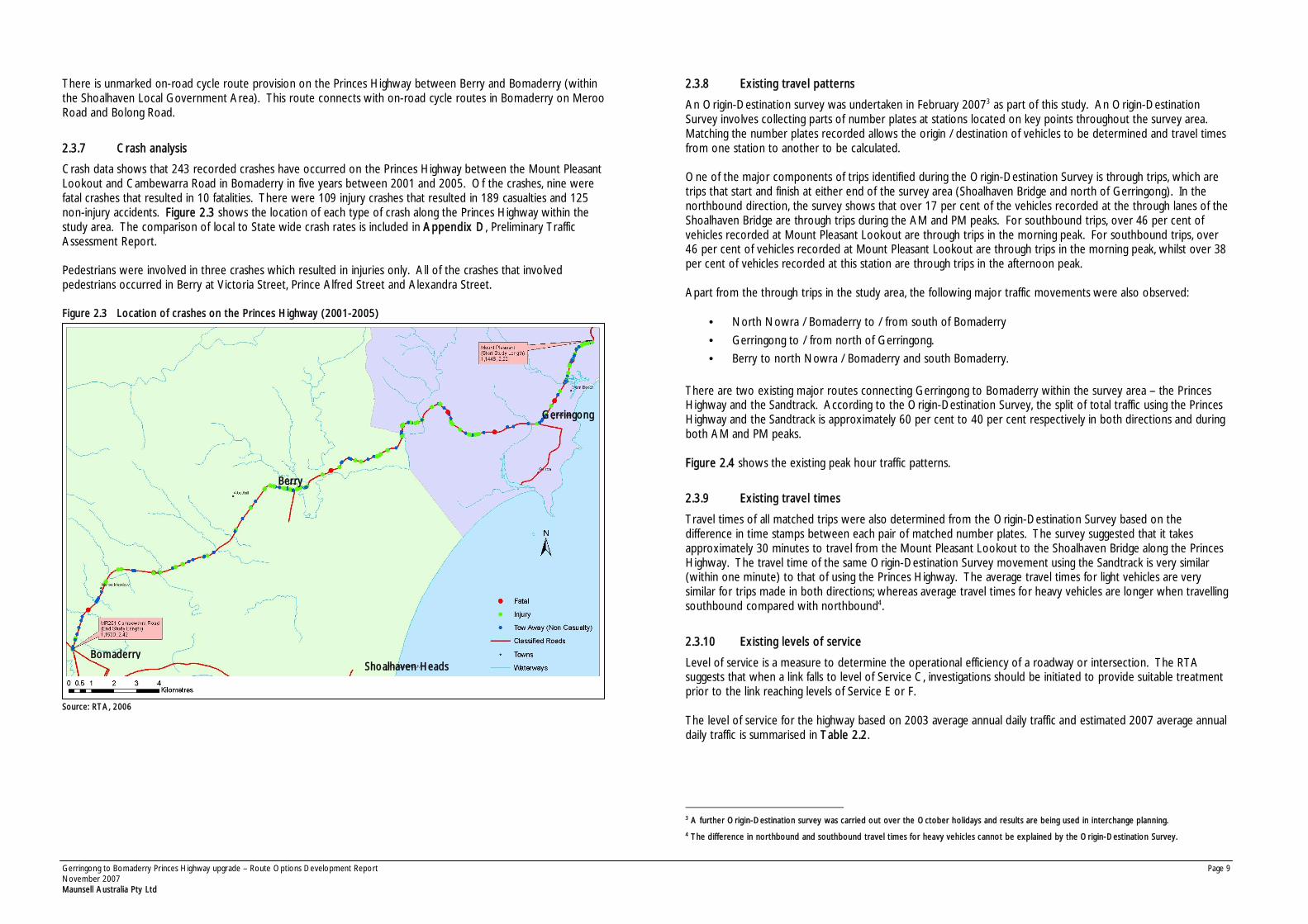
Crash data shows that 243 recorded crashes have occurred on the Princes Highway between the Mount PleasantLookout and Cambewarra Road in Bomaderry in five years between 2001 and 2005. Of the crashes, nine werefatal crashes that resulted in 10 fatalities. There were 109 injury crashes that resulted in 189 casualties and 125non-injury accidents. Figure 2.3 shows the location of each type of crash along the Princes Highway within thestudy area. The comparison of local to State wide crash rates is included in Appendix D, Preliminary TrafficAssessment Report.
Pedestrians were involved in three crashes which resulted in injuries only. All of the crashes that involvedpedestrians occurred in Berry at Victoria Street, Prince Alfred Street and Alexandra Street.
Figure 2.3 Location of crashes on the Princes Highway (2001-2005)
Source: RTA, 2006
2.3.8 Existing travel patterns
An Origin-Destination survey was undertaken in February 20073 as part of this study. An Origin-DestinationSurvey involves collecting parts of number plates at stations located on key points throughout the survey area.Matching the number plates recorded allows the origin / destination of vehicles to be determined and travel timesfrom one station to another to be calculated.
One of the major components of trips identified during the Origin-Destination Survey is through trips, which aretrips that start and finish at either end of the survey area (Shoalhaven Bridge and north of Gerringong). In thenorthbound direction, the survey shows that over 17 per cent of the vehicles recorded at the through lanes of theShoalhaven Bridge are through trips during the AM and PM peaks. For southbound trips, over 46 per cent ofvehicles recorded at Mount Pleasant Lookout are through trips in the morning peak. For southbound trips, over46 per cent of vehicles recorded at Mount Pleasant Lookout are through trips in the morning peak, whilst over 38per cent of vehicles recorded at this station are through trips in the afternoon peak.
Apart from the through trips in the study area, the following major traffic movements were also observed:
• North Nowra / Bomaderry to / from south of Bomaderry
• Gerringong to / from north of Gerringong.
• Berry to north Nowra / Bomaderry and south Bomaderry.
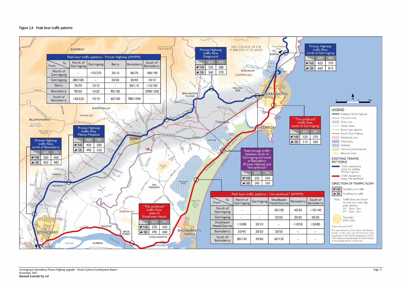
There are two existing major routes connecting Gerringong to Bomaderry within the survey area – the PrincesHighway and the Sandtrack. According to the Origin-Destination Survey, the split of total traffic using the PrincesHighway and the Sandtrack is approximately 60 per cent to 40 per cent respectively in both directions and duringboth AM and PM peaks.
Figure 2.4 shows the existing peak hour traffic patterns.
2.3.9 Existing travel times
Travel times of all matched trips were also determined from the Origin-Destination Survey based on thedifference in time stamps between each pair of matched number plates. The survey suggested that it takesapproximately 30 minutes to travel from the Mount Pleasant Lookout to the Shoalhaven Bridge along the PrincesHighway. The travel time of the same Origin-Destination Survey movement using the Sandtrack is very similar(within one minute) to that of using the Princes Highway. The average travel times for light vehicles are verysimilar for trips made in both directions; whereas average travel times for heavy vehicles are longer when travellingsouthbound compared with northbound4.
2.3.10 Existing levels of service
Level of service is a measure to determine the operational efficiency of a roadway or intersection. The RTAsuggests that when a link falls to level of Service C, investigations should be initiated to provide suitable treatmentprior to the link reaching levels of Service E or F.
The level of service for the highway based on 2003 average annual daily traffic and estimated 2007 average annualdaily traffic is summarised in Table 2.2.
3 A further Origin-Destination survey was carried out over the October holidays and results are being used in interchange planning.
4 The difference in northbound and southbound travel times for heavy vehicles cannot be explained by the Origin-Destination Survey.
Berry
Gerringong
BomaderryShoalhaven Heads
Gerringong to Bomaderry Princes Highway upgrade – Route Options Development Report Page 10November 2007Maunsell Australia Pty Ltd
Table 2.2 Level of service for the Princes Highway within the study area
Section from Section to Length(km)
2003AADT*
LoS* Estimated2007 AADT
LoS
Mt Pleasant Lookout Fern Street, Gerringong 2.27 19,293 D 20,700 D
Fern Street, GerringongKiama / Shoalhaven LocalGovernment Area
10.75 10,271 D 11,500 D
Kiama / Shoalhaven LocalGovernment Area
Tannery Street, Berry 5.13 10,271 D 11,500 D
Tannery Road, Berry Victoria Street, Berry 1.95 11,790 C 13,400 C
Victoria Street, Berry Cambewarra Road 12.30 11,790 C 13,400 C
Source: 2003 Level of Service Southern Region, RTA, 2005
*AADT = average annual daily traffic
*LoS = level of service
2.3.11 Forecast traffic volumes
Traffic flows extracted from RTA Southern Region’s strategic traffic models for 2001 and 2026 indicate that thehighway is experiencing an approximate growth of three per cent per annum based on the change in land usewithin the region. Applying this growth rate, the forecast level of traffic expected to use the existing highwayroute in 2026 can be determined. Table 2.3 summarises the forecast traffic flows at selected locations.
Table 2.3 Traffic forecasts at selected locations
AADT* (vehicle / day)
Location2003 2007 2027
Percentageincrease 2007-
2027
Princes Highway, north ofFern Street
19,293 20,700 36,300 75%
Princes Highway, north ofTannery Road
10,271 11,500 20,800 80%
Princes Highway, north ofCambewarra Road
11,790 13,400 22,500 70%
Source: Maunsell, 2007
*AADT = average annual daily traffic
2.4 Consequence of no action
Should the highway not be upgraded between Gerringong and Bomaderry, higher traffic volumes would continueto grow on the present highway and the Sandtrack with increases in travel time and the potential for crashes onboth roads.
2.4.1 Overall efficiency
Travel times on the Princes Highway within the study area would increase as the level of congestion increases.Delays may be caused by local traffic conflicting with major through traffic movements at major destinations suchas Berry. Heavy delays would also result in economic impacts, especially to freight and tourist traffic travellingeither to local areas or long distance.
Table 2.4 illustrates the level of service that has been estimated for the existing route should the highway not beupgraded. By the design year of 2027 the highway will be operating at an unacceptable level of service (E and F).
Table 2.4 Forecast mid-block level of service
Level of serviceLocation
2007 2027
Princes Highway, north of Fern Street D F
Princes Highway, north of Tannery Road D E
Princes Highway, north of Cambewarra Road C E
Source: Maunsell, 2007
2.4.2 Local road safety
The potential for crashes is likely to increase with increased traffic volumes especially at major intersections alongthe route, such as Fern Street and Belinda Street in Gerringong.
More rear-end crashes would also be likely to occur as delays on the Princes Highway continue to increase.Access to and from local roads and properties is expected to become more difficult with increased volumes ofthrough traffic. Drivers may take greater risks to make turns as gaps in the flow of traffic on the Princes Highwaywould be less frequent.
There are high pedestrian movements across Queen Street in Berry. Removal of through traffic to a bypass ofBerry would dramatically reduce the increased likelihood of crashes involving pedestrians.
2.4.3 Local and regional growth patterns
Increases in travel times on the highway could reduce the attractiveness of the local area to commercial businessand the region may suffer economically. For example, new businesses may choose to locate outside the area togain adequate freight access.
2.4.4 Local environmental setting
Heavier traffic levels are likely to result in increased levels of noise and air pollution to properties that are locatedclose to the existing highway network, including those along the Princes Highway in Gerringong and Berry.
2.4.5 Minimal intervention
Fundamental requirements of this study include the provision of a bypass of Berry and highway alignment meetingthe design speed of 100 and 110 km/h vertically and horizontally respectively. Scenarios involving minorimprovements only would not meet these requirements. Following the analysis above, not only would therequirements of the study objectives not be met, minor improvements would not provide a satisfactory solutionfrom a strategic, regional, local planning or transport context.
Gerringong to Bomaderry Princes Highway upgrade – Route Options Development Report Page 11November 2007Maunsell Australia Pty Ltd
Figure 2.4 Peak hour traffic patterns

Gerringong to Bomaderry Princes Highway upgrade – Route Options Development Report Page 12November 2007Maunsell Australia Pty Ltd
Not used