class lecture #2: zoning - city tech openlab lecture #2: zoning ... short history as a means of...
TRANSCRIPT

Class Lecture #2: Zoning
New York City College of TechnologyArch 2430 Building Technology IVProfessor FriedmanFall 2013
http://www.bestplacesin.com

Zoning Zoning
Zoning shapes the city. Compared with architecture and planning, zoning has a relatively short history as a means of organizing the way land is used. Yet zoning determines the size and use of buildings, where they are located and, in large measure, the density of the city’s diverse neighborhoods. Along with the city’s power to budget, tax, and condemn property, zoning is a key tool for carrying out planning policy. New York City has been a pioneer in the field of zoning since it enacted the nation’s first comprehensive zoning ordinance in 1916. (NYC DCP)

Zoning Zoning
Borough:MANHATTANBlock:690Lot:29Police Precinct:10Owner:SOMATIC REALTY LLC
Address:131 10 AVENUELot Area:23000 sfLot Frontage:184'Lot Depth:125Year Built:unknownNumber of Buildings:0Number of Floors:0Gross Floor Area:0 sf (estimated)Residential Units:0Total # of Units:0Land Use:Parking FacilitiesZoning:C6‐2Commercial Overlay:Zoning Map #:8BDept. of City Planning, PLUTO 11v2 © 2011
http://gis.nyc.gov/doitt/nycitymap/

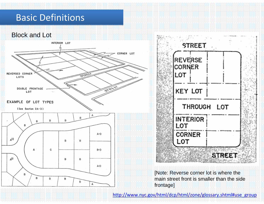
Basic Definitions Basic Definitions BlockA block is a tract of land bounded on all sides by streets or by a combination of streets, public parks, railroad rights‐of‐way, pierhead lines or airport boundaries.
Lot or Zoning LotA lot or zoning lot is a tract of land comprising a single tax lot or two or more adjacent tax lots within a block. An apartment building on a single zoning lot, for example, may contain separate condominium units, each occupying its own tax lot. Similarly, a building containing a row of townhouses may occupy several separate tax lots within a single zoning lot, or two or more detached homes on one zoning lot may each have its own tax lot.
The zoning lot is the basic unit for zoning regulations and may be subdivided into two or more zoning lots, and two or more adjoining zoning lots on the same block may be merged, provided that all resulting zoning lots comply with applicable regulations.
http://www.nyc.gov/html/dcp/html/zone/glossary.shtml#use_group
All buildings must have a block and lot designation…
Street numbers and names can change over time…
Basic Definitions Basic Definitions
http://www.nyc.gov/html/dcp/html/zone/glossary.shtml#use_group
Block and Lot
[Note: Reverse corner lot is where the main street front is smaller than the side frontage]

Basic Definitions Basic Definitions
Building HeightBuilding height refers to a building’s elevation as measured from the curb level or base plane to theroof of the building (except for permitted obstructions, such as elevator bulkheads).
http://www.nyc.gov/html/dcp/html/zone/glossary.shtml#use_group

FAR FAR
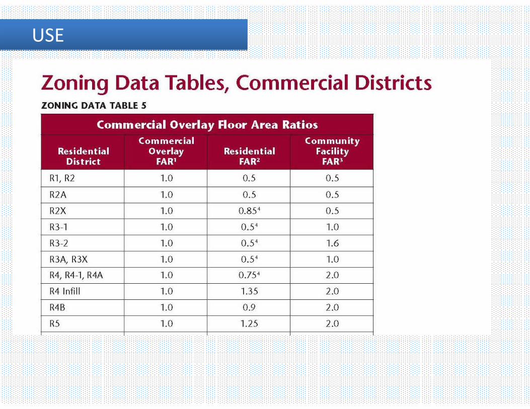
Floor Area Ratio (FAR)The floor area ratio is the principal bulk regulation controlling the size of buildings. FAR is the ratio of total building floor area to the area of its zoning lot. Each zoning district has an FAR which, when multiplied by the lot area of the zoning lot, produces the maximum amount of floor area allowable on that zoning lot. For example, on a 10,000 square foot zoning lot in a district with a maximum FAR of 1.0, the floor area on the zoning lot cannot exceed 10,000 square feet.
http://www.nyc.gov/html/dcp/html/zone/glossary.shtml#use_group

FAR FAR
Floor Area Ratio (FAR)
http://www.nyc.gov/html/dcp/html/zone/glossary.shtml#use_group
USE USE
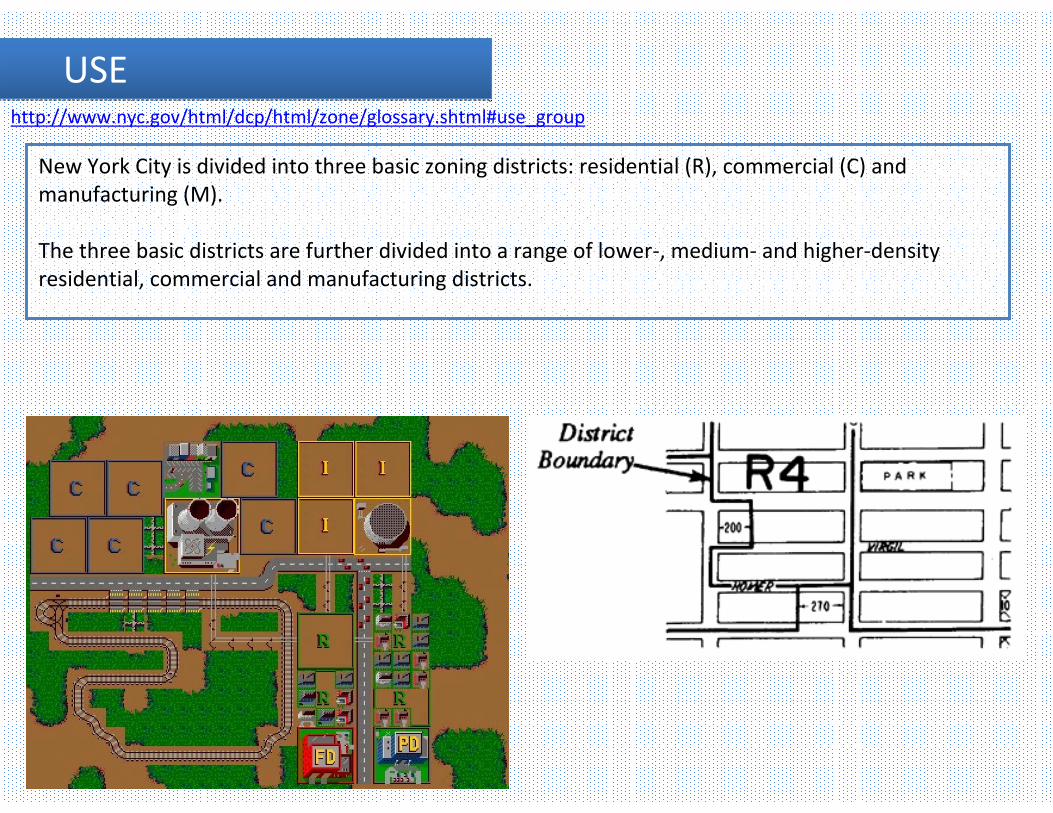
New York City is divided into three basic zoning districts: residential (R), commercial (C) and manufacturing (M).
The three basic districts are further divided into a range of lower‐, medium‐ and higher‐density residential, commercial and manufacturing districts.
http://www.nyc.gov/html/dcp/html/zone/glossary.shtml#use_group

USE USE
Limits are set to the population density of certain areas.
This is to make sure large populations don’t concentrate around areas without transportation and other amenities.

USE USE

USE USE
USE USE


USE USE
Any of these districts may in turn be overlaid by special purpose zoning districts tailored to the unique characteristics of certain neighborhoods.
Some blockfronts in residential districts may have a commercial overlay district as well in order to provide neighborhood retail stores and services.
Limited Height Districts, another type of overlay district, imposes height limits on new buildings in certain historic districts designated by the NYC Landmarks Preservation Commission. These overlay districts modify and supplement the controls of the underlying zoning districts.
Each zoning district regulates:• permitted uses listed in one or more of 18 use groups;• the size of the building in relation to the size of the zoning lot, known as the floor area ratio or FAR;• for residential uses, the number of dwelling units permitted, the amount of open space and plantings required on the zoning lot and the maximum amount of the lot that can be covered by a building;• the distance between the building and the front, side and rear lot lines; • the amount of required or permitted parking; and• other features applicable to specific residential, commercial or manufacturing districts
http://www.nyc.gov/html/dcp/html/zone/glossary.shtml#use_group

USE USE http://www.nyc.gov/html/dcp/html/zone/glossary.shtml#use_group
Special Landmark District (Gray area)

USE Sub GroupsUSE Sub Groups

USE Sub GroupsUSE Sub Groups

USE Sub GroupsUSE Sub Groups

USE Sub GroupsUSE Sub Groups
Incentive Zoning*Incentive zoning provides a bonus, usually in the form of additional floor area, in exchange for the provision of a public amenity or affordable housing. There are incentive bonuses for the provision of public plazas (privately owned public spaces), visual or performing arts spaces, subway improvements, theater preservation, FRESH food stores and affordable housing (Inclusionary Housing Program).

USE Sub GroupsUSE Sub Groups
Inclusionary Housing Program:Provides two optional floor area incentives in exchange for the creation or preservation of affordable housing, on or off-site, pre-dominantly for low-income households

USE Sub GroupsUSE Sub GroupsInclusionary Housing Program:

USE Sub GroupsUSE Sub Groups
Quality Housing ProgramThe Quality Housing Program, mandatory in contextual R6 through R10 residence districts and optional in non-contextual R6 through R10 districts
-encourages development consistent with the character of many established neighborhoods. Its bulk regulations set height limits and allow high lot coverage buildings that are setat or near the street line.
The Quality Housing Program also requires amenities relating to interior space, recreation areas and landscaping.
USE Sub GroupsUSE Sub Groups
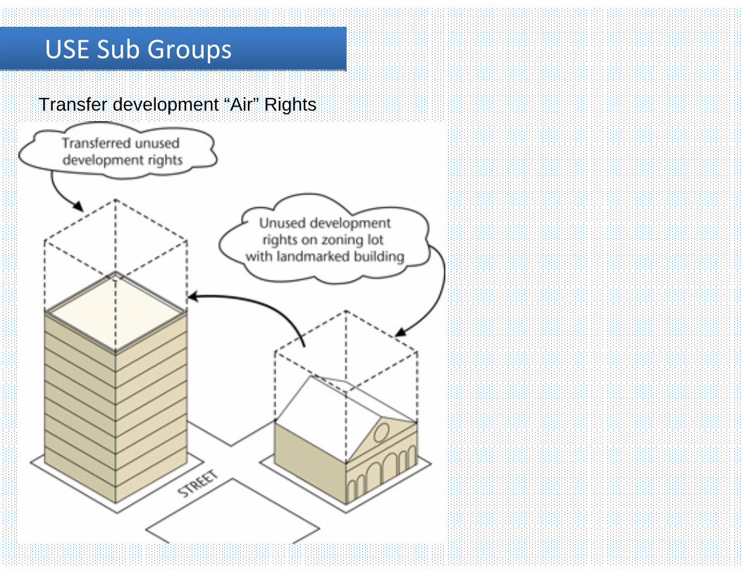
Transfer development “Air” Rights

USE Sub GroupsUSE Sub Groups
Bonus for Arts

USE Sub GroupsUSE Sub Groups
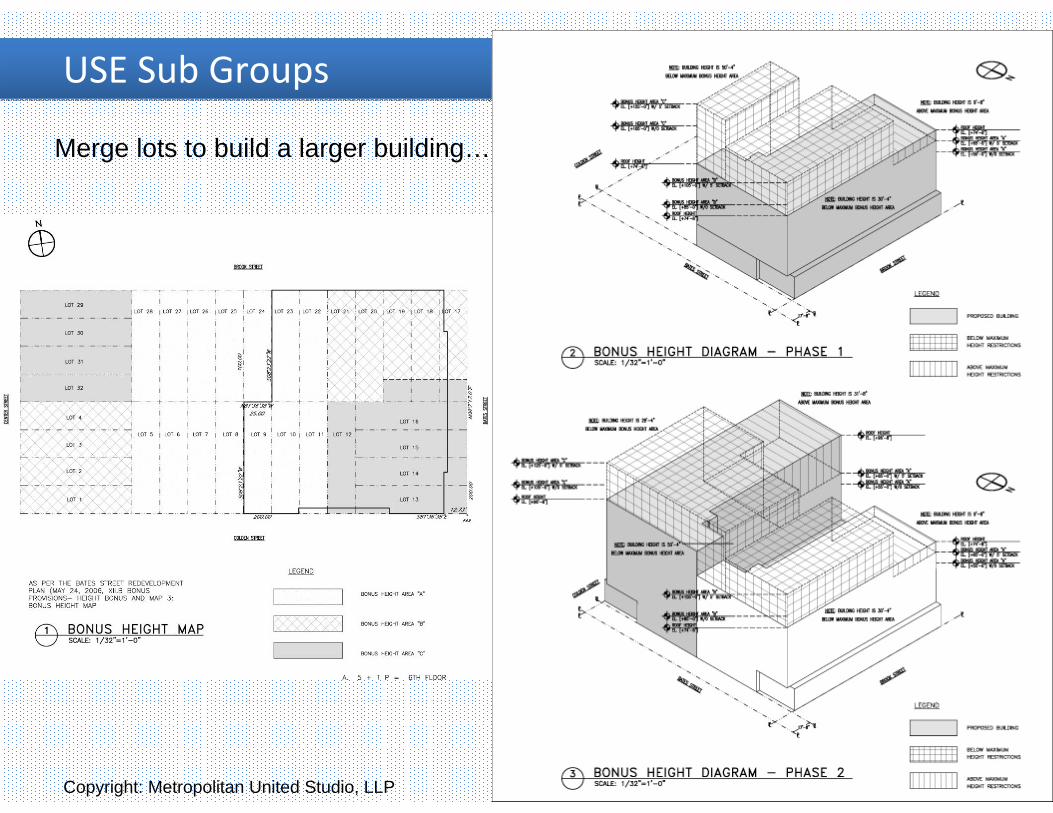
Merge lots to build a larger building…
USE Sub GroupsUSE Sub Groups
Merge lots to build a larger building…
Copyright: Metropolitan United Studio, LLP

USE Sub GroupsUSE Sub Groups

USE Sub GroupsUSE Sub Groups

Zoning DiagramsZoning Diagrams

Zoning DiagramsZoning Diagrams

Zoning DiagramsZoning Diagrams

Zoning DiagramsZoning Diagrams

Zoning DiagramsZoning Diagrams

Zoning DiagramsZoning Diagrams

Zoning DiagramsZoning Diagrams

Zoning DiagramsZoning Diagrams

Zoning Diagrams ‐ AxonZoning Diagrams ‐ Axon

Zoning Diagrams ‐ AxonZoning Diagrams ‐ Axon

Zoning Diagrams ‐ AxonZoning Diagrams ‐ Axon

Zoning Special DistrictZoning Special DistrictTenth Avenue Building FrontagesConsistent with the existing built character of walk‐up apartment buildings and high streetwall loft buildings, bulk controls along Tenth Avenue would mandate a mix of low and high streetwalls and would help preserve light, air, and views for the High Line open space. Under these frontage regulations, the street wall of a building along Tenth Avenue could rise to between 35 feet and 45 feet in height for 25% of its Tenth Avenue frontage. This lowered streetwallwould be required to be located at a street intersection. The remaining 75% of the street wall could rise to the maximum allowable building height.

Zoning Special DistrictZoning Special DistrictHigh Line Building FrontagesTo create a varied experience along the length of the High Line open space, portions of buildings would be required to set back from the High Line while other portions of buildings would be permitted to rise directly adjacent to, and connect with, the High Line. A maximum of 40% of a building’s High Line frontage would be permitted to rise to the maximum allowable building height directly adjacent to the High Line structure. The remaining 60% (minimum) of a building’s High Line frontage would be permitted to rise no higher than the level of the High Line before setting back a minimum of 25 feet.

Zoning Special DistrictZoning Special DistrictHigh Line Adjacency Controls: Required Open SpaceA minimum of 20% of the lot area would be required to be reserved as landscaped open space. To provide a visual extension of the High Line, the required open space would be located adjacent to and at a height not to exceed the level of the High Line. The required open space could not front on Tenth Avenue and could be used as a public or private space.

Zoning Special DistrictZoning Special DistrictHigh Line Adjacency Controls: West Side of the High LineWithin 15 feet of the west side of the High Line structure, buildings could rise no higher than the level of the High Line. For lots that occupy more than 60 feet of narrow street frontage, an additional 15 foot setback would be required at the base height.

Sample DrawingSample Drawing

Sample DrawingSample Drawing

Sample DrawingSample Drawing

Sample DrawingSample Drawing

Sample DrawingSample Drawing