descriptive notes san juan archipelago-southern gulf islands seafloor-mapping effort is an ongoing...
TRANSCRIPT
Is(s/g)_u
Is(g)_h/u
Is(s/m)_u
Is(s/g)_uIs(s/m)_u
Is(g)_h/u
Is(g)_h/u
Is(s/g)_u
Is(g)_u
Is(g)_h/u
Is(g)_u
Is(s/m)_u
Is(g)_u
Is(s/g)_u
Is(g)_u
Is(s/m)_u
Is(g)_u
Is(m)_u
Is(s)w_u
Ihed_d/s
Is(m)_u
Is(s/g)_u
Is(s)w_u
Is(s/g)_u
Is(s)_u
Is(m)_u
Is(s)w_u
Is(s)w_u
Is(m)_u
Is(s/m)_u
Is(s/m)_u
Is(s)_u
Is(m)_u
Is(s/g)_u
Is(g)_h/u
Is(s/m)_u
Is(s/m)_u
Is(s)w
_u
Is(m)_u
Is(g)_u
Is(g)_u
Is(m)_u
Is(m)_u
Is(s)w_u
Is(s)_u
Is(s)w_u
Ihed_d/s
Is(s)w_u
Is(m)_u
Is(s/m)_u
Ihe_f/s
Ihed_d/s
Ihed_d/s
Is(s/m)g_
s/u
Ihed_d/s
Is(s)_u
Ihed_d/s
Is(m)_u
Ihe_f/
s
Is(g)_h/u
Ime_c/u
Is(s/g
)h_s/u
Ihe_f/s
Is(s/m
)_u
Is(s/m)_u
Is(s)w_u
Is(s)w_u Is(s/g)_u
Is(m)_u
Ihed_d/s
Is(s)w
_u
Is(s)w_u
Is(s/m)_u
Is(m)_u
Is(m)_u
Ihed_d/s
Is(s/m)_u
Is(s/m)_u
Is(s/g)_u
Is(m)_u
Ime_c/u
Is(s)_
u
Is(s)w_u
Is(s/m
)_u
Is(s/g)_h/uIs(m
)_u
Ihed_d/s
Ihed_d/s
Is(s/m)_u
Is(m)_u
Ihed_d/s
Is(g)_u
Is(m)_u
Is(s)w_u
Is(s)w_u
Is(m)_u
Is(m)_u
Is(s/g)_u
Ihed_d/s
Is(s)w_u
Is(g)_h/u
Is(s)_u
Is(s)w_u
Is(g)_u
Is(s/g)_u
Is(s)w_u
Is(m)_u
Ihed_d/s
Is(s/g)_
u
Is(s/g
)_u
Is(s/g)_u
Ihed_d/s
Ihed_d/s
Is(s)_u
Is(s)w_u
Is(s/m)h_s/u
Ihe_f/s
Is(s/g)_h/u
Is(s)_u
Ime_c/u
Ime_c/u
Ihed_d/s
Is(m)_u
Is(s/g)i/m_u
Is(m)_u
Ime_c/u
Ihed_d/s
Is(s/g)
_h/a-d
d/u
Ihed_d/s
Is(s)_u
Is(s/g)h_s/u
Ihed_d/s
Ihed_d/s
Is(s/g)h_s/u
Is(s/g)_u
Is(s)w_u
Ihed_d/s
Is(s)w
_u
Ihed_d/s
123°10'W
123°10'W
123°20'W
123°20'W48°50'N 48°50'N
48°45'N 48°45'N
48°40'N 48°40'N
48°35'N 48°35'N
Stuart Island
San JuanIsland
Sidney Island
Moresby Island
Saturna Island
South PenderIsland
North PenderIsland
DESCRIPTIVE NOTES
ReferencesBarrie, J.V. and Hill, P.R., Conway K.W., Iwanowska, K. and Picard, K., 2005.
Environmental Marine Geoscience 4: Georgia Basin: Seabed features and geomarine geohazards: Geoscience Canada, 32(4) , p. 145-156.
Barrie, J.V., Conway, K. W, Picard, K. and Greene H.G., 2009. Large-scale sedimentary bedforms and sediment dynamics on a glaciated tectonic continental shelf: Examples from the Pacific margin of Canada: Continental Shelf Research 29, p. 796-806.
Fisheries and Oceans Canada, 2006. Rockfish Conservation Areas, Fisheries and Oceans Canada, Pacific Region, 177 p.
Greene, H.G., Yoklavich, M.M., Starr, R.M., O’Connell, V.M., Wakefield, W.W., Sullivan, D.E., McRea Jr., J.E., and Cailliet, G.M., 1999: A classif ication scheme for deep seafloor habitats: Oceanologica Acta. 22(6): p. 663-678
Greene, H.G., Bizzarro, J.J., O’Connell, V.M., and Brylinsky, C.K., 2007. Construction of digital potential marine benthic habitat maps using a coded classification scheme and its application. In Todd, B.J., and Greene, H.G., eds., Mapping the Seaf loor for Habitat Characterization. Geological Association of Canada, Special Paper 47, p. 141-155.
Mosher, D.C. and Johnson, S.Y. (eds.), Rathwell, G.J., Kung, R.B., and Rhea, S.B. (compilers), 2000. Neotectonics of the eastern Juan de Fuce Strait: a digital geological and geophysical atlas: Geological Survey of Canada Open File Report 3931, p.
Puget Sound Ambient Monitoring Program, 2002. 2002 Puget Sound Update: Eighth Report of the Puget Sound Ambient Monitoring Program: Puget Sound Water Quality Action Team.
Thompson, R.E., 1981. Oceanography of the British Columbia Coast: Canadian Fisheries and Aquatic Sciences, Special Publication 56: 291 p.
POTENTIAL MARINE BENTHIC HABITATS and SHADED SEAFLOOR RELIEF of theSouthern Gulf Islands and San Juan Archipelago,
Canada and USAMap Sheet 2 of 4
Scale 1:50,0002 0 2 4 6 81
Kilometers1 0 1 2 3 40.5
Miles
Universal Transverse Mercator Projection, Zone 10 NorthNorth American Datum 1983
Haro Fault
331122
44
122°30'W123°0'W123°30'W
49°0'N
48°30'N
48°0'N
Map Index
_̂
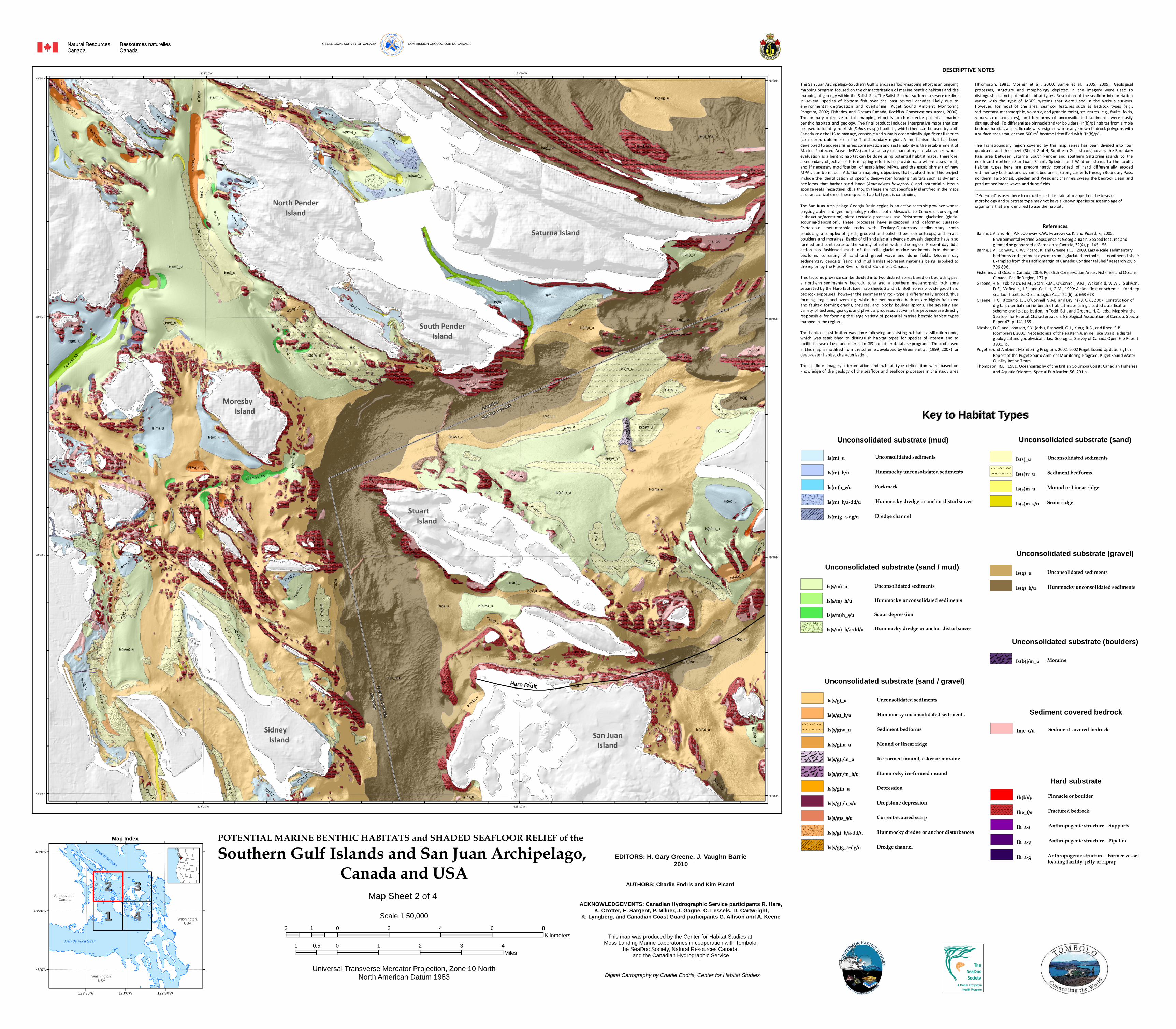
The San Juan Archipelago-Southern Gulf Islands seafloor-mapping effort is an ongoing mapping program focused on the characterization of marine benthic habitats and the mapping of geology within the Salish Sea. The Salish Sea has suffered a severe decline in several species of bottom fish over the past several decades likely due to environmental degradation and overfishing (Puget Sound Ambient Monitoring Program, 2002; Fisheries and Oceans Canada, Rockfish Conservations Areas, 2006). The primary objective of this mapping effort is to characterize potential i marine benthic habitats and geology. The final product includes interpretive maps that can be used to identify rockfish (Sebastes sp.) habitats, which then can be used by both Canada and the US to manage, conserve and sustain economically significant fisheries (considered outcomes) in the Transboundary region. A mechanism that has been developed to address fisheries conservation and sustainability is the establishment of Marine Protected Areas (MPAs) and voluntary or mandatory no-take zones whose evaluation as a benthic habitat can be done using potential habitat maps. Therefore, a secondary objective of this mapping effort is to provide data where assessment, and if necessary modification, of established MPAs, and the establishment of new MPAs, can be made. Additional mapping objectives that evolved from this project include the identification of specific deep-water foraging habitats such as dynamic bedforms that harbor sand lance (Ammodytes hexapterus) and potential siliceous sponge reefs (hexactinellid) , although these are not specifically identif ied in the maps as characterization of these specific habitat types is continuing. The San Juan Archipelago-Georgia Basin region is an active tectonic province whose physiography and geomorphology reflect both Mesozoic to Cenozoic convergent (subduction/accretion) plate tectonic processes and Pleistocene glaciation (glacial scouring/deposition) . These processes have juxtaposed and deformed Jurassic-Cretaceous metamorphic rocks with Tertiary-Quaternary sedimentary rocks producing a complex of f jords, grooved and polished bedrock outcrops, and erratic boulders and moraines. Banks of till and glacial advance outwash deposits have also formed and contribute to the variety of relief within the region. Present day tidal action has fashioned much of the relic glacial-marine sediments into dynamic bedforms consisting of sand and gravel wave and dune fields. Modern day sedimentary deposits (sand and mud banks) represent materials being supplied to the region by the Fraser River of British Columbia, Canada. This tectonic province can be divided into two distinct zones based on bedrock types: a northern sedimentary bedrock zone and a southern metamorphic rock zone separated by the Haro fault (see map sheets 2 and 3). Both zones provide good hard bedrock exposures, however the sedimentary rock type is differentially eroded, thus forming ledges and overhangs while the metamorphic bedrock are highly fractured and faulted forming cracks, crevices, and blocky boulder aprons. The severity and variety of tectonic, geologic and physical processes active in the province are directly responsible for forming the large variety of potential marine benthic habitat types mapped in the region. The habitat classification was done following an existing habitat classification code, which was established to distinguish habitat types for species of interest and to facilitate ease of use and queries in GIS and other database programs. The code used in this map is modified from the scheme developed by Greene et al. (1999, 2007) for deep-water habitat characterisation. The seafloor imagery interpretation and habitat type delineation were based on knowledge of the geology of the seafloor and seafloor processes in the study area
(Thompson, 1981, Mosher et al., 2000; Barrie et al., 2005; 2009). Geological processes, structure and morphology depicted in the imagery were used to distinguish distinct potential habitat types. Resolution of the seafloor interpretation varied with the type of MBES systems that were used in the various surveys. However, for most of the area, seafloor features such as bedrock types (e.g., sedimentary, metamorphic, volcanic, and granitic rocks), structures (e.g., faults, folds, scours, and landslides), and bedforms of unconsolidated sediments were easily distinguished. To differentiate pinnacle and/or boulders (Ih(b)/p) habitat from simple bedrock habitat, a specific rule was assigned where any known bedrock polygons with a surface area smaller than 500 m2 became identified with “Ih(b)/p”. The Transboundary region covered by this map series has been divided into four quadrants and this sheet (Sheet 2 of 4; Southern Gulf Islands) covers the Boundary Pass area between Saturna, South Pender and southern Saltspring islands to the north and northern San Juan, Stuart, Spieden and Waldron islands to the south. Habitat types here are predominantly comprised of hard dif ferentially eroded sedimentary bedrock and dynamic bedforms. Strong currents through Boundary Pass, northern Haro Strait, Spieden and President channels sweep the bedrock clean and produce sediment waves and dune fields. i “Potential” is used here to indicate that the habitat mapped on the basis of morphology and substrate type may not have a known species or assemblage of organisms that are identif ied to use the habitat.
EDITORS: H. Gary Greene, J. Vaughn Barrie2010
This map was produced by the Center for Habitat Studies at Moss Landing Marine Laboratories in cooperation with Tombolo,
the SeaDoc Society, Natural Resources Canada, and the Canadian Hydrographic Service
Digital Cartography by Charlie Endris, Center for Habitat Studies
AUTHORS: Charlie Endris and Kim Picard
ACKNOWLEDGEMENTS: Canadian Hydrographic Service participants R. Hare, K. Czotter, E. Sargent, P. Milner, J. Gagne, C. Lessels, D. Cartwright,
K. Lyngberg, and Canadian Coast Guard participants G. Allison and A. Keene
Juan de Fuca Strait
Strait of Georgia
Vancouver Is.,Canada
Washington,USA
Washington,USA
Key to Habitat TypesKey to Habitat Types
Sediment covered bedrockSediment covered bedrockIme_c/u
Unconsolidated substrate (boulders)MoraineIs(b)i/m_u
Unconsolidated substrate (sand / gravel)
Is(s/g)m_u Mound or linear ridge
Is(s/g)i/m_u Ice-formed mound, esker or moraine
Is(s/g)i/m_h/u Hummocky ice-formed mound
Is(s/g)h_u Depression
Is(s/g)i/h_s/u Dropstone depression
Is(s/g)s_s/u Current-scoured scarp
Is(s/g)_h/a-dd/u Hummocky dredge or anchor disturbances
Is(s/g)g_a-dg/u Dredge channel
E E E E EE E E E EE E E E EE E E E E
E E E E EE E E E EE E E E EE E E E E
Is(s/g)w_u Sediment bedforms
Is(s/g)_h/u Hummocky unconsolidated sediments
Is(s/g)_u Unconsolidated sediments
Unconsolidated substrate (sand / mud)
Is(s/m)h_s/u Scour depression
Is(s/m)_h/a-dd/u Hummocky dredge or anchor disturbances
Is(s/m)_h/u Hummocky unconsolidated sediments
Is(s/m)_u Unconsolidated sediments
Unconsolidated substrate (mud)
PockmarkIs(m)h_e/u
Hummocky dredge or anchor disturbancesIs(m)_h/a-dd/u
Dredge channelIs(m)g_a-dg/u
Hummocky unconsolidated sedimentsIs(m)_h/u
Unconsolidated sedimentsIs(m)_u
Unconsolidated substrate (sand)
Is(s)_u Unconsolidated sediments
E E E E EE E E E EE E E E EE E E E E
E E E E EE E E E EE E E E EE E E E E
Is(s)w_u Sediment bedforms
Is(s)m_u Mound or Linear ridge
Is(s)m_s/u Scour ridge
Unconsolidated substrate (gravel)
Is(g)_u
Is(g)_h/u
Unconsolidated sediments
Hummocky unconsolidated sediments
Hard substrate
Ihe_f/s
Ih_a-s
Ih_a-p
Ih_a-g
Fractured bedrock
Anthropogenic structure - Supports
Anthropogenic structure - Pipeline
Anthropogenic structure - Former vessel loading facility, jetty or riprap
Ih(b)/p Pinnacle or boulder
GEOLOGICAL SURVEY OF CANADA COMMISSION GÉOLOGIQUE DU CANADA