development control plan no. 58 south turramurra … residential subdivision..... 4 4 environmental...
TRANSCRIPT

Development Control Plan No. 58 South Turramurra Corridor
Adopted by Council: 24 July 2012 Effective from: 3 August 2012
Ku-ring-gai Council
Development Control Plan No. 58 - South Turramurra Corridor
Prepared by: Don Fox Planning Pty Limited In association with: Ku-ring-gai Council Locked Bag 1056 Pymble NSW 2073 Telephone: (02) 9424 0000 Facsimile: (02) 9424 0001 e-mail: [email protected] internet: www.kmc.nsw.gov.au Disclaimer Every effort has been made to provide accurate and complete information. However, the authors assume no responsibility for any direct, indirect, incidental, or consequential damages arising from the use of information in this document. Copyright Notice No part of this publication may be reproduced in any form, or stored in a database or retrieval system, or transmitted or distributed in any form by any means, electronic, mechanical photocopying, recording, or otherwise without written permission from Ku-ring-gai Council. All rights reserved.
Copyright © 2013, Ku-ring-gai Council

Ku-ring-gai Council
Development Control Plan No. 58 - South Turramurra Corridor
Ku-ring-gai Council File Ref: DCP No. 58
i
TABLE OF CONTENTS 1 Preamble .......................................................................................................................... i 2 Introduction .................................................................................................................... 1 2.1 Name of this Plan ........................................................................................................... 1 2.2 Land to which this Plan applies ...................................................................................... 1 2.3 Commencement of this Plan .......................................................................................... 1 2.4 Savings and transitional arrangements ......................................................................... 2 2.5 Purpose and Objectives of this Plan .............................................................................. 2 2.6 Structure of this Plan ...................................................................................................... 2 2.7 Relationship with other plans, reports and policies ........................................................ 3 2.8 Advisory Information on Sustainable Design ................................................................. 3 3 Background .................................................................................................................... 4 3.1 B2 Road Corridor ........................................................................................................... 4 3.2 Residential Subdivision .................................................................................................. 4 4 Environmental Management .......................................................................................... 5 4.1 Riparian Land Objectives ............................................................................................... 5 4.2 Biodiversity ..................................................................................................................... 6 4.3 Riparian Land & Water Cycle Management .................................................................. 7 4.4 Street Network, Public Open Space and Access ........................................................... 8 4.5 Lot Layout ...................................................................................................................... 8 4.6 General Site Landscaping ............................................................................................ 10 4.7 Public Utilities and Services ......................................................................................... 10
FIGURES Figure 1: Map – land to which this Plan applies. ...................................................................... 1 Figure 2: Riparian Zone ........................................................................................................... 6 Figure 3: Solar Lots .................................................................................................................. 9
APPENDICES APPENDIX A – PLANT SPECIES LIST FOR PUBLIC AND PRIVATE LAND .......................................... 11 APPENDIX B – INDICATIVE ROAD SECTIONS ............................................................................... 14 APPENDIX C - REFERENCES ...................................................................................................... 15 APPENDIX D – DESIGNING AN ENERGY AND WATER EFFICIENT HOME ......................................... 16

Ku-ring-gai Council
Development Control Plan No. 58 - South Turramurra Corridor
Ku-ring-gai Council File Ref: DCP No. 58
i
1 PREAMBLE
Following are the objectives included in the Project Delivery Agreement (PDA) between both owners of the subject land, being Ku-ring-gai Council and the Minister administering the Environmental Planning and Assessment Act 1979
(a) establish the foundation for a new low density urban community
consistent with all relevant planning law (incorporating best practice sustainability principles);
(b) establish a residential land release that is compatible with the existing environmental character of the locality and is sympathetic to other neighbourhood development;
(c) configure lots (in terms of area, width and shape) that take account of the predominant surrounding neighbourhood subdivision patterns;
(d) ensure that subdivision design is to include sustainable urban design parameters such as building materials, solar access and alignment, cross flow ventilation, setbacks, floor space, access, parking and landscaping provisions, The DCP is also to include opportunities for alternative power sources and maximum opportunities for water reuse;
(e) recognise the importance of providing additional housing for residents within the Ku-ring-gai local government area; and
(f) ensure the orderly and economic disposal of surplus land, including by providing a yield consistent with the commercial management and development of that land.
Any application for development of this land is to have regard to these objectives.

Ku-ring-gai Council File Ref: DCP 58
1
2 INTRODUCTION 2.1 NAME OF THIS PLAN
This Plan is the Ku-ring-gai Council Development Control Plan No. 58 - South Turramurra Corridor (the “Plan”).
2.2 LAND TO WHICH THIS PLAN APPLIES This Plan applies to land within the Ku-ring-gai local government area (LGA) known as the South Turramurra Corridor as shown on the Map (Figure 1). F Figure 1: Map – land to which this Plan applies.
2.3 COMMENCEMENT OF THIS PLAN This Plan has been prepared pursuant to the provisions of the Environmental Planning and Assessment Act 1979 (the Act) and the Environmental Planning and Assessment Regulation 2000 (the Regulation) and takes effect from 3 August 2012, being the date on which public notice was published, pursuant to the Regulation.
Ku-ring-gai Council File Ref: DCP 58
2
2.4 SAVINGS AND TRANSITIONAL ARRANGEMENTS
There are no savings or transitional provisions under this Plan. If a development application has been made prior to the date of commencement of this Plan in relation to land to which this Plan applies and the application has not been determined before that date, the application shall be determined in accordance with this Plan.
2.5 PURPOSE AND OBJECTIVES OF THIS PLAN This Plan has been prepared to complement the Ku-ring-gai Planning Scheme Ordinance (KPSO) and Development Control Plan No. 38 (DCP No. 38) The Ku-ring-gai Residential Design Manual by setting out additional planning controls for future development in the South Turramurra Corridor. Accordingly, the objectives of this Plan are as follows: (a) To adopt and implement the relevant aims objectives and provisions of
the Ku-ring-gai Planning Scheme Ordinance pertaining to subdivision and low density residential development and to provide additional planning controls for development in the South Turramurra Corridor;
(b) To adopt and implement the relevant aims, objectives and controls of DCP No. 38 to ensure appropriate low density residential development controls for dwellings in the South Turramurra Corridor;
(c) To manage the environmental impacts of development, particularly in regard to flora and fauna and water cycle management; and
(d) To encourage and support sustainable urban design parameters such as cross flow ventilation, solar access and alignment, building materials, alternative power sources and maximum opportunities for water reuse.
2.6 STRUCTURE OF THIS PLAN This Plan is arranged into three (3) sections: Section 1 – Introduction (this section), identifies the name of the Plan, its commencement date, the purpose, aims and objectives of the Plan, the land to which the Plan applies and the Plans relationship to other plans and policies. Section 2 – Background, briefly outlines the master planning process and investigative studies that have been undertaken in order to formulate this Plan; Section 3 – Environmental Management, sets out the objectives, development controls and submission requirements relating to flora and fauna, the Riparian Land and water cycle management; Section 4 – Advisory, provides advice in relation to the sustainability goals the Appendices to this Plan include a list of reference material used in the preparation of this Plan.

Ku-ring-gai Council File Ref: DCP 58
3
2.7 RELATIONSHIP WITH OTHER PLANS, REPORTS AND POLICIES
This Plan complements the provisions of, and should be read in conjunction with, the Act and Regulation, KPSO, State Environmental Planning Policy (Building Sustainability Index: BASIX) 2004, Planning for Bushfire Protection 2006 and other relevant Development Control Plans (DCPs) and polices adopted by Council including, but not limited to:
DCP No. 38 – The Ku-ring-gai Residential Design Manual;
DCP No. 40 – Construction and Demolition Waste Management;
DCP No. 43 – Car Parking Code;
DCP No. 46 – Exempt and Complying Development;
DCP No. 47 – Water Management Plan; and
The Ku-ring-gai Subdivision Code.
Ku-ring-gai Council Weed Management Policy Revised Edition 2007. Where there is an inconsistency between this Plan and any other DCP or Code, irrespective of whether any other DCP or Code was made either before or after the commencement of this Plan, this Plan prevails to the extent of any inconsistency.
2.8 ADVISORY INFORMATION ON SUSTAINABLE DESIGN The subdivision design is to include sustainable urban design parameters including building materials, solar access and alignment, cross flow ventilation, opportunities for alternative power sources and maximum opportunities for water reuse and consider setbacks, floor space, access, parking and landscaping provisions. Whilst BASIX is the mandatory instrument for the delivery of energy, thermal and water efficient dwelling design, an additional advisory section is provided within Appendix D of this document. This Appendix gives further information as to the value and methods of including sustainable measures within the design of a house.

Ku-ring-gai Council File Ref: DCP 58
4
3 BACKGROUND 3.1 B2 ROAD CORRIDOR
The land subject to this Plan was formerly part of a proposed road corridor which has since been abandoned. Future development options associated with the South Turramurra Corridor have been the subject of review and consultation since 2003.
3.2 RESIDENTIAL SUBDIVISION Land within the abandoned road corridor is predominantly zoned Residential 2(c) under the KPSO. The site is also part unzoned, but the two (2) minor portions of the site which remain unzoned are proposed to be zoned Residential 2(c) as part of Council’s comprehensive LEP review. Subdivision of the site is likely to be carried out jointly between Ku-ring-gai Council and the Minister Administering the Environmental Planning and Assessment Act 1979. The Residential 2(c) zone typically accommodates low density one and two storey residential dwellings on allotments that are approximately 929m2 in area, however a significant number of allotments within the surrounding locality are less than 929m2. Future subdivision of the site will need to be the subject of a separate development application that demonstrates amongst other things, consistency with the established low density residential character of the South Turramurra locality.

Ku-ring-gai Council File Ref: DCP 58
5
4 ENVIRONMENTAL MANAGEMENT 4.1 RIPARIAN LAND OBJECTIVES
(a) To improve the connectivity and continuity of riparian vegetation and
habitat; (b) To revegetate and manage the Riparian Land to improve ecological
values as described in the Ku-ring-gai Riparian Policy (December 2004); (c) To remove and eradicate noxious and environmental weeds and
decrease the abundance of non-locally indigenous plant species from the Riparian Land;
(d) To rehabilitate, revegetate and stabilise the Riparian Land to reduce the potential for bed and creek bank erosion;
(e) To assess and manage stormwater flows from the site and adjacent urban areas;
(f) To allow realignment of the existing creek; (g) To protect and/or provide habitat for terrestrial and aquatic fauna; (h) To provide a riparian buffer to counter edge effects on the urban
interface as shown in figure 2. Development Controls 1. The Riparian Land is to be restored and rehabilitated, through the
removal of weed species, decreasing the abundance of non-locally indigenous plant species and revegetated with locally indigenous plant species;
2. A Vegetation Management Plan (VMP) is to be prepared for any Riparian Land and for public land. The VMP must include management actions, plant densities, responsibilities, maintenance and monitoring;
3. Road crossings of the Riparian Land are discouraged but where proposed, road crossings are to be designed to maintain riparian connectivity;
4. A suitable interface between the Riparian Land and urban development (e.g. roads, passive open space) is to be provided;
5. All services (e.g. power, water, and sewerage, water retention tanks) are to be outside of the Core Riparian Zone unless the impact on riparian functions is demonstrated to be minimal;
6. Any Riparian Land design must consider reshaping, rock armouring, revegetation and potential for public access;
7. The Riparian Land may be within private or public ownership; 8. Any fencing fronting the Riparian Land is to be a maximum height of 1.2
metres with use of high quality materials incorporating native landscaping;
9. Provide bushfire asset protection zones outside the Core Riparian Zone.

Ku-ring-gai Council File Ref: DCP 58
6
Figure 2: Riparian Zone
4.2 BIODIVERSITY
Objectives
To ensure that significant Threatened Communities are retained, protected and restored;
To facilitate the restoration, revegetation and ongoing management of retained natural vegetation within the site, and particularly within the Riparian Land;
To improve and maintain native fauna habitat values.
Development Controls
1. A Tree Survey Plan is to be submitted as part of any development application for subdivision of land to which this Plan applies. The Plan is to identify the location, type and condition of all existing trees and is to indicate those trees proposed to be removed and those to be retained;
2. Where possible, existing locally indigenous vegetation and fauna habitat is to be retained and restored either within public open space or within private allotments.

Ku-ring-gai Council File Ref: DCP 58
7
4.3 RIPARIAN LAND & WATER CYCLE MANAGEMENT Objectives (a) To minimise the potential creek bank erosion and the potential impact of
flooding both within the Riparian Land, adjoining development and downstream of the development;
(b) To provide a neutral or beneficial effect on the existing watercycle quality;
(c) To provide flood free access and evacuation routes for an average predicted 1 in 100 year flood event;
(d) To incorporate best practice stormwater and watercourse management principles and strategies;
(e) To ensure that any proposed development does not affect adjoining and downstream properties: (i) by degrading stormwater quality; or (ii) by increasing flooding.
(f) To provide opportunities for reuse of stormwater in the form of underground water storage facilities where it is considered to have a community benefit and promote water recycling that is likely to benefit local community facilities.
Development Controls 1. All development is to incorporate water sensitive urban design (WSUD).
A stormwater management plan incorporating WSUD principles is to be submitted with any development application for subdivision of land. The plan is to include water cycle management measures generally in accordance with Council’s civil engineering advice and documentation;
2. On site stormwater detention is to be provided in accordance with
Council’s “On Site Stormwater Detention Technical Specification”; 3. A rainwater retention tank is to be provided with a minimum capacity of
250m3, to accommodate water recycling associated with development on land to which this Plan applies, for the benefit of nearby community facilities;
4. As far as is possible, overland flow frequency and runoff volumes should replicate pre-development circumstances. Any subdivision development application submitted should include modelling to demonstrate how pre-development and post-development flows have been calculated.
5. Pollutant reduction targets for the subdivision of land to which this Plan applies are to be as follows: - 90% reduction in gross pollutants - 85% reduction in Total Suspended Solids - 65% reduction in Total Phosphorous - 45% reduction in Total Nitrogen Pollution reduction targets are to be calculated in accordance with the methodology outlined in the Ku-ring-gai Development Control Plan No. 47 – Water Management.
Ku-ring-gai Council File Ref: DCP 58
8
4.4 STREET NETWORK, PUBLIC OPEN SPACE AND ACCESS
Objectives (a) To provide a safe and functional street network with appropriate
vehicular and pedestrian access. (b) To link the South Turramurra Corridor site with its surroundings; (c) To facilitate access to regional transport opportunities; (d) To link and extend local open space; (e) To reflect the streetscape and character of the surrounding area; (f) To improve local pedestrian permeability and visual access to the
Riparian Land; (g) To provide vehicular and dedicated pedestrian access between
Chisholm Street and Barwon Avenue. Development Controls 1. Provide a vehicle connection between Chisholm Street and Barwon
Avenue 2. The Chisholm Street/Barwon Avenue connection should generally align
with existing street intersections 3. Provide access and a street frontage to the Riparian Land 4. Riparian Land and new roads/carriageways are to be designed generally
in accordance with Appendix B. 5. A footpath should be provided on at least one side of each street. 6. Public pedestrian access is to be provided that connects Chisholm
Street and Barwon Avenue. This should occur adjacent to the carriageway and wherever possible connect through the Riparian Land;
7. Footpaths and boardwalks are to be a minimum of 1.2m wide and be designed in accordance with Australian Standard 1428:1-4 (also refer to Appendix B);
8. Streets are to have a total road reserve up to 16 metres wide comprising a 6 metre wide carriageway and verges on both sides ranging between 4.3 metres and 5.7 metres wide with use of grassed swales for drainage where possible (Appendix B);
9. Where possible, on-street parking shall be integrated within the turf nature strip.
4.5 LOT LAYOUT
Objectives
(a) To provide a range and mix of lot sizes to suit a variety of dwelling types consistent with those distributed throughout the South Turramurra locality;
(b) To provide lots that are oriented to optimise solar access to facilitate micro-climate management, including the application of energy conservation principles.
Ku-ring-gai Council File Ref: DCP 58
9
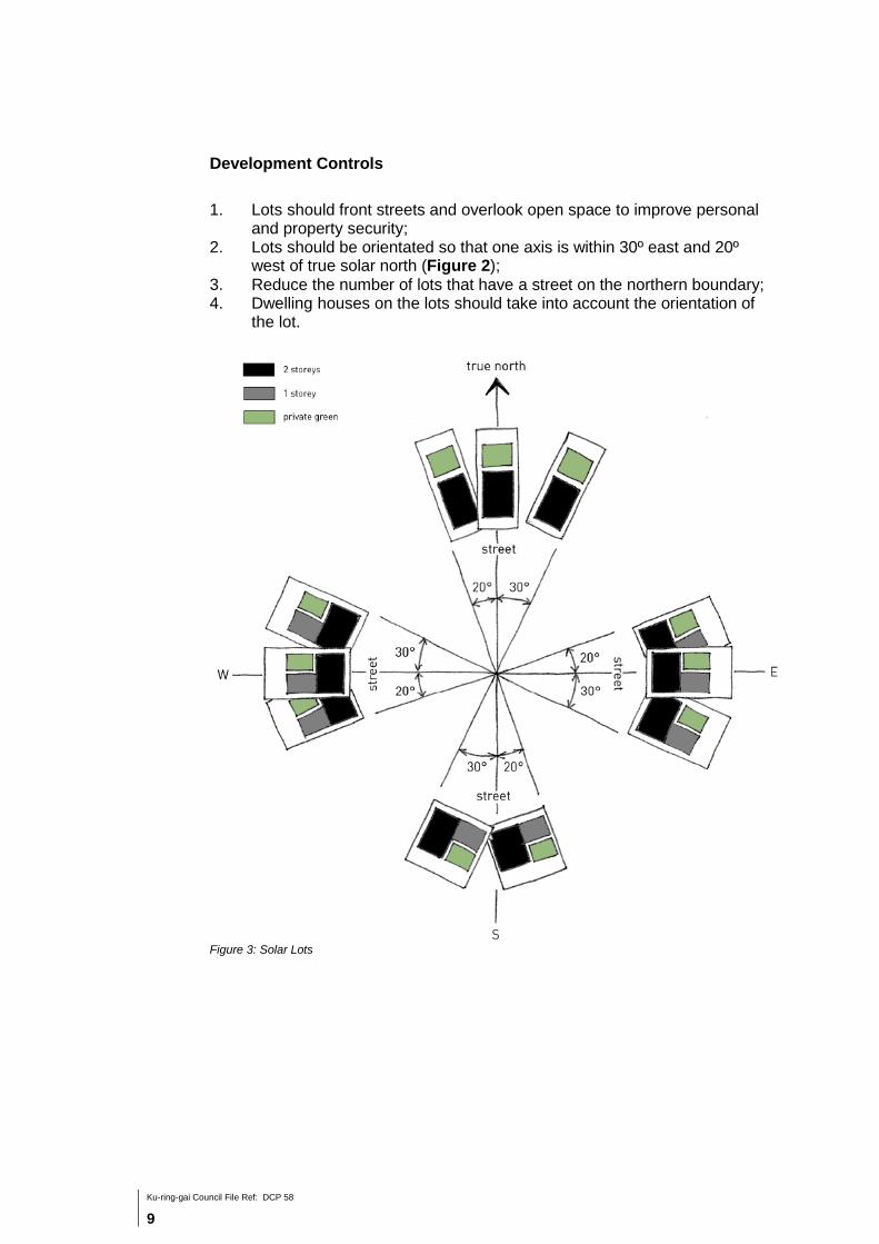
Development Controls
1. Lots should front streets and overlook open space to improve personal and property security;
2. Lots should be orientated so that one axis is within 30º east and 20º west of true solar north (Figure 2);
3. Reduce the number of lots that have a street on the northern boundary; 4. Dwelling houses on the lots should take into account the orientation of
the lot.
Figure 3: Solar Lots

Ku-ring-gai Council File Ref: DCP 58
10
4.6 GENERAL SITE LANDSCAPING Objectives (a) To enhance the landscape setting and site biodiversity. Development Controls 1. All planting within 40m of the of the centre of the watercourse shall be
native species of local provenance in accordance with the Vegetation Management Plan;
2. For lots not within the area nominated in 3.6(1), 50% of all plantings on the site must be selected from the ‘Desired Species’ within the Plant Species List in Appendix A;
3. Plants in the prohibited section of the Plant Species List are not to be planted in any part of the land to which this Plan applies;
4. All planting on the site is to have regard to the controls prescribed in DCP38.
4.7 PUBLIC UTILITIES AND SERVICES
Objectives (a) To ensure that public utilities and services can be provided without
unnecessary visual blight or adverse impact on the streetscape or character of the area.
Development Controls 1. Subject to agreement by the electricity authority, electricity
kiosks/substations are to be appropriately located and suitably landscaped so that these structures do not dominate the streetscape or any entrance/exit to the site;
2. All electricity power lines in new streets are to be located underground; 3. Where practicable, all stormwater infrastructure on public land is to be
located so that it is not visually prominent.

Ku-ring-gai Council File Ref: DCP 58
11
Appendix A – Plant Species List for Public and Private Land
Species listing for street & public domain trees
Common Name Botanical Name
Medium Tree
Broad-leaved Scribbly Gum Eucalyptus haemaasioma
Tall Tree
Sydney Red Gum Angophora costata
Red Bloodwood Corymbia gummifera
Brown Stringybark Eucalyptus capitellata
Grey Gum Eucalyptus punctata
Silvertop Ash Eucalyptus sieberi
Main Road / Residential - Native Tree Mix
Lilly Pilly Acmena smithii (Local provenance stock)
Sydney Red Gum Angophora costata
Rough-barked Apple Angophora floribunda
Yellow Blood Wood Corymbia eximia
Blueberry Ash Elaeocarpus reticulatus
Red Bloodwood Eucalyptus gummifera
Grey Ironbark Eucalyptus paniculata
Blackbutt Eucalyptus paniculata
Cheese Tree Glochidion fernandii
Brush Box Lophostemon confertus
Turpentine Syncarpia glomulifera
Water Gum Tristaniopsis laurina
Feature Trees - Exotic / Native
Ivory Curl Tree Buckinghamia celissima
Jacaranda Jacaranda mimosifolia
Indian Summer Crepe Myrtle Mauve Lagerstroemia indica x L.fauriei
Desired Species for dwelling lots Please refer to the Ku-ring-gai Residential Design Manual DCP No. 38. Prohibited Species Species in this section are prohibited and are not to be planted on the land to which this Plan applies. 1. Any species identified under the Noxious Weeds Act (1993) 2. Any noxious, environmental or urban environmental weeds identified in Ku-ring-
gai Council Weed Management Policy Revised Edition 2007. 3. Exotic perennial grasses as confirmed by Schedule 2 of the Threatened Species
Conservation Act 1995. 4. Any species in the following table:

Ku-ring-gai Council File Ref: DCP 58
12
Common Name Botanical Name
Agapanthus Agapanthus orientalis
African Lovegrass Eragrostis curvula
Albizia/Crested Wattle Paraserianthes lophantha
Bindii Soliva pterosperma
Black Locust Robinia pseudoacacia
Broom Genista spp. (all cultivars & hybrids)
Capeweed Arctotheca calendula
Catsear Hypochaeris radicata
Chilean Whitlow Paronychia brasiliana
Chickweed Stellaria media
Chinese Pistachio Pistacia chinensis
Chinese Tallow Sapium sebiferum
Clover Trifolium spp.
Common Couch (Prohibited in Riparian Land only)
Cynodon dactylon
Coreopsis Coreopsis lanceolata
Cootamundra Wattle Acacia baileyana
Creeping Buttercup Ranunculus repens
Crofton Weed Ageratina adenophora
Crowsfoot/Crab Grass Eleusine indica
Cudweed Gnaphalium spp. Gnaphalium spp.
Dandelion Taraxacum officinale
Date Palm Phoenix canariensis
Dock Rumex spp.
Ecklonia Aristea ecklonia
Ehrharta Ehrharta spp.
Fat Hen Chenopodium album
Fennel Foeniculum vulgare
Fireweed Senecio madagascariensis
Fishbone Fern Nephrolepis cordifolia
Fleabane Conyza spp.
Formosan Lily Lilium formosanum
Ginger Lily Hedychium gardneranum
Golden Robinia Robinia pseudoacacia "Frisia"
Green Amaranth Amaranthus viridis
Hemlock Conium maculatum
Honeysuckle Lonicera japonica
Hydrocotyle Hydrocotyle bonariensis
Illawarra Flame Tree Brachychiton acerifolius
Impatiens/Busy Lizzie Impatiens balsamina
Inkweed Phytolacca octandra
Isotoma Isotoma fluviatillis
Japanese Knotweed Persicaria capitata
Jasmine Jasminum polyanthum
Kikuyu Grass (Prohibited in Riparian Land only)
Pennisetum clandestinum
Liquidambar Liquidambar styraciflua
Medic/Burr Medic Medicago spp.
Mist Flower Ageratina riparia
Monbretia Crocosmia x crocosmiiflora

Ku-ring-gai Council File Ref: DCP 58
13
Common Name Botanical Name
Moth Vine Araujia sericiflora
Mouse Ear Chickweed Cerastium glomeratum
Cerastium glomeratum
Mullumbimby Couch Cyperus brevifolius
Nut Grass Cyperus rotundus
Onion Weed Nothoscordum borbonicum
Paddy's Lucerne Sida rhombifolia
Palm Grass Setaria palmifolia
Paspalum Paspalum dilatatum
Passionfruit Passiflora edulis
Pearlwort Sagina procumbens
Plantain Plantago spp.
Potato Vine Solanum jasminoides
Purple Top Verbena bonariensis
Queensland Silver Wattle Acacia podalyriifolia
Rambutan Alectryon tomentosum
Rice Paper Plant Tetrapanax papyriferus
Sand Rocket Diplotaxis tenuifolia
Scaly Tree Fern Cyathea cooperi
Scurfy Pea Bush Psoralea pinnata
Seaside Daisy Erigeron karvinskianus
Silky Oak Grevillea robusta
Spider Plant Chlorophytum comosum
Summer Grass Digitaria ciliaris
Summer Grass/Crab Grass Digitaria sanguinalis
Vetch Vicia spp.
Virginia Creeper Parthenocissus quinquefolia
Western Australia Bluebell Sollya heterophylla
White Root Lobelia Pratia concolor
Wild Tobacco Tree Solanum mauritianum
Wild Watsonia Watsonia meriana c. Bulbillifera
Yellow Kangaroo Paw Angiozanthos flavidus

Ku-ring-gai Council File Ref: DCP 58
14
Appendix B – Indicative Road Sections
Ku-ring-gai Council File Ref: DCP 58
15
Appendix C - References The following legislation, plans and policies, studies, technical guides and other information have been considered during the formulation of this Plan:
Environmental Planning and Assessment Act 1979 Environmental Planning and Assessment Regulation 2000 Threatened Species Conservation Act 1995. Noxious Weeds Act (1993) Ku-ring-gai Planning Scheme Ordinance State Environmental Planning Policy (Building and Sustainability Index: BASIX) 2004 Ku-ring-gai Development Control Plan No. 38 – The Ku-ring-gai Residential Design Manual Ku-ring-gai Development Control Plan No. 40 – Construction and Demolition Waste Management Ku-ring-gai Development Control Plan No. 43 – Car Parking Code Ku-ring-gai Development Control Plan No. 46 – Exempt and Complying Ku-ring-gai Development Control Plan No. 47 – Water Management Ku-ring-gai Draft Stormwater Quality Modelling Guidelines Planning for Bushfire Protection 2006 Ku-ring-gai Subdivision Code Ku-ring-gai Local Environmental Plan No. 201 Ku-ring-gai Local Environmental Plan No. 216 NSW Roads and Traffic Authority (October 2002 – Version 2.2), Guide to Traffic Generating Development Ku-ring-gai Council Weed Management Policy Revised Edition 2007 Ku-ring-gai Riparian Policy (December 2004)
Ku-ring-gai Council File Ref: DCP 58
16
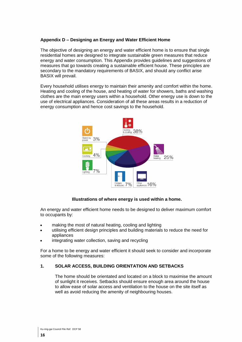
Appendix D – Designing an Energy and Water Efficient Home The objective of designing an energy and water efficient home is to ensure that single residential homes are designed to integrate sustainable green measures that reduce energy and water consumption. This Appendix provides guidelines and suggestions of measures that go towards creating a sustainable efficient house. These principles are secondary to the mandatory requirements of BASIX, and should any conflict arise BASIX will prevail. Every household utilises energy to maintain their amenity and comfort within the home. Heating and cooling of the house, and heating of water for showers, baths and washing clothes are the main energy users within a household. Other energy use is down to the use of electrical appliances. Consideration of all these areas results in a reduction of energy consumption and hence cost savings to the household.
Illustrations of where energy is used within a home.
An energy and water efficient home needs to be designed to deliver maximum comfort to occupants by: making the most of natural heating, cooling and lighting utilising efficient design principles and building materials to reduce the need for
appliances integrating water collection, saving and recycling For a home to be energy and water efficient it should seek to consider and incorporate some of the following measures: 1. SOLAR ACCESS, BUILDING ORIENTATION AND SETBACKS
The home should be orientated and located on a block to maximise the amount of sunlight it receives. Setbacks should ensure enough area around the house to allow ease of solar access and ventilation to the house on the site itself as well as avoid reducing the amenity of neighbouring houses.

Ku-ring-gai Council File Ref: DCP 58
17
The ideal location is with the daytime living areas facing north and the long axis of the house running east to west. Large windows on the north side of the house let the sunshine in during winter because of the low angle of the sun. Eaves prevent sunshine entering the house in summer because of the high angle of the sun. Avoid large, exposed areas of west facing wall if possible as they receive the strongest radiation at the hottest part of the day. Outdoor living areas such as courtyards, verandas and balconies should be suitably shaded. East and west facing openings receive the strongest sun and are the most difficult to shade due to the low sun angle. Keep their size to a minimum if this does not compromise cooling by ventilation. Alternatively, ensure they are well shaded.
Illustration of relationship between solar access and roof overhangs (eaves) 2. FLOOR AREA SIZE, LAYOUT AND ZONING
The design of the house should consider the building footprint and planning of rooms to maximise solar access and ventilation. Daytime living areas should be located on the north side with large north facing windows to capture the winter sun. Bedrooms and utility areas should be located on the south side. If the design allows it, bedrooms and other rooms can also face north. Following a plan with open style living areas will help to: make best use of the available space allow sunlight to easily enter the home allow air to circulate freely around the home. Design open plan areas so they can be zoned by closing doors. Zoning reduces the area you need to heat and cool.

Ku-ring-gai Council File Ref: DCP 58
18
3. CROSS FLOW VENTILATION
Cross ventilation occurs when two sides of the home are opened to allow air to flow from one end to the other. Encouraging airflow is an effective means of passive cooling of the house and occupants. Good orientation for passive cooling excludes unwanted sun and hot winds and ensures access to cooling breezes. A degree of passive cooling is necessary for most Australian climates. Open plan internal layouts facilitate ventilation. Homes of one-room depth are ideal. On sites with poor orientation or no access to cooling breezes an energy efficient home is still possible with good design. Use high level windows and vents to create convection currents for cooling in the absence of breezes. Landscape and building form can be designed to deflect and control the flow of breezes or to block unwanted sun. Windows should be openable and located on more than one side of a room to improve ventilation. Avoid windows with fixed glass. Ask for windows with a significant openable area for ventilation. Add additional small windows to rooms with only one window to improve ventilation. Use vents above or in internal doors to facilitate cross ventilation. Design narrow, elongated building forms for best performance, with the long elevations opening up to cooling breezes. Elevating the house so that air can circulate beneath it will also assist performance. Use landscape and building form to deflect cooling breezes into the interior and to exclude undesirable hot winds. Make use of shade or windbreaks provided by adjacent buildings or existing landscape. Design and position openings to control air flow. Use clerestory windows, roof ventilators, and vents in ridges, eaves and ceilings to create convection currents to cool the house in the absence of breezes. Install windows that can be opened for maximum ventilation.

Ku-ring-gai Council File Ref: DCP 58
19
Illustrations of how measures can be taken
to deflect breeze to enter the house.
4. INSULATION Insulating the home is the most important measure for making the home energy efficient. Insulation is any material that reduces the amount of hot or cold air lost through the home’s walls, ceilings, floors or windows. Installing insulation in the home will help to: keep the warmth inside the home in winter prevent heat from entering the home in summer reduce the need for heating and cooling appliances reduce the heating and cooling related costs and greenhouse gas
emissions. A well insulated house relies on the control of ventilation and prevention of draughts. Draughts can create discomfort and lead to energy losses in both summer and winter. In winter, draughts can account for 25% of heat loss. Reducing draughts is a cheap and cost effective way of reducing heating and cooling costs.

Ku-ring-gai Council File Ref: DCP 58
20
Illustration of common household draughts that can be prevented. 5. BUILDING MATERIALS
Wherever possible, building materials should be recycled or recyclable with low embodied energy come from renewable sources or those that are sustainable and generate
a lower environmental cost have acceptable life cycle costs and durability involve environmentally acceptable production methods Low Volatile Organic Compounds (VOC) (used throughout the building
interior - carpets, paints, adhesives, sealants and all other finishes) low emission building materials physical, rather than chemical, termite measures. This can be achieved by
appropriate materials and construction design, physical barriers and suspended floor systems
The following should be avoided wherever possible: rainforest timbers and timbers from old growth forests for the construction
or finishing of the building the use of construction materials and chemicals with toxic components
(this facilitates recycling and reduces pollution) ozone depleting products and materials, or products and materials
manufactured using ozone depleting substances materials likely to contribute to poor internal air quality, such as those
generating formaldehyde, or those that may create a breathing hazard in the event of fire, such as polyurethane

Ku-ring-gai Council File Ref: DCP 58
21
6. THERMAL MASS
All building materials have the ability to store heat. This is known as thermal mass. Building materials with a high thermal mass can store large amounts of heat without a large temperature change. They include: internal bricks and masonry concrete slab with hard floor coverings. Concrete, tiled or slate floors can absorb heat during day in winter and then release the stored heat into the room at night. They work best in rooms with north facing windows. Carpets and rugs act as insulations preventing the floor from absorbing heat. A balance needs to be achieved between thermal mass, window areas and insulation levels to suit climatic conditions. Poor use of thermal mass can cause: absorbed heat to radiate at night during summer heat you produce on a winter night to be absorbed.
7. GLAZING Windows, skylights and other glazed surfaces in an average insulated home can account for more heat gain or loss than any other aspect of the building fabric. Choosing the right size windows and the right glazing material can significantly improve the efficiency of the home. In general, all north facing windows should be close to full length to allow the heat from the winter sun in. Sunlight shining directly on north, east and west facing windows produces the same amount of heat per square metre as a one bar radiator. East and west facing sides should have a minimum area of glass or none at all. The measurement of how well a window or other glazed surface can prevent heat from entering the house is its R-value. Installing glazing with higher R-value means less heat is transferred through the glass. The inverse of the R-value is called the U-value which measures how well heat flows through the glass. A lower U-value means less heat will flow through the glass.
8. SHADING Shading is vital for keeping the house cool in summer. Well designed shading can greatly reduce: heat entering the home the need for and running costs of cooling appliances.

Ku-ring-gai Council File Ref: DCP 58
22
The most effective way to keep the summer heat out is to use external shading. Focus on providing shading devices and eaves overhang to north facing windows which receive the most direct sunlight and then east and west facing windows. South facing windows generally don't need shading. External shading should be designed to let in the winter sun but totally shade the summer sun. External shading can include: overhanging eaves horizontal shades or awnings pergolas landscaping
9. LANDSCAPING, ACCESS AND PARKING Landscaping can help to maintain comfortable temperatures around the home. Breezes entering the home will be cooler if they have passed through gardens or courtyards that have shade, ponds, shrubs and lawn. The layout of the garden can also be used to screen or direct breezes. Access ways to and parking areas in front of the house should allow ease of entry and can be integrated with landscaping to act as breeze corridors to the house. Carport and garages should be placed behind the front building line, and their location should be considered so that they do not block solar access or ventilation into the house. Wherever possible, avoid placing garages on northern facades that offer the best amenity for living areas.
10. ALTERNATE ENERGY SOURCES As previously mentioned, heating and cooling of the house and heating of water for showers, baths and washing clothes are the main energy users within a household. Other energy use is down to the use of electrical appliances. Consideration in all these areas results in a reduction of energy consumption and hence cost savings to the household.
Alternate electricity production - Solar photovoltaic (PV) systems are becoming an affordable way for households to lower their electricity bills and reduce their greenhouse gas emissions. They can be integrated into the design form to create interesting elevations. Solar PV panels produce most power when they are pointed directly at the sun. Solar modules should face north for optimum electricity production. Solar PV panels should ideally be in full sun from at least 9am to 3pm. They should not

Ku-ring-gai Council File Ref: DCP 58
23
be placed in shaded areas. Even a small amount of shade - from things like trees, roof ventilators or antennas - will have a large impact on the output of a panel, as it changes the flow of electricity through the panel. Shading on just one of the cells in a solar panel results in a loss of power from many cells, not just the one that is shaded. Heating water - Choosing an energy efficient water heater and using water efficiently can provide you with both energy and water savings. The three main energy sources used in household water heating are: Solar: Solar water heaters, such as evacuated tube hot water systems,
produce the least greenhouse gas emissions and have the lowest running costs. A gas boosted solar is more greenhouse friendly than an electric boosted solar but if you do not have access to gas, electric boosted solar is still an energy efficient option.
Gas: High efficiency gas water heaters are a good choice if you have a natural gas connection and solar can't be installed due to shading or limited space on the roof.
Electricity: If you do not have access to gas and solar can't be installed consider an electric heat pump water heater. Heat pumps are best installed outdoors in areas with good air circulation.
Appliance choice - In choosing appliances for the home, select those that are energy efficient and have low energy consumption. Most appliances on the market have star ratings and details of energy use.
11. WATER RECYCLING A rainwater tank is designed to capture and store rainfall runoff from roofs. In households without a rainwater tank, the water from rainfall simply passes through the stormwater system and flows out to the sea. Water captured in a rainwater tank from roof and ground runoff as well as greywater from household use such as laundry and bath/shower discharge, can be recycled and used again by the household for toilet flushing and for garden irrigation.
Illustrations of household water collection and recycling.

Ku-ring-gai Council File Ref: DCP 58
24
The use of water saving devices, such as dual flush, taps and shower fittings reduce water consumption whilst allowing the same amenity. Incorporation of water saving planting and reduction of lawn area reduces the necessity for irrigation. SOURCES OF INFORMATION AND DIAGRAMS:
www.sa.gov.au
www.yourhome.gov.au
www.climatechange.gov.au
www.livinggreener.gov.au/water/rainwater
www.borge009.hubpages.com/hub/eco-friendly-houses
www.environmentwriter.com/archives/tag/greywater