dinton castle dinton buckinghamshire · pdf file ·...
TRANSCRIPT

www.mola.org.uk
MOLA Mortimer Wheeler House, 46 Eagle Wharf Road, London N1 7ED tel 0207 410 2200 fax 0207 410 2201 email:[email protected] Museum of London Archaeology is a company limited by guarantee Registered in England and Wales Company registration number 07751831 Charity registration number 1143574 Registered office Mortimer Wheeler House, 46 Eagle Wharf Road, London N1 7ED
Dinton Castle
Dinton Buckinghamshire
Heritage Statement
June 2016

Dinton Castle Dinton
Buckinghamshire
Heritage Statement
June 2016
NGR: SP 76540 11548
Sign-off history
issue no.
issue date prepared by reviewed by approved by reason for issue
1
25/05/2016 Mark Strawbridge Lead Consultant
James Dixon Senior Archaeologist
Mark Strawbridge Lead Consultant
- Draft for comment
2 06/06/2016 MS/JC MS Client Issue


Heritage Statement © MOLA 2016 i P:\BUCK\1105\na\Assessments\HS Issue 06062016.docx
Contents
Contents i
Figures ii
Executive summary 1
1 Introduction 2
1.1 Origin and scope of the report 2
1.2 Heritage assets 2
1.3 Aims and objectives 2
2 Site description 3
2.1 Historical development 3
2.2 Historic Landscape 5
2.3 Building description 6
2.4 Condition 8
2.5 Current situation 10
2.6 Planning History 12
2.7 Nearby heritage assets 13
2.8 Commentary 14
3 Condition and Significance 15
3.1 Statement of significance 15
4 Proposed Development 16
4.1 Overview and impact of proposed development 16
5 Impact of Proposed Development 17
5.1 Dinton Castle 17
5.2 The Conservation Area 17
5.3 Nearby heritage assets 17
6 Conclusions and Recommendations 18
6.1 Conclusions 18
6.2 Recommendations 18
7 Planning framework 19
7.1 Statutory protection 19
7.2 National Planning Policy Framework 19
7.3 Local planning policy 21
8 Determining significance 22
9 Appendix A Existing Plans (Not to scale) 23
9.1 Site Survey Error! Bookmark not defined.
9.2 Floor Plans Error! Bookmark not defined.
9.3 Elevations Error! Bookmark not defined.

Heritage Statement © MOLA 2016 ii P:\BUCK\1105\na\Assessments\HS Issue 06062016.docx
Figures
Fig 1 Site location (MOLA 2016 Not to scale) ......................................................................................... 3 Fig 2 Jefferys County Map 1770 (CBS Not to scale) ............................................................................... 4 Fig 3 Extract from-Images of England (Ian Buxton 19 January 2003) .................................................... 5 Fig 4 Sketch Plan (Northamptonshire Archaeology 2010) Not to scale ................................................... 6 Fig 5 View from the south (MOLA 2016) ................................................................................................. 7 Fig 6 View form the north (MOLA 2016) ................................................................................................. 7 Fig 7 View from the west (MOLA 2016) .................................................................................................. 7 Fig 8 View from south (NA 2009 & MOLA 2016) ................................................................................... 10 Fig 9 View from north (NA 2009 & MOLA 2016) ................................................................................... 11
Note: site outlines may appear differently on some figures owing to distortions in historic maps. North is approximate on early maps.

Heritage Statement © MOLA 2016 1 P:\BUCK\1105\na\Assessments\HS Issue 06062016.docx
Executive summary
MOLA is instructed by Jaime Fernandez to prepare a Heritage Statement in relation to Dinton Castle, Buckinghamshire.
This desk-based study assesses the possible impacts of the proposed development on built heritage assets in and near the site. Although below ground heritage assets (historic structures) are not discussed in detail, they have been noted where they assist in the archaeological interpretation of the site.
Built heritage assets in the area comprise:
Dinton Castle is listed Grade II*; of Very High significance
Other listed buildings, including Dinton Hall are of Very High/High significance
The proposal comprises the restoration of the Castle to its original function as an accessible, utilitarian building, and its change of use to a dwelling.
It is considered that this represents a sustainable, sensitive and appropriate development which responds positively to the listed building and will not therefore undermine the significance of the asset.
It is considered that there will be no impact on the character, integrity or significance of the principal heritage asset or other assets in the vicinity.
As a consequence, the proposal is considered to accord with national and local policy and advice.

Heritage Statement © MOLA 2016 2 P:\BUCK\1105\na\Assessments\HS Issue 06062016.docx
1 Introduction
1.1 Origin and scope of the report
1.1.1 MOLA is instructed by Jaime Fernandez to prepare a Heritage Statement in relation to Dinton Castle, Buckinghamshire
1.1.2 This desk-based study assesses the impact of the scheme on built heritage assets (standing buildings). It forms an initial stage of investigation of the area of proposed development (hereafter referred to as the ‘site’) and may be required in relation to the planning process in order that the local planning authority (LPA) can formulate an appropriate response in the light of the impact upon any known or possible heritage assets. These are parts of the historic environment which are considered to be significant because of their historic, evidential, aesthetic and/or communal interest.
1.1.3 The assessment has been carried out in accordance with the requirements of the National Planning Policy Framework (NPPF) (DCLG 2012, 2014; see section 10 of this report) and to standards specified by the Institute for Archaeologists (IfA Oct 2012/Nov 2012), English Heritage (2008, 2011), Historic England (2015) and the Institute of Historic Building Conservation (IHBC 2009). Under the ‘Copyright, Designs and Patents’ Act 1988 MOLA retains the copyright to this document.
1.1.4 Note: within the limitations imposed by dealing with historical material and maps, the information in this document is, to the best knowledge of the author and MOLA, correct at the time of writing. Further archaeological investigation, more information about the nature of the present buildings, and/or more detailed proposals for redevelopment may require changes to all or parts of the document.
1.2 Heritage assets
1.2.1 Dinton Castle is listed Grade II*. It is described as ‘... an eccentric structure associated with Dinton Hall; an eighteenth century sham gothic castle built by Sir John Vanhattem in 1769 on the Aylesbury Road as an eyecatcher and to display his collection of fossils’.
1.2.2 The site is beyond the edge of the settlement; there are around 14 listed buildings in the vicinity, including Dinton Hall (Grade II* with which there is a causal relationship, the castle being sited in the former grounds of the Hall) and the Church of St Peter and St Paul (Grade II*).
1.2.3 A scheduled monument – ‘Enclosure east of Pasture Farm’ - lies to the east of the settlement some 600m to the south-east of Dinton Castle.
1.2.4 The site is denoted on old OS mapping as being the site of ‘Saxon Remains’ although it is understood that these had been excavated at some point in the last century. There is clearly archaeological interest in the site and area in general.
1.3 Aims and objectives
1.3.1 The aim of the assessment is to:
identify any built heritage assets that may be affected by the proposals;
describe the significance of such assets, as required by national planning policy (see section 7 for planning framework and section 8 for methodology used to determine significance);
assess the likely impacts upon the significance of the assets arising from the proposals; and
provide recommendations for further assessment where necessary of the historic assets affected, and/or mitigation aimed at reducing or removing completely any adverse impacts upon buried heritage assets and/or their setting.

Heritage Statement © MOLA 2016 3 P:\BUCK\1105\na\Assessments\HS Issue 06062016.docx
2 Site description
2.1 Historical development
2.1.1 The site is just to the north of the village of Dinton (formerly Donnington) in the parish of Dinton-with-Ford and Upton and was originally within the wider grounds of Dinton Hall.
Fig 1 Site location (MOLA 2016 Not to scale)
© Crown Copyright and database right 2016. All rights reserved.
2.1.2 The Conservation Area designation report (AVDC 2008) states that: ‘The name Dinton is likely to be Anglo-Saxon in origin, although the earliest documentary reference to the Parish and Manor is in Domesday Book. At this time the settlement was named ‘Danitone’, meaning Dunna’s estate, and was in the ownership of the Bishop of Bayeux. The ancient manor house of Dinton is no longer standing.
The earthwork remains of a number of deserted villages and hamlets close to Dinton provide evidence of mediaeval occupation in the area. Some of these are identified Deserted Medieval Villages (DMVs), and are designated Archaeological Notification Sites. The closest of these to Dinton is the DMV located to the south and east of Wallace Farm. The surviving earthworks are, for the most part, well preserved, as are a number of associated mediaeval ridge and furrow field patterns. There is also a Scheduled mediaeval moat which is identifiable on aerial photographs.

Heritage Statement © MOLA 2016 4 P:\BUCK\1105\na\Assessments\HS Issue 06062016.docx
Between 1464 and 1789 the Manor changed hands regularly, passing from Royal to private ownership a number of times. The Parishes of Westlington and Ford remained part of the Manor into the late 18th century.’
2.1.3 Jeffreys County Map of 1770 ( Fig 2) does not show the castle. There is a windmill on the ridge adjacent the site.
2.1.4 The 1803 Inclosure map and the Parish of Dinton Tithe map of 18481 do not show the castle There is a Plan of the Estate of Denton (1820) in the Bodleian Library, (not shown) which indicates the extent of the associated parkland; the castle is shown within the northern section.
2.1.5 The earliest edition of the OS dates 1879 notes Dinton Castle as being ‘in ruins’. It is set within a small mixed woodland area. Adjacent land has the note ‘Anglo Saxon remains found’. There is a north/south aligned footpath immediately to the west of the castle which links to the former turnpike (Aylesbury/Thame Road). The original causal link between Hall and castle, i.e. the building as a utility, had probably been lost for all intents and purposes by that point
2.1.6 The nearest benchmark indicates a level of 375.3 feet (around 115m AOD); the equivalent BM in the village is 291.6 feet (around 90m AOD) – the ridge on which the castle sits is therefore 20-25m more elevated, hence presumably the choice of location for an ‘eye-catcher’.
2.1.7 The 1885 OS shows orchards to the west and east of the settlement and a lodge in the middle of the cross-roads just to the west of the castle site.
2.1.8 By 1899 there was a mixed plantation woodland due north of Dinton Hall.
2.1.9 By 1921 there was a further expanse of mixed woodland due north of the Church.
2.1.10 The 1938 OS edition notes and ‘Anglo Saxon Burial Ground’ immediately to the west of the castle site; the 1960 edition similarly.
2.1.11 The 1984 edition shows much the current landscape. The footpath to the west of the castle site does not appear on this edition.
2.1.12 The British History on Line Inventory of Buckinghamshire P123-127 2mentions the church, Dinton Hall and various other assets, but does not refer to the castle.
Fig 2 Jefferys County Map 1770 (CBS Not to scale)
1 Buckinghamshire Records Office ref: 395A.
2 www.british-history.ac.uk

Heritage Statement © MOLA 2016 5 P:\BUCK\1105\na\Assessments\HS Issue 06062016.docx
2.2 Historic Landscape
2.2.1 The designation report continues: ‘Characterisation of the historic landscape around Dinton, Westlington and Upton indicates that the dominant historic landscape type is parliamentary enclosure fields, which were created by enclosure of the medieval open fields in 1803. There are also significant areas of pre-18th century irregular field patterns created by earlier piecemeal enclosure, historic meadows and the parkland at Dinton Hall. These historic field patterns survive best in the eastern parts of the Conservation Area and to its south and also north of the Aylesbury Road but around Westlington are much altered by modern reorganisation and sub-division.’
The overall settlement plan is one of a loose agglomeration of small “nucleated clusters” strung along the slope behind the ridgeline to the northwest. There is little sign of the deliberate planned form seen in some medieval villages rather this amorphous character seems to reflect a long and complex evolution from an early dispersed pattern of manors with the church at the parish’s focal point.
Running through the parish are two longer distance roads of historic interest – the Aylesbury Road and the Portway - both of which linked the medieval towns of Aylesbury and Thame. The former takes a classic ridgeline route whilst the latter’s - port name refers explicitly to a route to an early market.’
2.2.2 A view is noted, from Dinton Hall towards the castle, in the designation report but not described.
Fig 3 Extract from-Images of England (Ian Buxton 19 January 2003)

Heritage Statement © MOLA 2016 6 P:\BUCK\1105\na\Assessments\HS Issue 06062016.docx
Fig 4 Sketch Plan (Northamptonshire Archaeology 2010) Not to scale
2.3 Building description
2.3.1 Dinton Castle is listed thus on www.historicengland.org.uk:3
Date listed: 25 October 1951
Date of last amendment: 25 October 1951
SP 71 SE DINTON-WITH-FORD AND OXFORD ROAD UPTON (north side) 3/143 Dinton Castle 25.10.51 - II* Sham castle or folly, now ruinous, built as eyecatcher from grounds of Dinton Hall (q.v.) in 1769 for Sir John Vanhattern. Rubblestone with stone string courses, openings mostly cement architraved, except above entrance which has stone dressed window opening. Octagonal plan with circular towers at east and west. 2 storeys, the towers carried up to 3 storeys. Doorway in remains of porch in south face of octagon with depressed 2-centred brick arch. First floor tall ogee headed windows. Strings between storeys and at base of parapet. Parapet now mostly gone. Towers have strings between storeys with blank pointed headed loop windows. Walls have many ammonite fossils from the local limestone beds. Interior brick lined. West tower had fireplaces at each storey and east tower had newel staircase.
3 List extracts sourced May 2016

Heritage Statement © MOLA 2016 7 P:\BUCK\1105\na\Assessments\HS Issue 06062016.docx
Fig 5 View from the south (MOLA 2016)
Fig 6 View form the north (MOLA 2016)
Fig 7 View from the west (MOLA 2016)

Heritage Statement © MOLA 2016 8 P:\BUCK\1105\na\Assessments\HS Issue 06062016.docx
2.4 Condition
2.4.1 The 2009 survey by Northamptonshire Archaeology described the building in detail, at that time, thus: External
2.4.2 The plan of Dinton Castle is octagonal with projecting faceted bays on the northern and southern sides, with remains of a porch on the south side. (See Fig 4) The eastern and western turrets are circular in plan and form two towers. The east turret containing a staircase, the western turret contains fireplaces and their respective flues. The main body of the building is two storeys tall over a half-basement with a flat roof accessed via the stair turret. There is a single room per floor, measuring approximately 4.75m east to west and 4.80m north to south. The turrets are three storeys high, the method of the roofing to the stair turret and form of any chimneys on the other turret is uncertain. A simple stepped plinth extends around the lower band of the building just above present ground level, and decorative stone string or drip courses with cyma recta moulding differentiates storeys and the base of the parapet externally
2.4.3 Dinton Castle was constructed of both limestone and red brick laid in a creamy white lime mortar. The half-basement was constructed of limestone. The external walls were constructed of roughly coursed limestone rubble and dressed quoins. The limestone utilised was of the Portland Stone Member with occasional sandstone blocks (www.bgs.ac.uk). The structure includes many large locally-found ammonites incorporated in its external walls, they are now in poor condition due to exposure to the elements and several are missing. Brick was utilised on much of the internal walls and as external detailing around the windows and doors. Externally the brick detailing was covered in stucco, which had largely fallen off. Internally some small patches of light greyish-white lime plaster survived on the lower and upper floors.
2.4.4 Both the northern and southern octagonal bays have tall gothic style ogee headed windows. There is a doorway accessed via the porch on the south side at ground level. Originally this must have had internal stairs to rise to the lower floor which is raised over the half-basement. On either side at this level are two windows; on the corresponding north side of this floor there were three openings. On the upper floor there appears to have been another door above the porch, perhaps giving access to a balcony situated on top of the porch, again with windows to either side. The north side of this room has three windows, with simple stone sills. Both turrets have two narrow round arched windows on each floor in the style of loop windows in keeping with the manner of a sham castle. The outer moulding of these windows is of stone not stuccoed brick. All are blind in the fireplace turret, the blocking comprising brick covered with stucco, in the staircase turret the ground floor windows are also blind. The two second floor windows were apparently functional but their method of glazing is uncertain. At the top of each turret there is also a bull’s eye window. The one within the flue turret is blind, that in the staircase turret appears to have been open. Each is bordered with stone and not stuccoed brick. Internal
2.4.5 It is not quite clear how the half-basement was accessed; a break in the north-east cant of the north bay appears to be a constructed rather than broken through opening which may have been a doorway. There is no indication at present of steps.
2.4.6 In the central north facet of the octagon there is a round arched recess, the arch constructed of brick . There is a brick-built fireplace at the base of the west turret, the segmental arch of which is now missing, though the springers are still present on either side. It is not known at what level the half-basement floor was situated, but it is believed to be much deeper than the 200mm suggested previously from inspection of the test-pits dug by the owner, since at that level there would not be enough head room to make this a usable space. The half-basement appears to be filled with rubble from the collapse of the upper sections of the building.
Heritage Statement © MOLA 2016 9 P:\BUCK\1105\na\Assessments\HS Issue 06062016.docx
The lower floor
2.4.7 This floor is accessed via the doorway on the south side through a now fragmentary porch which appears to have had an entrance in the east side of that structure, which survives today as an L-shaped projection. The west wall of the porch is butted onto the south face of the hexagon, suggesting that it may be a later feature.
2.4.8 There is no corresponding wall on the east side which indicates the presence of a doorway. The entrance into the octagon is beneath a segmental brick arch and it is assumed that there was an internal short flight of stairs to rise from the external ground level up to the level of the lower floor above the half-basement . No clear evidence remains, though occasional empty sockets in the interior wall face indicate the location of principal beams.
2.4.9 Internally the walls are constructed entirely of red brick and traces of wall plaster remains indicating the finish of the internal surfaces. There are unusually also traces of plaster within the fireplace recess, on either side of which a chopped-back rebate indicates the location of the fire surround. The arch of this fireplace has either collapsed or has been broken out.
2.4.10 The window reveals are all splayed from floor to ceiling rather than just above sill level; this could be for a number of reasons. It could be simply that they allowed the visitor to approach the window, would have allowed the option of a window seat, or more likely could have housed cabinets for the fossil and mineral collection since there is such limited wall space around the outside of the room. It would also have afforded good lighting to view any collection. Empty square sockets on either side of the window jamb at sill level indicate the presence of timber sills. No indications remain of the type of window fixtures or arrangements which must have been made of wood. The internal soffits of the windows were finished with a flat timber lintel (most now missing) and do not follow the ogee shape visible externally. The window adjacent to the staircase turret on the south side of the octagon still retains a small section of lime plaster on both the jamb and soffit.
2.4.11 From this level, the upper floor was accessed via a spiral staircase in the east turret. A series of empty sockets show the line of timbers which supported the timber stairs, and a scar within the surviving plaster show the angle of the rise of the string. The upper floor
2.4.12 The upper floor was constructed in the same way as the lower floor. On the north side were three windows, each with splayed jambs and space below the sills internally for seats or cabinets. The central facet of the south side of the octagon is differently configured; the jambs are straight instead of being splayed. The opening rises from floor to ceiling and there is no window sill. The soffit of the arch is lower and the external surround is finished in stone rather than stuccoed brick (Fig 26). The external stone surround is rebated and retains iron hinge pins, which indicate the presence of either a door or shutters which opened outwards and apparently gave access onto a balcony above the roof of the porch. External two square sockets on either side suggest the presence of a handrail at roughly the same level as the flanking window sills.
2.4.13 The west turret contains the only fireplace to retain its segmental arch, which is constructed of brick, and is smaller and narrower than that on the lower floor (Fig 28). The purpose of two empty square sockets on either side of the opening are unclear, though chopped-back rebates on either jamb indicate the presence of a decorative surround with mantel shelf.
2.4.14 Surviving timber set into the brickwork, or empty sockets around the internal wall plane in a horizontal band, suggest the presence of either a timber dado panel, or perhaps even full-height panelling since other horizontal bands survive above. Smaller, square sockets in the splays of the window reveals suggest that these too could have been either panelled or more likely fitted with internal shutters. Many of these horizontal sockets have been in-filled during the recent stabilisation works with new brick. The fact that there are no traces of plaster on the internal wall surfaces at this level further
Heritage Statement © MOLA 2016 10 P:\BUCK\1105\na\Assessments\HS Issue 06062016.docx
support the theory that it was panelled. 2.4.15 The eastern tower housed the stairwell with the beam slots supporting the spiral
staircase visible in the walls. Graffiti found at the top of the stairwell indicates that it was still possible to gain access to this level until the mid-20th century. This section was plastered as it would have been difficult to panel the internal curved surface.
2.4.16 From the upper floor a further spiral flight gave access to the roof. The roof was probably covered with lead and relatively flat allowing it to be walked upon. The doorway onto the roof was narrow and fitted with a door that opened outwards, as evidenced by a rebate which still retained the iron pin hinges. The doorway was slightly off-centre to the north due to the rise of the spiral stair. A fragmentary timber sill remains in situ, and the doorway had a segmental brick arch. Flanking the outer walls of the turrets were fragments of a parapet wall. Externally this was constructed of stone with some brick on the inner face, although not enough survived to determine the configuration of its upper surface. A ledge in the stonework around the inner face of the wall at roof level suggests the presence of an internal gutter, perhaps fitted with spouts, since no indications were seen to suggest the presence of down pipes.
2.4.17 The 2009 survey provided a drawn internal elevation showing differentiating blocks of stone and brickwork. The drawing also shows any missing brickwork. Photographs were taken during the renovation and also on a visit after the works were completed and with the scaffolding removed. The folly was stabilized by replacing any missing or damaged bricks - note the new bright red bricks - on the internal walls, the parapet, and the window detailing. New wooden lintels were inserted in the windows and wooden bracketing. Second floor windows have been repaired and the window above the entrance had its external carved stone ogee arch replaced. The survey found that the lower and upper floors were originally finished differently, with the former plastered and the latter probably panelled.
2.5 Current situation
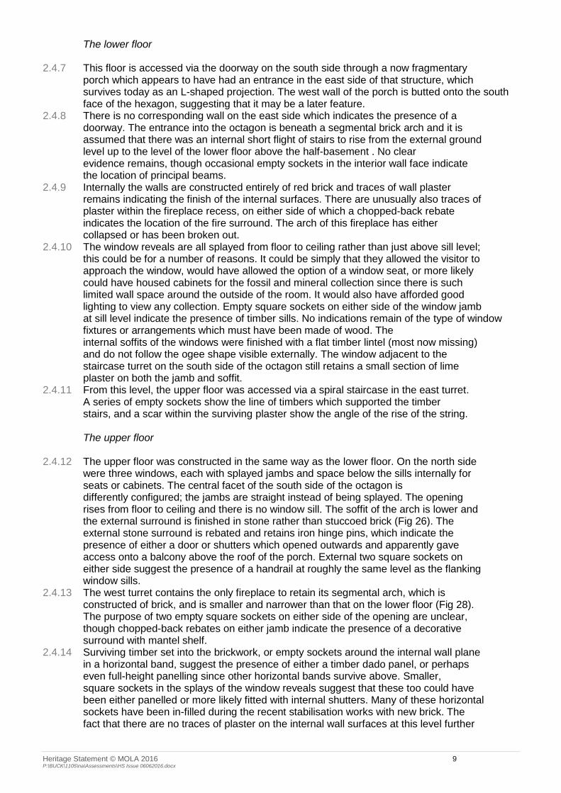
2.5.1 The approved works were undertaken in 2009/2010. With the exception of the incursion of vegetation, lack of maintenance and some minor damage and impact due to low-level anti-social behaviour, the current condition is not markedly different to its post-stabilisation state.
2.5.2 Vegetation has been stripped to reveal the structure and some of the debris has been removed.
Fig 8 View from south (NA 2009 & MOLA 2016)
Heritage Statement © MOLA 2016 11 P:\BUCK\1105\na\Assessments\HS Issue 06062016.docx
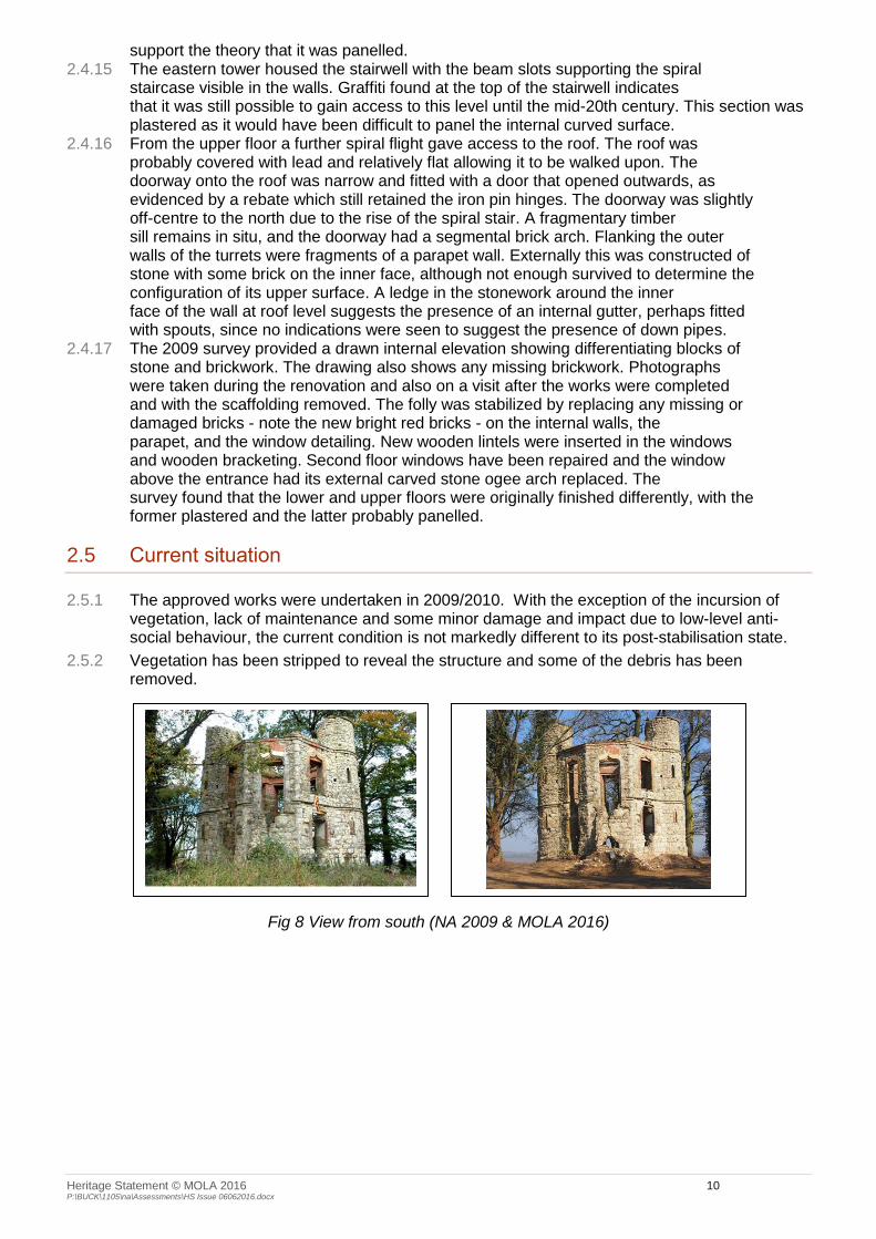
Fig 9 View from north (NA 2009 & MOLA 2016)
2.5.3 Substantial deterioration has not taken place but matters are clearly not moving forwards.

Heritage Statement © MOLA 2016 12 P:\BUCK\1105\na\Assessments\HS Issue 06062016.docx
2.6 Planning History
2.6.1 The Council’s website reveals the following decisions:
Ref Date Description Outcome
09/02092/ALB 16/04/2009 Works to stabilise Folly Consent
There was a series of proposals for a golf course encapsulating the site, during 1990/91, all of which were refused (mainly on grounds of agricultrural land quality, impact on the CA and amenity of footpath users), appealed and subsequently dismissed. Application 92/0481/APP for a course on land to the north of Dinton Castle was approved on appeal.
89/01784/ALB
89/02554/ALB
01/01/1989 Restoration of Castle, including garage and extension
Refusal – detriment to character and setting of the LB
Visual prominence and loss of rural isolation, detriment to setting
89/1630/ALB 23/06/1989 Restoration of Castle, including garage and extension
Refusal - Contrary to Housing policy, detriment to character and setting of LB
Increased use of access onto classified road; foul water drainage
Loss of TPO trees
89/02553/APP 01/01/1989 Erection of dwelling and detached garage. Restoration of Castle.
Refusal - Contrary to Housing policy, detriment to character and setting of LB
Increased use of access onto classified road; foul water drainage
Loss of TPO trees
2.6.2 The surrounding area is subject to a Tree Preservation Order (TPO 1991 No.26); a couple of applications, for the felling of individual trees, were approved in 2009 and 2012 respectively.
2.6.3 There has been resistance in the past to any development of the site, but that has not been in terms of ‘enabling’ development, i.e. development outside the general planning ‘policy environment’ which would ensure the rescue and long-term future of a heritage asset at risk.
2.6.4 The 2009 consent appears to have been implemented; however these works have served to stabilise the building at the time but not provided any means or revenue to secure its long-term condition. Although deterioration appears to have slowed, lack of maintenance and the impact of low level anti-social behaviour in and around the site in the interim since the works were undertaken is still apparent.
2.6.5 There appears to have been no consideration of the castle in terms of its use – it has been dubbed a ‘folly’ and treated as such.
Heritage Statement © MOLA 2016 13 P:\BUCK\1105\na\Assessments\HS Issue 06062016.docx
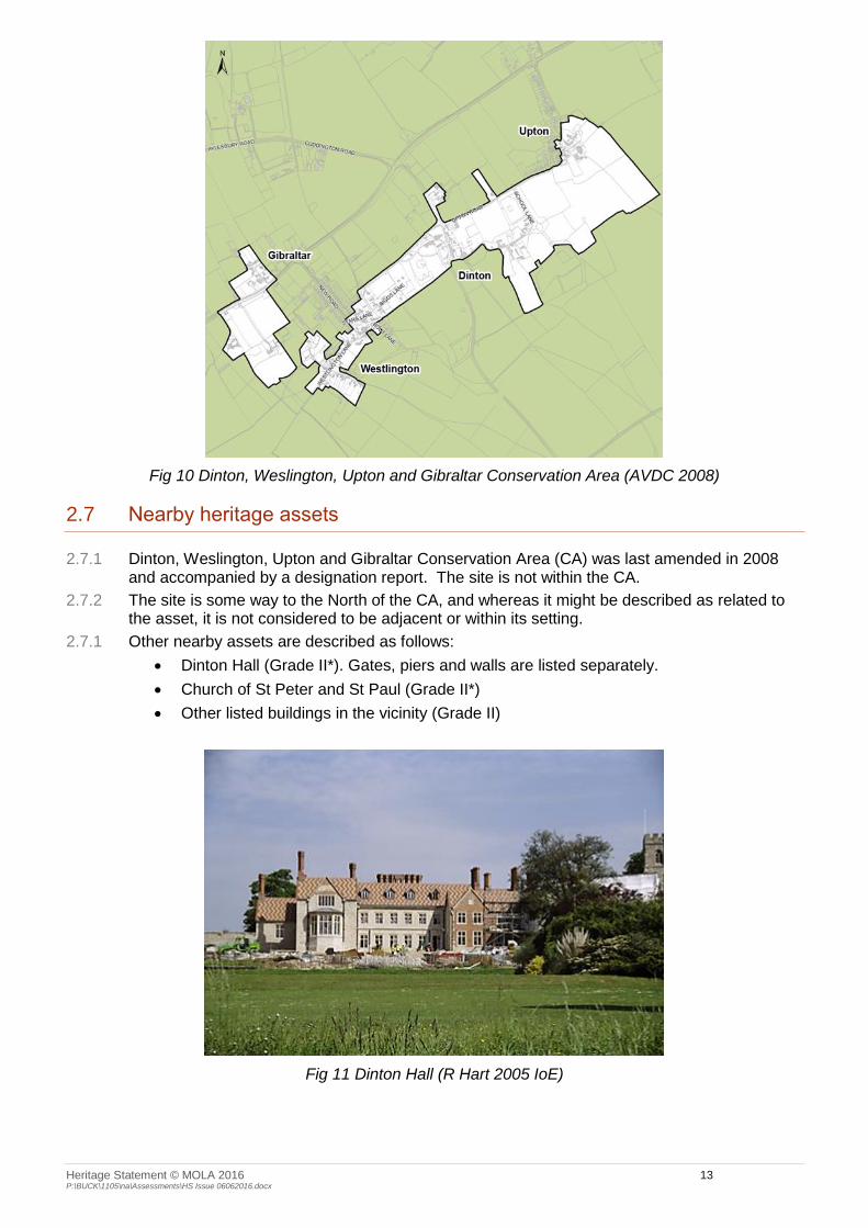
Fig 10 Dinton, Weslington, Upton and Gibraltar Conservation Area (AVDC 2008)
2.7 Nearby heritage assets
2.7.1 Dinton, Weslington, Upton and Gibraltar Conservation Area (CA) was last amended in 2008 and accompanied by a designation report. The site is not within the CA.
2.7.2 The site is some way to the North of the CA, and whereas it might be described as related to the asset, it is not considered to be adjacent or within its setting.
2.7.1 Other nearby assets are described as follows:
Dinton Hall (Grade II*). Gates, piers and walls are listed separately.
Church of St Peter and St Paul (Grade II*)
Other listed buildings in the vicinity (Grade II)
Fig 11 Dinton Hall (R Hart 2005 IoE)

Heritage Statement © MOLA 2016 14 P:\BUCK\1105\na\Assessments\HS Issue 06062016.docx
Fig 12 Church of saints Peter and Paul (Ian Buxton 2003 IoE)
2.8 Commentary
2.8.1 Dinton Castle is a fine example of an eighteenth-century structure. It is now called a folly, though perhaps since it was built with a specific purpose to house a collection of fossils and minerals, this epithet does not strictly apply. Its castellated form is typical of the period and reflects its location on high ground. It is not known when it fell into disuse but it is noted as a ruin as early as 1820. The parkland had been largely subsumed into the wider agricultural landscape by that point.
2.8.2 The building was therefore constructed for a purpose as well as in a position and form that would catch the eye. It was intended to be seen but also to be a ‘destination’ in terms of the overall leisure function of the estate at the time.
2.8.3 It is not and never was a ‘folly’; the Oxford English Dictionary (OED) defines a folly as: ‘A costly ornamental building with no practical purpose, especially a tower or mock-Gothic ruin built in a large garden or park’ (Origin: Middle English: from Old French folie 'madness', in modern French also 'delight, favourite dwelling'). The Cambridge English Dictionary (CED) defines as: ‘A building in the form of a small castle, temple, etc., that has been built as a decoration in a large garden or park: e.g. a Gothic garden folly’.
2.8.4 Eye-catchers differed from follies as they were supposed to added ‘variety and interest’ rather than evoking a classical idyll or an emotional response. The device was fashionable especially during the mid- to late-C18th.
2.8.5 Historic England suggest 2 categories of garden and parkland structures in their Guide to Listing (revised 2015) – ‘Pleasure’ and ‘Utility’. A ‘true folly’ is likened to the gothic ruin at Mount Edgecombe, Devon which was constructed as a ‘ruin’ in the first place and has no purpose other than the aesthetic. Many garden buildings in the latter group were dismissed as follies but are now better understood as ‘destination’ buildings with a specific purpose.
2.8.6 The best use or function for a building, according to Conservation Principles (EH 2008) is the use or function for which it was intended. Whereas it is not suggested the building should house a collector’s hoard, there is some logic to suggest that the best future for the asset should be its reconstruction as a sound, weathertight building with an ongoing, beneficial use to ensure its longevity.
2.8.7 Therefore there should be no objection, in principle and in heritage terms, to the studied and appropriately detailed reconstruction of the structure to its former, functional state.

Heritage Statement © MOLA 2016 15 P:\BUCK\1105\na\Assessments\HS Issue 06062016.docx
3 Condition and Significance
3.1 Statement of significance
3.1.1 Dinton Castle is listed Grade II*; as such it is considered to be of Very High significance from the outset.
3.1.2 In terms of the 4 values (see below):
Evidential value: The building is well documented and its origins are well-known
Aesthetic value: The building has been noted as a ruin since the beginning of the C19th at least and it has something of a patina of age about it; clearly very attractive in its ‘romantic decay’. It was not built however as a romantic ‘folly’; it had utility and as such could reasonably be refurbished as such without detriment to its underlying aesthetic qualities.
Historical value: The building is a significant contributor to the character and appearance of the historic landscape and its origins and original purpose are corroborated by evidence and part of the fabric of local lore.
Communal value: It is not known if there have been any recent community associations related to this site.
3.1.3 Change through time has taken place without apparent detriment to the status of the building. It is considered that its significance remains Very High.
3.1.4 The other listed buildings in the vicinity are of Very High/High significance; it is not considered likely that the proposal will impact on these assets at all.
3.1.5 The CA is an asset of High significance. The site is not within the CA nor, it is argued, within its setting. It is not considered likely that the proposal will impact on this asset at all.

Heritage Statement © MOLA 2016 16 P:\BUCK\1105\na\Assessments\HS Issue 06062016.docx
4 Proposed Development
4.1 Overview and impact of proposed development
4.1.1 The proposal comprises restoration of the building to a functional state and then its conversion to one residential unit. Please see Appendix A, the architect’s drawings, D&A and other submissions.
4.1.2 It is not the purpose of this report to comment on the planning aspects of the case; clearly this is a matter for others. There should be no objection in principle to the renovation of this building in itself and there would be no harm to the significance of the designated asset attendant upon so doing. The impact would be in the positive, as the development would better express the heritage value of the asset to a wider audience.
4.1.3 The scheme in detail is described in the application pack. With care, there will be the minimum impact on remaining historic fabric and the works will not impact on the asset to such an extent that its integrity is undermined. It is considered that this could be undertaken with negligible impact on the significance of the heritage asset or remaining fabric.
4.1.4 The impact of activity and the change of use will have an effect on the immediate setting of the castle but it is not considered that this will amount to harm to the significance of the asset. This aspect of the development will however require careful design and management if it is not to erode the qualities that contribute to the significance of the asset. Some outline ideas are expressed in the scheme; it is suggested that the detailed execution of this be the subject of conditions in due course.
4.1.5 Materials, including windows and doors, (to be agreed) will be in traditional materials to match existing.
4.1.6 It is considered that the scheme overall represents a subordinate, sensitive and appropriate development which responds positively to the listed building and will not therefore undermine the significance of this or any other heritage asset.

Heritage Statement © MOLA 2016 17 P:\BUCK\1105\na\Assessments\HS Issue 06062016.docx
5 Impact of Proposed Development
5.1 Dinton Castle
5.1.1 It is considered that there will be no negative impact on the integrity or significance of the heritage asset by renovating it to a purposeful condition,
5.2 The Conservation Area
5.2.1 It is considered that there will be no impact on the character, appearance, setting or significance of the heritage asset.
5.3 Nearby heritage assets
5.3.1 It is considered that there will be no impact on the character, setting, integrity or significance of the heritage assets.

Heritage Statement © MOLA 2016 18 P:\BUCK\1105\na\Assessments\HS Issue 06062016.docx
6 Conclusions and Recommendations
6.1 Conclusions
6.1.1 The proposal comprises the renovation of the castle to a functional building and its conversion to one residential unit.
6.1.2 It is considered that this represents a subordinate, sensitive and appropriate development which responds positively to the listed building and will not therefore undermine the significance of the asset.
6.1.3 It is considered that there will be no impact on the integrity or significance of the principal heritage asset or other assets in the vicinity.
6.1.4 As a consequence, the proposal is considered to accord with national and local policy and advice.
6.2 Recommendations
6.2.1 No further archaeological or additional recording work is considered necessary in this instance.

Heritage Statement © MOLA 2016 19 P:\BUCK\1105\na\Assessments\HS Issue 06062016.docx
7 Planning framework
7.1 Statutory protection
Listed Buildings and Conservation Areas
7.1.1 The Planning (Listed Buildings and Conservation Areas) Act 1990 sets out the legal requirements for the control of development and alterations which affect buildings, including those which are listed or in conservation areas. Buildings which are listed or which lie within a conservation area are protected by law. Grade I are buildings of exceptional interest. Grade II* are particularly significant buildings of more than special interest. Grade II are buildings of special interest, which warrant every effort being made to preserve them.
7.2 National Planning Policy Framework
7.2.1 The Government issued the National Planning Policy Framework (NPPF) in March 2012 (DCLG 2012) and supporting Planning Practice Guidance in 2014 (DCLG 2014). One of the 12 core principles that underpin both plan-making and decision-taking within the framework is to ‘conserve heritage assets in a manner appropriate to their significance, so that they can be enjoyed for their contribution to the quality of life of this and future generations’ (DCLG 2012 para 17). It recognises that heritage assets are an irreplaceable resource (para 126), and requires the significance of heritage assets to be considered in the planning process, whether designated or not. The contribution of setting to asset significance needs to be taken into account (para 128). The NPPF encourages early engagement (i.e. pre-application) as this has significant potential to improve the efficiency and effectiveness of a planning application and can lead to better outcomes for the local community (para 188).
7.2.2 NPPF Section 12: Conserving and enhancing the historic environment, is produced in full below:
Para 126. Local planning authorities should set out in their Local Plan a positive strategy for the conservation and enjoyment of the historic environment, including heritage assets most at risk through neglect, decay or other threats. In doing so, they should recognise that heritage assets are an irreplaceable resource and conserve them in a manner appropriate to their significance. In developing this strategy, local planning authorities should take into account:
the desirability of sustaining and enhancing the significance of heritage assets and putting them to viable uses consistent with their conservation;
the wider social, cultural, economic and environmental benefits that conservation of the historic environment can bring;
the desirability of new development making a positive contribution to local character and distinctiveness; and
opportunities to draw on the contribution made by the historic environment to the character of a place.
Para 127. When considering the designation of conservation areas, local planning authorities should ensure that an area justifies such status because of its special architectural or historic interest, and that the concept of conservation is not devalued through the designation of areas that lack special interest.
Para 128. In determining applications, local planning authorities should require an applicant to describe the significance of any heritage assets affected, including any contribution made by their setting. The level of detail should be proportionate to the assets’ importance and no more than is sufficient to understand the potential impact of the proposal on their significance. As a minimum the relevant historic environment record should have been consulted and the heritage assets assessed using appropriate expertise where necessary. Where a site on which development is proposed includes or has the potential to include heritage assets with archaeological interest, local planning authorities should require developers to submit an appropriate desk-based assessment and, where necessary, a field evaluation.
Para 129. Local planning authorities should identify and assess the particular significance of any heritage asset that may be affected by a proposal (including by development affecting the setting of a heritage asset) taking account of the available evidence and any necessary
Heritage Statement © MOLA 2016 20 P:\BUCK\1105\na\Assessments\HS Issue 06062016.docx
expertise. They should take this assessment into account when considering the impact of a proposal on a heritage asset, to avoid or minimise conflict between the heritage asset’s conservation and any aspect of the proposal.
Para 130. Where there is evidence of deliberate neglect of or damage to a heritage asset the deteriorated state of the heritage asset should not be taken into account in any decision.
Para 131. In determining planning applications, local planning authorities should take account of:
the desirability of sustaining and enhancing the significance of heritage assets and putting them to viable uses consistent with their conservation;
the positive contribution that conservation of heritage assets can make to sustainable communities including their economic vitality; and
the desirability of new development making a positive contribution to local character and distinctiveness.
Para 132: When considering the impact of a proposed development on the significance of a designated heritage asset, great weight should be given to the asset’s conservation. The more important the asset, the greater the weight should be. Significance can be harmed or lost through alteration or destruction of the heritage asset or development within its setting. As heritage assets are irreplaceable, any harm or loss should require clear and convincing justification. Substantial harm to or loss of a grade II listed building, park or garden should be exceptional. Substantial harm to or loss of designated heritage assets of the highest significance, notably scheduled monuments, protected wreck sites, battlefields, grade I and II* listed buildings, grade I and II* registered parks and gardens, and World Heritage Sites, should be wholly exceptional.
Para 133. Where a proposed development will lead to substantial harm to or total loss of significance of a designated heritage asset, local planning authorities should refuse consent, unless it can be demonstrated that the substantial harm or loss is necessary to achieve substantial public benefits that outweigh that harm or loss, or all of the following apply:
the nature of the heritage asset prevents all reasonable uses of the site; and
no viable use of the heritage asset itself can be found in the medium term through appropriate marketing that will enable its conservation; and
conservation by grant-funding or some form of charitable or public ownership is demonstrably not possible; and
the harm or loss is outweighed by the benefit of bringing the site back into use.
Para 134. Where a development proposal will lead to less than substantial harm to the significance of a designated heritage asset, this harm should be weighed against the public benefits of the proposal, including securing its optimum viable use.
Para 135. The effect of an application on the significance of a non-designated heritage asset should be taken into account in determining the application. In weighing applications that affect directly or indirectly non designated heritage assets, a balanced judgement will be required having regard to the scale of any harm or loss and the significance of the heritage asset.
Para 136. Local planning authorities should not permit loss of the whole or part of a heritage asset without taking all reasonable steps to ensure the new development will proceed after the loss has occurred.
Para 137. Local planning authorities should look for opportunities for new development within Conservation Areas and World Heritage Sites and within the setting of heritage assets to enhance or better reveal their significance. Proposals that preserve those elements of the setting that make a positive contribution to or better reveal the significance of the asset should be treated favourably.
Para 138. Not all elements of a World Heritage Site or Conservation Area will necessarily contribute to its significance. Loss of a building (or other element) which makes a positive contribution to the significance of the Conservation Area or World Heritage Site should be treated either as substantial harm under paragraph 133 or less than substantial harm under paragraph 134, as appropriate, taking into account the relative significance of the element affected and its contribution to the significance of the Conservation Area or World Heritage Site as a whole.
Para 139. Non-designated heritage assets of archaeological interest that are demonstrably of equivalent significance to scheduled monuments, should be considered subject to the policies for designated heritage assets.
Para 140. Local planning authorities should assess whether the benefits of a proposal for enabling development, which would otherwise conflict with planning policies but which would

Heritage Statement © MOLA 2016 21 P:\BUCK\1105\na\Assessments\HS Issue 06062016.docx
secure the future conservation of a heritage asset, outweigh the disbenefits of departing from those policies.
Para 141. Local planning authorities should make information about the significance of the historic environment gathered as part of plan-making or development management publicly accessible. They should also require developers to record and advance understanding of the significance of any heritage assets to be lost (wholly or in part) in a manner proportionate to their importance and the impact, and to make this evidence (and any archive generated) publicly accessible. However, the ability to record evidence of our past should not be a factor in deciding whether such loss should be permitted.
7.3 Local planning policy
7.3.1 Local policy and advisory documents pertinent to this application include:
Saved policies in the Adopted Aylesbury Vale District Local Plan 2007 (in so far as there is accordance with the NPPF 2012 above).
The Vale of Aylesbury Local Plan – emergent; due out for consultation mid-2016
The Conservation Area Management Plan (District-wide strategy) updated 2016
Advisory guidelines on LBs 2001
Advisory guidelines on CAs updated 2011

Heritage Statement © MOLA 2016 22 P:\BUCK\1105\na\Assessments\HS Issue 06062016.docx
8 Determining significance
8.1.1 ‘Significance’ lies in the value of a heritage asset to this and future generations because of its heritage interest, which may be archaeological, architectural, artistic or historic. Archaeological interest includes an interest in carrying out an expert investigation at some point in the future into the evidence a heritage asset may hold of past human activity, and may apply to standing buildings or structures as well as buried remains. Known and potential heritage assets within the site and its vicinity have been identified from national and local designations, HER data and expert opinion. The determination of the significance of these assets is based on statutory designation and/or professional judgement against four values (EH 2008):
Evidential value: the potential of the physical remains to yield evidence of past human activity. This might take into account date; rarity; state of preservation; diversity/complexity; contribution to published priorities; supporting documentation; collective value and comparative potential.
Aesthetic value: this derives from the ways in which people draw sensory and intellectual stimulation from the heritage asset, taking into account what other people have said or written;
Historical value: the ways in which past people, events and aspects of life can be connected through heritage asset to the present, such a connection often being illustrative or associative;
Communal value: this derives from the meanings of a heritage asset for the people who know about it, or for whom it figures in their collective experience or memory; communal values are closely bound up with historical, particularly associative, and aesthetic values, along with and educational, social or economic values.
8.1.2 Table 1 gives examples of the significance of designated and non-designated heritage assets.
Table 1: Significance of heritage assets Heritage asset description Significance
World heritage sites Scheduled monuments Grade I and II* listed buildings English Heritage Grade I and II* registered parks and gardens Protected Wrecks Heritage assets of national importance
Very high (International/
national)
English Heritage Grade II registered parks and gardens Conservation areas Designated historic battlefields Grade II listed buildings Burial grounds Protected heritage landscapes (e.g. ancient woodland or historic hedgerows) Heritage assets of regional or county importance
High (national/ regional/ county)
Heritage assets with a district value or interest for education or cultural appreciation Locally listed buildings
Medium (District)
Heritage assets with a local (i.e. parish) value or interest for education or cultural appreciation
Low (Local)
Historic environment resource with no significant value or interest Negligible
Heritage assets that have a clear potential, but for which current knowledge is insufficient to allow significance to be determined
Uncertain
8.1.3 Unless the nature and exact extent of buried archaeological remains within any given area has been determined through prior investigation, significance is often uncertain.

Heritage Statement © MOLA 2016 23 P:\BUCK\1105\na\Assessments\HS Issue 06062016.docx
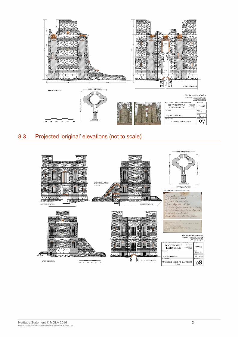
Appendix A Existing Plans (Not to scale)
8.2 Survey (extract, not to scale)
Heritage Statement © MOLA 2016 24 P:\BUCK\1105\na\Assessments\HS Issue 06062016.docx
8.3 Projected ‘original’ elevations (not to scale)