draft geotechnical data report
TRANSCRIPT

DRAFT Geotechnical Data Report
Prepared for
Vermont Agency of Transportation
One National Life Drive Montpelier, Vermont, 05633
October 21, 2011
CHA Project No. 23191.1000.32000
3 Winners Circle Albany New York, 12205
Burlington Roundabout Bedrock Probes
HES 5000(18) City of Burlington
Vermont
CHA - i - Burlington HES 5000(18) Roundabout Burlington, Vermont
This report has been prepared and reviewed by the following qualified engineers employed by
CHA.
Report Prepared By:
__________________
Daniel J. Spielvogel, E.I.T.
Geotechnical Engineer
Report Reviewed By:
__________________
Katherine E. Adnams, P.E.
Senior Geotechnical Engineer
__________________
John P. Sobiech, P.E.
Partner

CHA - ii - Burlington HES 5000(18) Roundabout Burlington, Vermont
TABLE OF CONTENTS
SECTION PAGE NUMBER
1.0 INTRODUCTION.............................................................................................................. 1 2.0 PROJECT AND SITE DESCRIPTION .......................................................................... 2 3.0 SUBSURFACE INVESTIGATION ................................................................................. 3 4.0 SUBSURFACE CONDITIONS ........................................................................................ 4
4.1 Regional Geology ........................................................................................................... 4 4.2 Subsurface Stratigraphy ................................................................................................. 4 4.3 Groundwater ................................................................................................................... 5
5.0 DEPTHS TO BEDROCK (AUGER REFUSAL) ............................................................ 6 6.0 CLOSURE .......................................................................................................................... 7
TABLES
Table 1 – Bedrock Depth ................................................................................................................ 6
APPENDICES APPENDIX A: FIGURES APPENDIX B: SUBSURFACE LOGS APPENDIX C: APRIL 2011 SUBSURFACE LOGS

CHA - 1 - Burlington HES 5000(18) Roundabout Burlington, Vermont
1.0 INTRODUCTION
This report summarizes the results of the geotechnical investigation performed by CHA for the
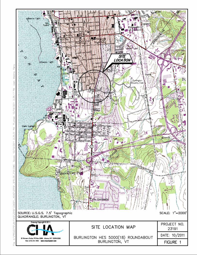
proposed roundabout at the Shelburne Road and Locust Street intersection in Burlington,
Vermont by the Vermont Agency of Transportation (VTrans). The project location is shown on
the Site Location Map included in Appendix A as Figure 1.
The objective of this investigation was to provide subsurface data in the general areas of the
proposed utility work associated with the roundabout design.

CHA - 2 - Burlington HES 5000(18) Roundabout Burlington, Vermont
2.0 PROJECT AND SITE DESCRIPTION
We understand that the Vermont Agency of Transportation (VTrans) is planning to construct a
roundabout at the Shelburne Road and Locust Street intersection in the City of Burlington,
Vermont. As part of the construction, utilities will be relocated in the area.
The project site is approximately 1,800 linear feet and encompasses approximately 650 feet
south and 400 feet north on Shelburne Road, approximately 200 feet north on South Willard
Road, approximately 150 feet east on Ledge Street, and approximately 400 feet west on Locust
street all from the existing roundabout intersection at the project center. The existing roads are
lined with residential homes, yards, and occasional trees and the roadways experience heavy
traffic during the day. Bedrock outcrops were noted in several locations off of South Willard
Street and Shelburne Road.

CHA - 3 - Burlington HES 5000(18) Roundabout Burlington, Vermont
3.0 SUBSURFACE INVESTIGATION
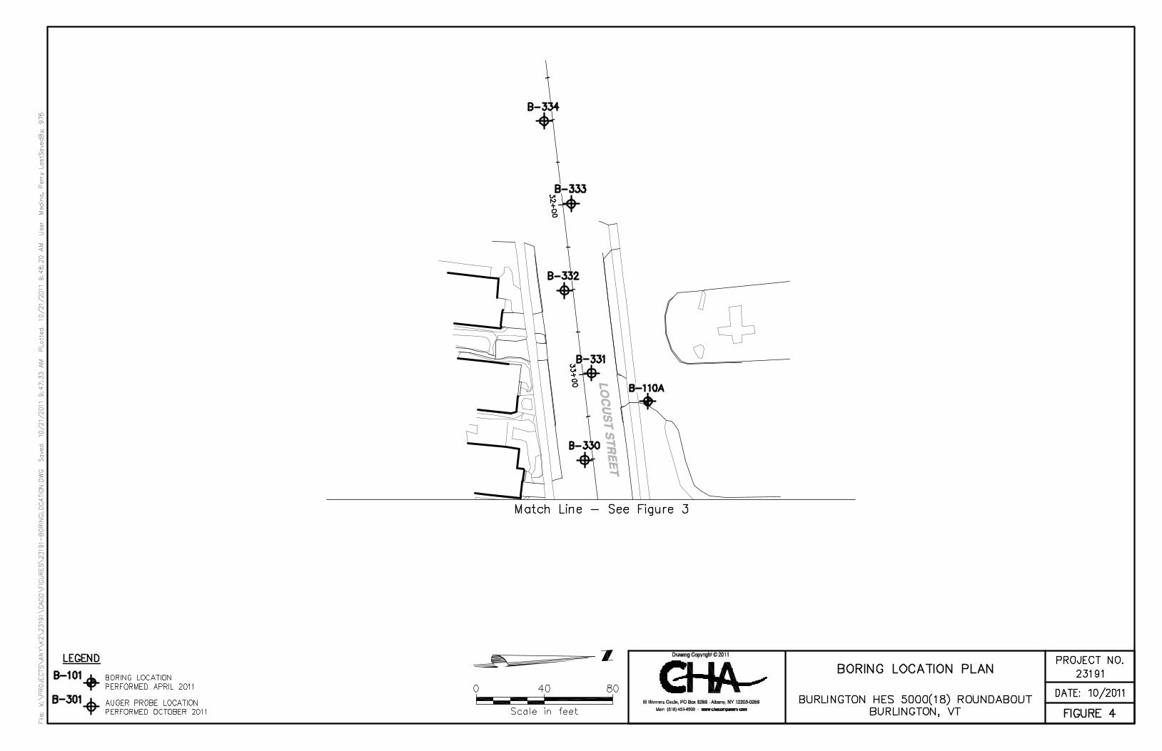
Thirty five auger probes, designated as B-301 to B-322 and B-324 to B-336, were advanced for
the subsurface investigation on September 6, October 3, and October 4, 2011. A log of
conditions encountered is included in Appendix B. This subsurface investigation was
supplemented by the borings completed by CHA in April 2011 for infiltration testing, which
were submitted to VTrans in the Geotechnical Data Report entitled “Burlington Roundabout
Infiltration Testing” and dated May 4, 2011. The boring logs from this previous investigation
are included in Appendix C. The boring and auger probe locations are shown on the Boring
Location Plan, Figures 2 through 4, included in Appendix A. Borings and auger probes noted
with an “A” were relocated from the VTrans proposed locations for utility clearance and drill rig
access purposes. The locations of these modified locations were determined by taping from
existing site features to the as-drilled boring locations. Auger probe B-323 was eliminated due to
an inability to confidently locate existing utilities within the planned probe location. The
locations of the borings should be considered accurate only to the degree implied by the method
used to determine them.
CHA retained Vermont Underground Locators, Inc. to assist with underground utility location
for sewer main lines and laterals not marked through the Dig Safe process.
CHA retained Specialty Drilling & Investigation, Inc. of Burlington, Vermont to advance the
auger probes. A CHA geotechnical engineer observed the field investigation to ensure that
proper drilling methods were used for this investigation, describe auger cuttings, and prepare
field logs documenting subsurface conditions.
The auger probes were advanced with a truck mounted drill rig (Simco 2800) using 2.25 inch
hollow stem augers. Augers were generally advanced to a depth of 15 feet or refusal, whichever
occurred first. Soil conditions were classified based upon visual observation of auger cuttings
during drilling.
CHA - 4 - Burlington HES 5000(18) Roundabout Burlington, Vermont
4.0 SUBSURFACE CONDITIONS
4.1 Regional Geology
According to the Surficial Geologic Map of the Burlington, Vermont7.5 Minute Quadrangle
(Wright, S. et al, 2009.) the site is underlain by medium fine sand and clay rich glacial till.
According to the Geologic Map of Vermont (Doll, C. G., (1961), the bedrock within the project
area generally consists of Monkton Quartzite.
4.2 Subsurface Stratigraphy
Subsurface conditions encountered in the auger probes are detailed and described on the probe
log included in Appendix B of this report. General subsurface conditions are described below in
order of increasing depth.
Asphalt – Asphalt was encountered at the ground surface in all of the auger probes and extended
to a depth of 0.2 feet to 0.4 feet.
Concrete – Concrete was encountered below the asphalt in probes B-317 through B-319A and
was 0.5 foot to greater than 1.0 foot thick (B-317, and B-319A were terminated at auger refusal
in the concrete.
Sand – Fine to coarse sand was encountered below the asphalt in probes B-301 through B-316,
B-320 through B-332, and B-334 through B-336 and extended to depths ranging from 2.6 to 13.0
feet. The sand contained varying amounts of gravel, clay, and silt and was brown. The sand was
generally brown and the moisture content was visually classified as moist.
Glacial Till – Glacial till comprised of silty clay or clayey silt was encountered beneath the
asphalt or sand in probes B-311 through B-320, B-322 through B-329 and B-331 through B-336
and extended to boring termination. The clay and silt contained various amounts of fine to
coarse sand and fine to coarse gravel, was generally brown to gray in color and the moisture
content was visually classified as moist to wet.
CHA - 5 - Burlington HES 5000(18) Roundabout Burlington, Vermont
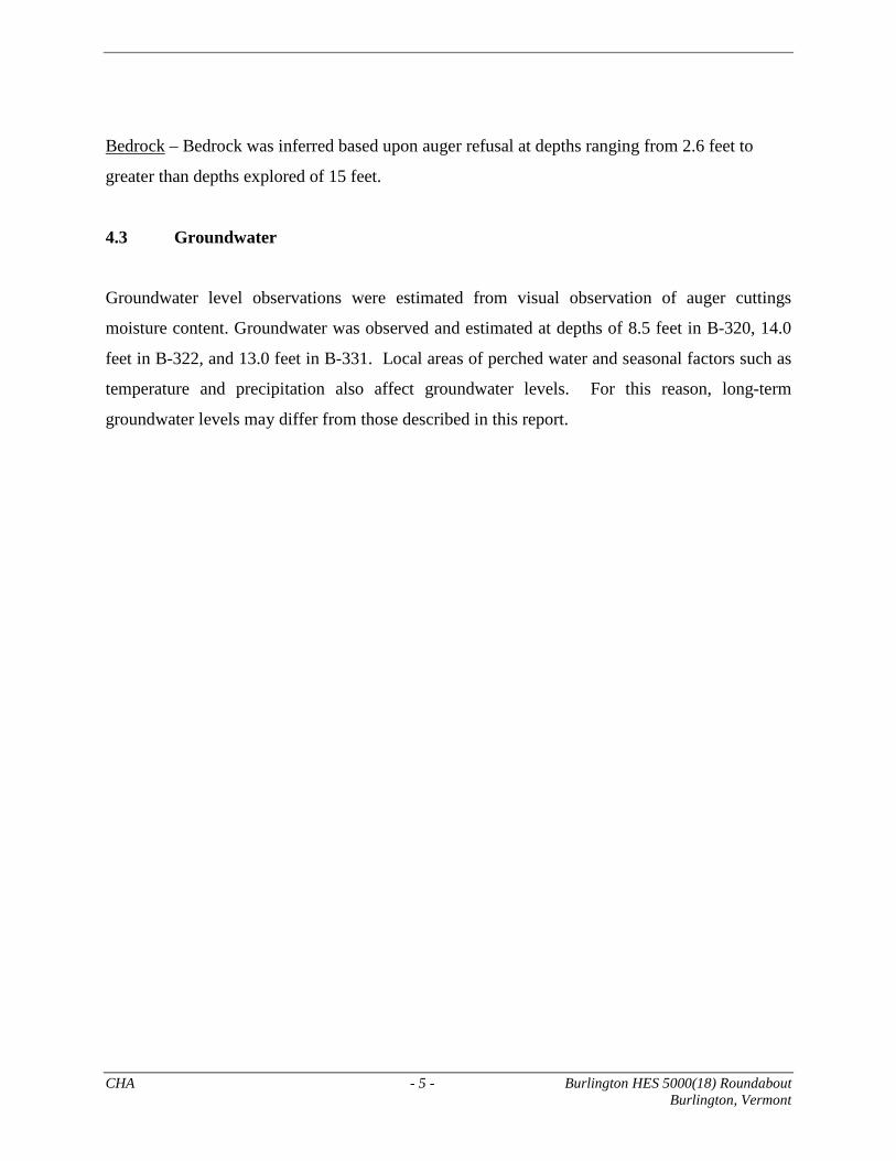
Bedrock – Bedrock was inferred based upon auger refusal at depths ranging from 2.6 feet to
greater than depths explored of 15 feet.
4.3 Groundwater
Groundwater level observations were estimated from visual observation of auger cuttings
moisture content. Groundwater was observed and estimated at depths of 8.5 feet in B-320, 14.0
feet in B-322, and 13.0 feet in B-331. Local areas of perched water and seasonal factors such as
temperature and precipitation also affect groundwater levels. For this reason, long-term
groundwater levels may differ from those described in this report.
CHA - 6 - Burlington HES 5000(18) Roundabout Burlington, Vermont
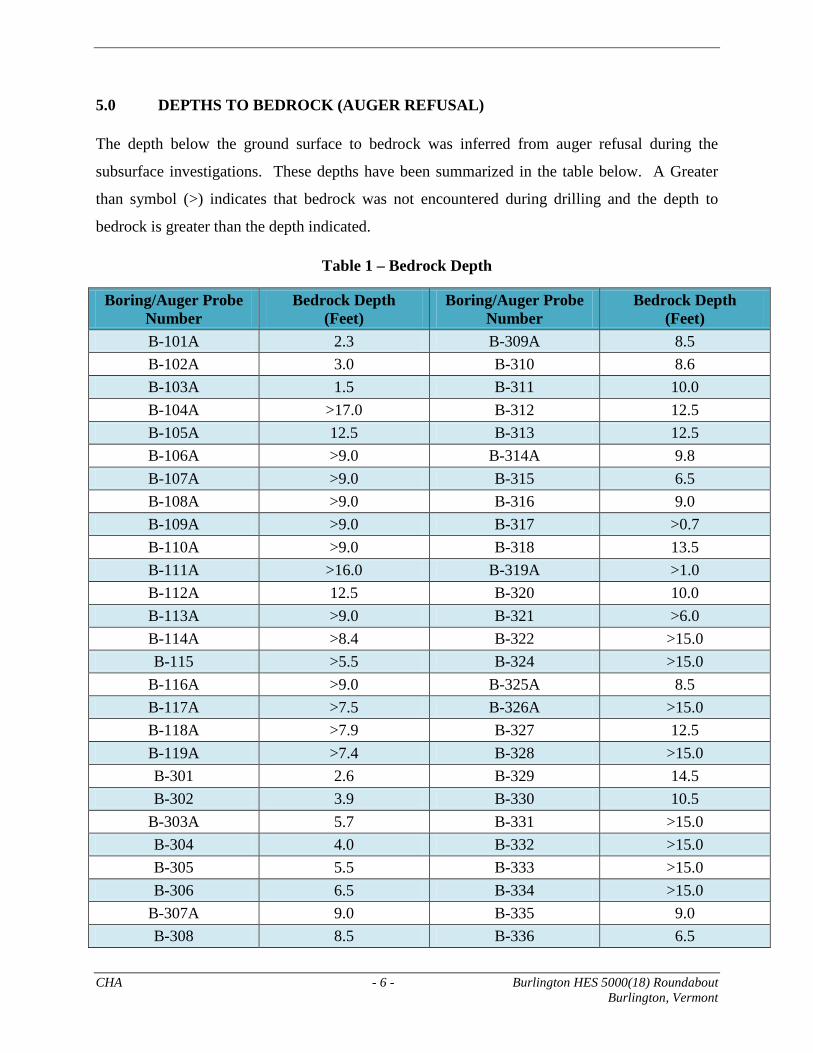
5.0 DEPTHS TO BEDROCK (AUGER REFUSAL)
The depth below the ground surface to bedrock was inferred from auger refusal during the
subsurface investigations. These depths have been summarized in the table below. A Greater
than symbol (>) indicates that bedrock was not encountered during drilling and the depth to
bedrock is greater than the depth indicated.
Table 1 – Bedrock Depth
Boring/Auger Probe Number
Bedrock Depth (Feet)
Boring/Auger Probe Number
Bedrock Depth (Feet)
B-101A 2.3 B-309A 8.5 B-102A 3.0 B-310 8.6 B-103A 1.5 B-311 10.0 B-104A >17.0 B-312 12.5 B-105A 12.5 B-313 12.5 B-106A >9.0 B-314A 9.8 B-107A >9.0 B-315 6.5 B-108A >9.0 B-316 9.0 B-109A >9.0 B-317 >0.7 B-110A >9.0 B-318 13.5 B-111A >16.0 B-319A >1.0 B-112A 12.5 B-320 10.0 B-113A >9.0 B-321 >6.0 B-114A >8.4 B-322 >15.0 B-115 >5.5 B-324 >15.0
B-116A >9.0 B-325A 8.5 B-117A >7.5 B-326A >15.0 B-118A >7.9 B-327 12.5 B-119A >7.4 B-328 >15.0 B-301 2.6 B-329 14.5 B-302 3.9 B-330 10.5
B-303A 5.7 B-331 >15.0 B-304 4.0 B-332 >15.0 B-305 5.5 B-333 >15.0 B-306 6.5 B-334 >15.0
B-307A 9.0 B-335 9.0 B-308 8.5 B-336 6.5
CHA - 7 - Burlington HES 5000(18) Roundabout Burlington, Vermont
6.0 CLOSURE
The results presented herein are based, in part, on project and subsurface information available at
the time this report was prepared and in accordance with generally accepted engineering
practices. No other warranty, expressed or implied, is made.

CHA Burlington HES 5000(18) Roundabout Burlington, Vermont
APPENDIX A
FIGURES


CHA Burlington HES 5000(18) Roundabout Burlington, Vermont
APPENDIX B
AUGER PROBE LOG

1
Project No: 23191.1000.32000Client: Vermont Agency of TransportationContractor: Specialty Drilling InvestigationsDriller: C. AldrichInspector: D. Spielvogel
FIELD DESCRIPTION
SOIL TYPE, COLOR,
MOISTURE
B-301 10/3/2011 Asphalt Pavementf.m.c. SAND, S. f.c Gravel, lit. clayey silt, brn, moist
Auger Refusal
B-302 10/3/2011 Asphalt Pavementf.m.c. SAND, S. f.c Gravel, lit. clayey silt, brn, moist
Auger Refusal
B-303A 10/3/2011 Asphalt Pavementf.m.c. SAND, S. f.c Gravel, lit. clayey silt, brn, moist
Auger Refusal
B-304 10/3/2011 Asphalt Pavementf.m.c. SAND, S. f.c Gravel, lit. clayey silt, brn, moist
Auger Refusal
B-305A 10/3/2011 Asphalt Pavementf.m.c. SAND, S. f.c Gravel, lit. clayey silt, brn, moist
Auger Refusal
B-306 10/3/2011 Asphalt Pavementf.m.c. SAND, S. f.c Gravel, lit. clayey silt, brn, moist
Auger Refusal
B-307A 10/3/2011 Asphalt Pavementf.m.c. SAND, S. f.c Gravel, lit. clayey silt, brn, moist
Grades to S. Clayey SiltAuger Refusal
B-308 10/3/2011 Asphalt Pavementf.m.c. SAND, S. f.c Gravel, lit. clayey silt, brn, moist
Auger Refusal
B-309A 10/3/2011 Asphalt Pavementf.m.c. SAND, S. f.c Gravel, lit. clayey silt, brn, moist
Grades to S. Clayey SiltAuger Refusal
B-310 10/3/2011 Asphalt Pavementf.m.c. SAND, S. f.c Gravel, lit. clayey silt, brn, moist
Auger Refusal
0.0 - 0.3None0.3-3.9
3.9
None 0.0 - 0.30.3-5.7
Burlington Roundabout
BORI
NG
NO
.
DA
TED
RILL
ED
HES 5000(18)
CHARACTER OF DRILLING, WATER RETURN, ETC.
Burlington, VT
GRO
UN
DW
ATE
R D
EPTH
(FEE
T)
None
REMARKS
DEP
TH
(FEE
T)
0.0 - 0.30.3-2.6
2.6
5.7
0.0 - 0.30.3-4.0
4.0
None
None 0.0 - 0.30.3-6.5
6.5
None 0.0 - 0.30.3-5.5
5.5
None 0.0 - 0.30.3-8.5
8.5
None 0.0 - 0.30.3-8.0
9.08.0-9.0
None 0.0 - 0.30.3-8.08.0-9.0
8.5
None 0.0 - 0.30.3-8.6
8.6

2
Project No: 23191.1000.32000Client: Vermont Agency of TransportationContractor: Specialty Drilling InvestigationsDriller: C. AldrichInspector: D. Spielvogel
FIELD DESCRIPTION
SOIL TYPE, COLOR,
MOISTURE
B-311 10/3/2011 Asphalt Pavementf.m.c. SAND, S. f.c Gravel, lit. clayey silt, brn, moist
Clayey Silt, S. f.m.c. Sand, trace f.c. gravel, brown, moistAuger Refusal
B-312 10/3/2011 Asphalt Pavementf.m.c. SAND, S. f.c Gravel, lit. clayey silt, brn, moist
Clayey Silt, S. f.m.c. Sand, trace f.c. gravel, brown, moistAuger Refusal
B-313 10/4/2011 Asphalt Pavementf.m.c. SAND, S. f.c Gravel, lit. clayey silt, brn, moist
Clayey Silt, S. f.m.c. Sand, trace f.c. gravel, brown, moistAuger Refusal
B-314A 10/4/2011 Asphalt Pavementf.m.c. SAND, S. f.c Gravel, lit. clayey silt, brn, moist
Clayey Silt, S. f.m.c. Sand, trace f.c. gravel, brown, moistAuger Refusal
B-315 10/3/2011 Asphalt Pavementf.m.c. SAND, S. f.c Gravel, lit. clayey silt, brn, moist
Clayey Silt, S. f.m.c. Sand, trace f.c. gravel, brown, moistAuger Refusal
B-316 10/3/2011 Asphalt Pavementf.m.c. SAND, S. f.c Gravel, lit. clayey silt, brn, moist
Clayey Silt, S. f.m.c. Sand, trace f.c. gravel, brown, moistAuger Refusal
B-317 10/3/2011 Asphalt PavementConcrete
Auger Refusal
B-318 10/3/2011 Asphalt PavementConcrete
Clayey Silt, S. f.m.c. Sand, trace f.c. gravel, brown, moistAuger Refusal
B-319A 10/3/2011 Asphalt PavementConcrete
Auger Refusal
None 0.0 - 0.3Auger refusal within concrete0.3-1.0
1.0
None 0.0 - 0.20.2-0.9
0.9-13.513.5
None 0.0 - 0.20.2-0.7
0.7Auger refusal within concrete
None 0.0 - 0.30.3-7.07.0-9.0
9.0
None 0.0 - 0.30.3-3.03.0-6.5
6.5
None 0.0 - 0.30.3-6.06.0-9.8
9.8
BORI
NG
NO
.
DA
TED
RILL
ED
GRO
UN
DW
ATE
R D
EPTH
(FEE
T)
DEP
TH
(FEE
T)
REMARKS
CHARACTER OF DRILLING, WATER RETURN, ETC.
Burlington RoundaboutHES 5000(18)Burlington, VT
None 0.0 - 0.30.3-8.58.5-10
Strong Petrol odor while drilling. Probe located near know petrol spill site per Specialty Drilling &
Investigation.10.0
None 0.0 - 0.30.3-7.0
7.0-12.512.5
None 0.0 - 0.30.3-7.0
7.0-12.512.5

3
Project No: 23191.1000.32000Client: Vermont Agency of TransportationContractor: Specialty Drilling InvestigationsDriller: C. AldrichInspector: D. Spielvogel
FIELD DESCRIPTION
SOIL TYPE, COLOR,
MOISTURE
B-320 10/3/2011 Asphalt Pavementf.m.c. SAND, S. f.c Gravel, lit. clayey silt, brn, moistClayey Silt, S. f.m.c. Sand, trace f.c. gravel, brn, wet
Auger Refusal
B-321 10/4/2011 Asphalt Pavementf.m.c. SAND, S. f.c Gravel, lit. clayey silt, brn, moist
Auger Refusal
B-322 10/4/2011 Asphalt Pavementf.m.c. SAND, S. f.c Gravel, lit. clayey silt, brn, moist
Clayey Silt, S. f.m.c. Sand, trace f.c. gravel, brn, moistbecomes wetEnd of Boring
B-324 10/4/2011 Asphalt Pavementf.m.c. SAND, S. f.c Gravel, lit. clayey silt, brn, moist
Clayey Silt, S. f.m.c. Sand, trace f.c. gravel, brn, moistEnd of Boring
B-325A 10/4/2011 Asphalt Pavementf.m.c. SAND, S. f.c Gravel, lit. clayey silt, brn, moist
Clayey Silt, S. f.m.c. Sand, trace f.c. gravel, brn, moistAuger Refusal
B-326A 10/3/2011 Asphalt Pavementf.m.c. SAND, S. f.c Gravel, lit. clayey silt, brn, moist
Clayey Silt, S. f.m.c. Sand, trace f.c. gravel, brn, moistEnd of Boring
B-327 9/6/2011 Asphalt Pavementf.m.c. SAND, S. clayey silt, lit. f.c Gravel, brn, moist
Clayey Silt, S. f.m.c. Sand, trace f.c. gravel, brn, moistAuger Refusal
B-328 9/6/2011 Asphalt Pavementf.m.c. SAND, lit. clayey silt, lit. f.c Gravel, brn, moist
Clayey Silt, S. f.m.c. Sand, trace f.c. gravel, brn, moistEnd of Boring
None 0.0 - 0.30.3-5.5
5.5-15.015.0
None 0.0 - 0.30.3-7.5
7.5-12.512.5
None 0.0 - 0.30.3-2.02.0-1515.0
None 0.0 - 0.40.4-5.05.0-8.5
8.5
None 0.0 - 0.30.3-7.07.0-1515.0
None 0.0 - 0.3Refusal on probable boulders and cobbles.0.3-6.0
6.0
14.00 0.0 - 0.3Groundwater estimated based upon soil cuttings moisture content and may not represent static
conditions.
0.3-8.5
14.0-15.015.0
7.0-14.0
8.50 0.0 - 0.3 Groundwater estimated based upon soil cuttings moisture content and may not represent static
conditions.
0.3-8.58.5-1010.0
Burlington RoundaboutHES 5000(18)Burlington, VT
BORI
NG
NO
.
DA
TED
RILL
ED
GRO
UN
DW
ATE
R D
EPTH
(FEE
T)
DEP
TH
(FEE
T)
REMARKS
CHARACTER OF DRILLING, WATER RETURN, ETC.

4
Project No: 23191.1000.32000Client: Vermont Agency of TransportationContractor: Specialty Drilling InvestigationsDriller: C. AldrichInspector: D. Spielvogel
FIELD DESCRIPTION
SOIL TYPE, COLOR,
MOISTURE
B-329 9/6/2011 Asphalt Pavementf.m.c. SAND, S. f.c Gravel, lit. clayey silt, brn, moist
Clayey Silt, S. f.m.c. Sand, trace f.c. gravel, brn, moistAuger Refusal
B-330 9/6/2011 Asphalt Pavementf.m.c. SAND, S. clayey silt, lit. f.c Gravel, brn, moist
Auger Refusal
B-331 9/6/2011 Asphalt Pavementf.m.c. SAND, S. f.c Gravel, lit. clayey silt, brn, moist
Clayey Silt, S. f.m.c. Sand, trace f.c. gravel, brn, moistbecomes wet, gray
End of Boring
B-332 9/6/2011 Asphalt Pavementf.m.c. SAND, S. f.c Gravel, lit. clayey silt, brn, moist
Silty Clay, S. f.m.c. Sand, trace f.c. gravel, brn, moistEnd of Boring
B-333 9/6/2011 Asphalt PavementSilty Clay, S. f.m.c. Sand, trace f.c. gravel, brn, moist
End of Boring
B-334 9/6/2011 Asphalt PavementClayey Silt, S. f.m.c. Sand, trace f.c. gravel, brn, moistf.m.c. SAND, S. clayey Silt, lit. f.c. gravel, brn, moist
Becomes grayEnd of Boring
B-335 9/6/2011 Asphalt Pavementf.m.c. SAND, S. f.c Gravel, lit. clayey silt, brn, moist
Clayey Silt, S. f.m.c. Sand, trace f.c. gravel, brn, moistAuger Refusal
B-336 9/6/2011 Asphalt Pavementf.m.c. SAND, S. f.c Gravel, lit. clayey silt, brn, moist
Clayey Silt, S. f.m.c. Sand, trace f.c. gravel, brn, moistAuger Refusal
None 0.0 - 0.30.3-5.05.0-6.5
6.5
None 0.0 - 0.30.3-7.07.0-9.0
9.0
None 0.0 - 0.30.3-15.0
15.0
None 0.0 - 0.30.3-8.0
8.0-13.0
15.013.0-15.0
None 0.0 - 0.30.3-6.0
6.0-15.015.0
None 0.0 - 0.30.3-10.5
10.5
13.00 0.0 - 0.3Groundwater estimated based upon soil cuttings moisture content and may not represent static
conditions.
0.3-6.06.0-13.0
13.0-15.015.0
None 0.0 - 0.30.3-6.0
6.0-14.514.5
Burlington RoundaboutHES 5000(18)Burlington, VT
BORI
NG
NO
.
DA
TED
RILL
ED
GRO
UN
DW
ATE
R D
EPTH
(FEE
T)
DEP
TH
(FEE
T)
REMARKS
CHARACTER OF DRILLING, WATER RETURN, ETC.

CHA Burlington HES 5000(18) Roundabout Burlington, Vermont
APPENDIX C
APRIL 2011
SUBSURFACE LOGS

Gravel: 12.3%, Sand:68.7%, Fines: 19.0%.
Gravel: 21.2%, Sand:63.2%, Fines: 15.7%.Auger and spoon refusalat 2.3 feet on inferredbedrock surface.
Borings were only openfor a short amount of timetherefore waterobservations made duringdrilling may not representequilibration conditions.
Sample gradationpercentages and/orAtterberg Limits shownare based on lab testingperformed by VTrans.
Borings made with Simco2800 truck mounted drillrig. Hammer EnergyCorrection Factor CE =0.80
2-4-6-6
50/4"
S-1
S-2
10
R
TOPSOILf.m.c. SAND, little clayey silt, little f.c. gravel,brown, loose, moist (FILL)
f.m.c. SAND, Some f.c. Gravel, little clayeysilt, brown, very compact, moist (FILL)End of Boring at 2.3 ft
1.1
0.3
2
0.3
4-1-11 1:45 PM None 2.32.3INSPECTOR: D. Spielvogel
VTrans
CONTRACTOR:
CLIENT:
4/1/2011 1:45:00 PM
LOCATION:
Specialty Drilling Investigation, Inc.
K. Adnams
C. Aldrich
START DATE and TIME:
FINISH DATE and TIME:SURFACEELEV:
Burlington, Vermont
CHECKED BY:
DRILLER:
4/1/2011 1:35:00 PM
SA
MP
./CO
RE
NU
MB
ER
RE
CO
VE
RY
(ft)
SA
MP
. AD
V. (
ft)LE
N. C
OR
E (
ft)
GR
AP
HIC
S
SA
MP
LEBlows Per 6"on Split Spoon
Sampler DE
PT
H(F
eet) Remarks on
Character ofDrilling, WaterReturn, etc.
WATERLEVELSAND/OR
WELL DATA
ELE
VA
TIO
N(F
eet)
DESCRIPTION AND CLASSIFICATION
"N"
Val
ueor
RQ
D%
4.25" HSACASINGBOTTOM
(ft)
WATERDEPTH
(ft)
DRILLING METHOD:DRILL FLUID:
DATE
WATER LEVELOBSERVATIONS
NoneHOLE
BOTTOM(ft)
READINGTYPE
TIME
2
4
6
8
10
12
14
16
Burlington HES 5000(18) RoundaboutSUBSURFACE LOG
HOLE NUMBER B-101APage 1 of 1PROJECT NUMBER: 22765.1000.32000
SU
BS
UR
FA
CE
LO
G B
UR
LIN
GT
ON
RO
UN
DA
BO
UT
LO
GS
.GP
J U
PD
AT
ED
CH
A.G
DT
5/5
/11
During Drilling

Gravel: 8.3%, Sand:63.1%, Fines: 28.6%.
Spoon refusal at 3.0 feeton inferred bedrocksurface.
Borings were only openfor a short amount of timetherefore waterobservations made duringdrilling may not representequilibration conditions.
Sample gradationpercentages and/orAtterberg Limits shownare based on lab testingperformed by VTrans.
Borings made with Simco2800 truck mounted drillrig. Hammer EnergyCorrection Factor CE =0.80
1-3-3-4
5-16-50/0"
S-1
S-2
6
R
TOPSOILf.m.c. SAND, Some clayey silt, trace f.c.gravel, brown, loose, moist (FILL)
becomes very compact (FILL)
End of Boring at 3 ft
1.2
0.3
2
1
4-1-11 2:00 PM None 3N/AINSPECTOR: D. Spielvogel
VTrans
CONTRACTOR:
CLIENT:
4/1/2011 2:00:00 PM
LOCATION:
Specialty Drilling Investigation, Inc.
K. Adnams
C. Aldrich
START DATE and TIME:
FINISH DATE and TIME:SURFACEELEV:
Burlington, Vermont
CHECKED BY:
DRILLER:
4/1/2011 1:50:00 PM
SA
MP
./CO
RE
NU
MB
ER
RE
CO
VE
RY
(ft)
SA
MP
. AD
V. (
ft)LE
N. C
OR
E (
ft)
GR
AP
HIC
S
SA
MP
LEBlows Per 6"on Split Spoon
Sampler DE
PT
H(F
eet) Remarks on
Character ofDrilling, WaterReturn, etc.
WATERLEVELSAND/OR
WELL DATA
ELE
VA
TIO
N(F
eet)
DESCRIPTION AND CLASSIFICATION
"N"
Val
ueor
RQ
D%
N/ACASINGBOTTOM
(ft)
WATERDEPTH
(ft)
DRILLING METHOD:DRILL FLUID:
DATE
WATER LEVELOBSERVATIONS
NoneHOLE
BOTTOM(ft)
READINGTYPE
TIME
2
4
6
8
10
12
14
16
Burlington HES 5000(18) RoundaboutSUBSURFACE LOG
HOLE NUMBER B-102APage 1 of 1PROJECT NUMBER: 22765.1000.32000
SU
BS
UR
FA
CE
LO
G B
UR
LIN
GT
ON
RO
UN
DA
BO
UT
LO
GS
.GP
J U
PD
AT
ED
CH
A.G
DT
5/5
/11
During Drilling

Gravel: 30.1%, Sand:59.2%, Fines: 10.8%.
Spoon refusal at 1.5 feeton inferred bedrocksurface.
Borings were only openfor a short amount of timetherefore waterobservations made duringdrilling may not representequilibration conditions.
Sample gradationpercentages and/orAtterberg Limits shownare based on lab testingperformed by VTrans.
Borings made with Simco2800 truck mounted drillrig. Hammer EnergyCorrection Factor CE =0.80
1-7-5-50/0"S-1 12
TOPSOILf.m.c. SAND, Some f. Gravel, little clayeysilt, brown, medium compact, moist (FILL)
End of Boring at 1.5 ft
0.81.5
4-1-11 2:15 PM None 1.5N/AINSPECTOR: D. Spielvogel
VTrans
CONTRACTOR:
CLIENT:
4/1/2011 2:15:00 PM
LOCATION:
Specialty Drilling Investigation, Inc.
K. Adnams
C. Aldrich
START DATE and TIME:
FINISH DATE and TIME:SURFACEELEV:
Burlington, Vermont
CHECKED BY:
DRILLER:
4/1/2011 2:05:00 PM
SA
MP
./CO
RE
NU
MB
ER
RE
CO
VE
RY
(ft)
SA
MP
. AD
V. (
ft)LE
N. C
OR
E (
ft)
GR
AP
HIC
S
SA
MP
LEBlows Per 6"on Split Spoon
Sampler DE
PT
H(F
eet) Remarks on
Character ofDrilling, WaterReturn, etc.
WATERLEVELSAND/OR
WELL DATA
ELE
VA
TIO
N(F
eet)
DESCRIPTION AND CLASSIFICATION
"N"
Val
ueor
RQ
D%
N/ACASINGBOTTOM
(ft)
WATERDEPTH
(ft)
DRILLING METHOD:DRILL FLUID:
DATE
WATER LEVELOBSERVATIONS
NoneHOLE
BOTTOM(ft)
READINGTYPE
TIME
2
4
6
8
10
12
14
16
Burlington HES 5000(18) RoundaboutSUBSURFACE LOG
HOLE NUMBER B-103APage 1 of 1PROJECT NUMBER: 22765.1000.32000
SU
BS
UR
FA
CE
LO
G B
UR
LIN
GT
ON
RO
UN
DA
BO
UT
LO
GS
.GP
J U
PD
AT
ED
CH
A.G
DT
5/5
/11
During Drilling

Borings were only openfor a short amount of timetherefore waterobservations made duringdrilling may not representequilibration conditions.
Gravel: 25.8%, Sand:66.4%, Fines: 7.8%.
Gravel: 21.5%, Sand:31.2%, Fines: 47.3%,Liquid Limit: 27, PlasticLimit: 16, Plasticity Index:11.
Gravel: 20.4%, Sand:39.0%, Fines: 40.6%.
Infiltration test performedat 8.0'.Gravel: 21.9%, Sand:36.1%, Fines: 42.0%.
Gravel: 16.8%, Sand:23.9%, Fines: 59.3%,Liquid Limit: 26, PlasticLimit: 18, Plasticity Index:18.
Gravel: 26.6%, Sand:36.2%, Fines: 37.2%.
Gravel: 31.9%, Sand:32.0%, Fines: 36.1%.Sample gradationpercentages and/orAtterberg Limits shownare based on lab testingperformed by VTrans.Borings made with Simco2800 truck mounted drillrig. Hammer EnergyCorrection Factor CE =0.80
5-6-7
6-6-9-9
3-8-16-22
22-42-50/3"
17-24-26-25
6-6-24-30
34-44-26-29
6-9-11-14
S-1
S-2
S-3
S-4
S-5
S-6
S-7
S-8
13
15
24
R
50
30
70
20
ASPHALTf.m.c. SAND, little silt, little f.c. gravel, brown,medium compact, moist (FILL)
f.m.c. SAND, Some f.c. Gravel,trace silt,brown, medium compact, moist (FILL)
Silty CLAY, Some f.m.c. Sand, little f.c.gravel, brown, medium compact, moist(SC-TILL)
Clayey SILT, And f.m.c. SAND, Some f.c.Gravel, brown, very compact, moist(SM-TILL)
becomes compact (SM-TILL)
Silty CLAY, Some f.m.c. Sand, little f.c.gravel, brown, medium compact, moist(SC-TILL)
Clayey SILT, And f.m.c. SAND, Some f.c.Gravel, brown, very compact, moist(SM-TILL)
Clayey SILT, Some f.m.c. Sand, Some f.c.Gravel, brown, medium compact, moist(SM-TILL)
End of Boring at 17 ft
1
1.2
1.4
1.1
1.2
1.8
1.1
0.1
1.5
2
2
1.4
2
2
2
2
4-4-11 3:15 PM None 86INSPECTOR: D. Spielvogel
VTrans
CONTRACTOR:
CLIENT:
4/4/2011 3:15:00 PM
LOCATION:
Specialty Drilling Investigation, Inc.
K. Adnams
C. Aldrich
START DATE and TIME:
FINISH DATE and TIME:SURFACEELEV:
Burlington, Vermont
CHECKED BY:
DRILLER:
4/4/2011 10:00:00 AM
SA
MP
./CO
RE
NU
MB
ER
RE
CO
VE
RY
(ft)
SA
MP
. AD
V. (
ft)LE
N. C
OR
E (
ft)
GR
AP
HIC
S
SA
MP
LEBlows Per 6"on Split Spoon
Sampler DE
PT
H(F
eet) Remarks on
Character ofDrilling, WaterReturn, etc.
WATERLEVELSAND/OR
WELL DATA
ELE
VA
TIO
N(F
eet)
DESCRIPTION AND CLASSIFICATION
"N"
Val
ueor
RQ
D%
4.25" HSACASINGBOTTOM
(ft)
WATERDEPTH
(ft)
DRILLING METHOD:DRILL FLUID:
DATE
WATER LEVELOBSERVATIONS
Water @ 8'HOLE
BOTTOM(ft)
READINGTYPE
TIME
2
4
6
8
10
12
14
16
Burlington HES 5000(18) RoundaboutSUBSURFACE LOG
HOLE NUMBER B-104APage 1 of 1PROJECT NUMBER: 22765.1000.32000
SU
BS
UR
FA
CE
LO
G B
UR
LIN
GT
ON
RO
UN
DA
BO
UT
LO
GS
.GP
J U
PD
AT
ED
CH
A.G
DT
5/5
/11
During Drilling
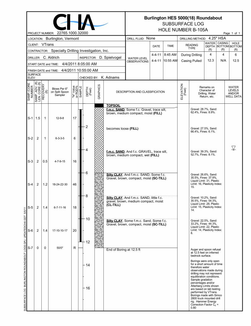
Gravel: 28.7%, Sand:62.4%, Fines: 8.9%.
Gravel: 27.5%, Sand:66.4%, Fines: 6.1%.
Gravel: 39.3%, Sand:52.7%, Fines: 8.1%.
Gravel: 26.6%, Sand:35.5%, Fines: 37.9%,Liquid Limit: 31, PlasticLimit: 16, Plasticity Index:15.
Gravel: 10.2%, Sand:35.5%, Fines: 54.3%,Liquid Limit: 29, PlasticLimit: 15, Plasticity Index:14.
Gravel: 22.5%, Sand:33.2%, Fines: 44.3%,Liquid Limit: 22, PlasticLimit: 14, Plasticity Index:8.
Auger and spoon refusalat 12.5 feet on inferredbedrock surface.
Borings were only openfor a short amount of timetherefore waterobservations made duringdrilling may not representequilibration conditions.Sample gradationpercentages and/orAtterberg Limits shownare based on lab testingperformed by VTrans.Borings made with Simco2800 truck mounted drillrig. Hammer EnergyCorrection Factor CE =0.80
12-9-8
6-3-3-5
4-7-9-15
18-24-22-30
6-7-11-16
17-10-10-17
50/0"
S-1
S-2
S-3
S-4
S-5
S-6
S-7
17
6
16
46
18
20
R
TOPSOILf.m.c. SAND, Some f.c. Gravel, trace silt,brown, medium compact, moist (FILL)
becomes loose (FILL)
f.m.c. SAND, And f.c. GRAVEL, trace silt,brown, medium compact, wet (FILL)
Silty CLAY, And f.m.c. SAND, Some f.c.Gravel, brown, compact, moist (SC-TILL)
Silty CLAY, And f.m.c. SAND, little f.c.gravel, brown, medium compact, moist(CL-TILL)
Silty CLAY, Some f.m.c. Sand, Some f.c.Gravel, brown, compact, moist (SC-TILL)
End of Boring at 12.5 ft
1
1
0.5
1.2
1.4
1.4
0
1.5
2
2
2
2
2
0
4-4-11
4-4-11
8:45 AM
10:55 AM
4
12.3
6
12.5
4
N/AINSPECTOR: D. Spielvogel
VTrans
CONTRACTOR:
CLIENT:
4/4/2011 10:55:00 AM
LOCATION:
Specialty Drilling Investigation, Inc.
K. Adnams
C. Aldrich
START DATE and TIME:
FINISH DATE and TIME:SURFACEELEV:
Burlington, Vermont
CHECKED BY:
DRILLER:
4/4/2011 8:05:00 AM
SA
MP
./CO
RE
NU
MB
ER
RE
CO
VE
RY
(ft)
SA
MP
. AD
V. (
ft)LE
N. C
OR
E (
ft)
GR
AP
HIC
S
SA
MP
LEBlows Per 6"on Split Spoon
Sampler DE
PT
H(F
eet) Remarks on
Character ofDrilling, WaterReturn, etc.
WATERLEVELSAND/OR
WELL DATA
ELE
VA
TIO
N(F
eet)
DESCRIPTION AND CLASSIFICATION
"N"
Val
ueor
RQ
D%
4.25" HSACASINGBOTTOM
(ft)
WATERDEPTH
(ft)
DRILLING METHOD:DRILL FLUID:
DATE
WATER LEVELOBSERVATIONS
NoneHOLE
BOTTOM(ft)
READINGTYPE
TIME
2
4
6
8
10
12
14
16
Burlington HES 5000(18) RoundaboutSUBSURFACE LOG
HOLE NUMBER B-105APage 1 of 1PROJECT NUMBER: 22765.1000.32000
SU
BS
UR
FA
CE
LO
G B
UR
LIN
GT
ON
RO
UN
DA
BO
UT
LO
GS
.GP
J U
PD
AT
ED
CH
A.G
DT
5/5
/11
During Drilling
Casing Pulled

Borings were only openfor a short amount of timetherefore waterobservations made duringdrilling may not representequilibration conditions.
Sample gradationpercentages and/orAtterberg Limits shownare based on lab testingperformed by VTrans.
Infiltration test performedat 5.0'.
After infiltration testing,Sample S-3 contained a1/2" layer of silty clayslough at the infiltrationsurface. This 1/2" layerlikely caused the low rateduring infiltration testing.
Borings made with Simco2800 truck mounted drillrig. Hammer EnergyCorrection Factor CE =0.80
1-1-2-2
2-1-2-2
6-6-6-9
15-12-20-67
S-1
S-2
S-3
S-4
3
3
12
32
TOPSOILf.m.c. SAND, little clayey silt, brown, veryloose, moist (FILL)
Similar Soil (FILL)
becomes medium compact (FILL)
becomes compact (FILL)
End of Boring at 9 ft
1
1.1
0.6
0.1
2
2
2
2
4-1-11 1:00 PM None 95INSPECTOR: D. Spielvogel
VTrans
CONTRACTOR:
CLIENT:
4/1/2011 1:00:00 PM
LOCATION:
Specialty Drilling Investigation, Inc.
K. Adnams
C. Aldrich
START DATE and TIME:
FINISH DATE and TIME:SURFACEELEV:
Burlington, Vermont
CHECKED BY:
DRILLER:
3/30/2011 2:00:00 PM
SA
MP
./CO
RE
NU
MB
ER
RE
CO
VE
RY
(ft)
SA
MP
. AD
V. (
ft)LE
N. C
OR
E (
ft)
GR
AP
HIC
S
SA
MP
LEBlows Per 6"on Split Spoon
Sampler DE
PT
H(F
eet) Remarks on
Character ofDrilling, WaterReturn, etc.
WATERLEVELSAND/OR
WELL DATA
ELE
VA
TIO
N(F
eet)
DESCRIPTION AND CLASSIFICATION
"N"
Val
ueor
RQ
D%
4.25" HSACASINGBOTTOM
(ft)
WATERDEPTH
(ft)
DRILLING METHOD:DRILL FLUID:
DATE
WATER LEVELOBSERVATIONS
Water @ 5'HOLE
BOTTOM(ft)
READINGTYPE
TIME
2
4
6
8
10
12
14
16
Burlington HES 5000(18) RoundaboutSUBSURFACE LOG
HOLE NUMBER B-106APage 1 of 1PROJECT NUMBER: 22765.1000.32000
SU
BS
UR
FA
CE
LO
G B
UR
LIN
GT
ON
RO
UN
DA
BO
UT
LO
GS
.GP
J U
PD
AT
ED
CH
A.G
DT
5/5
/11
During Drilling

Borings were only openfor a short amount of timetherefore waterobservations made duringdrilling may not representequilibration conditions.
Sample gradationpercentages and/orAtterberg Limits shownare based on lab testingperformed by VTrans.
Infiltration test performedat 5.0'.
Gravel: 15.3%, Sand:39.9%, Fines: 44.7%.
Borings made with Simco2800 truck mounted drillrig. Hammer EnergyCorrection Factor CE =0.80
2-2-2-2
2-2-2-2
4-7-3-10
28-5-3-3
S-1
S-2
S-3
S-4
4
4
10
8
TOPSOILf.m.c. SAND, little clayey silt, brown, veryloose, moist (FILL)
Similar Soil (FILL)
becomes loose, wet (FILL)
Clayey SILT, And f.m.c. SAND, little f.c.gravel, brown, loose, wet (SM-TILL)
End of Boring at 9 ft
1.1
1
0.9
0.8
2
2
2
2
4-1-11 1:25 PM None 95INSPECTOR: D. Spielvogel
VTrans
CONTRACTOR:
CLIENT:
4/1/2011 1:25:00 PM
LOCATION:
Specialty Drilling Investigation, Inc.
K. Adnams
C. Aldrich
START DATE and TIME:
FINISH DATE and TIME:SURFACEELEV:
Burlington, Vermont
CHECKED BY:
DRILLER:
3/31/2011 1:45:00 PM
SA
MP
./CO
RE
NU
MB
ER
RE
CO
VE
RY
(ft)
SA
MP
. AD
V. (
ft)LE
N. C
OR
E (
ft)
GR
AP
HIC
S
SA
MP
LEBlows Per 6"on Split Spoon
Sampler DE
PT
H(F
eet) Remarks on
Character ofDrilling, WaterReturn, etc.
WATERLEVELSAND/OR
WELL DATA
ELE
VA
TIO
N(F
eet)
DESCRIPTION AND CLASSIFICATION
"N"
Val
ueor
RQ
D%
4.25" HSACASINGBOTTOM
(ft)
WATERDEPTH
(ft)
DRILLING METHOD:DRILL FLUID:
DATE
WATER LEVELOBSERVATIONS
Water @ 5'HOLE
BOTTOM(ft)
READINGTYPE
TIME
2
4
6
8
10
12
14
16
Burlington HES 5000(18) RoundaboutSUBSURFACE LOG
HOLE NUMBER B-107APage 1 of 1PROJECT NUMBER: 22765.1000.32000
SU
BS
UR
FA
CE
LO
G B
UR
LIN
GT
ON
RO
UN
DA
BO
UT
LO
GS
.GP
J U
PD
AT
ED
CH
A.G
DT
5/5
/11
During Drilling

Borings were only openfor a short amount of timetherefore waterobservations made duringdrilling may not representequilibration conditions.
Sample gradationpercentages and/orAtterberg Limits shownare based on lab testingperformed by VTrans.
Infiltration test performedat 5.0'.
Gravel: 25.8%, Sand:44.4%, Fines: 29.9%.
Augers advanced to adepth of 9'. Boringterminated in verycompact glacial till.
Borings made with Simco2800 truck mounted drillrig. Hammer EnergyCorrection Factor CE =0.80
3-7-8-10
9-6-4-4
7-10-13-17
8-72-50/3"
S-1
S-2
S-3
S-4
15
10
23
R
f.m.c. SAND, Some clayey Silt, little f.c.gravel, trace brick, brown, medium compact,moist (FILL)
f.m.c. SAND, little clayey silt, trace f. gravel,brown, loose, moist (FILL)
becomes medium compact, wet (FILL)
f.m.c. SAND, Some clayey Silt, Some f.c.gravel, brown, very compact, wet (SM-TILL)
End of Boring at 9 ft
1.6
1.1
0.7
0.8
2
2
2
1.4
4-1-11 12:30 PM None 99INSPECTOR: D. Spielvogel
VTrans
CONTRACTOR:
CLIENT:
4/1/2011 12:30:00 PM
LOCATION:
Specialty Drilling Investigation, Inc.
K. Adnams
C. Aldrich
START DATE and TIME:
FINISH DATE and TIME:SURFACEELEV:
Burlington, Vermont
CHECKED BY:
DRILLER:
3/31/2011 1:15:00 PM
SA
MP
./CO
RE
NU
MB
ER
RE
CO
VE
RY
(ft)
SA
MP
. AD
V. (
ft)LE
N. C
OR
E (
ft)
GR
AP
HIC
S
SA
MP
LEBlows Per 6"on Split Spoon
Sampler DE
PT
H(F
eet) Remarks on
Character ofDrilling, WaterReturn, etc.
WATERLEVELSAND/OR
WELL DATA
ELE
VA
TIO
N(F
eet)
DESCRIPTION AND CLASSIFICATION
"N"
Val
ueor
RQ
D%
4.25" HSACASINGBOTTOM
(ft)
WATERDEPTH
(ft)
DRILLING METHOD:DRILL FLUID:
DATE
WATER LEVELOBSERVATIONS
Water @ 5'HOLE
BOTTOM(ft)
READINGTYPE
TIME
2
4
6
8
10
12
14
16
Burlington HES 5000(18) RoundaboutSUBSURFACE LOG
HOLE NUMBER B-108APage 1 of 1PROJECT NUMBER: 22765.1000.32000
SU
BS
UR
FA
CE
LO
G B
UR
LIN
GT
ON
RO
UN
DA
BO
UT
LO
GS
.GP
J U
PD
AT
ED
CH
A.G
DT
5/5
/11
During Drilling

Borings were only openfor a short amount of timetherefore waterobservations made duringdrilling may not representequilibration conditions.
Sample gradationpercentages and/orAtterberg Limits shownare based on lab testingperformed by VTrans.
Infiltration test performedat 5.0'.
Liquid Limit: 27, PlasticLimit: 16, Plasticity Index:11.
Borings made with Simco2800 truck mounted drillrig. Hammer EnergyCorrection Factor CE =0.80
6-3-2-1
6-7-10-50/4"
8-5-8-4
4-14-40-45
S-1
S-2
S-3
S-4
5
17
13
54
TOPSOILf.m.c. SAND, trace silt, brown, loose, moist(FILL)
f.m.c. SAND, little clayey silt, little f.c. gravel,brown/black, medium compact, moist (FILL)
grades to trace f.c. gravel, becomes wet(FILL)
f.m.c. SAND, Some silty Clay, trace f. gravel,brown, very compact, wet (SM-TILL)
End of Boring at 9 ft
1.4
1
1.1
0.3
2
1.8
2
2
3-30-11 12:00 PM None 95INSPECTOR: D. Spielvogel
VTrans
CONTRACTOR:
CLIENT:
3/31/2011 1:00:00 PM
LOCATION:
Specialty Drilling Investigation, Inc.
K. Adnams
C. Aldrich
START DATE and TIME:
FINISH DATE and TIME:SURFACEELEV:
Burlington, Vermont
CHECKED BY:
DRILLER:
3/30/2011 12:00:00 PM
SA
MP
./CO
RE
NU
MB
ER
RE
CO
VE
RY
(ft)
SA
MP
. AD
V. (
ft)LE
N. C
OR
E (
ft)
GR
AP
HIC
S
SA
MP
LEBlows Per 6"on Split Spoon
Sampler DE
PT
H(F
eet) Remarks on
Character ofDrilling, WaterReturn, etc.
WATERLEVELSAND/OR
WELL DATA
ELE
VA
TIO
N(F
eet)
DESCRIPTION AND CLASSIFICATION
"N"
Val
ueor
RQ
D%
4.25" HSACASINGBOTTOM
(ft)
WATERDEPTH
(ft)
DRILLING METHOD:DRILL FLUID:
DATE
WATER LEVELOBSERVATIONS
Water @ 5'HOLE
BOTTOM(ft)
READINGTYPE
TIME
2
4
6
8
10
12
14
16
Burlington HES 5000(18) RoundaboutSUBSURFACE LOG
HOLE NUMBER B-109APage 1 of 1PROJECT NUMBER: 22765.1000.32000
SU
BS
UR
FA
CE
LO
G B
UR
LIN
GT
ON
RO
UN
DA
BO
UT
LO
GS
.GP
J U
PD
AT
ED
CH
A.G
DT
5/5
/11
During Drilling

Borings were only openfor a short amount of timetherefore waterobservations made duringdrilling may not representequilibration conditions.
Sample gradationpercentages and/orAtterberg Limits shownare based on lab testingperformed by VTrans.
Infiltration test performedat 5.0'.
Sample S-4 lab testing:Gravel: 18.7%, Sand:35.2%, Fines: 46.1%.
Borings made with Simco2800 truck mounted drillrig. Hammer EnergyCorrection Factor CE =0.80
4-6-6-8
4-5-10-12
5-3-24-26
43-47-41-48
S-1
S-2
S-3
S-4
12
15
27
88
TOPSOILf.m.c. SAND, little clayey silt, little f.c. gravel,brown/black, medium compact, moist (FILL)
Similar Soil (FILL)
f.m.c. SAND, Some clayey Silt, Some f.c.Gravel, brown, medium compact, moist(SM-TILL)
Clayey SILT, And f.m.c. SAND, little f.c.gravel, brown, very compact, moist(SM-TILL)
End of Boring at 9 ft
0.5
0.1
0.2
1.7
2
2
2
2
3-30-11 12:45 PM None 95INSPECTOR: D. Spielvogel
VTrans
CONTRACTOR:
CLIENT:
3/30/2011 12:45:00 PM
LOCATION:
Specialty Drilling Investigation, Inc.
K. Adnams
C. Aldrich
START DATE and TIME:
FINISH DATE and TIME:SURFACEELEV:
Burlington, Vermont
CHECKED BY:
DRILLER:
3/29/2011 2:15:00 PM
SA
MP
./CO
RE
NU
MB
ER
RE
CO
VE
RY
(ft)
SA
MP
. AD
V. (
ft)LE
N. C
OR
E (
ft)
GR
AP
HIC
S
SA
MP
LEBlows Per 6"on Split Spoon
Sampler DE
PT
H(F
eet) Remarks on
Character ofDrilling, WaterReturn, etc.
WATERLEVELSAND/OR
WELL DATA
ELE
VA
TIO
N(F
eet)
DESCRIPTION AND CLASSIFICATION
"N"
Val
ueor
RQ
D%
4.25" HSACASINGBOTTOM
(ft)
WATERDEPTH
(ft)
DRILLING METHOD:DRILL FLUID:
DATE
WATER LEVELOBSERVATIONS
Water @ 5'HOLE
BOTTOM(ft)
READINGTYPE
TIME
2
4
6
8
10
12
14
16
Burlington HES 5000(18) RoundaboutSUBSURFACE LOG
HOLE NUMBER B-110APage 1 of 1PROJECT NUMBER: 22765.1000.32000
SU
BS
UR
FA
CE
LO
G B
UR
LIN
GT
ON
RO
UN
DA
BO
UT
LO
GS
.GP
J U
PD
AT
ED
CH
A.G
DT
5/5
/11
During Drilling
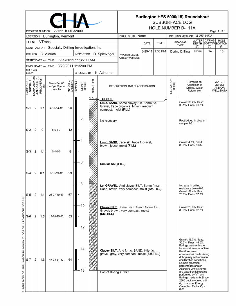
Gravel: 30.2%, Sand:38.1%, Fines: 31.7%.
Root lodged in shoe ofsample S-2.
Gravel: 4.7%, Sand:86.0%, Fines: 9.3%.
Increase in drillingresistance below 8.0'.Gravel: 39.4%, Sand:23.0%, Fines: 37.7%.
Gravel: 23.9%, Sand:33.9%, Fines: 42.7%.
Gravel: 19.7%, Sand:36.3%, Fines: 44.0%.Borings were only openfor a short amount of timetherefore waterobservations made duringdrilling may not representequilibration conditions.Sample gradationpercentages and/orAtterberg Limits shownare based on lab testingperformed by VTrans.Borings made with Simco2800 truck mounted drillrig. Hammer EnergyCorrection Factor CE =0.80
4-12-14-12
8-6-6-7
5-4-4-5
6-10-19-12
26-27-40-57
13-28-25-60
47-33-31-32
S-1
S-2
S-3
S-4
S-5
S-6
S-7
26
12
8
29
67
53
64
TOPSOILf.m.c. SAND, Some clayey Silt, Some f.c.Gravel, trace organics, brown, mediumcompact, moist (FILL)
No recovery
f.m.c. SAND, trace silt, trace f. gravel,brown, loose, moist (FILL)
Similar Soil (FILL)
f.c. GRAVEL, And clayey SILT, Some f.m.c.Sand, brown, very compact, moist (SM-TILL)
Clayey SILT, Some f.m.c. Sand, Some f.c.Gravel, brown, very compact, moist(SM-TILL)
Clayey SILT, And f.m.c. SAND, little f.c.gravel, gray, very compact, moist (SM-TILL)
End of Boring at 16 ft
1.1
0
1.4
0.1
1.1
1.5
1.6
2
2
2
2
2
2
2
3-29-11 1:05 PM None 1614INSPECTOR: D. Spielvogel
VTrans
CONTRACTOR:
CLIENT:
3/29/2011 1:15:00 PM
LOCATION:
Specialty Drilling Investigation, Inc.
K. Adnams
C. Aldrich
START DATE and TIME:
FINISH DATE and TIME:SURFACEELEV:
Burlington, Vermont
CHECKED BY:
DRILLER:
3/29/2011 11:35:00 AM
SA
MP
./CO
RE
NU
MB
ER
RE
CO
VE
RY
(ft)
SA
MP
. AD
V. (
ft)LE
N. C
OR
E (
ft)
GR
AP
HIC
S
SA
MP
LEBlows Per 6"on Split Spoon
Sampler DE
PT
H(F
eet) Remarks on
Character ofDrilling, WaterReturn, etc.
WATERLEVELSAND/OR
WELL DATA
ELE
VA
TIO
N(F
eet)
DESCRIPTION AND CLASSIFICATION
"N"
Val
ueor
RQ
D%
4.25" HSACASINGBOTTOM
(ft)
WATERDEPTH
(ft)
DRILLING METHOD:DRILL FLUID:
DATE
WATER LEVELOBSERVATIONS
NoneHOLE
BOTTOM(ft)
READINGTYPE
TIME
2
4
6
8
10
12
14
16
Burlington HES 5000(18) RoundaboutSUBSURFACE LOG
HOLE NUMBER B-111APage 1 of 1PROJECT NUMBER: 22765.1000.32000
SU
BS
UR
FA
CE
LO
G B
UR
LIN
GT
ON
RO
UN
DA
BO
UT
LO
GS
.GP
J U
PD
AT
ED
CH
A.G
DT
5/5
/11
During Drilling
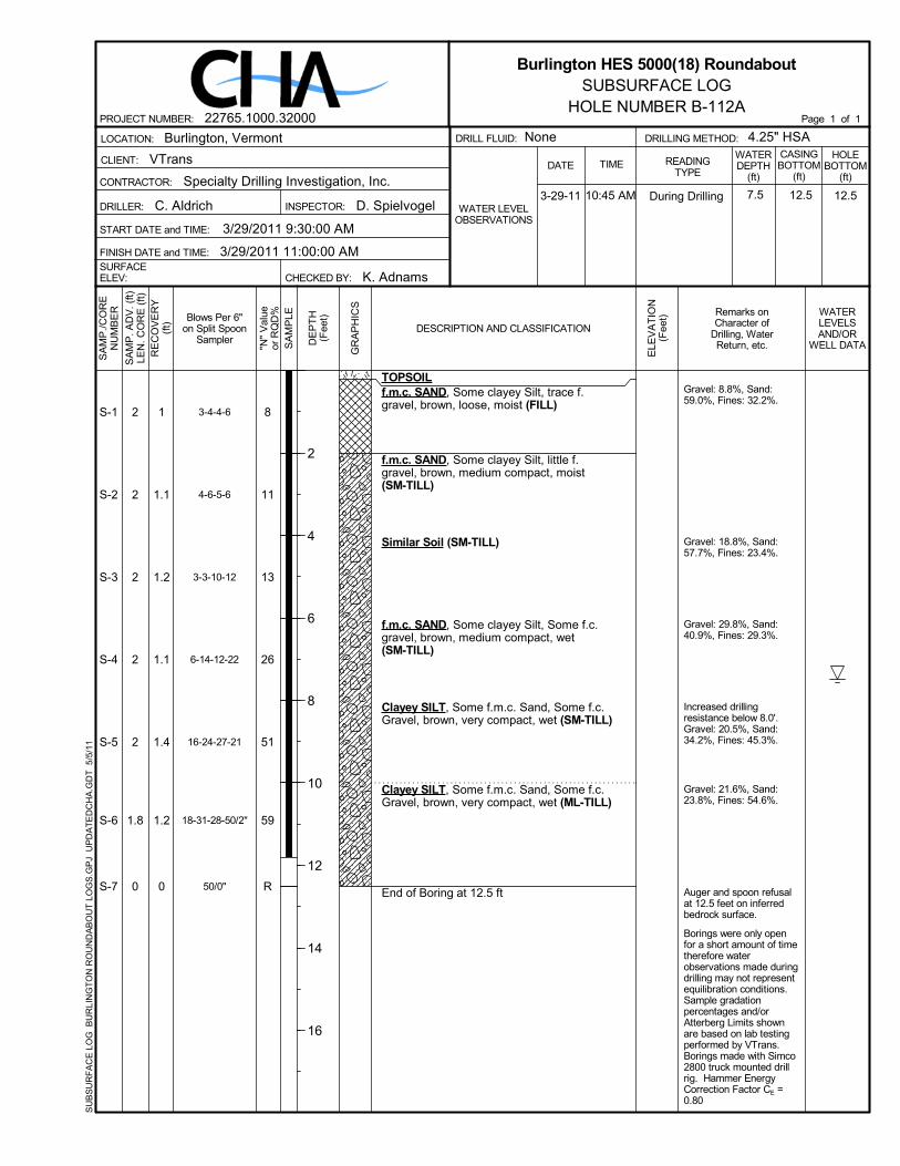
Gravel: 8.8%, Sand:59.0%, Fines: 32.2%.
Gravel: 18.8%, Sand:57.7%, Fines: 23.4%.
Gravel: 29.8%, Sand:40.9%, Fines: 29.3%.
Increased drillingresistance below 8.0'.Gravel: 20.5%, Sand:34.2%, Fines: 45.3%.
Gravel: 21.6%, Sand:23.8%, Fines: 54.6%.
Auger and spoon refusalat 12.5 feet on inferredbedrock surface.
Borings were only openfor a short amount of timetherefore waterobservations made duringdrilling may not representequilibration conditions.Sample gradationpercentages and/orAtterberg Limits shownare based on lab testingperformed by VTrans.Borings made with Simco2800 truck mounted drillrig. Hammer EnergyCorrection Factor CE =0.80
3-4-4-6
4-6-5-6
3-3-10-12
6-14-12-22
16-24-27-21
18-31-28-50/2"
50/0"
S-1
S-2
S-3
S-4
S-5
S-6
S-7
8
11
13
26
51
59
R
TOPSOILf.m.c. SAND, Some clayey Silt, trace f.gravel, brown, loose, moist (FILL)
f.m.c. SAND, Some clayey Silt, little f.gravel, brown, medium compact, moist(SM-TILL)
Similar Soil (SM-TILL)
f.m.c. SAND, Some clayey Silt, Some f.c.gravel, brown, medium compact, wet(SM-TILL)
Clayey SILT, Some f.m.c. Sand, Some f.c.Gravel, brown, very compact, wet (SM-TILL)
Clayey SILT, Some f.m.c. Sand, Some f.c.Gravel, brown, very compact, wet (ML-TILL)
End of Boring at 12.5 ft
1
1.1
1.2
1.1
1.4
1.2
0
2
2
2
2
2
1.8
0
3-29-11 10:45 AM 7.5 12.512.5INSPECTOR: D. Spielvogel
VTrans
CONTRACTOR:
CLIENT:
3/29/2011 11:00:00 AM
LOCATION:
Specialty Drilling Investigation, Inc.
K. Adnams
C. Aldrich
START DATE and TIME:
FINISH DATE and TIME:SURFACEELEV:
Burlington, Vermont
CHECKED BY:
DRILLER:
3/29/2011 9:30:00 AM
SA
MP
./CO
RE
NU
MB
ER
RE
CO
VE
RY
(ft)
SA
MP
. AD
V. (
ft)LE
N. C
OR
E (
ft)
GR
AP
HIC
S
SA
MP
LEBlows Per 6"on Split Spoon
Sampler DE
PT
H(F
eet) Remarks on
Character ofDrilling, WaterReturn, etc.
WATERLEVELSAND/OR
WELL DATA
ELE
VA
TIO
N(F
eet)
DESCRIPTION AND CLASSIFICATION
"N"
Val
ueor
RQ
D%
4.25" HSACASINGBOTTOM
(ft)
WATERDEPTH
(ft)
DRILLING METHOD:DRILL FLUID:
DATE
WATER LEVELOBSERVATIONS
NoneHOLE
BOTTOM(ft)
READINGTYPE
TIME
2
4
6
8
10
12
14
16
Burlington HES 5000(18) RoundaboutSUBSURFACE LOG
HOLE NUMBER B-112APage 1 of 1PROJECT NUMBER: 22765.1000.32000
SU
BS
UR
FA
CE
LO
G B
UR
LIN
GT
ON
RO
UN
DA
BO
UT
LO
GS
.GP
J U
PD
AT
ED
CH
A.G
DT
5/5
/11
During Drilling

Borings were only openfor a short amount of timetherefore waterobservations made duringdrilling may not representequilibration conditions.
Sample gradationpercentages and/orAtterberg Limits shownare based on lab testingperformed by VTrans.
Infiltration test performedat 5.0'.
Gravel: 17.6%, Sand:37.2%, Fines: 45.2%.
Borings made with Simco2800 truck mounted drillrig. Hammer EnergyCorrection Factor CE =0.80
2-3-4-7
3-3-4-6
3-2-2-1
3-5-6-21
S-1
S-2
S-3
S-4
7
7
4
11
TOPSOILf.m.c. SAND, Some silty Clay, Some f.c.Gravel, brown, loose, moist (FILL)
f.m.c. SAND, Some silty Clay, trace f. gravel,brown, loose, moist (SM-TILL)
Clayey SILT, And f.m.c. SAND, little f.c.gravel, brown, loose, wet (SM-TILL)
becomes medium compact (SM-TILL)
End of Boring at 9 ft
0.9
1.2
1.3
0.2
2
2
2
2
3-30-11 12:20 PM None 95INSPECTOR: D. Spielvogel
VTrans
CONTRACTOR:
CLIENT:
3/30/2011 12:20:00 PM
LOCATION:
Specialty Drilling Investigation, Inc.
K. Adnams
C. Aldrich
START DATE and TIME:
FINISH DATE and TIME:SURFACEELEV:
Burlington, Vermont
CHECKED BY:
DRILLER:
3/29/2011 9:04:00 AM
SA
MP
./CO
RE
NU
MB
ER
RE
CO
VE
RY
(ft)
SA
MP
. AD
V. (
ft)LE
N. C
OR
E (
ft)
GR
AP
HIC
S
SA
MP
LEBlows Per 6"on Split Spoon
Sampler DE
PT
H(F
eet) Remarks on
Character ofDrilling, WaterReturn, etc.
WATERLEVELSAND/OR
WELL DATA
ELE
VA
TIO
N(F
eet)
DESCRIPTION AND CLASSIFICATION
"N"
Val
ueor
RQ
D%
4.25" HSACASINGBOTTOM
(ft)
WATERDEPTH
(ft)
DRILLING METHOD:DRILL FLUID:
DATE
WATER LEVELOBSERVATIONS
Water @ 5'HOLE
BOTTOM(ft)
READINGTYPE
TIME
2
4
6
8
10
12
14
16
Burlington HES 5000(18) RoundaboutSUBSURFACE LOG
HOLE NUMBER B-113Page 1 of 1PROJECT NUMBER: 22765.1000.32000
SU
BS
UR
FA
CE
LO
G B
UR
LIN
GT
ON
RO
UN
DA
BO
UT
LO
GS
.GP
J U
PD
AT
ED
CH
A.G
DT
5/5
/11
During Drilling

Borings were only openfor a short amount of timetherefore waterobservations made duringdrilling may not representequilibration conditions.
Sample gradationpercentages and/orAtterberg Limits shownare based on lab testingperformed by VTrans.
Infiltration test performedat 5.0'.
Gravel: 10.0%, Sand:44.2%, Fines: 45.8%,Liquid Limit: 18, PlasticLimit: 15, Plasticity Index:3.
Spoon refusal on verycompact glacial till.
Borings made with Simco2800 truck mounted drillrig. Hammer EnergyCorrection Factor CE =0.80
3-2-1
4-5-4-5
13-15-15-26
21-43-50/5"
S-1
S-2
S-3
S-4
3
9
30
R
ASPHALT
f.m.c. SAND, Some f. Gravel, brown/black,loose, moist (FILL)
f.m.c. SAND, Some silty Clay, little f. gravel,brown, loose, moist (FILL)
Clayey SILT, And f.m.c. SAND, trace f.gravel, brown, medium compact, wet(SM-TILL)
becomes very compact (SM-TILL)
End of Boring at 8.4 ft
0.1
1.6
1.6
1.3
1.5
2
2
1.4
3-31-11 11:55 AM None 8.45INSPECTOR: D. Spielvogel
VTrans
CONTRACTOR:
CLIENT:
3/31/2011 11:55:00 AM
LOCATION:
Specialty Drilling Investigation, Inc.
K. Adnams
C. Aldrich
START DATE and TIME:
FINISH DATE and TIME:SURFACEELEV:
Burlington, Vermont
CHECKED BY:
DRILLER:
3/30/2011 2:30:00 PM
SA
MP
./CO
RE
NU
MB
ER
RE
CO
VE
RY
(ft)
SA
MP
. AD
V. (
ft)LE
N. C
OR
E (
ft)
GR
AP
HIC
S
SA
MP
LEBlows Per 6"on Split Spoon
Sampler DE
PT
H(F
eet) Remarks on
Character ofDrilling, WaterReturn, etc.
WATERLEVELSAND/OR
WELL DATA
ELE
VA
TIO
N(F
eet)
DESCRIPTION AND CLASSIFICATION
"N"
Val
ueor
RQ
D%
4.25" HSACASINGBOTTOM
(ft)
WATERDEPTH
(ft)
DRILLING METHOD:DRILL FLUID:
DATE
WATER LEVELOBSERVATIONS
Water @ 5'HOLE
BOTTOM(ft)
READINGTYPE
TIME
2
4
6
8
10
12
14
16
Burlington HES 5000(18) RoundaboutSUBSURFACE LOG
HOLE NUMBER B-114APage 1 of 1PROJECT NUMBER: 22765.1000.32000
SU
BS
UR
FA
CE
LO
G B
UR
LIN
GT
ON
RO
UN
DA
BO
UT
LO
GS
.GP
J U
PD
AT
ED
CH
A.G
DT
5/5
/11
During Drilling

Casing installed by handexcavation due toover-head utilities forinfiltration test. 8 cobblesremoved from excavationat depths ranging from 1'to 3'.Water seeping in fromsides of excavation.
Grab sample G-1collected using 3" handauger.Hand auger refusal at adepth of 5.5' in verycompact glacial till.
Borings were only openfor a short amount of timetherefore waterobservations made duringdrilling may not representequilibration conditions.
Sample gradationpercentages and/orAtterberg Limits shownare based on lab testingperformed by VTrans.
Borings made with Simco2800 truck mounted drillrig. Hammer EnergyCorrection Factor CE =0.80
G-1
TOPSOILf.m.c. SAND, Some clayey Silt, Some f.c.Gravel, brown, moist (FILL)
f.m.c. SAND, Some clayey Silt, little f.c.gravel, brown, wet (SM-TILL)
becomes moist (SM-TILL)
Similar Soil (SM-TILL)
End of Boring at 5.5 ft
0.50.5
3-31-11 8:00 AM 2 5N/AINSPECTOR: D. Spielvogel
VTrans
CONTRACTOR:
CLIENT:
4/1/2011 3:00:00 PM
LOCATION:
Specialty Drilling Investigation, Inc.
K. Adnams
C. Aldrich
START DATE and TIME:
FINISH DATE and TIME:SURFACEELEV:
Burlington, Vermont
CHECKED BY:
DRILLER:
3/31/2011 7:30:00 AM
SA
MP
./CO
RE
NU
MB
ER
RE
CO
VE
RY
(ft)
SA
MP
. AD
V. (
ft)LE
N. C
OR
E (
ft)
GR
AP
HIC
S
SA
MP
LEBlows Per 6"on Split Spoon
Sampler DE
PT
H(F
eet) Remarks on
Character ofDrilling, WaterReturn, etc.
WATERLEVELSAND/OR
WELL DATA
ELE
VA
TIO
N(F
eet)
DESCRIPTION AND CLASSIFICATION
"N"
Val
ueor
RQ
D%
4.00" FJCCASINGBOTTOM
(ft)
WATERDEPTH
(ft)
DRILLING METHOD:DRILL FLUID:
DATE
WATER LEVELOBSERVATIONS
Water @ 5'HOLE
BOTTOM(ft)
READINGTYPE
TIME
2
4
6
8
10
12
14
16
Burlington HES 5000(18) RoundaboutSUBSURFACE LOG
HOLE NUMBER B-115Page 1 of 1PROJECT NUMBER: 22765.1000.32000
SU
BS
UR
FA
CE
LO
G B
UR
LIN
GT
ON
RO
UN
DA
BO
UT
LO
GS
.GP
J U
PD
AT
ED
CH
A.G
DT
5/5
/11
During Drilling

Borings were only openfor a short amount of timetherefore waterobservations made duringdrilling may not representequilibration conditions.
Sample gradationpercentages and/orAtterberg Limits shownare based on lab testingperformed by VTrans.
Infiltration test performedat 5.0'.Sample S-3 lab testing:Gravel: 8.8%, Sand:34.7%, Fines: 56.4%,Liquid Limit: 18, PlasticLimit: 16, Plasticity Index:2.Borings made with Simco2800 truck mounted drillrig. Hammer EnergyCorrection Factor CE =0.80
2-3-4-6
7-5-6-10
3-4-6-7
21-8-18-46
S-1
S-2
S-3
S-4
7
11
10
26
TOPSOILf.m.c. SAND, little silty clay, brown, loose,moist (FILL)
f.m.c. SAND, Some silty Clay, trace f. gravel,brown, medium compact, moist (SM-TILL)
Clayey SILT, Some f.m.c. Sand, trace f.gravel, brown, loose, wet (ML-TILL)
becomes medium compact (ML-TILL)
End of Boring at 9 ft
1
1.2
2
0.8
2
2
2
2
3-30-11 12:05 PM None 95INSPECTOR: D. Spielvogel
VTrans
CONTRACTOR:
CLIENT:
3/30/2011 12:05:00 PM
LOCATION:
Specialty Drilling Investigation, Inc.
K. Adnams
C. Aldrich
START DATE and TIME:
FINISH DATE and TIME:SURFACEELEV:
Burlington, Vermont
CHECKED BY:
DRILLER:
3/29/2011 8:43:00 AM
SA
MP
./CO
RE
NU
MB
ER
RE
CO
VE
RY
(ft)
SA
MP
. AD
V. (
ft)LE
N. C
OR
E (
ft)
GR
AP
HIC
S
SA
MP
LEBlows Per 6"on Split Spoon
Sampler DE
PT
H(F
eet) Remarks on
Character ofDrilling, WaterReturn, etc.
WATERLEVELSAND/OR
WELL DATA
ELE
VA
TIO
N(F
eet)
DESCRIPTION AND CLASSIFICATION
"N"
Val
ueor
RQ
D%
4.25" HSACASINGBOTTOM
(ft)
WATERDEPTH
(ft)
DRILLING METHOD:DRILL FLUID:
DATE
WATER LEVELOBSERVATIONS
Water @ 5'HOLE
BOTTOM(ft)
READINGTYPE
TIME
2
4
6
8
10
12
14
16
Burlington HES 5000(18) RoundaboutSUBSURFACE LOG
HOLE NUMBER B-116Page 1 of 1PROJECT NUMBER: 22765.1000.32000
SU
BS
UR
FA
CE
LO
G B
UR
LIN
GT
ON
RO
UN
DA
BO
UT
LO
GS
.GP
J U
PD
AT
ED
CH
A.G
DT
5/5
/11
During Drilling
Borings were only openfor a short amount of timetherefore waterobservations made duringdrilling may not representequilibration conditions.
Sample gradationpercentages and/orAtterberg Limits shownare based on lab testingperformed by VTrans.
Infiltration test performedat 5.0'.
Sample S-3 lab testing:Gravel: 10.3%, Sand:52.7%, Fines: 37.0%.
Spoon refusal on verycompact glacial till.
Borings made with Simco2800 truck mounted drillrig. Hammer EnergyCorrection Factor CE =0.80
2-2-2-3
3-3-5-9
17-29-31-60
140-50/0"
S-1
S-2
S-3
S-4
4
8
60
R
f.m.c. SAND, Some clayey Silt, trace f.c.gravel, brown, loose, moist (FILL)
Similar Soil (FILL)
f.m.c. SAND, And clayey SILT, little f.c.gravel, brown, very compact, wet (SM-TILL)
Similar Soil (SM-TILL)
End of Boring at 7.5 ft
0.4
0.8
1.6
0.5
2
2
2
0.5
3-31-11 12:20 PM None 7.55INSPECTOR: D. Spielvogel
VTrans
CONTRACTOR:
CLIENT:
3/31/2011 12:20:00 PM
LOCATION:
Specialty Drilling Investigation, Inc.
K. Adnams
C. Aldrich
START DATE and TIME:
FINISH DATE and TIME:SURFACEELEV:
Burlington, Vermont
CHECKED BY:
DRILLER:
3/30/2011 1:25:00 PM
SA
MP
./CO
RE
NU
MB
ER
RE
CO
VE
RY
(ft)
SA
MP
. AD
V. (
ft)LE
N. C
OR
E (
ft)
GR
AP
HIC
S
SA
MP
LEBlows Per 6"on Split Spoon
Sampler DE
PT
H(F
eet) Remarks on
Character ofDrilling, WaterReturn, etc.
WATERLEVELSAND/OR
WELL DATA
ELE
VA
TIO
N(F
eet)
DESCRIPTION AND CLASSIFICATION
"N"
Val
ueor
RQ
D%
4.25" HSACASINGBOTTOM
(ft)
WATERDEPTH
(ft)
DRILLING METHOD:DRILL FLUID:
DATE
WATER LEVELOBSERVATIONS
Water @ 5'HOLE
BOTTOM(ft)
READINGTYPE
TIME
2
4
6
8
10
12
14
16
Burlington HES 5000(18) RoundaboutSUBSURFACE LOG
HOLE NUMBER B-117APage 1 of 1PROJECT NUMBER: 22765.1000.32000
SU
BS
UR
FA
CE
LO
G B
UR
LIN
GT
ON
RO
UN
DA
BO
UT
LO
GS
.GP
J U
PD
AT
ED
CH
A.G
DT
5/5
/11
During Drilling

Borings were only openfor a short amount of timetherefore waterobservations made duringdrilling may not representequilibration conditions.
Sample gradationpercentages and/orAtterberg Limits shownare based on lab testingperformed by VTrans.
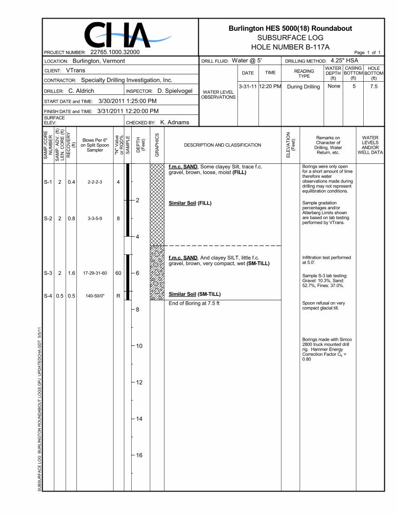
Infiltration test performedat 5.0'.Sample S-3 lab testing:Gravel: 10.1%, Sand:34.0%, Fines: 55.9%,Liquid Limit: 22, PlasticLimit: 14, Plasticity Index:8.
Spoon refusal on verycompact glacial till.
Borings made with Simco2800 truck mounted drillrig. Hammer EnergyCorrection Factor CE =0.80
2-4-4-5
5-7-11-9
3-10-15-25
28-50/5"
S-1
S-2
S-3
S-4
8
18
25
R
TOPSOILf.m.c. SAND, trace silt, light brown, veryloose, moist (FILL)
f.m.c. SAND, Some silty Clay, trace f.c.gravel, brown, medium compact, moist(SM-TILL)
Clayey SILT, Some f.m.c. Sand, little f.gravel, brown, medium compact, wet(ML-TILL)
becomes very compact (ML-TILL)
End of Boring at 7.9 ft
1.8
0.5
1.6
0.9
2
2
2
0.9
3-30-11 12:00 PM None 75INSPECTOR: D. Spielvogel
VTrans
CONTRACTOR:
CLIENT:
3/30/2011 12:00:00 PM
LOCATION:
Specialty Drilling Investigation, Inc.
K. Adnams
C. Aldrich
START DATE and TIME:
FINISH DATE and TIME:SURFACEELEV:
Burlington, Vermont
CHECKED BY:
DRILLER:
3/29/2011 8:15:00 AM
SA
MP
./CO
RE
NU
MB
ER
RE
CO
VE
RY
(ft)
SA
MP
. AD
V. (
ft)LE
N. C
OR
E (
ft)
GR
AP
HIC
S
SA
MP
LEBlows Per 6"on Split Spoon
Sampler DE
PT
H(F
eet) Remarks on
Character ofDrilling, WaterReturn, etc.
WATERLEVELSAND/OR
WELL DATA
ELE
VA
TIO
N(F
eet)
DESCRIPTION AND CLASSIFICATION
"N"
Val
ueor
RQ
D%
4.25" HSACASINGBOTTOM
(ft)
WATERDEPTH
(ft)
DRILLING METHOD:DRILL FLUID:
DATE
WATER LEVELOBSERVATIONS
Water @ 5'HOLE
BOTTOM(ft)
READINGTYPE
TIME
2
4
6
8
10
12
14
16
Burlington HES 5000(18) RoundaboutSUBSURFACE LOG
HOLE NUMBER B-118APage 1 of 1PROJECT NUMBER: 22765.1000.32000
SU
BS
UR
FA
CE
LO
G B
UR
LIN
GT
ON
RO
UN
DA
BO
UT
LO
GS
.GP
J U
PD
AT
ED
CH
A.G
DT
5/5
/11
During Drilling

Borings were only openfor a short amount of timetherefore waterobservations made duringdrilling may not representequilibration conditions.
Sample gradationpercentages and/orAtterberg Limits shownare based on lab testingperformed by VTrans.
Infiltration test performedat 5.0'.Sample S-3 lab testing:Gravel: 21.2%, Sand:49.1%, Fines: 29.7%.
Spoon refusal on verycompact glacial till.
Borings made with Simco2800 truck mounted drillrig. Hammer EnergyCorrection Factor CE =0.80
1-1-4-10
8-4-3-8
15-28-50-68
50/5"
S-1
S-2
S-3
S-4
5
7
78
R
TOPSOILf.m.c. SAND, Some clayey Silt, trace f.gravel, brown, loose, moist (FILL)
Similar Soil (FILL)
f.m.c. SAND, Some clayey Silt, Some f.c.Gravel, brown, very compact, wet (SM-TILL)
No recovery
End of Boring at 7.4 ft
1.1
1.2
1.6
0
2
2
2
0.4
3-31-11 12:50 PM None 7.45INSPECTOR: D. Spielvogel
VTrans
CONTRACTOR:
CLIENT:
3/31/2011 12:50:00 PM
LOCATION:
Specialty Drilling Investigation, Inc.
K. Adnams
C. Aldrich
START DATE and TIME:
FINISH DATE and TIME:SURFACEELEV:
Burlington, Vermont
CHECKED BY:
DRILLER:
3/30/2011 1:50:00 PM
SA
MP
./CO
RE
NU
MB
ER
RE
CO
VE
RY
(ft)
SA
MP
. AD
V. (
ft)LE
N. C
OR
E (
ft)
GR
AP
HIC
S
SA
MP
LEBlows Per 6"on Split Spoon
Sampler DE
PT
H(F
eet) Remarks on
Character ofDrilling, WaterReturn, etc.
WATERLEVELSAND/OR
WELL DATA
ELE
VA
TIO
N(F
eet)
DESCRIPTION AND CLASSIFICATION
"N"
Val
ueor
RQ
D%
4.25" HSACASINGBOTTOM
(ft)
WATERDEPTH
(ft)
DRILLING METHOD:DRILL FLUID:
DATE
WATER LEVELOBSERVATIONS
Water @ 5'HOLE
BOTTOM(ft)
READINGTYPE
TIME
2
4
6
8
10
12
14
16
Burlington HES 5000(18) RoundaboutSUBSURFACE LOG
HOLE NUMBER B-119APage 1 of 1PROJECT NUMBER: 22765.1000.32000
SU
BS
UR
FA
CE
LO
G B
UR
LIN
GT
ON
RO
UN
DA
BO
UT
LO
GS
.GP
J U
PD
AT
ED
CH
A.G
DT
5/5
/11
During Drilling