ems management plan - centennial coal
TRANSCRIPT

Aboriginal Cultural Heritage Management Plan
Western Region
July 2016


Western Region - Aboriginal Cultural Heritage Management Plan
Table of Contents 1 INTRODUCTION ...................................................................................................................................... 1
1.1 BACKGROUND .......................................................................................................................................... 1
1.2 PURPOSE ................................................................................................................................................ 1
1.3 RELATIONSHIP BETWEEN MANAGEMENT PLANS ............................................................................................. 2
1.4 ACKNOWLEDGEMENTS ............................................................................................................................... 5
2 LEGISLATION AND GUIDELINES ............................................................................................................... 6
2.1 COMMONWEALTH .................................................................................................................................... 6
2.1.1 Native Title Act (1993) ................................................................................................................... 6
2.2 STATE ..................................................................................................................................................... 6
2.2.1 Aboriginal Land Rights Act (1983) ................................................................................................. 6
2.2.2 National Parks and Wildlife Act 1974 ............................................................................................ 6
2.2.3 Heritage Act 1977 .......................................................................................................................... 7
2.2.4 Environmental Planning & Assessment Act 1979 (EP&A ACT) ...................................................... 7
2.3 GUIDELINES ............................................................................................................................................. 7
2.3.1 Due Diligence Code of Practice for the Protection of Aboriginal Objects in NSW ......................... 7
2.3.2 Aboriginal Cultural Heritage Consultation Requirements for Proponents .................................... 7
2.3.3 Burra Charter ................................................................................................................................. 8
2.3.4 Ask First: A guide to respecting Indigenous heritage places and values ....................................... 8
3 AHIMS REGISTERED SITES WITHIN THE BOUNDARY OF THE WESTERN OPERATIONS ............................ 10
4 POTENTIAL IMPACTS ON ABORIGINAL CULTURAL HERITAGE SITES FROM MINING AND MINING RELATED ACTIVITIES ...................................................................................................................................... 13
4.1 ARTEFACT SCATTERS AND ISOLATED FINDS .................................................................................................. 13
4.1.1 Potential Risk of Harm to Artefact Scatters and Isolated Finds ................................................... 13
4.2 SCARRED TREES /CARVED TREES ............................................................................................................... 13
4.2.1 Potential Risk of Harm to Scarred and Carved Trees ................................................................... 14
4.3 OCHRE QUARRIES ................................................................................................................................... 14
4.3.1 Potential Risk of Harm to Ochre Quarries ................................................................................... 14
4.4 POTENTIAL ARCHAEOLOGICAL DEPOSITS ..................................................................................................... 15
4.4.1 Potential Risk of Harm to Potential Archaeological Deposits ...................................................... 15
4.5 GRINDING GROOVES AND ROCKSHELTERS .................................................................................................... 15
4.5.1 Potential Risk of Harm to Grinding Grooves and Rockshelters .................................................... 16
4.6 STONE ARRANGEMENTS ........................................................................................................................... 16
4.6.1 Potential Risk of Harm to Stone Arrangements ........................................................................... 16
Page i

Western Region - Aboriginal Cultural Heritage Management Plan
4.7 HISTORIC/SOCIAL/CEREMONIAL/SPIRITUAL/DREAMING SITES AND ABORIGINAL PLACES ...................................... 17
5 ABORIGINAL COMMUNITY CONSULTATION ......................................................................................... 18
5.1 PRINCIPALS OF ABORIGINAL COMMUNITY CONSULTATION .............................................................................. 18
5.2 ABORIGINAL CULTURAL HERITAGE CONSULTATION REQUIREMENTS FOR PROPONENTS 2010 ................................ 18
5.3 ABORIGINAL HERITAGE SUB-COMMITTEE .................................................................................................... 18
6 ABORIGINAL CULTURAL HERITAGE IDENTIFICATION, MONITORING AND MANAGEMENT .................... 21
6.1 ABORIGINAL HERITAGE SURVEYS AND SITE IDENTIFICATION ............................................................................ 22
6.1.1 Culturally Sensitive Areas ............................................................................................................ 22
6.1.2 Qualifications Required for Site Recording .................................................................................. 22
6.1.3 Survey Methodology .................................................................................................................... 23
6.1.4 Documentation Methodology ..................................................................................................... 23
6.1.5 Survey Unit Recording ................................................................................................................. 23
6.1.6 Site Recording and Completion of AHIMS Site Cards ................................................................... 23
6.2 ASSESSMENT OF ABORIGINAL CULTURAL HERITAGE SITES ............................................................................... 24
6.2.1 Aboriginal Cultural Significance .................................................................................................. 24
6.2.2 Method of Assessing Cultural Significance (Landscape Features-Cultural Mapping) ................. 24
6.2.3 Scientific Significance Assessment ............................................................................................... 25
6.2.4 Methodology - Assessment Criteria and Ranking System ........................................................... 26
6.3 ASSESSMENT OF POTENTIAL IMPACT .......................................................................................................... 27
6.4 SITE IMPACT RECORDING ......................................................................................................................... 28
6.4.1 Salvage of Aboriginal Objects ...................................................................................................... 28
6.5 ABORIGINAL CULTURAL HERITAGE SITE MONITORING REQUIREMENTS .............................................................. 28
6.5.1 Monitoring Protocols for Artefact Scatters/Isolated Finds/Open Quarries ................................. 29
6.5.2 Monitoring Protocols for Scarred Trees/Carved Trees ................................................................ 30
6.5.3 Monitoring Protocols for Potential Archaeological Deposits (Shell Middens, PADs and Rockshelters) ............................................................................................................................................... 32
6.5.4 Monitoring Protocols for Structurally Sensitive Sites (Grinding Grooves & Rockshelters)........... 33
6.5.5 How to Monitor Ceremonial/Post Contact Aboriginal Cultural Heritage Sites and Aboriginal Places ..................................................................................................................................................... 34
6.6 MANAGEMENT AND MITIGATION MEASURES............................................................................................... 35
6.7 IDENTIFICATION OF PREVIOUSLY UNKNOWN ABORIGINAL CULTURAL HERITAGE SITES .......................................... 35
6.8 CARE AND CONTROL ............................................................................................................................... 36
6.9 ABORIGINAL HERITAGE IMPACT PERMIT (AHIP) ........................................................................................... 36
6.10 SUMMARY OF ABORIGINAL HERITAGE IDENTIFICATION, MONITORING AND MANAGEMENT PROCESS ...................... 38
7 ACCESS TO ABORIGINAL CULTURAL HERITAGE SITES ............................................................................ 40
Page ii

Western Region - Aboriginal Cultural Heritage Management Plan 8 CULTURALLY SENSITIVE INFORMATION ................................................................................................ 40
8.1 ABORIGINAL COMMUNITY CO-OPERATION .................................................................................................. 40
9 ROLES AND RESPONSIBILITIES .............................................................................................................. 42
9.1 PENALTIES AND CONSEQUENCES FOR NON-COMPLIANCE ............................................................................... 42
10 INDUCTIONS ......................................................................................................................................... 44
11 DOCUMENT CONTROL .......................................................................................................................... 44
11.1 MANAGEMENT PLAN UPDATES ................................................................................................................. 44
12 DISPUTE RESOLUTION ........................................................................................................................... 46
12.1 PROCEDURE TO RESOLVE A DISPUTE ........................................................................................................... 46
12.1.1 Role of the Mediator ................................................................................................................... 46
12.1.2 Conflict of Interest ....................................................................................................................... 47
12.2 DISPUTE RESOLUTION PROTOCOL DURING FIELD SURVEY................................................................................ 47
12.3 PROTOCOLS IF MEDIATION IS UNSUCCESSFUL ............................................................................................... 47
13 CONCLUSION ........................................................................................................................................ 48
14 REFERENCES ......................................................................................................................................... 49
Page iii

Western Region - Aboriginal Cultural Heritage Management Plan
List of Figures FIGURE 1 – CENTENNIAL’S WESTERN OPERATIONS ............................................................................................................ 4
FIGURE 2 - INTERACTION OF REGIONAL MANAGEMENT PLANS AND EXTRACTION PLANS ............................................................ 5
FIGURE 3 - AHIMS SITES WITHIN CENTENNIALS WESTERN OPERATIONS BOUNDARY .............................................................. 12
FIGURE 4 - PROCEDURE TO FOLLOW WHERE PROPOSED ACTIVITY WILL IMPACT AN ABORIGINAL CULTURAL HERITAGE SITE ............ 37
FIGURE 5 - MONITORING AND MANAGEMENT FLOWCHART FOR UNDERGROUND MINING ACTIVITIES ....................................... 38
FIGURE 6 - MONITORING AND MANAGEMENT FLOWCHART FOR SURFACE DISTURBANCE ACTIVITIES ......................................... 39
FIGURE 7 - PROTOCOL FOR HANDLING CULTURALLY SENSITIVE INFORMATION ....................................................................... 41
List of Tables TABLE 1 - AHIMS SITES WITHIN THE WESTERN OPERATIONS BOUNDARY ............................................................................ 10
TABLE 2 - THE ABORIGINAL CULTURAL HERITAGE CONSULTATION REQUIREMENTS (ACHCR) PROCESS ...................................... 20
TABLE 3 - ABORIGINAL CULTURAL HERITAGE SITE CATEGORIES AND DESCRIPTIONS ................................................................ 21
TABLE 4 - RANKING SCALE CULTURAL SIGNIFICANCE ASSESSMENT ...................................................................................... 25
TABLE 5 - ASSESSMENT OF SCIENTIFIC SIGNIFICANCE CRITERIA ........................................................................................... 26
TABLE 6 - OVERALL SCIENTIFIC SIGNIFICANCE .................................................................................................................. 27
TABLE 7 - ROLES AND RESPONSIBILITIES OF PERSONNEL INVOLVED IN THE ACHMP ................................................................ 43
Attachments Attachment 1 – Airly Mine/Airly Extension
Attachment 2 – Angus Place Colliery
Attachment 3 – Clarence Colliery
Attachment 4 – Lidsdale Siding
Attachment 5 – Springvale Mine/Springvale Extension
Attachment 6 – Western Coal Services
Attachment 7 – Consultation Log
Page iv

Western Region - Aboriginal Cultural Heritage Management Plan
DOCUMENT CONTROL DOCUMENT DETAILS
Name: Western Region - Aboriginal Cultural Heritage Management Plan
Author: Tessa Boer-Mah (RPS) Revision No.: 2 Document Status Final
APPROVAL DETAILS
Revision No.
Date Sent Details of Approval
Approved By Approval Date
1 10/6/2015 Final DPE 23/10/2014 2 11/2/2016 Final DPE 22/7/2016
CIRCULATION DETAILS
Name Department Circulation Date DPE 29/7/2016 OEH 29/7/2016 RAPs 29/7/2016 LCC 29/7/2016
Page v


Western Region - Aboriginal Cultural Heritage Management Plan
Acknowledgements
Centennial Coal would like to acknowledge the Traditional Custodians of the Blue Mountains in which it operates. Centennial also recognises that the territorial boundary and extent of each Aboriginal group’s interest and spiritual and cultural connection to the Country varies. We acknowledge the importance of the Traditional Owners in the greater understanding of the area, and special acknowledgement is extended to the Elders (past, present and future) for they are the holders of knowledge, traditions, culture and aspirations of the Aboriginal people.
Page vii


Western Region - Aboriginal Cultural Heritage Management Plan
Acronyms and Definitions
ACHCR Aboriginal Cultural Heritage Consultation Requirements
ACHMP Aboriginal Cultural Heritage Management Plan
A day For notification purposes, a day is to be read as a calendar day
AHIMS Aboriginal Heritage Information Management Systems
AHIP Aboriginal Heritage Impact Permit
ASIR form Aboriginal Site Impact Recording form
ALRA 1983 Aboriginal Land Rights Act (1983)
Country Country in Aboriginal culture has a broad definition, it includes the land, as well as associated stories and songlines, ancestral ties, history and other cultural practices.
CHIA Cultural Heritage Impact Assessment
Dispute A major disagreement or difference of opinion
EIA Environmental Impact Assessment
EIS Environmental Impact Statement
EoI Expression of Interest
EP&A Act 1979 Environmental Planning and Assessment Act 1979
ICOMOS International Council on Monuments and Sites
LGA Local Government Area
LEP Local Environment Plans
LGA Local Government Area
NPW 1974 National Parks and Wildlife Act 1974
NTA 1993 Native Title Act (1993)
OEH Office of Environment and Heritage
PAD Potential Archaeological Deposits
RAO Register of Aboriginal Owners
REF Review of Environmental Factors
Page ix

Western Region - Aboriginal Cultural Heritage Management Plan
REP Regional Environmental Plan
SHR State Heritage Register
Page x

Northern Region - Aboriginal Cultural Heritage Management Plan
1 Introduction Aboriginal people have occupied Australia for at least 40,000 years (40,000+) and have been recognised as the oldest continuously living culture in the world. The importance of the land to Aboriginal people is evident in the strong spiritual connection and sense of belonging which they have to the land and the environment, including the plants, animals, waterways and sacred sites. The arrival of Europeans in the late 18th century severely disrupted traditional Aboriginal lifestyles and practices, as well as resulting in a huge decline in the Aboriginal population during the 19th and early 20th centuries. Until the 1960s, little or no recognition was given to Aboriginal Australian culture and history or to citizenship rights and responsibilities. As a result of the colonisation of Australia, many Aboriginal communities have experienced significant disadvantage, which has been acknowledged on a national level, but is not always acknowledged at a local level.
Aboriginal cultural heritage provides essential links between the past and present – it is an essential part of Aboriginal people’s cultural identity, connection and sense of belonging to Country. The effective protection and conservation of this heritage is important in maintaining the identity, health and wellbeing of Aboriginal people. Aboriginal cultural heritage sites are a very important part of Australia's cultural heritage. More importantly is the significance of Aboriginal cultural heritage sites to Aboriginal communities. To Aboriginal people, the sites provide a direct link with their traditional culture. It is important to preserve as many of them as possible.
1.1 Background
Centennial Coal Company (Centennial) is a coal mining company supplying thermal and coking coal to the domestic and export markets. Centennial is a major fuel supplier to the New South Wales energy industry, fuelling approximately 40% of the State’s coal-fired electricity.
Centennial is one of the largest underground coal producers in NSW and now, as part of Banpu, a member of the largest independent pan-Asian coal group. Centennial’s western operations include Airly, Angus Place, Clarence, Lidsdale Siding, Springvale and Western Coal Services in the Lithgow and Mid-Western Local Government Areas (LGAs) (Figure 1).
1.2 Purpose
This Aboriginal Cultural Heritage Management Plan (ACHMP) has been prepared to provide Centennial with a consistent approach to Centennial’s consultation with the local Aboriginal communities regarding Aboriginal cultural heritage matters as well as identifying consistent minimum standards and processes for Aboriginal cultural heritage identification, monitoring and management across Centennial’s western operations which includes:
• Airly Mine;
• Angus Place Colliery;
• Clarence Colliery;
• Lidsdale Siding;
Page 1

Northern Region - Aboriginal Cultural Heritage Management Plan
• Springvale Mine; and
• Western Coal Services.
It is intended that this ACHMP will not supersede an existing management plan (e.g. Subsidence Management Plan) and be used in instances where and Aboriginal cultural heritage site is not managed or covered by an existing management plan. This ACHMP covers all Aboriginal cultural heritage sites not managed under an existing management plan.
Figure 1 details the location and extent of each of Centennial’s operations located within the western region. Aboriginal cultural heritage matters specific to each of the above operations have been addressed within Attachments 1 – 6 of this ACHMP.
Preparation of this ACHMP has been guided by the Australia International Council on Monuments and Sites (ICOMOS) Burra Charter process and has also been informed by guidelines for undertaking planning with Indigenous communities that are outlined in Ask First (2002).
1.3 Relationship between Management Plans
Centennial’s operations operate under an Environmental Management Strategy. The Environmental Management Strategy identifies Environmental Management Plans required including:
• Operational Environmental Management Plans;
• Regional Environmental Management Plans; and
• Operational Extraction Plan and Sub-Plans.
The Regional Environmental Management Plan, using a regional framework for consistency, identifies baseline monitoring, compliance monitoring, adaptive management, reporting and review processes to be adopted across the operations.
Extraction Plans and Sub-Plans required under the Mining Act 1992 are constrained to a mining area and specific to requirements outlined in the Extraction Plan Guidelines (NSW Department of Planning & Environment, 2015). As such, each Sub-Plan required by the Extraction Plan developed for Centennial operations will specifically include:
• Site specific baseline information;
• Updated subsidence predictions on relevant surface features;
• Performance measures for relevant surface features;
• Trigger Action Response Plans;
• Adaptive Management Approach; and
• Any additional monitoring reporting and review requirements not addressed by the Regional Environmental Management Plan.
Page 2

Northern Region - Aboriginal Cultural Heritage Management Plan
The specific Regional Environmental Management Plan and Extraction Plan Sub-Plan are interrelated and the plans will reference or duplicate sections where relevant for the purpose of maintaining consistency (Figure 2).
Page 3

COXS
RIVER
CAPERTEERIVER
WOLG
ANRIV
ER
TURONRIVER
WOLGAN RIVER
(WESTERN BRANCH)LithgowSt
Eddy
St
GlenDavis Rd
TweedieSt
MudgeeSt
Williwa St
Castlereagh
Hwy
CarsonsSiding Rd
MortSt
BartonAv
Wallerarang Rd
GlenAlice Rd
CastlereaghHwy
Bells Line of Rd
PipersFlat Rd
Portla
ndCull
enBu
llenRd
CastlereaghHwy
Bicentennial
National Trl
Range Rd
Chifley Rd
GreatWestern Hwy
GlenDavis Rd
CastlereaghHwy
GreatWestern Hwy
SUNNY CORNERSTATE FOREST
TURONNATIONAL
PARK
GARDENSOF STONE
NATIONAL PARK
LIDSDALESTATE
FOREST
BEN BULLENSTATE
FOREST
WOLGANSTATE
FOREST
NEWNESSTATE
FOREST
WOLLEMINATIONAL
PARK
AIRLYSTATE
FOREST
FALNASHSTATE
FORESTBLUE MOUNTAINSNATIONAL PARK
LITHGOW
PORTLAND
Path: J:\JOBS\Centennial\All Jobs\121000 Western Holdings CHMP\10 - Drafting\Arcgis Map Documents\Arch\121000 Figure 1 Western Holdings 20150414.mxd
121000
DATUM: GDA94PROJECTION: MGA Zone 56Figure 1: Western Holdings
RPS AUSTRALIA EAST PTY LTD (ABN 44 140 292 762)241 DENISON STREET BROADMEADOW PO BOX 428 HAMILTON NSW 2303
T: 02 4940 4200 F: 02 4961 6794 www.rpsgroup.com.au
0 5 10 15 20 km
SCALE AT A4 SIZE
Date: 14/04/2015Technician: jeremy.hill
Disclaimer: While all reasonable care has been taken to ensure the informationcontained on this map is up to date and accurate, no guarantee is given that theinformation portrayed is free from error or omission. Please verify the accuracyof all information prior to use.
Copyright: "This document and the information shown shall remain the property of RPS Australia East PTy. Ltd. The docuent may only be used for the purpose for which it was supplied and in accordance with the terms of engagement for the commission. Unauthorised use of this document in any way is prohibited"
Data Sources:EsriRPSOEH
CLIENT: Centennial Coal
LOCATION:
PURPOSE: JOB NO.:
Western Holdings
HERITAGE
LegendAirly Lease BoundarySpringval Lease boundariesAngus Place Lease BoundariesClarence Lease BoundariesWestern Coal Services PAALidsdale Sliding PAAForestryReserveNatureConservationReserve
k
1:197,884

Western Region - Aboriginal Cultural Heritage Management Plan
Figure 2 - Interaction of Regional Management Plans and Extraction Plans
1.4 Acknowledgements
This ACHMP has been prepared in consultation with registered Aboriginal parties for Centennials western operations. Centennial Coal would like to thank the representatives of the registered Aboriginal parties for their contribution to and participation in the preparation of this ACHMP which include the:
• Bathurst Local Aboriginal Land Council;
• Gundungurra Tribal Council Aboriginal Corporation Native Title Claimants;
• Mingaan Aboriginal Corporation;
• Mooka Traditional Owners;
• North-East Wiradjuri Corporation;
• Teitzel & Partners on behalf of the Wellington Valley Wiradjuri;
• Warrabinga/Wiradjuri People Native Title Claimants;
• Warrabinga Native Title Claimants Aboriginal Corporation;
• Wiradjuri Council of Elders;
• Wiray-dyuraa Maying-gu; and
• Wiray-dyuraa Ngumbaay-dyil.
In addition, this ACHMP has been prepared in consultation with the NSW Office of Environment and Heritage (OEH) and NSW Department of Planning and Environment.
Page 5

Western Region - Aboriginal Cultural Heritage Management Plan
2 Legislation and Guidelines The following legislation and guidelines are applicable to Aboriginal cultural heritage management.
2.1 Commonwealth
2.1.1 Native Title Act (1993)
The Commonwealth Government enacted the Native Title Act (1993) to formally recognise and protect native title rights in Australia following the decision of the High Court of Australia in Mabo & Ors v Queensland (No. 2) (1992) 175 CLR 1 (“Mabo”).
Although there is a presumption of native title in any area where an Aboriginal community or group can establish a traditional or customary connection with that area, there are a number of ways that native title can be extinguished. For example, land that was designated as having freehold title prior to 1 January 1994 extinguishes native title, as does any commercial, agricultural, pastoral or residential lease. Land that has been used for the construction or establishment of public works also extinguishes any native title rights and interests for as long as they are used for that purpose. Other land tenure, such as mining leases, may be subject to native title depending on when the lease was granted.
2.2 State
2.2.1 Aboriginal Land Rights Act (1983) The purpose of this legislation is to provide land rights for Aboriginal people within New South Wales and to establish Local Aboriginal Land Councils. The land able to be claimed by Aboriginal Land Councils on behalf of Aboriginal people is certain Crown land that (s36):
• Is able to be lawfully sold, leased, reserved or dedicated;
• Is not lawfully used or occupied;
• Does not comprise lands which, in the opinion of the Crown Lands Minister, are needed or are likely to be needed for residential purposes;
• Are not needed, nor likely to be needed for an essential public purpose;
• Does not comprise land under determination by a claim for native title; and
• Is not the subject of an approved determination under Native Title.
Claims for land are by application to the Office of the Registrar, Aboriginal Land Rights Act (1983).
2.2.2 National Parks and Wildlife Act 1974 The primary state legislation relating to Aboriginal cultural heritage in NSW is the National Parks and Wildlife Act (1974) [NPW Act]. The legislation is overseen by the Office of Environment and Heritage (OEH) and specifically the Director-General of the OEH.
Page 6

Western Region - Aboriginal Cultural Heritage Management Plan
2.2.3 Heritage Act 1977 Historical archaeological relics, buildings, structures, archaeological deposits and features are protected under the Heritage Act (1977) (as amended 1999) and may be identified on the State Heritage Register (SHR) or by an active Interim Heritage Order. Certain types of historic Aboriginal cultural heritage sites may be listed on the SHR or be subject to an active Interim Heritage Order; in such cases they would be protected under the Heritage Act (1977) and may require approvals or excavation permits from the NSW Heritage Branch.
2.2.4 Environmental Planning & Assessment Act 1979 (EP&A ACT) This Act regulates a system of environmental planning and assessment for NSW. Land use planning requires that environmental impacts are considered, including the impact on cultural heritage and specifically Aboriginal heritage. Assessment documents prepared to meet the requirements of the EP&A Act (1979) - including Review of Environmental Factors (REF), Environmental Impact Statements (EIS) and Environmental Impact Assessments (EIA) - must address Aboriginal heritage, and planning documents such as Local Environment Plans (LEP) and Regional Environmental Plans (REP) typically contain provisions for Aboriginal heritage where relevant.
2.3 Guidelines
2.3.1 Due Diligence Code of Practice for the Protection of Aboriginal Objects in NSW
In 2010, the NSW Office of Environment and Heritage released the Due Diligence Code of Practice for the Protection of Aboriginal Objects in NSW. This code of practice is designed to assist individuals and organisations to exercise due diligence when carrying out activities that may harm Aboriginal objects and to determine whether they should apply for consent in the form of an Aboriginal Heritage Impact Permit (AHIP).
The National Parks and Wildlife Act (1974) provides that a person who exercises due diligence in determining that their actions will not harm Aboriginal objects has a defence against prosecution for the strict liability offence if they later unknowingly harm an object without an AHIP.
The code sets out the reasonable and practicable steps which individuals and organisations need to take in order to:
• identify whether or not Aboriginal objects are, or are likely to be, present in an area;
• determine whether or not their activities are likely to harm Aboriginal objects (if present); and
• determine whether an AHIP application is required.
2.3.2 Aboriginal Cultural Heritage Consultation Requirements for Proponents In 2010 the NSW Office of Environment and Heritage released the Aboriginal Cultural Heritage Consultation Requirements for Proponents. The purpose of the consultation guidelines is to establish the requirements for consultation with the registered Aboriginal parties as part of the
Page 7

Western Region - Aboriginal Cultural Heritage Management Plan
heritage assessment process to determine potential impacts of proposed activities on Aboriginal objects and places and to inform decision making for any application for an AHIP. The aim of the consultation guidelines is to facilitate positive Aboriginal cultural heritage outcomes by:
• affording an opportunity for Aboriginal people who hold cultural knowledge relevant to determining the significance of Aboriginal objects(s) and/or place(s) in the area of the proposed project to be involved in consultation so that information about cultural significance can be provided to OEH to inform decisions regarding applications for an AHIP; and
• providing Aboriginal people who hold cultural knowledge relevant to determining the significance of Aboriginal objects (s) and/or place(s) in the area of the proposed project with the opportunity to participate in decision making regarding the management of their cultural heritage by providing proponents information regarding cultural significance and inputting into management options.
2.3.3 Burra Charter The Burra Charter defines the basic principles and procedures to be followed in the conservation of cultural heritage in Australia. Article 2 declares “‘The aim of conservation is to retain the cultural significance of a place and must include provision for its security, its maintenance and its future.” The principles that are set out in the Burra Charter guide and inform the assessment of significance of a place. As noted above, Cultural Significance means aesthetic, historic, scientific, or social value for past, present or future generations. Significance assessments are a helpful tool in the management of cultural heritage resources through allowing managers to make informed decisions especially in land use issues. Definitions of these concepts of significance are:
• Aesthetic value;
• Historic value;
• Scientific value or research potential; and
• Social value.
2.3.4 Ask First: A guide to respecting Indigenous heritage places and values Ask First (2002) was commissioned by the Australian Heritage Commission to help Australians protect different aspects of their natural and cultural heritage places, and is intended to be complementary to the Australia ICOMOS Burra Charter and the Australian Natural Heritage Charter. Ask First is a practical guide for land developers, land users and managers, cultural heritage professionals and others who may have an impact on Indigenous heritage. The main focus of the guidelines is to emphasise that consultation and negotiation with Indigenous parties is the best means of addressing Indigenous heritage issues. The guidelines also emphasise the need to comply with relevant Territory and Commonwealth Indigenous cultural heritage legislation and statutory authorities.
Page 8

Western Region - Aboriginal Cultural Heritage Management Plan
Ask First states that in recognising the rights and interests of Indigenous peoples in their heritage, all parties concerned with identifying, conserving and managing this heritage should acknowledge, accept and act on the principles that Indigenous people:
• are the primary source of information on the value of their heritage and how it is best conserved;
• must have an active role in any Indigenous heritage planning process;
• must have input into primary decision-making in relation to Indigenous heritage so that they can continue to fulfil their obligations towards this heritage; and
• must control intellectual property and other information relating specifically to their heritage, as this may be an integral aspect of its heritage value.
Page 9

Western Region - Aboriginal Cultural Heritage Management Plan
3 AHIMS registered sites within the Boundary of the Western Operations
There are 157 registered Aboriginal cultural heritage sites within the boundary of Centennial’s western operations (Table 1, Figure 3). Approximately half are surface artefacts (isolated finds, artefact scatters, open campsites) and/or Potential Archaeological Deposits (PADs). Rockshelter sites are the next common site group and are formed by eroded sandstone boulders or sheets. Some of these also contain art, PAD, grinding grooves or artefacts. Rockshelter sites and grinding grooves because they are formed on sandstone are particularly susceptible to subsidence. Surface artefacts tend to be exposed through track clearance and erosion and thus often need to be managed for proposed ground disturbing works. Scarred trees may be affected by subsidence, but it depends on the size and condition of the tree; and whether the tree is alive or dead.
Table 1 - AHIMS Sites within the Western Operations Boundary
Site Grouping Site Type Number Percent
Surface Artefact(s) / PADs
(n=81, 51.59%)
Surface Artefact(s) 23 14.65%
Artefact Scatter 22 14.01%
Isolated Find 21 13.38%
Open Camp Site* 9 5.73%
Surface Artefact(s) + PAD 2 1.27%
Open Site with PAD 2 1.27%
Artefact Scatter + PAD 1 0.64%
PAD 1 0.64%
Rockshelter Sites
(n=66, 42.04%)
Rockshelter + PAD 37 23.57%
Rockshelter + Art 14 8.92%
Rockshelter + PAD + Art 7 4.46%
Grinding Groove + Rockshelter + PAD 3 1.91%
Grinding Groove + Rockshelter + Art 2 1.27%
Rockshelter + Artefact Scatter 2 1.27%
Art Site 1 0.64%
Grinding Groove Grinding Groove 3 1.91%
Page 10

Western Region - Aboriginal Cultural Heritage Management Plan
Site Grouping Site Type Number Percent
Scarred Tree Scarred Tree 7 4.46%
Total 157 100%
Wile the AHIMS database is the most readily available source for identifying locations and types of Aboriginal cultural heritage sites, at the ACHMP workshops (conducted between 30 March and 01 April 2015) it was noted by the registered Aboriginal parties that unrecorded sites of extremely high significance were not on the AHIMS database. These were not listed on the AHIMS database as it was deemed that these sites may be at risk of harm if the location is made public.
At the Aboriginal Consultation meeting undertaken on 30 March it was agreed that the Aboriginal Heritage sub-committee would identify areas of cultural sensitivity, as required and that they must be consulted if new areas of impact were identified.
Page 11

#*#*
!(
!(!(
")
!(!(
!(
!( !(
#*!(
#*!(!(
!(
!(!(
!(")
#*!(!(
!(!(
#*
!(
#*
!(
!(
")
#*#*!(
#*
!(
#*#*
")!( !(
#*
!(
#*
!(!(
")
!(!(
#*
!(
!(
!(!(!(!(
!(
#*#*!(
!(!(
!(
!(!(!(
!(
!(!(!(!(
!(")")\
#*
")
#*ð
!(
#*
#*
!(
#*#*#*#*#*#*
#*(
#*#*(
#*
")")
#*
!(!(!( !(
")
#*#*
#*
#*
!(!(
#*
!(
!(
!(
"3
#*
B
!(!(
#*
!(!(!(!( !( !(!(
#*#*
!(!(
#*
!(
")
!(
!(!(!(!(
#*
!(
!\
#*#*#*
#*#*#*
#*#*
#*
#*#*
#*
#*
#*
#*#*
#*
#*
")
#*
!(
#*#*
#*#*
#*#*#*
!(!(
#*
#*
!(!(
")
#*
")")
#*
!\
#*
")")
")
")")
!(
!(!(
#*
!(
")")
#*
#*
")")
#*!( #*
#*
#*
") !(")!(
#*#*#*
#*#*
!(
!(
!(!(
!(
!( ð
!(
!(")")!( !(
!(!(
!\!\!\
B!\
!\
!\!\!\
!(
#*
#*
!(
!(!(
!(
#* #*
#*
!(
!(!(
!(
!(
")
#*#*
!(!(!(!(!(!(!(!(
!(!(!(!(!(
!(!(
#*
#*
#*#*
!(!(
#*
\
!(!(!(
#*!(!(!(
#*
!(
#*
#*
!(
#*
#*
!(
ð !(
ð
!(
ð
#*#*#*
#*
!(
#*
!(!(
!(
!\!(
#*
!(")!(
!(!(!(
!(
!(!(
!(")")
")
CA PER TEERIVE R
W OLGA
NRIVER
WOLLANGAMBERIVE R
WOLGAN RIVER
(WESTE RN BRANCH)
COXSRIVER
TURONRIVER
COXSRIVER
SUNNYCORNER STATE
FOREST
TURONNATIONAL
PARK
GARDENSOF STONE
NATIONAL PARK
LIDSDALESTATE
FOREST
BEN BULLENSTATE
FOREST
WOLGANSTATE
FOREST
NEWNESSTATE
FOREST
WOLLEMINATIONAL
PARK
AIRLYSTATE
FOREST
FALNASHSTATE
FORESTBLUE MOUNTAINSNATIONAL PARK
Path: J:\JOBS\Centennial\All Jobs\121000 Western Holdings CHMP\10 - Drafting\Arcgis Map Documents\Arch\121000 Figure 2 AHIMS within Western Holdings 20150414.mxd
121000
DATUM: GDA94PROJECTION: MGA Zone 56Figure 2: AHIMS within Western Holdings
RPS AUSTRALIA EAST PTY LTD (ABN 44 140 292 762)241 DENISON STREET BROADMEADOW PO BOX 428 HAMILTON NSW 2303
T: 02 4940 4200 F: 02 4961 6794 www.rpsgroup.com.au
0 5 10 15 km
SCALE AT A4 SIZE
Date: 14/04/2015Technician: jeremy.hill
Disclaimer: While all reasonable care has been taken to ensure the informationcontained on this map is up to date and accurate, no guarantee is given that theinformation portrayed is free from error or omission. Please verify the accuracyof all information prior to use.
Copyright: "This document and the information shown shall remain the property of RPS Australia East PTy. Ltd. The docuent may only be used for the purpose for which it was supplied and in accordance with the terms of engagement for the commission. Unauthorised use of this document in any way is prohibited"
Data Sources:EsriRPSOEH
CLIENT: Centennial Coal
LOCATION:
PURPOSE: JOB NO.:
Western Holdings
HERITAGE
LegendAirly Lease BoundariesSpringvale Lease BoundariesAngus Place Lease BoundariesClarence Lease BoundariesWestern Coal Services PAALidsdale Siding PAAForestryReserveNatureConservationReserve
AHIMS!( Stone Arrangement!( Artefact Scatter
ð
Artefact Scatter, PAD") Artefact(s) Unspecified
#* Isolated Find\ Artefact(s) Unspecified, PAD(
#* Isolated Find, PAD
!( Axe Grinding Groove
")Axe Grinding Groove, Shelterwith Art & Deposit
#*Axe Grinding Groove, Shelterwith Deposit
")Axe Grinding Groove,RockEngraving
"3Axe Grinding Groove,Shelterwith Art,Shelter with Deposit
!( Burial/s!( Burial/s,Carved Tree
#*Scarred Tree
")Potential ArchaeologicalDeposit
!( Shelter with Art
!\Shelter with Art, Shelter withDeposit
#*Shelter with DepositB Not an Aboriginal Site
k
1:197,884

Western Region - Aboriginal Cultural Heritage Management Plan
4 Potential Impacts on Aboriginal Cultural Heritage Sites from Mining and Mining Related Activities
In the process of undertaking mining activities there is potential for impact to Aboriginal cultural heritage sites, particularly as a result of surface works and/or subsidence. Any activity which results in the disturbance of the surface has the potential to harm Aboriginal heritage sites. Similarly, the process of underground mining can also induce changes to the ground surface and disturb Aboriginal cultural heritage sites. The level of impact to Aboriginal cultural heritage sites depends on the nature of the surface works/subsidence and the physical characteristics of the Aboriginal cultural heritage site types. Details of specific Aboriginal cultural heritage site types located within the boundary of Centennial’s western operations and how they may be affected by mining and mining associated activities are detailed below.
4.1 Artefact Scatters and Isolated Finds
Surface artefacts (artefact scatters and isolated finds) are the most often encountered evidence of Aboriginal occupation (Holdaway et al 2002). An isolated find, as the name suggests, comprises a single stone artefact which is not associated with other artefacts in the landscape. Artefact scatters contain more than one artefact and generally have more interpretive value because they have the potential to provide information on processes such as procurement, manufacture, usage and discard (Holdaway et al 2002). These two types of sites are usually classified as “open” because they are usually set in exposed landscape (i.e. not a rockshelter) and the extent of these sites are based on an arbitrary boundary according to changes in density level and/or landform units (for artefact scatters). Isolated finds occur as a single artefact and are usually 50m or more from any other surface artefacts.
4.1.1 Potential Risk of Harm to Artefact Scatters and Isolated Finds Artefact scatters and isolated finds are located on the ground surface and are generally at risk of harm when mining companies engage in ground surface activity such as earthmoving works (ie: buildings, roads, vents, pollution ponds, stockpile areas, etc).
Ground surface movement (including subsidence and/or upsidence) generally poses little harm to artefact scatters and isolated finds, but any form of displacement due to mining activity would still be regarded as an offence under legislation. Although artefacts may not be greatly affected if they are situated on the plane of movement, ones located above the fracture zones may fall into cracks, which ultimately damages the integrity of the site. The assessment of harm to artefact scatters and isolated finds should be assessed on a case by case scenario because the complexity and density of the site coupled with the ground surface integrity influences the potential harm posed to the site.
4.2 Scarred Trees /Carved Trees
Aboriginal modified trees are trees which have been scarred or carved by Aboriginal people through the deliberate removal of bark or wood (Long 2005:6). Bark removed from trees can be used for a
Page 13
Western Region - Aboriginal Cultural Heritage Management Plan
range of domestic activities including the manufacture of shelters, watercrafts, containers, woomeras (spear throwers) and shields. All Aboriginal scarred trees are protected under state legislation and are recognised as sites. Additionally, the living status of the tree does not diminish its cultural significance to Aboriginal people.
4.2.1 Potential Risk of Harm to Scarred and Carved Trees The potential risk of subsidence/upsidence causing damage to scarred/carved tree sites is largely dependent on the condition of the tree (health) and also where it is located in the landscape. If mature scarred/carved trees are healthy and alive, they generally have well established root systems which can keep them firmly affixed to the ground surface at the onset of minor subsidence. In that regard, the effects of minor subsidence which can occur during first workings has less potential to impact on the integrity and/or health of the site. However, significant levels of subsidence can cause trees to tilt.
Although a tree might be healthy, the ground condition and location of the site can also affect the site’s stability. If the site is located on a precarious ledge along a ridge line or in loose or eroded soils, this would impact on how firmly affixed the tree is to the ground surface. In this instance, even minor changes to ground level movement could potentially cause the tree to tilt and fall over completely.
Ground surface activity such as earthworks (including the construction of buildings, roads, vents, pollution ponds, stockpile areas) can harm scarred tree sites if they are within the area of proposed works. Changes in ground water levels or ponding areas, as a result of subsidence, may also lead to changes in tree health and potentially increase the risk of impact.
4.3 Ochre Quarries
Ochre is a naturally occurring mineral substance which is found in a variety of colours, including red, white, yellow and black. Ochre is plentiful in most parts of Australia, where suitable pieces can be collected as pebbles from creek beds or widespread geological strata (Morwood 2002: 110). In some instances, ochre quarries can be found which offer a large volume of the resource (for example, Wilga Mia Cave in the Murchison region of WA).
Ochre was used by Aboriginal people for rock art painting, body decoration and tool decoration for ceremonial events. High-grade ochre was also a traded commodity since it was such a widely used resource in daily life. The properties and formation of the different ochre pigments were explained in stories from the Dreaming, some of which may have religious significance (Morwood 2002:111). Ochre was sourced as hard clumps of pigment that were processed or ground down to a fine consistency and then mixed with water when used as paint. The hard ochre could also act as a crayon when used as a sketching implement.
4.3.1 Potential Risk of Harm to Ochre Quarries
Potential harm to ochre quarries is dependent on where the resource is located. If there is any surface activity, such as earth works directly over an open quarry site, this would harm the site.
Page 14

Western Region - Aboriginal Cultural Heritage Management Plan
However, subsidence of less than 20 mm would cause little to no harm. Levels of subsidence greater than 20 mm would require a detailed investigation to establish whether there is a risk of harm to the site.
4.4 Potential Archaeological Deposits
Potential archaeological deposits (PADs) are areas where sub-surface stone artefacts and/or other cultural materials are likely to occur. Sites are usually assessed as containing PADs when there is reasonable depth of sedimentation below artefact scatters and/or where the landform unit has been assessed to have been a likely occupation area for Aboriginal people. Sometimes rockshelters also contain PAD, that is, they have accumulated sufficient sediment to allow for the preservation of archaeological material, such as stone artefact or food refuse (animal bone, for example).
4.4.1 Potential Risk of Harm to Potential Archaeological Deposits
PADs can be associated with other site types such as artefact scatters, middens, and rockshelters, but can also be identified on landforms with reasonable potential to contain archaeological deposit. Subsidence caused by mining activity can potentially have an impact on PADs if the ground containing the deposit cracks, leading to the loss of stratigraphic integrity. However, it is important to note that natural ground swell movement should be taken into account when assessing the potential for harm to these types of sites.
4.5 Grinding Grooves and Rockshelters
Grinding groove sites are smoothed areas on rock surfaces that have been created by grinding activity, either associated with food processing or stone tool manufacture or maintenance. Grinding grooves are most commonly found in sandstone, as this is the most readily available resource that offers a suitable surface for sharpening/fashioning tool edges, particularly stone hatchets. Sandstone platforms of suitable texture for grinding and that are in close proximity to shallow pools of water, or where water trickles over the stone, are more likely to contain grinding grooves (Dickson 1980:157). A grinding groove site may contain only one grinding groove, but often multiple grooves are present due to a number of people undertaking the activity or as a result of repeated visits for tool manufacture and maintenance over a long period of time.
Rockshelters often occur in large outcrops of sandstone or boulders which have been weathered to form a cavity, or shelter. Rockshelters are used as occupation sites or temporary camping grounds and were often used in inclement weather. “Rock shelters are vertical or overhanging rock formations, including any flat or not steeply inclined ground surface below the overhang or at the base of the vertical face, which contain, or may be reasonably expected to contain, material traces of past Aboriginal land use (objects)” (DECCW 2010:38).
Page 15

Western Region - Aboriginal Cultural Heritage Management Plan
4.5.1 Potential Risk of Harm to Grinding Grooves and Rockshelters
Although natural processes such as the constant water flow over sandstone structures can cause erosion, and surface exfoliation can occur due to the heat of bush fires; mining activities can also cause harm to grinding groove and rockshelter sites.
The risks associated with substantial subsidence/upsidence can lead to major surface cracking and even the collapse or sheering of the grinding groove/rockshelter site. Minor levels of subsidence can cause cracking and exfoliation of these structures. Secondary risks which will need to be considered include the intensification of erosion and sheet wash over sandstone sites as a result of surface clearing and modification to drainage lines for the purpose of mining related activities.
4.6 Stone Arrangements
Aboriginal stone arrangements are places where Aboriginal people have positioned stones deliberately in the landscape to form shapes or patterns. Although the cultural reasons for stone arrangements are not readily discernible, some scholars (O’Conner et al 2007) have suggested that they may have served a spiritual function (i.e.: rituals and ceremonial usage) or have been used for practical subsistence purposes (i.e.: demarcating territorial boundaries or as fish traps along coastal regions). There are over 1000 known stone arrangements in NSW and QLD alone (Mulvaney & Kamminga 1999:25). Stone arrangements are characterised as low constructions, usually less than a metre high, and generally occur where there is a plentiful supply of boulders and suitable rock material to arrange. Although inferences can be made as to the reasons why particular stone arrangements were created based on research and intensive archaeological investigation, it is not possible to assign a generic function to stone arrangements. These types of sites can vary in size and shape and the choice of materials used in their construction can also vary greatly based on the availability of resources and selectivity of material. The spatial distribution of these arrangements may also have an interpretive implication on their function and usage.
4.6.1 Potential Risk of Harm to Stone Arrangements
Ground surface clearing activities and subsidence/upsidence can potentially harm stone arrangements. In terms of the potential harm associated with ground surface works, this can take place in the form of earth works activity directly where the site is located. However, these types of sites are more clearly identifiable in the natural landscape than artefact scatters and isolated finds because they are more physically imposing.
Subsidence/upsidence may harm stone arrangements if the movement of the ground surface causes the stones move; thus destroying their original arrangement. Secondary effects of subsidence may include changes in drainage patterns which also pose the risk of moving the stones in the arrangement.
Page 16

Western Region - Aboriginal Cultural Heritage Management Plan
4.7 Historic/Social/Ceremonial/Spiritual/Dreaming sites and Aboriginal Places
Aboriginal ceremonial/Dreaming/spiritual sites are linked to cultural traditions and their function and significance are determined by the Traditional Owners. These types of sites can be for different types of purposes and would therefore need to be assessed individually. Although archaeological material may be associated with this site type, often these sites comprise specific locations in the landscape or landscape features such as mountains, rock formations and similar which are associated with Aboriginal tradition, historical events significant to Aboriginal history, are part of Aboriginal Dreaming or rituals and/or Aboriginal oral histories.
An Aboriginal Place is declared by the Minister under Section 84 of the National Parks and Wildlife Act 1974. The Aboriginal Place may be deemed to have been or is of special significance to Aboriginal Culture.
Page 17
Western Region - Aboriginal Cultural Heritage Management Plan
5 Aboriginal Community Consultation
5.1 Principals of Aboriginal Community Consultation
Centennial recognises the rights and interests of Aboriginal people in their cultural heritage and will acknowledge, accept, and act on the principles that Aboriginal people:
• Are the primary source of information about the value of their heritage and how this is best protected and conserved;
• Must have an active role in any Aboriginal cultural heritage planning process;
• Must have early input into the assessment of the cultural significance of their heritage and its management so they can continue to fulfil their obligations towards their heritage; and
• Must control the way in which cultural knowledge and other information relating specifically to their heritage is used, as this may be an integral aspect of its heritage value.
Consultation with the relevant Aboriginal groups is paramount in Australian cultural heritage management. Aboriginal tradition is regarded as a living culture and the NSW Office of Environment and Heritage (OEH) encourages consultation with Aboriginal people for matters relating to Aboriginal heritage.
5.2 Aboriginal Cultural Heritage Consultation Requirements for Proponents 2010
In 2010 the OEH released the Aboriginal Cultural Heritage Consultation Requirements for Proponents (ACHCRs). These guidelines are designed to establish the requirements for consultation with the registered Aboriginal parties as part of the heritage assessment process. Centennial will undertake consultation in accordance with the ACHCRs where there is an identified potential for harm to Aboriginal sites/objects. A summary of ACHCR process is provided in Table 2 below.
Records of Aboriginal consultation will be kept by Centennial in the form of an Aboriginal consultation log and protocols for handling culturally sensitive information have been outlined in Section 7.0 of this ACHMP. Centennial has committed to consulting with registered Aboriginal parties for the assessment of cultural significance of Aboriginal sites and for the implementation of the monitoring protocols. To this end, Centennial has implemented a communication strategy which involves providing in writing any relevant information to the RAPs, has created an Aboriginal Heritage Sub-Committee, maintains a list of RAP contact details and observes the notification periods as stipulated in Table 2.
5.3 Aboriginal Heritage Sub-Committee
To ensure ongoing consultation with the registered Aboriginal parties, Centennial will establish an Aboriginal Heritage Sub-Committee for the western region. The Aboriginal Heritage Sub-Committee will include representatives from the various registered Aboriginal parties. The Aboriginal Heritage Sub-Committee will be managed by Centennial and meet twice a year to discuss matters relating to cultural heritage including a review of any heritage related works carried out over the previous 6
Page 18

Western Region - Aboriginal Cultural Heritage Management Plan
months and any works proposed over the coming 6 months (including field surveys and site recording), but other relevant works may also be considered especially if a longer planning timeframe is needed. An agenda will be distributed to members of the sub-committee prior to meetings taking place, ensuring that the members of the sub-committee will have input into the meeting’s agenda. The sub-committee will also discuss the Aboriginal heritage matters relating to any offset areas associated with the various operations. The meetings will be attended by representatives from each of Centennial’s western operations. Centennial established the Aboriginal Heritage Sub-Committee in 2015.
Page 19

Western Region - Aboriginal Cultural Heritage Management Plan
Table 2 - The Aboriginal Cultural Heritage Consultation Requirements (ACHCR) Process
Time Frame Component Detail ACHCR Stage
22 Days Government
Agency Requests
Letters need to be sent to:
• OEH;
• Local Aboriginal Land Council/s;
• Register of Aboriginal Owners (RAO);
• Native Title Tribunal;
• Native Title Services Corporation Limited;
• Local Council/s; and
• Catchment Management Authority.
Letters request a list and contact details of Aboriginal parties who may be interested in the Project Area.
*OEH has advised that they require 21 days from the receipt of letter to respond to requests for Aboriginal Parties.
STAGE 1
14 Days
Advertisement +
Expression of Interest (EoI)
Letters
An advertisement in a local print media needs to be published allowing 14 days for interested Aboriginal parties to respond.
Expression of Interest (EoI) letters to be sent to Aboriginal groups identified in the 7 Government Agency letters. All responses are to be added to the Aboriginal consultation log and if EoI received, the Aboriginal organisation should be added to the Aboriginal stakeholder list.
STAGE 1
28 Days
Methodology and Gathering
Cultural Information
Methodology for the proposed heritage assessment needs to be sent as well as methodology for gathering cultural information including sensitive cultural information.
STAGE 2 & 3
Variable
Field Work/Meeting with Aboriginal Cultural Group
The relevant Aboriginal parties invited to participate in fieldwork / Meeting STAGE 2
28 Days Draft Report Send a copy of the draft report to Aboriginal parties and allow 28 days for feedback STAGE 4
14 Days Final Report
Send a copy of the final report to Aboriginal parties within 14 days of an AHIP application being made (if needed) or just to provide the final report.
STAGE 4
Page 20

Western Region - Aboriginal Cultural Heritage Management Plan
6 Aboriginal Cultural Heritage Identification, Monitoring and Management
This section considers nature of the Aboriginal cultural heritage site types known to exist within the boundaries of Centennial’s western operations, as well as the nature of potential harm resulting from underground mining and mining related activities. In order to assist Centennial in the management of Aboriginal heritage items, all site types have been divided into four main categories (Table 3).
Table 3 - Aboriginal Cultural Heritage Site Categories and Descriptions
Category Site Types Applicable to the Category Description
Aboriginal cultural heritage sites within the Open Landscape
Artefact Scatters, Isolated Finds, Open Quarries, Scarred/Carved Trees
Sites within this category include items which have been deposited by past hunter-gatherers and are not physically attached to the landscape. The only exception is the scarred/carved tree.
Aboriginal cultural heritage sites within potential sub-surface deposits
Potential Archaeological Deposits (PADs) and Shell Middens
Sites within this category include items which may contain sub-surface cultural material.
Structurally sensitive Aboriginal cultural heritage sites
Grinding grooves, stone arrangements and Rockshelters
Sites within this category are natural landform features which have been used by past hunter-gatherers for the purpose of habitation and resource preparation.
Ceremonial and Post Contact Aboriginal cultural heritage sites
Ceremonial land, Dreaming Sites, Post contact Aboriginal cultural heritage sites (Historical)
Sites within this category are those which are associated with a historical event significant to Aboriginal history and/or are part of Aboriginal Dreaming or rituals.
Aboriginal Places Sites of special significance to present or historically
Sites designated as an “Aboriginal Place” under the National Parks and Wildlife Act 1974
A series of steps must be followed for the correct use of this ACHMP.
• Step 1 – Aboriginal heritage surveys and site identification (see Section 6.1);
• Step 2 – Assessment of Aboriginal cultural heritage sites (see Section 6.2);
• Step 3 - Assessment of potential impact (see Section 6.3);
• Step 4 – Identification of monitoring requirements (see Section 6.5); and
Page 21
Western Region - Aboriginal Cultural Heritage Management Plan
• Step 5 – Implementation of management measures (see Section 6.6).
6.1 Aboriginal Heritage Surveys and Site Identification
Before any mine associated development can be undertaken, an Aboriginal heritage survey will be conducted. Aboriginal heritage surveys will be undertaken by a suitably qualified archaeologist. If surface disturbance is required for the upgrades of existing access tracks or minor clearing/earthworks (e.g. clearing associated with construction of exploration drill sites), an Aboriginal heritage due diligence visual inspection will be carried out by a suitable qualified archaeologist in accordance with relevant due diligence assessment guidelines.
If major or extensive surface impacts are planned; associated with underground mining operations, or the construction of new infrastructure, representatives from the Aboriginal community will be invited to participate in an Aboriginal heritage survey. A minimum of 21 days notice will be provided to the relevant Aboriginal parties before the commencement of the field surveys.
6.1.1 Culturally Sensitive Areas
Prior to any Aboriginal cultural heritage site recording (Section 6.1.2) or surveys (Section 6.1.3) the
Aboriginal Heritage Sub-Committee will discuss any areas with potential sensitive issues like:
• Mens or Womens sites; and
• Organising suitable Aboriginal representatives based on the nature of sites proposed to be visited.
6.1.2 Qualifications Required for Site Recording
The cultural heritage consultant (archaeologist) is a specialist in the field of identifying Aboriginal cultural heritage sites and objects from a scientific (archaeological) viewpoint. The skill of identifying Aboriginal cultural heritage sites and objects is built from years of theoretical and practical training at a university level. It is this training which enables the archaeologist to make a determination about what is or is not a site. Site determination are based on an holistic approach where the diagnostic attributes of the object, type of resource exploited, the object’s relationship to the landscape and context are considered. In NSW, cultural heritage consultants are guided by the professional standards according to the OEH Guide to Investigating, Assessing and Reporting of Aboriginal Cultural Heritage (2011) and the Australian Archaeological Association Code of Ethics (2004). In any case, the opinions and values of the Aboriginal stakeholder will be considered as cultural input is an equally important process to gaining a better understanding of how the landscape was once exploited in the past. In the event that there is a disagreement between the Aboriginal stakeholder and archaeologist regarding site determination, attempts will be made by both parties to reach an agreeable medium. If an agreement cannot be derived because the object in question does not meet the archaeological assessment criteria, then the archaeologist may assist the Aboriginal stakeholder in recording the item as an Aboriginal place - if the request is within reason.
Page 22
Western Region - Aboriginal Cultural Heritage Management Plan
6.1.3 Survey Methodology
Aboriginal heritage surveys will involve a visual inspection of the potential impact area. The strategic survey method will largely depend on the size of the survey team, scope of works, landform features and accessibility. Survey coverage can only be determined on a case-by-case scenario because inaccessible landscapes and landowner restrictions may apply in some instances.
6.1.4 Documentation Methodology
The Aboriginal heritage survey will be undertaken using the following documentation methods, as a minimum:
• Digital photography (scaled as appropriate);
• Field notes;
• GPS (using differential preferably) for recording site locations; and
• Visibility flagging and off-set recording as appropriate.
6.1.5 Survey Unit Recording
The survey program will include recording field observations divided into survey units according to landforms, visibility or activity area, as appropriate. The recording of survey units will include observations of geomorphological processes, rock exposure, drainage, vegetation and any newly identified Aboriginal cultural heritage sites or potential archaeological deposits, where applicable. Survey unit ground surface exposure and visibility will be recorded and the sample fraction calculated according to OEH guidelines.
6.1.6 Site Recording and Completion of AHIMS Site Cards
If any new Aboriginal heritage sites are identified, site recording will be undertaken in accordance with OEH guidelines. An AHIMS site card will be completed; information required includes location of the site/s, description contents, condition of the site and similar. Site locations will be recorded using a GPS using MGA 56 coordinates. Site locations and contents will be photographed (scaled) and described in field notes. The dimension of Aboriginal artefacts/sites will be recorded using tapes or callipers as appropriate and information added to the site cards.
Page 23
Western Region - Aboriginal Cultural Heritage Management Plan
6.2 Assessment of Aboriginal Cultural Heritage sites
6.2.1 Aboriginal Cultural Significance
Archaeological field investigations are an effective way of determining the location of Aboriginal cultural heritage sites in the landscape. However, the cultural significance of the sites and landscape can only be assessed by the cultural knowledge holders because they draw on knowledge from their ancestors and their own experiences. Understanding the cultural significance of the landscape is an integral part of undertaking cultural heritage impact assessment because the information can identify areas deemed more culturally significant to the Aboriginal community and assist in the development of appropriate management strategies whilst taking into consideration any cultural sensitivities.
The registered Aboriginal parties were given the opportunity to assess the cultural significance of Aboriginal cultural heritage sites within Centennial’s western operations boundary through a number of cultural heritage significance workshops. The purpose of these workshops was to ensure that the registered Aboriginal parties were given the opportunity to discuss the significance of the sites amongst themselves and to provide any cultural knowledge that would assist Centennial in understanding the cultural significance of the site.
Centennial’s western operations are committed to providing the registered Aboriginal parties with an opportunity to provide a cultural significance assessment of sites across Centennial’s western operations. Where cultural heritage site significance has not yet been assessed by cultural knowledge holder an opportunity will be provided for assessment prior to undermining under an Extraction Plan ACHMP. A site visit for Aboriginal parties will be provided prior to the assessment of significance as part of the baseline monitoring program prior to mining.
6.2.2 Method of Assessing Cultural Significance (Landscape Features-Cultural Mapping)
All Aboriginal cultural heritage sites hold cultural significance for all Aboriginal people. Conventionally, the cultural heritage significance assessment would be undertaken in accordance with the Burra Charter and the NSW NPWS Heritage Guidelines. However, as the assessment is to be in partnership with the registered Aboriginal parties, the criteria for assessing significance was discussed and agreed upon during the Aboriginal consultation meeting, and thus differs from some of the existing guidelines.
The ranking process detailed here was developed in consultation with the registered Aboriginal Parties at a meeting on 30 March 2015. In accordance with the discussions held with the registered Aboriginal parties, ranking significance of the Aboriginal cultural heritage sites will take into account their landscape context, their inter-relatedness and will be based on the premise that they represent a small sample of the wider Aboriginal occupation of the area. Sites will not be assessed on individual criteria, but will assess the site as a whole and in relation to the surrounding sites and landscape contexts. At the 30 March meeting it was agreed that a draft significance ranking would be done by consensus with the registered Aboriginal parties present on that day and this would then
Page 24

Western Region - Aboriginal Cultural Heritage Management Plan
be disseminated to the registered Aboriginal Parties for review and comment and allow the opportunity for elders and other representatives to have input.
It was agreed that sites would be ranked on a scale of high cultural significance to extremely high cultural significance (Table 4). High cultural significance was ascribed to Aboriginal cultural heritage sites which demonstrate Aboriginal occupation and are indicative of Aboriginal landscape values. Sites with extremely high cultural significance included areas which had exceptional site types, which was indicative of special purpose sites and cultural activities.
Table 4 - Ranking Scale Cultural Significance Assessment
Ranking Scale
High Cultural Significance
Extremely High Cultural Significance
The results of the cultural significance assessment and ranking are presented in Attachments 1-6 appended to this document.
6.2.3 Scientific Significance Assessment
The primary documents for assessing scientific significance of Aboriginal cultural heritage sites in NSW are the Guide to Investigating, Assessing and Reporting on Aboriginal Cultural Heritage in NSW (OEH 2011) and the Burra Charter (1999). Scientific significance refers to the importance of landscape, area, place or object because of its rarity, representativeness and the extent to which it may contribute to further understanding of past Aboriginal occupation (2011:9).
In assessing the scientific significance, principles outlined in Hardesty and Little (2009) have been considered; and takes into account the nature of the site and the interpretative potential. The nature of the site comprises of observations made in the field about the cultural object such as the site type, form, shape, associations to other sites and content. The interpretive potential of the site is the assessment of how it may inform our understanding of past human activities (Binford 1983 in Hardesty and Little 2009: 70). Interpretative potential includes consideration of site formation processes, floodways, ancient environments, and similar. It should be understood that the assessment of scientific significance is predicated on the OEH requirements and principles of cultural resource management and should not be confused with academic archaeology. Academic archaeology is largely focused on addressing a number of complex research questions/hypothesis which can contribute to a better understanding of past cultures or a specialised field in the discipline of archaeology. Cultural resource management generally addresses basic research questions, rather than complex hypotheses because the main focus is on the development of site management strategies and mitigation measures for the correct handling of cultural objects. In order to develop an appropriate management plan, the scientific value is assessed by the heritage consultant.
Page 25

Western Region - Aboriginal Cultural Heritage Management Plan
6.2.4 Methodology - Assessment Criteria and Ranking System
Assessment of scientific significance is dependent upon the research question and purpose of the investigation. Scientific significance for sites in the boundary of Centennial’s western operations has been assessed according to the criteria listed in Table 5 which is based on the Burra Charter and OEH (2011) guidelines. Each Aboriginal cultural heritage site is to be assessed in terms of low, moderate or high significance for each of the criteria (research potential, rarity, representativeness, integrity and research potential). For ease of reference these significance rankings are assigned points (low =1 point, moderate = 2 points, high = 3 points) the sum of these points for each criteria is then used to tabulate the (total) overall significance ranking (Table 6). The scientific significance criteria are usually assessed on two scales: local and regional. However, in some cases where high regional significance is identified the site will be assessed on a state level to ascertain whether it meets state significance listing.
In some cases an AHIP has been issued for a site. AHIPs can be issued for partial salvage or full salvage (and consent to destroy), until recently the level of salvage was not consistently reported and therefore while an AHIP may have been issued; it is not always clear how much was salvaged. Sites which have had AHIPs issued are assessed to be low; because it is assumed that most of the archaeological material has been salvaged (but they retain some significance because there may still be limited archaeological material present). It should also be noted that even when sites are completely removed under an AHIP; AHIMS does not de-register them In the event that the site is ceremonial/mythological, the assessment of scientific significance cannot be determined.
Table 5 - Assessment of Scientific Significance Criteria
Research Potential Description
Research Potential This criteria is used to identify whether a site has the potential to contribute new information which to the interpretation of Aboriginal occupation in the area.
Rarity This criterion examines the frequency of the identified site types with others previously recorded in the local or regional landscape.
Representativeness
All sites are representative of a site type, however, some sites may be in better condition, or demonstrate more clearly a particular site type. Representativeness is based on the understanding of extant sites in the local or regional landscape and the purpose of this criteria is to ensure a representative sample of sites area conserved for future generations.
Integrity
This refers to site intactness. A site with contextual integrity can provide information relating to chronology, social systems, tool technology, site formation processes, habitation, frequency of use as well as other occupation indicators. Moderate to high levels of disturbance will generally result in low integrity.
Page 26

Western Region - Aboriginal Cultural Heritage Management Plan
Research Potential Description
Educational Potential
This refers to whether the subject area contains teaching sites or sites that might have teaching potential.
Table 6 - Overall Scientific Significance
Significance Level Allocated Points
Low Significance 5 to 7 Points
Moderate Significance 8 to 11 Points
High Significance 12 to 15 Points
6.3 Assessment of Potential Impact
If mining or mining associated activities have the potential to harm Aboriginal cultural heritage site/s, an assessment of the potential and likely impact will be undertaken in the form of an Aboriginal Cultural Heritage Impact Assessment. It is important that all aspects of Aboriginal heritage be considered in the assessment and technical information is appropriately balanced with an assessment of cultural values.
The Aboriginal Cultural Heritage Impact Assessment will be developed in accordance with the Guide to Investigating, Assessing and Reporting on Aboriginal Cultural Heritage in NSW (DECCW 2011) and any other relevant guidelines applicable to the planning instrument. As a minimum, The Aboriginal Cultural Heritage Impact Assessment will contain the following:
• A description of the Aboriginal object/s and declared Aboriginal places located within the area of the proposed activity;
• A description of the cultural heritage values, including the significance of the Aboriginal objects and declared Aboriginal places that exist across the whole area that will be affected by the proposed activity and the significance of these values for the Aboriginal people who have a cultural association with the land;
• How the requirements for consultation with Aboriginal people have been met;
• Actual or likely harm posed to the Aboriginal object/s or declared Aboriginal places from the proposed activity with reference to the cultural heritage values identified and any practical measures that may be taken to protect and conserve those Aboriginal object/s or declared Aboriginal places; and
• Any practical measures that may be taken to avoid or mitigate actual or likely harm, alternatives to harm or, if this is not possible, to manage (minimise) harm in accordance with this ACHMP and in consultation with the registered Aboriginal parties.
Page 27

Western Region - Aboriginal Cultural Heritage Management Plan
A copy of the draft Aboriginal Cultural Heritage Impact Assessment will be provided to the registered Aboriginal parties for comment in accordance with Stage 4 of the Aboriginal Cultural Heritage Consultation Requirements Process (see 3). A minimum of 28 days will be given to the Aboriginal parties to provide comments. The comments received will be considered and the final copy produced with the submissions appended to the back of the report. The final version of the Aboriginal Cultural Heritage Impact Assessment and associated AHIP application will be made available to the Aboriginal parties within 14 days of completion.
6.4 Site Impact Recording
Where site impacts have been identified and are allowed for under the mine approval or an AHIP approved by OEH an Aboriginal Site Impact Recording (ASIR) form must be filled out and submitted to AHIMS.
6.4.1 Salvage of Aboriginal Objects
All Aboriginal objects should be salvaged in partnership with the registered Aboriginal parties. After mining impacts have occurred the Aboriginal objects should be returned to country in consultation with the subcommittee.
6.5 Aboriginal Cultural Heritage Site Monitoring Requirements
The aim of the monitoring program is to identify whether there is a risk of harm to Aboriginal cultural heritage sites as a result of mining activities and to identify appropriate mitigation strategies, if required. This monitoring program has been developed in accordance with the principles of due diligence as defined by the NP&W Regulation 2009. While the broad principles of the Due Diligence Code of Practice for the protection of Aboriginal Objects in NSW (DECCW 2010) and the NSW Minerals Industry Due Diligence Code of Practice for the Protection of Aboriginal Objects (Minerals Council 2010) have been adopted; additional (and more specific heritage) management protocols have been developed to manage the complexities of mining activities, the nature of the Aboriginal cultural heritage sites present and the assessment of harm.
The monitoring program will record the condition of the site before mining (baseline survey and baseline check)and the condition of the site after mining (post mining initial condition and post mining secondary condition check) and thus has been separated into three phases.
• Phase 1: Baseline recording (prior to site being undermined)
• Phase 2: Post mining initial condition (immediately after undermining)
• Phase 3: Post mining secondary condition (approximately 8 months after undermining)
• Phase 3a: (Longwall Mining) - In instances where final subsidence is not achieved until after a number of longwall extractions have taken place, then additional inspections by a qualified cultural heritage consultant may be required to assess any risks to Aboriginal cultural heritage sites.
Page 28

Western Region - Aboriginal Cultural Heritage Management Plan
Phase 1, the baseline survey aims to record the condition of the site before mining (for example, has a scarred tree tilted prior to mining as result of tree growth or natural cracking of a rockshelter site due to weathering processes). Phase 2, the post mining initial condition check is to establish whether there has been any change to site and if change has occurred whether it is from the effects of subsidence. The purpose of Phase 3 - the post mining secondary condition check - is to identify whether there has been any change to the site in the period since mining and to make an assessment on whether the ground surface conditions have stabilised. If ground surface conditions have stabilised, then further monitoring should not be required.
Note: Access to Aboriginal cultural heritage sites to undertake monitoring is subject to landowner approval. If landowner approval is not obtained, no access can be granted to carry out the monitoring activities. In order to ensure that sites which require monitoring are appropriately undertaken, monitoring protocols have been provided below. Representatives of the registered Aboriginal Parties should be invited to participate in all three phases of the monitoring process for Aboriginal cultural heritage sites.
If an Aboriginal cultural heritage site or object has been assessed to be at risk of harm and it is not feasible for Centennial to modify the mining footprint to eliminate the risk, then irrespective of whether the risk is related to surface facilities and/or ground surface subsidence the following protocols detailed in Section 6.5.1 – 6.5.5 will be adopted for the below:
• Open site (Artefact Scatters/Isolated Finds/Open Quarries);
• Scarred Trees/Carved Trees;
• Potential Archaeological Deposits (Shells Middens/PADs/Rockshelters);
• Structurally Sensitive Sites (Grinding Groves/Rockshelters); and
• Ceremonial/Post Contact Aboriginal cultural heritage sites.
6.5.1 Monitoring Protocols for Artefact Scatters/Isolated Finds/Open Quarries
Phase 1: Before the commencement of mining activity, a baseline check of the sites condition must be undertaken. The purpose of this exercise is to document the condition of the site immediately before mining related activities take place and gauge whether there are impacts to the site related to natural processes rather than mining activities. Monitoring of the site will be undertaken using the following documentation methods:
• Digital photography (scaled as appropriate);
• Field notes to record the current condition and status of the site;
• GPS (using differential, preferably) to locate and confirm site location; and
• Produce a site plan using baseline and offsets (tape measure), or GPS plotted polygons, as appropriate
During the due diligence inspection and baseline recording, the location of the site will be verified using a GPS and the site dimensions and content will be confirmed. Photos of the site will be taken so that the overall condition can be documented.
Page 29

Western Region - Aboriginal Cultural Heritage Management Plan
If the site is determined by the archaeologist and representatives of the Aboriginal Parties to be at an inappropriate risk of harm, consideration will be given to salvage the artefacts with the aim of returning the objects to their original location after the completion of mining. This process would be subject to a Section 90 NPW Act application approval by OEH.
Phase 2: Following the completion of undermining, the condition of the site will be reinspected and the condition of the site compared to the last documented results. If the level of harm to the site becomes evident immediately post-mining, Centennial will endeavour to protect the site from further harm for example, by using non-invasive barrier fencing to prevent erosion. The Centennial Environmental Team will notify and inform OEH (Enviroline: 131 555) if that there is a potential for harm to the site and follow the advice given by OEH.
Phase 3: The post mining secondary check will be undertaken approximately 8 months after the mining activity has finished. The inspection is required to make an assessment on whether the ground surface conditions have stabilised. If ground conditions have stabilised and no changes to site condition are observed, then no further monitoring will be required. If noticeable amounts of erosion or disturbance is identified, Centennial’s Environmental Team will notify and inform OEH (Enviroline: 131 555) that there is a potential for harm to the site and follow the advice given by OEH.
Phase 3a: (Longwall Mining) - In instances where final subsidence is not achieved until after a number of longwall extractions have taken place, then additional inspections by a qualified cultural heritage consultant may be required to assess any further risks to Aboriginal cultural heritage sites.
Additional Items: All phases should be undertaken in partnership with the registered Aboriginal parties. This includes the baseline check (Phase 1) and subsequent checks (Phase 2 and Phase 3 and/ or 3a). The registered Aboriginal parties will determine who the most appropriate representative should attend each phase of monitoring, as well as the installation of mitigation measures (if required). If, during Phase 2 and Phase 3 and/ or 3a works, harm (inadvertent or deliberate) has been noted, Centennial will notify the registered Aboriginal parties in addition to the statutory authorities.
6.5.2 Monitoring Protocols for Scarred Trees/Carved Trees
Phase 1: A baseline recording of the site's condition will be ascertained and tabulated for future monitoring purposes. The baseline assessment will involve recording the position and tilt of the tree prior to sub-surface mining. The baseline recording will include the following measurements:
• Level of the tree (base);
• V-notch (top) tilt measurement (as an easting and northing location);
Page 30

Western Region - Aboriginal Cultural Heritage Management Plan
• V-notch (top) level;
• V-notch (bottom) tilt measurement (as an easting and northing location);
• V-notch (bottom) level; and
• Degree of tilt.
Phase 2: The tilt and condition of the scarred/carved tree will be re-assessed post mining. During the monitoring, if it is identified that the tilt of the tree exceeds 10° from the baseline recording, Centennial will endeavour to protect the tree from further tilting by erecting a non-invasive framework which may be in the form of bracing or other exterior supports. In this instance, Centennial’s Environmental Team will also inform and notify OEH (Enviroline: 131 555) that there is a potential for harm to the site. An AHIP may be required to be obtained prior to attempting to protect the site.
Phase 3: The post mining secondary check will be undertaken approximately 8 months after the mining activity has finished. The inspection will make an assessment on whether the ground surface conditions have stabilised. If ground conditions have stabilised and no changes to sites condition is observed, then no further monitoring will be required.
If it is identified that the tilt of the tree exceeds 10° from the baseline recording, Centennial must endeavour to protect the tree from further tilting by erecting a non-invasive framework to prevent further tilt to the tree where possible. Centennial’s Environmental Team will inform and notify OEH (Enviroline: 131 555) that there is a potential for harm to the site and follow the advice given by OEH.
Phase 3a: (Longwall Mining) - In instances where final subsidence is not achieved until after a number of longwall extractions have taken place, then additional inspections by a qualified cultural heritage consultant may be required to assess any further risks to Aboriginal cultural heritage sites.
Additional Items: All phases should be undertaken in partnership with the registered Aboriginal parties. This includes the baseline check (Phase 1) and subsequent checks (Phase 2 and Phase 3 and/ or 3a). The registered Aboriginal parties will determine who the most appropriate representative should attend each phase of monitoring, as well as the installation of mitigation measures (if required). If, during Phase 2 and Phase 3 and/ or 3a works, harm (inadvertent or deliberate) has been noted, Centennial will notify the registered Aboriginal parties in addition to the statutory authorities.
Page 31
Western Region - Aboriginal Cultural Heritage Management Plan
6.5.3 Monitoring Protocols for Potential Archaeological Deposits (Shell Middens, PADs and Rockshelters)
Phase 1: A baseline recording of the site at risk before the commencement of works will be undertaken which includes an archival recording. The archival recording will involve a detailed plan of the site, archival-quality photographic records and the surface conditions of the site.
The archival recording of the site should involve the following:
• A detailed plan of the site be recorded using archival quality photographic records; and
• Documentation of the site’s surface condition.
The photos of the site will be undertaken from a known bearing or from a designated permanent landmark nearby.
Phase 2: After the completion of undermining, the condition of the site will be reinspected and the condition of the site compared to the last documented results. If the level of potential harm to the site becomes evident immediately post-mining, Centennial will endeavour to protect the site from further harm with the use of sediment barriers and/or fencing where appropriate. If there is any evidence of ground surface cracking or noticeable amounts of surface erosion, Centennial’s Environmental Team will inform and notify OEH (Enviroline: 131 555) that there is a potential for harm to the site and follow the advice given by OEH. It may be required that the following measures be taken under the advice of the heritage consultant, OEH and agreement of Aboriginal parties:
• PAD - Apply and gain a Section 90 AHIP (if applicable) to conduct an excavation and salvage any artefacts identified.
• Shell Midden - Apply and gain a Section 90 AHIP (if applicable) to undertake a salvage excavation of the midden if considered necessary by the heritage consultant.
Phase 3: The post mining secondary check must be undertaken approximately 8 months after the mining activity has finished. The inspection is required to make an assessment on whether the ground surface conditions have stabilised. If ground conditions have stabilised and no changes to sites condition are observed, then no further monitoring should be required.
If there is any evidence of ground surface cracking or noticeable amounts of surface erosion, Centennial’s Environmental Team will inform and notify OEH (Enviroline: 131 555) that there is a potential for harm to the site and follow the advice given by OEH. It may be required that the following measures be taken under the advice of the heritage consultant, OEH and agreement of Aboriginal parties:
• PAD - Apply and gain a Section 90 AHIP (if applicable) to conduct an excavation and salvage any artefacts identified.
• Shell Midden - Apply and gain a Section 90 AHIP (if applicable) to undertake a salvage excavation of the midden if considered necessary by the heritage consultant.
Page 32
Western Region - Aboriginal Cultural Heritage Management Plan
Phase 3a: (Longwall Mining) - In instances where final subsidence is not achieved until after a number of longwall extractions have taken place, then additional inspections by a qualified cultural heritage consultant may be required to assess any further risks to Aboriginal cultural heritage sites.
Additional Items: All phases should be undertaken in partnership with the registered Aboriginal parties. This includes the baseline check (Phase 1) and subsequent checks (Phase 2 and Phase 3 and/ or 3a). The registered Aboriginal parties will determine who the most appropriate representative should attend each phase of monitoring, as well as the installation of mitigation measures (if required). If, during Phase 2 and Phase 3 and/ or 3a works, harm (inadvertent or deliberate) has been noted, Centennial will notify the registered Aboriginal parties in addition to the statutory authorities.
6.5.4 Monitoring Protocols for Structurally Sensitive Sites (Grinding Grooves & Rockshelters)
Phase 1: In order to manage rockshelter/grinding groove site, a baseline recording will be undertaken before the commencement of mining. This baseline recording must include the following:
• Detailed archaeological recording,
• Archival-quality photos; and
• The designation of survey control points for monitoring.
The heritage consultant will be responsible for undertaking the detailed recording and taking photographs of the site and observations of the rock morphology (surface) will be recorded. The archival-quality photographs will be taken in accordance with OEH and Heritage Branch guidelines. A 3D terrestrial scan of the rockshelter/grinding groove site(s) may also be considered if appropriate.
A minimum of six (6) control points will be nominated on the rockshelter/grinding groove site(s). The recording of control points will be undertaken by a suitably qualified surveyor (appointed by Centennial or heritage consultant) in consultation with the heritage consultant using a total station or better equipment if available. The purpose of the control points is to provide points of reference on the rockshelter/grinding groove in order to later monitor the effects of subsidence. The location of these control points will, where practical, be tied to known surveyed points outside the zone of influence and/or other permanent points such as electricity transmission towers.
Measures to reduce potential adverse impacts to sites at high risk as a result of mining activities will be considered in consultation with the Aboriginal parties.
Phase 2: After the completion of undermining, the condition of the site will be reinspected and the condition of the site compared to the last documented results. Again, observations of the rock morphology (surface) will also be recorded, particularly if there is widening of existing cracks and/or development of new cracks. Signs of sheet erosion or exfoliation will also be recorded and archived. This data will be compared to recorded information in Phase 1.
Page 33

Western Region - Aboriginal Cultural Heritage Management Plan
If the site is assessed to be at a greater risk of harm as a result of mining activities, Centennial’s Environmental Team will notify and inform OEH (Enviroline: 131 555) that there is a potential for harm to the site and follow the advice given by OEH.
Phase 3: The post mining secondary check will be undertaken approximately 8 months after the mining activity has finished. A final check of the six (6) control point measurements will be undertaken and compared to previous results. If there are no changes to the rock surface morphology, widening of existing cracks or signs of sheet erosion/surface exfoliation, then no further monitoring is required.
If there is a discrepancy from the baseline recording and determined to be as a result of subsidence, Centennial will contact a suitably qualified cultural heritage consultant to assess the potential risk of harm to the site. The appropriate mitigation measures provided by the inspecting heritage consultant will be followed and implemented accordingly.
Phase 3a: (Longwall Mining) - In instances where final subsidence is not achieved until after a number of longwall extractions have taken place, then additional inspections by a qualified cultural heritage consultant may be required to assess any further risks to Aboriginal cultural heritage sites.
Additional Items: All phases should be undertaken in partnership with the registered Aboriginal parties. This includes the baseline check (Phase 1) and subsequent checks (Phase 2 and Phase 3 and/ or 3a). The registered Aboriginal parties will determine who the most appropriate representative should attend each phase of monitoring, as well as the installation of mitigation measures (if required). If, during Phase 2 and Phase 3 and/ or 3a works, harm (inadvertent or deliberate) has been noted, Centennial will notify the registered Aboriginal parties in addition to the statutory authorities.
6.5.5 How to Monitor Ceremonial/Post Contact Aboriginal Cultural Heritage Sites and Aboriginal Places
In the event that underground mining activity is expected to take place over or under a ceremonial/post contact Aboriginal cultural heritage site, the Environmental Co-ordinator (Centennial representative) will contact the Aboriginal parties at least six (6) months prior to the commencement of works. Contact with the Aboriginal parties will be in writing and documented as part of the ACHCR process and include a plan showing the location of the site and a description of the proposed activities. Centennial will provide the Aboriginal stakeholder groups 28 days to consider options on how they would like the site to be managed. Centennial will also organise and arrange a meeting (workshop) scheduled after the 28 day period with the Aboriginal parties to discuss the possible options on how to manage the site/s. The Aboriginal stakeholder meeting will take place at a nominated location stipulated by Centennial.
Page 34

Western Region - Aboriginal Cultural Heritage Management Plan
Meeting Attendance: Centennial must ensure that reasonable notice is issued to the Aboriginal stakeholder groups of where and when the meeting will be conducted. It is advised that a cultural heritage consultant and a nominated independent mediator will also be present during the meeting. The meeting will aim at achieving an agreed management strategy for the site. If an agreed management strategy and monitoring procedure is determined, then Centennial will carry out the procedure. If no agreement is determined, then the parties which do not agree will undergo a dispute resolution procedure as detailed in Section 12.
6.6 Management and Mitigation Measures
If it is identified that an Aboriginal cultural heritage site is at a potential risk of harm as a result of mining associated activities, Centennial will endeavour to protect the site from harm wherever practicable in consultation with the registered Aboriginal parties by using non-invasive measures.
If during the monitoring process, impacts to an Aboriginal cultural heritage site are identified and are a result of underground mining or mining associated activities than management and mitigation measures will be implemented. Any management/mitigation measures will be determined in consultation with the relevant registered Aboriginal parties and OEH.
If Aboriginal cultural heritage sites are at risk of harm, Centennial will apply for a Section 90 AHIP to salvage the site where possible and fill out an ASIR form (if the project is not under the State Significant Development or Part 3A provisions of the EP&A Act 1979). In any instance where Aboriginal artefacts are salvaged, a care and control application will also be lodged for storage arrangements of artefacts. This should be considered as a last resort for management and mitigation of any Aboriginal cultural heritage site.
Mitigation measures will aim to repair the site to maintain the sites cultural significance and reduce any further impacts to the site. Mitigation measures may include infilling of cracks in sandstone rock bars or overhangs to reduce the weathering process which can result in further damage or undertake repairs to areas of erosion upstream of grinding grooves sites to reduce any potential for increased weathering of the grinding grooves. Mitigation measures may involve not undertaking any actions at all if it is determined culturally in-appropriate to do so by the relevant Aboriginal parties.
6.7 Identification of Previously Unknown Aboriginal Cultural Heritage
Sites
If, during the course of mining or development works, cultural heritage sites not previously identified are uncovered, onsite works will stop immediately in the vicinity of the site and the area will be cordoned off as appropriate with high-visibility flagging tape. The onsite personnel will inform the nominated Centennial Environmental Co-ordinator responsible about the whereabouts of the site, the condition of the site (i.e. any harm caused to the site as a result of mining or development works) in addition to any other relevant information. The Centennial Environmental Co-ordinator will then contact the Heritage Branch of OEH about the incident and/or newly identified site in addition to any required monitoring or management strategies to be instigated.
Page 35

Western Region - Aboriginal Cultural Heritage Management Plan
If any skeletal remains are identified all work will halt in the immediate area to prevent any further harm to the remains. Centennial will contact the NSW Police immediately. No action is to be undertaken until police provide written notification to Centennial. If the skeletal remains are identified as Aboriginal, Centennial will contact OEH’s Enviroline (131 555) and representatives of the local Aboriginal community. No works will continue until OEH provides written notification to Centennial about the action plan for the management of the skeletal remains and formulated management plan if required.
6.8 Care and Control
In any instance where Aboriginal artefacts are salvaged, Aboriginal cultural heritage items salvaged on site will be store in a locked Centennial building during the short term. A care and control application will be lodged with OEH in order to arrange for the long term storage of artefacts. Care and control arrangements will be made in consultation with the registered Aboriginal parties and OEH.
6.9 Aboriginal Heritage Impact Permit (AHIP)
An AHIP is required when an Aboriginal cultural heritage site is to be impacted and the project does not have a State Significant Development (SSD) approval (that is approval under Section 4.1 of the EP&A Act or approval under Part 3A of the EP&A Act). Thus an AHIP is likely to be needed if the project is under an older approval, or if impact is needed before an SSD application has been approved. If the project already has an SSD approval, then the provisions the ACHMP should be followed. This decision making process is outlined in Figure 4.
If an AHIP is required, then Aboriginal Consultation under the Aboriginal Cultural Heritage Consultation Requirements (ACHCRs) will be required (this process has been outlined in Section 5.2). The registered Aboriginal parties will need to be consulted and this is a minimum of 3 months for an AHIP application. The AHIP application will then need to be lodged with OEH for approval and this process can take up to 2 months. After approval by OEH, any required heritage salvage or mitigation works should be undertaken and documentation supplied to OEH; after which the proposed activity can proceed. In general, a lead time of 6 months should be allocated for an AHIP.
Page 36

Western Region - Aboriginal Cultural Heritage Management Plan
Figure 4 - Procedure to follow where Proposed Activity will Impact an Aboriginal Cultural Heritage Site
Has consent been granted under the provisions of an SSD or Part 3A Approval?
Yes
Follow provisions in
ACHMP
No
AHIP Required
Undertake Aboriginal Consultation (ACHCRs) (3 months)
Prepare and submit AHIP application to OEH (2 month approval process)
Conduct and document required heritage works under approved AHIP
(usually 1-2 week timeframe, but variable depending on nature of heritage work)
Proceed with Activity
Page 37

Western Region - Aboriginal Cultural Heritage Management Plan
6.10 Summary of Aboriginal Heritage Identification, Monitoring and Management Process
Figure 5 summarises the process for identifying, assessing, monitoring and managing Aboriginal cultural heritage for underground mining activities associated with Centennials operations within the western region.
Figure 5 - Monitoring and Management Flowchart for Underground Mining Activities
Have surveys been undertaken within proposed mining area?
Yes No
Are there any Aboriginal sites within the proposed mining area?
No Yes
Proceed with mining activity If site is at potential risk of harm - apply for
and gain approval of an s90 AHIP from OEH. Not required if impact approved through Part 3A or Division 4.1 of the EP&A
Non invasive measures to be implemented where practical to minimise the potential of harm to the site/s from mining activities in consultation with the Aboriginal community.
Proceed with mining activity
Surveys to be undertaken in accordance with the ACHMP (access for surveys subject to landowner approval). and with participation from the registered Aboriginal Stakeholders
Are any Aboriginal sites identified during surveys? No Yes
Proceed with mining activity
Aboriginal site must be registered with AHIMS
Have surveys been undertaken prior to proposed mining activities?
No
If site is at potential risk of harm - apply for and gain approval of an s90 AHIP from OEH. Not required if impact approved through Part 3A or Division 4.1 of the EP&A Act.
Initiate Phase 1 monitoring program to be implemented in accordance with the ACHMP which is subjected to landowner access and participation of relevant Aboriginal stakeholders.
Surveys to be undertaken in accordance with the ACHMP (access for surveys subject to landowner approval). and with participation from the registered Aboriginal Stakeholders
Are any Aboriginal sites identified during surveys? No Yes
Proceed with mining activity
Aboriginal site must be registered with AHIMS
Page 38

Western Region - Aboriginal Cultural Heritage Management Plan
Figure 6 summarises the process for identifying, assessing, monitoring and managing Aboriginal cultural heritage for surface disturbance activities associated with Centennial’s operations within the western region.
Figure 6 - Monitoring and Management Flowchart for Surface Disturbance Activities
Is surface disturbance minor (i.e. minor track upgrades or exploration drill site) Yes
Contact archaeologist and have a due diligence assessment of the disturbance area undertaken.
Any Aboriginal sites identified during the field inspection?
No
Proceed with surface disturbance activity.
Can surface disturbance activities be modified to avoid harm to Aboriginal site/s? No
Apply for and gain approval of an s90 AHIP from OEH (if required).
Relocate surface disturbance activities to avoid impacts to Aboriginal site.
Is site at potential risk of harm as a result of the proposed surface disturbance?
No Yes
No - significant surface disturbance required or disturbance for the installation of new infrastructure.
Contact archaeologist and relevant registered Aboriginal Stakeholders to undertake a survey over the proposed disturbance area.
Yes
Site must be registered with AHIMS.
Yes
No
Page 39

Western Region - Aboriginal Cultural Heritage Management Plan
7 Access to Aboriginal Cultural Heritage Sites Centennial will maintain and managing reasonable access for Aboriginal stakeholders to cultural heritage sites on Centennial owned land. Requests for access to the Aboriginal cultural heritage sites will need to be made in writing by the Aboriginal groups detailing the proposed date and time of the visit, the intended length of visit and the names and contact details of representatives who will be attending. The request for access must be made no less than fourteen (14) days prior to the intended visit to ensure appropriate and safe access can be ensured.
8 Culturally Sensitive Information The purpose of undergoing the consultation process with the Aboriginal community is to gather cultural knowledge relevant to the area so that Aboriginal cultural heritage sites and objects can be appropriately managed. During the process of consultation, some information may be culturally sensitive. For example, gender restrictions (men or women’s business) may be one form of culturally sensitive information in addition to ceremonial and ritualistic information associated to an Aboriginal place. It is therefore paramount that cultural sensitivities associated with the landscape are treated as important information that must be handled with care in a respectful manner.
8.1 Aboriginal Community Co-operation
In the event that culturally sensitive information is associated to a particular area within Centennial’s western operations, it is the responsibility of the Aboriginal community to clearly inform either Centennial and/or the contracted heritage consultant of this matter so that appropriate management protocols can be formulated to minimise the risk of mining-related impact to the area. Should the Aboriginal community provide detailed information about the sensitive information for the purpose of documentation, but the information has been requested to remain private from public access; the following protocols (Figure 7) will be adopted unless another protocol is agreed upon by the Aboriginal community.
Page 40
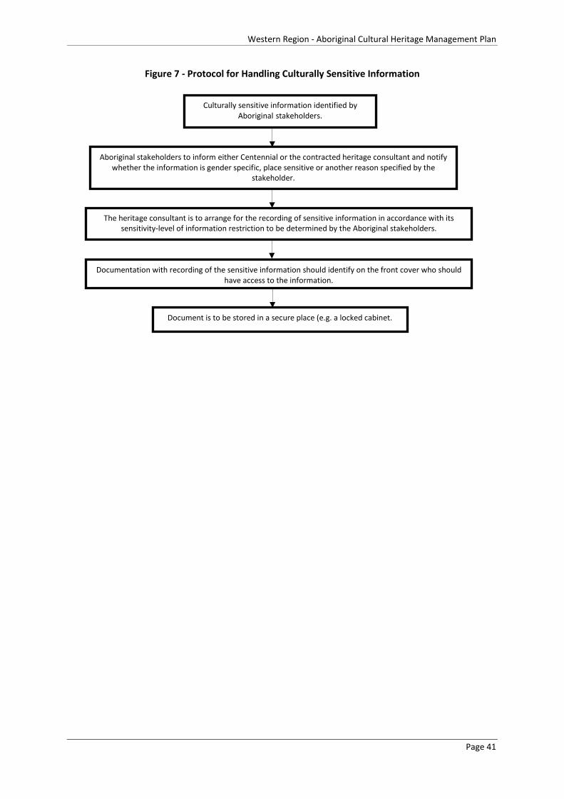
Western Region - Aboriginal Cultural Heritage Management Plan
Figure 7 - Protocol for Handling Culturally Sensitive Information
Culturally sensitive information identified by Aboriginal stakeholders.
Aboriginal stakeholders to inform either Centennial or the contracted heritage consultant and notify whether the information is gender specific, place sensitive or another reason specified by the
stakeholder.
The heritage consultant is to arrange for the recording of sensitive information in accordance with its sensitivity-level of information restriction to be determined by the Aboriginal stakeholders.
Documentation with recording of the sensitive information should identify on the front cover who should have access to the information.
Document is to be stored in a secure place (e.g. a locked cabinet.
Page 41

Western Region - Aboriginal Cultural Heritage Management Plan
9 Roles and Responsibilities This section defines the roles of persons associated with the implementation of this ACHMP as well as their responsibilities under the ACHMP. This section identifies the individuals and/or organisations outlined in the Aboriginal Cultural Heritage Monitoring Program.
The roles and responsibilities for the monitoring of Aboriginal cultural heritage sites and areas of cultural require the efforts from the following groups:
• Environment and Community Co-ordinator;
• Archaeologist;
• Aboriginal parties; and
• Surveyors (where applicable).
In order to successfully facilitate the management plan/strategy for Aboriginal cultural heritage sites in the boundary of Centennial’s western operations, it is important that the following personnel ensure that their roles and responsibilities are carried out correctly. Table 7 details the roles and responsibilities that each group much carry out.
9.1 Penalties and Consequences for Non-Compliance
It is important that the roles and responsibilities listed in Table 7 are adhered to closely to ensure that the monitoring process for Aboriginal cultural heritage sites and objects are undertaken correctly and to best practice standards for the management of Aboriginal cultural heritage sites and objects. It is important to be aware that there are legal repercussions for the mismanagement of Aboriginal cultural heritage which can harm Aboriginal cultural heritage sites and objects. The NPW Act 1974 defines the process of harm as destroying, defacing damaging or moving an Aboriginal object from the land on which it has been situated. The only defence from prosecution is if the proponent can demonstrate that harm was authorised under an AHIP, under an approved ACHMP or that the proponent exercised due diligence in respect to Aboriginal heritage.
Under the NPW Act 1979, the penalty for knowingly harming an Aboriginal object (s86[1]) and/or an Aboriginal place (s86[4]) is up to $550,000 for an individual and/or imprisonment for 2 years; and in the case of a corporation the penalty is up to $1.1 million. The penalty for a strict liability offence (s86[2]) is up to $110,000 for an individual and $200,000 for a corporation.
Page 42
Western Region - Aboriginal Cultural Heritage Management Plan
Table 7 - Roles and Responsibilities of Personnel involved in the ACHMP
Environment and
Community Co-ordinator
Responsibilities Onsite Personnel Responsibilities Archaeologist Responsibilities Aboriginal
Parties Responsibilities Surveyor Responsibilities
This is the person
nominated by Centennial to co-ordinate and manage
environmental requirements
in each respective operation
• Read, Understand, implement and ensure the practical application of this ACHMP.
• Follow instructions outlined in this ACHMP
• Ensure that a copy of this ACHMP is available onsite in addition to any other reports applicable to area of proposed works.
• Liaise with the Aboriginal community, as appropriate
Any individual
undertaking surface
disturbance within
Centennial’s western
operations
• Understand the heritage requirements under the NSW legislation.
• Be aware that there is an immediate STOP WORK requirement for some situations outlined in heritage management flow charts and ensure that there are procedures in place to secure the area for such situations.
An individual with
appropriate qualification to undertake
cultural heritage
assessments and
management actions
• Assist with the implementation of this ACHMP, as required.
• Co-ordinate Aboriginal Heritage monitoring program.
• Provide heritage advice in accordance with the relevant legislation.
• Undertake the recording of new sites in accordance with OEH guidelines.
• Liaise with the Aboriginal community, as appropriate.
• Complete monitoring control forms.
Person/s of Aboriginal
descent who have an
interest in a specific
Project Area within
Centennial’s western
operations
• Participate in the consultation process
• Provide advice on Aboriginal cultural heritage issues in a timely manner.
• Assist in the identification of cultural heritage sites, as necessary.
• Participate, if available in the monitoring of the respective colliery in which they have an interest in.
An individual with
appropriate qualifications to undertake
surveying. This may be a
Centennial survey or
contractor.
• Complete monitoring control forms in conjunction with the heritage consultant, as required.
Page 43

Western Region - Aboriginal Cultural Heritage Management Plan
10 Inductions All Centennial staff and contractors undertaking work at Centennial’s operations are required to undertake a site specific induction prior to commencing work. Aboriginal heritage matters form a component of these inductions. Records of inductions will be kept and are maintained on site.
11 Document Control
11.1 Management Plan Updates
The purpose of this document is to provide a standardised and overarching management plan and mitigation strategy for Aboriginal cultural heritage sites within the boundary of Centennial’s western operations. However, this does not discount the possibility that certain sites may require extra attention and require additional specific management protocols put in place to ensure that the site is not harmed as a result of mining-related activities. There may be requirements to adjust/modify some of the management strategies or mitigation measures in this document if it becomes outdated or proven to be inefficient in practice. As a consequence, the ACHMP will be updated when deemed necessary and reviewed annually to ensure that the document remains current and user-friendly for the purpose of managing Aboriginal cultural heritage sites according to the standards required under NSW legislation. Updated versions of the ACHMP report must also be provided to the registered Aboriginal parties.
Given that the expected lifespan of the mining program is more than 20 years, it is important that current and future Centennial Environmental and Community Co-ordinators thoroughly read and clearly understand the operations of this document. Centennial will ensure that this document is readily accessible to Centennial staff and relevant contactors working on site. It is the responsibility of the nominated Centennial Environmental Co-ordinator to ensure that revised editions of this document is made readily accessible to all onsite Centennial staff and contractors and that refreshers inductions provided when deemed necessary.
Revised editions of the document will be provided to the Registered Aboriginal Parties. The date that it was revised will also be included and the version of the document clearly specified (Figure 8).
Page 44
Western Region - Aboriginal Cultural Heritage Management Plan
Figure 8 - Continual Revision of the ACHMP Procedure
Master copy of the ACHMP will be updated annually or as necessary.
Each version of the updated ACHMP will be clearly dated, the version of the report noted. The updated version of the ACHMP must be issued to the registered Aboriginal
parties.
Updated version of the ACHMP will be returned to the nominated Centennial Environmental Co-ordinator in charge for safe keeping.
The most current version of the document will be made readily to all relevant staff via electronic or hardcopy.
Page 45
Western Region - Aboriginal Cultural Heritage Management Plan
12 Dispute Resolution
12.1 Procedure to Resolve a Dispute
In the event that a resolution cannot be achieved between Centennial and the Aboriginal stakeholder groups, or if there is a dispute between the Aboriginal stakeholder groups at any point during the consultation process, the parties in dispute will attempt to resolve the issue/s and aim to reach an agreement from the time that the conflict arises.
If the dispute cannot be resolved within two weeks of the dispute arising, the disputing parties will engage each other in a more formal setting to seek a dispute resolution. The meeting will be set in an agreed location where both parties can attend and facilitated by an independent mediator agreed to by both parties.
In the event that the disputing parties cannot agree on a meeting place, the mediator will nominate a location.
The scheduled meeting place will be stated in a formal invitation letter prepared by Centennial to the disputing parties, which stipulates the time, date and the issue of discussion. In the event that one of the disputing parties is not able to attend on the day the meeting was scheduled, notice will be provided at least two (2) days before the date of attendance. If either party involved in the dispute fail to confirm their participation and/or fails to attend the meeting, this will be considered a forfeiture of the dispute.
The meeting will be conducted under mediation, which comprises an independent mediator and representatives of the disputing parties. The parties in dispute will be prepared to negotiate in good faith and work towards a mutually satisfying compromise with the assistance of the mediator. All points of view will be documented by the mediator and the purpose of the meeting will be to encourage the parties to negotiate and ultimately reach a satisfying agreement. The course of the meeting will be based on the complexity and number of the disputed issues. Any information disclosed to a mediator in private is to be treated as confidential by the mediator unless the party making the disclosure states otherwise. If agreement is reached at the mediation, the terms of the agreement will be written down and signed by the parties before leaving the mediation.
12.1.1 Role of the Mediator
The mediator is a neutral and impartial person who will not impose a solution on the parties, nor will not make a decision for or give any legal advice to the parties. The mediator will not act for any party in relation to any proceeding concerning the dispute. The mediator will be agreed by both parties in dispute. If the disputing parties cannot agree on a person to act as a mediator, it is recommended that OEH be contacted as an independent advisor to suggest a mediator for the dispute resolution.
The mediator will provide an overview of the mediation process which will include the following stages:
• The systematic identification of all disputed matters;
• Facilitation of direct communication between the parties;
Page 46

Western Region - Aboriginal Cultural Heritage Management Plan
• Develop options for the resolution of these issues;
• Explore the usefulness of these options; and
• Arrive at a settlement that the parties find mutually acceptable.
12.1.2 Conflict of Interest
The mediator must, prior to the commencement of the mediation, disclose to the parties to the best of his or her knowledge any prior dealings with any of the parties as well as any interests in the dispute. If in the course of the mediation the mediator becomes aware of any circumstances that might reasonably be considered to affect the mediator’s capacity to act impartially, the mediator will immediately inform the parties of these circumstances. In this instance, the parties will then decide whether the mediation will continue with that mediator or with a new mediator appointed by the parties.
12.2 Dispute Resolution Protocol during Field Survey
Participation in the field survey for Aboriginal cultural heritage sites and objects require the co-operation of all parties involved. It is important that all members of the field team co-operate to ensure that the task is undertaken smoothly without deliberate delays. Professional standards will be employed at all times to ensure that the purpose of the exercise is not disrupted.
In the event that a disagreement takes place, it is not acceptable to engage in an argument in the field. Instead, the incident will be clearly documented in writing by each party at the end of the day which will clearly indicate the following:
• Date of incident;
• Place where the incident took place;
• The individuals involved in the incident; and
• Matter of dispute or disagreement.
The incident report will be submitted to Centennial within two days of the field survey so that the information can be documented and to give Centennial the opportunity to seek a pathway to resolve the issue. In the event that a resolution cannot be achieved by means of informing Centennial the protocols outlined in Section 12.3 of this ACHMP will be initiated.
12.3 Protocols if Mediation is Unsuccessful
Mediation will be adopted as the primary means of achieving a resolution if an agreement cannot be achieved through informal discussions. In the event that the disputing parties remain in conflict after going through mediation, advice will be sought from the appropriate regulatory authority depending on the nature of the dispute. The advice provided by the regulatory authority will be followed in order to achieve a dispute resolution.
Page 47
Western Region - Aboriginal Cultural Heritage Management Plan
13 Conclusion Centennial recognises the importance of consulting with Aboriginal parties in the management of Aboriginal cultural heritage. This Aboriginal Cultural Heritage Management Plan has been developed to provide a base framework to ensure that the management of Aboriginal heritage is dealt with in a consistent manner across all of Centennial’s operations within Centennial’s western operations. Key elements to this document include minimum requirements for Aboriginal consultation and minimum standards for Aboriginal heritage identification, assessment, monitoring and management. This document has identified the roles and responsibilities of Centennial staff, Aboriginal parties and the heritage consultant as well as protocols for dealing with disputes and document control. The protocols detailed in this document are informed by the legislative requirements and understanding of previous archaeological investigations undertaken in the area.
Page 48
Western Region - Aboriginal Cultural Heritage Management Plan
14 References • Australian Heritage Commission (2002) Ask First: A Guide to Respecting Indigenous Heritage and
Places. Australian Heritage Commission.
• Binford (1983) in Hardesty D and Little B (2009) Assessing Site Significance: a guide for Archaeologists and Historians, Altamira Press.
• DECCW. 2010. Code of Practice for Archaeological Investigation of Aboriginal Objects in New South Wales. Department of Environment, Climate Change and Water.
• Dickson F.P (1980) Of Grinding Grooves, Archaeology of Physical Anthropology, Oceania, Vol 15: 157-161
• Hardesty D and Little B (2009) Assessing Site Significance: a guide for Archaeologists and Historians, Altamira Press.
• Holdaway S et al. (2002) Artefact Visibility at Open Sites in Western New South Wales, Australia, Journal of Field Archaeology, Vol: 29, Number3/4, PP: 255-271
• ICOMOS, (1999) The Burra Charter: The Australia ICOMOS Charter for Places of Cultural Significance, Australia ICOMOS Inc.
• Long A (2005) Aboriginal Scarred Trees in New South Wales: A field Manuel, Department of Environment and Conservation NSW.
• Morwood M.J (2002) Visions from the Past: The archaeology of Australian Aboriginal art, Allen and Unwin Publishing, NSW
• Mulvaney J & Kamminga J (1999) Prehistory of Australia, Allen and Unwin Publishing, NSW
• OEH (2011). Guide to Investigating, Assessing and Reporting on Aboriginal Cultural Heritage in NSW. Report to State of NSW and the Office of Environment and Heritage, Department of Premier and Cabinet.
Page 49

Western Region - Aboriginal Cultural Heritage Management Plan
• Holdaway S et al (1998) New Approaches to Open Site Spatial Archaeology in Stuart National Parl, NSW, and Australia, Archaeology in Oceania, Vol 33
Page 50

Western Region - Aboriginal Cultural Heritage Management Plan
Attachment 1
Airly Mine/Airly Extension
Page 51

Page 52
Western Region - Aboriginal Cultural Heritage Management Plan
Overview of Operations
Airly Mine is an underground coal mine located approximately 40 kilometres north-northwest of Lithgow and approximately 171 kilometres northwest of Sydney. The Mine’s consent allows extraction of 1.8 million tonnes of coal per annum for supply to both domestic and international markets by rail. The key infrastructure at the Airly Mine surface facilities area comprises administration buildings, bathhouse, workshop, coal handling infrastructure, mine ventilation infrastructure, a rail loop and train loading facilities.
Registered Aboriginal Parties
Table 1 below details the Aboriginal parties who have registered an interest in the consultation process for mining operations associated with Airly Mine/Airly Extension.
Table 1 - Registered Aboriginal Parties – Airly Mine/Airly Extension
Bathurst Local Aboriginal Land Council
Gundungurra Tribal Council Aboriginal Corporation Native Title Claimants
Mooka Traditional Owners
North-East Wiradjuri Company Ltd
Warrabinga Native Title Claimants Aboriginal Corporation
Wiradjuri Council of Elders
Wiray-dyuraa Ngambaay-dyil
Wiray-dyuraa Maying-gu
Warrabinga/Wiradjuri people Native Title Claimants
Mingaan Aboriginal Corporation
Page 53
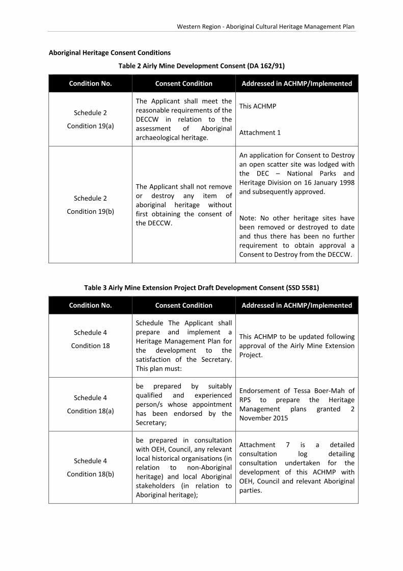
Western Region - Aboriginal Cultural Heritage Management Plan
Aboriginal Heritage Consent Conditions
Table 2 Airly Mine Development Consent (DA 162/91)
Condition No. Consent Condition Addressed in ACHMP/Implemented
Schedule 2
Condition 19(a)
The Applicant shall meet the reasonable requirements of the DECCW in relation to the assessment of Aboriginal archaeological heritage.
This ACHMP
Attachment 1
Schedule 2
Condition 19(b)
The Applicant shall not remove or destroy any item of aboriginal heritage without first obtaining the consent of the DECCW.
An application for Consent to Destroy an open scatter site was lodged with the DEC – National Parks and Heritage Division on 16 January 1998 and subsequently approved.
Note: No other heritage sites have been removed or destroyed to date and thus there has been no further requirement to obtain approval a Consent to Destroy from the DECCW.
Table 3 Airly Mine Extension Project Draft Development Consent (SSD 5581)
Condition No. Consent Condition Addressed in ACHMP/Implemented
Schedule 4
Condition 18
Schedule The Applicant shall prepare and implement a Heritage Management Plan for the development to the satisfaction of the Secretary. This plan must:
This ACHMP to be updated following approval of the Airly Mine Extension Project.
Schedule 4
Condition 18(a)
be prepared by suitably qualified and experienced person/s whose appointment has been endorsed by the Secretary;
Endorsement of Tessa Boer-Mah of RPS to prepare the Heritage Management plans granted 2 November 2015
Schedule 4
Condition 18(b)
be prepared in consultation with OEH, Council, any relevant local historical organisations (in relation to non-Aboriginal heritage) and local Aboriginal stakeholders (in relation to Aboriginal heritage);
Attachment 7 is a detailed consultation log detailing consultation undertaken for the development of this ACHMP with OEH, Council and relevant Aboriginal parties.
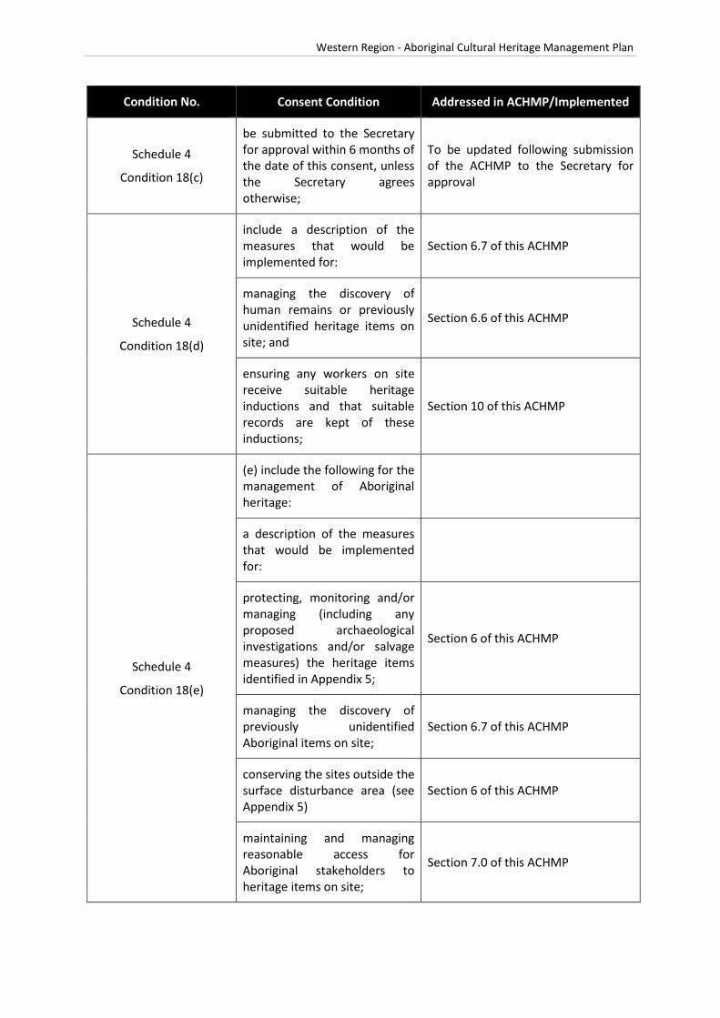
Western Region - Aboriginal Cultural Heritage Management Plan
Condition No. Consent Condition Addressed in ACHMP/Implemented
Schedule 4
Condition 18(c)
be submitted to the Secretary for approval within 6 months of the date of this consent, unless the Secretary agrees otherwise;
To be updated following submission of the ACHMP to the Secretary for approval
Schedule 4
Condition 18(d)
include a description of the measures that would be implemented for:
Section 6.7 of this ACHMP
managing the discovery of human remains or previously unidentified heritage items on site; and
Section 6.6 of this ACHMP
ensuring any workers on site receive suitable heritage inductions and that suitable records are kept of these inductions;
Section 10 of this ACHMP
Schedule 4
Condition 18(e)
(e) include the following for the management of Aboriginal heritage:
a description of the measures that would be implemented for:
protecting, monitoring and/or managing (including any proposed archaeological investigations and/or salvage measures) the heritage items identified in Appendix 5;
Section 6 of this ACHMP
managing the discovery of previously unidentified Aboriginal items on site;
Section 6.7 of this ACHMP
conserving the sites outside the surface disturbance area (see Appendix 5)
Section 6 of this ACHMP
maintaining and managing reasonable access for Aboriginal stakeholders to heritage items on site;
Section 7.0 of this ACHMP

Western Region - Aboriginal Cultural Heritage Management Plan
Condition No. Consent Condition Addressed in ACHMP/Implemented
ongoing consultation with the Aboriginal stakeholders in the conservation and management of Aboriginal cultural heritage on site;
Section 5.3 of this ACHMP
Schedule 4
Condition 18(f)
(f) include the following for the management of non-Aboriginal heritage items:
Subject to a separate Management Plan
a description of the measures that would be implemented for:
Subject to a separate Management Plan
protecting, monitoring and managing the heritage items identified in Appendix 6; and
Subject to a separate Management Plan
managing the discovery of previously unidentified cultural heritage items on site.
Subject to a separate Management Plan

#*
#*
!(
!(!(
")
!(!(
!(
!( !(
#*
!(
#*
!(!(
!(
!(
!(
!(
")
#*
!( !(
!(
!(
#*
!(
#*
!(
!(
CAPERTEERIVER
GARDENSOF STONE
NATIONAL PARK
Sources: Esri, DeLorme, NAVTEQ, TomTom, Intermap, increment P Corp.,GEBCO, USGS, FAO, NPS, NRCAN, GeoBase, IGN, Kadaster NL, OrdnanceSurvey, Esri Japan, METI, Esri China (Hong Kong), swisstopo, and the GISUser Community
Path: J:\JO B S\Centennia l\A ll Jobs \121000 Western Hold ings CHM P \10 - Drafting\Ar cg is M ap D oc uments \Ar ch\121000 Ai rly Hold ings 20140619.m xd
121000
DATUM : GDA 94PRO JE CTION: M GA Zone 56Airly Holdings with AHIMS
RPS AUSTRALIA EAST PTY LTD (ABN 44 140 292 762)241 DENISON STREET BROADMEADOW PO BOX 428 HAMILTON NSW 2303
T: 02 4940 4200 F: 02 4961 6794 www.rpsgroup.com.au
0 1,000 2,000 3,000 4,000 m
SCALE AT A4 SIZE
Date: 19/06/2014Technician: Nata lie .Wood
Disclai mer: Whi le all reasonable car e has been taken to en sur e the infor mationcon tained on this map is up to date and accur at e, no guarantee is given that t heinfor mation por trayed is fr ee from error or o mission. Please ver ify th e accuracyof all inf orm at ion pri or to use.
Copyright: "This document and the information show n sha ll remai n the prope rty o f RPS Austra lia East PTy. L td. The docuent may onl y be used for the purpose for w hi ch it was suppli ed and in accordanc e with the terms of engagement for the commi ssion. Unauthorised us e of this document in any way is prohibi ted"
Data S our ces :Es riRPSOE H
CLIE NT: Centennia l Coal
LO CATION :
PURP OS E:
JOB NO.:
Western Holdings
HERITAGE
FIS H
RIV E R
LithgowSt
Ely St
Pee l Rd
Val e Rd
Roc ke tSt
Tw e ed i eSt
Ilfor
d R
d
Br idgeSt
M udge eSt
High St
Ca rsonsSid ing Rd
M ort S t
Ba rton A v
Je no la n
Ca ve s R d
By long
Val le y Wa y
Sta t ion R
d
Sofa
la R
d
Ilfo r
dR
d
Wa lle ra rang
Rd
Diamond
Swam
p Rd
Roc kl eyRd
Gre a tWe st e rn Hw y
Coope r Dr
Gl enA lic e Rd
C as t le r eagh
Hwy
B yl o n gVa ll ey W ay
Portlan
d Cu ll e
n
Bu ll en R
d
P ip ersFlat R dSy dn e y R d Di a mon d
S wa mp
Rd
B ice nt en n ia l
Nat io na l T r l
Ra nge Rd
C h if le y R d
Be lls Lin e of Rd
Oc onne ll Rd
H illEn d R d
G le nDa vi s Rd
Cast ler eagh
H wy
Ilf o rd
Sofa la R d
G re a tW e st e rn H w y
Gre a t
We st e rn Hw y
Sof a
l aRd
C as tl e rea gh
H wy
BATHU RST
KAN DO S
KELSO
LITH G OW
PORTLAN D
LegendAirly Lease BoundaryForestryReserveNatureConservation...RiversCreeks
AHIMS!( Art Site!( Artefact Scatter
#* Isolated Find
#* Scarred Tree") Shelter with Artefacts
#* Shelter with Deposit
k
1:58,986

Western Region - Aboriginal Cultural Heritage Management Plan
Cultural Significance Ranking Outcomes – Airly Mine/Airly Extension
All Aboriginal cultural heritage sites hold cultural significance for all Aboriginal people. A cultural significance ranking workshop was held on 30 March 2015.
The Aboriginal parties that attended the workshop are listed in Table 4.
Table 4 - Aboriginal Stakeholder Attendance – Airly Mine
Organisation
Warrabinga Native Title Claimants Aboriginal Corporation
Mingaan Aboriginal Corporation
Wiray-dyuraa Maying-gu
Gundungurra Tribal Council Aboriginal Corporation Native Title Claimants
Wiradjuri Council of Elders
Bathurst Local Aboriginal Land Council
At the workshop (30 March 2015) it was considered that the sites on Genowlan Mountain were of extremely high significance due to their location and difficulty of access and such locations may have been used for ceremonial purposes. The remaining sites were considered to be of high significance as it showed a sample of occupation in the local area and their inter-relatedness to the ceremonial sites on Genowlan Mountain.
The results of the workshop are listed in Table 5.
Table 5 - Cultural Significance Ranking Outcomes – Airly Mine
AHIMS Site Types Airly Mine Overall Cultural Significance
45-1-2544 Scarred Tree High
45-1-0168 Surface Artefact(s) High
45-1-0167 Rockshelter + PAD Extremely High
45-1-2760 Artefact Scatter High
45-1-2761 Rockshelter + PAD High
45-1-2762 Artefact Scatter High

Western Region - Aboriginal Cultural Heritage Management Plan
AHIMS Site Types Airly Mine Overall Cultural Significance
45-1-2763 Artefact Scatter High
45-1-2765 Artefact Scatter Extremely High
45-1-2766 Art Site Extremely High
45-1-2767 Artefact Scatter High
45-1-2768 Artefact Scatter in Rockshelter Extremely High
45-1-2769 Isolated Find High
45-1-2770 Artefact Scatter High
45-1-2771 Artefact Scatter High
45-1-2772 Artefact Scatter High
45-1-2773 Artefact Scatter High
45-1-2774 Isolated Find High
45-1-2775 Artefact Scatter High
45-1-2776 Scarred Tree High
45-1-2777 Artefact Scatter High
45-1-2745 Artefact Scatter High
45-1-2746 Artefact Scatter High
45-1-2747 Artefact Scatter Extremely High
45-1-2748 Isolated Find Extremely High
45-1-2742 Rockshelter + Artefact Scatter High

Western Region - Aboriginal Cultural Heritage Management Plan
Archaeological Significance Ranking Outcomes – Airly Mine
The archaeological significance ranking outcomes for sites residing in the Airly Mine boundary are listed below in Table 6.

Western Region - Aboriginal Cultural Heritage Management Plan
Table 6 - Archaeological (Scientific) Significance Ranking Outcomes – Airly Mine
AHIMS SITE TYPE Scope of Assessment Research Potential Represent-ativeness Rarity Educational
Potential
Airly Mine
Local Scientific Significance Ranking
Airly Mine
Regional Scientific Significance Ranking
45-1-2544* Scarred Tree Local 1 1 1 1 Low (no longer present at
recorded location) Low (no longer present at recorded
location) Regional 1 1 1 1
45-1-0168 Surface Artefact(s) Local 1 1 1 1
Low Low Regional 1 1 1 1
45-1-0167 Rockshelter with Deposit
Local 3 3 2 2 High High
Regional 2 2 2 1
45-1-2760 Artefact Scatter Local 1 1 1 1
Low Low Regional 1 1 1 1
45-1-2761 Rockshelter with Deposit
Local 2 2 2 1 Moderate Low
Regional 1 1 2 1
45-1-2762 Artefact Scatter Local 1 1 1 1
Low Low Regional 1 1 1 1
45-1-2763 Artefact Scatter Local 1 1 1 1
Low Low Regional 1 1 1 1
45-1-2765 Artefact Scatter Local 1 2 2 1
Low Low Regional 1 1 1 1
45-1-2766 Art Site Local 2 3 3 3
High Moderate Regional 2 2 2 2
45-1-2767 Artefact Scatter Local 1 2 1 1
Low Low Regional 1 1 1 1
45-1-2768 Rockshelter with Artefacts
Local 3 3 2 2 High High
Regional 2 2 2 1
45-1-2769 Isolated Find Local 1 2 2 1 Low Low

Western Region - Aboriginal Cultural Heritage Management Plan
AHIMS SITE TYPE Scope of Assessment Research Potential Represent-ativeness Rarity Educational
Potential
Airly Mine
Local Scientific Significance Ranking
Airly Mine
Regional Scientific Significance Ranking
Regional 1 1 1 1
45-1-2770 Artefact Scatter Local 1 1 1 1
Low Low Regional 1 1 1 1
45-1-2771 Artefact Scatter Local 1 2 1 1
Low Low Regional 1 1 1 1
45-1-2772 Artefact Scatter Local 1 1 1 1
Low Low Regional 1 1 1 1
45-1-2773 Artefact Scatter Local 1 2 2 1
Low Low Regional 1 1 1 1
45-1-2774 Isolated Find Local 1 2 2 1
Low Low Regional 1 1 1 1
45-1-2775 Artefact Scatter Local 2 3 3 3
High Low Regional 1 2 1 1
45-1-2776 Scarred Tree Local 2 2 2 2
Moderate Low Regional 1 2 2 1
45-1-2777 Artefact Scatter Local 1 1 1 1
Low Low Regional 1 1 1 1
45-1-2745 Artefact Scatter Local 1 1 1 1
Low Low Regional 1 1 1 1
45-1-2746 Artefact Scatter Local 2 2 2 2
Moderate Low Regional 1 1 1 1
45-1-2747 Artefact Scatter Local 2 2 1 1
Low Low Regional 1 1 1 1
45-1-2748 Isolated Find Local 1 1 1 1 Low Low

Western Region - Aboriginal Cultural Heritage Management Plan
AHIMS SITE TYPE Scope of Assessment Research Potential Represent-ativeness Rarity Educational
Potential
Airly Mine
Local Scientific Significance Ranking
Airly Mine
Regional Scientific Significance Ranking
Regional 1 1 1 1
45-1-2742 Rockshelter + Artefact Scatter
Local 2 1 2 1 Low Low
Regional 1 1 1 1


Western Region - Aboriginal Cultural Heritage Management Plan
Site Specific Management Measures – Airly Mine
Centennial Airly will undertake all mining operations, Aboriginal stakeholder consultation, site surveys, reporting, impact assessment, site assessment, monitoring and management of Aboriginal cultural heritage sites in accordance with the Centennial’s Western Operations ACHMP.
Unless otherwise authorised under the National Parks and Wildlife Act 1974, the Applicant shall ensure that the development does not cause any direct or indirect impact on identified Aboriginal sites.

Western Region - Aboriginal Cultural Heritage Management Plan
Attachment 2
Angus Place Colliery


Western Region - Aboriginal Cultural Heritage Management Plan
Overview of Operations
Angus Place Colliery is an existing underground coal mine located approximately 15 kilometres to the northwest of Lithgow and approximately 120 kilometres west-northwest of Sydney. Angus Place Colliery commenced production in 1979, after being developed as an extension of the Newcom Mine at Kerosene Vale. This initially was a bord and pillar operation, but converted to longwall mining due to the depth of cover and geotechnical environment. Current approvals for the mine authorise the extraction of up to 4 million tonnes of coal per annum using a combination of continuous miner and longwall mining methods. The key infrastructure at the Angus Place surface facilities area comprises administration buildings, bathhouse, workshop, mine ventilation infrastructure and coal handling infrastructure.
Registered Aboriginal Parties
Table 1 below details the Aboriginal parties who have registered an interest in the consultation process for mining operations associated with Airly Mine/Airly Extension.
Table 1 - Registered Aboriginal Parties – Airly Mine/Airly Extension
Bathurst Local Aboriginal Land Council
Gundungurra Tribal Council Aboriginal Corporation Native Title Claimants
Mingaan Aboriginal Corporation
Warrabinga Native Title Claimants Aboriginal Corporation

Western Region - Aboriginal Cultural Heritage Management Plan
Aboriginal Heritage Consent Conditions
Table 2 - Angus Place Colliery Project Approval (PA06_0021)
Condition No. Consent Condition Addressed in ACHMP/Implemented
Schedule 3
Condition 3C(h)
Each Extraction Plan must include a Heritage Management Plan, which has been prepared in consultation with OEH and relevant stakeholders for Aboriginal heritage, to manage the potential environmental consequences of the proposed second workings on Aboriginal heritage sites or values.
Approval of the Heritage Management Plan prepared as part of the Extraction Plan for longwalls 900W and 910 was received 11 April 2014 (see Attachment 8)
This ACHMP was approved by the Secretary on 22 July 2016.
This ACHMP was prepared in consultation with OEH and relevant Aboriginal stakeholders (refer to consultation log in Attachment 7).

!\
#*
#*
#*
#*#*
#*
#*#*
#*
#*
#*
#*
#*
#*
#*
#*
#*
#*
")
#*
!(
#*#*
#*#*
#*#*
#*
!( !(
#*
#*!( !(
")
#*
")")
#*
!\
#*
")
")
")
")")
!(
!(!(
#*
!(
")")
#*
#*
")")
#*
!(
#*
#*
#*
")
!(
")!(
#*#*#*
#*#*
WOLGAN
RIVER
WOLGAN RIVER
(WESTERN BRANCH)
COXSR IVER
GARDENSOF STONE
NATIONAL PARK
BEN BULLENSTATE
FOREST
WOLGANSTATE
FOREST
NEWNESSTATE
FOREST
WOLLEMINATIONAL PARK
Sources: Esri, DeLorme, NAVTEQ, TomTom, Intermap, increment P Corp.,GEBCO, USGS, FAO, NPS, NRCAN, GeoBase, IGN, Kadaster NL, OrdnanceSurvey, Esri Japan, METI, Esri China (Hong Kong), swisstopo, and the GISUser Community
Path: J:\JO B S\Centennia l\A ll Jobs \121000 Western Hold ings CHM P \10 - Drafting\Ar cg is M ap D oc uments \Ar ch\121000 Angus P lac e Hold ings 20140618.m x d
121000
DATUM : GDA 94PRO JE CTION: M GA Zone 56Angus Place Holdings with AHIMS
RPS AUSTRALIA EAST PTY LTD (ABN 44 140 292 762)241 DENISON STREET BROADMEADOW PO BOX 428 HAMILTON NSW 2303
T: 02 4940 4200 F: 02 4961 6794 www.rpsgroup.com.au
0 1,000 2,000 3,000 4,000 m
SCALE AT A4 SIZE
Date: 19/06/2014Technician: Nata lie .Wood
Disclai mer: Whi le all reasonable car e has been taken to en sur e the infor mationcon tained on this map is up to date and accur at e, no guarantee is given that t heinfor mation por trayed is fr ee from error or o mission. Please ver ify th e accuracyof all inf orm at ion pri or to use.
Copyright: "This document and the information show n sha ll remai n the prope rty o f RPS Austra lia East PTy. L td. The docuent may onl y be used for the purpose for w hi ch it was suppli ed and in accordanc e with the terms of engagement for the commi ssion. Unauthorised us e of this document in any way is prohibi ted"
Data S our ces :Es riRPSOE H
CLIE NT: Centennia l Coal
LO CATION :
PURP OS E:
JOB NO.:
Western Holdings
HERITAGE
FIS H
RIV E R
LithgowSt
Ely St
Pee l Rd
Val e Rd
Roc ke tSt
Tw e ed i eSt
Ilfor
d R
d
Br idgeSt
M udge eSt
High St
Ca rsonsSid ing Rd
M ort S t
Ba rton A v
Je no la n
Ca ve s R d
By long
Val le y Wa y
Sta t ion R
d
Sofa
la R
d
Ilfo r
dR
d
Wa lle ra rang
Rd
Diamond
Swam
p Rd
Roc kl eyRd
Gre a tWe st e rn Hw y
Coope r Dr
Gl enA lic e Rd
C as t le r eagh
Hwy
B yl o n gVa ll ey W ay
Portlan
d Cu ll e
n
Bu ll en R
d
P ip ersFlat R dSy dn e y R d Di a mon d
S wa mp
Rd
B ice nt en n ia l
Nat io na l T r l
Ra nge Rd
C h if le y R d
Be lls Lin e of Rd
Oc onne ll Rd
H illEn d R d
G le nDa vi s Rd
Cast ler eagh
H wy
Ilf o rd
Sofa la R d
G re a tW e st e rn H w y
Gre a t
We st e rn Hw y
Sof a
l aRd
C as tl e rea gh
H wy
BATHU RST
KAN DO S
KELSO
LITH G OW
PORTLAN D
LegendAngus Place LeaseBoundariesForestryReserveNatureConservation...RiversCreeks
AHIMS") Artefact(s) unspecified
#* Isolated Find") PAD
#* Scarred Tree") Shelter!( Shelter with Art
!\Shelter with Art andDeposit
!(Shelter with Art,Grinding groove
#* Shelter with Deposit
")Shelter with deposit,Grinding groove
!( Stone Arrangement
k
1:75,000

Western Region - Aboriginal Cultural Heritage Management Plan
Cultural Significance Ranking Outcomes – Angus Place Colliery
All Aboriginal cultural heritage sites hold cultural significance for all Aboriginal people. A cultural significance ranking workshop was held on 30 March 2015.
The Aboriginal parties that attended the workshop are listed in Table 3.
Table 3 - Aboriginal Stakeholder Attendance – Angus Place Colliery
Organisation
Warrabinga Native Title Claimants Aboriginal Corporation
Mingaan Aboriginal Corporation
Wiray-dyuraa Maying-gu
Gundungurra Tribal Council Aboriginal Corporation Native Title Claimants
Wiradjuri Council of Elders
Bathurst Local Aboriginal Land Council
At the workshop (30 March 2015) it was considered that the sites on the Newnes Plateau were considered of extremely high significance due to their location and difficulty of access. It was considered that the sites locations signify that these sites were used for ceremonial purposes.
The remaining sites were considered to be of high significance as it showed a sample of occupation in the local area and their inter-relatedness to the ceremonial sites on the Newnes Plateau.
The results of the workshop are listed in Table 4.
Table 4 - Cultural Significance Ranking Outcomes – Angus Place Colliery
AHIMS Site Types Angus Place Overall Cultural Significance
45-1-0147 Rockshelter + PAD Extremely High
45-1-0148 Rockshelter + PAD Extremely High
45-1-0159 Rockshelter + PAD Extremely High
45-1-0008 Rockshelter + PAD Extremely High
45-1-0044 Scarred Tree Extremely High
45-1-2555 Rockshelter + PAD + Art High
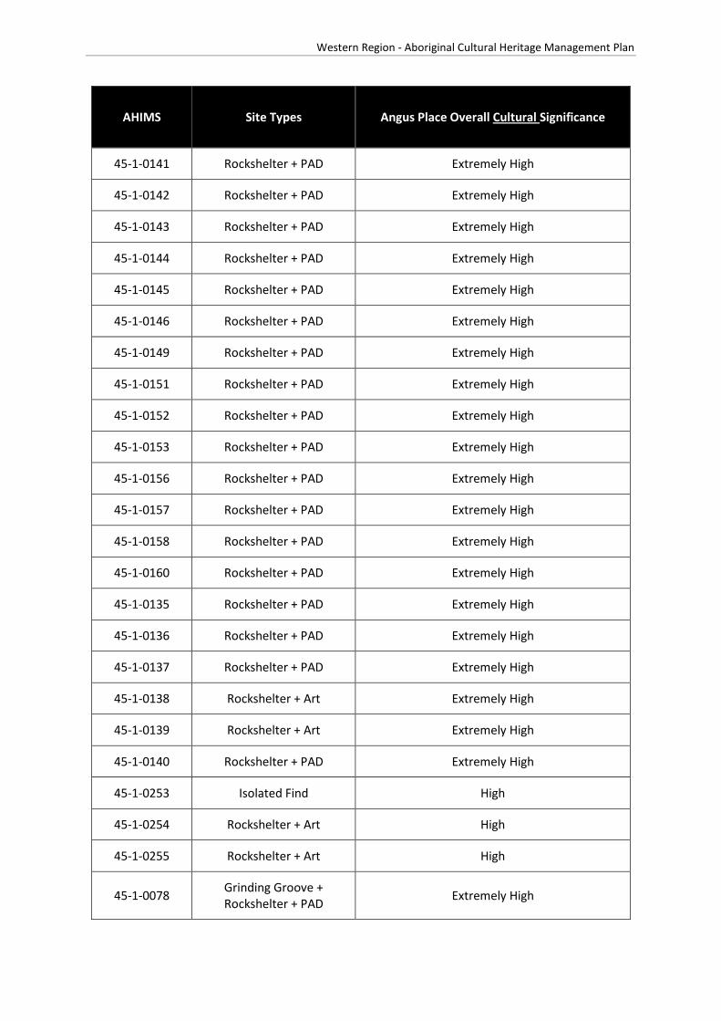
Western Region - Aboriginal Cultural Heritage Management Plan
AHIMS Site Types Angus Place Overall Cultural Significance
45-1-0141 Rockshelter + PAD Extremely High
45-1-0142 Rockshelter + PAD Extremely High
45-1-0143 Rockshelter + PAD Extremely High
45-1-0144 Rockshelter + PAD Extremely High
45-1-0145 Rockshelter + PAD Extremely High
45-1-0146 Rockshelter + PAD Extremely High
45-1-0149 Rockshelter + PAD Extremely High
45-1-0151 Rockshelter + PAD Extremely High
45-1-0152 Rockshelter + PAD Extremely High
45-1-0153 Rockshelter + PAD Extremely High
45-1-0156 Rockshelter + PAD Extremely High
45-1-0157 Rockshelter + PAD Extremely High
45-1-0158 Rockshelter + PAD Extremely High
45-1-0160 Rockshelter + PAD Extremely High
45-1-0135 Rockshelter + PAD Extremely High
45-1-0136 Rockshelter + PAD Extremely High
45-1-0137 Rockshelter + PAD Extremely High
45-1-0138 Rockshelter + Art Extremely High
45-1-0139 Rockshelter + Art Extremely High
45-1-0140 Rockshelter + PAD Extremely High
45-1-0253 Isolated Find High
45-1-0254 Rockshelter + Art High
45-1-0255 Rockshelter + Art High
45-1-0078 Grinding Groove + Rockshelter + PAD Extremely High

Western Region - Aboriginal Cultural Heritage Management Plan
AHIMS Site Types Angus Place Overall Cultural Significance
45-1-0079 Not an Aboriginal Site Extremely High
45-1-0084 Rockshelter + PAD Extremely High
45-1-0093 Surface Artefact(s) Extremely High
45-1-0007 Rockshelter + PAD + Art High
45-1-0024 Rockshelter + Art Extremely High
45-1-0040 Rockshelter + Art High
45-1-0041 Rockshelter + Art Extremely High
45-1-0046 Rockshelter + Art Extremely High
45-1-2556 Rockshelter + Art High
45-1-0133 Rockshelter + PAD Extremely High
45-1-0155 Rockshelter + PAD Extremely High
45-1-0150 Rockshelter + PAD Extremely High
45-1-2692 PAD Extremely High

Western Region - Aboriginal Cultural Heritage Management Plan
Archaeological Significance Ranking Outcomes – Angus Place Colliery
The archaeological significance ranking outcomes for sites residing in the Angus Place Colliery boundary are listed below in Table 5.

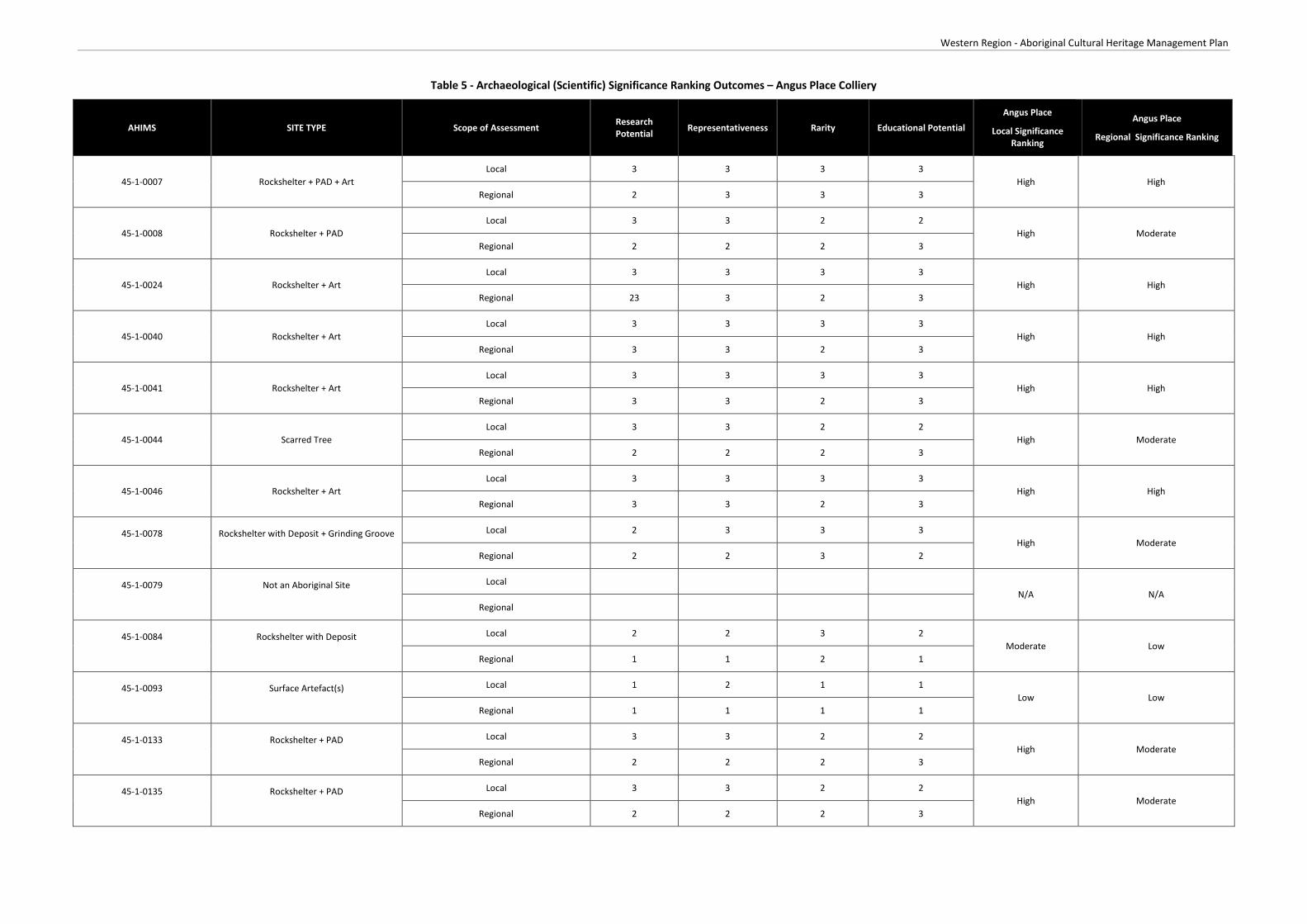
Western Region - Aboriginal Cultural Heritage Management Plan
Table 5 - Archaeological (Scientific) Significance Ranking Outcomes – Angus Place Colliery
AHIMS SITE TYPE Scope of Assessment Research Potential Representativeness Rarity Educational Potential
Angus Place
Local Significance Ranking
Angus Place
Regional Significance Ranking
45-1-0007 Rockshelter + PAD + Art Local 3 3 3 3
High High Regional 2 3 3 3
45-1-0008 Rockshelter + PAD Local 3 3 2 2
High Moderate Regional 2 2 2 3
45-1-0024 Rockshelter + Art Local 3 3 3 3
High High Regional 23 3 2 3
45-1-0040 Rockshelter + Art Local 3 3 3 3
High High Regional 3 3 2 3
45-1-0041 Rockshelter + Art Local 3 3 3 3
High High Regional 3 3 2 3
45-1-0044 Scarred Tree Local 3 3 2 2
High Moderate Regional 2 2 2 3
45-1-0046 Rockshelter + Art Local 3 3 3 3
High High Regional 3 3 2 3
45-1-0078
Rockshelter with Deposit + Grinding Groove
Local 2 3 3 3 High Moderate
Regional 2 2 3 2
45-1-0079
Not an Aboriginal Site
Local N/A N/A
Regional
45-1-0084
Rockshelter with Deposit
Local 2 2 3 2 Moderate Low
Regional 1 1 2 1
45-1-0093
Surface Artefact(s)
Local 1 2 1 1 Low Low
Regional 1 1 1 1
45-1-0133
Rockshelter + PAD
Local 3 3 2 2 High Moderate
Regional 2 2 2 3
45-1-0135
Rockshelter + PAD
Local 3 3 2 2 High Moderate
Regional 2 2 2 3

Western Region - Aboriginal Cultural Heritage Management Plan
AHIMS SITE TYPE Scope of Assessment Research Potential Representativeness Rarity Educational Potential
Angus Place
Local Significance Ranking
Angus Place
Regional Significance Ranking
45-1-0136
Rockshelter + PAD
Local 3 3 2 2 High Moderate
Regional 2 2 2 3
45-1-0137
Rockshelter with Deposit
Local 1 2 1 1 Low Low
Regional 1 1 1 1
45-1-0138
Rockshelter + Art
Local 3 3 3 3 High High
Regional 3 3 2 3
45-1-0139
Rockshelter + Art
Local 3 3 3 3 High High
Regional 3 3 2 3
45-1-0140
Rockshelter + PAD
Local 1 2 1 1 Low Low
Regional 1 1 1 1
45-1-0141
Rockshelter + PAD
Local 1 2 1 1 Low Low
Regional 1 1 1 1
45-1-0142
Rockshelter + PAD
Local 1 2 1 1 Low Low
Regional 1 1 1 1
45-1-0143
Rockshelter + PAD
Local 1 2 1 1 Low Low
Regional 1 1 1 1
45-1-0144
Rockshelter + Deposit
Local 1 2 1 1 Low Low
Regional 1 1 1 1
45-1-0145
Rockshelter + Deposit
Local 1 2 1 1 Low Low
Regional 1 1 1 1
45-1-0146
Rockshelter + Deposit
Local 1 2 1 1 Low Low
Regional 1 1 1 1
45-1-0147
Rockshelter + PAD
Local 3 3 3 3 High Moderate
Regional 2 2 2 3
45-1-0148
Rockshelter + PAD
Local 1 2 1 1 Low Low
Regional 1 1 1 1
45-1-0149 Rockshelter + Deposit Local 1 2 1 1 Low Low

Western Region - Aboriginal Cultural Heritage Management Plan
AHIMS SITE TYPE Scope of Assessment Research Potential Representativeness Rarity Educational Potential
Angus Place
Local Significance Ranking
Angus Place
Regional Significance Ranking
Regional 1 1 1 1
45-1-0150
Rockshelter + PAD
Local 1 2 1 1 Low Low
Regional 1 1 1 1
45-1-0151
Rockshelter + Deposit
Local 1 2 1 1 Low Low
Regional 1 1 1 1
45-1-0152
Rockshelter + PAD
Local 2 3 3 3 High Moderate
Regional 2 2 3 2
45-1-0153
Rockshelter + Deposit
Local 1 2 1 1 Low Low
Regional 1 1 1 1
45-1-0155
Rockshelter + Deposit
Local 1 2 1 1 Low Low
Regional 1 1 1 1
45-1-0156
Rockshelter + Deposit
Local 1 2 1 1 Low Low
Regional 1 1 1 1
45-1-0157
Rockshelter + PAD
Local 1 2 1 1 Low Low
Regional 1 1 1 1
45-1-0158
Rockshelter + PAD
Local 1 2 1 1 Low Low
Regional 1 1 1 1
45-1-0159
Rockshelter + PAD
Local 1 2 2 1 Low Low
Regional 1 1 1 1
45-1-0160
Rockshelter + PAD
Local 1 2 2 1 Low Low
Regional 1 1 1 1
45-1-0253
Isolated Find
Local 1 1 1 1 Low Low
Regional 1 1 1 1
45-1-0254
Rockshelter + Art
Local 2 3 3 3 High Moderate
Regional 2 2 3 2
45-1-0255
Rockshelter + Art
Local 2 3 3 3 High Moderate
Regional 2 2 3 2
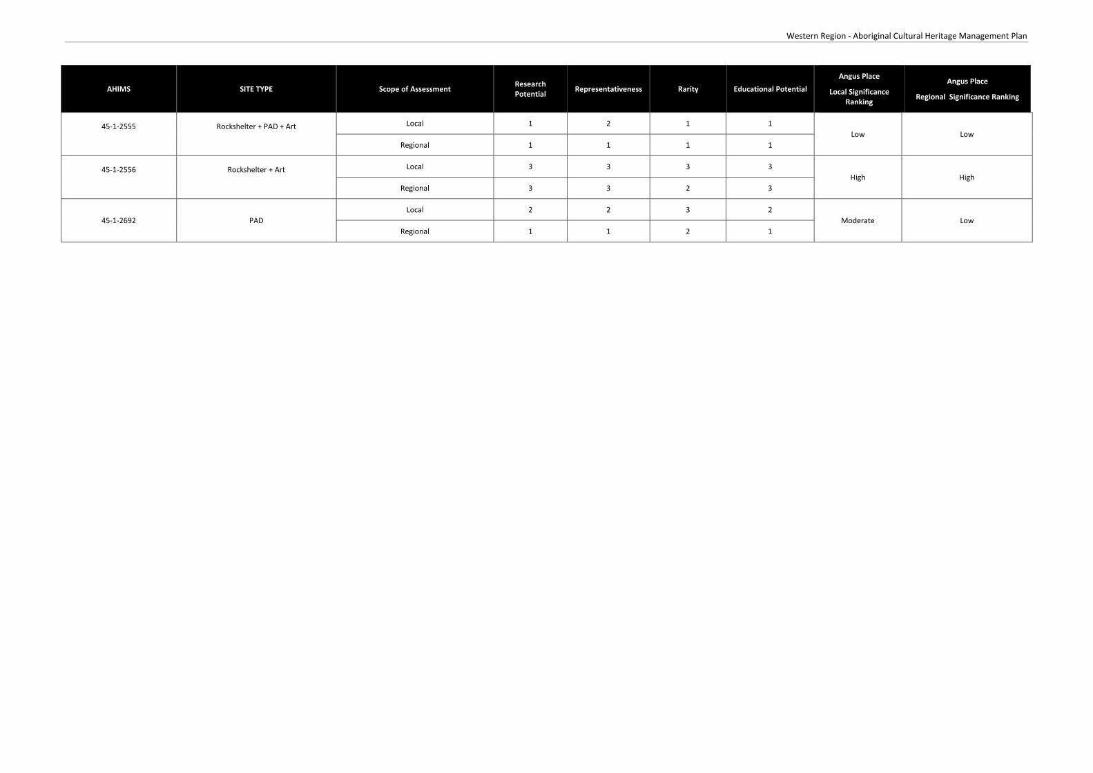
Western Region - Aboriginal Cultural Heritage Management Plan
AHIMS SITE TYPE Scope of Assessment Research Potential Representativeness Rarity Educational Potential
Angus Place
Local Significance Ranking
Angus Place
Regional Significance Ranking
45-1-2555
Rockshelter + PAD + Art
Local 1 2 1 1 Low Low
Regional 1 1 1 1
45-1-2556
Rockshelter + Art
Local 3 3 3 3 High High
Regional 3 3 2 3
45-1-2692 PAD Local 2 2 3 2
Moderate Low Regional 1 1 2 1

Western Region - Aboriginal Cultural Heritage Management Plan
Site Specific Management Measures – Angus Place Colliery
Centennial Angus Place will undertake all mining operations, Aboriginal stakeholder consultation, site surveys, reporting, impact assessment, site assessment, monitoring and management of Aboriginal cultural heritage sites in accordance with the Centennial’s Western Operations ACHMP.


Western Region - Aboriginal Cultural Heritage Management Plan
Attachment 3
Clarence Colliery


Western Region - Aboriginal Cultural Heritage Management Plan
Overview of Operations
Clarence Colliery is an underground coal mine located approximately 10 kilometres east of Lithgow and approximately 100 kilometres west-northwest of Sydney. Clarence Colliery is a partial pillar extraction mine that commenced operations in 1979. Clarence Colliery has existing development approvals in place enabling extraction of up to three million tonnes of coal per annum. The infrastructure at the Clarence Colliery surface facilities area comprises administration buildings, bathhouse, workshop, mine ventilation infrastructure, coal handling infrastructure, a rail loop and train loading facilities.
Registered Aboriginal Parties
Table 1 below details the Aboriginal parties who have registered an interest in the consultation process for mining operations associated with Clarence Colliery.
Table 1 - Registered Aboriginal Parties – Clarence Colliery
Bathurst Local Aboriginal Land Council
Gundungurra Tribal Council Aboriginal Corporation Native Title Claimants
Mingaan Aboriginal Corporation
Mooka Traditional Owners
North-East Wiradjuri
Warrabinga Native Title Claimants Aboriginal Corporation
Warrabinga/Wiradjuri People Native Title Claimants
Wiradjuri Council of Elders
Wiray-dyuraa Maying-gu
Wiray-dyuraa Ngambaay-dyil

Western Region - Aboriginal Cultural Heritage Management Plan
Aboriginal Heritage Consent Conditions
Table 2 - Clarence Colliery Development Consent (DA 504-00)
Condition No. Consent Condition Addressed in ACHMP/Implemented
Schedule 3
Condition 30
The Applicant shall prepare and implement a Heritage Management Plan for the development to the satisfaction of the Secretary.
Original ACHMP approved 23 October 2014.
This ACHMP was approved by the Secretary on 22 July 2016.
This Plan must:
Schedule 3
Condition 30(a) be prepared in consultation with relevant Aboriginal stakeholders
Attachment 7 is a detailed consultation log detailing consultation undertaken for the development of this ACHMP with OEH, Council and relevant Aboriginal parties
Schedule 3
Condition 30(b) be submitted to the Secretary for approval prior to 31 October 2014
Original version of this ACHMP submitted 2 October 2014
Schedule 3
Condition 30(c)
include consideration of the Aboriginal and non-Aboriginal cultural context and significance of the site
Section 1, Section 6.2 and Attachment 3 of this ACHMP
Note: non-Aboriginal heritage not addressed in this management plan
Schedule 3
Condition 30(d) detail the responsibilities of all stakeholders Section 9 of this ACHMP
Schedule 3
Condition 30(e)
include programs/procedures and management measures for appropriate identification, management, conservation and protection of both Aboriginal and non-Aboriginal heritage items identified on the site
Section 6 of this ACHMP
(non-Aboriginal heritage not addressed in this management plan)

!(
!(
!(
!(
ð
!(
!(
")")!( !(
!(!(
!\!\!\
B!\
!\
!\!\!\
!(
#*
#*
!(
!(
!(
!(#* #*
#*
!(
!(
!(
!(
!(
")
#*
#*
!( !(
!(!(
!(!(
!(!(
!(
!(!(
!(!(
!(!(
#*
#*#*
#*
!(
#*
!(
ð
!(
ð
!(
ð
#*#* #*
#*
!(
#*
!\!(
W OLL ANGAMB ER IVER
GARDENS OF STONENATIONAL PARK
NEWNESSTATE
FOREST
WOLLEMINATIONAL
PARK
BLUE MOUNTAINSNATIONAL PARK
Sources: Esri, DeLorme, NAVTEQ, TomTom, Intermap, increment P Corp.,GEBCO, USGS, FAO, NPS, NRCAN, GeoBase, IGN, Kadaster NL, OrdnanceSurvey, Esri Japan, METI, Esri China (Hong Kong), swisstopo, and the GISUser Community
Path: J:\JO B S\Centennia l\A ll Jobs \121000 Western Hold ings CHM P \10 - Drafting\Ar cg is M ap D oc uments \Ar ch\121000 Clar enc e Hold ings 20140619.m x d
121000
DATUM : GDA 94PRO JE CTION: M GA Zone 56Clarence Holdings with AHIMS
RPS AUSTRALIA EAST PTY LTD (ABN 44 140 292 762)241 DENISON STREET BROADMEADOW PO BOX 428 HAMILTON NSW 2303
T: 02 4940 4200 F: 02 4961 6794 www.rpsgroup.com.au
0 1,000 2,000 3,000 4,000 m
SCALE AT A4 SIZE
Date: 19/06/2014Technician: Nata lie .Wood
Disclai mer: Whi le all reasonable car e has been taken to en sur e the infor mationcon tained on this map is up to date and accur at e, no guarantee is given that t heinfor mation por trayed is fr ee from error or o mission. Please ver ify th e accuracyof all inf orm at ion pri or to use.
Copyright: "This document and the information show n sha ll remai n the prope rty o f RPS Austra lia East PTy. L td. The docuent may onl y be used for the purpose for w hi ch it was suppli ed and in accordanc e with the terms of engagement for the commi ssion. Unauthorised us e of this document in any way is prohibi ted"
Data S our ces :Es riRPSOE H
CLIE NT: Centennia l Coal
LO CATION :
PURP OS E:
JOB NO.:
Western Holdings
HERITAGE
FIS H
RIV E R
LithgowSt
Ely St
Pee l Rd
Val e Rd
Roc ke tSt
Tw e ed i eSt
Ilfor
d R
d
Br idgeSt
M udge eSt
High St
Ca rsonsSid ing Rd
M ort S t
Ba rton A v
Je no la n
Ca ve s R d
By long
Val le y Wa y
Sta t ion R
d
Sofa
la R
d
Ilfo r
dR
d
Wa lle ra rang
Rd
Diamond
Swam
p Rd
Roc kl eyRd
Gre a tWe st e rn Hw y
Coope r Dr
Gl enA lic e Rd
C as t le r eagh
Hwy
B yl o n gVa ll ey W ay
Portlan
d Cu ll e
n
Bu ll en R
d
P ip ersFlat R dSy dn e y R d Di a mon d
S wa mp
Rd
B ice nt en n ia l
Nat io na l T r l
Ra nge Rd
C h if le y R d
Be lls Lin e of Rd
Oc onne ll Rd
H illEn d R d
G le nDa vi s Rd
Cast ler eagh
H wy
Ilf o rd
Sofa la R d
G re a tW e st e rn H w y
Gre a t
We st e rn Hw y
Sof a
l aRd
C as tl e rea gh
H wy
BATHU RST
KAN DO S
KELSO
LITH G OW
PORTLAN D
LegendCCL705-Clarence_regionForestryReserveNatureConservationRese...RiversCreeks
AHIMS\
Aboriginal Ceremony andDreaming
!( Art!( Artefact Scatter
ð Artefact Scatter with pad!( Axe Grinding Groove
")Axe GrindingGroove,Shelter with Art
")
Axe GrindingGroove,Shelter with Art &Deposits
#* Axe GrindingGroove,Shelter withDeposit
!( Burial
#* Isolated Find
#* Scarred Tree!( Shelter with Art
!\Shelter with Art,Shelter withDeposit
#* Shelter with Deposit!( StoneB Not an Aboriginal
k
1:80,000

Western Region - Aboriginal Cultural Heritage Management Plan
Cultural Significance Ranking Outcomes – Clarence Colliery
All Aboriginal cultural heritage sites hold cultural significance for all Aboriginal people. A cultural significance ranking workshop was held on 30 March 2015.
The Aboriginal parties that attended the workshop are listed in Table 3.
Table 3 - Aboriginal Stakeholder Attendance – Clarence Colliery
Organisation
Warrabinga Native Title Claimants Aboriginal Corporation
Mingaan Aboriginal Corporation
Wiray-dyuraa Maying-gu
Gundungurra Tribal Council Aboriginal Corporation Native Title Claimants
Wiradjuri Council of Elders
Bathurst Local Aboriginal Land Council
At the workshop (30 March 2015) it was considered that the sites on the Newnes Plateau were considered of extremely high significance due to their location and difficulty of access. It was considered that the sites locations signify that these sites were used for ceremonial purposes.
The remaining sites were considered to be of high significance as it showed a sample of occupation in the local area and their inter-relatedness to the ceremonial sites on the Newnes Plateau.
The results of the workshop are listed in Table 4.
Table 4 - Cultural Significance Ranking Outcomes – Clarence Colliery
AHIMS Site Types Clarence Colliery Overall Cultural Significance
45-1-0063 Grinding Groove Extremely High
45-1-0064 Rockshelter + PAD High
45-1-0085 Surface Artefact(s) Extremely High
45-1-0192 Surface Artefact(s) Extremely High
45-1-0193 Surface Artefact(s) Extremely High
45-1-0194 Surface Artefact(s) Extremely High
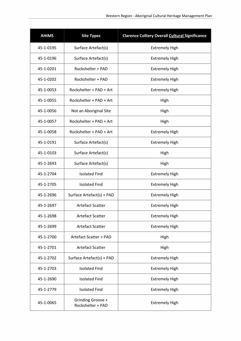
Western Region - Aboriginal Cultural Heritage Management Plan
AHIMS Site Types Clarence Colliery Overall Cultural Significance
45-1-0195 Surface Artefact(s) Extremely High
45-1-0196 Surface Artefact(s) Extremely High
45-1-0201 Rockshelter + PAD Extremely High
45-1-0202 Rockshelter + PAD Extremely High
45-1-0053 Rockshelter + PAD + Art Extremely High
45-1-0055 Rockshelter + PAD + Art High
45-1-0056 Not an Aboriginal Site High
45-1-0057 Rockshelter + PAD + Art High
45-1-0058 Rockshelter + PAD + Art Extremely High
45-1-0191 Surface Artefact(s) Extremely High
45-1-0103 Surface Artefact(s) High
45-1-2693 Surface Artefact(s) High
45-1-2704 Isolated Find Extremely High
45-1-2705 Isolated Find Extremely High
45-1-2696 Surface Artefact(s) + PAD Extremely High
45-1-2697 Artefact Scatter Extremely High
45-1-2698 Artefact Scatter Extremely High
45-1-2699 Artefact Scatter Extremely High
45-1-2700 Artefact Scatter + PAD High
45-1-2701 Artefact Scatter High
45-1-2702 Surface Artefact(s) + PAD Extremely High
45-1-2703 Isolated Find Extremely High
45-1-2690 Isolated Find Extremely High
45-1-2779 Isolated Find Extremely High
45-1-0065 Grinding Groove + Rockshelter + PAD Extremely High
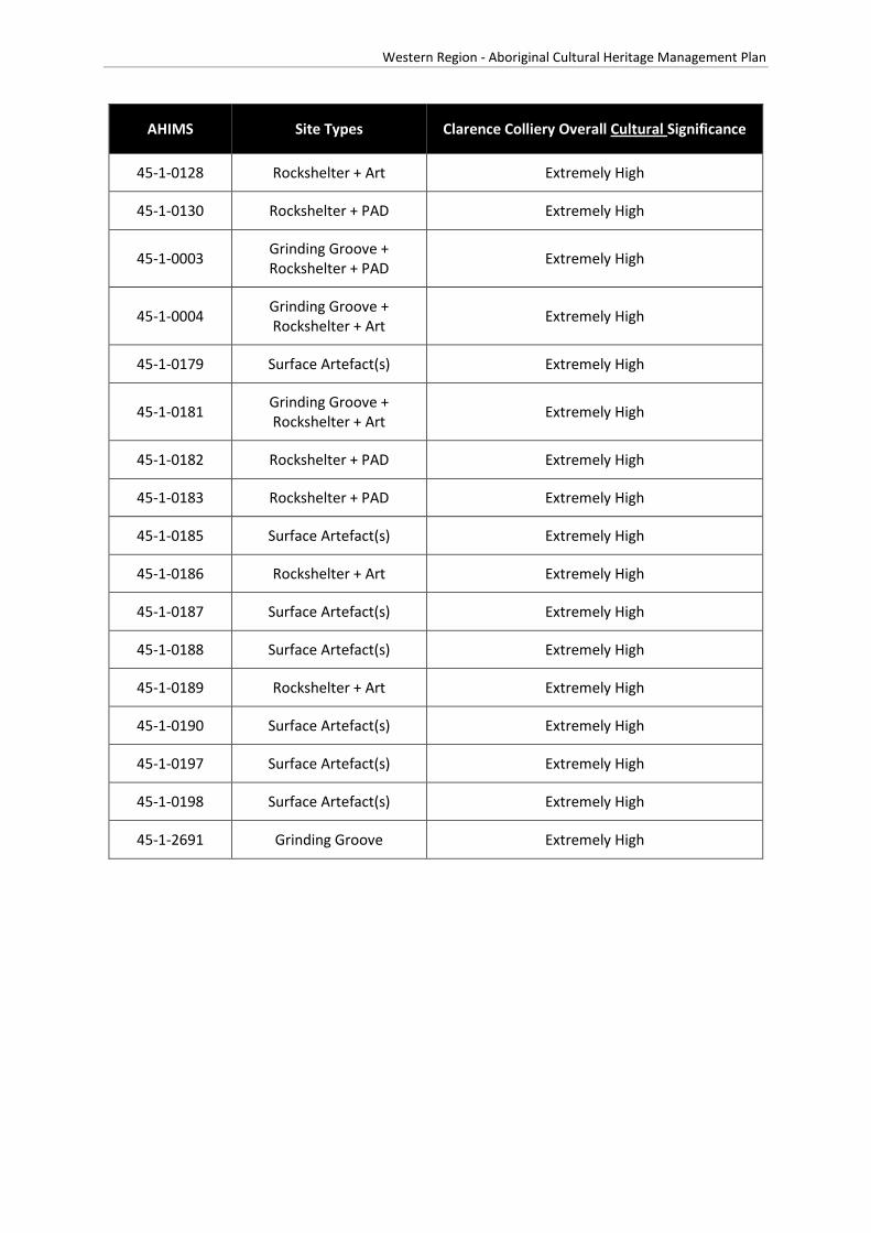
Western Region - Aboriginal Cultural Heritage Management Plan
AHIMS Site Types Clarence Colliery Overall Cultural Significance
45-1-0128 Rockshelter + Art Extremely High
45-1-0130 Rockshelter + PAD Extremely High
45-1-0003 Grinding Groove + Rockshelter + PAD Extremely High
45-1-0004 Grinding Groove + Rockshelter + Art Extremely High
45-1-0179 Surface Artefact(s) Extremely High
45-1-0181 Grinding Groove + Rockshelter + Art Extremely High
45-1-0182 Rockshelter + PAD Extremely High
45-1-0183 Rockshelter + PAD Extremely High
45-1-0185 Surface Artefact(s) Extremely High
45-1-0186 Rockshelter + Art Extremely High
45-1-0187 Surface Artefact(s) Extremely High
45-1-0188 Surface Artefact(s) Extremely High
45-1-0189 Rockshelter + Art Extremely High
45-1-0190 Surface Artefact(s) Extremely High
45-1-0197 Surface Artefact(s) Extremely High
45-1-0198 Surface Artefact(s) Extremely High
45-1-2691 Grinding Groove Extremely High

Western Region - Aboriginal Cultural Heritage Management Plan
Archaeological Significance Ranking Outcomes – Clarence Colliery
The archaeological significance ranking outcomes for sites residing in the Clarence Colliery boundary are listed below in Table 5.

Western Region - Aboriginal Cultural Heritage Management Plan
Table 5 - Archaeological (Scientific) Significance Ranking Outcomes – Clarence Colliery
AHIMS SITE TYPE Scope of Assessment Research Potential Rarity Representativeness Educational Potential Clarence Colliery
Local Significance Ranking
Clarence Colliery
Regional Significance Ranking
45-1-0003 Grinding Groove + Rockshelter + PAD Local 3 2 3 3
High Moderate Regional 2 2 2 2
45-1-0004 Grinding Groove + Rockshelter + Art Local 3 3 3 3
High High Regional 3 3 3 3
45-1-0053 Rockshelter + PAD + Art Local 3 3 3 3
High High Regional 3 3 3 3
45-1-0055 Rockshelter + PAD + Art Local 3 3 3 3
High High Regional 3 3 3 3
45-1-0056 Not an Aboriginal Site Local
N/A N/A Regional
45-1-0057 Rockshelter + PAD + Art Local 3 3 3 3
High High Regional 3 3 3 3
45-1-0058 Rockshelter + PAD + Art Local 3 3 3 3
High High Regional 3 3 3 3
45-1-0063 Grinding Groove Local 1 2 2 1
Low Low Regional 1 2 1 1
45-1-0064 Rockshelter + Deposit Local 2 2 2 2
Moderate Low Regional 1 1 1 1
45-1-0065 Grinding Groove + Rockshelter + PAD Local 3 3 3 3
High Moderate Regional 2 2 2 2
45-1-0085 Surface Artefact(s) Local 1 1 1 1
Low Low Regional 1 1 1 1
45-1-0103 Surface Artefact(s) Local 1 1 1 1
Low Low Regional 1 1 1 1
45-1-0128 Rockshelter + Art Local 3 3 3 3 High High

Western Region - Aboriginal Cultural Heritage Management Plan
AHIMS SITE TYPE Scope of Assessment Research Potential Rarity Representativeness Educational Potential Clarence Colliery
Local Significance Ranking
Clarence Colliery
Regional Significance Ranking
Regional 3 3 3 3
45-1-0130 Rockshelter + PAD Local 1 2 2 2
Moderate Low Regional 1 1 1 2
45-1-0179 Surface Artefact(s) Local 1 1 1 1
Low Low Regional 1 1 1 1
45-1-0181 Grinding Groove + Rockshelter + Art Local 3 3 3 3
High High Regional 3 3 3 3
45-1-0182 Rockshelter + PAD Local 1 2 2 2
Moderate Low Regional 1 1 1 2
45-1-0183 Rockshelter + PAD Local 2 2 2 2
Moderate Low Regional 1 1 1 1
45-1-0185 Surface Artefact(s) Local 1 1 1 1
Low Low Regional 1 1 1 1
45-1-0186 Rockshelter + Art Local 3 3 3 3
High Moderate Regional 2 3 3 2
45-1-0187 Surface Artefact(s) Local 1 2 1 1
Low Low Regional 1 1 1 1
45-1-0188 Surface Artefact(s) Local 1 1 1 1
Low Low Regional 1 1 1 1
45-1-0189 Rockshelter + Art Local 3 3 3 3
High High Regional 3 3 3 3
45-1-0190 Surface Artefact(s) Local 1 1 1 1
Low Low Regional 1 1 1 1
45-1-0191 Surface Artefact(s) Local 1 1 1 1
Low Low Regional 1 1 1 1
45-1-0192 Surface Artefact(s) Local 1 2 1 2
Low Low Regional 1 1 1 1

Western Region - Aboriginal Cultural Heritage Management Plan
AHIMS SITE TYPE Scope of Assessment Research Potential Rarity Representativeness Educational Potential Clarence Colliery
Local Significance Ranking
Clarence Colliery
Regional Significance Ranking
45-1-0193 Surface Artefact(s) Local 1 1 1 1
Low Low Regional 1 1 1 1
45-1-0194 Surface Artefact(s) Local 2 2 1 1
Low Low Regional 1 1 1 1
45-1-0195 Surface Artefact(s) + Rockshelter Local 2 2 1 2
Moderate Low Regional 1 1 1 2
45-1-0196 Surface Artefact(s) Local 1 1 1 1
Low Low Regional 1 1 1 1
45-1-0197 Surface Artefact(s) Local 1 1 1 1
Low Low Regional 1 1 1 1
45-1-0198 Surface Artefact(s) Local 1 1 1 1
Low Low Regional 1 1 1 1
45-1-0201 Rockshelter + Deposit Local 2 2 2 2
Moderate Low Regional 2 1 1 2
45-1-0202 Rockshelter + Deposit Local 2 2 2 2
Moderate Low Regional 2 1 1 2
45-1-2690 Isolated Find Local 1 1 1 1
Low Low Regional 1 1 1 1
45-1-2691 Grinding Groove Local 2 2 2 2
Moderate Low Regional 1 2 1 2
45-1-2693 Surface Artefact(s) Local 1 1 1 1
Low Low Regional 1 1 1 1
45-1-2696 Surface Artefact(s) + PAD Local 2 2 1 2
Moderate Low Regional 1 1 1 1
45-1-2697 Artefact Scatter Local 1 1 1 1
Low Low Regional 1 1 1 1
45-1-2698 Artefact Scatter Local 1 1 1 1 Low Low

Western Region - Aboriginal Cultural Heritage Management Plan
AHIMS SITE TYPE Scope of Assessment Research Potential Rarity Representativeness Educational Potential Clarence Colliery
Local Significance Ranking
Clarence Colliery
Regional Significance Ranking
Regional 1 1 1 1
45-1-2699 Artefact Scatter Local 1 1 1 1
Low Low Regional 1 1 1 1
45-1-2700 Artefact Scatter + PAD Local 2 2 1 2
Moderate Low Regional 1 1 1 1
45-1-2701 Artefact Scatter Local 1 1 1 1
Low Low Regional 1 1 1 1
45-1-2702 Surface Artefact(s) + PAD Local 2 2 1 2
Moderate Low Regional 1 1 1 1
45-1-2703 Isolated Find Local 1 1 1 1
Low Low Regional 1 1 1 1
45-1-2704 Isolated Find Local 1 1 1 1
Low Low Regional 1 1 1 1
45-1-2705 Isolated Find Local 1 1 1 1
Low Low Regional 1 1 1 1
45-1-2779 Isolated Find Local 1 1 1 1
Low Low Regional 1 1 1 1

Western Region - Aboriginal Cultural Heritage Management Plan
Site Specific Management Measures – Clarence Colliery
Centennial Clarence will undertake all mining operations, Aboriginal stakeholder consultation, site surveys, reporting, impact assessment, site assessment, monitoring and management of Aboriginal cultural heritage sites in accordance with the Centennial’s Western Operations ACHMP.


Western Region - Aboriginal Cultural Heritage Management Plan
Attachment 4
Lidsdale Siding

Western Region - Aboriginal Cultural Heritage Management Plan
Overview of Operations
The Lidsdale Siding Rail Loading Facility is located approximately 12 kilometres northwest of Lithgow and approximately 120 kilometres west of Sydney adjacent to the township of Wallerawang. The principal components of Lidsdale Siding are a rail siding, an overland conveyor which delivers coal from the Centennial Coal Western Coal Services site, coal stockpiles, workshop, office and pollution control dams. Lidsdale Siding handles thermal coal for distribution to domestic and international markets via the Main Western Railway Line to port facilities on the NSW coast.
Registered Aboriginal Parties
Table 1 below details the Aboriginal parties who have registered an interest in the consultation process for operations associated with Lidsdale Siding.
Table 1 - Registered Aboriginal Parties – Lidsdale Siding
Bathurst Local Aboriginal Land Council
Gundungurra Tribal Council Aboriginal Corporation Native Title Claimants
Mingaan Aboriginal Corporation
North-East Wiradjuri
Warrabinga Native Title Claimants Aboriginal Corporation
Mooka Traditional Owners

Western Region - Aboriginal Cultural Heritage Management Plan
Aboriginal Heritage Consent Conditions
Table 2 - Lidsdale Siding Project Approval (PA 08_0223)
Condition No. Consent Condition Addressed in ACHMP/Implemented
Schedule 3
Condition 23
The Proponent shall prepare and implement a Heritage Management Plan for the project to the satisfaction of the Director-General.
Approval was received from the then Department of Planning and Infrastructure in a letter dated 15 November 2013 for the original ACHMP for Lidsdale Siding,
Original version of this ACHMP approved 23 October 2014.
This ACHMP was approved by the Secretary on 22 July 2016.
This Plan must:
Schedule 3
Condition 23(a) be prepared in consultation with any relevant Aboriginal stakeholders
Attachment 7 is a detailed consultation log detailing consultation undertaken for the development of this ACHMP with OEH, Council and relevant Aboriginal parties
Schedule 3
Condition 23(b)
be submitted to the Director-General for approval within 6 months of the date of this approval
The Heritage Management Plan for Lidsdale Siding was originally submitted to the Director General on 2 October 2013
Original version of this ACHMP was submitted on 2 October 2014.
Schedule 3
Condition 23(c)
include consideration of the Aboriginal and non-Aboriginal cultural context and significance of the site
Section 1, Section 6.2 and Attachment 4 of this ACHMP
Schedule 3
Condition 23(d) detail the responsibilities of all stakeholders Section 9 of this ACHMP

Western Region - Aboriginal Cultural Heritage Management Plan
Condition No. Consent Condition Addressed in ACHMP/Implemented
Schedule 3
Condition 23(e)
include programs/procedures and management measures for appropriate identification, management, conservation and protection of both Aboriginal and non-Aboriginal heritage items identified on the site
Section 6.0 of this ACHMP
(non-Aboriginal heritage not addressed in this management plan)

!(
!(
!(
!(
!(
!(
!(!(
#*
!(
")")
ð
")")
!(
!(
#*
#*
#*#*
COXS RIVER
BEN BULLENSTATE
FOREST
Sources: Esri, DeLorme, NAVTEQ, TomTom, Intermap, increment P Corp.,GEBCO, USGS, FAO, NPS, NRCAN, GeoBase, IGN, Kadaster NL, OrdnanceSurvey, Esri Japan, METI, Esri China (Hong Kong), swisstopo, and the GISUser Community
Path: J:\JO B S\Centennia l\A ll Jobs \121000 Western Hold ings CHM P \10 - Drafting\Ar cg is M ap D oc uments \Ar ch\121000 L ids dale Sid ing Hold ings 20140619.m xd
121000
DATUM : GDA 94PRO JE CTION: M GA Zone 56Lidsdale Siding with AHIMS
RPS AUSTRALIA EAST PTY LTD (ABN 44 140 292 762)241 DENISON STREET BROADMEADOW PO BOX 428 HAMILTON NSW 2303
T: 02 4940 4200 F: 02 4961 6794 www.rpsgroup.com.au
0 200 400 600 800 m
SCALE AT A4 SIZE
Date: 19/06/2014Technician: Nata lie .Wood
Disclai mer: Whi le all reasonable car e has been taken to en sur e the infor mationcon tained on this map is up to date and accur at e, no guarantee is given that t heinfor mation por trayed is fr ee from error or o mission. Please ver ify th e accuracyof all inf orm at ion pri or to use.
Copyright: "This document and the information show n sha ll remai n the prope rty o f RPS Austra lia East PTy. L td. The docuent may onl y be used for the purpose for w hi ch it was suppli ed and in accordanc e with the terms of engagement for the commi ssion. Unauthorised us e of this document in any way is prohibi ted"
Data S our ces :Es riRPSOE H
CLIE NT: Centennia l Coal
LO CATION :
PURP OS E:
JOB NO.:
Western Holdings
HERITAGE
FIS H
RIV E R
LithgowSt
Ely St
Pee l Rd
Val e Rd
Roc ke tSt
Tw e ed i eSt
Ilfor
d R
d
Br idgeSt
M udge eSt
High St
Ca rsonsSid ing Rd
M ort S t
Ba rton A v
Je no la n
Ca ve s R d
By long
Val le y Wa y
Sta t ion R
d
Sofa
la R
d
Ilfo r
dR
d
Wa lle ra rang
Rd
Diamond
Swam
p Rd
Roc kl eyRd
Gre a tWe st e rn Hw y
Coope r Dr
Gl enA lic e Rd
C as t le r eagh
Hwy
B yl o n gVa ll ey W ay
Portlan
d Cu ll e
n
Bu ll en R
d
P ip ersFlat R dSy dn e y R d Di a mon d
S wa mp
Rd
B ice nt en n ia l
Nat io na l T r l
Ra nge Rd
C h if le y R d
Be lls Lin e of Rd
Oc onne ll Rd
H illEn d R d
G le nDa vi s Rd
Cast ler eagh
H wy
Ilf o rd
Sofa la R d
G re a tW e st e rn H w y
Gre a t
We st e rn Hw y
Sof a
l aRd
C as tl e rea gh
H wy
BATHU RST
KAN DO S
KELSO
LITH G OW
PORTLAN D
LegendLidsdale Siding_regionRiversCreeksForestryReserveNatureConservationRese...
AHIMS!( Artefact Scatter
ð Artefact Scatter, PAD") Artefact(s) Unspecified!( Axe Grinding Groove!( Burial/s,Carved Tree
#* Isolated Find") PAD
#* Shelter with Deposit
k
1:15,000

Western Region - Aboriginal Cultural Heritage Management Plan
Cultural Significance Ranking Outcomes – Lidsdale Siding
All Aboriginal cultural heritage sites hold cultural significance for all Aboriginal people. A cultural significance ranking workshop was held on 30 March 2015.
The Aboriginal parties that attended the workshop are listed in Table 3.
Table 3 - Aboriginal Stakeholder Attendance – Lidsdale Siding
Organisation
Warrabinga Native Title Claimants Aboriginal Corporation
Mingaan Aboriginal Corporation
Wiray-dyuraa Maying-gu
Gundungurra Tribal Council Aboriginal Corporation Native Title Claimants
Wiradjuri Council of Elders
Bathurst Local Aboriginal Land Council
At the workshop (30 March 2015) it was considered that due to the level of disturbance at Lidsdale Siding it was difficult to assess the level of significance. However, all sites are of high significance to Aboriginal people.
The results of the workshop are listed in Table 4.
Table 4 - Cultural Significance Ranking Outcomes – Lidsdale Siding
AHIMS Site Types Lidsdale Siding Overall Cultural Significance
45-1-0237 Artefact Scatter High
45-2-2539 Artefact Scatter High
45-1-2716 Artefact Scatter High
45-1-2715 Isolated Find High
45-1-2718 Isolated Find High
45-1-2719 Isolated Find High
45-1-2717 Isolated Find High

Western Region - Aboriginal Cultural Heritage Management Plan
Archaeological Significance Ranking Outcomes – Lidsdale Siding
The archaeological significance ranking outcomes for sites residing in the Lidsdale Siding boundary are listed below in Table 5.
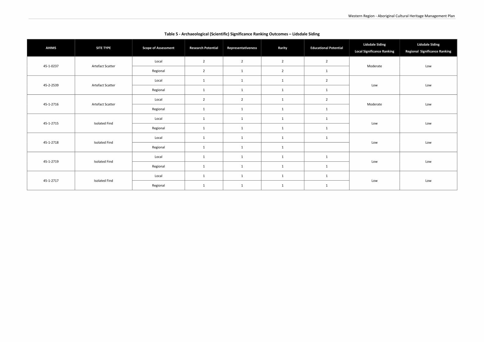
Western Region - Aboriginal Cultural Heritage Management Plan
Table 5 - Archaeological (Scientific) Significance Ranking Outcomes – Lidsdale Siding
AHIMS SITE TYPE Scope of Assessment Research Potential Representativeness Rarity Educational Potential Lidsdale Siding
Local Significance Ranking
Lidsdale Siding
Regional Significance Ranking
45-1-0237 Artefact Scatter Local 2 2 2 2
Moderate Low Regional 2 1 2 1
45-2-2539 Artefact Scatter Local 1 1 1 2
Low Low Regional 1 1 1 1
45-1-2716 Artefact Scatter Local 2 2 1 2
Moderate Low Regional 1 1 1 1
45-1-2715 Isolated Find Local 1 1 1 1
Low Low Regional 1 1 1 1
45-1-2718 Isolated Find Local 1 1 1 1
Low Low Regional 1 1 1
45-1-2719 Isolated Find Local 1 1 1 1
Low Low Regional 1 1 1 1
45-1-2717 Isolated Find Local 1 1 1 1
Low Low Regional 1 1 1 1


Western Region - Aboriginal Cultural Heritage Management Plan
Site Specific Management Measures – Lidsdale Siding
Centennial Ivanhoe will undertake all operations at Lidsdale Siding including Aboriginal stakeholder consultation, site surveys, reporting, impact assessment, site assessment, monitoring and management of Aboriginal cultural heritage sites in accordance with the Centennial’s Western Operations ACHMP.

Western Region - Aboriginal Cultural Heritage Management Plan
Attachment 5
Springvale Mine/Springvale Extension


Western Region - Aboriginal Cultural Heritage Management Plan
Overview of Operations
Springvale Mine is an existing underground coal mine located approximately 15 kilometres to the northwest of Lithgow and approximately 120 kilometres west-northwest of Sydney. Underground coal mining commenced at Springvale Mine in 1995. The main components of Springvale Mine’s operations are an underground longwall mine, accessed via the Springvale pit top, and supporting surface infrastructure within the pit top area and on Newnes Plateau within the Newnes State Forest. The key components of the Springvale surface facilities area comprises administration buildings, bathhouse, workshop, mine ventilation infrastructure and coal handling infrastructure.
Registered Aboriginal Parties
Table 1 below details the Aboriginal parties who have registered an interest in the consultation process for mining operations associated with Springvale Mine/Springvale Extension.
Table 1 - Registered Aboriginal Parties – Springvale Mine/Springvale Extension
Bathurst Local Aboriginal Land Council
Gundungurra Tribal Council Aboriginal Corporation Native Title Claimants
Mingaan Aboriginal Corporation
North-East Wiradjuri
Warrabinga Native Title Claimants Aboriginal Corporation
Mooka Traditional Owners
Wiray-dyuraa Ngambaay-dyil
Wiray-dyuraa Maying-gu
Wiradjuri Council of Elders
Warrabinga/Wiradjuri People Native Title Claimants
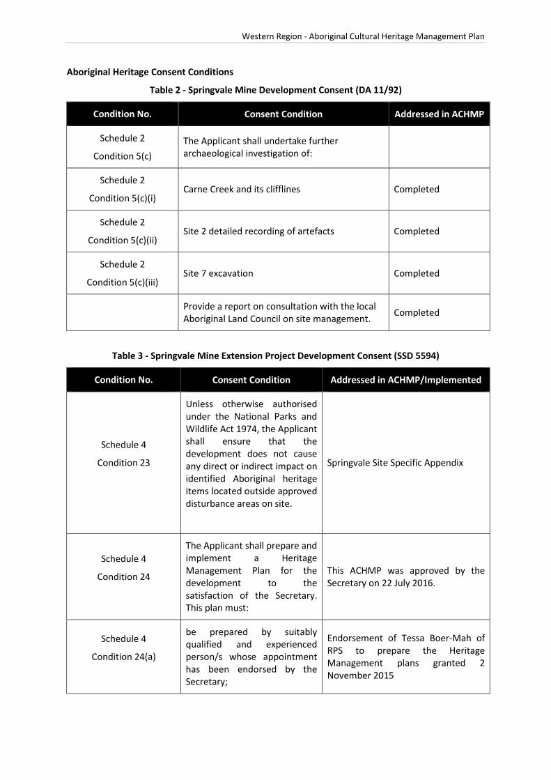
Western Region - Aboriginal Cultural Heritage Management Plan
Aboriginal Heritage Consent Conditions
Table 2 - Springvale Mine Development Consent (DA 11/92)
Condition No. Consent Condition Addressed in ACHMP
Schedule 2
Condition 5(c) The Applicant shall undertake further archaeological investigation of:
Schedule 2
Condition 5(c)(i) Carne Creek and its clifflines Completed
Schedule 2
Condition 5(c)(ii) Site 2 detailed recording of artefacts Completed
Schedule 2
Condition 5(c)(iii) Site 7 excavation Completed
Provide a report on consultation with the local Aboriginal Land Council on site management. Completed
Table 3 - Springvale Mine Extension Project Development Consent (SSD 5594)
Condition No. Consent Condition Addressed in ACHMP/Implemented
Schedule 4
Condition 23
Unless otherwise authorised under the National Parks and Wildlife Act 1974, the Applicant shall ensure that the development does not cause any direct or indirect impact on identified Aboriginal heritage items located outside approved disturbance areas on site.
Springvale Site Specific Appendix
Schedule 4
Condition 24
The Applicant shall prepare and implement a Heritage Management Plan for the development to the satisfaction of the Secretary. This plan must:
This ACHMP was approved by the Secretary on 22 July 2016.
Schedule 4
Condition 24(a)
be prepared by suitably qualified and experienced person/s whose appointment has been endorsed by the Secretary;
Endorsement of Tessa Boer-Mah of RPS to prepare the Heritage Management plans granted 2 November 2015

Western Region - Aboriginal Cultural Heritage Management Plan
Condition No. Consent Condition Addressed in ACHMP/Implemented
Schedule 4
Condition 24(b)
be prepared in consultation with OEH, Council and local Aboriginal stakeholders (in relation to management of Aboriginal heritage values);
Attachment 7 is a detailed consultation log detailing consultation undertaken for the development of this ACHMP with OEH, Council and relevant Aboriginal parties.
Schedule 4
Condition 24(c)
be submitted to the Secretary for approval within 6 months of the date of this consent, unless the Secretary agrees otherwise;
To be updated following submission of the ACHMP to the Secretary for approval
Schedule 4
Condition 24(d)
include a description of the measures that would be implemented for:
Section 6.7 of this ACHMP
managing the discovery of human remains or previously unidentified heritage items on site; and
Section 6.6 of this ACHMP
ensuring any workers on site receive suitable heritage inductions and that suitable records are kept of these inductions;
Section 10 of this ACHMP
Schedule 4
Condition 24(e)
include the following for the management of Aboriginal heritage:
a description of the measures that would be implemented for:
protecting, monitoring and/or managing the heritage items identified in Table 1 (including any proposed archaeological investigations and/or salvage measures);
Section 6 of this ACHMP
managing the discovery of previously unidentified Aboriginal items on site;
Section 6.7 of this ACHMP
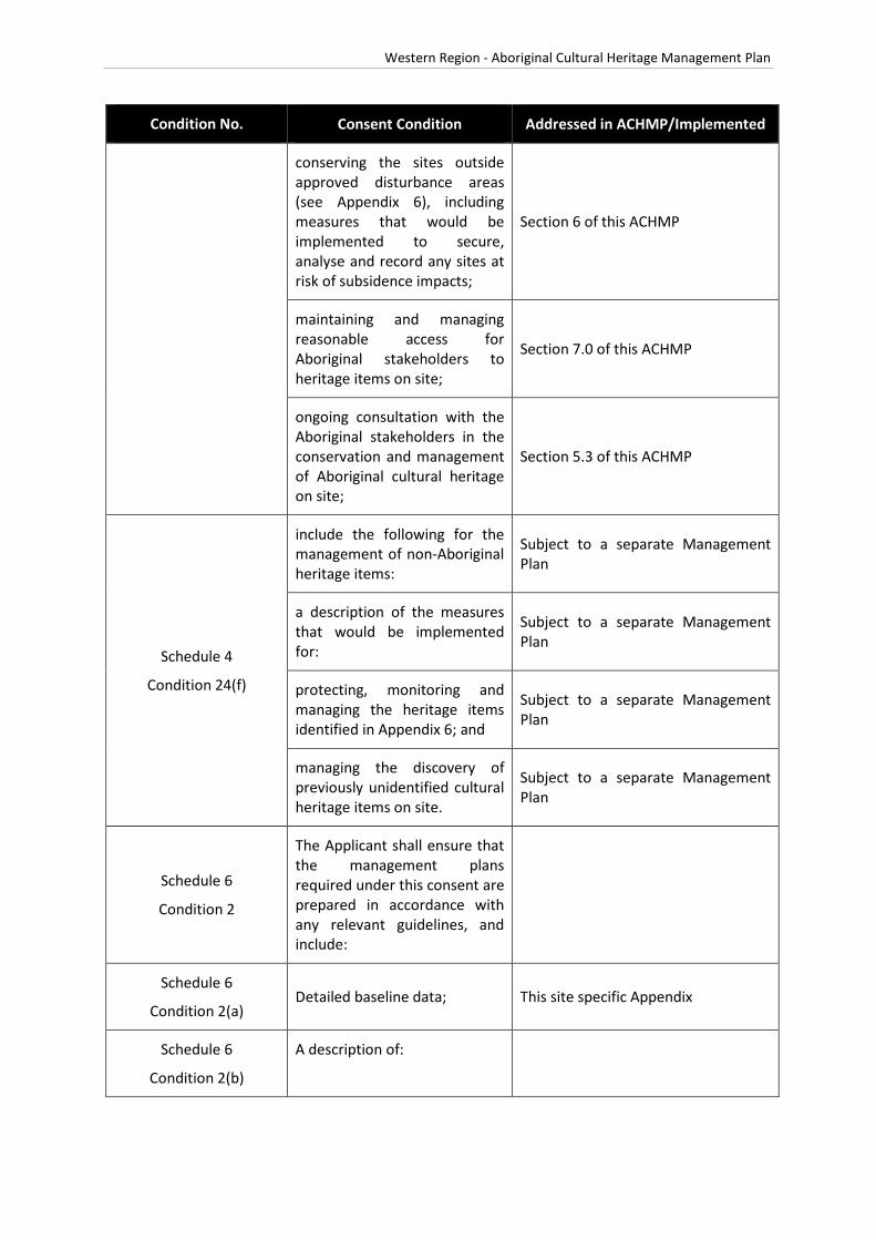
Western Region - Aboriginal Cultural Heritage Management Plan
Condition No. Consent Condition Addressed in ACHMP/Implemented
conserving the sites outside approved disturbance areas (see Appendix 6), including measures that would be implemented to secure, analyse and record any sites at risk of subsidence impacts;
Section 6 of this ACHMP
maintaining and managing reasonable access for Aboriginal stakeholders to heritage items on site;
Section 7.0 of this ACHMP
ongoing consultation with the Aboriginal stakeholders in the conservation and management of Aboriginal cultural heritage on site;
Section 5.3 of this ACHMP
Schedule 4
Condition 24(f)
include the following for the management of non-Aboriginal heritage items:
Subject to a separate Management Plan
a description of the measures that would be implemented for:
Subject to a separate Management Plan
protecting, monitoring and managing the heritage items identified in Appendix 6; and
Subject to a separate Management Plan
managing the discovery of previously unidentified cultural heritage items on site.
Subject to a separate Management Plan
Schedule 6
Condition 2
The Applicant shall ensure that the management plans required under this consent are prepared in accordance with any relevant guidelines, and include:
Schedule 6
Condition 2(a) Detailed baseline data; This site specific Appendix
Schedule 6
Condition 2(b)
A description of:

Western Region - Aboriginal Cultural Heritage Management Plan
Condition No. Consent Condition Addressed in ACHMP/Implemented
The relevant statutory requirements (including any relevant approval, licence or lease conditions);
Section 2
Any relevant limits or performance measures/criteria; and
To be addressed as part of the Extraction Plan
The specific performance indicators that are proposed to be used to judge the performance of, or guide the implementation of, the development or any management measures
Section 6.6
Schedule 6
Condition 2(c)
a description of the measures that would be implemented to comply with the relevant statutory requirements, limits, or performance measures/criteria;
Section 6.5 and 6.6 and to be addressed as part of the Site Specific Extraction Plan Aboriginal Cultural Heritage Management Plan
Schedule 6 Condition 2(d)
a program to monitor and report on:
• Impacts and environmental performance of the development; and
Section 4 and to be addressed as part of the Site Specific Extraction Plan Aboriginal Cultural Heritage Management Plan
• Effectiveness of any management measures. Section 6.5 and 6.6
Schedule 6 Condition 2(e)
a contingency plan to manage any unpredicted impacts and their consequences and to ensure that ongoing impacts reduce to levels below relevant impact assessment criteria as quickly as possible;
Section 6.5 and 6.6

Western Region - Aboriginal Cultural Heritage Management Plan
Condition No. Consent Condition Addressed in ACHMP/Implemented
Schedule 5 Condition 2(f)
a program to investigate and implement ways to improve the environmental performance of the development over time;
Section 6
Schedule 5 Condition 2(g)
a protocol for managing and reporting any:
Incidents Section 6.8
Complaints Section 12
Non-compliances with statutory requirements; and Section 6.8
Exceedances of the impact assessment criteria and/or performance criteria; and
To be addressed as part of the Site Specific Extraction Plan Aboriginal Cultural Heritage Management Plan
Schedule 5 Condition 2(h)
a protocol for periodic review of the plan. Section 11.1

#*#*
#*
#*
#*
!(
")B
!(!(
#*
#*
!(
!(!(
#*
!(")
ð
#*#*#*
#*
!(
#*#*
#*
!( !(
"3
!(
!(
!(
"3
#*
!(
!(
!(
!(!(
#*
#*
!(
!(
!(
!(
!(
#*
#*
!(!(
#*
!(
!(!(!(!(!( !(
!(
!(
!(
!\
!(
!(
!(
!(
!(
#*
")
!(
#*
!(
!( !(
!(!(
!(!(
!(
!(!(
!(!(
#*
!(
!(
!(
ð
!(
!(!(
!(
!(!(
!(
#*
ð
")
#*
!(
!(
!(
!(
CO XS RI VER
WOLGAN RIVER
(W ESTERN BRANCH)
COXSRIVER
GARDENSOF STONE
NATIONAL PARK
LIDSD ALESTATE
FOREST
BEN BULLENSTATE
FOREST
WOLGANSTATE FOREST
NEWNESSTATE
FOREST
WOLLEMINATIONAL
PARK
Sources: Esri, DeLorme, NAVTEQ, TomTom, Intermap, increment P Corp.,GEBCO, USGS, FAO, NPS, NRCAN, GeoBase, IGN, Kadaster NL, OrdnanceSurvey, Esri Japan, METI, Esri China (Hong Kong), swisstopo, and the GISUser Community
Path: J:\JO B S\Centennia l\A ll Jobs \121000 Western Hold ings CHM P \10 - Drafting\Ar cg is M ap D oc uments \Ar ch\121000 S pr ingvale Hold ings 20140619.m x d
121000
DATUM : GDA 94PRO JE CTION: M GA Zone 56Springvale Holdings with AHIMS
RPS AUSTRALIA EAST PTY LTD (ABN 44 140 292 762)241 DENISON STREET BROADMEADOW PO BOX 428 HAMILTON NSW 2303
T: 02 4940 4200 F: 02 4961 6794 www.rpsgroup.com.au
0 1,000 2,000 3,000 4,000 m
SCALE AT A4 SIZE
Date: 19/06/2014Technician: Nata lie .Wood
Disclai mer: Whi le all reasonable car e has been taken to en sur e the infor mationcon tained on this map is up to date and accur at e, no guarantee is given that t heinfor mation por trayed is fr ee from error or o mission. Please ver ify th e accuracyof all inf orm at ion pri or to use.
Copyright: "This document and the information show n sha ll remai n the prope rty o f RPS Austra lia East PTy. L td. The docuent may onl y be used for the purpose for w hi ch it was suppli ed and in accordanc e with the terms of engagement for the commi ssion. Unauthorised us e of this document in any way is prohibi ted"
Data S our ces :Es riRPSOE H
CLIE NT: Centennia l Coal
LO CATION :
PURP OS E:
JOB NO.:
Western Holdings
HERITAGE
FIS H
RIV E R
LithgowSt
Ely St
Pee l Rd
Val e Rd
Roc ke tSt
Tw e ed i eSt
Ilfor
d R
d
Br idgeSt
M udge eSt
High St
Ca rsonsSid ing Rd
M ort S t
Ba rton A v
Je no la n
Ca ve s R d
By long
Val le y Wa y
Sta t ion R
d
Sofa
la R
d
Ilfo r
dR
d
Wa lle ra rang
Rd
Diamond
Swam
p Rd
Roc kl eyRd
Gre a tWe st e rn Hw y
Coope r Dr
Gl enA lic e Rd
C as t le r eagh
Hwy
B yl o n gVa ll ey W ay
Portlan
d Cu ll e
n
Bu ll en R
d
P ip ersFlat R dSy dn e y R d Di a mon d
S wa mp
Rd
B ice nt en n ia l
Nat io na l T r l
Ra nge Rd
C h if le y R d
Be lls Lin e of Rd
Oc onne ll Rd
H illEn d R d
G le nDa vi s Rd
Cast ler eagh
H wy
Ilf o rd
Sofa la R d
G re a tW e st e rn H w y
Gre a t
We st e rn Hw y
Sof a
l aRd
C as tl e rea gh
H wy
BATHU RST
KAN DO S
KELSO
LITH G OW
PORTLAN D
LegendSpringvale LeaseBoundariesRiversCreeksForestryReserveNatureConservation...
AHIMS!\
Aboriginal Ceremonyand Dreaming
!( Stone Arrangement!( Burial/s!( Art!( Artefact Scatter
#* Isolated Find
ð Artefact Scatter, Pad
ð Artefact Scatter, Art!( Axe Grinding Groove
"3Axe Grinding Groove,Shelter with Art
")Axe Grinding Groove,Shelter with Deposit
") PAD
#* Scarred Tree!( Shelter with Art
#* Shelter with DepositB Not an Aboriginal Site
k
1:75,000

Western Region - Aboriginal Cultural Heritage Management Plan
Cultural Significance Ranking Outcomes – Springvale Mine/Springvale Extension
All Aboriginal cultural heritage sites hold cultural significance for all Aboriginal people. A cultural significance ranking workshop was held on 30 March 2015.
The Aboriginal parties that attended the workshop are listed in Table 2.
Table 4 - Aboriginal Stakeholder Attendance – Springvale Mine/Springvale Extension
Organisation
Warrabinga Native Title Claimants Aboriginal Corporation
Mingaan Aboriginal Corporation
Wiray-dyuraa Maying-gu
Gundungurra Tribal Council Aboriginal Corporation Native Title Claimants
Wiradjuri Council of Elders
Bathurst Local Aboriginal Land Council
At the workshop (30 March 2015) it was considered that the sites on the Newnes Plateau were considered of extremely high significance due to their location and difficulty of access. It was considered that the sites locations signify that these sites were used for ceremonial purposes.
The remaining sites were considered to be of high significance as it showed a sample of occupation in the local area and their inter-relatedness to the ceremonial sites on the Newnes Plateau.
The results of the workshop are listed in Table 5.
Table 5 - Cultural Significance Ranking Outcomes – Springvale Mine/Springvale Extension
AHIMS Site Types Springvale Overall Cultural Significance
45-1-0005 Grinding Groove Extremely High
45-1-0212 Surface Artefact(s) High
45-1-0129 Scarred Tree High
45-1-0087 Rockshelter + PAD High
45-1-0088 Rockshelter + PAD High
45-1-0091 Rockshelter + PAD High

Western Region - Aboriginal Cultural Heritage Management Plan
AHIMS Site Types Springvale Overall Cultural Significance
45-1-0177 Surface Artefact(s) Extremely High
45-1-0178 Surface Artefact(s) Extremely High
45-1-0204 Rockshelter + Art Extremely High
45-1-0205 Rockshelter + Art Extremely High
45-1-0051 Surface Artefact(s) Extremely High
45-1-0052 Surface Artefact(s) Extremely High
45-1-2600 Scarred Tree Extremely High
45-1-2756 / 45-1-2757 Rockshelter + PAD + Art High
45-1-2758 Scarred Tree Extremely High
45-1-2759 Scarred Tree High
45-1-2739 / 45-1-2740 Isolated Find High
Archaeological Significance Ranking Outcomes – Springvale Mine/Springvale Extension
The archaeological significance ranking outcomes for sites residing in the Springvale Mine/Springvale Extension boundary are listed below in Table 6.

Western Region - Aboriginal Cultural Heritage Management Plan

Western Region - Aboriginal Cultural Heritage Management Plan
Table 6 - Archaeological (Scientific) Significance Ranking Outcomes – Springvale Mine/Springvale Extension
AHIMS Site Types Scope of Assessment Research Potential Representativeness Rarity Educational Potential Springvale Mine
Local Significance Rating Springvale Mine Regional
Significance Rating
45-1-0005 Grinding Groove
Local 2 2 1 2
Moderate Moderate
Regional 2 2 1 2
45-1-0212 Surface Artefact(s) Local 2 1 1 1
Low Low Regional 1 1 1 1
45-1-0129 Scarred Tree Local 1 2 2 2
Moderate Low Regional 1 1 1 2
45-1-0087 Rockshelter + Deposit Local 2 1 1 2
Low Low Regional 1 1 1 1
45-1-0088 Rockshelter + Deposit Local 2 1 1 2
Low Low Regional 1 1 1 2
45-1-0091 Rockshelter + Deposit Local 2 1 1 2
Low Low Regional 1 1 1 2
45-1-0177 Surface Artefact(s) Local 1 1 1 1
Low Low Regional 1 1 1 1
45-1-0178 Surface Artefact(s) Local 2 1 1 1
Low Low Regional 1 1 1 1
45-1-0204 Rockshelter + Art Local 2 3 2 2
Moderate Moderate Regional 2 2 1 2
45-1-0205 Rockshelter + Art Local 2 3 2 3
High Moderate Regional 2 2 2 2
45-1-0051 Surface Artefact(s) Local 2 1 1 1
Low Low Regional 1 1 1 1
45-1-0052 Surface Artefact(s) Local 2 1 1 1
Low Low Regional 1 1 1 1
45-1-2600 Scarred Tree Local 1 2 2 2
Moderate Low Regional 1 1 1 1

Western Region - Aboriginal Cultural Heritage Management Plan
AHIMS Site Types Scope of Assessment Research Potential Representativeness Rarity Educational Potential Springvale Mine
Local Significance Rating Springvale Mine Regional
Significance Rating
45-1-2756 / 45-1-2757 Rockshelter complex (Shelter A + Shelter B)
Local 3 3 3 3 High High
Regional 3 3 3 3
45-1-2758 Scarred Tree Local 1 2 1 1
Low Low Regional 1 1 1 1
45-1-2759 Scarred Tree Local 1 2 1 1
Low Low Regional 1 1 1 1
45-1-2739 / 45-1-2740 Isolated Find Local 1 1 1 1
Low Low Regional 1 1 1 1

Western Region - Aboriginal Cultural Heritage Management Plan
Site Specific Management Measures – Springvale Mine/Springvale Extension
Centennial Springvale will undertake all operations, Aboriginal stakeholder consultation, site surveys, reporting, impact assessment, site assessment, monitoring and management of Aboriginal cultural heritage sites in accordance with the Centennial’s Western Operations ACHMP.
Unless otherwise authorised under the National Parks and Wildlife Act 1974, the Applicant shall ensure that the development does not cause any direct or indirect impact on identified Aboriginal heritage items located outside approved disturbance areas on the site.


Western Region - Aboriginal Cultural Heritage Management Plan
Attachment 6
Western Coal Services


Western Region - Aboriginal Cultural Heritage Management Plan
Overview of Operations
The Western Coal Services operation comprises the haul roads between Angus Place Colliery and Mount Piper and Wallerawang Power Stations, an over land conveyor linking Springvale Coal Mne, to the Wallerawang and Mt Piper Power Stations, a washery and the Kerosene Vale Coal Stockpile Area. The Western Coal Services site receives coal from both the Springvale and Angus Place Collieries, and sends washed and run of mine coal to customers via Lidsdale Siding.
Registered Aboriginal Parties
Table 1 below details the Aboriginal parties who have registered an interest in the consultation process for operations associated with Western Coal Services.
Table 1 - Registered Aboriginal Parties – Western Coal Services
Bathurst Local Aboriginal Land Council
Mingaan Aboriginal Corporation
North-East Wiradjuri
Gundungurra Tribal Council Aboriginal Corporation Native Title Claimants
Warrabinga Native Title Claimants Aboriginal Corporation
Mooka Traditional Owners
Wiray-dyuraa Ngambaay-dyil
Wiray-dyuraa Maying-gu
Wiradjuri Council of Elders

Western Region - Aboriginal Cultural Heritage Management Plan
Aboriginal Heritage Consent Conditions
Table 2 - Western Coal Services Development Consent (SSD 5179)
Condition No. Consent Condition Addressed in ACHMP/Implemented
Schedule 3
Condition 31
The applicant shall ensure that the development does not cause any direct or indirect impact on identified Aboriginal sites located outside the approved disturbance area of the development site.
Section 6 of this ACHMP
Refer also to site specific management measures provided in Attachment 6 of this ACHMP
Schedule 3
Condition 32 The Applicant shall prepare and implement a Heritage Management Plan for the development to the Satisfaction of the Director-General.
Original version of this ACHMP approved 23 October 2014.
This ACHMP was approved by the Secretary on 22 July 2016.
The Plan must:
Schedule 3
Condition 32(a) be prepared by a suitably qualified and experienced person/s whose appointment has been endorsed by the Director-General
Letter received from NSW Planning and Environment dated 14 July 2014 endorsing Tessa Boer Mah of RPS as a suitably qualified consultant to prepare this ACHMP
Schedule 3
Condition 32(b) be prepared in consultation with OEH and local Aboriginal stakeholders (in relation to the management of Aboriginal heritage values).
Attachment 7 is a detailed consultation log detailing consultation undertaken for the development of this ACHMP with OEH, Council and relevant Aboriginal parties.
Schedule 3
Condition 32(c)
be submitted to the Director-General for approval within 6 months of the date of this consent, unless the Director-General agrees otherwise.
This ACHMP was submitted to the Secretary on 11 February 2016 and approved by the Secretary on 22 July 2016.
Schedule 3
Condition 32(d)
include a description of the measures that would be implemented for:
addressing relevant statutory requirements under the National Parks and Wildlife Act.
Section 2 of this ACHMP
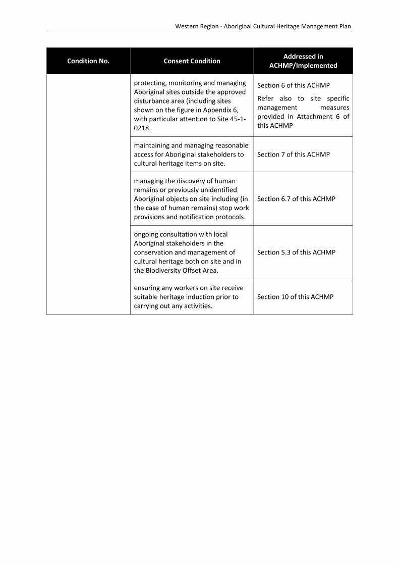
Western Region - Aboriginal Cultural Heritage Management Plan
Condition No. Consent Condition Addressed in ACHMP/Implemented
protecting, monitoring and managing Aboriginal sites outside the approved disturbance area (including sites shown on the figure in Appendix 6, with particular attention to Site 45-1-0218.
Section 6 of this ACHMP
Refer also to site specific management measures provided in Attachment 6 of this ACHMP
maintaining and managing reasonable access for Aboriginal stakeholders to cultural heritage items on site.
Section 7 of this ACHMP
managing the discovery of human remains or previously unidentified Aboriginal objects on site including (in the case of human remains) stop work provisions and notification protocols.
Section 6.7 of this ACHMP
ongoing consultation with local Aboriginal stakeholders in the conservation and management of cultural heritage both on site and in the Biodiversity Offset Area.
Section 5.3 of this ACHMP
ensuring any workers on site receive suitable heritage induction prior to carrying out any activities.
Section 10 of this ACHMP

")#*
#*
!(
#*
!(
#*
#*
")!(
!(
#*
!(
#*!(
!(
")
!(!(
#*
!(
!(
!(!(
!(
!(
!(
#*#*
!(
!(
!(
!(
!(
!(
!(
!(
!(
!(
!(!(
!(
")")\
#*
")
#*
ð
!(
#*
#*
!(
#*#*#*#*#* #*
#*
(
#*
#*
(
#*
")
")
#*
!(
!(!(
!(
!(
#*
!(
!(
#*
#*
")
!(!(!(
!(
COXSRIV ER
BEN BULLENSTATE
FOREST
NEWNESSTATE
FOREST
Sources: Esri, DeLorme, NAVTEQ, TomTom, Intermap, increment P Corp.,GEBCO, USGS, FAO, NPS, NRCAN, GeoBase, IGN, Kadaster NL, OrdnanceSurvey, Esri Japan, METI, Esri China (Hong Kong), swisstopo, and the GISUser Community
Path: J:\JO B S\Centennia l\A ll Jobs \121000 Western Hold ings CHM P \10 - Drafting\Ar cg is M ap D oc uments \Ar ch\121000 Wes ter n Coal Ser vices 20140619.m xd
121000
DATUM : GDA 94PRO JE CTION: M GA Zone 56Western Coal Services PAA with AHIMS
RPS AUSTRALIA EAST PTY LTD (ABN 44 140 292 762)241 DENISON STREET BROADMEADOW PO BOX 428 HAMILTON NSW 2303
T: 02 4940 4200 F: 02 4961 6794 www.rpsgroup.com.au
0 500 1,000 1,500 2,000 m
SCALE AT A4 SIZE
Date: 19/06/2014Technician: Nata lie .Wood
Disclai mer: Whi le all reasonable car e has been taken to en sur e the infor mationcon tained on this map is up to date and accur at e, no guarantee is given that t heinfor mation por trayed is fr ee from error or o mission. Please ver ify th e accuracyof all inf orm at ion pri or to use.
Copyright: "This document and the information show n sha ll remai n the prope rty o f RPS Austra lia East PTy. L td. The docuent may onl y be used for the purpose for w hi ch it was suppli ed and in accordanc e with the terms of engagement for the commi ssion. Unauthorised us e of this document in any way is prohibi ted"
Data S our ces :Es riRPSOE H
CLIE NT: Centennia l Coal
LO CATION :
PURP OS E:
JOB NO.:
Western Holdings
HERITAGE
FIS H
RIV E R
LithgowSt
Ely St
Pee l Rd
Val e Rd
Roc ke tSt
Tw e ed i eSt
Ilfor
d R
d
Br idgeSt
M udge eSt
High St
Ca rsonsSid ing Rd
M ort S t
Ba rton A v
Je no la n
Ca ve s R d
By long
Val le y Wa y
Sta t ion R
d
Sofa
la R
d
Ilfo r
dR
d
Wa lle ra rang
Rd
Diamond
Swam
p Rd
Roc kl eyRd
Gre a tWe st e rn Hw y
Coope r Dr
Gl enA lic e Rd
C as t le r eagh
Hwy
B yl o n gVa ll ey W ay
Portlan
d Cu ll e
n
Bu ll en R
d
P ip ersFlat R dSy dn e y R d Di a mon d
S wa mp
Rd
B ice nt en n ia l
Nat io na l T r l
Ra nge Rd
C h if le y R d
Be lls Lin e of Rd
Oc onne ll Rd
H illEn d R d
G le nDa vi s Rd
Cast ler eagh
H wy
Ilf o rd
Sofa la R d
G re a tW e st e rn H w y
Gre a t
We st e rn Hw y
Sof a
l aRd
C as tl e rea gh
H wy
BATHU RST
KAN DO S
KELSO
LITH G OW
PORTLAN D
LegendWestern Coal Services PAARiversCreeksForestryReserveNatureConservationReserve
AHIMS!( Stone Arrangem ent!( Artefact Scatter
ð
Artefact Scatter, PAD") Artefact(s) Unspecified
#*
Iso lated Find\ Artefact(s) Unspecified, PAD
(
#* Iso lated Find, PAD!( Axe Grinding Groove
")Axe Grinding Groove, Shel terwith Art & Deposit
#*Axe Grinding Groove, Shel terwith Deposit
")Axe Grinding Groove,RockEngraving
"3Axe Grinding Groove,Shelterwith Art,Shelter wi th Deposit
!( Burial /s!( Burial /s,Carved Tree
#*
Scarred Tree
")Potentia l Archaeolog icalDeposit
!( Shelter w ith Art
!\Shelter w ith Art, Shelter withDeposit
#*Shelter w ith DepositB Not an Aboriginal S ite
k
1:40,000
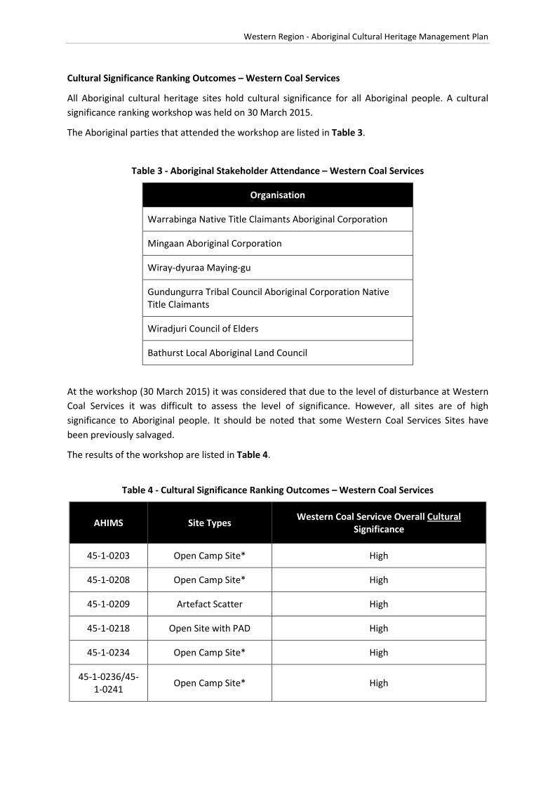
Western Region - Aboriginal Cultural Heritage Management Plan
Cultural Significance Ranking Outcomes – Western Coal Services
All Aboriginal cultural heritage sites hold cultural significance for all Aboriginal people. A cultural significance ranking workshop was held on 30 March 2015.
The Aboriginal parties that attended the workshop are listed in Table 3.
Table 3 - Aboriginal Stakeholder Attendance – Western Coal Services
Organisation
Warrabinga Native Title Claimants Aboriginal Corporation
Mingaan Aboriginal Corporation
Wiray-dyuraa Maying-gu
Gundungurra Tribal Council Aboriginal Corporation Native Title Claimants
Wiradjuri Council of Elders
Bathurst Local Aboriginal Land Council
At the workshop (30 March 2015) it was considered that due to the level of disturbance at Western Coal Services it was difficult to assess the level of significance. However, all sites are of high significance to Aboriginal people. It should be noted that some Western Coal Services Sites have been previously salvaged.
The results of the workshop are listed in Table 4.
Table 4 - Cultural Significance Ranking Outcomes – Western Coal Services
AHIMS Site Types Western Coal Servicve Overall Cultural Significance
45-1-0203 Open Camp Site* High
45-1-0208 Open Camp Site* High
45-1-0209 Artefact Scatter High
45-1-0218 Open Site with PAD High
45-1-0234 Open Camp Site* High
45-1-0236/45-1-0241 Open Camp Site* High

Western Region - Aboriginal Cultural Heritage Management Plan
AHIMS Site Types Western Coal Servicve Overall Cultural Significance
45-1-0242/0235 Open Camp Site* High
45-1-0243 Open Camp Site* High
45-1-0244 Open Camp Site* High
45-1-2601 Open Site with PAD High
45-1-2720 Isolated Find High
45-1-2721 Isolated Find High
45-1-2722 Isolated Find High
45-1-2723 Isolated Find High
45-1-2724 Isolated Find High
45-1-2725 Isolated Find High
45-1-2749 Isolated Find High
45-6-2354 Open Camp Site* High
45-6-2355 Open Camp Site* High
Archaeological Significance Ranking Outcomes – Western Coal Services
The archaeological significance ranking outcomes for sites residing in the Western Coal Services boundary are listed below in Table 5.

Western Region - Aboriginal Cultural Heritage Management Plan
Table 5 - Archaeological (Scientific) Significance Ranking Outcomes – Western Coal Services
AHIMS Site Types Scope of Assessment Research Potential Representativeness Rarity Educational Potential Western Coal Services Local Significance Rating Western Coal Services Regional Significance Rating
45-1-0005 Grinding Groove
Local 2 2 1 2
Moderate Moderate
Regional 2 2 1 2
45-1-0212 Surface Artefact(s) Local 2 1 1 1
Low Low Regional 1 1 1 1
45-1-0129 Scarred Tree Local 1 2 2 2
Moderate Low Regional 1 1 1 2
45-1-0087 Rockshelter + Deposit Local 2 1 1 2
Low Low Regional 1 1 1 1
45-1-0088 Rockshelter + Deposit Local 2 1 1 2
Low Low Regional 1 1 1 2
45-1-0091 Rockshelter + Deposit Local 2 1 1 2
Low Low Regional 1 1 1 2
45-1-0177 Surface Artefact(s) Local 1 1 1 1
Low Low Regional 1 1 1 1
45-1-0178 Surface Artefact(s) Local 2 1 1 1
Low Low Regional 1 1 1 1
45-1-0204 Rockshelter + Art Local 2 3 2 2
Moderate Moderate Regional 2 2 1 2
45-1-0205 Rockshelter + Art Local 2 3 2 3
High Moderate Regional 2 2 2 2
45-1-0051 Surface Artefact(s) Local 2 1 1 1
Low Low Regional 1 1 1 1
45-1-0052 Surface Artefact(s) Local 2 1 1 1
Low Low Regional 1 1 1 1
45-1-2600 Scarred Tree Local 1 2 2 2
Moderate Low Regional 1 1 1 1
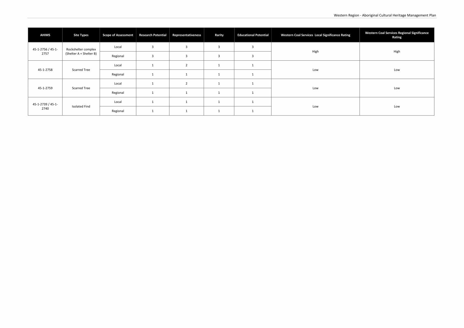
Western Region - Aboriginal Cultural Heritage Management Plan
AHIMS Site Types Scope of Assessment Research Potential Representativeness Rarity Educational Potential Western Coal Services Local Significance Rating Western Coal Services Regional Significance Rating
45-1-2756 / 45-1-2757
Rockshelter complex (Shelter A + Shelter B)
Local 3 3 3 3 High High
Regional 3 3 3 3
45-1-2758 Scarred Tree Local 1 2 1 1
Low Low Regional 1 1 1 1
45-1-2759 Scarred Tree Local 1 2 1 1
Low Low Regional 1 1 1 1
45-1-2739 / 45-1-2740 Isolated Find
Local 1 1 1 1 Low Low
Regional 1 1 1 1

Western Region - Aboriginal Cultural Heritage Management Plan
Site Specific Management Measures – Western Coal Services
Centennial Springvale will undertake all operations at Western Coal Services including Aboriginal stakeholder consultation, site surveys, reporting, impact assessment, site assessment, monitoring and management of Aboriginal cultural heritage sites in accordance with the Centennial’s Western Operations ACHMP.
Centennial Western Coal Services will undertake an initial site inspection of all sites shown on figure 44 of the EIS outside the disturbance footprint with the Registered Aboriginal Parties prior to 31 December 2014 to identify the site condition and agree on any protection and/or management measures that need to be implemented. Monitoring with, representatives from the Registered Aboriginal Parties, of these sites will be undertaken every 2 years thereafter.


Western Region - Aboriginal Cultural Heritage Management Plan
Attachment 7
Consultation Log


Western Region - Aboriginal Cultural Heritage Management Plan
Date Description of Consultation
16 June 2014 Letter to NSW Planning and Environment seeking endorsement of consultant to prepare ACHMP.
19 June 2014 Letters to Registered Aboriginal Parties Inviting them to attend ACHMP Project Inception Meeting.
20 June 2014 Email to OEH (Peter Christie) inviting to attend Project Inception Meeting.
14 July 2014 Letter from planning and Environment endorsing the consultant (RPS) to prepare the Regional ACHMP.
16 July 2014 Project Inception meeting (Representatives from OEH, Gundungurra, NE Wiradjury and Wiradjury Council of Elders in attendance).
23 July 2014 Distribution of meeting minutes, presentation and draft table of contents to RAPs and OEH. Request for provision of a Statement of Significance.
4 September 2014 Submission of draft ACHMP to RAPs and OEH for review and comment. Feedback requested by 26 September 2014.
29 September 2014 Feedback received from OEH on the draft ACHMP.
2 October 2014 Submission of final ACHMP to DoPE.
23 October 2014 Letter from DoPE approving the ACHMP.
18 November 2014 Letters sent to RAPs inviting them to join the Aboriginal Heritage Sub-Committee (response requested by 2 December 2014) and distribution of hardcopy approved ACHMP.
30 March 2015 Cultural heritage ranking workshop held and review of ACHMP. Changes to the ACHMP requested.
5 May 2015 Copy of ACHMP sent to Lithgow City Council for review and comment
28 April 2015 Letters sent to RAPs with revised ACHMP.
5 June 2015 Letter from Lithgow City Council noting no additional feedback on the ACHMP
10 June 2015 Letter with updated ACHMP sent to DoPE and OEH.
1 December 2015 Letters sent to RAPs ncluding hardcopy of revised draft ACHMP for review (response by Friday 8 January 2016).
1 December 2015 Letter sent to OEH and LCC including hardcopy of revised draft ACHMP for review

Western Region - Aboriginal Cultural Heritage Management Plan
(response by Friday 8 January 2016).
9 February 2016 Final Draft ACHMP provided for comment to DP&E
8 July 2016 Revised ACHMP submitted to DPE for approval
22 July 2016 ACHMP Approved by DPE