executive summary - world bank
TRANSCRIPT

THDC INDIA LIMITED
Environmental Studies for
Vishnugad Pipalkoti Hydro Electric Project
EXECUTIVE SUMMARY
Nov 2009
CES (INDIA) PVT LTDNEW DELHI
Pub
lic D
iscl
osur
e A
utho
rized
Pub
lic D
iscl
osur
e A
utho
rized
Pub
lic D
iscl
osur
e A
utho
rized
Pub
lic D
iscl
osur
e A
utho
rized
Pub
lic D
iscl
osur
e A
utho
rized
Pub
lic D
iscl
osur
e A
utho
rized
Pub
lic D
iscl
osur
e A
utho
rized
Pub
lic D
iscl
osur
e A
utho
rized

Project : Environmental Studies for Vishnugad-Pipalkoti Hydro-Electric Project Page: 1 Document : 2008026/EC/Executive Summary /R-4 Date: Nov 2009
Executive Summary 1. INTRODUCTION
THDC India Ltd. proposes to commission Vishnugad Pipalkoti Hydro-electric Power (VPHEP) Project on the river Alaknanda, a major tributary of the river Ganga. VPHEP is a run-of-the-river hydropower project with an installed capacity of 444 Mega Watts. A dam is to be located at village Helong in Joshimath Tehsil and an underground power house at village Haat in Chamoli Tehsil. The Government of India has requested World Bank financing for VPHEP. Prior to GoI’s decision to request World Bank funding, THDC had undertaken an Environmental Impact Assessment (EIA) of VPHEP through Water & Power Consultancy Services (WAPCOS), a PSU under Ministry of Water Resources, engaged in total consultancy in water resources, water supply, hydro power and allied sectors. The Project also obtained Environmental Clearance from the Statutory Authority on the basis of this original EIA. On reviewing the approved EIA of VPHEP, it was found that some aspects, such as managed river flow, terrestrial biodiversity, environmental impacts of advanced construction sites and archaeological survey etc., needed further analysis to strengthen the report and to comply with World Bank policy requirements for environmental assessment. In order to address these shortcomings, THDC assigned the work to M/s Consulting Engineering Services (India) Private Limited, New Delhi to carry out additional environmental studies and consolidate the initial EIA into a comprehensive Environmental Assessment in line with the requirements of the Government of India and the World Bank.
In addition, the Social Impact Assessment (SIA) & Resettlement Action Plan (RAP) has been undertaken through the Centre for Management & Social Research (CMSR), Hyderabad. The project involves acquisition of public (government and forest land) and private land from titleholders located in 19 villages. The acquisition of land and consequent displacement will have potential impacts on the social, economic, cultural and environmental attributes of the affected population. The present Executive Summary is a concise document bringing out the salient points from the consolidated EA developed by M/S CES as described above. The summary is set out under the following sub-headings: Project Context and Location Project Description Environment and Social Assessment Process Analysis of Alternatives Important Site Characteristics Environmental & Social Impacts & Mitigation Measures Environmental Management Plan Implementation Arrangements Environment Management Monitoring.

Project : Environmental Studies for Vishnugad-Pipalkoti Hydro-Electric Project Page: 2 Document : 2008026/EC/Executive Summary /R-4 Date: Nov 2009 2. PROJECT CONTEXT & LOCATION 2.1 Project Context
Development of hydro power resources is important for energy security of the country. Considering the fact that hydro power is a renewable source of energy and is environment-friendly compared to coal based thermal power plants, and also the fact that India has huge hydro power potential, policy decisions were taken at national level to develop hydro power to meet the country’s growing energy demand. India is currently facing an energy deficit. In Northern region there is an energy deficit of 13.41 percent and a peaking deficit of 17.62 percent and the demand for energy is projected to rise further. According to estimates by the Central Electricity Authority, the demand for peaking power in the Northern Region alone is projected to rise from 35,145 MW during 2007-08 to 48137 MW in 2011-12. To meet the all India peak demand and energy requirement at the end of 12th Plan, a capacity addition of more than 90,000 MW has been assessed during 12th Plan (2012-2017), which includes 30,000 MW of hydro electric power. The requirement of power (Source: Ministry of Power) during the year 2002-03 in the state of Uttarakhand and the Northern Region was 3774 MU and 156610 MU against availability of 3670 MU and 144218 MU respectively. Thus there was a deficit of 2.8% and 9.1% respectively. Uttarakhand is one state which has tremendous scope for development of Hydro power projects. The hydro power potential of the State is assessed by CEA on 31 Jan 2009 is given below. Identified capacity : 18,175 MW Capacity Developed : 3056.1 MW (16.81%) Capacity under Construction : 1850 MW (10.18%) Capacity yet to be Developed : 13269 MW (73.01%) VPHEP is suited to help provide peaking power to the national grid. Once commissioned, the project will provide 1813 million units of electricity each year to the Northern Region to meet India’s growing energy needs. The Project shall also help to improve the hydro-thermal mix in the country.
As per the Hydro Policy 2008 of GoI, the following benefits would be provided:
Twelve percent of the power generated at VPHEP will be provided free of cost to the home state of Uttarakhand.
Twenty five percent of the remaining power will go to Uttar Pradesh in lieu of its equity in the company.
The rest of the power will be available to the Northern Grid.
An additional 1 percent free power from the project will be earmarked for a Local Area Development Fund. This amount will be provided on a sustained and continued basis over the life of the project.
Project : Environmental Studies for Vishnugad-Pipalkoti Hydro-Electric Project Page: 3 Document : 2008026/EC/Executive Summary /R-4 Date: Nov 2009
100 units of electricity per month will be provided free to each Project Affected Family (PAF) through the relevant distribution company, for a period of 10 years from the date of commissioning of the project.
2.2 Project Location
VPHEP Site
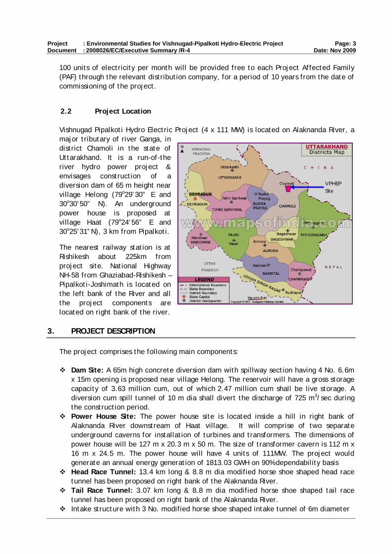
Vishnugad Pipalkoti Hydro Electric Project (4 x 111 MW) is located on Alaknanda River, a major tributary of river Ganga, in district Chamoli in the state of Uttarakhand. It is a run-of-the river hydro power project & envisages construction of a diversion dam of 65 m height near village Helong (79o29’30” E and 30o30’50” N). An underground power house is proposed at village Haat (79o24’56” E and 30o25’31”N), 3 km from Pipalkoti.
The nearest railway station is at Rishikesh about 225km from project site. National Highway NH-58 from Ghaziabad-Rishikesh –Pipalkoti-Joshimath is located on the left bank of the River and all the project components are located on right bank of the river.
3. PROJECT DESCRIPTION The project comprises the following main components:
Dam Site: A 65m high concrete diversion dam with spillway section having 4 No. 6.6m
x 15m opening is proposed near village Helong. The reservoir will have a gross storage capacity of 3.63 million cum, out of which 2.47 million cum shall be live storage. A diversion cum spill tunnel of 10 m dia shall divert the discharge of 725 m3/sec during the construction period.
Power House Site: The power house site is located inside a hill in right bank of Alaknanda River downstream of Haat village. It will comprise of two separate underground caverns for installation of turbines and transformers. The dimensions of power house will be 127 m x 20.3 m x 50 m. The size of transformer cavern is 112 m x 16 m x 24.5 m. The power house will have 4 units of 111MW. The project would generate an annual energy generation of 1813.03 GWH on 90% dependability basis
Head Race Tunnel: 13.4 km long & 8.8 m dia modified horse shoe shaped head race tunnel has been proposed on right bank of the Alaknanda River.
Tail Race Tunnel: 3.07 km long & 8.8 m dia modified horse shoe shaped tail race tunnel has been proposed on right bank of the Alaknanda River.
Intake structure with 3 No. modified horse shoe shaped intake tunnel of 6m diameter
Project : Environmental Studies for Vishnugad-Pipalkoti Hydro-Electric Project Page: 4 Document : 2008026/EC/Executive Summary /R-4 Date: Nov 2009
3 No. underground sedimentation chambers Silt flushing tunnel of size 3.6m x 4.0m Earlier, four Adits located at Gulabkothi village (Adit -1), Langsi (Adit-2), Maina Nadi
(Adit- 3) and Adit-4 on U/s of Surge shaft had been envisaged by Project. THDC has introduced, Tunnel Boring Machine for the portion of Head race tunnel operations. This will reduce the use of identified muck disposal sites. Adit–1 at Gulabkoti & Adit-4 on U/s Surge Shaft shall be utilized for muck disposal and will be constructed. Adit 3 at Maina Nadi shall be considered for construction at later stage in view of any contingency,
4. ENVIRONMENT AND SOCIAL ASSESSMENT PROCESS The project area is located in the Himalayas and is characterized by rugged topography with steep hills. The area experiences subtropical climate and is sparsely vegetated. The hill slopes are steep, and are generally covered with sparse vegetation. Most of the human population in the area is concentrated in the villages along the highway. Although forestry is the major land use in the hill state of Uttarakhand (with 34,662 km2 or about 64.79% of the state area under legally defined forests) the forest cover is 24,442 km2 (45.7 %), there has been a long history of forest degradation. As a result, only about 4002 km2 area of the state currently is classified as “dense” forest, and the remaining is a mix of “open” forests, meadows, grasslands and barren scree slopes. Most of the good quality forests remain in the relatively remote and inaccessible areas, whereas the forest cover near the traditional settlements, major towns and near major transportation routes are relatively poor. As part of the governments’ plans and programs for managing forests, biodiversity and wildlife, vast tracts of forest land is currently being protected in the state. Of these, 71.08% forest areas are demarcated as Reserved Forests, and 28.51% as Protected Forests. An area of 0.71 million ha (13.35 % of the state area) is under the protected area network, which include 6 national parks and 6 wildlife sanctuaries. Historical reasons combined with the natural setting, have led to areas around the project having relatively poor forest cover. The project is located by the side of a major pilgrim route (National Highway 58), and in the midst of a number of traditional settlements including the township of Pipalkoti. The steep rocky slopes by the deep gorges of the Alaknanda and its tributaries do not support good forests. The project area does not include any protected area.
4.1 EIA Process
Environmental impact assessment involved a detailed survey of the project area and review of relevant literature on various environmental aspects. A baseline environmental study was conducted to understand the present status of the environmental resources in the project area. The study area consisted of Project Influence Area (7km around the Project sites), Project Immediate Affected Area (500m on either side of Project sites) and at the Project Affected Areas (land acquired for Project). The Environment aspects

Project : Environmental Studies for Vishnugad-Pipalkoti Hydro-Electric Project Page: 5 Document : 2008026/EC/Executive Summary /R-4 Date: Nov 2009
involved topography, geology, hydrology, land use, aquatic ecology, terrestrial biodiversity and archaeology of the Project area. Primary survey was followed by detailed consultation with local people and relevant Govt department such as Forest, Public Health, Jal Nigam, Watershed, Irrigation etc to get the relevant information about the area and future plan, if any. Based on baseline environmental status and proposed project activities potential impacts have been assessed and predicted and appropriate mitigation measures are suggested to avoid / reduce/ compensate the potential adverse impacts and enhance the positive impacts. THDC has, over the last three years, conducted wide-ranging and detailed consultations with project-affected communities as part of its project preparation process. In order to strengthen its own capacity for handling community relations, the company hired two social workers and retained the services of a reputed local NGO to help the consultation process around assessing possible direct and indirect impacts of the project on local communities and their environment, and to forge appropriate mitigation measures. Some 72 formal consultation sessions; five project-wide public meetings (including two statutory public hearings that are part of the environmental clearance process); 11 meetings focused on environment issues and; innumerable informal meetings with Project-affected persons have been held during project preparation. Details of the formal consultation sessions can be found in the Project Information Center at Pipalkoti and on THDC’s corporate website at thdc.nic.in.
4.2 SIA Process
The loss of private assets resulting in loss of income and displacement has made social impact assessment an important input into the project design while initiating and implementing developmental interventions. An understanding of the issues related to social, economic and cultural factors of the affected people is critical in the formulation of an appropriate rehabilitation plan. A detailed social impact assessment (SIA) therefore was carried out incorporating social analyses and participatory processes into project design and implementation to make it responsive to social development concerns. SIA also helped in enhancing the project benefits to poor and vulnerable people while minimizing or mitigating concerns, risks and adverse impacts. Further as the project implementation entails a large number other social issues such as influx of labour during construction and others, a systematic assessment provided the basis to formulate the approach to the Social Impact Assessment (SIA) through Resettlement Action Plans etc..
The objectives of the SIA were:
To carry out a socio-economic, cultural and political/institutional analysis to identify the project stakeholders and social issues associated with the project;
To assess the extent of land acquisition/appropriation and other losses and undertake the census of potential project affected people;
To develop a Resettlement Action Plan (RAP) in consultation with the affected people and project authorities;
To identify likely occurrence of HIV/AIDS resulting from the influx of outside labourers and others and develop a strategy to reduce their incidence; and
To develop a consultation framework for participatory planning and implementation of proposed mitigation plan.

Project : Environmental Studies for Vishnugad-Pipalkoti Hydro-Electric Project Page: 6 Document : 2008026/EC/Executive Summary /R-4 Date: Nov 2009
In order to conduct SIA, both qualitative as well as quantitative data was collected. The assessment was conducted in two phases. In the first phase, familiarization exercise was carried out and various stakeholders were identified through (a) discussions with Project Implementing authorities and other concerned and (b) collection of available Project Affected Persons database and other relevant project literature. Consultations were held with concerned village revenue officials to update the ownership of land and its utilization pattern by referring to Records of Right (ROR) or Jamabandi Registers. Literature review and consultations formed the basis for identification of key stakeholders. Following the review, rapid preliminary field visits were conducted as a part of ground truthing exercise. This enabled to cross verify the issues identified in the chapter on social impact in Environmental Assessment report prepared by WAPCOS. This has provided the basis for field research preparation and helped in testing the questionnaires and checklists. In phase II of the assessment, census survey of all the project-affected persons available was conducted. The survey, inter alia, has assessed the impacts of the project, the socio-economic conditions, and living standards of affected persons due to the project implementation. Qualitative surveys were conducted for evaluation of both affected population and implementation capacities of THDC. The qualitative survey included focus group discussions and in depth interviews with various sections of the population such as women, knowledgeable persons and community leaders to elicit their expectations and suggestions, which will support and provide additional information collected through quantitative survey.
4.3 Policy and Regulatory Framework
From the point of view of environmental impact assessment, the project is subject to a variety of national and state laws, and rules and regulations. Among these, the prominent are the following: a) The Forest Act 1927; the Forest (Conservation) Act 1980; the Wildlife (Protection) Act,1972; National Wildlife Action Plan 1983, revised 2002; National Conservation Strategy,1992; National Forest Policy, 1988;
b) The Environment (Protection) Act 1986; and the Environmental Impact Assessment Notifications Sept 2006.
According to the prevailing procedures, the project required Forestry clearances and Environmental clearances.
Forest clearance is required to acquire forest land for the project. After joint survey and verification of forest land to be transferred for the project , GoUK has recommended the forestland to be acquired for the project for approval before MoEF and clearance is expected shortly.
The project has obtained the three-stage environmental clearance from the Ministry of Environment and Forests, GoI (MoEF). The final environmental clearance to the project was granted on 22 August 2007. This was preceded by the Stage I(2003) and the Stage II clearances from MoEF in May 2005. The no-objection certificate from the UK State Pollution Control Board (UKPCB) was obtained in April 2007. Public hearing as part of

Project : Environmental Studies for Vishnugad-Pipalkoti Hydro-Electric Project Page: 7 Document : 2008026/EC/Executive Summary /R-4 Date: Nov 2009
environmental clearance of the project was held twice: in October 2006 and also in January 2007.
The project does not require any regulatory clearance under the GoI Ancient Sites and Remains Act, as it does not impact, directly or indirectly any known or notified cultural heritage resource. However, as a part of due diligence on safeguard policies, EA consultants conducted a study by surveying the archeological, historical and religious sites around the project area to identify and understand the impacts, if any, on such sites due to project activities. The study revealed that there is no such site within the project area (where land is going to be acquired for project infrastructure).
A detailed description of the project’s baseline environmental conditions; probable adverse social and environmental impacts; and detailed environmental management plans including institutional responsibilities, implementation schedules, budget, and arrangements for monitoring and evaluation, are provided in the THDC-commissioned Environmental Assessment and Management Plan (EA/EMP) consolidated and prepared by CES India Pvt. Ltd.; and Social Impact Assessment and Resettlement Action Plan by Centre for Management & Social Research, Hyderabad.
The EA/EMP was supplemented with the following supporting documents (i) Study of the Managed River Flow in the project stretch of the River Alaknanda.; (ii) Assessment of the Terrestrial Biodiversity Impacts from the project; (iii)Assessment of Archeological, Physical and Cultural Resources (documents (i) to (iii) prepared by CES Pvt. India Ltd.) (iv) Safety Assurance Plan for the project prepared in house by THDC; (v) Catchment Area Treatment Plan for the project prepared by the State Forest Department. The summary recommendations of all the above studies have been incorporated in the EMP.
5. ANALYSIS OF ALTERNATIVES
In 1984, Uttar Pradesh Irrigation Department identified Vishnugad – Pipalkoti HEP for development with an installed capacity of 340 MW. Several alternative sites were considered in the identification report. The report also considered construction of a high dam and creation of a large storage. Two alternatives were considered. In the first case, an underground power house at Birahi on right bank was considered, and in the second alternative, a surface power house near village Haat, on the left bank, was proposed. However, no detailed investigations were carried out at the time.
In a subsequent development, the Government of Uttarakhand assigned the THDC the task of investigating and developing Vishnugad Pipalkoti site for hydro power generation. In order to decide on a barrage or a dam, investigations were carried out by THDC at several locations in the area. A summary of the findings of various alternatives is given below:
Summary of findings of various Alternatives of Dam Site Alternatives Location Environmental, Social & Technical issues Remarks
D-1 site Near Pipalkoti Pipalkoti town and 6 villages will submerge
Huge forestland under submergence
Not suitable

Project : Environmental Studies for Vishnugad-Pipalkoti Hydro-Electric Project Page: 8 Document : 2008026/EC/Executive Summary /R-4 Date: Nov 2009
Alternatives Location Environmental, Social & Technical issues Remarks
NH-58 below pond level, will need realignment in 20/30 km stretch
Main Central Thrust close to the site Calcareous rock-not suitable for storage
dam Upper Barrage Site
Just d/s of Animath nala - Alaknada confluence
Overburden depth too much- much excavation required
Not suitable
Lower Barrage Site
Near Helong Close to MCT Full head not able to utilize
Not suitable
D-2 Site 120 m d/s of D-1 Overburden depth too much Not suitable
D-3 Site 200 m d/s of D-2 Rockfall prone 20m thick river borne material terrace
above water level on both bank
Not suitable
D-4 Site 1.5 km of d/s of D-1 Least environmental and social problem Found suitable
D-5 50 m d/s of D-4 Most appropriate site from environmental, social and technical aspects
Finally selected
Conclusion: On the basis of these investigations, Alternative-D5 has been selected for construction of a diversion dam with low height spillway. Once the dam site was finalized, location/ alignments of other project components like HRT, power house, approach road etc. were selected. Environmental and social aspects were taken into consideration while finalizing the location/ alignments of these components. No-Project Scenario The demand for power in the agricultural, industrial and domestic sectors in Uttarakhand and other States in the northern region of India is increasing. Most of the States in the region are experiencing power shortage. In order to overcome this shortage, it is felt necessary to increase generation of hydro power, for which there is huge potential in Uttarakhand. The Central Electricity Authority (CEA), in its 16th Electric Power Survey, projected the growth in demand in the northern region at the rate of 7% during the 10th Plan and at the rate of 6.9% during the 11th Plan. The current deficit in power supply in Uttarakhand is 2.8% and in the northern region as a whole, 9.1%. VPHEP is one of the important projects to improve the power generation. In the ‘No-Project-scenario’, that is, if VPHEP does not materialize, the present environmental status in the area may not change, but this may lead to other problems like: • Non-availability of electricity affecting households, hospitals, tourism and other
commercial activities, industry and agriculture.

Project : Environmental Studies for Vishnugad-Pipalkoti Hydro-Electric Project Page: 9 Document : 2008026/EC/Executive Summary /R-4 Date: Nov 2009
• Dependence on diesel generators and firewood to meet local requirements, leading to green house gas emissions and other environmental and health related problems.
Taking all these aspects into consideration, it may be stated that environmental and health related problems would be there in the ‘No-Project-Scenario’ and, at the same time, power shortage problems will aggravate. It is, therefore, concluded that VPHEP is required to be implemented with adequate safeguards for environmental and social concerns due to the project.
6. IMPORTANT SITE CHARACTERISTIC The topography is by and large rugged, the entire region is mountainous. The area is drained by Alaknanda River, which has originated from the Satopanth-Bhagirath Kharak group of glacier. From Dam site to TRT outfall Alaknanda River is drained by its three major tributaries namely Maina Nadi, flowing almost in northwest-southwest direction, while the Patal Ganga and Garur Ganga flowing in southeast-northwest direction.
6.1 Seismicity
State comes under Seismic Zones V and IV of Seismic Zoning Map of India, which corresponds to Zone Factors of 0.36 and 0.24 (effective peak ground acceleration in terms of ‘g’) (IS 1893 part I, 2002). The north dipping Main Central Thrust (MCT) lies about 2 km northeast of the proposed dam site. The Alaknanda fault, and Srinagar thrust (NAT) are located about 32 km and 45 km southwest respectively of the proposed dam site. A number of other less prominent structural dislocations are also present in the area. A detailed Scientific and Technical studies to determine seismic parameters with regard to the safety of the dam have been conducted by Dept. of Earthquake Engineering, IIT Roorkee. Based on this, dynamic analysis has also been conducted. The studies have been approved by the National Standing Committee on Seismic Design Parameters (NCSDP). It has been concluded that the present design of the dam is safe.
6.2 Geology
The project area forms part of Alaknanda valley, exposed rocks belonging to Garhwal and Central Himalayan Crystalline Group. The rocks occurring at the dam site are quartzites and along most of the length of the tunnel alignment are: quartzite with biotite schist, interbanded grey slates and dolomites/limestone, grey thinly bedded slates with minor interbeds of limestone, dolomitic limestone with subordinate grey slates, grey pyritous shale / slates, thinly bedded dolomitic limestones, grey slate / phyllite, white siliceous dolomite with magnesite and talc schist; light grey dolomite with stromatolitic structures, interbedded quartzite phyllite and dolomite belong to Garhwal Group. Calcareous shale and dolomitic limestone / dolomite were observed at the dam site. Along Tail race Tunnel, dolomitic limestone, metabasics, augen gneisses and schist were observed. During tunnel construction and underground power house construction proper air circulation should be maintained inside the work area. Proper ventilation should be provided. International guidelines for underground work with respect to air circulation, fire protection, communication, health, emergency preparedness should be followed

Project : Environmental Studies for Vishnugad-Pipalkoti Hydro-Electric Project Page: 10 Document : 2008026/EC/Executive Summary /R-4 Date: Nov 2009
6.3 Landslide
On the basis of the Total Estimated Hazard (TEHD), five categories of landslide hazard zones have been identified namely, very low hazard, low hazard, moderate hazard, high hazard and very high hazard. Likelihood of landslide is higher on slopes showing steep angles, highly weathered and fractured lithology large unforested watershed and at locations showing concave transverse sections where colluvium is accumulated. In the study area very high hazard zone (VHH) are located along the valley of riverbed, in the Patal Ganga and Birahi Ganga area where old landslide and rock debris are accumulated and along the escarpment of Karmnasa river. Moderate hazard zones are present in the north of Dungri, around Kiruli, Gadora and around Baimru area. Low hazard and very low hazardous area are mainly restricted to cultivated fields, alpine zone and in the area with gentle slope with good vegetated cover. The dam and surge shaft area come under the low hazardous zone while the TRT outfall area come under the moderate hazardous zone. Slope stabilization techniques including engineering and vegetative measures are provided in detail in EMP.
6.4 Design Flood
The river diversion is required to facilitate the working area for construction and also to increase the availability of construction period during the year. Diversion structures required during the construction works has been estimated as 725m3/sec for a return period of 1 in 25 years. A disaster management plan is prepared based on worst case scenario: in case failure of the dam. Administrative responsibility, warning system and emergency preparedness are identified.
6.5 Sedimentation and Silt erosion
For sediment handling of the VPHEP a very crucial choice has to be made, whether storage in the reservoir should be maintained through reservoir flushing from time to time or whether the reservoir should be allowed to fill up through sedimentation. The notion that reservoir sedimentation will be minimal or even that storage can be regained by discharging excess water through the gates during the monsoon does not hold. The flow velocities will be very low in (at least) the vicinity of the gates and significant sediment will take place. Effective flushing (i.e. flushing that regains storage) requires drawdown of the water level, hence the power plant cannot be operated during reservoir flushing. Advantages of maintaining reservoir storage through regular flushing are mainly 1) the sediment concentration in the intake will be smaller thus repair/maintenance costs of turbines will reduce drastically; and 2) with the storage a larger part of the flow during the lean period can be used for peak-hour production. To achieve the latter benefit flushing would only be required on the falling limb of the hydrograph. The main disadvantage is that high sediment concentrations occur during flushing events with potential negative environmental effects downstream. As an example: the model simulations have shown that flushing for 2 days with the radial gates fully open can recover 30 days of sedimentation during a “mean monsoon” period. This implies that the concentration – as an order of magnitude estimate – will be 15 (=30 divided by 2) times larger than the natural sediment concentration in the river for the same discharge. Another way to put the flushing concentration into perspective is that the flushing concentration corresponds to the (natural) river concentration that would occur for a 4 times larger discharge. If for instance only half of the flushing concentration would be acceptable then the duration of the reservoir flushing would have to double, and the power revenue reduced correspondingly.
Project : Environmental Studies for Vishnugad-Pipalkoti Hydro-Electric Project Page: 11 Document : 2008026/EC/Executive Summary /R-4 Date: Nov 2009
Optimum Sediment Operation When the sediment laden water enters the backwater of the reservoir the transport capacity of the flow decreases and sediment will start to settle. In this way the reservoir will gradually fill up starting upstream with a sedimentation “front” migrating through the reservoir. While the reservoir fills up the scope for operation will decrease and hence the possibility for storing water during off-peak periods to enable peaking production will decrease. Moreover, the retention time in the reservoir (and thus the settling time) decreases so that more sediment will enter the power intake. An important aspect of sediment handling is therefore to decide at which stage of the in-filling of the reservoir to start flushing to evacuate the sediment deposited. Flushing of the sediment deposited close to the radial gates will be much more efficient than flushing sediment deposited at the tail end of the reservoir. There will thus be a trade of between water usage for flushing and the benefit of the storage regained by flushing as well as the benefit of reduced sediment concentration in the intake. The two-dimensional M21C model has quantified the water usage for different flushing scenarios and the “Reservoir Model” has determined the sediment concentration at the power in-take associated with the various flushing scenarios. These model simulations in combination with a simple model for estimation of loss of revenue due to decreased life storage and water usage for reservoir flushing have identified the optimal flushing strategy involving start of flushing when life storage has been reduced with about 40%. This requires flushing about 4 times each year (in an average year) with each flushing lasting about three days. The turbines have to be closed down during flushing. The revenue loss for flushing the reservoir and reduced life storage compared to a “no sediment” scenario is about 5%. Future Sediment Handling (for Operation)
Optimum sediment operation will be complex with many factors affecting the necessary decisions to be taken. For instance a decision about flushing the desilting chambers would have to consider the following factors: How much sediment is deposited in the flushing trench of the desilting chambers and what is the likely increase of that? This would thus involve 1) Monitoring of sediment in trench and 2) A forecast of (near) future reservoir inflow (water and sediment). What is the available flow for flushing thus a forecast of required production is required. How is the downstream conditions (flow and sediment transport) and what possible environmental constraints would there be in relation to sediment flushing. This complexity calls for a Decision Support System (DSS) that integrates real-time monitoring data with forecasts values of inflow and production and a decision tree that will guide the operator to take the right decision. A real-time monitoring system should comprise discharge and sediment concentration at inflow to the reservoir, sediment concentration at intake, after desilting chambers (head race tunnel) and at sediment flushing channel from desilting chambers built up of sediment in trench of desilting chambers and at selected locations in the reservoir including in front of the intake. A minimum flow of 3 cumecs shall be maintained from dam downstream to TRT outfall where diverted river water will meet again in the river. A detailed CAT plan is also prepared to address erosion in the catchment area.
7. ENVIRONMENTAL & SOCIAL IMPACTS & MITIGATION MEASURES
Impact on Flora and Fauna
Water Quality Issue

Project : Environmental Studies for Vishnugad-Pipalkoti Hydro-Electric Project Page: 12 Document : 2008026/EC/Executive Summary /R-4 Date: Nov 2009
Construction related impacts
Safety of workers and communities
Impact on Physical and Cultural Resources
Other induced impacts and cumulative impacts
Dam safety
Catchment Area Treatment & Other Environmental Enhancements
Land Acquisition and its Impact
Impacts on Indigenous people
7.1 Impact on Flora and Fauna
Baseline studies were conducted for the Project Influence Area (PIA- 7 Km area around the project) Project Immediate Affected Area (PIAA-500m on both sides of project sites) and the directly affected area. The project will require a total of 141.55 ha of land comprising 31.62 ha of private land, 90.09 ha of government forest/grazing land, 10.3 ha of van panchayat land (community held grazing and forest land), and 9.54 ha of state land owned by the Public Works Department.
7.2 Impact of the project on Nanda Devi Biosphere Reserve (NDBR)
The Nanda Devi Biosphere Reserve (30° 05'-31° 02'N latitude, 79°12'-80019'E longitude) – a World Heritage site for its Himalayan highland biodiversity is located in the northern part of West Himalayas and comprises of parts of the districts of Chamoli, Bageshwar and Pithoragarh, in altitude range of 1,800 – 7,817 m above mean sea level. The NDBR consists of a core zone (712km2), surrounded by a buffer zone (5148km2) which in turn is covered around by a transition zone (584km2). The core zone (which includes two national parks) is protected as an absolutely undisturbed area. In the buffer zone, which surrounds the core zone, uses and activities are limited and managed in ways that protect the core zone. The usual uses permitted in buffer zone include forest restoration, demonstration sites for enhancing value addition to the resources, limited recreation and tourism, fishing and grazing. The transition zone is the outermost part of the biodiversity reserve, where uses and activities are managed to strike a balance between the need for protection of forests and the need for improving livelihood of people. Infrastructure and economic development activities are permitted in the transition zone unless specifically prohibited by a management plan of the transition zone. The transition zone currently includes major settlements, highways and other medium-scale economic infrastructure.
The project is located 37km away from the core zone of the NDBR. The project is also located outside the transition zone, and at its closest touches the boundary of the transition zone (at the dam site). No legal or regulatory restriction therefore applies to the project. Other than the NDBR, the protected area closest to the project is the Kedarnath Wildlife Sanctuary, 72km away from the project.

Project : Environmental Studies for Vishnugad-Pipalkoti Hydro-Electric Project Page: 13 Document : 2008026/EC/Executive Summary /R-4 Date: Nov 2009
Although there is no direct impact of the project on the protected areas, the EA assessed the potential of indirect impacts on the transition and buffer zones of the NDBR, and determined that such impacts are not significant, during construction or operation. The EMP, nevertheless, provides for interventions to enhance the quality and the management of the buffer zone, even if the project’s impacts are not significant.
Dam Site
If the environmental management measures envisaged in the EMP of the Project will be implemented , the overall impact of the project may be positive on the NDBR. The implementation of Catchment Area Treatment and Afforestation Plan will enhance the existing environmental status besides, resources and environment of the NDBR area. The interventions proposed in CAT plan under NDBR include:
Project : Environmental Studies for Vishnugad-Pipalkoti Hydro-Electric Project Page: 14 Document : 2008026/EC/Executive Summary /R-4 Date: Nov 2009
Forestry Work: Afforestation work (50ha), Densification (100 ha) Medicinal plant plantation (50 ha), Assisted natural regeneration in the area (300 ha). The budget provided to NDBR for the Forestry activities is Rs 80,80,500/-
Soil & Moisture Conservation Engineering Work such as Vegetative check dams (250 No.), Gully Plugging (1500 No), Stone check dams (500 No. ),Crate wire check dams (500 No.) Spurs (200 No.) and Water percolation tanks (500 No.)The budget provided to NDBR for the Soil & Moisture Conservation Engineering Work Rs 215,40,000/-
For management of Wildlife a budget of Rs.61,50,000/- is proposed in NDBR region under CAT Plan. The total Budget for NDBR is Rs.4,39,80,500/- under CAT plan out of Rs.44,66,64,900/-The management of CAT plan is provided in Chapter 4-EMP, Section 4.5.
Wildlife monitoring to be established in association with Forest Dept. in the project area and hunting/poaching should be strictly banned.
Comparative Distribution of Forest Types Forest Type Uttarakhand Alaknanda
Basin Project
Influence Area
Project Immediate
Influence Area
Project Directly
Affected Area
Moist Alpine Scrub + + - - - Sub- Alpine Forests + + - - - Himalayan Dry Temperate Forests
+ + + - -
Himalayan Moist Temperate Forests
+ + + - -
Sub-tropical Pine Forests + + + + + Tropical Dry Deciduous Forests
+ - - - -
Tropical Deciduous Forests + - - - - Littoral & Swamp Forests + - - - -
A comparative status of natural resources in the project area is summarized below
Comparative Status of Natural Resources in the Project Area Parameters Uttarakhand Alaknanda
Basin Project
Influence Area
Project Immediate Influence
Area
Project Directly
Affected Area
Forests Type 8 5 3 1 1 Flora (total trees, shrubs, climbers, grasses, ferns etc.)
4048 800 154 96 87
Flora : Diversity Index - - - 0.89 – 2.41 0.89 – 2.41 National Parks 6 2 0 0 0 Sanctuaries 6 1 0 0 0 Biosphere Reserve* 1 1 1 1 1 Threatened / Protected fauna (no. of species)
22 15 5** 3*** 3***
Other Fauna 2248 - 33 32 32 * The dam site touches the transitional boundary of NDBR ** Varanus bengalensis, Panthera Pardus, Capricornis sumataensis Moschus chrysogaster, Ursus aretos (as per Indian Wildlife Protection Act 1972) *** Panthera Pardus, Ursus aretos, Varanus bengalensis (as per Indian Wildlife Protection Act 1992)

Project : Environmental Studies for Vishnugad-Pipalkoti Hydro-Electric Project Page: 15 Document : 2008026/EC/Executive Summary /R-4 Date: Nov 2009
Based on the baseline data and comparison of available data, the forests of the project Influence area mainly fall in the degraded category. The forest areas are dominated by pine. The pine crops comprise mostly of middle age to mature trees. Young trees are generally deficient, occurring scattered or in small patches. The degeneration stage occur scattered in the Chir zone in patches where the trees are either destroyed or are unable to develop owing to excessively dry and shallow soil. Open shrub formations occupy the ground. The existing terrestrial biodiversity status of the project immediate influence area revealed the, natural flora is interrupted by human settlements and intensive agricultural & horticultural activities, heavy lopping & browsing activities, continuous traffic on existing NH-58. The Forest consists of Chir Pine and Sub tropical Scrub.
A detailed site specific investigation has been carried out to establish terrestrial biodiversity status which revealed that, dominant shrubs were Berberis aristata (Kashmoi), Eupatorium adenophorum (Kala bansa) Euphorbia royleana (Shuru), Princepia utilis (Bhekal) Zanthoxylum alatum(Timru), Colebrookea oppositifolia (Bindur), Cannabis sativa (Bhang), Agave americana (Rambans), Euphorbia royleana (Shuru), Opuntia dilenii (Nagpani), Rubus ellipticus (Hinsar), Lantana camara (Lantana), Rumex hastatus (Bhilmora) etc. The common tree species observed were Pinus roxburghii (Pine), Cedrela toona (Tun) Bauhinia variegata (Kachnar), Melia azedarach (Dhenk), Ficus palmata (Bedu), Sapium insigne (Khinna), Phoenix humilis (Khajoor) and Mangifera India (Aam). These species were widely distributed throughout the project immediate influence area as well as project influence area. The forest patches present in the project affected area is mostly plantation carried out by State Forest Department and Village Panchatyat. Most of the hill slopes are very steep and almost without any vegetation or with thin vegetation dominated by pine. There is a dense forest at one location after Guniyala villages towards the site of Maina Adit on the right bank of Alaknanda River. Three herb species Berginia ligulata (Silpara), Hedychium spicatum (Ban Haldi) and Thalictrum foliolosum (Mamiri) are reported in the forest area near Maina adit. These species fall in vulnerable category as per IUCN Red list. However these species are common in India in Himalayan region and are found in altitudinal range from 1000 to 3000 m. The vulnerable species found in the area should be developed in separate herbal garden at suitable place in consultation with forest department and propagation of the species must be taken. Besides the three species other species of medicinal value may be also encouraged.
Fauna of the project area is mainly represented by reptiles, birds and mammals. The reptiles were represented by Calotes versicolor (Common Lizard). The mammals were represented by domestic animals such as cow, buffalo, donkey, horses, mules, sheeps, goats and dogs. Mules and horses are the backbone of transportation system of local population in hilly areas. Most of the wildlife are present at higher elevation in the forest area and are not found near the river course. Steep slopes do not allow the mammals to use river water. The water of springs / tributaries is sufficient for these wild animals. Himalayan Musk Deer, Goral, Leopard, Brown bear and Wild Boar are reported in Project Influence Area. The common Leopard is reported to follow cattle/ goat/ sheep herds in the area. No threatened species are present in the project-affected area. The wildlife inhabits the forest areas mostly at higher elevations away from settlement. However they roam and hunt in the area. The project activities are likely to
Project : Environmental Studies for Vishnugad-Pipalkoti Hydro-Electric Project Page: 16 Document : 2008026/EC/Executive Summary /R-4 Date: Nov 2009
disturb the normal peace of the wildlife and they are likely to move in other areas. There are no wildlife habitat areas in the project affected area and no fragmentation of habitat is occurring due to the project. In order to improve forest cover and wild habitat suggested recommendations to be strictly implemented as per approved Compensatory Afforestation Plan and Catchment Area Treatment Plan.
The project will clear fell an estimated 6153 trees. The major species to be affected are Melia azedarach, Albizzia lebbek, Cedrela toona, Pinus roxburghii, Alnus nepalensis, Bauhinia variegata, Mallotus philippinensis and Cupressus torulosa. No endangered, rare, threatened or endemic tree is lost due to felling in project. The species are commonly distributed throughout the project immediate influence area and project influence area. Therefore, adverse impacts on terrestrial biodiversity due to proposed tree felling is not expected. Owing to their common distribution the loss of these trees will not significantly affect existing biodiversity status of Project Influence Area, Alaknanda Basin or Uttarakhand in totality. It will not affect the structure composition, of existing forest types, forest cover or distribution characteristics of flora. The highest value of Diversity Index as 2.29 was reported at Dam site, which shows moderate diversity, and site was a planted site. For other areas it is lower and indicated that the area is not rich in floral wealth and represents poor diversity.
Compensatory Afforestation should be carried out to compensate the loss of trees. Compensatory Afforestation will be carried out in double the area of forest land acquired as regulated by Forest (conservation) Act 1980 and Uttarakhand Forest Policy. In lieu of 100.39 ha Forestland the project will undertake Compensatory Afforestation in double the area which will enhance the environment of the area. Additional measures by the project include roadside plantation, green belt development and Catchment Area Treatment Plan which will add to the natural resource of the area.
Indirect impacts of project activities on flora are expected to be limited to project immediate influence area and to some extent to project influence area. Indirect impacts will be due to various construction activities such as generation of dust due to earthwork, excavation, transportation of construction materials (sand aggregate, cement etc), quarry, crusher & blasting operations, air pollution due to movement of construction vehicles, equipments and machineries, influx of labour population and pollution generated through provision of labour camps established temporarily at construction sites etc. These impacts will be short term and limited to construction period only. The project will take necessary measures to control dust during construction period.
It may be ensured by the Contractor that no hunting is practiced at the site by any of the worker and that all site personnel are aware of the location, value and sensitivity of the wildlife resources. Movement of wildlife is reported in the area therefore monitoring unit should be established in the project sites in consultation with Forest Department.
The EMP also includes measures related to prevention of disturbance to Forest and wildlife by construction workers, procedure for disposal and management of muck and debris and redevelopment of muck disposal sites. Dumping area are either devoid of vegetation or show weedy shrubs. Very limited adverse impact is on flora is expected as these shrubs are widely distributed. To mitigate the loss of shrubs an approved muck

Project : Environmental Studies for Vishnugad-Pipalkoti Hydro-Electric Project Page: 17 Document : 2008026/EC/Executive Summary /R-4 Date: Nov 2009
disposal plan should be strictly implemented. After the quarry operation the area should be redeveloped.
7.2 Water Quality Issue
Instream flow and water availability:The average discharge in the river at dam site is 182.7 m3/s. Dependable flow at 50%, 75% and 90% are 88.6 m3/s, 42.5 m3/s, and 28.5 m3/s respectively. Low flow of the order of 35 m3/s occurs in the river in the month of January, February and March. Less than 100 m3/s and more than 25 m3/s discharges are available in months of November, December and April. 12 months discharge data of the tributaries were measured. Birahi was found to be the major tributary in this reach, while Garur Ganga & Tapan Nala are small tributaries. Very low discharge is available in months of Jan-Feb-March. There is likely impact on the flow downstream i.e. point of diversion to tunnel to point till water is released in to the main river. This may impact on water quality , water usages downstream and so on aquatic life especially during lean periods i.e December to February. To address the flow, aquatic and aesthetic requirement managed river flow suggests a minimum of 3 cumecs water to be made available in the stretch downstream of dam to TRT outfall where water diverted at intake will rejoin the main river course. This is critical only to the stretch between the dam to 2.69 km downstream of the dam (that too in lean period) as beyond this point there are four to five tributaries joining the main river which contribute to the main river flow.
THDC will maintain a minimum flow of 3 cumecs in the downstream of the dam throughout the year with the following mitigation measures as well (a) construction of six numbers of 5m high concrete overflow weirs across Alaknanda river on the d/s of the dam to address the issues of water diversion. These weirs are proposed up to the location where the first major tributary Tapan Nala meets river Alaknanda. With this arrangement there would be perennial pond age of about 0.13 Mcum of water in the above stretch of the river, which shall be good enough to allow the local people to fulfill all of their water needs during non monsoon /low discharge period. Average ponding of water behind each weir would be about 21666 cu.m. It is suggested that THDC should prepare an annual desilting plan for maintenance of the ponds. And; (b) In order to have regular replenishing of these ponds with fresh water, it is estimated that a minimum 2 cumecs of river water is required to gradually re-circulate the entire pond water in 3 hours time. In case of the minimum environmental flow of 3 cumecs as indicated for VPHEP, the water stored behind the weirs shall be fully replaced by the fresh water in about 2 hours time. Therefore, there would be no chances of this water becoming stagnant and the freshness of the water shall always be ensured.
Aquatic analysis: An in-depth aquatic ecological study was carried out in the project area. Primary data on various components of aquatic ecology were collected through intensive survey of area, aquatic sampling, consultation with local communities and fishery experts. Review of secondary data was also made for confirming the primary data. No commercial fishing is practiced in the entire stretch of Alaknanda River. However in distant past ,some local inhabitants used to operate cast net or fishing lines, hanging loops in the tributaries of Alaknanda. Although,Fishing is common throughout the year in the Birahi River which seems to be most favorite habitat for coldwater fish.
Project : Environmental Studies for Vishnugad-Pipalkoti Hydro-Electric Project Page: 18 Document : 2008026/EC/Executive Summary /R-4 Date: Nov 2009
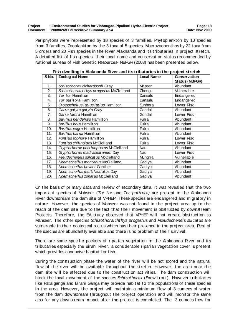
Periphytons were represented by 18 species of 3 families, Phytoplankton by 10 species from 3 families, Zooplankton by the 3 taxa of 5 species, Macrozoobenthos by 22 taxa from 5 orders and 20 Fish species in the River Alaknanda and its tributaries in project stretch. A detailed list of fish species, their local name and conservation status recommended by National Bureau of Fish Genetic Resources- NBFGR (2003) has been presented below.
Fish dwelling in Alaknanda River and its tributaries in the project stretch S.No. Zoological Name Local Name Conservation
Status (NBFGR) 1. Schizothorax richardsonii Gray Maseen Abundant 2. Schizothoraichthys progastus McClelland Chongu Vulnerable 3. Tor tor Hamilton Dansulu Endangered 4. Tor putitora Hamilton Dansulu Endangered 5. Crossocheilus latius latius Hamilton Sunhera Lower Risk 6. Garra gotyla gotyla Gray Gondal Abundant 7. Garra lamta Hamilton Gondal Lower Risk 8. Barilius bendelisis Hamilton Fulra Abundant 9. Barilius bola Hamilton Fulra Abundant 10. Barilius vagra Hamilton Fulra Abundant 11. Barilius barna Hamilton Fulra Abundant 12. Puntius sophore Hamilton Fulra Lower Risk 13. Puntius chilinoides McClelland Fulra Lower Risk 14. Glyptothorax pectinopterus McClelland Nau Abundant 15. Glyptothorax madraspatanum Day Nau Lower Risk 16. Pseudecheneis sulcatus McClelland Mungria Vulnerable 17. Noemacheilus montanus McClelland Gadiyal Abundant 18. Noemacheilus bevani Gunther Gadiyal Abundant 19. Noemacheilus multifasciatus Day Gadiyal Abundant 20. Noemacheilus zonatus McClelland Gadiyal Abundant
On the basis of primary data and review of secondary data, it was revealed that the two important species of Mahseer (Tor tor and Tor putitora) are present in the Alaknanda River downstream the dam site of VPHEP. These species are endangered and migratory in nature. However, the species of Mahseer was not found in the project area up to the reach of the dam site due to the fact that their movement is obstructed by downstream Projects. Therefore, the EA study observed that VPHEP will not create obstruction to Mahseer. The other species Schizothoraichthys progastus and Pseudecheneis sulcatus are vulnerable in their ecological status which has their presence in the project area. Rest of the species are abundantly available and there is no problem of their survival.
There are some specific pockets of riparian vegetation in the Alaknanda River and its tributaries especially the Birahi River, a considerable riparian vegetation cover is present which provides conducive habitat for fish.
During the construction phase the water of the river will be not stored and the natural flow of the river will be available throughout the stretch. However, the area near the dam site will be affected due to the construction activities. The dam construction will block the local movement of the species Schizothorax (Snow trout). However tributaries like Patalganga and Birahi Ganga may provide habitat to the populations of these species in the area. However, the project will maintain a minimum flow of 3 cumecs of water from the dam downstream throughout the project operation and will monitor the same also for any downstream impact after the project is completed. The 3 cumecs flow for

Project : Environmental Studies for Vishnugad-Pipalkoti Hydro-Electric Project Page: 19 Document : 2008026/EC/Executive Summary /R-4 Date: Nov 2009
aquatic survival will be essential during the lean period especially in the initial critical stretch up to 2.69 Km downstream of dam where next tributary with sufficient discharge namely Tapan Nala joins the river.
Fish management program has been undertaken by THDC Ltd. in consultation with the Department of Fisheries, GoUK / Directorate of Cold Water Fisheries (DCFR), ICAR, Bhimtal. The Senior Scientist from DCFR Bhimtal have already visited the project site for identification of suitable site for establishment of Snow Trout hatchery for fulfillment of fishery action plan towards restoration of aquatic ecosystem. The MoU for implementation of Fishery Action Plan is under process. The Mahseer hatchery already constructed at the Tehri Dam on the Bhagirathi River is used for propagation of the Mahseer. The catchment of Birahi river can be improved by plantation along the bank. The anthropogenic activity like extraction of sand, pebbles, gravels and stones and fishing activity in the river should be completely banned. In the event that Mahseer do in fact appear in the project area, efforts for complete diversion of route of Mahseer towards Birahi River may be made for effective management of Mahseer and other vulnerable fishes in the region. For in-depth study on fish potential and fishery biology in addition to aquatic biodiversity, any institute which has a reputation of undertaking this kind of work can be consulted. For that purpose, Department of Environmental Sciences, HNB Garhwal University (A Central University), Srinagar Garhwal, Uttarakhand is recommended for further consultation.
7.3 Construction related Impacts
During construction phase Construction / Labour Camp will be located along the project area. The project construction is likely to last for a period of about 5 years. The peak labour strength likely to be employed during project construction phase is about 2,000 workers and 600 technical staff. The establishment of labour camps is likely to affect environment through improper waste (Solid & Garbage / Sewage) disposal, negative impacts on public health, unfriendly use of community resources, poaching of wildlife by laborers, and leaving dirty and waste material after shifting from one site to another site. Laborers may cut trees for cooking fuel. There is possibility of transmission of diseases by immigrant labour population. t The improper disposal of muck generated from construction of structures could have negative impacts in the area, in particular on the river. The construction of new roads involve hill cutting that triggers soil erosion & landslides, generation of solid wastes in the form of debris, dust pollution, disturbance of local drainage, siltation in nearby water bodies.
Management of construction related impacts: Management of construction related issues will be the responsibility of THDC (through Contractor, as and where relevant and described in the EMP). The construction agency is required to comply with the laws with respect to Environment protection, Pollution Prevention, Forest Conservation, Resettlement and safety and any other applicable law. The EMP constitutes of Emission and Dust Management Plan, Construction / Labour Camp Management, Borrow Area Management Plan, Public Health (including plan to manage HIV / communicable diseases) and Safety, Green Belt Development etc.
(a) Muck Disposal Management: The total quantity of muck to be generated is estimated at about 1.5 Mm3. A muck disposal plan has been provided in the EMP to manage this muck. The plan includes: reuse of part of muck as construction material for the project,

Project : Environmental Studies for Vishnugad-Pipalkoti Hydro-Electric Project Page: 20 Document : 2008026/EC/Executive Summary /R-4 Date: Nov 2009
site protection, rehabilitation measures which includes civil works, vegetative measures, fencing and planting. As the selected four muck disposal sites are located close to the Alaknanda River, there is a chance that muck / loose material may fall into the river, leading to blockage in river flow or contamination of water due to silting. To avoid this, retaining walls of height up to 7m shall be built prior to the commencement of muck dumping at identified muck disposal sites. Plantation shall be carried out at the disposal sites for the stabilization of the slopes, landscaping and improving the aesthetic value of the area. Once dumping activities are completed, the areas shall be developed into terraces and restored by laying of soil on the top and digging of pits and planting of plant saplings.
(b) Labour Camp Management: To ensure good health of the workers and hygienic conditions around the labour camp, the EMP calls for the provision of certain measures, such as: One community latrine for 20 persons, sewage treatment, one septic tank for 500 persons, Storm water drainage, Medical and first aid facilities and awareness camp on health and hygiene. In addition solid waste management and provision of kerosene / LPG for cooking and Community kitchen shall be encouraged. The contract for main civil works contract places similar obligations on the contractor.
(c) Road Construction and Management : The construction of new roads involves hill cutting that triggers soil erosion & landslides, generation of solid wastes in the form of debris, dust pollution, disturbance of local drainage, siltation in nearby water bodies. The EMP provides measures for muck disposal, slope stabilization drainage and bioengineering measures to protect the road slopes. The Project will utilise the existing road of PWD as part of the approach road to Dwing Adit. The old PWD road will be utilised from NH- 58 to River Alaknanda hence no new road cutting will be involved on the left bank for this reach. This will reduce the impact of road construction. The EMP also includes measures to control air and noise pollution. Regular water sprinkling on construction sites, haul & unpaved roads particularly near habitation will be undertaken to control fugitive dust. Trucks carrying soil, sand and stone should be duly covered to avoid spilling. Plants, machinery and equipment will be handled so as to minimize generation of dust. All crusher, machineries, vehicles and equipments used in construction shall conform to relative dust emission standards of CPCB.
7.4 Safety of Workers and Communities
THDC has adopted a Safety Manual which describes a system approach using an established standard similar to the well known ISO 9001 standards. The manual also stipulate the obligation to ensure effective health and safety management at site / in Plant, Safety Programme and its Implementation, Fire Prevention, Fire Fighting Arrangements, First Aid and Medical Care. At every work site adequate and suitable arrangements for rendering prompt and efficient first aid to injured persons shall be maintained under the guidance of the medical officer-in-charge of the project. First aid appliances including an adequate supply of sterilized dressings and sterilized cotton shall be maintained in a readily accessible place. The appliances shall be kept in good order and they shall be placed under the charge of a responsible person who shall be readily available during working hours. The contract for the main civil works contract puts these obligations on the contractor.

Project : Environmental Studies for Vishnugad-Pipalkoti Hydro-Electric Project Page: 21 Document : 2008026/EC/Executive Summary /R-4 Date: Nov 2009
Downstream Hazards
The downstream hazards were assessed for the worst-case scenario in which the dam is washed away. The downstream hazards may occur due to failure of the dam and flooding of the river bank that triggers landslides. The water will flow with force, eroding the banks and causing damage to life and property located at the lower elevation. Most of the villages are located at higher elevations and there are no villages located close to the banks of the river Alaknanda. The villages which are located at lower elevations may suffer loss of property and life. The detail of villages is depicted in the EA. The villages may not be impacted directly but may be impacted in terms of loss of access route and agricultural land. THDC’s Dam safety programme include a Disaster management plan to establish an effective Dam Safety Surveillance and Monitoring Programme, including rapid analysis and interpretation of instrumentation and observation data periodic inspection and safety reviews/evaluation by an independent panel of experts to formulate and implement an Emergency Action Plan to minimize, to the maximum extent possible, the probable loss of life and damage to property in the event of failure of dam.
7.5 Indirect Impacts
Indirect impacts are associated with various construction activities such as clearing of vegetation for establishment of various project units, movement of vehicles, construction equipments & machineries, interferences due to influx of laborers as well as temporary establishment of labour camps, blasting operations etc. These could impact on the project vicinity area and communities. The major positive effect of the VPHEP project will be creation of new job opportunities in the area. Development of Vishnugad Pipalkoti Hydro-electric Project is likely to trigger associated development in several sectors such as transportation, automobile, commercial sectors such as daily needs, agriculture related developments such as vegetable, fruit, grain, fertilizer, pesticides, irrigation, electric appliances, which is likely to provide employment opportunities for local people and help to increase their social & economic status. The possible negative impact relates to transmission of diseases by immigrant labour population. Indirect impacts of project activities on flora are expected in the project immediate influence area and to some extent in project influence area. Indirect impacts will be due to various construction activities such as generation of dust due to earthwork, excavation, transportation of construction materials (sand aggregate, cement etc), quarry, crusher & blasting operations, air pollution due to movement of construction vehicles, equipments and machineries, influx of labour population and pollution generated through provision of labour camps established temporarily at construction sites etc. These impacts will be limited to the construction period. The project will take necessary measures to control dust during construction period. The mitigation measures to be adopted have been suggested in the EMP for implementation under the project.
7.6 Impact on Physical and Cultural Resources
The project does not have any impact on cultural resources within the project influence area and project immediate affected area. There are sites of Cultural importance at Siyasain near the proposed colony area. There are remains and abandoned structures of Haat (bazaar) and transit camps of the pilgrimages that used to halt at this place en-route to Badrinath from Chamoli and vice-versa in earlier times. These structures are in

Project : Environmental Studies for Vishnugad-Pipalkoti Hydro-Electric Project Page: 22 Document : 2008026/EC/Executive Summary /R-4 Date: Nov 2009
a bad state of conservation and preservation. Therefore it is suggested to conserve and preserve those portions of the structural members of such building which can be restored and preserved.
There are number of temples in the villages in the project area. It is suggested that the temples falling in the villages on the right bank of river Alaknanda may be considered for enhancement and beautification. These villages are Tirosi, Tapon, Dwing, Kimana, Palla, Lanji, Pokhani, Hyuna, Guniyala, Biamaru, Surenda, Kanda, Bedumath, Bajani, Math Jharetha, Haat, Siyasain, Jaisal, Durgapur, Kunj, Bowala and Chhinka.
In case of discovery of any archeological monuments, pottery, coin and artifacts the construction contractors will report to the concerned THDC official responsible for the supervision of the construction activity. The concerned THDC official in turn will report this to Archeological Survey of India. Any Archeological/Historical items and artifacts found during construction will be the property of Govt. of India. A chance find procedure has been included in the EMP.
7.7 Dam Safety
Dam safety programme includes the formation a Disaster management plan to establish an effective Dam Safety Surveillance and monitoring programme including rapid analysis and interpretation of instrumentation and observation data periodic inspection and safety reviews/evaluation by an independent panel of experts and to formulate and implement an Emergency Action Plan to minimize the probable loss of life and damage to property in the event of failure of dam.
The EAP presents warning and notification procedures to follow during the monsoon season in case of failure or potential failure of the dam. The objective is to provide timely warning to nearby residents and alert key personnel responsible for taking action in case of emergency. It also includes evacuation plans and procedures for implementation based on local needs. Any precarious situation during floods will be communicated either by an alert situation followed by a warning situation. An alert situation would indicate that although failure or flooding is not imminent, a more serious situation could occur unless conditions improve. A warning situation would indicate that flooding is imminent as a result of an impending failure of the dam. It would normally include an order for evacuation of delineated inundation areas. The alerts and warning shall be communicated to State Administration through wireless/telephone besides local radio/television/news paper and to local population through loudspeakers and warning sirens.
7.8 Catchment Area Treatment & Other Environmental Enhancements
Common anthropogenic factors leading to erosion in the catchment area are over-grazing and collection of trees for fuel fodder and timber. The project activities will accelerate the soil erosion in the area significantly in the construction phase. A well-designed Catchment Area Treatment (CAT) Plan is framed to address the issue and ameliorate the environment of the area.
The Plan includes 37 micro watersheds in 5 sub watersheds namely Saraswati, Dhauliganga, Rishigang, Budhiganga & Nagoigad. But as various CAT plans are already

Project : Environmental Studies for Vishnugad-Pipalkoti Hydro-Electric Project Page: 23 Document : 2008026/EC/Executive Summary /R-4 Date: Nov 2009
under implementation in this catchment particularly Tapovan Vishnugad CAT plan, only 18 micro watersheds in 2 sub watersheds namely Budhiganga and Nagoigad have been selected for treatment. The total area of selected catchment is 84085.00 ha. Out of which, 12964.00 ha (15.42%) is rocky and snowbound. The remaining area of 71121.00 ha (84.58%) is treatable, of which, agriculture area is 6647.00 ha (7.90%), forest area is 40678.00 ha (48.38%) and blank area is 23.796 ha (28.30%). Therefore, total workable area is 71.121 Sq. Km. The total Budget for CAT plan is Rs.44,66,64,900/-
Project will give maximum emphasis on catchment treatment through plantation, soil and water conservation works. The biodiversity conservation measures shall be carried involving local inhabitants that will also enhance the livelihood of the people of the area. The interventions proposed in CAT plan are Forestry Work which includes afforestation work, densification, medicinal plant plantation and assisted natural regeneration in the area. A total of 1000 ha. area shall be treated for plantation activities. Out of this, 450 ha. area will be taken under densification, 50 ha. under pasture development and 300 ha under medicinal plants. Apart from this, around 1200 ha. area has been selected for assisted natural regeneration. Soil & Moisture Conservation Engineering Work comprise of construction of Vegetative check dams, Gully Plugging, Stone check dams , Crate wire check dams , Spurs and Water percolation tanks .
The CAT plan earmarks the provision for selected inputs in livelihood support activities for the local community, which would facilitate eco-restoration as well as eco-development of the catchment area. Education and awareness of the community for catchment development on watershed approach will be central to all these activities. Apart from this, special care is to be taken on decreasing dependence of the local people on forest areas. For this special effort will be done by raising forest on Civil Soyam and Van Panchayats and doing pastoral development activities
The responsibility of implementing the CAT plan will lie with the concerned Divisional Forest Officer (DFO). THDC will responsible for overall supervision of the CAT Plan implementation. The Environmental Management Cell (EMC) of THDC will supervise the implementation of each activity given in the CAT plan. EMC will also monitor physical & financial progress and prepare a quarterly progress report. Year wise fund will released by THDC for which a Memorandum of Understanding (MoU) may be signed between THDC & Forest Department.
The project will form a MoU with Directorate of Cold Water Fisheries (DCFR), ICAR, Bhimtal, for management of fish. For management of Mahseer (Tor tor and Tor putitora) TEHRI Mahseer hatchery will be utilised. For management of Snow trout, Gram Panchyats can be involved along with DCFR, ICAR, Bhimtal. DCFR will provide the technical assistance and the Gram Panchayats will be involved in intensive culture of fish. This will be an income generating activity for the local inhabitants and also provide nutrition to the malnourished population of the area. Thus it will contribute in enhancing the living condition of the people in the area.
7.9 Land Acquisition and its Impact
A Social Impact Assessment (SIA) for the project area was completed in April 2008. It included consultations with stakeholders, information on socio-economic and cultural features of the population and baseline data on land acquisition impacts. This

Project : Environmental Studies for Vishnugad-Pipalkoti Hydro-Electric Project Page: 24 Document : 2008026/EC/Executive Summary /R-4 Date: Nov 2009
information together with consultations with communities in the project area regarding their concerns, and subsequent verification and updating by THDC of the SIA data on impacts have informed the measures to ensure that negative impacts are mitigated and that people receive benefits from the project.
To address land acquisition impacts, THDC has developed a project-specific Resettlement and Rehabilitation Policy which goes beyond the requirements of the National Resettlement and Rehabilitation Policy (NRRP) of 2007 and which together with the Resettlement Action Plan establishes compliance with the World Bank’s OP 4.12. At THDC’s headquarters, a Corporate Environment and Social Group is headed by a General Manger (Social and Environment) who is supported by a Senior Manager and a Manager at both the corporate office and at the project site. The team at the project site includes two social workers soon to be supplemented with two more. A reputed regional NGO has been recruited to assist with communication with the villagers, preparation and implementation of the Resettlement Action Plan (RAP), and preparation of local development activities. In line with the NRRP, 2007, the state government has appointed an Administrator and Commissioner for R&R, and established grievance redress arrangements.
Land Acquisition: As a run-of-river project, VPHEP has comparatively limited land acquisition impacts which affect a total of 1,223 households (1,477 families with 5,159 persons) in 19 villages. The project will require a total of 141.55 ha of land comprising 31.62 ha of private land, 90.09 ha of government forest/grazing land, 10.3 ha of van panchayat land (community held grazing and forest land), and 9.54 ha of state land owned by the Public Works Department.
Project Components and land requirement (July 2009) Project Component Area to be acquired (in ha.) 1 Dam and reservoir 29.95 2 Access roads 21.66 3 Quarry 11.71 4 Excavation dumping sites 5.04 5 Colony, power house, switchyard & TBM
assembly 63.65
6 PWD roads 9.54 Total 141.55
The acquisition of private land affects 769 families in seven villages, while 708 families in the remaining 12 project-affected villages will lose partial access only to government forest/grazing and/or van panchayat land. Of the private land required, 60% is being purchased from willing sellers in one of the seven affected villages - Haat. The transfer of land and houses in Haat is based on land acquisition procedures to ensure complete recording of ownership and on the compensation and assistance provisions in THDC’s Resettlement and Rehabilitation Policy. A total of 265 families will have to resettle, and 92% of these are families from Haat who requested THDC to purchase their land.
Haat village: After protracted negotiations THDC agreed to a demand from the village Haat, that the company acquire land and houses from anyone in the village who wished to relocate. THDC agreed to consider buying the additional land in recognition of the disproportionate impact on the village of land acquisition and construction disturbance from the powerhouse, switchyard, a surge shaft, and access roads. A total of 136

Project : Environmental Studies for Vishnugad-Pipalkoti Hydro-Electric Project Page: 25 Document : 2008026/EC/Executive Summary /R-4 Date: Nov 2009
households (242 families) from Haat agreed to sell their land and houses amounting to 18.64 ha to THDC. Of the 136 households whose houses are acquired, only 95 reside in the village. The other 41 households who own houses or are part-owners of houses in Haat have already migrated and settled elsewhere over the years. Only in the hamlet of Hatsari did 8 of the households (11 families) not agree to this arrangement, since unlike the other 136 households they did not have alternative land or houses outside the main Haat village. To limit land acquisition impacts on Hatsari, THDC has therefore shifted the location of the switchyard from land to be acquired from this hamlet to already acquired government forest land, and has also realigned an access road. The land acquisition impacts on 8 households were reduced to 1.63 ha, and the total amount of private land obtained from Haat is 20.27 ha. With the recent decision to use Tunnel Boring Machine (TBM) instead of Drilling & Blasting Method (DBM) to excavate the Head Race Tunnel (HRT), THDC will make use of all the land acquired in Haat, since a substantial area shall be required for assembling the TBM.
Private land: An analysis of the loss of agricultural land shows that 32% of the affected landholders are losing less than 10 percent of their total holdings. Five landowners will be rendered landless and 264 landholders are losing more than 75% of their land. About 30 landowners will be left with less than a Naali (the basic local unit of land = 1/50th ha = 200 sq.m) after land acquisition, and therefore all their land will be acquired. Even if the amount of agricultural or residential land acquired is less than one Naali, the minimum compensation will be equivalent to 1.5 Naali. The majority of the affected land owners (about 96%) across various impact categories were marginal farmers with holdings below 1 ha prior to the land acquisition. In the village of Lungsi farmers along an existing PWD road, which needs widening as a project access road, have encroached into the right-of-way, and a total of 5.92 ha are utilized by 46 farmers who will be compensated for the value of their standing crops when the land is repossessed.
Grazing and forest land: Villages use both government land and van panchayat land for grazing and fodder collection. Van panchayats were formed from 1921 onwards for the use and management of forest and grazing land by village communities. A total of 11 villages will lose access to an average of 2.5% of the government forest land that they use at present for grass collection and grazing, and a total of 8 villages lose access to an average of 0.9% of the van panchayat land they use for grazing and collection of grass and firewood. Of these villages, 3 lose access to both government forest and van panchayat land.
Buildings and resettlement: A total of 139 private structures and 31 community properties will be acquired under the project. Of the private structures, 99 are residential, 5 are residential and commercial, 3 are only commercial, and the remaining 32 are cattle sheds or dilapidated structures. Of the families losing their houses, three are non-titleholders, who will nevertheless receive the minimum land compensation of INR 100,000. Of the 104 residential and residential / commercial houses to be acquired, 94 are in Haat, and the remaining are in the villages of Jaisal (6) and Batula (4). All the families that will be resettling have chosen to move to locations of their own choice. In addition to the house compensation – which in the case of Haat equals the agreed selling price – all the relocating households that are resident in the houses acquired (including the non-titleholders) will receive the additional INR 1 million for self-resettlement to substitute for the infrastructure they would have access to in a resettlement site.
Project : Environmental Studies for Vishnugad-Pipalkoti Hydro-Electric Project Page: 26 Document : 2008026/EC/Executive Summary /R-4 Date: Nov 2009
Most of the households in Haat own either a house or land in the adjacent villages of Maina, Daswana, and Mayapur on the other side of the river. There are 17 Scheduled Caste households (29 families) from Haat most of whom hold agricultural patta land – granted by the government and allocated by the Gram Panchayat to landless families – in Daswana. A special permission is required from the District Magistrate to build houses on this land, and THDC will facilitate this. Whereas the NRRP of 2007 does not provide for compensation for patta land, THDC is paying compensation equivalent to land held as private property (Naap land). This enables the three Scheduled Caste households, who do not have land outside Haat, to buy replacement land with the payment they receive for their patta land.
Facilities: Since the affected families that will have to relocate have chosen to move individually to locations of their own choice where most already own an alternative house, THDC will not establish resettlement sites. In the case of Haat, the relocation will be across the river where people will be closer to the schools and health facilities that they already use. For the Scheduled Caste families from Haat who are moving to Daswana and building new houses there, THDC will provide a road connection to the site and access to electricity and water.
Indigenous Peoples: There is no Scheduled Tribal community in the project affected area, and the World Bank’s OP 4.10 on Indigenous Peoples is not triggered. The population in the project affected villages is predominantly Hindu general castes (about two-thirds) and scheduled castes (one third). In Haat the affected population includes 11 Bhotia families (8 households) who migrated from Malari near the Hindu pilgrimage site of Badrinath on the upper reaches of the Alaknanda river 15 years ago and settled in the village. Another project affected Bhotia household resides in Batula. Of the families settled in Haat and Batula, some have acquired marginal landholdings while others are tenants, and some hold government jobs. They still hold land in their original home area. The Bhotia families do not speak a separate language from that of the majority population (Garhwali and Hindi) and are Hindus. They do not have a historically based collective attachment to the land in Haat or any customary rights to forest and grazing land. Nor do they or have political institutions that separate them from the majority population. The Bhotia families affected by land acquisition will receive compensation and assistance based on the provisions of the R&R Policy.
Local development and benefit sharing: Although the project causes adverse impacts, it will also bring positive benefits to the local population. Two categories of local development funds will be available which include (i) dedicated funds of INR 90 million that will be used for the 19 affected villages over five years during the construction period (THDC has already spent an additional INR 5 million from other sources during the current financial year); and (ii) as mandated by the Corporate Social Responsibility Policy of THDC, one percent of the plant’s profit will be available for local development activities in a wider area comprising both directly and indirectly affected communities after the commissioning of the Project. The modalities for utilization of the one percent will be determined when the state Hydro Benefit Sharing Policy, which is currently being drafted, has been completed. However, for the first category, investment plans will be prepared by the communities. Civil works will be carried out by contractors or by the Gram Panchayats with monitoring by the beneficiary community. In addition, during the construction period, contracts for small civil works will to the extent possible be given to

Project : Environmental Studies for Vishnugad-Pipalkoti Hydro-Electric Project Page: 27 Document : 2008026/EC/Executive Summary /R-4 Date: Nov 2009
eligible PAPs. THDC will also provide 100 kWh of free electricity per month for a period of 10 years to affected households.
7.10 Lessons learnt from Tehri Project Tehri Dam Project was approved by the Planning Commission in 1972 and was accorded the administrative clearance in 1976 by Uttar Pradesh Government. Various Project activities related to R&R and Catchment Area Treatment (CAT) works started during 1976 to 1978. Forest (Conservation) Act came into existence in 1980; Environmental (Protection) Act came into existence in 1986 while National Forest Policy was framed in 1988, National Environment Policy in 2006 and National Water Policy in 2002, thus there were no guidelines and hence there was no clarity about environmental safeguards. The National R&R Policy was adopted in 2007. The EIA notification of 19994 has been revised in September 2006. In view of the above, there were no guidelines at that time on R&R as well as environmental aspects. Following experience were gained from implementation of Tehri Hydropower Project:
The “CAT” programme should be developed by the Project in consultation with the State Forest Department keeping in mind (i) the results of fauna study, (ii) botanical species required for the desired fauna considering the fauna study, and (iii) soil conservation works in direct draining areas. CAT plan should include plantation of all types of the area including fruit bearing plants, medicinal plants, herbs and shrubs etc. The CAT plan should be implemented by Forest Department of the State Government, adopting their Joint Forest Management (JFM) Scheme.
Compensatory afforestation should fulfill the requirement of an ideal forestry, that is: Supply of forest goods and services to the people with a well thought out plan of production; and long term ecological security through conservation of forest cover and its restoration. A massive social forestry programme is needed to meet the demands of local people for fuel, fodder, timber etc. Compensatory afforestation in the same eco-system is more effective and compensates the damages due to deforestation in that ecosystem.
Measures should be taken for propagation of Fisheries
Stabilization of Hill Slopes and Reservoir Rim
A plan for re-vegetation of muck disposal sites should be adopted.
Treatment of borrow areas, abandoned quarries should be undertaken by the project.
People displaced from the affected areas may not be moved up-stream of the watershed as, use of forest and cultivation by them can change land use pattern and increase soil erosion, leading to increased sedimentation thereby reducing storage capacity and affecting water quality. Therefore, it is always advisable to resettle the displaced families in the plains or command area of the Project.
Employment provision to local inhabitants for unskilled work.
Promotion of improved ecotourism.

Project : Environmental Studies for Vishnugad-Pipalkoti Hydro-Electric Project Page: 28 Document : 2008026/EC/Executive Summary /R-4 Date: Nov 2009
EIA and SIA study should be conducted and a detailed Environmental and Social Management and Monitoring plan should be framed.
With the benefit of the lessons learnt during implementation of the Tehri Dam Project, THDC Management has taken a conscious decision to initiate actions on all the above aspects with respect to VPHEP. Thus, for VPHEP, works relating to Catchment Area Treatment, Compensatory Afforestation, Hatcheries for fish propagation, Resurfacing / Revegetation of Muck Disposal Sites, Quarry and Borrow area Relocation and Rehabilitation of Project Affected People have already been taken up or will be taken up shortly, as appropriate.
8. ENVIRONMENTAL MANAGEMENT PLAN Environmental Management Plan (EMP) is the key to ensure a safe and clean environment. The desired results from the environmental mitigation measures proposed in the project may not be obtained without a management plan to assure its proper implementation & function. The EMP envisages the plans for the proper implementation of mitigation measures to reduce the adverse impacts arising out of the project activities during pre-construction, construction and operation stage. Details on all the aspects and budget provisions have been detailed in the Consolidated EA & EMP Report. A monitoring plan is framed to monitor the implementation of activities provided in EMP. A summary of budget provisions of EMP is detailed below.
Summary of EMP Budget
S. No.
Item Activities proposed Cost
(Rs. million)
1. Biodiversity Management Development of Herbal garden, Compensatory afforestation, Roadside plantation, Wildlife protection
66.60
2. Implementation of CAT Plan
Forestry work, Soil & moisture conservation, Wildlife management, Capacity building and exposure visit, Village level development and livelihood support, Income generation activities, PMC running cost, Alternate Energy support, Fish management, Construction & Renovation works, micro-planning etc
470.095
3. Muck Disposal Management Plan
Plantation on spoil slope, Turfing of slopes, Fencing, nursery development & maintenance, Watch & ward and 4 portable pumps
19.783
4. Fish Management Transportation of seeds from TEHRI Mahseer hatchery, Management of Snow trout, Habitat restoration.
11.400
5. Greenbelt Development Plan
Plantation of trees, shrubs and herbs 6.153
6. Restoration of Quarry Sites
Filling up the excavated site, Green manure, , fertilizer, pesticides , fencing maintenance and watch & ward
5.000
7. Solid Waste Management Two covered truck for transportation of solid waste to landfill site, 10 persons for 5 years
9.799
8. EMP Measures for Road Clearing & grubbing, Breast wall catch water interceptors 9.000

Project : Environmental Studies for Vishnugad-Pipalkoti Hydro-Electric Project Page: 29 Document : 2008026/EC/Executive Summary /R-4 Date: Nov 2009
S. No.
Item Activities proposed Cost
(Rs. million)
Construction and drainage system along road
9. Sanitary Facilities for Labour Camps
Community Latrines, Septic tank including sewerage system
12.500
10. Provision of Fuel LPG Cylinders and Kerosene 1.000
Public Health Delivery System
Establish Dispensary and First Aid Centers, employ medical staff, Medicine, Ambulance
37.300
11. Environmental Monitoring Programme
Monitoring of Water Quality, Ambient Air Quality, Noise, Soil Erosion and Sedimentation, Incidence of water related diseases, Aquatic ecology, landuse (CAT)and Soil quality
22.310
12. Adaptive Capacity Corporate recruitment, special studies, lab set-up 64.080
13. Capacity Building Environmental Training and exposure visit of THDC Staff 21.38
14. ISO 14001 / OHSAS Formulation of Quality Manual & Quality Procedure, implementation of EMS, Hiring of consultant, OHSAS
2.00
15. Archaeological Management
Conservation of Archaeological sites, opening of Archaeological Museum
2.50
Grand Total 760.900
9. IMPLEMENTATION ARRANGEMENT
9.1 Institutional Framework The THDC India Ltd. is headed by Chairman & Managing Director. The Board of Directors constitutes of total 12 executive staff. There are 3 Director - Personnel, Technical and Finance in the board. For taking care of Environmental affairs a Social & Environment Department headed by General Manager assisted by Senior Managers and Senior Environmental Officers is established at Corporate Office, Rishikesh. The functions of Corporate Environment Department include:
Obtaining statuary and Non-statuary clearances, viz. Site / Environment Clearances, Forest Clearance, Wild Life Clearance and No Objection Certificate from SPCB etc.
Coordination and interaction with MOP, MOEF, SPCB etc.
Coordination with the Project on environmental matters and providing required assistance/ inputs
Compliance reporting to statuary/ monitoring agencies.
Monitoring of all environmental studies / implementation of environmental conditions.
Policy related issues, viz National Environment Policy, NPV for Forest Land transfer, apportionment of CAT etc.

Project : Environmental Studies for Vishnugad-Pipalkoti Hydro-Electric Project Page: 30 Document : 2008026/EC/Executive Summary /R-4 Date: Nov 2009
Material for Standing Committee of Parliament reply of Parliament/ Assembly Questions related to environment and other VIP references
At VPHEP it is proposed to form an Environmental Management Cell (EMC) at project level. The EMC will handle all issues related to different environmental attributes, it will be responsible for overall environmental management in project being undertaken by THDC from investigation level to execution at project level. EMC will be strengthened by posting at least one specialized Environment specialist and one Social specialist at each project site. However during execution stage of various environmental mitigation measures, the individual teams can be reinforced from the Corporate Environment team.
VPHEP Social and Environment Cell (EMC)
The Social and Environmental Cell will be responsible for the planning, implementation and monitoring of all environmental and social mitigation and compensation measures under THDC’s responsibility outlined in EMP, R&R policy and RAP.
Implementation of community development initiatives through its NGO under CSR. The cell will monitor mitigation measures that will be implemented by Contractor to
ensure compliance with Constructor’s Contract (CC). The cell will work closely with the State Pollution Control Board (SPCB) and MoEF, as
appropriate. The cell will prepare regular reports for submission to SPCB and MoEF. During the construction and the operating phases, THDC, through the cell, will be
responsible for Implementing and monitoring environmental mitigation measures. The cell will work closely with the Administrator and Commissioner of R&R for land
acquisition and implementation of RAP. The cell shall also be responsible for hiring of consultants and NGO. The cell shall provide policy guidance to consultants and NGO
The Construction Contractors
Meeting effluent standards before discharging into surface water Managing waste at construction sites Muck disposal Location of construction camps at proper place - away from Forest Area and
Settlements Arrange fuel for the construction camp – no tree cutting for fuel and hut making for
the camp Manage erosion and sedimentation in construction area Managing onsite traffic- provide diversion signs/flags/guard along approach road Control noise emissions Control dust and fugitive emission. Managing, preventing and developing emergency plans for chemical pollution
incidents Implementing a health program for all persons engaged in undertaking construction
works
Project : Environmental Studies for Vishnugad-Pipalkoti Hydro-Electric Project Page: 31 Document : 2008026/EC/Executive Summary /R-4 Date: Nov 2009
State Forest Department
Implementing Catchment Area Treatment (CAT) plan Implementing Compensatory Afforestation Plan Wildlife Conservation Program Develop Herbal Garden in consultation with State Medicinal Plant Board (SMPB) Facilitate and guide Van Panchayats.
Administrator - R&R
Approval of award passed by Land Acquisition officer Oversee the disbursement of compensation for land acquired Formulation of Resettlement and Rehabilitation plans/schemes Minimize displacement of persons and identify non-displacing or least displacing
alternatives in consultation with the project authorities Hold consultation with the PAPs and ensure the interest of adversely affected PAFs of
STs and weaker sections Verification and approval of PAFs eligible for various entitlements Issuance of individual certificates to the land less people and those loosing houses Review the implementation of RAP and community development works
NGO (engaged by THDC)
Develop rapport with PAFs and between PAFs and THDC Verification of PAFs Consultations with the VDAC and local community during the implementation of the
RAP Preparation of micro plans and assist the PAFs in receiving the rehabilitation
assistance Motivate and guide PAP for productive utilization of the compensation and assistance
amounts Assist the PAFs in getting benefits from the appropriate local development schemes Forward the grievances of the PAFs to the grievance redressal mechanism Assist the PAFs in usage of modern techniques in agriculture and animal husbandry Assess the level of skills and efficiency in pursuing economic activities, identify needs
for training and organize training programmes Participate in the monthly review meetings with the Project Social Group and VDACs Carry out other responsibilities as required from time to time
Van Panchayats
Protection of plantation sites in the project area Regulate usage of Vanpanchayat resources Cultivation of Herbal species Develop nurseries for Plantation under the Project area

Project : Environmental Studies for Vishnugad-Pipalkoti Hydro-Electric Project Page: 32 Document : 2008026/EC/Executive Summary /R-4 Date: Nov 2009
9.2 Responsibility Matrix
The EMP envisages the plans for the proper implementation of mitigation measures to reduce the adverse impacts and enhance positive impacts arising out of the project activities during pre-construction, construction and operation stage. The responsibility matrix defines the agency responsible for execution and supervision of mitigation measures in pre-construction, construction and operation phase.
Pre-Construction Stage Responsibility Sl.
No. Environmental and Social Issues
Planning and Execution Supervision/ Monitoring
1.
Acquisition of Forest land State Forest Department, EMC of THDC
THDC
2. Felling of Trees State Forest Department, EMC of THDC
THDC
3. Clearing & Grubbing The Contractor Social and Environmental Cell
4. Construction vehicles, equipment and machinery
The Contractor Social and Environmental Cell
5. Labour requirements The Contractor Social and Environmental Cell
6. Construction camp – location, design and lay-out
The Contractor Social and Environmental Cell
7. Arrangements for temporary land The Contractor Social and Environmental Cell
8. Orientation of Implementing Agency and the Contractors
EMC / THDC Social and Environmental Cell
9 Acquisition of private land Administrator – R&R Social and Environmental Cell
10 Relocation of displaced households Administrator – R&R / NGO Social and Environmental Cell
11 Income restoration training Administrator – R&R / NGO Social and Environmental Cell -
THDC 12 Disclosure of EMP, SIA and RAP NGO / THDC - 13 Disbursement of R&R assistance NGO / THDC -
Construction Stage
Sl. Environmental Responsibility No. Issues Execution/ Civil Work Supervision/ Monitoring 1.
Preservation of top soil The Contractor Environmental Expert of SC and EMC
2. Earth from Borrow Areas for Construction The Contractor Environmental Expert of SC and EMC
3. Quarry operation The Contractor Environmental Expert of SC and EMC
4. Construction water The Contractor Environmental Expert of SC and EMC
5. Construction of approach roads The Contractor Environmental Expert of SC and EMC
6. Muck disposal The Contractor Environmental Expert of SC and EMC
7. Water pollution from - construction wastes and fuel & lubricants
The Contractor Environmental Expert of SC and EMC

Project : Environmental Studies for Vishnugad-Pipalkoti Hydro-Electric Project Page: 33 Document : 2008026/EC/Executive Summary /R-4 Date: Nov 2009
Sl. Environmental Responsibility No. Issues Execution/ Civil Work Supervision/ Monitoring 8. Air pollution The Contractor Environmental Expert of
SC and EMC 9. Noise pollution The Contractor Environmental Expert of
SC and EMC 10. Safety The Contractor Environmental Expert of
SC and EMC 11. First aid The Contractor Environmental Expert of
SC and EMC 12. Labour Camp Management The Contractor Environmental Expert of
SC and EMC 13. Contractor’s Demobilization The Contractor Environmental Expert of
SC and EMC 14 Disbursement of assistance for loss of
Vanpanchayat land NGO / THDC -
15 Implementation of CSR activities THDC -
Operation Stage Responsibility Sl.
No. Environmental Issues Execution/ Civil Work Supervision/
Monitoring 1. Monitoring Operation Performance EMC THDC 2. Pollution Monitoring Pollution Monitoring Agency,
EMC THDC
3. Terrestrial Biodiversity State Forest Department/ EMC THDC 4 Implementation of CSR activities THDC
9.3 Capacity Building of THDC
THDC has successfully implemented environmental management measures of the Tehri Dam Project, Phase-1 of which is now fully operational. THDC has moved from single project (Tehri Dam Project) organization to multiple projects. At present THDC have 13 projects at National level and two abroad at various stages of investigation and development.
With increase in projects of THDC the increasing role of the organization is also felt. Requirement of qualified man power for the various Hydro Projects and enforcement of environmental activities at various stages - Construction, Commissioning, Operation & Maintenance phase, is essential. THDC is committed to the environmental management of the projects and a Social & Environment Department headed by General Manager assisted by Senior Managers and Senior Environmental Officers at Corporate Office is established.
THDC has already taken a number of actions to augment the capacity of the Social and Environment Department. For capacity building of environmental staff, a Capacity Building Plan has been prepared. It includes environmental activities at corporate level & project level, development plan for staffing of the EMC. Further, a detailed training plan has been prepared, which includes training for environmental staff of THDC at corporate & project level, training of contractor’s staff, training components, list of training institutes and budget for capacity building.

Project : Environmental Studies for Vishnugad-Pipalkoti Hydro-Electric Project Page: 34 Document : 2008026/EC/Executive Summary /R-4 Date: Nov 2009
9.4 THDC’s Environmental and Social Commitments
THDC believes in Corporate Social Responsibility (CSR) and is committed to fulfill its obligation towards the society. The CSR objectives of THDC include the following aspects:
To undertake community development in the neighborhood area of operating stations with particular focus on women, children, disabled persons and aged persons;
To create appropriate partnership with the concerned stakeholders for the
effective delivery of community development programs through consultation and participation.
To explore and work in various domains of community such as Health, Education,
Drinking water, peripheral development etc. on individual basis or partnership basis with the help of Government, NGO, Private firm etc. as per suitability to promote sustained livelihood, overall development and well being of the target communities.
10. ENVIRONMENTAL MANAGEMENT MONITORING
A monitoring plan is framed to monitor the implementation of activities provided in EMP. EMC, VPHEP in association with Corporate office shall be monitoring the EMP. However, a third-party monitoring for the implementation of the EMP will be conducted by an agency or a committee of experts who will visit the Project site twice a year to oversee and evaluate the EMP implementation and suggest improvements. In addition, THDC has retained an International Panel of Experts on Environment and social to advise THDC during preparation phase and this will continue in the implementation phase as well.
11. PUBLIC CONSULTATION AND DISCLOSURE
The project has engaged stakeholders including the project-affected people to discuss different aspects of the project over the last two years. THDC has organized community meetings, meetings with village elders and elected leaders of the villages. During the preparation of EA and social assessments, a number of informal but significant meetings were organized. As part of the regulatory clearance process, a formal public hearing was organized. At Haat village, a Public Information Centre (PIC) was set up on July 20,2007, where the local community and other stakeholders have full access. The PIC has been helpful for the local public in recording their views about the project. Additionally, THDC has also opened a PIC near its office in Pipalkoti on August 19,2008. A schematic 3-D model depicting all the proposed components of the project has been placed in PIC for Public Display. THDC has distributed tree saplings (around 1000) to the local project affected villages for plantation in their respective villages. THDC has undertaken extensive consultations on environmental issues, organizing two public meetings on EMP and RAP as per regulatory requirement. During the course of EA and additional environment studies, SIA & RAP, till August 2009, a total of 72 consultations on environmental and social issues have been held. There were eleven focused related to
Project : Environmental Studies for Vishnugad-Pipalkoti Hydro-Electric Project Page: 35 Document : 2008026/EC/Executive Summary /R-4 Date: Nov 2009
environmental issues during EA consolidation process and are recorded in the EA. The EIA report (based on which regulatory clearance for the project was granted) was disclosed before the formal public hearing, with assistance from the State Pollution Control Board. The revised updated EA/EMP prepared after incorporating recommendations of additional environmental studies and the RAP (including translation of the Executive Summaries in the local language, Hindi) is available in the PICs, offices of the affected panchayats, office of the District Magistrate/Collector/ SDM and in THDC’s corporate office at Rishikesh. All the documents are also available on THDC’s website, www.thdc.nic.in.
The availability of these documents was widely announced in the local newspapers (both English and Hindi newspapers) on 27 July 2009. These documents were also disclosed in the Bank’s Info shop on Sept 14, 2009. The draft reports will be replaced with the final reports once their final versions are endorsed by the Bank and the borrower. A public meeting was held on September 13, 2009 at project site to disclosure the EA/EMP and RAP.