geochemistry of a nonvolcanic geothermal area in pohon batu
TRANSCRIPT

PROCEEDINGS, 41st Workshop on Geothermal Reservoir Engineering
Stanford University, Stanford, California, February 22-24, 2016
SGP-TR-209
1
Geochemistry of Geothermal Area in Pohon Batu, West Seram Regency, Moluccas
Anna Yushantarti and Santia Ardi Mustofa
[email protected] and [email protected]
Keywords: Indonesia, Moluccas, Non Volcanic, Geochemistry
ABSTRACT
Indonesia has many geothermal areas which are associated with non-volcanic environment. One of them is Pohon Batu, West Seram
Regency, Moluccas. The geothermal manifestations are only Pohon Batu 1-7 hotsprings, the temperatures are about 40-60,9oC with
neutral pH. Physiographically, it is included Outer Banda arc non volcanic which is consisted of metamorphic rocks in the Permian-
Triassic. Pohon Batu has chloride-bicarbonate type of water based on Cl-SO4-HCO3 diagram and plots in partial equilibrium zone based
on Na-K-Mg diagram. The temperature of reservoir is about 175-220oC from Na-K geothermometry.
1. INTRODUCTION
Geothermal systems in Indonesia are associated with Quaternary volcanism (Sumatera, Java, Bali, Nusa Tenggara, Banda Islands, and
North Sulawesi) and non volcanic environment (Kalimantan, most of Sulawesi, Buru island, and Papua). By March 2015, about 324
geothermal locations have been identified with a total potential energy equivalent to 29 GWe (Center for Geological Resources, 2015).
Of all these locations, about 70 (25 %) are associated with non-volcanic environment with a total potential of more than 1 GWe.There
are about 4 geothermal areas in Seram Island, Indonesia. One of them is Pohon Batu geothermal area which is located at West Seram
district, Central Moluccas (Figure 1) or 460951-478870 mE and 9647537- 9632325mN at UTM zone -52. Pohon Batu, is a non volcanic
geothermal area. Indonesia non-volcanic geothermal systems have not been utilized as a source of electrical energy, because of the lack
of understanding for the non-volcanic geothermal system. This study describes the characteristics of fluids and the conditions of the
Pohon Batu non-volcanic geothermal area.
Figure 1: Map Location of Pohon Batu geothermal area
2. GEOLOGY BACKGROUND
Regionally, based on geology regional of Ambon and Masohi, Moluccas, (Tjokrosapoetra, et al, 1993), Seram, Boano, Kedang, and
Manipa island is located at Outer Banda Arc, Seram island incorporated into the Neogen Imbrication zone. Rocks in the investigation
area consists of non-volcanic rocks aged Permian (Paleozoic) until Holocene (Figure 2). Pohon Batu regional geology is composed of
non-volcanic rocks consisting of metamorphic and sedimentary rocks. The establishment of a geothermal system in the research area is
closely related to tectonic activity which is still active today.
The oldest rocks outcrop that can be discovered in the research area is Phyllit with Perm age. The younger lithology is Schist of Perm.
The younger lithology is sedimentary rock, Conglomerate with Pliocene –Pleistocene age. The younger than Conglomerate is Limestone
with Holocene age. The youngest unit is alluvium.
Geological structure of the research area, generally has northwest-southeast and southwest-northeast orientation. That faults may
controlled the occurrence of hotsprings in the research area
Geothermal system of Pohon Batu area could be formed by the presence of thermal residue of magma chamber which associated with
young plutonic activity. The activity caused igneous intrusion in fracture zone. The intrusive rocks didn’t appear to the surface in the
research area. The intrusive rocks estimated formed by collision between Seram Island and Australia Plate (Plate Collision) that caused
magma flowing upward in the fault zone. The thermal residue formed geothermal activity and forming reservoir in Pohon Batu area.

Yushantarti and Mustofa
2
Geothermal system of Pohon Batu area belong to heat sweep system in plate collision setting in associated with forming of intrusive
rocks (Center for Geological Resources, 2014).
Figure 2: Geological Map of Pohon Batu Geothermal Area (modified from Center for Geological Resources, 2014)
2. GEOCHEMISTRY
2.1 Thermal Manifestations
1) Hot Spring Pohon Batu-1, 2, and 3
The hot springs are located at Sanahu village, the coordinate is 471645 mT and 9635670 mU, elevation 27 msl. The temperature of hot
spring Pohon Batu-1 is about 57,2oC, Pohon Batu-2 is about 59,1oC, and hot spring Pohon Batu-3 is about 50oC (air temperature is
28,2oC), pH 6,13-6,95, electrical conductivity of 7890-9760 µS/cm, flow rate Pohon Batu-1 about 0,5 l/s, and Pohon Batu-2 and 3
about 0,1 l/s. The hot springs are clear, salty, and there are some deposition of iron oxide.
2) Hot Spring Pohon Batu-4
The hot spring Pohon Batu-4 is located at Sanahu village and the coordinate is 471798 mT dan 9635756 mU, elevation of 27 msl.
Temperatur of hot spring Pohon Batu-4 is about 57oC (air temperature is 28,2oC), pH 6,34, electrical conductivity of 9040 µS/cm, and
flow rate is about 0,1 l/s. The hot springs are clear, salty, and there are some deposition of iron oxide.
3) Hot Spring Pohon Batu-5
The hot spring Pohon Batu-5 is located at Sanahu village and the coordinate is 471455 mT and 9635850 mU elevation of 27 msl. It is
appear at Way Popupula river. The temperature of hot springs is about 49,7oC (air temperature is 30,2oC), pH 6,34, electrical
conductivty of about 5640 µS/cm,and flow rate is about 0,1 l/s.
4) Hot Spring Pohon Batu-6
The hot spring is located at Sanahu village and the coordinate is 471384 mT and 9635974 mU elevation of 27 msl. The hot spring is
near the Way Popupula river with continous buble. The temperature of hot spring is about 40,5oC (air temperature is about 27,9oC), pH
5,63, electrical conductivity of 3280 µS/cm, and flow rate is about 0,1 liter/detik.
5) Hot Spring Pohon Batu-7
It is located at 471012 mT and 9635165 mU elevation of 27 msl. It is appear at the edge of Pohon Batu beach along about 30 m and
appears when the sea is receeding. The temperature is about 60,9oC (air temperature is 27,9oC), pH 6,79, electrical conductivity of 3730
µS/cm. The hotspring is already contaminated with sea water at the surface.

Yushantarti and Mustofa
3
2.2 Classification of the Fluids
12 samples were taken during the research consisting 8 samples of hot springs and warm springs, 3 samples of cold water, and 1 sample
of sea water. The chemical analysis of the water samples is shown on Table 1.The results of hot spring analysis was dominated by
chloride ion (1190-1365 mg/l), Na (1069-1246 mg/l), HCO3 (865-975 mg/l), K (90-110 mg/l), dan SO4 (216-283 mg/l).
In Figure.3 from the Cl-SO4-HCO3 diagram (Figure 3), Pohon Batu 1, 2, 3, 4, 5, 5a, and 6 hot springs were Chloride-Bicarbonate type
with neutral pH. For cold waters mostly are bicarbonate type. Pohon Batu 7 hot spring plotted in the chloride type caused by
contamination of sea water.
Based on Cl-Li-B diagram (Figure 4), Pohon Batu hot springs are plotted at Cl Zone. It could be an indication that the hot springs come
from magmatism process. Pohon Batu 1-6 hot springs contain chloride about 1190-1365 mg/l, has smaller quantity than sea water. It
may indicate there is no mixing with sea water.
Cl/B ratio generally used to indicate for common reservoir source (Nicholson, 1993) of fluids. Diferrence value of Cl/B depend on
lithology and B adsorbsion to clay layer during fluid transport. In Figure 4, there is positive correlation that Pohon Batu hot spring group
are from the same reservoir
Based on Na/1000-K/100-Mg0,5 diagram,Pohon Batu 1-6 hot springs/wam springs fall into the partial equilibrium zone. It is an
indication that reaction between fluids and reservoir rocks were mixed with meteoric water. But there is possibility that Pohon Batu
fluids Na-K-Feldspar equilibrium was disturbed by other elements which has high consentration in that environment. In other case,
Pohon Batu 7 hotspring which contaminated by sea water is in one trendline with sea water.
Table 1: Water Result Analysis in Pohon Batu Area
Sampel,
(mg/l)pH EC
Tempera
ture (oC)
SiO2 B Al3+
Fe3+
Ca2+
Mg2+
Na+
K+
Li+
As3+ NH4
+F
-Cl
- SO42- HCO3 CO3
= ion
balance
Hot Spring
Pohon Batu-16.48 8800 57.2 82.81 12.98 0.03 2.07 34.42 17.44 1246.96 108.7 4.98 0.5 28 1.35 1365.42 279.82 975.13 0 1.83
Hot Spring
Pohon Batu-26.13 9760 59.1 83.06 13.82 0.02 1.4 33.64 15.92 1244.32 110.75 5 < 0.01 28 1.4 1365.42 283.11 874.46 0 2.93
Hot Spring
Pohon Batu-36.95 7890 50 77.59 14.48 0.03 3.7 32.98 15.29 1069.02 90.52 4.35 0.5 26 1.05 1190.77 216.9 877.09 0 1.38
Hot Spring
Pohon Batu-46.34 9040 57 60.11 11.98 0.03 3.76 38.31 17.18 1217.86 98.45 4.89 0.5 25 0.85 1306.45 278.17 865.38 0 3.60
Hot Spring
Pohon Batu-56.04 5640 49.7 55.53 8.14 0.03 6.07 8.71 4 742.63 57.65 3.43 1 18 1.02 823.14 214.8 480.99 0 1.07
Hot Spring
Pohon Batu-5a6.04 5640 46.6 54.07 7.53 0.02 6.41 8.32 3.71 687.37 54.67 3.16 1 18 0.92 739.48 178.64 430.18 0 3.32
Hot Spring
Pohon Batu-65.63 3280 40.5 46.21 4.61 0.06 9.99 5.14 2.84 478.31 41.54 2.14 0.5 15.1 0.73 538.06 151.11 279.05 0 2.40
Hot Spring
Pohon Batu-76.79 3730 60.9 20.1 6.34 0.03 0.15 390.3 842.15 7987.5 326.6 1.08 < 0.01 10.3 1.24 13019.14 2013.06 260.28 0 3.69
Cold Water
Pohon Batu-25.79 1261 34.4 26.26 1.96 0.01 0.03 2.93 2.54 201.51 12.25 1.01 < 0.01 3.8 0.19 207.49 49.45 152.56 0 2.08
Sea Water
Pohon Batu7.85 47800 - 2.27 3.84 0.04 0.22 476.5 787.9 10649.8 440.47 0.1 < 0.01 5.4 2.75 17831.5 2567.76 146.82 0 0.39
Cold Water
Pohon Batu-13.82 130.4 25.8 46.12 0.02 0.34 7.16 0.46 1.68 1.86 2.72 0.01 < 0.01 2.1 0.08 1.9 45.32 0 0 -8.05
River Water Nari
Kecil 6.24 91 23,4 18,11 0,02 0,01 0,09 3,31 2,21 1,82 1,07 0,01 < 0,01 0,5 0,03 1,47 4,11 21,89 0 0,16

Yushantarti and Mustofa
4
Figure 3: Cl-SO4-HCO3 Ternary Diagram
Figure 4: Na-K-Mg Ternary Diagram

Yushantarti and Mustofa
5
Figure 5: Cl-Li-B Ternary Diagram
2.3 Geothermometry
The prediction of reservoir temperature is calcullated with eight different geothermometer equations (Tabel 2). The calculation result
that shown in Table 2, the temperature of reservoir about 170-220 °C (intermediate entalphy). Since the temperature of manifestations
relative low to medium, the silica geothermometers seems not to realistic.
Table 1: Geothermometry in Pohon Batu Area
Sample Quartz condQuartz
adiabaticNa-K-Ca
Na-K-Ca Mg
corrNa/K Fournier
Na/K
Truesdell
Na/K
(Giggenbach)
K/Mg
(Giggenbach)
Pohon Batu-1
Hotspring127 124 206 -31 205 173 222 123
Pohon Batu-2
Hotspring127 124 207 -16 207 175 223 125
Pohon Batu-3
Hotspring124 121 201 -31 203 170 219 120
Pohon Batu-4
Hotspring111 110 200 -32 199 166 216 121
Pohon Batu-5
Hotspring107 107 202 55 196 162 213 127
Pohon Batu-5a
Hotspring106 106 202 58 198 164 215 126
Pohon Batu-6
Hotspring99 99 205 52 205 173 221 122
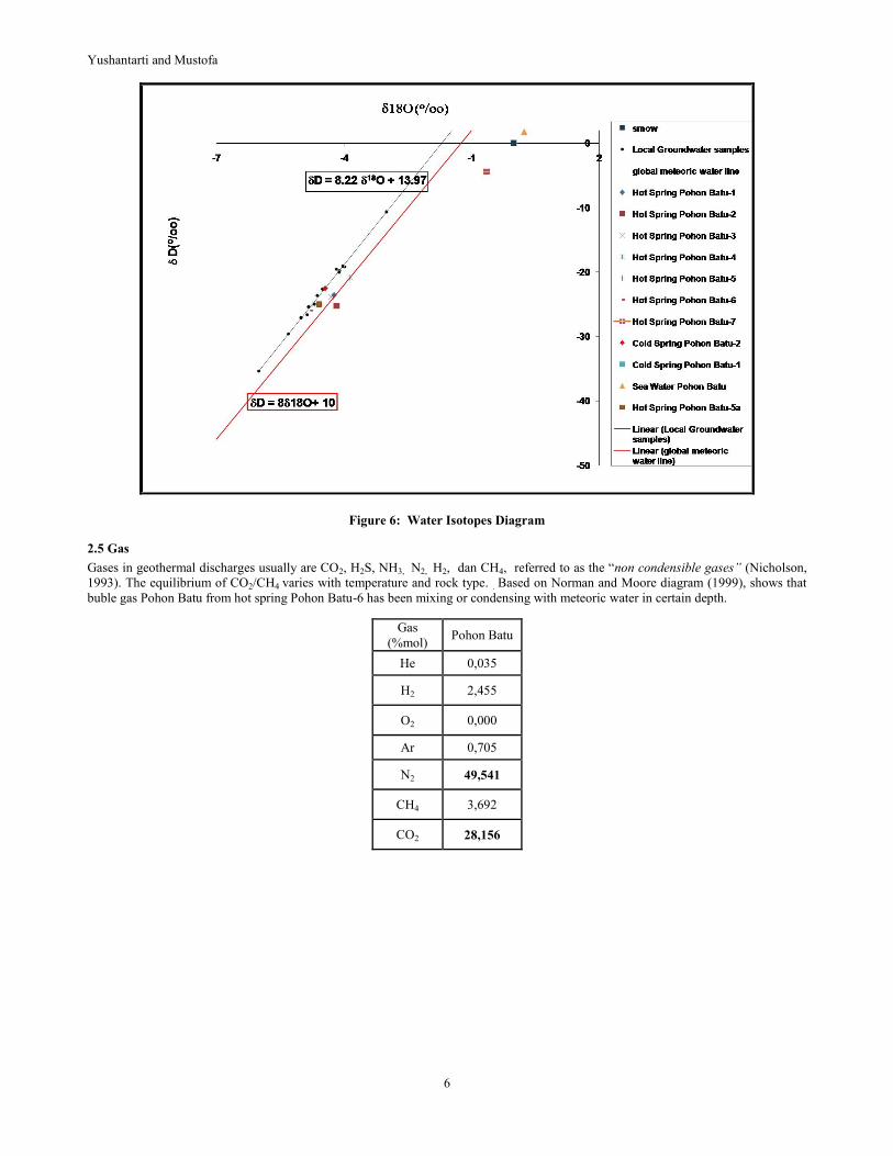
2.4 Isotope
Stable water isotope data plot in global meteoric water line and local meteoric water line which approached by local groundwater
samples, and the formula is δD = 8.22 δ18O + 13.97 (Figure 6.). It could be an indication that it is meteoric water origin. Several isotope
of hot springs (Pohon Batu 5, 5a, and 6) near to local meteoric water line, it could be an indication that the contributions of deep fluids
is minor, but for hot spring Pohon Batu 1, 2, 3, and 4 are more positive than local waters, this could be an indication that geothermal
fluids has been enriched with 18O because of rock-water reactions at depth (Nicholson, 1993). Pohon Batu 7 hotspring was appropriate
with its environment which contaminated by sea water.
Yushantarti and Mustofa
6
Figure 6: Water Isotopes Diagram
2.5 Gas
Gases in geothermal discharges usually are CO2, H2S, NH3, N2, H2, dan CH4, referred to as the “non condensible gases” (Nicholson,
1993). The equilibrium of CO2/CH4 varies with temperature and rock type. . Based on Norman and Moore diagram (1999), shows that
buble gas Pohon Batu from hot spring Pohon Batu-6 has been mixing or condensing with meteoric water in certain depth.
Gas
(%mol) Pohon Batu
He 0,035
H2 2,455
O2 0,000
Ar 0,705
N2 49,541
CH4 3,692
CO2 28,156

Yushantarti and Mustofa
7
Figure 7. Indicator Origin Fluid Diagram (Norman dan Moore, 1999)
2.6 Mercury Soil
Permeable regions and possible upflow could be determined with soil mercury survey (Nicholson, 1993). Concentrations of Hg soil
have a range from 2.6 to 20.915 ppb. The anomaly of Hg soil concentrated arround hot springs. It could be an indication of an upflow
of the Pohon Batu geothermal system, supporting that the type of manifestations is chloride-bicarbonate type, low terrain, and there is
no manifestations except the Pohon Batu hot springs.
Figure 8. Map of Distribution Soil Hg at Pohon Batu Geothermal Area
3. CONCEPTUAL MODEL
Distribution of Pohon Batu hotsprings are along Wai Popupula River with temperature about 40-60 °C. The appereance of the
manifestations controlled by oblique fault (normal-dextral) with north-south orientation. The presence of the manifestations may related
with plutonic activities in the form as young intrusive rocks which not appear to the surface as heat source and strong tectonic activities
as consequence of Pohon Batu location that located in convergent of Australia, Pacific, and Eurasia tectonic plates.

Yushantarti and Mustofa
8
Tentative geochemistry model in Pohon Batu geothermal area was hypothesized in Figure 9. Since geothermal manifestation only
seven hotsprings where relative close each others, the type of waters are chloride-bicarbonate type, neutral pH, and located in partial
equilibrium zone, stable istope analysis estimated as interaction between rocks and thermal fluid in the reservoir, relative low terrain at
Pohon Batu geothermal area, and support with anomaly of mercury soil at the hot springs, so it could be an indication that the hot
spring of Pohon batu is the upflow of the system or margin upflow of the geothermal system. This indication is correlated with the
gravity and AMT result that the anomaly of geophysic is just below the Pohon Batu hot springs (Center for Geological Resources,
2015). High sulfate consentration may came from oxidation of H2S gases that condensed, also may came from enrichment from
oxidation of sulphide minerals.
Based on data that mentioned above, the tentative model of hydrogeochemistry of Pohon Batu can be created (Figure 9)
Figure 9. Tentative model of hydrogeochemistry Pohon Batu Geothermal Area
4. CONCLUSION
Geothermal manifestations are only one cluster hotsprings Pohon Batu (40-60,9oC and neutral pH). Pohon Batu hotsprings are
chloride-bicarbonate type and plotted in partial equilibrium. Reservoir temperature was estimated about 175-220 °C that belong to
medium temperature. Pohon Batu hot springs could be the upflow zone of the system
.
REFERENCES
Center for Geological Resources, Geothermal Area Distribution Map and Its Potential in Indonesia, Bandung, (2015)
Center for Geological Resources, Survei Terpadu Geologi dan Geokimia Daerah Panas Bumi Pohon Batu, Seram Barat, Maluku,
Bandung, (2014)
Center for Geological Resources, Survei Terpadu Gravity dan AMT Daerah Panas Bumi Pohon Batu, Seram Barat, Maluku, Bandung,
(2015)
Giggenbach, W.F., Chemical techniques in geothermal exploration. In: D’Amore, F. (coordinator), Application of geochemistry in
geothermal reservoir development, UNITAR/UNDP, Rome, (1991), 119-142
Nicholson, K., Geothermal Fluids Chemistry and Exploration Techniques, Springer-Verlag, Germany. (1993),
Norman, David I. And Moore. Joseph N., Methane and Excess N2 and Ar in Geothermal Fluid Inclusions, Proceedings Twenty Third
Workshop on Geothermal Reservoir Engineering, stanford University,S tanford, California, (1999)
S.Tjokrosapoetro et al,. Geologi Lembar Masohi, Maluku, skala 1 : 250.000, (1993)