gruline, mull, and other inner hebridean things whyte.pdfgruline, mull, and other inner hebridean...
TRANSCRIPT

The Journal of Scottish Name Studies 8, 2014, 115–52
1 For more on the estate and its tenurial history, see Whyte, forthcoming. For architectural notes on Gruline House and its predecessor (NM552393), see RCAHMS, Canmore IDs 22241 and 22240. I am grateful to the following for comments and advice received with regard to the development of this paper: Dr Simon Taylor, Professor Thomas Owen Clancy, Dr Colleen Batey and Professor Stephen Driscoll. I am grateful, too, to the anonymous reviewer for useful comments and suggestions. Any shortcomings are my own.2 Gruline House is therefore Glenforsa House on the OS 1st edn map.
Gruline, Mull, and Other Inner Hebridean Things
Alasdair C. WhyteUniversity of Glasgow
Gruline (NM547398), in the modern toponomasticon of the Inner Hebridean island of Mull, refers to a sizeable area of low-lying land at the head of Loch na Keal, the insularly-central sea loch which comes within around 4.5km of splitting the island in two. At the eastern end of this isthmus on the island’s Sound of Mull coastline is Salen, one of the population centres of modern Mull. The modern application of the name Gruline is to the lands of the Gruline estate, at the centre of which is Gruline Home Farm (NM548399). Gruline House (NM551393) was built in 1861 by Lieutenant Colonel Charles Greenhill-Gardyne (1831–1923) and formed the headquarters in his day of the united estate of Jarvisfield and Glenforsa (Currie 2000, 386–87).1
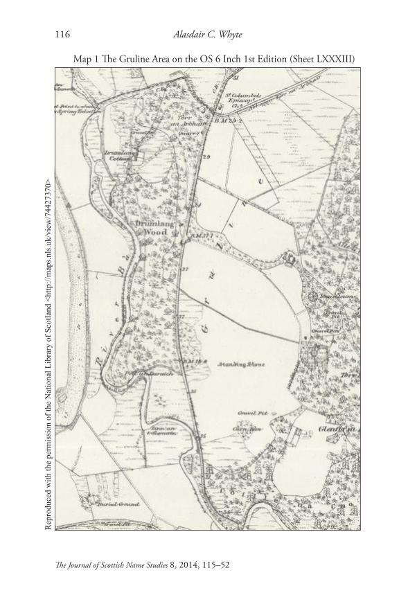
The area to which the name Gruline referred in the time of Colonel Gardyne is clearly illustrated both on the 6 inch first edn Ordnance Survey (OS) map of 1881 and in the OS Object Name Book (OSNB) produced following the initial survey of the area in 1878: a ‘small District Comprehending the home farm of Glenforsa Bounded on the South by Loch & River Bà, on the West by River Bà, on the North by Abhuinn Tòrr an Arbhair, & on the E. by the West Side of Guala Buidhe’ (OSNB ARG OS1/2/46/1/49/1). This record is worth unpacking. The passage’s ‘home farm of Glenforsa’ is the modern Gruline Home Farm, both farm and estate house specified in the time of Colonel Gardyne by the existing name Glenforsa, as opposed to Gruline, following the aforementioned amalgamation of the estates of Jarvisfield and Glenforsa in 1836 (Currie 2000, 261).2 The building now called Gruline House stands at the north end of Loch Bà, a large freshwater loch which stretches out for around 5km to the south-east. The River Bà issues from this loch around 300m south of Gruline House, initially flowing south-west before flowing north to empty into Loch na Keal near Killiechronan Farm around 3km to the north-west. Abhuinn Tòrr an Arbhair is a name not included on the modern map but which refers, as is illustrated on the OS first edn map, to the stretch of river
Alasdair C. Whyte116
The Journal of Scottish Name Studies 8, 2014, 115–52
Map 1 The Gruline Area on the OS 6 Inch 1st Edition (Sheet LXXXIII)R
epro
duce
d w
ith th
e pe
rmis
sion
of t
he N
atio
nal L
ibra
ry o
f Sco
tland
<ht
tp://
map
s.nls
.uk/
view
/744
2737
0>

Gruline, Mull, and Other Inner Hebridean Things 117
The Journal of Scottish Name Studies 8, 2014, 115–52
3 It is Abhuinn Tòrr an Arbhair on the 1900 OS 2nd edn map.4 The school and post office are indicated on the OS 2nd edn map.5 See the Appendix for a detailed record of the historical forms of Gruline and the sources in which these appear.6 Thereafter the Barony of Moy was sold to Murdoch’s nephews, Major Lachlan (1761–1824), appointed governor of New South Wales in 1809, and Captain Charles Macquarie (1771–1835) (Currie 2000, 214). The Mausoleum (NM549398) situated around 600m north-west of Gruline House is the burial-place of the former.
which connects Abhainn na Fèithe Bàine to the River Bà, entering the latter at NM541405;3 Tòrr an Arbhair (NM544405), the existing name in Abhuinn Tòrr an Arbhair, is included on the modern map. Guala Buidhe (NM555403), the final toponym contained within the above passage, applies to the shoulder of land which extends northwards from the vicinity of Gruline House for around 2.5km, visible on the left-hand side of the B8035 when heading west in the direction of Gruline from Salen.
The Gruline area, still dotted with modern houses, could until fairly recent times have been described, as Salen is now, as a population centre on the island. Gruline’s populace was served by a school (NM544400), post office (NM545405) and had its own village hall;4 its school pupils were transferred to the school in Salen at the tail end of the 1960s (Reay Whyte, pers. comm.). An Episcopalian chapel (NM546405) was built during Colonel Gardyne’s tenure in 1872 and subsequently dedicated to St Columba (Canmore ID 157679; OSNB ARG OS1/2/46/1/49/2).
Fiscal evaluation of this part of Mull records that Gruline, consistently valued at two pennylands, has long been a valuable landholding, the earliest known reference dating to the forfeiture of the Lordship of the Isles in the final decade of the 15th century.5 Gruline is listed in these assessments among the lands of Forsa, the district which formed the north-easternmost portion of the medieval parish of Torosay (Killean), held by the Maclaines of Lochbuie until the death of the 19th chief, Murdoch, in 1804;6 this district-name survives in the modern toponyms Glen Forsa (NM597437) and River Forsa (NM599433).
Etymology: Old Norse (ON) grjóT ‘(rough) stone(s); stony ground; cleared and cultivated ground’ + ON þing ‘assembly-place’The final -ding of the earliest historical forms of Gruline, recorded in four separate sources, suggests that Gruline can be identified as a þing- or thing-

Alasdair C. Whyte118
The Journal of Scottish Name Studies 8, 2014, 115–52
25 0 25 50 75 100 km
EIGG
ISLAY
MULL
Map 2 Grulin(e) Sites

Gruline, Mull, and Other Inner Hebridean Things 119
The Journal of Scottish Name Studies 8, 2014, 115–52
7 It is common in the most recent commentaries for assemblies named in ON þing to be referred to as things and this is the term used throughout this paper. Recent work includes the publication produced by the ‘THING project’ (Owen, ed., 2012); updates on the project’s ongoing work are available on-line at <http://www.thingproject.eu/> and <http://www.thingsites.com/>. In 2013, The Assembly Project (TAP) produced a publication which included the latest international thinking on the role of assemblies in the emergent power structures of medieval northwest Europe (400–1500) entitled ‘Debating the Thing in the North I: Selected Papers from Workshops Organized by The Assembly Project’. TAP is led by the Museum of Cultural History (University of Oslo) and involves principal investigators from Durham University, University of Vienna and the University of the Highlands and Islands.8 For further recent comment on this element within the context of other terms relating to assemblies in medieval Scotland, see O’Grady 2014, 131.9 See Márkus 2012, 357–361, for detailed analysis of *Edin and the names in which this reconstructed existing name appears on the modern map: Edinbeg, Edinbeg Hill and Edinmore.
name, the location of a Norse assembly-site.7 ON þing nt. is the predominant element used to describe assembly-places in northern Scotland (O’Grady 2008, 188).8 The initial consonant in this element, a voiceless dental fricative /θ/, is orthographically represented in modern Scottish toponymy variously as th, as in Thingsva, Caithness, and as t, as in Delting, Shetland, in which ON þing is the generic, as is proposed here in relation to Gruline. There are also examples in which this consonant appears as d: it lies behind the initial consonant in Dingwall in Ross and Cromarty and has been suggested as the generic in name-final position – as in Gruline – in *Edin in Bute, perhaps ON eið + ON þing ‘isthmus-assembly’ (Márkus 2012, 359).9 As regards Gruline, the earliest known forms suggest that /θ/-, preceded by a voiceless dental plosive -/t/ (ON grjót) in the underlying ON toponym, was perceived, and presumably therefore realised, as a voiced dental plosive /d/ when these forms of the name were recorded. The earliest known forms of Gruline date to the final decade of the 15th and the early 16th centuries, a period in which Mull’s inhabitants are certain to have been speakers of Gaelic and not of Old Norse: the earliest available forms are likely to have been recorded in reference to the pronunciations of Gaelic speakers of a name coined in Old Norse but phonologically adapted to the Gaelic sound system, the name having been used in a Gaelic-speaking environment for several centuries before it was first recorded.
The -t which is proposed to have preceded þ- in ON *grjót-þing is of importance with regard to the toponym’s phonetic development and there are examples of ON grjót nt. in toponyms transmitted by Gaelic speakers elsewhere with which to compare it. Stahl has highlighted a cluster of names on the island of Pabbay, south of Barra, which are of relevance here: Rubha Greotach (NL589871), a name found on the 1997 OS Landranger map and etymologised

Alasdair C. Whyte120
The Journal of Scottish Name Studies 8, 2014, 115–52
as ‘gravelly promontory’ (Papar Project, App. H4, 2),10 and two alternative names for a nearby feature collected from oral sources, Greòtal (NL591871)11 (ibid., 6) and Na Greòtan (NL593869) (ibid., 12). Rubha Greotach is a name coined by Gaels, containing G rubha m. ‘point’ as the generic; the latter two names have been etymologised as ON grjót, defined as ‘gravel, stone’, + ON hóll f. ‘mound’. In discussion of these examples, Cox has highlighted the possibility that ON grjót was a term borrowed into ScG as greòd, although he states that this possible loan-word may not lie behind Na Greòtan if its orthography reflects its pronunciation (Cox 2005, 2, 10). As regards Gruline, it is proposed here that the earliest forms suggest an ON toponym as opposed to a Gaelic construction involving a loan-word, and Greòtal is of particular interest if it represents phonological adaptation of ON *grjót-hóll; the juxtaposition in the Pabbay name of -t and h- is not directly comparable to the proposed juxtaposition of -t and þ- in Gruline, but the development of ON grjót in name-initial position is. The orthography recorded in relation to local pronunciation of Greòtal and Na Greòtan, considered alongside Rubha Greotach which may contain the proposed loan-word, suggests articulation of a diphthong in the region of /eɔː/ following the vibrant,12 followed by pre-aspiration of a voiceless dental plosive /t/.13 On the evidence of the orthography attributed to these Pabbay examples, the possible loan-word may be better represented as G greòt, presumably articulated locally as [greɔːht].14 The forms of Gruline suggest that juxtaposition of -t and þ- in the ON toponym yielded a phoneme perceived as a voiced dental plosive, typically devoiced in modern Gaelic.
Both the later historical forms and the modern form of Gruline illustrate that the early medial d has subsequently developed into a lateral; locally, within an English-speaking context, this intervocalic consonant is articulated as /l/.15 There is no record of an intervocalic or postvocalic broad d being articulated as a lateral in the dialects of Mull or the surrouding area in SGDS.16 There is, however, plenty of evidence for variation in the articulation of the broad
10 1901 Rubh’ na Geod H. Sharbau (estate plan).11 1823 Greotas MacLean (map): Map of Barra as part of John Thomson Southern Part of the Western Isles.12 Cf. G beò (Survey of the Gaelic Dialects of Scotland (SGDS), §§96–97); G ceòl (§181); G eòlas (§376), points 28–30 [south Barra].13 Cf. G bàta (SGDS §§81, 82–83); G cat (§§158–59); G slat (§§768–69); G sùghta (§809).14 Cf. G greigh (SGDS §500) for initial consonantal cluster.15 This phoneme is defined as a ‘voiced dental approximant lateral’ in SGDS i, 123. 16 The three Mull informants, one from each of the three contemporary insular parishes, were recorded in 1957 and are as follows: pt 81 Dugald MacArthur, Achnacraig, parish of Torosay; pt 82 Miss Jean Gibson, Knockan, parish of Kilfinichen and Kilvickeon; pt 83 Mrs Mary MacColl, Torloisk, parish of Kilninian and Kilmore.

Gruline, Mull, and Other Inner Hebridean Things 121
The Journal of Scottish Name Studies 8, 2014, 115–52
17 G bàta (§81): pts 81–83 /baˑtə/; G bàta (§82): 81 /baˑtə/; 82 /baˑdə/; 83 /baˑdə/; G mo bhàta (§83): 81 /mə vaˑtə/; 82 /mə vaˑtə/; 83 /mə vαˑtə/.18 G sùghta (§809): pt 81 /suˑdˊɪ/; pt 82 /suːdˊzˊə/; pt 83 /suˑdˊzˊɪ/. There was preaspiration of /t/ from all informants in G cat (§§158–59) and in G slat (§§768–69) following a short vowel; see also Grannd 2000, 55 –56.
l in the wider area. This is a well known feature of the dialects of Islay, in which an initial broad l is often articulated as a voiced dental plosive (Grannd 2000, 59–60), and there is evidence of variation, too, in the dialects of Mull. An illustrative example of this is G loisg ‘to burn’ (SGDS §585). Each of the four Islay informants (pts 53–56) articulated this consonant as /d/; in Mull, it was articulated variously as /uˋ/, a velarised semivowel (pt 81), /ðˋ/, a velarised voiced dental fricative (pt 82), and /lˋ/, a velarised voiced dental approximant lateral (pt 83), the most common articulation throughout the surveyed area. Grannd’s conclusion regarding treatment of broad l in the dialect of Islay was that, although unlenited broad l is realised as a plosive, broad l in medial and final position is realised as a lateral (2000, 60). The SGDS evidence suggests variation in the Mull dialects regarding the consonant in both of these positions. A pertinent comparison as regards the consonant in Gruline is G ùbhlan ‘apples’ (pl.) (§878) in which an intervocalic broad l is preceded by a back close rounded vowel in the Mull dialects. SGDS recorded variation in the articulation of the consonant in Mull: a velarised voiced labio-dental fricative in /uˑvˋən/ (pt 81); a velarised voiced dental fricative, as above in G loisg, in /uˑðˋən/ (pt 82); and, also as above in loisg, a velarised voiced dental approximant lateral in /ʔuˑlˋən/ (pt 83). The development in the historical forms of Gruline from d to l is clear; proximity as regards the respective qualities of the broad d and broad l in the dialects of Mull, highlighted by the variation in the above examples, may explain why this development from d to l occurs. This development would have been facilitated when the toponym’s etymology became opaque.
On the basis of the SGDS evidence and in comparison with the Pabbay names highlighted above, a diphthong in the region of /ɛɔː/ might be expected with regard to the hypothetical articulation of ON grjót by Gaelic speakers native to Mull. A comparison of note is G ceòl (SGDS §181) for which the following were recorded: /kˊ[ɛɔ]uˋ/ (pt 81); /kˊ[ɛɔˑ]ðˋ/ (pt 82); /kˊ[ɛɔ]lˋ/ (pt 83). The aforementioned variation in articulation of the postvocalic broad l, again including a velarised semivowel (pt 81) and a velarised voiced dental fricative (pt 82), is once more illustrated in these examples. In contrast to the dialects of Barra, preaspiration of the final plosive might not be expected in the Mull dialects: SGDS records that following a long vowel, the Mull informants had no preaspiration of /t/ or /d/ in G bàta17 and G sùghta.18 In the latter example, in

Alasdair C. Whyte122
The Journal of Scottish Name Studies 8, 2014, 115–52
19 Cf. G greim (SGDS §503) in relation to gr-.20 For further discussion of this name, see Whyte, forthcoming.
which the preceding vowel is most comparable, the plosive was realised not as a voiceless dental plosive but as a voiced dental plosive from all three informants, two of which had accompanied devoicing. On this evidence, a monolingual Gael of the type who would be expected to have been an inhabitant of Gruline in the late 15th century might be expected to have articulated the initial element in *grjót-þing as something approaching /grɛɔːd/.19 Juxtaposition of -t and þ- appears to have yielded a sound at least perceived as a voiced dental plosive in the earliest known forms, a phoneme expected on the basis of the above evidence; the lateral is a subsequent development. The most recent forms of Gruline reflect the back close rounded vowel /uː/ which follows the vibrant in local modern pronunciation of the toponym; the earliest forms in Growd-, Croud- and Growd-, however, in addition to providing evidence for an earlier dental plosive, may reflect pronunciation in the region of the diphthong highlighted above, /ɛɔː/, which, similar to that illustrated in the Pabbay names, might have been expected to develop from an original ON -jó-.
It is interesting that the Gaelic form of the name at the beginning of the 20th century appears to have been Grùilinn, an orthography likely to indicate a palatalised alveolar lateral /lˊ/ as opposed to the broad l which might be expected to have developed from *grjót-þing: John MacCormick’s Màm Maol Ghrùilinn (Mac Cormaic 1911, 6) ‘the bare màm of Gruline’, a toponym not included in the OS record, may be an alternative name for Cruach Torr an Lochain (NM563402; 348m).20 It is likely that Gruline’s etymology was unknown to the author and his contemporaries, thus facilitating further variation in articulation of this intervocalic consonant; the OSNB informants did not know the toponym’s etymology in 1878 (ARG OS1/2/46/1/49/1). The form may have been influenced by understanding of the final element as G linn(e) f., gen. linne ‘pool, pond, lake, mill-dam, channel’ (Taylor 2005). It is difficult to correlate MacCormick’s form with a plausible etymological explanation of the toponym containing Gaelic elements and, as is outlined above, Gruline’s l appears to be a relatively recent development. This l, and perhaps the Gaelic form of the name, appears to have influenced recent etymological analyses of Gruline. MacQuarrie (1982, 76) has interpreted the second element as the aforementioned G linn(e) and, although there are pools on the River Bà here, Linn’ an t-Sìomain (NM542393) including this element as its generic found on the first edn OS map, this is very unlikely given the consistent d of the earliest forms. MacQuarrie’s proposed Gaelic-Old Norse etymology is implausible although the ‘[ON] Gru, gravel, stony ground’ which he proposes as the initial

Gruline, Mull, and Other Inner Hebridean Things 123
The Journal of Scottish Name Studies 8, 2014, 115–52
21 ON steinn m. is the element which is applied to standing stones, normally appearing on the modern map as ‘stane’, e.g. Whitestanes (HY4715) and Kirk Stane (HY5316) (Stahl 2004).22 See the entry on G grùdair ‘brewer’, where there is reference to both Modern Ir grúdaire and grúid ‘malt’. See Taylor, with Márkus (2012, 625–36), for discussion of a 13th-century Fife man whose name appears to contain OG gruadaire, G grùdaire ‘brewer’.23 See the entry for ‘grit’, where the ON word is recorded as griót.24 The element found with its definite article here is G corran m., gen. -ain ‘sickle’, a descriptive illustration of the crescent-shaped bay at the head of the loch. It is also commonly applied to promontories on the west coast, Watson (1926, 506) defining it specifically as ‘a low cape tapering symmetrically to a point’, from OG corr ‘taper, peaked, rounded to a point’.
element represents ON grjót, the specific proposed in this article. Maclean (1997, 27) voices uncertainty with regard to Gruline’s etymology, settling for ‘[G] Cruaidh-linn’, interpreted as ‘stony ground’, although it is unclear why G linn(e) has been translated here as ‘ground’. G cruaidh ‘hard, firm’ from OG crúaid ‘hard(y), harsh; stern, strict; rough’ (DIL) for the specific is unlikely given the earliest forms in Grow- (1494, 1538) and Crou- (1509). Interestingly, Maclean (1997, 27) refers in discussion of Gruline to Forbes (1923, 208) who provides the same etymology for a place-name in Eigg, rendered Grulainn or Grulin, a toponym to which discussion returns below.
In terms of the application of ON grjót, it is defined as ‘gravel, stone’ in reference to the Pabbay names above; in Cleasby/Vigfusson the primary definition is as follows: ‘stones, but chiefly with the notion of rough stones or rubble in a building, etc.; grjót, like Engl. grit, is a collective word, and is consequently never used in plur.; a single stone is called steinn, not grjót.’21 In the modern Celtic languages, G grùid f., gen. -e, is ‘lees, dregs, grounds, sediment; malt’ (Dwelly), MacBain (1911) explicitly asserting a connection between this word and English ‘groats’ and ‘grit’,22 both confirmed as cognates of ON grjót in OED.23 Lexical substitution of Scots grit for ON grjót may lie behind the present form of Grit Ness, Evie, Orkney (HY3626) (Sandnes 2010, 201). ON grjót was also used ‘of the shingle on the beach’ (Cleasby/Vigfusson), of particular interest when considered within the context of An Corran (NM536411), the shingle beach which lies at the head of Loch na Keal.24 Jakobsen (1993, 48) noted that de Grøt o’ Stavaness in Nesting, Shetland, applies to a ‘pebbly beach’. Jakobsen (ibid., 48–49) defined ON grjót primarily as ‘stone, stony ground’, proposing that in Shetland it commonly denotes rocky ground, although in some cases refers to ‘cleared and cultivated ground’ and ‘is also used in a special sense: low-lying rocky neck or tongue of land, connecting a smaller piece of land with a larger one’. The latter sense appears to be applied to land connecting skerries with larger areas of ground; given the primary status of Gruline in the earliest fiscal evaluations, however, the application to cultivated ground, presumably on account of the removal of stones from the said

Alasdair C. Whyte124
The Journal of Scottish Name Studies 8, 2014, 115–52
25 The sense of ‘cleared and cultivated ground’ is explicitly proposed in relation to the following names, for which Jakobsen unfortunately provides no NGRs; the Shetland names are recorded here and elsewhere as they appear in the source: de Grōds (Virs, Norwick, Unst; Sooth Voxter, Conningsburgh); Grødi or Grøti (Gunnister, Northmavine); de Lalligrøds (Houbie, Fetlar).26 A useful on-line resource featuring an interactive soil map, which can be used in conjunction with the Macaulay Institute reports, is ‘Soil Information for Scottish Soils | SIFSS - The James Hutton Institute’, <http://sifss.hutton.ac.uk/index.php> – accessed 29/11/14.27 This particular soil type (map unit 279) is also found along the southern shoreline of Loch na Keal, between Scarisdale and Dhiseig, and at the mouth of the River Forsa on the farms of Callachally and Pennygown.
area, is striking.25 Although not explicitly stated, this sense may, on account of the respective compounded elements, lie behind Jakobsen’s de Grøddelds (Papa Stour), Grotpund (Voe, Dunrossness) and Grøthwi (Walls) (ibid., 48): Jakobsen proposed that these are combined with ON deildir, nom. pl. of deild f., locally ‘patch of ground, part of a field’ (ibid., 34), Shetlandic pund ‘fold, enclosure’ (ibid., 203) and ON kví ‘fold, cattle enclosure’ (ibid., 74), respectively. The extensive area of low-lying land east of An Corran at Gruline is itself stony in quality, a characteristic which no doubt influenced the etymological analyses of both MacQuarrie and Maclean; a toponym in ON grjót might similarly have been coined in reference to Gruline’s ‘stony ground’, and perhaps the clearing of it for cultivation during the period in which Old Norse was spoken in the area. Gruline has given its name to a soil association in the Soil Survey of Scotland, the soils of the Gruline Association (map units 278–80), known to have long been utilised agriculturally, are ‘very restricted in extent’, covering only 30 square kilometres in total, and important in this respect (SLCFA 1982, 71).26 Map unit 279 covers 18 square kilometres in total, including the low-lying land at the head of Loch na Keal from around Kellan Old Farm (NM519407) to a short distance west of the Burial Ground at Knock (NM540391).27 Developed upon raised beach or outwash sands and gravels derived from a range of igneous rocks but with a strong basic igneous component, the texture of these soils is dominantly gravel, ‘sometimes very coarse as in part of the Gruline area of the Isle of Mull’ (ibid., 71). Jakobsen (1993, 48–49) notes that ON *grýtingr, defined as a ‘stony stretch’ and said to derive from ON grjót, lies behind Grøtin (Sandsting; Fetlar), de Grødins (Øver Soond) and, perhaps, Grødi or Grøti (Gunnister, Northmavine), the proposal being that -n is occasionally dropped in final -in. For the initial vowel in Jakobsen’s term, the preceding asterisk denoting that it is not attested in what he terms ‘old Northern literature’, cf. ON grýting f. ‘a pelting with stones, stoning’ and ON grýttr ‘stony’ (Cleasby/Vigfusson). The final -tingr of Jakobsen’s term is striking given the final -ding of Gruline’s earliest forms, but phonemic development from ON ý, a long front close unrounded vowel, to the vowel represented in the historical forms of Gruline and the back close rounded vowel of modern pronunciation seems unlikely: ON ý would surely be expected to

Gruline, Mull, and Other Inner Hebridean Things 125
The Journal of Scottish Name Studies 8, 2014, 115–52
28 The form would be more correctly Càrn Bàn; this the orthography recorded in OSNB ARG OS1/2/46/1/50 and on the 6 inch 1st edn OS map, where it is described as a ‘wooded knoll’, the name translated there as ‘White Cairn’. See FitzPatrick 2004, 46–47, for discussion of the ‘reasonably homogenous morphological identity’ of OG carn in relation to inauguration sites in Ireland where it appears to refer to ‘modest, compact mounds of earth or a combination of earth and stone’.
yield G ì, particularly given the close or close-mid front unrounded vowel which follows.
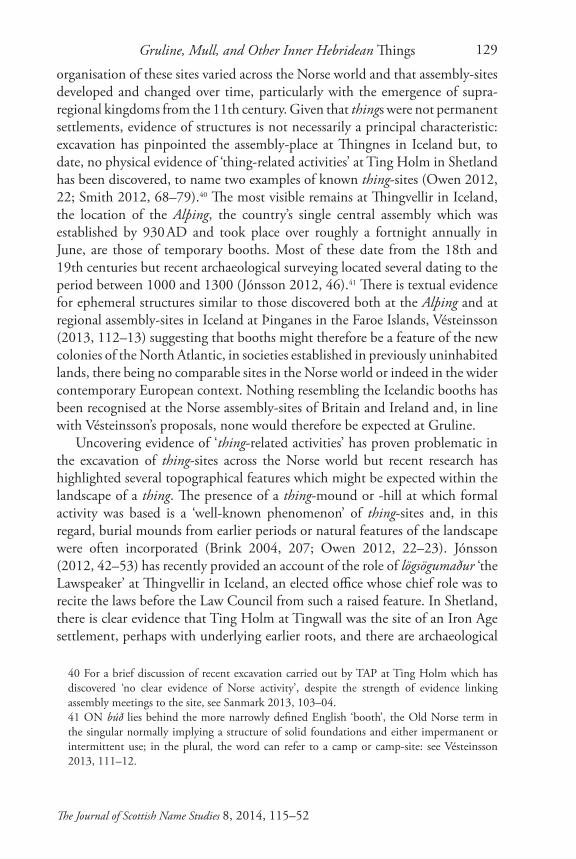
The element may have originally referred either to the stony beach or the stony (cleared) ground, or to both, but two nearby cairns, the largest of which is known as Carn Bàn, may lie behind *grjót-þing. ON grjót-haugr m., literally ‘stone how(e) or mound’, one of the many compounds in which ON grjót is recorded, is a ‘heap of stones, cairn’ (Cleasby/Vigfusson); Carn Bàn’s origins lie in G càrn ‘heap of stones’ and G bàn ‘fair, white, pale, light in colour’.28 The two cairns are individually described in RCAHMS site reports which record their locations at NM546393 (Carn Bàn) and NM547393. The report on Carn Bàn (Canmore ID 22244) provides the following description:
A prominent knoll known as Carn Ban is surmounted by a grass-covered cairn measuring about 26 m in diameter and 2.2m in height. Its original shape and size have been mutilated by robbing, clearance, and fallen
Fig. 1 Carn Bàn on Approach from NNW
Phot
ogra
ph: A
lasd
air C
. Why
te

Alasdair C. Whyte126
The Journal of Scottish Name Studies 8, 2014, 115–52
29 Both cairns were surveyed in 1972, the reports published in RCAHMS 1980, 57, no. 39 (2), which correctly renders the toponym ‘Càrn Bàn’.30 The 6 inch 1st edn OS map does not in fact indicate the presence of this smaller cairn, although it depicts a gravel pit less than 100m north-east of Carn Bàn.31 There is also a possible cairn of prehistoric date at Knock around 600m south-west of Carn Bàn: RCAHMS, Canmore ID 22249.32 It is noted here that ‘the appearance of a final -ar in the earliest forms ... would not be easily explained if the name contained ON þing’.33 Woolf (2007, 300) adds that ‘it is less clear whether we should imagine there to have been a single alþingr [sic] or ‘general assembly’ for the Isles, or whether intermediate sized groupings, such as the Outer Isles, and the Islay group were the largest functional units.’
trees. The stony bank running round its perimeter appears to be a tree-ring.29
The smaller cairn is situated 400m west of Gruline House, standing at ‘about 18m in diameter and 1m in height’ and ‘has been severely robbed of stone and is overgrown by shrubs’ (Canmore ID 22248).30 No assertion is made in either of the reports regarding the chronology of the cairns.31
ON þingThere is at present little knowledge of the administration of Scotland’s western littoral in the early Norse Age but in Gruline, Mull, there is a likely ON toponym relating to an assembly-site of the period. As regards Dingwall, Crawford (2004, 113) has proposed that the toponym ‘provides incontrovertible evidence of a flourishing Scandinavian community in the Firthlands of Easter Ross, dominant enough in the locality to organise its own legal assembly for the running of social and economic matters according to Norse law and custom’. Crawford has envisaged Dingwall as the administrative centre for this semi-autonomous province: ‘The Norse settlers in Ross may have been more or less self-governing, although no doubt obliged to provide some renders and services for the [Orkney] earls’ (ibid., 113–15). With regard to *Edin in Bute, nearby Cnoc an Rath, G cnoc + G an + G ràth ‘ “hill of the fortress” ’ is proposed to possess many features which mark it out as a potential medieval assembly-site and Márkus (2012, 359–60), despite voicing linguistic reservations, has commented that ‘it would be strange indeed if there were not a þing-site somewhere on Bute’.32 The same may be said of Mull. In reference to the western seaboard of Scotland, Woolf (2007, 300) considers it likely ‘that each island or group of small islands would have had its own assembly’.33 Placing the potential for loss and displacement of names to one side, in the Hebrides only Tinwhil (or Hinnisdale) in Trotternish, Skye, Tiongal in Lewis and Finlaggan
Gruline, Mull, and Other Inner Hebridean Things 127
The Journal of Scottish Name Studies 8, 2014, 115–52
34 These are Tingwall, Dingieshowe, Stenness and Kirkwall.35 As Smith highlights, these administrative quarters, eights and heraðs (ON nom. pl. heruð), have left their mark on the toponymy of the islands. The same element may lie behind Harris, Rhum (Papar Project, H9, 3).36 For more on the Gulating, see Misje 2012, 30–41.37 Prior to 1266, these skattlands included the Faroe Islands, Shetland, Orkney and the Western Isles. The initial element in ON skatt-land ‘tributary land’ is ON skattr m. ‘tribute’ (Cleasby/Vigfusson).
in Islay, where a forerunner to the subsequent council site of the Lordship of the Isles may have been located, have been identified as likely thing-sites to date (O’Grady 2008, 192–217). By way of comparison, four locations in Orkney are considered as probable thing-sites in the administrative system which preceded the centralising reforms of the mid- to late 12th century (Gibbon 2012, 91).34 Smith (2012, 75–78) has highlighted the possibility that, prior to legal reform of Shetland in 1274, the island group was divided into administrative units called quarters and eights, but also into smaller units of heraðs, each of which might have had its own thing.35 The law of Norway’s Gulating, a legislative body, court of law and political assembly located in Gulen on the country’s west coast from at least 900 to 1300, contains references to quarter-things, in addition to things of larger provinces (ibid., 77).36
Application of ON þing in the available contemporary written sources and in Norse mythology illustrates that the term refers both to the body of free men that met to resolve conflicts and discuss matters of common interest within a particular area and to the physical site at which the assembly was held (Løkka 2013, 18). The indigenous legal system of pagan Norse society was based around these things, the existence of thing-sites in mainland Scotland, in the areas ruled by ON speakers but which were not included among the Norwegian skattlands,37 suggesting that the thing formed part of the culture brought by the Norse settlers to their new homelands, as opposed to having been centrally imposed (Sanmark 2013, 107). In the ninth- to twelfth-century kingdoms of the North Sea littoral, it is clear that assemblies, both royal and public, were ‘integral elements in the processes of negotiating, achieving consensus and exercising authority’ within contemporary power structures (Sanmark et al. 2013, 1). It has been argued that control of the assembly was vital in the formalisation, expansion and consolidation of power, both for kings in the Scandinavian kingdoms and for the Norse elite in the newly-settled territories in the west (ibid., 1), although, as previously highlighted, only a small number of Hebridean locations have been proposed as thing-sites. Although the assembly seems to have been more focussed around a collective ethos than other contemporary power centres of the time, such as palaces and castles

Alasdair C. Whyte128
The Journal of Scottish Name Studies 8, 2014, 115–52
38 As Owen (2012, 19) highlights, however, the sagas provide plenty of evidence that the legal system did not preclude blood feud and honour killings in this period.39 For useful recent summaries of the social activities and functions of the þing, see Løkka 2013, 18 and Owen 2012, 9.
(decisions and verdicts being made jointly by groups of assembly participants), the available sources suggest that the thing was a place where those with power often seem to have been able to push decisions in their favour, even before royal reform of the legislative system in the 13th century saw the beginning of an era in which Scandinavian kings assumed full control of the assemblies (ibid., 1). It appears that there existed a hierarchical structure, assemblies at local levels existing alongside regional or national things. Judicially, the system allowed for disputes to be settled in a neutral and non-violent forum, as opposed to blood feud, the thing responsible for setting penalties and compensatory measures, determining land boundaries and, in extreme cases of wrongdoing, imposing outlawry (Owen 2012, 11–14).38 As well as having judicial, administrative and political roles, it is clear that the thing also provided an important social centre, the assembly often sitting ‘at the axis of lordship and peer-to-peer relations’ (Sanmark et al. 2013, 1). The thing was a social gathering at which individuals from the area’s families and dynasties could drink, trade, take part in sporting competitions, negotiate alliances and make arrangements regarding marriages and inheritance,39 an aspect which is also suggested within the context of central judicial-sites across medieval Scotland (O’Grady 2008, 55). Gatherings at the thing-site at Tynwald Hill in Man appear to have included market and sporting activities associated with the central court proceedings (ibid., 60). The sources do suggest, however, that, although a range of social levels appears to have been represented, active participation at the thing was limited to the elite and to the landowning class of free men, the latter including the likes of tenant farmers, some craftsmen, merchants and warriors (ibid., 189).
The archaeology of the Thing
Despite some saga evidence, the scarcity of written sources from the early Norse Age mean that detailed information on the thing system and its laws, regional variations and the character of thing-sites is still lacking and, in that regard, place-names are vital in their identification. In terms of the research of certain, probable and potential sites, archaeological understanding of the thing has recently been described as being ‘still in its infancy’ (Owen 2012, 22). The paucity of known thing-sites in Norway, for example, means that characterisation of their archaeological and topographical attributes remains uncertain (Ødegaard 2013, 43). It is clear, nonetheless, that the nature and
Gruline, Mull, and Other Inner Hebridean Things 129
The Journal of Scottish Name Studies 8, 2014, 115–52
40 For a brief discussion of recent excavation carried out by TAP at Ting Holm which has discovered ‘no clear evidence of Norse activity’, despite the strength of evidence linking assembly meetings to the site, see Sanmark 2013, 103–04.41 ON búð lies behind the more narrowly defined English ‘booth’, the Old Norse term in the singular normally implying a structure of solid foundations and either impermanent or intermittent use; in the plural, the word can refer to a camp or camp-site: see Vésteinsson 2013, 111–12.
organisation of these sites varied across the Norse world and that assembly-sites developed and changed over time, particularly with the emergence of supra-regional kingdoms from the 11th century. Given that things were not permanent settlements, evidence of structures is not necessarily a principal characteristic: excavation has pinpointed the assembly-place at Thingnes in Iceland but, to date, no physical evidence of ‘thing-related activities’ at Ting Holm in Shetland has been discovered, to name two examples of known thing-sites (Owen 2012, 22; Smith 2012, 68–79).40 The most visible remains at Thingvellir in Iceland, the location of the Alþing, the country’s single central assembly which was established by 930 AD and took place over roughly a fortnight annually in June, are those of temporary booths. Most of these date from the 18th and 19th centuries but recent archaeological surveying located several dating to the period between 1000 and 1300 (Jónsson 2012, 46).41 There is textual evidence for ephemeral structures similar to those discovered both at the Alþing and at regional assembly-sites in Iceland at Þinganes in the Faroe Islands, Vésteinsson (2013, 112–13) suggesting that booths might therefore be a feature of the new colonies of the North Atlantic, in societies established in previously uninhabited lands, there being no comparable sites in the Norse world or indeed in the wider contemporary European context. Nothing resembling the Icelandic booths has been recognised at the Norse assembly-sites of Britain and Ireland and, in line with Vésteinsson’s proposals, none would therefore be expected at Gruline.
Uncovering evidence of ‘thing-related activities’ has proven problematic in the excavation of thing-sites across the Norse world but recent research has highlighted several topographical features which might be expected within the landscape of a thing. The presence of a thing-mound or -hill at which formal activity was based is a ‘well-known phenomenon’ of thing-sites and, in this regard, burial mounds from earlier periods or natural features of the landscape were often incorporated (Brink 2004, 207; Owen 2012, 22–23). Jónsson (2012, 42–53) has recently provided an account of the role of lögsögumaður ‘the Lawspeaker’ at Thingvellir in Iceland, an elected office whose chief role was to recite the laws before the Law Council from such a raised feature. In Shetland, there is clear evidence that Ting Holm at Tingwall was the site of an Iron Age settlement, perhaps with underlying earlier roots, and there are archaeological
Alasdair C. Whyte130
The Journal of Scottish Name Studies 8, 2014, 115–52
remains from multiple periods at Lunnasting (Sanmark 2013, 104). There is evidence for the adaptation of the Neolithic chambered tomb at Maeshowe in Orkney for assembly and/or cult purposes during the early Norse Age. In addition to a large number of runic inscriptions here, a embankment was created around the cairn, demarcating the space inside from the surrounding landscape (Graham-Campbell and Batey 1998, 42, 61; O’Grady 2008, 205; Gibbon 2012, 90–91). Sanmark (2013, 105) has proposed that ‘Reused mounds, as seen across Scotland, would have served as useful site markers and perhaps platforms for speakers, while at the same time carrying religious and ancestral connotations.’ Archaeological evidence indicates that the majority of known thing-sites in Scotland were in fact established in locations with pre-existing cultural significance, including prehistoric monuments and, possibly, established early medieval assembly-sites (O’Grady 2008, 192). O’Grady (ibid., 194–95) has highlighted the possibility that pagan Old Norse speakers may have perceived the locations chosen for thing-sites as having ‘potent supernatural associations, which would be appropriate for concepts of legal sanctuary and perhaps the casting of lots if cultic practices persisted.’
Reuse of the central place is a notable feature of several northern and western European societies, Fitzpatrick (2004, 53) referring to the commonality of ‘the appropriation of an antique landscape for tribal assembly and the ceremony of royal inauguration’ within an Irish context. Where territory was annexed, the adoption of the assembly-place of the conquered people by the victors proclaimed and consolidated the acquisition of the land (ibid., 67). Within a Scottish context, O’Grady (2008, 333–34) has demonstrated with regard to medieval court-settings that there was ‘considerable interest in Scotland during the extended medieval period’ in prehistoric monuments: 65% of the analysed historically-attested assemblies from the 12th to 16th centuries indicate reuse of prehistoric remains for court-settings. It is argued in relation to the medieval Scottish court site that reused prehistoric monuments providing conceptual stability as ‘immemorial features of the landscape’ may have been effective symbols for ‘collective memory of past negotiations and resolutions of dispute’ (ibid., 338). Sanmark (2013, 106) has suggested that the reuse of older monuments at Tingwall and Lunnasting, comparable to Dingwall in Ross-shire and Thingsva in Caithness where there is also evidence of underlying earlier archaeology (O’Grady 2008, 195–201), place the establishment and usage of the things in these locations in the early part of the Norse Age, between the ninth and the eleventh century at the most; in Sweden, thing-sites established before the 11th century appear frequently to have reused older features, later sites instead being located with primary concern for administrative organisation of the landscape.

Gruline, Mull, and Other Inner Hebridean Things 131
The Journal of Scottish Name Studies 8, 2014, 115–52
42 Mx keeil is a cognate of G cill f., gen. cille, ‘church, chapel’.
Comparative analysis: Tynwald Hill, ManIt is proposed here that the mound at Carn Bàn was central to the thing-site of Gruline. By way of comparison, particularly appropriate given the Isle of Man’s context relative to Mull in the Norse Age, it is notable that the artificial flat-topped mound at Tynwald Hill in Man, the existing name in that toponym originating, like Dingwall, in ON þing + ON vǫllr m. ‘field, level ground, meadow’ (Stahl 2004), measures 25m in diameter at its base, rising to a height of 3.6m (Darvill 2004, 218); Carn Bàn stands at about 26m in diameter and 2.2m in height. The Norse-Age thing-site at Tynwald is therefore of particular relevance, ON vǫllr looking likely in this case to have applied to the ‘Fairfield’, an open, level field which surrounds the complex (Broderick 2003, 56–57). Within the context of reuse and appropriation, there is evidence that the Norse-Age assembly was located on a prehistoric cult-site and that it was a central place of assembly in the preceding period. The earliest phase in the development of the site may date to the second millenium BC: there is a Bronze Age round barrow with a central stone-built cist, Tynwald Hill itself possibly a late Neolithic developed passage grave (Darvill 2004, 220). In the site’s subsequent phase of development in the latter half of the first millenium AD, the mound and barrow, probably surrounded by some sort of enclosure from an early date, were joined by a burial ground, perhaps a keeil or small chapel and another possible burial mound, the site clearly forming part of a ‘very extensive group of cemeteries and barrows’ in the area (ibid., 221).42 Archaeology confirms occupation of a fairly high-status settlement here between the sixth and eighth centuries AD with parallels to regional power centres such as Navan and Tara in Ireland and there is a distinct possibility that the site became a meeting-place in this period (ibid., 221). The mound’s stepped profile, still a feature of the modern site, is visible in the earliest 17th-century illustrations and written accounts of the ceremonies held here suggest that this stepped profile is ancient (ibid., 222). Tynwald’s tiers appear, on the evidence of later practice, to have been used to symbolise social hierarchy among the assembly’s representatives and O’Grady (2008, 59, 196–97) has proposed that terracing of such mounds would have facilitated this hierarchical division of space. As regards the site in the Norse Age, there is substantial evidence of Viking Age grave burials (Johnson 2012, 108), a commonly occuring trait in the Norse world which may indicate an attempt to assert ownership of land (Sanmark 2013, 105), comparable in this

Alasdair C. Whyte132
The Journal of Scottish Name Studies 8, 2014, 115–52
43 The Viking Age is chronologically nebulous, intended to refer here and elsewhere to the activity of pagan, non-Christian, Old Norse speakers; regional variation in the period is therefore a consideration of the most recent commentaries. Within a Hebridean context, Macniven (2013b, 3 note) has recently cited the ‘official’ conversion of the Northern Isles by Óláfr Tryggvasonr in the last decade of the 10th century as the most appropriate terminus ante quem. The Christian aspect of Norse settlement in Torosay, Mull, will be discussed in Whyte, forthcoming.44 For an account on the Gaelic influence on the institutions of the Tynwald, see Broderick 2003.45 See also Driscoll 1998, 103, and O’Grady 2008, 60. Other stepped mounds include Thingmount, Little Langdale, Cumbria, and perhaps two others in Dumfriesshire at Tinwald and Lincluden Mote; there may also be evidence of a stepped mound at the thing-site in Dingwall in Ross and Cromarty and at Tomnacross (Tom na Croiseige), Kiltarlity (O’Grady 2008, 196).
sense to the appropriation of sepulchral monuments and assembly-mounds.43 There is little archaeology which can be specifically dated to the Norse Age, although it appears that during the third phase of the site’s development a large rectangular enclosure was constructed around the hill and the church, perhaps to form a boundary for assemblies (Darvill 2004, 221–22; O’Grady 2008, 57); such a development could therefore provide a parallel with the aforementioned embankment at Maeshowe. Future archaeological research of Carn Bàn might investigate parallels not only with Tynwald Hill but also with thing-mounds elsewhere in the area of the North Channel and the Irish Sea, particularly given the later historical evidence suggesting that the Hebrides were closely linked into the organisation of medieval assemblies in the Kingdom of Man and the Isles (Crawford 1987, 205; O’Grady 2008, 192).44 The stepped profile of thing-mounds such as The Thingmote in Dublin and Doomster Hill in Govan has been described as ‘another dimension to the development of a distinctive Irish Sea cultural province’ (Darvill 2004, 228).45
The Thing-landscapeBrink (2004, 209, 215) has proposed a number of ‘essential elements’ that constituted a Viking Age thing in Scandinavia: a large thing mound, for which the evidence is plentiful within a Scottish context, one or more runestones and a row of standing stone slabs, these often lining an old road. There are two monoliths in the vicinity of Carn Bàn. The stone indicated on the modern map at NM547395, less than 300m NNW of Carn Bàn, is described as ‘impressive’ in an RCAHMS report (Canmore ID 22242). Another is indicated on the modern map at NM543397 within non-coniferous woodland locally referred to as Drumlang Wood, a toponym not included on the modern OS map but

Gruline, Mull, and Other Inner Hebridean Things 133
The Journal of Scottish Name Studies 8, 2014, 115–52
46 Drumlang Cottage (NM542403) is marked on the modern map. This standing stone is not indicated on the 6 inch 1st edn map.
which is evident on the first edn OS map.46 In line with Brink’s work on assembly-sites in early Scandinavia, further surveying of Gruline’s standing stones within the context of the proposed assembly-site at Carn Bàn may be important. Appropriation of local monoliths might be expected within the context of appropriation of the burial mound of Carn Bàn, the area clearly a central place long before ON speakers applied to it the name Gruline. At Anundshögen, the thing-site of the hundred (hundare) of Seunda in the province of Västmanland, Sweden, the stone row leads the road here to a ford or bridge and one wonders if there might have been a relationship between Gruline’s monoliths and the River Bà which lies between An Corran at the head of Loch na Keal and Carn Bàn and the arable to the east; there is a small island in the river not far from the Drumlang Wood monolith. As regards the river, it is evident that it does not follow its original course and, without placing too much emphasis on the point in the absence of any chronological analysis, it is worth noting here that at Thingvellir in Iceland the Öxará, translated as ‘axe river’, was deliberately diverted through the thing-site ‘in order to provide water for the assembly’ (Jónsson 2012, 46).
The evidence of saga accounts and of the numerous toponymic examples in which ON þing is compounded with ON vǫllr highlight another characteristic of the thing-landscape: location on or near level ground. There is a now famous passage in the description of the Gulating in the Saga of Egill Skallagrímsonar which records that the court was established where there was a vǫllr sléttr ‘level field’ (Egil’s Saga, ch. 56, 138 ff; Brink 2004, 205–06). A number of other elements denoting level or dry land, land suitable for the assembly of large numbers and all that came with that in the form of pasture for horses, for example, are found in toponyms relating to thing-sites (Brink 2004, 210). Carn Bàn lies within a sizeable expanse of low-lying ground, rare within its insular context, a feature illustrated in the fiscal evaluation of Forsa in which Gruline is assessed at a value of two pennylands, each of the other settlements of the district, Scallastle excepted, valued at a pennyland. The enclosed area around Carn Bàn is referred to locally both as Achadh Mòr ‘big field’ and the Target Field, on account of targets placed here by the home guard (Reay Whyte, pers. comm.), although neither of these names appear in the OS record. The OSNB record for the standing stone marked on the modern map at NM547395 describes the ‘arable field’ in which it lies here less than 300m NNW of the largest of the Carn Bàn cairns (OSNB ARG OS1/2/46/1/55). A map commissioned by the Duke of Argyll in 1770 indicates that the 30 acre field bordering the western shoreline of Loch Bà here at Gruline was at that

Alasdair C. Whyte134
The Journal of Scottish Name Studies 8, 2014, 115–52
47 The 6 inch 1st edn OS form is identical.48 The additional application of G tòrr in some cases as ‘mountain’ (Márkus 2012, 577) is not relevant in this case.
time used as arable land (Holley 2000, 145). On account of its OS forms,47 the aforementioned Tòrr an Arbhair (NM544405), G tòrr m., gen. torra, ‘heap, hill, mound’, + G an + G arbhar m., gen. -air, ‘corn’, seems likely to have referred to crop production at Gruline. The toponym applies to a small knoll of around 20m in height on the south side of Abhuinn Tòrr an Arbhair on the opposing side of the B8035 from St Columba’s Episcopal Church.48
Providing comparison once more with Tynwald Hill, its location in Man is similarly impressive, set on a broad plateau above the confluence of two branches of the river Neb, overlooked by high hills, central and easily accessible within its insular context (Darvill 2004, 218). Thing-mounds may be understood as the exclusive space in which courts would be convened and where the ‘relevant overseeing of legal authority and the body of the court would be located’, the open level space forming the main area on which the people would assemble (O’Grady 2008, 52). O’Grady (ibid., 53) has suggested that, where a mound
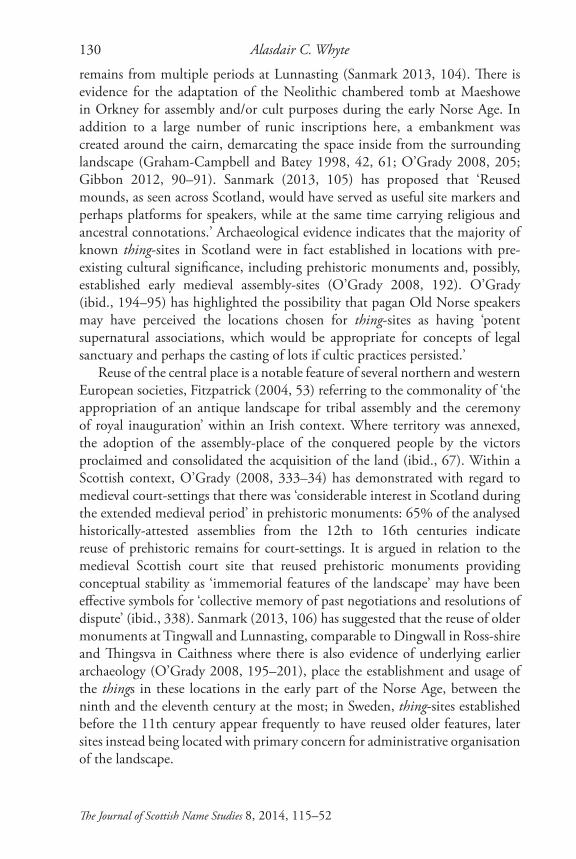
Fig. 2 From the Top of Carn Bàn, Facing NNWPh
otog
raph
: Ala
sdai
r C. W
hyte

Gruline, Mull, and Other Inner Hebridean Things 135
The Journal of Scottish Name Studies 8, 2014, 115–52
49 I am grateful to Professor Stephen Driscoll, University of Glasgow, for comments on photographs of the site.
is associated with a thing-site, ‘it may perhaps be assumed that the monument formed the core of the assembly, but that it was also set within the assembly-field or þing-valla.’ That this exclusive space was in many cases defined by an enclosure or temporary structure, as is evidenced at Tynwald Hill in Man and at Maeshowe in Orkney, has been discussed above, and is a feature which might therefore be expected in Norse-Age appropriation of Carn Bàn.
Delimitation of the central spaceThe RCAHMS survey of Carn Bàn revealed little on the site’s function and chronology but there may, as is highlighted above, be evidence of a stone ring running around the mound’s perimeter; the outlying boulders in and around this ring may also be of archaeological significance.49 Enclosure of the sanctified space around the thing or thing-mound in Scandinavian society, a characteristic comparable to ‘fencing’ of the court in medieval Scotland, has been discussed by O’Grady (2008, 53). This practice would enable the establishment of a visible fence defining the boundaries of the court and provide the ‘essential controlled space within which the processes of a court could be negotiated’ (ibid., 335). The passage in the Saga of Egill Skallagrímsonar which describes the level field in which the Gulating was established also refers to the encirclement of the court with hazel poles and ropes referred to as vébond ‘hallowed bands’; inside the ring sat the judges, those charged with reaching a verdict in lawsuits, the rest of the assembled thingsmen standing outside (Brink 2004, 206). This delimitation of space seems likely to lie behind the creation of the rectangular enclosure around the thing-site of Tynwald Hill and the adaptation of the pre-existing enclosure at Maeshowe. The flat-topped south mound of the artificial complex at Jelling in Denmark, constructed by King Harald Bluetooth in the late 10th century, was surrounded by a palisade defining the physical extent of the thing-site (Owen 2012, 23). As regards the process of ‘fencing’ at cairns or mounds in medieval Scotland, O’Grady (2008, 337) has highlighted the timber ‘fence’ of Tillydrone Hill, Old Aberdeen, and the enclosing ditch of the Market Knowe cairn of Longforgan. O’Grady’s proposal is that the layout of prehistoric monuments may have provided ‘physical prompts for the spatial organisation of medieval courts and their associated practices’ (ibid., 337). The ‘fencing’ ceremony may in fact have been the responsibility of a specific official, incorporating a physical adaptation of the space to activitate the social significance and legal sanctity of court sites with pre-attached prehistoric significance (ibid., 336). The use of stone in the delimitation of the central

Alasdair C. Whyte136
The Journal of Scottish Name Studies 8, 2014, 115–52
space is known at thing-sites in Scandinavia: stone slabs mark out a rectangular area around the thing-site at Bällsta, in the parish of Täby a short distance north of Stockholm, the creation of which has been dated to 1010 AD based on the style of the runestone inscription which names Ulvkel, Arnkel and Gye as the men who established the thing there (Owen 2012, 20; Brink 2004, 211–12; O’Grady 2008, 53). A connection between circles of stones and thing-sites in Scotland was proposed long ago by Hibbert (1831, 103–210), it being argued that these features represented the remains of Norse-Age assemblies in the Northern Isles, although no modern study has verified this within either this or the wider Scottish context (O’Grady 2008, 193). Further analysis of Carn Bàn may be able to provide chronological information on its surrounding stony bank and outlying boulders and these may be of particular relevance given the proposal that ON grjót specified the thing-site here. The possibility is that the toponym was coined by Old Norse speakers in reference to an assembly-site characterised by an encircling embankment of stone, perhaps stone blocks appropriated from Carn Bàn or surrounding monuments, the original shape and size of Carn Bàn having been ‘mutilated by robbing’ and the neighbouring, smaller cairn specifically described as having been ‘severely robbed of stone’ (RCAMHS Canmore IDs 22244 and 22248). The possibility that a pre-existing kerb around Carn Bàn was appropriated or adapted cannot be ruled out in the absence of further chronological analysis. The extent to which the removal of stones from Gruline’s cultivable land contributed to Carn Bàn’s stony bank before, during and after the Norse Age is unclear.
Liminality and centrality: an assembly-site for the island?O’Grady (2008, 337–38) has proposed that the liminal status of prehistoric monuments may have made them appropriate venues for judicial assemblies within a Scottish context, the subsequent adoption of such sites perhaps indicating a change of perception towards megaliths in the early historic period. A feature found elsewhere in Britain and in Europe, it seems likely that the liminality of prehistoric sites was considered functionally effective as regards the assembling of neighbouring communities across administrative boundaries in medieval Scotland (ibid., 337, 344–48). The location of Gruline can be considered liminal within Mull’s Norse-Age administrative units in that it lay in the extreme north-west corner of the district of Forsa, ON fors + ON á ‘waterfall river’, the specific most likely referring to the falls (NM600432) at the mouth of the River Forsa where it enters the Sound of Mull at the east end of the airstrip at Glenforsa. Given that a name of ON origin was also applied to this administrative district, the likelihood is that it was functional in the same period as the proposed assembly-site of Gruline. Indeed, the
Gruline, Mull, and Other Inner Hebridean Things 137
The Journal of Scottish Name Studies 8, 2014, 115–52
50 See also Waugh 2010.
earliest fiscal assessments of Mull illustrate that Gruline lay at the boundary of four separate administrative districts: Knock across the River Bà to the west lay within a district which included the settlements along the southern shoreline of Loch na Keal and Clachaig on the southern shoreline of Loch Bà; Glencannel and the settlements at the opposing end of Loch Bà lay within another; and the lands to the north-west along the northern shoreline of Loch na Keal lay within another (Whyte, forthcoming). Those lands to the north-west also lay across an ecclesiastical boundary within the parish of Kilninian and Kilmore in the medieval period, separated from the parish of Torosay by Loch na Keal and, for a short distance, the River Bà. Gruline’s liminality may be indicated in the specific element of both the aforementioned Carn Bàn and Torr Bàn (NM551394), this toponym applying to a mound which lies less than 500m north-east of the large cairn; the generic here is G tòrr, as in Tòrr an Arbhair. The specific in both Carn Bàn and Torr Bàn names is G bàn which, as highlighted above, can primarily be defined as ‘fair, white, pale, light in colour’. In place-names with topographical generics it probably chiefly refers to light-coloured vegetation, although Taylor (2012, 530–31) notes that both Scots white and Latin albus, especially in combination with generics such as ‘hill’ and ‘field’, appear in a Fife context to be applied also to boundary lands between communities, with implications of dispute, sharing and the absence of cultivation. G bàn can also mean ‘vacant, waste’ or ‘untilled’ and, although it is clear that late 19th-century locals understood the name of Carn Bàn as ‘white cairn’ (OSNB ARG OS1/2/46/1/50), G bàn may in these toponyms refer to liminality of location.
Discussion of the situation of thing-sites within their respective insular contexts has been a feature of recent scholarship on the nature of Norse assemblies in the Northern Isles. Sanmark (2013, 105) has argued that the most common trait linking the locations of Shetland’s things is their isthmus location, which also occurs in Orkney and frequently in Scandinavia.50 As highlighted previously, ON eið ‘isthmus’ is also the element proposed by Márkus as the specific in *Edin in Bute, this specific element illustrative of the site’s location on that island. Referring to Shetland’s thing-sites, O’Grady (2008, 209) has proposed that ‘Isthmuses are nexus points of land and sea movement’, offering ‘prominent landmarks which could be used to define a focal place for assembly activities’. An assembly-site on the extensive low-lying plain between the stony beach at the head of Loch na Keal and freshwater Loch Bà would undoubtedly constitute a prominent landmark on the coastline of Mull. The virtues of Loch na Keal are extolled by MacCormick (1923, 32) in

Alasdair C. Whyte138
The Journal of Scottish Name Studies 8, 2014, 115–52
51 There is also a dun and medieval settlement remains at Torr nam Fiann (NM539415) less than 3km NNW of Carn Bàn (RCAHMS, Canmore ID 22302).52 The generic here is clearly G caisteal ‘stone fort, castle’; the specific on account of the OS form is G sreang f., gen. -einge, literally meaning ‘string, line, cord’, but in this case likely to apply to the aforementioned track which connects the coastlines. The String (NR980360) is the name of a road in Arran (Fraser 1999, 144). It is An t-Sreang, the modern form clearly a direct translation into English from Gaelic, on the 1868 OS 6 inch 1st edn (Sheet CCXLIV).
the typically floral language of his day: ‘With Inchkenneth guarding its entrance from the sweeping career of the Atlantic’s wintry billows, and, surrounded on every side by a battlement of gigantic mountain ranges, Loch-na-Keal gets the name of being one of the safest harbours in the West Highlands.’ The situation of Gruline at the western end of the 4.5km isthmus between Loch na Keal and the Sound of Mull to the east would mark the site out as one of particular strategic seafaring significance, a significance which is clearly represented by the area’s monoliths and the aforementioned cairns.51 The B8035 is the modern route along the isthmus separating Loch na Keal from Salen on the Sound of Mull coast and a similar distance separates Loch na Keal and the estuary where the Aros River meets the Sound in the shadow of Aros Castle. The still-traversable track which connects the island’s west and east coasts here is clearly indicated as the main route, despite traversing land in excess of 150m in altitude, across the isthmus on the 19th-century maps of Langlands (1801) and Thomson (1832). This route runs past the conspicuous remains of an oval-shaped dun at Caisteal na Sreinge (NM555433; RCAHMS, Canmore ID 22283).52 There is no known name in ON eið in the Gruline area, but this expanse of flat land on the banks of the River Bà between Loch na Keal and freshwater Loch Bà, at the nexus of these established communication routes, means that Gruline was likely to have been a location of strategic significance suited to the assembling of local peoples long before the Norse Age. Within the wider context of assembly-sites in medieval Scotland, and with specific reference to fording places, O’Grady (2008, 345–46) has highlighted the importance attached to the positioning of assembly-sites ‘at focal points of movement and communication’. Brink (2004, 215), referring to thing-sites in early Scandinavia, notes that ‘The communications aspect was, of course, most important’. Location within insular and regional context has been important in both the identification and analysis of Scottish thing-sites in recent commentaries. The majority of identified thing-sites in Scotland represent locally significant institutions, likely to have served an area comparable to a single parish or group of minor estates (O’Grady 2008, 193). Gruline’s insularly central location may be more comparable to those of Tingwall in Shetland, Tingwall in Orkney and Tinwhil, or Hinnisdale, in Skye, however, whose things may have had a regional orbit, serving a populous beyond the immediate locale (ibid., 193).

Gruline, Mull, and Other Inner Hebridean Things 139
The Journal of Scottish Name Studies 8, 2014, 115–52
53 Sanmark’s five points are as follows: 1. Isthmus and small island location. 2. Proximity to fresh water. 3. Monument reuse. 4. Sheltered location. 5. Proximity to churches and chapels.54 For discussion of Glencannel and Knock, the early forms of which highlight the possibility that both of these names may in fact be hagiotoponyms, see Whyte, forthcoming. Blaeu’s map was based on the original survey work of Timothy Pont which may have been completed in the final decade of the 16th century. 55 The names have the same orthography on the 6 inch 1st edn OS map. Their etymologies were unknown to the informants of OSNB (ARG OS1/2/33/113/1 and OS1/2/33/109/3).
Sanmark’s ‘salient traits’ relating to Shetland’s thing-sites are a useful tool in the analysis of the thing-site at Gruline (2013, 102–05).53 In this regard, Gruline can be described as being located on an insularly central isthmus, is contiguous with freshwater by way of Loch Bà and the River Bà, and lies at the head of a sheltered sea loch and harbour in Loch na Keal. As regards proximity to an ecclesiastical site, there is a burial ground at Knock around 600m to the south-west in a square enclosure defined by a wall of 19th-century date, its earliest datable monument belonging to the mid-18th century (Canmore ID 22246); at the opposing end of Loch Bà around 8km south-east of Carn Bàn in Glencannel lies an old burial ground, an ecclesiastical site depicted here on the map of Blaeu published in the mid-17th century.54 There is strong evidence that Old Norse speakers, appropriating a central place in the Mull landscape in the form of Carn Bàn, applied *grjót-þing to a thing-site here, the central space perhaps being delimited by a stone kerb encircling the mound. Excavation of the site may reveal more as to the chronology of the mound and of the possible stone kerb, in turn providing more information on the political administration of this Inner Hebridean island in the Norse Age. Sanmark (2013, 98, 107) has argued that thing-sites were established in Shetland from the early phases of Norse settlement, an organic phase envisaged here from the ninth century onwards in which assemblies were set up by powerful individuals or families as a way of taking or claiming control over a particular area. Little has been confirmed to date on the Norse political mechanisms of control in the Inner Hebridean area.
Two further inner hebridean Things?Further research may take note of two possible Inner Hebridean parallels. Grulin (NR241681), in the parish of Kilchoman, is among the settlement-names listed in historical documents relating to Islay; this existing name is found in combination with the familiar Gaelic affixes mòr and beag, ‘big’ and ‘little’, on the modern OS map on the north side of Loch Gorm in the names Grulinmore (NR242666) and Grulinbeg (NR239680) (Macniven 2006, 335–36).55 Macniven has proposed an ON etymology for the existing name, interpreting the second element as ON land, translated in that study as ‘farm’. The specific is identified either as the
Alasdair C. Whyte140
The Journal of Scottish Name Studies 8, 2014, 115–52
56 Macniven’s forms elsewhere are chronologically ordered and the date relating to the form listed first here appears to be recorded in error. The asterisk which precedes the head-name in Macniven has not been included here.57 See also Walker 1990.
Old Norse feminine personal-name Gró or the element discussed above, ON grjót, which Macniven (ibid., 335) translates as ‘stoney’. The earliest forms of the toponym collected in Macniven’s study, however, highlight the possibility that Islay’s Grulin contains the same elements as Mull’s Gruline. The forms subsequent to 1733 are consistent in -lin(t), but the earliest forms are Grudin (1584), Groden (1562) and Groden (1563).56 There are no recorded forms in -ing as there are in the forms of Gruline, Mull, but the local pronunciation of the name included by Macniven (ibid., 335) indicates a final velar nasal: [ gruʔlɪŋ]. There is clear evidence of the same development from a medial voiced dental plosive to a lateral in the historical forms. As is outlined above in relation to the Gaelic dialects of Mull, it is proposed here that proximity between the broad d and broad l in the dialects of Islay lies behind this development. Although Grannd’s research suggests that broad l in medial position is realised as a lateral in the modern dialects of Islay (2000, 60), the early forms of Grulin could suggest closer historical proximity in the respective qualities of broad d and broad l in this position.
As regards ON grjót, some soils in the area of Grulin are of a type closely comparable with those of the Gruline Association discussed above. Although there are peaty, wet soils around Loch Gorm (SLCFA 1982, 3, map unit 4), the soils around Grulinmore are of the Corby Association. This is of particular interest given that the Gruline Assocation ‘may intergrade to the Corby Association’ (ibid., 71). Soils of the Corby Association type developed on interbedded sands and gravels derived from acid rocks, textures described as ‘always coarse’, although extreme variation is found (ibid., 49–50). The specific soil type found in the area of Grulinmore (map unit 99) is present on the gently undulating ground formed by raised beach and fluvioglacial outwash deposits (ibid., 51). It has soils of various types, the SLCFA report (ibid., 51) asserting that ‘Some of the best arable ground of the west coast is found on this map unit’.57 The reference to gravelly textures here is noteworthy given the above discussion of Gruline’s soils and must be a consideration with regard to the proposed etymologies in ON grjót. Jakobsen’s proposal regarding the application of the element to cleared and cultivated ground may also be appropriate here given this settlement’s primary status in early fiscal evaluation of Islay.
In addition to the parallels between the historical forms of the names, the possibility that Grulin was also coined in reference to a Norse assembly-site is made all the more attractive given the archaeology of this area of Islay. Norse

Gruline, Mull, and Other Inner Hebridean Things 141
The Journal of Scottish Name Studies 8, 2014, 115–52
58 Graham-Campbell and Batey (1998, 122–25) includes a case study on Ballinaby.59 Macniven (2006, 336), in discussion of the Grulin area’s antiquities, does not draw attention to the cairn but does refer to the nearby dun (NR239670) situated on a rocky knoll on the edge of the marshy flats on Loch Gorm here, about 400m WSW of Carnduncan (Canmore ID 37394). Macniven follows previous interpretations of the toponym as G càrn + G personal-name Donn(a)chadh ‘Duncan’s cairn’.60 The OS 1979 report notes that it is situated on level ground near the crest of a gentle scarp and commands ‘commanding views’ to the west (Canmore ID 239672).
origins have been suggested for the nearby ruins at An Sithean (NR250665) and Àird Thorrinnis (NR210675) (Canmore IDs 37374 and 37411; Macniven 2013b, 9), and four or more high-status pagan burials have been discovered at Ballinaby (NR221670) on the north-west shore of Loch Gorm (Canmore ID 37407). As regards the latter, Graham-Campbell and Batey (1998, 125) concluded that the wide-ranging array of artefacts discovered here provides ‘general archaeological information for the Norse presence on Islay during some part of the ninth and tenth centuries’ but that ‘all too little is known of the organisation of what would seem to have been a somewhat dispersed cemetery.’58 Macniven (2006, 308–09; 2013b, 9) has since argued that ‘The location of these burials – on or very near some of the best arable land in the northern half of the Rhinns – their relatively late date; and the fact that they include typical female assemblages all point to established Norse communities with a well defined social hierarchy.’ Neighbouring Grulin on the north side of Loch Gorm is Carnduncan (NR244672), a name which must have been coined in reference to the cairn, G càrn, at NR239672.59 The generic element in this toponym is not the only parallel with Gruline’s Carn Bàn, as the 1984 RCAHMS report on the cairn (Canmore ID 37384) illustrates:
This cairn stands in pastureland 350m W of Carnduncan and 30m NE of the public road from Loch Indaal to Sanaigmore. It measures 17m in diameter and although it has been reduced by stone-robbing, particu-larly on the E, it still survives to a height of 1.7m. A notable feature is the carefully chosen series of large boulders, up to 0.9m wide and 0.5m high, that form a kerb round the perimeter; the kerb is now discontinu-ous, and it is likely that the four dislodge[d] boulders shown on the plan originally belonged to it.60
In addition to its topographical situation, its relative dimensions and its contiguity with a freshwater loch and a river, in the form of the River Leòig, interpreted by Macniven (2006, 201) as ON lœkr m. ‘brook, rivulet’ (Cleasby/Vigfusson), the deliberate encircling of the cairn with large boulders, as is

Alasdair C. Whyte142
The Journal of Scottish Name Studies 8, 2014, 115–52
61 Macniven (2006, 336) has proposed that, while the area around Carnduncan and Grulin appears to fall within the bounds of Leek (NR223678) on Stephen MacDougall’s 1749–51 map of the island, ‘it seems more likely that they were once part of Grulin.’62 This feature has not been subject to archaeological investigation to date, although there is a record relating to possible cairns, cists and standing stones said to have been found in the conical hills below Sunderland Farm (Canmore ID 37436).63 In addition to devoicing, dental quality was recorded in relation to this voiced dental plosive at pt 56.
outlined above, may be paralleled at Carn Bàn.61 The possibility is that ON grjót applied to the stone kerb encircling this Islay cairn as it did at Gruline.
Macniven did not make a connection between the early forms of Grulin and ON þing but has argued that a prominent conical hillock (NR232648) on the farm of Sunderland (NR246645) was the location of a thing (2006, 195–97, 363–65; 2013a, 81–82).62 Sunderland is etymologised by Macniven (2013a, 81–82) as *Sjóvarland ‘the farm by/of the lake’, a name which is explained as having been conflated in local usage with the name of the surrounding district, ‘ON Sjóvarþing “the assembly place by the lake” ’; ON þing and ON land, it is suggested, were compounded with the same specific and used to describe different features in the landscape. An etymology in ON þing is argued on the basis of Shinart, the form of the name on the Blaeu map, which appears to be echoed in local pronunciation of the name: / ʃuɁnarɁtiŋ/. The earliest forms recorded by Macniven (2006, 195–97), however, are consistent with the medial l of the modern form: Synerlay (1507); Synarley (1509); Synnarland (1541a); Synnerland 1541b); Schynnerll (1542). On the basis of these earliest forms, ON land is a more likely candidate for the secondary element than ON þing. Again, proximity in the articulation of broad l and broad d in the Gaelic dialects of Islay may explain what appears on the basis of the early forms to be a development from an orthographical and phonological l to d in Sunderland, the opposite development to the Gruline/Grulin effect as it were. There may also be further evidence here of closer historical proximity between broad l and d in the Gaelic dialects of the area in a medial position. In all but one of the forms recorded by Macniven – the atypical Skynneil (1617), including the Blaeu form and modern pronunciation – the relevant consonant follows r. There is evidence that when broad l follows r in the dialects of Islay, it is realised not as a lateral but as a voiced dental plosive /d/: an illustrative example in SGDS is G Beurla ‘English language’, all four Islay informants articulating this consonant as /d/ (§100, pts 53–56).63 This feature of the local dialects seems likely to explain the orthographical t of the Blaeu form and the voiceless dental plosive of modern pronunciation recorded by Macniven.

Gruline, Mull, and Other Inner Hebridean Things 143
The Journal of Scottish Name Studies 8, 2014, 115–52
64 The nom. forms recorded in Zoëga are sær, sjár and sjór, where the term is defined as ‘sea’; the gen. forms noted here are sævar, sjávar, sjóvar and sjófar.65 The sacrality of the landscape in this part of the island in the psyche of the local Gaelic populace is confirmed by the aforementioned An Sithean (NR250665), a common toponym in the Gàidhealtachd which refers to conspicuous small mounds considered to be the dwelling-places of, to quote Taylor (2012, 499), ‘denizens of the Other World’; G sìthean is a diminutive form of G sìth.66 Dwelly’s entry on G teamhair points the reader to G tèamhaidh but also adds the following on the former: ‘Time, season, in season — Suth’d & N. Coast. 2** Covered or shaded walk on a hill. Teamhair fhuar, cold weather.’
With regard to the initial element of this toponym, Macniven (2006, 364) explains the *Sjóvar- part of the proposed compound as the genitive form of ‘ON sjó (f ), “lake” ’. This appears to be the gen. form, however, of ON sær m., also sjór and sjár, the former the most common form in the older texts; the gen. forms are sævar, sjóvar and sjávar, the intervocalic -v- sometimes written as -f- (Cleasby/Vigfusson). The sjó form provided by Macniven is found in both the acc. and dat. cases. As regards definition, the term applies to ‘the sea’, unsuprisingly found in numerous compounds, but is ‘never used, like Germ<an> see, of a lake’ (ibid.).64 Neither ON sær nor its alternative forms are likely to apply to freshwater Loch Gorm and are therefore unlikely to feature in the etymology of Sunderland. The consistent n and nn in the first element of the earliest forms, represented in the modern pronunciation of the name, are also problematic in Macniven’s preferred etymology, although there is an attempt to explain this in a ‘speculative re-interpretation’ of Sunderland as ‘ON *Sjúhundaraþing “the assembly place of the seven hundreds” ’ (Macniven 2013a, 89).
Returning to Grulin on the north shoreline of Loch Gorm, it is worth drawing attention here within the context of the reuse and adoption of central places outlined above to Druim Teamhair (NR226680).65 The name applies to a ridge, G druim m., gen. droma, lying just under 2km west of Grulinbeg. The specific may be the Gaelic form of OG temair, defined in DIL as ‘any high place, eminence, hill’. Druim Teamhair is translated as ‘pleasant ridge’ in OSNB (ARG OS1/2/33/109/1), a connection clearly being made with G tèamhaidh adj. ‘pleasant, agreeable, delightful, quiet’ (Dwelly).66 Watson (1926, 505), however, highlighted this Islay name in his discussion of the element teamhair, where he recorded the Gaelic form of the name as Druim Teamhra, a form retaining the older gen. which later became teamhrach. Watson defines the term as ‘an eminence of wide prospect standing by itself ’, noting that it is commonly anglicised within an Irish context as ‘Tara’, most famously in the renowned Temair Breg, Tara of Brega, in County Meath. With regard to

Alasdair C. Whyte144
The Journal of Scottish Name Studies 8, 2014, 115–52
67 MacBain (1911) discussed OG temair and Modern Ir teamhair in the entry for G teamhaidh, which he records without the accompanying length mark on the ‘e’ recorded in Dwelly; he derives the terms from *stemari (Mac Giolla Easpaig 2004, 429).68 For further discussion of the place-names containing this element, see also Ó Muraíle 2005, 449–477.
the term’s etymology, Watson (1905, 286), in an earlier study, suggested an origin in the Indo-European root tem- ‘to cut’. Dónall Mac Giolla Easpaig (2005, 448) has recently advocated Watson’s suggestion, asserting that the element derives from Indo-European *tem-r-i-s, reflecting the e-grade of the root *tem- ‘cut’ compounded with -r- suffix, thus signifying an area that has been cut off from the surrounding landscape. In Mac Giolla Easpaig’s own words, the element originally referred to an area that had been ‘demarcated for sacred purposes’, closely related both semantically and etymologically therefore to Greek temenos and Latin templum, and can be explained as a ‘sacred place’ (ibid., 448). In terms of the semantic development outlined above, Mac Giolla Easpaig (ibid., 427–28) has proposed that the term became a common appellative, albeit rarely found, subsequent to its application to Temair Breg, an eminent feature in the landscape of Meath, developing various associative meanings by the Middle Gaelic period. The figurative development of the term and its subsequent application as a place-name element were therefore only possible when its meaning and derivation had become opaque to speakers of Old Gaelic. The term’s metaphorical sense looks likely to explain MacBain’s definition of the word which he connects, like Dwelly, to G tèamhaidh, defined as ‘pleasant, delightful’;67 the word is in fact glossed elsewhere as OG aibinn ‘pleasant, delightful’ (Stokes 1907, 271: §126; Mac Giolla Easpaig 2005, 427). There are over 20 confirmed instances of OG temair in the toponymy of Ireland, a remarkable rate of survival in the opinion of Mac Giolla Easpaig (ibid., 430), given the ‘obvious antiquity of Temair as a name’.68 Watson’s analysis of the element in Dail Teamhair, one of the cluster of names seemingly containing the element in Glen Casley, Sutherland, implies application of the element in its metaphorical sense, as an adjective as it were, his explanation of the name being ‘Dale of Taras’; the specific element in Dail Teamhair is reckoned to apply to the numerous truncated conical mounds on this level plain (1905, 286). The older genitive form recorded by Watson in relation to the Islay name, however, when considered within the context of a sacred landscape in this part of Islay (evident in the area’s toponymy), opens up the possibility that this is a toponym of some antiquity. Further investigation of the toponymic landscape of this Islay name, in addition to further archaeological investigation, may reveal more on this area of the island, which appears likely on the above evidence to have been a central place from an early date. The specific in Druim

Gruline, Mull, and Other Inner Hebridean Things 145
The Journal of Scottish Name Studies 8, 2014, 115–52
69 For discussion of a toponym in Mull which looks to contain G teamhair, also located in the district of Forsa but not associated with Gruline, see Whyte, forthcoming.70 NGRs here are those provided in the RCAHMS reports on the ruined townships, Canmore IDs 22170 and 22191, respectively. The forms of the names included on the OS 6 inch 1st edn maps are identical to the modern forms. OSNB INV OS1/16/13/19/2 highlights that Grulin Iochdrach, rendered ‘Lower Gruline’, although this is subsequently scored out, applied to a ‘small district’ in this part of the island; Grulin Uachdrach, ‘Upper Gruline’ similarly scored out, also applied to a ‘district’, the meaning of the name unknown at that time (INV OS1/16/13/24/3. Both anglicised forms include a final e, as is found in the modern form of Gruline, Mull. 71 RMS ii no. 2438; ALI App. 54 228–29.72 RMS ii no. 2439.
Teamhair, or Druim Teamhra, carries ancient and significant associations and there is a distinct possibility that it refers to the cairn of Carnduncan. The name Grulin may well indicate continued centrality of this area in Norse-Age Islay, wholly unsurprising considering the above discussion concerning the reuse of prehistoric monuments.69
Grulin, EiggThere looks to be another Inner Hebridean toponym of comparison in the form of Grulin, Eigg. This name appears on the modern map in the form of Grulin Iochdrach (NM446850) and Grulin Uachdrach (NM455842),70 with the affixed adjectives G ìochd(a)rach and G uachd(a)rach ‘lower’ and ‘upper’, two ruined townships on Eigg’s south coast situated under the cliffs of An Sgùrr. The slopes here are characterised by rocky outcrops and large stone blocks, around which some of the ruined houses of Grulin Uachdrach were constructed (Canmore ID 22193). The topography here is markedly different to that of the low-lying arable of Gruline, Mull, and Grulin, Islay, and, if not applying to cultivable land cleared of stone, may be more comparable to applications of ON grjót to the likes of de Grūd in the western part of Unst, Shetland, where the name refers to a ‘steep, rocky strip of coast’ (Jakobsen 1993, 48). The pebble beaches which line the coast below the villages provide a topographical parallel to An Corran at Gruline.
The earliest forms of these names may be Grudling-Etrach and Grudleng-Neyvaidlean, recorded in a 1498 charter which granted to Ranald ‘Makallane’ of Clanranald lands in Uist, Eigg and Arisaig which had previously been held by the lords of Isles.71 A charter of the same year records the latter name as Grudling-Neyvaidlean.72 Grudling-Etrach looks likely to represent Grulin Iochdrach; the latter name clearly contains a different affix to the G uachdrach recorded by the OS. With regard to the incorporated existing name, Grulin, the medial -dl- of these forms appears to be unparallelled in the historical forms

Alasdair C. Whyte146
The Journal of Scottish Name Studies 8, 2014, 115–52
73 RMS vii no. 264; vii no. 344; ix no. 7; xi no. 1105.74 Retours (Inverness) i nos. 47 and 118; AÀA: Grealin/Grialainn, see also Forbes 1923, 206.75 The reference here in RCAHMS Canmore ID 22193 is to a manuscript labelled ‘R Rusbrooke et al 1986 (MS 581/1)’: it is ‘Interim Report of Archaeological Survey, Eigg, Inner Hebrides’, by P. Rushbrooke, P. and V. Williams and P. and S. Wade-Martins, 1986.
of the Mull and Islay names and, given the analysis of the two comparable examples above, may represent an intermediate form between Grud- and Grul-. The forms of the Eigg toponyms suggest similar proximity between broad d and l as is discussed above in relation to the Mull and Islay Gaelic dialects although there is no evidence for articulation of broad l as anything other than a lateral in SGDS: a velarised voiced dental approximant lateral preceded by an approximant was recorded in G ùbhlan, G ceòl and in an initial position in G loisg (pt 94). A glance at the subsequent forms of the Eigg names in RMS illustrates that, parallel to the Mull and Islay names, the orthographical d is later dropped for l: Growlin (1610), Groullin (1610), Growlin (1634) and Growling (1667).73 The Retours forms Growlin (1627) and Grouling (1695) also relate to this location in Eigg and are not of Grealin (NG508617), Skye, as is recorded in AÀA.74 The modern forms of Grealin suggest that the toponym does not contain the same elements as the Grulin(e) names: the Gaelic form is Grialainn and it is Grealin on the OS 6 inch first edn map. Returning to the Eigg toponym, and with regard to the proposed generic in ON þing, the 1498 forms in -ing and -eng are reminiscent of the earliest forms of Gruline, Mull. If the -dl- of these earliest forms does not represent articulation of a single phoneme, an etymology in ON grjót + ON land may be a consideration.
In addition to parallels with the Mull and Islay names concerning the orthographical development of Grulin, Eigg, however, its archaeological landscape may also be indicative of ON þing. Within the context of Mull’s Carn Bàn and Islay’s Carnduncan, a name of particular interest in the vicinity of Grulin is Carnan Ghrulin (NM456842). The generic here is G càrnan m. ‘small heap of stones’, the diminutive of G càrn; the specific is our existing name, lenited in the gen. case. The specific invites immediate comparison with the Mull and Islay sites and this area of Eigg was surveyed in some detail in 2001–2002 as part of the RCAHMS Eigg Survey. The project identified at least 13 huts and eight enclosures between the upper edge of the ruined settlement of Grulin Uachdrach and the cliffs of An Sgùrr, the huts being constructed of pitchstone rubble. There is evidence for the anticipated reuse of rubble and stone, some enclosures being of later date, and at least one having a hut built over it. One enclosure, having an external diameter of 7.8m E-W and 9.1m N-S, was identified as a hut circle in a 1986 survey of the site,75 the more recent

Gruline, Mull, and Other Inner Hebridean Things 147
The Journal of Scottish Name Studies 8, 2014, 115–52
76 There are also monoliths at the Eigg site which may be of interest within the context of a thing-site here: RCAHMS, Canmore ID 22193.77 The format of this Appendix follows that of Taylor, with Márkus, 5 vols, 2006–2012, and Márkus 2012.
RCAHMS survey proposing that this was in fact more likely to represent a small stock enclosure. Stock enclosures, more specifically areas designated for the provisioning of the horses of thing-attendees, might nonetheless be among the features expected of a thing-site’s archaeology. There is as yet, however, no analysis dating any of Grulin’s features to the Norse Age.76
ConclusionThe linguistic and archaeological evidence suggests the presence of a thing in each of these three Inner Hebridean locations. The early forms of the toponyms found in relation to these locations look to provide evidence that each was identified by a toponym compounding ON grjót and ON þing. Although geological and topographical applications of ON grjót may also be considered in each location, the specific element may apply to a shared characteristic which appears to be presented in the archaeological evidence: that these thing-sites were enclosed by a stone kerb. This is a feature of Norse-Age assembly-sites in Scandinavia, but also within a more local context at Tynwald Hill in Man and at Maeshowe in Orkney. It may be that names in Gruline and Grulin represent an Inner Hebridean Norse-Age culture relating to assembly-sites at which legal adminstration of the respective areas was focussed. Discussion of the Islay and Eigg sites in this study is preliminary in nature and more extensive research of both the toponymic and archaeological context of both locations is likely to elucidate the situation of the sites in the Norse Age, but there are parallels here which point to shared cultural traits in the establishment of Norse-Age assembly-sites in the area. Focussing in conclusion on Gruline, Mull, this site’s centrality within the context of the island and its location at the head of Loch na Keal, a sea loch renowned as a sheltered harbour, open up the possibility that the thing here had a regional orbit, perhaps serving more than the populace of this central part of Mull and the immediately adjacent smaller islands.
Appendix
GRULINE TOY S NM547398 1 375 20m77
Growding 1494 RMS ii. no. 2200 [2 pennylands; in Forsay]Crouding 1509 ER xiii 214 [16 shillings 8 pence; in Glenforssay et Leremulach;
the initial C- here may reflect either scribal error or scribal perception of

Alasdair C. Whyte148
The Journal of Scottish Name Studies 8, 2014, 115–52
78 This is the local pronunciation of the toponym in an English-speaking context.
this plosive, given the otherwise consistent G- of the historical forms and of modern orthography]
Growding 1538 RMS iii no. 1745 [2 pennylands; in Forsay]Gronding 1542 RSS ii no. 4732 [2 pennylands; in Glenfossy]Grouding 1612 RMS vii no. 663 [2 pennylands; in Glenfossay]Gronding 1615 Retours i no. 15 [2 pennylands; in Glensossy]Gruiling 1625 RMS viii no. 815 [2 pennylands; in Glenfossay]Growillie 1654 Blaeu (Pont) Mula Insula [settlement in black; NE of Auon Va]Gruigling 1663 Retours i no. 73 [2 pennylands; in Glensossay]Gruline 1801 Langlands ArgyllshireGruline 1824 Thomson Northern Part of Argyll ShireGruline 1881 OS 6 inch 1st edn Sheet LXXXIIIGruline 1900 OS 6 inch 2nd edn Sheet LXXXIIIMàm Maol Ghrùilinn 1911 MacCormick Seanchaidh na h-Airigh [toponym
in gen. but orthography suggests that the nom. case was *Grùilinn; not included on modern map, likely to refer to Cruach Tòrr an Lochain (NM563402; 348m)]
/ gruːlɪn/78
ReferencesAÀA:‘Ainmean-Àite na h-Alba - Gaelic Place-Names of Scotland’, on-line
database at <http://www.gaelicplacenames.org/database.php>.ALI: Munro, Jean, and R. W. Munro, eds, Acts of the Lords of the Isles, 1336–
1493 (Edinburgh: Scottish History Society).Blaeu: Blaeu, Johan, 1654, Atlas Novus (Amsterdam: Blaeu). Work based on
maps surveyed by Timothy Pont and reworked by Robert Gordon of Straloch and James Gordon of Rothiemay; reprinted in 2006, with an introduction (C. W. J. Withers) and translated texts (I. C. Cunningham), as The Blaeu Atlas of Scotland (Edinburgh: Birlinn); NLS WD3B/44, on-line at <http://maps.nls.uk/atlas/blaeu/page.cfm?id=111>.
Brink, Stefan, 2004, ‘Legal assembly sites in early Scandinavia’, in Aliki Pantos and Sarah Semple, eds, Assembly Places and Practices in Medieval Europe (Dublin: Four Courts Press), 205–16.
Broderick, George, 2003, ‘Tynwald: A Manx cult-site and institution of pre-Scandinavian origin’, Cambrian Medieval Celtic Studies 46, 55–94.
Cleasby-Vigfusson: An Icelandic-English Dictionary, initiated by Richard Cleasby, subsequently revised, enlarged and completed by Gudbrand Vigfusson, on-line at <http://lexicon.ff.cuni.cz/texts/oi_cleasbyvigfusson_about.html>.

Gruline, Mull, and Other Inner Hebridean Things 149
The Journal of Scottish Name Studies 8, 2014, 115–52
Crawford, Barbara E., 1987, Scandinavian Scotland (Leicester: Leicester University Press).
—— 2004, ‘Earldom Strategies in North Scotland and the Significance of Place-Names’, in D. G. E. Williams and P. Bibire, eds, Sagas, Saints and Settlements (Leiden: Brill).
Cox, Richard A. V., 2005, ‘Indicators of Ecclesiastical and Norse Settlement and History in the Toponymic Material in Appendixes H1–H8 of the Papar Project’, on-line at <http://paparproject.org.uk/hebrides.html>.
Currie, Jo, 2000, Mull: the island and its people (Edinburgh: Birlinn).Darvill, Timothy, 2004, ‘Tynwald Hill and the ‘things’ of power’, in Pantos and
Semple, eds, Assembly Places and Practices in Medieval Europe, 217–32.Driscoll, Steven T., 1998, ‘Church archaeology in Glasgow and the kingdom of
Strathclyde’, Innes Review 49, 95–114.Dwelly: Dwelly, Edward, 1994, The illustrated Gaelic-English dictionary:
containing every Gaelic word and meaning given in all previously published dictionaries, and a great number never printed before / to which is prefixed A concise Gaelic grammar (11th edn, Glasgow; 1st pub. 1901–1911).
Egil’s Saga: Jones, Gwyn, ed., 1960, Egil’s saga: translated from the Old Icelandic, with introduction and notes by Gwyn Jones/Egils saga Skallagrímssonar (Syracuse: Syracuse U. P. for the American-Scandinavian Foundation).
ER: Stuart, John, et al., eds, 1878–1908, The Exchequer Rolls of Scotland (Edinburgh: General Register House).
FitzPatrick, Elizabeth, 2004, ‘Royal inauguration mounds in medieval Ireland: antique landscape and tradition’, in Pantos and Semple, eds, Assembly Places and Practices in Medieval Europe, 44–72.
Forbes, Alexander R., 1923, Place-names of Skye and Adjacent Islands: with lore, mythical, traditional and historical (Paisley: Alexander Gardner).
Fraser, Ian A., 1999, The Place-Names of Arran (Glasgow: The Arran Society of Glasgow).
Gibbon, Sarah Jane, 2012, ‘Orkney’s Things’, in Olwyn Owen, ed., Things in the Viking World (Lerwick: Shetland Litho), 80–93.
Graham-Campbell, James, and Batey, Colleen E., 1998, Vikings in Scotland: an archaeological survey (Edinburgh: Edinburgh University Press).
Grannd, Seumas, 2000, The Gaelic of Islay: A Comparative Study (Aberdeen: The Department of Celtic, University of Aberdeen).
Hibbert, Samuel, 1831, ‘Memoir on the Tings of Orkney and Shetland’, Archaeologia Scotica 3, 103–210.
Holley, Mark W., 2000, The Artificial Islets/Crannogs of the Central Inner Hebrides (Oxford: Archaeopress).
Jakobsen, Jakob, 1993, The Place-Names of Shetland (repr., Kirkwall, Orkney:

Alasdair C. Whyte150
The Journal of Scottish Name Studies 8, 2014, 115–52
The Orcadian Limited; 1st pub. 1936).Johnson, Andrew, 2012, ‘Tynwald – Ancient Site, Modern Institution – Isle of
Man’, in Owen, ed., Things in the Viking World, 104–17.Jónsson, Torfi Stefán, 2012, ‘Thingvellir as an early National Centre – Iceland’,
in Owen, ed., Things in the Viking World, 42–53.Langlands: Langlands, George, 1801, This map of Argyllshire ... (Campbeltown);
NLS EMS.s.326, on-line at <http://maps.nls.uk/joins/581.html>.Løkka, Nanna, 2013, ‘Þing goða – The Mythological Assembly Site’, Journal of
the North Atlantic 5 (sp5), 18–27.Márkus, Gilbert, 2012, The Place-Names of Bute (Donington: Shaun Tyas).MacBain, Alexander, 1911, An Etymological Dictionary of the Gaelic Language
(2nd edn, Stirling: Eneas MacKay; 1st pub. 1896).Mac Cormaic, Iain (John MacCormick), 1911, Seanchaidh na h-Airigh
(Struibhle: Aonghas Mac Aoidh).MacCormick, John, 1923, The Island of Mull: its history, scenes and legends
(Glasgow: Alex. MacLaren & Sons).Mac Giolla Easpaig, Dónall, 2005, ‘Significance and Etymology of the
Placename Temair’, in Edel Bhreathnach, ed., The Kingship and Landscape of Tara (Dublin: Four Courts Press), 423–48.
Maclean, Charles, 1997, The Isle of Mull: Placenames, Meanings and Stories (Dumfries: Maclean Publications).
Macniven, Alan, 2006, ‘The Norse in Islay: a settlement historical case-study for medieval Scandinavian activity in Western Maritime Scotland’ (unpublished PhD thesis, University of Edinburgh).
—— 2013a, ‘ “Borgs”, Boats and the Beginnings of Islay’s Medieval Parish Network?’, Northern Studies 45, 68–99.
—— 2013b, ‘Modelling Viking Migration to the Inner Hebrides’, Journal of the North Atlantic 4 (sp4), 3–18.
MacQuarrie, Duncan M., 1982, The Placenames of Mull (Inverness).Misje, Anne-Karin, 2012, ‘The Gulating Code of Law’, in Owen, ed., Things in
the Viking World, 30–41.NLS: National Library of Scotland, George IV Bridge, Edinburgh. Map images
on-line at <http://maps.nls.uk/>.O’Grady, Oliver J. T., 2008, ‘The Setting and Practice of Open-air Judicial
Assemblies in Medieval Scotland: a Multidisciplinary Study’, 2 vols (unpublished PhD thesis, University of Glasgow).
—— 2014, ‘Judicial Assembly Sites in Scotland: Archaeological and Place-Name Evidence of the Scottish Court Hill’, Medieval Archaeology 58, 104–35.
Ó Muraíle, Nollaig, 2005, ‘Temair/Tara and Other Places of the Name’, in

Gruline, Mull, and Other Inner Hebridean Things 151
The Journal of Scottish Name Studies 8, 2014, 115–52
Bhreathnach, ed., The Kingship and Landscape of Tara, 449–77.Ødegaard, Marie, 2013, ‘State Formation, Administrative Areas, and Thing Sites
in the Borgarthing Law Province, Southeast Norway’, Journal of the North Atlantic 5 (sp5), 42–63.
OED: The Oxford English Dictionary, on-line at <http://www.oed.com/>.OSNB: Ordnance Survey Object Name Books: the unpublished place-name
data from which the OS 6 inch 1st edition maps were created, with variants, names of informants, and descriptions and discussions of objects; on-line as a subscription resource at <http://www.scotlandsplaces.gov.uk/>, on microfilm in NAS West Register House, Edinburgh, and in the library of RCAHMS, Edinburgh.
Owen, Olwyn, 2012, ‘Things in the Viking World – an introduction’, in Owen, ed., Things in the Viking World, 4–29.
Papar Project: The Papar Project, on-line at <http://paparproject.org.uk/>.RCAHMS: Royal Commission on the Ancient and Historical Monuments of
Scotland. Canmore database on-line at <http://www.rcahms.gov.uk/canmore.html>.
RCAHMS: RCAHMS, 1980, Argyll: an inventory of the ancient monuments. Vol. 3, Mull, Tiree, Coll & Northern Argyll (excluding the early medieval & later monuments of Iona) (Edinburgh: HMSO).
Retours: Thomson, Thomas, ed., 1811–16, Inquisitionum ad Capellam Domini Regis Retornatarum, quae in publicis archivis Scotiae adhuc servantur, Abbreviatio, 3 vols (Edinburgh).
RMS: Thomson, John Maitland, et al., eds, 1882–1914, Registrum Magni Sigilli Regum Scottorum (Edinburgh).
RSS: Livingstone, Matthew, ed., 1908- , Registrum Secreti Sigilli Regum Scottorum (Edinburgh: HM General Register House).
Sandnes, Berit, 2010, From Starafjall to Starling Hill: An investigation of the formation and development of Old Norse place-names in Orkney, Scottish Place-Name Society ebook, <http://www.spns.org.uk/Starafjall.pdf>.
Sanmark, Alexandra, 2013, ‘Patterns of Assembly: Norse Thing Sites in Shetland’, Journal of the North Atlantic 5 (sp5), 96–110.
Sanmark, Alexandra, et al., 2013, ‘Debating the Thing in the North I: Introduction and Acknowledgments’, Journal of the North Atlantic 5 (sp5), 1–4.
SGDS: Ó Dochartaigh, Cathair, ed., 1994–1997, Survey of the Gaelic dialects of Scotland: questionnaire materials collected for the Linguistic Survey of Scotland, 5 vols (Dublin: Dublin Institute for Advanced Studies).
SIFSS: ‘Soil Information for Scottish Soils | SIFSS - The James Hutton Institute’, <http://sifss.hutton.ac.uk/index.php>.

Alasdair C. Whyte152
The Journal of Scottish Name Studies 8, 2014, 115–52
SLCFA: Bibby, J. S., G. Hudson and D. J. Henderson, 1982, Soil and Land Capability for Agriculture: Western Scotland. Handbook to accompany the 1:250 000 scale Soil and Land Capability for Agriculture maps, Sheet 4 (Aberdeen: The Macaulay Institute for Soil Research); on-line at <http://www.soils-scotland.gov.uk/publications/result?view=GUIDELINES>.
Smith, Brian, 2012, ‘Shetland’s Tings’, in Owen, ed., Things in the Viking World, 68–79.
Stahl, Anke-Beate, 2004, Guide to Scandinavian origins of place names in Britain, OS ebook, <http://www.ordnancesurvey.co.uk/docs/ebooks/guide-to-scandinavian-origins-of-place-names.pdf>.
Stokes, Whitley, 1907, ‘The Stowe Glossaries’, Archiv für celtische Lexikographie 3, 268–89.
Taylor, Simon, 2005, Guide to Gaelic origins of place names in Britain, OS ebook, <http://www.ordnancesurvey.co.uk/docs/ebooks/guide-to-gaelic-origins-of-place-names.pdf>.
Taylor, Simon, with Márkus, Gilbert, 2006–2012, The Place-Names of Fife, 5 vols (Donington: Shaun Tyas).
Thomson: Thomson, John, 1824, Northern Part of Argyll Shire (Edinburgh: John Thomson & Co.); NLS EMS.s.712(17), on-line at <http://maps.nls.uk/atlas/thomson/506.html>.
Vésteinsson, Orri, 2013, ‘What is in a Booth? Material Symbolism at Icelandic Assembly Sites’, Journal of the North Atlantic 5 (sp5), 111–24.
Walker, A. D., 1990, ‘Corby Series’ (Macaulay Land Use Research Institute, Aberdeen), on-line at <http://sifss.hutton.ac.uk/smuds/Corby.jpg>.
Watson, William J., 1905, ‘Tara’, Celtic Review 1, 286.—— 1926, The History of the Celtic Place-Names of Scotland (Edinburgh and
London; reprinted with an Introduction by Simon Taylor, Edinburgh 2004; and, with an extended Introduction, Edinburgh 2011).
Waugh, Doreen, 2010, ‘On eið-names in Orkney and other North Atlantic islands’, in John Sheehan and Donnchadh Ó Corráin, eds, The Viking Age: Ireland and the West. Papers from the Proceedings of the Fifteenth Viking Congress, Cork, 18–27 August 2005 (Dublin: Four Courts Press, Dublin), 545–54.
Whyte, Alasdair C., forthcoming, ‘Early Settlement- and District-Names in Torosay (Killean) parish, Mull’ (forthcoming PhD thesis, University of Glasgow, provisional title).
Woolf, Alex, 2007, From Pictland to Alba 789–1070 (Edinburgh: Edinburgh University Press).
Zoëga: Zoëga, Geir T., 1910, A Concise Dictionary of Old Icelandic (Oxford: Clarendon Press); on-line at <http://norse.ulver.com/dct/zoega/>.