hartley anderson limited
TRANSCRIPT

Hartley Anderson Limited Marine Environmental Science and Consultancy
Appropriate Assessment Screening and Appropriate Assessment Codling Wind Park Foreshore Investigation Licence Application
Report to Department of Housing, Local Government
and Heritage
December 2020 Updated following provision of further information
from the developer

Appropriate Assessment Screening and Appropriate Assessment
Hartley Anderson Limited December 2020
Page 1
TABLE OF CONTENTS
SECTION 1 - INTRODUCTION .................................................................................. 2
1.1 Background ................................................................................................... 2
1.2 Application documents submitted .................................................................. 2
1.3 Relevant consultation responses .................................................................. 2
1.4 Response to Request for Further Information ............................................... 3
1.5 Legislative context ......................................................................................... 4
SECTION 2 - DESCRIPTION OF PROPOSED INVESTIGATIVE WORKS ............... 6
2.1 Introduction ................................................................................................... 6
2.2 Summary of proposed investigative works .................................................... 6
2.3 Review of proposed investigative works ....................................................... 9
SECTION 3 - STAGE 1 SCREENING FOR APPROPRIATE ASSESSMENT ......... 11
3.1 Basis for screening the project .................................................................... 11
3.2 Sources of likely significant effect ............................................................... 11
3.3 Identification of relevant sites ...................................................................... 12
3.4 Sites identified by the applicant to be screened for AA ............................... 14
3.5 Request for Further Information .................................................................. 20
3.6 Screening Conclusion ................................................................................. 23
SECTION 4 - STAGE 2 APPROPRIATE ASSESSMENT ........................................ 24
4.1 AA Conclusion ............................................................................................. 29
SECTION 5 - ARTICLE 12 ASSESSMENT .............................................................. 31
5.1 Relevant Annex IV species ......................................................................... 31
5.2 European Protected Species Risk Assessment .......................................... 31
5.3 Article 12 Conclusion .................................................................................. 32
BIBLIOGRAPHY ...................................................................................................... 33

Appropriate Assessment Screening and Appropriate Assessment
Hartley Anderson Limited December 2020
Page 2
SECTION 1 - INTRODUCTION
1.1 Background
Arup with Hartley Anderson Limited have been commissioned by the Department of Housing, Local Government and Heritage (DHLGH) to conduct an Appropriate Assessment (AA) Screening (stage 1 screening) and if required, an AA (stage 2), of the likelihood of significant impact on Natura 2000 sites from an application for a Foreshore Investigation Licence. The application by Codling Wind Park Limited (CWPL), covers a range of proposed geophysical/geotechnical and environmental surveys over an area which includes both the proposed CWP array site together with the potential export cable corridors and additional buffer zones. The proposed investigative works are required to provide updated environmental and engineering information to inform the project design and the environmental assessments (e.g. Habitat Regulation Assessment (HRA) and Environmental Impact Assessment (EIA) required for the consenting of the CWP OWF.
1.2 Application documents submitted
A number of application documents submitted by CWPL have formed the basis of this AA Screening and AA, including:
• Application Form • Foreshore Licence Map • Site Investigations - Indicative Locations • Appendix A Coordinates • European Protected Species Risk Assessment Report • Supplementary Information • Device Specification
The CWPL Supplementary Information report provided information to inform both stage 1 (Appendix 2 Appropriate Assessment Stage 1: Screening) and stage 2 (Appendix 3 Appropriate Assessment Stage 2: Natura Impact Statement) assessments. In addition and with respect to the Habitats Directive, an Article 12 Assessment of the proposed investigative works is described in Section 5 of this report based on information provided in the CWPL Supplementary Information report (Appendix 7 European Protected Species Risk Assessment).
1.3 Relevant consultation responses
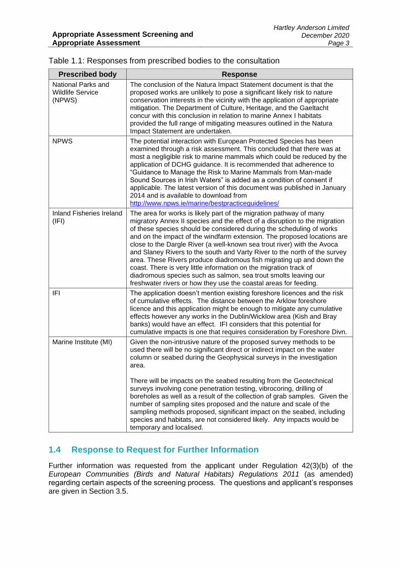
The site investigation licence application was open for public consultation between 15 July to 15 August 2020. Consultation responses from the prescribed bodies are provided in Table 1.1.
Appropriate Assessment Screening and Appropriate Assessment
Hartley Anderson Limited December 2020
Page 3
Table 1.1: Responses from prescribed bodies to the consultation
Prescribed body Response
National Parks and Wildlife Service (NPWS)
The conclusion of the Natura Impact Statement document is that the proposed works are unlikely to pose a significant likely risk to nature conservation interests in the vicinity with the application of appropriate mitigation. The Department of Culture, Heritage, and the Gaeltacht concur with this conclusion in relation to marine Annex I habitats provided the full range of mitigating measures outlined in the Natura Impact Statement are undertaken.
NPWS The potential interaction with European Protected Species has been examined through a risk assessment. This concluded that there was at most a negligible risk to marine mammals which could be reduced by the application of DCHG guidance. It is recommended that adherence to “Guidance to Manage the Risk to Marine Mammals from Man-made Sound Sources in Irish Waters” is added as a condition of consent if applicable. The latest version of this document was published in January 2014 and is available to download from http://www.npws.ie/marine/bestpracticeguidelines/
Inland Fisheries Ireland (IFI)
The area for works is likely part of the migration pathway of many migratory Annex II species and the effect of a disruption to the migration of these species should be considered during the scheduling of works and on the impact of the windfarm extension. The proposed locations are close to the Dargle River (a well-known sea trout river) with the Avoca and Slaney Rivers to the south and Varty River to the north of the survey area. These Rivers produce diadromous fish migrating up and down the coast. There is very little information on the migration track of diadromous species such as salmon, sea trout smolts leaving our freshwater rivers or how they use the coastal areas for feeding.
IFI The application doesn’t mention existing foreshore licences and the risk of cumulative effects. The distance between the Arklow foreshore licence and this application might be enough to mitigate any cumulative effects however any works in the Dublin/Wicklow area (Kish and Bray banks) would have an effect. IFI considers that this potential for cumulative impacts is one that requires consideration by Foreshore Divn.
Marine Institute (MI) Given the non-intrusive nature of the proposed survey methods to be used there will be no significant direct or indirect impact on the water column or seabed during the Geophysical surveys in the investigation area. There will be impacts on the seabed resulting from the Geotechnical surveys involving cone penetration testing, vibrocoring, drilling of boreholes as well as a result of the collection of grab samples. Given the number of sampling sites proposed and the nature and scale of the sampling methods proposed, significant impact on the seabed, including species and habitats, are not considered likely. Any impacts would be temporary and localised.
1.4 Response to Request for Further Information
Further information was requested from the applicant under Regulation 42(3)(b) of the European Communities (Birds and Natural Habitats) Regulations 2011 (as amended) regarding certain aspects of the screening process. The questions and applicant’s responses are given in Section 3.5.
Appropriate Assessment Screening and Appropriate Assessment
Hartley Anderson Limited December 2020
Page 4
1.5 Legislative context
The Foreshore Act 1933 (as amended), requires that a lease or licence must be obtained from the Minister for Housing, Local Government and Heritage for the carrying out of works or placing structures or material on, or for the occupation of or removal of material from, State-owned foreshore. Under the Act, foreshore consent is required to investigate/survey a proposed offshore wind farm site. Investigation licences permit a developer to undertake surveying at specific locations to determine their suitability for energy generation and are subject to specific conditions that address, but are not confined to, (i) the scale of the project and (ii) the duration of occupation of the foreshore. The Department’s current position of not accepting new Offshore Renewable Energy (ORE) applications other than those for site investigation and demonstration projects will remain in force for the foreseeable future as the new marine planning framework and legislation is developed. The Marine Planning and Development Management (MPDM) Bill has evolved from the Maritime Area and Foreshore Amendment Bill. A final General Scheme of the Bill was approved by Government in December 2019. The MPDM Bill seeks to establish in law a new regime for the maritime area. The new regime will replace existing State and development consent regimes and streamline arrangements on the basis of a single consent principle i.e. one state consent (Maritime Area Consent) to enable occupation of the Maritime Area and one development consent (planning permission), with a single environmental assessment. The MPDM Bill general scheme outlines the Transitional Protocols for “Relevant Projects”; these are projects which currently have either a Lease, are well advanced in the planning application process and Lease application submitted or have an agreement for a grid connection already in place. CWPL understands that CWP is considered as having a Relevant Project status under these Transitional arrangements. The 1992 EU Habitats Directive (Council Directive 92/43/EC) is transposed into Irish law by the European Communities (Birds and Natural Habitats) Regulations (SI 477 of 2011) (as amended), which outlines the requirements for screening for AA and AA under Regulation 42:
42. (1) A screening for Appropriate Assessment of a plan or project for which an application for consent is received, or which a public authority wishes to undertake or adopt, and which is not directly connected with or necessary to the management of the site as a European Site, shall be carried out by the public authority to assess, in view of best scientific knowledge and in view of the conservation objectives of the site, if that plan or project, individually or in combination with other plans or projects is likely to have a significant effect on the European site. (2) A public authority shall carry out a screening for Appropriate Assessment under paragraph (1) before consent for a plan or project is given, or a decision to undertake or adopt a plan or project is taken. (6) The public authority shall determine that an Appropriate Assessment of a plan or project is required where the plan or project is not directly connected with or necessary to the management of the site as a European Site and if it cannot be excluded, on the basis of objective scientific information following screening under this Regulation, that the plan or project, individually or in combination with other plans or projects, will have a significant effect on a European site.

Appropriate Assessment Screening and Appropriate Assessment
Hartley Anderson Limited December 2020
Page 5
In addition to the requirement to consider potential effects of a plan or project on European Sites under Article 6(3) of the Habitats Directive, the Directive requires consideration of the potential effects on species listed under Annex IV of the Directive (termed Annex IV species). Under Article 12, Annex IV species are afforded strict protection throughout their range, both inside and outside of designated protected areas.

Appropriate Assessment Screening and Appropriate Assessment
Hartley Anderson Limited December 2020
Page 6
SECTION 2 - DESCRIPTION OF PROPOSED INVESTIGATIVE WORKS
2.1 Introduction
The proposed investigative works that are the subject of the licence application include:
• Geophysical and geotechnical/Unexploded Ordnance (UXO) surveys; • Fish & shellfish (potting and trawl surveys); • Benthic (grab sampling and epibenthic trawl survey); • Intertidal (ecological and archaeological walkover surveys); and • Metocean (deployment of floating LIDAR, wave buoys, ADCP units) • Marine mammal acoustic survey (deployment of echolocation click detectors (PODs)
and potential broadband sound recorders). The proposed investigative works are summarised below with more information provided in Section 2 of the Supplementary Information report.
2.2 Summary of proposed investigative works
2.2.1 Survey locations
The Licence Application Area lies within the 12 nautical mile (nm) limit and covers approximately 51,523 hectares (ha) or 515 km2. It includes both the proposed CWP array site together with the potential export cable corridors and additional buffer zones. The proposed surveys will not take place across the whole Licence Application Area (see Figures 5.2.1 to 5.2.3 in the Supplementary Information report), nor will all the surveys take place concurrently (see Section 2.2.2 below). The final locations for many of the surveys e.g. geotechnical and benthic surveys, are dependent on and will be informed by the results of the geophysical surveys. Therefore, the final locations and total number of samples will be further refined following analysis of this survey data. The geophysical survey will cover the full extent of the CWP array site, and a 500 m buffer zone. The search area for the export cable routes is quite extensive as it covers potential route corridors landfalling from Poolbeg in the north to Wicklow in the south, with potential options for landfall at two locations in between (i.e. total of four broad landfall locations. The potential export cable routes will also be surveyed using a 500 m wide survey corridor. Survey routes will be finalised following survey procurement and further technical studies. It should be noted that for some survey types (e.g. benthic habitat sampling and marine mammal acoustic surveys) the survey area may extend beyond the Licence Application Area outside the 12 nm zone (primarily to include reference sites).
2.2.2 Survey programme and scope
CWPL are applying for a licence of 5-year duration to take into account potential baseline and pre-construction survey requirements and allow for flexibility including to take account of any unforeseen delays and breaks within survey campaigns. A high-level indicative project programme and summary of survey scope is provided in Table 2.1. This is illustrative and may be subject to change depending on the final design and outcome of any consultation and agreements reached with statutory bodies or consultees.

Appropriate Assessment Screening and Appropriate Assessment
Hartley Anderson Limited December 2020
Page 7
Timings are also indicative and dependent on various factors including but not limited to weather downtime and timing restrictions.
Table 2.1: Indicative survey programme and scope
Activity Proposed Sample numbers / locations Indicative timings
Geotechnical surveys
Array 20 boreholes and 60 CPTs (Cone Penetration Tests) (baseline) 100 boreholes (pre-construction, which may be run in two separate campaigns). The locations of these boreholes are yet to be determined and will be informed by prior survey work and detailed engineering and project design work but will be located within the CWP array site. Cable corridors Offshore Co-located vibrocore and CPTs every 1 km plus 10% contingency. Landfall Boreholes (or CPTs) every 200 m from MHWS for approx. 1.5 km. Up to 200 CPTs, 177 vibrocores and 50 boreholes across all possible export cable routes are proposed. Indicative locations are included in Figures 2.1 and 2.2.
6 – 12 months per campaign (baseline and pre-construction)
Geophysical and Unexploded Ordnance (UXO) surveys
Array Surveys across CWP to assess ground conditions and to identify possible UXOs. Multibeam echosounder (MBES), side scan sonar (SSS) and gradiometer system using several magnetometers, sub bottom profiler, multichannel high-resolution acoustic seismic surveys i.e. sparkers. Underwater positioning systems (USBL) will be used for towed equipment. Full coverage of array sites plus 500 m buffer. Export cable routes Full coverage of all potential cable routes with 500 m buffer. 500 m width maybe exceeded in isolated locations.
6 - 12 months (per survey)
Potting survey
To Be Determined (TBD) in consultation with the Sea Fisheries Protection Authority (SFPA). Surveys will be designed to undertake pre and post construction samples (rather than to inform EIA baseline). Indicatively may include 10 locations for potting and trawl surveys within array or along cable routes.
Up to 5 days per survey visit, over 12 months (pre-construction)
Trawl survey
TBD in consultation with SFPA. Surveys will be designed to undertake pre and post construction samples (rather than to inform EIA baseline). Indicatively may include 10 locations for potting and trawl surveys within array or along cable routes.
Up to 5 days per survey visit, over 12 months (pre-construction)
Appropriate Assessment Screening and Appropriate Assessment
Hartley Anderson Limited December 2020
Page 8
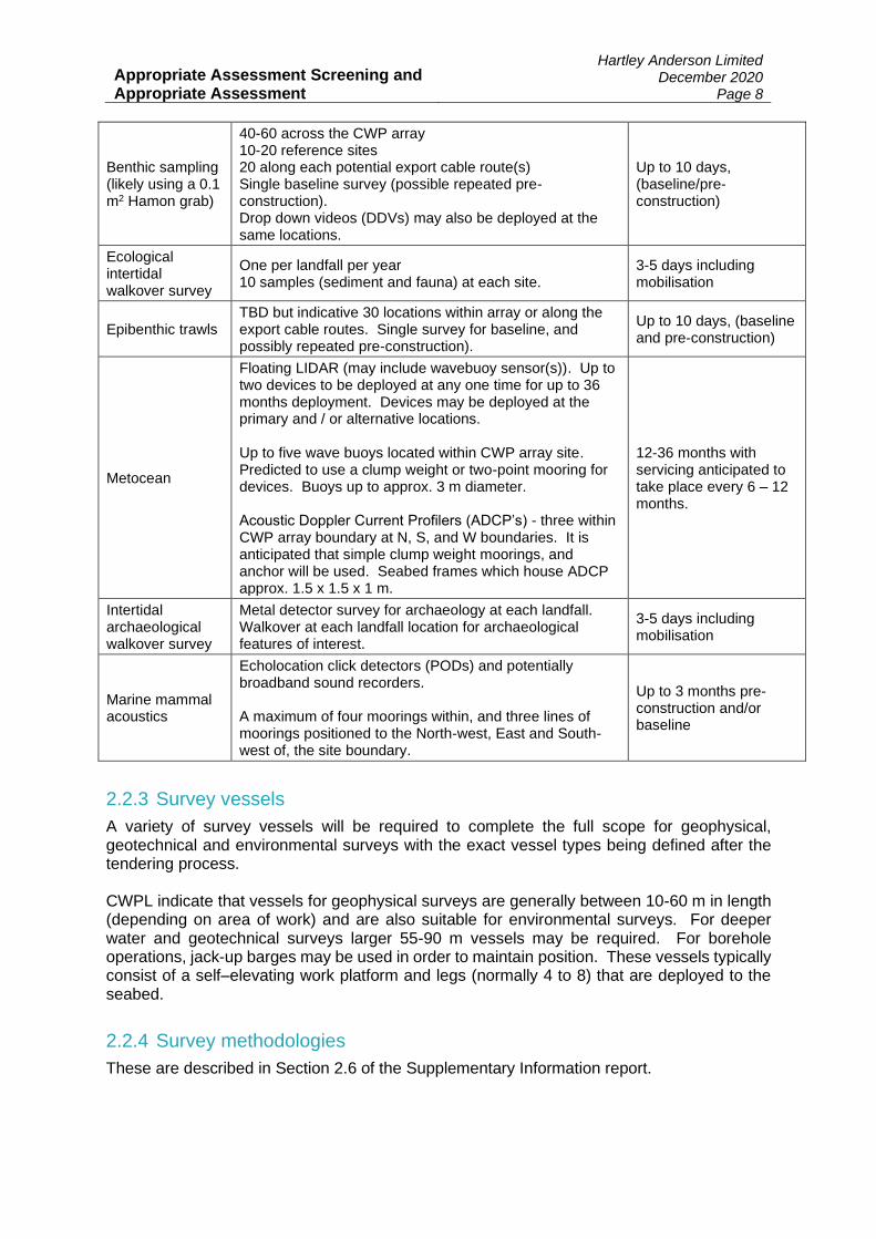
Benthic sampling (likely using a 0.1 m2 Hamon grab)
40-60 across the CWP array 10-20 reference sites 20 along each potential export cable route(s) Single baseline survey (possible repeated pre-construction). Drop down videos (DDVs) may also be deployed at the same locations.
Up to 10 days, (baseline/pre-construction)
Ecological intertidal walkover survey
One per landfall per year 10 samples (sediment and fauna) at each site.
3-5 days including mobilisation
Epibenthic trawls TBD but indicative 30 locations within array or along the export cable routes. Single survey for baseline, and possibly repeated pre-construction).
Up to 10 days, (baseline and pre-construction)
Metocean
Floating LIDAR (may include wavebuoy sensor(s)). Up to two devices to be deployed at any one time for up to 36 months deployment. Devices may be deployed at the primary and / or alternative locations. Up to five wave buoys located within CWP array site. Predicted to use a clump weight or two-point mooring for devices. Buoys up to approx. 3 m diameter. Acoustic Doppler Current Profilers (ADCP’s) - three within CWP array boundary at N, S, and W boundaries. It is anticipated that simple clump weight moorings, and anchor will be used. Seabed frames which house ADCP approx. 1.5 x 1.5 x 1 m.
12-36 months with servicing anticipated to take place every 6 – 12 months.
Intertidal archaeological walkover survey
Metal detector survey for archaeology at each landfall. Walkover at each landfall location for archaeological features of interest.
3-5 days including mobilisation
Marine mammal acoustics
Echolocation click detectors (PODs) and potentially broadband sound recorders. A maximum of four moorings within, and three lines of moorings positioned to the North-west, East and South-west of, the site boundary.
Up to 3 months pre-construction and/or baseline
2.2.3 Survey vessels
A variety of survey vessels will be required to complete the full scope for geophysical, geotechnical and environmental surveys with the exact vessel types being defined after the tendering process. CWPL indicate that vessels for geophysical surveys are generally between 10-60 m in length (depending on area of work) and are also suitable for environmental surveys. For deeper water and geotechnical surveys larger 55-90 m vessels may be required. For borehole operations, jack-up barges may be used in order to maintain position. These vessels typically consist of a self–elevating work platform and legs (normally 4 to 8) that are deployed to the seabed.
2.2.4 Survey methodologies
These are described in Section 2.6 of the Supplementary Information report.

Appropriate Assessment Screening and Appropriate Assessment
Hartley Anderson Limited December 2020
Page 9
Of particular relevance to the AA Screening and AA is equipment that may be used as part of the proposed geophysical surveys (Table 2.2), which produce underwater noise that may be detected by (and potentially impact) sensitive receptors at distance from the source.
Table 2.2: Equipment proposed for the geophysical survey work
Equipment type Purpose Frequency range Maximum Source Pressure Level
(dB re 1 µPa @ 1m)
Multibeam Echo Sounder (MBES)
Determines depth and nature of the seabed by transmitting sound pulses (active sonar). Transmits broad acoustic pulse.
200-400 kHz 220
Side Scan Sonar (SSS)
Determines depth and nature of the seabed by transmitting sound pulses (active sonar).
High frequency min. 600 kHz Preferred high frequency 800 kHz
210-224
Sub-bottom Profiler (SBP) – Pinger
Identifies and measures sediment layers below the seabed.
500 Hz-15 kHz 149-225
Ultra-high resolution seismic (UHRS) - Sparker
To identify and characterise the deeper layers of sediment/bedrock underneath the seafloor.
500 Hz-5 kHz 200-225
Ultra-Short Base Line (USBL)
Positioning of the vessel and ROV.
18-55 kHz 190-220
Magnetometer Locate and identify ferrous objects on the seabed.
No sound emitted No sound emitted
2.3 Review of proposed investigative works
EC (2002) guidance indicates that a project description should identify all those elements of the project, alone or in combination with other projects or plans, that have the potential for having significant effects on the Natura 2000 site. To this end, the guidance provides a checklist of the main type of project parameters that will normally need to be identified which has been applied to the description of the proposed investigative works provided by CWPL, primarily but not solely within the Supplementary Information report (see box below).
Size, scale, area, land-take, etc.
Yes: All relevant information regarding size and scale of the investigative works can be found in Section 2 of the Supplementary Information report and the proposed survey areas are provided in Figures 2.1 to 2.3. There will be no land-take in relation to the surveys.
Project sector Yes. The project is in the offshore wind sector.
Physical changes that will flow from the project (from excavation, piling, dredging, etc.)
Yes: The potential for physical changes to the environment from the proposed surveys are discussed in Section 4 of the Supplementary Information report.
Resource requirements Partly: The Supplementary Information report does indicate the minimum resource requirements for survey vessels (Section 2.5) but at a very basic level (e.g. fuel, water, stores, etc.) to

Appropriate Assessment Screening and Appropriate Assessment
Hartley Anderson Limited December 2020
Page 10
undertake the required survey works). The survey equipment is described in Section 2.6 of the Supplementary Information report.
Emissions and waste Partly. Emissions and waste from the survey vessels are expected to include treated domestic effluents (comprising grey water, sewage and food waste) and surface drainage from decks. Atmospheric emissions from the survey vessels in transit are also expected and solid domestic and operational wastes. The magnitude of these emissions and waste discharges are not estimated. However, Section 6.2 of the Supplementary Information report details key aspects of waste management and pollution control with direct mortality from pollution and littering described in Section 9.2.1.3 of the Supplementary Information report.
Transportation requirements Yes. Section 2.6 of the Supplementary Information report provides examples of potential vessels to be used during the surveys.
Duration of construction, operation, decommissioning, etc.
Yes. The survey programme is detailed in Section 2.4 of the Supplementary Information report and indicative timings of each survey are included.
Project implementation period Partly. CWPL are applying for a licence of 5-year duration to take into account potential baseline and pre-construction survey requirements. However, no indication of the extent to which the implementation of individual surveys may overlap during this 5 year period.
Distance from Natura 2000 site or key features of the site
Yes. See Table 3.1 of this report.
Cumulative impacts with other projects or plans
Partly. See Section 3.4.1 of this report.
Appropriate Assessment Screening and Appropriate Assessment
Hartley Anderson Limited December 2020
Page 11
SECTION 3 - STAGE 1 SCREENING FOR APPROPRIATE ASSESSMENT
3.1 Basis for screening the project
Article 6(3) of the Habitats Directive indicates that, “Any plan or project not directly connected with or necessary to the management of the site but likely to have a significant effect thereon, either individually or in combination with other plans or projects, shall be subject to appropriate assessment of its implications for the site in view of the site's conservation objectives. In the light of the conclusions of the assessment of the implications for the site and subject to the provisions of paragraph 41, the competent national authorities shall agree to the plan or project only after having ascertained that it will not adversely affect the integrity of the site concerned and, if appropriate, after having obtained the opinion of the general public.” These provisions are transposed under regulation 42 of the European Communities (Birds and Natural Habitats) Regulations 2011 (as amended). The project, as defined in Section 2, is not directly connected with the management of a Natura 2000 site, and under the provisions of the European Communities (Birds and Natural Habitats) Regulations 2011 (as amended), and the Competent Authority (in this case the Department of Housing, Local Government and Heritage) must therefore determine whether an Appropriate Assessment is required. As part of their application, CWPL have provided details of what they consider to be the potential sources of likely significant effect from the survey operations, and a screening of Natura 2000 sites against these sources of effect. The following sections outline the approach taken by CPWL to screen for AA, including the range of sites and qualifying interests for which a LSE was identified. This is accompanied by a review, concluding as to whether or not the information provided by the applicant is sufficient to conclude whether an AA should be undertaken for the sites and qualifying interests they identify.
3.2 Sources of likely significant effect
A range of potential sources of LSE are identified by the applicant for receptor groups containing species which are relevant qualifying interests of Natura 2000 sites. These individual elements of the project (either alone or in combination with other plans or projects) likely to give rise to impacts on European Sites are described by the applicant in Section 9.2 of the additional information provided in support of their application for consent and include: Ornithology: disturbance and/or displacement (includes above water noise, underwater noise, and visual disturbance). Note that indirect effects on prey and supporting habitats (e.g. increased suspended sediment concentrations (SSC) induced oxygen depletion) and, direct mortality (pollution and littering) were identified as potential sources of effect, but discounted for consideration at the AA stage. Reasons for discounting these sources of effect included the tolerance of prey species to the survey activities, the local and temporary nature of the sources of effect, or through the application of procedures and legislative adherence (i.e. in relation to spills and litter). Migratory fish: injury and disturbance from underwater noise (geophysical and geotechnical surveys).
1 Article 6(4) relates to plans or projects which must be undertaken despite identification of an assessment determining a negative effect on a given site due to imperative reasons of overriding public interest (IROPI), including those of a social or economic nature. Suitable compensatory measures are required to maintain the coherence of the network should such a case be made.
Appropriate Assessment Screening and Appropriate Assessment
Hartley Anderson Limited December 2020
Page 12
Marine mammals: disturbance or auditory injury from increased anthropogenic noise from geophysical survey and positioning equipment, disturbance or auditory injury from increased anthropogenic noise from geotechnical survey work and, mortality or injury from collision events. Annex I habitats: habitat disturbance / loss and, increased SSC.
It is considered that the above sources of potential LSE adequately cover those associated with the proposed scope of the project. It is further considered adequate to assume that procedures, policies and legal requirements relating to shipping operations effectively eliminate the potential for LSE from pollution and littering. However, it would have been preferrable if the applicant made specific reference to the policies, procedures and legal requirements that underpin this conclusion, either directly or with reference to other parts of their application (e.g. Section 6.2 Waste Management and Pollution Control), to clarify that no such procedure represents mitigation at the screening stage of the process.
3.3 Identification of relevant sites
The basis for the selection of Natura 2000 sites by the applicant were: Ornithology: Given the highly localised, temporary and short duration of the proposed surveys, it is considered that only those SPA sites with direct overlap have potential to be affected by the proposed activities. Annex I Habitats: There was considered to be potential connectivity with SACs designated for Annex I habitats if the Application Area overlapped the SACs designated features or was within range of indirect impacts. Elevated SSC was the only indirect effect that was considered, but the applicant noted that this was likely to only be in close proximity to most of the works due to the coarse nature of the seabed, or within 1km in sheltered areas where there may be finer sediments. It was not considered that there could be an interaction with any qualifying interest located above mean high water springs, and so these were not addressed in the screening. Annex II Species: All sites for Annex II migratory fish, other than those for which the twaite shad is a qualifying feature, were not considered relevant to the screening. All other fish were not considered to be noise-sensitive. For Annex II marine mammals, there was considered to be potential connectivity with a relevant SAC where the project fell within the “likely foraging range” of seal species, or, “likely population range” for cetaceans. The “foraging ranges” for seals used to consider sites to be subject to screening was 60km for grey seal and 100km for harbour seal. These ranges were based on telemetry data from the UK due to the lack of equivalent data for the Irish east coast. All bottlenose dolphin SACs in Ireland and the UK were subject to “pre-screening” on the basis of recent sightings of an individual from the Moray Firth SAC in Irish waters. The SCANS-II modelled density surface was used to define potential connectivity with relevant SACs for harbour porpoise, an area the applicant noted is similar to the Celtic and Irish Seas Management Unit (MU) for harbour porpoise (IAMMWG 2015).

Appropriate Assessment Screening and Appropriate Assessment
Hartley Anderson Limited December 2020
Page 13
A review of the suitability and application of the above site selection criteria is provided below:
Ornithology: The applicant recognises the potential for diving birds to be affected by underwater noise generated from survey activities, however, they only consider those sites which intersect any part of the working area. It is considered that the potential for LSE should be addressed for mobile features from sites outside of the working area but which may use it, and which are potentially vulnerable to underwater noise. In addition to divers (e.g. red-throated diver) as identified, certain seabirds (Manx shearwater, gannet, cormorant, shag, guillemot, razorbill and puffin) and diving ducks (pochard, tufted duck, scaup, eider, long-tailed duck, common scoter, velvet scoter, goldeneye, red-breasted merganser, goosander) are relevant. It is further noted that while two key publications relating to foraging ranges of breeding seabirds (Thaxter et al. 2012, Woodward et al. 2019), and therefore potential bases on which to consider interactions of certain SPAs are listed in Section 7 References, these do nor appear to have informed either the information base or site identification process. In view of the qualifying interests of SPAs relative to the working area, it would be expected that interactions with at least Ireland’s Eye SPA, Lambay Island SPA and Saltee Islands SPA should be addressed for relevant auk species within the mean maximum foraging range, noting their relatively high abundance in this area throughout the year (e.g. see Rogan et al. 2018). Similarly, there is the potential for interaction with gannet from either Saltee Islands SPA or Grassholm SPA. In relation to Manx shearwater, and the substantial published mean maximum foraging range for the species (Woodward et al. 2019), it is noted that those sites in Ireland are generally located to the south and west (noting that on Lambay Island SPA is not recorded as a qualifying interest of the site). Tracks (Wischnewski et al. 2019, Fayet et al. 2015) and density distributions (Dean et al. 2013, 2015, Fayat et al. 2015) suggest that for the UK and Irish colonies studied, longer trips were to offshore waters of the North Atlantic, with higher levels of activity closer to colonies. Large numbers of Manx shearwater are present in offshore waters during the summer, with large numbers of sightings (and large group sizes), occurring in the Irish Sea and eastern Celtic Sea. Recent tracking studies indicate that large numbers of birds breeding in the UK (e.g. Bardsey, Wales) forage within the western Irish Sea during summer months (Guilford et al. 2008, Shoji et al. 2015). The screening should consider the potential for interaction with UK colonies for Manx shearwater, including Skomer, Skokholm and the Seas of Pembrokeshire SPA, Aberdaron Coast and Bardsey Island SPA and Copeland Islands SPA. Additionally, while the applicant identified underwater noise as a potential source of likely significant effect, the basis of information demonstrating the understanding of such effects on birds is limited, and cross refers to Appendix 7 EPS Risk Assessment, a section which does not address ornithological interest features of relevant Natura 2000 sites. Additional supporting information outside of the AA Screening (e.g. in 4.3.2 Below water noise) similarly addresses underwater noise effects on birds in a limited way, and the references cited in this section largely relate to effects from disturbance. Annex I habitats: The screening criteria for the inclusion of relevant sites for Annex I habitats is considered to be adequate to capture all of those SACs relevant to the project for such features.

Appropriate Assessment Screening and Appropriate Assessment
Hartley Anderson Limited December 2020
Page 14
Annex II species: The screening criteria for the inclusion of relevant sites for cetaceans is considered to be adequate to capture all of those SACs relevant to the project for such features. The screening criterion for harbour seals (100km) is considered to be highly precautionary in view of the evidence, for example in addition to that presented by the applicant, Jones et al. (2015) noted that only 3% of tagged harbour seals foraged further than 50km, though behaviour varies with geographical location, and so is therefore adequate in identifying relevant SACs to consider. Jones et al. (2010) also noted that individual grey seals may undertake foraging excursions up to 100km offshore, and more generally, grey seals may be considered wider ranging than harbour seals. While it is acknowledged that no additional Natura 2000 sites for grey seal in Ireland would be included in the screening with the adoption of a larger foraging range criterion for this species, such a range would mean that a consideration of Lleyn Peninsula and the Sarnau SAC would be required. It is agreed that evidence relating to potential effects from underwater noise on fish, including migratory diadromous fish, is still limited, however the basis for excluding features including sea lamprey, river lamprey and Atlantic salmon (and by association freshwater pearl mussel) provided in the application is limited. For example, studies such as those of Gill & Bartlett (2010), Harding et al. (2016) and Mickle et al. (2019), provide relevant evidence on the potential sensitivity of these species to underwater noise. Additionally, there is no clear justification for how the sites were selected at the screening stage. Summary: In view of the above, while the applicant has identified the main sources of potential effect for relevant sites within an area which could be affected by the proposed activities, it is considered that a number of potential interactions with mobile qualifying interests of SPAs and SACs which may be sensitive to the proposed activities have not been identified. The basis of information provided to understand the spatial extent of impacts of the works (i.e. a Zone of Influence) on specific receptor groups is limited, and could have better informed the criteria used to identify relevant sites.
3.4 Sites identified by the applicant to be screened for AA
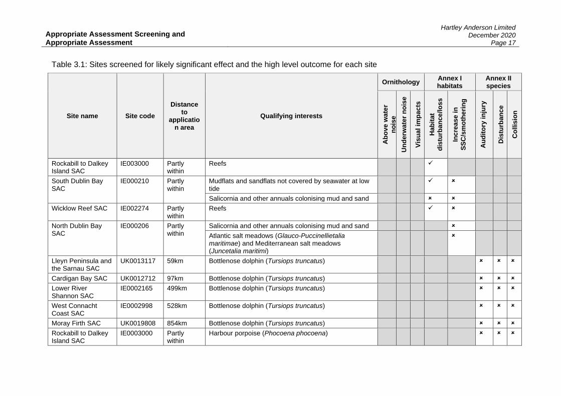
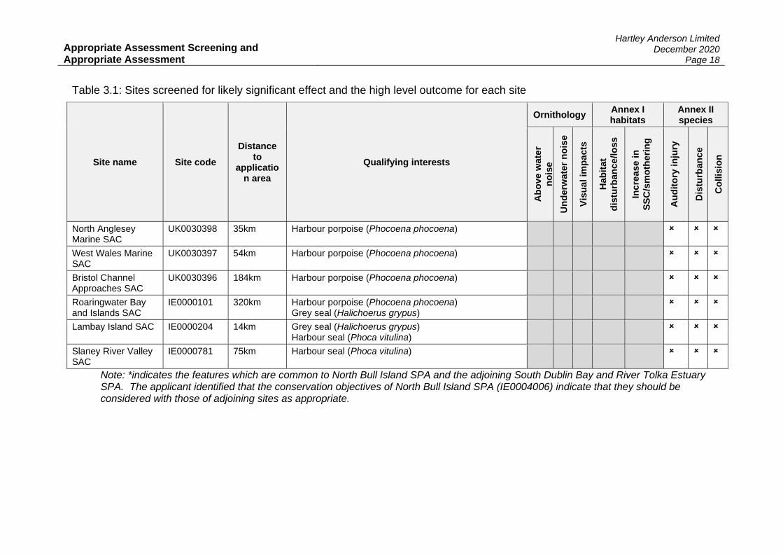
The sites which were identified as relevant to the project on the basis of the above criteria were subject to screening assessment by the applicant. The high level outcome for each site is presented in Table 3.1.

Appropriate Assessment Screening and Appropriate Assessment
Hartley Anderson Limited December 2020
Page 15
Table 3.1: Sites screened for likely significant effect and the high level outcome for each site
Site name Site code
Distance to
application area
Qualifying interests
Ornithology Annex I habitats
Annex II species
Ab
ove w
ate
r
no
ise
Un
derw
ate
r n
ois
e
Vis
ua
l im
pa
cts
Hab
itat
dis
turb
an
ce
/lo
ss
Incre
ase i
n
SS
C/s
mo
theri
ng
Au
dit
ory
in
jury
Dis
turb
an
ce
Co
llis
ion
SPAs
The Murrough SPA IE0004186 Partly within
Teal (Anas crecca) Wigeon (Mareca penelope) Greylag goose (Anser anser) Light-bellied Brent goose (Branta bernicla hrota) Herring gull (Larus argentatus) Black-headed gull (Chroicocephalus ridibundus)
✓ ✓
Red-throated diver (Gavia stellata) ✓ ✓ ✓
Little tern (Sternula albifrons) ✓ ✓
Sandymount Strand/Tolka Estuary SPA (also known as South Dublin Bay and River Tolka SPA)
IE0004024 Partly within
Light-bellied Brent goose (Branta bernicla hrota)* Sanderling (Calidris alba)* Dunlin (Calidris alpina)* Knot (Calidris canutus)* Ringed plover (Charadrius hiaticula) Oystercatcher (Haematopus ostralegus)* Black-headed gull (Chroicocephalus ridibundus)* Bar-tailed godwit (Limosa lapponica)* Grey plover (Pluvialis squatarola)* Redshank (Tringa totanus)* Mediterranean gull (Ichthyaetus melanocephalus)
✓ ✓

Appropriate Assessment Screening and Appropriate Assessment
Hartley Anderson Limited December 2020
Page 16
Table 3.1: Sites screened for likely significant effect and the high level outcome for each site
Site name Site code
Distance to
application area
Qualifying interests
Ornithology Annex I habitats
Annex II species
Ab
ove w
ate
r
no
ise
Un
derw
ate
r n
ois
e
Vis
ua
l im
pa
cts
Hab
itat
dis
turb
an
ce
/lo
ss
Incre
ase i
n
SS
C/s
mo
theri
ng
Au
dit
ory
in
jury
Dis
turb
an
ce
Co
llis
ion
Roseate tern (Sterna dougallii) Common tern (Sterna hirundo) Arctic tern (Sterna paradisea)
✓ ✓
Common tern (Sterna hirundo) Arctic tern (Sterna paradisea)
✓ ✓
Dalkey Islands SPA IE0004172 Abuts Roseate tern (Sterna dougallii) Common tern (Sterna hirundo) Arctic tern (Sterna paradisea)
Wicklow Head SPA IE0004127 Partly within
Kittiwake (Rissa tridactyla)
SACs
Slaney River Valley SAC
IE0000781 75km Twaite shad (Alosa fallax)
Lower River Suir SAC
IE0002137 152km Twaite shad (Alosa fallax)
Blackwater River (Cork/Waterford) SAC
IE0002170 200km Twaite shad (Alosa fallax)
River Barrow and River Nore SAC
IE0002162 141km Twaite shad (Alosa fallax)
Appropriate Assessment Screening and Appropriate Assessment
Hartley Anderson Limited December 2020
Page 17
Table 3.1: Sites screened for likely significant effect and the high level outcome for each site
Site name Site code
Distance to
application area
Qualifying interests
Ornithology Annex I habitats
Annex II species
Ab
ove w
ate
r
no
ise
Un
derw
ate
r n
ois
e
Vis
ua
l im
pa
cts
Hab
itat
dis
turb
an
ce
/lo
ss
Incre
ase i
n
SS
C/s
mo
theri
ng
Au
dit
ory
in
jury
Dis
turb
an
ce
Co
llis
ion
Rockabill to Dalkey Island SAC
IE003000 Partly within
Reefs ✓
South Dublin Bay SAC
IE000210 Partly within
Mudflats and sandflats not covered by seawater at low tide
✓
Salicornia and other annuals colonising mud and sand
Wicklow Reef SAC IE002274 Partly within
Reefs ✓
North Dublin Bay SAC
IE000206 Partly within
Salicornia and other annuals colonising mud and sand
Atlantic salt meadows (Glauco-Puccinellietalia maritimae) and Mediterranean salt meadows (Juncetalia maritimi)
Lleyn Peninsula and the Sarnau SAC
UK0013117 59km Bottlenose dolphin (Tursiops truncatus)
Cardigan Bay SAC UK0012712 97km Bottlenose dolphin (Tursiops truncatus)
Lower River Shannon SAC
IE0002165 499km Bottlenose dolphin (Tursiops truncatus)
West Connacht Coast SAC
IE0002998 528km Bottlenose dolphin (Tursiops truncatus)
Moray Firth SAC UK0019808 854km Bottlenose dolphin (Tursiops truncatus)
Rockabill to Dalkey Island SAC
IE0003000 Partly within
Harbour porpoise (Phocoena phocoena)
Appropriate Assessment Screening and Appropriate Assessment
Hartley Anderson Limited December 2020
Page 18
Table 3.1: Sites screened for likely significant effect and the high level outcome for each site
Site name Site code
Distance to
application area
Qualifying interests
Ornithology Annex I habitats
Annex II species
Ab
ove w
ate
r
no
ise
Un
derw
ate
r n
ois
e
Vis
ua
l im
pa
cts
Hab
itat
dis
turb
an
ce
/lo
ss
Incre
ase i
n
SS
C/s
mo
theri
ng
Au
dit
ory
in
jury
Dis
turb
an
ce
Co
llis
ion
North Anglesey Marine SAC
UK0030398 35km Harbour porpoise (Phocoena phocoena)
West Wales Marine SAC
UK0030397 54km Harbour porpoise (Phocoena phocoena)
Bristol Channel Approaches SAC
UK0030396 184km Harbour porpoise (Phocoena phocoena)
Roaringwater Bay and Islands SAC
IE0000101 320km Harbour porpoise (Phocoena phocoena) Grey seal (Halichoerus grypus)
Lambay Island SAC IE0000204 14km Grey seal (Halichoerus grypus) Harbour seal (Phoca vitulina)
Slaney River Valley SAC
IE0000781 75km Harbour seal (Phoca vitulina)
Note: *indicates the features which are common to North Bull Island SPA and the adjoining South Dublin Bay and River Tolka Estuary SPA. The applicant identified that the conservation objectives of North Bull Island SPA (IE0004006) indicate that they should be considered with those of adjoining sites as appropriate.

Appropriate Assessment Screening and Appropriate Assessment
Hartley Anderson Limited December 2020
Page 19
Finding of no significant effects statement:
The applicant only provides justifications for screening features of sites out rather than in. In view of the limited array of sites and previous basis of information provided on site selection, the reasons for screening sites in can be assumed at a high level, however, a clear explanation should have been provided in all cases as to what the justification was for screening in or out site qualifying interests. The applicant has considered the LSE stage without reference to mitigation.
Ornithology
LSE was discounted for Dalkey Islands SPA (roseate, common and Arctic tern) and Wicklow Head SPA (kittiwake). This was in view of the location of survey activities relative to the site features, and their relative sensitivity to the sources of effect identified (above water and underwater noise, and visual disturbance). In view of the conclusions presented in Section 3.3, the following sites and related features should have also be considered in relation to underwater noise: Ireland’s Eye SPA (razorbill, guillemot), Lambay Island SPA (razorbill, puffin, guillemot), Saltee Islands SPA (puffin, gannet),Skomer, Skokholm and the Seas of Pembrokeshire SPA (Manx shearwater), Aberdaron Coast and Bardsey Island SPA (Manx shearwater) and Copeland Islands SPA (Manx shearwater), Grassholm SPA (gannet). In view of these omissions, it is regarded that further information is required under Regulation 42(3)(b) of the European Communities (Birds and Natural Habitats) Regulations 2011 (as amended) before a screening determination can be made for these sites.
Annex I habitats
LSE was discounted for North Dublin Bay SAC (Salicornia and other annuals colonising mud and sand and, Atlantic salt meadows and Mediterranean salt meadows) on the basis that there would be no direct interaction with the site, and the limited scope for elevated suspended sediment concentrations from survey activities affecting the site features.
Annex II species
LSE was discounted for fish species (specifically twaite shad). While the applicant makes reference was to Popper et al. (2014), a number of other reviews are of relevance (e.g. Hawkins et al. 2015, Carroll et al. 2017, Slabbekoorn et al. 2019), which support a conclusion of no LSE on the basis of limited evidence of physical injury to fish from exposure to high amplitude low-frequency seismic survey noise and the comparatively lower amplitude and higher frequency source characteristics of the equipment proposed for use in this project. Following the points made in Section 3.3 on the lack of a detailed body of evidence to discount effects on a wider range of Annex II fish species (including Atlantic salmon and lamprey), it is, however, considered that no further sites should be subject to screening for these features. This is in view of the distance to the closest relevant sites which are, River Boyne and River Blackwater SAC (Atlantic salmon, river lamprey, 45km) and Slaney River Valley SAC (Atlantic salmon, sea lamprey, brook lamprey, river lamprey, 70km) – all other relevant sites are more than 100km from the working area – and the above mentioned low likelihood for effect. No LSE was identified for cetaceans (bottlenose dolphin, harbour porpoise) or seals (grey, harbour) for all sources of effect (auditory injury, disturbance and collision). It is considered

Appropriate Assessment Screening and Appropriate Assessment
Hartley Anderson Limited December 2020
Page 20
that while the applicant may have provided sufficient information to reach a screening conclusion for the species listed in relation to auditory injury or disturbance, this can only be made with cross reference to their EPS Risk Assessment, noting that as seals are not an Annex V species they are not strictly relevant to that assessment. It is noted that both the screening consideration and EPS Risk Assessment (see Section 5 of this report) refer to auditory injury criteria from Southall et al. (2007). While this is still referred to in the DAHG (2014) guidance to manage the risk to marine mammals from man-made sound sources in Irish waters, in view Regulation 42(1) of the European Communities (Birds and Natural Habitats) Regulations 2011 (as amended) i.e. that in screening for AA the public authority should make its assessment “…in view of best scientific knowledge…”, the latest thresholds (e.g. Southall et al. 2019) should have been used. Of the species considered, the harbour porpoise has the lowest threshold criterion for the onset of PTS at 202dB re 1µPa (after Southall et al. 2019). The potential noise sources associated with the survey will either not generate source levels of this magnitude, or will not result in received sound levels exceeding this threshold beyond more than a few metres from the source. For all other species/functional hearing groups including pinnipeds, the criteria for the onset of PTS is higher than source levels for all potential equipment. Taken with the other evidence presented by the applicant (albeit in their EPS Risk Assessment), it is considered that a LSE can be discounted for the cetacean and seal species listed in Table 3.1 above.
Consultation with conservation authorities
The consultation feedback is provided in Table 1.1. Comments were only received on the NIS and EPS Risk Assessment; no comments were made on the screening approach or conclusions, but overall, the conclusions of the applicant were supported.
3.4.1 In-combination effects
The applicant notes that there are routes for in-combination effects and lists other relevant projects (Appendix 5), however, no assessment of which effects arising from any of these other projects could, in-combination with those proposed as part of the project, result in an effect on any feature is presented. The applicant should provide additional information including how they identified the impacts of the other activities on sites relevant to their application, how these other projects may interact with that of the applicant’s (e.g. defining the spatial boundaries of those other activities), and what the pathways of in-combination effect identified were.
3.4.2 Transboundary effects
No potential transboundary LSE is identified.
3.5 Request for Further Information
Further information was requested from the applicant under Regulation 42(3)(b) of the European Communities (Birds and Natural Habitats) Regulations 2011 (as amended) on a series of questions, reproduced below with the applicant’s response, together with any commentary from the reviewers. Question 1:
The potential for LSE due to interactions with Ireland’s Eye SPA (razorbill, guillemot), Lambay Island SPA (razorbill, puffin, guillemot), Saltee Islands SPA (puffin,

Appropriate Assessment Screening and Appropriate Assessment
Hartley Anderson Limited December 2020
Page 21
gannet),Skomer, Skokholm and the Seas of Pembrokeshire SPA (Manx shearwater), Aberdaron Coast and Bardsey Island SPA (Manx shearwater) and Copeland Islands SPA (Manx shearwater), Grassholm SPA (gannet).
Applicant’s response:
SPAs considered in screening are identified in Section 9.3.1 of Appendix 2 (Appropriate Assessment Stage 1:Screening) of the report. Given the highly localised, temporary and short duration of the proposed surveys, in addition to the unobtrusive nature of proposed works (i.e. very minor levels of additional vessel and terrestrial survey activity in areas where baseline levels of vessel and terrestrial activity are very high) it is considered that only those SPAs with direct overlap have potential to be affected by the proposed activities. This rationale for Natura 2000 site inclusion for screening was considered appropriate and proportional in relation to the proposed works, and NPWS were content with this approach during formal consultation with statutory consultees. As such, the following sites were pre-screened in for consideration in screening: The Murrough SPA, South Dublin Bay/River Tolka SPA, Dalkey Islands SPA, Wicklow Head SPA and North Bull Island SPA. As the following SPAs do not directly overlap areas covered during proposed SI works, potential impacts upon SCIs/receptors from those SPAs were thereby pre-screened out for further consideration during screening of LSE: Ireland’s Eye SPA, Lambay Island SPA, Saltee Islands SPA, Skomer, Skokholm and the Seas of Pembrokeshire SPA, Aberdaron Coast and Bardsey Island SPA and Copeland Islands SPA and Grassholm SPA.
Commentary:
The applicant’s documentation did not provide a clear basis for site selection and it would not have been onerous for them to readily show no LSE for the sites queried.
Question 2: Whether similar conclusions would be reached in the effects of noise consideration if the latest published noise thresholds for seals and cetaceans (Southall et al. 2019) are used.
Applicant’s response: We are aware of the latest updates to the criteria for assessing the potential effects of anthropogenic sound on marine mammal hearing (Southall et al., 2019 and NOAA, 2018). However, during consultation with NPWS (see 15062020 meeting minutes)[reproduced at Appendix 1], we were advised that the 2014 DAHG guidance on managing the risk to marine mammals from man-made sound sources in Irish waters – which uses the Southall et al. (2007) criteria – should be used for the purposes of this assessment. Commentary: The wording in the minutes forwarded includes that “[NPWS] advised that the new updates [NOAA and Southall et al. 2019] would need to be reviewed during the guidance update but that [NPWS] is open to discussions on comparison of outputs using the different thresholds.” Whilst the wider guidance may still be current, the advice given is not interpreted as that the older Southall et al. 2007 thresholds “should be used for the purposes of this assessment”. The assessment should have made use of the best scientific knowledge as required Regulation 42 (1) quoted in Section 1.5 above, which is currently the NOAA and Southall et al. (2019) reports, and have considered whether using the revised thresholds would make any difference to the conclusions. The minutes also relate to the wider Codling project and

Appropriate Assessment Screening and Appropriate Assessment
Hartley Anderson Limited December 2020
Page 22
are not specific to the application. Our review made use of the latest information and we consider that LSE on noise sensitive site features are unlikely. Question 3:
How they identified the impacts of the other activities (as listed in Appendix 5 of their report) on Natura 2000 sites relevant to their application, how these other projects may interact with that of the applicant’s (e.g. defining the spatial boundaries of those other activities), and what the pathways of in-combination effect identified were, to support their conclusion of no LSE from in-combination effects.
Applicant’s response: Projects used in the in-combination assessment for the FILA were chosen based on their proximity to the Application Area and associated Natura 2000 sites. Due to the small scale, temporary and localised effects predicted to arise from the work, only projects within the Application Area or those within the specified Zone(s) of Influence were included, as it was considered that it was these plans and projects only, that had the potential to lead to in-combination effects on the relevant receptors in the area. The information for these projects was obtained from the marine planning online database, as it was at the time this assessment was compiled (April 2020). The department website does not hold spatial data for each of the projects therefore plans for all projects within the east coast counties were required to be overlaid with the Application Area in order to ascertain whether or not they were to be included. Further research was also undertaken in order to gain status updates on the projects on the shortlist as this was not always present, this allowed any projects that were confirmed to be complete but were still listed as going through the application process to be removed from the shortlist. Any project which overlapped spatially that could have been underway at the same time as the Codling site investigation works was then included in the final list. This final list of plans and projects was considered for its connectivity with each relevant designated site and the potential for in-combination LSE assessed. Pathways of effect were considered to be the same for the in-combination assessment as for the project alone, as only residual (non-LSE effects from the project alone have the potential to contribute to effects in-combination. The spatial extents of individual activities were considered, though as this information is not present within all applications, this was a qualitative rather than quantitative assessment. However, it should be noted that the activities included as part of the other plans and projects (as per the types of work specified in Appendix 5) were all considered to result in small scale, temporary and localised effects which had no potential to lead to LSE in-combination with the Codling site investigation work (which itself was considered to only lead to small scale, temporary and localised effects). Finally the CWP surveys will be spread out over a number of years and various site investigation campaigns will not be occurring simultaneously but rather they will be phased. Commentary: It is not clear what proximity criteria have been used, or how they relate to sites. Similarly, it is not clear how the applicant defined a Zone of Influence. Since “plans for all projects within the east coast counties were required to be overlaid with the Application Area in order to ascertain whether or not they were to be included” these should have been presented in the application. The approach to potential for in-combination LSE is acceptable, but the applicant did not present the evidence to support their conclusion. Finally, since the CWP surveys will be spread out over a number of years, the applicant will need to keep watch on the potential for in-combination effects with other projects.

Appropriate Assessment Screening and Appropriate Assessment
Hartley Anderson Limited December 2020
Page 23
3.6 Screening Conclusion
The applicant considered that the following sites should be the subject of further assessment:
• The Murrough SPA
• South Dublin Bay and River Tolka SPA
• Rockabill to Dalkey Island SAC
• South Dublin Bay SAC
• Wicklow Reef SAC The basis for identifying LSE for these sites is considered to be adequate, and it is determined that these sites should be subject to Appropriate Assessment (Section 4).

Appropriate Assessment Screening and Appropriate Assessment
Hartley Anderson Limited December 2020
Page 24
SECTION 4 - STAGE 2 APPROPRIATE ASSESSMENT
CPWL has prepared a Natura Impact Statement (NIS) to provide the Competent Authority with sufficient information to complete an Appropriate Assessment (AA). In view of the screening determination, the Department of Housing, Local Government and Heritage must undertake an AA. While the findings of no significant effect concurred with the conclusions of the applicant for those sites it considered, in view of the requirement for additional information in relation to SPAs, this AA can only consider those elements of the NIS which have been presented on the basis of the applicant’s screening process. A description of the project including its nature, scale, and duration is provided in Section 2 of this report. The applicant has provided sufficient information detailing the conservation objectives of the relevant ornithological features and SACs considered in their NIS, either in Table 10.1 or Appendix 4 Conservation Objectives and Conservation Status of Ornithological Features in NIS, of their report, and these are not repeated here. The sources of potential effect addressed in the NIS are those which were identified at the screening stage to present a LSE to the relevant site qualifying interests. These are generally direct effects, with secondary and indirect effects (e.g. on prey species) having been discounted at the screening stage, though note in certain areas the applicant has provided additional information relating to secondary effects not covered in their screening, and this is highlighted in Table 4.1. A summary of the AA outcome is presented in Table 4.1.
Table 4.1: Appropriate Assessment
Qualifying interests Assessment
The Murrough SPA
Teal (Anas crecca) Wigeon (Mareca penelope) Greylag goose (Anser anser) Light-bellied Brent goose (Branta bernicla hrota) Herring gull (Larus argentatus) Black-headed gull (Chroicocephalus ridibundus) Red-throated diver (Gavia stellata)
Sources of effect addressed: Disturbance or displacement caused by human activity Above water noise Visual impacts Summary assessment: Potential impacts on the wintering features of the site are considered possible from disturbance from ecological walkover or archaeological surveys in the intertidal area, as well as from above water noise and visual impacts from vessels associated with the survey. The level of above water noise is not expected to be greater than that from existing vessel noise in the area. In relation to species particularly sensitive to the physical presence of vessels (visual impacts), Fleissbach et al. (2019) reported maximum escape distances for individual birds in response to vessels to be ≥1.5km for divers and sea duck (other than common scoter). Mitigation: To mitigate for the potential visual impact on red-throated diver, and other wintering species, no work will take place within 2km of the seaward site boundary during the months of the non-breeding season, defined as September to March inclusive. No onshore walkover over intertidal survey work will take place during the wintering period.
Appropriate Assessment Screening and Appropriate Assessment
Hartley Anderson Limited December 2020
Page 25
Qualifying interests Assessment
Conclusion: The application of the mitigation measures limits the potential for interaction with relevant qualifying interests for which an LSE was identified, and is suitably precautionary to conclude that no adverse effects will result. The buffer area around the site within which work will be prohibited during the wintering season must be defined and agreed with the relevant conservation authority (NPWS) prior to work commencing.
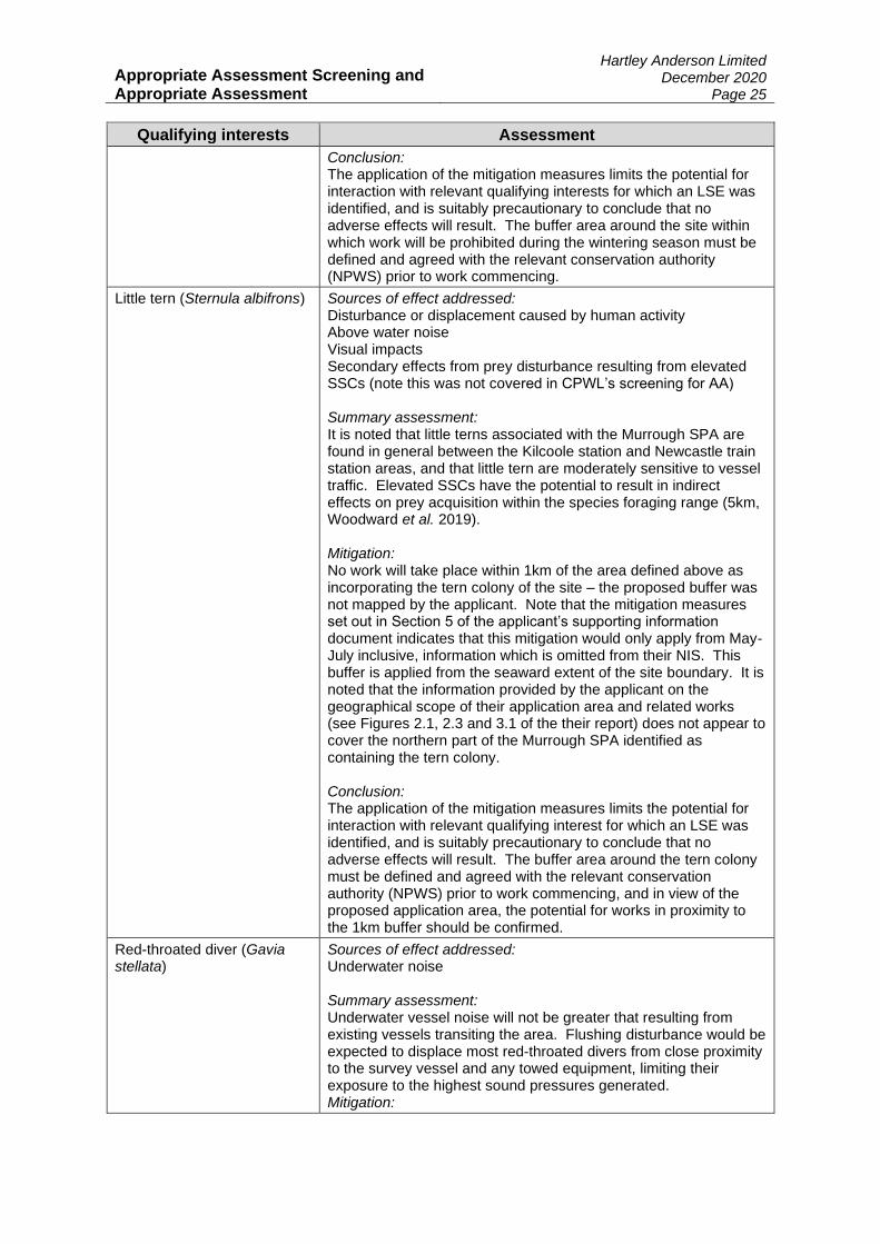
Little tern (Sternula albifrons) Sources of effect addressed: Disturbance or displacement caused by human activity Above water noise Visual impacts Secondary effects from prey disturbance resulting from elevated SSCs (note this was not covered in CPWL’s screening for AA) Summary assessment: It is noted that little terns associated with the Murrough SPA are found in general between the Kilcoole station and Newcastle train station areas, and that little tern are moderately sensitive to vessel traffic. Elevated SSCs have the potential to result in indirect effects on prey acquisition within the species foraging range (5km, Woodward et al. 2019). Mitigation: No work will take place within 1km of the area defined above as incorporating the tern colony of the site – the proposed buffer was not mapped by the applicant. Note that the mitigation measures set out in Section 5 of the applicant’s supporting information document indicates that this mitigation would only apply from May-July inclusive, information which is omitted from their NIS. This buffer is applied from the seaward extent of the site boundary. It is noted that the information provided by the applicant on the geographical scope of their application area and related works (see Figures 2.1, 2.3 and 3.1 of the their report) does not appear to cover the northern part of the Murrough SPA identified as containing the tern colony. Conclusion: The application of the mitigation measures limits the potential for interaction with relevant qualifying interest for which an LSE was identified, and is suitably precautionary to conclude that no adverse effects will result. The buffer area around the tern colony must be defined and agreed with the relevant conservation authority (NPWS) prior to work commencing, and in view of the proposed application area, the potential for works in proximity to the 1km buffer should be confirmed.
Red-throated diver (Gavia stellata)
Sources of effect addressed: Underwater noise Summary assessment: Underwater vessel noise will not be greater that resulting from existing vessels transiting the area. Flushing disturbance would be expected to displace most red-throated divers from close proximity to the survey vessel and any towed equipment, limiting their exposure to the highest sound pressures generated. Mitigation:

Appropriate Assessment Screening and Appropriate Assessment
Hartley Anderson Limited December 2020
Page 26
Qualifying interests Assessment
No work will take place within 2km of the site during the months of the non-breeding season, defined as September to March inclusive. The proposed buffer was not mapped by the applicant. Conclusion: The application of the mitigation measures limits the potential for interaction with relevant qualifying interest for which an LSE was identified, and is suitably precautionary to conclude that no adverse effects will result. The buffer area around the site within which work will be prohibited during the wintering season must be defined and agreed with the relevant conservation authority (NPWS) prior to work commencing.
South Dublin Bay and River Tolka SPA
Light-bellied Brent goose (Branta bernicla hrota)* Sanderling (Calidris alba)* Dunlin (Calidris alpina)* Knot (Calidris canutus)* Ringed plover (Charadrius hiaticula) Oystercatcher (Haematopus ostralegus)* Black-headed gull (Chroicocephalus ridibundus)* Bar-tailed godwit (Limosa lapponica)* Grey plover (Pluvialis squatarola)* Redshank (Tringa totanus)* Mediterranean gull (Ichthyaetus melanocephalus)
Sources of effect addressed: Above water noise Visual impacts Summary assessment: Potential impacts on the wintering features of the site are considered possible from visual impacts from vessel presence (though with a variable degree of tolerance from such disturbance noted), but this is not expected to be appreciably greater than existing vessel traffic in the area. Similarly, the level of above water noise is not expected to be greater than that from existing vessel noise in the area. Mitigation: To mitigate for the potential visual impact on the wintering features, no work will take place within 1km of the seaward site boundary during the months of the non-breeding season, defined as September to March inclusive. The proposed buffer was not mapped by the applicant. Conclusion: The application of the mitigation measures limits the potential for interaction with relevant qualifying interests for which an LSE was identified, and is suitably precautionary to conclude that no adverse effects will result. The buffer area around the site within which work will be prohibited during the wintering season must be defined and agreed with the relevant conservation authority (NPWS) prior to work commencing.
Roseate tern (Sterna dougallii) Common tern (Sterna hirundo) Arctic tern (Sterna paradisea)
Sources of effect addressed: Disturbance or displacement caused by human activity Above water noise Visual impacts Summary assessment: There are potential impacts on staging terns from the above water noise and visual presence of the survey activities, but mitigation is possible. Mitigation: Accounting for the use of the SPA by staging terns, to mitigate for the potential impacts on staging terns, the applicant proposed all work inside the SPA must take place during daylight hours (9am-5pm), with work outside this time prohibited inside the SPA and

Appropriate Assessment Screening and Appropriate Assessment
Hartley Anderson Limited December 2020
Page 27
Qualifying interests Assessment
within 100m of the seaward boundary of the site (based on Althouse et al. 20192), for the period mid-July-September inclusive. Note that the type of disturbance considered in Althouse et al. (2019) was from people rather than industrial activities such as shipping, and that responses at >100m were noted. It is not clear why, on that basis, the applicant did not suggest a more precautionary buffer distance, for example, 200m. The proposed buffer was not mapped by the applicant. Conclusion: In view of the current levels of shipping in the Dublin Bay area in close proximity to the site, and the nature, scale and likely duration of the activities, along with the application of the mitigation measures, no adverse effects will result. The buffer distance and area around the site within which work will be prohibited during hours outside of 9am-5pm must be defined and agreed with the relevant conservation authority (NPWS) prior to work commencing.
Common tern (Sterna hirundo) Arctic tern (Sterna paradisea)
Sources of effect addressed: Disturbance or displacement caused by human activity Above water noise Visual impacts Summary assessment: There are potential impacts on breeding terns from the above water noise and visual presence of the survey activities (for example reduced breeding success), but mitigation is possible. Mitigation: Accounting for the use of the SPA by breeding terns on a number of structures within the South Dublin Bay and River Tolka SPA, mitigation involved a 200m buffer around these consistent breeding locations, for the period April-July inclusive. The specific location of these areas and buffers was not mapped by the applicant. Conclusion: In view of the current levels of shipping in the Dublin Bay area in close proximity to the site, and the nature, scale and likely duration of the activities, along with the application of the mitigation measures, no adverse effects will result. The areas used by breeding terns must be confirmed, and the proposed buffers defined and agreed with NPWS prior to work commencing.
Rockabill to Dalkey Island SAC
Reefs Sources of effect addressed: Habitat disturbance/loss Summary assessment: Survey activities including the use of barges or potentially jack-up vessels, and methods involving direct interaction with the seabed (grab sampling, vibrocores, CPTs) will take place within the site boundary. Should such activities directly impact the reef feature, there is the potential for habitat disturbance and loss.
2 Note that the type of disturbance considered in Althouse et al. (2019) was from people rather than industrial activities such as shipping, and that responses at >100m were noted.
Appropriate Assessment Screening and Appropriate Assessment
Hartley Anderson Limited December 2020
Page 28
Qualifying interests Assessment
Mitigation: Activities which directly impact the seabed within the site will only take place following geophysical survey which will allow for the identification of potential Annex I reef features which would then be avoided through the micrositing of equipment. Conclusion: In view of the proposed mitigation measures, no adverse effects will result. The mitigation measures mention use of geophysical surveys to identify potential Annex I reef. Appropriate interpretation of these from an environmental perspective will be required, and results of the surveys used to inform the intrusive works or other interactions such as anchoring and use of jack-up vessels, must be shared with NPWS. Areas to be avoided by intrusive works must be agreed with NPWS prior to work commencing.
Wicklow Reef SAC
Reefs Sources of effect addressed: Habitat disturbance/loss Summary assessment: Survey activities including the use of barges or potentially jack-up vessels, and methods involving direct interaction with the seabed (grab sampling, vibrocores, CPTs) will take place within the site boundary. Should such activities directly impact the reef feature, there is the potential for habitat disturbance and loss. Mitigation: Activities which directly impact the seabed within the site will only take place following geophysical survey which will allow for the identification of potential Annex I reef features which would then be avoided through the micrositing of equipment. Conclusion: In view of the proposed mitigation measures, no adverse effects will result. The mitigation measures mention use of geophysical surveys to identify potential Annex I reef. Appropriate interpretation of these from an environmental perspective will be required, and results of the surveys used to inform the intrusive works or other interactions such as anchoring and use of jack-up vessels, must be shared with NPWS. Areas to be avoided by intrusive works must be agreed with NPWS prior to work commencing.
South Dublin Bay SAC
Mudflats and sandflats not covered by seawater at low tide
Sources of effect addressed: Habitat disturbance/loss Summary assessment: Survey activities including the use of tracked vehicles, vessels, barges or potentially jack-up vessels, and methods involving direct interaction with the seabed (grab sampling, vibrocores, CPTs) will take place within the site boundary. Should such activities directly impact the site feature, Mudflats and sandflats not covered by seawater at low tide, there is the potential for habitat disturbance and loss. The scale of potential habitat disturbance from the activities is considered to be small (though is not explicitly defined

Appropriate Assessment Screening and Appropriate Assessment
Hartley Anderson Limited December 2020
Page 29
Qualifying interests Assessment
by the applicant), and temporary. Greater disturbance will be generated should a jack-up vessel be used, and through the use of tracked vehicles in the intertidal area, which can disturb sensitive features such as Zostera and Angulus tenuis dominated communities located within the site. It should be noted that based on the mapped information supporting the conservation objectives of the site3, that the survey activities are unlikely to interact with the Zostera community as it is outside of the application area, but that direct interaction is likely with the Angulus tenuis dominated community. Mitigation: The following mitigation measures are proposed in relation to the use of tracked vehicles:
• All work undertaken in the intertidal by tracked vehicles will avoid the Zostera dominated community, the boundary of which will be delineated through a survey of the area prior to such work commencing;
• Movement of tracked vehicles in the intertidal will be restricted to the minimum number of access tracks necessary to achieve the sampling. This will reduce areas of compaction allowing rapid recovery of the small area affected after the cessation of the work, ensuring the natural condition of the feature is maintained; and
• Works on the intertidal using a tracked vehicle will be overseen by an Ecological Clerk of Works to ensure adherence to the above measures.
Conclusion: In view of the proposed mitigation measures, no adverse effects will result for the Mudflats and sandflats not covered by seawater at low tide feature of the site. The areas of Zostera dominated community confirmed through survey should be agreed with NPWS, and like other proposed mitigation measures, should be suitably mapped and agreed with NPWS prior to works commencing. Similarly, all access tracks and associated interaction with the site should be confirmed and agreed with NPWS prior to works taking place.
Note: Note: *indicates the features which are common to North Bull Island SPA and the adjoining South Dublin Bay and River Tolka Estuary SPA. The applicant identified that the conservation objectives of North Bull Island SPA (IE0004006) indicate that they should be considered with those of adjoining sites as appropriate.
4.1 AA Conclusion
For those sites and features identified by the applicant together with those clarified through responses to the Request for Further Information (Section 3.5), it is determined that the activities are unlikely to have a significant effect on the sites and features for which a LSE was identified. For those sites considered above, the geographic extent of the mitigation measures proposed and the basis of these measures which are designed to avoid or minimise effects
3 https://www.npws.ie/sites/default/files/publications/pdf/000210_South%20Dublin%20Bay%20SAC%20Marine%20Supporting%20Doc_V1.pdf and https://www.npws.ie/sites/default/files/protected-sites/conservation_objectives/CO000210.pdf

Appropriate Assessment Screening and Appropriate Assessment
Hartley Anderson Limited December 2020
Page 30
(e.g. identification and avoidance of sensitive areas via site survey), must be agreed with the NPWS prior to works commencing.

Appropriate Assessment Screening and Appropriate Assessment
Hartley Anderson Limited December 2020
Page 31
SECTION 5 - ARTICLE 12 ASSESSMENT
5.1 Relevant Annex IV species
Under Article 12 of the Habitats Directive, Annex IV species are afforded strict protection throughout their range, both inside and outside of designated protected areas. An assessment on the impact of the proposed investigative works on Annex IV species is provided in Appendix 7 European Protected Species Risk Assessment of the Supplementary Information report. Those Annex IV species that could potentially occur in the survey area are described in Section 4 of Appendix 7. The Small Cetaceans in European Atlantic waters and the North Sea (SCANS) III surveys were undertaken in the summer of 2016 (Hammond et al. 2017). Densities for most common cetacean species encountered during the survey were estimated for the different survey blocks. The CWP is located within SCANS III Block E. SCANS III surveys found harbour porpoise, bottlenose dolphin, Risso’s dolphin and minke whale in this block. The SCANS III data suggest that harbour porpoises are the most common cetacean in the Irish Sea (see Table 4.1 of Appendix 7). This is also evidenced by other sightings data (Berrow et al. 2018, Berrow et al. 2008, DAHG, 2009). This species is the primary qualifying feature of the Rockabill to Dalkey Island, North Anglesey Marine and West Wales Marine Special Areas of Conservation (SAC) which are at distances of 0 km, 35.1 km and 54.7 km respectively from the Application Area. Aerial surveys were undertaken across Ireland’s Exclusive Economic Zone (EEZ) as part of the ObSERVE Programme in both summer and winter from 2015 to 2017 (Rogan et al. 2018). The CWP lies within ObSERVE stratum 5 and sightings were continuously higher for marine mammal species in summer months than in winter. As with the SCANS III surveys harbour porpoises were the most sighted species (see Table 4.2 of Appendix 7) and stratum 5 showed higher densities than other strata surveyed. Only one sighting of a group of five bottlenose dolphins was recorded during the entirety of the survey. Similar to the SCANS III surveys, no common dolphins were recorded within the Irish Sea with sightings predominately occurring off the south and west of Ireland. Risso’s dolphins sighted during these surveys were thought to represent a community that is frequently located near the Saltee Islands off Co. Wexford. The predictive modelling carried out from this survey suggested that for minke whales the Irish Sea is more important for this species during the summer period rather than during winter. The most recent site specific boat-based surveys during 2018-2019, indicated that of the total of 309 individual marine mammals sighted in the area (3 cetacean species and two seal species), 71% were harbour porpoises. The leatherback turtle is the most common turtle species found in Irish waters, but with sightings concentrated off the southwest coast of Ireland (King & Berrow 2009, Doyle 2007). Due to the low likelihood of occurrence in the CWP area, marine turtles were not considered in the risk assessment although it was noted that any mitigation proposed for cetacean species would also be applied to turtles.
5.2 European Protected Species Risk Assessment
The potential effects on Annex IV marine mammal species from potential impacts from underwater noise is considered in Section 5.1 of the Appendix 7.

Appropriate Assessment Screening and Appropriate Assessment
Hartley Anderson Limited December 2020
Page 32
Of the survey methodologies, the geophysical surveys may generate the greatest source levels, with Table 2.2 of this report indicating source levels ranging from 149dB re 1μPa @1m (peak) to 225dB re 1μPa @1m (peak). The source levels associated with the proposed geotechnical surveys are of lower magnitude (see Table 2.3 of this report). As in the screening assessment (see Section 3 of this report), the EPS Risk Assessment refers to auditory injury criteria from Southall et al. (2007). While this is still referred to in the DAHG (2014) guidance to manage the risk to marine mammals from man-made sound sources in Irish waters, the latest thresholds are those of Southall et al. (2019). Of the species considered, the harbour porpoise has the lowest threshold criteria for the onset of PTS at 202dB re 1µPa (after Southall et al. 2019). The potential noise sources associated with the surveys will either not generate source levels of this amplitude, or will not result in received sound levels exceeding this threshold beyond more than a few metres from the source. For all other species/functional hearing groups, the criteria for the onset of PTS is higher than source levels for all potential equipment. The risk assessment notes that while geophysical and geotechnical surveys may be detected by cetaceans and therefore their use may have the potential to cause disturbance, the most likely response will be temporary behavioural avoidance. The risk assessment notes that the small number of vessels that will be required for the surveys will not significantly increase vessel traffic in the area and therefore there will be not be an increased risk of collisions with marine EPS.
5.3 Article 12 Conclusion
The Article 12 assessment of the potential impacts on EPS from activities associated with the proposed geophysical and geotechnical survey work for the CWP (increased anthropogenic noise from use of the geophysical survey and positioning equipment, increased anthropogenic noise from the use of geotechnical equipment and collision with vessels) concluded that:
• The potential for auditory injury is considered to be nil or negligible; and • The potential for disturbance is considered to be trivial.
Therefore, it is concluded that the proposed surveys will not give rise to significant impacts to species listed under Annex IV of the Habitats Directive.
Appropriate Assessment Screening and Appropriate Assessment
Hartley Anderson Limited December 2020
Page 33
BIBLIOGRAPHY
Berrow SD, Hickey R, O’Brien J, O’Connor I & McGrath D (2008). Harbour porpoise survey 2008. Report to the National Parks and Wildlife Service. Irish Whale and Dolphin Group, 33pp.
Berrow SD, O’Brien J, Meade R, Delarue J, Kowarski K, Martin B, Moloney J, Wall D, Gillespie D, Leaper R, Gordon J, Lee A & Porter L (2018). Acoustic surveys of cetaceans in the Irish Atlantic Margin in 2015–2016: Occurrence, distribution and abundance. Department of Communications, Climate Action and Environment and the National Parks and Wildlife Service (NPWS), Department of Culture, Heritage and the Gaeltacht, Dublin, Ireland, 348pp.
Carroll AG, Przeslawski R, Duncan A, Gunning M, Bruce B (2017). A critical review of the potential impacts of marine seismic surveys on fish & invertebrates. Marine Pollution Bulletin 114, 9-24.
DAHG (2009). Conservation plan for cetaceans in Irish waters. December 2009. Prepared by the National Parks and Wildlife Service of the DAHG.
Dean B, Freeman R, Kirk H, Leonard K, Phillips RA, Perrins CM & Guilford T (2013). Behavioural mapping of a pelagic seabird: combining multiple sensors and a hidden Markov model reveals the distribution of at-sea behaviour. Journal of the Royal Society Interface 10: http://dx.doi.org/10.1098/rsif.2012.0570
Dean B, Kirk H, Fayet A, Shoji A, Freeman R, Leonard K, Perrins CM & Guilford T (2015). Simultaneous multi-colony tracking of a pelagic seabird reveals cross-colony utilization of a shared foraging area. Marine Ecology Progress Series 538: 239-248.
Doyle TK (2007). Leatherback sea turtles (Dermochelys coriacea) in Irish waters. Irish Wildlife Manuals, No. 32. National Parks and Wildlife Service, Department of the Environment, Heritage and Local Government, Dublin, Ireland.
EC (2002). Assessment of plans and projects significantly affecting Natura 2000 sites - Methodological guidance on the provisions of Article 6(3) and (4) of the Habitats Directive 92/43/EEC. European Commission, 81pp.
Fayet AL, Freeman R, Shoji A, Padget O, Perrins CM & Guilford T (2015). Lower foraging efficiency in immatures drives spatial segregation with breeding adults in a long-lived pelagic seabird. Animal Behaviour 110: 79e89 Gill AB & Bartlett M (2010). Literature review on the potential effects of electromagnetic fields and subsea noise from marine renewable energy developments on Atlantic salmon, sea trout and European eel. Scottish Natural Heritage Commissioned Report No.401, 43pp.
Guilford T, Meade J, Freeman R, Biro D, Evans T, Bonadonna F, Boyle D, Roberts S & Perrins C (2008). GPS tracking of the foraging movements of Manx Shearwaters Puffinus puffinus breeding on Skomer Island, Wales. Ibis 150: 462-473.
Hammond PS, Lacey C, Gilles A, Viquerat S, Börjesson P, Macleod K, Ridoux V, Santos MB, Scheidat M, Teilmann J, Vingada J & Øien N (2107). Estimates of cetacean abundance in European Atlantic waters in summer 2016 from the SCANS-III aerial and shipboard surveys, 39pp.
Harding H, Bruintjes R, Radford AN & Simpson SD (2016). Measurement of hearing in the Atlantic salmon (Salmo salar) using auditory evoked potentials, and effects of pile driving playback on salmon behaviour and physiology. Scottish Marine and Freshwater Science Report 7 No 11, 51pp.
Hawkins AD & Johnstone ADF (1978), The hearing of the Atlantic Salmon, Salmo salar. Fish Biology 13: 655-673.
Jones EL, McConnell BJ, Smout S, Hammond PS, Duck CD, Morris CD, Thompson D, Russell DJF, Vincent C, Cronin M, Sharples RJ & Matthiopoulos J (2015). Patterns of space use in sympatric marine colonial predators reveal scales of spatial partitioning. Marine Ecology Progress Series 534: 235-249.
King GL & Berrow SD (2009). Marine turtles in Irish waters. The Irish Naturalists’ Journal 30: 1-30.
Mickle MF, Miehls SM, Johnson NS, Higgs DM (2019). Hearing capabilities and behavioural response of sea lamprey (Petromyzon marinus) to low-frequency sounds. Canadian Journal of Fisheries and Aquatic Sciences 2019 76(9), 1541-1548.
Popper AN, Hawkins AD, Fay RR, Mann DA, Bartol S, Carlson TJ, Coombs S, Ellison WT, Gentry RL, Halvorsen MB, Løkkeborg S, Rogers PH, Southall BL, Zeddies DG & Tavolga WN (2014). Sound exposure guidelines for fishes and sea turtles: A technical report prepared by ANSI-Accredited Standards Committee S3/SC1 and registered with ANSI.
Rogan E, Breen P, Mackey M, Cañadas A, Scheidat M, Geelhoed S & Jessopp M (2018). Aerial surveys of cetaceans and seabirds in Irish waters: Occurrence, distribution and abundance in 2015-2017. Department of Communications, Climate Action & Environment and National Parks and
Appropriate Assessment Screening and Appropriate Assessment
Hartley Anderson Limited December 2020
Page 34
Wildlife Service (NPWS), Department of Culture, Heritage and the Gaeltacht, Dublin, Ireland, 297pp. Shoji A, Aris-Brosou S, Fayet A, Padget O, Perrins C & Guilford T (2015). Dual foraging and pair coordination during chick provisioning by Manx shearwaters: empirical evidence supported by a simple model. Journal of Experimental Biology 218: 2116-2123.
Slabbekoorn H, Dalen J, de Haan D, Winter HV, Radford C, Ainslie MA, Heaney KD, van Kooten T, Thomas L, Harwood J (2019). Population-level consequences of seismic surveys on fishes: An interdisciplinary challenge. Fish and Fisheries 20: 653-685.
Southall B, Finneran JJ, Reichmuth C, Nachtigall PE, Ketten DR, Bowles AE, Ellison WT, Nowacek DP & Tyack PL (2019). Marine Mammal Noise Exposure Criteria: Updated Scientific Recommendations for Residual Hearing Effects. Aquatic Mammals 45: 125-232.
Southall BL, Bowles AE, Ellison WT, Finneran JJ, Gentry RL, Greene Jr. CR, Kastak D, Ketten DR, Miller JH, Nachtigall PE, Richardson WJ, Thomas JA & Tyack PL (2007). Marine mammal noise exposure criteria: Initial scientific recommendations. Aquatic Mammals 33: 411-522.
Thaxter CB, Lascelles B, Sugar K, ASCP Cook, Roos S, Bolton M, Langston RHW & Burton NHK (2012). Seabird foraging ranges as a preliminary tool for identifying candidate Marine Protected Areas. Biological Conservation 156: 53–61.
Wischnewski S, Arneill GE, Bennison AW, Dillane E, Poupart TA, Hinde CA, Jessopp MJ, Quinn JL (2019). Variation in foraging strategies over a large spatial scale reduces parent–offspring conflict in Manx shearwaters. Animal Behaviour 151: 165-176. Woodward I, Thaxter CB, Owen E & Cook ASCP (2019). Desk-based revision of seabird foraging ranges used for HRA screening. Report of work carried out by the British Trust for Ornithology on behalf of NIRAS and The Crown Estate. BTO Research Report No. 724, 139pp.

Appropriate Assessment Screening and Appropriate Assessment
Hartley Anderson Limited December 2020
Page 35
Appendix 1 – Minutes of Codling Wind Park: Project Introduction meeting 15th June 2020

1
Codling Wind Park: Project Introduction
Date: 15/06/2020 Time: 1430 - 1630 Room Number & Building: Starleaf Video Conference
Present: Natural Power
Natural Power
Natural Power
Natural Power
Natural Power
Natural Power
National Parks and Wildlife Service (NPWS)
NPWS
NPWS
NPWS
NPWS
NPWS
Agenda Item Action
1.
provided a run through of the project background, overview, indicative timescales and location.
highlighted that the number of turbines consented /as applied for are to be revised and the actual number built is likely to be less (but larger in size) due to advances in turbine technology.
also highlighted the possible delays the project could face including the changing government and policy, delays to the granting of the Foreshore Investigation Licence (FIL), uncertainty around grid connections and the recent Covid-19 pandemic.
2. Slide 8 provides an overview of the current study/application area for the project. highlighted that the large area was required to allow flexibility for cable routes due to the uncertainty in grid connection availability.
3.
provided an overview of the current design changes:
- Bigger turbines but fewer in number - The cable routes are starting to be refined and will hopefully be refined further prior to the EIA being
undertaken added that the surveys undertaken as part of the site investigation works will inform the design work.
highlighted that one of the current routes runs through the South Dublin Bay SPA.
4.
advised that CWPL are aware of the various Natura 2000 sites that surround the Codling Wind Park Project but that the information surround the Natural Heritage Areas (NHA) and proposed NHAs was very vague and CWPL queried whether there was any further information on these to allow a robust assessment of the interest features.
5. provided a high-level overview of the survey applied for under the FIL adding that these will be used
to inform our knowledge of the site and to aid in project design.

2
Codling Wind Park: Project Introduction
Agenda Item Action
added that the level of surveys applied for covers everything the specialists advised that they may require to inform the EIA and project design and that it is expected that not all will be utilised however, the option is there should it be needed.
6.
provided an overview on the data collected from previous and current bird and marine mammal surveys.
added that in response to the Covid-19 restrictions CWPL have adapted to use aerial surveys to reduce the survey gap caused by the pandemic and that to all comparison of the data sets there will be a three survey overlap with the boat-based surveys when they recommence.
also added that CWPL are looking into the need for staging tern surveys.
7.
Questions to NPWS:
Is any further information due to be made available on the NHA/pNHAs? i.e. species lists or conservation objectives/advice on operations? Do we need to consider NHA/pNHAs in our assessments or are the species covered under other designations?
suggested a data request be submitted for these
Cable installation through SPA – any issues?
advised that this would greatly depend on the methods used.
advised that the surveys undertaken as part of site investigation works will inform the final cable route however at the moment, we have one that goes through an SPA. The survey work will also inform the install method in conjunction with discussions with NPWS and other stakeholders. Possible install methods include HDD and open trenching.
advised that seasonal restrictions may be difficult due to the differences in sensitive periods for certain species. added that the annual temporal window not covered by relevant receptors (wintering birds and post-breeding terns) is likely to be relatively small (late spring/early summer). outlined that CWPL are using adapted IWeBS methods to map key areas used by receptors throughout the year and during different tidal conditions. added that breeding bird surveys are being undertaken within each survey area to locate any nesting territories of sensitive receptors, and that consideration is being given to the need for staging tern surveys.
also added that CWPL are looking at background levels of disturbance for context and to inform the assessments in the EIA.
added that there is also a lot of engineering work ongoing to determine the chosen route and that this will be aided by the geophysical and geotechnical surveys to better understand the geology which would in turn have an impact on the chosen install method.
queried whether trenching/HDD through an SPA has been undertaken before and whether NPWS could point CWPL in the direction of any examples
advised that fibre optic cables are almost always trenched in and that there is generally no issues. In terms of power cables, DL suggested a review of the East-West Interconnector documents as this was trenched in through a short section of intertidal consisting of coarse sand which is easier to work with and highly recoverable.

3
Codling Wind Park: Project Introduction
Agenda Item Action
The impacts of Covid-19 mean we have impacted spring 2020 bird and marine mammal baseline surveys – how does NPWS feel we should address this? This question appears to have been covered off through the questions and discussions on data sources and adapted surveys. Attendees to confirm.
All
Minimum requirements for collection of bird data?
queried whether CWPL have sufficient data to see trends and patterns and to determine its significance.
advised that the data is certainly showing consistent patterns for some species and non-consistent patterns for others but that “events” have been observed such as the congregation of 1000s of kittiwakes which is not normally observed.
queried whether other data sources have been used. advised that during the EIA process they will be to contextualise interannual variation (specifically obSERVE data and Waggitt et al. 2019)
advised that a range of sources would be required in the assessment in order to contextualise the data gathered. confirmed that various sources will be identified and used.
What are the expected timelines of the NPWS Natura 2000 site project to update the network? NPWS has contracted GMIT to undertake an analysis of all available and appropriate data on marine bird abundances and distributions in Irish waters with a view to identifying areas that may warrant mSPA classification. This work is due to begin in August 2020 and areas within the western Irish Sea will be prioritised.
Marine mammal piling mitigation guidance and sound thresholds update?
advised that the updated guidance is not in the immediate future so for the purposes of assessment the previous guidance (i.e. the 2014 guidance to manage the risk to marine mammals from man-made sound sources in Irish waters) should be used.
queried the use of the 2014 guidance noise thresholds (Southall 2007) as these have since been updated by both NOAA and Southall since the 2014 guidance was published. advised that the new updates would need to be reviewed during the guidance update but that she is open to discussions on comparison of outputs using the different thresholds.
What are their areas of concern for benthic and fish? And who should we engage with for this?
queried why no baseline fish surveys were proposed.
advised that the MI have agreed that the level of data already available from other sources is sufficient to allow CWPL to compile the list of possible receptor species without having to undertake further surveys as these would be unlikely to add any further information. added that there are other ways to determine the presence/absence or certain species e.g. sandeel. The use of seabed suitability mapping shows where sandeel are likely to be present based on the substrate without having to undertake surveys as sandeel can be difficult to catch.
Any other ecological receptors we should be considering offshore or onshore?

4
Codling Wind Park: Project Introduction
Agenda Item Action
advised that Bats should be considered in the EIA and that NPWS have been advising all developers of this.
advised that CWPL will be adding a bat detector to the FLiDAR for this purpose
8.
Questions to CWPL:
Boat-based surveys
queried the spacing between the transects to which advised that they were approx. 2km but would need to check the exact distance. *in a post meeting follow up confirmed that the spacing is actually 0.8nm (c.1.5km).
queried whether the surveys used dedicated MMOs, confirmed this to be the case
Collision Risk Modelling (CRM)
- Does the flight height data collected by lazer range finders deviate from other sources available (specifically species specific generic flight height distributions used for CRM)?
– These datasets have not been fully investigated, but anecdotally they do not appear to deviate significantly from expected flight height distributions. also noted that human observers appear to generally estimate slightly lower than heights derived using laser range finder.
Coastal/Landfall Surveys
queried the line “Little to no evidence of migration (by migratory waterfowl) through the offshore wind farm (OWF)”
acknowledged the inability of onshore observers to observe out to the OWF due to distance, however noted the observers have seen the majority of migration occurring along the coast rather than further offshore within their viewsheds. also added that migration observers are present on survey vessels during migration periods and that these observers had not recorded passages of migratory wildfowl through the proposed development area.
queried how night-time and bad weather migrations have been taken into account. advised that they cannot survey on the boat in anything above sea state 4 or at night but otherwise
they are carried out. He added that coastal surveys are only not carried out in times of poor visibility and that if birds choose to migrate during these times then they would not be observed but that they generally time the surveys with large migration events.
Use of radar DT queried whether CWPL would be using radar for data collection.
advised that no radar surveys have been undertaken to date on this site. further queried how the data gap would be bridged. advised that he would take this away for internal discussion
added that as part of the site investigation works a FLiDAR would be deployed and on that there is the option to add one however a single radar also has its limitations. JL further added that until this point there has been no structures to which a radar could be mounted in the offshore area

5
Codling Wind Park: Project Introduction
Agenda Item Action
Aerial Surveys
queried whether these followed the same pattern as the boat-based surveys, confirmed that the aerial surveys follow the same transects and cover both sides.
Marine Mammal Acoustics
queried why CWPL did not think they would be used.
advised that the reasons will be outlined in the scoping report but that what is considered the most useful information for assessing impacts is species density (so that numbers of animals with the potential to be impacted can be estimated) and that while PODs do give useful data it is not generally used in the impact assessment.
9.
Overlapping surveys (boat-based and aerial) Discussion on how the Covid-19 restrictions could limit the number of personnel onboard vessels which may impact the survey.
advised that correction factors can be used for each type of survey and that they are slightly different depending on the survey type used.
10.
Timeline for Scoping Submission
advised that it could submitted in the next month however we are currently waiting on an updated project description.
11. queried which department would be the best suited to discuss visual impacts. advised that the Built Heritage Dept would be best suited. added that the Sustainable Energy
Authority for Ireland had some involvement in the guidance so they would also be worth talking to.
12.
AA/NIS
advised that as part of the new bill, the board will be looking at the NIS and undertaking the AA and highlighted that the integrity of the site should not be impacted. added that all landfall considerations should be weighed and then CWPL should decide whether the legal requirements of the AA process could be met.
13.
Onshore aspects
queried whether the onshore and offshore will fall under one consent. confirmed this to be the case however scopings will be undertaken separately due to uncertainties in grid connection and onshore cable routes. advised that the separation should be made clear in the scoping to be submitted.
14. Cumulative Projects

6
Codling Wind Park: Project Introduction
Agenda Item Action
queried the NPWS understanding of the types of projects to be included in this assessment as from CWPLs understanding only consented projects are to be included however, with the lengthy consenting time this list could change a lot prior to submission and following submission.
advised he would pass on the caselaw that advises which projects should be included. *post meeting note – circulated this caselaw information
15.
Communication between NPWS and CWPL going forward
advised that as CWP was still pre-scoping the DATS team do not currently have a file for it therefore they would need to develop an internal group for all CWP related discussions and then move it to the DATS file once scoping has been submitted
confirmed that he would be the point of contact going forward however he was happy for specific discussions and meetings with specialists to be had providing he was copied in and kept up to date with any progressions.
16. AOB. No AOB.