hertfordshire minerals local plan review minerals local plan review 2002-2016 adopted march 2007...
TRANSCRIPT

HERTFORDSHIRE MINERALS
LOCAL PLAN REVIEW
2002-2016
Adopted March 2007
County Development Unit Hertfordshire County Council Contact: 01992 556227 www.hertsdirect.org


Table of Contents
TABLE OF CONTENTS 1
CHAPTER 1: INTRODUCTION 3
1.1 THE PLANNING SYSTEM 3 1.2 MINERALS PLANNING 4 1.3 MINERALS WORKED IN HERTFORDSHIRE 5 1.4 THE NEED FOR AGGREGATES 6 1.5 NATIONAL AND REGIONAL MINERALS POLICY 6 1.6 HERTFORDSHIRE’S CONTRIBUTION TO SUPPLY OF AGGREGATES 8 1.7 THE NEED FOR A REVIEW OF THE HERTFORDSHIRE MINERALS LOCAL PLAN 8 1.8 WHO ARE THE ‘STAKEHOLDERS’ IN MINERALS PLANNING? 10 TIMETABLE FOR MINERALS LOCAL PLAN REVIEW 11
CHAPTER 2: MINERALS PLANNING IN HERTFORDSHIRE 12
2.1 NATIONAL AIMS AND OBJECTIVES 12 2.2 HERTFORDSHIRE STRUCTURE PLAN VISION, AIMS AND OBJECTIVES 13 2.3 HERTFORDSHIRE MINERALS LOCAL PLAN REVIEW AIMS AND OBJECTIVES 16 2.4 STRATEGIC ENVIRONMENTAL APPRAISAL 18
CHAPTER 3: STRATEGIC POLICIES 19
3.1 INTRODUCTION 19 3.2. SUPPLY OF MINERALS 20
MINERALS POLICY 1 ~ AGGREGATES SUPPLY 20 3.3 NEED 21
MINERALS POLICY 2 ~ NEED FOR MINERAL WORKING 21 3.4 IDENTIFIED SITES 21
MINERALS POLICY 3 ~ SITES FOR SAND AND GRAVEL EXTRACTION AND THE WORKING OF PREFERRED AREAS 23
3.5 APPLICATIONS OUTSIDE PREFERRED AREAS 24 MINERALS POLICY 4 ~ APPLICATIONS OUTSIDE PREFERRED AREAS 25
3.6 MINERAL STERILISATION 25 MINERALS POLICY 5 ~ MINERAL STERILISATION 25
3.7 OTHER NON-ENERGY MINERALS 26 MINERALS POLICY 6 – OTHER NON-ENERGY MINERALS 26
3.8 SECONDARY AND RECYCLED MATERIALS 26 MINERALS POLICY 7 ~ SECONDARY AND RECYCLED MATERIALS 28 MINERALS POLICY 8 ~ RECYCLING FACILITIES ON MINERAL SITES 29
3.9 BIODIVERSITY 29 MINERALS POLICY 9 ~ CONTRIBUTION TO BIO-DIVERSITY 29
3.10 RAILHEADS AND WHARVES 30 MINERALS POLICY 10 ~ RAILHEADS AND WHARVES 30
CHAPTER 4: OPERATIONAL POLICIES 32
4.1 INTRODUCTION 32
1

4.2 CUMULATIVE IMPACT 32 MINERALS POLICY 11 ~ CUMULATIVE IMPACT 33
4.3 LANDSCAPE 33 MINERALS POLICY 12 ~ LANDSCAPE 34
4.4 RECLAMATION OF MINERAL WORKINGS 35 MINERALS POLICY 13 ~ RECLAMATION SCHEME 36 MINERALS POLICY 14 ~ AFTERUSE 37
4.5 LANDFILL 37 MINERALS POLICY 15~ LANDFILL 39
4.6 TRANSPORT 39 MINERALS POLICY 16 ~ TRANSPORT 40
4.7 CONFORMITY WITH THE DEVELOPMENT PLAN AND OTHER PLANNING GUIDANCE 41 4.8 CRITICAL CAPITAL AND OTHER IMPORTANT ENVIRONMENTAL ASSETS 42
MINERALS POLICY 17 ~ CRITERIA FOR THE CONTROL OF MINERAL DEVELOPMENT TO PROTECT CRITICAL CAPITAL AND OTHER ENVIRONMENTAL ASSETS 43
4.9 OPERATIONAL CRITERIA 44 MINERALS POLICY 18 ~ OPERATIONAL CRITERIA FOR THE CONTROL OF MINERAL DEVELOPMENT 44
4.10 APPLICATIONS FOR NEW CONDITIONS 46 4.11 ENFORCEMENT 46
MINERALS POLICY 19 ~ ENFORCEMENT OF PLANNING CONTROL 47 4.12 MINERAL EXPLORATIONS 47
MINERALS POLICY 3 ~ SITES FOR SAND AND GRAVEL EXTRACTION AND THE WORKING OF PREFERRED AREAS 72
APPENDICIES
APPENDIX 1: FUNCTION, PERIOD AND SCOPE OF PLAN OF THE MINERALS LOCAL PLAN REVIEW........................................................................................................48 APPENDIX 2: ANNUAL SALES OF SAND AND GRAVEL IN HERTFORDSHIRE SINCE 1990............................................................................................................................50 APPENDIX 3: MINERALS PLANNING GUIDANCE NOTES [MPGS) AND PLANNING POLICY GUIDANCE NOTES [PPGS) OF PARTICULAR RELEVANCE TO PLANNING FOR MINERALS IN HERTFORDSHIRE (*NOT INCLUSIVE).........................................................................51 APPENDIX 4: SUMMARY OF HERTFORDSHIRE’S CHARACTERISTICS ..........................52 APPENDIX 5: SPECIFIC SITES FOR SAND AND GRAVEL EXTRACTION .........................61 APPENDIX 6 : GLOSSARY....................................................................................62 APPENDIX 7 : BIBLIOGRAPHY ...............................................................................70 APPENDIX 8: INSET MAPS INCLUDING PREFERRED AREAS......................................73
2

Chapter 1: Introduction 1.1 The Planning System 1.1.1 The planning system was established to regulate the development and use of
land. Its main aim is to balance the demand for development against the protection of the environment. Planning decisions are made having regard to the planning system and are taken in the wider public interest.
1.1.2 To provide a structure to the planning system, planning authorities are given
responsibility for preparing, implementing, and reviewing development plans, and for determining planning applications (development control). Each planning authority is required to produce a development plan which sets out the land-use policies that will subsequently be used when making planning decisions. This is known as the “plan-led system” and is provided for by Section 54A of the Town and Country Planning Act 1990.
1.1.3 In planning terms, Hertfordshire comprises eleven planning authorities and the
development plan is not a single document. The development plan for Hertfordshire comprises the Structure Plan, the ten District Local Plans, the Waste Local Plan and the Minerals Local Plan. Currently the County Council is responsible for the Structure Plan, which sets the key strategic policies for all types of development in the county and provides a framework for all local plans. The ten District Councils are responsible for district local plans which set out more detailed policies for all development in their area, apart from minerals and waste. The County Council is also the mineral planning authority [MPA] for the county as a whole and the planning authority for waste. It is therefore responsible for producing both the minerals and the waste local plans, which cover the entire county and dealing with planning applications for minerals and waste development proposals. District Councils are responsible for determining all other planning applications, with the exception of those made by the County Council for its own development (e.g. highways, schools, social services) which are determined by the County Council.
1.1.4 The Planning and Compulsory Purchase Act has introduced fundamental
changes to the planning system, including the plan-making framework. The provisions are based on two tiers: a tier of strategic plan making, at the regional level; and a tier of local decision making, at the district and unitary council level, based on Local Development Frameworks. County structure plans are to be abolished, subject to transitional arrangements, but Counties will still be responsible for waste and minerals plans and for Local Transport Plans.
1.1.5 Regional Planning Guidance will be replaced by statutory Regional Spatial
Strategies [RSS]. The main purpose of the RSS will be to provide a spatial framework within which Local Development Frameworks and Local Transport Plans can be prepared. The RSS will provide a spatial framework for the region over a fifteen to twenty year period. The aim should be an integrated, strategic approach with regional and sub-regional priorities for housing being
3

formulated together with priorities for environmental protection and improvement, transport, other infrastructure, economic development, agriculture, minerals and waste treatment and disposal.
1.1.6 County Councils retain responsibility for minerals and waste planning, and will
in future prepare Minerals and Waste Development Frameworks for their areas, but, as with Local Development Frameworks, with the ability to agree to prepare these jointly with other authorities. Any adopted plans or plans sufficiently advanced under the former provisions will be saved for a period of three years.
1.1.7 This review of the Minerals Local Plan commenced during a period of
transition in which the Government was progressing its proposals for the reform of the planning system. Government advice at that time was that it was vitally important that development plan preparation, including structure plans, should continue pending the commencement of the new legislation which it hoped to introduce.
1.1.8 Within this time of change, therefore, the approach of this Minerals Local Plan
Review has been to adopt a flexible framework of strategic and operational policies supported by Supplementary Planning Guidance.
1.2 Minerals Planning 1.2.1 Minerals are an important natural resource which make an essential
contribution to the nation’s prosperity and quality of life. Sand, gravel, crushed rock, chalk and clay all provide the construction industry with the raw materials required for constructing and maintaining roads, buildings and other infrastructure. Minerals such as coal, oil and gas are essential sources of energy and enable the production of electricity and heat. Minerals are also essential elements in the production of a variety of other products. An adequate and steady supply of minerals is essential if current standards of living are to be maintained in society as well as meeting basic needs for quality of life, such as shelter.
1.2.2 County Councils (and where relevant, Unitary Authorities) are responsible for
minerals planning and are described as mineral planning authorities. In accordance with the Town and Country Planning Act 1990 (as amended), Hertfordshire County Council has a duty to prepare and review a Minerals Local Plan. The County Council adopted its first Minerals Local Plan in July 1998. The function, period and scope of this Review are set out in Appendix 1.
1.2.3 Planning for minerals in Hertfordshire is guided by national and regional policy.
The Hertfordshire Structure Plan provides the strategic framework (broad principles) for minerals planning within the county. The Hertfordshire Minerals Local Plan interprets national and regional policy and carries forward and develops in detail the broad mineral policies in the Structure Plan. In this way,
4

the Minerals Local Plan ensures that minerals policies which are used to inform decisions on minerals planning applications in the county are relevant to the situation in Hertfordshire. The Minerals Local Plan sets out the development planning framework for future minerals extraction and associated development whilst providing for environmental protection. This plays an important role in providing certainty and consistency for both industry and the general public.
1.3 Minerals worked in Hertfordshire 1.3.1 Hertfordshire contains three main types of naturally occurring worked
minerals: sand and gravel, chalk and brick clay. Sand and gravel (which are generally worked together) are the major aggregate minerals worked in Hertfordshire. Sand and gravel deposits are found in most parts of the county although they are concentrated in that part south of a line between Bishops Stortford in the east and Hemel Hempstead in the west (often referred to as the sand and gravel belt). This area covers the whole of the District Council areas of Three Rivers, Watford, Hertsmere, Welwyn Hatfield and Broxbourne. Large parts of the City and District of St Albans and East Hertfordshire are covered, together with a small part of Dacorum. North Hertfordshire and Stevenage Districts fall outside the sand and gravel belt.
1.3.2 The scale of working for chalk and brick clay is relatively small. Chalk is
mainly quarried at a small number of sites to the north and west of the sand and gravel belt. The only brick clay extraction occurs at a site in the west of the county.
1.3.3 Sand and gravel from Hertfordshire is mostly used by the construction
industry. Most is washed and screened to remove clay particles and to separate the various sized stones and larger stones are usually crushed and screened again. Most sand extracted in Hertfordshire is sharp sand and is suitable for making concrete when mixed with various selections of gravel sizes, cement and water. The other main aggregate excavated in Hertfordshire is hoggin which is a mixture of sand and gravel held together by clay. Hoggin is suitable for use without processing and is often sold “as raised” from the ground for lower quality purposes. Crushed rock (imported to Hertfordshire) may be used in place of local gravel, but sand may only be substituted by fines from crushed rock, which is more costly to use because of its lesser binding properties. Building sand, for use in mortars, may also be washed and screened before use. Known as soft sand, it is less commonly found in the county and is mostly imported.
1.3.4 Chalk in Hertfordshire is extracted for use as an agricultural lime on farms both
within and outside the county. Brick clay is extracted for use at specialist brickworks in the county.
5

1.4 The Need for Aggregates 1.4.1 The Government believes that Britain needs an active and efficient
construction industry in order to secure its further economic and social development. That requires construction aggregates, notwithstanding the fact that some modern building techniques may have reduced the need for these. Aggregates quarried or dredged for construction purposes in Great Britain in 1997 totalled about 220 million tonnes. Although sales of primary aggregates have fallen from a peak of 300 million tonnes in 1989, sales have exceeded 200 million tonnes per annum in all but four of the past thirty years.
1.4.2 The traditional sources of new (or primary) aggregates in Britain are sand and
gravel and crushed hard rock dug from the ground, and sand and gravel dredged from the sea. In 1997 about 60% of newly quarried supply was crushed rock and about 40% sand and gravel. Other sources include some mineral and industrial waste and by-products, and reclaimed materials such as construction and demolition wastes. Other materials may have potential for such future use. Use of alternative materials is thought to have been about 30 million tonnes in 1996 or about 12% of total aggregates supply, although survey data is patchy.
1.4.3 Sales of sand and gravel in South East England have almost halved since
1973. Sales of sand and gravel from extraction in Hertfordshire have decreased by 40% since 1990 (see Appendix 2). The latest estimates for 2001 show sales at 1.67 million tonnes. The most recent figures available (1997) show that Hertfordshire was a net importer of sand and gravel with consumption exceeding sales by 0.356mt.
1.4.4 Of the remaining sources of aggregate in 1998, landings of marine-dredged
sand and gravel to the South East were 1.24 million tonnes (3.7% of all aggregates), crushed rock imports by sea to the South East were 3 million tonnes (8.8%), crushed rock imports by rail to the South East were 6.9 million tonnes (20.4%) and sales of crushed rock from local sources were 1.24 million tonnes (3.7%).
1.5 National and Regional Minerals Policy 1.5.1 The National policy framework for minerals planning is set out in a number of
documents. Most notable are the series of Minerals Planning Guidance Notes [MPGs], a number of Planning Policy Guidance Notes [PPGs], ministerial statements, White Papers and secondary legislation. The Regional planning framework is set out in Regional Planning Guidance [RPG]. The relevant RPG for Hertfordshire is currently RPG 9 for the London and South East Regional Planning Conference [SERPLAN] area (which is in the process of revision to cover the period to 2016), although it will ultimately be replaced by guidance [RPG 14] for the Eastern Region, within which Hertfordshire now sits. A list of MPGs and PPGs, which are of particular relevance to minerals planning in Hertfordshire, are included at Appendix 3. As part of the Government’s
6

fundamental changes to the planning system it is also intending to make improvements to national planning and mineral policy statements [PPSs and MPSs], which will, over time, replace the existing Planning and Mineral Policy Guidance notes. The intention is to reduce the volume of guidance and increase its clarity, with less policy prescribed at the national level whilst ensuring that PPSs/MPSs are more concise, clearer and better focussed on implementation of policy objectives.
1.5.2 Currently, the principal guidance note for minerals planning is MPG 1 “General
Considerations and the Development Plan System” (June 1996). This sets out the Government’s policy on minerals and planning issues and provides advice to mineral planning authorities and the minerals industry on policies and the operation of the planning system with regard to minerals. It also highlights specific policy considerations for minerals planning and provides signposts to other guidance on various matters. MPG 1 advises that mineral local plans should make sufficient provision to meet the anticipated need for minerals by delineating areas for future working. These may be in the form of specific sites, preferred areas or areas of search; although the guidance indicates that specific sites and preferred areas will generally constitute the core provision with areas of search meeting any shortfall in supply.
1.5.3 For counties such as Hertfordshire, where sand and gravel are the major
minerals worked, MPG 6 “Guidelines for Aggregates Provision in England” (April 1994) (as amended in June 2003) is of particular significance. MPG 6 describes the machinery by which national forecasts of demand for aggregates are translated into agreed figures for each region by Regional Aggregates Working Parties [RAWPs] and published as regional commentaries. The Note advises mineral planning authorities and the industry on what needs to be done to ensure an adequate and steady supply of minerals at the best balance of social, environmental and economic costs. It also elaborates national policy in terms of the need to maintain the supply of aggregates, whilst stressing the various constraints. The overall aim of the advice in MPG 6 is to provide for the release of land to maintain a stock of planning permissions sufficient for at least 7 years of mineral extraction unless exceptional circumstances prevail in an area, with mineral planning authorities maintaining such a landbank of mineral reserves. MPG 6 covers the period from 1994 to 2016, and incorporates national forecasts of aggregate consumption. These provided a starting point from which each Regional Aggregates Working Party came to a considered view of the likely future demand in its region and how that demand should be met (or apportioned) by each mineral planning authority. MPG 61 states that apportionment figures should not be regarded as inflexible and that the preparation of development plans provides an important opportunity to test the practicality and environmental acceptability at the local level of the Guidelines figure. It goes on to say that the provision to be made in each plan will need to be justified not only in relation to MPG 6, but also in relation to all other relevant considerations affecting planning for the area.
1 Paragraph 58, MPG6 (April 1994)
7

1.5.4 There are no specific MPGs for chalk (for agricultural liming) or brick clay,
although much of the guidance in various MPGs and PPGs is relevant. 1.5.5 Regional guidelines, based on the regional commentaries proposed by the
Regional Aggregates Working Parties, are also contained in MPG 6. Hertfordshire (together with Bedfordshire and Essex) is now within the East of England Region. Hertfordshire’s sub-regional apportionment has been agreed as 1.99 million tonnes per year.
1.6 Hertfordshire’s Contribution to Supply of Aggregates 1.6.1 An important feature of minerals planning is that a stock or landbank of
planning permissions should be maintained at all times to ensure continuity of production. This is required to meet the cyclical demand for minerals, long lead-in times, and capital outlay in commissioning extraction sites. Minerals local plans are required to include policies to ensure continuity of production and for the maintenance of landbanks for non-energy minerals. The number of years provided for in landbanks is dependent upon the mineral concerned and guidance is set out in a number of MPGs. In Hertfordshire, a landbank is required for sand and gravel (aggregates) but not for chalk or brick clay. No landbank is required for secondary or recycled aggregates.
1.6.2 MPG 6 currently advises that a landbank equivalent to at least 7 years worth
of extraction should be maintained. Sufficient resources should be identified in preparing a minerals local plan to ensure that the landbank can be maintained at the required level (i.e. the apportionment) throughout the plan period. Whilst minerals local plans do not need to provide for the maintenance of a full landbank beyond the end of the plan period at the start of the plan period, they should contain a commitment to ensure that such could occur and that resources can be brought forward should this be necessary. For Hertfordshire this meant that at any one time there should be planning permission for a total of 13.93 million tonnes of sand and gravel (7 years x 1.99mt).
1.6.3 The County Council is committed to permitting the extraction of primary
aggregates at appropriate locations so as to make an appropriate contribution to meeting the Region’s varying aggregate needs as duly determined for the whole of the relevant period or periods.2 The current Government guidance accepts that apportionment’s are for guidance only and are not inflexible and are for testing through the Minerals Local Plan process and it is therefore important that the practicality and environmental acceptability of working potential areas for future mineral working are properly assessed.
1.7 The need for a review of the Hertfordshire Minerals Local Plan
2 Policy 53, Hertfordshire Structure Plan Review 1991-2011 (adopted April 1998)
8

1.7.1 As detailed in Section 1.1, the planning system in Britain requires that planning decisions conform with the development plan unless there are very good reasons why not. In order to ensure effective and efficient decision making, plans must be kept up to date. The Government advises that plans should be reviewed regularly and changes monitored to inform the frequency of review3.
It is expected that plans should be reviewed in full at least once every 5 years and that partial reviews may be appropriate on a more frequent basis.
1.7.2 There are a number of reasons why the County Council is reviewing the
Hertfordshire Minerals Local Plan. The main reasons are to ensure that the minerals planning policy framework in the County remains up to date, reflects most recent policy and guidance, takes account of new information and changing circumstances and so that appropriate guidance can be given to mineral operators and the general public as to where future mineral extraction should take place.
1.7.3 Government guidance (PPG 12 “Development Plans”4) states that plan
reviews offer the opportunity for local authorities to consider whether the policies and/or proposals in the adopted plan have proved useful in either encouraging development where it was sought or in preventing development in areas where it was not appropriate. The review process offers a positive opportunity to make development plans slimmer and more focused. Evidence that policies or proposals have served no useful purpose may be a trigger for removing them from the plan or for rationalising them in some way.
1.7.4 A Plan review also offers the opportunity to re-assess existing site allocations
where development has not yet been granted planning permissions. Account will need to be taken of any revised national policy guidance and the opportunity taken to remove less sustainable site allocations and replacing them with more sustainable ones. It may also be an opportunity to consider the realism of site allocations made previously. In the context of the Minerals Local Plan Review, this means that consideration has been given to the appropriateness of retaining the existing preferred areas in terms of both comparative sustainability and the prospects of the planning permission being granted (given that no minerals applications have been received in respect of land within these areas). It also enables consideration of whether the Minerals Local Plan Review should contain a phased approach to any identified areas or sites for future mineral working such that if planning permissions are not granted within specified periods, other areas or sites should replace these in order to provide for continued supply.
1.7.5 PPG 12 also states5 that minerals local plans should make provision for
development for at least 10 years from the plan’s forecast adoption date. The draft timetable anticipates adoption in 2004. The Minerals Local Plan Review will cover the period until 2016 in order to coincide with the Structure Plan,
3 Paragraphs 2.20-2.21, PPG12 (December 1999) 4 Paragraph 2.22, PPG12 (December 1999) 5 Paragraph 6.8, PPG12 (December 1999)
9

which is also under review and with which the Plan must conform, together with emerging national and regional planning guidance.
1.7.6 Based on previous government guidance, this would mean that the Plan would
need to identify potential sites to yield 23.88 million tonnes (including those which currently have planning permission), together with an indication of where a further 13.93 million tonnes might come from for the seven years after the plan period.
1.8 Who are the ‘stakeholders’ in minerals planning? 1.8.1. There are a number of significant issues arising from the Minerals Local Plan
Review. The respective importance of these issues is likely to be different for various stakeholders. Stakeholders include the minerals industry, other commercial enterprises, landowners, conservation or other interest groups and the general public including local residents. Since each stakeholder group may have its own particular concerns and priorities, some of which may be contradictory, it is likely that a degree of compromise will be required. It is the role of the Minerals Local Plan Review to ensure that a satisfactory balance is struck between these potentially competing interests in terms of sustainable planning for minerals in Hertfordshire.
1.8.2 The review of the Minerals Local Plan offers the opportunity for all
stakeholders to have an input into the next Minerals Local Plan for Hertfordshire and therefore (given the fact that planning applications should be determined in accordance with the development plan unless other material considerations indicate otherwise) influence decision making on minerals planning applications for many years to come. Participation in this way accords with the County Council’s objective of community participation in the review and implementation of the development plan.
1.8.3 The various stages in the plan review process and anticipated timetable for
these are set out below. It should be noted that the timetable beyond the Proposed Modifications stage is speculative and depends to a large degree on the number and nature of representations received.
10

Timetable for Minerals Local Plan Review 2001
29 October – 4 January 2002
Pre-Deposit Consultation (“Key Issues”)
2002 January – Sept
Consideration of responses to Key Issues and preparation of 1st Deposit Draft Plan
2002 Oct – Dec Public consultation on 1st Deposit Draft Plan
2003 Spring Consideration of responses to 1st Deposit Draft Plan and preparation of 2nd Deposit Draft
2003 Oct - Nov Public consultation on 2nd Deposit Draft 2004 Nov/Dec Local Plan Inquiry 2005 Autumn Modifications 2006 Spring Appropriate Assessment Screening 2006/07
Dec – Jan Proposed Further Modifications
2007 March Adoption
11

Chapter 2: Minerals Planning in Hertfordshire
This chapter sets out the proposed overall approach to minerals planning in Hertfordshire. The County Council wants to ensure that minerals planning in the county is as sustainable as possible and that the environment is protected and enhanced where mineral working occurs. The review of the Hertfordshire Minerals Local Plan provides an opportunity to achieve these overall aims.
2.1 National Aims and Objectives 2.1.1 Underlying all planning decisions should be principles of sustainable
development. There is always a difficult balance to strike between the conflicting aims of conserving resources, protecting the environment and quality of life and the need for minerals for construction to sustain economic growth. The purpose of the plan should be to provide for the needs of the wider community in the most long-term sustainable way.
2.1.2 The key issues for sustainable mineral development are6:
the use and management of mineral resources and the environmental constraints placed on the availability of resources in the longer term, having regard to the implications of present and future demand, and the contribution which minerals make to economic growth; and
the environmental impact of minerals provision and the overall quality of the environment achievable after restoration.
2.1.3 The basic policy considerations for minerals planning are set out in MPG 1,
which states that: “In decision making, all the costs and benefits of a development including the environmental costs and benefits, need to be taken into account. In particular the objectives for sustainable development for minerals planning are: (i) to conserve minerals as far as possible, whilst ensuring an adequate
supply to meet needs; (ii) to ensure that the environmental impacts caused by mineral
operations and the transport of minerals are kept, as far as possible, to an acceptable minimum;
(iii) to minimise production of waste and to encourage efficient use of materials, including appropriate use of high quality materials, and recycling of wastes;
(iv) to encourage sensitive working, restoration and aftercare practices so as to preserve or enhance the overall quality of the environment;
(v) to protect areas of designated landscape or nature conservation value from development, other than in exceptional circumstances and where
6 “Sustainable Development: the UK Strategy” HMSO 1994
12

it has been demonstrated that development is in the public interest; and
(vi) to prevent the unnecessary sterilisation of mineral resources.” 2.2 Hertfordshire Structure Plan Vision, Aims and Objectives 2.2.1 In providing the strategic planning framework for Hertfordshire, the
Hertfordshire Structure Plan Review 1991-2011 (adopted in April 1998) sets out a vision for a sustainable county. The proposed Alterations to the Structure Plan incorporate this vision, which evolved following extensive stakeholder and public consultation and debate, and includes:
making the most efficient use of all natural resources and maximising the use of renewable resources;
protecting and enhancing the county’s natural, cultural and historic assets;
protecting and enhancing the environment and limiting pollution to create healthy living environments;
reducing road congestion; and providing the opportunity for communities and stakeholders to be
involved in assessing options and playing an integral element in decision making processes.
2.2.2 To help translate this vision into a useable framework, the Structure Plan sets
out broad sustainability aims and corresponding land use planning objectives which underpin the Plan. The sustainability aims include:
reducing overall demand for resources; making most efficient use of renewable and non-renewable resources (including re-use and recycling);
increasing the use of renewable resources (where appropriate); maintaining national environmental assets; maintaining and increasing (where possible) local environmental assets (including biological diversity);
improving the overall quality of life; and increasing community awareness and involvement.
The land use planning objectives include:
making adequate provision for development to meet human needs; minimising the effect of mineral operations on the local environment and
quality of life while making a proper contribution to the mineral needs of the nation;
maximising the benefits from, and minimising the environmental damage caused by waste;
reducing the effects of movement;
13

protecting and (where possible) enhancing all aspects of the environment;
encouraging maximum community participation in reviewing and implementing the development plan (including the Minerals Local Plan); and
supporting these objectives and improving quality of life through careful control of development.
2.2.3 These aims and objectives are brought together in Policy 1 of the Structure
Plan, which seeks to enable activities and development to be carried out consistently with the principles of sustainable development. The general aims set out in Policy 1 include: improving people’s quality of life in ways which do not prejudice the quality of life of people in the future or threaten the environment; avoiding pollution in all its forms (in particular pollution of ground and surface water resources); containing road traffic growth (in particular through development of new and improved rail services); conserving the County’s environmental assets and natural resources; and minimising resource depletion and making the most efficient use of land, minerals, buildings, energy, water and waste.
2.2.4 Within these overall sustainability aims and objectives Structure Plan Policies
52 and 53 set out the County Council’s strategic policy for minerals planning. 2.2.5 The minerals resource of Hertfordshire is part of a national resource.
Safeguarding future access to mineral resources will ensure their availability when needed and thereby also help to minimise pressure to exploit resources in more environmentally sensitive areas. Structure Plan Policy 52 seeks to safeguard mineral resources. It states that:-
“Development which would unnecessarily sterilise land containing economically workable mineral deposits will not be permitted. Where essential development can be justified on such land, encouragement will be given to extraction of the mineral resource prior to, or in conjunction with, such development.”
Policy 52 is relevant to all types of development in Hertfordshire that may
potentially sterilise mineral resources. 2.2.6 Structure Plan Policy 53, which is more directly relevant to mineral extraction
in the county, has two principal aims: - • that restoration and after uses which support the other objectives of the
Plan will be prime, but not the sole, considerations in determining the appropriateness of mineral extraction (while still ensuring that the mineral extraction itself takes place in line with criteria designed to protect the local environment); and
• that the reliance on locally won sand and gravel (i.e. direct mineral extraction in the County) during the period of this Plan is reduced, while
14

still meeting the County’s appropriate contribution to the region’s varying needs.
Policy 53 states that:-
“Facilities to allow:
• the handling, and where necessary the reprocessing, of secondary aggregates,
• the importation of primary and secondary aggregates, • the extraction of primary aggregates, and
• the importation and extraction of chalk and clay will be permitted at appropriate locations, subject to the other policies of this plan. Particular regard will be had to policies relating to the environmental and other effects of development, notably Policy 39 on the water environment. The extraction of primary aggregates will be permitted so as to make an appropriate contribution to meeting the Region’s varying aggregate needs as duly determined for the whole of the relevant period or periods. In considering proposals for primary extraction, proper restoration in accordance with Policy 45, and appropriate after use will be of prime consideration. Facilities to cater for an increase in the use of indigenous or imported secondary aggregates will be particularly supported so as to reduce the need for the extraction of primary aggregates, particularly within Hertfordshire.”
2.2.7 Policy 53 contributes to a number of the aims or objectives set out above; in
particular those relating to the use of non-renewable resources, increasing renewables, increasing re-use and recycling, minimising the effect of mineral operations whilst providing for needs, making provision for homes (i.e. supply of materials), and wealth creation and working needs (the industry as an employer). Whilst Policy 53 does not in itself conflict with the general aims of protecting assets and preventing and reducing pollution, the implementation of mineral extraction has the potential to threaten assets and be a potential polluter. Similarly, whilst minerals provide society with a fundamental resource for many of its needs, extraction can affect the quality of life of those communities living near operations. Other aims, objectives and policies in the Structure Plan seek to keep such disbenefits to a minimum.
2.2.8 Other Structure Plan Policies of particular relevance to minerals planning
include those relating to Transport (e.g. Traffic and Safety Implications of Development Proposals and Rail and Water Freight Depots), Environmental Assets (e.g. Critical Capital and Other Important Environmental Assets, The Water Environment, Tree and Hedge Cover, Chilterns AONB, Landscape Conservation Areas, Landscape Regions, and Restoration of Damaged Land), Recreation and Leisure (e.g. Rights of Way and Walting Chase Community
15

Forest), Waste Management and Hazardous Installations, Potentially Polluting Development and the Location of Pollution Sensitive Development.7
2.3 Hertfordshire Minerals Local Plan Review Aims and Objectives 2.3.1 The Minerals Local Plan Review takes on board and builds on the various
aims and objectives detailed above. The winning and working of minerals can have a significant effect on the local environment. The aim of the County Council as Mineral Planning Authority is to limit the adverse environmental impacts and where possible seek to enhance the environment in accordance with the principles of sustainable development. The Review aims and objectives are clearly set out and presented in such a way as to enable more effective monitoring.
Aim 1: to encourage the efficient use of materials, particularly
maximising the use of recycled and secondary aggregates and reducing the use of primary aggregates, thereby reducing reliance on land won sources of material.
To be achieved by:- 1. encouraging the use and production of alternative aggregates
(i.e. secondary and recycled aggregates); 2. seeking to achieve the aims of the waste hierarchy by
encouraging waste minimisation and the appropriate re-use and recovery of materials;
3. seeking to ensure that all minerals are used as high up the use-chain as possible and that high quality aggregates are not used where lower quality ones would be suitable; and
4. seeking the best use of resources.
Aim 2: to identify and safeguard mineral resources to ensure that there are sufficient environmentally acceptable sources to maintain an appropriate level of current and future supply in accordance with Government guidance and to prevent the unnecessary sterilisation of mineral resources.
To be achieved by:- 1. identifying the most sustainable resources for potential future
sand and gravel extraction; 2. identifying sufficient specific sites or preferred areas for future
sand and gravel working to make an appropriate contribution to the region’s needs;
3. reducing the reliance on locally won sand and gravel where more environmentally sources are available (through recycling and where appropriate, facilitating an increase in importation),while
7 For further details see the Hertfordshire Structure Plan Review 1991-2011 (adopted April 1998)
16

still meeting the County’s appropriate contribution to the Region’s needs; and
4. protecting known mineral resources from sterilisation by other development.
Aim 3: to ensure that the adverse impacts on the environment and people
caused by mineral operations and the transport of minerals are kept, as far as possible, to an acceptable minimum.
To be achieved by:-1. safeguarding existing rail facilities used for the importation of
aggregates and the production and distribution of these and associated value-added products and seek the provision of suitable new rail or water based facilities if needed;
2. ensuring that the adverse effects of mineral traffic, both on and off-site, are minimised;
3. protecting residents of the County from noise, dust, visual intrusion and other amenity effects of mineral extraction;
4. preventing excessive environmental and cumulative impacts; 5. carrying out regular monitoring and review of operating quarries
and other sites; 6. taking prompt action to resolve breaches of planning control
satisfactorily; 7. providing appropriate constraints on land affected by
international, national and regional policy designations; 8. providing appropriate constraints on land affected by local policy
constraints and other site specific considerations; and 9. treating impacts on adjoining uses, including residential areas, as
a key constraint. Aim 4: to ensure sensitive working, reclamation and aftercare practices
so as to preserve or enhance the overall quality of the environment and promote biodiversity where appropriate.
To be achieved by:-1. ensuring best practice at all times in the working and restoration
of mineral sites; 2. securing the prompt restoration of mineral extraction sites to
suitable beneficial afteruses (e.g. agriculture, forestry/woodland, amenity, nature conservation such as heathland, and built development);
3. seeking appropriate environmental improvements from mineral working and restoration;
4. ensuring that sites which have been the subject of mineral extraction are left in a condition which maintains or enhances
17

their value to the immediate environment, local communities and the surrounding area;
5. protecting and enhancing the County’s cultural heritage (e.g. archaeology and the historic environment);
6. protecting and enhancing the County’s ecological and geological interest (e.g. international, national, and local wildlife sites and regionally important geological and geomorphological sites) and the natural processes associated with these;
7. safeguarding valuable landscapes, protecting and enhancing the County’s landscape quality and seeking landscape improvements from extraction and restoration;
8. protecting the water environment (e.g. water resources); 9. protecting and enhancing the quality of open space and rights of
way; 10. taking account of potential afteruses of sites; 11. facilitating the improvement of derelict land or land previously
worked for minerals where restoration does not meet modern standards and provide a beneficial afteruse; and
12. increasing public access (where appropriate) to the countryside as a result of sensitive restoration and enhancing the amenity value of the land (e.g. through the creation of new public rights of way or permissive routes).
Aim 5: to enable stakeholders to contribute to planning for minerals
supply in Hertfordshire To be achieved by:-
1. informing stakeholders about the minerals planning process; 2. enabling stakeholders to input positively into the minerals
planning process. 3. increasing knowledge of minerals planning generally.
2.4 Strategic Environmental Appraisal 2.4.1 Government guidance advises that local authorities carry out a full
environmental appraisal of their development plan.8 As sustainable development is not limited to environmental concerns, it is necessary for any appraisal to include economic and social, as well as environmental issues. The appraisal process forms an important element of each stage of plan preparation and is iterative. It is designed to ensure that a clear set of environmental and sustainability objectives are established which inform each part of the plan. The first appraisal stage was undertaken prior to the completion of the First Deposit Draft of the plan, which reflects its findings.
8 Paragraphs 4.16-4.22, PPG12 “Development Plans” (December 1999)
18
Chapter 3: Strategic Policies 3.1 Introduction 3.1.1 Hertfordshire is a buoyant prosperous county with one of the strongest
economies in the UK. It enjoys high standards of living, high per capita income and low unemployment. The county also has a high quality built and natural environment. The natural environment in particular is subject to pressures from development, traffic and use of natural resources. A summary of Hertfordshire’s characteristics is set out in Appendix 4.
3.1.2 These characteristics give rise to a number of key issues in relation to mineral
planning for the county. • Mineral working is concentrated in the south of the county, in the ‘sand
and gravel belt’. The landscape here reflects this activity.
• Landscape character must be taken into account in selecting sites and in determining appropriate restoration land uses.
• Hertfordshire has a rich cultural heritage which must be protected.
• Protected areas of nature conservation interest must be protected, as well as the wider conservation interest of the county. In particular, note should be taken of High Biodiversity Areas in Hertfordshire, as identified in the Local Biodiversity Action Plan.
• Certain areas in the county are prone to flooding. Mineral workings must be planned so they do not exacerbate flooding issues.
• Water supply in the county is under pressure. Water resources must be used efficiently, and in such a way which protects water quality.
• Traffic pressures are increasing; it is therefore important that alternatives to road-based transport are maximised.
• The county is aiming to decrease reliance on landfill. This will have implications for use of mineral voids which must be addressed.
• Hertfordshire is a densely populated county. Local amenity must be protected.
• The high quality environment plays a key role in the economy by attracting and retaining high quality firms and a skilled workforce. It is very important to maintain and enhance the quality of the environment in order to contribute to further economic success.
3.1.3 The following policies, together with those in Chapter 4, seek to address these
issues whilst balancing the need for local, land-won minerals. Additional guidance where appropriate is included in “Supplementary Guidance for
19

Mineral Extraction in Hertfordshire” September 2002, which accompanies this Plan.
3.2. Supply of minerals 3.2.1 The Council is committed to encouraging the recycling and re-use of materials
as aggregates and reducing the reliance on primary aggregates. At the same time, the County Council is committed to permitting extraction of primary aggregates so as to make an appropriate contribution to the Regional needs for the plan period. Under the current guidance, this means that at any one time there should be planning permission for at least 13.93 million tonnes of sand and gravel (7 years x 1.99 mt) unless exceptional circumstances prevail.
The following table identifies the additional provision that needs to be identified in the Plan. Plan period requirement 2002-2016 14 x 1.99mt 27.86mt
Less actual production to December 2003 2.80mt
Less assumed production 2004 1.26mt
Less permitted reserves to December 2004 1 11.55mt
Balance 12.25mt
Less reserves permitted at Symondshyde 3.25mt
Balance to be identified in the Plan 9.00mt
1 2004 Sales assumed at 2003 levels
3.2.2 The following policy takes forward the commitment in the Hertfordshire County
Structure Plan as advised by central Government’s mineral planning guidance to ensure the county meets the regional requirements for primary aggregates supply.
MINERALS POLICY 1 ~ AGGREGATES SUPPLY
Planning permission for the extraction of proven economic mineral reserves will only be granted where it is necessary to ensure that adequate supplies are available to meet the county’s agreed apportionment of regional supply. The County Council will seek to maintain an appropriate landbank of sand and gravel reserves in accordance with government guidance, throughout the Plan period, consistent with the above apportionment, to enable an appropriate contribution to be made to meet the region’s varying needs.
20

3.3 Need 3.3.1 All mineral extraction will involve disturbance and harm to the area in which it
takes place. Therefore, a primary consideration will be whether or not there is a need for extraction to take place in order to meet the County Council’s supply policy. All applications will therefore be judged against the following policy. In addition, Minerals Policy 7 sets out the County Council’s policy for encouraging the use of alternative sources of aggregate to primary land-won supply.
3.3.2 In the context of Minerals Policy 2 the County Council will consider the
adequacy of the landbank in relation to the quantity and quality of the mineral reserve (existing and proposed) and the proposed end-use of the mineral.
MINERALS POLICY 2 ~ NEED FOR MINERAL WORKING When determining planning applications for mineral extraction the County Council will take into account the following factors:- i) the existing quantity of permitted reserves of the mineral;
ii) the rate at which, and the proposed timescale over which it is expected that those permitted reserves will be worked;
iii) the proposed rate and timescale in the application for working the mineral deposit;
iv) the existence of resources of the mineral which are identified as Preferred Areas within the Plan and which are shown as being desirably worked at an early stage of the Plan period; and
v) the particular nature and qualities of the mineral deposit concerned, such as the suitability for a particular end use not met by other available sources in the area or region.
3.4 Identified sites 3.4.1 A primary purpose in identifying areas in which mineral working might be
encouraged is to give clear guidance to users of the Plan, both as to where permission is likely to be forthcoming, and where permission is unlikely to be granted during the plan period. It is also essential that the extent of disturbance caused by mineral working is limited, and for this reason permissions are unlikely to be granted which would permit extraction greatly in excess of that required to maintain an adequate and steady supply of minerals.
21

3.4.2 The County Council has undertaken an extensive site selection process in order to identify the most sustainable locations for future aggregates extraction. This involved:
• adopting a framework for site selection;
• a desk top evaluation of mineral resources in the county to identify economically viable resource blocks;
• testing these resource blocks against a series of environmental and other constraints to identify areas suitable for further investigation as potential sites for mineral extraction;
• a pre-deposit draft consultation exercise on key issues including the “least worst” 21 potential locations (from an original list of 35) for further investigation;
• comparative evaluation of sites, incorporating feedback from the consultation exercise;
• independent sustainability appraisal of the six most sustainable sites. 3.4.3 It is therefore intended that, unless exceptional circumstances indicate
otherwise, the county’s needs for land-won aggregate will be met from the sites identified in Policy 3 of this plan.
3.4.4 It is estimated that the three identified preferred areas could contribute from
17.5 to 18.5 million tonnes of sand and gravel over the fourteen years of the Plan period.
3.4.5 The County Council has taken the view that it will not rely on a single site for
meeting the future need. The following table shows how the preferred areas could contribute to the Plan’s overall provision. The table shows the low and high estimates of potential yield. Mt Provision required (see para 3.2.1) from 2005 onwards 9.0 Estimated contribution from PA1 – BAE 8.0 PA2 - Rickneys (low/high est.) 5 - 6 PA3 – Coursers Road 4.5
Total 17.5 18.5 Permitted landbank (including Symondshyde) 14.75 TOTAL PROVISION 32.25– 33.25
Equates to 16.2 – 16.7 years at regional apportionment of 1.99mtpa.
22

MINERALS POLICY 3 ~ SITES FOR SAND AND GRAVEL EXTRACTION AND THE WORKING OF PREFERRED AREAS
Specific Sites for sand and gravel extraction are identified on the Proposals Map and listed at Appendix 5. These are:
i) sites which have a valid planning permission for mineral extraction including active sites with unworked permitted reserves and sites on which extraction has not commenced; and
ii) sites which are subject to a resolution of the County Council to grant planning permission.
The following sites as defined on the Proposals and Inset Maps are identified as Preferred Areas for future mineral working:
Preferred Area 1: Land at former British Aerospace, Hatfield
Preferred Area 2: Land adjoining Rickneys Quarry, near Hertford
Preferred Area 3: Land at Coursers Road, near London Colney Proposed mineral working within the Preferred Areas defined in this Plan will be permitted only when:
a) they contribute to maintaining the County’s appropriate contribution to local, regional and national aggregate needs, including the maintenance of a landbank in accordance with Mineral Policy 1; and
b) the application satisfactorily fulfils the requirements of the Proposals for that Preferred Area as identified with the Inset Maps.
3.4.6 The Specific Sites are listed in Appendix 5 of the Plan and are identified to
show clearly in i) the present size of the permitted land bank (i.e. those sites that already have planning permission) and in ii) the sites that are likely to contribute to the landbank in future (those sites that are subject to a resolution to grant planning permission). The additional Preferred Areas are the parcels of land likely to be required to make up the balance of the County’s contribution to the regional apportionment for the plan period (to 2016) and the landbank period beyond. The precise contribution each site will make will not be established until a planning application is made. To ensure the sites facilitate a steady supply of aggregate throughout the plan period, their timely release is dealt with by Minerals Policy 2 above.
3.4.7 The specific sites and preferred areas are referred to collectively in this Plan
as the ‘identified areas’.
23

3.5 Applications outside preferred areas
3.5.1 The purpose of the site selection process has been to identify those sites that have least environmental impact and represent the most sustainable option to supply the community with aggregates. The County Council intends that all new workings during the Plan period will take place within the specific sites and preferred areas identified in Policy 3 of the Plan. Allowing other sites for aggregate extraction within the plan period could undermine the strategic objectives of the plan. However the County Council acknowledges that there are some circumstances, such as when the landbank of reserves with planning permission is below the required level, when extraction at other sites could be allowed.
3.5.2 For example, should it be found that the resources within the identified areas
are either unsuitable or insufficient, or that there are planning reasons which preclude the working from the identified areas at a rate which provides an adequate and steady supply of minerals, it may be necessary for the industry to make application for working outside the identified areas. Any such applications will be judged against Minerals Policy 4, which draws together the various supply issues and concerns that the County Council will assess when considering the need for permitting new applications for mineral working. In decision making, all the costs and benefits of a development, including the environmental costs and benefits, need to be taken into account. Need may be a consideration where material planning objections are not outweighed by other planning benefits. Any after use will need to accord with the policies of the Development Plan, including the relevant district Local Plan.
3.5.3 Proposals for borrow pits will be considered against Minerals Policy 2 and the
operational policies of the Plan, in particular, Minerals Policy 18. It is also acknowledged that extensions to existing mineral extraction sites may be preferable to opening up new sites, although each proposal will be considered on its merits and judged against the relevant policies of the Plan. For example, there may be benefits especially where there is existing processing plant or established access arrangements that can continue to be used in an environmentally acceptable manner or where comprehensive restoration for the whole area would be achieved, which would enable the land affected to be put to a sustainable afteruse.
3.5.4 In all cases proposals will need to satisfy the relevant policies of this Plan and
contribute to achieving its aims.
24

MINERALS POLICY 4 ~ APPLICATIONS OUTSIDE PREFERRED AREAS Applications to develop land for aggregate extraction outside of the Preferred Areas will be refused planning permission unless: i) the landbank is below the required level and there is a need for the
proposal to maintain the County’s appropriate contribution to local, regional and national need that cannot be met from the identified areas; and
ii) it can be demonstrated that the proposals would not prejudice the timely working of Preferred areas; or
iii) the sterilisation of resources will otherwise occur.
3.6 Mineral Sterilisation 3.6.1 Mineral resources are essential to the wider community. To prevent their
permanent loss, and in accordance with national and regional guidance, the Structure Plan, the Minerals Local Plan and most of the district local plans include policies to resist the sterilisation of minerals when other development is proposed, by encouraging its prior extraction. Mineral extraction proposals at these sites would still have to accord with all other relevant policies of this plan.
3.6.2 Minerals Policy 5 seeks to ensure that the appropriate weight is accorded to
the prior extraction of minerals which would otherwise be sterilised, or which would enhance land use proposals by improving despoiled land. It also seeks to ensure that such areas are accorded priority ahead of extraction outside the identified areas in the Plan to ensure timely working of the mineral in co-ordination with other development. To assist with the implementation of this policy, as an interim measure until such time as Development Plan Documents are prepared, the County Council will identify Mineral Consultation Areas as a Supplementary Planning Document, for subsequent inclusion in the Minerals and Waste Development Framework.
MINERALS POLICY 5 ~ MINERAL STERILISATION Mineral extraction will be encouraged prior to other development taking place where any significant mineral resource would otherwise be sterilised, or where despoiled land would be improved following restoration.
25

The County Council will object to any development proposals within, or adjacent to areas of potential mineral resource, which would prevent, or prejudice potential future mineral extraction unless it is clearly demonstrated that:
i) the land affected does not contain potentially workable mineral deposits; and/or
ii) there is an overriding need for the development; and
iii) the mineral cannot practically be extracted in advance.
3.7 Other non-energy minerals 3.7.1 Whilst sand and gravel deposits provide the main mineral resource for the
county there are limited brickclay resources, together with chalk which is predominantly worked for agricultural lime. Existing consents for these minerals will ensure a continued supply up to and beyond the end of the Plan period.
3.7.2 Current national guidance does not require the maintenance of a stock of
planning permissions (or landbank) in the same way as for aggregates. In policy terms any applications for chalk or brick clay within the county are judged on general considerations common to every type of mineral development. Although many of the policies within the Plan are relevant to the working of other minerals, Minerals Policy 6 provides an overarching policy in respect of proposed clay and chalk workings.
3.7.3 Much of the County’s clay and chalk is in the Chilterns AONB and so any
application would be carefully considered against Minerals Policy 17 and all other policies of the Plan.
MINERALS POLICY 6 – OTHER NON-ENERGY MINERALS
Proposals for chalk or clay extraction will only be permitted if:
i) it can be demonstrated that need for the mineral cannot be met adequately from existing permitted reserves or other sources; and
ii) The need for the mineral in question can clearly be demonstrated to outweigh all adverse effects of the proposed development.
3.8 Secondary and recycled materials 3.8.1 The County Council is committed to promoting the use of alternative materials
to primary land-won aggregates in order to make the most sustainable use of scarce resources. Policies in the Adopted Waste Local Plan reinforce this commitment and district councils are being encouraged to include policies
26
promoting the use of re-used or recycled materials for development in their Local Plans.
3.8.2 Recycled aggregates are defined as: “those obtained from the treatment of
materials formerly used for another purpose.”9 This refers to aggregates that have been used previously in construction and can comprise construction and demolition wastes, asphalt road planings and used railway ballast, all of which are currently produced in Hertfordshire. Sources of recycled aggregate are set out in the glossary to this plan.
3.8.3 Recycled aggregates currently offer the greatest potential as an alternative to
primary aggregates. The principal reasons for this are that:- • the volumes of waste arisings are considerable; • the waste is generated and recycling takes place at many locations across
the country and often close to potential markets; • the material can provide an end product with a variety of different
construction uses; and • where adequate sorting facilities are available, recycled aggregates can
compete with a wide range of primary materials. 3.8.4 Recycling construction and demolition waste for use as a substitute for primary
aggregate does have benefits. These can include reducing both the amount of this waste that is landfilled, reducing the demand for primary aggregates, and so reducing the environmental impacts of quarrying and land take, as well as husbanding primary aggregates for uses where no alternative can be used.
3.8.5 Due to local environmental effects and a traditionally poor image (particularly
due to the effects of noise and dust), recycled and secondary aggregate operations are often regarded as unneighbourly. Planning permission may be refused because the local environmental effects are considered to be greater than the environmental and sustainability benefits of the development. However, it can be argued that the use of secondary and recycled aggregate is more sustainable than the provision of new sites for primary extraction. In order to further the aims of the County Council to encourage the use of secondary and recycled materials where this is environmentally and economically acceptable, the following policy is included.
9 Waste Strategy 2000 for England and Wales, DETR (May 2000)
27

MINERALS POLICY 7 ~ SECONDARY AND RECYCLED MATERIALS The County Council will seek, encourage and support the increased use of secondary and recycled materials in place of primary land-won aggregates in development proposals. Facilities to allow the handling, and where necessary the re-processing, of secondary and recycled aggregates will be supported in appropriate locations, particularly where this reduces the need for the extraction of primary land-won aggregates, particularly within Hertfordshire.
3.8.6 The processing of secondary and recycled aggregate could be viewed as a
compatible operation on a existing mineral site particularly where restoration is by infilling and appropriate waste materials are already being brought to the site. A number of mineral sites in Hertfordshire use the space provided by the extraction to process secondary and recycled aggregates, as it can offer a well screened location.
3.8.7 Several current or former quarries and other sites within Hertfordshire
currently process recycled aggregates, details of these are listed below:- • Anstey Chalk Quarry (in the north of the county) has been working under a
temporary planning permission for recycling aggregate (predominantly crushed concrete together with soil screening).
• Westmill Quarry, Ware (in the east). Planning permission for this site has been granted for a waste recycling facility that deals with construction waste and screening. The material will be used for haul roads, daily cover, on site engineering and restoration.
• Colne Way, Watford (in the south-west) is a ‘picking station’, which screens skip waste and includes facilities for the recycling of construction and demolition waste.
• Water Hall Quarry (in the east) has planning permission for materials recovery facilities, concrete crushing, soil screening and glass recycling.
• The Old Gravel Pit, Lower Hatfield Road (in the east) contains an asphalt plant and also has a certificate of lawful use for recycling, concrete crushing and soil screening.
• Burnside (east-central Hertfordshire) has planning permission for concrete crushing, soil screening and tyre shredding.
• Harper Lane (south-central Hertfordshire) has a comprehensive permission that has been implemented for recycling of construction and demolition waste, rail ballast and glass to manufacture recycled aggregates. The importation of demolition waste will be by road and rail ballast by rail. Exports of processed materials by road each year are subject to a 30,000 tonne limit. Rail exports are not restricted. There is also a restriction on total lorry movements to and from the Harper Lane Quarry Complex.
3.8.8 The provision of appropriately located importation and distribution facilities for
the recycling and re-use of materials is primarily a matter for the Waste Local Plan. However, Policy 13 of the Adopted Waste Local Plan 1998
28

acknowledges that land used for mineral processing may be suitable for locating facilities for re-use, recovery and recycling plants. The individual merits of a given site would need to be assessed in order to establish the suitability for either permanent or temporary facilities. It is therefore considered appropriate that the Minerals Local Plan includes a policy reinforcing the County Council’s commitment to recycling and providing guidance for recycling proposals on mineral sites.
MINERALS POLICY 8 ~ RECYCLING FACILITIES ON MINERAL SITES
The County Council will support proposals for facilities in appropriate locations for recycling/reprocessing materials for use as secondary or recycled aggregates. Proposals which seek to use mineral sites and associated plant for recycling and/or reprocessing imported secondary and recyclable materials for use as aggregates will be permitted where:
i) they do not cause significant adverse impacts to local communities, by way of visual intrusion, noise, dust and transport (including to, from, and in and around the site);
ii) the duration of development is appropriate for the location;
iii) they do not prejudice the long-term beneficial restoration of the site.
3.9 Biodiversity 3.9.1 In June 1992 the United Nations Conference on Environment and
Development, known as the Earth Summit, took place in Rio de Janeiro. Leaders from around the world gathered to address the problems of environmental degradation and identify ways to promote sustainable development. Agenda 21, the social and environmental action plan for the 21st century, was created, and the need to protect endangered plants and species recognised. This has resulted in Hertfordshire’s local authorities developing their own strategies and becoming partners in implementing ‘A 50 year vision for Hertfordshire’ - the Hertfordshire Biodiversity Action Plan which aims to conserve habitats and the variety of wildlife in the county.
3.9.2 It is important that mineral extraction does not lead to the loss or damage of
habitats or species. However, it should also be recognised that there may be opportunities for mineral development to contribute to biodiversity. These matters are brought together in Policy 9 below.
MINERALS POLICY 9 ~ CONTRIBUTION TO BIO-DIVERSITY Proposals for mineral development should, where appropriate, provide opportunities to contribute to the delivery of the national, regional, and local biodiversity action plan targets. Additionally, proposals that
29

prejudice the delivery of these targets or would result in the loss of, or damage to habitats and/or species will not be supported. Where appropriate, the minerals planning authority will seek long-term overall enhancement to local biodiversity through restoration or by other means such as by the attachment of conditions or planning obligations.
3.10 Railheads and Wharves 3.10.1 For the local transport of minerals, road transport is usually the only feasible
option. It is also an important element of the principles of sustainable development that minerals are worked as close as possible to their ultimate destination. However, some minerals are transported longer distances, either to meet specialist needs or to meet shortfalls in supply in other areas. It is generally accepted that the best environmental option for the long distance movement of minerals is by rail. Although transport of any type of freight by water is at present very limited, safeguarding existing and disused facilities would reduce the infrastructure costs should water develop as a commercially viable mode.
3.10.2 In order to promote more sustainable modes of transporting minerals Policy 10
seeks to protect existing and disused facilities to help maximise the opportunities for the use of rail or water where it is appropriate. To assist with the implementation of this policy, as an interim measure until such time as Development Plan Documents are prepared, the County Council will identify Mineral Consultation Areas around the existing and disused railheads and wharves in the county, as a Supplementary Planning Document, for subsequent inclusion in the Minerals and Waste Development Framework.
MINERALS POLICY 10 ~ RAILHEADS AND WHARVES
Existing and disused railheads and wharves will be safeguarded where they have potential for the exportation and importation of minerals and secondary/recycled aggregates. The retention of existing and disused railheads and wharves will be expected unless: a) The existing or disused facility can be satisfactorily relocated within
the development proposals in terms of operational requirements and environmental criteria; or
b) It can be demonstrated that the site is no longer viable for use as a rail aggregates depot or wharf; or
c) The facility has been or will be replaced in an appropriate alternative location.
30

Proposals for new or replacement aggregate terminals for rail and water transport will be supported, subject to the suitability of the local road network for secondary collection and distribution and taking into account other environmental effects.
31

Chapter 4: Operational Policies 4.1 Introduction 4.1.1 It is unavoidable that mineral extraction will always result in harm to the
environment. However, through careful design, planning, operation and control the adverse effects can be mitigated to make it more acceptable. High standards of operation and reclamation together with imaginative afteruse can lead to longer term improvements for the environment. The following policies aim to provide a framework to ensure that mineral extraction takes place in an environmentally acceptable way and contributes to the objectives of sustainable development.
4.2 Cumulative Impact 4.2.1 MPS2 advises that policies should take into account the level of existing
activity and impacts, the duration and nature of proposals for new or further working, and the extent of impacts which a particular site, locality, community, environment or wider area of mineral working can reasonably be expected to tolerate over a particular or proposed period. With respect to an individual site, the effect of all relevant impacts (i.e. of noise, dust, traffic, on landscape etc.) should be considered objectively. Impacts that are acceptable individually should not be regarded as unacceptable in combination without a proper assessment. Mineral Planning Authorities should also have regard where relevant to cumulative impacts of simultaneous and/or successive working of a number of sites in a wider area of commercially-viable deposits. These may affect communities and localities over an extended period, depending on the nature, age and size of the site(s). (MPS2 para 12) 4.2.2 Cumulative impacts will therefore be considered in terms of their spatial and temporal dimensions, as well as the acceptability or otherwise of the impacts arising from the proposed development itself. This will take into account the extent to which the environment could be impacted on by workings, including habitats and species, landscape character, cultural heritage, air quality, ground and surface water resources and quality, agricultural resources and flood risk.
4.2.3 Policy 11 provides an introductory framework for considering cumulative
impact in regard to the other policies of this Plan. Cumulative impact will also be taken into account in deciding if a proposal should be subject to an environmental impact assessment.
32

MINERALS POLICY 11 ~ CUMULATIVE IMPACT
Development which would result in an unacceptable cumulative impact on the environment of an area either in relation to an individual proposal having regard to the collective effect of different impacts, or in relation to the effects of a number of minerals developments occurring either concurrently or successively will not be permitted.
4.3 Landscape 4.3.1 The need to incorporate landscape considerations into decision-making is not
new, but has grown in importance as the emphasis on sustainable development has increased. For many years, and especially in the 1970s, the emphasis in dealing with landscape as a consideration in land use planning and management was on landscape evaluation - what makes one area 'better' than another. Landscape assessment emerged in the mid-80s as a tool to separate the classification and description of landscape character (i.e. what makes one area 'different' or 'distinct' from another) from landscape evaluation. During recent years yet more emphasis has been placed on the role of landscape character and the process has become described as Landscape Character Assessment to reflect this.
4.3.2 In particular, Landscape Character Assessment can help in processes which:
identify what environmental and cultural features are present in a locality; monitor change in the environment; understand a location's sensitivity to development and change; inform the conditions for any development and change
4.3.3 The County Council has prepared a landscape strategy10 which uses the
Countryside Agency Character Areas as a basis for developing more localised regions, each containing a number of more detailed Landscape Character Assessment areas. Whilst coverage of the county is not yet wholly complete, the south of the county has been studied due to the need to progress the Minerals Local Plan Review, since this area (i.e. the sand and gravel belt) was likely to contain the best sand and gravel resources. The Council has also prepared a supplementary report on the ‘Suitability of landscape character areas for mineral extraction’11. The report provides additional stand-alone analysis of the suitability of sites identified as having potentially viable mineral resources, with reference to their location within specific Landscape Character
10 Hertfordshire Landscape Strategy volumes 1 & 2, 1997 and 2001 11 Landscape Character Assessment, evaluation and guidelines for Southern Hertfordshire. Supplementary report on the suitability of landscape character areas for mineral extraction by the Landscape Partnership, October 2001.
33

Areas and the impact any mineral extraction might have on the landscape character of such areas.
4.3.4 It is intended that the Landscape Strategy will be adopted as Supplementary
Planning Guidance to the Hertfordshire Structure Plan. It will then be taken into account as a material consideration when considering planning applications. It will assist in assessing whether the proposed siting, working and restoration methods, phasing and timescales are acceptable, as well as determine whether the form of restoration and proposed afteruse are the most appropriate. Whilst the coverage of the Landscape Character Assessment is not yet complete, if it is to be used to assist in all aspects of mineral planning, further areas of work may need to be commissioned.
MINERALS POLICY 12 ~ LANDSCAPE
All mineral extraction and related development proposals will be required to take account of existing and, where appropriate, historic landscape character and maintain its distinctiveness. Planning applications may be refused where there is significant local landscape intrusion and loss of important landscapes or distinctive landscape features. Development proposals will be expected to:
i) respect landscape character both during operations and in proposals for reclamation;
ii) ensure that any distinctive landscape features are protected from the impact of development;
iii) be accompanied by landscape conservation, design and management measures that both strengthen the character and enhance the condition of the landscape.
The County Council will have regard to the visual impact of proposals (including any proposed mitigation measures to minimise visual or other intrusion) on sensitive landuses, including areas of public access. Particular regard will be had to the Hertfordshire Landscape Strategy in assessing proposals.
4.3.4 Although the County Council cannot require any works to be undertaken
before planning permission is granted, if mineral working is intended to commence soon after permission, adverse impact on the landscape is likely to be reduced if pre-application planting has been carried out by the applicant.
34

4.3.5 Landscaping should be considered as an integral part of any scheme for mineral working and restoration. In designing final restoration schemes account should be taken of the current and any historic landscape character
4.4 Reclamation of Mineral Workings 4.4.1 Reclamation has a special meaning in minerals planning. It comprises
operations that are designed to return the area to an acceptable environmental condition, whether for the resumption of the former land use or for a new use. However, it includes events which take place before and during extraction (e.g. correct stripping and protection of soils); and also operations after extraction which may include filling and contouring, the creation of planned water areas, landscaping and tree planting. Reclamation therefore includes ‘restoration’ and ‘aftercare’, which are described as follows:
• ‘Restoration’ comprises steps to return land to its original or former
condition following mineral working by using subsoil, topsoil and/or soil making material. It does not necessarily mean infilling to original levels.
• ‘Aftercare’ provides for steps to be taken to bring land to the required standard for use for agriculture, forestry or amenity. These may include planting, cultivating, fertilising, watering, drainage or otherwise treating the land.
• ‘After-use’ is used to mean the ultimate use after mineral working for agriculture, forestry, amenity (including nature conservation), industrial or other development.”
4.4.2 The best and most versatile agricultural land will still need to be protected in
some areas but, where appropriate, other forms of after-use should be encouraged. Reclamation to agriculture should no longer be seen as the only choice for the reclamation of a site, as it may no longer be appropriate and all sites will be dealt with on a site-specific basis. If other forms of after-use are favoured these should not, as a general rule, preclude a return to high-grade farmland in the future. Where biodiversity is to be encouraged the reclamation scheme will need to take into account both the UK and Hertfordshire Bio-diversity Action Plans.
4.4.3 The following policies set out how the County Council will consider proposals
for extraction with regard to reclamation, afteruse and aftercare.
35

MINERALS POLICY 13 ~ RECLAMATION SCHEME
The County Council will not allow land worked for minerals to become derelict or remain out of beneficial use. All applications for mineral workings must be accompanied by a detailed, comprehensive proposal for progressive reclamation wherever practical. The proposed restoration and afteruse must be integral with the design of the proposed workings as a whole, irrespective of the proposed afteruse. The County Council will refuse applications for mineral working if:
i) there are no proposals for restoration, afteruse and a programme for aftercare covering a five year period; or
ii) the proposed form of restoration or afteruse is inconsistent with the landscape character of the area or would involve detrimental environmental impact, including the impact on the highway network; or
iii) the proposals, although feasible, are considered unlikely to occur within a reasonable timescale; or
iv) the details of the proposal for restoration (and, where appropriate, aftercare) are considered to be inadequate; or
v) satisfactory arrangements have not been concluded by the applicant to secure effective control over the site for restoration and aftercare purposes.
vi) the applicant is not able to demonstrate that the site will be satisfactorily reinstated.
4.4.4 A fundamental principle of mineral extraction is that it is a temporary use of
land. Although the length of time for some sites can extend to several decades, the site, when exhausted of its mineral, must be returned to a use that benefits the community as a whole.
4.4.5 All after-use proposals must be specified and if the after-use proposals involve
a change of use from the existing use, a further planning permission will be required and should accord with the policies of the development plan.
36

MINERALS POLICY 14 ~ AFTERUSE
Mineral operators will be required to facilitate proposals for sustainable after-use as part of the reclamation scheme. Proposals for afteruse will, where appropriate:
i) respect and/or enhance the local character of the area; ii) benefit the local community; iii) support and diversify the local economy; iv) provide improved and increased public access to the countryside
and recreation and create public open space; v) create new or enhance existing water bodies for wildlife; vi) create new water bodies for sport and recreation; vii) support and enhance national, regional and local biodiversity action
plan objectives and sites of nature conservation importance, especially Special Protection Areas, Special Areas of Conservation and Ramsar sites;
viii) contribute to achieving the long term objectives for the Watling Chase Community Forest or any regional park;
ix) maximise opportunities for sites of geological interest x) promote sustainable forms of transport such as cycling or access via
public transport. All after-use proposals must be acceptable in terms of traffic impact, both on the highway and on local communities.
4.5 Landfill 4.5.1 The final land level of a site will be dependant on a combination of factors,
including the initial overburden, any quarry waste, the amount of material imported onto the site in order to fill the void left by extraction and the depth of working. The level of restoration needs to be addressed on a site-specific basis as restoration to a lower level than the original may be more appropriate than restoration to pre-extraction/original levels. The landscape character assessment and the provisions of Policy 18 (ii) (form of restoration) will be considered when determining the appropriate levels for any restoration.
4.5.2 A number of important issues arise in connection with reclamation. Notably,
these include those relating to the timescale and quality of reclamation (e.g. dependant on the mineral type and the availability of restoration materials) on many sites and the resultant adverse cumulative impact resulting from a lack of suitable materials for restoration purposes.
4.5.3 Under certain circumstances, the intended relationship between the phasing of
working and restoration at a site can be upset. Factors such as geological or other ground conditions, weather, demand for minerals, and the availability of suitable materials for restoration purposes can all result in more extensive
37

areas of land being ‘open’ at any one time, resulting in adverse landscape impacts.
4.5.4 Inert waste is often utilised elsewhere in creative schemes that enable
avoidance of landfill tax payments (e.g. golf courses and other landraising schemes). It should also be noted that there is an increasing dilemma in promoting the recycling of waste that previously would have been used for restoration since this can give rise to consequent impacts on rates of restoration. The introduction of annual monitoring reports containing accurate, up to date information should assist in planning for, and mitigating against, the adverse effects associated with this.
4.5.5 A big concern for many people will be the importation of materials onto a site
to assist with restoration. Some mineral sites may be suitable for use as a landfill, depending on the geology, hydrogeology and proximity to other developments. However, the recent Government initiative (“Waste Strategy 2000”12) is promoting (through the waste hierarchy) waste minimisation, re-use and recovery (recycling, composting and energy recovery) ahead of landfill. Landfill is regarded as the last resort for waste disposal. Any planning application for waste disposal, be it inert or non-inert, will be judged on its merits against the policies within the Hertfordshire Waste Local Plan.
4.5.6 Some mineral extraction sites will require restoration to or close to the land
levels prevailing prior to extraction. However, landfill (waste disposal) has considerable impact on the environment and operations therefore need to be carefully managed to prevent unnecessarily prolonged activities.
4.5.7 The Environment Agency is the lead authority for permitting and licensing
landfills under the ‘Landfill Directive Designation (England and Wales) Order 2001’ and the ‘Landfill (England and Wales) Regulations 2001’. Any application to landfill a site will be assessed in terms of the Agency’s Landfill Directive RGN 3 Annex 3 ‘The Location and Impact Assessment of Landfill Sites’.
4.5.8 Where it is considered appropriate to grant planning permission for waste
disposal as part of the restoration scheme, the County Council will wish to be satisfied that an operator is able to ensure a satisfactory supply of fill material is available within a reasonable time period. Further guidance on landfilling can be found in the Waste Local Plan.
12 “Waste Strategy 2000 for England and Wales” DETR (May 2000)
38

MINERALS POLICY 15~ LANDFILL The reclamation of mineral workings with waste will only be permitted where it can be demonstrated that the disposal of waste is necessary to achieve the restoration proposals. The County Council will require any infilling of pits to be achieved within an appropriate timescale and in such a way as to minimise settlement. Applicants must be able to demonstrate that where restoration with fill, particularly non-degradable (inert) fill, is proposed, there is a sufficient total quantity of fill likely to be available to ensure restoration at the required rate. Sufficient resources must be made available for site preparation, reinstatement and restoration. Permission may be refused if it cannot be demonstrated that suitable material is available. When determining an application which includes filling, the County Council will pay particular regard to the standard of restoration which can be achieved and, where appropriate, to the past and present restoration record of the operator. Permission will be refused where there is serious doubt as to whether satisfactory restoration can be achieved.
4.6 Transport 4.6.1 One of the most obvious effects of mineral workings on an area is the amount
of heavy lorry traffic generated. This usually falls into two stages: transporting the material from the quarry to the processing plant and then from the plant to the customer. As far as possible in relation to the first stage the County Council would expects such movements to be kept off public roads through the use of internal haul routes or preferably conveyor belts. Internal haul routes, particularly where they traverse sensitive terrain, whether in landscape or ecological terms, need careful design and landscaping.
4.6.2 In addition to its ability to control lorry movements in and around quarries
under planning legislation, the County Council also has powers under the Road Traffic Regulation Act 1984, its general aim being to eliminate lorry movements from roads which are unsuitable. The County Council has been successful in recent years in implementing a wide range of controls on lorry movements, from restrictions on single lengths of roads or bridges to area-wide bans. It will continue to implement these measures to support its overall objective of providing an efficient hierarchy of approved routes on to which heavy lorry traffic can be channelled.
4.6.3 Ideally, the transport of minerals should be via more sustainable modes such
as rail or water; however it is acknowledged that this may not always be feasible. Heavy goods vehicles associated with the industry are normally acceptable in principle on strategic roads, main distributor roads and secondary distributor roads. However, some of these roads may be
39

unsuitable for increased levels of traffic associated with mineral workings, so there is no certainty that a new access would be allowed on to all such roads. Moreover, there is a general presumption against the use of significant lengths of local roads to gain access to a site from the major road network.
4.6.4 The County Council is concerned to minimise so far as practicable the impact
of mineral related traffic on areas of substantial residential development. In determining planning applications, it will be a material consideration if traffic from a mineral working cannot reach the defined route network without passing residential areas, or if the use of a designated route by mineral traffic would have an identifiable impact on a developed area. Consideration of this issue will, however, have to be balanced against the fact that minerals can only be worked where they occur naturally.
4.6.5 With regard to the vehicles themselves, whilst there are controls on vehicles
used for the transport of waste, they do not yet extend to the transport of aggregates. However, the County Council is still able to exercise some control over them either through the use of appropriate conditions or through seeking a legal agreement prior to planning permission being granted.
4.6.6 Policy 16 therefore seeks to promote alternative modes of transport for
minerals water where this is justified by the balance of all likely costs and benefits. Where road transport is the only option, the policy seeks to channel lorry movements on to appropriate routes within the County’s road hierarchy, to avoid overloading unsuitable roads and to avoid unnecessary damage to them:
MINERALS POLICY 16 ~ TRANSPORT
Proposals which include the transport of minerals to or from the development site by non-road transport such as water or rail will be supported. Mineral development will only be permitted when the provision for vehicle movement within the site, the access to the site, and the conditions of the local highways network are such that the traffic movements likely to be generated by the development including the proposed afteruse would not have an unacceptable impact on highway safety, the effective operation of the road network, residential amenity or the local environment. In assessing the likely impact of traffic movements, account will be taken of any highway improvements, traffic management or other mitigating measures that may be provided in association with the development. Applicants must demonstrate, by a detailed transport appraisal, that the safest and least environmentally damaging methods of transporting minerals from extraction/production to markets, that are practically achievable, are used.
40

Planning permission will normally only be granted for the extraction of minerals which are capable of being transported from sites via Primary and Distributor Roads (as defined in the County Council’s Local Transport Plan). Where the transport of material would require the use of local roads (as defined in the County Council’s Local Transport Plan) to gain access from the site to the major road network, or where other roads may be unsuitable on traffic safety, engineering or environmental grounds for increased levels of heavy traffic, applicants seeking planning permission will normally be required to carry out, and submit the results of a study of the impact of heavy goods vehicle traffic on road safety and the environment.
4.6.7 In assessing development proposals which are expected to give rise to a
change in the amount or type of traffic on local rural roads, the County Council will take into account factors including: i) increased risk of accidents, especially to pedestrians and cyclists; ii) where the road is poor in terms of width alignment and/or structural
condition; iii) where increased traffic would have an adverse effect on the local
environment, either to the rural character of the road or residential properties along it.
These considerations will particularly apply to recreational developments, which could attract large numbers of visitors, even if this is only on one or two occasions per year. They will also apply to an expansion of proposals which have already received permission.
4.6.8 Where the traffic impact study shows that the proposed development would
have an adverse impact on the highway network for which some form of ameliorative measures are required or are desirable, the County Council will, in cases where planning permission would otherwise be refused, invite the operator to enter into legal agreements with the County Council to cover the costs of improvements to highways, maintenance of road surfaces, safety measures, landscaping of accesses and possibly also lorry routing. Lorry routing arrangements should take account of the traffic and environmental impact assessment. Where appropriate, conditions requiring certain works to be carried out before development commences, may be attached to planning permissions.
4.7 Conformity with the Development Plan and other Planning Guidance 4.7.1 All proposals for mineral extraction and related development will be assessed
against national and regional planning policy guidance, the policies of the development plan and any appropriate supplementary planning guidance.
41

This Plan, therefore, does not seek to re-iterate that guidance in its policies unless more local interpretation at a policy level is considered appropriate. The following policies set out the additional criteria against which individual proposals will be assessed.
4.8 Critical Capital and other Important Environmental Assets 4.8.1 Hertfordshire has a diversity of environmental assets, which are set out in
more detail in Appendix 4. It has a rich variety of character – both rural and urban - providing a high quality environment for those who live and work in the county. It also has a rich cultural heritage, with numerous historic towns and villages and other important historic assets throughout the county. There are a variety of habitats present in the county. This diversity also reflects the way Hertfordshire straddles two main river catchments: the Colne in the west and Upper Lee in the east, with several others overlapping at the extremities, such as the Thames Valley in the far west of the county.
4.8.2 The Structure Plan defines critical capital and other important environmental
assets. These are defined as: i) The Chilterns Area of Outstanding Natural Beauty; ii) Special Areas of Conservation, Special Protection Areas, National
Nature Reserves, Ramsar Sites and Sites of Special Scientific Interest;
iii) Local Nature Reserves, Wildlife Sites, ecological features of Wildlife Site quality and Prime Biodiversity Areas;
iv) Identified landscapes of high historic value, including Registered Parks and Gardens of Special Historical Interest;
v) Regionally Important Geological/Geomorphological Sites (RIGS); vi) Species of fauna and flora protected by law or identified in the UK
Biodiversity Action Plan as in need of particular conservation action; vii) Hedgerows of ecological or historical importance; viii) Scheduled Ancient Monuments and other archaeological remains of
both national and more local importance, and their setting; ix) Listed buildings and their settings and other buildings of architectural,
archaeological or historic merit; x) Conservation Areas; xi) Unregistered historic parks and gardens, and their setting; xii) Sites with historic associations.
4.8.3 It is important that mineral extraction does not have any permanent adverse
effect on these assets: equally, it is important that any opportunities to enhance these assets are taken.
42

4.8.4 In the case of Natura 2000 sites (that is, Special Areas of Conservation, Special Protection Areas) and Ramsar sites, mineral extraction and related activities (including afteruses) should not have any temporary or permanent adverse effects on the integrity of these assets. For example, in assessing potential effects on these Natura 2000 and Ramsar sites, regard should be had to possible changes to hydrology and air quality (particularly associated with drawdown or water abstraction and transport related emissions) and disturbance which could have an adverse impact on the integrity of these internationally designated sites. In assessing effects on these sites consideration should be given to potential effects on Natura 2000 and Ramsar sites both within and outside of Hertfordshire County.
4.8.5 Any development that would be likely to have a significant effect on the European site, either alone or in combination with other plans and projects, will be subject to assessment under Part IV of the Habitats Regulations at project application stage. Any development that could have a negative effect on the conservation objectives of the European site is not provided for in the policy and would not therefore be in accordance with the development plan.
4.8.6 In relation to archaeology there will be a presumption in favour of physical
preservation and in-situ preservation if appropriate. Regard should be had to the CBI’s Code of Practice for Mineral Operators for archaeological investigations.
MINERALS POLICY 17 ~ CRITERIA FOR THE CONTROL OF MINERAL
DEVELOPMENT TO PROTECT CRITICAL CAPITAL AND OTHER ENVIRONMENTAL ASSETS
All proposals for mineral extraction and related development (including after uses):
i) shall not be permitted where they would result in the permanent loss or damage or significant and irreversible change to those particular characteristics and features that define the special quality of critical capital or other environmental assets as defined in the Structure Plan (the degree of protection given will be appropriate to status according to their international, national or local importance);
ii) shall include proposals for mitigation, where appropriate, that will provide for the maintenance and enhancement of critical capital or other environmental assets as defined in the Structure Plan, including where temporary loss would occur;
iii) shall not be permitted if the development would cause the permanent loss in quality or extent of the best and most versatile agricultural land unless there is an overriding need for the development, and either sufficient land in lower grades is unavailable, or available lower grade land has an environmental value which outweighs the agricultural considerations;
43

iv) shall not be permitted if the development and/or subsequent after-use would have a negative quantitative and/or qualitative impact on the water environment, including main rivers, ordinary water courses and groundwater resources, unless appropriate measures can be imposed to mitigate any harmful effects;
v) shall not be permitted if the development would increase the risk of flooding or have a material negative impact on the storage or flow capacity of the floodplain, unless the risk or impact can be obviated;
vi) shall not be permitted in the Chilterns Area of Outstanding Natural Beauty unless exceptional circumstances indicate otherwise;
vii) shall not result in the net reduction in either the quantity or quality of woodland, trees or hedges, whether directly or indirectly. Where quantity or quality is lost, redress in equivalent measures will be sought, with species to be agreed with the mineral planning authority, so as to recreate a suitable landscape and habitat sympathetic to the proposed restoration scheme and afteruse. Enhancement of existing woodland, trees and hedges through improved management will be sought. Development proposals must ensure the appropriate management of both retained vegetation cover such as trees and hedgerows, and new planting over the long -term.
4.9 Operational Criteria 4.9.1 The quality of the environment plays a key role in both maintaining and
enhancing quality of life and contributing to the wider economic development in the County. In order to ensure that mineral extraction takes place in a planned and orderly fashion, whilst minimising any adverse environmental effects the following policy criteria shall apply.
MINERALS POLICY 18 ~ OPERATIONAL CRITERIA FOR THE CONTROL
OF MINERAL DEVELOPMENT All proposals for mineral extraction and related development shall, where appropriate: i) include a comprehensive scheme of working and restoration,
including detailed proposals for soil handling (stripping, movement, storage and replacement), a schedule of extraction operations and proposals for the removal of plant, machinery and other related development on completion of operations. The proposals should also demonstrate that machinery and buildings are energy efficient in accordance with best practice;
44
ii) demonstrate a satisfactory restoration landform, including full details of landscaping and long term land management, which can be secured within a reasonable timescale and are appropriate to the area. The final landform should be one that has the appearance of one created naturally and set harmoniously within the surrounding landscape, consistent with the landscape character of the area, be sustainable and pose no long term risk to the environment by way of reduced stability;
iii) where restoration to agriculture is proposed, demonstrate that the proposals will achieve reclamation to the highest practicable grade, which must be at least equivalent to that which previously existed;
iv) include measures to minimise visual intrusion and any adverse impact on the local landscape;
v) ensure that the proposals do not encroach within at least ten metres from the canopy spread of all periphery or other retained trees (including isolated mature trees within hedgerows) nor within three metres from the canopy spread of hedgerows;
vi) demonstrate the stability of the perimeter slopes of the excavation and make provision for appropriate stability buffer zones, particularly where the boundary adjoins a public highway including public rights of way
vii) incorporate an appropriately defined buffer zone in order to safeguard sensitive land-uses. The following matters will be taken into account when delineating the buffer zone at the application stage of development:
a) topography and hydrology of the site and surrounding areas; b) natural and manmade features, which may reduce the impact of
development, for example landscape features, roads, railway lines etc;
c) the direction of the prevailing wind; d) the proximity of the proposed development to sensitive land-uses
such as dwellings; e) duration and direction of the proposed working; and f) location of plant and other ancillary development;
viii) demonstrate that no significant noise intrusion will arise from the development;
ix) demonstrate that no significant degradation of the air (particularly from dust and emissions) or water quality or quantity –with respect to both groundwater and surface water will occur;
x) ensure that public rights of way are not adversely affected or, where this is not possible, that good quality, safe and convenient temporary alternative provision is made and long-term reinstatement or suitable replacement of rights of way is secured. The use of rights of way to obtain vehicle access to a site will not be permitted unless it can be clearly demonstrated that the safety of
45

rights of way users can be adequately protected. Proposals should enhance the public rights of way network through the creation of new rights of way and/or open space, or the improvement of public access;
xi) include proposals to prevent the soiling of the public highway including the provision of suitably surfaced access roads, wheel cleaning equipment and sheeting to prevent dust or spillage and measures for dealing with the immediate cleaning of public roads should accidental soiling occur;
xii) include proposals for the submission of an annual report detailing progress over the previous twelve months, operational proposals for working and restoration for the ensuing twenty-four months and compliance with conditions;
xiii) include proposals for involving the local community, including site specific liaison meetings;
xiv) demonstrate that the method of operation and manner of reclamation will not represent an unacceptable increase in risk of birdstrike incidents to aviation where appropriate;
xv) include appropriate buffer zones adjacent to open channel watercourses to ensure the ecology and integrity of the watercourse and river corridor is protected.
4.10 Applications for new conditions 4.10.1 Many of the mineral extraction sites in the county have a long history with parts
of the site working to older and less comprehensive conditions. The review of permissions for mineral development via the provisions of the Planning and Compensation Act 1991 and the Environment Act 1995 represents an important opportunity to update and improve conditions to reflect current standards of practice and operation.
4.10.2 The County Council expects that all applications submitted for updated conditions
to have regard to the policies in this Plan.
4.11 Enforcement 4.11.1 In April 2002 the County Council adopted a set of standards and protocols for
enforcement, which are set out in ‘Planning Enforcement – Code of Practice and Policy’. This document sets out the County Council’s regime for monitoring sites and responding to complaints and reports of unauthorised activity. The County Council’s commitment to its enforcement powers is set out in the following policy.
46

MINERALS POLICY 19 ~ ENFORCEMENT OF PLANNING CONTROL
The County Council will, where it considers it expedient to do so, rigorously pursue its powers to remedy breaches of planning control, including breaches of planning conditions and development occurring without planning permission. In deciding whether to take such action, and the appropriate course of action to be taken, the County Council will have regard to its adopted ‘Planning Enforcement – Code of Practice and Policy’ and other factors relevant to the particular circumstances of each case.
4.12 Mineral explorations 4.12.1 The Town and Country Planning (General Permitted Development) Order
1995 [GPDO) makes many operations associated with mineral exploration permitted development. Part 22 of Schedule 2 to this Order provides for two Classes of permitted development for mineral exploration, including the drilling of boreholes, conducting seismic surveys and the making of excavations subject to certain restrictions as to duration, location, and nature and extent of the exploration. Such development is subject to condition as specified in the Order, and for a longer period of permission covered by the second Class the Mineral Planning Authority [MPA) must be notified, giving it the opportunity to negotiate improvements in the proposals if appropriate. The GPDO, however, specifically excludes the drilling of boreholes for petroleum exploration. In addition to the requirements of Town and Country Planning Legislation under the terms of Section 199 of the Water Resources Act 1991, operators intending to carry out exploration borings must give prior notice to the appropriate Area Office of the Environment Agency.
47

APPENDIX 1: FUNCTION, PERIOD AND SCOPE OF PLAN OF THE MINERALS LOCAL PLAN REVIEW A1.1 According to Planning Policy Guidance Note 12 it is for a Minerals Local Plan
to:
(i) carry forward policies for ensuring the supply of minerals; (ii) indicate, in more detail than is possible in the Structure Plan, those areas
where provision is made for mineral working and those areas where mineral resources are to be safeguarded for future working;
(iii) set out the development control criteria that will be applied in considering
applications for mineral working and requirements for the restoration of such sites.
A1.2 In the Plan, references to “Mineral Working” are intended to cover all aspects
of mineral extraction operations from removal of overburden and other site preparation works, processing and transportation of materials, to ancillary processes within the site (as defined in the Glossary).
A2 Period and Scope of Plan A2.1 The Minerals Local Plan relates to the whole of Hertfordshire and its provisions
cover the period 2002-2016. Although it deals specifically with sand and gravel, which occur mainly in the south of the County, many of the Plan’s extraction and restoration policies are also relevant to the other two minerals worked in the County, chalk and brick clay, even though these are generally on a smaller scale. The policies concerning alternative materials, whether through recycling or importation via rail freight depots, are also applicable throughout the County.
A2.2 The Plan identifies 'specific sites' and 'preferred areas' to guide the location of
new mineral working in the County. A2.3 The history of former gravel workings, particularly in the upper Colne Valley,
has left behind a considerable legacy of derelict and damaged land in need of further restoration. Elsewhere, the resources of the Lee Valley and Colne Valley Parks have been substantially worked out, with restoration to water features, either for nature conservation or recreation. Any further extraction proposals need to take account of these contexts.
A2.4 The settlement pattern of the sand and gravel belt is such that remaining
known resources are often in close proximity to the urban areas. If these resources are to be extracted, it is essential that the afteruse takes account of the proximity of the urban area. Most of the gravel belt outside the towns is designated Green Belt. Although not a constraint in terms of national policy, in
48

Green Belt situations the overriding consideration must be the appropriate afteruse and the restoration process which leads to it.
A2.5 It is considered that all proposals should have regard to both good town and
country planning and to a comprehensive landscape strategy. The importance of restoration is, therefore, a central theme of this Plan. In the long term, the aim must be to reduce substantially and progressively the impact of sand and gravel extraction on the community, the Hertfordshire countryside and the environment.
49

APPENDIX 2: ANNUAL SALES OF SAND AND GRAVEL IN HERTFORDSHIRE SINCE 1990
Year sales (mt pa)
% Change over previous year
1990 2.77 n/a
1991 2.26 -18%
1992 2.70 +20%
1993 2.28 -16%
1994 1.95 -15%
1995 2.11 +8%
1996 1.59 -25%
1997 1.37 -13%
1998 1.51 +10%
1999 1.84 +22%
2000 1.39 -24%
2001 1.67 +20%
2002 1.54 -8%
2003 1.26 -19%
Annual Average 1999
to 2003 inclusive
1.54mt
50

APPENDIX 3: MINERALS PLANNING GUIDANCE NOTES [MPGS) AND PLANNING POLICY GUIDANCE NOTES [PPGS) OF PARTICULAR RELEVANCE TO PLANNING FOR MINERALS IN HERTFORDSHIRE (*NOT INCLUSIVE) MPG1 General considerations and the development plan system (June 1996) MPG2 Applications, Permissions and Conditions (July 1998) MPG5 Stability in Surface Mineral Workings and Tips (January 2000) MPG6 Guidelines for Aggregates Provision in England (April 1994) (As
amended June 2003) MPG7 The Reclamation of Mineral Workings (November 1996) MPG9 Planning and Compensation Act 1991: Interim Development Order
Permissions (IDOs) – Conditions (March 1992) MPG11 The Control of Noise at Surface Mineral Workings (April 1993) MPG14 Environment Act 1995: Review of Mineral Planning Permissions (1995) PPG1 General Policies and Principles (February 1997) PPG2 Green Belts (January 1995) PPG7 The Countryside: Environmental Quality and Economic and Social
Development (1997) (as amended) PPG9 Nature Conservation (October 1994) PPG10 Planning and Waste Management (September 1999) PPG11 Regional Planning (October 2000) PPG12 Development Plans (December 1999) PPG13 Transport (March 2001) PPG15 Planning and the Historic Environment (September 1994) PPG16 Archaeology and Planning (November 1990) PPG17 Sport and Recreation (1991) PPG18 Enforcing Planning Control (1992) PPG21 Tourism (1992) PPG22 Renewable Energy (1993) (only relevant where restoration involves landfill
with non-inert waste) PPG23 Planning and Pollution Control (1994) (mostly now covered in PPG10 or
MPGs 1 and 6) PPG24 Planning and Noise (1994) (needs to be read in conjunction with MPG11) DRAFT MINERALS PLANNING GUIDANCE NOTES (MPGS) AND PLANNING POLICY GUIDANCE NOTES [PPGS) (INCLUDING CONSULTATION PAPERS) OF PARTICULAR RELEVANCE TO PLANNING FOR MINERALS IN HERTFORDSHIRE (*NOT INCLUSIVE) MPG11 (Consultation Paper) MPG11: Controlling Mitigating the Environmental Effects
of Mineral Extraction in England (May 2000) To be replaced by MPS (Minerals Policy Statement) 2.
51

APPENDIX 4: SUMMARY OF HERTFORDSHIRE’S CHARACTERISTICS A4 Introduction A4.1 Hertfordshire is a buoyant prosperous county with one of the strongest
economies in the UK. It enjoys high standards of living, high per capita income and low unemployment. The county also has a high quality built and natural environment. The natural environment in particular is subject to pressures from development, traffic and use of natural resources.
Landscape A4.2 Hertfordshire has a rich variety of character – both rural and urban - providing
a high quality environment for those who live and work in the county. In the west, the landscape consists of the chalk landscape of the Chilterns character area, with its dramatic scarp face between Tring and Hitchin, and the gentler dip slope towards Welwyn, St Albans and Watford. This area is characterised by rolling chalk hills. This character area slopes into the Hertfordshire Plateaux and River Valleys (in the Northern Thames Basin character area) to the southeast. This area is a diverse landscape with a series of broad valleys containing the major rivers Ver, Colne, Lea and extensive areas of broad-leaved woodlands. Hertfordshire’s large towns are a major influence on character. Moving northeast, the landscape moves into the East Anglian Chalk. The distinctive, open, variable chalk topography of this area is a continuation of the Chilterns landscape. The area is characterised by large scale rolling downland, mainly arable, with distinctive beech belts along roads and in hilltop clumps and ash-dominated woodland. There are few large towns. Villages are generally found in the valleys. To the southeast of the county is located the South Suffolk and North Essex Clayland character area. This is a broadly flat, chalky, boulder clay plateau landscape, dissected by undulating river valley topography. The area is predominantly arable with a wooded appearance.
A4.3 The north-eastern part of the Chilterns AONB covers an area of west
Hertfordshire. It was designated on account of the quality of the chalk landscape, with its dramatic chalk escarpment, open downland and rolling the dip slope.
A4.4 The County Council has also prepared a landscape strategy13 which uses the Countryside Agency Character Areas as a basis for developing more localised regions, each containing a number of more detailed Landscape Character Assessment areas. Whilst coverage of the county is not yet wholly complete, the south of the county has been included due to the need to progress the Minerals Local Plan Review and since this area (i.e. the sand and gravel belt) was likely to contain the best sand and gravel resources. The Council has also prepared a supplementary report on the ‘Suitability of landscape
13 Hertfordshire Landscape Strategy volumes 1 & 2, 1997 and 2001
52

character areas for mineral extraction’14. The report provides additional stand-alone analysis of the suitability of sites identified as potential mineral working areas, with reference to their location within specific Landscape Character Areas and the impact any mineral extraction might have on the landscape character of such areas.
Geology
A4.5 The solid geology of Hertfordshire is relatively simple, being largely Chalk of the Cretaceous period, overlain in the south and east by London Clay. In the far north and northwest of the county are small areas of Gault Clay. Throughout much of the county, the superficial deposits which overlay the solid geology complicate the picture. These include the Clay-with-flints of much of west Hertfordshire; including the Chilterns dip slope; the boulder clay of central and east Hertfordshire; and the gravels of the Vale of St Albans and the river valleys15.
A4.6 The scale of working for chalk and brick clay is relatively small. Chalk is
mainly quarried at a small number of sites to the north and west of the sand and gravel belt. The only brick clay extraction occurs at a site in the west of the county.
Heritage
A4.7 Hertfordshire has a rich cultural heritage. There are numerous historic towns and villages and other important historic assets throughout the county. Historic market towns include Ware, St Albans, Sawbridgeworth and Bishop’s Stortford.
A4.8 Archaeological relics date back to the early Stone Age, although the Romans
left a more lasting impression on the county. Roman occupation ended in the fifth century with the arrival of the Anglo-Saxons, who founded their own towns such as Hertford, which was built as a fortress. The Normans were the next settlers in the county leaving a series of castles such as those at Hertford, Bishop's Stortford and Berkhamsted. Over the next few centuries, proximity to London made the county a popular retreat for the nobility, who built grand houses with parks and gardens. The industrial revolution had a significant impact on Hertfordshire; the county saw a rapid increase in population. It was in response to this that Victorian pioneer Ebenezer Howard came up with his plan for a Garden City. Letchworth was chosen in 1903 as the first site for this experiment in town planning. Pressure for space continued and in 1946 the New Towns Act was passed. Stevenage was the first of these New Towns, planned to combine residential, shopping, industrial and leisure areas in discrete self-contained ‘neighbourhood communities’.
14 Landscape Character Assessment, evaluation and guidelines for Southern Hertfordshire. Supplementary report on the suitability of landscape character areas for mineral extraction by the Landscape Partnership, October 2001. 15 This description is taken from the 50 Year Vision for the Wildlife and Natural Habitats of Hertfordshire: A local Biodiversity Action Plan prepared by Herts and Middlesex Wildlife Trust, April 1998.
53

A4.9 The extent of the cultural asset of the county is reflected in the number of scheduled monuments, listed buildings and registered parks and gardens. There are around 170 Scheduled Ancient Monuments in the county. These are fairly evenly spread throughout, although there are concentrations around some historic towns in the north, such as St Albans, and along communication routes, such as the Lee Valley. There are also a significant number of Listed Buildings, again spread throughout the county, but with concentrations in the historic towns, such as Hertford and St Albans. There are 110 Grade I, 472 Grade II* and 7477 Grade II listed buildings. There are 45 parks and gardens of special historic interest in Hertfordshire, as listed by English Heritage. These include 2 Grade I, 9 Grade II* and 34 Grade II parks and gardens. Ecology
A4.10 In parallel with the Countryside Commission work, English Nature identified a series of Natural Areas, which form distinct geographical areas in terms of their wildlife and habitats. In the study area, there are four main Natural Areas: the Chilterns, London Basin, East Anglian Plain and East Anglian Chalk, and a tiny part of the West Anglian Plain at the northernmost tip of the county. The range of Natural Areas reflects the variety of habitats present in the county. The north-eastern end of the Chilterns falls within the county; here the main habitats of importance are the chalk downland and scrub, ancient semi-natural and secondary woodlands and species rich hedgerows.
A4.11 The London Basin, which covers the southern part of the county, is an area of
sands and clay sediments. The Natural Area is characterised by islands of semi-natural habitats, including large areas of woodland and notable areas of heathland. The London Basin is drained by the River Thames and its extensive network of tributaries which provide important freshwater habitats. There is also a series of flooded gravel pits and reservoirs that support nationally important populations of waterfowl.
A4.12 The East Anglian Plain in the east of the County is an ancient landscape upon
which modern agriculture has been imposed. There is a complex network of old hedgerows, ancient woods, villages, hay meadows and pastures, streams and rivers and wetlands, set in arable land. Much of the vegetation character derives from the widespread chalky clay soils deposited by glaciers over chalk rock.
A4.13 There is also an area of the East Anglian chalk in the north of the county. This
is a distinct area, comprising low-lying chalk hills dissected by river valleys. It is typified by large arable fields, with scattered chalk grassland. The habitats of greatest nature conservation interest are the chalk grassland, spring-fed fens and meadows and ancient coppice woodland. These habitats are scattered fragments and make up a small proportion of the total Natural Area.
A4.14 On behalf of the Hertfordshire Environmental forum, the Herts and Middlesex
Wildlife Trust has prepared a Local Biodiversity Action Plan for the county. This sets out action plans for managing the priority habitats and species in the
54

county. Habitat Action Plans have been prepared for woodlands, wetlands, heathland and acid grassland, neutral grassland, chalk grassland, farmland and urban areas, and Species Action Plans have been prepared for 17 species of flora and fauna. The plan also identifies 30 potential High Biodiversity Areas where there are concentrations of important habitats and species. The benefit of concentrating on these areas is that they represent an opportunity to maintain and enhance large areas of linked habitats.
A4.15 Important wildlife habitats are protected by both statutory legislation and local
policies. Hertfordshire has three sites of international importance: the Lea Valley Special Protection Area, Wormley Hoddesdonpark which is a Special Area of Conservation and also a National Nature Reserve and part of the Chilterns Beechwoods Special Area of Conservation. There are 43 Sites of Special Scientific Interest (SSSIs), a national designation, and 22 local nature reserves, and other locally designated sites.
A4.16 The Quality of Life Report 2001 sets out trends in wildlife and habitats in the county. Generally there have been large losses in habitats in the post war period, and some decline is still occurring. It reports that 45% of ancient semi-natural woodland has been lost since 1920, but that there do not appear to have been significant losses within the last ten years. However, new roads such as the A41 in the Chilterns have led to fragmentation of this habitat. Data on grassland sites shows that since the 1930s there have been huge losses. Over a ten year period from 1998/1999 to 1999/2001 two-thirds of grassland sites monitored have maintained or improved their quality, but around 25% have declined in some way. Similarly the number of ponds has declined, and biological quality has decreased between 1986 and 1997. There is also evidence of declining numbers of important species, such as water voles and great crested newts. The Quality of Life Report acknowledges that there are many factors causing such a decline, but particularly highlights the impacts of changing agricultural practices. Water resources
A4.17 Hertfordshire straddles two main river catchments: the Colne in the west and Upper Lee in the east, with several others overlapping at the extremities, such as the Thame Valley in the far west of the county. This section provides an overview of flood risk, water supply and water quality issues and groundwater protection issues. The Minerals Local Plan Review Key Issues Document notes that mineral working (and associated development) can have the potential to affect aquifers, groundwater and surface water and needs to be protected from potential adverse effects associated with mineral working. The water environment can be affected in various ways, such as pollution, impedance of water flows and flooding.
A4.18 Environment Agency indicative flood maps indicate that there are areas at risk of flooding in Hertfordshire. Indicative flood plain represents land which lies beneath either the tidal 1:200 year or fluvial 1:100 year return period water level. It should be noted that indicative flood plain maps are not definitive and where there is uncertainty about the flood risk the applicant would be expected
55

to carry out a more detailed assessment, in accordance with the requirements of Planning Policy Guidance 25.
A4.19 The River Lee and its tributaries, which rise in Hertfordshire and flow south to the Thames, have a significant flood plain area, especially to the south - Bishop’s Stortford, Ware and Hertford all lie on or immediately adjacent to the floodplain. There are a number of settlements along the flood plain on the Broxbourne-Epping Forest border, including Broxbourne and Cheshunt. There are also floodplains along the other rivers in the county, for example the Colne has historically been prone to flooding.
A4.20 It should be noted that the indicative flood plain maps do not differentiate between defended and undefended areas or take account that flood risk will be increased by climate change, but in some areas they do represent best current information available from the Environment Agency.
A4.21 Water consumption in Hertfordshire is continuing to rise according to the Quality of Life report. Total water demand has risen from 802 million litres a day to 829 million litres a day during the last ten years. However, leakage has decreased over this period.
A4.22 The County lies within three Environment Agency Regions, Thames, North East and Anglian (in Central Anglian and West Thames). The Agency has published long-term strategies for both. The Anglian region is the driest region in England and Wales and the Thames region also suffers from demand pressures. High population growth and a valuable natural environment make careful management of water resources essential.
A4.23 In the Anglian region there are large areas where no further water is available during summer and some areas where damage is already occurring. There is generally winter surface water available across the region.
A4.24 In the Thames region summer surface water throughout the region is now fully committed and, generally, no further unconstrained consumptive use can be licensed. Parts of the Lee catchment are suffering from unsustainable abstraction. Further winter surface water resources are generally available, however, the Lee catchment also suffers from unsustainable abstraction in terms of winter surface water availability. Groundwater resources across the region are now at or approaching full utilisation. In the Colne catchment, water abstraction for washing sand and gravel is cited as a major source of abstraction. In years of low rainfall abstraction will have a greater impact on river flow than may be evident in years of average rainfall. In terms of meeting demand the Colne Local Environment Agency Action Plan [LEAP) notes that water resources are intensively used and under pressure, as is the case throughout the Thames region.
A4.25 There are many examples of low flows in rivers. For example, in the upper Lee catchment, the Beane sub-catchment is suffering from low flows and levels in the middle reaches due to unsustainable abstraction. The Mimram,
56

another sub-catchment of the Lee, may also be over abstracted, although investigations are currently at an initial stage. The Environment Agency has identified several rivers which suffer from low flows, where any further derogation of river levels of flows should be avoided, which include the Ver, Gade, Bulbourne, Mimram, Rib, Middle Lee and Beane.
A4.26 However, the Quality of Life Report indicates that the winter of 2000/01 produced very high rainfall and recharge of aquifers. Consequently many rivers were flowing above their monthly maximums. Most chalk rivers showed their highest September flows since records began. Nevertheless these rivers are vulnerable to fluctuations in rainfall and climate change and rising demand are all likely to affect water quantity and quality. The county is developing a programme to address water management issues. Groundwater protection
A4.27 Groundwater is important for water supply and for maintaining river flows and wetlands. In order to protect groundwater the Environment Agency has defined Groundwater Protection Areas, where the Agency seeks to restrict certain types of development.
A4.28 Groundwater protection zones cover all the land draining the groundwater resource. These areas are important for supporting river flows, wetlands and small unlicensed supplies of groundwater. These are characterised into major and minor aquifers and non-aquifers. Within the county there is a major aquifer which covers North and East Hertfordshire and also extends east into Essex.
A4.29 Source protection zones [SPZ) are located around existing major abstractions for public or industrial supplies. SPZs are divided into three zones:
• Zone 1 represents the area in which it takes 50 days or less for water to travel thorough the water table to the point of abstraction;
• Zone 2 represents the area equivalent to a 400 day time of travel through the water table; and
• Zone 3 is equivalent to the total catchment of the abstraction, which means that all water reaching the table will eventually reach the point of abstraction.
A4.30 A band of zone 3 falls within the major aquifer described above, within which
there are smaller areas of zones 1 and 2.
57

Water quality
A4.31 Whilst the chalk streams of the Chilterns are of a high quality, other rivers such as the Lower Lee suffer from poorer water quality and significant levels of pollution. The Quality of Life Report states that:
• 69% of rivers in Hertfordshire are achieving ‘very good’ or ‘good’ chemical quality. This is a substantial improvement on previous years (the figure for 1996-1998 was 30%).
• A further 30% of river length is achieving ‘fairly good’ or ‘fair’ quality.
• Only 1.3% of river length is classified as ‘poor’, and none is classified as ‘bad’.
A4.32 Water quality has been substantially better in 1998-2000 than previous years
for two reasons. Firstly these years have been particularly wet, resulting in high river flows which dilute polluting material. Secondly Thames Water has invested heavily in cleaning up the quality of five sewage treatment works, leading to a class upgrade of the quality of the Stort Navigation and River Lee.
Air quality A4.33 In Hertfordshire, Nitrogen Dioxide, Ozone, Carbon Monoxide and Particulates
(PM10) are monitored. The Quality of Life Report contains an indicator measuring the number of days of air pollution in Hertfordshire (where a day of air pollution is recorded when pollutants exceed the ‘low’ level). In general the number of days of air pollution rose between 1998/99 and fell in 2000. In 2001, the number of days rose again. The pollutant in most evidence is ozone. Nitrogen Dioxide levels, measured since 1993 are showing a gradual decline.
A4.34 Local authorities in Hertfordshire have recently completed air quality ‘review and assessments’. Where it is predicted that an objective limit for a pollutant will be exceeded, if significant public exposure is identified then an Air Quality Management Area [AQMA) must be designated, and an action plan drawn up to improve air quality. By the end of 2001, Three Rivers, Hertsmere, Broxbourne and East Herts Councils were intending to declare AQMAs. Areas identified are close to the M1, the M25 and the A1184 through Sawbridgeworth. St Albans is still evaluating its evidence. Transport
A4.35 Transport issues play a prominent role in discussions about sustainability. The Quality of Life report contains a section on transport. It notes that over the last ten years transport has continued to have a significant impact on the environment. The main impact has been from air pollution, and there have also been direct effects on landscape and habitats through the construction of new roads. National policy is aiming to reduce the length and number of
58

motorised journeys and to encourage alternative more sustainable forms of transport, including walking and cycling, and public transport.
A4.36 In 200l, vehicles on main roads in Hertfordshire covered 30.6 million kilometres, a slight decrease of 1% on 1999 levels. Since 1991, traffic on all roads in the county has risen by 14%, although this is considerably less than the 40% growth experienced during the previous decade. In total, 33 km of motorway and A roads were opened in Hertfordshire during the 1990s, and car ownership rose from 478,000 in 1991 to 533,000 in 2000.
A4.37 Despite a growth in traffic, pollution from individual vehicles has declined, with the exception of carbon dioxide. Increased traffic has led to a 6% increase in fuel consumption nationally between 1991 and 1999, but the use of leaded petrol has fallen from 40% to 7% of the total market and diesel has grown in use. These changes have reduced emissions of lead, but resulted in an increase in particulates which can pose a potential health risk. Waste
A4.38 In 2000/01 approximately 2 million tonnes of waste were produced in Hertfordshire, of which more than 520,000 tonnes was household waste, a 2.4% increase in household waste from the 1999/2000 total. Around 77% of household waste was disposed of in landfill sites in 2000/01, and only 15% recycled. Landfill space is set to run out by 2008. In line with national policy, the county is seeking to minimise waste production and reduce reliance on landfill. Economic characteristics
A4.39 The Quality of Life report sets out figures on unemployment. Employment levels provide a good indication of economic strength and social inclusion. During 2000 unemployment in Hertfordshire fell by 5.9%. Long term unemployment has continued to fall. In October 2001 there were 876 long term unemployed compared to 1,277 in October 2000.
A4.40 The Local Economy Assessment for Hertfordshire 2001 summarises the key sectors of the economy. It provides figures for the metals, minerals and chemicals sector as a whole, and indicates that the sector accounts for 6% of the economy in Hertfordshire. Over the period 1996-99 the sector saw a growth of 5%, but it is forecasted that a slower rate of growth of 2% will take place over the period 2000-03.
A4.41 Hertfordshire’s close proximity to London, strong communications links, highly skilled workforce and good quality of life have attracted a wide range of businesses to the county. Hertfordshire is now home to thriving and diverse industries including leading pharmaceutical, bio-technology, financial services, and film and computer-related businesses. The quality of the environment is recognised to play a valuable role in attracting and retaining firms and workers in the county. However, the Economic Development Strategy for
59

Hertfordshire16 notes that whilst the county is buoyant and prosperous, it is heavily dependent on the London economy and large companies, which could, as global operators, relocate away from Hertfordshire. It therefore sets out a strategy to ensure continuing prosperity for the county.
16 Prosperity in Hertfordshire: An economic development strategy for Hertfordshire 2000-2005 by the Hertfordshire Prosperity Forum
60

APPENDIX 5: SPECIFIC SITES FOR SAND AND GRAVEL EXTRACTION (i) Dobbs Weir
Hatfield Quarry, including land at Symondshyde Farm Hoddesdon Quarry Panshanger Pole Hole Quarry Tyttenhanger Quarry Water Hall Quarry Westmill Quarry
(ii) (none at the time of adoption)
61

APPENDIX 6: GLOSSARY After-use (see Reclamation)
After-care (see Reclamation)
Aggregates Sand and gravel, crushed rock and other bulk
materials used in the construction industry for purposes such as the making of concrete, mortar, asphalt or for roadstone, drainage or bulk filling
Agricultural Land Classification - ALC
The process used by the Ministry of Agriculture, Fisheries and Food to determine the quality of agricultural land. Grades 1,2 and 3a are classed as being of the ‘best and most versatile’ and land with ALC is deemed as being national resource for the future and considerable weight should be attached to the protection of such land. (Planning Policy Guidance 7, para. 2.6, Department of the Environment, January 1992).
Alternative sources Aggregate sources other than land-won sand and gravel (e.g. coastal super quarries, recycled material).
Ancient Woodland Areas that have had a continuous woodland cover since at least 1600 and have only been cleared for underwood or timber production.
Ancillary processes
Processes associated with minerals development as defined in Part 19 of the General Permitted Development Order 1995 for the treatment, storage, removal of minerals from a site, and for the treatment, preparation for sale, consumption or utilisation of minerals from the site, for example a processing plant for washing and grading .
Apportionment The disaggregation of regional guidance between mineral planning authorities.
Aquifer - A permeable water-bearing stratum which is capable of storing and yielding water when tapped by a well.
Area of Outstanding Natural Beauty (AONB)
Areas designated by the Countryside Commission under Sections 87 and 88 of the National Parks and Access to the Countryside Act 1949. Hertfordshire contains part of one AONB - the Chiltern Hills.
62
Asphalt A natural or artificial mixture in which bitumen is combined with a substantial proportion of mineral matter.
Bed A layer of rock or mineral.
Borrow Pits A pit in close proximity to and worked solely in conjunction with a large scale construction project. The working provides the development with bulk filling minerals and is restored with any surplus soils that may arise.
Bund An embankment formed from natural material, used either to screen a site from view or reduce noise emission from a site.
Conservation Areas An area, as defined in the Planning (Listed Building and Conservation Areas) Act 1990, designated as being of special architectural or historical interest and therefore protected from any alterations which would destroy its character.
Constant Environmental Assets
Natural or cultural resources that are considered vitally important and irreplaceable, and where any loss or damage would be extremely serious.
Critical Environmental Capacity
Areas where there is a need to maintain the overall character and quality of the environment, but not necessarily its exact current make-up.
Crushed Rock Hard rock (usually limestone and granite) which has been quarried, fragmented and graded for use as aggregate.
Degradable waste
Waste which decomposes naturally over time.
De-watering The removal of surface water that accumulates in a pit by the means of continual or seasonal pumping.
East of England Regional Aggregates Working Party (EoERAWP)
A joint working group consisting of local authority officers, representatives of the aggregates industry, central government bodies and the Environment Agency, established to consider the demand and supply of aggregates in the East of England. EoERAWP advises the Office of the Deputy Prime Minister.
63

Environmental Assets These range from essential resources such as: water; ecological processes; landscape; and historic and archaeological features which give a locality its unique character. The use of the term ‘environmental asset’ encompasses not only those things which are considered to be valuable and irreplaceable and therefore need to be strongly protected in their entirety (critical capital), but also those elements of the environment which, although amenable to some management or change, need to be protected or enhanced to avoid their degradation or where any loss would have to be compensated for by equivalent provision elsewhere (constant assets)
Environmental Capacity The limit of acceptable environmental change within a defined area.
Environmental Statement - ES
A document to be prepared following an Environmental Assessment which provides a systematic and objective account of the significant environmental effects to which the proposed project is likely to give rise. Every ES must contain a non-technical summary which will enable non-experts to understand its findings.
Environmental Impact Assessment - EIA
A process by which information about the environmental effects of a project is collected, both by the developer and from other sources, and taken into account by the planning authority in determining planning applications. Project types are contained in the Town and Country Planning (Assessment of Environmental Effects) Regulations 1999.
Groundwater Water present in underground strata which fills pores and fissures up to the water-table.
Hectare Area of 10,000m2 . One hectare = 2.471 acres.
Hoggin Aggregate with too much clay to be worked for other than common fill material.
Identified Areas
This term is used in this Plan to refer collectively to the 'Specific sites' and the 'Preferred Areas' (qqv).
Landbank A stock of planning permissions for the winning and working of minerals.
64

Listed Building A building officially listed as being of special architectural or historic interest as defined in the Planning (Listed Building and Conservation Areas) Act 1990.
Local Nature Reserve - LNR
A non-statutory designation of a site of local nature conservation significance, declared by local planning authorities under the National Parks and Access to the Countryside Act 1949.
Local Plan A detailed land use plan prepared and adopted by a local planning authority in accordance with the policies of a Structure Plan.
Low-level restoration The re-establishment of land following mineral extraction, without in-filling. This restoration is usually, but not exclusively, associated with agricultural after-use.
Main river A water course which is shown by a distinctive colour on the main river map of the Environment Agency areas and includes a structure or appliance for controlling or regulating the flow of water into, or out of the channel.
Marine-dredged aggregates
Sand and gravel dredged from deposits on the seabed and landed at wharves for use as aggregates.
Mineral planning authority The local planning authority (the County Council) responsible for planning control over mineral working and other minerals related development
National Aggregates Survey
A quadrennial nation-wide analysis of all aggregate production, consumption, reserves and movements. Produced by the Department of the Environment (now the Office of the Deputy Prime Minister), the results of the most recent survey (2001) are yet to be published.
National Nature Reserves - NNR
Site of national conservation importance, managed by English Nature or other approved bodies and established under the National Parks and Access to the Countryside Act 1949.
Ordinary water course A water course that does not form part of a main river.
Permitted reserves Mineral deposits with the benefit of planning permission for extraction.
65

Preferred Areas Areas with no current planning permission, which are identified in this Plan as the locations favoured for the mineral working needed to meet the Plan's requirements. The precise boundaries of extraction within the Preferred Areas will be determined through the development control process, to ensure protection to adjacent areas and residents.
RAMSAR A statutory designation adopted following an international conference, held in 1971 in Ramsar, Iran, which identifies Wetlands of International Importance especially as Wildfowl Habitat (Cmmd 6465).
Reclamation Has a special meaning in minerals planning. It comprises operations which are designed to return the area to an acceptable environmental condition, whether for the resumption of the former land use or for a new use. However, it includes events which take place before and during extraction (e.g. correct stripping and protection of soils); and also operations after extraction which may include filling and contouring, the creation of planned water areas, landscaping and tree planting. Reclamation includes “restoration”, “aftercare” and “after-use” which are described below.
“Restoration” comprises steps to return land to its original or former condition following mineral working by using subsoil, topsoil and/or soil-making material. “Aftercare” provides for steps to be taken to bring land to the required standard for use for agriculture, forestry or amenity. These may include planting, cultivating, fertilising, watering, drainage or otherwise treating the land. “After-use” is used to mean the ultimate use after mineral working for agriculture, forestry, amenity (including nature conservation), industrial or other development.
66

Recycled Aggregates Aggregates obtained from the treatment of materials formerly used for another purpose. Construction and demolition wastes: The demolition of buildings and other manmade structures results in a range of waste materials, including concrete, brick, masonry, metal and timber. Construction arisings include waste generated from roadworks and building projects, such as crushed or damaged bricks, blocks, cement and concrete. The excavating of trenches by utility companies is also currently providing a significant source of material. Asphalt road planings: Asphalt road planings are removed from the surface of roads prior to maintenance work or full resurfacing, by machinery designed specifically for the purpose. Around 80% of road planings have a secondary use.
Railway Ballast: The recycling and re-use of railway ballast has risensince privatisation of the track maintenance companiesand the introduction of the landfill tax.
Regionally Important Geological/Geomorph- ological Sites (RIGS)
A national scheme promoted by English Nature and organised on a County basis. A non-statutory designation to promote the protection of sites for research, science, education, leisure and amenity.
Resource A potential mineral deposit where the quality and quantity of material has not been tested.
Restoration (see Reclamation).
Safeguarding Protection of mineral deposits, rail heads and potential minerals wharfage from sterilisation by preventing building or other development.
Scheduled Ancient Monument
A nationally important archaeological site included in the Schedule of Ancient Monuments maintained by the Secretary of State for the Environment under the Ancient Monuments and Archaeological Areas Act 1979.
Sea-borne aggregates Any aggregates transported by sea whether won from the seabed or not.
67

Secondary Aggregates Aggregates other than sand, gravel and crushed rock (primary aggregates) produced as by-products of other processes and used instead of primary aggregates. Secondary aggregates include boiler ashes, burned shale, burned clay, pulverised fuel ash, chalk and shale.
Sharp sand/Concreting sand
Large grained and angular sand, usually found in association with gravel deposits and predominantly used in the manufacture of concrete.
Silt A fine-grained sediment having a particle size intermediate between that of fine sand and clay.
Site of Special Scientific Interest (SSSI)
An area designated under the Wildlife and Countryside Act 1981 as being of special importance by reason of its flora or fauna, or its geological or physiographical features.
Soft sand/Building sand A fine rounded sand, derived largely from solid sand deposits. Used for a variety of building operations such as the manufacture of mortar and the production of asphalt for road construction purposes.
South East Regional Working Party - SERAWP
A joint working group consisting of local authority officers, representatives of the aggregates industry, central government bodies and British Rail, established to consider the demand and supply of aggregates in South East England. SERAWP advises the Office of the Deputy Prime Minister.
Special Area of Conservation (SAC)
An SSSI (qv) designated under the EC Habitats Directive as being of importance as a particular defined natural habitat or as a habitat for particular defined animal or plant species.
Special Protection Area - SPA
Identified as an important habitat for rate and vulnerable birds under the European Community Directive on the Conservation of Wild Birds (Directive 79/409/EEC).
Specific Sites Sites that already have planning permission for mineral extraction, or that are subject to a resolution of the Council to grant such a permission, and which are therefore expected to contribute to meeting aggregates demand over the period of this Plan.
68

Structure Plan A written statement of the County Planning Authority’s general strategy, policies and main proposals for change over a period of up to 15 years.
Super quarry A quarry capable of producing at least 5 million tonnes of rock per annum and with reserves of at least 150 million tonnes.
Sustainable development Development that meets the needs of the present without comprising the ability of future generations to meet their own needs.
The London and South East Regional Planning Conference - SERPLAN
An organisation of local authorities that considers planning and transportation issues for the south east region, including minerals.
Tonne A metric ton of 1000 kg. (1 ton = 1.016 tonnes).
Water Table The top surface of the saturated zone within the aquifer.
69

APPENDIX 7 : Bibliography17A 50 Year Vision for the Wildlife and Natural Habitats of Hertfordshire: A local Biodiversity Action Plan prepared by Herts and Middlesex Wildlife Trust, April 1998 Colne Local Environment Action Plan (LEAP) East of England Aggregates Working Party Annual Aggregates Monitoring Figures (various years) Guidance on Policies for Minerals Planning (Prepared for the Planning Officers Society and The ODPM by Land Use Consultants) April 2003 Hertfordshire Minerals Local Plan Review Framework for Site Selection Strategy October 1998 Hertfordshire Landscape Strategy volumes 1&2 1997 and 2001 Hertfordshire Structure Plan Review 1991-2011 Adopted 1998 Hertfordshire’s Local Transport Plan 2001/02-2005/06 Adopted July 2000 Hertfordshire Waste Local Plan 1995-2005 Adopted January 1999 Hertfordshire County Council – Comparative Evaluation of Mineral Resources: Mineral Resource Assessment Stage 1 – Desk Study (Independent Consultants) May 2000 Hertfordshire County Council – Comparative Evaluation of Mineral Resources in Hertfordshire: Sieves One and Two (Independent Consultants) Hertfordshire Minerals Local Plan Review – Comparative Evaluation of Mineral Resources: Sieve 2 (Independent Consultants) Dec 2000 Hertfordshire Minerals Local Plan Review – Comparative Evaluation of Sites Sieve 3A: Summary Findings (Independent Consultants) Hertfordshire Minerals Local Plan Review – Comparative Evaluation of Mineral Resources – Audit Trail Report (Independent Consultants) July 2001 Hertfordshire Minerals Local Plan Review – Comparative Evaluation of Sites: Final Site Summaries (Independent Consultants) Oct 2001 Landscape Character Assessment, evaluation and guidelines for Southern Hertfordshire. Supplementary report on the suitability of landscape character areas for mineral extraction by the Landscape Partnership, October 2001 Minerals Local Plan Review Key Issues Document October 2001
17 In response to objection No 248/4527 Hertford Civic Society
70

Planning Enforcement – Code of Practice and Policy (Hertfordshire County Council April 2002) Minerals Local Plan Review 2002-2016 First Deposit Draft September 2002 Planning Policy Guidance Note 12 (Development Plans) Code of Practice PPG’s and MPG’s Listed at Appendix 3 Prosperity in Hertfordshire: An economic development strategy for Hertfordshire 2000-2005 by the Hertfordshire Property Forum Quality of Life Report 2001 by Hertfordshire Environment Forum Regional Planning Guidance For The South East (RPG9) March 2001 Summary of Response to the Hertfordshire Minerals Local Plan Review - Key Issues Document March 2002 Summary of Responses to the Hertfordshire Minerals Local Plan Review – First Deposit Draft August 2003 Supplementary Planning Guidance for Mineral Extraction in Hertfordshire First Deposit Draft September 2002 South Eastern Regional Aggregates Working Party Annual Aggregates Monitoring Figures (various years) Strategic Environmental Assessment/Sustainability Appraisal of Hertfordshire Minerals Local Plan Adopted July 1998 Strategic Environmental Assessment/Sustainability Appraisal of Hertfordshire Minerals Local Plan Review 2002-2016 First Deposit Draft September 2002 Sustainable Development: the UK Strategy HMSO 1994 Town and Country Planning Act 1990 The Local Economy Assessment for Hertfordshire 2001 The Town and Country Planning (General Permitted Development) Order 1995 [GDPO] The Environmental Effects of Recycling and Secondary Aggregates Operations: Good Practice Guidance (DETR July 2001) Use of Recycled Materials in Roads Construction (Enviros Aspinwall) 2001 Waste Strategy 2000 for England and Wales, DETR (May 2000)
71

MINERALS POLICY 3 ~ SITES FOR SAND AND GRAVEL EXTRACTION AND THE WORKING OF PREFERRED AREAS
Specific Sites for sand and gravel extraction are identified on the Proposals Map and listed at Appendix 5. These are:
iii) sites which have a valid planning permission for mineral extraction including active sites with unworked permitted reserves and sites on which extraction has not commenced; and
iv) sites which are subject to a resolution of the County Council to grant planning permission.
The following sites as defined on the Proposals and Inset Maps are identified as Preferred Areas for future mineral working:
Preferred Area 1: Land at former British Aerospace, Hatfield
Preferred Area 2: Land adjoining Rickneys Quarry, near Hertford
Preferred Area 3: Land at Coursers Road, near London Colney Proposed mineral working within the Preferred Areas defined in this Plan will be permitted only when:
c) they contribute to maintaining the County’s appropriate contribution to local, regional and national aggregate needs, including the maintenance of a landbank in accordance with Mineral Policy 1; and
d) the application satisfactorily fulfils the requirements of the Proposals for that Preferred Area as identified with the Inset Maps.
72
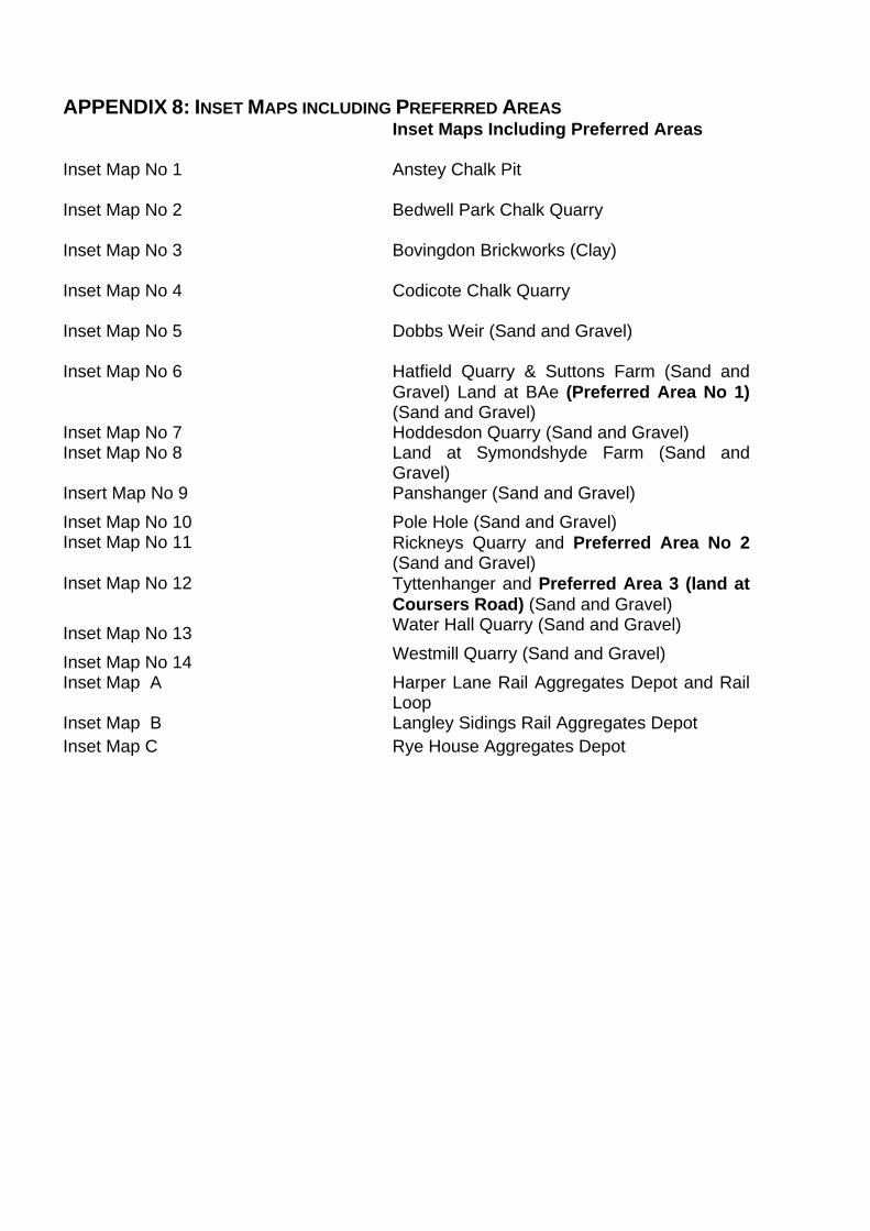
APPENDIX 8: INSET MAPS INCLUDING PREFERRED AREAS Inset Maps Including Preferred Areas Inset Map No 1 Anstey Chalk Pit
Inset Map No 2 Bedwell Park Chalk Quarry
Inset Map No 3 Bovingdon Brickworks (Clay)
Inset Map No 4 Codicote Chalk Quarry
Inset Map No 5 Dobbs Weir (Sand and Gravel)
Inset Map No 6 Hatfield Quarry & Suttons Farm (Sand and
Gravel) Land at BAe (Preferred Area No 1) (Sand and Gravel)
Inset Map No 7 Hoddesdon Quarry (Sand and Gravel) Inset Map No 8 Land at Symondshyde Farm (Sand and
Gravel) Insert Map No 9 Panshanger (Sand and Gravel) Inset Map No 10 Pole Hole (Sand and Gravel) Inset Map No 11 Rickneys Quarry and Preferred Area No 2
(Sand and Gravel) Inset Map No 12 Tyttenhanger and Preferred Area 3 (land at
Coursers Road) (Sand and Gravel) Inset Map No 13 Water Hall Quarry (Sand and Gravel)
Inset Map No 14 Westmill Quarry (Sand and Gravel) Inset Map A Harper Lane Rail Aggregates Depot and Rail
Loop Inset Map B Langley Sidings Rail Aggregates Depot Inset Map C Rye House Aggregates Depot

Preferred Area 1 Address: Land at former British Aerospace, Hatfield. Location: This preferred area lies to the west of Hatfield, on the Green Belt
land of the former Hatfield Aerodrome. Access: Via the A1057 Hatfield Road eastbound to A1001. Timing This site should ideally be worked very early in the Plan period Specific Considerations: The Ellenbrook Linear Park is excluded from the preferred area but
any reclamation proposals should clearly demonstrate how the Park is to be integrated in the overall scheme. The reclamation of any extraction area should clearly demonstrate that it is consistent with the principles set out in the Supplementary Planning Guidance and planning permission ref S6/1999/1064/OP for the BAe site as a whole to deliver the proposed Country Park.
Any proposals to exclude extraction from parts of the preferred area should be fully justified to avoid unnecessary sterilisation. Appropriate buffer zones will be required to protect the amenity of residents at Ellenbrook, Smallford and Popefield Farm.
A landscaped buffer zone incorporating Ellenbrook Linear Park
shall be provided to the eastern part of the site with the boundary to the redeveloped area of the BAe site (non-Green Belt land) and the University playing fields.
The site lies within the Watling Chase Community Forest, and so
there is potential for restoration to include extensive new woodland combined with suitable amenity use.
Appropriate measures shall be incorporated to ensure that Home
Covert is not adversely affected. The site is a possible area of archaeological interest and any
proposals should include provision for archaeological investigations.
Advice from The Environment Agency: The Ellen Brook runs along the eastern edge of the preferred area
in a north to south direction. The Environment Agency would seek to ensure that a buffer strip, a minimum of 30m wide between any excavation and the top of the riverbank. Additionally, 20 metres of

the buffer strip should be vegetated and free from any development between the working area and the bank of the Ellen Brook. The purpose of the buffer strip would be to protect both the integrity of the watercourse and the ecology associated with the watercourse, and the river corridor.
The River Nast currently runs in a culvert through the preferred
area. It may be acceptable to temporarily divert this culverted watercourse during the operational phase but on final restoration the watercourse should be reinstated in open channel through the site and appropriate buffer strips defined on each side of the watercourse.
The proposed site lies over an area contaminated with a plume of
Bromate. A more robust risk assessment may be required at this site in order to determine the risk of impact on the Three Valleys Water source at the public water source at Bishops Rise.
The area lies over both groundwater protection zones ll and lll. The
Environment Agency will object to the use of landfill for restoration in zone ll unless it can be demonstrated that the waste used will be non-polluting matter such as inert, naturally excavated material. The Agency will not usually object to landfilling in zone lll, provided it can be proved that the risk of pollution of groundwater can be mitigated. Proposals for individual landfills will be determined in detail at the application stage.

Preferred Area 2 Address: Land adjoining Rickneys Quarry, near Hertford. Location: This preferred area lies to the north of Hertford, to the east of
Sacombe Road and the south of Dimmings Lane18. Access: Via the existing access from the B158, to/from the north. Timing This site should ideally be worked earlier in the plan period. Specific Considerations: Working of this site would be considered as an extension to the
existing Rickneys Quarry. The village of Chapmore End as well as some individual properties
(in particular the properties on Sacombe Road, ‘Stonyhills’,‘Dimmings’ and the former Rickneys Farmhouse and adjacent, recently converted farm buildings) are in close proximity to this preferred area and appropriate buffer zones will be required in order to minimise any impact of extraction. Additional planting should be added at an early stage to strengthen existing hedgerows to Chapmore End and Rickneys/Rickneys Cottages.
The operations should be phased in such a way as to minimise the
duration of any impacts on Chapmore End village. Individual areas of ancient woodland will require safeguarding with
consideration given to the wider implications of mineral working impacts, including hydrology. The non-plantation parts of Flowersash Wood and Upper Stonyhills Wood shall be excluded from the extraction area.
The site is a possible area of archaeological interest and any
proposals should include provision for archaeological investigations.
Proposals will be required to include a comprehensive plan for
Public Rights of Way to ensure that a network is maintained and kept safe at all times.
Advice from The Environment Agency:
The site overlies a large proportion of the Groundwater Source Protection Zone (GPZ) l for the Wadesmill Road water supply bore. This is a very sensitive site in terms of potential pollution of the groundwater resource. There are a number of other licensed
18The preferred area boundary excludes all land to the east of the main north-south rights of way in the area: Gypsy Lane (Bengeo BOAT 22), Bengeo Footpath 14, Hertford Footpath 1 and 2 (except where the hedgerow deviates from Footpath 2) and Hertford RUPP 1. The footpaths are also excluded from the Preferred Area. Modification No 67 IR 8.1/1 and 8.1/2

abstractions from groundwater and surface waters on or close to this site, which should be considered as part of any Environmental Impact Assessment. There are a number of ordinary watercourses on this site and treatment of these watercourses would need to be detailed in an Environmental Impact Assessment for the proposal.
Due to the presence of a ground water protection zone and the
Wadesmill Road pumping station, restoration would be to a lower level than existing. The need for landfill will be resisted, however if landscape objectives are to be met, some soils may need to be imported without prejudicing the ground water protection zone.
Proposals will need to demonstrate that there is a sufficient balance of materials to achieve the proposed restoration.

Preferred Area 3 Address: Land at Coursers Road, near London Colney Location: This preferred area comprises two parcels of land north-east of the
M25 J22 and to the south east of Coursers Road, near London Colney. The two parcels are located either side of an existing area with planning permission for extraction ref 5/0250-97 and 0/0085-97.
Access: Mineral should be exported via the existing access at Tyttenhanger
Quarry to the A414. Any required fill should be via Coursers Road and A1081 as close as possible to the Bell roundabout. Any proposals should include details of a traffic management scheme to ensure road safety on Coursers Road.
Timing: This site should not be worked until late in the Plan period, following
completion of extraction from the existing consented area unless a comprehensive scheme for the preferred area and the consented area is submitted and approved which re-phases the working of all the land as a whole.
Specific Considerations: Working of this site would be considered as an extension to the
existing Tyttenhanger Quarry. Alternatively, there is potential to re-phase the working of this land
with the existing consented area to provide a comprehensive scheme for the land as a whole. Whilst this would not affect the timing of completion of restoration of the area, it would enable a more holistic approach to phasing and restoration. Proposals will need to demonstrate how they have given consideration to this matter.
In any event, the proposed restoration scheme would need to be
compatible with that approved for the central piece of permitted land and any proposals should demonstrate how this has been taken into account. The submitted scheme should clearly demonstrate the phasing of working and restoration.
The land comprises high-grade agricultural land and any restoration should ensure that its quality is not prejudiced. Restoration of the site to arable farmland with additional new hedges, tree planting and permanent grass field margins, would have the potential to increase biodiversity on the site, particularly bats and declining farmland birds.
Appropriate buffers to London Colney, Coursers Farm and the Bell roundabout should be included in any proposals19.
19 The preferred area boundary excludes Coursers Farm.

The site lies within the Watling Chase Community Forest and any
restoration proposals should contribute to the aims of the Forest Plan.
The site is a possible area of archaeological interest and any
proposals should include provision for archaeological investigations.
Advice from The Environment Agency:
The Tyttenhanger Stream (main river) and the Tyttenhanger stretch of the River Colne runs across part of the preferred area for future mineral extraction. The environment Agency would expect appropriate buffer strips to be established either side of the watercourse to protect the watercourse and the river corridor.
The site lies over a Groundwater Source Protection Zone (GPZ) lll
area as defined by the Environment Agency’s Source Protection Maps. The Environment Agency will not usually object to landfilling in a zone lll, provided it can be proved that risk of pollution of groundwater can be mitigated. However, any landfilling of this site has a potential to impact on three different source protection zones (North Mimms, Roestock, Tyttenhanger Wells). Proposals for individual landfills will be determined in detail at the application stage.