historical perspective - fema.gov · these evaluations provide a historical perspective on the ......
TRANSCRIPT
2-1C O A S T A L C O N S T R U C T I O N M A N U A L
1 CHAPTER TITLEC O A S T A L C O N S T R U C T I O N M A N U A L
2Historical Perspective2.1 IntroductionThrough the years, FEMA, other Federal agencies, State and local agencies, and other private groups have documented and evaluated the effects of coastal flood and wind events and the performance of buildings located in coastal areas during those events. These evaluations provide a historical perspective on the siting, design, and construction of buildings along the Atlantic, Pacific, Gulf of Mexico, and Great Lakes coasts. These studies provide a baseline against which the effects of later coastal flood events can be measured.
Within this context, certain hurricanes, coastal storms, and other coastal flood events stand out as being especially important, either because of the nature and extent of the damage they caused or because of particular flaws they exposed in hazard identification, siting, design, construction, or maintenance practices. Many of these events—particularly those occurring since 1979—have been documented by FEMA in Flood Damage Assessment Reports, Building Performance Assessment Team (BPAT) reports, and Mitigation Assessment Team (MAT) reports. These reports summarize investigations that FEMA conducts shortly after major disasters. Drawing on the combined resources of a Federal, State, local, and private sector partnership, a team of investigators
CROSS REFERENCE
For resources that augment the guidance and other information in this Manual, see the Residential Coastal Construction Web site (http://www.fema.gov/rebuild/mat/fema55.shtm).
NOTE
Hurricane categories reported in this Manual should be interpreted cautiously. Storm categorization based on wind speed may differ from that based on barometric pressure or storm surge. Also, storm effects vary geographically—only the area near the point of landfall will experience effects associated with the reported storm category.
2-2 C O A S T A L C O N S T R U C T I O N M A N U A L
2 HISTORICAL PERSPECTIVE
is tasked with evaluating the performance of buildings and related infrastructure in response to the effects of natural and man-made hazards. The teams conduct field investigations at disaster sites; work closely with local and State officials to develop recommendations for improvements in building design and construction; and prepare recommendations concerning code development, code enforcement, and mitigation activities that will lead to greater resistance to hazard events.
This chapter summarizes coastal flood and wind events that have affected the United States and its territories since the beginning of the twentieth century. The lessons learned regarding factors that contribute to flood and wind damage are discussed.
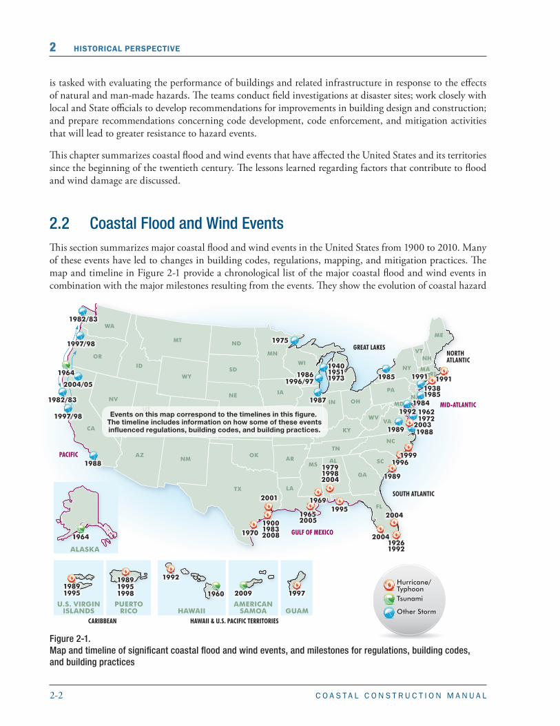
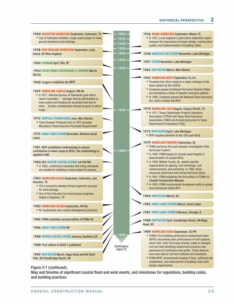
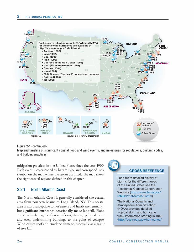
2.2 Coastal Flood and Wind EventsThis section summarizes major coastal flood and wind events in the United States from 1900 to 2010. Many of these events have led to changes in building codes, regulations, mapping, and mitigation practices. The map and timeline in Figure 2-1 provide a chronological list of the major coastal flood and wind events in combination with the major milestones resulting from the events. They show the evolution of coastal hazard
Figure 2-1. Map and timeline of significant coastal flood and wind events, and milestones for regulations, building codes, and building practices
NORTHATLANTIC
SOUTH ATLANTIC
CARIBBEAN
MID-ATLANTIC
GULF OF MEXICO
HAWAII & U.S. PACIFIC TERRITORIES
GREAT LAKES
PACIFIC
WA
OR
NV
CA
UT
AZNM
CO
NE
KS
TX
MO
IL
IN OH
KY
TN
LA
GA
FL
NC
VA
PA
NY
NJ
NH
ME
MACT
DEMD
WV
VT
RI
IA
SD
ND
WY
MT
ID
AR SCALMS
OK
MI
WI
MN
GUAMHAWAIIPUERTO
RICOAMERICAN
SAMOA
ALASKA
U.S. VIRGINISLANDS
Hurricane/TyphoonTsunami
Other Storm
Events on this map correspond to the timelines in this figure. The timeline includes information on how some of these eventsinfluenced regulations, building codes, and building practices.
190019832008
19261992
1960
1964
19652005
1969
1970
1989
199219891995
1995
1996
1997
2004
2004
1997/98
1982/83
2004/05
2009
198919951998
197919982004
19911985
194019511973
1987
19861996/97
1988
1982/83
1988
198419621972
1992
1989
1999
19381985
19911964
1997/98 1975
2001
2003
2-3C O A S T A L C O N S T R U C T I O N M A N U A L
HISTORICAL PERSPECTIVE 2
Figure 2-1 (continued). Map and timeline of significant coastal flood and wind events, and milestones for regulations, building codes, and building practices
2-4 C O A S T A L C O N S T R U C T I O N M A N U A L
2 HISTORICAL PERSPECTIVE
Figure 2-1 (continued). Map and timeline of significant coastal flood and wind events, and milestones for regulations, building codes, and building practices
mitigation practices in the United States since the year 1900. Each event is color-coded by hazard type and corresponds to a symbol on the map where the storm occurred. The map shows the eight coastal regions defined in this chapter.
2.2.1 North Atlantic Coast
The North Atlantic Coast is generally considered the coastal area from northern Maine to Long Island, NY. This coastal area is most susceptible to nor’easters and hurricane remnants, but significant hurricanes occasionally make landfall. Flood and erosion damage is often significant, damaging foundations and even undermining buildings to the point of collapse. Wind causes roof and envelope damage, especially as a result of tree fall.
CROSS REFERENCE
For a more detailed history of storms for the different areas of the United States see the Residential Coastal Construction Web site (http://www.fema.gov/rebuild/mat/fema55.shtm).
The National Oceanic and Atmospheric Administration (NOAA) provides detailed tropical storm and hurricane track information starting in 1848 (http://csc.noaa.gov/hurricanes/)

2-5C O A S T A L C O N S T R U C T I O N M A N U A L
HISTORICAL PERSPECTIVE 2
Figure 2-1 (concluded). Map and timeline of significant coastal flood and wind events, and milestones for regulations, building codes, and building practices
2-6 C O A S T A L C O N S T R U C T I O N M A N U A L
2 HISTORICAL PERSPECTIVE
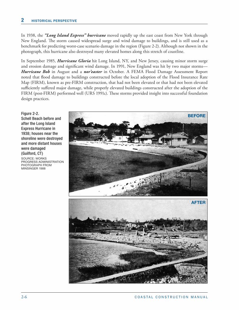
In 1938, the “Long Island Express” hurricane moved rapidly up the east coast from New York through New England. The storm caused widespread surge and wind damage to buildings, and is still used as a benchmark for predicting worst-case scenario damage in the region (Figure 2-2). Although not shown in the photograph, this hurricane also destroyed many elevated homes along this stretch of coastline.
In September 1985, Hurricane Gloria hit Long Island, NY, and New Jersey, causing minor storm surge and erosion damage and significant wind damage. In 1991, New England was hit by two major storms—Hurricane Bob in August and a nor’easter in October. A FEMA Flood Damage Assessment Report noted that flood damage to buildings constructed before the local adoption of the Flood Insurance Rate Map (FIRM), known as pre-FIRM construction, that had not been elevated or that had not been elevated sufficiently suffered major damage, while properly elevated buildings constructed after the adoption of the FIRM (post-FIRM) performed well (URS 1991c). These storms provided insight into successful foundation design practices.
Figure 2-2. Schell Beach before and after the Long Island Express Hurricane in 1938; houses near the shoreline were destroyed and more distant houses were damaged (Guilford, CT) SOURCE: WORKS PROGRESS ADMINISTRATION PHOTOGRAPH FROM MINSINGER 1988
BEFORE
AFTER
2-7C O A S T A L C O N S T R U C T I O N M A N U A L
HISTORICAL PERSPECTIVE 2
2.2.2 Mid-Atlantic Coast
The Mid-Atlantic Coast is generally considered the coastal area from New Jersey to Virginia. This coastal area is susceptible to both nor’easters and hurricanes with flood and wind damage similar to the damage that occur in New England.
In March 1962, a significant nor’easter, known as the Great Atlantic Storm of 1962 or the Ash Wednesday Storm, affected almost the entire eastern seaboard and caused extreme damage in the Mid-Atlantic region. The combination of sustained high winds with spring tides resulted in severe beachfront erosion and flooding, sweeping many buildings out to sea.
In June 1972, Tropical Storm Agnes produced rains up to 19 inches, resulting in severe riverine flooding from New York to Virginia and billions of dollars in flood damage. The catastrophic damage from this storm led to the “Mandatory Flood Insurance Purchase Requirement” in the Flood Disaster Protection Act of 1973 (see Section 5.2 for more on the history of the NFIP).
A March 1984 nor’easter caused significant erosion problems. As a result of damage observed after this storm and Hurricane Gloria (see Section 2.2.1), New Jersey implemented several changes to its coastal development practices in 1985.
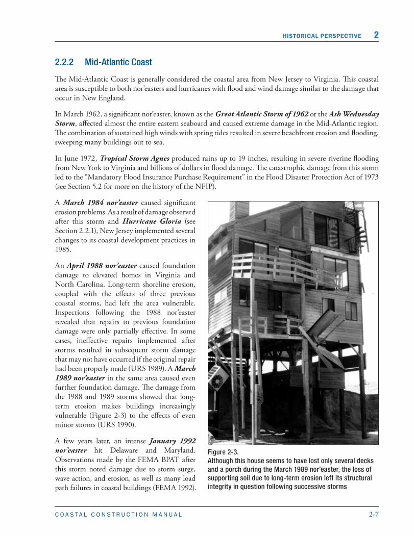
An April 1988 nor’easter caused foundation damage to elevated homes in Virginia and North Carolina. Long-term shoreline erosion, coupled with the effects of three previous coastal storms, had left the area vulnerable. Inspections following the 1988 nor’easter revealed that repairs to previous foundation damage were only partially effective. In some cases, ineffective repairs implemented after storms resulted in subsequent storm damage that may not have occurred if the original repair had been properly made (URS 1989). A March 1989 nor’easter in the same area caused even further foundation damage. The damage from the 1988 and 1989 storms showed that long-term erosion makes buildings increasingly vulnerable (Figure 2-3) to the effects of even minor storms (URS 1990).
A few years later, an intense January 1992 nor’easter hit Delaware and Maryland. Observations made by the FEMA BPAT after this storm noted damage due to storm surge, wave action, and erosion, as well as many load path failures in coastal buildings (FEMA 1992).
Figure 2-3. Although this house seems to have lost only several decks and a porch during the March 1989 nor’easter, the loss of supporting soil due to long-term erosion left its structural integrity in question following successive storms

2-8 C O A S T A L C O N S T R U C T I O N M A N U A L
2 HISTORICAL PERSPECTIVE
In September 2003, Hurricane Isabel made landfall near Cape Lookout, NC, as a Category 2 hurricane, breaching the barrier island. Storm surge and heavy rainfall caused extensive flooding across the Mid-Atlantic region, especially in areas adjacent to the Chesapeake Bay. Maximum observed water levels at stations along the Chesapeake Bay exceeded historical observations (NOAA 2004).
2.2.3 South Atlantic Coast
The South Atlantic Coast is generally considered the coastal area from North Carolina up to and including the Florida Keys. This region, especially the North Carolina Outer Banks and south Florida, is often subjected to hurricanes. States in the northern part of this region, such as North Carolina, are also susceptible to nor’easters. Damage is typically caused by flooding, waves, erosion, water-borne debris, wind, and wind-borne debris. The degree of damage ranges from slight to severe, depending on the characteristics of the storm.
After a September 1926 hurricane hit Miami, FL, a south Florida engineer, Theodore Eefting, wrote an article on the damage pointing out many weaknesses in buildings and construction that continue to be discussed today. Most notably, he stressed the consequences of poor quality construction, and the importance of strengthening building codes (Eefting 1927).
In late September 1989, Hurricane Hugo struck South Carolina. Observations following this hurricane revealed notable differences between the performance of pre- and post-FIRM buildings. Additionally, the BPAT deployed after Hurricane Hugo noted that some of the most severely damaged buildings were several rows back from the shoreline, and as a result recommended that design standards for Coastal A Zones (defined in Chapter 1) be more stringent. The wind damage from Hurricane Hugo also exposed deficiencies in residential roofing practices (URS 1991a, URS 1991b, and Texas Tech 1990).
In August 1992, Hurricane Andrew struck the southeast Atlantic coast. This hurricane remains one of the most memorable hurricanes to hit this region and one of the costliest to date. The majority of the damage from this hurricane was due to wind; many of the failures were traced to inadequate connections between building elements (Figure 2-4). As such, buildings could not resist wind forces because of the lack
Figure 2-4. Roof structure failure due to inadequate bracing and inadequate fastening of the roof deck, Hurricane Andrew (Dade County, FL, 1992)
2-9C O A S T A L C O N S T R U C T I O N M A N U A L
HISTORICAL PERSPECTIVE 2
of continuous load transfer paths from the roofs to the foundations (FEMA 1993). Hurricane Andrew was a major catalyst for building code changes involving wind design that improved wind pressure calculation procedures and emphasized the need for a continuous load transfer path in buildings for uplift and lateral loads, not just for the traditional downward-acting gravity loads. Hurricane Andrew destroyed 97 percent of the manufactured homes in its path, leading the Department of Housing and Urban Development (HUD) to adopt more stringent wind design criteria for manufactured homes (FEMA 2009a).
In 1996, Hurricane Fran hit North Carolina. The resulting wave damage reinforced the idea that buildings in Coastal A Zones should be more hazard-resistant. The FEMA BPAT report noted that more stringent design codes and standards were needed to achieve improved performance (FEMA 1997).
In September 1999, Hurricane Floyd briefly touched Florida before making landfall in North Carolina and moving north along the east coast as a tropical storm all the way to Maine. Although inland flood damage was severe in eastern North Carolina, high winds, storm surge and torrential rains caused moderate damage to coastal and inland communities along much of the east coast.
2.2.4 Gulf of Mexico Coast
The Gulf of Mexico coast includes the coastal area from the Florida Keys northward and westward to Texas. This coastal area has long been susceptible to strong hurricanes, and in recent years the northern Gulf Coast (Florida panhandle to east Texas) has experienced a number of them. Low-lying areas are especially vulnerable to damage from erosion, waves, and storm surge.
The September 1900 hurricane that hit Galveston, TX, is still the deadliest natural disaster to affect the United States. Shortly after, as a result of destruction due to poor siting practices, Galveston Island completed the first large-scale retrofit project in the United States: roads and hundreds of buildings were elevated, ground levels in the city were raised several feet, and the Galveston seawall was built (Walden 1990). In 1961, the extensive damage caused by erosion from Hurricane Carla again highlighted the need for proper siting and construction in coastal areas (Hayes 1967).
Hurricane Camille, a Category 5 hurricane, made landfall in Mississippi in August 1969 and caused “near total destruction” in some areas near the beach as a result of waves and storm surge (Thom and Marshall 1971). High winds also caused damage farther inland. The studies performed by Thom and Marshall after the hurricane led to building design criteria that resulted in the construction of new homes with improved resistance to higher wind forces.
In September 1979, Hurricane Frederic hit Alabama and caused widespread damage, including the destruction of many houses elevated to the BFE. After Hurricane Frederic, FEMA began to include wave heights in its determination of BFEs in coastal flood hazard areas (FEMA 1980).
TERMINOLOGY
BASE FLOOD ELEVATION (BFE):The BFE is the water surface elevation resulting from a flood that has a 1 percent chance of equaling or exceeding that level in any given year. Section 3.6.1 has more information on how the BFE is established.
DESIGN FLOOD ELEVATION (DFE):The DFE is the locally adopted regulatory flood elevation. If a community regulates to minimum NFIP requirements, the DFE is identical to the BFE. If a community chooses to exceed minimum NFIP requirements, the DFE exceeds the BFE.
2-10 C O A S T A L C O N S T R U C T I O N M A N U A L
2 HISTORICAL PERSPECTIVE
Hurricane Alicia made landfall in August 1983 in the Houston-Galveston area, causing extensive wind and flood damage. Wood frame houses were the hardest hit, and most of the damage was traced to poor roof construction and inadequate roof-to-wall connections (National Academy of Sciences 1984). Homes near the water were washed off their foundations, leading to the recommendation that grade-level enclosures be constructed with breakaway walls.
In October 1995, Hurricane Opal hit the Florida panhandle, exacerbating erosion and structural damage from a weaker hurricane (Hurricane Erin) that hit the area 1 month earlier. A FEMA BPAT revealed that post-FIRM Zone A and pre-FIRM buildings failed most often, especially those with insufficient pile embedment. In addition, damage observations confirmed that State regulations that exceeded NFIP requirements helped reduce storm damage (FEMA 1996).
Hurricane Georges made landfall in Mississippi in September 1998 and moved north and east through Alabama and Florida, causing both flood and wind damage. The FEMA BPAT found that buildings constructed in accordance with building codes and regulations, and buildings using specialized materials such as siding and roof shingles designed for higher wind speeds, performed well. The FEMA BPAT also confirmed that manufactured homes built after 1994 (when HUD wind design criteria were adopted following Hurricane Andrew) performed well. Most of the observed flood damage was attributed to inadequately elevated and improperly designed foundations, as well as poor siting practices (FEMA 1999a).
In June 2001, Tropical Storm Allison made landfall in Galveston, TX. It took a unique path, stalling and then making a loop around Houston, resulting in heavy rainfall of more than 30 inches over a 4-day period. Severe flooding destroyed over 2,700 homes in Houston (RMS 2001). Flood damage to commercial and government buildings in the greater Houston area was severe. Tropical Storm Allison made it clear that some of the most destructive tropical systems are not hurricanes, but slow-moving tropical storms dropping large amounts of rainfall.
Hurricane Charley made landfall in Florida in August 2004. After observing extensive wind damage, the FEMA MAT concluded that buildings built to the 2001 Florida Building Code (FBC) generally performed well structurally (FEMA 2005a), but older buildings experienced damage because design wind loads underestimated wind pressures on some building components, buildings lacked a continuous load path, and building elements were poorly constructed and poorly maintained.
In September 2004, Hurricane Ivan made landfall in Alabama and Florida. Although not a design wind event, Ivan caused extensive envelope damage that allowed heavy rains to infiltrate buildings and damage interiors. This damage highlighted weaknesses in older building stock and the need for improved guidance and design criteria for better building performance at these “below code” events. Flood-borne debris and wave damage extended into Coastal A Zones (FEMA 2005b).
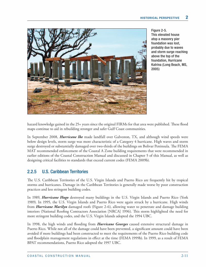
In August 2005, Hurricane Katrina caused extensive storm surge damage and flooding well beyond the SFHA in Louisiana and Mississippi. Flooding in New Orleans was worsened by levee failures, and floodwaters rose well above the first floor of elevated buildings (Figure 2-5). The long duration of the flooding added to the destruction (FEMA 2006). After Katrina, FEMA issued new flood maps for the area that built on the
NOTE
The NFIP regulates structures to the BFE while building codes regulate to the DFE. The DFE is either equivalent to or greater than the BFE, depending on the governing codes of the jurisdiction in which the structure is located.
2-11C O A S T A L C O N S T R U C T I O N M A N U A L
HISTORICAL PERSPECTIVE 2
Figure 2-5. This elevated house atop a masonry pier foundation was lost, probably due to waves and storm surge reaching above the top of the foundation, Hurricane Katrina (Long Beach, MS, 2005)
hazard knowledge gained in the 25+ years since the original FIRMs for that area were published. These flood maps continue to aid in rebuilding stronger and safer Gulf Coast communities.
In September 2008, Hurricane Ike made landfall over Galveston, TX, and although wind speeds were below design levels, storm surge was more characteristic of a Category 4 hurricane. High waves and storm surge destroyed or substantially damaged over two-thirds of the buildings on Bolivar Peninsula. The FEMA MAT recommended enforcement of the Coastal A Zone building requirements that were recommended in earlier editions of the Coastal Construction Manual and discussed in Chapter 5 of this Manual, as well as designing critical facilities to standards that exceed current codes (FEMA 2009b).
2.2.5 U.S. Caribbean Territories
The U.S. Caribbean Territories of the U.S. Virgin Islands and Puerto Rico are frequently hit by tropical storms and hurricanes. Damage in the Caribbean Territories is generally made worse by poor construction practices and less stringent building codes.
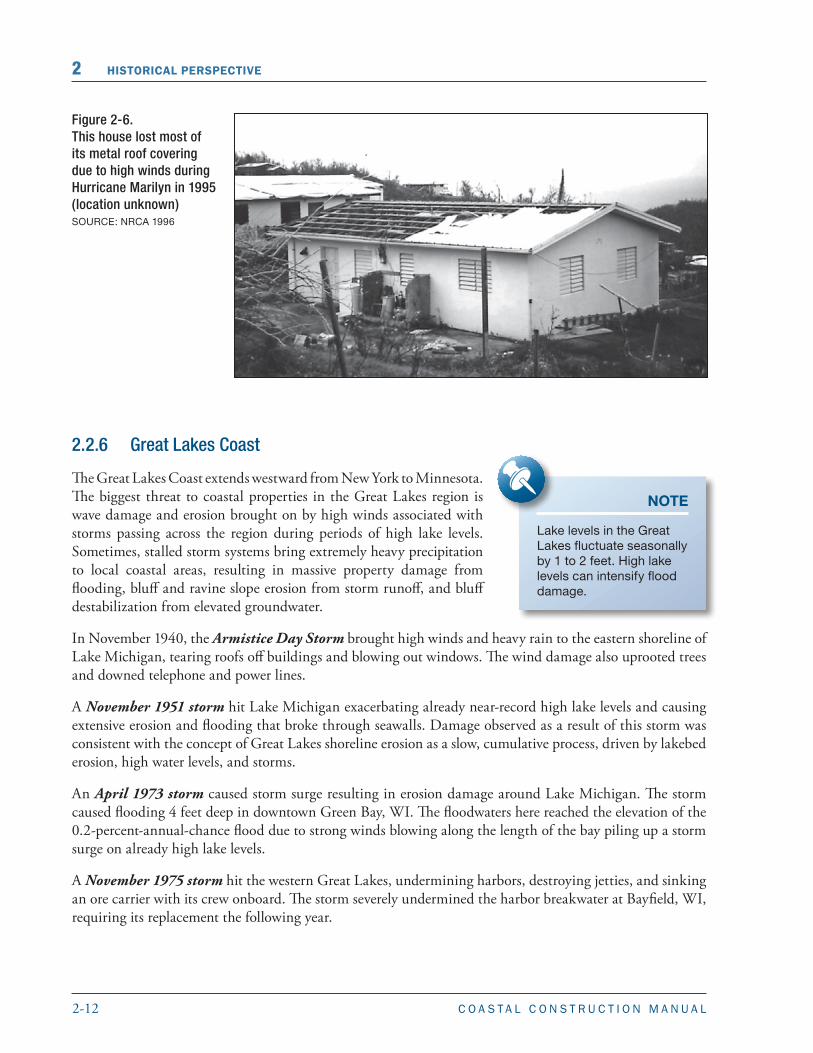
In 1989, Hurricane Hugo destroyed many buildings in the U.S. Virgin Islands and Puerto Rico (York 1989). In 1995, the U.S. Virgin Islands and Puerto Rico were again struck by a hurricane. High winds from Hurricane Marilyn damaged roofs (Figure 2-6), allowing water to penetrate and damage building interiors (National Roofing Contractors Association [NRCA] 1996). This storm highlighted the need for more stringent building codes, and the U.S. Virgin Islands adopted the 1994 UBC.
In 1998, the high winds and flooding from Hurricane Georges caused extensive structural damage in Puerto Rico. While not all of the damage could have been prevented, a significant amount could have been avoided if more buildings had been constructed to meet the requirements of the Puerto Rico building code and floodplain management regulations in effect at the time (FEMA 1999b). In 1999, as a result of FEMA BPAT recommendations, Puerto Rico adopted the 1997 UBC.
2-12 C O A S T A L C O N S T R U C T I O N M A N U A L
2 HISTORICAL PERSPECTIVE
Figure 2-6.This house lost most of its metal roof covering due to high winds during Hurricane Marilyn in 1995 (location unknown)SOURCE: NRCA 1996
2.2.6 Great Lakes Coast
The Great Lakes Coast extends westward from New York to Minnesota. The biggest threat to coastal properties in the Great Lakes region is wave damage and erosion brought on by high winds associated with storms passing across the region during periods of high lake levels. Sometimes, stalled storm systems bring extremely heavy precipitation to local coastal areas, resulting in massive property damage from flooding, bluff and ravine slope erosion from storm runoff, and bluff destabilization from elevated groundwater.
In November 1940, the Armistice Day Storm brought high winds and heavy rain to the eastern shoreline of Lake Michigan, tearing roofs off buildings and blowing out windows. The wind damage also uprooted trees and downed telephone and power lines.
A November 1951 storm hit Lake Michigan exacerbating already near-record high lake levels and causing extensive erosion and flooding that broke through seawalls. Damage observed as a result of this storm was consistent with the concept of Great Lakes shoreline erosion as a slow, cumulative process, driven by lakebed erosion, high water levels, and storms.
An April 1973 storm caused storm surge resulting in erosion damage around Lake Michigan. The storm caused flooding 4 feet deep in downtown Green Bay, WI. The floodwaters here reached the elevation of the 0.2-percent-annual-chance flood due to strong winds blowing along the length of the bay piling up a storm surge on already high lake levels.
A November 1975 storm hit the western Great Lakes, undermining harbors, destroying jetties, and sinking an ore carrier with its crew onboard. The storm severely undermined the harbor breakwater at Bayfield, WI, requiring its replacement the following year.
NOTE
Lake levels in the Great Lakes fluctuate seasonally by 1 to 2 feet. High lake levels can intensify flood damage.

2-13C O A S T A L C O N S T R U C T I O N M A N U A L
HISTORICAL PERSPECTIVE 2
High winds from a March 1985 storm caused storm surge flooding in upstate New York and Lake Erie, where lake levels rose to record levels. That month, Wisconsin’s Lake Michigan lakeshore suffered rapid shoreline recession in successive storms, and some homes had to be relocated.
The southeastern Wisconsin coast of Lake Michigan experienced rainfall in excess of the 0.2-percent-annual-chance precipitation event as a result of a 1986 storm, causing massive property damage from flooding, erosion, and bluff destabilization (U.S. Army Corp of Engineers [USACE] 1997, 1998).
A February 1987 storm hit Chicago, IL, during a period of record high lake levels on Lake Michigan (Figure 2-7 shows damage from a similar storm). High waves destroyed a seawall and caused severe erosion to Chicago’s lakeshore. Waves slammed high-rise condominiums, smashing first floor windows, and flooding basements.
The southeastern Wisconsin coast of Lake Michigan experienced two rainfall events, in 1996 and 1997, each of which resulted in precipitation in excess of the 0.2-percent-annual-chance event. These events, similar to the 1986 storm, caused massive property damage from flooding, erosion, and bluff destabilization (USACE 1997, 1998).
2.2.7 Pacific Coast
The Pacific Coast extends from Alaska to southern California. The Pacific Coast is mostly affected by high waves and erosion during winter storms, though tsunamis occasionally affect the area. Hurricanes can affect the southern Pacific Coast, but this is rare. Damage to homes from El Niño-driven storms over the past several decades reinforces the importance of improving siting practices near coastal bluffs and cliffs on the Pacific Coast.
A March 1964 earthquake with an epicenter in Prince William Sound, Alaska, generated a tsunami that affected parts of Washington, Oregon, California, and Hawaii. The tsunami flooded entire towns and triggered landslides. A post-disaster report provided several recommendations on foundation design, such
Figure 2-7.Erosion along the Lake Michigan shoreline at Holland, MI, resulting from high lake levels and storm activity (August 1988)SOURCE: MARK CROWELL, FEMA
2-14 C O A S T A L C O N S T R U C T I O N M A N U A L
2 HISTORICAL PERSPECTIVE
as deep foundations to resist scour and undermining, and placement of wood frame buildings (Wilson and TØrum 1968).
In the winter of 1982-83, a series of El Niño-driven coastal storms caused widespread and significant damage to beaches, cliffs, and buildings along the coast between Baja California and Washington. These storms prompted a conference on coastal erosion, which concluded that siting standards were needed for homes built in areas subject to erosion, especially those atop coastal bluffs (McGrath 1985). The California Coastal Commission now uses the 1982-83 storms as its design event for new development (California Coastal Commission, 1997).
In January 1988, a rapidly developing coastal storm struck southern California. The waves from the storm were the highest on record at the time and severely damaged shore protection structures and oceanfront buildings. This storm demonstrated the severity of damage that could be caused by a winter storm.
In the winter of 1997-98, another notable series of severe El Niño-driven coastal storms battered the coasts of California and Oregon. Heavy rainfall caused widespread soil saturation, resulting in debris flow, landslides, and bluff collapse.
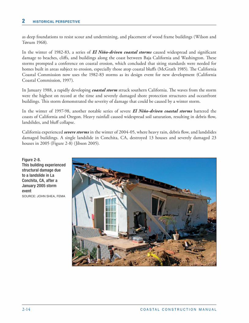
California experienced severe storms in the winter of 2004-05, where heavy rain, debris flow, and landslides damaged buildings. A single landslide in Conchita, CA, destroyed 13 houses and severely damaged 23 houses in 2005 (Figure 2-8) (Jibson 2005).
Figure 2-8.This building experienced structural damage due to a landslide in La Conchita, CA, after a January 2005 storm event SOURCE: JOHN SHEA, FEMA
2-15C O A S T A L C O N S T R U C T I O N M A N U A L
HISTORICAL PERSPECTIVE 2
2.2.8 Hawaii and U.S. Pacific Territories
Hawaii and the U.S. Pacific Territories of Guam, the Northern Marianas Islands, and American Samoa are subject to tropical cyclones (called hurricanes in Hawaii and American Samoa, and typhoons in Guam and the Northern Marianas Islands) and tsunamis. Tropical cyclones can cause damage in these areas from high winds, large waves, erosion, and rapid flow of rainfall runoff down steep terrain. Tsunamis can cause damage from rapidly moving water and debris across the shoreline area.
In 1992, Hurricane Iniki, the strongest hurricane to affect the Hawaiian Islands in recent memory, caused significant flood and wave damage to buildings near the shoreline. Following the hurricane, FEMA recalculated BFEs to include hurricane flood effects, instead of just tsunami effects. This revision made flood maps more accurate and aided in the rebuilding process. A FEMA BPAT after the hurricane revealed problems with foundation construction that resulted in some buildings being washed off their foundations. It also concluded that inadequately designed roofs and generally poor quality of construction resulted in wind damage that could have been avoided.
In December 1997, Typhoon Paka hit Guam causing substantial damage to wood-frame buildings, but minimal damage to concrete and masonry buildings. After the typhoon, Guam adopted ASCE 7-98 design wind speeds, which incorporated topographic influences in wind speeds for the first time.
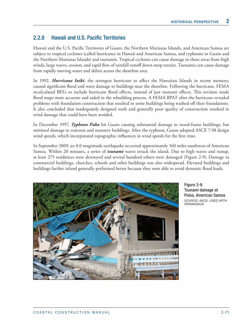
In September 2009, an 8.0 magnitude earthquake occurred approximately 160 miles southwest of American Samoa. Within 20 minutes, a series of tsunami waves struck the island. Due to high waves and runup, at least 275 residences were destroyed and several hundred others were damaged (Figure 2-9). Damage to commercial buildings, churches, schools and other buildings was also widespread. Elevated buildings and buildings farther inland generally performed better because they were able to avoid dynamic flood loads.
Figure 2-9. Tsunami damage at Poloa, American Samoa SOURCE: ASCE, USED WITH PERMISSION
2-16 C O A S T A L C O N S T R U C T I O N M A N U A L
2 HISTORICAL PERSPECTIVE
2.3 Breaking the Disaster-Rebuild-Disaster Cycle
Although the physiographic features vary throughout the coastal areas of the United States, post-event damage assessments and reports show that the nature and extent of damage caused by coastal flood events are remarkably similar. Similar findings have been noted for coastal storms in which high winds damage the built environment. In the case of wind, the evolution of building for “wind resistance” is characterized by improved performance of some building components (e.g., structural systems), but continued poor performance of other elements (e.g., building envelope components).
Although many aspects of coastal design and construction have improved over the years, the harsh coastal environment continues to highlight deficiencies in the design and construction process. The design and construction community should incorporate the lessons learned from past events in order to avoid repeating past mistakes, and to break the disaster-rebuild-disaster cycle.
The conclusions of post-event assessments can be classified according to those factors that contribute to both building damage and successful building performance: hazard identification, siting, design, construction, and maintenance. Special attention must also be paid when designing and constructing enclosures in coastal buildings. Reduction of building damage in coastal areas requires attention to these factors and coordination between owners, designers, builders, and local officials.
2.3.1 Hazard Identification
Understanding and identifying the hazards that affect coastal areas is a key factor in successful mitigation. Historical and recent hurricanes have provided insight into coastal hazards and their effects on coastal buildings. An all-hazards approach to design is needed to address all possible impacts of coastal storms and other coastal hazards.
The minimum Zone A foundation and elevation requirements should not be assumed to provide buildings with resistance to coastal flood forces. The Coastal A Zone recommendations in this Manual should be considered as a part of the best practices approach to designing a successful building. Flood hazards in areas mapped as Zone A on coastal FIRMs can be much greater than flood hazards in riverine Zone A for two reasons:
CROSS REFERENCE
Chapter 3 discusses coastal hazards in more detail and their effects on coastal buildings.
Sections 1.4.3 and 3.3 of this Manual explain the concept of the Coastal A Zone.
WARNING
FIRMs do not account for future effects of sea level rise and long-term erosion. All mapped flood hazard zones (V, A, and X) in areas subject to sea level rise and/or long-term erosion likely underestimate the extent and magnitude of actual flood hazards that a coastal building will experience over its lifetime. FIRMs also do not account for storm-induced erosion that has occurred after the FIRM effective date.
Refer to Section 3.5 for more detailed information on erosion.
NOTE
Conclusions presented in this section are based on numerous post-event damage assessments by FEMA and other technical and scientific organizations. Although most of the findings are qualitative, they serve as a valuable source of information on building performance and coastal development practices.
2-17C O A S T A L C O N S T R U C T I O N M A N U A L
HISTORICAL PERSPECTIVE 2
1. Waves 1.5 to 3 feet high (i.e., too small for an area to be classified as Zone V, but still capable of causing structural damage and erosion) occur during base flood conditions in many areas.
2. Older FIRMs may fail to reflect changing site conditions (e.g., as a result of long-term erosion, loss of dunes during previous storms) and improved flood hazard mapping procedures.
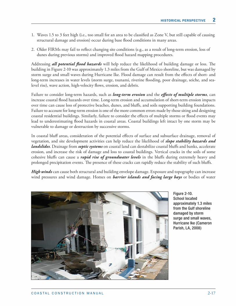
Addressing all potential flood hazards will help reduce the likelihood of building damage or loss. The building in Figure 2-10 was approximately 1.3 miles from the Gulf of Mexico shoreline, but was damaged by storm surge and small waves during Hurricane Ike. Flood damage can result from the effects of short- and long-term increases in water levels (storm surge, tsunami, riverine flooding, poor drainage, seiche, and sea-level rise), wave action, high-velocity flows, erosion, and debris.
Failure to consider long-term hazards, such as long-term erosion and the effects of multiple storms, can increase coastal flood hazards over time. Long-term erosion and accumulation of short-term erosion impacts over time can cause loss of protective beaches, dunes, and bluffs, and soils supporting building foundations. Failure to account for long-term erosion is one of the more common errors made by those siting and designing coastal residential buildings. Similarly, failure to consider the effects of multiple storms or flood events may lead to underestimating flood hazards in coastal areas. Coastal buildings left intact by one storm may be vulnerable to damage or destruction by successive storms.
In coastal bluff areas, consideration of the potential effects of surface and subsurface drainage, removal of vegetation, and site development activities can help reduce the likelihood of slope stability hazards and landslides. Drainage from septic systems on coastal land can destabilize coastal bluffs and banks, accelerate erosion, and increase the risk of damage and loss to coastal buildings. Vertical cracks in the soils of some cohesive bluffs can cause a rapid rise of groundwater levels in the bluffs during extremely heavy and prolonged precipitation events. The presence of these cracks can rapidly reduce the stability of such bluffs.
High winds can cause both structural and building envelope damage. Exposure and topography can increase wind pressures and wind damage. Homes on barrier islands and facing large bays or bodies of water
Figure 2-10. School located approximately 1.3 miles from the Gulf shoreline damaged by storm surge and small waves, Hurricane Ike (Cameron Parish, LA, 2008)

2-18 C O A S T A L C O N S T R U C T I O N M A N U A L
2 HISTORICAL PERSPECTIVE
may be exposed to wind pressures higher than in areas of flat terrain, especially at high pressure zones of the roof. The house in Figure 2-11 sustained damage at the roof edge and roof corners, even though the hurricane was below the design event and wind damage should not have occurred. Recent studies have influenced wind design standards to increase design wind pressures on these exposed structures. Failure to consider the effects of topography (and changes in topography such as bluff erosion) on wind speeds can lead to an underestimation of design wind speeds. Siting buildings on bluffs or near high-relief topography requires special attention by the designer.
Some coastal areas are also susceptible to seismic hazards. Although the likelihood of simultaneous flood and seismic hazards is small, each hazard should be identified carefully and factored into siting, design, and construction practices.
Figure 2-11. Galveston Island beach house with wind damage to roof in high pressure zones at roof edge and roof corners, Hurricane Ike, 2008
2.3.2 Siting
There is inherent risk in building near a coast, but this risk can be reduced through proper siting practices. The effects of coastal storms and hurricanes on buildings provide regular lessons on the effects of siting in coastal environments.
Building close to the shoreline is a common, and often poor, siting practice. It generally renders a building more vulnerable to wave, flood, and erosion effects and reduces any margin of safety against multiple storms or erosion events. If flood hazards increase over time, the building may require removal, protection, or demolition. In coastal areas subject to long-term or episodic erosion, poor siting often leads to otherwise well-built elevated buildings standing on the active beach. While considered a structural success, such buildings are generally uninhabitable because of the loss of utilities and
CROSS REFERENCE
Section 8.7.1 explains the increased wind pressures on certain zones of a roof (Figure 8-17).
CROSS REFERENCE
Chapter 4 discusses siting considerations, siting practices to avoid, and recommended alternatives.

2-19C O A S T A L C O N S T R U C T I O N M A N U A L
HISTORICAL PERSPECTIVE 2
access. The presence of homes on active beaches can also lead to conflicts over beach use and increase pressure to armor or re-nourish beaches (both controversial and expensive measures). Buildings sited on naturally occurring rocky shorelines are better protected from erosion and direct wave impacts, but may still be subject to wave overtopping.
Buildings subject to storm-induced erosion, including those in low-lying areas and buildings sited on the tops of erodible dunes and bluffs are vulnerable to damage caused by the undermining of foundations and the loss of supporting soil around vertical foundation members. Building on dunes and bluffs is discouraged. If buildings are constructed on dunes or bluffs they must be sited far from erodible slopes and must have a deep, well-designed, and well-constructed pile or column foundation.
The additional hazards associated with building near naturally occurring geographic features should be considered. Siting along shorelines protected against wave attack by barrier islands or other land masses does not guarantee protection from flooding. In fact, storm surge elevations along low-lying shorelines in embayments are often higher than storm surge elevations on open coast shorelines. Buildings sited near unstabilized tidal inlets or in areas subject to large-scale shoreline fluctuations may be vulnerable to even minor storms or erosion events.
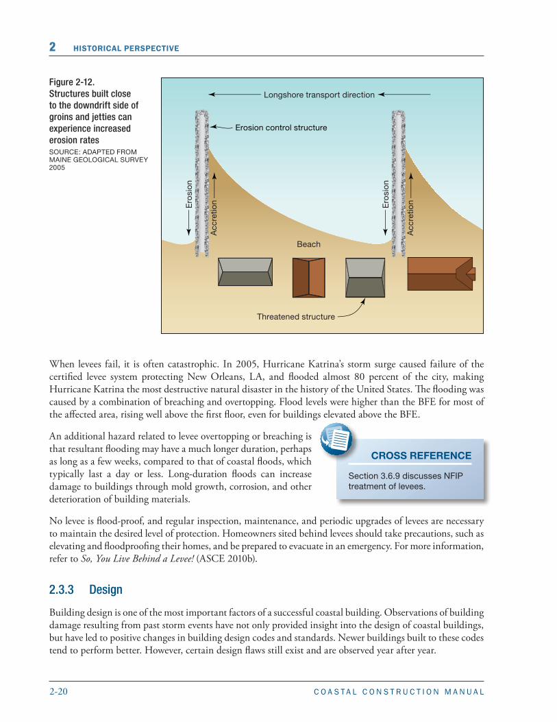
Building close to other structures may increase the potential for damage from flood, wind, debris, and erosion hazards. Siting homes or other small buildings adjacent to large, engineered high-rise structures is a particular concern. The larger structures can redirect and concentrate flood, wave, and wind forces, and have been observed to increase flood and wind forces, as well as scour and erosion, to adjacent structures. Siting near erosion control or flood protection structures has contributed to building damage or destruction because these structures may not afford the required protection during a design event. Seawalls, revetments, berms, and other structures may themselves be vulnerable as a result of erosion and scour or other prior storm impacts. Siting too close to protective structures may preclude or make difficult any maintenance of the protective structure. Buildings sited on the downdrift shoreline of a groin or stabilized tidal inlet (an inlet whose location has been fixed by jetties) may be subject to increased erosion. Figure 2-12 shows how increased erosion rates on the downdrift side of groins can threaten structures.
Building in a levee-impacted area has special risks that should be understood. Levees are common flood protection structures in some coastal areas. The purpose of a levee is to reduce risk from temporary flooding to the people and property behind it (known as levee-impacted areas). Levees are designed to provide a specific level of risk reduction (e.g., protection from the 1-percent-annual-chance flood). It must be remembered that levees can be overtopped or breached during floods that are larger than they were designed to withstand. Levees can also fail during floods that are less than the design level due to inadequacies in design, construction, operation, or maintenance.
CROSS REFERENCE
Figures 3-37 and 3-46 show the consequences of siting buildings on the tops of erodible bluffs.
TERMINOLOGY: LEVEE
A levee is a man-made structure, usually an earthen embankment, built parallel to a waterway to contain, control, or divert the flow of water. A levee system may also include concrete or steel floodwalls, fixed or operable floodgates and other closure structures, pump stations for rainwater drainage, and/or other elements, all of which must perform as designed to prevent failure.
2-20 C O A S T A L C O N S T R U C T I O N M A N U A L
2 HISTORICAL PERSPECTIVE
Figure 2-12. Structures built close to the downdrift side of groins and jetties can experience increased erosion rates SOURCE: ADAPTED FROM MAINE GEOLOGICAL SURVEY 2005
When levees fail, it is often catastrophic. In 2005, Hurricane Katrina’s storm surge caused failure of the certified levee system protecting New Orleans, LA, and flooded almost 80 percent of the city, making Hurricane Katrina the most destructive natural disaster in the history of the United States. The flooding was caused by a combination of breaching and overtopping. Flood levels were higher than the BFE for most of the affected area, rising well above the first floor, even for buildings elevated above the BFE.
An additional hazard related to levee overtopping or breaching is that resultant flooding may have a much longer duration, perhaps as long as a few weeks, compared to that of coastal floods, which typically last a day or less. Long-duration floods can increase damage to buildings through mold growth, corrosion, and other deterioration of building materials.
No levee is flood-proof, and regular inspection, maintenance, and periodic upgrades of levees are necessary to maintain the desired level of protection. Homeowners sited behind levees should take precautions, such as elevating and floodproofing their homes, and be prepared to evacuate in an emergency. For more information, refer to So, You Live Behind a Levee! (ASCE 2010b).
2.3.3 Design
Building design is one of the most important factors of a successful coastal building. Observations of building damage resulting from past storm events have not only provided insight into the design of coastal buildings, but have led to positive changes in building design codes and standards. Newer buildings built to these codes tend to perform better. However, certain design flaws still exist and are observed year after year.
CROSS REFERENCE
Section 3.6.9 discusses NFIP treatment of levees.

2-21C O A S T A L C O N S T R U C T I O N M A N U A L
HISTORICAL PERSPECTIVE 2
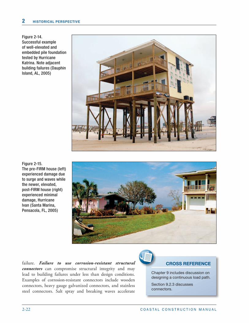
Foundation design is an important factor in the success of a coastal building. Use of shallow spread footing and slab foundations in areas subject to wave impact and/or erosion can result in building collapse, even during minor flood or erosion events. Because of the potential for undermining by erosion and scour, this type of foundation may not be appropriate for coastal bluff areas outside the mapped floodplain and some Coastal A Zones. Figure 2-13 shows an extreme case of localized scour undermining a slab-on-grade house after Hurricane Fran. The lot was mapped as Zone A and located several hundred feet from the shoreline. This case illustrates the need for open foundations in Coastal A Zones. Use of continuous perimeter wall foundations, such as crawlspace foundations (especially unreinforced masonry) in areas subject to wave impact and/or erosion may result in building damage, collapse, or total loss. For open foundations, inadequate depth of foundation members is a common cause of failure in pile-elevated one- to four-family residential buildings. Figure 2-14 shows a building that survived Hurricane Katrina with a deeply embedded pile foundation that is sufficiently elevated.
In addition, insufficient elevation of a building exposes the superstructure to damaging wave forces. Designs should incorporate freeboard above the required elevation of the lowest floor or bottom of the lowest horizontal member. Figure 2-15 shows two neighboring homes. The pre-FIRM house on the left experienced significant structural damage due to surge and waves. The newer, post-FIRM house on the right sustained minor damage because it was elevated above grade, and grade had been raised a few feet by fill.
In addition to foundation design, there are other commonly observed points of failure in the design of coastal buildings. Failure to provide a continuous load path from the roof to the foundation using adequate connections may lead to structural
CROSS REFERENCE
Chapter 10 provides a detailed discussion of foundation design.
TERMINOLOGY: LOWEST FLOOR
Under the NFIP, the “lowest floor” of a building includes the floor of a basement. The NFIP regulations define a basement as “... any area of a building having its floor subgrade (below ground level) on all sides.” For insurance rating purposes, this definition applies even when the subgrade floor is not enclosed by full-height walls.
Figure 2-13.Extreme case of localized scour undermining a Zone A continuous perimeter wall foundation located several hundred feet from the shoreline, Hurricane Fran (Topsail Island, NC, 1996)
2-22 C O A S T A L C O N S T R U C T I O N M A N U A L
2 HISTORICAL PERSPECTIVE
Figure 2-14. Successful example of well-elevated and embedded pile foundation tested by Hurricane Katrina. Note adjacent building failures (Dauphin Island, AL, 2005)
Figure 2-15. The pre-FIRM house (left) experienced damage due to surge and waves while the newer, elevated, post-FIRM house (right) experienced minimal damage, Hurricane Ivan (Santa Marina, Pensacola, FL, 2005)
failure. Failure to use corrosion-resistant structural connectors can compromise structural integrity and may lead to building failures under less than design conditions. Examples of corrosion-resistant connectors include wooden connectors, heavy gauge galvanized connectors, and stainless steel connectors. Salt spray and breaking waves accelerate
CROSS REFERENCE
Chapter 9 includes discussion on designing a continuous load path.
Section 9.2.3 discusses connectors.

2-23C O A S T A L C O N S T R U C T I O N M A N U A L
HISTORICAL PERSPECTIVE 2
corrosion of metal building components. Nails, screws, sheet-metal connector straps, and truss plates made of ferrous metals are the most likely to corrode. Decks and roofs supported by inadequately embedded vertical members, especially those that are multiple stories, can lead to major structural damage even during minor flood and erosion events. Failure to adequately connect porch roofs and to limit the size of roof overhangs can lead to extensive damage to the building envelope during minor wind events. Roof overhangs should be designed to remain intact without vertical supports. Alternatively, supports should be designed to the same standards as the main foundation. Decks must be designed to withstand all design loads or should be designed so that they do not damage the main building when they fail.
Building envelopes are susceptible to wind damage, wind debris, and water penetration. Protection of the entire building envelope is necessary in high-wind areas. It is recommended that glazing in hurricane-prone areas be protected; however, in wind-borne debris regions as defined by the governing building code and ASCE-7, glazing is required to be protected by temporary or permanent storm shutters or impact-resistant glass. In addition to preventing pressurization, opening protection will reduce damage caused by wind, wind-borne debris, and rainfall penetration. However, proper specification of windows, doors, and their attachment to the structural frame is essential for full protection. Figure 2-16 shows two similar buildings in the same neighborhood that survived Hurricane Charley. The building on the left lost its roof structure due to internal pressurization resulting from unprotected windows and doors. The building on the right was protected with shutters and the roof sustained relatively minor damage.
Many commonly used residential roofing designs, techniques, systems, and materials are susceptible to damage from wind and wind-borne debris. Designers should carefully consider the selection and attachment of roof sheathing and roof coverings in coastal areas. Low-slope roofs may experience higher wind loads and must effectively drain the heavy rains accompanying coastal storms. As with all houses, the designer should
CROSS REFERENCE
Chapter 11 provides a detailed discussion of building envelope design, including exterior walls, windows, doors, and roofs.
Figure 2-16. The unprotected building sustained roof damage due to pressurization (left) while the other sustained only minor damage because it was protected by shutters (right), Hurricane Charley (Captiva Island, FL, 2004)
2-24 C O A S T A L C O N S T R U C T I O N M A N U A L
2 HISTORICAL PERSPECTIVE
2.3.4 Construction
Post-disaster observations often indicate that damage could have been reduced if buildings had been constructed according to approved designs and using best practices. Careful preparation of design documents and attention to construction details can reduce damage to coastal homes. FEMA P-499, Home Builder’s Guide to Coastal Construction (FEMA 2010) and the NFIP Technical Bulletin Series Numbers 1 through 11 (FEMA 1993-2011, available at http://www.fema.gov/plan/prevent/floodplain/techbul.shtm) provide detailed technical guidance and recommendations concerning the construction of coastal residential buildings.
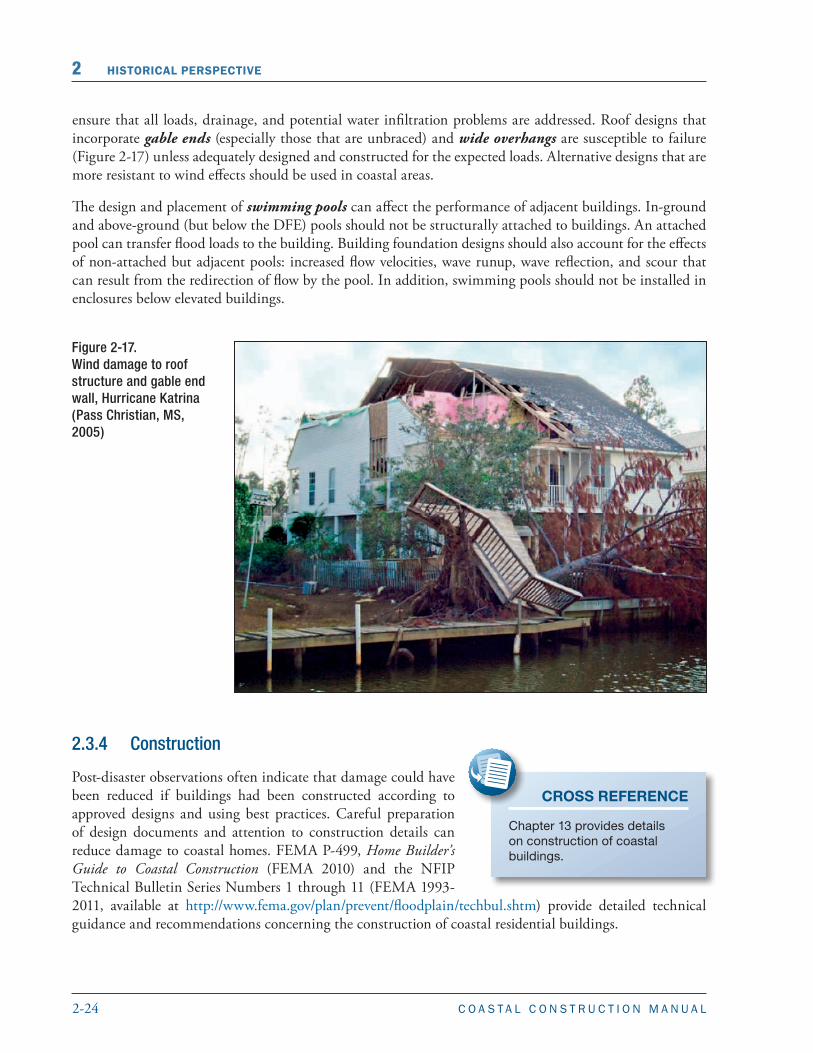
Figure 2-17.Wind damage to roof structure and gable end wall, Hurricane Katrina (Pass Christian, MS, 2005)
ensure that all loads, drainage, and potential water infiltration problems are addressed. Roof designs that incorporate gable ends (especially those that are unbraced) and wide overhangs are susceptible to failure (Figure 2-17) unless adequately designed and constructed for the expected loads. Alternative designs that are more resistant to wind effects should be used in coastal areas.
The design and placement of swimming pools can affect the performance of adjacent buildings. In-ground and above-ground (but below the DFE) pools should not be structurally attached to buildings. An attached pool can transfer flood loads to the building. Building foundation designs should also account for the effects of non-attached but adjacent pools: increased flow velocities, wave runup, wave reflection, and scour that can result from the redirection of flow by the pool. In addition, swimming pools should not be installed in enclosures below elevated buildings.
CROSS REFERENCE
Chapter 13 provides details on construction of coastal buildings.
2-25C O A S T A L C O N S T R U C T I O N M A N U A L
HISTORICAL PERSPECTIVE 2
Failure to achieve the pile or foundation embedment specified by building plans or local and State requirements will render an otherwise properly constructed building vulnerable to flood, erosion, and scour damage. Improperly constructed breakaway walls (e.g., improperly fastened wall panels or panels constructed immediately seaward of foundation cross-bracing) can cause preventable damage to the main structure during a flood event.
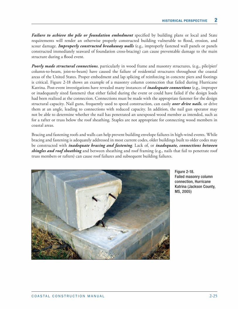
Poorly made structural connections, particularly in wood frame and masonry structures, (e.g., pile/pier/column-to-beam, joist-to-beam) have caused the failure of residential structures throughout the coastal areas of the United States. Proper embedment and lap splicing of reinforcing in concrete piers and footings is critical. Figure 2-18 shows an example of a masonry column connection that failed during Hurricane Katrina. Post-event investigations have revealed many instances of inadequate connections (e.g., improper or inadequately sized fasteners) that either failed during the event or could have failed if the design loads had been realized at the connection. Connections must be made with the appropriate fastener for the design structural capacity. Nail guns, frequently used to speed construction, can easily over drive nails, or drive them at an angle, leading to connections with reduced capacity. In addition, the nail gun operator may not be able to determine whether the nail has penetrated an unexposed wood member as intended, such as for a rafter or truss below the roof sheathing. Staples are not appropriate for connecting wood members in coastal areas.
Bracing and fastening roofs and walls can help prevent building envelope failures in high-wind events. While bracing and fastening is adequately addressed in most current codes, older buildings built to older codes may be constructed with inadequate bracing and fastening. Lack of, or inadequate, connections between shingles and roof sheathing and between sheathing and roof framing (e.g., nails that fail to penetrate roof truss members or rafters) can cause roof failures and subsequent building failures.
Figure 2-18.Failed masonry column connection, Hurricane Katrina (Jackson County, MS, 2005)
2-26 C O A S T A L C O N S T R U C T I O N M A N U A L
2 HISTORICAL PERSPECTIVE
2.3.5 Enclosures
Enclosures present a unique situation to coastal construction. NFIP regulations state that the area below an elevated building can be used only for parking, building access, and storage. These areas must not be finished or used for recreational or habitable purposes. No mechanical, electrical, or plumbing equipment is to be installed below the BFE. However, post-construction conversion of enclosures to habitable space remains a common violation of floodplain management requirements and is difficult for communities and States to control.
Designers and owners should realize that: (1) enclosures and items in them are likely to be damaged or destroyed even during minor flood events; (2) enclosures, and most items in them, are not covered by flood insurance and, if damaged, the owner may incur significant costs to repair or replace them; and (3) even if enclosures are properly constructed with breakaway walls, the presence of enclosures increases flood insurance premiums for the entire building (the premium rate increases with the size of the enclosed area). Therefore, enclosed areas below elevated buildings, even if compliant with NFIP design and construction requirements, can have significant future cost implications for homeowners.
Enclosures can have two types of walls:
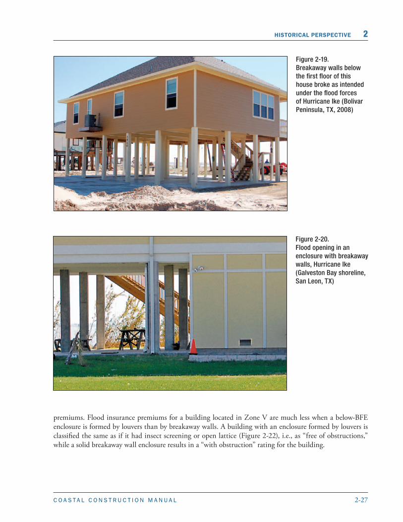
� Enclosures with breakaway walls are designed to collapse under flood loads and act independently from the elevated building, leaving the foundation intact (Figure 2-19). All enclosures below elevated buildings in Zone V must have breakaway walls. Enclosures in Zone A and Coastal A Zones may have breakaway walls, but the walls must have flood openings to comply with Zone A requirements.
� Enclosures and closed foundations that do not have breakaway walls can be constructed below elevated buildings in Zone A but are not recommended in Coastal A Zones. The walls of enclosures and foundation walls below elevated buildings in Zone A must have flood openings to allow the free entry and exit of floodwaters (Figure 2-20).
Taller breakaway walls appear to produce larger pieces of flood-borne debris. Post-disaster investigations have observed some breakaway walls in excess of 11 feet high (FEMA 2009b). These investigations have also observed that louvered panels (Figure 2-21) remained intact longer than solid breakaway walls under the same flood conditions. As a result, houses with louvered panels had less flood-related damage (and repair cost) and generated less flood-borne debris. The use of louver panels can also result in lower flood insurance
CROSS REFERENCE
Section 9.3 discusses the proper design of breakaway walls.
NOTE
A change beginning with the May 2009 FEMA Flood Insurance Manual rates Zone V enclosures as “free of obstructions” if they are constructed with louvers or lattice on all walls except one (for garage door or solid breakaway wall). Previous rating practice called this “with obstruction.”
TERMINOLOGY: ENCLOSURE
An enclosure is formed when any space below the lowest floor is enclosed on all sides by walls or partitions.
2-27C O A S T A L C O N S T R U C T I O N M A N U A L
HISTORICAL PERSPECTIVE 2
Figure 2-20. Flood opening in an enclosure with breakaway walls, Hurricane Ike (Galveston Bay shoreline, San Leon, TX)
Figure 2-19. Breakaway walls below the first floor of this house broke as intended under the flood forces of Hurricane Ike (Bolivar Peninsula, TX, 2008)
premiums. Flood insurance premiums for a building located in Zone V are much less when a below-BFE enclosure is formed by louvers than by breakaway walls. A building with an enclosure formed by louvers is classified the same as if it had insect screening or open lattice (Figure 2-22), i.e., as “free of obstructions,” while a solid breakaway wall enclosure results in a “with obstruction” rating for the building.

2-28 C O A S T A L C O N S T R U C T I O N M A N U A L
2 HISTORICAL PERSPECTIVE
Figure 2-22.An enclosure formed by open lattice (Isle of Palms, SC)
Figure 2-21. Louvers installed beneath an elevated house are a good alternative to breakaway wallsSOURCE: FEMA P-499 2010

2-29C O A S T A L C O N S T R U C T I O N M A N U A L
HISTORICAL PERSPECTIVE 2
Two other enclosure scenarios have design and flood insurance implications. Designers should be cautious when an owner asks for either type of enclosure, and should consult with the community and a knowledgeable flood insurance agent:
� Enclosures that do not extend all the way to the ground (sometimes called “above-grade,” “hanging,” or “elevated” enclosures). These enclosures have a floor system that is not in contact with the ground, but that may be connected to the building foundation or supported on the primary pile system or short posts (Figure 2-23). Having the floor of the enclosure above grade means frequent flooding passes underneath, which may reduce the frequency and severity of damage. These enclosures were not contemplated when flood insurance premium rate tables were prepared, and thus can result in significantly higher flood insurance premiums. As of early 2011, the NFIP was working to address this type of construction, but until such time as it is resolved, owners will pay a substantial premium penalty for this type of enclosure.
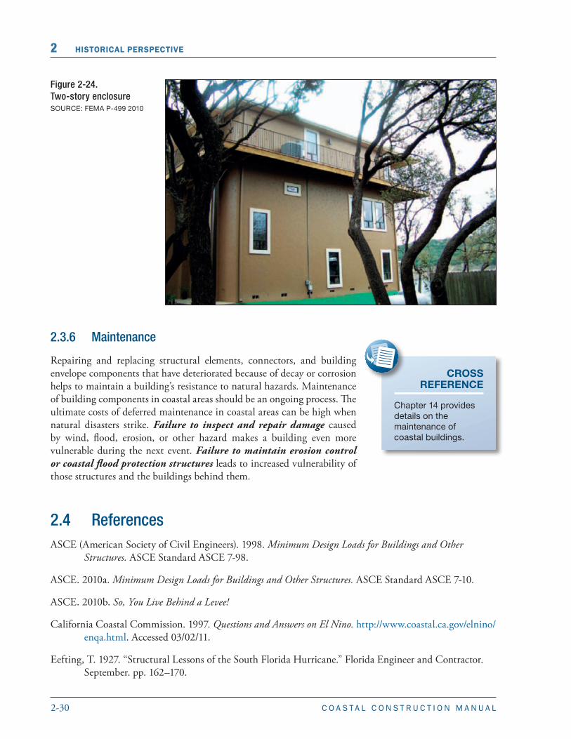
� Two-story enclosures. In flood hazard areas with very high BFEs, some owners have constructed two-story, solid walls to enclose areas below elevated buildings, typically with a floor system approximately midway between the ground and the elevated building (Figure 2-24). These enclosures present unique problems. In Zone A, the walls at both levels of the enclosure must have flood openings; there must be some means to relieve water pressure against the floor system between the upper and lower enclosures; and special ingress and egress code requirements may apply. These enclosures may also result in substantially higher flood insurance premiums.
Figure 2-23. Above-grade enclosure (Perry, FL)
2-30 C O A S T A L C O N S T R U C T I O N M A N U A L
2 HISTORICAL PERSPECTIVE
Figure 2-24.Two-story enclosure SOURCE: FEMA P-499 2010
2.3.6 Maintenance
Repairing and replacing structural elements, connectors, and building envelope components that have deteriorated because of decay or corrosion helps to maintain a building’s resistance to natural hazards. Maintenance of building components in coastal areas should be an ongoing process. The ultimate costs of deferred maintenance in coastal areas can be high when natural disasters strike. Failure to inspect and repair damage caused by wind, flood, erosion, or other hazard makes a building even more vulnerable during the next event. Failure to maintain erosion control or coastal flood protection structures leads to increased vulnerability of those structures and the buildings behind them.
CROSS REFERENCE
Chapter 14 provides details on the maintenance of coastal buildings.
2.4 ReferencesASCE (American Society of Civil Engineers). 1998. Minimum Design Loads for Buildings and Other
Structures. ASCE Standard ASCE 7-98.
ASCE. 2010a. Minimum Design Loads for Buildings and Other Structures. ASCE Standard ASCE 7-10.
ASCE. 2010b. So, You Live Behind a Levee!
California Coastal Commission. 1997. Questions and Answers on El Nino. http://www.coastal.ca.gov/elnino/enqa.html. Accessed 03/02/11.
Eefting, T. 1927. “Structural Lessons of the South Florida Hurricane.” Florida Engineer and Contractor. September. pp. 162–170.

2-31C O A S T A L C O N S T R U C T I O N M A N U A L
HISTORICAL PERSPECTIVE 2
FEMA (Federal Emergency Management Agency). 1980. Elevating to the Wave Crest Level — A Benefit-Cost Analysis. FIA-6.
FEMA. 1992. Building Performance Assessment Team, Field Trip and Assessment within the States of Maryland and Delaware in Response to a Nor’easter Coastal Storm on January 4, 1992. Final Report. March 4.
FEMA. 1993. Building Performance: Hurricane Andrew in Florida, Observations, Recommendations and Technical Guidance. FIA-22.
FEMA.1996. Hurricane Opal in Florida, A Building Performance Assessment. FEMA-281.
FEMA. 1997. Building Performance Assessment: Hurricane Fran in North Carolina, Observations, Recommendations and Technical Guidance. FEMA-290.
FEMA. 1999a. Hurricane Georges in the Gulf Coast – Observations, Recommendations, and Technical Guidance. FEMA 338.
FEMA. 1999b. Hurricane Georges in Puerto Rico – Observations, Recommendations, and Technical Guidance. FEMA 339.
FEMA. 2005a. Hurricane Charley in Florida – Observations, Recommendations, and Technical Guidance. FEMA 488.
FEMA. 2005b. Hurricane Ivan in Alabama and Florida – Observations, Recommendations, and Technical Guidance. FEMA 489.
FEMA. 2006. Hurricane Katrina in the Gulf Coast – Building Performance Observations, Recommendations, and Technical Guidance. FEMA 549.
FEMA. 2009a. Protecting Manufactured Homes from Floods and Other Hazards – A Multi-Hazard Foundation and Installation Guide. FEMA P-85, Second Edition.
FEMA. 2009b. Hurricane Ike in Texas and Louisiana – Building Performance Observations, Recommendations, and Technical Guidance. FEMA P-757.
FEMA. 2010. Home Builder’s Guide to Coastal Construction Technical Fact Sheet Series. FEMA P-499.
FEMA. 2011. National Flood Insurance Program, Flood Insurance Manual.
Hayes, M. O. 1967. “Hurricanes as Geological Agents: Case Studies of Hurricanes Carla, 1961, and Cindy, 1963.” Bureau of Economic Geology Report of Investigation No. 61. Austin, TX: University of Texas.
Jibson, R. 2005. Landslide Hazards at La Conchita, California. Prepared for the United States Geological Survey. Open-File Report 2005-1067.
Maine Geological Survey. 2005. Coastal Marine Geology: Frequently Asked Questions. http://www.maine.gov/doc/nrimc/mgs/explore/marine/faq/groins.htm. Accessed 11/24/2010.
McGrath, J., ed. 1985. “California’s Battered Coast.” Proceedings from a February 6–8, 1985, Conference on Coastal Erosion. California Coastal Commission.

2-32 C O A S T A L C O N S T R U C T I O N M A N U A L
2 HISTORICAL PERSPECTIVE
Minsinger, W.E. 1988. The 1938 Hurricane, An Historical and Pictorial Summary. Blue Hill Meteorological Observatory, East Milton, MA. Greenhills Books, Randolph Center, VT.
National Academy of Sciences, National Research Council, Commission on Engineering and Technical Systems. 1984. Hurricane Alicia, Galveston and Houston, Texas, August 17–18, 1983.
NOAA (National Oceanic and Atmospheric Administration). 2004. Effects of Hurricane Isabel on Water Levels: Data Report. NOS CO-OPS 040.
National Roofing Contractors Association. 1996. Hurricane Marilyn, Photo Report of Roof Performance. Prepared for the Federal Emergency Management Agency. March.
RMS (Risk Management Solutions). 2001. Tropical Storm Allison, June 2001: RMS Event Report.
Thom, H. C. S.; R. D. Marshall. 1971. “Wind and Surge Damage due to Hurricane Camille.” ASCE Journal of Waterways, Harbors and Coastal Engineering Division. May. pp. 355–363.
TTU (Texas Tech University). 1990. Performance of roofing systems in Hurricane Hugo. August.
URS Group, Inc. (URS). 1989. Flood Damage Assessment Report: Sandbridge Beach, Virginia, and Nags Head, North Carolina, April 13, 1988, Northeaster. Prepared for the Federal Emergency Management Agency. March.
URS. 1990. Flood Damage Assessment Report: Nags Head, North Carolina, Kill Devil Hills, North Carolina, and Sandbridge Beach, Virginia, March 6–10, 1989, Northeaster. Prepared for the Federal Emergency Management Agency. April.
URS. 1991a. Flood Damage Assessment Report: Surfside Beach to Folly Island, South Carolina, Hurricane Hugo, September 21–22, 1989. Volume I. Prepared for the Federal Emergency Management Agency. August.
URS. 1991b. Follow-Up Investigation Report: Repair Efforts 9 Months After Hurricane Hugo, Surfside Beach to Folly Island, South Carolina. Volume I. Prepared for the Federal Emergency Management Agency. August.
URS. 1991c. Flood Damage Assessment Report: Buzzard’s Bay Area, Massachusetts, Hurricane Bob, August 19, 1991. October.
USACE (U.S. Army Corps of Engineers). 1997. “Annual Summary.” Great Lakes Update. Vol. No. 126. Detroit, MI: Detroit District. January 3.
USACE. 1998. “Annual Summary.” Great Lakes Update. Detroit, MI: Detroit District.
Waldon, D. 1990. “Raising Galveston.” American Heritage of Invention and Technology. Vol. 5, No. 3, pp. 8–18.
Wilson, B. W. and A. Torum. 1968. The Tsunami of the Alaskan Earthquake, 1964: Engineering Evaluation. Technical Memorandum No. 25. U.S. Army Corps of Engineers, Coastal Engineering Research Center.
York, Michael. “Deadly Hugo Slams Puerto Rico, Virgin Islands.” Washington Post. September 19, 1989.
ContentsHistorical Perspective ..................................................................................................... 2-1
2.1 Introduction ............................................................................................................................... 2-1
2.2 Coastal Flood and Wind Events .................................................................................................2-22.2.1 North Atlantic Coast ..................................................................................................... 2-42.2.2 Mid-Atlantic Coast ........................................................................................................ 2-72.2.3 South Atlantic Coast ...................................................................................................... 2-82.2.4 Gulf of Mexico Coast ..................................................................................................... 2-92.2.5 U.S. Caribbean Territories .............................................................................................2-112.2.6 Great Lakes Coast ........................................................................................................ 2-122.2.7 Pacific Coast .................................................................................................................2-132.2.8 Hawaii and U.S. Pacific Territories ................................................................................2-15
2.3 Breaking the Disaster-Rebuild-Disaster Cycle ........................................................................... 2-162.3.1 Hazard Identification ....................................................................................................2-162.3.2 Siting ............................................................................................................................2-182.3.3 Design.......................................................................................................................... 2-202.3.4 Construction ................................................................................................................ 2-242.3.5 Enclosures .................................................................................................................... 2-262.3.6 Maintenance ................................................................................................................ 2-30
2.4 References .................................................................................................................................2-30