jacobs - apps.fcd.maricopa.gov
TRANSCRIPT

•
Maricopa CountyDepartment ofTransportation
March, 2006
Submitted to:
Submitted by:
JACOBS875 West Elliot Road, Suite 201Tempe, AZ 85284480.763.8600 Fax 480.763.8601
Final Drainage Report
83rd
Avenue / Pinnacle PDrainage ImprovementsFCDMC Contract No. 200 CProject Control No. 450.02.33
Flood Control District City of Peoriaof
Maricopa County
JACOBS
•

Flood Control District of Maricopa County
Maricopa County Department of Transportation
Supplement to the Final Drainage Report
Supplement
Prepared by:Jacobs Civil Inc.
875 West Elliot Road, Suite 201Tempe, AZ 85284
480.763.8600Fax 480.763.8601
March, 2006
FCDMC Contract No. 2003C060Project Control No. 450.02.33
City of Peoria
In Conjunction with:J2 Engineering and Environmental Design
4649 East Cotton Gin Loop, Suite B2Phoenix, AZ 85040
602.438.2221Fax 602.438.2225
Prepared for:
83rd Avenue/Pinnacle Peak RoadDrainage Improvements
W7X74300
83rd Avenue/Pinnacle Peak Road Drainage Improvements
•••••••••••••••••••••••••••••••••••••••••••

The Final Drainage Report was included with the 90% Plans submittal. Since that time thescope of services has been amended to include roadway design for Cielo Grande, between91 st Avenue and 89th Avenue, and Avenida del Sol, between 89
thAvenue and si
hAvenue.
The proposed roadway improvements include curb and gutter, ribbon curb and asphaltpaving. This Supplement to the Final Drainage Report contains the inlet calculations forthe new roadway section. In addition, the StormCAD computations for the storm drainsupstream of the Pinnacle Peak basin have been developed for the conditions when thebasin is at its maximum storage. Other data included in this supplement include anenhanced Table 2-1, HEC-l Summary of Flows. The purpose for this table is to betteridentify the source of flow data used in the StormCAD analyses.
83rd Avenue/Pinnacle Peak Road Drainage Improvements••••••••••••••••••••'.••••••••••••••••••••.'•• W7X74300
Foreword
ii
Supplement

83rd Avenue/Pinnacle Peak Road Drainage Improvements
Table of Contents
•••••••••••••••••••••••••••••••••••••••••••
LIST OF APPENDICES
Appendix A
Appendix B
W7X74300
Supplement
StormCAD Computations
Cielo Grande and Avnida del Sol Catch Basin CalculationsB-1 Maximum Allowable Spread CalculationsB-2 Catch Basin Design Calculations
iii

To provide a better link between the peak flows developed in the HEC-l Inodel and thedischarges contained in the StormCAD analyses of storm drains, Table 2-1 has been
The HEC-I model presented in the Final Drainage Report has not been altered. Thepurpose of this section is to explain the basis for the new catch basin flows and toenhance Table 2-1, Summary of Flows.
The area upstream of Avenida del Sol was modeled in HEC-I as sub-basin NIlL3A.The flow pattern is predominantly in a southerly direction. Interviews with residents andfield observations confirmed this conclusion. Therefore, it was assumed the runoff fromthis sub-basin would be intercepted by the proposed curb and gutter with combinationcurb open inlets. Since field observations did not indicate any significant consolidationof the flows, it was assumed the runoff would be proportional to the length of curb andgutter between 89th Avenue and 87th Avenue. Since small swales do exist on the northside of the road, the ribbon curb will be protected by cut-off walls as shown on theroadway plans. The lO-year peak flow to be collected in the curb and gutter section is 28cfs. This runoff is spread evenly across the 1,300' of curb and gutter.
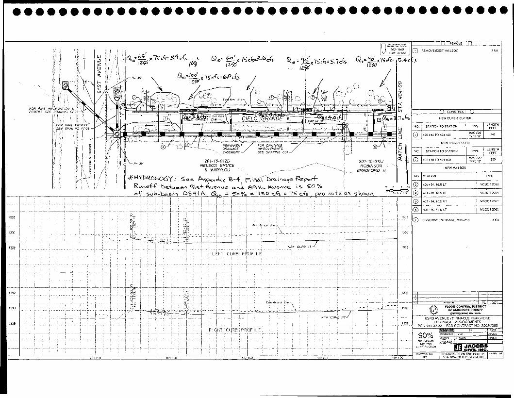
The area upstream of Cielo Grande was modeled in HEC-l as sub-basin DS91A.Although the flow pattern is predominantly in a southern direction, a review of the aerialInapping indicated a portion of the runoff flowing in a southwesterly direction.Interviews with residents and field observations confirmed this conclusion. Therefore, itwas assumed 50% of the runoff from this sub-basin would be conveyed in the ditches oneach side of 91 5t Avenue. This flow would be collected with drop inlets as shown ondrawing C3l. The remaining runoff will flow in a southerly direction to be interceptedby the proposed curb and gutter with combination curb open inlets. Since fieldobservations did not indicate any consolidation of the flows, it was assumed the runoffwould be proportional to the length· of curb and gutter between 9l 5t Avenue and 89th
Avenue. The 10-year peak flow to be collected in the curb and gutter section is 50% of150 cubic feet per second (cfs) or 75 cfs. This runoff is spread evenly across the 1,250'of curb and gutter.
Supplement
1.1
Cielo Grande Hydrology
Avenida del Sol Hydrology
Summary of Flows
Section 1
Revised Hydrology
83rd Avenue/Pinnacle Peak Road Drainage Improvements
1.1
1.2
1.3
W7X74300
•.'
••••••••'.•••••••••Ie•••••••••••••'.••.'•••••

expanded and revised. The basis of this table is the HEC-I model with input fileBYPASS2.DAT.
HEC-1 100 YEAR PEAK.SUB-BASIN LOCATION/APPENDIXISTORMCADD OPERATION DISCHARGE, cfs
25% DS91A CIELO GRANDE & 91~1 AVE/B-4/INLET 1-13 37*
250/0 DS91A CIELO GRANDE & 91~1 AVE/B-4/INLET 1-14 37*
500/0 DS91A CIELO GRANDE CURB & GUTTER/B-4/INLETS 1-5 & 1-6 75*
200/0 14*N11 LSA CIELO GRANDE & 89TH AVE WEST/B-4/INLET 1-7
800/0 55*N11LSA CIELO GRANDE & 89TH AVE EAST/B-4/1NLET 1-15
N11 L3A AVENIDA DEL SOL CURB & GUTTER/B-4/INLETS 1-9 & 1-11 28*
R11P7S CALLE LEJOS STA 340+27/B-4/INLET 1-1 175
RDP4E CALLE LEJOS STA 336+66/B-4/INLET 1-2 28
45% VPDIV CALLE LEJOS STA 327+25/B-4/INLET 1-12 158
550/0 VPDIV CALLE LEJOS STA 326+47/B-4/1NLET 1-3 193
C87B 87 1H AVE &AVENIDA DEL SOL/B-4/MANHOLE MH-7 683
50% 870UT 87 1M AVE BASIN BYPASS/B-3/INLET 1-4 61
50% 870UT 87 1H AVE BASIN QUTLET/B-3/INLET 1-3 61
3% 870UT 87 'M AVE & PINNACLE PEAK RD/B-3/1NLET 1-2 4
500/0 R91 91~1 AVE & PINNACLE PEAK RD WEST/B-2/INLET 1-7 28*
50% R91 91~' AVE & PINNACLE PEAK RD EAST/B-2/1NLET 1-8 28*
250/0 N11 L5 90 'M AVE & PINNACLE PEAK RD/B-2/1NLETS 1-9 & 1-10 18*
250/0 R89S 891M
AVE & PINNACLE PEAK RD/B-2/1NLETS 1-11 & 1-12 24*
RN11 L5 PINNACLE PEAK RD STA 214+00/B-2/PIPE P-8 90*
N11L4 PINNACLE PEAK RD STA 215+20/B-2/1NLET 1-13 9*
500/0 RSOL PINNACLE PEAK RD STA 221+60/B-2/1NLET 1-14 25*
500/0 RSOL PINNACLE PEAK RD STA 222+90/B-2/1NLET 1-15 25*
870UT 87 'H AVE & PINNACLE PEAK RD/B-2/1NLET 1-4 122
130/0 N2111 PINNACLE PEAK RD STA 232+84/B-2/INLET 1-16 24
130/0 N2111 PINNACLE PEAK RD STA 234+60/B-2/1NLET 1-17 24
130/0 N2111 PINNACLE PEAK RD STA 236+30/B-2/1NLET 1-18 24
330/0 N2111 PINNACLE PEAK RD STA 236+54/B-2/1NLET 1-19 60
13% N2111 PINNACLE PEAK RD STA 237+37/B-2/1NLET 1-20 24
13% N2111 PINNACLE PEAK RD STA 239+30/B-2/1NLET 1-21 24
83rd Avenue/Pinnacle Peak Road Drainage Improvements
••••••••'.••.'.1••••••••••'.•••••••••••••••'e•••
W7X74300
Table 2-1HEC-l Summary of Flows
1.2
Supplement

PPSO PINNACLE PEAK RO STA 240+00/B-2/PIPE P-21 380
N11P3 83KU AVE & AVENIDA DEL SOL WEST/B-1/1NLET 1-1 53
RT83CL 83KU AVE & AVENIDA DEL SOL EAST/B-1/INLET 1-2 40
83S0 83KU AVE STA 142+00/B-1/PIPE P-3 92
550/0 JCT1 PINNACLE PEAK BASIN BYPASS WEST/B-1/INLET 1-4 19
450/0 JCT1 PINNACLE PEAK BASIN BYPASS NORTH/B-1/1NLET 1-6 15
50% RESD PINNACLE PEAK RD & 831W AVE STA 11+69/B-1/INLET 1-3 32
50% RESD PINNACLE PEAK RD & 83KU AVE STA 10+64/B-1/INLET 1-5 32
JCT PINNACLE PEAK RD STA 128+00/B-1/PIPE P-12 90
83rd Avenue/Pinnacle Peak Road Drainage Improvements
••••••••••••••••.\'.•••••••••••'.•••••••••••••
* denotes 10 Year Peak Discharge
W7X74300 1.3
Supplement

Section 2
Revised StormCAD
In the Final Drainage Report, the discharge from the detention basins was modeled byflow through an orifice. Since the storm drains downstream from the restrictor plates arein outlet control, the StormCAD model should have the computed headloss through therestrictor plates. A spreadsheet was provided by the District that would compute theheadloss for each plate for a given flow rate. By iteration the flows could be varied untilthe HGLs at the basin are equal to the maximum water surface elevation. This would be1310.76 for the Pinnacle Peak basin and 1319.66 for the 87th Avenue basin. SeeAppendix A for these results.
The StromCAD analyses of pipes as presented in the Final Drainage Report are underpeak flow conditions. It has been determined that the storm drains upstream of thePinnacle Peak basin will have a higher hydraulic grade line under conditions when thebasin is at its peak level. For these revised analyses the tailwater elevation of the stormdrains was set at the maximum water surface elevation of 1310.76. After the StormCADfiles were developed, the plan and profile sheets were revised to reflect the highestcomputed hydraulic grade line. At the basin and a distance upstream, the hydraulic gradeline was determined in the StromCAD analyses included in this supplement. SeeAppendix A for the results.
••'.'•'.••••••••••••••••••••'.•••••.'•.'••••••••• W7X74300 2.1

Section 3
Cielo Grande and Avenida del Sol Catch BasinCalculations
After the curb profiles were established, the maximum flow rate was computed for eachslope. It was assumed the spread could not exceed the street width or the depth of flow inthe gutter could not exceed 6", top of vertical curb elevation. Using HEC-12, Chart 3 andChart 4, the maximum flow rate for the composite cross slope section was computed.These computations have been summarized in Appendix B-1. The maximum allowableflow rate varies from 10.53 cfs to 22.34 cfs.
In setting a profile grade for the roadway improvements to Cielo Grande and Avenida delSol several conditions needed to be met. Since runoff flows in a southerly direction, itwas important that the curb on the north si-de of each street was at or below existinggrade. In addition, flows in excess of the 10-year storm would not be collected;therefore, the south curb grade needed to match existing elevations as closely as possible.Sags were placed in the profile only where existing sags occur. To ensure all runoff iscollected at the intersections with 91 5t Avenue, 89th Avenue and 87th Avenue, sags wereplaced as closely as possible. It was assumed that the minimum grade would be 0.2%.
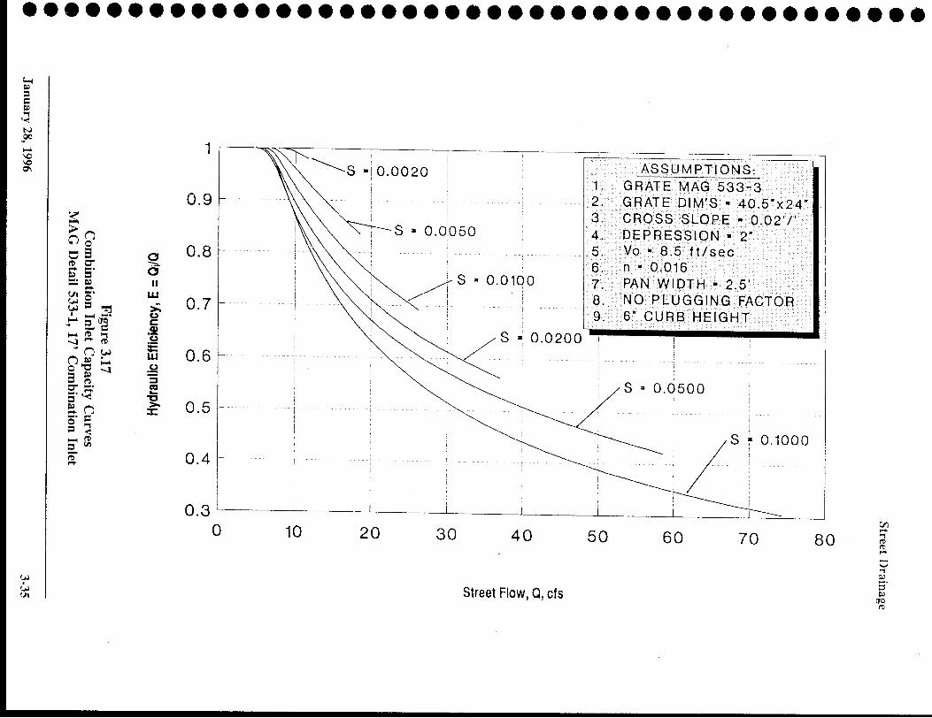
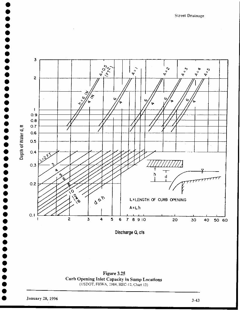
Catch basins were then located at points so that the maximum spread was not exceededand the driveway conflicts were minimized. Appencix B-2 shows the computed flows ateach catch basin. This total flow is the off-site runoff plus the bypass flow from theupstream catch basin. All catch basins are MAG 533-1 combination catch basins witheither L= 10' or L=17' wings. A clogging factor of 650/0 was applied to all computations.For inlets in sag conditions, HEC-12, Chart 13 was used to compute the depth of water atthe inlet. The catch basins were sized so that the depth did not exceed the top of curb, 6".For inlets on grade, Figures 3.16 and 3.17 from the Drainage Design Manual forMaricopa County was utilized. The results for these computations have been included inAppendiz B-2.
Supplement
3.1
83rd Avenue/Pinnacle Peak Road Drainage Improvements
W7X74300
••••••••••'.•••••••••••!.I •.'•••••••••••••.1•••••

•••••••••••••.''.••••••.'•••:.•••••••••••••••••
83rd Avenue/Pinnacle Peak Road Drainage Improvements
Appendix A
StormCAD Computations
W7X74300
Supplement

............. ' .Scenario: Base
Pipe Report
B~~ ~ ~'-.Je/\ \Je
~Tf:\ ZO~IB -\-0 ~\~ \+2.1--rS-
Label Upstm Dnstm Length Construdec Number Section Mannings irotal FloVII Full Upstm Dnstm Upstm Dnstm Hydraulic Hydraulic VelodtyNode Node (ft) Slope of Size n (cfs) Capacny Invert Invert Ground Ground Grade Grade Out
(ftIft) Sections (cfs) Elev Elev Elev Elev Line In Line Out (ftIs)(ft) (ft) (ft) (ft) (ft) (ft)
P-2 1-2 MH-1 79.00 0.060253 1 36 inch 0.013 7.00 163.71 1,318.22 1,313.46 1,322.00 1,322.20 1,319.05 1.314.39 3.75
P-1 1-1 MH-1 33.00 0.127576 1 36 inch 0.013 8.00 238.22 1,317.67 1,313.46 1,322.55 1,322.20 1,318.56 1,314.39 4.29
P-6 MH-3 0-1 78.00 -0.004231 1 42 inch 0.013 0.00 -65.44 1,302.67 1,303.00 1,316.25 1,311.00 1,310.76 1,310.76 0.00
P-4 MH-2 MH-3 364.00 0.009011 1 42 inch 0.013 15.00 95.50 1,309.65 1,306.37 1,317.85 1,316.25 1,310.83 1,310.76 1.56
P-3 MH-1 MH-2 396.00 0.008990 1 42 inch 0.013 15.00 95.39 1,313.21 1,309.65 1,322.20 1,317.85 1,314.39 1,310.59 7.23
Title: 83rd Avenue/Pinnacle Peakp:\... \61 Odrain\61 Ofstorm\83aven basin full.stm02/20/06 05: 15:07 PM
Jacob's Engineering Inc.© Haestad Methods, Inc. 37 Brookside Road Waterbury, CT 06708 USA +1-203-755-1666
Project Engineer: Pat FyieStormCAD v5.5 [5.5005]
Page 1 of 1

•••••••••••••••••••••••••••••••••••••••••••Scenario: Base
Pipe Report
p,' /\/t.D..cle.. ?eC\.~<. i2-0a...J
ST~ \~~+~O +0 S~ 30+~4
Label Upstm Dnstm Length Constructec Number Section Mannings rota I Flo~ Full Upstm Dnstm Upstm Dnstm Hydraulic Hydraulic VelodtyNode Node (ft) Slope of Size n (cfs) Capacity Invert Invert Ground Ground Grade Grade Out(ftlft) Sections (cfs) Elev Elev Elev Elev Line In Line Out (ftls)
(ft) (ft) (ft) (ft) (ft) (ft)P-25 1-7 1-1 70.00 0.016571 1 30 inch 0.013 19.00 52.80 1,312.37 1,311.21 1,316.20 1,315.96 1,313.85 1,312.29 9.40P-26 1-8 JS-1 70.00 0.039429 1 30 inch 0.013 0.00 81.44 1,312.89 1,310.13 1,316.73 1,315.99 1,312.89 1,310.98 0.00P-1 1-1 JS-1 85.00 0.002000 1 54 inch 0.013 19.00 87.94 1,309.21 1,309.04 1,315.96 1,315.99 1,311.02 1,310.98 2.89P-2 JS-1 MH-1 455.00 0.002000 1 54 inch 0.013 19.00 87.94 1,309.04 1,308.13 1,315.99 1,316.35 1,310.98 1,310.90 1.85P-3 MH-1 JS-2 200.00 0.002000 1 60 inch 0.013 19.00 116.47 1,308.13 1,307.73 1,316.35 1,315.86 1,310.90 1,310.88 1.46P-28 1-10 JS-2 77.00 0.014156 1 30 inch 0.013 0.00 48.80 1,310.11 1,309.02 1,316.11 1,315.86 1,310.88 1,310.88 0.00P-27 1-9 1-10 38.00 0.018684 1 30 inch 0.013 0.00 56.06 1,310.82 1,310.11 1,315.82 1,316.11 1,310.88 1,310.88 0.00P-4 JS-2 MH-2 300.00 0.002000 1 60 inch 0.013 19.00 116.47 1,307.73 1,307.13 1,315.86 1,315.63 1,310.88 1,310.87 1.21P-30 1-12 JS-3 77.00 0.021169 1 30 inch 0.013 0.00 59.67 1,309.39 1,307.76 1,314.39 1,315.20 1,310.86 1,310.86 0.00P-5 MH-2 JS-3 340.00 0.002000 1 60 inch 0.013 19.00 116.47 1,307.13 1,306.45 1,315.63 1,315.20 1,310.87 1,310.86 1.04P-29 1-11 1-12 38.00 0.050526 1 30 inch 0.013 0.00 92.19 1,311.31 1,309.39 1,316.31 1,314.39 1,311.31 1,310.86 0.00P-6 JS-3 1-3 160.00 0.002000 1 60 inch 0.013 19.00 116.47 1,306.45 1,306.13 1,315.20 1,315.37 1,310.86 1,310.85 0.99P-31 1-13 JS-4 23.00 0.060435 1 18 inch 0.013 0.00 25.82 1,309.38 1,307.99 1,315.38 1,315.49 1,310.85 1,310.85 0.00P-7 1-3 JS-4 20.00 0.002000 1 60 inch 0.013 19.00 116.47 1,306.13 1,306.09 1,315.37 1,315.49 1,310.85 1,310.85 0.98P-8 JS-4 1-5 430.00 0.002000 1 60 inch 0.013 19.00 116.47 1,306.09 1,305.23 1,315.49 1,315.42 1,310.85 1,310.83 0.97P-32 1-14 JS-5 27.00 0.094074 1 30 inch 0.013 0.00 125.80 1,308.84 1,306.30 1,314.84 1,315.29 1,310.82 1,310.82 0.00P-9 1-5 JS-5 210.00 0.002000 1 60 inch 0.013 19.00 116.47 1,305.23 1,304.81 1,315.42 1,315.29 1,310.83 1,310.82 0.97P-10 JS-5 1-6 130.00 0.002000 1 60 inch 0.013 19.00 116.47 1,304.81 1,304.55 1,315.29 1,315.25 1,310.82 1,310.81 0.97P-33 1-15 JS-6 27.00 0.092222 1 30 inch 0.013 0.00 124.55 1,308.52 1,306.03 1,314.52 1,315.22 1,310.81 1,310.81 0.00P-11 1-6 JS-6 10.00 0.002000 1 60 inch 0.013 19.00 116.47 1,304.55 1,304.53 1,315.25 1,315.22 1,310.81 1,310.81 0.97P-12 JS-6 1-4 364.00 0.002005 1 60 inch 0.013 19.00 116.63 1,304.53 1,303.80 1,315.22 1,313.33 1,310.81 1,310.79 0.97P-13 1-4 MH-7 386.00 0.003342 1 72 inch 0.013 19.00 244.82 1,303.80 1,302.51 1,313.33 1,313.68 1,310.79 1,310.78 0.67P-34 1-16 JS-7 32.00 0.111875 1 24 inch 0.013 0.00 75.66 1,307.65 1,304.07 1,313.15 1,313.00 1,310.78 1,310.78 0.00P-14 MH-7 JS-7 235.00 0.003362 1 72 inch 0.013 19.00 245.54 1,302.51 1,301.72 1,313.68 1,313.00 1,310.78 1,310.78 0.67P-15 JS-7 JS-8 195.00 0.003333 1 72 inch 0.013 19.00 244.50 1,301.72 1,301.07 1,313.00 1,313.13 1,310.78 1,310.77 0.67P-35 1-17 JS-8 37.00 0.101081 1 24 inch 0.013 0.00 71.92 1,307.09 1,303.35 1,312.59 1,313.13 1,310.77 1,310.77 0.00P-16 JS-8 MH-8 70.00 0.003286 1 72 inch 0.013 19.00 242.75 1,301.07 1,300.84 1,313.13 1,312.89 1,310.77 1,310.77 0.67P-17 MH-8 JS-9 90.00 0.003333 1 78 inch 0.013 19.00 302.68 1,300.84 1,300.54 1,312.89 1,312.35 1,310.77 1,310.77 0.57P-36 1-18 JS-9 22.00 0.227273 1 36 inch 0.013 0.00 317.95 1,308.03 1,303.03 1,312.37 1,312.35 1,310.77 1,310.77 0.00P-37 1-19 JS-10 22.00 0.149091 1 24 inch 0.013 0.00 87.35 1,306.19 1,302.91 1,311.69 1,312.19 1,310.77 1,310.77 0.00P-18 JS-9 JS-10 110.00 0.003364 1 78 inch 0.013 19.00 304.05 1,300.54 1,300.17 1.312.35 1,312.19 1,310.77 1,310.77 0.57P-38 1-20 JS-11 22.00 0.176364 1 24 inch 0.013 0.00 95.00 1,306.56 1,302.68 1,312.06 1,312.56 1,310.77 1,310.77 0.00P-19 JS-10 JS-11 90.00 0.003444 1 78 inch 0.013 19.00 307.68 1,300.17 1,299.86 1,312.19 1,312.56 1,310.77 1,310.77 0.57P-39 1-21 JS-12 22.00 0.175909 1 24 inch 0.013 0.00 94.88 1,306.25 1,302.38 1,311.75 1,312.25 1,310.77 1,310.77 0.00P-20 JS-11 JS-12 90.00 0.003333 1 78 inch 0.013 19.00 302.68 1,299.86 1,299.56 1,312.56 1,312.25 1,310.77 1,310.77 0.57'-----
Title: 83RD AVENUE / PINNACLE PEAK RDp:\... \61 Ofstorm\pinnaclepeak basin full.stm02/20/06 05: 19:23 PM
Jacob's Engineering Inc.© Haestad Methods, Inc. 37 Brookside Road Waterbury, CT 06708 USA +1-203-755-1666
Project Engineer: Pat FyieStormCAD v5.5 [5.5005]
Page 1 of 2

•••••••••••••••••••••••••••••••••••••••••••Scenario: Base
Pipe Report
Label Upstm Dnstm Length Con stru ctec Number Section Mannings Irotal Flow Full Upstm Dnstm Upstm Dnstm Hydraulic Hydraulic VelodtyNode Node (ft) Slope of Size n (cfs) Capacity Invert Invert Ground Ground Grade Grade Out
(ft/ft) Sections (cfs) Elev Elev Elev Elev Line In Line Out (ft/s)(ft) (ft) (ft) (ft) (ft) (ft)
P-21 JS-12 MH-9 120.00 0.003250 1 78 inch 0.013 19.00 298.87 1,299.56 1,299.17 1,312.25 1,312.55 1,310.77 1,310.77 0.57
P-22 MH-9 MH-10 390.00 0.003359 1 78 inch 0.013 19.00 303.84 1,299.17 1,297.86 1,312.55 1,312.69 1,310.77 1,310.76 0.57
P-23 MH-10 MH-11 125.00 0.003440 1 84 inch 0.013 19.00 374.66 1,297.86 1,297.43 1,312.69 1,312.95 1,310.76 1,310.76 0.49
P-24 MH-11 0-1 64.00 -0.002500 1 84 inch 0.013 19.00 -319.40 1,297.43 1,297.59 1,312.95 1,306.76 1,310.76 1,310.76 0.49
Title: 83RD AVENUE 1 PINNACLE PEAK RDp:\... \61 Ofstorm\pinnaclepeak basin full.stm02/20/06 05: 19:23 PM
Jacob's Engineering Inc.© Haestad Methods, Inc. 37 Brookside Road Waterbury, CT 06708 USA +1-203-755-1666
Project Engineer: Pat FyieStormCAD v5.5 [5.5005]
Page 2 of 2

•••• Storm Drains at Pinnacle Peak Basin•• 83rd Avenue/Pinnacle Peak Road• Drainage Improvements.' Date: 3/24/06
• Project No.: W7X74300
••'. Pipe L Vfull Sfr HL Inlet EGL• in ft fps ftlft ft ./:;:;:;n:293:·~z·::./':·
• P18 6.44 0.004654 0.29 1293.71P19 6.44 0.004654 0.88 1294.59• P17 6.44 0.004654 1.28 1295.87
• P16 7.24 0.004013 2.01 1297.88
P15 7.24 0.004013 2.01 1299.89,. P14 7.24 0.004013 2.01 1301.89.' P13 7.24 0.004013 2.01 1303.90P12 7.24 0.004013 1.58 1305.48'.• Pick up flows from east of Pinnacle Peak and 83rd Ave.
• Pipe Q D D L VtUIi Str HL Inlet EGLcfs in ft ft fps ftlft ft 1305.48 p12• P11 3 9.62 0.010394 0.67 1306.14
•'. 83rd Avenue (Pinnacle Peak to Inlet to Basin)Pipe Q D 0 L Vfull Str HL Inlet EGL• cfs in ft ft fps ft/ft ft 1305.48 P12
• P9 2.5 7.13 0.007281 0.79 1306.26
P7 2 5.90 0.006702 2.00 1308.27• P6 2 5.90 0.006702 1.41 1309.68
• Basin 2 6.82 1.08 1310.76
• Pinnacle Peak (83rd Avenue to Inlet to Basin)• Pipe Q 0 0 L Vfull Sfr HL Inlet EGL
• cfs in ft ft fps ftlft ft 1306.26 pg
P8 16.48 2 5.25 0.005307 3.65 1309.91• Basin 16.48 2 6.06 0.86 1310.77
•• 83rd Avenue (North of Basin, Basin Full)Pipe Q D 0 L Vfull Sfr HL Inlet EGL• cfs in ft ft fps ftlft ft 1310.76 Basin P6
• P5 3 2.12 0.000506 0.03 1310.79P4 3 2.12 0.000506 0.10 1310.89• P3 3 2.12 0.000506 0.14 1311.03
• P2 4 1.19 0.000109 0.05 1311.08
• 83rd Avenue (Westside Flows at Avenida del Sol, Basin Full)• Pipe Q D D L Vfull Sfr HL Inlet EGL
• cfs in ft ft fps ft/ft ft 1311.03 P3
• P1 3 1.13 0.000144 0.00 1311.03
•

•••••• Pipe Vfull 5 fr HL
in fps ft/ft ft• P5 9.56 0.008362 0.65
• P4 9.56 0.008362 3.04P3 9.56 0.008362 3.31• P2 5.66 0.003597 0.28
•• 83rd Avenue (Westside Flows at Avenida del 501, Peak in Pipe)Pipe Q D D L Vfull 5 fr HL Inlet EGL• cfs in ft ft fps ftIft ft 1312.74 P3
• P1 3 7.50 0.006314 0.21 1312.95
• Pinnacle Peak (83rd Avenue to Inlet to Basin)
• Pipe Q D D L Vfull 5fr HL Inlet EGL
• cfs in ft ft fps ftlft ft 1306.26 P9P8 16.48 2 5.25 0.005307 3.65 1309.91
• Basin 16.48 2 10.49 0.85 1310.76I.'. Pipe Vfull 5 fr HL Inlet EGL
• in fps ftlft ft 1310.76 Basin aftel
• P24 0.49 8.85E-06 0.00 1310.76P23 0.49 8.85E-06 0.00 1310.76.' P22 0.57 1.31 E-05 0.01 1310.77
• P21 0.57 1.31 E-05 0.00 1310.77P20 0.57 1.31E-05 0.00 1310.77• P19 0.57 1.31 E-05 0.00 1310.77
• P18 0.57 1.31 E-05 0.00 1310.78P17 0.57 1.31 E-05 0.00 1310.78• P16 0.67 2.01 E-05 0.00 1310.78
• P15 0.67 2.01 E-05 0.00 1310.78P14 0.67 2.01 E-05 0.00 1310.79• P13 0.67 2.01 E-05 0.01 1310.79
• P12 0.97 5.32E-05 0.02 1310.81
• P11 0.97 5.32E-05 0.00 1310.81P10 0.97 5.32E-05 0.01 1310.82
'e P9 0.97 5.32E-05 0.01 1310.83.' P8 0.97 5.32E-05 0.02 1310.86P7 0.97 5.32E-05 0.00 1310.86• P6 0.97 5.32E-05 0.01 1310.86
• P5 0.97 5.32E-05 0.02 1310.88P4 0.97 5.32E-05 0.02 1310.90• P3 0.97 5.32E-05 0.01 1310.91
• P2 1.19 9.34E-05 0.04 1310.95
• P1 1.19 9.34E-05 0.01 1310.96
••.'.'••

••••••••••••••••••••••••••'.••••••••••••••••
Pipe
P24P23P22P21P20P19P18P17P16P15P14P13P12P11P10P9P8P7P6P5P4P3P2P1
Vfull
fps9.419.8711.4511.4510.7310.019.287.478.777.927.077.077.497.496.215.405.404.944.943.723.722.803.461.76
5 fr
ftlft0.0032110.0035380.0052530.0052530.0046110.00401
0.0034510.0022380.0034290.0027980.002230.00223
0.0031860.0031860.0021940.0016560.0016560.0013870.0013870.0007860.0007860.0004460.0007820.000203
HL Inlet EGLft ':.:>::,1·p.('j~~:~8·,;:·i;:::; Artificial
0.21 1303.490.44 1303.932.05 1305.980.63 1306.610.41 1307.020.36 1307.380.38 1307.760.20 1307.960.24 1308.200.55 1308.750.52 1309.270.86 1310.131.16 1311.290.03 1311.330.29 1311.610.35 1311.960.71 1312.670.03 1312.700.22 1312.920.27 1313.190.24 1313.420.09 1313.510.36 1313.870.02 1313.89

•••.'•••••••••.'•••.'•.'•'.•••••••••••••••••.'•••
Storm Drains at 87th Avenue Basin
83rd Avenue/Pinnacle Peak RoadDrainage Improvements
Date: 3/24/06Project No.: W7X74300
87th Avenue (to basin)Pipe Q D D L VfUIl 5 fr HL Inlet EGL
cfs in ft ft fps ft/ft ft P13P7 4 10.35 0.008191 0.49 1310.69P6 4 10.03 0.007694 0.15 1310.85P5 4 9.71 0.007214 1.59 1312.43P4 4 9.71 0.007214 2.38 1314.81P3 4 9.71 0.007214 0.87 1315.68P2 3.5 6.64 0.004034 1.63 1317.31P1 3.5 6.64 0.004034 0.50 1317.81
87th Avenue (to basin)Pipe Q D D L Vfull 5 fr HL Inlet EGL
cfs in ft ft fps ftlft ft P13Basin 63.90 3.5 13.18 1.85 1319.66
P7 7 1.51 8.27E-05 0.00 1319.66
83rd Av~nue (Pinnacle Peak to Inlet to Basin)Pipe Q D D L Vfull 5 fr HL Inlet EGL
cfs in ft ft fps ftlft ft 1315.68 P12P8 58.10 3.5 6.04 0.003335 0.64 1316.32
Basin 58.10 3.5 11.98 3.34 1319.66
0.7071 0.49999
W7X74300
Cielo Grande and Avenida del Sol Catch BasinCalculations
•••••••••••••••.'••.''.•.'•••••••••••••••••••••
83rd Avenue/Pinnacle Peak Road Drainage Improvements
Appendix B
Supplement

•."••••••••••••••.'.'.'.'•••••••••••••••.'••••.'".••
83rd Avenue/Pinnacle Peak Road Drainage Improvements Supplement
Appendix B-1
Maximum Allowable Spread Calculations
W7X74300
............................ ' '.
NO, STATION TYPE
CD 400+91,16,5' LT MCDOT 2065
0 401 +03,16,5' RT MCDOT 2065
0 403+84, '6,5' RT MeDOT 2065
CD 403+90, 165' LT MCDOT 2065
CD DRIVEWAY ENTRANCE, MAG 250 3EA1332
.~~~9. - i- .. -. - ...,-.. --- - - .. -,.- .. '-- ..
'~i~ -
'-:.. _ _ _ _ ~ _' ,'.'.' ' __0 .~-_._. ~.~.~,.-,: .-=-=:,~~: -------
1332
1330
[] REMOVE 1 JREMOVE EXSIT MAILBOX
C) CONSTRUCT TjNEW CURB & GUTIER
2EA
1328
oJ u, ,till.
NE.:W CURB L 1328
T L B 'F E
~ BY I DATE
90% ~~~ZED 1~:~~:RA I::::::PR~g~~~~RY CHECKED I I
CONSTRUCTION ~ .JACOBS~ CIVIL.MC.
1332
1328
:UH 'R!O It ER CiH
1328
1332 ~.~ g~
~~ :~·"--3"3-0-·-- t----··,'·-'·--1.-.'.--;--".--,.,--.;.,..".,,'j.-.-,._-;---.--"----;--'-+.,-..,,": ..-. +-·"'~-·-"+"'--~+l~:~'---if------~'·"··+"'-"-'~· .. ,.+-.. -'-:-.-:or...;~-----;--.,----.f-----'--"-"-".j-.-'-.".L ..,_..__ j,..,,,,,_.L_ .. _+. __.,-_.._:._ c:(i<;t-G'(,U{){1--tJr:~.~-\".,--,---_ ... ,,,-,,-.,--,,-,.-:.-.._,,- .•:.--,..,;-----.,.-,.'--..........."--.;....-...,,,...--,;-.... ,-,-,--,-.I---1-~3~--·I-N'''''''Of----~-'---Fl-O-O-D-C-ON-T-R-O-L-D'-S+TR...,'C,....T-+-~~
S p~m-t-~=-~-~j:.rl"n~~,~~==l===~~'.;;,:=--'-=+=-..:.=-::::...::--~:::.£:~E:::~~~:::.=~:::.:.=:~T~=c=.~7r:~-i---~I '.~ o~:~;?::D~~~~~____~ ~__~-~-_~~-,,~__~__~_,,~_~~-~--~-_.~~~LI_/-~-~~-t-~~---~-~" ~w~m ~ ~RDAVENUE/~NNACLEPEAKROAD
DRAINAGE IMPROVEMENTSPCN 450.02,33 FCD CONTRACT NO, 2003C060
400+00 40' +00 402+00 403+00 404+00DRAWING NO
RD01ROADWAY PLAN AND PROFILE !SHEET OF
STA 400+30 TO STA 404+00

•••••••••••••••••••••••••••••••••••••••••••••••••2EA
[J REMOVE r I
REMOVE EXSIT MAILBOX
INO. STATION TYPE
CD 405+32, 165' LT . MeDOT 2065
0 405+68,16.5' RT MCDOT 2065
Sc Ie In F/lfll 0 406+73,16.5' LT MCDOT 2065
0 407+24,16.5' RT MCDOT 2065
1332 0 408+33. 165' LT MCDOT 2065
0 408+61,16.5' LT MeDOr 2065
1330
CD DRIVEWAY ENTRANCE. MAG 250 8EA
1328
II
\1
\
1328
1332
:F[T R[B f 0''-1 LE
1332 r 3:::-r-,------------r--...,...----421
1332
- - - ,- -
_\- - -'-
Nt:W :URl HT
- -'~'
1330
NO' RE'w'ISION DAlE
FLOOD CONTROL DISTRICTOF MARICOPA COUNTY
ENGINEERING DIVISION
1328
R ,H CU 3 P:R01_ I_L _. ._ _ _ , __.. _._ _. __ l.._ _ __ 1-.._.__ ;_.__ .; , _.. _ ; __ ._
..--- --;._---_.-
1328
83RD AVENUE / PINNACLE PEAK ROADDRAINAGE IMPROVEMENTS
PCN 450.02.33 FCD CONTRACT NO. 2003C060
40H·00 405+00 406+00 407 +00 408+00 409+00DnAWING NO
RD02ROADWAY PLAN AND PROFILE ISHEEl OF
STA 404 +00 TO STA 409+00

..........................' ' .2EA
1MAG 220 I 378TYPE 'B'
I MAG 220 I 376TYPE 'A'
I TYPE I LENGTHFEET
[J REMOVE [J
NEW CUR8 & GUTIER
() CONSTRUCT T)
NEW RI8BON CURB
STATION TO STATION I TYPE I LENGTHFEET
STATION TO STATION
REMOVE EXSIT MAILBOX
NO.
NEW MAIL80X
NO. STATION TYPE
CD 409+61, 16.5' RT MCDOT 2065
0 410+44,16.5' LT MCDOT 2065
0 412+08.165' LT MCDOT 2065
0 412+12,165' RT MCDOT 2065
CD DRIVEWAY ENTRANCE. MAG 250 4EA
o 409+00 TO 412+78
(j) 409+00 TO 412+76
1330
,f~,
10 0 10 20
Sc 8m Feel
NO.
O,WOWO'l,W,COAYS I
8UORE ,QUo,e.cALLI
B~~~- ~~o;E 0
- - - -
MATCH LINE STA 414+00
\.>f no u \
r~i __ .
1330
1332
NE~ CLRB (T~
1328 1328
LEFT t) IF B PI~OF• - -- -- --1·---'"--~·------T---7 .-.- .. -; --.;_.--._+.-._-~_ T' -·--~··-·-l·---·;-----+.. --.- ~..---'--i··-~-· --1---'-: ""---i- ----:---·---F·--..~·-.::---r-=-=·-:---- j_ -.~--- f·--·_·~------!--_·~---_· -1· -.~ .._..) ~ __ ._._L__ ..~ .-.--) ----~_ ..L.._ --.:..--.--.l..-.--. _~. .l .~.__. l. --. ~- ..--.;.... .~ -"'" .L.-- .. ': ----1----.--.-- ----
FlOOD CONTROL DISTRICTOF MARICOPA COUNTY
ENGINEERING DNISION
ROADWAY PLAN AND PROFILE /SHEE1 OFSTA 409+00 TO STA 413+00
83RD AVENUE / PINNACLE PEAK ROADDRAINAGE IMPROVEMENTS
PCN 450.02.33 FCD CONTRACT NO. 2003C060
DRAWING NORD03
~ BY I DATE
90% ~~~ZED: ~ :~~:RA :~~::~:PR~~~~~~RY CHECKED I I
CONSTRUCTION ~ .lACOBSE!J.:! CIVIL I.C_
1330
1328.-
. _ __ 1.~~~ ..~~t--I-----------+--..----111
. - .... -- . -- --;. - .. -- . _ ... ~ ..
.•. -' __ •.. _ •• __ ..•. .•• i.•... _C .....• .•.• j ••.
413+00
g(~)
.~~·gli~. --
c: d~!
~:~ ';1- .'..
;:- ~~Il-'-J
~ - bLP - - - -'- -'- - -- - -
412+00
. _ , .. _ : - ,.--_ •.
CURB RT \NJ
411-+·00
• •. .. ---i ..• -- ... - .•• c- ..• -· ... -- •• - •••.. - ....... - ... --
IC
-: j •• ---;-- -.,-- -'. ..• _ •• ! !.• .. - •• j --- l .. 1_ 2 , .. _ __ , !__. '. -- ..- .. -,---- - -i..-.----.. , .. --- ~ - "'1' - ;.- ..-1 .. ---.-- ··.··--..···1--·----0 ··.. --,--·· --; '.... ,--... .. , -- --,-- L · · ·..l .. · .._ ---,------ _ .. , -- --",·r,,· c ·1 .
.. - ..
m~ --,NI~
(1-
1332
:il~..
1·--- --- "-'"._... C:. -l- .. _... --
1330_ ..
1328
[_.........
... _._-- - - ~ . . ..
.. .-.....
:
410 +00

•••••••••••••••••••••••••••••••• :••••••••1 ;.
NEW CURB & GUTIER
NEW RIBBON CURB
I TYPE I LENGTHFEET
I MAG 220 I 42TYPE 'N
r1 REMOVE r1
(') CONSTRUCT (')
NO I STATION TO STATION I TYPE I LENGTH. FEET
NO I STATION TO STATION
'2' 1 416 + 96 TO 417+40 I MAG 220 I 44\V TYPE'S'
CD 1416+98 TO 417+40
-
[OTWOWOR.'''CDAY:; I
8€fMEYOUD,GCAi.L I263· 1100
BLUE STAKE
~~;OJ
. .....)
..........--OJ--'..,,·_··-·~-O+~t-o ... ·---",-+·nl·--
'/'.
......
Line')
... :-. ..... , •.•. :- ... _.: ... _ .. ,sc._~.Feel
1330 1330
i~
1328
1326
;~CURar\.\..,_ ; ,- .. " ~ _.
I~ ~;= +~125C1% \
1328
1326
1330 1330
\ __ ...•... _.: " _,. .; .. _•.... : ~ i ....•" ~ __ ~ _._ 1.- .. _. I ~ •. _-i ,.. __ ,.~ __ _I. _,. •• I ~. _. -i- .. _ ~. _~.•.•...•_ _ ~ _ t.i""-l~........ • ,'Ox.iS.'._.;.ro.u.n.• d~ ,n.8••\.\- '. _ ,. _.:~ ~ _"_ , ' ; .. _. '.- _ ~ . _1.~~~ __
............,j·.•.-----i --..";- -.+ ,,, ..,,.; -.+ _..~-_ + -~-, !, ,,-"_ ,.; ,""'_;,::::""Il~~u.~J ..:.._-_._.>--,.:...._ ..., :c.; .. __- ,-_.\" ',- -c"..:,.-:".. "-."c .~ - , _:_.._-._c._ ..- .•:_, -_: - .• :.._ ..-·.. 1 .. ········"··..·",,.. ··\
1328
1326
Ie:
S= .302 % I(lU'r .•...'J./ ..... , .. - .. ---.,.-.
1326
I
NO
FLOOD CONTROL DISTRICTOF MARICOPA COUNTY
ENGINEERING ONISION
83RD AVENUE I PINNACLE PEAK ROADDRAINAGE IMPROVEMENTS
PCN 450.02.33 FCD CONTRACT NO. 2003C060~ BY I DATE
90% ~~~ZED+: :~~ILSU.G :::~::PREUMINARY CHECKED I I
NOT FORCONSTRUCTION m.JACOBS
CIVIL ••C.
414+00 415+00 416+00 417+00 417+40DRAWING NO
RD04ROADWAY PLAN AND PROFILE ISHEET OF
STA 413+00 TO STA 417+00

....................' : ( .
.<: t······~~ ..~.~
1330 ( I~g:g
I~~~
1328~~ I~...
..~~ - - '- - - -_0. __ - + ,5513
1326
1330
--.~,---.~-- - - - - - -
:F :L!R P IC[FIU
FX
--_\,----+(.2000%
f1iE CUR£? .r./- -
1330
NO
[J REMOVE [ ]
() CONSTRUCT ()
NEW CURB & GUTIER
STATION TO STATION I TYPE I417+40T0422+00 I MAG 220 I
TYPE "A"
LENGTHFEET
460
NEW GUTTER oJ
1328
1326nUj
s -{j]()21_.~_ ' ; .S +C.5~tlj
!s-,;.. ---:--:-- - ,..-
i= + 20OC%
Exist Ground Line
1
\ --
1326
1
NO
FLOOD CONTROL DISTRICTOF MARICOPA COUNTY
ENGINEERING DIVISION
83RD AVENUE / PINNACLE PEAK ROADDRAINAGE IMPROVEMENTS
PCN 450.02.33 FCD CONTRACT NO. 2003C060
Fil ciJ IS HD ILE
DRAWING NO R. OA.OW.AY PLAN AND PROFILE ISHEET OF.1 ----=4:..:..1~8+:...::0~0 -.:!..4~19~+.':!..OO~ ~42~0.!.+~OO!-- ~4~21l...:!+~OO~ ~42~2.±.+OOQQ._ ...L_~R~DO~5__. ~~.417+00TOSTA422+00

•••••••••••••••••••••••••••••••••••••••••••••
I,... fL.
I;
500
LENGTHFEET
I MAG 220 ITYPE "N
NEW RIBBON CURB
[J REMOVE [J
NEW CURB & G':.JTIER
() CONSTRUCT ()
STATION TO STATIONNO.
CD 422+00 TO 427+00
oa+~
.... L·-·-'· ~
Inrl<OWOR.
IV BLUE STAKE I!
k····(I ..•··•··
I:
MCDOT 2065
MCDOT 2065
1326
Sec 8 In F9fJ( 0 423+75,16.5' RT
1··.· - ·.··1·· ··-:--- ..< -..· : ·········i.. ········,···-· ..··"· ···~,·-··.. i~I;oOl-_··~··· .. ···-t·-·_···,····_·· ...j - --1.----".- 1···.·. ..:·······_.·1.·;·.·· -c~>iU").- ....;. _-l-_·..·~···.-1-· ..·..- ;-- ..1-.-...• ·.· •. ·-/· .•·.··-.-,..•..•; .....•.•.......... i ......•.••.• _ ••••_ _ ••••.••.•••..• ;.. _ _ ••.••._,_ •.••.. I._ ••_~ ...•• _ •.., •..•.••_ .• _ .•.••.. ; .. _.•..., " •.•.....,.........• 1..- - ---10 423+77,165' RT MCDOT 2065( I~ ~i~ t---t-------r------I
I..... ~I~ ._. E~iSGiound.Lme\ 1330 (0425+55.165'RT MCDOT2065
.. i~ ,~"'-~-J;..~+=-- ~-~~~~~~~--~-~:2~~~~....~-~+=~~~~~~~~_~=_~.~--l-~i,-~~-Q~~L~~~t-~~t~-~~-t-~~-=b\~====7-~~~.::·.;;.~~-~:.=..=-~~ -~~===.:~=t~~T==1--·:~.~~·-·10 425+58, 165' RT MCDOT 2065
1328 ~ +0.200:>% ·02000' , ! ' f.... NEW CURB. LT! S +0.2000% 1328 t-®-9-+-4-25-+-68-.-16-.5-'R-T------+-M-CD-0-T-2-06-5~
.....--.-- @ 425+69,165' RT
1326...
1330
@ DRIVEWAY ENTRANCE, MAG 250 7EA
LE fT CURE )RO IILE
FLOOD CONTROL DISTRICTOF MARICOPA COUNTY
ENGINEERING DIVISION
1
NO
1328
_1.~~0 ~3f-------------+-+--~2
...... _····~·_··_ .. ,..···--·I-.. -·..·_·..··· .._·
- - - - --- -
~~= ·02000'
- -5-+0.2000%
1328 - -
1330 ~.~ ~l~c I~ .. ; -!- , , ••..• ,••• "'I,Br-.:········-·;······: .. ····: ...•.......; , ..
_·_ ..·· .. ·· ..· ·••. 1· .....•_ _.~ "-" ·'··..·.. ·7······.:·· .. ·..:······.. ··; ······-+-.. ···~··;::H::.o····.: .. ·····.··+-··_·_..·~·_.··+·- _ 1.-·· 1 '- _-.·.+- -.,· -.1.·. '" ..•._ ':ill'.·, _:..-._.. i ! + _ ~.._ +._ ~~.'Sl Gfllund inc '\
_'_ ( 0 _,_ - - _ _ ;, I~ _ _ 1\- - - ... ,..... - - - - - - - -' -, - '- -[I
it=! 'IT ·t=D .DT
1326 1326
83RD AVENUE / PINNACLE PEAK ROADDRAINAGE IMPROVEMENTS
PCN 450.02.33 FCD CONTRACT NO. 2003C060
······· .. i·····,····,·····,-·· .. i
:RIGH ( JRB )F~OFiL.~ ; ' _.; . _' c J , ' , c .
~ BY I DATE
90% ~~:ED: : ::~,~LJRG :~:~::PR~~~~~~RY CHECKED' 1 I
CONSTRUCTION m-IACOBSCIVIL INC_
423+00 424+00 425 ... 00 426+00DRAWING NO
RD06ROADWAY PLAN AND PROFILE ISHEET OFSTA 422 ... 00 TO STA 427+00

•••••••••••••••••••••••••••••••••••••••••••
3EA
234
LENGTHFEET
TYPE
MCDOT 2065
MeDOT 2065
MCDOT 2065
MCDOT 2065
I TYPE I LENGTHFEET
I MAG 220 I 234TYPE "A"
NEW MAILBOX
NEW RIBBON CURB
STATION TO STATION I TYPE I
STATION TO STATION
I MAG 220 I427 +00 TO 429+34 TYPE "B"
427+00 TO 429+34
[J REMOVE [J
NEW CURB & GUTIER
() CONSTRUCT ()
NO.
CD DRIVEWAY ENTRANCE, MAG 250
NO. STATION
CD 428+02,16.5' LT
8) 428+03,16.5' LT
CD 428+04,165' LT
.... 0 428+05,165' LT
1326
1328
1330
I
J
f~
SC8e m Feel
10OUORF YUUDlG.CALI I
263-1100BLUE STAKE
SEE DRAWING C42- C46 FOR
BASIN GRADING PLANS
/'"
J
8M1'CHISELED "+" ON EAST RIM OF WATER VALVE COVERAT NE CORNER OF 87TH AVENUE AND AVENIDA DEL SOL
......
.:
1,·'-
!•••
/
<::(ICI)
1326
LE~ C:U tl IRO:I
1330
1328
1326
En 'Otrnd Lhe"
- ---I------.;..--~---'-----:--_t_--.:-.~~-:.:.I- ~_
~~~
NEW (
gi~ s ~ ~1~~FII~fE'STA'-' 2'~'6i.OO
~:8 ~ ci //
... _,_ '.' . : :_ ..,. _'Q~IUI~I-' .f- •. _ •. , __ . _ •• -.-1•• - _~ •••• ,C-=-v~~~r:.'lV
... -. _... -~ ., .. -, .. --.' ; _...... _. . _--, -- --, ..-- '-f' - ..- --i .-----_ .. _ .. ;.-- - '.' _. - i- - -- •.... -i" _ ••• - _ •• ,. _. --f" , •• ,.
-~~-----,.--.:::..LI..:_~...,--~~~~
1330
1328
1326
1
NO
FLOOD CONTROL DISTRICTOF MARICOPA COUNTY
ENGINEERING DIVISION
83RD AVENUE / PINNACLE PEAK ROADDRAINAGE IMPROVEMENTS
PCN 450.02.33 FCD CONTRACT NO. 2003C060
IG H ..., IR B PIRI IFILE
~ BY I DATE
90% ~~~ZED I:~~~I~URG l~~;::PR~gTM~~~RY CHECKED I I
CONSTRUCTION m~ACOBSCIVIL INC_
428+00 429+00
DRAWING NO
RD07ROADWAY PLAN AND PROFILE ISHEET OFSTA 427 +00 TO STA 429+91.32

Qmax represents the maximum flow within the roadway section without overtopping the top of curb.
0.0640.17 (Chart 4)
0.016(0.56/n) x SxA 1.67 x SAO.5 x TSA2.67Qs I (1 - Eo)
HEC-12 Chart 3 & 4 Triangular Gutters
Composite Cross Slopes
WIT =Eo=n=
Qs=Qmax=
1.522.0
0.04000.0200
From To S Qs QmaxStation Station (ftlft) (cfs) (cfs)
401+20 409+42 0.0021 8.96 10.79409+42 412+20 0.0020 8.74 10.53412+20 412+80 0.0160 24.72 29.79416+64 417+60 0.0030 10.71 12.90417+60 418+80 0.0056 14.63 17.62418+80 427+60 0.0020 8.74 10.53427+60 429+00 0.0090 18.54 22.34429+00 429+65 0.0117 21.14 25.47
W=Ts=Sw=Sx=
. By:. JPFDate: 3/23/06
Checked:--------
Project No.: W7X74300-----------------
Project: 83rd Avenue/Pinnacle Peak RoadSubject: Spread Calculations
Cielo Grande and Avenida del Sol
Jacobs Civil Inc.
Input:
•••••••••••••••••••••••••••••••••••••••••••

Figure 3.2Nomograph for Triangular Gutters
(USDOT, FHWA, 1984, HEC-12, Chart 3)
3-5
0.02
0.8
0.01 0.60.008
0.0060.4
0.004·
0.2
0.2
10,......U) 8"~~
LL 0.1 6
0.08c:a
0.06 4
0.04.-
- - - ---------- - -- 2
Stre~t Drainage
10
8
30
20
T (FT)
Q\€IT
n =0.016 Sx =0.03S =0.04 T = 6 ft
RmQ = 2.4 ft3/sQ1 =0.038 ft3/s
4
3
_6---------
E;arpe:
2
1) Fa-v-~, L5e the~ 'h1th
~Sx2Sx = (Sx! + Sd
~ To detanine cfIsctage in gliterWtt1 rorp:lSitecross sIqx=s, fird C6 lliifg Ts ard 5.<. ThEn, l.5e
Rglre 323~ 3-41) to fird Eo. The tctal cis-
dBge is Q = (1~ •crd Qv = Q- Qs.
wZ
...J
e"ZZa::='~
0~04," , ,
0.06 '
aoe0.1
, ,
Sx
0.01
-~
, ," 0.02,
'\.
"
0.004
a.OJ
0.008
0.006
0.002
0.001
'4-- T
0.2
s
0.1
0.08
0.06
0.04,", , , , ,0.02 " ,
"
January 28, 1996
I • T j" ~~.
•••••••••••••••••••••••••••••••••••••••••••

3-41
0.8 1.00.60.4
Figure 3.23Ratio of Frontal Flow to Total Gutter Flow
(USDOT, FHWA, 1984, HEC-12, Chart 4)
Street Drainage
wrr
o .....----'---........- ........-.-....---..---'-----~- .......- ....o ~0.2f=O,D&+
0.8 "'-------+--
January 28, 1996
0 0.4--...aII0
-1w T
0.2ED~O.l1 ~
••.1••••••••••••••••••••••••••••••••••••••••
•••••••••••••••••••••••••••••••••••••••••••
83rd Avenue/Pinnacle Peak Road Drainage Improvements
Appendix B-2
Catch Basin Design Calculations
W7X74300
Supplement

•••••••••••••••••••••••••••••••••••••••••••
Jacobs Civil Inc.
Project: 83rd Avenue/Pinnacle Peak RoadSUbject: Combination Curb Open Inlets
Cielo Grande and Avenida del Sol
HEC-12 Chart 13
MCFCD Hydraulics ManualBy: JPF
Date: 5/19/06Checked:
------Project No.: W7X74300

Drainage Design Nlanual for J\1aricopa County, Volume II, Hydraulics
January 28, 1996
C"}
a~
o
-0----. ---l
Il
/---.----,,--J 0N
L()
oc.oo
o
f'-..
o
oL{)
0_---'--__ao
coo
OflO =3 'A:lUetOW3 OunBJpAH
Figure 3.16Combination Inlet Capacity Curves
MAG DetaiIS33-1, 10' Combination Inlet
(J)
o
(J)
oo~
1,.'05..', ,". UJ .•.·•.·w".........•..•.'.,(/),..,'....•.. w.•·.·,co.·.·,.-.,•..•..•.:. b .•..•.>.,'. ,.:.;:. ::3.'.......•• a:t. ,.~•••••..•• '. CfJ.a::..•.•• ·.·;;>··;; :;.::J
,.-
oN
-~~---------~-------(J)~. 0
I~ 0 0o a
I c:: • """: I LD!--o----··--(f)---·--- -- - - - .--.---------O.-----JJ ~
I· \ ·I (J)\ (J) 01-------.-- J~
! I I I 0
3-34
•••••••••••••••••••••••••••••••••••••••••••
80706050
S 0.1000··· .. ··; ·.. ·· ·..·..·..·..·· ·· ·..··;f·:·..···· .40
50
S :. 0.01 0
30
Street Flow, 0, cfs
SaO. 500
SO.O 20 0~............~....1IIIII1IIIII1IIIII1IIIII1IIIII1iII
SaO.
<1:.'::2 ..:;"3.>:
:::4><...................................... ; , >5.:;
>:.6\:):>7.~/"'8:.>"'"'''''''''' : .. ···...... · ..·.. ··· ....· ....·...... ·...... ·......1;········ ......·.... ·.. · ....·I
\;9.':':
20
-----..s · 0.0020
10
1 r---~~=------r----~---:---------:--- ~ ~
0.9
0.8 t-- ·· · · ·.. · ·· i \
0.7 t-- ..
0.6
0.5
o.4 t-- j ..
o.3 '---------l..-----l-------l..--_---L-__~L--__---L l-===::::::::-_~
o
40 50 60
3-43
3020
l1l(I11/1//21h ---r ---.oIT~--
-.J1
L=L£NGTH a= CURB OPENING
A=Lh
Discharge Q, cfs
4 5 6 7 8 9 1032
Figure 3.25Curb Opening Inlet Capacity in Sump Locations
(USDOT, FHWA, 1984, HEC-12, Chart 13)
3
'0tV' "- rv "'> ~ 4?O·II i.(.A.... 'I II II I, 'I
~'-= V ~ ~ ~ ~
2
Street Drainage
Io. 9 L---!---~l+---4---~~--t--+---+-~+--77'+--;-j~'T--_r_----r---r-1
0.8o.7 l----!----L,A---4----J.-,f--t-_t_~'7l__t__f__4'_;__----,"tr_~tt_--_r_-_;__-_r_1
0.6 l---!---+----4----=--J--t--t--+--+--+--t----t---r----r-----r---r---"1
0.5 l---!---+----4----J--t--f--+--+--t--t----t---r----r--_;__-_r_.
0.4
0.3
0.2 ~-....--+~
January 28, 1996
•••••••••••••••••••••••••••••••••••••••••••