jaga nathpur a coal block summary part a
TRANSCRIPT
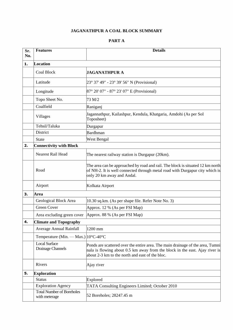
JAGANATHPUR A COAL BLOCK SUMMARY
PART A
Sr.
No.
Features Details
1. Location
Coal Block JAGANATHPUR A
Latitude 23° 37' 49" - 23° 39' 56" N (Provisional)
Longitude 87° 20' 07" - 87° 23' 07" E (Provisional)
Topo Sheet No. 73 M/2
Coalfield Raniganj
Villages
Jagannathpur, Kailashpur, Kendula, Khatgaria, Amdohi (As per SoI
Toposheet)
Tehsil/Taluka Durgapur
District Bardhman
State West Bengal
2. Connectivity with Block
Nearest Rail Head The nearest railway station is Durgapur (20km).
Road The area can be approached by road and rail. The block is situated 12 km north
of NH-2. It is well connected through metal road with Durgapur city which is
only 20 km away and Andal.
Airport Kolkata Airport
3. Area
Geological Block Area 10.30 sq.km. (As per shape file. Refer Note No. 3)
Green Cover Approx. 12 % (As per FSI Map)
Area excluding green cover Approx. 88 % (As per FSI Map)
4. Climate and Topography
Average Annual Rainfall 1200 mm
Temperature (Min. — Max.) 10°C-40°C
Local Surface Drainage Channels
Ponds are scattered over the entire area. The main drainage of the area, Tumni
nala is flowing about 0.5 km away from the block in the east. Ajay river is
about 2-3 km to the north and east of the bloc.
Rivers Ajay river
5. Exploration
Status Explored
Exploration Agency TATA Consulting Engineers Limited; October 2010
Total Number of Boreholes with meterage 52 Boreholes; 28247.45 m

Borehole Density Approx. 5 Boreholes/sq.km.
General Dip of Seams Dip varies between 4°-5 ° towards South with a tendency of becoming
gentler towards south.
General Strike Direction
General trend of strata is almost E-W. There are local variations in the trend
towards NE-SW.
6. Coal Seams & Reserve (217.961 MT Proved+49.37 MT Indicated)
Coal Seams Thickness Range (m)
Depth Range (m) Geological Reserve
(MT)
Grade
Proved + Indicated
R-IX 0.48-3.35 60.33-321.58 30.87 D-F
R-VIII (T) 0.30-2.60 122.40-383.14 4.82 F-G
R-VIII (B) 0.59-2.40 136.41-380.45 1.88 C
R-VII 1.20-3.04 114.11-430.70 30.34 E-G
R-VII A&B 0.68-2.12 138.40-450.32 14.13 D-F
R-VII C 0.06-1.59 180.04-510.55 0.35 D
R-Local 0.19-3.93 201.10-533.14 7.50 F
R-V (T) 1.85-4.72 248.10-563.00 48.67 B-D
R-V (B) 0.94-3.54 268.73-570.23 30.80 D-G
R-IV 0.46-3.69 273.20-602.00 24.09 B-F
R-III/II 3.02-8.84 223.40-668.35 73.88 B-D
Total 267.331 7.
Surface Constraints /Features
Road passes through the block.
8. Grade of the block
G8 (Provisional) based on weighted average grade as per data available in
GR.
9. Decision Support System (DSS) Analysis -
10. Eco Sensitive Zone (ESZ) Analysis
Approx. 95.2 km to the Parasnath ESZ from the North-western block
boundary.

PART B
Sr. No. Features Details
1. Previous Allocation
Name of Allocatee West Bengal Mineral Development and Trading
Corporation Limited (WBMDTCL)
Address West Bengal Mineral Development and Trading
Corporation Limited (WBMDTCL)
13, Nelli Sengupta Sarani (Lindsay Street) 2nd Floor,
Post Box No : 9026, Kolkata-700087, India
2. Status of Mineral Exploitation
Target capacity as per Mining
Plan
0.6 MTPA (Mining Plan available but not approved)
3. Status of Clearances/Approvals
Mining Plan (Reference to
Grant)
N.A.
Forest Clearance (Reference to
Grant)
N.A.
Environmental Clearance
(Reference to Grant)
N.A.
Land Acquired N.A.
Note:
1. The above data is compiled from Geological Report, Mining Plan and the data furnished by the
prior allottee in Annexure-I/II, as available. For clarifications with regard to above data, please
refer aforesaid source documents.
2. The boundary of the block has been taken from GR after conversion to WGS84 system by
feature matching. The block boundary is provisional and the cardinal points, bounding co-
ordinates are approximate.
3. There may be a difference in area in the shape file and GR. Area in the shape file is based on
feature mapped plan of the block as given in the GR. So, the area is tentative and field DGPS
survey is required to ascertain the exact area.
Disclaimer:
1. The analysis is done on Beta-version (Trial Version) of Decision Support System (DSS) of FSI
/ MOEF.
2. The Decision Rules for various parameters of this DSS System are controlled by FSI.
3. CMPDI only runs this DSS to obtain the status of any block based on these Decision Rules.
4. The database of the Decision Rules is updated by FSI from time to time.
5. CMPDI does not own any responsibility for variation in the results which are based on the
Decision Rules of the FSI DSS in case of any updation of the database at FSI end.
6. ESZ analysis and tiger habitat/ corridor given here is based on the information available in
public domain. Bidders are encouraged to verify this information and any other information
additionally available.

!.!.
!.
!.
!.
!.
!.
!.
!.
!. !.
!.
!.
!.
!.
!.
!. !.
!.!.
!.
!.
!.
!.!.
!.
!.
!.
!.
!.
!.
!.
!.
!.
!.
!.
!.!. !.
!.!.BISTUPUR
SOUTH
Jaganathpur B
Jaganathpur A
RANGAMATI BINTEGRATED
RANAGMATI AJHANJHRA
KUNUR
P-1P-2
P-3
P-4
P-5
P-6
P-7
P-8P-9
P-10P-11
P-12
P-13
P-14
P-15
P-16
P-17P-18
P-19P-20
P-21
P-22P-23
P-24P-25
P-26P-27
P-28
P-29
P-30
P-31
P-32
P-33
P-34
P-35
P-36
P-3787° 20' 7" E23° 37' 49" N
87° 20' 7" E23° 39' 56" N
87° 23' 7" E23° 39' 56" N
87° 23' 7" E23° 37' 49" N
87°23'0"E
87°23'0"E
87°22'0"E
87°22'0"E
87°21'0"E
87°21'0"E
87°20'0"E
87°20'0"E
23°40'0"N
23°40'0"N
23°39'0"N
23°39'0"N
23°38'0"N
23°38'0"N
Jagannathpur A Block, Raniganj Coalfield
Legend!.
Bounding CoordinatesBounding Envelope
!.Cardinal PointsBlock Boundary
CategoryCILADDITIONAL CILCMSPMMDRSCCL
00.75
1.50.375
Km
.
FOR INTERNAL/RESTRICTED USE ONLY
Note: Data is in WGS84 coordinate system.

Provisional Cardinal Points for Jaganathpur A Block
POINT NO Longitude (WGS84) Latitude (WGS84)P-1 87° 21' 9.741" E 23° 37' 50.742" NP-2 87° 21' 6.310" E 23° 37' 49.227" NP-3 87° 21' 1.556" E 23° 37' 55.268" NP-4 87° 20' 57.677" E 23° 38' 0.199" NP-5 87° 20' 53.240" E 23° 38' 5.932" NP-6 87° 20' 37.378" E 23° 38' 26.212" NP-7 87° 20' 20.861" E 23° 38' 47.402" NP-8 87° 20' 13.816" E 23° 38' 56.411" NP-9 87° 20' 11.198" E 23° 38' 59.760" NP-10 87° 20' 7.910" E 23° 39' 3.880" NP-11 87° 20' 8.697" E 23° 39' 4.205" NP-12 87° 20' 19.164" E 23° 39' 9.032" NP-13 87° 20' 29.372" E 23° 39' 13.807" NP-14 87° 20' 43.327" E 23° 39' 20.285" NP-15 87° 21' 0.842" E 23° 39' 28.449" NP-16 87° 21' 17.894" E 23° 39' 36.396" NP-17 87° 21' 50.741" E 23° 39' 51.718" NP-18 87° 21' 51.019" E 23° 39' 51.846" NP-19 87° 21' 56.121" E 23° 39' 54.216" NP-20 87° 21' 57.549" E 23° 39' 55.037" NP-21 87° 22' 9.197" E 23° 39' 42.334" NP-22 87° 22' 21.967" E 23° 39' 28.692" NP-23 87° 22' 25.552" E 23° 39' 24.705" NP-24 87° 22' 31.838" E 23° 39' 18.068" NP-25 87° 22' 33.520" E 23° 39' 16.175" NP-26 87° 22' 35.715" E 23° 39' 13.905" NP-27 87° 22' 38.897" E 23° 39' 10.325" NP-28 87° 22' 44.553" E 23° 39' 4.306" NP-29 87° 22' 59.519" E 23° 38' 48.230" NP-30 87° 23' 6.035" E 23° 38' 41.195" NP-31 87° 22' 51.351" E 23° 38' 34.858" NP-32 87° 22' 32.966" E 23° 38' 26.856" NP-33 87° 22' 13.944" E 23° 38' 18.610" NP-34 87° 21' 57.369" E 23° 38' 11.412" NP-35 87° 21' 42.149" E 23° 38' 4.809" NP-36 87° 21' 29.999" E 23° 37' 59.593" N
Note: The provisional cardinal points are in WGS84 coordinate system. These points are extracted through ArcGIS software after
georeferencing of block boundary and ongrund DGPS survey is required to acertain the exact location of the points.