kellogg-deering well field superfund site · system so as not to physically restrict ... the...
TRANSCRIPT
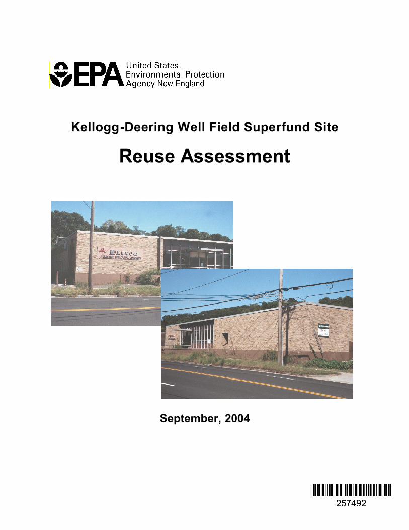
Kellogg-Deering Well Field Superfund Site
Reuse Assessment
September, 2004

TABLE OF CONTENTS
Page PURPOSE 1
SECTION 1 - SITE BACKGROUND 2 General 2
Site Description 2 Surrounding Land Uses 5 Site Zoning 6 Transportation Infrastructure 8 Land Use Trends 8
Environmental History/Status 8 Past Site Operations 8 Federal and State Response Actions 9 Status of Cleanup Activities 12
SECTION 2 - SITE USE/REUSE STATUS 15 Zell/Elinco Buildings Property 15
Background 15 Current Uses 17 Potential Future Uses 17 Potential Use/Reuse Considerations 17 General Findings 19 Recommendations 19
Matheis Court Building Property 20 Background 20 Current Uses 21 Potential Future Uses 21 Potential Use/Reuse Considerations 21 General Findings 22 Recommendations 22
SECTION 3 - REFERENCES 23
APPENDICES 24
Cover Photos: Front of Elinco Building along Main Avenue

PURPOSE
EPA- New England is responsible for the cleanup of over 100 Superfund sites throughout New England. Although protecting human health and the environment is the primary objective of these cleanups, EPA also recognizes the value in helping to return Superfund sites to beneficial reuse. Understanding the current and likely future uses of a site are fundamental to achieving both objectives.
Most importantly, accurate information on the likely uses of a Superfund site and the surrounding area is necessary to make reasonable assumptions about possible exposures to contaminants. These assumptions form the basis for establishing site-specific cleanup levels and, ultimately, for designing a protective remedy. Uncertainty in this information makes it difficult to appropriately tailor the site investigation and cleanup, and can lead to increased project costs and delays.
From the standpoint of facilitating site reuse, details regarding current or planned uses enables EPA to consider those uses in the selection, design and implementation of the remedy. For instance, it may be possible to locate a soil or groundwater treatment system so as not to physically restrict the construction of future buildings. In other cases, the cleanup might be phased in a way that allows certain portions of a site to be available sooner. There are numerous Superfund sites across the country where reuse has already been facilitated in this manner. However, such accommodations will only be considered if they do not compromise the protectiveness of the cleanup.
This Reuse Assessment summarizes information on the current and potential future land uses at the Kellogg-Deering Superfund Site that is currently known to the EPA case team. Potential reuse-related issues, data gaps and other relevant considerations are also described.
EPA will continue to work with the local community and other stakeholders to resolve remaining uncertainties and develop a more complete and realistic understanding of site use. This information will be used to support EPA's decisions regarding future response actions at the Site.
The Reuse Assessment is presented in three sections: • Section 1 - Site Background: Describes the physical, environmental, and
historical context of the site. • Section 2 - Use/Reuse Status: Describes the current and potential future uses of
the separate parcels or discrete areas within the Site. Potential use/reuse considerations and key findings and recommendations relating to these parcels or areas are also discussed
Page1of33

SECTION 1 -SITE BACKGROUND
General
Site Description
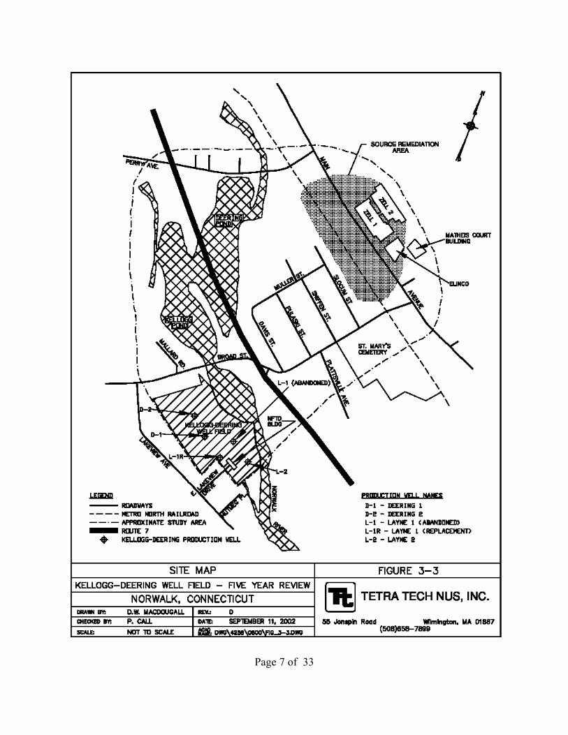
The Kellogg-Deering Well Field Superfund Site (the Site) is located in Norwalk, Fairfield County, Connecticut and consists of an approximately 10-acre municipal well field and the adjacent area that contributes to the contamination (Figure 1-1). EPA has divided the Site into three areas or operable units (OU) for the purpose of selecting and
QUICK FACTS
Location: Norwalk, Connecticut
ID Number: CTD980670814
Site Area: 9.5 acres (Source Remediation Area)
Number of Parcels: 20 approx. (Source Remediation Area), 3 (Complex only)
Current Uses: Commercial Offices: one parcel, Abandoned: two parcels. (Complex only)
Current Zoning: Commercial, multi-unit residential, restricted manufacturing
Ownership: Private
Cleanup Status: Construction completed (OU1 & 2); Groundwater treatment (OU1 &2) and soil treatment (OU2) ongoing.
EPA Contact: Terry Connelly Remedial Project Manager (617)918-1373 [email protected]
implementing remedial actions: The Kellogg-Deering Well Field (OU1), the Source Remediation Area (SRA) or (OU2), and the Downgradient Area (OU3), which includes the area of contamination downgradient from the source area but upgradient from the well field. Maps depicting the relative locations of operable units are presented as Figures 1-1 and 1-2. (EPA, 1989).
Although this Reuse Assessment will discuss the status of the Site as it pertains to all three areas, primary emphasis will be on the Source Remediation Area, which is undergoing active soil and groundwater remediation and appears to be in a state of flux with respect to future reuse.
The SRA is an approximately 9.5-acre area that EPA defined by trichloroethene (TCE) concentrations in groundwater greater than 6,600 parts per billion (ppb). (EPA, 1989). The SRA is located hydraulically upgradient of the Kellogg-Deering Well Field (Well Field)
The Elinco/Pitney Bowes/Matheis Court Complex (the Complex) is a group of four buildings within the SRAfrom which the contamination originated. The Complex covers approximately 5.7 acres roughly 2,000
Page 2 of 33

Page 3 of 33

Page 4 of 33

feet to the east of the Well Field (Figure 1-3). Three of the four buildings are located on two adjacent parcels that occupy most of the Complex. These buildings are unoccupied and in a state of serious disrepair. The remaining parcel is approximately 0.2-acre and houses an operating office building. Ownership of the Complex is divided between two separate private parties. The majority of the Complex and surrounding areas are covered with asphalt pavement. A more detailed description of the Complex can be found in Section 2 of this Reuse Assessment.
The SRA includes the Complex and the area extending approximately 600 feet west, 500 feet north, and 600 feet south of the Complex (Figure 1-2). Businesses and other buildings located within the SRA that are not part of the Complex include a shopping plaza, car wash, a pizza shop, gas station, an assisted living facility, and several single-family residences.
The ground surface at the SRA generally slopes from east to west (elevation 70-100 feet) toward the Norwalk River (elevation 50 feet). The ground surface to the east of the SRA rises steeply to about 140 feet in elevation where bedrock outcrops, and is held back by a concrete retaining wall located at the east end of the Complex.
Moving west from the eastern boundary, overburden material consists of approximately 10 feet of dense sand and gravel and/or glacial till over bedrock. West of Main Avenue, the unconsolidated material increases in thickness to approximately 15 to 30 feet and remains roughly the same thickness until the railroad tracks (NUS, 1989).
Flood insurance maps indicate that the SRA is not within the 100-year flood plain of the Norwalk River. A small stream, originating from an un-named pond about 100-feetfrom the northeast corner of the Complex, runs along the northern boundary before entering a culvert. Groundwater in the SRA is not used as a source of drinking water. All businesses and residences are served by the municipal water supply.
Surrounding Land Uses
The SRA is bordered to the north by an elderly housing development and several commercial businesses; to the west by railroad tracks, to the south by commercial properties along Broad Avenue, and to the east by condominiums.
The Downgradient Area (OU3), defined by EPA as the area downgradient (approximately west) of the SRA and upgradient of the Well Field, contains concentrations of TCE in groundwater between 5 ppb and 6,600 ppb. (EPA, 1989). The Downgradient Area is bordered to the north and west by Deering Pond and the Norwalk River, to the east by the SRA and the Metro-North railroad tracks, and to the south by St. Mary's Cemetery and Plattsville Avenue.
Page 5 of 33

The Downgradient Area is primarily occupied by single or multi-family homes along Slocum, Sniffen, Pulaski, and Davis Avenues. Light industrial facilities are currently operating to the north of Muller Avenue in the Muller Industrial Park, west of Slocum Avenue, and south of Broad Avenue. All are served by municipal water. Connecticut law strictly regulates the drilling of water supply wells (CONN. GEN. STAT.§§ 25-126,128 to 137 (West 2004)). This law and the state Public Health Code (CONN. GEN. STAT.§§ 19a-36 to 37 (West 2004)) do not allow for any exemptions that might enable the drilling of water supply wells on properties on the Site, thus preventing the use of groundwater in this area.
Topographically, the Downgradient Area generally slopes from east to west towards the Norwalk River. The western portions are located within the 100-year floodplain of the Norwalk River. Overburden material within the Downgradient Area consists primarily of glacial drift deposits consisting of sand and gravel. Overburden thicknesses between the railroad tracks and Pulaski Avenue are between 15 and 30 feet, then begin to increase gradually to approximately 65 feet near the east side of the Norwalk Municipal well field with treatment system River. The bedrock surface slopes from east to west gently between the railroad tracks and Davis Avenue and steeply between Davis Avenue and the Norwalk River (NUS, 1989).
The Well Field (also known as the Smith Well Field) is owned and operated by the Norwalk First Taxing District (NFTD) Water Department and consists of four municipal water supply wells that provide a portion of the water to residents and businesses in the city of Norwalk (Figure 1.3). The water supply wells are located in an aquifer that is classified as GAA under the State of Connecticut's Water Quality Standards and II-A under EPA’s Groundwater Protection Strategy. The Connecticut GAA classification encompasses the immediate vicinity of the Kellogg-Deering Well Field and indicates that the Well Field is an existing or potential public drinking water supply (NUS, 1989).
Site Zoning
According to maps obtained through the City of Norwalk Planning and Zoning Offices, the SRA is zoned as a “Business No. 2 Zone” (B2). B2 zoning allows for mixed use, including multifamily residential with certain restrictions. Other allowed uses include: offices, banks, hotels/motels, retail stores, restaurants and taverns, theaters, schools,
Page 6 of 33
Page 7 of 33

museums, and off-street parking facilities. The expansion of an existing manufacturing use may be allowed without a special permit providing the use has not been discontinued or abandoned for a continuous period of one year or more. New manufacturing facilities would require a special permit (Norwalk, 2004). Sections 118522 of the Building Zone Regulations of the City of Norwalk, CT, which describe B2 zoning, are included as Appendix A.
Transportation Infrastructure
Primary access to the SRA is from Main Avenue, which intersects with the Merritt Parkway to the north and Route 1 to the south. Immediately west of Main Avenue are the Metro North Railroad tracks and a connecting spur.
Land Use Trends
The most recent City of Norwalk Master Plan, dated October 1, 2003, did not contain any specific references to the Kellogg-Deering Superfund Site or to the SRA properties. EPA is unaware of any large-scale construction projects or publicly-available land use plans that would indicate that the SRA properties and surrounding area are undergoing significant transformation.
Environmental History/Status
(See Appendix B for a chronology of key events)
Past Site Operations
The Zell 1 Building (280 Main Avenue) was built in the mid-1940s by the Zell Products Corporation (Zell) for the production of metal cosmetic and handbag frames. These operations continued at Zell 1 for more than 20 years until the late 1960s. Manufacturing processes at Zell 1 included plating and solvent cleaning, apparently with TCE, although other solvents may have been used. In 1969, Pitney Bowes Corporation occupied Zell 1 and used it as a warehouse facility. The building was later renovated in 1977 and used for office and warehouse space. Zell 1 is currently vacant.
Zell built the Zell 2 building, behind and connected to Zell 1, in 1955 to expand its production capability. Manufacturing processes similar to those used in Zell 1 were conducted in this building. In 1974, Pitney Bowes occupied the facility and converted it into office space. Zell 2 is currently vacant.
The Elinco Building (272 Main Avenue) was constructed in 1961 by Zell to further expand its production capability. Manufacturing processes similar to those used in Zell 1 were performed in this building until the mid-1970s. Elinco Corporation took over the
Page 8 of 33

building in the mid-1970s to produce fractional horsepower motors. The Elinco building was used for manufacturing until the late 1990s but is currently vacant (EPA, 2002).
Federal and State Response Actions
Elevated levels of TCE in groundwater were first detected at the Well Field in 1975 during a routine sampling event (EPA, 1986). Wells with unacceptable levels of TCE, were shut down. Between 1975 and 1980 the Connecticut Department of Environmental Protection (CTDEP) performed several inspections, collected samples from the Well Field and adjacent areas, and initiated investigations of several local industries in an effort to determine the extent of groundwater contamination. In 1981, NFTD installed and operated a redwood slat aerator on a well (Layne 2) to allow continued use of the well for the production of drinking water for the City. Layne 2 had been found to have unacceptable levels of TCE. Attempts to install a more efficient air stripper in 1985 were reportedly not successful. (EPA, 2002).
The Kellogg-Deering Well Field (OU1) was placed on the National Priority List (NPL) in 1984, and EPA initiated a Remedial Investigation/Feasibility Study (RI/FS) shortly thereafter to evaluate risks posed by contamination at the Site and propose remedial alternatives to protect public health. In 1986, after completion of the RI/FS, EPA issued a Record of Decision (ROD) establishing cleanup goals for the Wellfield. In May of 1987, EPA issued an Administrative Order to the NFTD requiring it to, among other things, construct, operate and monitor an air stripper system to ensure that water entering the public water supply distribution system meets specified Federal and/or State contaminant levels. In May 1998, EPA notified NFTD of its successful implementation of these requirements.
The Remedial Investigation for OU1 also found that the source of contamination to the Well Field was located to the east, and recommended additional investigations to delineate the contamination plume. In 1986, EPA initiated a supplemental RI/FS that determined the Complex to be the primary source of contamination. (NUS, 1989). This had the effect of expanding the original Site boundaries to include these identified source areas and other areas where contaminated groundwater had migrated.
In the ROD that followed in 1989, EPA separated the management of migration component for the area upgradient of the Well Field into two operable units. OU 2 was termed the "Source Remediation Area" and was characterized by TCE concentrations greater than 6,600 |ig/l. OU3 was defined as the "Downgradient Area" and characterized by TCE concentrations exceeding 5 |ig/l, but less than 6,600 |ig/l. The 1989 ROD addressed the Source Remediation Area only. Remedial decisions for OU3 were postponed due to the then pending plans for construction of a new highway (Route 7) in the Downgradient Area. The 1989 ROD established the following remedial action objectives (RAOs):
Page 9 of 33

• Prevent further introduction of contaminated groundwater from the Source Remediation Area to the Downgradient Area and ultimately to the production wells at the Kellogg-Deering Well Field and the Norwalk River; Restore the Source Remediation Area aquifer to drinking water quality;
• Reduce the mass of contaminants at the Source Remediation Area; and Prevent human consumption of or contact with contaminated groundwater above the cleanup goals presented in the ROD (EPA, 1989).
EPA's selected remedy included source control and management of migration components. The source control component included the design, installation, operation, and maintenance of an in-situ soil vapor extraction (SVE) system to remove volatile organic compounds (VOCs) from vadose zone soils. The management of migration component included the design, installation, operation, and management of a groundwater extraction, treatment, and disposal system to remove VOCs from groundwater in the Source Remediation Area. The selected groundwater treatment method was air stripping. The soil and groundwater treatment systems were integrated to provide treatment of air from each component through the use of carbon adsorption. Institutional controls associated with the selected remedy were to include restrictions on the installation and use of private wells in the Source (OU2) and Downgradient (OU3) Areas and restrictions on soil excavation in areas of contamination (EPA, 1989).
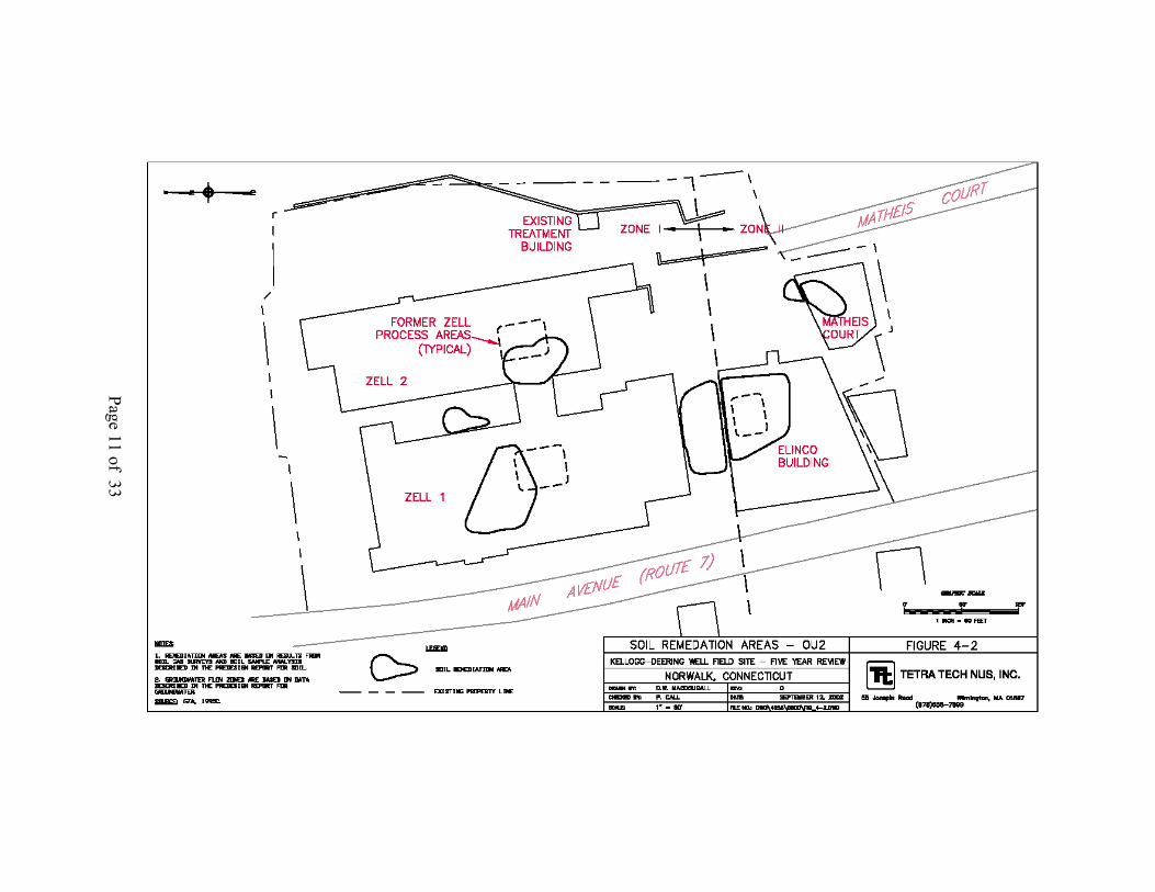
In September 1990, a Consent Decree for implementation of the OU2 Remedial Design/Remedial Action (RD/RA) was signed between EPA and four Responsible Parties (RPs). The Consent Decree provided that the soil cleanup goals would be established as part of the pre-design study. Two sets of cleanup goals were established for soil at OU2 due to variability in organic carbon content, water content, and lateral groundwater flow rates in different portions of OU2. Zone I was defined as the area to the north of the straight line extending across the Complex, parallel to the north wall of the Elinco Building (see Figure 1-4). Area II was defined as the area to the south of this line. Table 1-1 contains the soil cleanup standards for Zones I and II and the groundwater cleanup standards. The cleanup standards for groundwater are based on federal Maximum Contaminant Levels (MCLs) for drinking water.
The SVE system was designed to treat soils in six general areas of the Complex where VOC concentrations exceeded cleanup goals as follows: • Three areas associated with the former Zell Products process areas inside of the
Elinco Building, Zell 1, and Zell 2; The Zell/Elinco Corridor; An area in the courtyard between Zell 1 and Zell 2; and,
• A small area just north of the Matheis Court Office Building.
A potential seventh area was identified below the Matheis Court Building based on elevated soil gas VOC concentrations. During SVE construction, additional samples were collected and the area below the building was determined to require remediation.
Page 10 of 33
Page 11 of
33

This area and the area north of the building were covered in a single extraction network for the both the indoor and outdoor areas of the Matheis Court Building. The six soil remediation areas are shown on Figure 1-4.
Operation and maintenance of the soil vapor and groundwater extraction and treatment systems began in 1996. EPA agreed to suspend operation of the SVE system, with periodic pulsing, in August of 1999 since the sampling data indicated that very little contamination was being recovered by
Treatment Building behind Zell Buildings
the system. The groundwater extraction and treatment system remains active.
Status of Cleanup Activities
In September of 2002, EPA issued a Five-Year Review Report (Report) that summarized its evaluation of the cleanup activities for the Kellogg-Deering Well Field (OU1) and the Source Remediation Area (OU2). This report provided the following assessment and recommendations with respect to the three areas.
OU1 - Kellogg-Deering Well Field: According to the Report,
“...the remedy for OU1 is functioning as intended by the decision documents, is achieving RAOs, and remains protective of human health and the environment. However, due to elevated concentrations of VOCs detected in groundwater samples collected from OU3 (which are not hydraulically contained by the OU2 groundwater extraction system), it is recommended that NFTD continue operation of the air stripper to protect against potential future migration of VOCs into the Well Field from the Downgradient Area” (EPA, 2002; pg. 9-1).
OU2- Source Remediation Area: Although the remedy for OU2 appears to be functioning as intended, residual concentrations of VOCs in groundwater and certain areas of soil remain significantly above the established cleanup standards. For example, soil samples in the Zell/Zell Courtyard and beneath the Zell 1 and Zell 2 buildings remain contaminated with concentrations of VOCs above cleanup standards. Similarly, groundwater monitoring results indicate VOC concentrations in the Complex have not been significantly reduced by the operation of the groundwater extraction and treatment system, and remain orders of magnitude higher than MCLs. This may be indicative of the presence of dense non-aqueous phase liquid (DNAPL) in OU2 that is
Page 12 of 33

contributing to sustained high VOC concentrations in the groundwater. If this proves to be the case, remediation of groundwater to drinking water standards may not be technically practicable. This information suggests that the ability of the remedy to achieve its long-term goals is questionable. The Report further notes that the CTDEP believes the potential for migration of vapors from the soil and contaminated groundwater into the Complex buildings or buildings in OU3 needs to be further investigated. The Report therefore recommends that the current remedy be reevaluated to determine; (1) Whether the RAOs need to be revised; and, (2) whether modifications to the remedy are necessary.
The Report does emphasize that although the current remedies for OU2 and OU3 may need to be re-evaluated for long-term protectiveness, these areas are protective in the short term,
"The remedy at OU2 currently protects human health and the environment (i.e. in the short term) because exposure pathways that could result in unacceptable risks are being addressed through institutional controls that prevent direct contact with contaminated soil, inhalation of contaminated soil vapors, and use of contaminated site groundwater. Groundwater extraction and treatment and periodic SVE treatment continue to occur, but VOC mass removal does not appear to be adequate to achieve the cleanup standards that were established in the ROD. In order for the remedy to be protective in the long-term, a reevaluation of the RAO of restoring the Source Area aquifer to drinking water quality must be made, and soil and groundwater cleanup standards should be reconsidered. If necessary, modifications to the remedy should be made" (EPA, 2002; pg. 10-1).
and
"The remedy at OU3 currently protects human health and the environment because institutional controls are in place to prevent the use of contaminated groundwater. Despite elevated concentrations of VOCs in groundwater in OU3, continued remedial activities at OU2, including possible modifications to the SRA monitoring and remediation system, should protect human health and the environment in the Downgradient Area" (EPA, 2002; pg. 10-1).
The air emissions from the integrated treatment system indicate that negligible VOCs are being released and remain well below the threshold for which an air permit would be required (EPA, 2002)
The Responsible Parties collected soil samples in April 2004 to assess the effectiveness of the SVE and is working with EPA to resolve the remaining issues concerning soil contamination.
Page 13 of 33

Table 1-1: Soil Cleanup and Groundwater Cleanup Standards for OU2
Compound
Soil Cleanup Standards (:g/kg)
Groundwater Cleanup Standards
(:g/l)Zone I Zone II
Benzene 130 110 5
Toluene 154,000 141,000 2,000
Ethyl Benzene 183,000 169,000 680
1,1,1 - TCA 8,300 7,500 200
1,2 - DCA 43 32 5
PCE 460 420 5
TCE 180 160 5
cis-1,2, - DCE 1,200 1,000 70
1,1 - DCE 150 130 7
Vinyl Chloride 38 32 2
MiBK 4,300 3,500 -
4-Methyl-2-
pentanone
- - 350
Page 14 of 33

SECTION 2 -SITE USE/REUSE STATUS
This section provides a general summary of the current and potential future uses of the Source Remediation Area. Potential use/reuse considerations are also discussed. This summary is based on information that was readily available to the EPA case team.
As stated previously, the Source Remedial Area consists of the area described as the Complex and an area of groundwater contamination extending approximately 600 feet west and 500 feet south of the Complex. The western extent of the SRA coincides with the rail road tracks.
This section will focus on the following two properties comprising the Complex: • Zell/Elinco Buildings Property (Lots 174 and 97)
Matheis Court Building Property(Lot 345)
All lot numbers refer to those listed on the October 1, 1991 Tax Map, City of Norwalk, Connecticut.
The remaining properties located downgradient of the Complex encompass about twenty parcels of primarily commercial and residential uses. These properties have not been identified as source areas of the contamination plume. Other than the physical presence of groundwater extraction or monitoring wells on some of these properties, there are currently no restrictions on the use of the properties resulting from the ongoing cleanup of the Site. The wells appear to have minimal impact on the ongoing uses. For these reasons, detailed analysis of the use/reuse status for these properties is not being provided in this section.
Zell/Elinco Buildings Property (Lots 174 and 97)
Background: This approximately 5.7-acre property consists of two adjacent parcels that were previously owned by the Zell Products Corporation (Zell) and are currently owned by Banque Arabe et Internationale d'Investissement (formerly the Arabian Bank of Paris), which acquired the properties in 1998 through a mortgage foreclosure.
Lot 174 and Lot 97 are located at 280 Main Avenue and 272 Main Avenue, respectively. Lot 174 is four-acres +/- and houses two interconnected buildings, Zell 1 and Zell 2. Zell 1 is about 45,000 square-feet and Zell 2 is 33,000 square-feet. The 20,000 square-foot Elinco Building is located on Lot 97, which is approximately 1.7-acres. The combined two parcels have 456 feet of frontage along Main Avenue. Main Avenue is the primary access point, although Lot 97 could also be accessed from Matheis Court.
The property is located in a mixed-use area. The property to the north (Lot 98) is an assisted living facility, to the east is a condominium complex (Lot 101), and mixed
Page 15 of 33

commercial and residential properties are to the southeast and across Main Avenue to the south and southwest. The zoning for the property and surrounding area is “B-2",
which allows for commercial and some residential uses. Manufacturing use is restricted.
Zell 1 was built in the mid-1940s by the Zell Products Corporation (Zell) to manufacture metal cosmetic and handbag frames. In 1955, Zell built Zell 2 to expand its manufacturing process. These operations continued at Zell 1 until the late 1960s, after which Pitney Bowes used it for a
Zell 1 and Elinco Building along Main Avenue warehouse. In 1974, Pitney Bowes converted Zell 2 for its use as office
space. Both Zell 1 and 2 are currently unoccupied and in a state of disrepair. During an April 2004 Site visit, EPA noted several places where rain water was pouring into both buildings through the roofs.
The Elinco Building was constructed in 1961 by Zell as an expansion to its production operations. Manufacturing processes similar to those in Zell 1 were conducted here until the mid-1970s. From the mid-1970s to the late 1990s, the Elinco Corporation used the building to manufacture fractional-horsepower motors. The building is currently unoccupied.
The Zell/Elinco Property has been identified as a source area for the groundwater contamination impacting the Norwalk First Taxing District Well Field and other areas. There is soil and groundwater remediation occurring on the property. A small building housing the treatment equipment is located along the eastern boundary of Lot
Front o f Elinco Building 174, and associated piping, wells and other appurtenances run throughout the property. The piping for the groundwater pump-and-treat system is located in three areas of the Complex: Beneath the pavement to the north of the Zell 1/Zell 2 Buildings; just west of the Zell 1 and Elinco Buildings; and in the corridor between the Zell Buildings and the Elinco Building. The piping from each well in these areas runs underground to the treatment building. The SVE system
Page 16 of 33

is a combination of above ground and below ground piping, with the above ground piping located within the buildings and the below ground under the pavement.
The Responsible Parties collected soil samples in April 2004 to assess the effectiveness of the SVE and is working with EPA to resolve the remaining issues concerning soil contamination.
The areas of the property not occupied by buildings is paved. Chain-link fence with locked gates currently extend from the Elinco and Zell 1 buildings to the property lines and along the entire Complex area. There is a permanent sanitary sewer easement along the Main Avenue boundary. Electricity and public water are available at Zell 2 Building
the property. Flood insurance maps indicate that the property is not within the 100-year floodplain of the Norwalk River. A stream originating from a un-named pond about 100 feet to the northeast of the property runs along the northern boundary before entering a culvert that crosses under Main Avenue.
The back property taxes were reportedly paid by the current owner.
Current Uses: Except for the on-going remediation activities, the property is unused.
Potential Future Uses: Unknown. The current owner has not put forward any plans to reuse the property and has placed the property up for sale. The City has not indicated any intention to acquire the property.
Potential Use/Reuse Considerations: Factors that could potentially impact the reuse of the property include:
(1) Final Cleanup Goals
The cleanup may need to be re-evaluated to determine what, if any, changes should be made to ensure long-term protectiveness of the Site. The potential that DNAPL may exist in the bedrock and saturated overburden could make achieving the current goal of remediating groundwater to drinking water standards technically impracticable. This should not impact the availability of water to the property since municipal water is readily accessible.
Page 17 of 33
The residual VOC contamination in the groundwater and soils could, however, serve as a long-term source of vapors that may need to be considered in the design and construction of buildings and other structures, both on and off the Complex. This residual contamination could also result in restrictions being placed on the soils, particularly involving excavation activities.
(2) Physical Restrictions Relating to Cleanup and Monitoring Equipment There are a number of extraction wells, piping and other equipment associated with the soil and groundwater cleanup that may create physical restrictions in some portions of the property. This may need to be considered in the future use of the property.
The length of time that the groundwater pump-and-treat system will need to operate is highly dependent on the final groundwater cleanup goals. The presence of DNAPLs could mean that, without modification, groundwater treatment could continue for a very long period. The Consent Decree provides a mechanism that allows for a waiver for the pump-and-treat system to not attain the final groundwater cleanup goals provided all other requirements are met with respect to remediation of the groundwater (See "Status of Cleanup Activities" in Section 1).
The soil vapor extraction system can be decommissioned once the soil cleanup standards are met either through the redesign of the remedy or by excavating the remaining "hot spots." As noted in Section 1, the operation of SVE system was partially suspended in 1998 because the sampling data indicated that very little additional VOCs were being removed. The final choice for completing the soil cleanup will therefore have a significant impact on when the effected portions of the property will be available for reuse.
It should also be noted that all of the SRA wells are flush with the pavement and protected by either road boxes or manhole covers.
3) Stakeholder Coordination The reuse prospects of the property in the foreseeable future will likely depend on the joint cooperation of the key stakeholders that include the EPA, State, owner, Responsible Parties, developers and town officials. This is particularly true if modifications to the existing remedy are necessary either to accommodate a planned reuse or to achieve the RAOs. Through proper coordination, these modifications can be implemented in a manner that both facilitates the reuse and accomplishes a more cost-effective and protective remedy. This could also conceivably result in the owners and developers agreeing to contribute some of the costs for implementing these changes (e.g., removing soil contamination "hot spots", relocating remediation equipment, etc.). Coordination can also enable any additional requirements under the Connecticut PropertyTransfer Act to be addressed concurrently, obviating the need to revisit those potential issues at a later time. This may help remove some of the uncertainty and future delays that might otherwise discourage future reuse.
Page 18 of 33
(4) Liability Concerns Potential developers may have concerns regarding their potential liability should they acquire or lease the property. In addition to Superfund, the applicability of Connecticut's Property Transfer Act should be evaluated when considering purchasing this property. The Property Transfer Act requires that forms are filed with Connecticut Department of Environmental Protection when the "transfer of establishment" occurs that certifies that the property will be investigated according to prevailing standards and any pollution be remediated in accordance with state regulations
General Findings:
(1) Reasonably-Anticipated Future Land Uses (RAFLU) The future use of the Zell/Elinco Buildings Property is uncertain since it is currently abandoned and there are no known plans for reuse. Use of the property for commercial purposes remains a likely possibility. This use would be consistent with the current zoning and surrounding land uses. Residential use is also allowed under the current zoning subject to certain restrictions (e.g., a minimum of 6 dwelling units and a minimum plot size of 1,650 sq. ft per dwelling unit is required) and consistent with the area. According to Sean Cahill, First Vice President with the real estate firm CB Richard Ellis, there is a strong market in that area for both residential and commercial uses, with residential being particularly strong. Mr. Cahill also indicated that in the years that his firm has maintained a listing for this property, there has been considerable interest from developers.
A special permit would be required for new manufacturing use. The City has not indicated any intent to propose changes to local zoning by-laws that would alter the current uses.
Recommendations:
(1) Minimizing Uncertainty Regarding Cleanup Time Frames From a technical standpoint, two unresolved questions regarding the cleanup may represent the most significant barrier to the near-term reuse of the property: (1) Does the potential for vapor intrusion exist?, and (2) When will the soil cleanup be completed? Of these, the soil cleanup may be the more critical question because the presence of the SVE system more directly interferes with the construction of new buildings and structures. This is especially true of Lots 174 and 97, where the buildings would likely be difficult to rehabilitate and may need to be demolished and replaced. Many developers may be reluctant to pursue acquisition until the soil cleanup is complete or at least a clearer time frame for completion is known. The vapor intrusion issue, on the other hand, can be addressed through relatively straight-forward and low-
Page 19 of 33

cost engineering solutions that can be incorporated into the design of any new buildings.
EPA and the CTDEP should therefore continue to work with the Responsible Parties, Owners and other key stakeholders to expedite the soil cleanup and address other issues that could create unnecessary impediments to reuse.
(2) Liability Concerns It will be important for EPA and CTDEP to work with potential developers, the current owner and other key stakeholders to help clarify liability issues so that they can better assess their options. Some of the available federal- and private-sector tools include:
Statutory Exemptions. There are certain liability protections afforded under the Superfund statute and recent amendments, such as the Small Business Liability Relief and Brownfields Revitalization Act (commonly referred to as the "Brownfields Law"). Among the entities potentially covered are municipalities, lenders/financial institutions, and prospective purchasers.
Commercially-Available Insurance Products. There are a wide variety of insurance products currently available. Although these products cannot eliminate Superfund liability, they can limit financial exposure and can be useful in securing loans from lending institutions. Typically, the premiums reflect the insurer's perception of financial risk, so that properties with contamination left in place may be expected to pay a higher cost for its coverage.
• Ready-for-Reuse Determinations. EPA can issue a site-specific determination that all or certain portions of a Site are available for either "restricted" or "unrestricted" use. This determination and the specific nature of any restrictions (e.g., institutional controls, prohibited uses, etc.) are summarized in a supporting document that can be made available to property owners, developers and other interested parties. These determinations are intended to promote earlier use of Superfund sites.
Matheis Court Building Property (Lot 345)
Background: The Matheis Court Building Property at 7 Matheis Court is an approximately 0.2 acre parcel east of the Zell/Elinco Buildings Property (Lots 174 and 97). Road access is from Matheis Court. The property is in a mixed commercial and residential area that is zoned "B-2".
The Matheis Building was constructed in 1984. The building is privately-owned and currently leased as office space.
Page 20 of 33

The property has been identified as a source area for the groundwater contamination impacting the NFTD wellfield and other areas. The soil vapor extraction well system is located beneath the first floor parking area and the associated above-ground piping generally runs along the north boundary of the property. This is one of the areas where soil samples were collected in April 2004 to determine whether the cleanup goals have been met. The Responsible Parties are working with EPA to resolve the remaining issues concerning soil contamination. Groundwater monitoring wells are located on the Zell/Elinco Buildings Property near the northeast and northwest corners of the Matheis Court Building.
Electricity and public water are available at the property. Chain-link fence with locked gates currently extend around the entire Complex area. Flood insurance maps indicate that the property is not within the 100-year flood plain of the Norwalk River. There are no wetlands or water bodies on the property.
Current Uses: Commercial office space.
Potential Future Uses: EPA is unaware of any plans to change the current use.
Potential Use/Reuse Considerations: Factors that could potentially impact the reuse of the property include:
(1) Final Cleanup Goals
The potential exists that VOCs in the soils and groundwater could serve as a long-term source of vapors. (Please see discussion under Zell/Elinco Buildings Property, “Potential Use/Reuse Issues...Final Cleanup Goals”). However, the fact that the first floor of the office building is used as a parking garage with open-air sides makes it unlikely
Vapo r line along Matheis Court Building that vapor intrusion will be an issue with respect to the existing building. The results of an indoor air screening conducted within the Matheis Court office building prior to the activation of the SVE system did not indicate a concern related to vapor intrusion. None-the-less, this potential may need to be factored into the design and construction of any new buildings and other structures, and whenever excavation of the soils occurs.
(2) Physical Restrictions Relating to Cleanup and Monitoring Equipment
Unlike the Zell/Elinco Buildings Property, the piping and other equipment associated with the SVE system appears to have minimal impact on the ongoing use of the property. There are no groundwater extraction wells located on this parcel.
Page 21 of 33

(3) Liability Concerns Parties interested in acquiring or leasing the property may have concerns regarding their potential Superfund liability.
General Findings:
(1) Reasonably-Anticipated Future Land Uses (RAFLU) Continued use of the Matheis Court Building Property for office/commercial space appears likely. EPA is unaware of any plans to change this use.
Residential use is also allowed under the current zoning subject to certain restrictions (e.g., a minimum of 6 dwelling units and a minimum plot size of 1,650 sq. ft per dwelling unit is required) and consistent with the surrounding land uses. A special permit would be required for new manufacturing use. The City has not indicated any intent to propose changes to local zoning by-laws that would alter the current uses.
Recommendations:
(1) Minimizing Uncertainty Regarding Cleanup Time Frames Because the SVE system appears to have minimal impact on the ongoing use of the property, and the potential for vapor intrusion into the existing building appears low, the immediate resolution of the soil cleanup is less of a priority than it is for the Zell/Elinco Buildings Property. However, the potential impact of these VOCs on any future construction and excavation will still need to be addressed. This consideration should be part of any discussions regarding the final Site cleanup.
(2) Liability Concerns Please see discussion under Zell/Elinco Buildings Property, "Recommendations...Liability Concerns."
Page 22 of 33
REFERENCES CITED
EPA, 1986. Record of Decision. Kellogg-Deering Well Field Superfund Site Operable Unit 1-Kellogg-Deering Well Field. U.S. Environmental Protection Agency, Region 1, Boston, Massachusetts September 25, 1986
EPA, 1989. Record of Decision Declaration Statement. Kellogg-Deering Well Field Superfund Site Operable Unit 2-Source Control. U.S. Environmental Protection Agency, Region 1, Boston, Massachusetts, September 29, 1989.
EPA, 2002. Five-Year Review, Kellogg-Deering Well Field Site. U.S. Environmental Protection Agency, Region 1, Boston, Massachusetts, September 20, 2002.
Norwalk, 2004. Building Zone Regulations of the City of Norwalk, CT; Effective October 16, 1929, amended to May 28, 2004.
NUS, 1989. Final Supplemental Remedial Investigation and Feasibility Study, Kellogg-Deering Superfund Site, Norwalk, Connecticut. Volume I of IV. NUS Corporation. July 17, 1989
Page 23 of 33

Page 24 of 33

APPENDICES
Appendix A - Section 118-522 of the Building Zone Regulations of the City of Norwalk, CT
Appendix B - Chronology of Key Events
Page 25 of 33

Page 26 of 33

Appendix A
Section 118-522 of the Building Zone Regulations of the City of Norwalk, CT
§ 118-522. Business No. 2 Zone. [Added effective 1-16-1987] . A. Purpose and intent. The purpose of this regulation is to permit retail stores, service
shops, mixed-use development and other compatible uses at a scale appropriate to the commercial, employment and housing needs of this city. The area within this zone is intended to have infrastructure of sufficient capacity either prior to or coincident with permitted development. The provisions of this zone are designed to ensure that all permitted uses and structures will be compatible with each other and will provide protection to adjacent residential areas.
B. Uses and structures.
(1) Principal uses and structures. In a Business No. 2 Zone, premises shall be used and buildings shall be erected which are used, designed or intended to be used for one (1) or more of the following uses and no other. Any use or structure having a gross floor area of eight thousand (8,000) square feet or more or requiring twenty (20) parking spaces or more shall be permitted subject to the provisions of § 118-1451, Site plan review.
(a) All uses permitted in the D Residence Zone.
(b) Offices and Contractor's offices. [Amended effective 1-26-2001]
(c) Banks and financial institutions.
(d) Hotels and motels.
(e) Retail stores and personal and business service shops having a gross floor area of less than twenty-five thousand (25,000) square feet. [Amended effective 8-28-1998]
(f) Restaurants and taverns.
(g) Theaters and auditoriums.
(h) Lodge, meeting and concert halls, including social clubs,
(i) Schools, including business and trade schools, and studios,
(j) Mixed-use development, subject to § 118-750.
Page 27 of 33

(k) Research and development facilities.
(l) Museums.
(m) Off-street parking facilities.
(n) The expansion of an existing manufacturing use, provided that the use has not been discontinued or abandoned for a continuous period of one (1) year or more, in which case a Special Permit shall be required. [Added effective 12-27-1991]
(2) Special Permit uses and structures. The following uses shall be permitted by Special Permit in accordance with the provisions of Article 140, § 118-1450, Special Permits, and shall comply with the Schedule Limiting Height and Bulk of Buildings, Commercial and Industrial, and any additional standards set forth herein:
(a) New manufacturing facilities, limited to the processing or assembly of goods which are not noxious due to emission of noise, pollutants or waste. [Amended effective 12-27-1991]
(b) Warehouse and wholesale distribution facilities.
(c) Gasoline stations and the sale and service of motor vehicles, subject to § 1181010.
(d) Halfway houses, with no less than two hundred (200) square feet of living area per person. [Added effective 6-29-1990]
(e) Commercial recreation establishment. [Added effective 12-7-1990]
(f) The expansion of an existing contractor's plant and storage yard, provided that the use has not been discontinued or abandoned for a continuous period of one (1) year or more. [Added effective 11-24-1995]
(g) Animal care centers, provided that the use is fully enclosed within a structure located on a lot a minimum of two (2) acres in size, that the structure is located a minimum of two hundred (200) feet from a residential structure as certified by a licensed surveyor and that adequate provisions are made to control noise and odors emanating from the facility, subject to approval by the Zoning Commission. [Added effective 3-29-1996]
(h) Extended stay hotels, subject to a minimum lot size of four (4) acres or more in size. [Added effective 8-29-1997]
(i) Retail stores and personal and business service shops having a gross floor area of twenty-five thousand (25,000) square feet or more. [Added effective 8-28-1998]
Page 28 of 33

(j) Helicopter landing sites, as an accessory use to a principal permitted use, subject to special permit review and to the following restrictions: the landing site shall be a minimum of 300 feet from a residence zone and flight operations shall be restricted to the hours of 7:00 am to 7:00 pm only. [Added effective 9-28-2001]
(3) Uses which are not otherwise permitted in Subsection B(1) and (2) above shall not be permitted by variance in the Business No. 2 Zone.
(4) Accessory uses and structures. Accessory uses and structures which are incidental to and customarily associated with the principal use of the premises shall be permitted subject to the following restrictions:
(a) Outdoor storage shall be confined to the rear and side yards only and shall be effectively screened from adjacent properties.
(b) Commercial communication antennas are permitted as an accessory use when located on an existing building or structure, subject to the height limitation of that zone, except that antennas mounted on existing buildings which meet or exceed the height limitation of that zone, may extend above the existing building height by no more than 15 feet. In addition, the color of the building shall be incorporated into the design of the antenna. [Added effective 12-20-1996]
C. Lot and building requirements. See the Schedule Limiting Height and Bulk of Buildings, Commer cial and Industrial, and all other applicable sections of these regulations, and in addition:
(1) Multifamily dwellings shall require one thousand six hundred fifty (1,650) square feet of lot area per dwelling unit. [Amended effective 12-30-1988]
(2)EN49 On parcels five (5) acres or larger in size, a maximum building height of four (4) stories and fifty (50) feet shall be permitted. [Added effective 12-27-1991]
(3) Except where the abutting property is within a limited access highway or railroad right-of-way, any portion of a building within fifty (50) feet of an abutting residence zone shall not exceed three (3) stories and thirty-five feet in height. [Added effective 12-27-1991EN50; amended 8-30-2002]]
(4) Open space shall include natural and landscaped areas, pedestrian plazas, courtyards, walkways, recreation areas and the like. Open space on the roof of a structure shall be permitted, provided that the minimum open space requirement extends neither more than ten (10) feet nor more than and one (1) story above the center-line elevation of the street.
D. Off-street parking and loading requirements. See §§ 118-1200 through 118-1260, and in addition:
Page 29 of 33

(1) The principal use and structure of the property shall be located between the front yard and the street wall of a parking structure which is more than three (3) feet above the center-line elevation of the street, for a minimum of fifty percent (50%) of the length of the parking structure. This provision shall not be applicable to parking structures within a development park which parking structures are located more than one hundred and ten (110) feet from the center-line of the street (subject to § 1181000B) and separated from the street by a wetland or watercourse. Any portion of a parking structure which is more than three (3) feet above the center-line elevation of the street and which extends to the front yard shall be effectively screened, except that any parking structures in existence at the time of adoption of this subsection are hereby declared to be in conformance with the requirements of this subsection, provided that if such structures are destroyed by fire, explosion, act of God or act of public enemy to an extent exceeding fifty percent (50%) of their assessed value, they may be reconstructed only if the height, bulk, location and use of the structure is substantially as it had previously existed, subject to approval by the Director of Planning and Zoning, except as modified to conform to the Flood Hazard Zone of these regulations. [Amended effective 5-27-1994; 11-24-1995; effective 12-20-1996]
(2) Parking facilities and driveways shall not be closer than twenty (20) feet to a property line which abuts a residence zone.
E. Sign regulations. See §§ 118-1290 through 118-1295.
F. The Business No. 2 Zone shall not apply to buildings for which a zoning permit has been issued or Commission approval granted prior to November 1, 1991. Such buildings may be completed in accordance with plans filed with the Zoning Inspector or Commission prior to such date. [Amended effective 12-27-1991]
Page 30 of 33

Appendix B
Chronology of Key Events
Date Event
1945 Zell 1 building constructed by Zell Products Corporation (Zell).
1955 Zell 2 building constructed by Zell to expand production capability.
1955 First drinking water production well (Layne 1) installed at the Kellogg-Deering well field.
1961 Elinco building constructed by Zell to perform similar operations as Zell 1 and Zell 2.
1965 Second drinking water production well (Deering 1) installed at the well field.
1966 Third drinking water production well (Deering 2) installed at the well field.
1974 Pitney Bowes takes over Zell 2 building and installs engineering offices.
1975 Fourth drinking water production well (Layne 2) installed at the well field.
1975 Trichloroethylene (TCE) first detected by the Norwalk First Taxing District (NFTD) during routine sampling of Kellogg-Deering Well Field.
May, 1981 NFTD installs redwood slat aerator on Layne 2.
September 8, 1983
Kellogg-Deering Well Field Site proposed for inclusion on the National Priorities List (NPL).
September Kellogg-Deering Well Field Site placed on the NPL.
21, 1984
1985 NFTD installs air stripper on Layne 2 for more efficient removal of organic constituents. Air stripper not put into operation due to equipment problems.
April, 1986 Remedial Investigation (RI) completed for OU1. EPA separates the Site into two operable units: OU1 is the well field, OU2 is the “Source Area”.
June, 1986 Feasibility Study (FS) completed for OU1.
September, EPA issues Record of Decision (ROD) for OU1.
1986
October, CTDEP issues Consent Order for the Complex (4 groundwater extraction
1987 wells and air stripper installed).
Page 31 of 33

1987
May 1, 1987
1988
July, 1988
July, 1989
September, 1989
September, 1990
November, 1992
December, 1992
June, 1994
December, 1994
January, 1995
September, 1995
April, 1996
May, 1996
September 4, 1996
September 30, 1996
November, 1996
March, 1997
Supplemental RI/FS initiated to provide further information regarding the source(s) and extent of groundwater contamination at OU2.
Administrative Order for OU1 remedy issued to NFTD by EPA.
Air stripper begins operating on Layne 2 (OU1 remedy).
Connecticut DEP letter to NFTD grants an exemption to air emissions permitting requirements.
Supplemental RI/FS completed forOU2.
EPA issues ROD for OU2 providing for source control and management of migration at the source area.
Statement of Work issued by EPA for the OU2 remedial action.
Consent Decree for OU2 signed between EPA and Responsible Parties.
First five-year review completed (OU1)
Predesign Report for soil at OU2 submitted to EPA.
Remedial Design for OU2 approved by EPA.
Final Remedial Design Report/Plans and Specifications for OU2.
Construction of soil-vapor extraction (SVE) and groundwater extraction systems begins at OU2.
OU2 SVE system startup.
OU2 Groundwater extraction and treatment system startup.
EPA inspection of OU2 SVE and groundwater extraction and treatment systems.
Operations and Management (O&M) of the SVE system and groundwater extraction and treatment systems begins at OU2.
Final Remedial Construction Report (RCR)for OU2 remedy submitted to EPA
EPA issues Declaration for the Explanation of Significant Differences (ESD).
Page 32 of 33

September, 1997
August, 1999
September 29, 1999
November, 1999
April 10, 2000
August 4, 2000
September 1, 2000
February, 2001
March 4, 2001
September 20, 2002
April, 2004
Second five-year review completed (OU1).
EPA agrees to modify the operation of the OU2 SVE system from full-time to cyclical operation on a monthly schedule while the remedial progress issues are being discussed.
RPs prepare a pre-screening soil sampling and analysis program workplan to evaluate the impact of using Method 5035 to confirm the attainment of clean-up goals at OU2.
RPs implement above-mentioned sampling and analysis program, collecting and analyzing soil samples using Method 5030, Method 5035, and Method 1312 to compare results.
Kellogg-Deering Site Settling Parties Group (KDSSPG) submits Soil Vapor Extraction Progress Assessment Plan (SVE PAP).
RPs propose a revision to the monthly cycling operation of OU2 SVE system. SVE system shut down in early August 2000.
EPA agrees to change the SVE pulsing intervals from monthly cycles, to six months off and one-plus days on.
OU2 SVE system restarted for approximately three weeks.
PRPs submit an Integrated Treatment System Progress Report addressing remedial progress of both the SVE and groundwater treatment systems (OU2).
Five Year Review Completed
Responsible Parties conduct additional soil sampling to evaluate SVE system performance.
Page 33 of 33