management plan 74 2013–2023 - parks and wildlife … · representatives from the surfing sector,...
TRANSCRIPT

WEST E R N A U S T R ALIA
TH
E
GO V E R N M ENT OF
management plan 74
2013–2023
Ngari Capes Marine Park

Ngari Capes Marine Park management plan 2013–2023
Department of Environment and Conservation 168 St Georges Terrace Perth WA 6000
Phone: (08) 6467 5000 Fax: (08) 6467 5562 www.dec.wa.gov.au
© Government of Western Australia 2013 January 2013
ISSN 2200-9965 (print) ISSN 2200-9973 (online)
This work is copyright. You may download, display, print and reproduce this material in unaltered form (retaining this notice) for your personal, non–commercial use or use within your organisation. Apart from any use as permitted under the Copyright Act 1968, all other rights are reserved. Requests and enquiries concerning reproduction and rights should be addressed to the Department of Environment and Conservation.
This management plan was prepared by the Department of Environment and Conservation’s Marine Policy and Planning Branch on behalf of the Marine Parks and Reserves Authority.
Questions regarding this plan should be directed to:
Marine Policy and Planning Branch Department of Environment and Conservation 17 Dick Perry Avenue, Kensington WA 6151 Locked Bag 104 Bentley Delivery Centre WA 6983 Phone: (08) 6467 5000
The recommended reference for this publication is:
Department of Environment and Conservation 2013, Ngari Capes Marine Park management plan 2013–2023, Management plan number 74. Department of Environment and Conservation, Perth.
This document is available in alternative formats on request.
Front cover photos
Main–Canal Rocks. Photo: Jamie Scott Top right–Leafy sea dragon. Photo: Mick Eidam Top left–Dave Delroy-Carr getting barreled at Boodjidup. Photo: Jamie Scott Header photo–Cosy Corner. Photo: Jamie Scott

Page 3
Ngari Capes Marine Park management plan 2013–2023
management plan 74
2013–2023
Ngari Capes Marine Park
WEST E R N A U S T R ALIA
TH
E
GO V E R N M ENT OF

Page iv
Ngari Capes Marine Park management plan 2013–2023
ContentsAcknowledgments ......................................................................................................................................vii
Summary .....................................................................................................................................................viii
1 Introduction ............................................................................................................................................... 1
1.1 Marine parks and reserves: special marine places ...............................................................................1
1.2 The Ngari Capes Marine Park ..............................................................................................................1
2 Vision and strategic objectives ............................................................................................................... 3
2.1 Vision ...................................................................................................................................................3
2.2 Strategic objectives ..............................................................................................................................3
3 Definition of the area ................................................................................................................................ 4
4 Bioregional setting and park values ..................................................................................................... 8
4.1 Bioregional setting ...............................................................................................................................8
4.2 Park values ...........................................................................................................................................8
5 Management programs ......................................................................................................................... 11
5.1 Management frameworks ...................................................................................................................11
5.2 Education and interpretation ..............................................................................................................24
5.3 Public participation ............................................................................................................................26
5.4 Patrol and enforcement ......................................................................................................................26
5.5 Management intervention and visitor infrastructure ..........................................................................27
5.6 Research .............................................................................................................................................30
5.7 Monitoring .........................................................................................................................................32
6 Management of ecological values ........................................................................................................ 33
6.1 Geomorphology .................................................................................................................................33
6.2 Water quality (KPI) ............................................................................................................................35
6.3 Seagrass communities (KPI) ..............................................................................................................38
6.4 Intertidal reef communities (KPI) ......................................................................................................39
6.5 Shallow subtidal reef communities (KPI) ..........................................................................................41
6.6 Deep reef communities (KPI) ............................................................................................................43
6.7 Coral communities .............................................................................................................................44
6.8 Invertebrate communities (excluding corals) (KPI) ...........................................................................47
6.9 Finfish (KPI) ......................................................................................................................................49
6.10 Cetaceans and pinnipeds ..................................................................................................................51
6.11 Seabirds and shorebirds ...................................................................................................................53
7 Management of social values ............................................................................................................... 55
7.1 Aboriginal cultural significance (KPI) ..............................................................................................55
7.2 Maritime heritage ...............................................................................................................................57

Page v
Ngari Capes Marine Park management plan 2013–2023
7.3 Marine nature based tourism ..............................................................................................................59
7.4 Commercial fishing and aquaculture .................................................................................................60
7.5 Mining ................................................................................................................................................63
7.6 Recreational fishing ...........................................................................................................................64
7.7 Recreational water sports ...................................................................................................................66
7.8 Coastal use .........................................................................................................................................69
7.9 Seascapes (KPI) ................................................................................................................................71
7.10 Research opportunities .....................................................................................................................72
7.11 Educational opportunities ................................................................................................................73
8 Auditing and reviews .............................................................................................................................. 75
8.1 Annual review by the Department of Environment and Conservation ..............................................75
8.2 Audit by the Marine Parks and Reserves Authority ...........................................................................75
8.3 Links with state of the environment reporting ...................................................................................75
8.4 Links with national environment reporting ........................................................................................76
Appendices ................................................................................................................................................... 77
Appendix I: Reserve tenure and technical descriptions for Ngari Capes Marine Park ....................................77
Appendix II: Bioregional and social setting ....................................................................................................86
Appendix III: Legislative and policy context ...................................................................................................90
Appendix IV: Outcome based management.....................................................................................................94
Appendix V: Operational schedule to guide implementation of management actions for Ngari Capes Marine Park by management program ........................................................................................97
Acronyms and abbreviations ..........................................................................................................................112
References ......................................................................................................................................................114
Information sources .......................................................................................................................................119
Figures
Figure 1: Locality of the Ngari Capes Marine Park ...........................................................................................6
Figure 2: Tenure within and adjacent to the Ngari Capes Marine Park .............................................................7
Figure 3: Ngari Capes Marine Park management zoning scheme ...................................................................20
Figure 4: Major benthic and shoreline habitats within and adjacent to the Ngari Capes Marine Park............46
Tables
Table 1 Management frameworks objective, actions and target ......................................................................12
Table 2 Sanctuary zone general description .....................................................................................................14
Table 3 Special purpose zone (surfing) general description ............................................................................17
Table 4 Special purpose zone (shore based activities) general description .....................................................18
Table 5 Recreation zone general description ...................................................................................................18
Table 6 General use zone general description ..................................................................................................18
Table 7 Permitted commercial uses in the Ngari Capes Marine Park ..............................................................21
Table 8 Permitted recreational uses in the Ngari Capes Marine Park ..............................................................22
Table 9 Permitted uses: other ...........................................................................................................................23
Table 10 Key for permitted use provisions in Table 7, Table 8 and Table 9 ....................................................24

Page vi
Ngari Capes Marine Park management plan 2013–2023
Table 11 Education and interpretation objective, actions and targets ..............................................................25
Table 12 Public participation objective, actions and target ..............................................................................26
Table 13 Patrol and enforcement objective, actions and target ........................................................................27
Table 14 Management intervention and visitor infrastructure objectives, actions and target ..........................29
Table 15 Research objectives, actions and targets ...........................................................................................31
Table 16 Monitoring objective, actions and target ...........................................................................................32
Table 17 Management of geomorphology ......................................................................................................34
Table 18 Management of water quality ...........................................................................................................36
Table 19 Management of seagrass communities .............................................................................................39
Table 20 Management of intertidal reef communities ....................................................................................40
Table 21 Management of shallow subtidal reef communities .........................................................................42
Table 22 Management of deep reef communities ...........................................................................................43
Table 23 Management of coral communities ..................................................................................................45
Table 24 Management of invertebrate communities (excluding corals) .........................................................48
Table 25 Management of finfish ......................................................................................................................50
Table 26 Management of cetaceans and pinnipeds .........................................................................................52
Table 27 Management of seabirds and shorebirds ..........................................................................................54
Table 28 Management of Aboriginal cultural significance .............................................................................57
Table 29 Management of maritime heritage ...................................................................................................58
Table 30 Management of marine nature based tourism ...................................................................................60
Table 31 Management of commercial fishing and aquaculture ......................................................................63
Table 32 Management of mining .....................................................................................................................64
Table 33 Management of recreational fishing social value ..............................................................................66
Table 34 Management of recreational water sports ........................................................................................68
Table 35 Management of coastal use ..............................................................................................................70
Table 36 Management of seascapes ................................................................................................................72
Table 37 Management of research opportunities ............................................................................................73
Table 38 Management of educational opportunities .......................................................................................74
Table 39 State authorities and agencies with responsibilities in the marine parks ..........................................91
Table 40 Management frameworks operational schedule ................................................................................97
Table 41 Education and interpretation operational schedule .........................................................................101
Table 42 Public participation operational schedule .......................................................................................103
Table 43 Patrol and enforcement operational schedule .................................................................................104
Table 44 Management intervention and visitor infrastructure operational schedule .....................................105
Table 45 Research operational schedule ........................................................................................................108
Table 46 Monitoring operational schedule.....................................................................................................110

Page vii
Ngari Capes Marine Park management plan 2013–2023
AcknowledgmentsThe Department of Environment and Conservation was greatly assisted in the preparation of the management plan by the considerable time and effort put into discussion and meetings by the community based advisory committee for the proposed Geographe Bay/Leeuwin–Naturaliste/Hardy Inlet Marine Park. The advisory committee members were Bob McKay (Chair), Terry Adams, Wayne Baddock, Ross Bromell, Ken Colbung, Gary Kendrick, Peter Macdonald, Steve Mitchell, Renee Mouritz, Caroline Narkle, Graeme Walker, Ray Walker and Peter Warrilow.
Many groups and individuals provided valuable input to the advisory committee through sector reference groups, out-of-session discussions and individual submissions. In particular, Robin Juniper is acknowledged for her role in helping to promote the concept of a marine protected area for the South West capes and for the production of the video Ocean walking – marine life in the lower south-west of Australia in 2003, which showcased the natural, cultural and Indigenous values of the South West capes. Representatives from the surfing sector, tourism industry, science and conservation sector, the shires of Busselton and August–Margaret River, the Western Australian Abalone Association, South West Aboriginal Land and Sea Council, South West Boojarah Working Party, Western Australian Fishing Industry Council, Western Rock Lobster Council, Australian Anglers Association and Recfishwest also provided valuable and constructive input.
During the course of reserve planning, Department of Environment and Conservation planning input was provided by Andrew Hill and John Lloyd (project coordinators), Jessica Meeuwig, Liesl Ludgerus, Barb Green (plan coordinators), Mark Sheridan, Neil Taylor, Sonya Stewart, Victoria Stroud, Alison Sampey and Heather Taylor. Dr Sue Osborne, Dr Nick D’Adamo and Kevin Bancroft provided valuable assistance in the initial community consultation and resource assessment. Other staff from DEC’s South-West region and Blackwood District also provided support and advice during the planning process. The Marine Parks and Reserves Authority, the vesting body for the marine park, is acknowledged for their participation and contributions to advisory committee meetings, and for their diligence in pursuing the establishment of the marine park. Officers from the Department of Fisheries, the then Department for Planning and Infrastructure and subsequent Department of Transport, Water Corporation, Department of Water, then Department of Industry and Resources and subsequent Department of Mines and Petroleum, and Tourism WA provided information and guidance relating to their areas of responsibility.

Page viii
Ngari Capes Marine Park management plan 2013–2023
SummaryThe Ngari Capes Marine Park management plan 2013–2023 (this document) was produced on behalf of the Marine Parks and Reserves Authority (MPRA) by the Department of Environment and Conservation (DEC), in consultation with the community. It has been formally approved by the Minister for Environment.
The plan directs management for a ten-year period for the Ngari Capes Marine Park, which was gazetted on 12 June 2012. The marine park is located in the south-west of Western Australia and covers an area of approximately 123,790 hectares.
The South West capes area is one of the most diverse temperate marine environments in Australia. Warm, tropical waters of the Leeuwin Current mingle with the cool waters of the Capes Current, resulting in high finfish diversity, including tropical and temperate species, as well as internationally significant seagrass diversity with seagrasses occurring at depths greater than 40 metres. The area’s geomorphology is complex with an array of intertidal and subtidal reef environments. Many marine plants and animals are endemic to the southern coast of Australia due to its long geographical isolation, with seagrass, algae and estuarine habitats functioning as spawning, nursery and feeding grounds for a wide range of invertebrates and fish. Significant numbers of marine mammals also frequent the area, including the blue whale, the largest of all marine creatures.
Ancient spiritual beliefs connect Aboriginal people and their culture to this area. Many locality names such as Yallingup, Meelup, Injidup, Cowaramup and Boodijup are of Aboriginal origin and carry Aboriginal meaning and significance. A significant number of sites important to Aboriginal people are located within the South West capes area. Following consultation with the South West Aboriginal Land and Sea Council (SWALSC) and the South West Boojarah Working Party, the Noongar word ngari, meaning salmon, was chosen for inclusion in the name of the marine park. In addition, the MPRA wanted to retain a well established locality reference to the area. Hence, the name ‘Ngari Capes Marine Park’ was chosen.
A rich maritime heritage is evident in place names such as Geographe, Leeuwin, Naturaliste, Freycinet and Hamelin. These places provide a continual reminder of early European exploration and scientific visits which occurred prior to colonial settlement of Western Australia. The Cape Naturaliste and Cape Leeuwin lighthouses stand as reminders of early settler presence and ingenuity. Cape Leeuwin is the point of meeting of two great oceans of the world, the Indian Ocean and the Southern Ocean.
The South West capes area has one of the fastest growing populations in Australia and is frequently visited by tourists. The unique geographical location of this region exposes it to large, uninterrupted ocean swells and results in the South West capes being recognised as one of the world’s premier surfing regions. Many recreational activities occurring in the park are marine based, including swimming, diving, snorkelling, boating and fishing. The major commercial activities in the park are marine nature based tourism and commercial fishing. The wild character of the west coast and wildlife experiences are also highly valued, ranging from the appreciation of spectacular seascapes to whale and dolphin watching. Tourism is a major growth industry in the area.
The Ngari Capes Marine Park management plan 2013–2023 has been prepared within the context of an overall community vision that reflects community aspirations for proactive marine conservation and management of human activity that preserves the environmental, social and cultural values of the park. The format of the management plan is based around seven management programs and discussion of ecological and social values. The plan takes an ‘outcome based approach’, based on work by the Australia and New Zealand Environment Conservation Council and the International Union for Conservation of Nature, to ensure effective implementation by DEC and auditing by the statutory vesting authority, the MPRA.
The outcomes of the management planning process are:
• the establishment of a zoning scheme that includes sanctuary, recreation, special purpose, and general use zones. This provides for multiple use in the marine park and meets a range of community and
Page ix
Ngari Capes Marine Park management plan 2013–2023
government aspirations for biodiversity conservation, sustainable use, nature appreciation, scientific study and public enjoyment;
• a management framework that helps provide for the protection and conservation of the value of the area to the culture and heritage of Aboriginal people;
• extensive provision of nearshore fishing opportunities;
• the inclusion of approximately 10.9 per cent or 13,530 hectares of the marine park in sanctuary zones (‘no take’ areas) for the priority purpose of biodiversity conservation and nature appreciation;
• approximately 0.9 per cent or 1,090 hectares in special purpose zones with surfing as a priority activity;
• approximately 0.03 per cent or 40 hectares in special purpose zones (shore based activities) where extractive activities are limited to the shore;
• approximately 0.1 per cent or 160 hectares in recreation zones to provide for conservation and compatible recreation activity;
• approximately 88 per cent or 108,970 hectares zoned as general use in which a range of recreational and commercial activities are permitted;
• a range of objectives and actions in seven management programs that work to achieve the biodiversity conservation and sustainable use outcomes;
• a collaborative approach between government agencies, particularly between DEC and the Department of Fisheries (DoF); and
• prioritised and coordinated research and monitoring programs to support adaptive management and audit processes.

Page 1
Ngari Capes Marine Park management plan 2013–2023
1 Introduction
1.1 Marine parks and reserves: special marine placesThe state government is progressively establishing a representative system of multiple-use marine parks and reserves in Western Australia. These help to conserve marine biodiversity and provide special places for people to enjoy, appreciate and learn about the spectacular marine life of Western Australia.
Under the Conservation and Land Management Act 1984 (CALM Act), marine parks and reserves are vested in the Marine Parks and Reserves Authority. The authority has a statutory function under the CALM Act to prepare management plans for marine parks and reserves management plans, through the Department of Environment and Conservation, and to assess the implementation of these plans. The authority also provides independent advice to the Minister for Environment in relation to marine parks and reserves and may prepare policies to guide management.
1.2 The Ngari Capes Marine ParkIn recognition of the importance of conserving the state’s marine biodiversity, the then Minister for the Environment established the Marine Parks and Reserves Selection Working Group (MPRSWG) in 1986. The mandate of this group was to identify representative and unique areas of Western Australia’s marine waters for consideration as part of a statewide system of marine conservation reserves established under the CALM Act. The working group’s report was released in June 1994 and identified over 70 candidate areas throughout the coastal waters of Western Australia as being worthy of consideration for reservation (MPRSWG 1994).
The marine and coastal environments of Geographe Bay, Cape Naturaliste, Cape Leeuwin and Hardy Inlet were identified in the working group report as being areas of high conservation and social value. To ensure that human activities are managed in a way that does not diminish the high conservation values, the working group recommended that a marine reserve be established, extending northward into Geographe Bay as far as Vasse. It would encompass:
• the Dunn Bay sand bar;
• the best of the bay’s seagrass meadows; and
• the areas with the most prolific coral development.
It would extend southward around Cape Naturaliste and Cape Leeuwin to encompass Flinders Bay, and the New Zealand fur seal and Australian sea lion colonies on the offshore islands.
In August 2003, the then Minister for the Environment appointed an advisory committee to assist DEC in developing an indicative management plan for the South West capes. The advisory committee met seven times between September 2003 and August 2004 to develop an indicative management plan and was reconvened in March 2007 to provide advice to the MPRA in regard to the 257 submissions received when the indicative management plan was released for public comment. Subsequently, the MPRA provided its final advice to the Minister for Environment and this management plan was prepared taking into consideration this advice, and other planning issues.
The Ngari Capes Marine Park management plan 2013–2023 identifies the ecological and social values of the park and presents management objectives, strategies, performance measures and targets for each
Page 2
Ngari Capes Marine Park management plan 2013–2023
of these values. The plan should not be considered in isolation, but as an integral part of a number of complementary management practices that occur in and adjacent to the marine park. These include:
• management of adjacent terrestrial reserves;
• fisheries management;
• wildlife protection;
• pollution control;
• land use management;
• environmental impact assessment;
• maritime transport; and
• safety measures.
Many marine species are not permanent residents in the marine park and move in and out of the area during different stages of their lifecycles. The water quality in the marine park may also be affected by activity outside the park, particularly land based activity. It is therefore critical that the management objectives of the environment external to and within the marine park are compatible. In particular, this plan aims to complement the management objectives for the adjacent Leeuwin–Naturaliste National Park.

Page 3
Ngari Capes Marine Park management plan 2013–2023
2 Vision and strategic objectives
2.1 VisionThe vision statement represents the community’s aspirations for the conservation, use and management of the Ngari Capes Marine Park and will provide a broad direction for future management.
2.2 Strategic objectivesWestern Australia is progressively establishing its marine parks and reserves system to:
• preserve representative as well as special ecosystems in the marine environment; and
• put a formal management framework in place to ensure that the various uses of marine parks and reserves are managed in an equitable and integrated manner that preserves the environmental, social and cultural values of the park.
The strategic objectives for the marine park are listed below.
Conservation • maintain the marine biodiversity
• maintain ecological integrity (i.e. key ecosystem structure and function).
Aboriginal culture• provide for the protection and conservation of the value of the area to the culture and heritage of
Aboriginal people.
Science and education • promote education, nature appreciation (through recreation and tourism opportunities) and scientific
research.
Public participation • promote community involvement in the management of the marine park.
Recreational uses• facilitate, manage and, where appropriate, assist in managing recreational activity within an equitable
and ecologically sustainable framework.
Commercial uses• facilitate, manage and, where appropriate, assist in managing commercial activity within an equitable
and ecologically sustainable framework.
Vision for the Ngari Capes Marine Park
To preserve for present and future generations the unique nature of our marine environment, supporting sustainable human endeavour and recognising cultural and spiritual values.

Page 4
Ngari Capes Marine Park management plan 2013–2023
3 Definition of the area
The Ngari Capes Marine Park is gazetted as a Class A Marine Park. The park is located off the south-west coast of Western Australia, approximately 250 kilometres south of Perth, covering approximately 123,790 hectares. The seaward boundary of the marine park is congruent with the seaward limit of Western Australian waters (three nautical miles from the territorial baseline). The north-eastern boundary in Geographe Bay is located near the intersection of the Shire of Busselton boundary with the coastline. The Shire of Busselton–Shire of Capel boundary is approximately 30 metres north-east of the marine park boundary, while the south-eastern boundary in Flinders Bay is located at 115˚17’00” E.
The marine park will extend to high water mark wherever possible. However, some vested terrestrial reserves already extend to low water mark, effectively precluding the inclusion of some intertidal areas (between high and low water mark) from the marine park as dual tenure cannot exist. In these cases, management arrangements for the marine and terrestrial reserves will aim to be complementary, including working with the Department of Fisheries to help ensure effective protection of intertidal habitats and facilitate effective compliance.
In addition, in some places the initial reservation will be to the low water mark until obligations under the Commonwealth Native Title Act 1993 are met. Intertidal areas may then be included in the marine park following the consent of traditional owners through a registered Indigenous land use agreement.
A technical description of the boundaries of the marine park is included at Appendix I. The boundaries of the Ngari Capes Marine Park and adjacent land tenure are shown in figures 1 and 2.
The Augusta Boat Harbour, extending from the shores of Cape Leeuwin into Flinders Bay, was declared under the Marine and Harbours Act 1981 in September 1989. Areas vested as ports cannot be included in marine parks and reserves. To ensure the inclusion of marine areas of high conservation value while still allowing for future development, DEC and the then Department for Planning and Infrastructure (DPI) negotiated a reduction to the original port area. A 30 metre easement for submarine cabling also exists within Flinders Bay and is not included in the marine park.
The jetty lies within Crown Reserve 46715 which is inclusive of the waters and seafloor under and around the jetty to a distance of 20 metres from the surveyed centre line of the jetty. The jetty reserve is excluded from the marine park. In addition to Crown Reserve 46715, a small portion of a terrestrial reserve, vested in the Shire of Busselton, extends into marine waters to the south-east of the jetty. This reserve is not available for inclusion in the marine park. Jetty structures are required to be licensed under the Marine and Harbours Act 1981. The Busselton jetty is licensed to and managed by the Shire of Busselton.
The HMAS Swan dive wreck, and an area around it, is leased to and managed by the Geographe Bay Artificial Reef Society Incorporated for a period of 21 years, expiring in October 2019. The lease, considered as tenure, results in the wreck area not being available for inclusion in the marine park. However, an existing section 43 order under the Fish Resources Management Act 1994 (FRM Act) which restricts fishing will ensure that management of the lease area and the surrounding Eagle Bay sanctuary zone is complementary.
An area around Port Geographe in Geographe Bay has been excluded from the marine park for a distance of between approximately 600 and 1400 metres from the outer rock wall. This exclusion is to allow for appropriate management of the area as a marina, including maintenance operations.
The marine park surrounds a number of islands that are important seabird nesting habitat and pinniped haul-outs (places where seals and sea lions leave the water and come onto land), including Hamelin

Page 5
Ngari Capes Marine Park management plan 2013–2023
Island, Sugarloaf Rock and the Saint Alouarn Islands which include Flinders Island, Seal Island and Square Rock. These islands are vested with the Conservation Commission as nature reserve and are managed by DEC for the purpose of conservation. The marine park is also adjacent to the Leeuwin–Naturaliste National Park which extends to the high water mark.
Hardy Inlet remains an area of interest for future inclusion in the marine park.

Page 6Figure 1: Locality of the Ngari Capes Marine Park

Figure 2: Tenure within and adjacent to the Ngari Capes Marine Park
Page 7

Page 8
Ngari Capes Marine Park management plan 2013–2023
4 Bioregional setting and park values
4.1 Bioregional settingThe marine park lies in the Leeuwin–Naturaliste (LNE) bioregion (ANZECC 1998). This marine bioregion covers an area of 26,575 square kilometres seaward of the 10 metre depth contour, between Perth and Black Point, east of Augusta. This marine bioregion is characterised by a narrow continental coast with shores that are affected by high energy, heavy swells, and with rocky headlands interspersed with long, sweeping beaches. Biological productivity in the region is supported by extensive temperate seagrass meadows, which are second only to Shark Bay in the state, and macroalgal communities associated with the rocky reefs.
The marine park consists of four areas that are representative of the Leeuwin–Naturaliste marine bioregion:
• Geographe Bay
• the Cape Naturaliste to Cape Mentelle coast
• the Cape Mentelle to Cape Leeuwin coast
• Flinders Bay.
These areas show distinct differences in geomorphology, oceanography, habitats and flora and fauna.
The South West capes area is one of the most diverse temperate marine environments in Australia. Warm, tropical waters of the Leeuwin Current mingle with the cool waters of the Capes Current, resulting in high finfish diversity, including tropical and temperate species and internationally significant seagrass diversity with seagrasses occurring at depths greater than 40 metres. The area’s geomorphology is complex with an array of intertidal and subtidal reef environments. Many marine plants and animals are endemic to the southern coast of Australia due to its long geographical isolation, with seagrass, algae and estuarine habitats functioning as spawning, nursery and feeding grounds for a wide range of invertebrates and fish. Significant numbers of marine mammals also frequent the area, including the blue whale, the largest of all marine creatures.
4.2 Park valuesAncient spiritual beliefs connect Aboriginal people and their culture to this area. Many locality names such as Yallingup, Meelup, Injidup, Cowaramup and Boodijup are of Aboriginal origin and carry Aboriginal meaning and significance. A significant number of sites important to Aboriginal people are located within the South West capes area. This ongoing connection with the area has resulted in an Aboriginal name being provided for this plan by the South West Aboriginal Land and Sea Council and the South West Boojarah Working Party.
A rich maritime heritage is evident in place names such as Geographe, Leeuwin, Naturaliste, Freycinet and Hamelin. These places provide a continual reminder of early European exploration and scientific visits which occurred prior to colonial settlement of Western Australia. The Cape Naturaliste and Cape Leeuwin lighthouses stand as reminders of early settler presence and ingenuity. Cape Leeuwin is the point of meeting of two great oceans of the world, the Indian Ocean and the Southern Ocean.

Page 9
Ngari Capes Marine Park management plan 2013–2023
The South West capes area has one of the fastest growing populations in Australia and is frequently visited by tourists. The unique geographical location of this region exposes it to large, uninterrupted ocean swells and results in the South West capes area being recognised as one of the world’s premier surfing regions. Many activities occurring in the region are marine based, including commercial and recreational fishing, swimming, surfing, diving, snorkelling, boating, and marine nature based tourism. The wild character of the west coast and wildlife experiences are also highly valued, ranging from the appreciation of spectacular seascapes to whale and dolphin watching. Tourism is a major growth industry in the area.
A summary of the climate, oceanography, geology, ecology and social values of the marine park is provided in Appendix II. The major marine benthic habitats of the marine park are shown in Figure 4 in Section 6.7.
Summary of ecological values
Management targets of selected key ecological and social values of the reserves are used as ‘key performance indicators’ (KPI) of management effectiveness. Those values used as key performance indicators are indicated.
Geomorphology: The geomorphology consists of a complex arrangement of low profile, low energy sandy north facing bays, high energy limestone and granite reefs bordered by headlands and cliffs, two weathered capes and a low profile, high energy, south facing sandy bay.
Water quality (KPI): The clear waters of the marine park provide for a healthy marine ecosystem.
Seagrass communities (KPI): Seagrasses in the marine park are highly diverse and include endemic and rare deep water species. Seagrass is an important primary producer and provides spawning and nursery habitat for a wide range of finfish and invertebrates.
Intertidal reef communities (KPI): Intertidal reef communities consist of a diverse range of reef dependent plants and animals that are adapted to live within shallow, high energy environments.
Shallow subtidal reef communities (KPI): Shallow subtidal reef communities consist of a diverse range of reef dependent plants and animals that are adapted to live within relatively shallow, high energy environments which may be influenced by strong currents.
Deep reef communities (KPI): Deep reef communities in the marine park consist of a diverse range of reef dependent plants and animals that are adapted to live within deep, low and high energy environments which may be light limited and influenced by strong currents.
Coral communities: The coral communities consist of both tropical and temperate species. Their presence is influenced by substrate, depth, availability of food and interaction of the Capes and Leeuwin currents.
Invertebrate communities (excluding corals) (KPI): The invertebrate communities consist of both tropical and temperate species. Their presence is influenced by substrate, depth, availability of food and the interaction of the Capes and Leeuwin currents. Species exhibit high levels of endemism.
Finfish (KPI) : The finfish fauna of the marine park consists of tropical and temperate species whose presence is influenced by habitat type, depth, availability of food and the influences of the Capes and Leeuwin currents.
Cetaceans and pinnipeds: Cetaceans (whales and dolphins) and pinnipeds (seals and sea lions) are resident in and/or transient through the marine park.
Seabirds and shorebirds: The diverse range of seabirds and shorebirds of the marine park include resident, transient and migratory species whose presence is influenced by the availability of prey and of habitat for breeding, nesting and roosting.

Page 10
Ngari Capes Marine Park management plan 2013–2023
Summary of social values
Aboriginal cultural significance (KPI): Aboriginal people maintain a strong connection to their traditional country in the south-west through identity and place, family networks, spiritual practice, resource gathering and natural resource management.
Maritime heritage: The maritime heritage associated with the marine park dates from 1622. The evidence is the whaling history, lighthouses, jetties, wrecks and stories which remain.
Marine nature based tourism: Marine nature based tourism is a rapidly growing industry and is supported by a wide range of attractions and opportunities, with popular activities including nature appreciation, diving and fishing.
Commercial fishing and aquaculture: There is a diverse range of commercial fisheries in and around the marine park. Target species include abalone, salmon, sharks, demersal finfish, baitfish and western rock lobster. Aquaculture is a developing industry.
Mining: The sedimentation and geology of the South West capes offers opportunities for mineral and coal seam exploration and extraction.
Recreational fishing: Recreational fishing for a variety of pelagic, reef and estuarine finfish and invertebrates from the shore, boats and underwater, is an important social activity in the region.
Recreational water sports: Beautiful beaches, sheltered bays, prevailing ocean swells and diverse marine life combined with easy access provide for a variety of water sports including surfing, diving, swimming, boating, sailing, kite surfing, jet skiing, windsurfing and kayaking.
Coastal use: The coastline within and adjacent to the marine park hosts a wide range of recreational opportunities and provides access to the marine park.
Seascapes (KPI): Seascapes can be enjoyed from shore or sea, and are a major attraction of the marine park, providing for passive, low impact enjoyment of the marine environment.
Scientific research: The diversity of marine habitat, flora and fauna, combined with the range of human activities which occur in the marine park, provide excellent opportunities for ecological and social research.
Educational opportunities: The marine park, and the variety of marine habitat and life within, provides opportunity for community education.

Page 11
Ngari Capes Marine Park management plan 2013–2023
5 Management programsThe vision, objectives, management targets and performance measures described in sections 2, 5, 6 and 7 provide the framework for the development of specific management actions designed to conserve ecological and social values. These actions are achieved within seven management programs:
• Management frameworks
• Education and interpretation
• Public participation
• Patrol and enforcement
• Management intervention and visitor infrastructure
• Research
• Monitoring.
5.1 Management frameworksThe legislative and policy context (including agency responsibilities and international, national a nd state policy context of management) under which marine park management sits is described in Appendix III. The best practice outcome based management model which is employed in this plan is described in Appendix IV.
This model includes the prioritisation of management strategies as high (H), medium (M) or low (L) to provide an indication of their relative importance. A number of management strategies within each management program considered to be critical to achieving the strategic objectives of the management plan (Section 2), are presented as ‘high – key management strategies’ (H–KMS).
The agency with primary responsibility for implementing a management strategy appears first in the bracketed list following the action. Other agencies listed provide support, as necessary, to implement the strategy within the scope of their statutory roles and responsibilities.
The Marine Policy and Planning Branch was responsible for developing the Ngari Capes Marine Park management plan 2013–2023 in liaison with the MPRA and a ministerially appointed advisory committee. Following gazettal of the marine park the operational responsibility for implementation rests with the Blackwood District Manager working within DEC’s South West Region. Offices for the Blackwood District are located in Busselton and Margaret River. DEC’s Marine Planning and Policy Branch will continue to have a strategic supporting role in assisting regional and district offices in the management of marine parks and reserves and development of education programs. A number of other specialist DEC branches provide support, direction and assistance in relation to such areas as wildlife management, licensing, data and information management, research and monitoring. For example DEC’s Marine Science Program has a leading role in implementing and coordinating research requirements and works closely with districts to undertake monitoring.
During the life of this management plan there may be proposals for installing and constructing necessary marine infrastructure. These could be major development such as jetties or groynes, or minor works such as installing moorings or navigation markers. When developments or significant operational works are proposed in the marine park they are subject to the environmental impact assessment requirements of the Environmental Protection Act 1986 (EP Act) and consideration by DEC and the MPRA in the context of the management plan and all relevant policy. In addition, developers are required to satisfy the

Page 12
Ngari Capes Marine Park management plan 2013–2023
requirements of the Aboriginal Heritage Act 1972 (AH Act) and the Commonwealth Native Title Act 1993 (NT Act) and all other legislation that may relate to their proposal.
The management plan will guide management of the park for a period of 10 years, or until such time as a statutory revision is undertaken and a new management plan prepared. The CALM Act specifies that if such a revision has not occurred by the end of the plan’s specified lifespan, it will remain in force in its original form unless it is revoked by the minister or a new plan is approved. Full public consultation will occur at the time of a revision and approval of a revised management plan will be sought from the MPRA, Minister for Environment, Minister for Fisheries and Minister for Mines and Petroleum.
The implementation of management frameworks is essential to ensure effective long-term management of the marine park. This particular management program consists of legal, administrative and human resource requirements, data management, licensing, performance assessment and operational functionality including implementation of zoning and procedures.
Table 1 Management frameworks objective, actions and target
Management objective
To ensure that the marine park has appropriate legal, administrative, financial and human resource frameworks in place so that management can be applied within a collaborative setting.
Management program actions
1. Implement all legal provisions necessary to establish and manage the marine park, including CALM Act classified waters notice and FRM Act fisheries management orders. Amendments to the CALM Act will be pursued as necessary to ensure special purpose zones can restrict certain classes of fishing. Where amendments are required, a form of zoning maybe used for these areas in the interim which does not restrict classes of fishing. (DEC, DoF, DoT, DMP) (H-KMS).
2. Establish an order under the FRM Act to prohibit fishing over the full extent of the Busselton jetty sanctuary zone, including adjacent waters of Reserve 46715 (DoF, DEC) (H–KMS).
3. Develop and undertake joint collaborative operational plans (DEC, DoF) (H).
4. Ensure that the setting of conditions for new developments and operations are consistent with the management objectives and targets for ecological and social values (DEC, MPRA, OEPA, DoF, LG, DMP, DoT, TWA) (H).
5. Ensure that proponents of development proposals or activities with the potential to impact on the marine park’s values conduct appropriate compliance monitoring programs (DEC, MPRA, OEPA, DoF) (H).
6. Ensure the provision of necessary information to the MPRA for audit processes (DEC, DoF) (H).
7. Ensure that appropriate licences and permits are provided where necessary (DEC, DoF) (H).
8. Liaise with and provide advice to agencies and stakeholders, where necessary, to ensure the protection of ecological and social values (DEC) (H).
9. Develop and implement a policy framework and/or codes of practice to ensure responsible use of the marine park (DEC) (M).
10. Investigate the future inclusion of Hardy Inlet in the marine park, once obligations under the Commonwealth Native Title Act 1993 are fulfilled (DEC) (L).
Target To have the management actions implemented within the agreed timeframes (Appendix V).
Abbreviations for priorities: H–KMS – high – key management strategy, H – high, M – medium, L – low.

Page 13
Ngari Capes Marine Park management plan 2013–2023
Marine park zoning scheme
Section 13B of the CALM Act requires marine parks to be zoned using one or a combination of zone types. These are:
• sanctuary
• special purpose
• recreation and/or
• general use.
The park’s zoning scheme is an important legal framework for both the protection of ecological values and the responsible management of social values in the marine park.
The development of the zoning scheme was guided by the following principles:
• The zoning scheme should include a system of comprehensive, adequate and representative ‘no-take’ or sanctuary areas for marine biodiversity conservation and provide for a degree of ecological ‘insurance’ against natural and human disturbances.
• The zoning scheme should provide areas relatively free of significant effects of human activity for research and monitoring, nature appreciation, and education.
• The precautionary principle should be applied, which means that a lack of scientific certainty about the location, size or number of sanctuary zones does not prevent the establishment of sanctuary zones.
• Where possible, the placement of zones to achieve the management objectives, should be done so as to minimise any adverse effects on ecological and social values.
• Community support is critical.
• The zoning scheme should be simple for the public to understand and to comply with.
• The zoning scheme should assist in separating conflicting use while seeking to provide for complementary uses such as scientific study, education and nature appreciation.
Some limitations to the zoning scheme are acknowledged. This includes a less than optimal representation of nearshore habitats and species within sanctuary zones. The effectiveness of the zoning scheme in achieving the park’s biodiversity conservation and social use objectives will be assessed as part of the ten-year statutory review of the management plan.
Zones are formally established as classified areas under section 62 of the CALM Act. Changes to the marine park’s zoning during the life of the management plan can only occur after meeting the statutory public consultation requirements and obtaining the agreement of the Minister for Environment, Minister for Fisheries and Minister for Mines and Petroleum.
The zoning scheme for the marine park was derived primarily through a consultative process with a community based advisory committee, sector reference groups, peak bodies and government agencies. The indicative management plan was released for the statutory three-month public submission period between September and December 2006 enabling broader public comment and input into the plan and zoning scheme.
The zoning scheme is presented in Figure 3 and the permitted uses for each zone are displayed in Table 7 and Table 8. General descriptions for each zone are presented in tables 2 to 5.
The zoning scheme comprises 15 sanctuary zones, 12 special purpose zones and 2 recreation zones. The remainder is zoned for general use.

Page 14
Ngari Capes Marine Park management plan 2013–2023
Sanctuary zonesSanctuary zones provide the highest level of protection of representative habitats and examples of marine aquatic life within the marine park. These zones help to improve understanding of the marine parks key ecosystems and provide ecological benefits by becoming refugia for exploited species and acting as replenishment areas They also provide a degree of ecological ‘insurance’ for biodiversity conservation. Nature appreciation is the primary human use permitted in sanctuary zones.
Table 2 Sanctuary zone general description
Zone Habitat description and species associations Area (ha)
East Geographe Bay sanctuary zone
Includes large areas of dense perennial seagrass habitat and communities dominated by Posidonia sinuosa. Acts as a nursery area for juvenile finfish, protective canopy for a large range of demersal species, and a substrate for a high number of epiphytes and epifaunal invertebrates. Includes some small limestone patch reefs and coral bommies which host a diversity of finfish and invertebrates not ordinarily found in seagrass habitat. Includes sandy nearshore and intertidal habitat.
2,145
Busselton jetty sanctuary zone
Surrounds the Busselton jetty, and supports a unique assemblage of coral, other invertebrates and fish. The jetty is a complex habitat structure attracting a highly diverse range of marine life including high numbers of filter feeders. Common seadragons are present at times and large pelagic fish can be observed relatively close to shore. The Busselton jetty sanctuary zone lies at the seaward end of the Busselton jetty. It extends from the gate (50 metres shoreward of the underwater observatory) to 25 metres beyond the end of the jetty, and 50 metres either side but does not include the jetty reserve. An existing fishing closure notice under Section 43 of the Fish Resources Management Act 1994 is located at the seaward end of the jetty reserve and the intent is for this closure to be extended to coincide with the sanctuary zone boundary.
1
Central Geographe Bay sanctuary zone
Includes a large area of dense perennial seagrass habitat and communities dominated by Posidonia sinuosa. Acts as a nursery area for juvenile fish, protective canopy for a large range of demersal species, and a substrate for a high number of epiphytes and epifaunal invertebrates. Includes limestone patch reef and large coral bommies which host a high diversity of finfish and invertebrates not ordinarily found in seagrass habitat. Coral bommies are more numerous here than in the East Geographe Bay sanctuary zone.
572
Eagle Bay sanctuary zone
Includes representative areas of both dense and medium perennial seagrass communities, low relief limestone reef communities, sand and shoreline reef, and unusual and rich sponge gardens and coral bommies. Seagrass habitat, coral and sponge communities are swell influenced. Largely protected from prevailing southerly winds.
918

Page 15
Ngari Capes Marine Park management plan 2013–2023
Zone Habitat description and species associations Area (ha)
Cape Naturaliste sanctuary zone
Includes granite reef across a depth gradient reaching greater than 50 metres. Inhabited by deep water seagrass species and diverse invertebrate communities including many coral outcrops dominated by Turbinaria sp. The nearshore includes shallow intertidal limestone platforms with kelp (Ecklonia sp.) forest in shallow waters. This zone is strongly affected by the oceanographic influences of the Capes and Leeuwin currents, as well as being located in the narrowest part of the continental shelf in temperate Western Australia. High energy environment. Includes whale migration route and northernmost breeding colony of New Zealand fur seals. Includes intertidal and nearshore areas to the east of the cape, and to the south, providing protection for a wide variety of marine life.
984
Yallingup sanctuary zone
Formerly the Yallingup Reef Protected Area under the FRM Act this area has had a period of protection leading up to the establishment of the sanctuary zone. The sanctuary zone provides a higher level of protection for this important natural community asset. It is one of the more accessible nearshore limestone reef platforms in the marine park, adjoining a small rocky promontory between sandy beaches to its north and south. Includes intertidal and nearshore shallow limestone platform dominated by turf algae and small molluscs. Turban shells, Roe’s abalone and large limpets are common. Kelp fringes the seaward edge of the limestone platform. The platform contains numerous rock pools which provide a sheltered habitat for small anemone, fish and octopus.
13
Wyadup sanctuary zone
Granite boulders are prevalent here, acting as an important habitat for transient and resident marine life. Encompassed in a small west facing bay between two rocky headlands. Includes granite boulder fields and sand patches creating a highly complex benthos. Occasional inundation of the boulder field results in communities being relatively ephemeral, except in areas of high relief. Dominated by brown algae. Demersal reef fish associate with this area, with tropical species being present at times. Includes a small area of intertidal reef and sand habitat.
21
Injidup sanctuary zone
Provides a unique area of reef across a depth gradient. Encompassing a bay protected from prevailing southerly winds and extending around the tip of a significant promontory on the west coast. Includes unique, high relief inshore granite and dolerite reef. Kelp dominates to a depth of about 25 to 30 metres at which invertebrates begin to dominate. Seagrass is found at depths up to 45 metres offshore which is unusual in Western Australia. Areas of patch reef and Turbinaria coral bommies attract reef and pelagic fish.
1,825
Kilcarnup sanctuary zone
Inshore limestone reef with granite on the headlands and in deeper water. Sheltered and shallow, with clear waters hosting a highly productive mollusc population.
26
Cape Freycinet sanctuary zone
This area is affected by an upwelling of cold nutrient rich water in around February each year resulting in it being highly productive. Includes granite reef habitat across a wide depth gradient, including intertidal limestone platform. Gummy and whiskery sharks are common and southern rock lobster have their northern limit here. Kelp and other large brown algae dominate the nearshore. Contains deep water coral communities and deep water seagrasses.
3,906

Page 16
Ngari Capes Marine Park management plan 2013–2023
Zone Habitat description and species associations Area (ha)
Hamelin Island sanctuary zone
Intertidal reef extending through to shallow subtidal reef to deep reef in a small area attached to a terrestrial nature reserve island hosting New Zealand fur seals and a variety of seabirds. Includes a unique combination of limestone and granite reefs creating an area with relatively high topographic complexity. The shallow reefs are dominated by kelp (Ecklonia radiata and several species of Sargassum) with a rich understory of turf algae. There are seagrass meadows of Amphibolis griffithii and A. antarctica. Relatively exposed to prevailing southerly winds. Provides some protection for nearshore seabird and shorebird foraging.
8
Cosy Corner sanctuary zone
Encompasses a complex arrangement of granite and limestone reef habitat in relatively shallow water. Includes offshore subtidal limestone reef and a very small offshore limestone island. High level of seabird activity. Provides suitable habitat for a variety of invertebrate species. Area is relatively sheltered, offering a spectacular seascape. Kelp is found inshore.
136
Cape Leeuwin sanctuary zone
Includes granite reef, extending across a wide depth gradient. Depth drops quickly in this area. Oceanographically unique in relation to its influence on the Capes and Leeuwin currents. Often referred to as the geographical meeting point of the Southern and Indian oceans. Encompasses important whale migration route. New Zealand fur seals, sea lions, seabird and large pelagic fish feeding areas. Moderate to high energy environment. Captures some geomorphologically important submerged features of the submarine extension of Cape Leeuwin. Significant focal point for seascape appreciation.
2,009
Flinders Island sanctuary zone
Southernmost sanctuary zone in the marine park. Encompasses geomorphologically important submarine and emergent extensions of Cape Leeuwin. Provides a unique offshore habitat for a variety of deep water pelagic species that may be transient in shallower water. Includes shallow offshore limestone reef habitat with some exposed granite. Granite islands are edged by limestone reef creating a unique habitat arrangement near the southernmost extent of the marine park. Islands host seabird and New Zealand fur seal colonies. Waters surrounding the islands offer a feeding area for young pups and fledgling seabirds. Sea lions also haul out here indicating that prey is also available for this species. Bronze whaler sharks are common.
166
East Flinders Bay sanctuary zone
Easternmost sanctuary zone in the marine park, encompassing an area of high energy swell offshore and nearshore reef. Includes habitat highly influenced by Southern Ocean swells. Considered a high energy environment which is rarely still. Includes the western part of Bessie Reef and other inshore reef habitat in Flinders Bay. Contains seagrass, macroalgal and invertebrate communities.
804
Total area of sanctuary zone
13,530
Total proportion of marine park
10.9%
Note: Areas and percentages are approximate. Total area figures have been rounded to the nearest 10 hectares. Individual zone figures have not been rounded because many zones are smaller than 10 hectares. As a result, the individual zone areas may not add up to the total rounded areas.

Page 17
Ngari Capes Marine Park management plan 2013–2023
Special purpose zones
Special purpose zones provide for a purpose or purposes specified in the management plan and in the CALM Act section 62 notice. They are primarily used to recognise and emphasise particular biodiversity conservation values (e.g. wildlife breeding, habitat protection). They can also be used to recognise and emphasise cultural heritage protection (European or Aboriginal), or particular social or commercial values (e.g. pearling). Where a particular social or commercial value is recognised in a special purpose zone, any complementary biodiversity conservation purpose should also be specified.
There are two types of special purpose zones in the Ngari Capes Marine Park:
• Special purpose zone (surfing)
• Special purpose zone (shore based activities).
Special purpose zones (surfing)The purpose of this zone is to recognise and provide for surfing as a priority use. This zoning recognises the high social value of surfing, including body surfing, board riding, body boarding, surf and wave skiing and kite and windsurfing. Other activities may be carried out in this zone if they are considered compatible. The purpose for these zones also includes biodiversity conservation.
The potential for surfer entanglement in rock lobster pot ropes resulted in the DoF negotiating with surfers and commercial and recreational rock lobster pot fishers to resolve safety concerns. Negotiations concluded with the gazettal of a prohibition on fishing by rock lobster pot under section 43 of the FRM Act in a number of surfing locations in the South West capes area. Recreational and commercial rock octopus potting and trapping is also prohibited in these zones for the same safety reasons. The boundaries of the 10 special purpose zones are consistent with these orders that prohibit commercial and recreational rock lobster pot fishing, with the exception of the Margaret River special purpose zone (surfing) where recreational rock lobster pot fishing is permitted. During the planning process consideration was given to extending the FRM Act order to exclude recreational rock lobster pot fishers in this zone to establish an equitable level of access between commercial and recreational rock lobster pot fishers within special purpose zones (surfing). In response to this a management action is included in Section 7.6 to consult with relevant stakeholders to investigate implementing a prohibition on recreational rock lobster pot fishing in the Margaret River special purpose zone (surfing) and Cowaramup recreation zone, if there are legitimate safety and equity concerns.
Table 3 Special purpose zone (surfing) general description
Zone Area (ha)
Windmills special purpose zone (surfing) 95
Three Bears special purpose zone (surfing) 113
Yallingup special purpose zone (surfing) 64
Moses Rock special purpose zone (surfing) 11
Goannas special purpose zone (surfing) 6
Moses Beach special purpose zone (surfing) 17
Gallows/Guillotine special purpose zone (surfing) 43
Lefthanders special purpose zone (surfing) 254
Margaret River special purpose zone (surfing) 480
Redgate special purpose zone (surfing) 9
Total area of special purpose zone (surfing) 1,090
Total proportion of marine park 0.9%
Note: Areas and percentages are approximate. Total area figures have been rounded to the nearest 10 hectares. Individual zone figures have not been rounded because many zones are smaller than 10 hectares. As a result, the individual zone areas may not add up to the total rounded areas.

Page 18
Ngari Capes Marine Park management plan 2013–2023
Special purpose zones (shore based activities)Special purpose zones (shore based activities) have a biodiversity conservation purpose but also recognise and specially provide for shore based activities. Activities permitted in this zone include nature appreciation and shore based recreational fishing (where fishers must be standing on the shore, not fishing from a boat).
Table 4 Special purpose zone (shore based activities) general description
Zone Habitat description Area (ha)
Eagle Bay special purpose zone (shore-based activities)
Includes representative areas of both dense and medium perennial seagrass communities, low relief limestone reef communities, sand and shoreline reef, and unusual and rich sponge gardens and coral bommies.
24
Cosy Corner special purpose zone (shore-based activities)
Includes representative areas of low and high relief limestone and granite reef communities and sand, as well as smaller areas of offshore intertidal reef systems, dense perennial seagrasses, low relief granite reefs and island habitats. The zone includes limestone reef and bommies with well developed cave formations.
14
Total area of special purpose zone (shore-based activities) 40
Total proportion of marine park 0.03%
Note: Areas and percentages are approximate. Total area figures have been rounded to the nearest 10 hectares. Individual zone figures have not been rounded because many zones are smaller than 10 hectares. As a result, the individual zone areas may not add up to the total rounded areas.
Recreation zonesRecreation zones provide for the protection of ecological values while permitting compatible recreational activities including fishing. Cowaramup and Hamelin Bay are areas of high recreational value and use for visitors. This zoning recognises these high values and priority for recreational use. Commercial activity such as fishing and aquaculture are not permitted within these zones.
Table 5 Recreation zone general description
Zone Area (ha)
Cowaramup recreation zone 85
Hamelin Bay recreation zone 76
Total area of recreation zones 160
Total proportion of marine park 0.1%
Note: Areas and percentages are approximate. Total area figures have been rounded to the nearest 10 hectares. Individual zone figures have not been rounded because many zones are smaller than 10 hectares. As a result, the individual zone areas may not add up to the total rounded areas.
General use zoneThe general use zone is all the area of the marine park not included in recreation, special purpose or sanctuary zones. Protection of ecological values remains a priority in the general use zone, but activities such as commercial and recreational fishing, aquaculture, water sports and petroleum exploration are permitted, subject to to relevant legislation.
Table 6 General use zone general description
Zone Area (ha)
Total area of general use zone 108,970
Total proportion of marine park 88%
Note: Areas and percentages are approximate. Total area figures have been rounded to the nearest 10 hectares. Individual zone figures have not been rounded because many zones are smaller than 10 hectares. As a result, the individual zone areas may not add up to the total rounded areas.

Page 19
Canal Rocks. Photo: Jamie Scott

Pag
e 20
Figure 3: Ngari Capes Marine Park management zoning scheme

Page 21
Ngari Capes Marine Park management plan 2013–2023
Permitted uses in the marine parkTable 7 and Table 8 describe the commercial and recreational uses permitted in each of the zones in the marine park. Table 9 describes the other permitted uses. Table 10 explains the notes used in these tables.
Table 7 Permitted commercial uses in the Ngari Capes Marine Park
Activity Sanctuary zone
Special purpose
zone (surfing)
Recreation zone [k]
Special purpose
zone (shore-based
activities)
General use zone
Nature-based tourism [a] Yes Yes [b] Yes Yes [b] Yes
Surfing competition [a] Yes [b] Yes Yes Yes Yes
Charter vessels – (non fishing) [a,e]
Yes Yes [b] Yes[b] Yes Yes
Commercial abalone fishing [a,e]
No Yes [b] No Yes [l] Yes
Commercial salmon fishing [a,e]
No Yes [b] No No Yes
Commercial demersal gillnet/ longline fishing [a,e]
No Yes [b] No No Yes
Commercial wetline fishing [a,e]
No Yes [b] No No Yes
Commercial rock lobster fishing [a,e]
No No No No Yes
Commercial beach seine fishing [a,e]
No Yes [b] No No Yes
Commercial purse seine fishing [a,e]
No Yes [b] No No Yes
Commercial trawl fishing [a,e]
No No No No Yes
Commercial aquarium fishing [a,e]
No Yes [b] No Yes [l] Yes
Commercial specimen shell collecting [a,e]
No Yes [b] No Yes [b,l] Yes
Commercial coral, ‘live rock’ and ‘live sand’ collecting [a,e]
No No No No Yes
Commercial octopus fishing [a,e]
No No No No Yes
Aquaculture [a,j] No No No No Yes
Mineral & petroleum exploration [a,e, m]
Assess Assess [b] No No Assess
Mineral & petroleum development [a,e]
No Assess [b] No No Assess

Page 22
Ngari Capes Marine Park management plan 2013–2023
Table 8 Permitted recreational uses in the Ngari Capes Marine Park
Activity Sanctuary zone
Special purpose
zone (surfing)
Recreation zone [k]
Special purpose
zone (shore-based
activities)
General use zone
Nature appreciation [a,e] Yes Yes Yes Yes Yes
Recreational boating (motorised & non-motorised) [a,e,g]
Yes [b] Yes [b] Yes Yes [b] Yes
Water skiing [a,j] No No Yes No Yes
Parasailing [a,e] No No Yes No Yes
Free styling [j] on motorised vessel [a,e]
No No Yes [b] No Yes
Swimming Yes Yes [b] Yes Yes Yes
Surfing [i] Yes [b] Yes Yes Yes [b] Yes
Recreational snorkelling and diving [h]
Yes Yes [b] Yes Yes Yes
Animal exercising No No [d] No [d] No [d] No [d]
Recreational abalone fishing [a,e]
No Yes [b] Yes Yes [l] Yes
Recreational line fishing [a,e]
No Yes [b] Yes Yes [l] Yes
Recreational netting [a,e] No Yes [b] Yes Yes [l] Yes
Recreational crabbing [a,e] No Yes [b] Yes Yes [l] Yes
Recreational specimen shell collecting – alive [a,e] *
No No No No Yes
Recreational specimen shell collecting – dead [a,e] *
No Yes [b] Yes Yes [b,l] Yes
Recreational coral and live rock collecting [a,e, n]
No No No No No
Recreational rock lobster fishing by pot [a,e]
No No [f] Yes Yes [l] Yes
Recreational rock lobster fishing by hand [a,e]
No Yes [b] Yes Yes [l] Yes
Recreational bait collection [a,e]
No Yes [b] Yes Yes [l] Yes
Recreational octopus fishing using pots/traps
No No Yes No Yes
Customary Aboriginal hunting [a]
Yes Yes Yes Yes Yes
Spearfishing [a,e] No Yes [b,c] Yes [b,c] No Yes [c]
Charter vessels – fishing [a,e]
No Yes [b] No No Yes

Page 23
Ngari Capes Marine Park management plan 2013–2023
Table 9 Permitted uses: other
Activity Sanctuary zone
Special purpose zone (surfing)
Recreation zone [k]
Special purpose zone (shore-based activities)
General use zone
Marine infrastructure [a] No Assess Assess No Assess
Dredging and dredge spoil dumping [a]
No No Assess No Assess

Page 24
Ngari Capes Marine Park management plan 2013–2023
Table 10 Key for permitted use provisions in Table 7, Table 8 and Table 9
Symbol Meaning
a Subject to the requirements of the Western Australian Marine Act 1982 and/or FRM Act and/or Pearling Act 1990 and/or CALM Act and/or Wildlife Conservation Act 1950 and/or Environmental Protection Act 1986 and/or Mining Act 1978 and associated regulations.
b Use may be restricted if shown to be incompatible with primary purpose of the zone.
c Spearfishing may be restricted if there are legitimate safety concerns at family and high use areas.
d Unless undertaken in areas designated for animal exercising under the CALM Regulations.
e Boating and associated activities (e.g. anchoring, mooring, speed, access) may be restricted in specific areas where there is a clear need for such restrictions.
f Recreational rock lobster pot fishing is permitted in the Margaret River Special Purpose Zone (surfing).
g Includes jet skis and other motorised personal water craft.
h Using scuba or hookah dive equipment and undertaking non-extractive activity
i Surfing includes board riding, body boarding, surf and wave skiing, kite surfing and windsurfing.
j Free styling is defined as using a personal water craft in a manner that is characterised by high speed and erratic or irregular driving such as wave jumping, driving in a circle or other pattern and/or weaving or diverting.
k Prior to gazettal of the marine park, Cowaramup Bay was gazetted a Reef Protection Area under the FRM Act effectively protecting a range of species from extraction. The prohibition order states ‘A person must not engage in fishing in Cowaramup Bay other than for fish described as: abalone; blue manna crabs; cuttlefish; finfish; rock lobster and squid. This order will remain in force.’
l Shore based recreational fishing only. Fishers must be standing on the shore, not fishing form a boat.
m Exploratory drilling for petroleum is not permitted.
n Recreational coral and live rock collecting is prohibited state wide under the FRM Act.
* From a conservation perspective there is a policy preference for visitors not to disturb or remove any live or dead specimen shells within marine parks. Limits for collection are set under the FRM Act by DoF. See DoF Recreational Fishing Guide 2013 for bag limits for specimen shells.
Assess Proposal will be assessed by relevant agencies in accordance with standard procedures.
5.2 Education and interpretationThe desired outcome of the education and interpretation program is to increase public awareness and understanding of conservation and management issues in the marine park, and the marine environment in general. This increased understanding will help to develop a sense of community stewardship which will subsequently lead to better protection of ecological values and the responsible management of social values. Providing educational opportunities and presenting interpretative materials will be an important function of marine park managers.
The educational and interpretation program needs to be flexible and applied in ways that maximise the effectiveness of that program for various sectors and target audiences.
A number of agencies and organisations have a role in promoting education and interpretation for the marine park. Educational opportunities has been identified as an important social value of the marine park and is discussed further in Section 7.11.

Page 25
Ngari Capes Marine Park management plan 2013–2023
Table 11 Education and interpretation objective, actions and targets
Management objective
To increase community understanding of, and support for, the marine park and marine conservation through education and interpretation programs.
Management program actions
1. Develop and implement an education and interpretation program designed to raise community awareness of:
•theimportanceofecologicalandsocialvalues,especiallykeyperformanceindicator values
•appropriatebehaviourstoavoidorreducehumanimpacts,particularlyfishing,and to ensure public safety
•zoningandboundariesofthemarinepark(DEC,DoF,DoT)(H–KMS).
2. Where appropriate, implement education and interpretation programs in collaboration with external organisations (DEC, DoF, TWA, LG, WAM, SWCC, licensed tourism operators) (H).
3. Ensure that education and interpretation programs complement, and integrate with, terrestrial programs for the Leeuwin–Naturaliste National Park (DEC) (H).
4. Prepare signage and materials in accordance with the requirements of the education and interpretation program (DEC, DoF) (H).
5. Distribute appropriate education and interpretive materials to individuals, community groups, clubs, schools and customers and staff of commercial operations (DEC, DoF) (H).
6. Integrate marine conservation information into the school curriculum, where possible (DEC, DoF) (M).
7. Facilitate, where appropriate, the development of in situ marine education and interpretive opportunities that enhance visitor appreciation, including such things as the placement of educational snorkel and/or dive plinths and trails and placement of underwater markers to indicate noteworthy underwater photographic points (DEC) (M).
8. Provide work experience and voluntary placement opportunities, where possible, to facilitate education through direct involvement in operational management (DEC, DoF) (M).
9. Provide talks and briefings about the marine park’s values and management to user groups as necessary (DEC) (M).
Targets 1. Fifty per cent of visitors to the marine park aware of the existence of the marine park, its values and the restrictions applying to the area, and of the need for marine conservation, within three years of gazettal.
2. Seventy-five per cent of local residents aware of the existence of the marine park, its values and the restrictions applying to the area, and of the need for marine conservation, within three years of gazettal.
3. Ninety per cent of visitors to the marine park aware of the existence of the marine park, its values and the restrictions applying to the area, and of the need for marine conservation, within ten years of gazettal.
4. To have the management actions implemented within the agreed timeframes (Appendix V).
Abbreviations for priorities: H–KMS – high – key management strategy, H – high, M – medium, L – low.

Page 26
Ngari Capes Marine Park management plan 2013–2023
5.3 Public participationPublic participation can provide meaningful community engagement with park managers and can sustain the support that is critical for effectively implementing the management plan.
It will be important for DEC to maintain relationships with all organisations with an interest in implementing the management plan, and/or protecting ecological and social values. The South West capes area has a number of committed community groups working in areas such as education, catchment and coastal rehabilitation, species protection, marine and river clean up, Aboriginal interests and water quality monitoring.
In addition to existing community involvement and effort, an important early step in the operations of the marine park will be establishing a community based management advisory committee to build a partnership between the local community and government. Its main function will be to provide advice and assistance to DEC and the MPRA regarding the management of the Ngari Capes Marine Park. The committee will provide an ideal forum for information sharing as well as being an avenue for disseminating information to the public. For example, local stakeholders would be able to raise management implementation issues with DEC or the MPRA. In addition to the management advisory committee, effective communication and participation in management activities with a range of other community groups will help achieve management objectives and actions.
The park also presents an opportunity to promote DEC’s Healthy Parks Healthy People program which encourages people to visit natural areas to improve their physical, mental and social health and wellbeing.
Table 12 Public participation objective, actions and target
Management objective
To facilitate on-going community participation in the management of the marine park.
Management program actions
1. Develop and implement a public participation program for the marine park which encourages community involvement through a range of opportunities, including monitoring programs (DEC, DoF) (H–KMS).
2. Establish and maintain a management advisory committee (DEC) (H–KMS).
3. Liaise with the South West Catchment Council to assist with determining investment priorities for the marine environment, particularly in relation to marine park management (DEC) (M).
4. Maintain a database of community participation (DEC) (M)
Target To have the management actions implemented within the agreed timeframes (Appendix V).
Abbreviations for priorities: H–KMS – high – key management strategy, H – high, M – medium, L – low.
5.4 Patrol and enforcement This management plan describes a range of actions for the management of particular human activities within the marine park. While users typically comply with management regulations when they understand why such controls have been put in place, there is always a need to monitor the level of compliance and take action to stop inappropriate or illegal behaviour. To achieve this, an appropriate level of ‘on-water’ presence by DEC, DoF and DoT will be necessary in the marine park. It will be necessary for enforcement officers to implement the requirements of the permitted use tables (Section 5.1, Table 7 and Table 8) and make marine park users aware of restrictions and requirements However, because of the size of the marine park, it is anticipated that users (e.g. commercial fishermen, charter operators and the general community) will play both a self-regulatory and peer surveillance role.
A memorandum of understanding has been developed between the Minister for Environment and the Minister for Fisheries to establish principles of cooperation and integration between DEC and DoF in the
Page 27
Ngari Capes Marine Park management plan 2013–2023
management of the state’s marine parks and reserves. Collaborative operational plans will be developed between DEC and DoF to ensure efficient and effective delivery of a range of programs where there is shared agency responsibility or mutual interest including patrol and enforcement, education, research and monitoring.
Table 13 Patrol and enforcement objective, actions and target
Management objective
To achieve a high level of compliance with regulations, permitted uses and other management arrangements within the marine park.
Management program actions
1. Develop and implement a collaborative operational plan which includes an education, research and monitoring and patrol and enforcement programs. Areas requiring a high level of protection should be targeted to ensure compliance with zoning restrictions, permitted uses and other regulations (DEC, DoF, DoT) (H–KMS).
2. Encourage voluntary compliance and peer enforcement of regulations (DEC, DoF, DoT) (H–KMS).
3. Facilitate cross-authorisation of government enforcement officers as appropriate (DEC, DoF, DoT) (H–KMS).
4. Ensure that marine park users, including researchers, obtain and comply with appropriate permits (DEC, DoF) (M).
Target To have the management actions implemented within the agreed timeframes (Appendix V).
Abbreviations for priorities: H–KMS – high – key management strategy, H – high, M – medium, L – low.
5.5 Management intervention and visitor infrastructureIntervention comprises direct management actions required to achieve conservation outcomes. These can be proactive (i.e. preventative) or reactive (i.e. restorative) and include provision of visitor facilities to reduce site disturbance and environmental impacts, rehabilitation of degraded areas and risk management.
Given the popularity of the South West capes to tourists and plans for growth of settlements along the coast, human use of the marine park is anticipated to continue to increase. An increase in visitor numbers may require additional facilities to be provided to protect the ecological values from human disturbance (e.g. moorings or pontoons) and to enhance the visitor experience (e.g. dive trails). Development and management of associated land based facilities need to be consistent with the management of ecological values in the marine park. Approximately two-thirds of the coast adjacent to the marine park is designated as national park and managed by DEC. The remaining third is public or private land and DEC will need to liaise with land managers and owners to assist with meeting the objectives of the marine park.
Moorings and anchoringA survey of moorings undertaken in May 2006 identified 653 public and private moorings in the marine park, the majority of which were unregistered. It is likely that the number of moorings has substantially increased since that time.
Moorings may be either public or private. Public moorings within the marine park are managed by DEC while private moorings are licensed and managed by the DoT and imply certain rights to an area. If not installed and maintained correctly, moorings may cause irreversible environmental damage to seabed habitat. DEC’s Policy statement no. 59 Mooring policy for marine parks and reserves aims to:
• minimise the detrimental impacts of uncontrolled mooring and anchoring;
• enhance user safety, access and equity in relation to moorings; and
• provide a framework to accommodate present and future mooring usage patterns.

Page 28
Ngari Capes Marine Park management plan 2013–2023
The mooring policy also states that DEC will seek to designate all marine parks and reserves as ‘mooring control areas’ under the Shipping and Pilotage Act 1967 or other legislative mechanism. DEC will further seek appointment of an appropriate ‘controlling authority’, in accordance with the Shipping and Pilotage (Mooring Control Areas) Regulations 1983, or other legislative instrument, to facilitate the management and control of ‘mooring control areas’ in marine parks and reserves. Developing and implementing a mooring plan is a priority action of the management plan and will include the designation of appropriate anchoring areas. Existing moorings in inappropriate locations may be required to be removed or relocated at the owner’s expense. Applications for new moorings will be assessed on a case-by-case basis, and will need to meet the criteria established in the mooring policy, which includes mooring design specifications and consistency with the mooring plan. The mooring plan will identify areas in which anchoring and mooring is acceptable and/or necessary from an environmental, equity and safety perspective, and will include specifying the capacity of each area.
Dredging and mechanical movement of sand It is important to allow natural coastal processes governing sand movement in the marine park to continue to function without mechanical intervention wherever possible. If dredging, sand removal or sand nourishment is proposed then the situation will be assessed to balance the need for it against any adverse effects it may have on the ecological and social values of the marine park. Dredging will be discouraged unless it is needed to maintain established navigation channels or established boat launching facilities.
This type of work requires consideration by DEC and MPRA to ensure that the ecological and social values and management targets of the marine park are not significantly affected. In some instances, this type of work may require formal assessment by the Office of the Environmental Protection Authority (OEPA) in accordance with the requirements of the EP Act).
Navigation infrastructureSafe navigation and passage of recreational and commercial vessels is an important consideration in the waters of the South West capes. Navigation markers are necessary in some areas. The DoT is responsible for the introduction, maintenance and management of navigation markers. Consideration will need to be given to protecting the ecological and social values of the marine park if new navigation infrastructure is proposed.
Groyne construction and beach revetmentThe Geographe Bay coastline consists of a mobile sediment system that has been affected by reclamation of foreshore, construction of groynes and the building of shoreline infrastructure such as boat launching facilities. It is intended that the marine park boundary will extend, in the majority, to the high water mark and hence there may be cases where coastal protection measures required for shoreline stabilisation extend into the park. For example, the then DPI and Shire of Busselton have worked together to undertake maintenance of the revetment wall and the wooden groynes that help to stabilise the beach and foreshore east and west of the Busselton jetty (DPI 2007; DPI 2007). This type of work requires consideration by the DEC and MPRA to ensure that the ecological and social values of the marine park are not adversely affected. In some instances, this type of work may require formal assessment by the OEPA in accordance with the requirements of the EP Act.
Jetty structuresJetty structures are licensed by DoT under the Marine and Harbours Act 1981. Busselton jetty is located within a crown reserve managed by the Shire of Busselton and is excluded from the marine park. The Busselton jetty and adjoining waters are outside the marine park but surrounded in part by the Busselton jetty sanctuary zone and managed in a complementary manner for nature appreciation and visitor enjoyment. It is expected that the structure will require ongoing maintenance during its life. Maintenance works will be required to have minimal impact on marine life in the sanctuary zones and management actions and conditions will need to be developed to assist in avoiding or mitigating any adverse effects within this zone.

Page 29
Ngari Capes Marine Park management plan 2013–2023
Visitor riskVisitor risk management is an important focus for DEC. The remote nature of some areas of the marine park, combined with shallow submerged reefs, rough seas, strong ocean currents and high winds, pose a risk to visitors who may be inexperienced in, or unprepared for, such conditions. As visitation to the marine park will increase during the life of the management plan, an ongoing visitor risk assessment system will be used to identify potential hazards and measures implemented to minimise these hazards. Risks to visitors within the park boundary are managed under the framework of the DEC’s Policy statement no. 53 Visitor risk management policy.
Table 14 Management intervention and visitor infrastructure objectives, actions and target
Management objectives
1. To manage and remediate where appropriate, existing human impacts on the ecological and social values of the marine park.
2. To provide facilities to enhance visitor enjoyment and minimise environmental impacts on the marine park.
3. To take reasonable steps to minimise visitor risk, where possible, in the marine park.
Management program actions
1. Ensure that appropriate management related signage is installed and maintained (DEC, DoF) (H–KMS).
2. Consider the use of zone markers and, where appropriate, install and maintain these (DEC, DoF) (H–KMS).
3. Gazette the marine park as a mooring control area or use alternative legislative mechanism (DEC, DoT) (H–KMS).
4. Develop a mooring plan for the marine park, with appropriate consultation, which identifies areas in which moorings and anchoring are acceptable and/or necessary from environmental, equity and safety perspectives. The plan should include an assessment of the capacity of each area. (DEC, DoT) (H).
5. Manage existing moorings and assess new moorings in accordance with DEC’s Policy statement no. 59 Mooring policy and the approved mooring plan (DEC, DoT) (H).
6. Administer the mooring plan and maintain necessary public moorings (DEC, DoT) (H).
7. Gazette restricted anchoring areas where damage to ecological values is occurring or is likely to occur (DEC, DoT) (H).
8. Liaise closely with coastal managers in regard to coastal management practices, such as sand by-passing, sand nourishment (input and outtake) and sea wrack relocation which occur adjacent to the marine park boundary (DEC, LG, DoT) (H).
9. Contribute to, and lead where appropriate, detailed recreation and site planning for areas of current or anticipated high use and/or for sensitive sites in consultation with major users (DEC) (H).
10. Perform regular assessments for visitor risks in the marine park and implement measures to reduce or remove identified visitor risks DEC) (H).
11. Within the constraints of the MPRA position statement on sea wrack in marine parks and reserves, ensure that boat launching and other public facilities within or immediately adjoining marine park boundaries are not impeded by excessive accumulation of sea wrack for significant periods of time (DEC) (M).

Page 30
Ngari Capes Marine Park management plan 2013–2023
Management program actions
12. Implement a program of routine inspection, maintenance and reporting on infrastructure condition (e.g. zone markers, signage) in the marine park (DEC) (M).
13. Identify degraded areas in the marine park, assess rehabilitation options and implement, where appropriate (DEC) (M).
14. Provide an appropriate level of visitor infrastructure, based on monitoring of human use patterns (DEC, LG) (M).
15. Liaise with coastal managers where visitor risk responsibilities may require a collaborative response (DEC, LG) (M).
Target To have the management actions implemented within the agreed timeframes (Appendix V).
Abbreviations for priorities: H–KMS – high – key management strategy, H – high, M – medium, L – low.
5.6 ResearchDeveloping an understanding of the ecological and social values of the marine park is critical to effective management. A comprehensive research program facilitates this understanding and provides background information necessary for an effective approach to protecting ecological values and the responsible management of social values. Much of this information does not exist at this stage for the Ngari Capes Marine Park, so research programs should be designed to fill key gaps in current knowledge relevant to management, including establishing the natural state of key ecological values and the processes supporting them.
Research within the marine park will require a licence to be issued by DEC. This enables DEC to:
• maintain an understanding of research effort;
• direct research effort, where necessary, so it is relevant to management;
• collaborate with researchers where possible; and
• share research outcomes with others.
Permits may also be required through DoF if research is undertaken on fish as defined in the FRM Act.
A number of organisations have a role in promoting and undertaking research for the marine park. Specific research management actions are described for each ecological and social value in sections 6 and 7. Research opportunity is identified as an important social value of the marine park and is discussed further in Section 7.10.

Page 31
Ngari Capes Marine Park management plan 2013–2023
Table 15 Research objectives, actions and targets
Management objectives
1. To obtain an appropriate understanding of the biodiversity, key ecological processes and social issues in the marine park.
2. To promote ecological and social research that improves knowledge of the marine park and provides the technical basis for management decisions.
Management program actions
1. Ensure that all research projects undertaken by or on behalf of DEC comply with DEC’s Policy statement no. 78 Science policy and associated guidelines (DEC) (H–KMS).
2. Develop and progressively implement a coordinated and prioritised research program focusing on key ecological and social values, processes and issues of the marine park (DEC, DoF) (H–KMS).
3. Communicate the prioritised research program to appropriate research organisations (DEC, DoF) (H–KMS).
4. Undertake or facilitate research on the effectiveness of zoning as an aid to achieving the objectives for the marine park (DEC, DoF) (H–KMS).
5. Maintain a database of research information relevant to the management of the marine park e.g. human use patterns, wildlife presence (DEC, DoF) (H–KMS).
6. Facilitate ecological and social research in the marine park conducted by research, academic and educational institutions, by providing financial and logistical assistance, where possible (DEC, DoF) (H).
7. Develop partnerships with stakeholders and the community to implement research programs (DEC, DoF) (H).
8. Share research outcomes with interested stakeholders, where appropriate (DEC, DoF) (H).
9. Encourage marine park users to contribute to research programs (DEC, DoF) (M).
10. Implement a policy of non-destructive research in sanctuary zones where possible (DEC) (M).
Targets 1. Establishment of priority baselines against which change can be measured. 2. To have the management actions implemented within the agreed timeframes (Appendix V).
Abbreviations for priorities: H–KMS – high – key management strategy, H – high, M – medium, L – low.

Page 32
Ngari Capes Marine Park management plan 2013–2023
5.7 MonitoringMonitoring the condition of the marine environment is essential for measuring the effectiveness of the management of the marine park. Monitoring enables the early detection of detrimental impacts and provides the trigger for corrective management action before ecological and social values of the marine park become significantly degraded. Where changes have occurred and remediation measures have been implemented, a monitoring program should determine the extent of recovery of an affected area or value. A prioritised monitoring program will be progressively implemented by DEC as part of a statewide initiative to improve monitoring within marine parks and reserves. Programs will focus on the monitoring of key ecological and social values against their management targets. These are identified as the key performance indicators in the management plan. Where required, short-term management targets will be developed, or further refined, to reflect meaningful interim steps in achieving the longer term management targets and marine park objectives.
DEC’s Marine Science Program will help determine appropriate performance measures, or surrogates, to monitor the values of the marine park and measure whether the objectives of the plan are being achieved. Monitoring will be undertaken in collaboration with DEC’s regional and district staff, who are responsible for day-to-day management of the park, DoF for fisheries related aspects, as well as other providers such as the Commonwealth Scientific and Industrial Research Organisation (CSIRO), Australian Institute of Marine Science, and universities, where appropriate. The detection of human-induced changes requires an understanding of what is ‘natural’ as a benchmark and this information will be progressively established through strategic research programs.
Table 16 Monitoring objective, actions and target
Management objective
To monitor human usage and key ecological values at risk, to provide a basis for adapting and improving management of the marine park.
Management program actions
1. Ensure that all monitoring activities undertaken by or on behalf of DEC comply with DEC’s Policy statement no. 78 Science policy and associate guidelines (DEC) (H–KMS).
2. Develop and progressively implement a coordinated and prioritised monitoring program for the ecological and social values of the marine park including community based monitoring programs, and with particular emphasis on MPRA audit requirements (DEC, DoF) (H–KMS).
3. Monitor changes in key values within the marine park against adequate baseline data (DEC, DoF) (H–KMS).
Target To have the management actions implemented within the agreed timeframes (Appendix V).
Abbreviations for priorities: H–KMS – high – key management strategy, H – high, M – medium, L – low.
Page 33
Ngari Capes Marine Park management plan 2013–2023
6 Management of ecological valuesEcological values are the physical, geological, chemical and biological characteristics of an area. Ecological values are significant in terms of their biodiversity (representativeness, rareness or uniqueness) and ecosystem integrity roles. Ecological values also have a social significance because many social values are functionally dependent on the maintenance of ecological values. Set out below is information on specific ecological values, and the objectives, strategies and targets for managing them. These specific strategies complement the overarching strategies in Section 5 that apply to many of the park’s values, particularly in the case of education and interpretation, research, and monitoring.
Management targets for selected key ecological and social values of the reserves are used as key performance indicators of management effectiveness. These values are indicated with the term ‘KPI’ in the heading.
Priorities for actions, and the organisations responsible for carrying them out, are shown in brackets in the ‘specific actions’ sections.
6.1 GeomorphologyThe geomorphology consists of a complex arrangement of low profile, low energy sandy north facing bays, high energy limestone and granite reefs bordered by headlands and cliffs, two weathered capes and a low profile, high energy, south facing sandy bay.
The geomorphology of the marine park has been influenced by geological and hydrological events over the last 600 million years. Variations in sea level have eroded valleys and subsequently flooded them again when sea levels rose less than 10,000 years ago. Since the relative stabilisation of sea levels, physical and chemical weathering and depositional processes have continued to influence the geomorphology of the coast.
Oceanographic processes play a major part in shaping the coast, and together with the morphology of the seabed, contribute to influencing the distribution of biota. Natural interactions between oceanographic processes and sediment are of major importance in maintaining the biological and ecological character of the marine environment of the South West capes. Human induced interruption of the flow of water and sediments may impact on these values.
The introduction of infrastructure across the intertidal or in the nearshore has the potential to cause changes in the geomorphology of the coast. Boat launching facilities, groynes, revetment and marinas, in particular, can significantly influence the shape and dynamics of coastal areas.
While the seabed and geomorphology of the marine park and associated geophysical processes are generally undisturbed, the coastline from Busselton to Dunsborough has been affected by coastal development including revetments, groynes and marinas. Coastal management practices in this area have included sand by-passing and sand nourishment (input and outtake). Other coastal areas of the marine park are generally less disturbed.
An important feature of the intertidal and nearshore areas is sea wrack. Rafts of wrack play an important role in stabilising beaches and facilitating the maintenance of geomorphological values as well as providing food and shelter for juvenile fish and seabirds and shorebirds. Sea wrack is derived from detached and dying algae and seagrasses and naturally accumulates on the seabed and shores of some parts of the marine park.
Management for protecting geomorphological values relies on continued liaison with land and sea management agencies, particularly when development proposals are presented that may have the potential

Page 34
Ngari Capes Marine Park management plan 2013–2023
to directly disturb the seabed or shores, or interrupt the oceanographic processes of the marine park. These proposals will be subject to assessment in accordance with the EP Act.
Table 17 Management of geomorphology
Current status The seabed and geomorphology of the marine park and associated geophysical processes are generally undisturbed. However, the coastline from Busselton to Dunsborough has been affected by coastal development including revetments, groynes and marinas.
Existing and potential uses and/or pressures
• Large scale coastal developments such as marinas, groynes and canal estates.
• Mechanical opening of estuaries and inlets can change the natural sediment and hydrological flow along the coast.
• Mineral sand extraction may affect sediment budget.
• Removal of sea wrack from beaches may impact on ecological values.
• Construction of boat launching facilities.
Current major pressure
• Mechanical intervention and construction of groynes and revetments to manage shoreline erosion within Geographe Bay.
Management objectives
1. To ensure that the seabed and coastal morphology of the marine park are not significantly affected by coastal development and catchment activities.
2. To ensure, where practicable, that the oceanographic processes, particularly in the nearshore, are not significantly altered so as to cause a change in seabed or coastal geomorphology.
Specific actions 1. See management program actions in Section 5.
2. Gain an improved understanding of coastal processes and geomorphological changes of Geographe Bay (DEC, DoT, LG) (H).
3. Determine the level of existing disturbance to coastal geomorphology to set benchmarks (DEC) (H).
Performance measures
1. Area of hard seabed disturbance
2. Area of coastal disturbance
Desired trends 1. Constant or negative
2. Constant or negative
Short-term target To be developed as required.
Management targets
1. In sanctuary zones:
(i) No change in seabed structural complexity as a result of human activity in the marine park; and
(ii) No change in coastal geomorphology as a result of human activity in the marine park.
2. In all other zones:
(i) No change in seabed structural complexity as a result of human activity in the marine park, and
(ii) No change in coastal geomorphology as a result of human activity in the marine park, except in designated areas where some level of acceptable change is approved by appropriate government regulatory authorities.
Abbreviations for priorities: H–KMS – high – key management strategy, H – high, M – medium, L – low.

Page 35
Ngari Capes Marine Park management plan 2013–2023
6.2 Water quality (KPI)The clear waters of the marine park provide for a healthy marine ecosystem.
Water quality in the marine park is strongly influenced by oceanographic processes that involve the transport, dispersal and mixing of sediment, nutrients, biota and pollutants. Nearshore processes in Geographe Bay vary seasonally and depending on wind strength and direction, water residence time for Geographe Bay can regularly reach at least 15 days during a south-easterly wind. The remainder of the marine park is exposed to stronger currents and wave energy and is generally well mixed. Temperature and salinity are variable throughout the water column in shallow areas of Geographe Bay, the Leeuwin–Naturaliste coast and Flinders Bay due to diurnal variations in heating and cooling and freshwater input from rivers, drains and submarine groundwater discharge.
The National Water Quality Management Strategy (ANZECC & ARMCANZ 1994a, 1994b, 1998, 2000a, 2000b, 2000c) provides a framework for water quality management based on nationwide policies and principles. It is implemented in Western Australia through the State Water Quality Management Strategy and a state implementation framework (Government of Western Australia 2001, 2003, 2004). Development and infrastructure proposals that have the potential to affect water quality are subject to assessment under the EP Act. Through the assessment process the OEPA may set conditions with respect to water quality. These are regulated by DEC.
The majority of the waters of the marine park are in good condition. In the inshore area of Geographe Bay, there has been some loss of seagrass as a result of nutrient enrichment from stormwater run-off and groundwater seepage, and there are periodic algal blooms.
The main nutrient inputs to the park are from agricultural run-off. For example, in Geographe Bay, approximately 90 per cent of the nutrient loading to the bay is from rural sources, reflecting the clearing of over 80 per cent of the native, deep rooted perennial vegetation from the catchment. Similarly, approximately 80 per cent of the Blackwood catchment has been cleared of native vegetation and run-off associated with horticulture and intensive feedlots which strongly influences water quality in the Hardy Inlet. Less visible sources of nutrients, sediment and pollutants, such as groundwater, can also influence water quality (Geographe Catchment Council 2000).
There are five waste water treatment facilities in the South West capes area. Each treatment plant has varying treatment capacities and the volume discharged to waterways varies significantly. In 2010–11:
• The Busselton plant treated 1,423,962kL and discharged 981,648kL to waterways. Busselton effluent was discharged to two wetlands, which in turn discharged to agricultural drains that flow to Geographe Bay.
• The Dunsborough plant treated 447,116kL and discharged 100,062kL into waterways. Dunsborough effluent was used almost exclusively to irrigate blue gum plantations.
• The Gnarabup plant treated 36,953kL but discharged none into waterways. Gnarabup effluent was infiltrated into groundwater in the dunes near the shoreline.
• The Margaret River plant treated 411,026kL but discharged none into waterways. The effluent was entirely used to irrigate pine trees on DEC land. The towns of Gracetown and Prevelly are on septic sewage systems in 2013, but there is some indication that these are to be upgraded.
• The Augusta plant discharged to sumps that eventually flow into Redman Brook, which in turn flow into Flinders Bay.
The required capacity of sewage treatment will increase with population growth and discharge may influence water quality depending on the level of treatment that occurs.
Damming, river diversions and artificial drains cause hydrological changes that can locally affect estuarine and nearshore marine water quality. Boating activities may also have an impact on water quality in well used embayments. Hull antifouling toxins, fuel spillage or leakage and litter all affect water
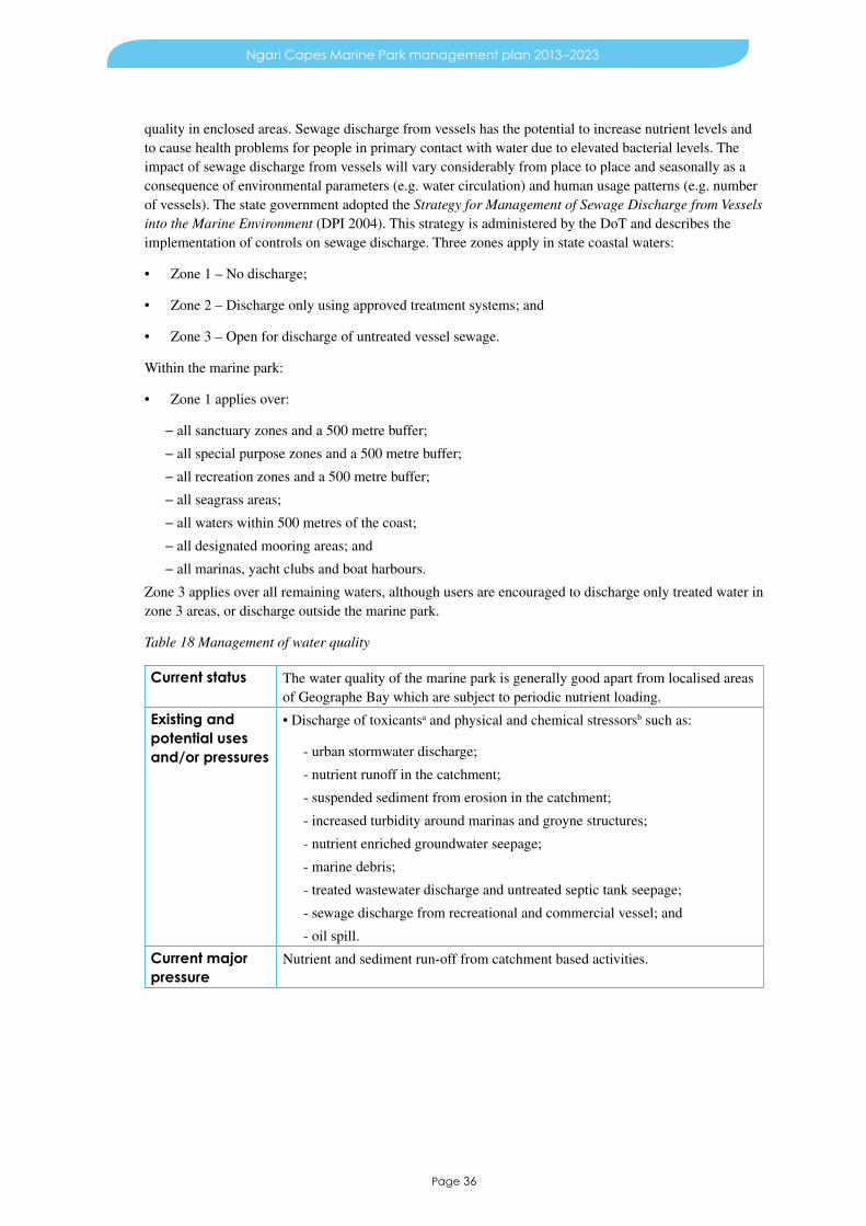
Page 36
Ngari Capes Marine Park management plan 2013–2023
quality in enclosed areas. Sewage discharge from vessels has the potential to increase nutrient levels and to cause health problems for people in primary contact with water due to elevated bacterial levels. The impact of sewage discharge from vessels will vary considerably from place to place and seasonally as a consequence of environmental parameters (e.g. water circulation) and human usage patterns (e.g. number of vessels). The state government adopted the Strategy for Management of Sewage Discharge from Vessels into the Marine Environment (DPI 2004). This strategy is administered by the DoT and describes the implementation of controls on sewage discharge. Three zones apply in state coastal waters:
• Zone 1 – No discharge;
• Zone 2 – Discharge only using approved treatment systems; and
• Zone 3 – Open for discharge of untreated vessel sewage.
Within the marine park:
• Zone 1 applies over:
− all sanctuary zones and a 500 metre buffer;
− all special purpose zones and a 500 metre buffer;
− all recreation zones and a 500 metre buffer;
− all seagrass areas;
− all waters within 500 metres of the coast;
− all designated mooring areas; and
− all marinas, yacht clubs and boat harbours.
Zone 3 applies over all remaining waters, although users are encouraged to discharge only treated water in zone 3 areas, or discharge outside the marine park.
Table 18 Management of water quality
Current status The water quality of the marine park is generally good apart from localised areas of Geographe Bay which are subject to periodic nutrient loading.
Existing and potential uses and/or pressures
•Dischargeoftoxicantsa and physical and chemical stressorsb such as:
- urban stormwater discharge;
- nutrient runoff in the catchment;
- suspended sediment from erosion in the catchment;
- increased turbidity around marinas and groyne structures;
- nutrient enriched groundwater seepage;
- marine debris;
- treated wastewater discharge and untreated septic tank seepage;
- sewage discharge from recreational and commercial vessel; and
- oil spill.
Current major pressure
Nutrient and sediment run-off from catchment based activities.

Page 37
Ngari Capes Marine Park management plan 2013–2023
Management objective
To maintain the high water quality of the marine park by ensuring that there is no significant impact from nutrient and sediment run-off from catchment based activities.
Specific actions 1. See management program actions in Section 5.
2. Determine appropriate baseline measures from which changes in water quality can be measured (DEC) (H–KMS).
3. Liaise with relevant authorities and organisations to reduce land and sea based pollutant inputs to the marine environment e.g. marine debris, nutrients and stormwater (DEC, DoF, DoAF, LG, DoW, DoT, SWCC, Geocatch, landowners) (H).
4. Support and contribute, where possible, to efforts to reduce the amount of floating, submerged and beached marine debris in the marine park (DEC) (H).
5. Map the ecological and social values of the reserves that are highly sensitive to oil and chemical spills and ensure that this information is accessible to the State Committee for Combating Marine Oil Pollution (DEC) (H).
6. Enforce controls on the discharge of sewage from vessels in the marine park in areas designated ‘Zone 1’ (DoT, DEC) (H).
7. Maintain a pollutant input database for the marine park (DEC) (M).
8. Highlight the need for integrated management and the linkages between the marine environment and adjacent catchments (DEC) (L).
9. Investigate the option for the listing of the marine park with the International Maritime Organisation as a ‘Particularly sensitive sea area’ or state designation as a ‘Marine environment high risk area’ to minimise risks associated with shipping (DEC) (L).
Performance measures
1. Nutrients: Chlorophyll a and inorganic nitrogen concentration in seawater
2. Toxicants: concentration in seawater
3. Pathogens: Faecal coliform concentration in seawater
4. Litter: Mass of litter at selected monitoring sites
Desired trends 1. Constant or negative
2. Constant or negative
3. Constant or negative
4. Negative
Short-term target To be developed as required.
Management targets
The targets for water quality are as follows:
i. Sanctuary zones, Flinders Bay and West Coastc – no change from background levels, as a result of human activity in the marine park.
ii. Geographe Bay – to be developed in consultation with relevant agencies.
iii. All other areas – no change from background levels as a result of human activity in the park, except in designated areas approved by the appropriate Government regulatory authority. The area not meeting appropriate guidelines is not to exceed 1 per cent of these areas in total.
Abbreviations for priorities: H–KMS – high – key management strategy, H – high, M – medium, L – low.a Toxicants are chemical contaminants that have the potential to exert toxic effects at concentrations beyond
acceptable levels due to human activity (modified from ANZECC & ARMCANZ 2000b).b Physical and chemical stressors include heavy metals, dissolved oxygen, temperature and/or nutrients. When human
activity causes changes in ambient levels of naturally occurring physical and chemical components of the marine environment, beyond acceptable limits, there may be impacts on ecosystems or individual species (modified from ANZECC & ARMCANZ 2000b).
c State waters between Cape Naturaliste and Cape Leeuwin.

Page 38
Ngari Capes Marine Park management plan 2013–2023
6.3 Seagrass communities (KPI)Seagrasses in the marine park are highly diverse and include endemic and rare deep water species. Seagrass is an important primary producer and provides spawning and nursery habitat for a wide range of finfish and invertebrates.
Approximately half of the world’s 70 species of seagrasses are found in Australian waters, with the highest biomass and species diversity occurring in the south-west of Western Australia. There are 13 species of seagrass in the marine park, three of which are endemic and two of which form unusual communities in deep water. Seagrass communities are typically present on sand bottoms and can sometimes also occur on sand patches over reef pavement. The seagrasses within the marine park include both perennial and ephemeral species. These seagrass types make up approximately 36 per cent and 3 per cent respectively of the total habitats in the marine park. Of the perennial seagrass coverage, the majority of areas are classified as having a sparse coverage (approximately 52 per cent), followed by medium (approximately 23 per cent) and dense (approximately 25 per cent) coverage. The ephemeral seagrasses are all sparse.
The Geographe Bay seagrass meadows are among the most extensive temperate seagrass communities on the west coast (MPRSWG 1994), and include 10 species from five genera (Amphibolis, Posidonia, Halophila, Heterozostera and Thalassodendron). Geographe Bay is dominated by stands of the narrow-leaf tape-weed (Posidonia sinuosa) that covers approximately 70 per cent of Geographe Bay. It has smaller areas of Posidonia angustifolia, Amphibolis griffithii, A. antarctica and minor species, which have irregular distributions both spatially and temporally (Lord 1995). Thalassodendron pachyrhizum, Posidonia spp. and Amphibolis spp. are also found in depths of between 27 and 45 metres (Walker et al 1994).
The area between Cape Leeuwin and Cape Naturaliste is dominated by sparse, perennial seagrasses in deeper waters. South of Cape Naturaliste, seagrass beds occur within bays protected by offshore reefs or by headlands. Seagrasses of the Ostenfeldii complex (i.e. P. ostenfeldii, P. coriacea, and P. kirkmanii) predominate in exposed areas as their strong leaves and deep roots are adapted to heavy swell conditions. The clear waters near Cape Mentelle allow T. pachyrhizum to predominate, forming large, sparse beds at depths greater than 35 metres. Posidonia spp. and Amphibolis spp. also occur in relatively deep waters. Deep seagrass beds, exposed to heavy swells are not found on any other coast in the world (Kirkman & Kuo 1990).
Flinders Bay seagrass communities include A. antarctica, A. griffithii, T. pachyrhizum, Halophila ovalis and Heterozostera nigricaulis. T. pachyrhizum H. ovalis and H. nigricaulis species are generally ephemeral, and all are sparsely distributed with smaller amounts of perennial seagrasses present. P. sinuosa is common in Storm Bay. Similarly to other areas, T. pachyrhizum dominates in deeper water.
Seagrasses are a food source for many marine organisms either through direct consumption or as a part of the detrital food chain. Seagrass meadows are important habitat and nursery for many species, including those targeted by recreational and commercial fishers. Seagrasses also play an important role in stabilising coastal sediments and thereby the coast itself, both as a living habitat and as accumulated sea wrack.
Seagrasses are susceptible to increased nutrient levels which can cause an increase in epiphytic loads on seagrass blades (leaves) and/or increased phytoplankton in the water column that in turn results in shading of seagrasses to limit photosynthetic ability.
Seagrasses are protected throughout the state under the Wildlife Conservation Act 1950 (WC Act) and the FRM Act. In addition, development proposals that may impact on macroalgal and seagrass communities are subject to environmental impact assessment under the requirements of the EP Act. Guidance for the Assessment of Environmental Factors. Seagrass Habitat Protection (EPA 1998) provides non-statutory advice to proponents, consultants and the public generally about the minimum requirements for environmental management.

Page 39
Ngari Capes Marine Park management plan 2013–2023
Table 19 Management of seagrass communities
Current status The seagrass communities are generally undisturbed, apart from localised nearshore areas in Geographe Bay which may be affected by stormwater discharge and sediment inundation associated with sand by-passing works at Port Geographe.
Existing and potential uses and/or pressures
• Discharge of toxicantsa and physical and chemical stressorsb such as:
- urban stormwater discharge;
- nutrient runoff in the catchment;
- unregulated mooring and anchoring within seagrass dominated areas that cause scouring; and
- sand mining, dredging and sand by-passing works.
Current major pressures
• Discharge of nutrients from catchment activities, stormwater run-off and treated sewage discharge.
• Unregulated mooring and anchoring.
Management objective
To maintain the diverse and abundant seagrass communities of the marine park by ensuring that there is no significant impact from nutrient and sediment run-off from catchment based activities and management of mooring activity.
Specific actions 1. See management program actions in Section 5.
Performance measures
1. Diversity
2. Biomass
Desired trends 1. Constantc
2. Constant or positivec
Short-term target To be developed as required.
Management targets
1. No loss of seagrass diversity and/or associated organisms as a result of human activity in the marine park.
2. No permanent loss in perennial seagrass biomass and/or associated organisms from 2013 levels as a result of human activity in the marine parkd.
a Toxicants are chemical contaminants that have the potential to exert toxic effects at concentrations beyond acceptable levels due to human activity (modified from ANZECC & ARMCANZ 2000b).
b Physical and chemical stressors include heavy metals, dissolved oxygen, temperature and/or nutrients. When human activity causes changes in ambient levels of naturally occurring physical and chemical components of the marine environment, beyond acceptable limits, there may be impacts on ecosystems or individual species (modified from ANZECC & ARMCANZ 2000b).
c Refers to native species only, not’exotic’/introduced species.d Excludes loss of a minor, transient or accidental nature
6.4 Intertidal reef communities (KPI)Intertidal reef communities consist of a diverse range of reef dependent plants and animals that are adapted to live within shallow, high energy environments.
Intertidal reef communities are found throughout the marine park, occurring along approximately 141 kilometres of the shoreline. Inshore intertidal reefs are found as low relief reef platforms of limestone or sandstone substratum, while offshore intertidal reefs are low relief platforms of limestone or high relief granite or gneiss. Intertidal reefs are typically exposed to high energy ocean swell and can be tidally exposed, particularly during spring tides. Marine life on inshore and offshore intertidal reef is influenced by the level of exposure to wave energy. Algae able to hold fast to the reef by dissipating energy through the canopy are the main primary producers in both types of intertidal reef systems. At least 26 intertidal species of algae have been identified in the marine park (Osborne 2002).

Page 40
Ngari Capes Marine Park management plan 2013–2023
Inshore intertidal reefs lie at the interface of terrestrial and marine environments and typically host turf algae, mussels, crabs, barnacles, and anemones as well as sea stars, sponges and juvenile reef fish. Life on these reefs can be influenced by sediment inundation when wave wash carries sand from beaches. Because of this, nearshore areas of inshore intertidal reef may support ephemeral communities if the reef adjoins a sandy beach. Offshore intertidal reefs generally host a wider range of plants and animals than inshore intertidal reefs because they are generally less affected by human activity. Offshore intertidal reefs host macroalgae, turf algae, a variety of shell producing molluscs, abalone, crabs, shrimps, barnacles and juvenile reef fish. Some of the largest intertidal reefs occur at Yallingup, Cowaramup Bay, Margaret River, Gnarabup, Hamelin Island and Augusta.
Under the FRM Act, DoF is responsible for the management of the recreational and commercial take of intertidal target species such as abalone, using strategies such as bag and size limits, closures, licensing and quotas. Any development proposals that may affect intertidal reef communities may be subject to assessment by the OEPA in accordance with the requirements of the EP Act.
Pressures on the intertidal reefs come primarily from the growing coastal population and include physical disturbance such as trampling by reef walkers, overfishing and shell collecting. This is particularly apparent at the highly visited Yallingup Lagoon reef.
Table 20 Management of intertidal reef communities
Current status The intertidal reef communities are generally undisturbed, apart from localised disturbance in some areas of high visitor use, such as Yallingup Reef, and areas subject to commercial and recreational abalone fishing.
Existing and potential uses and/or pressures
• Discharge of toxicantsa and physical and chemical stressorsb such as:
- urban stormwater discharge;
- nutrient runoff in the catchment;
- infrastructure development such as marinas and groynes;
- commercial and recreational fishing;
- trampling by reef walkers; and
- shell collecting.
Current major pressures
• Physical disturbance from reef walkers
• Overfishing.
Management objective
To maintain diverse and healthy intertidal reef communities in the marine park by ensuring that there is no significant impact from physical disturbance from reef walkers and overfishing within the marine park.
Specific actions 1. See management program actions in Section 5.
2. Seek to minimise trampling of intertidal reef communities in affected areas through education programs (DEC) (M).
Performance measures
1. Diversity
2. Biomass
Desired trends 1. Constantc
2. Constant or positivec
Short-term target To be developed as required

Page 41
Ngari Capes Marine Park management plan 2013–2023
Management targets
1. No loss of species diversity of intertidal reef communities as a result of human activity in the marine park.
2. Sanctuary zones – No loss of biomass of intertidal reef platform communities as a result of human activity in the marine parkd.
3. All other zones – No loss of biomass of intertidal reef platform communities except for species for which extractive activity is permitted, with sustainable limits to be set by DoF (in collaboration with DEC) which provides for ecological function and integrity to be maintainedd.
Abbreviations for priorities: H–KMS – high – key management strategy, H – high, M – medium, L – low.a Toxicants are chemical contaminants that have the potential to exert toxic effects at concentrations beyond
acceptable levels due to human activity (modified from ANZECC & ARMCANZ 2000b).b Physical and chemical stressors include heavy metals, dissolved oxygen, temperature and/or nutrients. When human
activity causes changes in ambient levels of naturally occurring physical and chemical components of the marine environment, beyond acceptable limits, there may be impacts on ecosystems or individual species (modified from ANZECC & ARMCANZ 2000b).
c Refers to native species only, not ‘exotic’/introduced species.d Excludes loss of a minor, transient or accidental nature
6.5 Shallow subtidal reef communities (KPI)Shallow subtidal reef communities consist of a diverse range of reef dependent plants and animals that are adapted to live within relatively shallow, high energy environments which may be influenced by strong currents.
Shallow subtidal reef (shallow reef) is, for the purposes of this plan, defined as limestone and granite reefs found between one and ten metres in depth. Shallow reef is distinct from deep reef because of the ecological differences associated with depth and potential pressures.
Approximately 11 per cent of the marine park is shallow reef, of which 31 per cent is classified as limestone and 69 per cent granite.
Significant differences occur in algal assemblages between high and low relief limestone reefs. In sheltered, low relief limestone areas, Kelp species Sargassum spp. and Ecklonia radiata are dominant, while between the capes, Curdiea obesa, Pterocladia lucida and Callophyllus spp. are dominant (Harman, Harvey & Kendric 2003). Low relief limestone habitat is associated with a wide range of invertebrate life such as ascidians, calcareous sponges and gastropods. High relief areas are covered by a higher diversity of fleshy macroalgae (e.g. E. radiata, Sargassum doryocarpa, Platythalia sp., Cystophora spp.) than low relief areas but have a lower overall algal biomass (Harman, Harvey & Kendric 2003). Colonial ascidians, sponges, octocorals and soft corals are common throughout the caves and overhangs of the high relief limestone areas. Also associated with this habitat are mobile invertebrates such as sea stars, sea urchins, crustaceans and gastropods. More species of fish are found in high relief limestone reefs than in low relief reefs (Harman, Harvey & Kendric 2003). Within Geographe Bay and Flinders Bay, patches of shallow limestone reef occur amongst the seagrass communities. There is also a long limestone reef, known as the Four Mile Reef, that traverses Geographe Bay.
Granite reef is characterised by large buried boulders or fields of small boulders that may also incorporate small sand patches. Shallow granite reefs host a diverse range of sessile invertebrates including colonial ascidians, sponges, octocorals and soft corals. Mobile invertebrates such as sea stars, sea urchins and gastropods are also present. The western king wrasse (Coris auricularis), dusky morwong (Dactylophora nigricans) and common scalyfin (Palma spp.) are more typical of these reefs than limestone reefs. Granite reefs are dominated by the algae Platythalia angustifolia (Harman, Harvey & Kendric 2003). Low relief shallow granite reefs support a wide variety of invertebrates including ascidians, calcareous sponges and gastropods. High relief shallow granite reefs are dominated by crustose coralline algae as well as kelp and turf. Shallow granite reef are characterised by species rich canopies of E. radiata and species of Sargassum, Cystophora, Platythalia and Scytothalia and other large brown algae (Womersley 1987; Kendric et al 1999).

Page 42
Ngari Capes Marine Park management plan 2013–2023
A 2007 survey within the marine park found that highly targeted fishes that inhabit shallow subtidal reefs are present in low numbers (Westera et al 2007). These include western blue groper (Achoerodus gouldii), Western Australian dhufish (Glaucosoma hebraicum), breaksea cod (Epinephelides armatus), harlequin fish (Othos dentex), and western foxfish (Bodianus frenchii) .
Under the FRM Act, DoF is responsible for the management of the recreational and commercial take of invertebrate and fish species. This management is implemented under an ecosystem based fisheries management approach and through strategies such as bag and size limits for target species, closures, licensing and quotas.
Table 21 Management of shallow subtidal reef communities
Current status Shallow subtidal reef communities are generally undisturbed physically, but there is localised depletion of rock lobster and targeted finfish species such as western blue groper, West Australian dhufish, breaksea cod , harlequin fish, and western foxfish.
Existing and potential uses and/or pressures
• Discharge of toxicantsa and physical and chemical stressorsb such as:
- urban stormwater discharge; o nutrient runoff in the catchment;
- commercial and/or recreational fishing;
- sediment plumes from rivers and inlets;
- anchoring; and
- diving and snorkelling.
Current major pressure
• Commercial and recreational fishing.
Management objective
To maintain diverse and healthy shallow subtidal reef communities in the marine park by ensuring that there is no significant impact from commercial and recreational fishing within the marine park.
Specific actions 1. See management program actions in Section 5.
Performance measures
1. Diversity
2. Biomass
Desired trends 1. Constantc
2. Constant or positivec
Short-term target To be developed as required.
Management target
1. No loss of species diversity in shallow subtidal reef communities as a result of human activity in the marine park.
2. Sanctuary zones – No loss of biomass of shallow subtidal reef communities as a result of human activity in the marine parkd.
3. All other zones – No loss of biomass of shallow subtidal reef communities except for species for which extractive activity is permitted, with sustainable limits to be set by DoF (in collaboration with DEC) which provides for ecological function and integrity to be maintainedd.
a Toxicants are chemical contaminants that have the potential to exert toxic effects at concentrations beyond acceptable levels due to human activity (modified from ANZECC & ARMCANZ 2000b).
b Physical and chemical stressors include heavy metals, dissolved oxygen, temperature and/or nutrients. When human activity causes changes in ambient levels of naturally occurring physical and chemical components of the marine environment, beyond acceptable limits, there may be impacts on ecosystems or individual species (modified from ANZECC & ARMCANZ 2000b).
c Refers to native species only, not ‘exotic’/introduced species.d Excludes loss of a minor, transient or accidental nature.

Page 43
Ngari Capes Marine Park management plan 2013–2023
6.6 Deep reef communities (KPI)Deep reef communities in the marine park consist of a diverse range of reef dependent plants and animals that are adapted to live within deep, low and high energy environments which may be light limited and influenced by strong currents.
Deep reef, for the purpose of this plan, is defined as limestone or granite reef found in depths greater than 10 metres. Deep reef has been distinguished from shallow reef because of the significant ecological differences associated with depth and exposure. Approximately 18 per cent of the marine park is deep reef, of which 38 per cent is limestone and 62 per cent is granite.
The assemblage of species hosted by limestone and granite are similar in shallow and deep reef. However, significant differences with depth do occur. Abundance and size of organisms, particularly finfish, tends to be greater on deep reefs and include more predatory species as opposed to shallow reef which host more omnivores and herbivores. Algal kelp species such as Ecklonia radiata and Sargassum doryocarpa are dominant with understory of Curdiea obesa, Pterocladia lucida and Callophyllus spp. Platythalia quercifolia and to a lesser extent Cystophora grevillei.
Deep reef communities are considered to be generally undisturbed physically. However, pressures on the biological system are exerted through commercial and recreational fishing, scuba diving, and anchoring. Marine pests, introduced via shipping, potentially have an impact on deep reef communities as shipping traffic increases. Management will focus on zoning that protects representative deep reef communities, on implementing research and monitoring programs to increase our relatively limited understanding of these more remote systems and on developing education programs.
Under the FRM Act, DoF is responsible for the management of the recreational and commercial take of invertebrate and fish species. This management is implemented under an ecosystem based fisheries management approach and through strategies such as bag and size limits for target species, closures, licensing and quotas.
Table 22 Management of deep reef communities
Current status Deep reef communities are largely undisturbed, apart from localised depletion of rock lobster and targeted finfish species such as western blue groper (Achoerodus gouldii), West Australian dhufish (Glaucosoma hebraicum), breaksea cod (Epinephelides armatus), harlequin fish (Othos dentex), and western foxfish (Bodianus frenchii).
Existing and potential uses and/or pressures
• Discharge of toxicantsa and physical and chemical stressorsb such as:
- commercial and/or recreational fishing;
- shipping;
- diving; and
- anchoring.
Current major pressure
• Commercial and recreational fishing.
Management objective
To maintain diverse and healthy deep reef communities in the marine park by ensuring that there is no significant impact from commercial and recreational fishing within the marine park.
Specific actions 1. See management program actions in Section 5.
Performance measures
1. Diversity
2. Biomass
Desired trends 1. Constantc
2. Constant or positivec
Short-term target To be developed as required.

Page 44
Ngari Capes Marine Park management plan 2013–2023
Management targets
1. No loss of species diversity in deep reef communities as a result of human activity in the marine park.
2. Sanctuary zones – No loss of biomass of deep reef communities as a result of human activity in the marine parkd.
3. All other zones – No loss of biomass of deep reef communities except for species for which extractive activity is permitted, with sustainable limits to be set by DoF (in collaboration with DEC) which provides for ecological function and integrity to be maintainedd.
a Toxicants are chemical contaminants that have the potential to exert toxic effects at concentrations beyond acceptable levels due to human activity (modified from ANZECC & ARMCANZ 2000b).
b Physical and chemical stressors include heavy metals, dissolved oxygen, temperature and/or nutrients. When human activity causes changes in ambient levels of naturally occurring physical and chemical components of the marine environment, beyond acceptable limits, there may be impacts on ecosystems or individual species (modified from ANZECC & ARMCANZ 2000b).
c Refers to native species only, not ‘exotic’/introduced species.d Excludes loss of a minor, transient or accidental nature.
6.7 Coral communitiesThe coral communities consist of both tropical and temperate species. Their presence is influenced by substrate, depth, availability of food and interaction of the Capes and Leeuwin currents.
Corals are found patchily throughout the marine park. Unusual communities of endemic and tropical corals are found on subtidal reefs, as bommie formations and on artificial structures. At least 14 species representing seven genera are present, including Coscinaraea marshae, C. mcneilli, Favites abdita, F. complanata, Goniastrea aspera, G. australensis, Montipora mollis, Plesiastrea versipora, Scolymia australis, Symphyllia wilsoni, Turbinaria frondens, T. mesenterina, T. reniformis and T. peltata. Of these 14 species, 10 are tropical, two are temperate and two (C. marshae and S. wilsoni) are endemic to the south-west of Western Australia (Marsh, pers. comm.).
Geographe Bay has a number of areas of low relief, rocky reef in depths of 5 to 20 metres that provide substrate for corals. Coral communities are particularly well developed between Dunsborough and Cape Naturaliste. Rare giant colonies of Turbinaria in Eagle Bay are an unusual feature of the area. Of the 10 tropical species, five have their southern limit near Cape Naturaliste and are relatively abundant on the offshore reefs in Geographe Bay. There is also an unusual assemblage on the Busselton jetty that includes deeper water corals. The assemblage is best developed towards the end of the jetty. Corals occur patchily along the west coast of the marine park, nestled among the macroalgae and most commonly found on sheltered reefs. Corals are also found on the limestone patch reefs in Flinders Bay.
The commercial and recreational taking of corals is managed under the FRM Act. Coral communities in the marine park appear to be largely undisturbed. The major pressures on these communities include siltation and pollution at the mouths of some inlets, trampling by reef walkers, anchoring, illegal aquarium collection, diver damage and fishing line entanglement. Crushing of coral communities by rock lobster pots may also occur.
Management of coral communities is precautionary, including zoning to provide insurance against potential impacts. Research and monitoring to assess the levels of pressure is an important strategy. Collaboration with agencies responsible for managing some of the major pressures on corals, for example catchment activities and boat based activities will be needed, as will public education about the effects of human activities on corals. Coral occurrence within the marine park is an unusual and valuable feature. This is due to its extension so far south of the warm tropical waters where coral is usually found, its limited abundance, importance as habitat within the park and its slow growth rate, Appropriate management of corals and coral reef communities will thus be a consideration in park management. The management plan recommends that no collection of coral should be permitted within the marine park due to their slow growth rates, limited abundance and ecological importance as habitat.

Page 45
Ngari Capes Marine Park management plan 2013–2023
Table 23 Management of coral communities
Current status Coral communities in the marine park appear to be largely undisturbed, apart from some localised disturbance in areas of high use.
Existing and potential uses and/or pressures
• Discharge of toxicantsa and physical and chemical stressorsb such as:
- siltation and nutrients from inlet outflows;
- trampling by reef walkers;
- installation and proliferation of moorings;
- anchoring;
- illegal aquarium collection / removal of “souvenirs”
- diver fin damage, particularly in areas with high visitation;
- crushing by rock lobster pots; and
- recreational fishing line entanglement.
Current major pressures
• Siltation and nutrients from inlet outflow.
• Anchoring.
• Physical disturbance from reef walkers.
Management objective
To maintain diverse and healthy coral communities in the marine park by ensuring that there is no significant impact from human activities within the marine park.
Specific actions 1. See management program actions in Section 5.
2 Facilitate research that increases understanding of high latitude coral ecology and addresses knowledge gaps relevant to management (DEC) (M).
Performance measures
1. Diversity
2. Biomass
Desired trends 1. Constant
2. Constant or positive
Short-term target To be developed as required.
Management targets
1. No loss of species diversity from coral communities as a result of human activity in the marine park.
2. No loss of biomass of coral communities except for species for which extractive activity is permitted, with sustainable limits to be set by DoF (in collaboration with DEC) which provides for ecological function and integrity to be maintainedc.
Abbreviations for priorities: H–KMS – high – key management strategy, H – high, M – medium, L – low.a Toxicants are chemical contaminants that have the potential to exert toxic effects at concentrations beyond
acceptable levels due to human activity (modified from ANZECC & ARMCANZ 2000b).b Physical and chemical stressors include heavy metals, dissolved oxygen, temperature and/or nutrients. When human
activity causes changes in ambient levels of naturally occurring physical and chemical components of the marine environment, beyond acceptable limits, there may be impacts on ecosystems or individual species (modified from ANZECC & ARMCANZ 2000b).
c Excludes loss of a minor, transient or accidental nature

Figure 4: Major benthic and shoreline habitats within and adjacent to the Ngari Cape Marine Park
Page 46

Page 47
Ngari Capes Marine Park management plan 2013–2023
6.8 Invertebrate communities (excluding corals) (KPI)The invertebrate communities consist of both tropical and temperate species. Their presence is influenced by substrate, depth, availability of food and the interaction of the Capes and Leeuwin currents. Species exhibit high levels of endemism.
Marine invertebrates are animals such as sea urchins, starfish, sea cucumbers, crabs, lobsters, mussels, oysters, octopus, abalone, jellyfish, anemones, sponges, sea squirts and assorted bryozoans, worms and brachiopods that live on and in the seafloor. Invertebrates have important functions within the ecosystem as a food source for other invertebrates, finfish and migratory birds, as well as in nutrient cycling.
The marine park has been found to host a diverse array of invertebrate communities due in part to the range of habitats and depths, and the influence of the Capes and Leeuwin currents. These currents ensure the presence of tropical and temperate species, with both Cape Leeuwin and Cape Naturaliste recognised as hotspots of invertebrate diversity. Nevertheless, knowledge of the invertebrate communities of the marine park is incomplete. The limited knowledge about invertebrates is a significant challenge to management. Data from surveys and reviews of species distributions in the marine park, available at the time the management plan was being prepared, suggest there are approximately 100 species of echinoderms (with at least three species endemic to the South West) and 115 species of crabs, prawns and shrimps (43 per cent endemic to southern Australia and 6 per cent endemic to the South West). While no list of molluscs has been compiled, most molluscs in the South West are likely to be of temperate affinity with only two per cent estimated to have a tropical affinity. The lighthouse shell, Campanile symbolicum, which is endemic to the South West, ranging from Esperance to Geraldton, is found in the marine park. Survey work on ascidians and sponges identified 44 and 110 species respectively. Of note were the high diversity of these groups at individual sampling sites and the lack of similarity among sites.
Invertebrate communities in the marine park are generally undisturbed. The major pressures on them are commercial and recreational fishing, siltation and pollution at the mouths of some inlets, trampling by reef walkers, anchoring, aquarium collection, diver damage and fishing line entanglement. Crushing of invertebrate communities by rock lobster pots may also occur.
Under the FRM Act, DoF is responsible for the management of the recreational and commercial take of invertebrate species using strategies such as bag and size limits, closures and quotas.
Fisheries management scales do not currently reconcile with the spatial scales of a marine park and as such, populations of some invertebrates in the marine park could become locally depleted even though a fishery is being managed on a sustainable basis at a broader scale. To help overcome this, DoF will continue to consider the appropriateness of recreational and/or commercial extraction and whether specific invertebrates should be protected in part, or all, of the marine park. Consideration could be based on a number of factors including species distribution, abundance, size distribution, life history, and an assessment of the ecological and social importance of the species in the context of the marine park.

Page 48
Ngari Capes Marine Park management plan 2013–2023
Table 24 Management of invertebrate communities (excluding corals)
Current status Most invertebrate populations are considered to be stable, although the existing information base is poor. Anecdotal information suggests some species of molluscs and crustaceans, particularly in shallow, easily accessible areas may be locally depleted.
Existing and potential uses and/or pressures
• Discharge of toxicantsa and physical and chemical stressorsb such as:
- recreational and commercial fishing;
- sediment and nutrients from inlet outflow;
- trampling by reef walkers;
- installation and proliferation of moorings;
- anchoring; o aquarium collection / removal of ‘souvenirs’; and
- crushing by rock lobster pots.
Current major pressures
• Recreational and commercial fishing.
• Siltation and nutrients from inlet outflow.
• Anchoring.
• Physical disturbance from reef walkers.
Management objective
To maintain diverse and abundant invertebrate communities in the marine park by ensuring that there is no significant impact from human activities within the marine park.
Specific actions 1. See management actions in Section 5.
2. Identify invertebrate species that require protection from recreational and commercial fishing (DoF, DEC) (H–KMS).
3. Participate in reviews of the management arrangements for recreational and commercial fisheries targeting invertebrates (DoF, DEC) (M).
Performance measures
1. Diversity
2. Biomass
Desired trends 1. Constantc
2. Constant or positivec
Short-term target To be developed as required.
Management targets
1. No loss of invertebrate diversity as a result of human activity in the marine park.
2. No loss of non-targeted invertebrate species biomass as a result of human activity in the marine parkd.
3. Abundance and size composition of invertebrate species in sanctuary zones and non-targeted invertebrate species in other zones of the marine park to be at near natural levelse.
4. Management targets for targeted invertebrate species to be determined in consultation with DoF, in its role as the lead agency for managing fisheries.
Abbreviations for priorities: H–KMS – high – key management strategy, H – high, M – medium, L – low.a Toxicants are chemical contaminants that have the potential to exert toxic effects at concentrations beyond
acceptable levels due to human activity (modified from ANZECC & ARMCANZ 2000b).b Physical and chemical stressors include heavy metals, dissolved oxygen, temperature and/or nutrients. When human
activity causes changes in ambient levels of naturally occurring physical and chemical components of the marine environment, beyond acceptable limits, there may be impacts on ecosystems or individual species (modified from ANZECC & ARMCANZ 2000b).
c Refers to native species only, not ‘exotic’/introduced species.d Excludes loss of a minor, transient or accidental nature.e Natural refers to the abundance that would occur in areas that are undisturbed and/or unexploited by human
activities.
Page 49
Ngari Capes Marine Park management plan 2013–2023
1 Under the FRM Act ‘fish’ means an aquatic organism of any species (whether alive or dead) and includes: the eggs, spat, spawn, seeds, spores, fry, larva or other source of reproduction or offspring of an aquatic organism; and a part only of an aquatic organism (including shell or tail), but does not include aquatic mammals, aquatic reptiles, aquatic birds, amphibians or pearl oysters (covered under the Pearling Act 1990).
6.9 Finfish (KPI)The finfish fauna of the marine park consists of tropical and temperate species whose presence is influenced by habitat type, depth, availability of food and the influences of the Capes and Leeuwin currents.
The finfish assemblages of the marine park include both migratory, transient and resident species. About 85 per cent of all temperate marine finfish species found in the marine park are endemic to Australia, while a high number have a relatively limited distribution. Migratory species include tailor (Pomatomus saltatrix), Australian herring (Arripis georgianus), and Australian salmon (Arripis truttaceus). Pelagic finfish such as yellow-tailed kingfish (Seriola lalandi), silver trevally (Pseudocaranx dentex) and blue mackerel (Scomber australasicus) are considered transient and may regularly pass in and out of the marine park.
At least 150 species have been identified throughout the marine park as being reef-associated (Hutchins 1994). Of these, 77 per cent are warm temperate species, 18 per cent are subtropical species and five per cent are tropical.
A survey of marine communities of the South West capes region (Westera et al 2007) recorded a total of 73 species of fish at the Busselton jetty for the summers of 2005–6 and 2006–7. The high number of species at the jetty highlights the importance of this structure as a habitat for fish in Geographe Bay. Apart from Busselton jetty, the highest number of species was recorded at Flinders Bay and the highest species diversity at Cape Naturaliste. The most abundant species across the region were the Maori wrasse (Opthalmolepis lineolatus), red banded wrasse (Pseudolabrus biserialis), McCulloch’s scalyfin (Parma mccullochi), and western king wrasse (Coris auricularis). The yellow headed hulafish (Trachinops noarlungae), black headed puller (Chromis klunzingeri), rough bullseye and common bullseye (Pempheris multiradiata and P. klunzingeri) were also common at Eagle Bay and Geographe Bay (Westera et al 2007).
At Hamelin Bay and Kilcarnup, stingrays and eagle rays are common in the nearshore, particularly near boat launching facilities. It has become common practice, over the last 20 to 30 years, for fishers to discard offal into the water for the rays to feed on. At these times ray numbers are high and their presence has become a significant drawcard for visitors. It is known that this ‘provisioning’ is increasing at Hamelin Bay although little is known about the impact on the rays (both behavioural and physical) and the risk to humans. There is a need to manage the anticipated increase in visitor numbers and interest in interaction with rays as the deliberate feeding of wildlife may have adverse effects on the rays and visitors may be at risk. DEC policy does not generally support the feeding of wildlife in marine parks. There is an existing fisheries closure to prevent the take of stingrays and skates (members of the Superorder Batoidea) in the area of Hamelin Bay that is visited by these habituated animals.
DoF is responsible for the sustainable management of fish1 throughout Western Australia. This management uses an ecosystem based fisheries management approach and through a variety of strategies and tools which include, among others, licensing, closures and quotas. The finfish found in the marine park demonstrate a wide range of life history characteristics that influence their population dynamics. The degree to which populations in this area are self-recruiting or rely on external recruitment is unknown for most species. However, it is likely that the marine park will serve as an important source of recruits, particularly for species that aggregate to spawn and relatively long-lived species.
The main pressures on finfish are extraction and habitat degradation (through, for example, coastal development and modification). The management of exploited finfish needs to consider the population viability in the context of maintaining the values of the marine park. Fisheries management scales do not fully reconcile with the spatial scales of a marine park and as such, populations of some finfish in the marine park could become locally depleted even though a fishery is being managed on a sustainable basis at a broader scale. Periodic consideration by DoF as to the appropriateness of recreational and/or commercial extraction levels and whether specific finfish should be protected in part of, or all, the marine

Page 50
Ngari Capes Marine Park management plan 2013–2023
park will be undertaken, consistent with its developing an ecosystem based fisheries management approach throughout Western Australian waters. Consideration could be based on a number of factors including species distribution, abundance, size distribution, life history, and an assessment of the ecological and social importance of the species in the context of the marine park. Management will primarily focus on maintaining targeted species diversity, protecting important habitats, increasing abundance and recovering age structure in sanctuary zones. Priority species to monitor include those that are long-lived, change sex, aggregate to spawn, and/or have limited home ranges.
Table 25 Management of finfish
Current status Targeted fishes have generally been found to be low in abundance in the coastal waters of the capes region, particularly the West Australian dhufish, western blue groper, breaksea cod, queen snapper, harlequin fish and western foxfish (Westera et al, 2007). From oral history accounts, present levels would seem to be low compared to earlier levels.
Existing and potential uses and/or pressure
• Commercial and recreational fishing.
• Habitat degradation
Current major pressure
• Commercial and recreational fishing.
Management objective
To maintain diverse and abundant finfish communities in the marine park by ensuring that there is no significant impact from commercial and recreational fishing within the marine park.
Specific actions 1. See management program actions in Section 5
2. Identify finfish species that require protection from recreational or commercial fishing (DoF, DEC)) (H–KMS).
3. Initiate research to identify important finfish nursery, spawning and aggregation sites (DoF, DEC) (M).
4. Participate in reviews of the management arrangements for recreational and commercial fisheries targeting finfish (DEC, DoF) (M).
5. Quantify the level and significance of by catch for commercial and recreational fishing and, if necessary, implement measures to progressively reduce the bycatch (DoF, DEC) (M).
Performance measures
1. Diversity
2. Biomass
Desired trends 1. Constantb
2. Constant or positiveb
Short-term target To be developed as required.
Management targets 1. No loss of finfish diversity as a result of human activity in the marine park.
2. No loss of non-targeted finfish species biomass as a result of human activities in the marine parkc.
3. Abundance and size composition of targeted finfish species in sanctuary zones and non-target finfish in other zones to be at naturala levels, this refers to the abundance that would occur in areas that are undisturbed and/or unexploited by human activities.
4. Management targets for targeted finfish species in other zones to be determined in consultation with DoF, in its role as the lead agency for managing fisheries.
Abbreviations for priorities: H–KMS – high – key management strategy, H – high, M – medium, L – low.a Natural refers to the abundance that would occur in areas that are undisturbed and/or unexploited by human activities. b Refers to native species only, not ‘exotic’/introduced species.c Excludes loss of a minor, transient or accidental nature.
Page 51
Ngari Capes Marine Park management plan 2013–2023
6.10 Cetaceans and pinnipedsCetaceans (whales and dolphins) and pinnipeds (seals and sea lions) are resident in and/or transient through the marine park.
A total of 16 species of cetacean have been recorded in the marine park, including 13 species of whales and three species of dolphins. Whales include the humpback (Megaptera novaeangliae), southern right (Eubalaena australis), blue (Balaenoptera musculus), pygmy blue (B. musculus brevicauda), pygmy right (Caperea marginata), sperm (Physeter macrocephalus), pygmy sperm (Kogia breviceps), minke (Balaenoptera acutorostrata), long-finned pilot (Globicephala melas), scamperdown (Mesoplodon grayi), false killer (Pseudorca crassidens), Cuvier’s (Ziphius cavirostris) and Shepherds beaked (Tasmacetus shepherdi) whales. The migration paths of the humpback, southern right and blue whales occur within the marine park area, bringing these animals close to shore in the western end of Geographe Bay and around Cape Naturaliste. It is possible that the whales are taking advantage of increased productivity associated with an oceanic upwelling to the north-west of Cape Naturaliste. Humpback whales are often seen with calves, especially in Geographe Bay and Flinders Bay, suggesting that these areas are being used as nursery grounds. The southern right whale, one of the most heavily exploited species and one that has shown the slowest recovery rates, utilises Flinders Bay as a calving and nursing ground. An estimated 10 per cent of the Australian southern right population is present in Flinders Bay annually (Burton, pers. comm.).
Bottlenose dolphins (Tursiops aduncas) are common throughout the marine park and are frequently sighted within the Hardy Inlet. Management of this species is likely to become increasingly important. It is believed that dolphins may bear the brunt of the effects of human activity on the coastal environment, including habitat degradation and consequent reduction in local food resources (Ross 2006). The common dolphin (Delphinus delphis) and striped dolphin (Stenella coeruleoalba) have only been recorded as ‘stranded’ in the region.
The New Zealand fur seal (Arctocephalus forsteri) is resident in the marine park. The sub-Antarctic fur seal (Arctocephalus tropicalis) and the leopard seal (Hydrurga leptonyx) have been occasionally recorded as strandings (Hill & Ryan 2002a) and the Australian sea lion (Neophoca cinerea) is occasionally sighted. Flinders, Saint Alouarn and Seal Island have been identified as significant haul-out and pupping sites for New Zealand fur seals, and a mainland haul-out consisting of up to sixty fur seals has established at Cape Naturaliste. While relatively difficult to access, walkers are known to visit the mainland haul-out. To protect the fur seals from disturbance, the Leeuwin–Naturaliste Capes Area Parks and Reserves Draft Management Plan 2010 (DEC 2010) proposes to permanently close an unauthorised walking track and erect appropriate signage. The western most breeding colony of this species is found in Flinders Bay. On the south coast there is a general impression that fur seals are more common there now than previously (Shaughnessy 1999).
The blue, humpback and southern right whale, Australian sea lion and New Zealand fur seal are threatened species declared to be specially protected under the WC Act. All cetaceans and pinnipeds are protected under the Commonwealth Environment Protection and Biodiversity Conservation Act 1999 (EPBC Act). A DEC licence is required for marine tourism operations, and wildlife viewing is controlled by a code of conduct, which includes minimum approach distances, maximum boat speeds and use of lights in the vicinity of wildlife. Restrictions also apply to recreational activities. For example, all vessels must stay 100 metres away from a whale, or if a whale approaches a vessel the motor must be in neutral or be driven at less than five knots away from the whale.
Pressure is greater on species that occupy nearshore areas where boat traffic is higher. Nursing southern right whales are particularly vulnerable. These pressures, if unmanaged, are likely to increase as both the marine tourism industry and the use of recreational boats and personal watercraft increases.
Education, public participation programs and enforcement of regulations are the focus of marine mammal management in the marine park. Research about the regional significance of the marine park for marine mammals will be an important management strategy.

Page 52
Ngari Capes Marine Park management plan 2013–2023
An additional concern for pinnipeds and cetaceans is the management of marine debris. The ‘Cape to Cape Clean Up’, a community organised event held each year, has reported that plastics made up more than 89% of debris found along the capes coast and intertidal zone in 2007 Plastics such as bait and shopping bags, bait box tape and tiny resin pellets used in packing may be fatal to marine life if entangled, or ingested (Tangaroa Blue Ocean Care Society 2007).
Table 26 Management of cetaceans and pinnipeds
Current status • Southern right and humpback whales are being sighted more regularly within and adjoining the marine park, particularly at Flinders Bay and numbers are believed to be increasing steadily. Blue whale numbers appear to be increasing.
• New Zealand fur seal numbers appear to be increasing (Shaughnessy 1999).
• Little information exists on dolphin populations within the marine park.
Existing and potential uses and/or pressures
• Potential decline in water quality (including sudden events such as spillages).
• Competition for prey with fishers.
• Possible ingestion of marine litter.
• Provisioning (feeding) of dolphins and seals.
• Entanglement in litter and discarded fishing gear.
• Potential for boat strike.
• Inappropriate approach by boaters to the point that it interferes with natural behaviour.
Current major pressure
•Physicaldisturbancebyvessels.
Management objective
To ensure that the abundance and behaviour of cetaceans and pinnipeds is not significantly impacted by vessel activity in the marine park.
Specific actions 1. See management program actions in Section 5.
2. Implement marine mammal interaction controls in place under the Wildlife Conservation (Close Season for Marine Mammals) Notice 1998 (DEC) (H).
3. Maintain records of the incidence of entanglement, boat strike, stranding or mortality of cetaceans and pinnipeds in the marine park in collaboration with tour operators and the local community (DEC, DoF, community) (M).
4. Facilitate independent research projects undertaken on cetaceans and pinnipeds where it contributes to management effectiveness (DEC) (M).
Performance measures
1. Diversity
2. Abundance
Desired trends 1. Constant
2. Constant or positive
Short-term target To be developed as required
Management targets
1. No loss of cetacean and pinniped diversity as a result of human activity in the marine park.
2. No loss of cetacean and pinniped abundance as a result of human activity in the marine parka.
Abbreviations for priorities: H–KMS – high – key management strategy, H – high, M – medium, L – low.a Excludes loss of a minor, transient or accidental nature.

Page 53
Ngari Capes Marine Park management plan 2013–2023
6.11 Seabirds and shorebirds The diverse range of seabirds and shorebirds of the marine park include resident, transient and migratory species whose presence is influenced by the availability of prey and of habitat for breeding, nesting and roosting.
The marine park provides habitats for a significant variety of sea and shorebirds. Seabirds are generally those birds that forage at sea for the greater part of their lives. Shorebirds are birds that commonly feed by wading in shallow water or saturated substrate along the shores of lakes, rivers and sea (Geering, Agnew & Harding 2007). At least 85 species of sea and shorebirds have been recorded, with as many as 33,000 individuals counted in the Wonnerup-Vasse estuary systems (Australian Nature Conservation Agency 1996). The island habitats of the South West capes are known to be important breeding and nesting areas for seabirds. Of particular note is Saint Alouarn Island, the only island within the marine park where the little penguin (Eudyptula minor) is known to occur. The bridled tern (Sterna anaethetus) was thought to have reached its southernmost limits for breeding on the islands off Cape Leeuwin (Dunlop, Klomp & Wooller 1988; Dunlop, Cheshire & Wooller 1988; Dunlop, Wooller & Cheshire 1988), but it extended its range to Investigator Island, east of Esperance sometime in the 1990s (Dunlop, pers. comm.). The red-tailed tropicbird (Phaethon rubricauda) has been recorded as successfully breeding on Sugarloaf Rock since 1966 (Dunlop & Wooller 1986; Wooller et al 1991) and, although the population appears to be in decline, it is one of the most southerly breeding sites of the species in the world. Seal Island, Saint Alouarn Island, Flinders Island, Hamelin Island, Square Rock, South East Rocks and Sugarloaf Rock are vested with the Conservation Commission of Western Australia as nature reserves.
The Vasse–Wonnerup Wetland System is of international significance for shorebirds and is listed on the Register of the National Estate as a Wetland of International Importance under the Ramsar Convention (Lane et al 1997).
Many of the sea and shorebirds within the marine park are protected by international treaties. Species that are rare or likely to become extinct are subject to intergovernmental agreements and these, as well as species in need of special protection, are listed under the WC Act and EPBC Act. Listed birds that occur in the marine park include the grey headed, royal, wandering and sooty albatrosses (Diomedea chrysostoma, D. epomophora, D. exulans and Phoebetria fusca) and the blue and soft plumaged petrels (Halobaema caerulea and Pterodroma mollis) (Elscot & Bancroft 1998). The royal albatross is also listed as ‘vulnerable’ on the World Conservation Union’s red list.
The hooded plover (Thinornis rubricollis) is a shorebird found on several beaches within the South West capes. It is endemic to southern Australia and the population is estimated to be about 5000 to 7000. Hooded plovers live on sandy surf beaches and prefer beaches backed by dunes rather than cliffs. Many of the threats faced by hooded plovers involve humans, who accidentally crush nests and chicks, disturb the birds when breeding, and allow dogs to chase and sometimes kill birds (Birds Australia 2007). Driving of off-road vehicles on beaches is a major concern for the viability of this species.
DEC undertakes research on a number of coastal species, including the red-tailed tropic bird and the hooded plover, to find or confirm any active breeding sites, review actions in species management plans, quantify threats, replace, renew and install signage and to raise community awareness. In the most part the management of shorebird nesting sites is a terrestrial management issue. Nevertheless it is necessary to integrate this with marine management as the birds are dependent on the marine environment for foraging.
Education of visitors will be an important management strategy for the protection of birds within the marine park. As no comprehensive surveys have been performed in the area, there is only limited information about population and distribution of birds. Therefore, additional surveys will be encouraged. Integration of terrestrial and marine management will be important for the management of seabird and shorebird requirements.
An additional concern for seabirds and shorebirds is the management of marine debris. The ‘Cape to Cape Clean Up’, a community organised event held each year, has reported that plastics made up more than
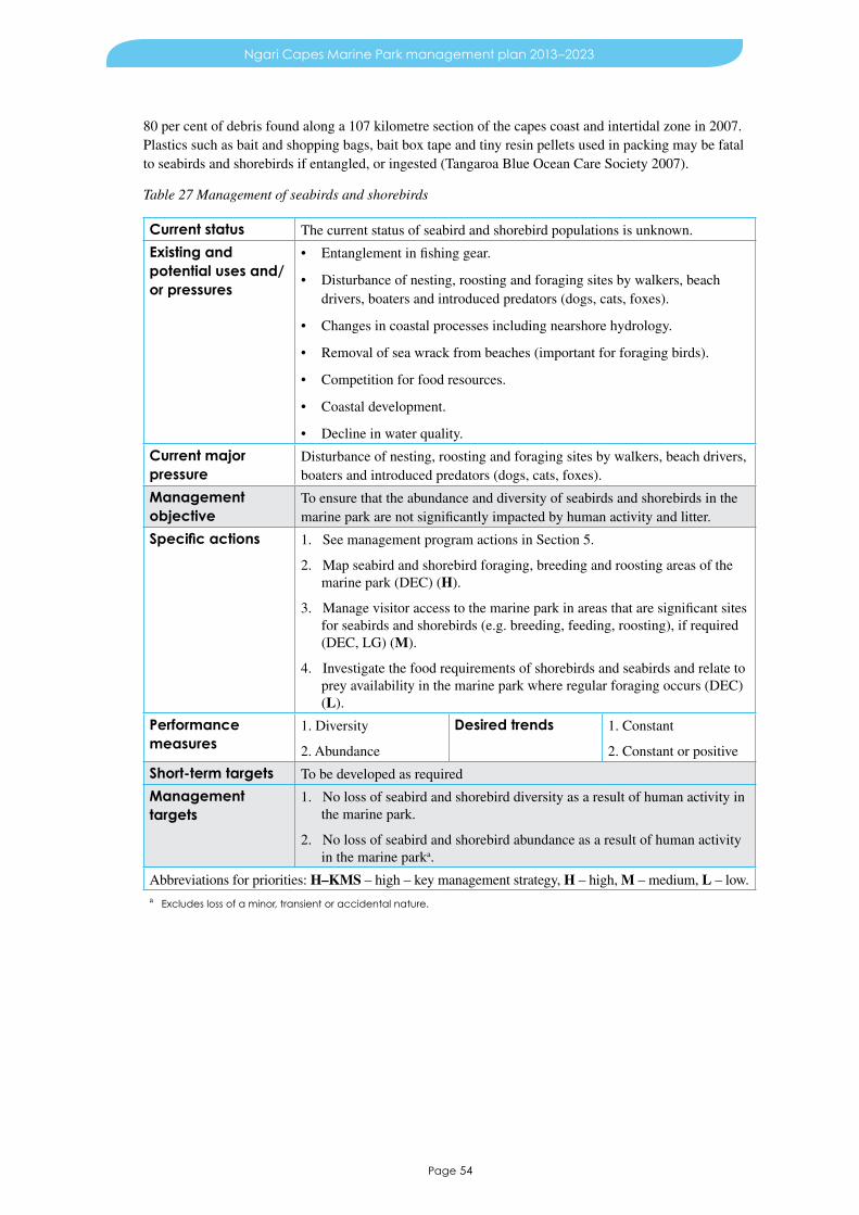
Page 54
Ngari Capes Marine Park management plan 2013–2023
80 per cent of debris found along a 107 kilometre section of the capes coast and intertidal zone in 2007. Plastics such as bait and shopping bags, bait box tape and tiny resin pellets used in packing may be fatal to seabirds and shorebirds if entangled, or ingested (Tangaroa Blue Ocean Care Society 2007).
Table 27 Management of seabirds and shorebirds
Current status The current status of seabird and shorebird populations is unknown.
Existing and potential uses and/or pressures
• Entanglement in fishing gear.
• Disturbance of nesting, roosting and foraging sites by walkers, beach drivers, boaters and introduced predators (dogs, cats, foxes).
• Changes in coastal processes including nearshore hydrology.
• Removal of sea wrack from beaches (important for foraging birds).
• Competition for food resources.
• Coastal development.
• Decline in water quality.
Current major pressure
Disturbance of nesting, roosting and foraging sites by walkers, beach drivers, boaters and introduced predators (dogs, cats, foxes).
Management objective
To ensure that the abundance and diversity of seabirds and shorebirds in the marine park are not significantly impacted by human activity and litter.
Specific actions 1. See management program actions in Section 5.
2. Map seabird and shorebird foraging, breeding and roosting areas of the marine park (DEC) (H).
3. Manage visitor access to the marine park in areas that are significant sites for seabirds and shorebirds (e.g. breeding, feeding, roosting), if required (DEC, LG) (M).
4. Investigate the food requirements of shorebirds and seabirds and relate to prey availability in the marine park where regular foraging occurs (DEC) (L).
Performance measures
1. Diversity
2. Abundance
Desired trends 1. Constant
2. Constant or positive
Short-term targets To be developed as required
Management targets
1. No loss of seabird and shorebird diversity as a result of human activity in the marine park.
2. No loss of seabird and shorebird abundance as a result of human activity in the marine parka.
Abbreviations for priorities: H–KMS – high – key management strategy, H – high, M – medium, L – low.a Excludes loss of a minor, transient or accidental nature.

Page 55
Ngari Capes Marine Park management plan 2013–2023
7 Management of social valuesMarine parks are created to provide for conserving and restoring the natural environment, protecting indigenous flora and fauna and preserving features of archaeological, historical or scientific interest, while providing opportunities for nature based recreation, tourism and commercial uses, where appropriate. Within this setting, a range of human activities and uses are recognised and will continue as long as they are consistent with management targets set for habitats and species of conservation interest in the marine park.
It is recognised that DEC-managed lands and waters, such as marine parks, have the capacity to satisfy an important portion of public demand for outdoor recreation and nature based tourism, and in so doing contribute significantly to the social, psychological, physical and economic wellbeing of the community. Management of use and visitation in the marine park is guided principally by the zoning scheme and permitted uses (Section 5.1, Table 8 and Table 9), and the management objectives, strategies and targets in sections 5 to 7, as well as by the provisions of the CALM Act and WC Act in association with other government legislation relating to marine management (Appendix III). DEC’s Policy statement no. 18 Recreation, tourism and visitor services provides specific guidance for recreation, tourism and visitor services within CALM Act reserves (Department of Environment and Conservation 2006).
7.1 Aboriginal cultural significance (KPI)Aboriginal people maintain a strong connection to their traditional country in the south-west of the state through identity and place, family networks, spiritual practice, resource gathering and natural resource management.
Aboriginal people in this area identify themselves as being from the Noongar language group. Noongar people occupy the country from Jurien Bay in the north to Esperance in the south-east (Bindon & Walley undated). The coastal area adjacent to the marine park also includes Aboriginal people who refer to themselves as the Pibelmen and the Wardandi (‘forest people who live by the sea’). The Blackwood River functions both as a language and cultural boundary between the Pibelmen and Wardandi language groups, and a trade route between inland areas around Nannup and the west coast. Archaeological evidence of Indigenous marine resource usage dates back about 6000 years to the formation of the current coastline (Smyth 1993). Fishing weirs, shell middens, grindstones, fish bones and scales that remain in burial grounds, campsites and ceremonial places demonstrate the extensive cultural history of the capes area and provide for continuing contemporary spirituality.
Prior to colonisation, a sophisticated Noongar culture and society existed (Geographe Catchment Council 2000). However, conflicts between Aboriginal people and early settlers led to the dispersal, dispossession and disempowerment of Noongar peoples. In recent times, initiatives by Noongar people have led to a strong resurgence of Noongar culture. For example, the Wardan Cultural Centre provides a meeting place and interpretive centre for Noongar culture and society. Through such enterprises Noongar marine and coastal knowledge can be maintained and transferred through the generations.
There are numerous examples of Noongar cosmology and how it is intimately intertwined with the marine environment, ‘Spirits come to this area [oceans of the south-west] and enter one of the caves or grottos and go out into the ocean protected by old man Wardandi. Then the ambition of the spirit is to get to the ocean land or Koorannup where they disperse back into the cosmos’ (Webb, pers. comm. in Stewart 2003). Many marine species have spiritual significance. The mammang borungar (whale) and kalda (sea mullet) are important throughout the region (Bates 1985). In the South West capes, certain areas are highly significant because they represent the whale ancestor’s travels across the landscape before becoming a sea dwelling creature. Other areas relate to cosmological events such as the ‘Great earth shaking’ that explain some of the coastal landforms throughout the region.
Page 56
Ngari Capes Marine Park management plan 2013–2023
Aboriginal values in the South West capes area include intrinsic and instrumental values. Intrinsic values are those that are held by a person because of family, community, culture and/or spirituality. Instrumental values are those that are associated with a physical use or function of a resource or area. Instrumentally, specific areas in the marine park are valued as they provide food, recreational opportunity, employment opportunity, inspiration for art and dance (Stewart 2003). The marine park contains many sacred sites and sites of significance that provide an ongoing link to Noongar life and belief. These sites continue to sustain Noongar life ways, nurturing and strengthening Noongar identity and culture.
Specific areas throughout the marine park continue to provide an important link between the ocean and the cultural life of the Noongar. The Noongar caught whiting, pilchard and salmon at Dunsborough, groper at Yallingup Reef and salmon at Gnarabup and they harvested shellfish along the coast from Geographe Bay to Augusta. They followed the seasonal patterns of skippy spawning at Eagle Bay and of mulloway, snapper and bream juveniles in the Wonnerup Inlet, which at that time was permanently open to the ocean. Resource gathering, ceremonial activities, natural resource management and recreational activities provide a contemporary manifestation of a traditional practice anchored deep in the past (Stewart 2003).
The AH Act aims ‘to make provision for the preservation on behalf of the community, of places and objects customarily used or traditional to the original inhabitants of Australia or their descendants, or associated therewith, and for other purposes incidental thereto.’ Although there are specially registered sites, the Act covers all Aboriginal sites regardless of whether they are registered or not. At least 45 sites of Indigenous significance have been identified either in or adjacent to the marine park.
Amendments to the CALM Act require that DEC’s management of land and waters includes the objective to protect and conserve the value of land to the culture and heritage of Aboriginal people in a manner that does not have an adverse effect on the protection and conservation of flora and fauna. The amendments also provide for joint management arrangements. Section 23 of the WC Act exempts people of Aboriginal descent from the provisions of the Act if taking of fauna or flora is for the provision of food for him/herself and his/her family, but not for sale. However, section 63 of the Wildlife Conservation Regulations 1970 suspends the provisions of section 23 of the WC Act if flora or fauna is specially protected through a gazettal notice prepared under section 14 of the WC Act. Under the FRM Act, an Aboriginal person is not required to hold a recreational fishing licence as long as the person takes fish from waters in accordance with continuing Aboriginal tradition and if the fish are taken for purposes of the person or his or her family and not for a commercial purpose. DoF applies a customary fishing policy which is available on the DoF website.
At January 2013 there are two registered native title claims extending over the marine park. Determination of native title claims will occur under the procedures outlined in the Commonwealth NT Act. The marine park is proposed to extend to the high water mark. However, in some places the initial reservation will be to the low water mark until such time as the traditional owners provide their consent for the intertidal areas to be included through a registered Indigenous land use agreement.
DEC recognises the need to increase involvement of Aboriginal people in managing conservation lands and water, biodiversity and cultural landscapes (DEC Corporate Plan 2007-2009). Continued access to areas for Noongar cultural purposes will be an important focus of marine park management. This focus can be facilitated through the ongoing involvement of Noongar people in marine planning and management processes, including participation of local representatives in the management advisory committee. Education about Aboriginal values and uses of the local marine environment is also essential.

Page 57
Ngari Capes Marine Park management plan 2013–2023
Table 28 Management of Aboriginal cultural significance
Requirements • Protection of Aboriginal heritage sites.
• Recognition of Noongar spiritual and cultural values and traditional uses.
• Provision of access for cultural and traditional activities.
• Collaborative involvement of local Aboriginal people in planning and management of the marine park.
Management objectives
1. To ensure that human activity does not significantly affect sites of significance to Aboriginal people in the marine park.
2. To engage local Aboriginal people in the management of the marine park.
3. To raise awareness and knowledge of Aboriginal connections with the marine environment, where culturally appropriate.
Specific actions 1. See management program actions in Section 5.
2. Consult with traditional owners and/or local Aboriginal people to provide ongoing advice for marine park management (DEC, DIA, SWALSC) (H).
3. Promote the significance of the marine environment for Aboriginal people in regard to physical and spiritual connections (DEC, DIA, SWALSC, WAM, Wardan Centre and other local Aboriginal organisations/groups, TWA) (H).
4. Seek to develop Indigenous land use agreements where considered appropriate (DEC) (H).
5. Monitor known Aboriginal heritage sites to determine their condition (DIA, DEC) (M).
6. Encourage and assist research on Aboriginal heritage, including recording oral histories, to facilitate long-term management (DIA, WAM, DEC) (M).
Reporting To be developed as required.
Management targets
Provide for the protection and conservation of the value of the area to the culture and heritage of Aboriginal persons.
Abbreviations for priorities: H–KMS – high – key management strategy, H – high, M – medium, L – low.
7.2 Maritime heritageThe maritime heritage associated with the marine park dates from 1622. The maritime past is shown by the whaling history, lighthouses, jetties, wrecks and stories which remain.
The South West capes has a rich maritime history. The area was first charted in 1622 for the Dutch East India Company by the Leeuwin, but it was Matthew Flinders who sailed the region known as ‘Leeuwin’s Land’ and named the cape in 1801. The earliest confirmed exploration in the Busselton area also dates to 1801 when two French ships, the Geographe under Nicholas Baudin and the Naturaliste, under Emmanuel Hamelin, charted the area. It was Baudin who gave Geographe Bay its name. Baudin also named the Vasse River after a sailor who was lost and believed drowned in the area.
Whalers and sealers from America, France and Britain also visited the area in the 18th and 19th centuries, but no permanent settlements were established until 1830 when Flinders Bay was first settled. The settlement of the Busselton area followed in 1837. Works for processing whale meat were established as early as 1839 by J W Child, and Robert Heppingstone built a whaling station at Castle Rock that operated for several years in the 1850s. In addition to whaling, which flourished until the collapse of whale populations rendered the industry commercially unviable, the timber industry, pastoralism and later tourism, were all important sectors.

Page 58
Ngari Capes Marine Park management plan 2013–2023
Maurice Coleman Davies established sawmills at Coodardup, Karridale, Boranup and Jarrahdene. Almost single-handedly Davies created a market for karri and jarrah hardwoods. In 1885, the Cape Leeuwin Lighthouse was built by Davies’ firm, Davies and Wishart. It continued to guide maritime shipping until 1928. A waterwheel was built nearby in 1895 to supply water to the lighthouse keepers and their families.
Shipping transport flourished as the timber industry grew, and led to the construction of the first stage of the Busselton jetty in 1865. The structure was extended several times with the last extension being built in 1911. This extended the jetty to its current length of approximately two kilometres. The Busselton jetty supported shipping until 1973. Jetties to support the timber industry were also completed in Flinders Bay and Hamelin Bay by 1885. Ships would stop at these places in order to load up much sought after karri timber before heading further north to collect the equally popular jarrah. At its height, Hamelin Bay was a major timber port and the main jetty was 549 metres long. However, by 1907, the timber resources at Karridale had declined and the jetty was ultimately closed for safety reasons. Interestingly, any ships that docked at Hamelin Bay were refused insurance because of the frequency with which ships were wrecked in the area.
Nine shipwrecks are recorded between 1830 and 1910. Three of the nine ships were lost in Hamelin Bay while other wrecks occurred off Augusta, Calgardup Bay (near Hamelin Bay), Cape Leeuwin, Ringbolt Bay and Lockeville. All shipwrecks over 75 years old are protected under the Commonwealth Historic Shipwrecks Act 1976. In Western Australia pre-1900 shipwrecks and artefacts are protected under the Maritime Archaeology Act 1973. The Western Australian Museum has statutory responsibility for management of these wrecks. Both lighthouses and their quarters are listed under the Register of Heritage Places, governed by the Heritage of Western Australia Act 1990.
Management of maritime heritage within the marine park will focus on educating visitors, the ongoing identification of new and existing historical maritime sites, and monitoring.
Table 29 Management of maritime heritage
Requirements • Protection of maritime heritage and historical sites.
• Recognition of cultural value.
Management objectives
1. To ensure that, in collaboration with the Western Australian Museum , human activity does not significantly affect historical sites or shipwrecks in the marine park.
2. To increase awareness of maritime heritage within the local community and among visitors.
Specific actions 1. See management program actions in Section 5.
2. Determine and maintain appropriate levels of access to historical sites that lie within the marine park (DEC, WAM, stakeholders) (M).
3. Encourage and assist research on maritime heritage, including recording oral histories to facilitate long-term management (WAM, DEC) (M).
4. Monitor known maritime heritage sites to determine their condition (WAM, DEC) (L).
Reporting To be developed as required
Management target
Maintenance of maritime heritage and historical sites in the marine park.
Abbreviations for priorities: H–KMS – high – key management strategy, H – high, M – medium, L – low.

Page 59
Ngari Capes Marine Park management plan 2013–2023
7.3 Marine nature based tourismMarine nature based tourism is a rapidly growing industry and is supported by a wide range of attractions and opportunities, with popular activities including nature appreciation, diving and fishing.
The marine park offers a wide range of attractions for marine based tourism. Valuable visitor experiences are provided by the diversity of seascapes which includes sheltered bays, rugged exposed coastline, complex bathymetry, diverse marine habitats, clear waters and the obvious presence of marine wildlife.
Shore based and boat based whale watching is one on the major tourist attractions in the area. The best shore based vantage points to see whales are Flinders Bay, Cape Leeuwin, Cape Naturaliste, Gracetown and Sugarloaf car park. Humpbacks are particularly common in the months leading up to summer and often provide a display of breaching within a short distance of the shore. New Zealand fur seal haul-out islands are also popular attractions. Many popular dive and snorkel spots are located around the marine park, and viewing stingrays at Hamelin Bay is an increasingly popular activity. Recreational fishing is a popular pastime for visitors to the region and is discussed in detail in Section 7.6.
Major tourist attractions in the area include the HMAS Swan dive wreck, Busselton jetty, lighthouses at both capes, unusual rock formations along the coast at Sugarloaf Rock and Canal Rocks and world class surf breaks such as those at Margaret River, Prevelly, Yallingup, and Cowaramup Bay. The Busselton jetty’s underwater observatory allows visitors to experience a diverse community of invertebrates and fish more than a kilometre from shore without getting wet. Attracting over 400,000 visitors per year, the landmark Busselton jetty is one of the most popular marine tourist attractions in the South West capes area.
Marine nature based tourism is offered by a number of charter boat operators who conduct fishing, diving and wildlife watching tours within the marine park. DEC manages commercial tourism activities within marine parks under the framework of Policy statement no. 18 Recreation, tourism and visitor services which relates to recreation and tourism and visitor services, and through licences. Under section 101 of the CALM Act all commercial activities on lands and waters managed by DEC and vested in the Conservation Commission or MPRA require a licence. Human interactions with marine wildlife are controlled through the CALM Act, WC Act, WC regulations and codes of conduct. In addition DoF manages charter fishing activities through a system of fishing tour operator’s licences and aquatic eco-tourism licences.
Marine nature based tourism has the potential to make an important contribution to protecting the region’s ecosystems by fostering a greater understanding of the environment. However, unless carefully managed, visitation has the potential to cause environmental damage, particularly as the number of visitors continues to increase. This includes increases in litter and marine debris, overfishing, damage to coastal areas adjacent to the marine park, as well as disturbance of seabirds, shorebirds and marine plants and animals.
Management actions for tourism in the marine park will focus on both the management of activities consistent with protecting the marine park’s values (the values on which commercial nature based marine tourism depend), and maintenance of a viable tourism product. A key strategy in supporting marine nature based tourism is the establishment of sanctuary zones. Sanctuary zones provide undisturbed areas in which marine life can be observed, and may enhance fishing opportunities for marine tourism operators and visitors to the region.

Page 60
Ngari Capes Marine Park management plan 2013–2023
Table 30 Management of marine nature based tourism
Requirements • High water quality.
• Healthy marine and estuarine communities.
• Clean beaches and coastal areas.
• High aesthetic quality of the marine environment.
• Provision of ‘undisturbed’ areas for nature appreciation.
• Appropriate infrastructure and facilities.
Management objectives
1. To manage marine nature based tourism in a manner that is consistent with maintaining the marine park’s values, and provides for nature appreciation and enjoyment.
2. To maintain the ecological and social values of the marine park important to the marine nature based tourism industry.
Specific actions 1. See management program actions in Section 5.
2. Raise the awareness of marine nature based tourism operators regarding the possible detrimental impacts of tourism on the ecological values of the marine park, through education and participation in management (DEC, DoF, TWA) (M).
3. Investigate the inclusion of the HMAS Swan dive wreck in the Eagle Bay sanctuary zone of the marine park, when and if appropriate (DEC) (L).
Reporting To be developed as required.
Management target
To have the management actions implemented within the agreed timeframes (Appendix V).
Abbreviations for priorities: H–KMS – high – key management strategy, H – high, M – medium, L – low.
7.4 Commercial fishing and aquacultureA diverse range of commercial fisheries exist in and around the marine park and target species such as abalone, salmon, sharks, demersal finfish, baitfish and western rock lobster. Aquaculture is a developing industry.
Commercial fishing has a long history in the region and has been important in building the local and regional economy. Inshore and estuarine fisheries were some of the first industries to become established in the South West capes area, particularly within Geographe Bay.
Early commercial fishing, during the settlement of the lower south-west area, included whaling and sealing which were undertaken by foreign as well as local fishers. In current times, commercial fishers based in or working within the South West capes area may have a number of different types of fishing licences and many operate family based fishing operations that have been passed down through several generations.
The DoF manages commercial fishing in Western Australia under the FRM Act, using management plans, regulations, notices and orders. A range of management strategies are used including limitations on fishing gear, temporal and spatial closures, size limits, limits to the number of licences and quotas. DoF also monitors fishing activities, assesses the impact on key target stocks and, in consultation with other stakeholders, undertakes ecological risk assessments of its managed fisheries with to a view to establishing their ongoing biological and ecological sustainability. The marine park area lies within the DoF designated ‘West Coast Bioregion’, with an overlap of some commercial fisheries into the ‘South Coast Bioregion’ which begins at Black Point.

Page 61
Ngari Capes Marine Park management plan 2013–2023
Fisheries and aquaculture
There are 12 fisheries and one commercial aquaculture operation licensed to operate in, or close to, the park, at the time of publication.
West Coast rock lobster managed fisheryBetween two and 60 rock lobster fishers operate in the South West capes area seasonally. Numbers are dependent on annual rock lobster recruitment. Western rock lobster (Panulirus cygnus) make up the majority of the catch, with incidental catches of southern rock lobster (Jasus edwardsii) occurring. The bulk of the product is exported to Japan, Taiwan, Hong Kong, China and the United States (DoF 2006).
Windy Harbour – Augusta rock lobster managed fisheryThere are two operators working this fishery between Windy Harbour and Augusta. This coast is very exposed to Southern Ocean swell, with those two towns offering the only relatively safe anchorages. Western rock lobster is a significant component of the catch in the Windy Harbour – Augusta Fishery.
Abalone managed fisheryEight commercial abalone fishers are licensed to collect greenlip (Haliotis laevigata) and brownlip (H. conicopora) abalone from the marine park area. In addition up to eight fishers are licensed to collect Roe’s (H. roei) abalone. Most of the abalone catch in this area is made up of greenlip. The roe fishery operates on intertidal reef platforms throughout the marine park and the greenlip and brownlip abalone fishery operates in waters deeper than five metres primarily south of Margaret River.
West Coast demersal scalefish interim managed fisheryThirteen permit holders in this fishery are entitled to fish in the area of the marine park The main target species are dhufish (Glaucosoma herbraicum) and red snapper (Lutjanus erythropterus). In 2009, 15.4 tonnes of scalefish were taken within the fishing blocks overlying the marine park.
Joint authority southern demersal gillnet and demersal longline managed fisheryUp to six fishers work within this fishery and range throughout the South West capes area, targeting gummy (Mustelus antarcticus), dusky whaler (Carcharhinus obscurus) and whiskery (Furgaleus macki) sharks, as well as demersal scalefish. The majority of operators use demersal gillnets.
West Coast purse seine managed fisheryOne licensed fisher operates within the marine park area targeting mainly pilchard (Sardinops sagax). This fishery generally occurs within the Geographe Bay area but extends northward to Mandurah. The quota for pilchards and other small pelagic species is set at a maximum of 10 per cent of the spawning biomass, leaving more than 90 per cent of the total biomass available to natural predators such as fish and seabirds (DoF 2010a).
South-west salmon managed fishery Six licensees are permitted to take Australian salmon (Arripis trutta) within the marine park boundaries They operate from shore at Smiths Beach and Hamelin Bay. Fishers target schools of migrating salmon as they move west and north along the southern coastline of Western Australia during the late summer and autumn. In 2009, these fishers landed 494 tonnes of Australian salmon. DoF implemented a ban on shore based salmon fishing, between Port Geographe and Cape Naturaliste on 1 July 2009.
South-west beach seine fisheryUp to 18 beach seine fishers operated in the marine park area. DoF implemented a ban on beach seine fishing, between Port Geographe and Black Point on 20 July 2010. However, one commercial fisher has been allowed continued access to Flinders Bay, near Augusta to target whiting and mullet as part of his estuarine fishing operation in Hardy Inlet (DoF 2010b).The majority of the catch was white bait (Hyperlophus vittatus), but herring, whiting species, sea mullet (Mugil cephalus) and blue sprat (Spratelloides robustus) were also caught, with activity typically concentrated in Geographe Bay (Cape Naturaliste to Preston Beach).

Page 62
Ngari Capes Marine Park management plan 2013–2023
Specimen shell managed fisheryThe specimen shell managed fishery is based on the collection of individual shells for the purposes of display, collection, cataloguing, classification and sale. The fishery comprises 32 licence holders targeting over 200 different species around the state (DoF 2010a), mainly in shallow coastal waters from small boats of less than eight metres. There is some concentration of effort around the Bunbury area (DoF 2010a) although collectors regularly travel to a variety of locations around the state. Specimen shell collection is a permitted use in some zones of the marine park.
Marine aquarium fish managed fisheryThe marine aquarium fish managed fishery comprises 11 licence holders and targets over 250 species named within a DoF management plan (DoF 2010a). Collection includes the taking of fish, coral, algae, ‘live rock’, ‘live sand’ and invertebrates. It is primarily a dive based fishery with collectors working from boats up to eight metres in length. Catches are relatively low in volume due to the special handling requirements of live fish. The Perth to Busselton area has been one of the most popular collection areas in the state (DoF 2006). Marine aquarium collection for commercial purposes is a permitted use in some zones of the marine park.
South-west trawl managed fisheryThere are currently no commercial trawl fishers authorised by DoF to fish in the marine park. The trawl fishery boundary extends from Mandurah to the Geographe Bay area but due to low and often variable numbers of scallops, and community concern over impacts, this fishery is not exploited.
Developing octopus fisheryThere are five operators permitted to commercially fish for octopus within the marine park area. The developing octopus fishery uses both passive shelter pots and active (trigger pots) traps to selectively harvest octopus (primarily Octopus tetricus). The fishery is managed through limited entry and limits on pot allocations, and effort is spatially controlled.
Commercial aquacultureAquaculture is a developing industry in the South West capes area. There is an existing sea based abalone farm in Flinders Bay and it is expected that other proposals will be forthcoming to develop infrastructure at specific sites. DoF is responsible for licensing such facilities. It will be important to consider the impact of the infrastructure and operations on marine benthos and the quality of marine water intake and discharge. Implications for marine park management such as wildlife interaction and conflict with other users will also be considered.
Sea based aquaculture could include finfish sea cages, mussel farming and/or abalone farming. Such proposals would be assessed against marine park values, and possibly under the requirements of the EP Act.
DoF assessed the Western Australian coast (DoF 2002) and identified the following places (at or in the vicinity of) as potential land based aquaculture sites:
• Eagle Bay
• Bunker Bay
• Canal Rocks
• Turner Brook
• Ledge Point.
Access to public beaches for commercial fishing within conservation estate is permitted by the DEC under licence. Issues of access are managed in accordance with DEC’s Policy statement no. 51 Access for commercial fishing through CALM lands. This acknowledges that commercial fishermen require access only for a limited time and that access generally does not conflict with peak periods of use. Where appropriate, commercial fishermen may be granted limited access to closed beaches (e.g. Injidup beach)

Page 63
Ngari Capes Marine Park management plan 2013–2023
during the salmon season (February to April) or to management only tracks that lead to open beaches (e.g. Deepdene beach). Conditions of approval, such as restrictions to prevent environmental damage (e.g. prohibiting off-road driving to dune vantage points, camping and campfires on beaches and illegal infrastructure), may apply. Special conditions may apply to beaches with nesting hooded plovers.
Where the establishment of a marine park is claimed to have reduced the commercial value of a commercial fishing authorisation, the licensee may be eligible for compensation under the Fishing and Related Industries Compensation (Marine Reserves) Act 1997.
Table 31 Management of commercial fishing and aquaculture
Requirements • High water quality.
• Maintenance of key habitats (e.g. nursery grounds, areas of high productivity).
• Equitable access to fishing grounds in appropriate zones.
• Maintenance of sustainable targeted fish stocks.
• Appropriate provision and placement of infrastructure and facilities.
Management objectives
1. To ensure that, in collaboration with the industry and DoF, commercial fishing activities and aquaculture in the marine park are managed in a manner consistent with maintaining the marine park’s ecological values while providing opportunities for social and economic benefits.
2. To maintain ecological values of the marine park important to commercial fisheries and aquaculture.
Specific actions 1. See management program actions in Section 5.
2. Monitor commercial fishing catch and effort within the marine park and report the results publicly (DoF) (M).
3. Consult with and/or advise the MPRA in regard to proposed new fisheries or aquaculture operations and major changes to existing fisheries (DoF) (M).
4. Reduce litter originating from commercial fisheries through education and interpretation programs (DoF, DEC) (L).
Reporting To be developed with DoF.
Target To have the management actions implemented within the agreed timeframes (Appendix V).
Abbreviations for priorities: H–KMS – high – key management strategy, H – high, M – medium, L – low.
7.5 MiningThe sedimentation and geology of the South West capes area offers opportunities for mineral and coal seam exploration and extraction.
There are a number of titles and exploration licences for petroleum, mineral sands and coal in and adjacent to the marine park. As of January 2013, there are three pending exploration licences overlying the marine park. E7004196 overlies the northern corner of the marine park and the permit holder’s interest is in mineral sands. E7004091 overlies a section of the marine park between Dunsborough and Busselton and the permit holder’s interest is in coal. E7002441 overlies the marine park east of Augusta and the permit holder’s interest is in mineral sands. In addition there are other titles, such as for petroleum exploration (EP408R1) adjacent to the marine park.
Titanium mineral sands occur in the south-west and extensively along Geographe Bay. Some parts of the marine park may be explored in the future. Sand mining, if undertaken, may have significant

Page 64
Ngari Capes Marine Park management plan 2013–2023
environmental impacts on marine park values and would require careful consideration. These impacts may include a loss of seagrass, particularly due to an increase in sedimentation and suspension of sediment bound nutrients, which may cause increases in phytoplankton and epiphyte biomass, resulting in the shading of seagrass blades and/or communities.
Management of mineral, energy and petroleum industries is the responsibility of the Department of Mines and Petroleum (DMP), under the Mining Act 1978, Mining Act Regulations 1981, Mine Safety and Inspection Act 1994, Mine Safety and Inspection Regulations 1995, and Petroleum Act 1967. Exploration and extraction in marine parks and reserves is subject to environmental impact assessment under the EP Act. If exploration or extraction is approved, proponents must undertake monitoring of the environmental impact of their activities in accordance with licence conditions set by the OEPA.
Table 32 Management of mining
Requirements • Equitable access in appropriate zones, subject to environmental assessment.
Management objective
To ensure that mining activity, if permitted within the marine park, is operated in a manner consistent with maintaining the marine park’s ecological and social values.
Specific actions 1. See management program actions in Section 5.
2. Ensure that a recognised environmental management system is prepared and implemented for industry projects to protect the ecological and social values of the marine park (OEPA, DMP, DEC) (H).
Reporting To be developed as required
Target To have the management actions implemented within the agreed timeframes (Appendix V).
Abbreviations for priorities: H–KMS – high – key management strategy, H – high, M – medium, L – low.
7.6 Recreational fishingRecreational fishing for a range of pelagic, reef and estuarine finfish and invertebrates from the shore, from boats and underwater, is an important social activity in the region.
The area between Kalbarri and Cape Leeuwin is one of the state’s most significant recreational fishing areas (DoF 2010a). Shore based, boat based and underwater fishing are popular recreational activities in the South West capes area. Geographe Bay, in particular, provides sheltered and easy access for safe, family oriented fishing experiences with other areas of the South West capes offering experiences in less protected waters. From February to April, predictable salmon runs attract large numbers of recreational fishers to beaches between Cape Naturaliste and Cape Leeuwin. This annual migration provides economic contributions to the region.
The diversity of the coastline allows for shore based fishing from sandy beaches and rocky headlands. Boat based fishing is governed by boat size, crew capability, weather conditions and location of boat

Page 65
Ngari Capes Marine Park management plan 2013–2023
launching facilities. There is also a growing charter fishing industry providing access to otherwise inaccessible areas. Underwater recreational fishing, using spear guns and/or gidgees, involves free diving or the use of compressed air to fish for demersal finfish such as the western blue groper (Achoerodus gouldii) and breaksea cod (Epinephelides armatus). It is not known what level of underwater recreational fishing is occurring within the marine park but spearfishing tournaments are hosted in the region intermittently and the Dunsborough Angling and Aquatic Club hosts a regular group of spearfishers. The use of spear guns and gidgees in family and high use areas will need to be monitored carefully. The management plan contains a provision for the introduction of spearfishing exclusion areas where legitimate safety concerns are raised by marine park users at family and high use areas. The introduction of an exclusion area would require community consultation prior to implementation.
Shore based fishing activity has the potential to affect terrestrial coastal environments. For example, many fishing locations are only accessible by off-road vehicles. The Leeuwin–Naturaliste Capes Area Parks and Reserves Draft Management Plan 2010 (DEC 2010) recommends management strategies to address issues associated with the influx of fishing activity along the marine park’s coast. Shore based fishing from rocks and the risk of unexpected large waves is a major safety issue along the coast. Fishing from rocks is an inherently dangerous activity, where the natural environment combined with the desire to secure a catch often leads to high-risk behaviours by fishers. In accordance with Policy statement no. 53 Visitor risk management policy, DEC has prepared Coastal safety – Rock fishing guidelines to mitigate this risk. In addition, DEC will investigate use of anchor points as necessary and contribute to safety awareness education.
The recreational rock lobster fishery primarily targets western rock lobster (Panulirus cygnus) and southern rock lobster (Jasus edwardsii) using pots or by hand. This fishery requires a recreational fishing licence. Rock lobster fishing in the DoF designated ‘West Coast Bioregion’ generally occurs in depths of less than 20 metres (DoF 2010a).
The recreational abalone fishery targets Roe’s (Haliotis roei), greenlip (H. laevigata) and brownlip (H. conicopora) abalone within the marine park. Roe’s abalone are generally found in shallow reef areas, and greenlip and brownlip abalone are usually collected by scuba divers in deeper waters. Recreational fishers must purchase an abalone recreational fishing licence and fish within specified seasonal openings.
Recreational fishing is managed by DoF under the FRM Act, using a variety of management tools. These tools include bag and size limits, gear restrictions, seasonal restrictions, closures, and licensing. The bag and size limits for fishing on the west coast can be found in Recreational fishing guide West Coast Region (DoF 2005). In addition, recreational fishers are required to hold a ‘Recreational fishing from boat’ licence if they are fishing from a powered boat (unless they are fishing for a species or by a method that is already covered under a separate recreational fishing licence).
DoF manages the west coast demersal scalefish fishery using a number of management arrangements which were introduced during 2009–10. These are aimed at reducing the recreational take of demersal scalefish in the West Coast Bioregion by at least 50 per cent from 2005–06 levels. Recreational fishing for ‘high risk’ demersal scalefish is currently prohibited between 15 October and 15 December within the DoF West Coast Bioregion, with reduced bag limits through the rest of the year (DoF 2010a). The DoF Recreational fishing guide 2013 (DoF 2013) reiterates these management arrangements.
The establishment of sanctuary zones within the marine park provides for reference sites for research and monitoring against which the impacts of recreational fishing can be assessed. The primary role of marine park management in relation to recreational fishing is to maintain the ecological values that support fish populations and ensure that recreational fishing activities in the marine park are sustainable.

Page 66
Ngari Capes Marine Park management plan 2013–2023
Table 33 Management of recreational fishing social value
Requirements • High water quality.
• Maintenance of species key habitats (e.g. nursery and spawning areas).
• Equitable and safe access to fishing grounds in appropriate zones.
• Maintenance of sustainable targeted recreational fish stocks.
• Maintenance of recreational fishing experience.
• Appropriate infrastructure and facilities.
• Access and boating facilities.
Management objectives
1. To ensure that, in collaboration with the community and DoF, recreational fishing is managed in a manner that is consistent with maintaining the marine park’s ecological values while providing for social uses and enjoyment.
2. To maintain ecological values of the marine park important to recreational fishing.
Specific actions 1. See management program actions in Section 5.
2. Consult with relevant stakeholders to investigate implementing management provisions for excluding spearfishing from family and high use areas if there are legitimate safety issues, and it becomes necessary to implement such provisions (DEC, DoF) (M).
3. Consult with relevant stakeholders to investigate implementing a prohibition on recreational rock lobster pot fishing in the Margaret River special purpose zone (surfing) and Cowaramup Recreation Zone, if there are legitimate safety and equity concerns (DEC, DoF) (M).
Reporting To be developed with DoF.
Target To have the management actions implemented within the agreed timeframes (Appendix V).
Abbreviations for priorities: H–KMS – high – key management strategy, H – high, M – medium, L – low.
7.7 Recreational water sportsBeautiful beaches, sheltered bays, prevailing ocean swells and diverse marine life combined with easy access provide for a range of water sports including surfing, diving, swimming, boating, sailing, kite surfing, jet skiing, windsurfing and kayaking.
Surfing
Western Australia’s first surf riders’ club, the West Coast Board Club, has been facilitating surfing from Cape Naturaliste to Cape Leeuwin for over 40 years. ‘Main Break’ at Yallingup was the first spot to be ‘discovered’, followed by Injidup Bay, Gallows and South Point. Since the first breaks were discovered, the region has become famous for them. The Margaret River ‘Main Break’ is now world renowned for its surf and hosts an annual surfing competition.
Surfing events are increasing in number and surfing is becoming a popular spectator sport along the Leeuwin–Naturaliste coast. Many local board riding clubs, and metropolitan based surfing clubs hold competitions along the coast, and many surfers live in the region, or visit it regularly to surf. During peak tourism periods, surf breaks often become crowded, particularly those that can be reached on sealed roads. In addition, the popularity of kite surfing and windsurfing (and wave sailing), results in the need for more area for these activities, both on land and in the water. While all surfing types are welcomed in the marine park, careful management may be required if conflict between different surfing types arises

Page 67
Ngari Capes Marine Park management plan 2013–2023
and where adverse environmental impacts such as degradation of foredunes and limestone cliffs, loss of coastal vegetation and disturbance of fauna occur. It is important that surfing, and in particular surf events, are permitted in appropriate locations where visitor facilities can be suitably planned for and provided. The Leeuwin–Naturaliste Capes Area Parks and Reserves Draft Management Plan 2010 (DEC 2010) recommends that a surf policy be prepared to address these management issues within the adjoining national park.
The zoning scheme for this marine park recognises a number of iconic surf breaks within its special purpose (surf) zones.
Boating
DoT is responsible for all boating regulations including licensing, safety standards, navigation markers, moorings and jetties. However, mooring controls can be delegated to other management agencies. In 2011, the South West capes area more than 4,000 vessels are registered (Shore Coastal 2011). This means that about 8.5 per cent of people, or a quarter of all households, owned boats. Most of these boats are runabouts, open boats and half cabin cruisers. In addition there are 105 personal water craft (i.e. jet skis). The number of boats using the area dramatically increases during the summer months when visitor numbers are highest.
There are three designated areas located at popular swimming locations in the marine park in which boat access is prohibited to improve swimmer safety in these areas. These are gazetted under Navigable Waters Regulations 1983 and are located at Gnarabup Bay, Cowaramup Bay, and within 60 metres of the foreshore at Dunsborough between the northern boundaries of Finlayson Street and Beach Road. In addition there is a boating prohibited area gazetted under Navigable Waters Regulations 1983 between Craig and Bower streets in West Busselton, which overlays a snorkel trail.
Speed limits apply within harbour limits, near jetties and in some inshore areas of Geographe Bay. Skiing areas have been designated along all the waters of Geographe Bay between Wonnerup Inlet and Castle Rock (except for near boat launching facilities). Management of water sports, particularly boating, is necessary to ensure that conflict between users is minimised. It will be important to continue to assess impacts and pressures throughout the marine park to ensure social values are maintained and that the widest possible opportunity for recreation is provided. Assessment of ecological impacts will be an important part of this.
The yacht club in Busselton has been operating for over 40 years and there are also yacht clubs in Augusta and Bunbury. These clubs hold regattas and competitions throughout the marine park, particularly during the summer months. The Quindalup area is particularly popular as a summer anchorage and mooring site for visiting yachts from the metropolitan area or further afield.
Sea kayaking is a sport growing in popularity. It is popular at Hamelin Bay, the lower sections of the Blackwood River and the sheltered, shallow waters of Geographe Bay. Sea kayaks can be launched at any point along the coast that allows vehicle access.
Diving and snorkelling
The marine park offers a diversity of marine attractions, both natural and artificial, for divers and snorkellers. Natural attractions include places such as Canal Rocks, Moses Rock, Cosy Corner, Kilcarnup, Prevelly–Gnarabup, Redgate, Hamelin Bay and the small islands off Augusta. The HMAS Swan dive wreck and the Busselton jetty are the two most popular artificial marine attractions in the marine park. The Busselton jetty has recently been listed in the top 10 dive sites in Australia and is a popular scuba site for beginners and advanced divers alike. There is also a snorkel trail near West Busselton in Geographe Bay, which is accessible from shore and is marked with plinths on the seabed. Divers and snorkellers operate from boats and from the shore. The Busselton jetty also provides access to deeper waters. Dive charter operators offer a range of opportunities for recreational divers and snorkellers to reach many parts of the marine park that they would not normally be able to.

Page 68
Ngari Capes Marine Park management plan 2013–2023
Swimming
There are areas within the marine park that can be hazardous for swimming due to large swells, rips and difficult conditions. Hence, swimming generally occurs at calm, sheltered locations such as Geographe Bay, Meelup, Bunker Bay, Yallingup Lagoon, Kilcarnup, Hamelin Bay, Cosy Corner and some parts of Flinders Bay. Most swimming activity occurs during the summer months, particularly during peak holiday periods. Organised swimming events such as the Busselton Jetty Swim, amateur swim club events, swimming classes and triathlons occur in the calmer parts of the marine park.
Management actions
The actions relating to the management of water sports within the marine park include education about the impacts and compatibility of certain water sports. Liaison and involvement with other agencies will also be a priority.
Table 34 Management of recreational water sports
Requirements • High water quality.
• High aesthetic quality of the marine environment.
• Equitable access to the natural values in appropriate zones.
• Separation of incompatible activities.
• Appropriate infrastructure and facilities.
Management objectives
1. To ensure that recreational water sports are managed in a manner that is consistent with the maintenance of the marine park’s ecological values, while providing opportunities for use and enjoyment.
2. To maintain the ecological and social values of the marine park which are important to those participating in recreational water sports.
3. To manage recreational water sports in a manner that minimises conflict between marine park users.
Specific actions 1. See management program actions in Section 5.
2. Determine the nature, spatial and temporal patterns, compatibility and potential environmental impacts of all existing water sports in the marine park and maintain a database of these (DEC) (H).
3. Implement appropriate management arrangements for special events e.g. surf events, to minimise impacts on marine park values (DEC, LG) (M).
4. Seek to designate vessel speed restrictions for wildlife protection and/or for safety requirements (DEC, DoT) (M).
5. Investigate strategies to separate incompatible water sports in the marine park, if there are legitimate safety issues (DEC, DoT) (M).
Reporting To be developed as required
Target To have the management actions implemented within the agreed timeframes.
Abbreviations for priorities: H–KMS – high – key management strategy, H – high, M – medium, L – low.

Page 69
Ngari Capes Marine Park management plan 2013–2023
7.8 Coastal useThe coastline within and adjacent to the marine park hosts a wide range of recreational opportunities and provides access to the marine park.
The interface between land and sea is a major focus for human activity. The coastline adjacent to the marine park offers a wide range of coastal land based recreational opportunities including walking, camping, four-wheel driving, photography, picnicking and nature appreciation. The Leeuwin–Naturaliste National Park and associated reserves extend along a large portion of the coast, with remaining lands being managed by the shires of Busselton and Augusta-Margaret River or being held in private tenure. The Leeuwin–Naturaliste Capes Area Parks and Reserves Draft Management Plan 2010 (DEC 2010) provides priorities for coastal access within the national park. Local government managed reserves are managed in accordance with coastal management plans (Shire of Augusta-Margaret River 2005) or coastal asset plans (Shire of Busselton 2006).
There is good vehicle and pedestrian access to most of the coast abutting the marine park, resulting in it being highly accessible to most people. Sealed roads and car parks are most often associated with town sites and developed coastal nodes, such as Meelup Beach. Unsealed roads and tracks can be found throughout the South West capes area and offer a recreational opportunity for off-road-vehicle drivers, leading them to undeveloped coastal nodes, such as Three Bears surf break in the Leeuwin–Naturaliste National Park. The provision of a range of access types provides for diversity of experiences for local people and visitors alike.
Boat launching facilities have been provided at points along the coast where boaters have shown a preference for launching trailered vessels such as at Busselton, Dunsborough, Gracetown, Gnarabup, Hamelin Bay, Flinders Bay and Hardy Inlet. Port Geographe, at Busselton provides a marina to cater for larger vessels. The Shire of Augusta-Margaret River is planning for the construction of a boating facility at Flat Rock in Flinders Bay (Oceanica 2007). When constructed, this facility has the potential to significantly change boat usage patterns in Flinders Bay and areas further east of Augusta. Boat launching facilities and marinas tend to act as important recreation nodes, and will provide significant points of access for boaters wishing to access the marine park. These facilities are considered terrestrial infrastructure and as such are best managed by coastal managers, including DoT and local government. It will be important, however, that boat launching facilities are managed in a manner that maintains the ecological and social values of the marine park, and in keeping with the zoning scheme. Boat launching facilities are important for marine park users but may have an impact on marine park values. In some instances, construction, extension or maintenance of a boat launching facility may require assessment by the OEPA as per the requirements of the EP Act.
The Busselton jetty provides a unique access point extending nearly two kilometres into the marine park. The end of the jetty hosts an observatory to enable people to stay dry while visiting the seafloor to enjoy the unique marine life that associates with the jetty structure, within an area protected from extractive activities.
Horse riding and dog exercising are popular recreational activities, particularly for local people. Both activities are regulated on DEC managed lands, including marine parks under CALM regulations and by local laws in shire reserves. Regulations are required because of potential impacts including introduction of seed of weed species, destabilisation of dunes, trampling of nesting shorebirds and conflict with other users. Horse and dogs are not permitted in the marine park except where a designated area is established under CALM regulations 16 and 17. In these areas, the animals must be controlled and managed by a person in accordance with conditions specified on signs erected in the designated area. DEC Policy statement no. 18 Recreation, tourism and visitor services states that designated areas will generally not be declared in marine parks and marine management areas except in circumstances where dog access is considered to be manageable and/or there has been a history of dog access in the area. However, it makes a provision for dogs to be permitted to travel in vessels in a marine park. Hence dogs will be permitted

Page 70
Ngari Capes Marine Park management plan 2013–2023
on vessels but not in the waters of the Ngari Capes Marine Park. Recreational and site planning (see Section 5.5) will identify if and where there are suitable areas in which dog and horse exercising can be undertaken. However horses and dogs will not be allowed in coastal portions of the marine park that are sanctuary zones.
The Cape to Cape walking trail is becoming an internationally recognised attraction that provides low impact access for people seeking to experience remote areas of coast between Cape Naturaliste and Cape Leeuwin. The trail takes people to the best locations for experiencing seascapes, historical locations, spectacular geological formations and out-of-the-way surf spots. Other shorter walking trails provide alternative experiences and degrees of difficulty. It is important to ensure that walkers do not have an impact on the marine park through inappropriate disposal of rubbish and waste into the sea, fishing where it is not permitted and disturbance of seabirds, shorebirds and fur seals.
In addition to a genuine concern for visitor welfare, the DEC has a moral and legal responsibility to visitors to public conservation estate. To this end, DEC’s Policy statement no. 53 Visitor risk management policy aims to minimise the potential for injuries and misadventure to visitors, in a manner that does not render the environment sterile or unnecessarily diminish visitor use and enjoyment in the process. The policy provides for implementing a visitor risk management program for DEC managed parks and reserves.
The main risks for users of the west and south coast are fishing from rocks and other beach and headland use along the high energy coastlines. Policy 53 provides guidelines and procedures to identify, analyse, and improve safety. Education is considered an important aspect of maintaining visitor safety.
Educating coastal users about the zoning scheme, risks associated with coastal use, and their impact on the coastal and marine environment is an essential management strategy.
Table 35 Management of coastal use
Requirements • High aesthetic quality of the marine environment.
• Clean beaches.
• Equitable access to the natural values in appropriate zones.
• Separation of incompatible activities.
• Appropriate infrastructure and facilities.
• Avoidance or minimisation of visitor injury.
Management objectives
1. To ensure that coastal use is managed in a manner that is consistent with the maintenance of the marine park’s values.
2. To maintain the ecological values of the marine park important for coastal users.
3. To facilitate the integration of marine and terrestrial management.
4. To provide safe and enjoyable visitor experiences consistent with the marine park values.
Specific actions 1. See management program actions in Section 5.
2. Liaise with land managers to ensure that the management of adjacent reserves is consistent with the maintenance of marine park values (DEC, LG) (L).
Reporting To be developed as required.
Target To have the management actions implemented within the agreed timeframes (Appendix V).
Abbreviations for priorities: H–KMS – high – key management strategy, H – high, M – medium, L – low.

Page 71
Ngari Capes Marine Park management plan 2013–2023
7.9 Seascapes (KPI)Seascapes can be enjoyed from shore or sea, and are a major attraction of the marine park, providing for passive, low impact enjoyment of the marine environment.
Panoramic vistas of the bays, reefs, white sandy beaches, rocky shores, breaking surf and the ocean are major aesthetic attractions of the marine park. Seascapes can include natural and artificial features that can be above or below the sea, viewed from the sea or from the shore. Appreciated artificial seascape features currently include the HMAS Swan dive wreck, Cape Naturaliste and Cape Leeuwin lighthouses and the Busselton jetty. Artificial features of the seascape contribute colour and texture to the natural backdrop, and depending on the level of appreciation they evoke can become much loved fixtures of the local or regional seascape. Calm blue waters within bays, white-washed reef breaks, long white beaches, rocky shores and the changing colours and textures of the sea itself are natural features of the marine park’s seascape. Both natural and artificial features can be appreciated from high vantage and lookout points along coastal roads and walking trails, along beaches, from boats at sea and also underwater at many points. Continued and increasing appreciation of the seascape in the marine park will be beneficial for economic growth in the region, particularly in regard to tourism development. Protection of seascapes can also be important for community health and wellbeing.
With increasing population growth forcing development pressure on large parts of the coast it will become increasingly important that impact on seascape character, both from shore and from land, be considered carefully so that poorly designed or poorly placed structures are avoided wherever possible. These can be small developments such as stairs to beaches and lookouts at high points, or large developments such as shipping channels, sea based aquaculture leases, marinas or high rise buildings.
DEC’s Policy statement no. 34 Visual resource management on lands and waters managed by CALM helps to ensure that all uses and activities are planned and implemented so as to complement rather than detract from the inherent visual qualities of the environment in which they occur. The Shire of Busselton is guided by its District Town Planning Scheme No. 20 (Shire of Busselton 1999) which includes clauses to protect the amenity of ‘landscape value areas’, ‘coastal management areas’ and ‘special character areas’. The Shire of Augusta-Margaret River is guided by its five town planning schemes, four of which apply to coastal locations (Shire of Augusta-Margaret River 1985a, 1985b 1995, 1998) and all of which discuss landscape amenity and the preservation of buildings, objects or places of architectural, historic or scientific interest and places of natural beauty. In addition, the Leeuwin–Naturaliste Ridge Statement of Planning Policy 6.1 (Western Australian Planning Commission, 1998) provides a strategic planning framework to promote sustainable development, conservation and land and resource management.
Potential developers and land use planning decision makers need to consider the management objectives and targets of the marine park to ensure that development proposals do not adversely affect seascape character. Monitoring of seascape character will provide a way to assess changes. Education will also be an important management strategy to preserve the integrity of seascapes.
An additional concern for the maintenance of visual amenity is the management of marine debris. The Cape to Cape Clean Up, a community organised event held each year, has reported that plastics made up more than 80 per cent of debris found along a 107 kilometre section of the capes coast and intertidal zone in 2007. This shows that marine debris is a potential major form of visual pollution (Tangaroa Blue Ocean Care Society 2007).
Page 72
Ngari Capes Marine Park management plan 2013–2023
Table 36 Management of seascapes
Requirements • Generally uninterrupted and/ or aesthetically pleasing coastal, offshore and underwater vistas.
• Sensitively designed and located underwater, offshore and coastal infrastructure.
Management objective
To identify designated seascapes of the marine park and seek to minimise degradation of these seascapes by coastal developments, island structures or marine infrastructure within or adjacent to the marine park.
Specific actions 1. See management program actions in Section 5.
2. Identify and determine the key characteristics and spatial extent of major seascapes of the marine park (DEC) (H–KMS).
3. Seek to integrate the preservation of seascapes into gazetted town planning schemes and planning policies (DEC, LG) (M).
4. Liaise with the Leeuwin Naturaliste National Park Management Advisory Committee with respect to the maintenance of seascapes (DEC) (L).
Reporting 1. Spatial extent of major seascapes to remain constant or become positive.
2. Number of identified major seascapes and seascape quality rating to remain constant.
Target No loss of seascapes visual amenity as a result of human activity in the marine park.
Abbreviations for priorities: H–KMS – high – key management strategy, H – high, M – medium, L – low.
7.10 Research opportunitiesThe diversity of marine habitat, flora and fauna, combined with the range of human activities which occur in the marine park, provide excellent opportunities for ecological and social research.
The marine park is located within the Leeuwin–Naturaliste marine bioregion which is influenced by the tropical waters to the north of North West Cape and the cool temperate waters eastward of Cape Leeuwin. As a result, the marine park contains an unusual mix of tropical and temperate marine plants and animals resulting in the area being of significant scientific interest.
The opportunity provided by the marine park for scientific research is an important value. In addition, research is one of the seven management programs used to achieve the plan’s ecological and social objectives.
A good understanding of the ecological functions of the marine park, and knowledge of the cumulative long-term impact of recreational and commercial use on values, is fundamental for effective management. Ideally, research programs should be designed to fill key gaps in existing knowledge and to refine existing management efforts.
The sanctuary zones, in particular, provide an opportunity for scientists to undertake research on the recovery of marine ecosystems over time when pressures such as fishing are removed. All zones provide the opportunity for social research in regard to use patterns and community perceptions.
Most scientific research programs have relatively benign sampling methods. Nevertheless the combined effects of many research projects have the potential to adversely impact the ecological values of the marine environment. Conflicts with other human activities can also be an issue for management as scientific research has specific access requirements such as access to representative areas free of major human influences for ‘scientific sites’ and to areas covering the range of major human activities for ‘impact sites’.

Page 73
Ngari Capes Marine Park management plan 2013–2023
Integration of research effort is important to enable an integrated management framework to be developed over time. It will also be important for marine park managers to remain aware of the outcomes of research through the revision of papers and reports produced by researchers.
Scientific research is permitted in all areas of the marine park, subject to the issue of appropriate permits and conditions. Permits are required under the CALM Act, WC Act and/or FRM Act, depending on the subject under scrutiny.
Table 37 Management of research opportunities
Requirements 1. Access to representative sites free of major human influences for ‘scientific reference’ sites.
2. Access to representative sites covering the range of major human activities for ‘impact’ sites.
3. Equitable access to the marine park for ecological and social research opportunities in appropriate zones.
Management objectives
1. To provide access and opportunities for ecological and social research in the marine park.
2. To ensure ecological and social research within the marine park is ethical and ecologically sustainable.
Specific actions 1. See management program actions in Section 5.
Reporting Number of current research and monitoring projects relevant to priority needs.
Target To have the management actions implemented within the agreed timeframes (Appendix V).
7.11 Educational opportunitiesThe marine park, and the variety of marine habitat and life within, provides many excellent opportunities for community education.
The marine park possesses a wide range of habitats and species and is host to a variety of human activities. It is adjacent to the Leeuwin–Naturaliste National Park, is close to the populated centres of Busselton, Dunsborough, Margaret River and Augusta and is a major tourism area. These characteristics provide excellent opportunity for community education about the marine park and marine environment in general.
Education can empower people to become stewards for the marine park, and allow a greater dissemination of information to occur. Education can also help to create an affinity and respect for marine life and encourage participation in marine park management, particularly in the area of compliance to rules and regulations.
The provision of educational opportunities and access to specific groups such as schools, community groups, tourist operations and museums will be a primary focus. It will also be important to protect the ecological values of the marine park to ensure the value of educational access is not diminished.
In addition to educational access and opportunity as a value, education is one of the seven management programs used to achieve the plan’s objectives (see Section 5.2).

Page 74
Ngari Capes Marine Park management plan 2013–2023
Table 38 Management of educational opportunities
Requirements 1. Equitable access to the full range of educational opportunities in appropriate zones.
2. Access to sites covering the range of major human activity in the marine park.
3. Access to sites free of major human influences.
Management objectives
1. To promote and facilitate the use of the marine park for marine education.
2. To ensure that educational opportunities are not diminished as a result of the effects of human impacts.
Specific actions 1. See management program actions in Section 5.
2. Provide public access to research outcomes for education purposes (DEC, DoF) (H).
Reporting 1. Number of people accessing the marine park for educational purposes to increase.
2. Visitor knowledge regarding the marine park to increase.
Target To have the management actions implemented within the agreed timeframes (Appendix V)
Abbreviations for priorities: H–KMS – high – key management strategy, H – high, M – medium, L – low.
Page 75
Ngari Capes Marine Park management plan 2013–2023
8 Auditing and reviews
Progress in implementing the management plan and in assessing management effectiveness against the stated objectives will be periodically reviewed through a formal audit process (MPRA 2008). Management targets of selected ecological and social values of the reserves are used as key performance indicators of management effectiveness. The KPIs reflect both the conservation priorities and the management imperatives of the MPRA, DEC and the community. The KPIs for the reserves will be the management targets for:
• water quality;
• seagrass communities;
• intertidal reef communities;
• shallow subtidal reef communities;
• deep reef communities;
• invertebrate communities (excluding corals); and
• finfish.
8.1 Annual review by the Department of Environment and ConservationThe prioritised actions outlined in sections 5 to 7 of this management plan will be built into the annual works programs of DEC’s Blackwood District for implementation. DEC’s Blackwood District will also prepare an annual review of the implementation of the management plan for the consideration by the MPRA . Key parts of the annual review will be:
• identifying issues affecting implementation;
• resource allocation;
• progress in implementing the management plan actions; and
• the condition of ecological and social values against performance measures and targets.
8.2 Audit by the Marine Parks and Reserves AuthorityThe MPRA is responsible for auditing management plans to monitor their implementation and to assess the effectiveness of management. Following receipt of annual reviews from DEC for all marine reserves in the system, the MPRA will prepare an Annual Audit Summary Report which will be included in its annual report to parliament. In addition to annual reviews the MPRA will also facilitate the preparation of periodic (every three to five years) and 10-yearly audits. The MPRA may also seek stakeholder comment on the management of the marine park for inclusion in periodic and 10-yearly reviews.
8.3 Links with state of the environment reportingThe Western Australian State of the Environment Report, published most recently in 2007, is designed to communicate credible, timely and accessible information about the current condition of the environment

Page 76
Ngari Capes Marine Park management plan 2013–2023
to decision makers and the community. The reports discuss objectives, indicators, overall condition, key findings and suggested responses for marine and terrestrial ecosystems.
Relevant marine issues covered by the state of the environment reporting framework (Government of Western Australia 2007) include:
• the degradation of the marine environment;
• marine contamination;
• introduced marine species; and
• emerging issues (such as marine debris).
The audit process for Western Australia’s marine parks and reserves as described in sections 8.1 and 8.2 is broadly consistent with the state of the environment reporting framework.
8.4 Links with national environment reportingAt a national level, there are two major reporting mechanisms relevant to marine conservation reserves. These are the national State of the Environment Report and the performance assessment framework for the ‘National representative system of marine protected areas’ (NRSMPA). The national State of the Environment Report, published most recently in 2011, is prepared by an independent committee to provide an assessment of the Australian environment (State of the Environment 2011 Committee). A number of performance assessment criteria are being developed to assess whether the goals of the NRSMPA are being achieved. The audit process for this management plan is broadly consistent with the performance assessment criteria being developed for the NRSMPA.

Page 77
Ngari Capes Marine Park management plan 2013–2023
Appendices
Appendix I: Reserve tenure and technical descriptions for Ngari Capes Marine ParkMarine parks are declared under the CALM Act (section 13B (1)) which states that a marine park is established ‘… for the purpose of allowing only that level of recreational and commercial activity which is consistent with the proper conservation and restoration of the natural environment, the protection of indigenous flora and fauna and the preservation of any feature of archaeological, historic or scientific interest.’
In addition, the CALM Act (section 6(6)) states that a marine park ‘… includes:
- the airspace above such waters or land;
- in the case of waters, the sea-bed or other land beneath such waters and the subsoil below the sea-bed or other land to a depth of 200 metres; and
- in the case of land other than waters, the subsoil below such land to a depth of 200 metres.’
Under the statutory classification of Class A reservation, any amendment of the purpose or boundary of the marine park requires the tabling of an order in both Houses of Parliament. As such Class A reservation provides the highest security of tenure. By contrast, the zoning scheme and the management plan can be amended through a formal public consultation process and do not require Parliamentary consideration. This approach provides the flexibility to respond to changing management priorities and community aspirations, and new information on the values and uses of the area. Any substantial change to the management plan requires a statutory three month public comment period and approvals from the Minister for Environment, Minister for Fisheries and Minister for Mines and Petroleum.
Technical description of marine reserve gazetted under the Conservation and Land Management Act 1984
Class ‘A’ Marine Reserve No. 14
Ngari Capes Marine Park BoundarySituated in the Indian Ocean and the Southern Ocean, the Ngari Capes Marine Park comprises Western Australian waters, the airspace above those waters, the seabed below those waters, and the subsoil to a depth of 200 metres below that seabed that are –
a) contained within and bounded by a line:
i) commencing in Geographe Bay at the intersection of the seaward limit of the coastal waters of the State and the north-westerly prolongation of the geodesic joining the point at latitude 33º32’45” south longitude 115º24’36” east and the point at latitude 33º34’54” south longitude 115º27’15” east; and
ii) extending south-easterly along that geodesic to the intersection of that geodesic and the high water mark that is the north-western boundary of Lot 25 as shown on Landgate Deposited Plan 41766;

Page 78
Ngari Capes Marine Park management plan 2013–2023
iii) thence generally south-westerly along the high water mark boundary of that lot to the intersection of that boundary and the north-eastern boundary of Lot 4805 (Reserve 39193) as shown on Landgate Deposited Plan 240253;
iv) thence generally north-westerly and generally south-westerly along the low water mark boundary of that lot to the mouth of the Wonnerup Inlet;
v) thence south-westerly across the mouth of that inlet, along the most direct line tangential to the seaward low water mark boundary of Lot 4805 and the seaward high water mark boundary of Lot 94 (part Reserve 385) as shown on Landgate Deposited Plan 91775, to the seaward high water mark that is the north-western boundary of that lot;
vi) thence generally south-westerly along the high water mark boundary of that lot to the intersection of that boundary and the north-western boundary of Lot 57 (part Reserve 5217) as shown on Landgate Deposited Plan 223220;
vii) thence generally south-westerly along the high water mark boundary of that lot to the intersection of that water mark and latitude 33º37’12” south;
viii) thence west along that latitude to the intersection of that latitude and longitude 115º23’36” east;
ix) thence south-westerly along the geodesic to the intersection of latitude 33º37’42” south and longitude 115º22’36” east;
x) thence south along that longitude to the intersection of that longitude and the north-western boundary of Lot 5030 (part Reserve 44314) as shown on Landgate Plan 8815;
xi) thence generally south-westerly along the high water mark boundary of that lot to the intersection of that boundary and the north-western boundary of Lot 4339 (Reserve 26354) as shown on Landgate Plan 6436;
xii) thence generally south-westerly along the high water mark boundary of that lot to the intersection of that boundary and the north-western boundary of Lot 4303 (part Reserve 24455) as shown on Landgate Plan 6309;
xiii) thence generally south-westerly along the high water mark boundary of that lot to the intersection of that boundary and the northern boundary of Lot 4124 (part Reserve 24455) as shown on Landgate Diagram 19461;
xiv) thence generally westerly along the high water mark boundary of that lot, and continuing generally westerly along the high water mark that is the northern side of Ford Road road reserve, to the intersection of that northern side and the north-western boundary of Lot 500 (part Reserve 49652) as shown on Landgate Deposited Plan 55319;
xv) thence generally south-westerly along the high water mark boundary of that lot to the intersection of that boundary and the north-western boundary of Lot 3001 (Reserve 38558) as shown on Landgate Deposited Plan 43542;
xvi) thence generally south-westerly along the high water mark boundary of that lot to the intersection of that boundary and the north-eastern boundary of Lot 350 (Reserve 46715) as shown on Landgate Deposited Plan 55296;
xvii) thence generally north-westerly, south-westerly, generally south-easterly, south-westerly and south-easterly along the boundary of that lot, around Busselton jetty, to the intersection of that boundary and the north-western boundary of Lot 405 (part Reserve 37207) as shown on Landgate Deposited Plan 215327;

Page 79
Ngari Capes Marine Park management plan 2013–2023
xviii) thence generally south-westerly along the high water mark boundary of that lot to the intersection of that boundary and the north-western boundary of Lot 4358 (part Reserve 37207) as shown on Landgate Deposited Plan 211912;
xix) thence generally south-westerly along the high water mark boundary of that lot to the intersection of that boundary and the north-western boundary of Lot 4359 (Reserve 17319) as shown on Landgate Deposited Plan 211912;
xx) thence generally south-westerly along the high water mark boundary of that lot, and continuing generally south-westerly along the high water mark that is the northern side of Thurkle Street road reserve, to the intersection of that northern side and the northernmost north-western boundary of Lot 866 (part Reserve 16061) as shown on Landgate Diagram 4170;
xxi) thence generally south-westerly along the high water mark boundary of that lot to the intersection of that boundary and the north-western boundary of Lot 4764 (part Reserve 37813) as shown on Landgate Diagram 61721;
xxii) thence generally south-westerly along the high water mark boundary of that lot, and continuing generally south-westerly along the high water mark that is the northern side of Mill Road road reserve, to the intersection of that northern side and the north-western boundary of Lot 357 (part Reserve 26463) as shown on Landgate Deposited Plan 29251;
xxiii) thence generally south-westerly along the high water mark boundary of that lot, or south-westerly along the seaward boundary of the adjacent lot south of that lot where coastal movement has caused the high water mark to intersect the boundary of that adjacent lot, to the intersection of that line and the north-western boundary of Lot 30 as shown on Landgate Plan 4916;
xxiv) thence generally south-westerly along the high water mark boundary of that lot, or generally south-westerly along the seaward boundary of the adjacent lot and road reserve south of that lot where coastal movement has caused the high water mark to intersect the boundaries of that adjacent lot and road reserve, to the intersection of that line and the north-western boundary of Lot 436 (part Reserve 26463) as shown on Landgate Plan 8321;
xxv) thence generally south-westerly along the high water mark boundary of that lot, or generally south-westerly along the seaward boundary of the adjacent road reserve south of that lot where coastal movement has caused the high water mark to intersect the boundaries of that adjacent road reserve, and continuing generally south-westerly along the high water mark that is the northern side of Earnshaw Road road reserve, to the intersection of that northern side and the northern boundary of Lot 4311 (Reserve 25909) as shown on Landgate Plan 7428;
xxvi) thence generally westerly along the high water mark boundary of that lot to the intersection of that boundary and the north-western boundary of Lot 200 as shown on Landgate Deposited Plan 53024;
xxvii) thence generally south-westerly along the high water mark boundary of that lot, and continuing generally westerly along the high water mark that is the northern side of Dolphin Road road reserve, to the intersection of that northern side and the northern boundary of Lot 62 as shown on Landgate Deposited Plan 220436;
xxviii) thence generally westerly along the high water mark boundary of that lot to the intersection of that boundary and the north-eastern boundary of Lot 60 (part Reserve 22624) as shown on Landgate Deposited Plan 194383;

Page 80
Ngari Capes Marine Park management plan 2013–2023
xxix) thence generally north-westerly and generally westerly along the high water mark boundary of that lot to the intersection of that boundary and the northern side of Geographe Bay Road road reserve;
xxx) thence generally south-westerly and generally westerly along the high water mark that is the northern side of that road reserve, or generally south-westerly and westerly along the seaward boundary of the adjacent lots and reserves south of that road reserve where coastal movement has caused the high water mark to intersect the boundaries of those adjacent lots and reserves, to the intersection of the northern side of that road reserve and the northern boundary of Lot 5303 (Reserve 22674) as shown on Landgate Deposited Plan 220583;
xxxi) thence generally westerly along the high water mark boundary of that lot to the intersection of that boundary and the eastern side of the unnamed road reserve as shown on Landgate Deposited Plan 171990;
xxxii) thence north-easterly and north-westerly along the eastern and northern sides of that road reserve to the intersection of that northern side and the northern boundary of Lot 44 (drain reserve) as shown on Landgate Deposited Plans 171990 and 140655;
xxxiii) thence north-westerly and south-westerly along the boundary of that lot to the intersection of that boundary and the north-eastern boundary of Lot 5302 (Reserve 46844) as shown on Landgate Deposited Plan 220583;
xxxiv) thence generally north-westerly along the high water mark boundary of that lot to the intersection of that boundary and the northern boundary of Lot 4360 (Reserve 26871) as shown on Landgate Diagram 28314;
xxxv) thence generally westerly along the high water mark boundary of that lot to the intersection of that boundary and the northern boundary of Lot 66 as shown on Landgate Diagram 15698;
xxxvi) thence generally westerly along the high water mark boundary of that lot to the intersection of that boundary and the northern boundary of Lot 401 as shown on Landgate Deposited Plan 37588;
xxxvii) thence generally westerly along the high water mark boundary of that lot to the intersection of that boundary and the northern boundary of Lot 8 as shown on Landgate Deposited Plan 26508;
xxxviii) thence generally north-westerly along the high water mark boundary of that lot to the intersection of that boundary and the north-eastern boundary of Lot 7 as shown on Landgate Deposited Plan 26508;
xxxix) thence generally north-westerly along the high water mark boundary of that lot to the intersection of that boundary and the north-eastern boundary of Lot 4183 (part Reserve 24847) as shown on Landgate Diagram 21766;
xl) thence generally north-westerly along the high water mark boundary of that lot, and continuing generally north-westerly along the high water mark that is the north-eastern boundary of the eastern severance of Lot 200 as shown on Landgate Plan 609, or generally north-westerly along the north-eastern boundary of Lot 4183 where that boundary is seaward of Lot 200, to the intersection of that line and the north-eastern boundary of Lot 4654 (part Reserve 24847) as shown on Landgate Diagram 49351;
xli) thence generally north-westerly along the high water mark boundary of that lot to the intersection of that boundary and the eastern boundary of Lot 4794 (part Reserve 40676) as shown on Landgate Deposited Plan 216131;

Page 81
Ngari Capes Marine Park management plan 2013–2023
xlii) thence northerly and north-westerly along the boundary of that lot, and continuing generally north-westerly along the high water mark that is the north-eastern boundary of the central severance of Lot 200 as shown on Landgate Plan 609 where that water mark is seaward of Lot 4794, and further continuing generally north-westerly along the high water mark boundary of Lot 200 where that water mark is seaward of Lot 22 as shown on Landgate Diagram 14775 and Lot 4377 (Reserve 27055) as shown on Landgate Diagram 28441, or generally north-westerly along the north-eastern boundaries of those lots where that water mark intersects those boundaries, to the intersection of that line and the north-eastern boundary of Lot 4221 (part Reserve 25150) as shown on Landgate Deposited Plan 169134;
xliii) thence generally north-westerly along the high water mark boundary of that lot to the intersection of that boundary and the north-eastern boundary of Lot 123 as shown on Landgate Diagram 20736;
xliv) thence generally north-westerly along the high water mark boundary of that lot to the intersection of that boundary and the north-eastern boundary of Lot 123 as shown on Landgate Diagram 17388;
xlv) thence generally north-westerly along the high water mark boundary of that lot, and continuing generally north-westerly along the high water mark that is the north-eastern boundary of the western severance of Lot 200 as shown on Landgate Plan 609 where that water mark is seaward of Lot 5105 (Reserve 45169) as shown on Landgate Deposited Plan 20504, or generally north-westerly along the north-eastern boundary of Lot 5105 where that water mark intersects that north-eastern boundary, to the intersection of that line and the eastern boundary of Lot 4857 (Reserve 23572) as shown on Landgate Deposited Plan 188917;
xlvi) thence northerly along the eastern boundary of that lot, generally north-westerly along the low water mark that is the northern-eastern boundary of that lot, and southerly along the western boundary of that lot, and across the mouths of Annie Brook and Toby Inlet along the most direct line tangential to the seaward low water mark on either side of those mouths, to the intersection of that boundary and the north-eastern boundary of Lot 4748 (part Reserve 29844) as shown on Landgate Plan 10146;
xlvii) thence generally north-westerly along the high water mark boundary of that lot to the intersection of that boundary and the north-eastern boundary of Lot 4511 (part Reserve 29844) as shown on Landgate Plan 9047;
xlviii) thence generally north-westerly along the high water mark boundary of that lot to the intersection of that boundary and the north-eastern boundary of Lot 500 (part Reserve 46) as shown on Landgate Deposited Plan 40449;
xlix) thence generally north-westerly along the high water mark boundary of that lot to the intersection of that boundary and the north-eastern boundary of Lot 500 (part Reserve 34111) as shown on Landgate Deposited Plan 67916;
l) thence generally north-westerly along the high water mark boundary of that lot, or generally north-westerly along the seaward boundary of adjacent lots south-west of that lot where coastal movement has caused the high water mark to intersect the boundaries of those adjacent lots, and continuing generally north-westerly along the high water mark to the intersection of that line and the north-eastern boundary of Lot 480 as shown on Landgate Deposited Plan 65894;
li) thence generally north-westerly along the high water mark boundary of that lot to the intersection of that boundary and the north-eastern boundary of Lot 251 (Reserve 22965) as shown on Landgate Deposited Plan 91235;

Page 82
Ngari Capes Marine Park management plan 2013–2023
lii) thence generally north-westerly along the high water mark boundary of that lot to the intersection of that boundary and the north-eastern boundary of Lot 320 (part Reserve 44343) as shown on Landgate Plan 19587;
liii) thence generally northerly and generally north-westerly along the high water mark boundary of that lot to the intersection of that boundary and the north-eastern boundary of Lot 501 (part Reserve 44343) as shown on Landgate Deposited Plan 32529;
liv) thence generally north-westerly along the high water mark boundary of that lot to the intersection of that boundary and the south-eastern side of the unnamed road reserve east of Lot 182 (part Reserve 32231) as shown on Landgate Plan 9656;
lv) thence generally northerly along the easternmost boundary of that road reserve, or generally northerly along the high water mark where that water mark is seaward of that road reserve, past Point Daking and Point Dalling, to the intersection of that line and the easternmost southern boundary of Lot 351 (part Reserve 21629) as shown on Landgate Deposited Plan 56267;
lvi) thence easterly and generally north-westerly along the low water mark boundary of that lot to the intersection of that boundary and the north-eastern boundary of Lot 4971 (part Reserve 21629) as shown on Landgate Deposited Plan 240400;
lvii) thence generally north-westerly along the low water mark boundary of that lot to the intersection of that boundary and the eastern boundary of Lot 4954 (part Reserve 21629) as shown on Landgate Deposited Plan 190993;
lviii) thence generally northerly along the low water mark boundary of that lot to the intersection of that boundary and the eastern boundary of Lot 4970 (part Reserve 21629) as shown on Landgate Deposited Plan 240400;
lix) thence generally north-westerly and generally westerly along the low water mark boundary of that lot to the intersection of that boundary and the northern-eastern boundary of Lot 50 as shown on Landgate Deposited Plan 29164;
lx) thence generally north-westerly along the low water mark boundary of that lot to the intersection of that boundary and the north-eastern boundary of Lot 4969 (part Reserve 21629) as shown on Landgate Deposited Plan 240400;
lxi) thence generally north-westerly and generally northerly along the low water mark boundary of that lot to the intersection of that boundary and the southernmost eastern boundary of Lot 300 (part Reserve 8428 – Leeuwin Naturaliste National Park) as shown on Landgate Deposited Plan 49919;
lxii) thence generally northerly and generally westerly along the high water mark boundary of that lot, and continuing generally westerly along the high water mark that is the northern side of Bunker Bay Road road reserve, and further continuing generally westerly, generally south-easterly, generally south westerly and generally south-easterly along the high water mark boundary of Lot 300, past Cape Naturaliste, Sugarloaf Rock and Kabbijgup Beach, to the intersection of that boundary and the northernmost western boundary of Lot 301 (part Reserve 8428) as shown on Landgate Deposited Plan 49920;
lxiii) thence generally south-easterly and generally south-westerly along the high water mark boundary of that lot, past Yallingup, to the intersection of that boundary and the northernmost north-western boundary of Lot 1409 at Smiths Beach as shown on Landgate cancelled Deposited Plan 219100;

Page 83
Ngari Capes Marine Park management plan 2013–2023
lxiv) thence generally south-westerly, generally north-westerly and generally westerly along the high water mark boundary of that lot to the intersection of that boundary and the northernmost north-western boundary of Lot 1410 at Smiths Point as shown on Landgate cancelled Deposited Plan 219100;
lxv) thence generally south-westerly along the high water mark boundary of that lot to the intersection of that boundary and the northernmost north-western boundary of Lot 302 (part Reserve 8428) as shown on Landgate Deposited Plan 49921;
lxvi) thence generally south-westerly, generally southerly, generally westerly and generally south-easterly along the high water mark boundary of that lot, past Canal Rocks, Wyadup Rocks, Cape Clairault and Moses Rocks, to the intersection of that boundary and the northernmost western boundary of Lot 303 (part Reserve 8428) as shown on Landgate Deposited Plan 49922;
lxvii) thence generally southerly, generally south-westerly and generally easterly along the high water mark boundary of that lot, past Gallows, Guillotines and North Point surf breaks, to the intersection of that boundary and the northernmost western boundary of Lot 85 (part Reserve 27618) as shown on Landgate Deposited Plan 240093, in Cowaramup Bay;
lxviii) thence generally south-easterly and generally south-westerly along the high water mark boundary of that lot, past Gracetown, to the intersection of that boundary and the northernmost north-eastern boundary of Lot 303 (part Reserve 8428) as shown on Landgate Deposited Plan 49922;
lxix) thence generally north-westerly, generally south-easterly and generally southerly along the high water mark boundary of that lot, past Cowaramup Point, Lefthanders surf break and Gnoocardup Beach, to the intersection of that boundary and the northernmost western boundary of Lot 304 (part Reserve 8428) as shown on Landgate Deposited Plan 49923;
lxx) thence generally southerly, generally south-westerly and generally south-easterly along the high water mark boundary of that lot, past Kilcarnup Beach, Cape Mentelle and across the mouth of Margaret River, to the intersection of that boundary and the northernmost north-western boundary of Lot 4862 (part Reserve 41545) as shown on Landgate Deposited Plan 91785;
lxxi) thence generally south-westerly, generally southerly and generally south-easterly along the high water mark boundary of that lot to the intersection of that boundary and the northernmost western boundary of Lot 5389 (part Reserve 41545) as shown on Landgate Deposited Plan 195320;
lxxii) thence generally southerly and generally south-easterly along the high water mark boundary of that lot, past Gas Bay, to the intersection of that boundary and the northernmost western sea boundary of Lot 304 (part Reserve 8428) as shown on Landgate deposited Plan 49923;
lxxiii) thence generally south-easterly and generally southerly along the high water mark boundary of that lot, past Boodjidup Beach and Redgate, to the intersection of that boundary and the northernmost western boundary of Lot 305 (part Reserve 8428) as shown on Landgate Deposited Plan 49924;
lxxiv) thence generally southerly, generally south–easterly and generally south-westerly along the high water mark boundary of that lot, past Conto Spring, Cape Freycinet and North Point, to the intersection of that boundary and the northernmost north-western boundary of Lot 306 (part Reserve 8428) as shown on Landgate Deposited Plan 49925;

Page 84
Ngari Capes Marine Park management plan 2013–2023
lxxv) thence generally south-westerly, generally southerly, generally south-easterly, generally easterly and generally northerly along the high water mark boundary of that lot, past White Cliff Point, Cosy Corner, Cape Hamelin and Cape Leeuwin, to the intersection of that boundary and the southernmost eastern boundary of Lot 4127 (part Reserve 25141) as shown on Landgate Plan 7032;
lxxvi) thence generally northerly and generally easterly along the high water mark boundary of that lot to the intersection of that boundary and the southern boundary of Lot 4487 (Reserve 29219) as shown on Landgate Plan 1326;
lxxvii) thence generally easterly along the high water mark boundary of that lot to the intersection of that boundary and the westernmost southern sea boundary of Lot 4127 (part Reserve 25141);
lxxviii) thence generally easterly along the high water mark boundary of that lot to the intersection of that boundary and longitude 115º09’24” east that is the southernmost western boundary of Augusta Port Area (Lot 852 on Landgate Deposited Plan 64848, Reserve 50466);
lxxix) thence south along that longitude, contiguous with the Augusta Port Area, to the intersection of that longitude and latitude 34º22’24” south;
lxxx) thence east along that latitude, contiguous with the Augusta Port Area, to the intersection of that latitude and longitude 115º10’06” east;
lxxxi) thence north-easterly along the geodesic joining that point and the point at latitude 34º21’00” south longitude 115º10’54” east, contiguous with the Augusta Port Area, to the intersection of that geodesic and the south-western boundary of Lot 649 as shown on Landgate Deposited Plan 64849;
lxxxii) thence south-easterly, north-easterly and north-westerly along the boundary of that lot to the intersection of that boundary and the afore-mentioned geodesic;
lxxxiii) thence north-easterly along that geodesic, contiguous with the Augusta Port Area, to the intersection of that geodesic and the point at latitude 34º21’00” south longitude 115º10’54” east;
lxxxiv) thence north along that longitude, contiguous with the Augusta Port Area, to the intersection of that longitude and latitude 34º19’54” south;
lxxxv) thence north-easterly along the geodesic, contiguous with the Augusta Port Area, to the intersection of that geodesic and the point at latitude 34º19’24” south longitude 115º12’00” east;
lxxxvi) thence north along that longitude, contiguous with the Augusta Port Area, to the intersection of that longitude and the high water mark in Flinders Bay;
lxxxvii) thence generally north-easterly and generally easterly along the high water mark to the intersection of that water mark and longitude 115º17’00” east;
lxxxviii) thence south along that longitude to the intersection of that longitude and the seaward limit of the coastal waters of the State;
lxxxix) thence generally westerly, generally south-easterly, generally south-westerly, generally westerly, generally north-westerly, generally northerly, generally south-easterly and generally north-easterly along that limit to the point of commencement; and

Page 85
Ngari Capes Marine Park management plan 2013–2023
b) within that line:
i) seaward of the boundary of Lot 5150 (HMAS Swan wreck site) as shown on Landgate Deposited Plan 193647;
ii) seaward of the low water mark boundary of Lot 4919 (Reserve 41901 – Hamelin Island Nature Reserve) as shown on Landgate Deposited Plan 91987;
iii) seaward of the low water mark boundary of Reserve 39421 (Flinders Bay Nature Reserve) as shown on Landgate Deposited Plan 91567;
iv) seaward of the low water mark of all other islands; and
v) seaward of the low water mark of the mainland, except for Lot 400 as shown on Landgate Deposited Plan 68260 (that is from approximately latitude 34º12’30.30” south in Hamelin Bay to approximately latitude 34º13’41.40” south in Foul Bay) where the marine park extends to high water mark.
Notes:
1) All geographic coordinates are expressed in terms of the Geocentric Datum of Australia 1994 (‘GDA94’).
2) ‘Western Australian waters’ means all waters -
a) that are within the limits of the State; or
b) that are ‘coastal waters of the State’.
3) ‘coastal waters of the State’ has the meaning given to that term in the Coastal Waters (State Powers) Act 1980 (Commonwealth) section 3 (1).
4) Low water mark (L.W.M) means the ordinary (mean of) low water mark at spring tides.
5) High water mark (H.W.M.) means the ordinary (mean of) high water mark at spring tides as defined in the Land Administration Act 1997 section 3 (1).
6) Where the water mark boundary of the marine park intersects the oceanic mouth of inlets, rivers, brooks and drains, the boundary of the marine park extends across the mouth of those inlets, rivers, brooks and drains along the most direct line tangential to the water mark boundary on either side of the mouth of those inlets, rivers, brooks and drains.

Page 86
Ngari Capes Marine Park management plan 2013–2023
Appendix II: Bioregional and social setting
Bioregional setting
ClimateThe South West capes area enjoys a Mediterranean style climate that is characterised by cool, wet winters and hot, dry summers. In winter, wind patterns are characterised by a prevailing westerly wind stream. This enables winter cold fronts and strong westerly winds to regularly penetrate the south-west, with cold fronts crossing the coast every week or so. Apart from the passage of storms, typically lasting one day or less, the weather is otherwise mild in winter with winds variable and relatively weak. In summer, cold fronts rarely penetrate into the south of the state with any strength and hot easterly winds prevail. This prevailing pattern is modulated on an almost daily basis from mid-spring to late summer, by strong afternoon south-south-westerly sea breezes along the west coast and strong south-west to south-easterly breezes along the south coast (Hill & Ryan 2002a).
Over 50 per cent of rainfall occurs during winter while a seasonal drought typically occurs during the summer months (Hill & Ryan 2002a). The south-west area derives much of its winter rain from passing cold fronts and associated storms, and since the 1970s both the number of storms and the amount of rainfall generated has decreased. Climate modelling by the CSIRO (CSIRO 2001) indicates that under increasing greenhouse conditions there is a good chance of reduced rainfall in the south-west of the state. The potential effects of global scale climate change are beyond the scope of this 10-year management plan. Monitoring programs for the ecological values and the pressures acting on those values will be used to provide an adaptive management response as necessary.
OceanographyThe offshore areas of the marine park are influenced by the warm, low salinity, nutrient-poor Leeuwin Current that flows along the Western Australian coastline from the North West Shelf to the Great Australian Bight. The current effectively bypasses Geographe Bay on its approach to Cape Naturaliste but then travels closer to the mainland between Cape Naturaliste and Cape Leeuwin and along the south coast en route to South Australia. The area east of Flinders Bay is within the path of the Leeuwin Current during autumn and winter.
During spring and summer, the Leeuwin Current’s southward flow is at its weakest and it is driven offshore by the onset and persistence of strong south-south-westerly winds and is replaced closer to the mainland by the northward flowing Capes Current. The Capes Current is a narrow (less than 20 kilometres wide), relatively cold and nutrient rich band of water which can reach into Geographe Bay as far as Busselton due to the action of onshore winds, thereby serving an important role in the flushing of Geographe Bay (Hill & Ryan 2002a). It is not known to what extent the Leeuwin and Capes currents flow into the nearshore zone close to the coast, but anecdotal reports that coastal waters are particularly warm in winter and particularly cold in summer suggest that the Leeuwin Current is close to shore during winter, while the Capes Current persists in summer (Hill & Ryan 2002a).
Closer to the shore, the prevailing wave conditions, wind strength and direction, existence of nearshore sand bars, and the extent of the beach rock and nearshore reefs, determines the presence and strength of nearshore currents. The more exposed beaches will typically be subject to stronger longshore currents while circulation cells and offshore rip currents may occur between areas of beach rock. In Geographe Bay, there are three main current directions: easterly, westerly and north-westerly, but in the nearshore zone, the predominant current is easterly which results in net longshore sediment transport from west to east. Relatively strong nearshore currents occur between Cape Naturaliste and Cape Leeuwin under typical wind conditions, though semi-enclosed areas can also be influenced by other factors including wave induced circulation, density currents and internal recirculation patterns. In Flinders Bay it is known that the wind has a dominating influence on broad coastal water circulation but the finer scale oceanography of the area is yet to be studied in great detail. Hardy Inlet drains the Blackwood and Scott rivers and seasonally, this freshwater discharge also influences the nearshore areas of Flinders Bay (Hill & Ryan 2002a).

Page 87
Ngari Capes Marine Park management plan 2013–2023
The coastal region between Cape Naturaliste and Cape Leeuwin is subjected to high energy seas and heavy swells. The prevailing direction of seas is seasonal and they are typically short crested with periods of 5 to 10 seconds. The prevailing swell is generated in the ‘Roaring Forties’, a strong wind zone in the vicinity of 40 degrees south in the Southern Ocean, and arrives from the south-west with typical heights of up to two metres and a period of about 12 seconds. Although more sheltered than the coast between Cape Naturaliste and Cape Leeuwin, Flinders Bay is subjected to the same heavy swells and the south-facing headlands and beaches along its shores are exposed to strong wave action for much of the time. Under the prevailing swell conditions, littoral currents move sediments to the east along Flinders Bay and to the north from Cape Leeuwin to Cape Naturaliste (Hill & Ryan 2002a).
Geographe Bay is relatively protected from the direct impact of prevailing south-westerly swells by Cape Naturaliste. The swell is refracted by the shallow shelf of Geographe Bay and around Cape Naturaliste to approach the shoreline of southern Geographe Bay from the west-north-west. Wind is the principle agent controlling the hydrodynamics of Geographe Bay, with the sea breeze effect driving most of the circulation and mixing throughout the bay (Hill & Ryan 2002a).
Sea temperatures in the region vary between about 16oC in winter and 22oC in summer (Osborne 2002). The presence of the Leeuwin Current effectively suppresses any broadscale upwelling of deeper, cooler waters up onto the continental shelf and as a result, autumn and winter sea temperatures at Cape Naturaliste are usually 2 to 3 degrees higher than in Geographe Bay. The shallow nearshore zones of Geographe Bay typically display vertical and horizontal stratification of salinity, which is generated by diurnal variations in heating and cooling, and freshwater input through rivers, drains and submarine groundwater discharge (Hill & Ryan 2002a).
Tides in the South West capes area are mixed (i.e. diurnal and semi-diurnal) and generally less than one metre, with a typical daily range of about 0.7 metres during spring tides and about 0.5 metres during neap tides. Tides of this magnitude produce weak currents compared to wind and wave driven flows (Hill & Ryan 2002a).
Geology and geomorphologyGeographe Bay, covering approximately 26,000 hectares of the marine park with 58 kilometres of shoreline, is characterised by low profile, low energy sandy shores. The bay is a long, north facing shallow embayment consisting mainly of beach fronted by gently sloping shallows and backed by a narrow plain of low foredune ridges. The dune system in this area, the Quindalup formation, is a series of small parabolic dunes and is the youngest of the dune systems on the Swan Coastal Plain. The Quindalup sand sheet forms the ocean floor from the intertidal zone to approximately seven kilometres offshore and varies in thickness from one to 2.4 metres and is underlain by limestone. The Dunn Bay Sandbar, a few hundred metres offshore between Dunsborough and Quindalup, is a shifting sandbar that sometimes partly emerges at high tide. Further east, the beach is eroding and artificial groynes have been constructed to control shoreline regression.
The Cape Naturaliste to Cape Mentelle area, covering approximately 36,000 hectares and 81 kilometres of west facing shoreline, is characterised by rocky shores, a narrow continental shelf and nearshore granite and gneiss drop offs. Granites and gneisses have been eroded by the sea to form sloping rock faces on exposed headlands with small intertidal areas subject to oceanic swells. High and low relief granite reef exists in both shallow and deep waters. In more sheltered areas such as Smiths Beach and Canal Rocks, granites form boulder fields or may be incorporated into the limestone matrix, such as occurs at Cowaramup and Moses Rock. Limestone cliffs and low relief, intertidal limestone platforms occur at Yallingup and Cowaramup. In offshore highly dynamic areas, deep sand beds form ripples up to one metre high.
Between Cape Mentelle and Cape Leeuwin, covering approximately 41,000 hectares of the marine park with 72 kilometres of west facing shoreline, the continental shelf widens with a transition to mixed limestone and granite reefs. In sheltered areas such as Quarry and Ringbolt Bay, granites and gneisses form boulder shores and large tide pools that may accumulate large amounts of algal wrack. Intertidal limestone platforms exist at Prevelly, Gnarabup, Hamelin Island and the islands near Cosy Corner. Limestone cliffs occur at Prevelly.

Page 88
Ngari Capes Marine Park management plan 2013–2023
Flinders Bay, covering approximately 19,600 hectares of the marine park with 27 kilometres of shoreline, is a large crescent shaped bay that opens to the south between Cape Leeuwin and Black Point. Flinders Bay is primarily composed of Quaternary sands with the coast between Cape Leeuwin and Israelite Bay underlain by tough granite and backed by highly mobile Holocene dunes. The bathymetry is characterised by two terrace-like shelves within the 50 metre and 200 metre isobaths. The coastline on the western side of Flinders Bay is the only east facing coastline in southern Western Australia.
Flora, fauna and habitatsThe marine park’s biodiversity is composed of tropical, sub-temperate and temperate species, a large number of which are known to be endemic. Of the temperate finfish species found in the marine park, 85 per cent are found only in Australian waters while a number of these, such as the ginger carpet shark (Parascyllium sparsimaculatum) are only known from the south-west of Western Australia. Such high levels of endemism are unusual globally and it is likely that many invertebrates, of which little is known, will show high levels of endemism.
Seventeen habitat types have been identified in the broadscale mapping of the major marine benthic habitats and the major coastline habitats (Hill & Ryan 2002b) (Figure 4). Thirteen species of seagrass can be found, with a number of these being endemic to the area. Particularly exceptional is the occurrence of perennial seagrass communities (Posidonia ostenfeldii complex) at depths of more than 40 metres. In other parts of the world light rarely penetrates to these depths to allow plants to flourish. Algae are similarly diverse with 221 species identified to date (Westera, pers. comm.) including the large, fleshy bull kelp (Ecklonia radiata), which forms extensive algal canopies throughout much of the park.
Many fauna species are resident in the marine park, but a number of significant species are migratory, including cetaceans. Humpback (Megaptera novaeangliae) and southern right (Eubalaena australis) whales are commonly seen, with blue whales (Balaenoptera musculus and B. musculus brevicauda) sometimes seen further offshore. These four species are threatened species declared to be specially protected under the WC Act. At least 13 species of whales have been recorded in the marine park, which is considered an important breeding, resting, and possibly feeding area for cetaceans. The New Zealand fur seal (Arctocephalus forsteri) and the Australian sea lion (Neophoca cinerea) can typically be found on or near islands in the marine park. The sea lion is endemic to Australia, while the New Zealand fur seal is found across southern Australia and New Zealand. Both species are threatened species declared to be specially protected under the WC Act.
The islands within the marine park provide important breeding, nesting and roosting habitat for a wide range of seabirds including crested terns (Sterna bergii), pacific gulls (Larus pacificus) and the red-tailed tropicbird (Phaeton rubricauda) which is not usually found in temperate regions. Shorebirds are also common on beaches throughout the marine park including pied and sooty oyster catchers (Haematopus ostralegus and H. fuliginosus), the hooded plover (Thinornis rubricollis) which is considered to be at risk, and a range of plovers, stilts, turnstones and sanderlings.
The marine park supports a diverse range of sessile invertebrate life such as ascidians, sponges, gastropods, octocorals, soft corals, and mobile invertebrates such as sea stars, sea urchins, crustaceans and many gastropods (Bancroft & Shattock 2000). Giant Turbinaria coral colonies occur in Geographe Bay and other areas around the capes. These large coral bommies are an important habitat of the marine park.
The commercially and recreationally important western rock lobster (Panulirus cygnus) also occurs within the marine park and associates strongly with reef habitat. Migratory finfish include species such as Australian salmon (Arripis truttaceus), herring (Arripis georgianus) and tailor (Pomatomus saltatrix) which are commercially and recreationally important. The great white shark (Carcharodon carcharias) is occasionally sighted in the marine park and is a threatened species declared to be specially protected under the WC Act.
The marine park’s diverse range of habitat provides important spawning and nursery sites for a number of exploited fish species including salmon, herring, King George whiting (Sillaginodes punctatus) and black bream (Acanthopagrus butcheri). Seagrass in particular is known to support large numbers of juvenile fish species.

Page 89
Ngari Capes Marine Park management plan 2013–2023
Social setting
Social values comprise the cultural, aesthetic, recreational and economic characteristics or activities for which the marine park area is significant or well known. They include Aboriginal and maritime heritage, seascapes, marine tourism, water sports, commercial and recreational fishing, coastal use, and scientific research and education. In addition, the marine park and adjacent national parks and nature reserves provide significant benefit to community wellbeing by providing natural places to enhance physical, mental and social health and wellbeing.
Four major urban communities are located adjacent to the marine park: Busselton, Dunsborough, Margaret River and Augusta. Other smaller population centres along the coast include Eagle Bay, Bunker Bay, Yallingup, Gracetown, Prevelly, Gnarabup, Hamelin Bay and Augusta, and small inland population centres (Vasse, Cowaramup, Witchcliffe, Karridale, and Kudardup). The population is growing at one of the fastest rates in the state, and includes permanent residents, retirees and holiday home owners. The proximity to the Perth metropolitan area also results in a high level of short-term visitation to the region.
Ancient spiritual beliefs connect Aboriginal people and their culture to the South West capes area and many locality names such as Yallingup, Meelup, Injidup, Cowaramup and Boodijup are of Aboriginal origin and carry important meaning. Aboriginal presence in the area dates from approximately 50,000 years ago and there are a number of important registered and unregistered heritage sites that provide evidence of Aboriginal occupation in the area. Fishing weirs, shell middens, grindstones, fish bones and scales, burial grounds, campsites and ceremonial places are Aboriginal sites that can be readily identified. As the ocean is spiritually important to many coastal dwelling Aboriginal people it is important to recognise and appreciate the marine and coastal values of Aboriginal people that may not have a physically identifiable nature. A strong Aboriginal connection occurs in the region today through the local Wardandi people and other Noongar people Following consultation with the South West Aboriginal Land and Sea Council and the South West Boojarah Working Party, the Noongar word ngari, meaning salmon, was chosen for inclusion in the name of the marine park. In addition, the MPRA wanted to retain a well established locality reference to the area. Hence, the name Ngari Capes Marine Park was selected.
European maritime presence in the area dates from 1622 when the Dutch ship Leeuwin sailed the coast from near Hamelin Bay to Point D’Entrecasteaux. Whalers and sealers, primarily American, British and French, hunted along the coast in the early 1800s. The first permanent settlement was established at Flinders Bay, followed by the Busselton town site in 1837. Whaling was an important commercial activity until the 1880s, when whale numbers and demand for whale products began to decline. A strong maritime heritage can be seen in the numerous lighthouses, jetties and shipwrecks located in the area. The Busselton jetty, built from 1865, was the focal point for commercial activity and export in the region for many decades and was particularly important for the development of the regional timber industry. It is preserved as a reminder of those early years, and is now a major tourism attraction.
The South West capes is an important area for leisure based activity including surfing, recreational fishing, diving, boating, sailing, windsurfing, kite surfing, waterskiing and sea kayaking. These activities are enjoyed by both full time residents and visitors to the area. Margaret River, in particular, is world renowned for its high quality surf breaks, with surfing contributing much to the cultural identity and economic development of the region. Many of these recreational activities have commercial counterparts, such as surfing competitions and charter boat operations that contribute to the marine tourism industry.
The area’s popularity is evidenced by the visitation rates to the neighbouring Leeuwin–Naturaliste National Park, which, with more than two million visits annually, is the most visited national park in Western Australia. Regional tourism was estimated to be worth $512 million in 2005–06 for overnight domestic visitors alone (Tourism WA 2007).

Page 90
Ngari Capes Marine Park management plan 2013–2023
Appendix III: Legislative and policy context
State context
The marine parks and reserves system in Western Australia is being progressively established to represent the rich and varied marine biodiversity of the state and to provide a variety of other social benefits that parks can provide. Enhanced management of the state’s marine biodiversity provides conservation, social and economic benefits to Western Australia.
DEC has primary responsibility for establishing and managing marine parks and reserves in Western Australia. The CALM Act, administered by DEC, is the state legislation under which marine parks and reserves are created in state waters. The MPRA is the statutory body in which marine parks and reserves are vested (legally entrusted). As such, it plays a pivotal role in developing management plans, establishing marine parks and reserves and in auditing the implementation of the management plan and its effectiveness. The MPRA’s audit function is fundamental to ensuring that management of these reserves is achieving the stated objectives and targets. The management plan provides the principal framework to enable the MPRA to carry out this function.
The WC Act, which is also administered by DEC, provides legislative protection for flora and fauna across the state’s lands and waters. The Wildlife Conservation Regulations 1970 regulate interaction with fauna and flora through a licensing system. In addition, the Conservation and Land Management Regulations 2002 provide a mechanism to manage human impacts in marine parks and reserves through enforcement and licensing. DoF remains responsible for managing and regulating recreational and commercial fishing and aquaculture in marine parks and reserves in accordance with the FRM Act.
The Fishing and Related Industries Compensation (Marine Reserves) Act 1997 provides the mechanism by which the holder of an existing authorisation for commercial fishing, aquaculture and/or fish processing may seek compensation if the commercial value of the authorisation is apparently diminished. Events that can give rise to compensation are the establishment of a marine nature reserve, or the classification of an area of a marine park as sanctuary area, recreation area or special purpose area in which commercial fishing activity has full or partial fishing restrictions beyond that which normally would be applied by DoF. DoF is also considering making provisions for compensation to be applicable for marine management areas.
The Western Australian Marine Act 1982 and Navigable Waters Regulations 1958 regulate boating in all State waters. These Acts are administered by DoT. The establishment of mooring control areas in marine parks and reserves will be achieved through the Shipping and Pilotage Act 1967 or other appropriate legislative instrument. DEC will seek appointment of an appropriate ‘controlling authority’, in accordance with the Shipping and Pilotage (Mooring Control Areas) Regulations 1983, or alternative legislative mechanism as appropriate, to facilitate the management and control of mooring control areas in marine parks and reserves. In addition, any development that may have a significant effect on the environment in or adjacent to a marine park or reserve (for example, marina, port or jetty) may be referred to the EPA to determine if it needs to be assessed under part IV of the EP Act by the EPA. DEC has responsibility for the regulation of pollution in state marine waters, also under the EP Act.

Page 91
Ngari Capes Marine Park management plan 2013–2023
Responsibilities of authorities and government agencies
DEC, as the primary manager of marine parks and reserves, collaborates with other authorities and agencies that have responsibilities for marine and/or coastal areas to ensure that various regulatory and management practices are complementary. In some cases, memorandums of understanding are developed to facilitate cooperation and promote operational efficiency. For example, in 2005 a memorandum of understanding was developed between the then Minister for the Environment and the then Minister for Fisheries to establish principles of cooperation and integration between DEC and DoF in the management of the state’s marine protected areas. Under this memorandum of understanding, DEC works closely with DoF through collaborative operational plans for efficient and effective delivery of the strategies contained within the management plan for which there is overlapping or shared agency responsibility, or mutual interest.
Table 39 State authorities and agencies with responsibilities in the marine parks
Marine Parks and Reserves Authority
• vesting body for marine conservation reserves
• provides policy advice to the Minister for Environment
• audits marine management plan implementation by DEC.
Department of Environment and Conservation
• manages marine parks and reserves vested in the MPRA. This includes:
- preparation of management plans;
- implementation of management plans;
- coordination of other agencies’ involvement;
- implementation of education, public participation and monitoring programs;
- wildlife research and management;
- management of nature based tourism; and
- ensuring compliance with the CALM Act and WC Act.
• ensures integrated management of marine parks and reserves with adjoining mainland and island conservation reserves
• assists the EPA in the process of assessing proposals that may significantly affect the marine environment, including marine parks and reserves
• administers pollution control legislation.
Department of Fisheries
• manages and regulates commercial and recreational fishing and aquaculture in all state waters, including marine parks and reserves, which includes the application of restricted seasons, bag and size limits
• lead role in enforcement of fisheries legislation in marine parks and reserves •implementseducationprograms.
Department of Transport
• responsible for all boating regulations, including licensing, safety standards, vessel navigation, marker buoys, moorings, jetties and support facilities such as navigation marks, navigation charts and harbour facilities. (Note that mooring controls can be delegated to other agencies).
• chairs and supports the State Coordinating Committee, which provides the mechanism to coordinate the management of marine pollution incidents
• responsible for managing vessel navigation and for developing and managing support facilities.

Page 92
Ngari Capes Marine Park management plan 2013–2023
Environmental Protection Authority
• assesses, reports and makes recommendations on proposals that may significantly affect the marine environment, including marine parks and reserves.
Department of Water • responsible for licensing, regulation and allocation of water supplies
• monitors streams, groundwater quality and flows.
Department of Mines and Petroleum
• administers Acts that control mineral and petroleum exploration and development
• regulates petroleum and mining industry operations.
Department of Indigenous Affairs
• protects Indigenous heritage and culture under the Aboriginal Heritage Act 1972.
Western Australian Maritime Museum
• protects pre-1900 shipwrecks and artefacts under the Maritime Archaeology Act 1973. All shipwrecks over 75 years old are declared and protected under the Commonwealth Historic Shipwrecks Act 1976.
National and international context
At the national level, the conservation of marine biodiversity, maintenance of ecological processes, and the sustainable use of marine resources are addressed by the Intergovernmental Agreement on the Environment. This agreement is implemented through national strategies such as:
• the National Strategy for Ecologically Sustainable Development (Commonwealth of Australia 1992);
• the National Strategy for the Conservation of Australia’s Biological Diversity (Commonwealth of Australia 1996);
• Australia’s Oceans Policy (Commonwealth of Australia 1998); and
• the Strategic Plan of Action for the National Representative System of Marine Protected Areas: A Guide for Action by Australian Governments (ANZECC TFMPA 1999).
The marine park contributes to the ‘National representative system of marine protected areas’. The NRSMPA is a national system of marine protected areas that contain representative samples of Australia’s marine ecosystems. The NRSMPA is being developed cooperatively by government agencies responsible for conserving, protecting and managing the marine environment. The primary goal of the NRSMPA is to establish and manage a comprehensive, adequate and representative system of marine protected areas to contribute to the long-term ecological viability of marine and estuarine systems, to maintain ecological processes and systems, and to protect Australia’s biological diversity at all levels (Australian and New Zealand Environment Conservation Council Task Force on Marine Protected Areas 1999). The principles of the reserve system being comprehensive, adequate and representative are outlined below:
• comprehensive – include marine protected areas in all the major bioregions of Australia
• adequate – include marine protected areas that are of appropriate size and configuration to ensure the conservation of biodiversity and the integrity of ecological processes
• representative – include the flora, fauna and habitats that are representative of the bioregion.
Development of the NRSMPA fulfils Australia’s international responsibilities and obligations as a signatory to the Convention on Biological Diversity (United Nations Environment Program 1994), provides a means of meeting obligations under the Convention on Migratory Species (Bonn Convention) and Australia’s bilateral migratory bird agreements with Japan, China and the Republic of Korea. In addition, it supports the International Union for the Conservation of Nature’s (IUCN) Protected Areas Program that promotes the establishment and management of a global representative system of marine protected areas (Australian and New Zealand Environment Conservation Council Task Force on Marine Protected Areas 1999).

Page 93
Ngari Capes Marine Park management plan 2013–2023
The Commonwealth EPBC Act, which is administered by the Department of Sustainability, Environment, Water, Populations and Communities, includes provisions to protect matters of national environmental significance. These include the ecological character of internationally important wetlands, nationally listed threatened species and ecological communities, listed migratory species, the Commonwealth marine environment, the values of world heritage properties, the values of national heritage places, and protection of the environment from the impact of nuclear actions. Listed migratory species include those listed under the Bonn Convention and bilateral agreements for protection of migratory birds with Japan, China and Republic of Korea. This list also includes a number of cetaceans, dugong (Dugong dugon), whale shark (Rhincodon typus) and great white shark (Carcharodon carcharias). Other listed marine species include seals, marine turtles, sea snakes, crocodiles, seahorses, sea-dragons and pipefish.

Page 94
Ngari Capes Marine Park management plan 2013–2023
Appendix IV: Outcome based managementOutcome based management involves measuring management effectiveness as the extent to which management objectives (or desired outcomes) are achieved (Jones 2000).
An outcome-based management framework can be defined as:
• objectives (specific, measurable, issue-based);
• standards (outcomes, clear relationship to objectives);
• performance indicators (measurement of outcomes);
• reporting; and,
• feedback into management (Meredith 1997).
Best practice management model
In 1997, a working group of the Australia and New Zealand Environment Conservation Council (ANZECC) undertook a project to review the status of management of protected areas across natural resource management agencies in Australia and set benchmarks for best practice management. The ANZECC working group identified criteria that they considered critical for natural resource management which were included in a best-practice model outlined in the report Best Practice in Performance Reporting in Natural Resource Management (Meredith 1997). In 2000, a taskforce of the IUCN World Commission on Protected Areas developed a management effectiveness framework (Hockings et al. 2000). This framework is now being used widely around Australia and overseas to help guide and structure management approaches and performance reporting.
These best-practice approaches and principles have implications for management planning and have been incorporated into the development and structure of this ‘outcome based’ management plan.
Ecological and social values
Ecological values are the intrinsic physical, chemical, geological and biological characteristics of an area. For convenience, the major ecological values are listed individually in the management plan. However, in reality, the marine environment is a structurally and functionally complex array of relationships between plants, animals and the physical environment. The ecological values should (where appropriate) include:
• species and communities that have special conservation status (for example, endangered or rare species);
• species endemic to the reserve (if known);
• key structural components of the ecosystem (for example, macroalgae, finfish and bird communities);
• exploited species and communities (for example, targeted fish populations); and
• key physical and chemical components of the ecosystem (for example, water quality, sediment quality and geomorphology).
Social values are the major cultural, aesthetic, recreational and economic uses of the area.
Management objectives
Management objectives are presented for each management program and value in sections 5 to 7 and identify what the primary aims of management are. They also reflect the statutory responsibilities required by the CALM Act for marine parks. The management objectives for each value provide broad direction for management in relation to protecting or managing the value from existing or likely pressures.

Page 95
Ngari Capes Marine Park management plan 2013–2023
Management strategies and actions
Management strategies provide direction on how the management objectives will be achieved. The seven overarching management programs provide strategies to guide implementation of specific strategies for each ecological and social value. The agency with primary responsibility for implementing a management strategy appears first in the bracketed list following the action. Other agencies listed provide support, as necessary, to implement the strategy within the scope of their statutory roles and responsibilities. All strategies have been prioritised as high (H), medium (M) or low (L) to provide an indication of their relative importance. A number of management strategies within each management program considered to be critical to achieving the strategic objectives of the management plan (Section 2), are presented as ‘High – key management strategies’ (H–KMS).The actions recommended for the marine park focus on managing pressures while providing opportunities for use and enjoyment consistent with the management plan’s objectives. Impacts on the ecological values can be direct effects such as damage to seagrass habitats by indiscriminate anchoring or impacts on fish stocks due to fishing. Indirect effects on the marine park’s values may arise from activity such as littering, inappropriate sewage disposal and downstream effects of activities such as introduction of pests from ballast water discharge or downstream impacts of dredging or nutrient enrichment from catchment based activity. With a projected rise in users of the marine park in the next decade, the pressures on the ecological and social values of the reserve will increase and potential conflicts between users will need to be managed.
Prioritised management strategies and actions for specific ecological and social values are also established in this plan to guide operational work programs over the life of the management plan.
Performance measures
Performance measures are indicators of management effectiveness in achieving the objectives and targets for the park . Performance measures should be quantitative, representative and, where possible, simple and cost effective. The management plan usually contains generic performance measures (for example, often diversity and abundance or biomass). Specific performance indicators will be developed during the design and implementation of monitoring programs. Performance measures for indirect (for example, nutrient enrichment impacts on seagrass meadows) and direct (for example, mooring impacts on seagrass meadows) impacts should focus on surrogate (for example, changes in phytoplankton biomass and species composition) and direct (for example, changes in seagrass biomass) measures of the value, respectively. These will be developed during the early phase of implementing the management plan.
In regard to the ‘active’ social values (that is, those social values that have the potential to impact negatively on the ecological values of the marine park) a different approach to performance assessment is required. This has been termed ‘reporting’ in Section 7 for the social values and incorporates information on the status, nature, level and trend of the human activity. This information is important in monitoring human activities to assist in determining trends in use, and to assist in assessing impacts of the social values on the ecological values of the marine park.
Management targets
Management targets represent the end points of management. Targets should be measurable, time bound and apply to defined areas. Ecological targets will be set as either the ‘natural state’ or some acceptable departure from the ‘natural state’. The long-term targets provide specific benchmarks to assess the success or otherwise of management actions within the life of the management plan. The short-term target, where identified, provides a rehabilitation milestone and is used when the condition of the value is well below the desired condition (that is, the long-term target). Where no short-term target is identified, it is considered that the condition of the value is close to or at the desired condition and, as such, the long-term target applies. The targets for active social values (for example, tourism and coastal use and recreational fishing) are process based and are generally stated as ‘Implementation of management strategies within agreed timeframe’.
Page 96
Ngari Capes Marine Park management plan 2013–2023
Key performance indicators
KPIs are a measure of the overall effectiveness of management in relation to the strategic objectives of the reserves. Management targets of key ecological and social values of the reserves are used as key performance indicators of management effectiveness. The key ecological and social values reflect the highest conservation (from biodiversity and ecosystem integrity perspectives) and management (social) priorities of the MPRA, DEC and the community. KPIs are a key element of the MPRA audit process.
Determining management priorities
A proactive and precautionary approach to conserving marine biodiversity is used to determine management priorities. A risk assessment is undertaken by considering the likelihood of existing and potential pressures affecting the ecological and social values and their associated ecological and social consequences. The relative level of risk posed by existing and/or potential pressures on the values of the reserves can be assessed by considering the following factors:
• the biological intensity of the pressure – pressures that affect lower trophic levels (for example, primary producers, such as seagrasses and macroalgal communities) are often of greater concern than pressures on higher trophic levels
• the temporal scale of the pressure – ongoing pressures are generally of greater management concern than pressures that are short-lived
• the spatial scale of the pressure – pressures that occur over a large area are often of greater management concern than localised pressures
• the social consequence – acknowledges that different pressures have different social and political consequences. A risk that has a high social, economic or political consequence is often of greater management concern
• the probability of a pressure occurring within the timeframe of the management plan.
It is therefore necessary to determine how each value is, or is likely to be, affected by existing or future pressures. The ecological values and the major uses of the South West capes area are well known. However, the short-term and long-term cumulative ecological effects of pressures are not fully understood. For the purposes of developing management priorities, pressures on the values are confined to current pressures and those likely to occur during the life of the management plan and considered to be manageable within a marine park context. By definition, this excludes global pressures such as climate change. The vision and strategic objectives of the management plan (Section 2) detail the longer term outcomes to be achieved.

Page 97
Ngari Capes Marine Park management plan 2013–2023
Appendix V: Operational schedule to guide implementation of management actions for Ngari Capes Marine Park by management program
Action to be completed within this timeframe
Action to be ongoing.
After each action, the organisations responsible for carrying out the action are listed with the primary organisation first.
The priorities for the actions are then given.
Table 40 Management frameworks operational schedule
Management frameworks Year
1 2 3 4 5 6 7 8 9 10
Management program action • Implement appropriate legal provisions to give effect to the marine park boundaries and zoning scheme including orders under the Fish Resources Management Act 1994 (FRM Act) which give full effect to fishing restrictions (DEC, DoF) (H–KMS).
Ecological value specific actions
None
Social value specific actions None
Management program action Gazette classified waters notice under the CALM Act (DEC) (H–KMS).
Ecological value specific actions
None
Social value specific actions None
Management program action • Establish an order under the FRM Act to prohibit fishing over the full extent of the Busselton jetty sanctuary zone, including adjacent waters of Reserve 46715 (DoF, DEC) (H–KMS).
Ecological value specific actions
None
Social value specific actions None
Management program action • Develop and undertake joint collaborative operational plans (DEC, DoF) (H).
Ecological value specific actions
None
Social value specific actions None

Page 98
Ngari Capes Marine Park management plan 2013–2023
Management frameworks Year
1 2 3 4 5 6 7 8 9 10
Management program action • Ensure that the setting of conditions for new developments and operations are consistent with the management objectives and targets for ecological and social values (DEC, MPRA, OEPA, DoF, LG, DMP, DoT, TWA) (H).
Ecological value specific actions
None
Social value specific actions • Consult with and/or advise the MPRA in regard to proposed new fisheries or aquaculture operations and major changes to existing fisheries (DoF) (M).
Management program action • Ensure that proponents of development proposals or activities with the potential to impact on the marine park’s values conduct appropriate compliance monitoring programs (DEC, MPRA, OEPA, DoF) (H).
Ecological value specific actions
• Ensure that a recognised environmental management system is prepared and implemented for industry projects to protect the ecological and social values of the marine park (OEPA, DMP, DEC) (H).
Social value specific actions None
Management program action • Ensure the provision of necessary information to the MPRA for audit processes (DEC, DoF) (H).
Ecological value specific actions
None
Social value specific actions None
Management program action • Ensure that appropriate licences and permits are provided where necessary (DEC, DoF) (H).
Ecological value specific actions
None
Social value specific actions None

Page 99
Ngari Capes Marine Park management plan 2013–2023
Management frameworks Year
1 2 3 4 5 6 7 8 9 10
Management program action • Liaise with and provide advice to agencies and stakeholders, where necessary, to ensure the protection of ecological and social values (DEC) (H).
Ecological value specific actions
• Liaise with relevant authorities and organisations to reduce land and sea based pollutant inputs to the marine environment e.g. marine debris, nutrients and stormwater (DEC, DoF, DoAF, LG, DoW, DoT, SWCC, Geocatch, landowners) (H).
• Support and contribute, where able, to efforts to reduce the amount of floating, submerged and beached marine debris in the marine park (DEC) (H).
• Map the ecological and social values of the reserves that are highly sensitive to oil and chemical spills and ensure this information is accessible to the State Committee for Combating Marine Oil Pollution (DEC) (H).
• Highlight the need for integrated management and the linkages between the marine environment and adjacent catchments (DEC) (L).
• Participate in reviews of the management arrangements for recreational and commercial fisheries targeting invertebrates (DoF, DEC) (M).
• Participate in reviews of the management arrangements for recreational and commercial fisheries targeting finfish (DEC, DoF) (M).
Social value specific actions • Liaise with land managers to ensure that the management of adjacent reserves is consistent with the maintenance of marine park values (DEC, LG) (L).
• Seek to integrate the preservation of seascapes into gazetted town planning schemes and planning policies (DEC, LG) (M).
• Liaise with the Leeuwin Naturaliste National Park Management Advisory Committee with respect to the maintenance of seascapes (DEC) (L).

Page 100
Ngari Capes Marine Park management plan 2013–2023
Management frameworks Year
1 2 3 4 5 6 7 8 9 10
Management program action • Develop and implement a policy framework and/or codes of practice to ensure responsible use of the marine park (DEC) (M).
Ecological value specific actions
• Investigate the option for the listing of the marine park with the International Maritime Organisation as a ‘Particularly sensitive sea area’ or state designation as a ‘Marine environment high risk area’ to minimise risks associated with shipping. (DEC) (L).
• Seek to minimise trampling of intertidal reef communities in affected areas through education programs (DEC) (M).
Social value specific actions • Seek to develop Indigenous land use agreements where considered appropriate (DEC) (H).
• Implement appropriate management arrangements for special events e.g. surf events, to minimise impacts on marine park values (DEC, LG) (M).
Management program action • Investigate the future inclusion of Hardy Inlet in the marine park, once obligations under the Commonwealth Native Title Act 1993 are fulfilled (DEC) (L).
Ecological value specific actions
None
Social value specific actions • Investigate the inclusion of the HMAS Swan dive wreck in the Eagle Bay sanctuary zone of the marine park, when and if appropriate (DEC) (L).

Page 101
Ngari Capes Marine Park management plan 2013–2023
Table 41 Education and interpretation operational schedule
Education and interpretation Year
1 2 3 4 5 6 7 8 9 10
Management program action • Develop and implement an education and interpretation program designed to raise community awareness of:
• the importance of ecological and social values especially key performance indicator values;
• appropriate behaviours to avoid or reduce adverse effects of human activity, particularly fishing, and to ensure public safety; and
• zoning and boundaries of the marine park (DEC, DoF, DoT) (H–KMS).
Ecological value specific actions
None
Social value specific actions • Promote the significance of the marine environment for Aboriginal people in regard to physical and spiritual connections (DEC, DIA, SWALSC, WAM, Wardan Centre and other local Aboriginal organisations and groups, TWA) (H).
• Raise the awareness of marine nature based tourism operators regarding the possible detrimental impacts of tourism on the ecological values of the marine park, through education and participation in management (DEC, DoF, TWA) (M).
• Reduce litter originating from commercial fisheries through education and interpretation programs (DoF, DEC) (L).
Management program action • Where appropriate, implement education and interpretation programs in collaboration with external organisations (DEC, DoF, TWA, LG, WAM, SWCC, licensed tourism operators) (H).
Ecological value specific actions
None
Social value specific actions None
Management program action • Ensure that education and interpretation programs complement, and integrate with, terrestrial programs for the Leeuwin–Naturaliste National Park (DEC) (H).
Ecological value specific actions
None
Social value specific actions None

Page 102
Ngari Capes Marine Park management plan 2013–2023
Education and interpretation Year
1 2 3 4 5 6 7 8 9 10
Management program action • Prepare signage and materials in accordance with the requirements of the education and interpretation program (DEC, DoF) (H)
Ecological value specific actions
None
Social value specific actions None
Management program action • Distribute appropriate education and interpretive materials to individuals, community groups, clubs, schools and customers and staff of commercial operations (DEC, DoF) (H).
Ecological value specific actions
None
Social value specific actions • Provide public access to research outcomes for education purposes (DEC, DoF) (H).
Management program action • Integrate marine conservation information into the school curriculum, where possible (DEC, DoF) (M).
Ecological value specific actions
None
Social value specific actions None
Management program action • Facilitate, where appropriate, the development of in situ marine education and interpretive opportunities that enhance visitor appreciation including such things as the placement of educational snorkel and/or dive plinths and trails and placement of underwater markers to indicate noteworthy underwater photographic points (DEC) (M).
Ecological value specific actions
None
Social value specific actions None
Management program action • Provide work experience and voluntary placement opportunities, where possible, to facilitate education through direct involvement in operational management (DEC, DoF) (M).
Ecological value specific actions
None
Social value specific actions None

Page 103
Ngari Capes Marine Park management plan 2013–2023
Education and interpretation Year
1 2 3 4 5 6 7 8 9 10
Management program action • Provide talks and briefings about the marine park’s values and management to user groups as necessary (DEC) (M).
Ecological value specific actions
None
Social value specific actions None
Table 42 Public participation operational schedule
Public participation Year
1 2 3 4 5 6 7 8 9 10
Management program action • Develop and implement a public participation program for the marine park which encourages community involvement through a range of opportunities, including monitoring programs (DEC, DoF) (H–KMS)
Ecological value specific actions
None
Social value specific actions None
Management program action • Establish and maintain a management advisory committee (DEC) (H–KMS).
Ecological value specific actions
None
Social value specific actions • Engage local Aboriginal people to provide ongoing advice for marine park management (DEC, DIA, SWALSC) (H).
Management program action • Liaise with the South West Catchment Council to assist with determining investment priorities for the marine environment, particularly in relation to marine park management (DEC) (M)
Ecological value specific actions
None
Social value specific actions None
Management program action • Maintain a database of community participation (DEC) (M).
Ecological value specific actions
None
Social value specific actions None

Page 104
Ngari Capes Marine Park management plan 2013–2023
Table 43 Patrol and enforcement operational schedule
Patrol and enforcement Year
1 2 3 4 5 6 7 8 9 10
Management program action • Develop and implement a collaborative operational plan which includes an education, research and monitoring and patrol and enforcement programs.
• Areas requiring a high level of protection should be targeted to ensure compliance with zoning restrictions, permitted uses and other regulations (DEC, DoF, DoT) (H–KMS).
Ecological value specific actions
• Enforce controls on the discharge of sewage from vessels in the marine park in areas designated ‘Zone 1’ (DoT, DEC) (H). Implement marine mammal interaction controls in place under the Wildlife Conservation (Close Season for Marine Mammals) Notice 1998 (DEC) (H).
Social value specific actions None
Management program action • Encourage voluntary compliance and peer enforcement of regulations (DEC, DoF, DoT) (H–KMS).
Ecological value specific actions
None
Social value specific actions None
Management program action • Facilitate cross-authorisation of government enforcement officers as appropriate (DEC, DoF, DoT) (H–KMS).
Ecological value specific actions
None
Social value specific actions None
Management program action • Ensure that marine park users, including researchers, obtain and comply with appropriate permits (DEC, DoF) (M).
Ecological value specific actions
None
Social value specific actions None

Page 105
Ngari Capes Marine Park management plan 2013–2023
Table 44 Management intervention and visitor infrastructure operational schedule
Management intervention and visitor infrastructure Year
1 2 3 4 5 6 7 8 9 10
Management program action • Ensure that appropriate management related signage is installed and maintained (DEC, DoF) (H–KMS).
Ecological value specific actions
None
Social value specific actions None
Management program action • Consider the use of zone markers and, where appropriate, install and maintain these (DEC, DoF) (H–KMS).
Ecological value specific actions
None
Social value specific actions None
Management program action • Gazette the marine park as a mooring control area or use alternative legislative mechanism (DEC, DoT) (H–KMS).
Ecological value specific actions
None
Social value specific actions None
Management program action • Develop a mooring plan for the marine park, with appropriate consultation, which identifies areas in which moorings and anchoring are acceptable and/or necessary from environmental, equity and safety perspectives. The plan should include an assessment of the capacity of each area (DEC, DoT) (H).
Ecological value specific actions
None
Social value specific actions None
Management program action • Manage existing moorings and assess new moorings in accordance with the DEC’s Policy statement no. 59 Mooring policy and the approved mooring plan (DEC, DoT) (H).
Ecological value specific actions
None
Social value specific actions None

Page 106
Ngari Capes Marine Park management plan 2013–2023
Management intervention and visitor infrastructure Year
1 2 3 4 5 6 7 8 9 10
Management program action • Administer the mooring plan and maintain necessary public moorings (DEC, DoT) (H).
Ecological value specific actions
None
Social value specific actions None
Management program action • Gazette restricted anchoring areas where damage to ecological values is occurring or is likely to occur (DEC, DoT) (H).
Ecological value specific actions
None
Social value specific actions None
Management program action • Liaise closely with coastal managers in regard to coastal management practices, such as sand by-passing, sand nourishment (input and outtake) and sea wrack relocation which occur adjacent to the marine park boundary (DEC, LG, DoT) (H).
Ecological value specific actions
None
Social value specific actions None
Management program action • Contribute to, and lead where appropriate, detailed recreation and site planning for areas of current or anticipated high use and/or for sensitive sites in consultation with major users (DEC) (H).
Ecological value specific actions
• Manage visitor access to the marine park in areas that are significant sites for seabirds and shorebirds (e.g. breeding, feeding, roosting), if required (DEC, LG) (M).
Social value specific actions • Determine and maintain appropriate levels of access to historical sites that lie within the marine park (DEC, WAM, stakeholders) (M).
• Consult with relevant stakeholders to investigate implementing management provisions for excluding spearfishing from family and high use areas if there are legitimate safety issues, and it becomes necessary to implement such provisions (DEC, DoF) (M).
• Consult with relevant stakeholders to investigate implementing a prohibition on recreational rock lobster pot fishing in the Margaret River special purpose zone (surfing) and Cowaramup Recreation Zone, if there are legitimate safety and equity concerns (DEC, DoF) (M).

Page 107
Ngari Capes Marine Park management plan 2013–2023
Management intervention and visitor infrastructure Year
1 2 3 4 5 6 7 8 9 10
• Seek to designate vessel speed restrictions for wildlife protection and/or for safety requirements (DEC, DoT) (M).
• Investigate strategies to separate incompatible water sports in the marine park, if there are legitimate safety issues (DEC, DoT) (M).
Management program action • Perform regular assessments for visitor risks in the marine park and implement measures to reduce or remove identified visitor risks (DEC) (H).
Ecological value specific actions
None
Social value specific actions None
Management program action • Within the constraints of the MPRA position statement on sea wrack in marine parks and reserves, ensure that boat launching and other public facilities within or immediately adjoining marine park boundaries are not impeded by excessive accumulation of sea wrack for significant periods of time (DEC) (M).
Ecological value specific actions
None
Social value specific actions None
Management program action • Implement a program of routine inspection, maintenance and reporting on infrastructure condition (e.g. zone markers, signage) in the marine park (DEC) (M).
Ecological value specific actions
None
Social value specific actions None
Management program action • Identify degraded areas in the marine park, assess rehabilitation options and implement, where appropriate (DEC) (M).
Ecological value specific actions
None
Social value specific actions None
Management program action • Provide an appropriate level of visitor infrastructure, based on monitoring of human use patterns (DEC, LG) (M).
Ecological value specific actions
None
Social value specific actions None

Page 108
Ngari Capes Marine Park management plan 2013–2023
Management intervention and visitor infrastructure Year
1 2 3 4 5 6 7 8 9 10
Management program action • Liaise with coastal managers where visitor risk responsibilities may require a collaborative response (DEC, LG) (M).
Ecological value specific actions
None
Social value specific actions None
Table 45 Research operational schedule
Research Year
1 2 3 4 5 6 7 8 9 10
Management program action • Ensure that all research projects undertaken by or on behalf of DEC comply with DEC’s Policy statement no. 78 Science policy and associated guidelines (DEC) (H–KMS).
Management program action • Develop and progressively implement a coordinated and prioritised research program focusing on key ecological and social values, processes and issues of the marine park (DEC, DoF) (H–KMS)
Ecological value specific actions
• Gain an improved understanding of coastal processes and geomorphological changes of Geographe Bay (DEC, DoT, LG) (H).
• Identify invertebrate species that require protection from recreational and commercial fishing (DoF, DEC) (H–KMS).
• Identify finfish species that require protection from recreational or commercial fishing (DoF, DEC) (H–KMS).
• Initiate research to identify important finfish nursery, spawning and aggregation sites (DoF, DEC) (M).
• Quantify the level and significance of by catch for commercial and recreational fishing and, if necessary, implement measures to progressively reduce the by catch (DoF, DEC) (M).
• Investigate the food requirements of shorebirds and seabirds and relate to prey availability in the marine park where regular foraging occurs (DEC) (L).
Social value specific actions • Encourage and assist research on Aboriginal heritage, including recording oral histories, to facilitate long-term management (DIA, WAM, DEC) (M).
• Identify and determine the key characteristics and spatial extent of major seascapes of the marine park (DEC) (H–KMS).

Page 109
Ngari Capes Marine Park management plan 2013–2023
Research Year
1 2 3 4 5 6 7 8 9 10
Management program action • Communicate the prioritised research program to appropriate research organisations (DEC, DoF) (H–KMS).
Ecological value specific actions
None
Social value specific actions None
Management program action • Undertake or facilitate research on the effectiveness of zoning as an aid to achieving the objectives for the marine park (DEC, DoF) (H–KMS).
Ecological value specific actions
None
Social value specific actions None
Management program action • Maintain a database of research information relevant to the management of the marine park e.g. human use patterns, wildlife presence (DEC, DoF) (H–KMS).
Ecological value specific actions
• Maintain a pollutant input database for the marine park (DEC) (M).
• Map seabird and shorebird foraging, breeding and roosting areas of the marine park (DEC) (H).
Social value specific actions • Determine the nature, spatial and temporal patterns, compatibility and potential environmental impacts of all existing water sports in the marine park and maintain a database of these (DEC) (H).
Management program action • Facilitate ecological and social research in the marine park conducted by research, academic and educational institutions, by providing financial and logistical assistance, where possible (DEC, DoF) (H).
Ecological value specific actions
• Facilitate research that increases understanding of high latitude coral ecology and addresses knowledge gaps relevant to management (DEC) (M).
• Facilitate independent research projects undertaken on cetaceans and pinnipeds where it contributes to management effectiveness (DEC) (M).
Social value specific actions • Encourage and assist research on maritime heritage, including recording oral histories to facilitate long-term management (WAM, DEC) (M).

Page 110
Ngari Capes Marine Park management plan 2013–2023
Research Year
1 2 3 4 5 6 7 8 9 10
Management program action • Develop partnerships with stakeholders and the community to implement research programs (DEC, DoF) (H).
Ecological value specific actions
None
Social value specific actions None
Management program action • Share research outcomes with interested stakeholders, where appropriate (DEC, DoF) (H).
Ecological value specific actions
None
Social value specific actions None
Management program action • Encourage marine park users to contribute to research programs (DEC, DoF) (M).
Ecological value specific actions
None
Social value specific actions None
Management program action • Implement a policy of non-destructive research in sanctuary zones where possible (DEC) (M).
Ecological value specific actions
None
Social value specific actions None
Table 46 Monitoring operational schedule
Monitoring Year
1 2 3 4 5 6 7 8 9 10
Management program action • Ensure that all monitoring activities undertaken by or on behalf of DEC comply with DEC’s Policy statement no. 78 Science policy and associated guidelines (DEC) (H–KMS).
Management program action • Develop and progressively implement a coordinated and prioritised monitoring program for the ecological and social values of the marine park including community based monitoring programs, and with particular emphasis on MPRA audit requirements (DEC, DoF) (H–KMS).
Page 111
Ngari Capes Marine Park management plan 2013–2023
Ecological value specific actions
• Maintain records of the incidence of entanglement, boat strike, stranding or mortality of cetaceans and pinnipeds in the marine park in collaboration with tour operators and the local community. (DEC, DoF, community) (M).
Social value specific actions • Monitor known Aboriginal heritage sites to determine their condition (DIA, DEC) (M).
• Monitor known maritime heritage sites to determine their condition (WAM, DEC) (L).
• Monitor commercial fishing catch and effort within the marine park and report the results publicly (DoF) (M).
Management program action • Monitor changes in key values within the marine park against adequate baseline data (DEC, DoF) (H–KMS).
Ecological value specific actions
• Determine the level of existing disturbance to coastal geomorphology to set benchmarks (DEC) (H).
• Determine appropriate baseline measures from which changes in water quality can be measured (DEC) (H–KMS).
Social value specific actions None

Page 112
Ngari Capes Marine Park management plan 2013–2023
Acronyms and abbreviations
AH Act Aboriginal Heritage Act 1972
ANZECC Australia and New Zealand Environment and Conservation Council
ANZECC TFMPA Australian and New Zealand Environment Conservation Council Task Force on Marine Protected Areas
ARMCANZ Agriculture and Resource Management Council of Australia and New Zealand
CALM Department of Conservation and Land Management (now DEC)
CALM Act Conservation and Land Management Act 1984
CAMBA China-Australian Migratory Bird Agreement
CSIRO Commonwealth Scientific and Industrial Research Organisation
DEC Department of Environment and Conservation
DIA Department of Indigenous Affairs
DMP Department of Mines and Petroleum
DoAF Department of Agriculture and Food
DoF Department of Fisheries
DoT Department of Transport
DPI Department for Planning and Infrastructure
EP Act Environmental Protection Act 1986
EPA Environmental Protection Authority
EPBC Act Environment Protection and Biodiversity Conservation Act 1999 (Cwlth)
FRM Act Fish Resources Management Act 1994
H High priority
H–KMS High – key management strategy (priority)
H.W.M High water mark
IUCN International Unioin for the Conservation of Nature
JAMBA Japan-Australia Migratory Bird Agreement
L Low priority
LG Local government
L.W.M Low water mark
M Medium priority
MPRA Marine Parks and Reserves Authority
MPRSWG Marine Parks and Reserves Selection Working Group
NRSMPA National Representative System of Marine Protected Areas
NT Act Native Title Act 1993 (Cwlth)
OEPA Office of the Environmental Protection Authority

Page 113
Ngari Capes Marine Park management plan 2013–2023
ROKAMBA Republic of Korea-Australia Migratory Bird Agreement
SWALSC South-west Aboriginal Land and Sea Council
SWCC South West Catchment Council
TWA Tourism Western Australia
WAM Western Australia Museum
WAM Act Western Australian Marine Act 1982
WAMM Western Australia Maritime Museum
WC Act Wildlife Conservation Act 1950

Page 114
Ngari Capes Marine Park management plan 2013–2023
References
ANZECC & ARMCANZ (1994a) National Water Quality Management Strategy – Water Quality Management: an outline of the policies, Canberra.
ANZECC & ARMCANZ (1994b) National Water Quality Management Strategy – Policies and Principles – A reference document, Canberra.
ANZECC & ARMCANZ (1998) National Water Quality Management Strategy – Implementation Guidelines, Canberra.
ANZECC & ARMCANZ (2000a) National Water Quality Management Strategy – An introduction to the Australian and New Zealand Guidelines for Fresh and Marine Water Quality, Canberra.
ANZECC & ARMCANZ (2000b) National Water Quality Management Strategy – Australian and New Zealand Guidelines for Fresh and Marine Water Quality: Vol. 2 – Aquatic Ecosystems – Rationale and Background, Canberra.
ANZECC & ARMCANZ (2000c) National Water Quality Management Strategy – Australian and New Zealand guidelines for fresh and marine waters quality No. 4, Canberra.
ANZECC (1998) Interim Marine and Coastal Regionalisation for Australia: An ecosystem-based classification for marine and coastal environments IMCRA Technical Group Version 3.3, Canberra.
ANZECC TFMPA (1999) Strategic Plan of Action for the National Representative System of Marine Protected Areas: A Guide for Action by Australian Governments. Australian and New Zealand Environment and Conservation Council, Task Force on Marine Protected Areas, Environment Australia, Canberra.
Australian Nature Conservation Agency (1996) A directory of important wetlands in Australia (Second edition). ANCA, Canberra.
Bancroft, K. P. & W. Shattock (2000) The major marine habitats of the proposed Geographe Bay-Capes-Hardy Inlet marine conservation reserve, Department of Conservation and Land Management, Perth,
Bates, D. (1985) The Native Tribes of Western Australia. White, I. (Ed). National Library of Australia, Canberra.
Bindon, P. & Walley, T. (undated). Hunter gatherers. Department of Conservation and Land Management, Perth.
Birds Australia (2007), viewed 29 December 2012, <www.birdsaustralia.com.au>.
Commonwealth of Australia (1992) National Strategy for Ecologically Sustainable Development, Australian Government Publishing Service, Canberra.
Commonwealth of Australia (1996) The National Strategy for the Conservation of Australia’s Biological Diversity, Department of the Environment, Sport and Territories, Canberra.
Commonwealth of Australia (1998) Australia’s Oceans Policy, Environment Australia, Canberra.
CSIRO (2001) Climate Change Projections for Australia 2 page brochure, CSIRO Canberra.
Department for Planning and Infrastructure (2004) Strategy for Management of Sewage Discharge from Vessels into the Marine Environment, Perth.

Page 115
Ngari Capes Marine Park management plan 2013–2023
Department for Planning and Infrastructure (2004) Locke Estate Busselton (Class ‘A’ Reserve No. 22674) Investigation of Beach Stabilisation Technical Report 424 Fremantle, Western Australia.
Department for Planning and Infrastructure (2007) Report for Busselton Groynes and Seawall – Preliminary Options Assessment, Fremantle, Western Australia.
Department of Environment and Conservation (2006) Recreation, Tourism and Visitor Services Policy Statement Number 18, Perth
Department of Environment and Conservation (2010) Leeuwin–Naturaliste Capes Area Parks and Reserves Draft Management Plan 2010, Perth.
Department of Fisheries (2002) Assessment for Land-Based, Temperate Marine Aquaculture from Shark Bay to South Australian Border, Western Australia, Perth.
Department of Fisheries (2005) Recreational Fishing Guide West Coast Region, August 2005, Department of Fisheries, Perth.
Department of Fisheries (2006) State of the Fisheries Report 2005-06, Perth .
Department of Fisheries (2010a) State of the Fisheries Report 2009-2010, Perth.
Department of Fisheries (2010b) Media Release: New fishing arrangements for commercial beach seine fishing 12 July. http://www.fish.wa.gov.au.
Department of Fisheries (2013) Recreational Fishing Guide 2013: Simpler Rules for Better Fishing. Department of Fisheries, Perth.
Dunlop JN & Wooller RD (1986) Range extensions and the breeding seasons of seabirds in south-western Australia, Records of the Western Australian Museum 12, 389-394.
Dunlop JN, Cheshire NG & Wooller RD (1988) Observations on the marine distribution of tropicbirds, sooty and bridled terns, and gadfly petrels from the eastern Indian Ocean, Records of the Western Australia Museum 14, 529-540
Dunlop JN, Klomp NI & Wooller RD (1988) Seabird Islands No. 188 Penguin Island, Western Australia.
Dunlop JN, Wooller RD & Cheshire NG (1988) ‘Distribution and abundance of marine birds in the eastern Indian Ocean’, Australian Journal of Marine and Freshwater Research, 39, 661-669.
Elscot, S. V. and Bancroft, K.P. (1998) A review of existing ecological information for the proposed Geographe Bay - Capes - Hardy Inlet marine conservation reserve, Department of Conservation and Land Management, Perth.
Environmental Protection Authority (1998) Guidance for the Assessment of Environmental Factors, Seagrass Habitat Protection, Draft Guidance Statement No. 22, Environmental Protection Authority, Perth.
Geering A, Agnew L & Harding S (2007) Shorebirds of Australia CSIRO Publishing, Victoria.
Geographe Catchment Council (2000) Geographe Catchment Management Strategy, GeoCatch, Natural Heritage Trust and Waters and Rivers Commission, Perth.
Government of Western Australia (2001) State Water Quality Management Strategy – Framework for Implementation, Report No. 1, Perth.
Government of Western Australia (2003) State Water Quality Management Strategy – Implementation Plan: Status, Report No. 2, Perth.

Page 116
Ngari Capes Marine Park management plan 2013–2023
Government of Western Australia (2004) State Water Quality Management Strategy – Implementation Framework for Western Australia for the Australian and New Zealand Guidelines for Fresh and Marine Water Quality and Water Quality Monitoring and Reporting Report No. 6 (Guidelines No.s 4 & 7: National Water Quality Management Strategy), Perth.
Government of Western Australia (2007) State of the Environment Report: Western Australia 2007, Environmental Protection Authority, Perth.
Harman, N., Harvey, E.S. and Kendrick, G. (2003) ‘Differences in fish assemblages from different reef habitats at Hamelin Bay, South-western Australia’, Marine and Freshwater Research 54: 177-184
Hill, A.K. and Ryan, K.A. (2002a) Resource Assessment Summary for the Proposed Geographe Bay-Capes-Hardy Inlet Marine Conservation Reserve, Department of Conservation and Land Management, Perth.
Hill, AK and Ryan, KA (2002b) Planning and Pre-declaration processes for a marine protected area in the Geographe Bay/Leeuwin–Naturaliste/Hardy Inlet Region Final Report: MRI/CF/GC-53/2001, Partly funded by the National Heritage Trust’s Coastal and Clean Seas Marine Protected Area Program Project No. WA9801, Perth.
Hockings M, Stolton S & Dudley N (2000) Evaluating effectiveness: A framework for Assessing the Management of Protected Areas, IUCN Gland, Switzerland and Cambridge UK.
Hutchins, B. (1994) A survey of the Nearshore Reef Fish Fauna of Western Australia’s West and South Coasts - The Leeuwin Province, Western Australian Museum, Perth.
Kendrick, G. A., Brearley, A., Prince, J., Harvey, E., Sim, C., Bancroft K.P., Huisman, J., and Stocker, L., (1999) Biological survey of the major benthic habitats of the Geographe Bay-Capes-Hardy Inlet region (Geographe Bay to Flinders Bay), Report no MRI/CF/GBC-25/1999, Marine Conservation Branch, Department of Conservation and Land Management, Perth .
Jones, Glenys (2000). Outcomes-based Evaluation of Management for Protected Areas - A Methodology for Incorporating Evaluation into Management Plans. Paper presented to ‘Beyond the Trees – an International Conference on the Design and Management of Forest Protected Areas’ Bangkok, May 2000.
Kirkman, H. and Kuo, J. (1990) ‘Pattern and process in Southern Australian seagrasses’, Aquatic Botany 37: 367-382.
Lane JAK, Hardcastle KA, Tregonning RJ & Holtfrieter GJ (1997) Management of the Vasse–Wonnerup Wetland System in Relation to Sudden Mass Fish Deaths, Department of Conservation and Land Management, Perth
Lord, D.A. (1995) Geographe Bay Study (1993-1995). Summary Report. D.A. Lord and Associates, Centre for Water Research, University of Western Australia, Water Authority of Western Australia, Perth.
Marine Parks and Reserves Authority (2008) Audit Policy, Prepared by the Marine Parks and Reserves Authority Audit Committee and the Marine Policy and Planning Branch, Department of Environment and Conservation Perth.
Marine Parks and Reserves Selection Working Group (1994) A representative marine reserve system for Western Australia, Department of Conservation and Land Management, Perth,
Meredith C (1997) Best Practice in Performance Reporting in Natural Resource Management prepared for ANZECC Working Group on National Parks and Protected Area Management – Benchmarking and Best Practice Program, Department of Natural Resource and Environment, Melbourne.
Oceanica (2007) Flat Rock Boating Facility, Environmental Referral Document, prepared for the Shire of Augusta-Margaret River, Perth.
Page 117
Ngari Capes Marine Park management plan 2013–2023
Osborne S (2002) Regional Perspective Paper Geographe Bay/Leeuwin–Naturaliste/Hardy Inlet Region, Marine Conservation Branch, Department of Conservation and Land Management, Perth.
Ross GJB (2006) Review of Conservation Status of Australia’s Smaller Whales and Dolphins, Australian Government, Canberra.
Shaughnessy PD (1999) The Action Plan for Australian Seals, Environment Australia, Canberra.
Shire of Augusta-Margaret River (1985a) Shire of Augusta-Margaret River District Zoning Scheme No. 11, Margaret River, Western Australia.
Shire of Augusta-Margaret River (1985b) Shire of Augusta-Margaret River Town Planning Scheme No. 16 (Augusta Townsite), Margaret River, Western Australia.
Shire of Augusta-Margaret River (1995) Shire of Augusta-Margaret River Town Planning Scheme No. 18 (Prevelly Townsite), Margaret River, Western Australia.
Shire of Augusta-Margaret River (1998) Shire of Augusta-Margaret River Town Planning Scheme No. 19 (Augusta Townsite), Margaret River, Western Australia.
Shire of Augusta-Margaret River (2005) Shire of Augusta-Margaret River Coastal Management Plan Margaret River, Western Australia.
Shire of Busselton (1999) Shire of Busselton District Town Planning Scheme No. 20, Busselton, Western Australia.
Shire of Busselton (2006) Shire of Busselton Coastal Facilities Asset Management Plan-Cape Naturaliste to TOby Inlet 2006–2026, Prepared by Ainley Projects for the Shire of Busselton, Victoria.
Shore Coastal (2011) Capes region boating strategy, Final report for Shire of Busselton and Shire of Augusta-Margaret River.
Smyth, D. (1993) A Voice in All Places: Aboriginal and Torres Strait Islander Interests in the Coastal Zone, Resource Assessment Commission – Coastal Zone Inquiry, Canberra.
State of the Environment 2011 Committee (2011) Australia state of the environment 2011, Independent report to the Australian Government Minister for Sustainability, Environment, Water, Population and Communities, Department of Sustainability, Environment, Water, Populations and Communities, Canberra.
Stewart, S. (2003) Integrating Indigenous values and uses of the coastal and marine environment into marine conservation planning and management in the South-west of Western Australian, unpublished honours thesis, Murdoch University, Perth.
Tangaroa Blue Ocean Care Society (2007) 2007 South West Marine Debris Project, Report to the Minister, unpublished report, Dunsborough.
Tourism WA (2007) Research and Analysis: Tourism Research Australia, Development Commission Regional Fact Sheet South-west 2006, Tourism WA, Perth.
United Nations Environment Program (1994) Convention on Biological Diversity, Switzerland
Walker, D.I., McMahon, K., Cosgrove, J. and Whittemore, R. (1994) Geographe Bay. Seagrass, Algal and Water Quality Studies. Summer 1993-94, Department of Botany, University of Western Australia, Perth.
Westera M, Barnes P, Harvey E & Kendrick G (2007) Benchmark study on marine communities of the south-west (capes) region for long-term monitoring including the proposed Capes Marine Park, Project CM-01A, Annual Report to the South-west Catchments Council: July 2007 School of Plant Biology, University of Western Australia, Crawley.

Page 118
Ngari Capes Marine Park management plan 2013–2023
Western Australian Planning Commission (1998) Leeuwin–Naturaliste Ridge Statement of Planning Policy No. 6.1, Perth, Western Australia.
Womersley H.B.S. (1987) The marine benthic flora of Southern Australia- Part II, Australian Biological Resources Study; with assistance from State Herbarium of South Australia. Government Printer, Adelaide.
Wooller RD, Dunlop JN, Klomp NI, Meathrel C & Wienecke BC (1991) ‘Seabird abundance, distribution and breeding patterns in relation to the Leeuwin Current’, Journal of the Royal Society of Western Australia, 74 129-132.

Page 119
Ngari Capes Marine Park management plan 2013–2023
Information sources
WebsitesIntergovernmental Agreement on the Environment www.environment.gov.au/esd/national/igae/index.html
Convention on the Conservation of Migratory Species of Wild Animals (referred to as the Bonn Convention) www.cms.int
Japan-Australia Migratory Bird Agreement (JAMBA) China-Australian Migratory Bird Agreement (CAMBA) Republic of Korea-Australia Migratory Bird Agreement (ROKAMBA) www.environment.gov.au/biodiversity/migratory/waterbirds/bilateral.html
Birds Australia Information www.birdsaustralia.com.au
Relevant legislationStateAboriginal Heritage Act 1972
Amendments (Marine Reserves) Act 1997
Conservation and Land Management Act 1984
Conservation and Land Management Regulations 2002
Environmental Protection Act 1986
Fish Resources Management Act 1994
Fishing and Related Industries Compensation (Marine Reserves) Act 1997
Heritage of Western Australia Act 1990
Land Administration Act 1997
Maritime Archaeology Act 1973
Mining Act 1978
Navigable Waters Regulation 1958
Offshore (Applications of Laws) Act 1982
Pearling Act 1990
Petroleum (Submerged Lands) Act 1982

Page 120
Ngari Capes Marine Park management plan 2013–2023
Petroleum Pipelines Act 1969
Shipping and Pilotage Act 1967
Shipping and Pilotage (Mooring Control Areas) Regulations 1983
Western Australian Marine Act 1982
Wildlife Conservation Act 1950
Wildlife Conservation (Closed Season for Marine Mammals) Notice 1998
Wildlife Conservation Regulations 1970
CommonwealthEnvironment Protection and Biodiversity Conservation Act 1999
Historic Shipwrecks Act 1976
Native Title Act 1993