mapinfo professional printing guide - mapinfo pro...
TRANSCRIPT
MapInfo Professional 12.0Printing Guide
The purpose of this guide is to assist you in getting the best possible output from your MapInfoProfessional software. We begin by covering the new print, import, and export features andcontinue with preferences and printing options available in MapInfo Professional. Then wegive you some helpful tips and tricks and finally we help you trouble shoot issues you maybe experiencing with your own use of MapInfo Professional.
We have updated this document with new features and new resolutions to existing issues.
Contents:
• Printing in MapInfo Professional . . . . . . . . . . . . . . . . . . . . . . . . . . . .1• General Printing Tips and Tricks . . . . . . . . . . . . . . . . . . . . . . . . . . . .5• Resolutions to Known Printing Issues . . . . . . . . . . . . . . . . . . . . . . . .7• Enhancements Added in Earlier Versions . . . . . . . . . . . . . . . . . . . .10
Printing in MapInfo ProfessionalBefore you start printing your map or your graphs, you may want to create a new layoutso you can arrange your graphs, maps, legends, titles, etc. for the best effect. ChooseWindows > New Layout Window to put together a more effective presentation. Werecommend that you use layout windows for printing because it ties directly to theprinter driver.
To print a map, layout, or graph from MapInfo Professional:1. When you have your map or layout the way you want it, choose File > Print to
display the Print dialog box.
When you print a layout, the Options button does not display. When youprint a graph, the Advanced button does not display.
Note:
2. Select the printer or plotter you want to use for this workspace from the Namedrop-down list. The properties that are available for this device are printer/plotterdependent. Please check your device manufacturer's manual for property details.
Asia Pacific/Australia:Phone: +61 2 9437 [email protected]@pb.comwww.pitneybowes.com.au/software
Canada:Phone: 1 800 268 [email protected]/software
Europe/United Kingdom:Phone: +44 (0) 1491 416 [email protected]/software
India:Phone: +91 120 402 [email protected]/software
United States:Phone: 1 800 327 [email protected]/software
© 2013 Pitney Bowes Software Inc. Allrights reserved. Pitney Bowes SoftwareInc. is a wholly-owned subsidiary of PitneyBowes Inc. Pitney Bowes, the Corporatelogo, MapInfo, Group 1 Software, andMapInfo Professional are [registered]trademarks of Pitney Bowes Inc. or asubsidiary. All other trademarks are theproperty of their respective owners.
May 23, 2013
Any selections you make in the Properties options will override the selections made in thepreferences for the current print session.
Note:
3. Select the print range of your output and the number of copies you want in the appropriate fields.4. To set further map print options, click the Options button to display the Map Print Options dialog
box.
You cannot select these options for a layout.Note:
5. Make your selections and click OK to return to the Print dialog box.
• Map Size–Select the size of the map in this group; the options are Window Size, Fit to Page, andCustom. As you make selections, theCustom Scale,Custom Width andCustom Height entrieschange.
• Window Size–Click this button to print the map as it displays on your computer screen.• Fit to Page–Click this button to fit the map to the page size you selected in preferences.• Custom–Click this button to enter your own custom scale, width, and height entries in the fieldsprovided.
Setting How Map Contents PrintIn the Map Print Options dialog box , you have the option to determine the map contents that you wantto print; the options are Same as Window and Centered on Window. (To go there select File > Printand click Options in the Print dialog box.)
• Same as Window – Click this button to print the map contents as it appears in the Map window, withthe same proportions and content as you see.
• Centered on Window – Click this button to center as much of the current map that fits on the page.When you select this option, the image may print on more than one page depending upon fit. In gen-eral when you select this option, MapInfo Professional assumes you want to select the Fit to Pageradio button and selects this for you.
Setting Advanced Print OptionsIn the Advanced Printing Options dialog box , you can refine your print settings. (To go there selectFile > Print and click Advanced in the Print dialog box.)
You cannot select these options for a graph.Note:
These options are the same as those you select in theOutput Settings Preferences dialog box. Selectingoptions here overrides the setting you selected in the Output Settings Preferences dialog box for thecurrent print session.
Output MethodThere are three output methods.
• Print Directly to Device – Use this option to print your image file directly from MapInfo Professional.This is the default setting and is same printing from all versions before 6.0.
• Print Using Enhanced Metafile (EMF) – Use this option to generate an enhanced metafile of yourMapInfo Professional image before sending it to the printer. This option takes advantage of currenttechnology to shrink the spool size and print your file quicker without sacrificing quality.
MapInfo Professional 12.02
Setting How Map Contents Print
• Print Using Offscreen Bitmap (OSBM) – Use this option to generate an offscreen bitmap of yourMapInfo Professional image before sending it to the printer. This option depends on the type oftranslucent content in the map and enhanced rendering state of the window.
Print Border for Map WindowSelect this check box to print a black border around the image you are printing. Clear this check box toprint the image without a border. This check box is selected by default.
Internal Handling for Printing Transparent Vector Fills and SymbolsSpecial programming has been added to handle transparent fill patterns and bitmaps for vector imageswhen you print. Select this check box to use this functionality or clear it to let the printer or plotter tomanage this type of work. This check box is selected by default.
Scale PatternsSelect this check box to print non-transparent fill patterns that look like what you see on your screen.This check box is checked by default. Clear this check box to let the printer driver have exclusive controlover rendering the pattern fills.
Use ROP Method to Display Transparent RasterSelect this check box to allow the internal ROP (Raster Overlay by Pixel) to manage the transparentpixels when printing raster images. Since the ROP Method is largely a display method, not all printersand plotters can use it. We recommend that you experiment with this setting until you get the results youwant when printing raster images. This setting has no effect when printing vector layers. This check boxis cleared by default.
Print Raster in True Color When PossibleSelect this check box to print your 24-bit raster or grid file images in true color. Make sure your printersettings are greater than 256 colors. This check box is selected by default.
Dither MethodClick this drop-down list to convert a 24-bit image into 256 colors, using either Halftone or Error diffusion.
When you have completed these selections and returned to the Print dialog box, click OK to beginprinting.
Recommendations for Effective Pattern ScalingWhen you are printing, find out what type of printer driver you are using. Many PCL6 and some HPGLdrivers handle fill pattern scaling and give you control over this feature. Turning off their scaling may bethe difference between what you see in print and what you see on your monitor. We recommend thatyou try turning off your driver's scaling options and try ours first, because we have enhanced our methodto better meet your Map and Layout window requirements. To turn our pattern scaling options on, selectthe Scale Patterns check box in the Output Preferences dialog box. Then try turning off our scalingand turn theirs back on to see which you like better. Tests show that our scaling produces color outputthat more closely matches your screen's display.
If you are printing to postscript drivers using LanguageLevel 2 or 3, we find that some of the Microsoftdrivers do not support pattern scaling. As a result, our scaling method may not help you. Microsoft re-
3Printing Guide
MapInfo Professional 12.0 Printing Guide
commended that you reset the language level of the postscript driver to LanguageLevel 1 to remove thisrestriction. We did find some exceptions to this condition. On Windows 2000 some HP Laser Jet andColor Laser Jet postscript drivers using our scaling option printed correctly.
Printing the Map to a File
To print the current map to a file:1. From the File menu, select Print.
The Print dialog box displays.2. Select the Print to File check box.3. Click OK.
The Print to File dialog box displays.4. Type the name of the file you want to create in the field provided and click OK. Use the extension
.PRN to help you identify the file as a print file.
Printing the Map to a Layered PDF FilePDFs are capable of holding multiple pages of information in the same space through the use of OptionalContent Groups (OCG), which are more commonly known as layers. Layers in PDFs are very similar toMapInfo Professional map layers.
Each layer may hold any portion of the document's objects and layers may be made visible or invisible,showing or hiding their contained objects, in any combination. By selectively hiding layers, you reducedistractions to concentrate on particular areas or types of objects. Layers can be organized into groupsand the visibility option can apply to all layers within a group as one step.
To print a Map window or a Layout window to a layered PDF:1. From the File menu, select Print.
The Print dialog box displays.2. From theName drop-down list, selectMapInfo PDF Printer. This PDF driver is installed with MapInfo
Professional.
• Optionally, click Properties to set any printing preferences.
3. Click OK to print to a layered PDF file.
It may take some time to process a large map with many layers.Note:
When saving a Layout window to a layered PDF, each frame (such as map frame and legend frame)becomes a layer in the PDF. You can also use a different PDF driver, not the MapInfo PDF Printer. Doingso creates a static PDF map without layer information, so you do not have the ability to turn on or offparticular map layers.
Labels in a Map window save to a separate layer in the PDF with a name that includes the parent layername. Adornments save as a separate Adornments layer in the PDF. Annotations in a layout save as aseparate layer named Annotation in the PDF. An empty Cosmetic layer does not save to the PDF.
Restrictions when Printing to a Layered PDF
Embedded legends in Mapper windows that export to the PDF file do not toggle on or off in the PDF.
MapInfo Professional 12.04
Printing the Map to a File
General Printing Tips and TricksGood first steps in troubleshooting a printing problem are to make sure you have downloaded and installedthe latest patch for MapInfo Professional and are using the latest printer driver for your printer/operatingsystem. Exceptions are noted in this document.
Seeing Black Boxes Instead of Symbols when Printing to PDF?
Turn on Enable Postscript Simulation. In the Print dialog box (after selecting File > Print to PDF), clickthe Properties button. In theMapInfo PDF Printer Properties dialog box, select theAdvanced Optionstab and then select the Enable Postscript Simulation check box.
Compress the Size of Raster Maps when Printing to PDF Tip
Use one of the image compression options with the MapInfo PDF Printer to select how to compressblack and white or color images, or select to remove duplicate images, downsample high resolution im-ages, and disable PNG/JPEG printing. On the Print dialog box (after selecting File > Print to PDF),click the Properties button. In the MapInfo PDF Printer Properties dialog box, select the ImageCompression tab.
Save New Defaults and Save Time Printing to PDF
Don't select the same setting over and over again when printing to PDF. Save your setting once as thedefault setting. From the Start menu, select the Control Panel and then Printers and Faxes. In thePrinters and Faxes screen, right-click MapInfo PDF Printer and select Printing Preferences. Makeyour favorite setting and click OK to apply it as a default when you print to PDF.
Embedding MapInfo Professional Graphics Tip
When you embed a MapInfo map or graph in another application (such as Word or PowerPoint), clickoutside the map/graph before you use the Print or Print Preview commands. This allows the containerapplication to take over previewing or printing properly. This is particularly true if you have just madechanges to the map or graph you are printing.
HP 755 Driver Suggestion
If you are having difficulties printing using this plotter model, try the plotter driver for the HP 650C (C2859B)instead. In many cases, if you are having difficulty with a printer or plotter model and a similar modelexists, you can substitute the similar model's driver for the current one and get good results. For example,you can use the printer driver for the HP 8500 DN Color LaserJet with the HP8550 color LaserJet driver).
Need for Speed When Using Fill Patterns?
Note that fill patterns on the first row of the Region Style dialog box (see next figure) are Windowsstandard and tend to print faster. The other patterns are bitmaps MapInfo has created for your use. Youmight want to consider this when you are selecting fill patterns.
5Printing Guide
MapInfo Professional 12.0 Printing Guide
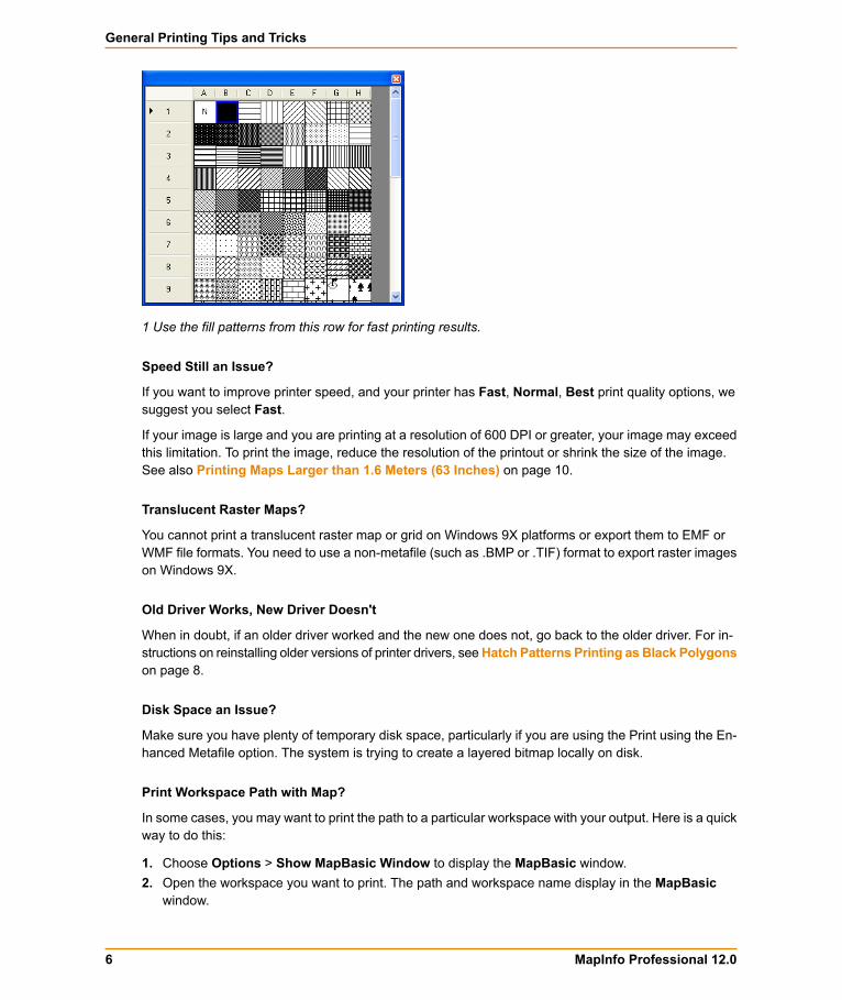
1 Use the fill patterns from this row for fast printing results.
Speed Still an Issue?
If you want to improve printer speed, and your printer has Fast, Normal, Best print quality options, wesuggest you select Fast.
If your image is large and you are printing at a resolution of 600 DPI or greater, your image may exceedthis limitation. To print the image, reduce the resolution of the printout or shrink the size of the image.See also Printing Maps Larger than 1.6 Meters (63 Inches) on page 10.
Translucent Raster Maps?
You cannot print a translucent raster map or grid on Windows 9X platforms or export them to EMF orWMF file formats. You need to use a non-metafile (such as .BMP or .TIF) format to export raster imageson Windows 9X.
Old Driver Works, New Driver Doesn't
When in doubt, if an older driver worked and the new one does not, go back to the older driver. For in-structions on reinstalling older versions of printer drivers, seeHatch Patterns Printing as Black Polygonson page 8.
Disk Space an Issue?
Make sure you have plenty of temporary disk space, particularly if you are using the Print using the En-hanced Metafile option. The system is trying to create a layered bitmap locally on disk.
Print Workspace Path with Map?
In some cases, you may want to print the path to a particular workspace with your output. Here is a quickway to do this:
1. Choose Options > Show MapBasic Window to display the MapBasic window.2. Open the workspace you want to print. The path and workspace name display in the MapBasic
window.
MapInfo Professional 12.06
General Printing Tips and Tricks
3. Use Ctrl C or Edit > Copy to copy the path and workspace name from the MapBasic window.4. Choose Window > New Layout Window to create a new Layout window.5. Make the new Layoutwindow active and useCtrl V or Edit > Paste to paste the path into the Layout
window. The path may paste in the gray area of the Layout window and may be difficult to see.6. Select and drag the path to the desired printable location.
Printing Globally? Spool Locally!
Try spooling print jobs locally rather than at the plotter. This allows the computer to rasterize your outputrather than the printer, which can be more efficient.
1. To set up local print job spooling, choose Start > Settings > Control Panel > Printers .2. Right-click the printer and choose Properties to display the printer's properties.3. Click the Advanced tab to display the advanced property options.4. Click the Spool Print Documents button and Start printing after last page is spooled button.
If you do not have administrative rights to your computer, you may not be able to use thespooling option. Contact your IT department if you want to make this change to get theirsupport.
Note:
5. Click OK to save your changes.
Resolutions to Known Printing IssuesThere are many variables that affect printing and plotting with any application, and MapInfo Professionalis no exception. MapInfo Professional does not provide its own printer drivers, it uses the existing onesinstalled under the current Windows operating system. This section addresses specific printer/plotterissues that have been uncovered by users and partners.
Platform Independent IssuesThese issues occur regardless of operating system or hardware/software, except where specificallynoted. Look for the issue you are working with below and refer to the resolution.
Printing a Layout Window to Multiple PagesPrinters/Plotters: HP Designjet Printers
MapInfo Professional Versions: 4.x and later
Issue: How do you print a Layout window to multiple pages?
Resolution: With the Layout window active, choose Layout > Options to display the Layout Optionsdialog box.
To make the layout page two pages wide and two pages tall, type 2 in the Layout Size Width andHeightfields. Then click OK.
7Printing Guide
MapInfo Professional 12.0 Printing Guide
Handling the "Unable to Save Window Contents" MessagePrinters/Plotters: HP Designjet 1055CM
MapInfo Professional Versions: 7.0+
Issue: This issue comes up whenever users try to print a Layout window at 60 in. x 36 in. or larger dueto memory issues.
Resolution: In this circumstance, print directly to the device rather than create the Enhanced MetaFile(EMF). Additionally we recommend that you use the appropriate HPGL driver for your printer and oper-ating system. All current HP printer drivers are available at their web site, http://www.hp.com.
Hatch Patterns Printing as Black PolygonsPrinters/Plotters: HP Designjet Series Plotters
MapInfo Professional Versions: All
Issue: When you print maps with hatch patterns, some regions display as solid black.
Resolution: According to Hewlett Packard support, the new HP printer driver (4.63) handles non-Windowsstandard hatch patterns properly. We recommend that you download and install the new HP 4.63 driverto resolve this problem.
Platform-Specific IssuesThese issues pertain to particular operating systems and/or hardware except where specifically noted.These issues are grouped by operating system.
Print output repeats itself every 2 to 4 cm using the HP 500, 800, 5000 Designjetplotter when printing RastersWe have two suggestions to working around this problem. First, try spooling the printer locally eitherfrom the driver level or the printer level.
You must have read/write rights to your printer and printer driver to resolve this issue.Note:
To work around this problem, there is an advanced hidden setting that you can change within the prop-erties of the driver. To prevent the printer from repeating itself every 2-4 cm. when printing rasters withvector overlays:
1. Locate the printer driver's properties in the Control Panel. To get to this setting, right-click theprinter icon and choose Properties.
2. Click the Advanced tab. Select the following options:
• Select the Avoid out of memory option.• If you are using the Windows 2000 or XP operating system, select a scaling factor of 100%.
3. From this dialog box, click the Printing Defaults button.4. In this dialog box, select the About button. The About <Driver Name> dialog box displays.5. Holding down the F8 key on your keyboard, click the OK button. The Special Options dialog box
displays:6. Do one of the following and click OK:
MapInfo Professional 12.08
Platform-Specific Issues
If printing from Windows 98, clear the Enable RenderSmart check box.•• If printing from Windows 2000 or XP, clear the Enable SpoolSmart check box.
CAUTION: When you modify settings in this driver option box, make sure to note the originalsettings in case you need to change them back. These were designed for HP Support Engineersand not for general public use.
You can save these settings as a Quick Set to ensure that they run every time you print raster files.
1. Choose Start > Settings/Control Panel > Printers .2. Right-click the appropriate plotter driver icon and choose Printing Preferences.3. Set the preferences the way you want them in the hidden menu.4. In the Quick Sets box, type a name for the selected settings (for example, "Raster Print Settings")
and click Save. All current driver settings (paper type, hidden menu settings, etc.) are saved underthe Quick Set name. The printer driver remembers these settings and they can be used for futureprint jobs.
To print a raster map later with the same settings:
1. Choose File > Print to display the Print dialog box.2. Choose the Properties button. The Properties dialog box displays.3. Make sure the name you entered (as in "Raster Print Settings" in our example) displays in the Quick
Sets drop-down list and click OK. The Print dialog box redisplays.4. Click OK to print.
If you do not need this special setting in Quick Sets, remember to change this setting back tothe default machine setting.
Note:
Cannot Print with HP Designjet Printers (Driver 5.31 or 5.32).When you attempt to use this driver one of these things happens:
• If you select the Maximum Performance option, you get memory error messages and the printerprints only part of the image.
• If you select the Avoid out of memory option, the computer shuts down unexpectedly and displaysboth an Out of Hard Disk Space message and an Out of Virtual Memory message.
The resolution of this issue is similar to Platform-Specific Issues on page 8. The dialog box is thesame.
To resolve this issue:1. Choose FilePrint to display the Print dialog box.2. Click the Advanced button at the bottom of this dialog box. The Advanced Printing Options dialog
box displays.3. Select these options and click OK:
• Print directly to the printer• Internal Handling for Transparent Vector Fills and Symbols• Use ROP Method to Display Transparent Raster• Print Raster in True Color When Possible
9Printing Guide
MapInfo Professional 12.0 Printing Guide
• Select the Half Tone dither method.
4. From the Control Panel, select Printers or Printers and Faxes and find the printer you want to printfrom.
5. Right-click the printer you want to print to and select the Properties option. The Properties dialogbox displays.
6. Click the About button to display the About <Printer Driver> dialog box.7. Holding down the F8 key on your keyboard, click the OK button. The Special Options dialog box
displays.8. Do one of the following:
• If printing from Windows 98, clear the Enable RenderSmart check box.• If printing from Windows 2000 or XP, clear the Enable SpoolSmart check box.
Printing Maps Larger than 1.6 Meters (63 Inches)When you print a map that is larger than 1.6 meters or 63 inches in Normal or Best modes, often theimage is incomplete. Only the first 1.6 m or 63" prints.
To resolve this issue, do one of the following:
• Click the Advanced button and in the Print Quality options, select a lower print resolution (from 600to 300 DPI or from 300 to 150 DPI).
• Set the Scale to fit option to 100% to divide the resolution rendering by 2.
When you use one of these alternatives you can print up to 3.2 meters (10.5 feet) at 300 DPI or up to6.4 meters (21 feet) at 150 DPI.
Enhancements Added in Earlier Versions
MapInfo Professional 11.0Saving Preferences for Georegistration Coordinate Units
You can select to store the bounds and coordinate systems of the map or layout view in your PDF file.This type of file is called a Georegistered PDF. You can save preferences to set the georegistration co-ordinate units to either Use Map Units or Use Degrees. For more information and instructions on howto do this, see Saving Preferences for Georegistration Coordinate Units in the Help System.
MapInfo Professional 10.5New in this release are polygon mode printing, printing to an offscreen bitmap (OSBM), subdivide printing,and printing to a PDF file.
Polygon Mode Printing
This release of MapInfo Professional introduces a new way of drawing complicated polygons, such asthose containing holes or many nodes through a User Interface. This was due to an issue with printing
MapInfo Professional 12.010
Enhancements Added in Earlier Versions
such objects using an Adobe PDF printer driver. It left visible seams and gaps in the image when thePDF was printed. These seams and gaps werenot visible on screen nor when printed using other printerdrivers.
Printing with the new method means that large polygons are now rendered as-is not broken into smallerpolygons, as the older method does. Additionally, the new method uses different calls that specificallysupport drawing polygons with holes. The older method manipulates the polygon with holes to draw asa single polygon, which caused seams and gaps to appear in the PDF
Because this issue does not affect all users of MapInfo Professional who print maps, we continueto provide the original polygon drawing method.
Note:
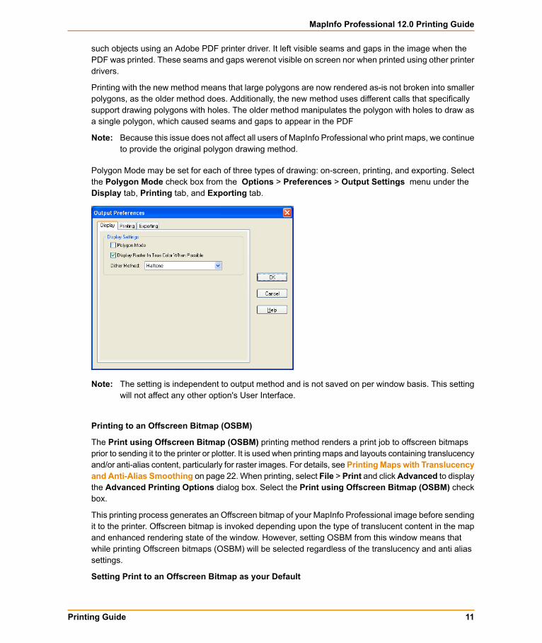
Polygon Mode may be set for each of three types of drawing: on-screen, printing, and exporting. Selectthe Polygon Mode check box from the Options > Preferences > Output Settings menu under theDisplay tab, Printing tab, and Exporting tab.
The setting is independent to output method and is not saved on per window basis. This settingwill not affect any other option's User Interface.
Note:
Printing to an Offscreen Bitmap (OSBM)
The Print using Offscreen Bitmap (OSBM) printing method renders a print job to offscreen bitmapsprior to sending it to the printer or plotter. It is used when printing maps and layouts containing translucencyand/or anti-alias content, particularly for raster images. For details, see Printing Maps with Translucencyand Anti-Alias Smoothing on page 22. When printing, select File > Print and clickAdvanced to displaythe Advanced Printing Options dialog box. Select the Print using Offscreen Bitmap (OSBM) checkbox.
This printing process generates an Offscreen bitmap of your MapInfo Professional image before sendingit to the printer. Offscreen bitmap is invoked depending upon the type of translucent content in the mapand enhanced rendering state of the window. However, setting OSBM from this window means thatwhile printing Offscreen bitmaps (OSBM) will be selected regardless of the translucency and anti aliassettings.
Setting Print to an Offscreen Bitmap as your Default
11Printing Guide
MapInfo Professional 12.0 Printing Guide
You can set this option as a default by selecting OptionsPreferencesOutput and then selecting Printusing Offscreen Bitmap (OSBM) under the Printing tab. This preference sets the default for all newwindows.
Subdivide Printing
In earlier versions of MapInfo Professional, there was an optional registry setting, called SubdividePrint-ing, to allow print jobs to be broken into multiple, smaller print requests. This was especially useful ifprinting large raster/ translucent maps to large paper sizes. Now that option has been added as a pref-erence. The preference is initialized using the registry setting if it existed.
Click Options > Preferences > Output Settings under the Printing tab. There is a check box forSubdivide Printing. If selected, the print job is broken into multiple smaller print request. If unchecked,the print is done in a single request.
Printing to PDF
Professional lets you save a map to a layered PDF file. Since Acrobat 6.0, PDFs are capable of holdingmultiple pages of information in the same space through the use of Optional Content Groups (OCG),which are more commonly known as layers. Layers in PDFs are very similar to MapInfo Professionalmap layers.
Your PDF now displays layers in the same order as shown in the MapInfo Professional Layer Controlwindow, and it displays translucency. The MapInfo PDF Printer supports GeoRegistration, which storesthe bounds and coordinate systems of the map view in the PDF file. The PDF file also stores the attributedata of the records on the map.
New in this release when saving to a PDF file:
• Print to PDF – Select File > Print to PDF to save your map, browser, graph, or layout to a PDF file.This option is similar to Save As, and gives you the option to concatenate PDF files.
• MapInfo PDF Printer tool – The Main menu includes a new MapInfo PDF Printer tool, which is thesame as selecting File > Print to PDF to save your map, browser, graph, or layout to a PDF file.
• Translucency – You can create a layered PDF that includes translucent layers in MapInfo Professional10.5.
• PDF Preferences – The MapInfo Professional Print dialog (select File > Print) now includes a PDFbutton that displays after selecting MapInfo PDF Printer from the Name list. This button launches thePDF Preferences dialog. From this dialog, you can make the following settings:
Layered PDF
Select to save layers for a map, as shown in the MapInfo Professional Layer Control window, to thePDF file. When saving a Layout window, each frame, such as map frame and legend frame, becomesa layer in the PDF.
Georegistered PDF
Select to store the bounds and coordinate systems of the map or layout view in the PDF file.
Add Attribute data to PDF
Select to store the attribute data of the records on the map in the PDF file.
Automatically open the PDF
MapInfo Professional 12.012
MapInfo Professional 10.5
Select to have the PDF file open after it is generated.
Selecting the Layered PDF option in the PDF Preferences dialog box enables the Direct to Deviceoption, and disables using OSBM and EMF.
If you select the Print using EMF or Print using the Offscreen Bitmap (OBSM) output method and lateron select the Layered PDF from the PDF Preferences dialog box, then the output method forciblysets to Direct to Device. However, disabling the Layered PDF option resets the print output methodback to your original selection, EMF/ OSBM.
• Context Sensitive Help for the MapInfo PDF Printer – This version of the MapInfo PDF Printer in-cludes documentation in the form of a help system. To access this help system, select File > Printand click Properties in the Print dialog box. This opens the MapInfo PDF Printer Properties dialogbox, which now includes a Help button on each tab.
MapInfo Professional 10.0MapInfo Professional lets you save a map to a layered PDF file, see Printing the Map to a LayeredPDF File on page 4.
MapInfo Professional 9.5.1MapInfo Professional provides enhanced rendering capabilities in this release, including:
• translucency of vector objects (map features, labels, themes, text, and layout objects)• smoothing (anti-aliasing) of text, vector and images• new drawing selection method• new export formats: EMF+ and EMF+Dual• use of offscreen bitmaps to draw layouts• printing improvements
Enhanced rendering is possible through Microsoft's GDI+, an operating system level capability thatprovides two-dimensional vector graphics, imaging, and typography handling. GDI+ improves onstandard Windows Graphics Device Interface (GDI) by adding new features and optimizing existingfeatures.
Enhanced rendering in MapInfo Professional allows you to create translucent labels, themes, and layers,as well as apply anti-aliasing to smooth the jagged edges of text, labels, lines, curves, region bordersand raster images. We also provide a new way of drawing selections and two new export formats as aresult of using the new enhanced rendering support.
Enhanced rendering covers the following topics:
• Enabling Enhanced Rendering on page 14• Enabling Enhanced Rendering for New Windows on page 14• Enhancing Selection Drawing Style on page 15• Workspaces on page 16• Translucency on page 16• Anti-Aliasing on page 19• EMF+ and EMF+Dual Export Formats on page 20
13Printing Guide
MapInfo Professional 12.0 Printing Guide
• Layout Drawing Improvements on page 21• PrintOSBM Registry Setting on page 21
Enabling Enhanced Rendering
To take advantage of enhanced rendering in MapInfo Professional, you must turn on the capability. Ifyou do not turn on enhanced rendering, rendering is performed using the standard Windows GraphicsDevice Interface (GDI).
Enhanced rendering does not mean that translucency and anti-aliasing are automatically applied.Translucency and anti-alias settings must also be applied to generate the best looking maps. You will,however, automatically have the improved selection drawing style (see Enhancing Selection DrawingStyle on page 15). Translucency and Anti-Aliasing are discussed under Translucency on page 16 andAnti-Aliasing on page 19, respectively.
Enhanced rendering is supported for Map, Browser, and Layout windows. Enhanced rendering is notavailable for other types of windows.
To enable enhanced rendering, set it in the Options dialog for the map (from the Map menu, selectOptions),Browser or Layoutwindows, or through aMapBasic statement. It is controlled on a per windowbasis.
Legends are drawn in the same mode as the associated Map window. So, if a map is in enhanced ren-dering mode, its legend is as well. There are no enhanced rendering options in the Legend Optionsdialog.
Like the Map and Browser windows, enhanced rendering for Layout windows is enabled in its Optionsdialog. This means that any annotations added to the layout, such as titles or watermarks will be drawnusing enhanced rendering. If you addMap andBrowserwindows that already are enabled for enhancedrendering, enhanced rendering will be forced on for the Layout window. Enhanced rendering for theMap and Browser windows have no affect on the Layout window, and vice versa. For more information,see Translucency on page 16.
There is also a style preference to determine the initial enhanced rendering state for newly createdwindows. See Enabling Enhanced Rendering for New Windows on page 14.
MapInfo Professional 9.5 opens a workspace with enhanced rendering, but ignores the enhancedrendering settings. Versions of MapInfo Professional prior to 9.5 cannot open a workspace withenhanced rendering. See Workspaces on page 16.
Note:
Enabling Enhanced Rendering for New Windows
MapInfo Professional provides a Style preference to determine the default state of enhanced renderingfor newly created Map, Browser and Layout windows. Each window can be changed independently ata later time. This preference is disabled by default to maintain backwards compatibility with earlier versionsof MapInfo Professional.
These preferences control the state of new windows, not existing windows. This means if youare opening old workspaces, they will open with enhanced rendering disabled, regardless of howthe Style preference is set.
Note:
To set enhanced rendering as a default style preference:
MapInfo Professional 12.014
MapInfo Professional 9.5.1
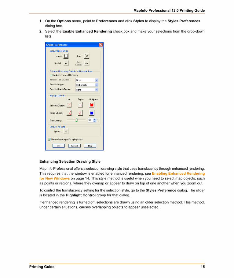
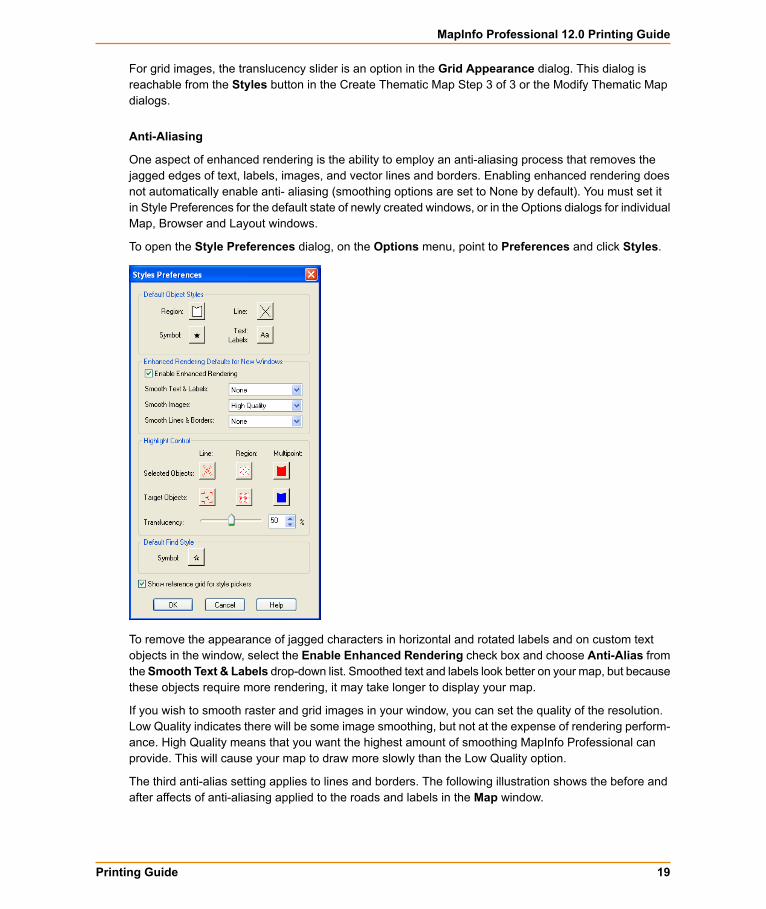
1. On the Options menu, point to Preferences and click Styles to display the Styles Preferencesdialog box.
2. Select the Enable Enhanced Rendering check box and make your selections from the drop-downlists.
Enhancing Selection Drawing Style
MapInfo Professional offers a selection drawing style that uses translucency through enhanced rendering.This requires that the window is enabled for enhanced rendering, see Enabling Enhanced Renderingfor New Windows on page 14. This style method is useful when you need to select map objects, suchas points or regions, where they overlap or appear to draw on top of one another when you zoom out.
To control the translucency setting for the selection style, go to the Styles Preference dialog. The slideris located in the Highlight Control group for that dialog.
If enhanced rendering is turned off, selections are drawn using an older selection method. This method,under certain situations, causes overlapping objects to appear unselected.
15Printing Guide
MapInfo Professional 12.0 Printing Guide
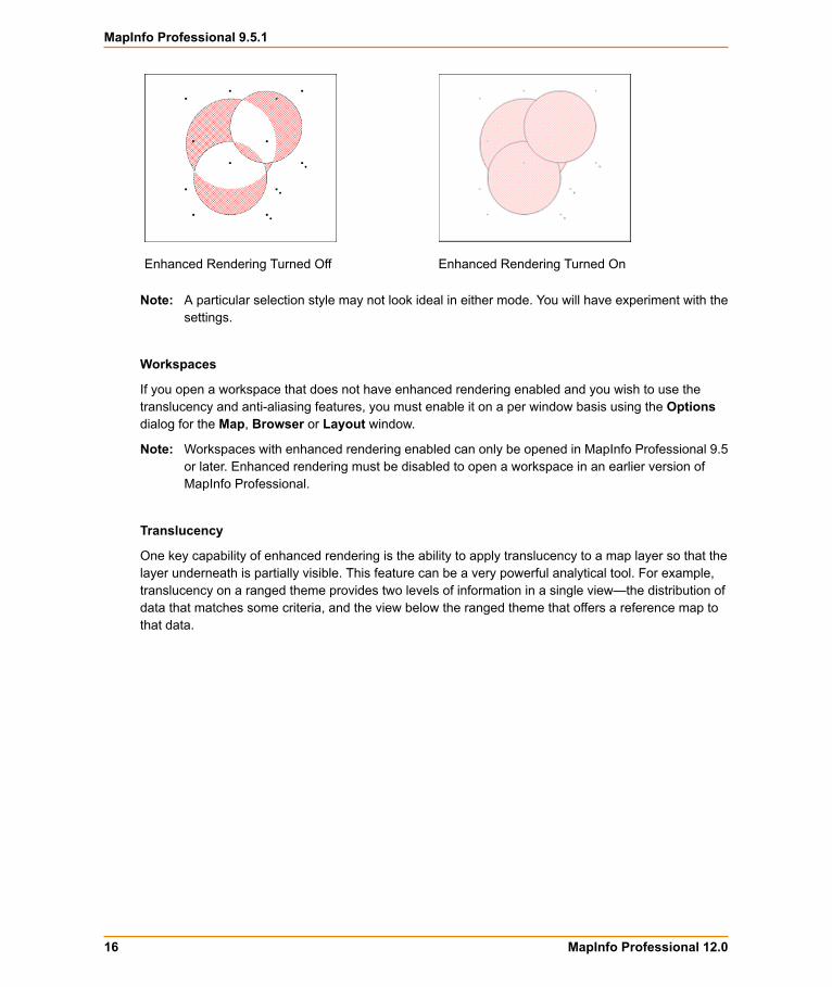
Enhanced Rendering Turned OnEnhanced Rendering Turned Off
A particular selection style may not look ideal in either mode. You will have experiment with thesettings.
Note:
Workspaces
If you open a workspace that does not have enhanced rendering enabled and you wish to use thetranslucency and anti-aliasing features, you must enable it on a per window basis using the Optionsdialog for the Map, Browser or Layout window.
Workspaces with enhanced rendering enabled can only be opened in MapInfo Professional 9.5or later. Enhanced rendering must be disabled to open a workspace in an earlier version ofMapInfo Professional.
Note:
Translucency
One key capability of enhanced rendering is the ability to apply translucency to a map layer so that thelayer underneath is partially visible. This feature can be a very powerful analytical tool. For example,translucency on a ranged theme provides two levels of information in a single view—the distribution ofdata that matches some criteria, and the view below the ranged theme that offers a reference map tothat data.
MapInfo Professional 12.016
MapInfo Professional 9.5.1
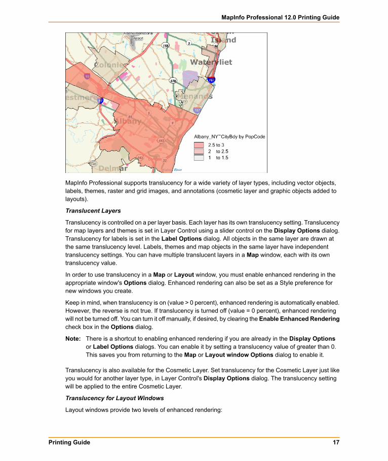
MapInfo Professional supports translucency for a wide variety of layer types, including vector objects,labels, themes, raster and grid images, and annotations (cosmetic layer and graphic objects added tolayouts).
Translucent Layers
Translucency is controlled on a per layer basis. Each layer has its own translucency setting. Translucencyfor map layers and themes is set in Layer Control using a slider control on the Display Options dialog.Translucency for labels is set in the Label Options dialog. All objects in the same layer are drawn atthe same translucency level. Labels, themes and map objects in the same layer have independenttranslucency settings. You can have multiple translucent layers in a Map window, each with its owntranslucency value.
In order to use translucency in a Map or Layout window, you must enable enhanced rendering in theappropriate window's Options dialog. Enhanced rendering can also be set as a Style preference fornew windows you create.
Keep in mind, when translucency is on (value > 0 percent), enhanced rendering is automatically enabled.However, the reverse is not true. If translucency is turned off (value = 0 percent), enhanced renderingwill not be turned off. You can turn it off manually, if desired, by clearing the Enable Enhanced Renderingcheck box in the Options dialog.
There is a shortcut to enabling enhanced rendering if you are already in the Display Optionsor Label Options dialogs. You can enable it by setting a translucency value of greater than 0.This saves you from returning to the Map or Layout window Options dialog to enable it.
Note:
Translucency is also available for the Cosmetic Layer. Set translucency for the Cosmetic Layer just likeyou would for another layer type, in Layer Control's Display Options dialog. The translucency settingwill be applied to the entire Cosmetic Layer.
Translucency for Layout Windows
Layout windows provide two levels of enhanced rendering:
17Printing Guide
MapInfo Professional 12.0 Printing Guide
• Annotation-level enhanced rendering for graphic objects, such as titles or watermarks.• Window-level enhanced rendering for the Maps, Legends and Browsers.
To set enhanced rendering for layout annotations for an already created layout, go to Layout > Optionsand select the Enable Enhanced Rendering check box. You can also set smoothing settings here aswell. If you have yet to create the Layout, you can enable enhanced rendering as a preference for newlycreated windows (Options > Preferences > Styles).
To set enhanced rendering for Map and Browser windows that you wish to display in a Layout window,go to the appropriate window options dialog (Map or Browser) and check the Enable Enhanced Ren-dering check box. Adding these windows to the layout and enhanced rendering will continue for thesewindows. To disable enhanced rendering for these frames, return to the appropriate Options dialog andclear the check box.
Embedding a Map or Browser window with enhanced rendering on in a Layout window will also forceenhanced rendering on for the layout. This can be seen in the Options dialog (Layout > Options) whenthe Enhanced Rendering check box is selected, but the control is disabled, preventing you from turningit off.
Adjusting Translucency in a Layout
Translucency for annotations in a layout is controlled by a translucency slider in the Options dialog forLayout windows.
To adjust the translucency of annotations in a Layout window go to Layout > Options and change thevalue on the translucent slider. All annotations in the Layout window will be treated with the sametranslucency setting. Annotations are objects you can add to a layout by using, for example, the AddSymbol, Line, Polyline, or Text toolbar options.
To adjust the translucency for Map windows in a layout, you must return to its Map window and accessthe Options dialog to reach the translucency slider.
Translucency for annotation objects does not affect the translucency of maps in layout frames.The contents of frames are drawn using that window's translucency settings. They are not drawn
Note:
using the Layout window translucency setting. The translucency slider on the Layout Optionsdialog does not control the translucency of the maps.
Translucent Raster and Grid Images
Translucency for raster and grid images has been available in MapInfo Professional prior to this release.The new aspect of image translucency is the added support through enhanced rendering. These imagescan be drawn translucently with or without enhanced rendering enabled.
The advantage of using enhanced rendering is seen when a translucent raster or grid image is printed.Enhanced rendering enabled forces MapInfo Professional to print to offscreen bitmaps, which typicallyyields better looking results than if printed without enhanced rendering.
For raster images, there is no change to how you set translucency through the user interface or viaMapBasic commands. Set the translucency in theAdjust Image Styles dialog ( Layer Control >DisplayOptions > Style Override > Adjust Image Styles ).
Raster display options can also be controlled on a per table basis so that the image will open using thoseparticular settings by default. These are found under Table > Raster > Adjust Image Styles .
MapInfo Professional 12.018
MapInfo Professional 9.5.1
For grid images, the translucency slider is an option in the Grid Appearance dialog. This dialog isreachable from the Styles button in the Create Thematic Map Step 3 of 3 or the Modify Thematic Mapdialogs.
Anti-Aliasing
One aspect of enhanced rendering is the ability to employ an anti-aliasing process that removes thejagged edges of text, labels, images, and vector lines and borders. Enabling enhanced rendering doesnot automatically enable anti- aliasing (smoothing options are set to None by default). You must set itin Style Preferences for the default state of newly created windows, or in the Options dialogs for individualMap, Browser and Layout windows.
To open the Style Preferences dialog, on the Options menu, point to Preferences and click Styles.
To remove the appearance of jagged characters in horizontal and rotated labels and on custom textobjects in the window, select the Enable Enhanced Rendering check box and choose Anti-Alias fromtheSmooth Text & Labels drop-down list. Smoothed text and labels look better on your map, but becausethese objects require more rendering, it may take longer to display your map.
If you wish to smooth raster and grid images in your window, you can set the quality of the resolution.Low Quality indicates there will be some image smoothing, but not at the expense of rendering perform-ance. High Quality means that you want the highest amount of smoothing MapInfo Professional canprovide. This will cause your map to draw more slowly than the Low Quality option.
The third anti-alias setting applies to lines and borders. The following illustration shows the before andafter affects of anti-aliasing applied to the roads and labels in the Map window.
19Printing Guide
MapInfo Professional 12.0 Printing Guide

Enhanced Rendering On, with smoothing optionsEnhanced Rendering Off
EMF+ and EMF+Dual Export Formats
In order to take full advantage of enhanced rendering, MapInfo Professional provides EMF+ and EMF+Dualimage export formats. These are enhanced metafile vector image formats that support Windows GDI+(Graphics Device Interface). Use these to save translucent maps instead of exporting to the oldermetafile formats, such as EMF and WMF. Older formats do not support translucency very well, whichdisplay images using translucency with a dithered, or speckled, appearance.
Choose EMF+ if you expect to bring your maps into an application that supports EMF+, such as MicrosoftOffice 2007. Choose EMF+Dual (a combination of EMF and EMF+) if your maps may be used in applic-ations that may or may not support EMF+, such as Microsoft's Office 2003 and Office 2007.
EMF+Dual format will produce a larger file than EMF+. But it provides better compatibility witholder application that do not support EMF+.
Note:
MapInfo Professional 12.020
MapInfo Professional 9.5.1
Layout Drawing Improvements
Beginning with this release, MapInfo Professional now prepares a layout for display by rasterizing thecontents to an offscreen bitmap, and displaying the entire layout once the bitmap is drawn. You will nolonger see a partial display of the Layout window. The drawing is done offscreen and is presented toyou when it is completely drawn.
This behavior applies to layout displays with or without enhanced rendering enabled.
PrintOSBM Registry Setting
This registry setting controls a new printing method that renders a print job to offscreen bitmaps prior tosending it to the printer or plotter. This is used when printing maps and layouts containing translucencyand/or anti-alias content.
For instructions to set PrintOSBM, see Anti-Aliasing on page 19.
MapInfo Professional 9.5
PolygonMode
This release of MapInfo Professional introduces a new way of drawing complicated polygons, such asthose containing holes or many nodes. This was due to an issue with printing such objects using anAdobe PDF printer driver. It left visible seams and gaps in the image when the PDF was printed. Theseseams and gaps were not visible on screen nor when printed using other printer drivers.
Printing with the new method means that large polygons are now rendered as-is not broken into smallerpolygons, as the older method does. Additionally, the new method uses different calls that specifically
21Printing Guide
MapInfo Professional 12.0 Printing Guide
support drawing polygons with holes. The older method manipulates the polygon with holes to draw asa single polygon. This is what caused seams and gaps to appear in the PDF
Because this issue does not affect all users of MapInfo Professional who print maps, we continue toprovide the original polygon drawingmethod. You can control whichmethod to use by changing the registrysetting PolygonMode=1 (default, renders using the new method), to PolygonMode=0 for the old method.This setting is located in the system registry under HKEY_LOCAL_MACHINE\SOFTWARE\MapInfo\Map-Info\Common.
PrintOSBM
This registry setting controls a new printing method that renders a print job to offscreen bitmaps prior tosending it to the printer or plotter. This is used when printing maps and layouts containing translucencyand/or anti-alias content. For details, see Printing Maps with Translucency and Anti-Alias Smoothing.
Printing Maps with Translucency and Anti-Alias Smoothing
MapInfo Professional provides a new printing method for maps and layouts containing translucent contentand anti-alias settings. This method renders the map or layout "behind the scenes" to an offscreen bitmapprior to sending it to your printer or plotter. The use of offscreen bitmaps is invoked depending on thetype of translucent content in the map and the enhanced rendering state of the window, as follows:
• Invoked when your map or layout contains translucent vectors (such as map layers, themes, or labels)and enhanced rendering has been enabled.
• Invoked if your map contains images with either High or Low Quality smoothing enabled.• Invoked for translucent raster and grid images provided enhanced rendering is enabled.
You cannot control this print method through the Print dialog, as you can with Direct to Device or Printto EMF. This is a registry setting called PrintOSBM, located under HKEY_LOCAL_MACHINE\SOFT-WARE\MapInfo\MapInfo\Common. The values are dword:00000000 (auto) and dword:00000001(forced on). Auto, the default, means that printing will use offscreen bitmaps only for the translucencyand anti-alias conditions listed above. Forced on means printing will use offscreen bitmaps regardlessof the translucency and anti-alias settings.
For translucent raster and grid images, you can also print using EMF when enhanced rendering is notenabled.
Direct printing to a printer or plotter does not support translucency.Note:
Enabling the PrintOSBM Option Using Registration Files
To edit the registry, you will need Administrator privileges. If you do not have the required privileges,then ask your System Administrator to assist you.
To enable the PrintOSBM option using registration files in the Knowledge Base document:
1. Go to the MapInfo Knowledge Base entry MapInfo Professional > Registry Settings > EnablingEnabling the PrintOSBM option: http://testdrive.mapinfo.com/TechSupp/MI-Prod.nsf/2fa3e3416d06d61d85257125006b2533/b769a029109299ab8525754c00591ec9?Open-Document
MapInfo Professional 12.022
MapInfo Professional 9.5
If you do not have Internet access, see Enabling the PrintOSBM Option Manually on page23 for instructions.
Note:
2. Save the Print_OSBM_ON.reg and Print_OSBM_auto.reg files locally. Use Windows Explorerto navigate to the registration files.
We recommend you create a permanent directory in case you need to remove the registrationoption later.
Note:
3. Double-click the Print_OSBM_ON.reg icon to add the new key to the registry. This option takes effectthe next time you open MapInfo Professional.
Disabling the PrintOSBM Option Using Registration Files
If you try this option and you want to remove this functionality, you can disable the registry entry by fol-lowing these instructions.
We assume that you have downloaded the registry files by following the instructions in Enablingthe PrintOSBM Option Using Registration Files on page 22.
Note:
To disable the PrintOSBM option using the downloaded registration file:
1. Go to the directory that contains the registration (.reg) files you downloaded earlier.2. To remove the PrintOSBM option, double-click the Print_OSBM_auto.reg icon. The registry entry
is updated with the new value. This option takes effect the next time you open MapInfo Professional.
Enabling the PrintOSBM Option Manually
If you do not have access to the Internet, or you want to add this option manually, follow these instructions.Before modifying the registry, make a backup:
1. Choose Start >Run and type the command regedit. ClickOK to display theRegistry Editorwindow.2. In the HKEY_LOCAL_MACHINE entry, navigate to Software > MapInfo > MapInfo > Common .3. Highlight the Common folder and then select File > Export.4. In the Export Registry File dialog, specify a location and file name to backup to and then click Save.
To enable the PrintOSBM Print option by entering the registration key manually:
1. From the Edit menu, select New > DWORD Value. A new entry displays in the list.2. Right-click the entry and select Rename. Rename the new entry PrintOSBM and press Enter.3. Double-click the new entry to display the Edit DWORD Value dialog box.4. To enable the PrintOSBM option, type 1 in the Value data field and click OK. This forces printing to
use off-screen bitmaps regardless of the translucency and anti-alias settings.
To disable this option, return to this dialog box, type 0 in the Value data field and click OK. Thiscauses printing to use off-screen bitmaps only for the translucency and anti-alias conditions.
This option takes effect the next time you open MapInfo Professional.
You can also remove this regedit entry entirely to remove this option.Note:
23Printing Guide
MapInfo Professional 12.0 Printing Guide
EMF+ and EMF+Dual Export Formats
In order to take full advantage of enhanced rendering, MapInfo Professional provides two new imageexport formats: EMF+ and EMF+Dual. These are enhanced metafile vector image formats that supportGDI+. Use these to save translucent maps instead of exporting to the older metafile formats (EMF andWMF). Older formats do not support translucency very well, which display images using translucencywith a dithered, or speckled, appearance.
Choose EMF+ if you expect to bring your maps into an application that supports EMF+, such as MicrosoftOffice 2007. Choose EMF+Dual (a combination of EMF and EMF+) if your maps may be used in applic-ations that may or may not support EMF+, such as Microsoft's Office 2003 and Office 2007.
EMF+Dual format will produce a larger file than EMF+. But it provides better compatibility witholder application that do not support EMF+.
Note:
If you are printing a map/layout that contains a translucent image, you must select Print UsingEnhancement Metafile (EMF). The Print Directly to Device option does not support translucentimages.
Note:
MapInfo Professional Printing Guide Available in Help
Over the years, users have told us that the MapInfo Professional Printing Guide helps them print largeor complex maps or layouts. You can now access the MapInfo Professional Printing Guide, which containsprinting tips and tricks from our Quality Assurance department, in the Help System.
To access the Printing Guide in the Help System, choose Help > MapInfo Professional Help Topics> Productivity Aids > MapInfo Professional 9.5 Printing Guide .
MapInfo Professional 9.0Printing Large and Complex Output
If you have seen the Cannot Print error message when printing, you may be trying to print one or moreof the following:
• Large format (large page size) maps or layouts containing raster or grid layers that may be translucentor transparent
In this case, many times the maps or layouts did not print at all, or if they did print, the translucent ortransparent layers did not print properly.
• Maps made up of multiple pages that contain borders
In this case multiple page maps with a border around the entire map would print with borders aroundeach page instead.
• Maps that contained labels that span more than one page
In this case, the labels would not print at all or would not print properly.
Largely, these issues were caused by the demand these print requests placed on the system resourcesin your computer.
To resolve these issues we now offer an option that breaks down a print request into smaller blocks,which reduces the demand on your system's resources. Each block is sent individually to the printerdriver. This change may allow you to print large and complex images that you could not print in the past.We call this feature Subdivide Print. We limit the size of each block to 8192 x 8192 pixels.
MapInfo Professional 12.024
MapInfo Professional 9.0
Caveat
During testing we discovered that many printer drivers handled this new option properly. However wefound that the output of some printer drivers resulted in gaps that display at the block boundaries.Therefore we did not enable this option by default. Since these gaps may affect the quality of your finaloutput, we are giving you the ability to enable this option if or when you need it. At this time, we do nothave a workaround to remove these gaps.
If you have both a postscript and a non-postscript version of your printer driver, we recommendyou try both to see which version gives you better results.
Note:
25Printing Guide
MapInfo Professional 12.0 Printing Guide