national spatial data infrastructure (nsdi) of the working groups december 2011 nsdi working groups...
TRANSCRIPT

Department of Science & TechnologyMinistry of Science & Technology
National Spatial Data Infrastructure (NSDI)
Government of India, New DelhiDecember 2011
Reports of the Working GroupsOn
Node Architecture & Guidelines, Interoperability & Data Exchange, Cost Recovery & Payment Gateways, Outreach & Communication and
Data Delivery & Capacity Building
PDF compression, OCR, web optimization using a watermarked evaluation copy of CVISION PDFCompressor

Reports of the Working Groups
On
Node Architecture & Guidelines, Interoperability & Data Exchange, Cost Recovery & Payment Gateways, Outreach &
Communication and Data Delivery & Capacity Building
National Spatial Data Infrastructure (NSDI) Department of Science & Technology
Ministry of Science & Technology Government of India, New Delhi
December 2011
PDF compression, OCR, web optimization using a watermarked evaluation copy of CVISION PDFCompressor
Reports of the working Groups December 2011
NSDI working Groups Report
Published by
National Spatial data Infrastructure (NSDI)
Department of Science and Technology
East block-7, Level-5, R K Puram
New Delhi-110066
Tel : 011-26177249, Fax : 011-26182967
Designed by : Gateway Media Pvt Ltd
Printed at : Srilakshmi Graphics
PDF compression, OCR, web optimization using a watermarked evaluation copy of CVISION PDFCompressor
Reports of the working Groups December 2011
NSDI Vision
National infrastructure for the
availability and access to
organised spatial data
Use of this infrastructure at
Community, Local, Regional
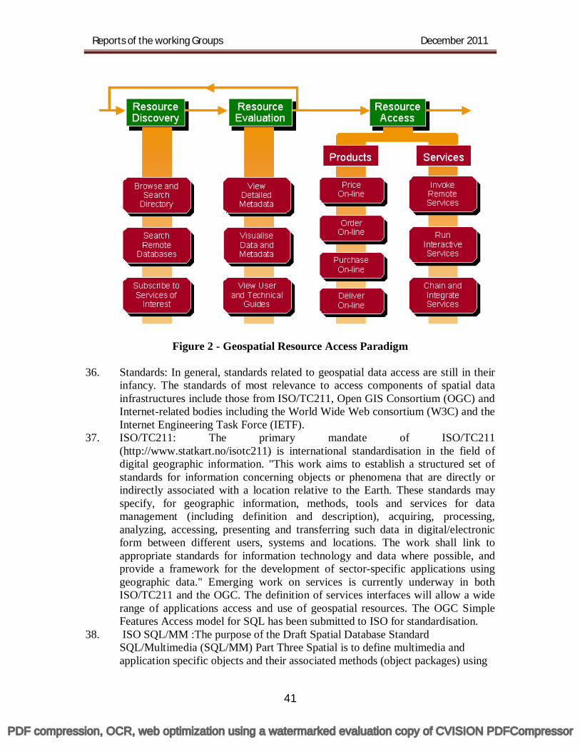
And National levels
for sustained economic growth.
PDF compression, OCR, web optimization using a watermarked evaluation copy of CVISION PDFCompressor

Reports of the working Groups December 2011
NSDI Working Groups
S. No Working Group Chair
1. Node Architecture and Guidelines CGWB
2. Interoperability and Data Exchange FSI
3. Metadata Standards SAC
4. Data content NSSLUP
5. Network and Access Control NIC
6. Cost Recovery/Payment Gateways NRSC
7. Outreach & Communication CWC
8.
Policy, Legal, Security and Projections/Transformations
SOI
9. Data Delivery and Capacity building. GSI
PDF compression, OCR, web optimization using a watermarked evaluation copy of CVISION PDFCompressor
Reports of the working Groups December 2011
Foreword
National Spatial Data Infrastructure (NSDI) is the National Agency mandated to develop standards for spatial data and services and promote the use of geospatial data at all levels. In order to have a focused view, NSDI has adopted a working group approach, which is well suited for making consensus and fostering team work. After discussing the various operational issues and to have a holistic growth, nine working groups were formed to look into the various aspects of NSDI. These working groups are constituted in such a way that each nodal officer of NSDI is either a chairman or a member of all of the nine groups to play a major role in the development of NSDI.
All the working groups have been very active and had many meetings. The working groups on Node Architecture & Guidelines, Cost Recovery & Payment Gateway, Data Delivery & Capacity Building and Interoperability & Data Exchange have finalized their deliberations and submitted their reports.
The report on Node Architecture is very relevant and helpful to the agencies planning to establish their NSDI node. The report on Cost Recovery and payment gateway provides very good insight for pricing mechanism of geospatial data sets, which is required by all the data producing agencies. With the advent of ubiquitous web technologies, the user’s requirement of the access of geospatial data and its delivery has drastically changed and the report deals the data delivery in this new perspective in detail. The report on interoperability deals with Real world Object Catalogue, Spatial data modeling, provisions of interoperable geo-web services and National Mirror Committee for TC 211 of ISO. All these reports have been discussed and approved by the Executive committee of NSDI.
New Delhi (Maj Gen Dr R Siva Kumar)
12 December 2011 CEO, NSDI
PDF compression, OCR, web optimization using a watermarked evaluation copy of CVISION PDFCompressor
Reports of the working Groups December 2011
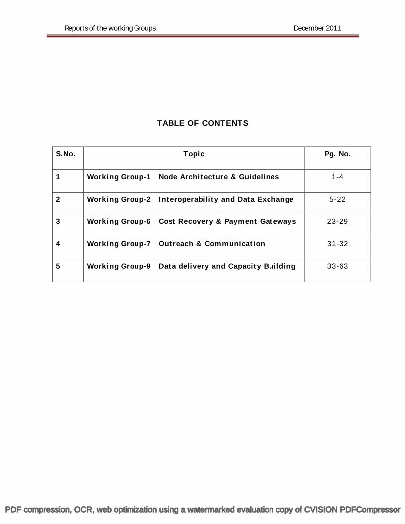
TABLE OF CONTENTS
S.No. Topic Pg. No.
1 Working Group-1 Node Architecture & Guidelines 1-4
2 Working Group-2 Interoperability and Data Exchange 5-22
3 Working Group-6 Cost Recovery & Payment Gateways 23-29
4 Working Group-7 Outreach & Communication 31-32
5 Working Group-9 Data delivery and Capacity Building 33-63
PDF compression, OCR, web optimization using a watermarked evaluation copy of CVISION PDFCompressor
1
Working Group-1 Node Architecture & Guidelines
Chairman Shri S K Sinha
Central Ground Water Board (CGWB)
PDF compression, OCR, web optimization using a watermarked evaluation copy of CVISION PDFCompressor
Reports of the working Groups December 2011
2
Node Architecture & Guidelines
The committee on “Working Group on Node Architecture & Guidelines” deliberated upon various options to formalize the node architecture. The two options that the participating agencies can adopt:
Option I: Develop own portal The participating agencies having minimum hardware infrastructure may develop their own portal using OGC compliant software. The Web Repository Services (WRS) to be connected with India Geo portal.
Immediate Requirements
1. Services should be OGC Compliant
2. WMS, WFS, WCS, WRS and CSW should run always with the option at the Node whether to make open WMS and WFS.
3. Selected / Preferred Services i.e. WMS and WFS should be connected to NSDI
portal either through intranet or Internet.
4. Security Server to protect from hacking
5. Firewall Future Requirements 1. Payment Gateway for data dissemination to users as per the policy of the Data
Owners.
Option II Organizations not having their own portal or Infrastructure Afresh installation with procurement of Hardware
1. Web Server 2. Application Server
PDF compression, OCR, web optimization using a watermarked evaluation copy of CVISION PDFCompressor
Reports of the working Groups December 2011
3
3. Data Base Server 4. Security Server 5. Firewall 6. Router / Switches
Software OGC Compliant software supporting following items Immediate Requirements
1. Services should be OGC Compliant
2. WMS, WFS, WCS, WRS and CSW should run always with the option at the Node whether to make open WMS and WFS.
3. Selected / Preferred Services i.e. WMS and WFS should be connected to NSDI
portal either through intranet or Internet.
4. Security Server to protect from hacking
5. Firewall Future Requirements
1. Payment Gateway
In all the organizations the Mirror Component should exist in all Nodes as per NSDI standards. Recommendations Based on the viable options, the Working Group after detailed deliberations recommends the following to activate all NSDI nodal agencies for immediate population of meta data, product catalogue and other OGC web services. 1. Infrastructure
i. Hardware Server (Entry Level) ii. DBMS software
iii. OGC Compliant Software with the following services: WMS, WFS, WCS, WRS and CSW should run always with the option at the Node whether to make open WMS and WFS.
iv. Translation interface Software to convert the internal data format to OGC format
v. Broadband internet connection
PDF compression, OCR, web optimization using a watermarked evaluation copy of CVISION PDFCompressor
Reports of the working Groups December 2011
4
2. Project base Human Resources
Two JRF’s and one DEO for a period of two years initially.
3. Approach: One of the agency i.e., CGWB shall develop a R&D project to activate above services and also in other interested agencies. As per recommendations of the NSDI-EC, DST shall initiate actions to release required funds.
4. The detailed specifications and modalities shall be workout by NSDI in
association with NSDI Nodal Agencies.
PDF compression, OCR, web optimization using a watermarked evaluation copy of CVISION PDFCompressor
5
Working Group-2 Interoperability and Data exchange
Chairman
Shri Mukund Srivastav Forest Survey of India, Dehradun
PDF compression, OCR, web optimization using a watermarked evaluation copy of CVISION PDFCompressor
Reports of the working Groups December 2011
6
Interoperability and Data exchange 1.0 Background Eight Working Groups were formed in the 1st Nodal Officers’ Meet held at NSDI, New Delhi on 23 May 2008. The Working Group on “Interoperability and Data Exchange” is being chaired by Joint Director, Forest Survey of India (FSI). Shri Mukund Srivastav is currently the Chairman of the Group, The First Meet of the Working Group took place in DST on 26 August, 2008. Representatives from Indian Space Research Organisation (ISRO), Military Survey, National Bureau for Soil Survey & Land Use Planning (NBSSLUP), Central Ground Water Authority (CGWA) participated. Details of the deliberations are available at Annex I. Based on the deliberations, various data providing agencies were advised to initiate preparation of real world object catalogues, modelling their databases using the standard Unified Modelling Language (UML) formalism, developing the well-known Geography Markup Language (GML) prototypes, setting up the web-accessible organizational data nodes, and providing interoperable geo-web services. During 29 September – 1 October 2008, a group of agencies like Survey of India (SoI), Military Survey, FSI, NBSSLUP, Indian National Centre for Ocean Information Services (INCOIS) (Ministry of Earth Sciences), West Bengal State Council for Science and Technology (WBSCST) etc. were trained at IIT Kharagpur. A set of artifacts required for the exercise was recommended in the NSDI Nodal Officers' Meet held at New Delhi on 7 October 2008. The present document reports the progress made in respect of 'Interoperability and Data Exchange' by various Data Providing Agencies and Research/ Academic Institutions participating in NSDI and NRDMS activities since the 2nd meeting of the Executive Committee of NSDI held in New Delhi on 19 March 2009. 2.0 Present Status of activities 2.1 Real World Object Catalogues The Working Group on ‘Interoperability’ recommended preparation of a real-world object catalogue so as to draft a standards-based topographic data model for developing an interoperable topographic database. The Real World Object Catalogue defines meaning and the conceptual framework (ontology) for each real world object surveyed during a survey operation. A draft catalogue has thus been prepared by the GIS and Remote Sensing Directorate of Survey of India, Hyderabad. A controlled vocabulary defining the geographical features surveyed by SoI in 1:10,000 and 1:2,000 scales form a part of the document. Ontologies between vocabularies between various organizations are the foundation for ensuring semantic interoperability and automatic integration/ sharing. Documentation format along with a few sample pages from SoI's Draft Real World Object Catalogue for 1:10,000 and 1:2,000 scale surveys are available at Annex II. The catalogue aims at providing a list of the real world objects that need to be surveyed for SoI's 1:10,000 and 1:2,000 scale data, defining the objects, listing the features and
PDF compression, OCR, web optimization using a watermarked evaluation copy of CVISION PDFCompressor
Reports of the working Groups December 2011
7
attributes for each of the objects, maintaining a reference document to clarify and change/ update representation as and when needed. A Real World Object Catalogue is available for the State Level NRDMS database for Karnataka where each district of the State is equipped with a data centre to support local planning activities. Real world object catalogues are useful in developing data models underlying spatial databases. 2.2 Spatial Data Modelling Spatial data model is about rigorous definition of data and their inter-relationships in the spatial/ geo-scientific domain. A conceptual data model is required to be designed as a technology-neutral artifact that can (i) form the basis for the design and development of a web-based spatial data interchange format e.g. the Open Geospatial Consortium (OGC)/ International Standardization Organization (ISO) specified Extensible Markup Language (XML)/ Geography Markup Language (XML/ GML) specifications, and (ii) guide implementation of the storage database in a common framework. The intended purpose is to allow spatial data sharing between data providers/ databases and users, independent of each other’s local information system implementation. Towards building interoperable systems, spatial data models have been developed and tested for the State Geo-portals and the Groundwater sector.
In an earlier NGRI study under ITSAP-NRDMS project in Ludhiana and Muktsar districts, it was observed that the impacts of paddy cultivation on depletion of groundwater resources need to be investigated further as depleting groundwater level is hampering the groundwater recharge processes in the vadose zone. Contamination of groundwater resources with pollutants from agriculture and industrial areas is alarming in many situations, particularly in peri-urban areas with serious implications for human and livestock health. NGRI study thus suggested regular monitoring and time series database is expected to provide a better understanding the processes responsible for mass transport processes. Therefore, in an on-going study, it is proposed to (i) develop a baseline groundwater quality data base on 1: 50000 scale and groundwater potential in Amritsar and Jalandhar districts of Punjab and (ii) use the hydro-geologic and water quality database in simulation models for prediction of future scenarios. The Groundwater Information System Data Model has been developed with the purpose of extracting information on groundwater levels and groundwater quality that includes major ions, pesticide residues. A groundwater data model has thus been developed for testing and validation using data sets acquired for the districts of Punjab. In a similar effort, a data model fro groundwater has been developed and tested by the Center for Geo-information Science, University of Kerala, Thiruvananthapuram and validated with data sets from the southern State. The data model has been implemented and demonstrated to the staff from the Kerala State Groundwater Board in August 2009. An interoperable Groundwater Information System is under development for efficient updation of data acquired by the State Groundwater Board from their district set-ups.
2.3 GML Prototypes Under the activities supported at the Kerala State Remote Sensing & Environment Centre (KSREC), Thiruvananthapuram and Kumaon University, Almora, Geography Markup Language (GML) prototypes have been developed.
PDF compression, OCR, web optimization using a watermarked evaluation copy of CVISION PDFCompressor

Reports of the working Groups December 2011
8
2.4 Provision of interoperable geo-web services 2.4.1 Interoperability in State Geo-portals OGC standard specifications on transfer/ services/ architecture e.g. GML/ Web Feature Service (WFS), Web Map Service (WMS), Catalogue Service on Web (CSW), portal architecture have been adopted in the development of the State Geo-portals. The Karnataka Geo-portal has been developed on the OGC-certified APOLLO-suite of products to help ensure interoperability between the provider and user systems. This will enable the district NRDMS Centres based at the districts of the State to access the Geo-portal and use the available data sets uploaded by the State-level Line Departments.
Figure 1: Standard portal architecture from OGC adopted in Karnataka State Geo-portal
The Karnataka model is being adopted by States like Kerala, West Bengal, North Eastern Region, Uttarakhand, Haryana, and Jammu & Kashmir towards developing standards-based geo-portals and clearinghouses. 2.4.2 Interoperable WMS/ WFS from Bankura district level Enterprise GIS (E-GIS) The Enterprise GIS developed for Bankura District has been installed at the office of District Magistrate Bankura for access by District Authorities in line with the deliberations of the District level End User Workshop held at Bankura on 28th February, 2008. The client module has been successfully used in the management of the recent Parliamentary Elections 2009. Complete set up has been made accessible to the District Magistrate Bankura for data updation on the server end and use by the clients like Block Development Officer (BDO) and Sub-Divisional Officer (SDO) spread over the entire
PDF compression, OCR, web optimization using a watermarked evaluation copy of CVISION PDFCompressor
Reports of the working Groups December 2011
9
district. User’s response has been satisfactory. The E-GIS has been developed based on open GIS standards of OGC. The West Bengal State Council for Science & Technology (WBSCST), Kolkata is adopting the Bankura model of IIT Kharagpur for developing a centralized interoperable spatial database for better managing the spatial data sets acquired by the State Government and operationalising a pilot scale West Bengal Geo-portal. IIT Kharagpur is conducting a training workshop on "Enterprise GIS and Interoperability' for the scientists and technical personnel from different teams of NRDMS entrusted with developing pilot scale State level SDIs and experimental research-oriented data nodes in various participating institutions on 16-20 November 2009. 2.5 Advanced Lab on 'Geo-information Science & Engineering' at IIT Bombay The Working Group on "Interoperability and Data Exchange" had recommended continuous review of evolving standards by the Open Geo-spatial Consortium (OGC) and the International Standardisation Organisation (ISO) TC 211 in its meeting held in DST on 26 August 2008. In line with the recommendations, a delegation of two experts - Prof. N.L. Sarda, Professor of Computer Science, Department of Computer Science and Engineering, Indian Institute of Technology, Bombay and Dr. S.K. Ghosh, Assistant Professor, School of Information Technology, IIT, Kharagpur - participated in the OGC Technical Committee/Planning Committee meetings held at Atlanta, Georgia, USA on 15 – 19 September, 2008. As a follow up of the recommendations of the delegation, Prof. Sarda presented a concept note to set up an advanced Centre of Geo-spatial technologies at IIT, Bombay. He felt that bigger emphasis should be given to different R&D facets of the computing aspects of Spatial Data Technologies like Geo-web/ Location Based Services, Sensor Networks, Workflow Management etc. by leveraging the expertise and experiences available at various IITB research institutions Centres/Departments like Computer science, Civil engineering, Environmental engineering, Earth Sciences, Resources Engineering etc. and other outside research organizations. This will facilitate closer interaction between different research groups in the area of Spatial Data Technologies for the achievement of long term goals in the field of Geo-information Science. Current R&D gaps could be efficiently addressed by the proposed advanced centre by collaborative research activities with other similar research institutions from abroad. In September 2009, the proposal has been sanctioned to IIT Bombay at a total cost of Rs. 13 Crores to set up the laboratory. In order to fine-tune the research priorities for the Laboratory, a workshop on "Geospatial Information for Developing Countries: Science and Technology" is being organised on 16-18 December 2009 with the support of Indo-US Science & Technology Forum. Leading experts in Geo-information Science are expected to participate in the deliberations of the Workshop. 2.6 Provision of Interoperable Web Map Service (WMS) for Open Series Maps (OSM) of Survey of India In order to facilitate provision of interoperable Web Map Service (WMS) for the OSM data, a Committee has been constituted by NSDI in May 2011. Operational WMS for the State of Andhra Pradesh in its entirety and for a part of Maharashtra has been
PDF compression, OCR, web optimization using a watermarked evaluation copy of CVISION PDFCompressor
Reports of the working Groups December 2011
10
inaugurated by the Hon'ble Minister (Science & Technology and Earth Sciences) in the Third meeting of the NSDC held in New Delhi on 20 October 2011. Two training Workshops have been organised for the senior officials of Survey of India at Hyderabad on 21-22 November 2011 and at New Delhi on 7-8 December 2011 for preparing the OSM data for provision of WMS for the rest of the country. The Committee is presently looking into re-engineering OSM data for setting up an interoperable data node in SOI to store the topographic OSM data for provision of Web Feature Service (WFS)/ Web Feature Service – Transaction (WFS-T). WFS-T will be useful in faster updation of topographic data and sharing. 2.7 Concurrent visualisation of Web Map Services of SOI and NRSC on India Geo Portal As a single window access mechanism to access geo-spatial data from multiple sources, the India Geo Portal has been upgraded to access the WMS of SOI OSM data and that of NRSC concurrently. The mechanism provides for concurrent viewing of geo spatial data sets from both the sources over the web to detect changes in land use, cross-country navigation, and quick referencing. 3.0 International Collaboration/ Participation A Memorandum of Understanding (MoU) was signed with the Natural Resources Canada (NRCan) for launching a collaborative project on development of SDIs in India in November 2009. As a follow up of the MoU, a work plan has been drawn up between NSDI/ DST and NRCan for pursuing collaborative activities during the visit of the DST delegation to Canada in June 2011. ‘Spatial Data Infrastructure (SDI)’ and 'Natural Disaster Management (Landslides)' are the two key areas for collaboration between NRCAN and DST. Some of the specific sub-areas that may immediately engage attention include 'Geo-spatial Policy', ‘Geo Portal Development (landslides)’, 'GI management', ‘Knowledge Exchange’, and 'Academic Exchange Visits'. 3.1 National Mirror Committee for TC 211 of ISO NSDI has facilitated setting up of the National Mirror Committee coordinated by Bureau of Indian Standards (BIS) for the Technical Committee 211 (TC 211) of the International Standardisation Organisation (ISO). The Mirror Committee will help evolve and adopt national geo-spatial data/ process standards in harmony with the international standards from ISO's TC 211. The existing mechanism of standards development of NSDI is proposed to be involved in the activities of the BIS's National Mirror Committee. 3.2 Hosting OGC TC/ PC Meetings in Nov./ Dec. 2013 It is proposed to host the Open Geo-spatial Consortium (OGC)'s Technical Committee and Planning Committee (TC/PC) meetings at IIT Bombay in Nov./ Dec. 2013. A decision has been taken in the last meeting of OGC TC/ PC and the OGC Board held in Brussels on 21-25 November 2011.
PDF compression, OCR, web optimization using a watermarked evaluation copy of CVISION PDFCompressor
Reports of the working Groups December 2011
11
4.0 Recommendations In view of the above developments in the past months, the Working Group recommends the following: * Concerned Data providing/ Survey Agencies should pro-actively follow up with various national level research institutions having the expertise for setting up their operational data nodes to help share their data sets over the web. The OGC Interoperability Standards have a role to play in this task. * The Data Providing Agencies should work towards operationalising interoperable Web Map Services for their domain-specific data layers (e.g. geological data by GSI and forest-related data by FSI etc.). Interoperable WMS will help combined visualisation of the layers from multiple Data Providing Agencies to support end user decision-making. * With the setting up of the Advanced Laboratory at IIT Bombay, stakeholders may consider deputing their personnel to the Laboratory for advanced research and training. * OGC standards be reviewed intensively for possible adoption by NSDI with the help of the IITB Laboratory. Suitable personnel from the stakeholder agencies and research institutions be deputed to OGC meetings.
--0—
PDF compression, OCR, web optimization using a watermarked evaluation copy of CVISION PDFCompressor
Reports of the working Groups December 2011
12
Annex I
Report on Progress made by the NSDI Working Group on “Interoperability and
Data Exchange” The First Meet of the Working Group took place in DST on 26 August, 2008. The meeting was chaired by Shri Subhash Ashutosh, Joint Director, Forest Survey of India, Dehradun. Representatives from ISRO, Military Survey, NBSSLUP, CGWB participated. Salient points of the deliberations in brief are:
Each Agency will be taking concrete steps to develop and demonstrate to the Working Group in its next meeting its GML prototypes and sharing those through WFS/WMS based on OGC specifications.
A Training Programme on GML, WFS and WMS should be conducted to facilitate building the above prototypes.
Next GML relay/plug-fest should be organized based on prototypes from various stakeholder agencies of Indian NSDI.
Emerging standards in different forums like ISO/ OGC should be reviewed continuously.
Suitable studies should be launched to influence standardization processes in ISO/OGC.
Priority application areas have been identified for developing and demonstrating standards for Geo-spatial Interoperability.
As a follow-up of the above deliberations following activities have been completed so far: A delegation of the following two experts has participated in the OGC Technical
Committee/Planning Committee meetings held at Atlanta, Georgia, USA on 15 – 19 September, 2008: Prof. N.L. Sarda, Professor of Computer Science, Department of Computer
Science and Engineering, Indian Institute of Technology, Bombay and Chairman of the DST NRDMS Expert Group on “Spatial Data Technologies for Decentralized Planning”. He presented on “Framework for Interoperability and Integration for Geographical data Sources” in OGC’s Geo-semantics Working Group.
Dr. S.K. Ghosh, Assistant Professor, School of Information Technology, IIT, Kharagpur and Principal Investigator of the NRDMS Project on “Enterprise GIS for Bankura District”. He presented “Integrating heterogeneous Data Sources using OGC standards – Indian NSDI initiative” in the Domain Working Group on “Workflow”.
A Training Workshop has been organized at School of Information Technology,
IIT, Kharagpur on 29 September – 1 October, 2008 for providing hands-on training on developing prototypes using standard specifications from OGC on
PDF compression, OCR, web optimization using a watermarked evaluation copy of CVISION PDFCompressor
Reports of the working Groups December 2011
13
GML, WFS and WMS. Representatives from SOI, Military Survey, FSI, NBSSLUP, INCOIS (Ministry of Earth Sciences), West Bengal State Council for Science and Technology etc. participated in the above training.
Recommendations for Nodal Officers’ Meet on 7 October 2008 Based on the above training imparted at IIT, Kharagpur on 29 September – 1 October, 2008, prototypes of a set of interoperable NSDI nodes at different organisations are proposed to be developed. Trained scientists/officials will require the following items for the development of the prototypes:
OGC Specification documents (GML, WFS, WMS available at www.opengeospatia.org)
An XML Editor (e.g. Altova XML SPY software package) A standard GML book (GML – Foundation for the Geo-web by Ron Lake,
Wiley publications) OGC 2.1.2/ 3.0/ 3.1 Core schemas from the OGC site
(www.opengeospatial.org, www.opengis.net/gml) GML Viewer (e.g. Snowflake’s GMLViewer) freely available on net for
viewing a GML data file SDI Software package (e.g. DEEGREE software package) freely downloaded
from the net Trained staff may please be provided with the above items for developing and operationalizing OGC specifications based interoperable spatial data nodes at each of the individual organization for demonstrating geo-spatial Interoperability and gaining an in-depth understanding of the related methods/techniques. It is recommended that the Nodal Officers take a continuous technical review of the activities in order that interoperable data nodes are in place in the shortest possible time. The NSDI Working Group could meet suitably for working towards demonstrating interoperability based on the feedback received from the respective Nodal Officials.
PDF compression, OCR, web optimization using a watermarked evaluation copy of CVISION PDFCompressor
Ann
ex II
R
eal w
orld
obj
ect C
atal
ogue
(Dra
ft)
(Pre
pare
d by
GIS
& R
S D
irec
tora
te, S
urve
y of
Indi
a, H
yder
abad
)
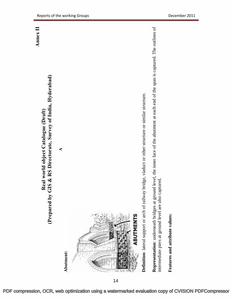
AA
butm
ent:
D
efin
ition
: lat
eral
supp
ort o
r arc
h of
railw
ay b
ridge
, via
duct
or o
ther
stru
ctur
e or
sim
ilar s
truct
ure.
Rep
rese
ntat
ion:
und
erne
ath
brid
ges a
t gro
und
leve
l, th
e in
ner f
ace
of th
e ab
utm
ent a
t eac
h en
d of
the
span
is c
aptu
red.
The
out
lines
of
inte
rmed
iate
pie
rs a
t gro
und
leve
l are
also
cap
ture
d.
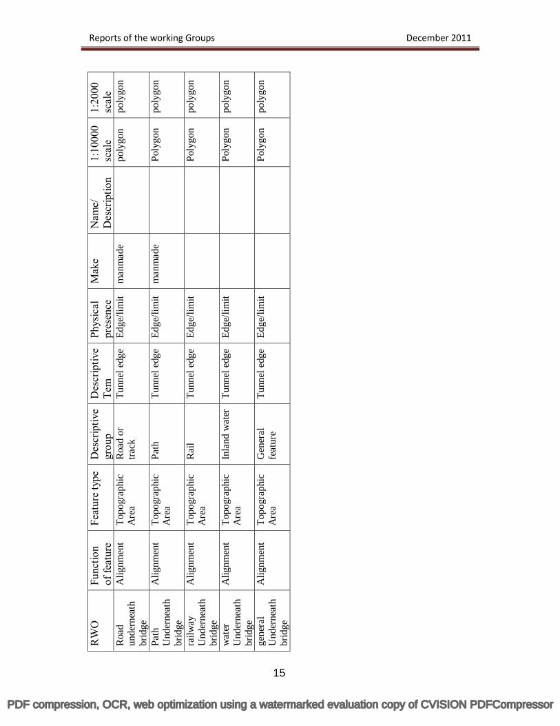
Feat
ures
and
att
ribu
te v
alue
s:
Reports of the working Groups December 2011
14
PDF compression, OCR, web optimization using a watermarked evaluation copy of CVISION PDFCompressor
RW
O
Func
tion
of fe
atur
e Fe
atur
e ty
pe
Des
crip
tive
grou
p D
escr
iptiv
e Te
m
Phys
ical
pr
esen
ce
Mak
e N
ame/
D
escr
iptio
n 1:
1000
0 sc
ale
1:20
00
scal
e R
oad
unde
rnea
th
brid
ge
Alig
nmen
t To
pogr
aphi
c A
rea
Roa
d or
tra
ck
Tunn
el e
dge
Edge
/lim
it m
anm
ade
po
lygo
n po
lygo
n
Path
U
nder
neat
h br
idge
Alig
nmen
t
Topo
grap
hic
Are
a Pa
th
Tunn
el e
dge
Edge
/lim
it m
anm
ade
Poly
gon
poly
gon
railw
ay
Und
erne
ath
brid
ge
Alig
nmen
t
Topo
grap
hic
Are
a R
ail
Tunn
el e
dge
Edge
/lim
it
Poly
gon
poly
gon
wat
er
Und
erne
ath
brid
ge
Alig
nmen
t
Topo
grap
hic
Are
a In
land
wat
er
Tunn
el e
dge
Edge
/lim
it
Poly
gon
poly
gon
gene
ral
Und
erne
ath
brid
ge
Alig
nmen
t To
pogr
aphi
c A
rea
Gen
eral
fe
atur
e Tu
nnel
edg
e Ed
ge/li
mit
Poly
gon
poly
gon
Reports of the working Groups December 2011
15
PDF compression, OCR, web optimization using a watermarked evaluation copy of CVISION PDFCompressor
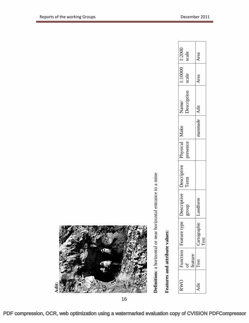
Adi
t:
D
efin
ition
: a h
oriz
onta
l or n
ear h
oriz
onta
l ent
ranc
e to
a m
ine
Feat
ures
and
att
ribu
te v
alue
s:
RW
O
Func
tion
of
feat
ure
Feat
ure
type
D
escr
iptiv
e gr
oup
Des
crip
tive
Term
Ph
ysic
al
pres
ence
M
ake
Nam
e/
Des
crip
tion
1:10
000
scal
e 1:
2000
sc
ale
Adi
t Te
xt
Car
togr
aphi
c
Text
La
ndfo
rm
man
mad
e A
dit
Are
a
Are
a
Reports of the working Groups December 2011
16
PDF compression, OCR, web optimization using a watermarked evaluation copy of CVISION PDFCompressor
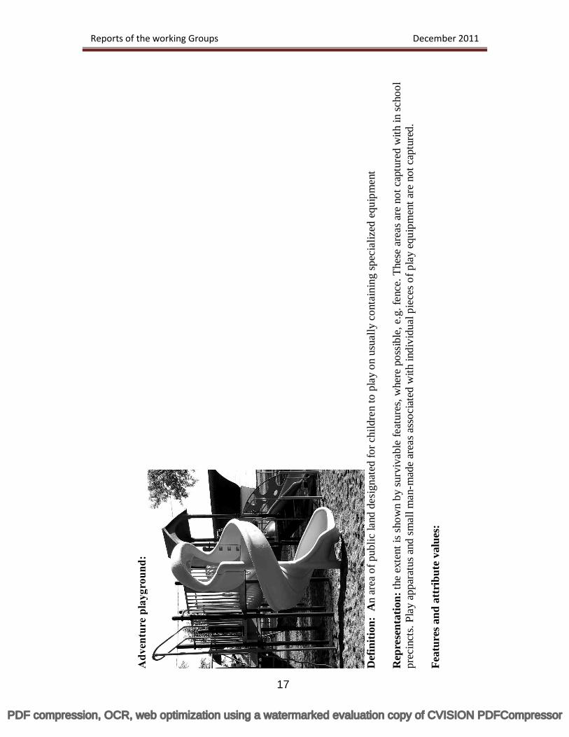
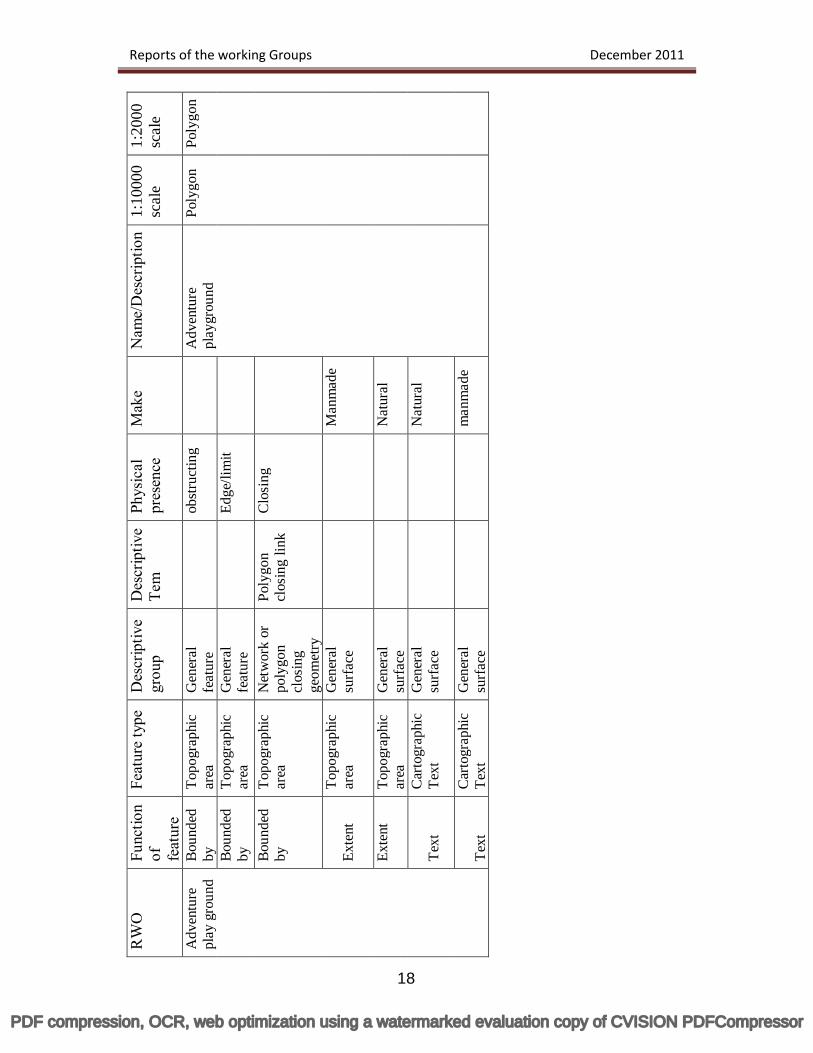
Adv
entu
re p
layg
roun
d:
D
efin
ition
: A
n ar
ea o
f pub
lic la
nd d
esig
nate
d fo
r chi
ldre
n to
pla
y on
usu
ally
con
tain
ing
spec
ializ
ed e
quip
men
t R
epre
sent
atio
n: th
e ex
tent
is s
how
n by
surv
ivab
le fe
atur
es, w
here
pos
sibl
e, e
.g. f
ence
. The
se a
reas
are
not
cap
ture
d w
ith in
scho
ol
prec
inct
s. Pl
ay a
ppar
atus
and
sm
all m
an-m
ade
area
s ass
ocia
ted
with
indi
vidu
al p
iece
s of p
lay
equi
pmen
t are
not
cap
ture
d.
Feat
ures
and
att
ribu
te v
alue
s:
Reports of the working Groups December 2011
17
PDF compression, OCR, web optimization using a watermarked evaluation copy of CVISION PDFCompressor
RW
O
Func
tion
of
feat
ure
F eat
ure
type
D
escr
iptiv
e gr
oup
Des
crip
tive
Tem
Ph
ysic
al
pres
ence
M
ake
Nam
e/D
escr
iptio
n 1:
1000
0 sc
ale
1:20
00
scal
e
Adv
entu
re
play
gro
und
Boun
ded
by
Topo
grap
hic
area
G
ener
al
feat
ure
obst
ruct
ing
A
dven
ture
pl
aygr
ound
Po
lygo
n Po
lygo
n
Boun
ded
by
Topo
grap
hic
area
G
ener
al
feat
ure
Edge
/lim
it
Boun
ded
by
Topo
grap
hic
area
N
etw
ork
or
poly
gon
clos
ing
geom
etry
Poly
gon
clos
ing
link
Clo
sing
Exte
nt
Topo
grap
hic
area
G
ener
al
surf
ace
Man
mad
e
Exte
nt
Topo
grap
hic
area
G
ener
al
surf
ace
Nat
ural
Text
C
arto
grap
hic
Text
G
ener
al
surf
ace
Nat
ural
Text
C
arto
grap
hic
Text
G
ener
al
surf
ace
man
mad
e
Reports of the working Groups December 2011
18
PDF compression, OCR, web optimization using a watermarked evaluation copy of CVISION PDFCompressor
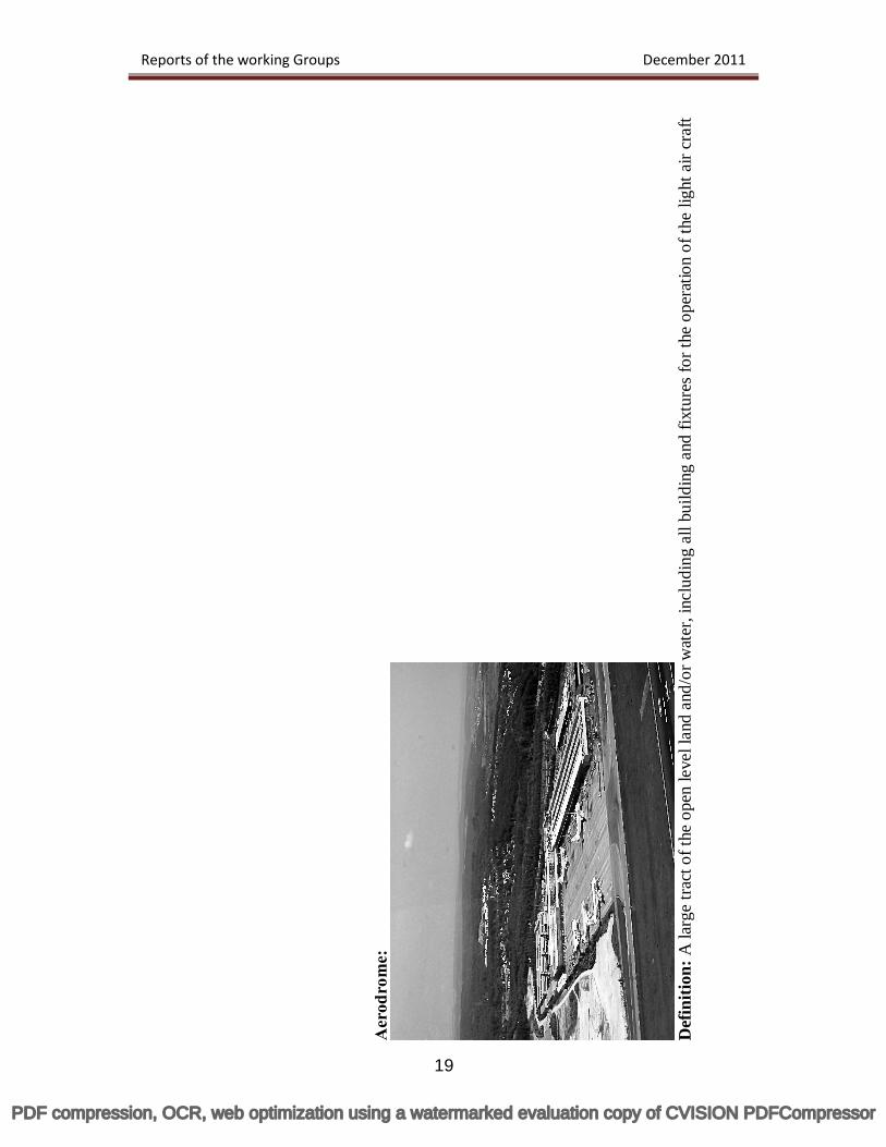
Aer
odro
me:
D
efin
ition
: A la
rge
tract
of t
he o
pen
leve
l lan
d an
d/or
wat
er, i
nclu
ding
all
build
ing
and
fixtu
res
for t
he o
pera
tion
of th
e lig
ht a
ir cr
aft
Reports of the working Groups December 2011
19
PDF compression, OCR, web optimization using a watermarked evaluation copy of CVISION PDFCompressor
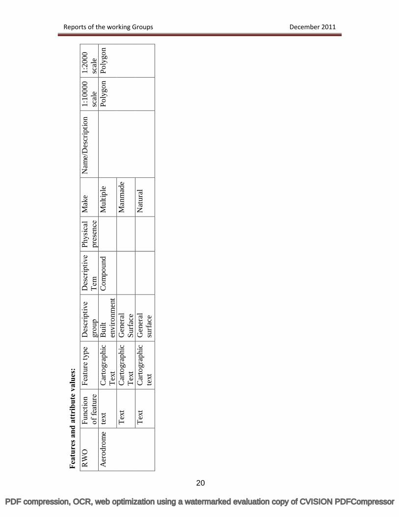
Feat
ures
and
att
ribu
te v
alue
s:
RW
O
Func
tion
of fe
atur
e Fe
atur
e ty
pe
Des
crip
tive
grou
p D
escr
iptiv
e Te
m
Phys
ical
pr
esen
ce
Mak
e N
ame/
Des
crip
tion
1:10
000
scal
e 1:
2000
sc
ale
Aer
odro
me
text
C
arto
grap
hic
Text
B
uilt
envi
ronm
ent
Com
poun
d
Mul
tiple
Poly
gon
Poly
gon
Text
C
arto
grap
hic
Te
xt
Gen
eral
Su
rface
M
anm
ade
Text
C
arto
grap
hic
te
xt
Gen
eral
su
rfac
e
N
atur
al
Reports of the working Groups December 2011
20
PDF compression, OCR, web optimization using a watermarked evaluation copy of CVISION PDFCompressor
21
Working Group-6 Cost Recovery & Payment Gateway
Chairman
Dr. YVS.Murthy National Remote Sensing Centre (ISRO)
PDF compression, OCR, web optimization using a watermarked evaluation copy of CVISION PDFCompressor
Reports of the working Groups December 2011
22
Cost Recovery & Payment Gateway
Introduction Spatial data is unique from other forms of data. It can be used right from public safety and national security to planning and infrastructure development. It plays a vital role in national development, as most of our planning and decision-making depends on the spatial data. The Natural Resources Information is vital for planning and execution of many developmental activities and their timely availability ensures optimal utilization of natural resources. Having systematically created and organized these datasets by various thematic data generating organisations, it is now essential to address pricing, payment gateway and other guidelines in order to disseminate these datasets keeping the national map policy and spatial data dissemination policy in tact. It is also widely agreed that public information is a necessary component of open government and the democratic process. A society or a government is considered to be spatially enabled, when locations and spatial information are regarded as common goods, and made available to the citizens and for business. It is now a ubiquitous part of the e-Government. It is also well known that the spatial data often have value to other organizations too than the organization that originates the data Objectives: NSDI has constituted a Working Group on ‘Cost Recovery and Payment Gateway’ (WG-CRPG) to work out the cost of the spatial data products for disseminating the data to different types of users through an established Gateway mechanism. The WG has worked out accordingly, prepared a draft document, deliberated on all the points and submitted the final version of the document to NSDI. A presentation was also made to NSDI-EC during its 5th meeting in Kolkata and the document was approved by EC. National Map Policy (NMP): Government of India has adopted National Map policy (NMP) in 2005. As per NMP, the responsibility for producing, maintaining and disseminating the topographic map database of the whole country, which is the foundation of all spatial data vests with the Survey of India (SOI). To ensure that in the furtherance of this policy, national security objectives are fully safeguarded, it has been decided that there will be two series of maps namely (a) Defence Series Maps (DSMs) - These will be the topographical maps (on Everest/WGS-84 Datum and Polyconic/UTM Projection) on various scales (with heights, contours and full content without dilution of accuracy). These will mainly cater for defence and national security requirements. This series of maps (in analogue or
PDF compression, OCR, web optimization using a watermarked evaluation copy of CVISION PDFCompressor
Reports of the working Groups December 2011
23
digital forms) for the entire country will be classified, as appropriate, and the guidelines regarding their use will be formulated by the Ministry of Defence. (b) Open Series Maps (OSMs) – OSMs will be brought out exclusively by SOI, primarily for supporting development activities in the country. OSMs shall bear different map sheet numbers and will be in UTM Projection on WGS-84 datum. Each of these OSMs (in both hard copy and digital form) will become “Unrestricted” after obtaining a one-time clearance of the Ministry of Defence. SOI will ensure that no civil and military Vulnerable Areas and Vulnerable Points (VA’s/VP’s) are shown on OSMs. Assumptions: The following assumption were made for working out the data/product pricing:
‘Data’ means ‘thematic data’. Data generated by all the participating agencies of NSDI is considered at par with respect to importance of information/details. Since SOI data is considered as fundamental data, costing process is not applied to SOI data by the WG.
Larger the input map scale, more is the information and higher is the data volume
in digital environment. Data volume is considered in terms of data file size and not in terms of number of polygons, lines and points present in the data.
Thematic data on 1:50,000 scale (corresponding to one topomap size of SOI) is
approximately equal to 2MB in digital form (file size), the largest being the land use/land cover data.
Cost of data means ‘cost of media, processing, manpower and
handling’/reproduction cost’.
PDF compression, OCR, web optimization using a watermarked evaluation copy of CVISION PDFCompressor
Reports of the working Groups December 2011
24
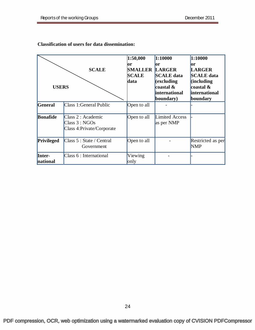
Classification of users for data dissemination: SCALE USERS
1:50,000 or SMALLER SCALE data
1:10000 or LARGER SCALE data (excluding coastal & international boundary)
1:10000 or LARGER SCALE data (including coastal & international boundary
General Class 1:General Public Open to all - -
Bonafide Class 2 : Academic Class 3 : NGOs Class 4:Private/Corporate
Open to all Limited Access as per NMP
-
Privileged Class 5 : State / Central Government
Open to all - Restricted as per NMP
Inter- national
Class 6 : International Viewing only
- -
PDF compression, OCR, web optimization using a watermarked evaluation copy of CVISION PDFCompressor
Reports of the working Groups December 2011
25
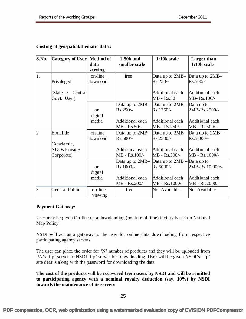
Costing of geospatial/thematic data : S.No. Category of User Method of
data serving
1:50k and smaller scale
1:10k scale Larger than 1:10k scale
1. Privileged (State / Central Govt. User)
on-line download
free Data up to 2MB– Rs.250/- Additional each MB - Rs.50
Data up to 2MB–Rs.500/- Additional each MB- Rs.100/-
on digital media
Data up to 2MB–Rs.250/- Additional each MB - Rs.50/-
Data up to 2MB – Rs.1250/- Additional each MB - Rs.250/-
Data up to 2MB-Rs.2500/- Additional each MB - Rs.500/-
2 Bonafide (Academic, NGOs,Private/ Corporate)
on-line download
Data up to 2MB–Rs.500/- Additional each MB - Rs.100/-
Data up to 2MB – Rs.2500/- Additional each MB - Rs.500/-
Data up to 2MB – Rs.5,000/- Additional each MB - Rs.1000/-
on digital media
Data up to 2MB–Rs.1000/- Additional each MB - Rs.200/-
Data up to 2MB – Rs.5000/- Additional each MB - Rs.1000/-
Data up to 2MB-Rs.10,000/- Additional each MB - Rs.2000/-
3 General Public on-line viewing
free
Not Available Not Available
Payment Gateway: User may be given On-line data downloading (not in real time) facility based on National Map Policy NSDI will act as a gateway to the user for online data downloading from respective participating agency servers The user can place the order for ‘N’ number of products and they will be uploaded from PA’s ‘ftp’ server to NSDI ‘ftp’ server for downloading. User will be given NSDI’s ‘ftp’ site details along with the password for downloading the data The cost of the products will be recovered from users by NSDI and will be remitted to participating agency with a nominal royalty deduction (say, 10%) by NSDI towards the maintenance of its servers
PDF compression, OCR, web optimization using a watermarked evaluation copy of CVISION PDFCompressor
Reports of the working Groups December 2011
26
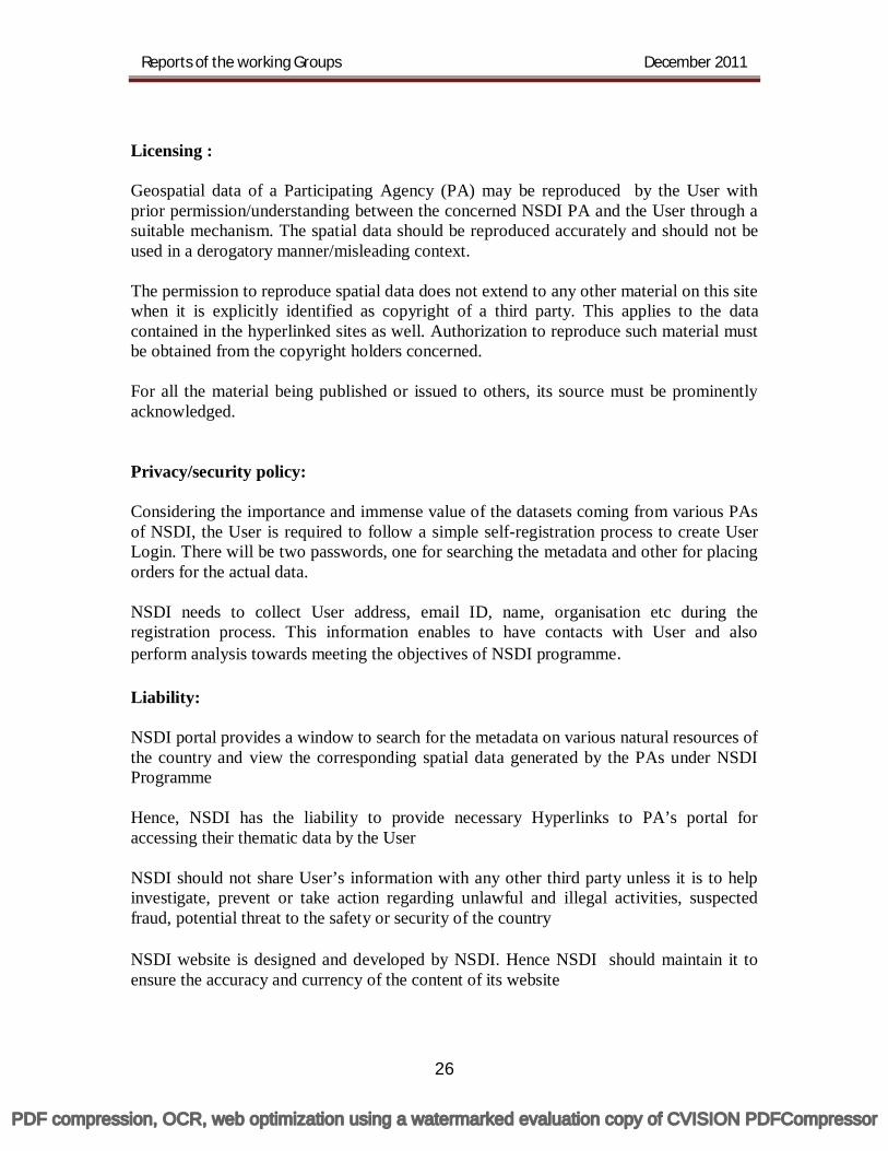
Licensing : Geospatial data of a Participating Agency (PA) may be reproduced by the User with prior permission/understanding between the concerned NSDI PA and the User through a suitable mechanism. The spatial data should be reproduced accurately and should not be used in a derogatory manner/misleading context. The permission to reproduce spatial data does not extend to any other material on this site when it is explicitly identified as copyright of a third party. This applies to the data contained in the hyperlinked sites as well. Authorization to reproduce such material must be obtained from the copyright holders concerned. For all the material being published or issued to others, its source must be prominently acknowledged. Privacy/security policy: Considering the importance and immense value of the datasets coming from various PAs of NSDI, the User is required to follow a simple self-registration process to create User Login. There will be two passwords, one for searching the metadata and other for placing orders for the actual data. NSDI needs to collect User address, email ID, name, organisation etc during the registration process. This information enables to have contacts with User and also perform analysis towards meeting the objectives of NSDI programme. Liability: NSDI portal provides a window to search for the metadata on various natural resources of the country and view the corresponding spatial data generated by the PAs under NSDI Programme Hence, NSDI has the liability to provide necessary Hyperlinks to PA’s portal for accessing their thematic data by the User NSDI should not share User’s information with any other third party unless it is to help investigate, prevent or take action regarding unlawful and illegal activities, suspected fraud, potential threat to the safety or security of the country NSDI website is designed and developed by NSDI. Hence NSDI should maintain it to ensure the accuracy and currency of the content of its website
PDF compression, OCR, web optimization using a watermarked evaluation copy of CVISION PDFCompressor
Reports of the working Groups December 2011
27
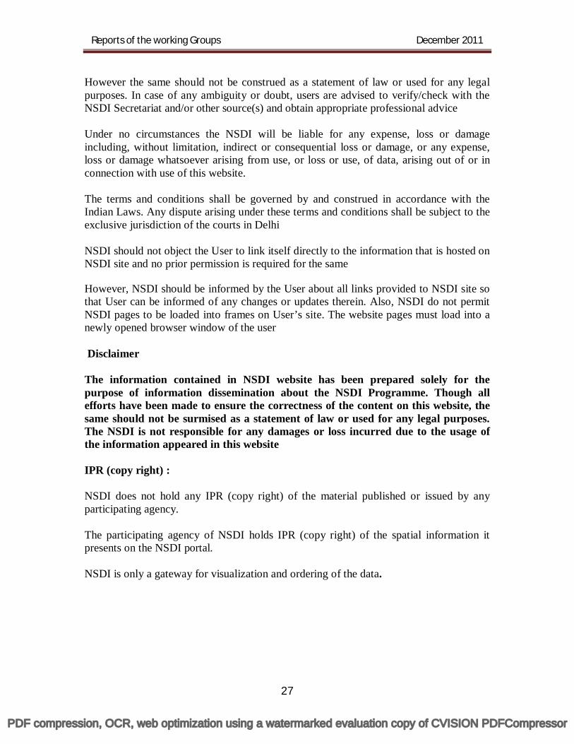
However the same should not be construed as a statement of law or used for any legal purposes. In case of any ambiguity or doubt, users are advised to verify/check with the NSDI Secretariat and/or other source(s) and obtain appropriate professional advice Under no circumstances the NSDI will be liable for any expense, loss or damage including, without limitation, indirect or consequential loss or damage, or any expense, loss or damage whatsoever arising from use, or loss or use, of data, arising out of or in connection with use of this website. The terms and conditions shall be governed by and construed in accordance with the Indian Laws. Any dispute arising under these terms and conditions shall be subject to the exclusive jurisdiction of the courts in Delhi NSDI should not object the User to link itself directly to the information that is hosted on NSDI site and no prior permission is required for the same However, NSDI should be informed by the User about all links provided to NSDI site so that User can be informed of any changes or updates therein. Also, NSDI do not permit NSDI pages to be loaded into frames on User’s site. The website pages must load into a newly opened browser window of the user Disclaimer The information contained in NSDI website has been prepared solely for the purpose of information dissemination about the NSDI Programme. Though all efforts have been made to ensure the correctness of the content on this website, the same should not be surmised as a statement of law or used for any legal purposes. The NSDI is not responsible for any damages or loss incurred due to the usage of the information appeared in this website IPR (copy right) : NSDI does not hold any IPR (copy right) of the material published or issued by any participating agency. The participating agency of NSDI holds IPR (copy right) of the spatial information it presents on the NSDI portal. NSDI is only a gateway for visualization and ordering of the data.
PDF compression, OCR, web optimization using a watermarked evaluation copy of CVISION PDFCompressor

28
PDF compression, OCR, web optimization using a watermarked evaluation copy of CVISION PDFCompressor

29
Working Group-7 Outreach & Communication
Chairman
Dr. Yogesh paithankar Central Water Commission (CWC)
PDF compression, OCR, web optimization using a watermarked evaluation copy of CVISION PDFCompressor
Reports of the working Groups December 2011
30
Outreach & Communication
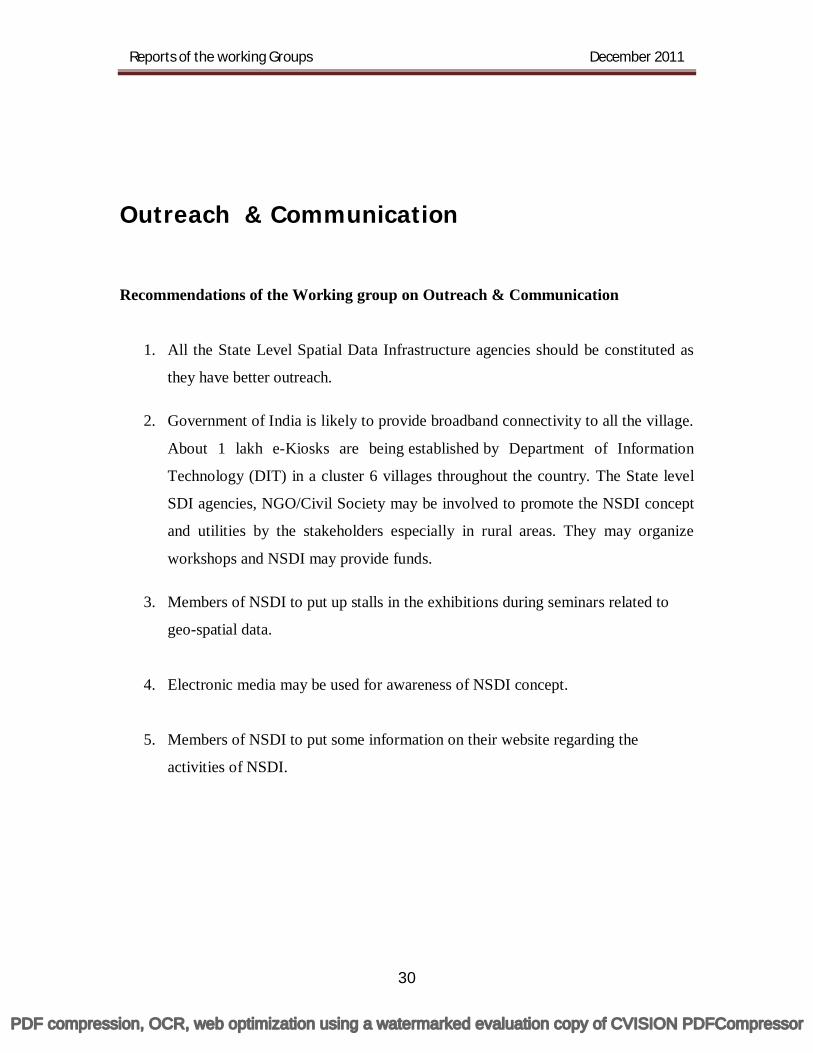
Recommendations of the Working group on Outreach & Communication
1. All the State Level Spatial Data Infrastructure agencies should be constituted as
they have better outreach.
2. Government of India is likely to provide broadband connectivity to all the village.
About 1 lakh e-Kiosks are being established by Department of Information
Technology (DIT) in a cluster 6 villages throughout the country. The State level
SDI agencies, NGO/Civil Society may be involved to promote the NSDI concept
and utilities by the stakeholders especially in rural areas. They may organize
workshops and NSDI may provide funds.
3. Members of NSDI to put up stalls in the exhibitions during seminars related to
geo-spatial data.
4. Electronic media may be used for awareness of NSDI concept.
5. Members of NSDI to put some information on their website regarding the
activities of NSDI.
PDF compression, OCR, web optimization using a watermarked evaluation copy of CVISION PDFCompressor

31
Working Group-9 Data Delivery and Capacity building
Chairman
Shri S K Bohra Geological Survey of India
PDF compression, OCR, web optimization using a watermarked evaluation copy of CVISION PDFCompressor
Reports of the working Groups December 2011
32
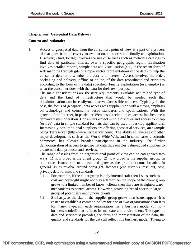
Chapter one: Geospatial Data Delivery
Context and rationale: 1. Access to geospatial data from the consumers point of view is a part of a process
of that goes from discovery to evaluation, to access and finally to exploitation. Discovery (find, locate) involves the use of services such as metadata catalogs to find data of particular interest over a specific geographic region. Evaluation involves detailed reports, sample data and visualisation (e.g., in the recent form of web mapping through gifs or simple vector representations of the data) to help the consumer determine whether the data is of interest. Access involves the order, packaging and delivery, offline or online, of the data (coordinate and attributes according to the form of the data) specified. Finally exploitation (use, employ) is what the consumer does with the data for their own purpose.
2. The main considerations are the user requirements, available nature and type of data and the kind of infrastructure that would be needed such that data/information can be easily/made served/accessible to users. Typically in the past, the focus of geospatial data access was supplier side with a strong emphasis on technology and community based standards and specifications. With the growth of the Internet, in particular Web based technologies, access has become a demand driven operation. Consumers expect simple discover and access to cheap (or free) data in simple standard formats that can be used in desktop applications. Increasingly non-traditional suppliers are offering geospatial services, an example being Terraserver (http://www.terraserver.com/). The ability to leverage off other major developments such as the World Wide Web, and in some cases electronic commerce, has allowed broader participation in the Industry. The further democratisation of access to geospatial data thus enables value-added suppliers to create new data products and services.
3. The range of issues from an organisational point of view can be categorised two ways: 1) how broad is the client group; 2) how broad is the supplier group. In both cases issues tend to appear and grow as the groups become broader. In general issues revolve around copyright, licences (end user vs. reseller), cost, privacy, data formats and standards. 3.1 For example, if the client group is only internal staff then issues such as
cost and copyright might not play a factor. As the scope of the client group grows to a limited number of known clients then there are straightforward mechanisms to control access. However, providing broad access to large group of potentially anonymous clients.
3.2 Similarly, as the size of the supplier group grows then issues appear. It is easier to establish a common policy for one or two organisations than it is for many. Typically each organisation has a business model (or non-business model!) that reflects its mandate and environment. The types of data and services it provides, the form and representation of the data, the quality and standards for the data all reflect this business model. Trying to
PDF compression, OCR, web optimization using a watermarked evaluation copy of CVISION PDFCompressor
Reports of the working Groups December 2011
33
bridge these issues between disparate organisations is an exponential problem.
4. The overlap between information managed by subject-specific communities in possibly parallel infrastructures can compound problems of data discovery and access. This can be viewed from either the consumer or supplier perspective. For example, as individuals in communities such as biodiversity or geoscience specialists attempt to leverage a combined spatial data infrastructure to support their own goals they introduce new factors. These could be new standards or convention that they commonly require, it could be a new attribution requirement on the data not previously realised, or it could be the need to provide common access to data not otherwise visible from a spatial data infrastructure.
5. Several trends can be noted in the treatment and handling of geospatial data. Typically in the past the first concern of a data custodian has been what format the data is stored or managed in. Increasingly the trend is to move one level up and only worry about the interfaces to the data. This allows the data to be managed in the best manner possible, while providing open, standards based access. A consequence of this, however, is that the content of the data must be of a sufficient quality to support these interfaces. Often existing data is not accurate enough, up to date or lacking in attribution.
6. Another trend is in the organisation of the data itself. There is an evolution that starts back with traditional paper products. These migrated into discrete digital files that were typically stored offline, e.g., on a tape rack. As mass storage became more affordable these files found themselves living on online media (magnetic or optical) for easier access. This last step is an important one when you couple it with the developing of ubiquitous, wide area internetworking, i.e. the Internet. At this point a supplier was empowered to deliver data online.
7. More recently the trend has been to merge all the discrete data sets together into single, seamless data warehouses, which have spawned the development of direct data access services. This has been enabled by developments in mass storage and spatial database technology. This step is also proving to be hard on the data, revealing inconsistencies in data accuracy and quality. Recent infrastructure developments allow the creation of virtual data warehouses which federate multiple instances of a data warehouses into a single logical entity.
8. Today’s data communication technologies provide efficient and secure data networking to help operators get the right information at the right time to evaluate their projects and make critical, timely technical and financial decisions.
9. For any project, the service provider, decision-makers and partners are not likely to be located in the same place. Through multipoint, two- way communication, today’s technology facilitates virtual collaboration in such circumstances. Regardless of the method used, it is important that the data to be delivered wherever and whenever they are needed. This becomes a challenge as technology evolves and the complexity and volume of acquired data increase. Advances in modern data acquisition system coupled with industry’s demand for more information have created additional challenges in managing a wide spectrum of data types and formats. Furthermore an efficient data- management, archival and retrieval system can help interpreters exploit knowledge from data previously
PDF compression, OCR, web optimization using a watermarked evaluation copy of CVISION PDFCompressor
Reports of the working Groups December 2011
34
acquired. For operator who does not wish to perform the post data acquisition, analysis and interpretation in-house service companies can provide these services in their centres. A powerful GIS engine on the web that allows on-line integration and application of GIS layers - apart from just serving them on the web.
10. The data and metadata should not be managed centrally, but by the data originator and/or owner, and that tools and services connect via computer networks to the various sources. To achieve these objectives, good coordination between all the data originators is necessary and the definition of standards is very important.
11. Service-Oriented Architecture (SOA) is an approach to organizing software in the form of independent, interoperable services that can be composed and recomposed to fulfill multiple business requirements. Each SOA building block can play one or both of two roles: 11.1 Service Provider - The service provider creates a web service and possibly
publishes its interface and access information to the service registry. Each provider must decide which services to expose, how to make trade-offs between security and easy availability, how to price the services, or (if no charges apply) how/whether to exploit them for other value.
11.2 The provider also has to decide what category the service should be listed for a given service and what sort of trading partner agreements are required to use the service.
11.3 It registers what services are available within it and lists all the potential service recipients.
11.4 Furthermore, the amount of the offered information has to be decided. 11.5 Service consumer - The web service client locates entries in the broker
registry using various find operations and then binds to the service provider in order to invoke one of its web services. Whichever service the service-consumers need, they have to take it into the brokers, then bind it with respective service and then use it. They can access multiple services if the service provides multiple services.
12. NSDI should enable the discovery and delivery of spatial data from a data repository, via a spatial service provider, to a user. It is often wished that the data provider is able to update spatial data stored in a repository. Hence, the basic software components of NSDI are proposed to be: a software client - to display, query, and analyse spatial data (this could be
a browser or a Desktop GIS), a catalogue service - for the discovery, browsing, and querying of
metadata or spatial services, spatial datasets and other resources, a spatial data service - allowing the delivery of the data via the Internet, processing services - such as datum and projection transformations, a (spatial) data repository - to store data, e.g. a Spatial database, GIS software (client or desktop) - to create and update spatial data.
13. Besides these software components, a range of (international) technical standards are necessary that allow interaction between the different software components.
PDF compression, OCR, web optimization using a watermarked evaluation copy of CVISION PDFCompressor
Reports of the working Groups December 2011
35
Among those are geospatial standards defined by the Open Geospatial Consortium (e.g. OGC WMS, WFS, GML etc.) and ISO (e.g. ISO 19115) for the delivery of maps, vector and raster data, but also data format and internet transfer standards by WWW consortium.
14. Due to the lack of co-ordination, the different data structures will not be compatible to facilitate data exchange. Networking relationships are not reflected in an operational co-ordination of activities. Many of the systems are still in their installation phase. Where there is metadata at all, different agencies maintain it using different formats and tools. More generally there is a lack of common elements that could facilitate data exchange such as same working scales, same GIS software, and the completion of a national database which could be used as standard basic information layers. In many instances, there is no copyright law and most public agencies need to market their product in order to find additional resources to maintain and update their data. Only very few institutions have already started to define clear data exchange policies to disseminate their information. Most of the motivation to employ geographic information and tools is still internal to institutions to serve their primary needs. The majority of the institutions are motivated by their own mission and therefore to a great extent do not subscribe to national policy objectives. Existing systems serve primarily their own clientele, without concern for the needs of other potential users. This leads to the duplication of efforts and sometimes inefficient use of resources, both financial and human. Sharing information in a fully transparent manner is not the main characteristic of the usual communication culture. Communication is instead linked to hierarchy and authority. Since the success of a SDI is based to a large extent on cross-sectoral networking and access to information, the inherent organisational "communication culture" impedes the build- up of an efficient SDI.
15. Practically every organization has its own way of producing digital data. Some departments are developing their own data standards including classification schemes for their own use. There is often a complete lack of policy around information management - it has not been addressed simply because it is not seen as a priority. Nobody really knows who disposes of what, where what is available or who is in charge to produce what. Without an overall information concept, without clear mandates, tasks and responsibilities, without a metadata-database, access to information remains a casual event. The major technical obstacles to data sharing reside in the lack of application of a national standard for spatial data, incompatible classification schemes and the almost total absence of data documentation or metadata. A fundamental problem underlying data sharing and distribution is the belief that one gains power and influence from withholding information and controlling it. In fact, true power is held by those who distribute the information and whose information is used by different stakeholders.
16. Once the importance of providing geographic information as an infrastructure similar to road and telecommunication networks is recognised, it makes sense to ensure that a consistent Spatial Data Infrastructure at the local and national level is developed.
PDF compression, OCR, web optimization using a watermarked evaluation copy of CVISION PDFCompressor
Reports of the working Groups December 2011
36
17. How stakeholders will play in the development and operation of the data access component of the infrastructure depends strongly on government policies regarding data distribution, cost recovery, etc. The final category of stakeholder is the consumer or end-user. Their use of the data access element infrastructure is dependent on a number of factors including: the functionality of the infrastructure tools, the amount and quality of the content accessible, operating policies, infrastructure business model (will consumers be charged for access?), etc. The management of the data should be done as close as possible to source. This ensures the accuracy and quality of the data.
18. A vector file will prove useful for WWW spatial Interfaces. A vector file, composed of layers like road, river, boundaries, etc, can be delivered to the client where it can be zoomed and panned without the need to expensively conduct every operation on a WWW server. The size and efficiency of a simple vector file will help with network services and response times. Furthermore most GIS software programmes can directly produce vector files. A vector file supports functions such as an interactive mapping, symbolization and coordinates transformation.
19. Extensible Markup Language i.e. XML support all types of data; classical (text, numbers), multimedia (sounds), etc. XML style sheets can be used to modify documents or websites without modifying the actual data. Data from different databases and multiple servers can be a part of an XML document. That is, the whole WWW is converted into one database. Multilingual documents and Unicode standards are supported by XML. The W3C has endorsed XML, which is supported by major software providers. XML is the most common tool for data transmission between all sorts of applications. Geography Markup Langauge i.e. GML is based on the XML standard to construct structured spatial and non-spatial information to enable data sharing and interchange over the Web. GML is a text-based, XML format that can represent vector and attribute data. This is an OGC specification for data interchange. GML files are usually a single text file with a GML filename extension. GML is positioned as an open data exchange standard, well suited for transmitting information. GML is usable with all standard XML tools. Only GML is specifically designed for the encoding of vector geographic information. For raster files, common compressed Web formats include GIF, JPEG and PNG.
20. The Web Map Server (WMS) specifications offer a way to enable the visual overlay of complex and distributed geographic information (maps) simultaneously, over the Internet. Additionally, other OGC specifications will enable the sharing of geoprocessing services, such as coordinate transformation, over the WWW. Software developers and integrators who develop web mapping software or who seek to integrate these capabilities into general purpose information systems can add these open web mapping interfaces to their software. "Web Mapping" refers, at a minimum, to the following actions: A Client makes requests to one or more Service Registries (based on the
OpenGIS Catalogue Services Specification) to discover URLs of Web Map Servers containing desired information.
PDF compression, OCR, web optimization using a watermarked evaluation copy of CVISION PDFCompressor
Reports of the working Groups December 2011
37
Service Registries return URLs and also information about methods by which the discovered information at each URL can be accessed.
The client locates one or more servers containing the desired information,
and invokes them simultaneously. As directed by the Client, each Map Server accesses the information
requested from it, and renders it suitable for displaying as one or more layers in a map composed of many layers. Clients may display information from many sources in a single window.
21. A number of GIS integrators and vendors have developed prototype versions of web mapping servers and compatible interfaces. The publication of the OGC Web Feature Service (WFS) Specification in 2002 provided a solution for the standardised request and delivery of vector data. GML is used as the primary encoding for vector information returned from the OGC WFS. The use of WFS with various GML application schemas allows for the publication and exchange of spatial data in full vector detail. The OGC Web Coverage Specification (WCS) extends the Web Map Server (WMS) interface to allow access to geospatial "coverages" that represent values or properties of geographic locations.
22. In order to support different access policies by the different data custodians, it is proposed to develop following services to support different basic paradigms. Authentication /authorisation services may be made for the custodians who
want to restrict access to particular users. Electronic commerce services may be developed in case the custodians want
to charge for data. 23. Key organisational issues, related to data access in development of a spatial data
infrastructure include: Ensuring key government, commercial, and value-added data/related service
providers are represented as key stakeholder in the development and implementation of a national spatial data infrastructure
Collaboration of government data suppliers on coordinated, supportive policies that relate to spatial data access and distribution including: availability of free data, pricing, copyright, and use/integration of electronic commerce
An access infrastructure and policy that is non threatening to stakeholder mandates
Support for multiple levels of “buy-in” to the data access infrastructure with a low barrier to entry
Sustainable long term business models Early and clear indication of the role of the private sector Early marketing and promotion of the entire spatial data infrastructure
program Awareness and adoption of international standards
PDF compression, OCR, web optimization using a watermarked evaluation copy of CVISION PDFCompressor
Reports of the working Groups December 2011
38
24. Definitions and Overview
24.1 Data Sets: Data sets are described by metadata and maintained within a data store. Foundation and Framework data sets represent fundamental data core that may be present within a spatial data infrastructure. Data sets are composed of collections of features (e.g. roads, rivers, political boundaries, etc.) and/or coverages (e.g. satellite/airborne imagery, digital elevation models, etc.).
24.2 Data Stores: Data stores are used to manage data sets. Data stores may be offline or online repositories. Traditional online data stores are file-based repositories, setup for the delivery of pre-defined data sets. Data stores also contain text and attribute data related to a data set. Data warehouses are datastores that provide seamless access and management of data sets.
24.3 Spatial Data Warehouse: A spatial data warehouse provides storage, management and direct access mechanisms. Typically, data warehouses ingest data from legacy file-based or data production systems. Key characteristic of a spatial data warehouse include:
access and delivery of arbitrary features, layers, etc. seamless repository common data model application neutral, supporting a heterogeneous application
environment support of large volumes of data multi-temporal support common repository for spatial and non-spatial data efficient access to large volumes of data
(http://www.oracle.com/database/options/spatial/) and ESRI Spatial Data Engine (http://www.esri.com/).
25. Data Access Service: Implementations of data access services include the following:
Offline (e.g. packaging and physical delivery of data sets in either hardcopy or softcopy)
Direct to datastore (e.g. softgoods delivery via ftp, specified via e-commerce order request)
Brokered - provide specification of data access request to secondary (online or offline) access service
Online data service (e.g. stateful request/response access protocol to data warehouse) supporting online operations such as:
- Drill down - Aggregation - Generalisation
26. In OpenGIS (http://www.opengis.org/) Project Document 98-060: "User Interaction with Geospatial Data" the Portrayal model is described. Figure 1 describes this model, which illustrates a simple features-based access and portrayal services pipeline.
PDF compression, OCR, web optimization using a watermarked evaluation copy of CVISION PDFCompressor

Reports of the working Groups December 2011
39
Figure 1- OGC portrayal model
27. Data Access Client : Online implementations of data access clients include:
"thin" Internet/Web - client is provided by standard Internet/Web tools (no Java - e.g. Web browser, e-mail, ftp client, etc.)
"medium" client provided by Web browser with Java, or ActiveX controls "thick" client provided by a Web browser plugin, or standalone
application (network access via a distribution computing platform such as Corba, DCOM, Java RMI, etc.)
Traditional GIS type client - access to previously downloaded data set, and direct network access to data warehouse
"middleware" client - transparent access to consumer via a middleware infrastructure or applications service
Geoprocessing service - direct access to data for use by a geoprocessing service
28. Data Formats : Common spatial data formats include the following: GIS proprietary (e.g. ESRI, MapInfo, Intergraph, etc.) International and community
Efforts have recently been made to minimise the number of geodata formats and to converge towards a reduced set.
PDF compression, OCR, web optimization using a watermarked evaluation copy of CVISION PDFCompressor
Reports of the working Groups December 2011
40
Exchange formats that allow the use of data outside of closed environments (e.g. Geography Markup Language)
29. Typical data formats for most GIS applications contain only enough information for the originating GIS application to be able to use it properly. The data formats usually carry the features and maybe some basic projection information.
30. Data Exchange formats are usually more robust. They usually carry information that would allow the use of the data in a variety of systems. Exchange formats usually also carry some minimum metadata to describe the data set as well as data quality statements. Data exchange formats are typically used by producers of data.
31. Due to lack of current standards, spatial data infrastructures must support for today's multitude of spatial data formats, and emerging data access services. In the past, a multitude of GIS data formats were very problematic. Currently, most GIS and related access systems support format translation. Unfortunately format translation systems do little to support translation of semantics. The real problem for interoperable data access services and formats is the lack of common semantics. Semantic translation and multi use feature coding catalogs (e.g. Digest) attempt to address the cross domain semantic support issue.
32. Vector Files: A vector file has many advantages that will prove useful for WWW spatial interfaces:
A vector file can be delivered to the client where it can be zoomed and panned without the need to expensively conduct every operation on a WWW server.
A vector file is composed of layers that might represent roads, rivers, boundaries. The layers can be switched on or off.
A vector file allows a mechanism to limit the level of zoom so that spatial data is not pushed beyond its level of reliability.
The size and efficiency of a simple vector file will help with network services and response times.
Most GIS software can directly produce vector files. A vector file is really an interactive map.
33. Recent on XML-based encoding formats (e.g. Geography Markup Language) allows for Web-based transfer of feature information, for subsequent styling and rendering via Web client, or client plug-ins.
34. Raster Files: Web/internet delivery of GIS raster formats such as ADRG, BIL and DEM is often problematic due to the large size of such files, combined with general lack of Internet bandwidth. Common Web formats include GIF, JPEG and PNG.
35. Relationship to other spatial data infrastructure services: Figure 2 illustrates the relationship role of data access in an end-to-end resource discovery, evaluation and access paradigm. Successive iterations of resource discovery via a metadata catalog, followed by resource evaluation (such as Web mapping) lead to data access either: direct as a data set, or indirect via a data access service.
PDF compression, OCR, web optimization using a watermarked evaluation copy of CVISION PDFCompressor
Reports of the working Groups December 2011
41
Figure 2 - Geospatial Resource Access Paradigm
36. Standards: In general, standards related to geospatial data access are still in their
infancy. The standards of most relevance to access components of spatial data infrastructures include those from ISO/TC211, Open GIS Consortium (OGC) and Internet-related bodies including the World Wide Web consortium (W3C) and the Internet Engineering Task Force (IETF).
37. ISO/TC211: The primary mandate of ISO/TC211 (http://www.statkart.no/isotc211) is international standardisation in the field of digital geographic information. "This work aims to establish a structured set of standards for information concerning objects or phenomena that are directly or indirectly associated with a location relative to the Earth. These standards may specify, for geographic information, methods, tools and services for data management (including definition and description), acquiring, processing, analyzing, accessing, presenting and transferring such data in digital/electronic form between different users, systems and locations. The work shall link to appropriate standards for information technology and data where possible, and provide a framework for the development of sector-specific applications using geographic data." Emerging work on services is currently underway in both ISO/TC211 and the OGC. The definition of services interfaces will allow a wide range of applications access and use of geospatial resources. The OGC Simple Features Access model for SQL has been submitted to ISO for standardisation.
38. ISO SQL/MM :The purpose of the Draft Spatial Database Standard SQL/Multimedia (SQL/MM) Part Three Spatial is to define multimedia and application specific objects and their associated methods (object packages) using
PDF compression, OCR, web optimization using a watermarked evaluation copy of CVISION PDFCompressor
Reports of the working Groups December 2011
42
the object-oriented features in SQL3 (ISO/IEC Project 1.21.3.4). SQL/MM is structured as a multi-part standard. It consists of the following parts: Part 1: Framework Part 2: Full-Text Part 3: Spatial Part 4: General Purpose Facilities Part 5: Still Image SQL/MM Part 3: Spatial is aimed at providing database capabilities to facilitate increased interoperability and more robust management of spatial data.
39. Open GIS Consortium (OGC): Phase 1 of the recent OGC (http://www.opengis.org/) sponsored Web Mapping Test (WMT) bed initiative [ref: Chapter 5] has been successful in "Webmapping" portrayal of spatial data. An XML-based encoding scheme (Geography Markup Language or GML) for OGC Simple features was also an important output of WMT phase 1. Further evolution of the GML specification and direct data access is expected in subsequent OGC testbed initiatives, including a WMT phase 2. Other activities of the OGC include the following: The Open GIS Consortium has achieved consensus on several families of
interfaces, and some of these have now been implemented in Off-The-Shelf software. All OGC consensus interface specifications carry a pledge of commercial or community implementation by their submitting teams.
Three Open GIS Simple Feature Access (SFA) interface specifications have been released: one each for SQL, COM-based, and CORBA distributed computing platforms. Companies belonging to the teams submitting one or more of these include Bentley Systems, ESRI, Oracle, Sun Microsystems, UCLA, Camber, Intergraph, Laser-Scan, MapInfo, Small worldwide, IBM, and Informix.
The interfaces provide several layers of access to and control over GIS features. At the primitive level, the interfaces provide for the establishment of linear and angular units, spheroids, datums, prime meridians, and map projections that give semantics to coordinates. At the intermediate level, they enable the construction and manipulation of geometric elements such as points, lines, curves, strings, rings, polygons, and surfaces, as well as the topological and geometric and other relationships between them. Included are support for common geometric and topological constructs, such as convex hull, symmetric difference, closure, intersection, buffer, length, distance, and dozens of others.
At the GIS feature level, the interfaces provide for the creation and management of feature collections, and the ability to access features from such collections using geometric, topological, or attributional modifiers. Features and feature collections may be invoked in Well-Known-Binary (WKB) or Well-Known-Text (WKT) codes. Work is underway to specify Simple Features Access encoding using the Extended Markup Language (XML) as a well-known packaging of geometric and attribute information.
PDF compression, OCR, web optimization using a watermarked evaluation copy of CVISION PDFCompressor
Reports of the working Groups December 2011
43
40. Open Geospatial Datastore Interface (OGDI): OGDI offers a data access approach that leverages and accelerates standardisation efforts. OGDI is an application programming interface (API) that resides between an application and various geodata products, to provide standardised geospatial access method. The publicly available OGDI specification, and reference implementations are maintained by the Internet Interoperability Institute (http://132.156.30.81/iii/). OGDI uses a client/server architecture to facilitate the dissemination of geodata products over the Internet/Intranet and a driver-oriented approach to facilitate access to a variety of geodata products and formats. OGDI features include the following: distribution of geodata products via Internet/Intranet. This reduces the
space needed to store geographic data and insures access to "closest to the source", up-to-date data.
access to data in native format. There is no need to keep multiple versions of geographic data in order to accommodate different GIS software packages.
the adjustment of coordinate systems and cartographic projections; done on-the-fly so that original data is unaltered.
the retrieval of geometric and attribute data. access to a large number of geodata products and formats.
41. Web and Internet related: The Internet Engineering task force (http://www.ietf.org/) develops and maintains specification for many Internet related application, transport, routing and security standards (Request for Comments - RFCs) many of which are related to data access (e.g. http, ftp, smtp) The World Wide Web consortium, or W3C (http://www.w3.org/) is responsible for the development of common protocols and specifications to further the evolution of the World Wide Web. Activities of the W3C that related to spatial data access include work on Web graphic file formats, XML and metadata.
42. Summary and Readiness Analysis 42.1 Organisational readiness: Key organisational issues, related to data access
in development of a spatial data infrastructure include: Ensuring key government, commercial, and value-added data/related service
providers are represented as key stakeholder in the development and implementation of a national spatial data infrastructure
Collaboration of government data suppliers on coordinated, supportive policies that relate to spatial data access and distribution including: availability of free data, pricing, copyright, and use/integration of electronic commerce
An access infrastructure and policy that is non threatening to stakeholder mandates
Support for multiple levels of "buy-in" to the data access infrastructure with a low barrier to entry
Sustainable long term business models Early and clear indication of the role of the private sector Early marketing and promotion of the entire spatial data infrastructure
program Awareness and adoption of international standards
PDF compression, OCR, web optimization using a watermarked evaluation copy of CVISION PDFCompressor
Reports of the working Groups December 2011
44
42.2 Implementation readiness: Migration from "classic" towards "infrastructure enabled; standards based; and full functioned" is required to bootstrap a national spatial data infrastructure. Both "top-down" and "bottom-up" implementation strategies are suggested. Early adoption and "best practices" should be followed by key government data providers.
43. Spatial Data Management in an Enterprise GIS:
43.1 What is an “Enterprise”? There are many different definitions of the word “Enterprise”. “Any
organization that needs to support multiple concurrent users accessing a shared information resource.” This may mean a three or four person shop concurrently working on a single project or it may mean several thousand people spread out over the globe networked together with a Wide Area Network or the Internet. 43.2 What are the data management needs of an Enterprise?
The information management needs of an organization change dramatically as soon as any group of users requires multiple concurrent use of any information asset. This basic requirement, with its attendant requirements for security, record level locking, edit conflict resolution, etc., is the prime force behind the evolution of the modern Relational Database Management System (RDBMS). It is this need for centralized management of the shared concurrent access to an organization’s information assets that we take to be the primary differentiator of an Enterprise from other organizations. In its simplest form, the problem boils down to providing your users with secure, dependable access to centrally managed information for the organization. 43.3 The old spatial data models: Up to this point, we have not mentioned Spatial Data specifically at all. This is no oversight. Geographic Information Systems are merely a small subset of the other Information Systems of an Enterprise. The GIS acronym stands for Geographic Information System after all. In many ways, the Spatial Data management needs for an Enterprise are little different than other data management needs. Unfortunately, until very recently, GIS data models have not kept pace with some of their more sophisticated RDBMS cousins and have traditionally been file based. From an Esri perspective, the traditional geographic data models have included Coverages, Shapefiles, GeoTIFFs, GRIDs, Image catalogs etc.
43.4 The new spatial data models: ESRI and most of the major database vendors have begun the process of developing spatial data models based upon Relational and Object-Relational Database Management Systems. The aim of these development efforts is to take advantage of advances in relational database technology in order to provide the Enterprise features lacking in a file-based data model. Security, multiple concurrent user access, and spatial indexes are dramatic improvements to the traditional spatial data models available through the new Spatial Database models. While many of the major database vendors (Oracle, Informix, IBM) have introduced their own proprietary spatial database formats, for the purposes of this
PDF compression, OCR, web optimization using a watermarked evaluation copy of CVISION PDFCompressor
Reports of the working Groups December 2011
45
paper, we will concentrate on ESRI’s implementation of Spatial Database Technology. 43.4.1 SDE layers: The ESRI Spatial Database Engine (SDE) has been
around for several years now and has achieved great performance advantages over file based spatial data models. SDE creates a multi-tiered spatial index scheme on your spatial data allowing a user to extract and render very quickly a subset of a very large spatial data layer. This capability allows a spatial data administrator to move away from the tiled spatial data model and create seamless data layers for the entire geographic extent of interest to the users. While you can load spatial data into SDE from almost any data format with the appropriate software, SDE enforces a much more rigorous spatial data model than shape files, and shape files can sometimes provide trouble when trying to load into SDE. We recommend that shape files be converted to coverages before being loaded into SDE. SDE is currently the only spatial data format that is visible to all of the ESRI clients.
43.4.2 The Geodatabase: The Geodatabase is the most significant advance in the spatial data model in thirty years. The Geodatabase, as implemented with ArcGIS 8.1, is an object-relational data model that enables tremendous new capabilities in our attempts to model the world around us. For the first time, we can begin to model the behaviours of the spatial objects in the world around us and not just the attributes of those objects. Coupled with the relational database technology that gives these new models their persistence, these new data models will deliver great new flexibility to users of spatial data in the years to come.
There is a tremendous amount of confusion currently about this new term “Geodatabase”. While the underlying technology that supports a Geodatabase is a group of relational database tables administered by SDE, the Geodatabase itself exists as a group of COM objects within ArcGIS as it is running on a MS Windows platform. For this reason, technologies that are not running within the MS Windows memory space (ArcIMS, ArcExplorer) or applications that have not been built to see the new Geodatabase objects (ArcView 3.X) will not be able to take advantage of the exciting new opportunities made available by these new data models. It is important to realize that while SDE may manage the storage aspects of a Geodatabase, SDE does not understand any of the custom behaviours that may have been defined for Geodatabase objects or the relationships that have been established within the Geodatabase. Within the Geodatabase, there are several base object classes to enable the storage and management of spatial objects. These base classes include:
PDF compression, OCR, web optimization using a watermarked evaluation copy of CVISION PDFCompressor
Reports of the working Groups December 2011
46
Feature Classes - This is the most basic type of Geodatabase object. You can think of it as roughly analogous to a shape file or an individual layer of a coverage. A feature class stores a group of features with a shared geographic extent, spatial reference, attribute table, etc. Each individual point, line, or polygon within a feature class is a separate object within the feature class.
Feature Datasets - A feature dataset is intended to store a group of feature classes that share some sort of spatial relationship. For example, you might create a ‘Political Boundaries’ feature data set that included Towns and Counties feature classes where Towns and Counties share some coincident boundaries. You could then establish some editing relationships that determine that whenever a Town boundary is moved, that any shared coincident geometry in the associated County will also be moved. There is no specific requirement of Feature Datasets that the member Feature Classes have spatial relationships. It is technically possible to utilize Feature Datasets as logical data organization mechanisms. For example, you could create a ‘Hydrography’ Feature Dataset that included Rivers, Ponds, Lakes and Streams. None of these feature classes would share any spatial relationship, but the Feature Dataset would be used to logically organize the data and make it more easily accessible by the Enterprise users.
Rasters - An SDE Raster represents the capability of storing raster data within a RDBMS. All of the justifications of centralized information management, security, multiple concurrent users of central information assets, and the performance gains inherent in the spatial indexing of very large datasets apply here.
Network objects - Spatial data models that require a network topology (transportation road networks, water distribution networks, electrical distribution networks, etc.) require the Geodatabase to be implemented. SDE alone does not support a network topology data model. (Nor do most of the proprietary RDBMS spatial data solutions). The Geodatabase, however, fully supports the network data model and several Esri business partners (most notably Minor and Minor) have developed custom network data models for water/wastewater distribution and electrical distribution.
Custom objects - As we just mentioned with the Minor and Minor example, it is very possible to create custom data models within the Geodatabase. Much work has already been done to develop a custom hydrography data model by the USGS and others. The EPA is working with Ross Associates to develop a custom data model for regulated facilities. With the new custom data modelling capabilities of the Geodatabase, it is now possible to create spatial data models with much more depth that more accurately represent the objects in the world around us.
PDF compression, OCR, web optimization using a watermarked evaluation copy of CVISION PDFCompressor
Reports of the working Groups December 2011
47
44. Implementing an Enterprise Geodatabase
44.1. Architecture Design: 44.1.1 How would my users like to apply GIS within their daily work flow?
The users would probably like to do a whole lot more with GIS than they are currently doing but are limited by the fact that data is hard to find, tiled in inconvenient ways, hard to get over the network, and they are unsure whether they have the most up to date copy. Before you can develop an Enterprise GIS that fulfils your users’ needs, you will first have to document what these needs are. This documentation process can be difficult and time consuming and can not be done from the comfort of your office. Get out there and talk to your users and figure out what it is that they really need to do with GIS. Write it down. Prioritize their requests. 44.1.2 What kind of bandwidth is available within my organization?
GIS datasets can be very large and dense. Moving even subsets of these datasets across the Enterprise network for manipulation or viewing purposes can have serious network performance implications. If you have a high capacity network and a relatively small number of GIS users each with a relatively powerful workstation, then connecting each workstation directly to the Enterprise Geodatabase over the network is a very viable solution. If, on the other hand, you have a large number of distributed users with less than ideal workstations and shared, modest bandwidth, then you will be better off setting up a central Citrix server on a high capacity network link to your Enterprise Geodatabase and serve your GIS client applications over Citrix connections for those users that need GIS desktop applications. 44.1.3 What are the capabilities of my users’ desktop machines?
As we have just described, ArcGIS requires a pretty substantial workstation for optimal performance. Don’t give GIS a bad name by delivering a high performance software package on inadequate hardware.
44.1.4 Do my users need to publish GIS data or services outside our internal network? Internet mapping infrastructure deserves a whole presentation of its own. First of all, it is very important to recognize that ArcIMS is a tool for publishing pre-defined maps over the internet. ArcIMS can utilize SDE layers, but will not be able to take advantage of most of the sophisticated capabilities of the Geodatabase. If you need to have access to Geodatabase objects from within ArcIMS, you will need to do some pretty sophisticated programming and utilize ArcGIS 8.1 as a GeoObject server (not something that is handled within the current licensing language of ArcGIS).
PDF compression, OCR, web optimization using a watermarked evaluation copy of CVISION PDFCompressor
Reports of the working Groups December 2011
48
44.2 Capacity planning (hardware): 44.2.1 How large and complex is my data?
Unfortunately, there are not simple elegant formulas to translate the size of a shape file into an equivalent Feature Class. Spatial database tuning is an interesting blend of art and science and involves a lot of trial and error.
44.2.2 What kind of spatial operations do my users want to do? Keep in mind that all users are not created equal. Users that are concurrently editing a networked data layer will require more hardware resources than those that are selecting and drawing points layers.
44.3 Security Planning What are the editing needs of my users? Which layers should be visible to which groups of users? Which groups of users should be able to edit which layers? Am I serving any sensitive data? You will need to develop a security plan for your enterprise that takes these issues into consideration.
44.4 RDBMS Software Selection: The choice of a particular RDBMS vendor for your Enterprise will likely not be determined by a list of required functionality that one vendor supports while others do not. For the most part, all of the major RDBMS vendors will be able to support the majority of your requirements. Your spatial RDBMS vendor selection will therefore fall on several other criteria: 44.4.1 Do I have any particular RDBMS skills in house?
If you already have RDBMS experience with a particular Enterprise database in house (MS Access is NOT an Enterprise database) then this vendor is most likely your best choice to implement your Enterprise Geodatabase. 44.4.2 How large is my installation likely to get?
If your Enterprise Geodatabase is likely to get very large and be distributed among several different offices, then Oracle and IBM probably offer the most scalable RDBMS platforms supporting advanced database replication. 44.4.3 Do I have requirements to integrate spatial data with non-spatial applications?
If you have non-spatial database applications within your organization that would be enhanced by GIS integration, then it makes the most sense to keep the RDBMS platform consistent across all applications.
PDF compression, OCR, web optimization using a watermarked evaluation copy of CVISION PDFCompressor
Reports of the working Groups December 2011
49
44.5 GIS Software Selection - If you are going to create an Enterprise Geodatabase, you must remember that the only clients that can view all of the capabilities of this new data model will be ArcGIS clients. There are essentially three different flavours of ArcGIS to choose from each implemented with different capabilities of ArcMap, ArcCatalog, and ArcToolbox. ArcView 8.1 is able to select and analyze data from an Enterprise Geodatabase, but is unable to edit within this environment. ArcView 8.1 is only able to edit shape files and personal geodatabases. ArcEditor is able to edit data within an Enterprise Geodatabase, but does not have all of the geo-processing tools available with ArcInfo workstation. ArcInfo 8.1 is the full blown, top of the line product.
44.6 Training - Moving to an entirely new data model, often accompanied by a change in the GIS desktop software obviously will require some user training to help your users make the most of your GIS investments. There is generic training on how to use the software products available through Esri (Introduction to ArcGIS etc.) but Enterprise Geodatabases are very unique installations and you should plan on investing a fair amount of time and energy in developing user training that is specific to your installation.
44.7 Planning for the migration OK, so once you have designed the systems architecture that will eventually house your new Enterprise Geodatabase, how do you start making the migration?
44.7.1 Existing spatial data inventory - Start by taking an inventory of all of your existing spatial data. How many duplicate or overlapping datasets are there? If there are differences between duplicate datasets, how will you resolve the editing differences? How much metadata exists for your current data?
44.7.2 Creating seamless datasets - For many organizations, the most important advance that a spatial data administrator can deliver to his or her users when implementing an Enterprise Geodatabase is access to seamless layers for the entire geographic extent of the organization’s area of interest. Moving away from tiled data is usually greeted by great cheers from the users.
Getting there requires a bunch of work however, the most dependable process for creating seamless datasets from tiled data is to convert all of the data to coverages, append the data into a single coverage using the appropriate snapping tolerances, resolve any editing problems and then clean and build the seamless coverage.
44.7.3 Spatial data loading - Once you have created your source data layers, you can either import these layers into your Enterprise Geodatabase using ArcCatalog or use SDE command line options. For large data loading operations, you will probably want to make some
PDF compression, OCR, web optimization using a watermarked evaluation copy of CVISION PDFCompressor
Reports of the working Groups December 2011
50
adjustments to the ‘db tune’ options (The initial source of storage parameters for ArcSDE Enterprise geodatabases is the dbtune.sde file) in the Geodatabase for the duration of your data loading operations and then change them back to your production settings once the loading is completed.
44.7.4 Spatial data tuning - SDE tuning is a bit of a black art. With some of the RDBMS platforms, (Oracle in particular) significant performance gains can be made by adjusting table definitions, indexes, and in some cases the placement of portions of the physical data in different places on the file system. SDE tuning is way beyond the scope of this paper and we will not attempt to do the subject justice here.
44.8 Start small and build incrementally: One of the principles of the Unified Software Development process that we have come to believe in very strongly is that of iterative and incremental development and deployment. You don’t need a pair of Sun 4500’s to begin your experiences with Enterprise Geodatabases. Start small. Learn the capabilities of the new software. Learn the strengths and weakness of your data. Roll out your Enterprise Geodatabase to a small number of users initially and test its performance under as many different user conditions as possible. As you gain experience with your users and your data, you will have a better understanding of how additional investments in your infrastructure could most effectively be made.
44.9 Looking ahead so how does an Enterprise Geodatabase fit into the broader future of GIS?
44.9.1 LOTS more spatial data is becoming available - There is an explosion of new spatial data becoming available and this trend will only increase over the coming years. Your ability to acquire and serve more and better spatial data to your users will increase dramatically in the next ten years. Make not mistake, your users will expect to have access to this data.
44.9.2 Network capabilities improving - Though is has not happened as quickly as any of us would like to see, network bandwidth is steadily improving and becoming accessible to more users. As bandwidth barriers fall, expect to hear from more users requesting GIS data and applications.
44.9.3 Publishing maps on the Internet - The more sophisticated capabilities are not currently available to our current map publishing software (ArcIMS). But this limitation will not be with us for long. The Arc 8 development team has indicated that with the release of ArcGIS 8.2 that it will be possible to author ArcIMS
PDF compression, OCR, web optimization using a watermarked evaluation copy of CVISION PDFCompressor
Reports of the working Groups December 2011
51
services with ArcMap. Though the complete functionality to be delivered has not been described yet, we are hopeful that these services will be fully mindful of the entire Geodatabase model.
44.9.4 Spatial data services - Your Enterprise Geodatabase will not be the only source of data of interest to your users. New Geographic data services are becoming available that will fill interesting niches particularly in temporally sensitive data (weather for example). There may be requirements for your organization to provide some of these same geographic data services either internally or externally.
44.9.5 Integration of GIS into Enterprise Information Systems - As the major RDBMS vendors mature in their ability to deliver integrated spatial data storage capabilities within their databases, the ability to integrate spatial concepts into the rest of our business database applications will become much easier to achieve and the demand for this capability will become much more common.
45. Open source software: The development of open source GIS software has - in terms of software history - a long tradition with the appearance of a first system in 1978. Numerous systems are nowadays available which cover all sectors of geospatial data handling.
GRASS GIS – Originally developed by the U.S. Army Corps of Engineers, open source: a complete GIS
SAGA GIS – System for Automated Geoscientific Analysis- a hybrid GIS software. SAGA has a unique Application Programming Interface (API) and a fast growing set of geoscientific methods, bundled in exchangeable Module Libraries.
Quantum GIS – QGIS is an Open Source GIS that runs on Linux, Unix, Mac OS X, and Windows.
MapWindow GIS – Free, open source GIS desktop application and programming component.
ILWIS – ILWIS (Integrated Land and Water Information System) integrates image, vector and thematic data.
uDig gvSIG – Open source GIS written in Java. JUMP GIS / OpenJUMP – (Open) Java Unified Mapping Platform (the
desktop GIS OpenJUMP, SkyJUMP, deeJUMP and Kosmo emerged from JUMP)
PDF compression, OCR, web optimization using a watermarked evaluation copy of CVISION PDFCompressor

Reports of the working Groups December 2011
52
46. Open Source : Desktop GIS The following open source desktop GIS projects are reviewed in Steiniger
and Bocher (2008/9):
gvSIG 1.0
GRASS GIS 6.4
Capaware rc1 0.1
PDF compression, OCR, web optimization using a watermarked evaluation copy of CVISION PDFCompressor
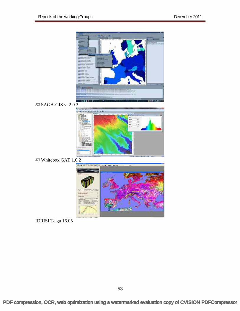
Reports of the working Groups December 2011
53
SAGA-GIS v. 2.0.3
Whitebox GAT 1.0.2
IDRISI Taiga 16.05
PDF compression, OCR, web optimization using a watermarked evaluation copy of CVISION PDFCompressor
Reports of the working Groups December 2011
54
Chapter two: Training and Capacity building 47. The following guidelines indicate some of the capacity building activities
that can be used to support the implementation of a NSDI: Awareness creation of NSDI components should be considered down to
the lowest level and with strong management support and leadership. Plans should be developed and implemented for the dissemination of
information on NSDI Activities. Capacity development should be a prime concern of senior management.
Modalities for scholarships/ support should be worked out for the persons desirous of undergoing long term courses in Geospatial Technology in national and international institutes. As job specific technical competencies will be stipulated, it will be
necessary to review positional titles, remuneration packages and salaries. The staff rotation system may be designed to enhance the capacity of
personnel within the department, therefore reducing the need for external recruitment of technical staff. In order to provide software to participating Organistions, cheaper
solutions may be worked out, in consultation with the geospatial industries. While the introduction of specialised software, for example for the
creation of a geospatial catalogue, is relatively easy, its effective use depends on the technical capabilities as well as organisational support. The personnel resources for spatial data infrastructure in many
organisations are very limited. A pool of qualified staff has to be created if the projects are to become sustainable. "Brain-drain" is a serious problem: the fact that skilled personnel are
leaving their jobs too often, too soon. Human capacity development and long term career planning should be of prime concern to senior management. It includes the training, theoretical issues and practical hands-on capabilities to implement projects and programs, as well as the working conditions. Working conditions need to be considered not only with respect to salary, but even more importantly with respect to the work climate, motivation and professional perspectives. There is a need to identify some lead universities or institutions in
different regions of the country to play crucial role in imparting training in Geospatial Technology. It is proposed that wider publicity should be given about the potentiality of
this Geospatial Technology. Print and electronic media should be involved for this purpose. NSDI to create a knowledge base that will bring benefits to its own
national development efforts. The nation to have a centre of excellence in geospatial technology with an
objective to promote a wide and deep knowledge enterprise in GIS through teaching, research and networking within the Indian GIS knowledge community. Geospatial education in India is still in a nascent stage and more
educational institutes need to start offering degrees in this field.
PDF compression, OCR, web optimization using a watermarked evaluation copy of CVISION PDFCompressor
Reports of the working Groups December 2011
55
By overcoming inefficiencies, a coherent and consistent NSDI can ensure that geographic information may be used to address complex social, environmental, and economic issues. A practical step to take in the development of a NSDI is the development
of a vision, detailing a vision of the desired future and a clear sense of how NSDI components could serve that future and help to realise it. This also involves setting clear priorities and defining a strategy or policy to accomplish the vision. A workshop organised with the stakeholders to define and create a
national co-ordinating body. The co-ordinating body needs to be mandated to manage the required
activities and devise an action plan to coordinate the activities. Consideration needs to be given to the necessary resources for implementing strategy, policy or plans and activities, considering staff, technical know-how, material, and funding opportunities such as innovative partnerships. Measures should be taken to monitor, analyse and participate in,
developments at international levels that affect the use of standards and supporting technologies in the national context.
48. In order to make the NSDI working robust, clear- cut policies regarding training and capacity building are absolutely necessary. With this in view, some of the salient points need to be considered are: 48.1 Development of a vision: NSDI should have a vision of desired future and
clear meaning of how NSDI components could serve that future and help to realise it. This also involves setting up of clear priorities and defining a strategy or policy to accomplish the vision.
48.2 Workshop with the Agencies: A workshop may be organised with the Agencies to define and create a National Coordinating body which in turn will ensure that within the Agencies all the data implementation department is ready to serve NSDI requirement.
48.3 Awareness Creation of SDI: Awareness Creation of SDI should consider down to minimum level with strong know-how practices. One reason for agencies and institutions contributing little to implementation of the national geo portal is that they remain unaware of how useful and supportive an NSDI can be in terms of their own function. Unfortunately, the potential for thematic use of the NSDI, including for disaster related activities, is not easily illustrated in its current status. Reasons for this include the fact that institutional arrangements for setting up infrastructure nodes have not been finalised, and that there are no proven applications. But a particular lack of capacity exists across agencies and institutions for making appropriate use of geospatial data infrastructure. This results in agencies and institutions initiating their own collection, accessing and dissemination efforts, rather than these being co-ordinated within the NSDI. Processing information regarding disaster preparedness and responses, such as analysing risks raised by the community, demands for infrastructure improvements and requests for aid, thus becomes difficult, if not impossible.
48.4 Flow of Information: The information transfer to the user agencies need to be developed to for proper dissemination and utility of the data. Need to
PDF compression, OCR, web optimization using a watermarked evaluation copy of CVISION PDFCompressor
Reports of the working Groups December 2011
56
develop a plan for dissemination of information for NSDI activity need not be overemphasized. There are several mechanisms by which the information can flow across to different agencies. The available best technical practices are Internet, CD’s, Manuals, periodicals, magazines etc.
48.5 Coordination with agencies: Coordination with the technical agencies and to conduct national level program for spreading the technical knowledge. Clearly, for better co-ordination and collaboration among institutions and agencies in support of national projects relating to urban disaster-risk reduction, an urgent need arises for capacity building. Decision-makers and staff must really comprehend the use and benefits of an NSDI. The case of an urban disaster-risk reduction programme was chosen as theme for training; such a programme requires collaboration among many agencies, including the Department of Civil Works, Agency for Meteorology and Geophysics, Land Office and Municipality Office. Specific attention was paid to the development of a use scenario utilising the National Geo portal as an integrated tool to support analysis and decision-making processes.
48.6 Training workshop on GIS: Integrating GIS in these studies would not only improve the scope of better analysis through spatial representation but would also build the capacities of the students in this new cutting edge technology of GIS. The objective of the capacity building programme was to increase the officer’s awareness, understanding and skills for data and information management in local government and assists them to identify the capacity building needed at local levels to manage, utilise and share spatial data and information more effectively. The training programme would help the officers to understand the current situation and will be the starting point for improvement. By building, awareness on the development and adoption of internationally accepted standards and guidelines for information management, it would promote best practices in information management. Sensitising the officers to provide the staff responsible for spatial information in local government, the right access to practical information management tools to reduce set up costs and duplication of effort. The training should also focus on how the officers could support the development of networks through open and efficient sharing of information resources and knowledge, and assists the establishment of information loops between regional, state/territory and national levels The officers would also learn how to fully exploit the information generated from local government projects and at the same time ensure the sustainable management of data used or created within local government and promote the sharing and distribution of data, thus reducing costs and increasing their value.
49. Capacity building:
What is capacity building? The results of a Google search on the word 'capacity building' highlight
the wide variety of interpretations of the term. These include human resource development, organisational change and societal transformation. Nevertheless to some people it means essentially the training of SDI technicians and managers
PDF compression, OCR, web optimization using a watermarked evaluation copy of CVISION PDFCompressor
Reports of the working Groups December 2011
57
although this definition is often extended to include the education of politicians and the general public outside the geographic information industry.
In capacity building, it can be seen that the implementation of a SDI is also a process of organisational change management. Despite this the need for capacity building initiatives to be developed in parallel to the processes of NSDI implementation is often underestimated. Two key strategic areas of SDI implementation: coalition formation and institutional development.
The effective implementation of SDIs is very much dependent on the extent to which they reflect the capabilities and the aspirations of all the stakeholders that are involved. This is particularly important in the early stages of SDI development when it is desirable to involve as many of the stakeholders as possible to participate in the process to form coalitions to formulate SDIs.
The benefits of coalition formation meets two goals at the same time, 1) helping large diverse groups discover values, purposes and projects they hold in common, and 2) enabling people to create a desired future together and start working towards it right away.
One of the most interesting features coalition formations is the way in which it avoids conflicts and focuses attention on the evolution of a shared agenda. This is done by treating 'problems and conflicts as information rather actions items while searching for common ground and desirable futures.' In essence it is a highly structured process that enables diverse groups of stakeholders to work alongside each other to find common ground. An important feature of this process is the extent to which those involved feel that they have created the desirable futures and have had the opportunity to commit themselves and their organisations to participate in the action plans that concern most.
Implementation: Another interesting example of coalition formation is the I-Team (or implementation team) initiative that was been set up in America to tackle the problems of upgrading and maintaining the seven framework data layers in the NSDI. It aims to offer a coherent set of institutional and financial incentives to make it easier for all levels of government and the private sector to collaborate in the building of the next generation of framework data. By aligning participant needs and resources, the I-Team Initiative will help all levels of government and the private sector to save money, migrate from existing legacy systems, make better user of existing resources, and develop the business case for additional public and private resources.
PDF compression, OCR, web optimization using a watermarked evaluation copy of CVISION PDFCompressor
Reports of the working Groups December 2011
58
Chapter Three: Case history of GSI 50. The GSI Enterprise Portal provides a single point of access to Enterprise
GIS. It is an application to maintain spatial data consistency, resolve heterogeneity, prevent data redundancy and provide authorised access to spatial data for all users across the organization. ESRI suite of products – ArcIMS and ArcSDE has been used to build geo-scientific applications of GSI. The web GIS application is accessed through portal, while data migration utility (Load and Update utility) and customized Metadata Editor are accessed from desktop ArcGIS ArcInfo clients. Using ArcSDE architecture, the ArcInfo clients and ArcIMS service is connected to the Oracle sever through mid tier ArcSDE service. Web browser displays the map using ArcIMS and ArcSDE service and shows the corresponding attribute data from the Geoscientific database schema residing in the Oracle server.
The existing desktop ArcGIS clients have been integrated in this architecture through customisation of Load and Update utility, using which users can upload spatial data via the spatial data engine to the spatial database through Intranet. The uploaded data can then be viewed and explored through the GSI Information Portal using the WebGIS utility. ArcSDE, the spatial data engine, manages the ArcInfo clients and ArcIMS service to connect to the Oracle server. The Web browser displays the map using ArcIMS and ArcSDE service and shows the corresponding attribute data from the geoscientific database schema residing in Oracle server.
A robust Spatial Data Ware House has been designed on Oracle-10g database using ArcSDE as mid-tier to store the spatial data of various domains. Thus, a centralized multi-user geodatabase has been built for maintaining the data consistency, interoperability and to eliminate data redundancy as a part of Enterprise GIS. This multi-user geodatabase acts as the centralized spatial data warehouse for all users across the organization. In this Geodatabase the following domains have been incorporated as feature datasets: Map50K, Coal, Marine, Photogeology & Remote Sensing (PGRS), Drilling, Geochemical, Geophysical, Mining Exploration, Natural Hazards, Environmental and Rock Sample.
Altogether 201 feature classes of the domains listed above are present in the geodatabase. In map 50K domain, 29 ArcSDE feature classes are available in 1:50,000 scale. They are lithology, fault, fold, oriented structures, shear zones, trend lines, dykes, boundary, fossil location etc.
A raster map service on Geological and Mineral data on 1:2 M scale that will be integrated with degreesheet -wise Geological Quadrangle Maps (1:250,000) scale as raster mosaic within the same framework. It will be further narrow down to the geological map of 1:50K scale. The display of the data will be scale dependent i.e. initially in the map service the 1:2M geological and generalized mineral data for entire country will be displayed. On further zooming to the scale of 1:250K or larger, 1:250K raster image data will be displayed following by 1:50 K scale map on further zooming. The entire map service will be
PDF compression, OCR, web optimization using a watermarked evaluation copy of CVISION PDFCompressor
Reports of the working Groups December 2011
59
image based. The following functionality needs to be integrated within the map service- 50.1 Data entry and Upload: So far 294 Geological Quadrangle Maps (1:250K) have been published by GSI. Thereafter, GSI intends to upload the rest of these maps and other new published maps (as and when available) to the system along with relevant attribute / metadata entry through a system based on authorisation by respective divisions / Users. Thus a system needs to be developed whereby user can upload scanned maps (in specified resolution and format) and specify the required metadata / attribute / tags during uploading such that the uploaded map dynamically gets georeferenced and fits into the mosaic. Similar exercise will be carried out for 4905 1:50K maps also. 50.2 Dynamic legend display: At every zoom level, a dynamic hierarchical stratigraphic legend (as depicted in the printed published maps) needs to be displayed depending on the spatial extent and objects that are viewable on the screen. By stratigraphic legend we mean display of Supergroup / Groups / Formations / lithounit in chronological order i.e. Precambrian in the bottom and Quaternary on the top.
The legend should be displayed in three columns, first column with a box showing the customised colour / symbology of spatial object, the second column displaying its stratigraphic name (Supergroup / Group / formation / lithounit) and last column displaying the age information. Normally the display of the legend should be in vertical succession, but a typical situation may arise when a particular zoom-in displays several rock types / Groups/ formations of same stratigraphic age; in this scenario the legend should display those rock types / Groups horizontally instead of vertically or a combination of both horizontal and vertical disposition as stratigraphy demands. 50.3 AOI based query: Area of Interest (AOI) based query system needs to be developed. Such query may be predefined such as region-wise (e.g. Eastern, Central, Western etc. depending on the Regional Structure of GSI), state-wise, degree sheet wise or toposheet-wise. User should also have the option to define his own AOI also. Depending of the query, a map with dynamic legend at appropriate scale should be displayed.
To narrow down the search, facility should be there to specify AOI in terms of latitude – longitude, textual search, prominent locational search (city /town / village), search depending on SOI Toposheet / degree sheet at any stage of AOI selection. The output of the search may be both graphic and textual. As stated earlier, depending on AOI, the graphical data and its corresponding stratigraphic legend should be dynamically placed.
PDF compression, OCR, web optimization using a watermarked evaluation copy of CVISION PDFCompressor
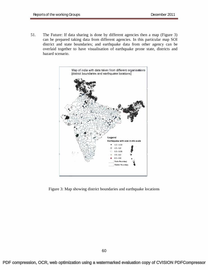
Reports of the working Groups December 2011
60
51. The Future: If data sharing is done by different agencies then a map (Figure 3)
can be prepared taking data from different agencies. In this particular map SOI district and state boundaries; and earthquake data from other agency can be overlaid together to have visualisation of earthquake prone state, districts and hazard scenario.
Figure 3: Map showing district boundaries and earthquake locations
PDF compression, OCR, web optimization using a watermarked evaluation copy of CVISION PDFCompressor
Reports of the working Groups December 2011
61
Source: 1. Geospatial data access & Data delivery edited by Brian McLeod, 2. Stuart Rich, and Amar Das, St. George Consulting Group Christopher Kroot, Maine Department of Environmental Protection
PDF compression, OCR, web optimization using a watermarked evaluation copy of CVISION PDFCompressor
National Spatial Data Infrastructure (NSDI)Department of Science & Technology, Govt. of India
East Block-7, Level-5, Sector-1, R K Puram
New Delhi - 110 066. Tel: 011 - 2617 7249, Fax : 011 - 2618 2967
http://nsdi.gov.in http://nsdiindia.gov.in
nsdi
PDF compression, OCR, web optimization using a watermarked evaluation copy of CVISION PDFCompressor