north carolina department of transportation-right …...north carolina department of transportation...
TRANSCRIPT
FRM5-S Revised: 04/11
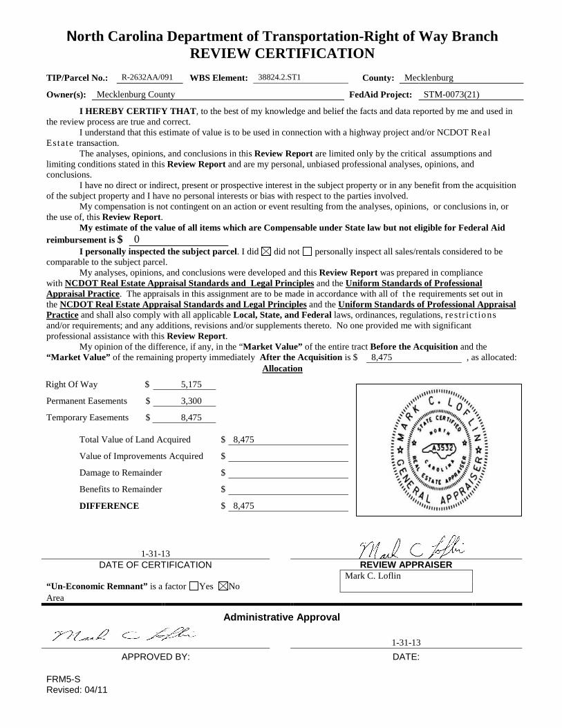
North Carolina Department of Transportation-Right of Way Branch REVIEW CERTIFICATION
TIP/Parcel No.: R-2632AA/091 WBS Element: 38824.2.ST1 County: Mecklenburg
Owner(s): Mecklenburg County FedAid Project: STM-0073(21)
I HEREBY CERTIFY THAT, to the best of my knowledge and belief the facts and data reported by me and used in the review process are true and correct.
I understand that this estimate of value is to be used in connection with a highway project and/or NCDOT Real Estate transaction.
The analyses, opinions, and conclusions in this Review Report are limited only by the critical assumptions and limiting conditions stated in this Review Report and are my personal, unbiased professional analyses, opinions, and conclusions.
I have no direct or indirect, present or prospective interest in the subject property or in any benefit from the acquisition of the subject property and I have no personal interests or bias with respect to the parties involved.
My compensation is not contingent on an action or event resulting from the analyses, opinions, or conclusions in, or the use of, this Review Report.
My estimate of the value of all items which are Compensable under State law but not eligible for Federal Aid reimbursement is $ 0
I personally inspected the subject parcel. I did did not personally inspect all sales/rentals considered to be comparable to the subject parcel.
My analyses, opinions, and conclusions were developed and this Review Report was prepared in compliance with NCDOT Real Estate Appraisal Standards and Legal Principles and the Uniform Standards of Professional Appraisal Practice. The appraisals in this assignment are to be made in accordance with all of the requirements set out in the NCDOT Real Estate Appraisal Standards and Legal Principles and the Uniform Standards of Professional Appraisal Practice and shall also comply with all applicable Local, State, and Federal laws, ordinances, regulations, restr ic t ions and/or requirements; and any additions, revisions and/or supplements thereto. No one provided me with significant professional assistance with this Review Report.
My opinion of the difference, if any, in the “Market Value” of the entire tract Before the Acquisition and the “Market Value” of the remaining property immediately After the Acquisition is $ 8,475 , as allocated:
Allocation
Total Value of Land Acquired
Right Of Way $ 5,175
Permanent Easements $ 3,300
Temporary Easements $ 8,475
$ 8,475
Value of Improvements Acquired $
Damage to Remainder $
Benefits to Remainder $
DIFFERENCE $ 8,475
1-31-13
DATE OF CERTIFICATION REVIEW APPRAISER Mark C. Loflin “Un-Economic Remnant” is a factor Yes No Area
Administrative Approval
1-31-13
APPROVED BY: DATE:
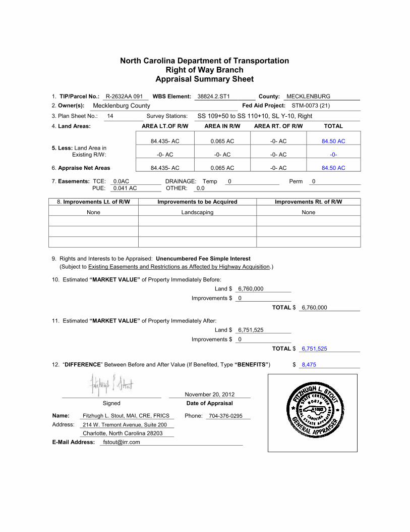
North Carolina Department of Transportation Right of Way Branch
Appraisal Summary Sheet
1. TIP/Parcel No.: R-2632AA 091 WBS Element: 38824.2.ST1 County: MECKLENBURG
2. Owner(s): Mecklenburg County Fed Aid Project: STM-0073 (21)
3. Plan Sheet No.: 14 Survey Stations: SS 109+50 to SS 110+10, SL Y-10, Right
4. Land Areas: AREA LT.OF R/W AREA IN R/W AREA RT. OF R/W TOTAL
84.435- AC 0.065 AC -0- AC 84.50 AC
5. Less: Land Area in Existing R/W:
-0- AC -0- AC -0- AC -0-
6. Appraise Net Areas
84.435- AC 0.065 AC -0- AC 84.50 AC
7. Easements: TCE: 0.0AC DRAINAGE: Temp 0 Perm 0
PUE: 0.041 AC OTHER: 0.0
8. Improvements Lt. of R/W Improvements to be Acquired Improvements Rt. of R/W
None Landscaping None
9. Rights and Interests to be Appraised: Unencumbered Fee Simple Interest
(Subject to Existing Easements and Restrictions as Affected by Highway Acquisition.)
10. Estimated “MARKET VALUE” of Property Immediately Before: Land $ 6,760,000
Improvements $ 0
TOTAL $ 6,760,000
11. Estimated “MARKET VALUE” of Property Immediately After: Land $ 6,751,525
Improvements $ 0
TOTAL $ 6,751,525
12. “DIFFERENCE” Between Before and After Value (If Benefited, Type “BENEFITS”) $ 8,475
November 20, 2012
Signed Date of Appraisal
Name: Fitzhugh L. Stout, MAI, CRE, FRICS Phone: 704-376-0295
Address: 214 W. Tremont Avenue, Suite 200
Charlotte, North Carolina 28203
E-Mail Address: [email protected]
Seal
Seal
North Carolina Department of Transportation-Right of Way Branch
Preamble
A. Objective of Appraisal and Purpose of Report
The objective of this appraisal is to estimate the market value of the subject property. The purpose of this report is to present data and analyses which support the opinion of market value.
B. Definition of Market Value
As defined in The Appraisal of Real Estate, 12th Edition, “MARKET VALUE is the most probable price, as of a specified date, in cash or in terms equivalent to cash, or in other precisely revealed terms, for which the specified property rights should sell after reasonable exposure in a competitive market under all conditions requisite to a “Fair Sale”, with the Buyer and Seller each acting prudently, knowledgeable, and for self-interest, and assuming that neither is under undue stimuli.”
C. Scope of Appraisal
The scope of this appraisal involves an inspection of the subject property and general area, research into the market for sales and other comparable information, analysis of the findings, and a report of the findings in a narrative format.
D. Hazardous Material Statement
Unless otherwise stated in this report, the existence of hazardous material and/or contamination which may or may not be present on the property, was not observed by the appraiser. The appraiser has no knowledge of the existence of such materials on or in the property. The appraiser, however, is not qualified to detect such substances. The presence of substances such as asbestos, urea-formaldehyde foam insulation, or other potentially hazardous materials may affect the value of the property. The value estimate is predicated on the assumption that there is no such material on or in the property that would cause a loss in value. No responsibility is assumed for any such conditions, or for any expertise or engineering knowledge required to discover them. The client/property owner is urged to retain an expert in this field, if desired. That is, the subject property is appraised "as clean".
E. Americans with Disabilities Act
The appraiser has not made a specific compliance survey and analysis of the subject 91 to determine whether or not it is in conformity with the various detailed requirements of the American with Disabilities Act ("ADA"). It is possible that a compliance survey of the property together with a detailed analysis of the requirements of the ADA could reveal that the subject 91 is not in compliance with one or more of the requirements of the Act. If so, this fact could have a negative effect upon the value of the property. Since the appraiser has no direct evidence relating to this issue, the appraiser did not consider possible non-compliance with the requirements of ADA in estimating the value of the subject.

Integra Realty Resources Charlotte
Appraisal Of Real Property
Vacant Land 16131 Old Statesville Road Huntersville, Mecklenburg County, North Carolina 28078 Project Number: R2632AA/014
Prepared For: NCDOT
Effective Date of the Appraisal: November 20, 2012
IRR - Charlotte File Number: 105-2012-1888
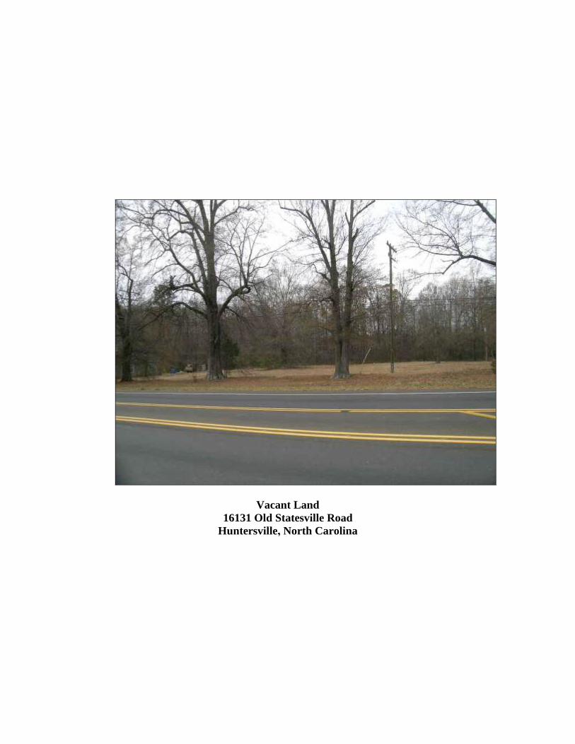
Vacant Land
16131 Old Statesville Road
Huntersville, North Carolina
Integra Realty Resources 214 W. Tremont Avenue T 704.376.0295 Charlotte Suite 200 F 704.342.3704 Charlotte, NC 28203 www.irr.com
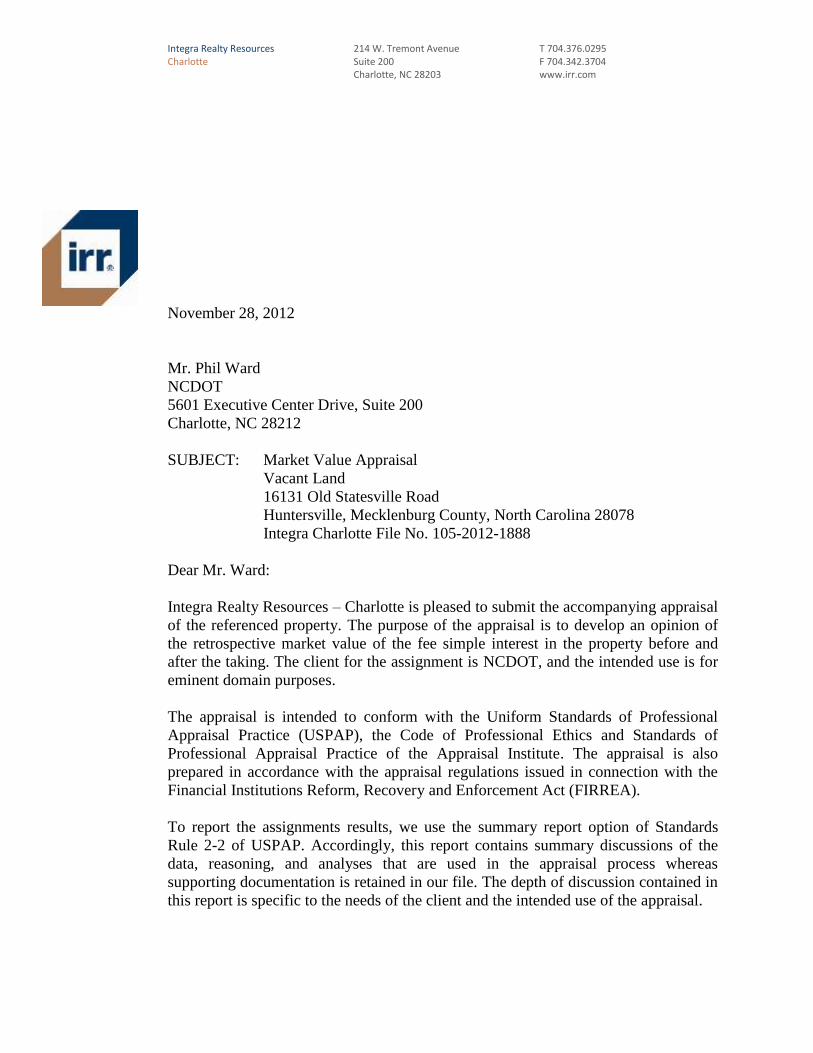
November 28, 2012
Mr. Phil Ward
NCDOT
5601 Executive Center Drive, Suite 200
Charlotte, NC 28212
SUBJECT: Market Value Appraisal
Vacant Land
16131 Old Statesville Road
Huntersville, Mecklenburg County, North Carolina 28078
Integra Charlotte File No. 105-2012-1888
Dear Mr. Ward:
Integra Realty Resources – Charlotte is pleased to submit the accompanying appraisal
of the referenced property. The purpose of the appraisal is to develop an opinion of
the retrospective market value of the fee simple interest in the property before and
after the taking. The client for the assignment is NCDOT, and the intended use is for
eminent domain purposes.
The appraisal is intended to conform with the Uniform Standards of Professional
Appraisal Practice (USPAP), the Code of Professional Ethics and Standards of
Professional Appraisal Practice of the Appraisal Institute. The appraisal is also
prepared in accordance with the appraisal regulations issued in connection with the
Financial Institutions Reform, Recovery and Enforcement Act (FIRREA).
To report the assignments results, we use the summary report option of Standards
Rule 2-2 of USPAP. Accordingly, this report contains summary discussions of the
data, reasoning, and analyses that are used in the appraisal process whereas
supporting documentation is retained in our file. The depth of discussion contained in
this report is specific to the needs of the client and the intended use of the appraisal.
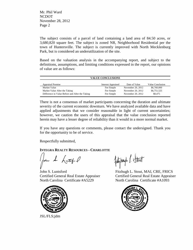
Mr. Phil Ward
NCDOT
November 28, 2012
Page 2
The subject consists of a parcel of land containing a land area of 84.50 acres, or
3,680,820 square feet. The subject is zoned NR, Neighborhood Residential per the
town of Huntersville. The subject is currently improved with North Mecklenburg
Park, but is considered an underutilization of the site.
Based on the valuation analysis in the accompanying report, and subject to the
definitions, assumptions, and limiting conditions expressed in the report, our opinions
of value are as follows:
VALUE CONCLUSIONS
Appraisal Premise Interest Appraised Date of Value Value Conclusion
Market Value Fee Simple November 20, 2012 $6,760,000
Market Value After the Taking Fee Simple November 20, 2012 $6,751,525
Difference in Value Before and After the Taking Fee Simple November 20, 2012 $8,475
There is not a consensus of market participants concerning the duration and ultimate
severity of the current economic downturn. We have analyzed available data and have
applied adjustments that we consider reasonable in light of current uncertainties;
however, we caution the users of this appraisal that the value conclusion reported
herein may have a lesser degree of reliability than it would in a more normal market.
If you have any questions or comments, please contact the undersigned. Thank you
for the opportunity to be of service.
Respectfully submitted,
INTEGRA REALTY RESOURCES - CHARLOTTE
John S. Luntsford
Certified General Real Estate Appraiser
North Carolina Certificate #A5229
Fitzhugh L. Stout, MAI, CRE, FRICS
Certified General Real Estate Appraiser
North Carolina Certificate #A1093
JSL/FLS;jdm
PARCEL 2632AA -091 GENERAL INFORMATION
TABLE OF CONTENTS
GENERAL INFORMATION ...................................................................................................... 1
Identification of Subject .............................................................................................. 1
Current Ownership and Sales History......................................................................... 1 Purpose, Property Rights and Effective Date ............................................................. 1 Definition of Market Value ......................................................................................... 1 Definition of Property Rights Appraised .................................................................... 2 Client, Intended User and Intended Use ..................................................................... 2
Applicable Requirements ............................................................................................ 2 Prior Services .............................................................................................................. 2 Scope of Work ............................................................................................................ 2
ECONOMIC ANALYSIS ........................................................................................................... 4
Surrounding Area Analysis ....................................................................................... 12
PROPERTY ANALYSIS .......................................................................................................... 16
Land Description and Analysis ................................................................................. 16
Real Estate Tax Analysis .......................................................................................... 24 Highest and Best Use Analysis ................................................................................. 25
VALUATION ANALYSIS ........................................................................................................ 26
Valuation Methodology ............................................................................................ 26 Land Valuation.......................................................................................................... 27
Description of the Acquisition .................................................................................. 37 Description of Remainder and Effects of the Acquisition ........................................ 40
Valuation of the Property After The Taking ............................................................. 41 Difference in Before and After Value ....................................................................... 42
Reconciliation and Conclusion of Value .................................................................. 43
CERTIFICATION ................................................................................................................... 44
ASSUMPTIONS AND LIMITING CONDITIONS ....................................................................... 46
ADDENDA
A. Appraiser Qualifications
B. Definitions C. Financials and Property Information D. Certification
PARCEL 2632AA -091 GENERAL INFORMATION
PAGE 1
GENERAL INFORMATION
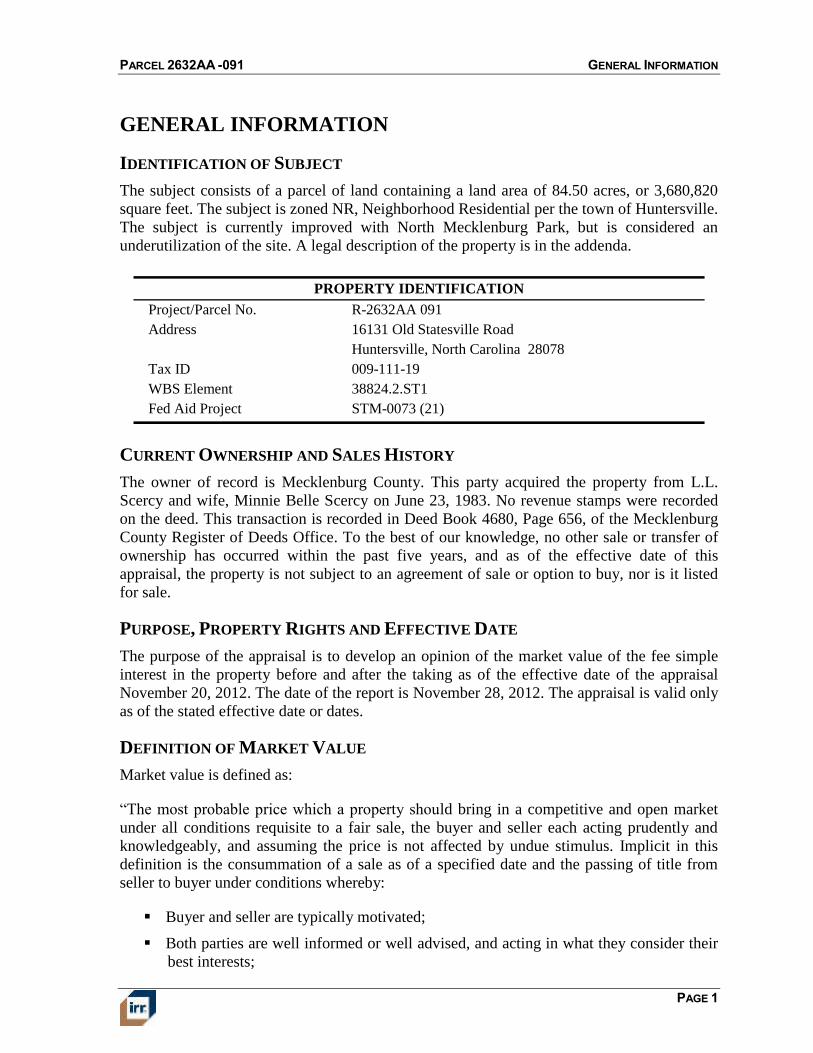
IDENTIFICATION OF SUBJECT
The subject consists of a parcel of land containing a land area of 84.50 acres, or 3,680,820
square feet. The subject is zoned NR, Neighborhood Residential per the town of Huntersville.
The subject is currently improved with North Mecklenburg Park, but is considered an
underutilization of the site. A legal description of the property is in the addenda.
Project/Parcel No. R-2632AA 091
Address 16131 Old Statesville Road
Huntersville, North Carolina 28078
Tax ID 009-111-19
WBS Element 38824.2.ST1
Fed Aid Project STM-0073 (21)
PROPERTY IDENTIFICATION
CURRENT OWNERSHIP AND SALES HISTORY
The owner of record is Mecklenburg County. This party acquired the property from L.L.
Scercy and wife, Minnie Belle Scercy on June 23, 1983. No revenue stamps were recorded
on the deed. This transaction is recorded in Deed Book 4680, Page 656, of the Mecklenburg
County Register of Deeds Office. To the best of our knowledge, no other sale or transfer of
ownership has occurred within the past five years, and as of the effective date of this
appraisal, the property is not subject to an agreement of sale or option to buy, nor is it listed
for sale.
PURPOSE, PROPERTY RIGHTS AND EFFECTIVE DATE
The purpose of the appraisal is to develop an opinion of the market value of the fee simple
interest in the property before and after the taking as of the effective date of the appraisal
November 20, 2012. The date of the report is November 28, 2012. The appraisal is valid only
as of the stated effective date or dates.
DEFINITION OF MARKET VALUE
Market value is defined as:
“The most probable price which a property should bring in a competitive and open market
under all conditions requisite to a fair sale, the buyer and seller each acting prudently and
knowledgeably, and assuming the price is not affected by undue stimulus. Implicit in this
definition is the consummation of a sale as of a specified date and the passing of title from
seller to buyer under conditions whereby:
Buyer and seller are typically motivated;
Both parties are well informed or well advised, and acting in what they consider their
best interests;
PARCEL 2632AA -091 GENERAL INFORMATION
PAGE 2
A reasonable time is allowed for exposure in the open market;
Payment is made in terms of cash in United States dollars or in terms of financial
arrangements comparable thereto; and
The price represents the normal consideration for the property sold unaffected by
special or creative financing or sales concessions granted by anyone associated with
the sale.” (Source: 12 C.F.R. Part 34.42(g); 55 Federal Register 34696, August 24,
1990, as amended at 57 Federal Register 12202, April 9, 1992; 59 Federal Register
29499, June 7, 1994)
DEFINITION OF PROPERTY RIGHTS APPRAISED
Fee simple estate is defined as, “Absolute ownership unencumbered by any other interest or
estate, subject only to the limitations imposed by the governmental powers of taxation,
eminent domain, police power, and escheat.”
(Source: The Dictionary of Real Estate Appraisal, Fifth Edition, Appraisal Institute,
Chicago, Illinois, 2010)
CLIENT, INTENDED USER AND INTENDED USE
The client and intended user is NCDOT. The intended use is for eminent domain purposes.
The appraisal is not intended for any other use or user.
APPLICABLE REQUIREMENTS
This appraisal is intended to conform to the requirements of the following:
Uniform Standards of Professional Appraisal Practice (USPAP)
Code of Professional Ethics and Standards of Professional Appraisal Practice of the
Appraisal Institute
Appraisal requirements of Title XI of the Financial Institutions Reform, Recovery and
Enforcement Act of 1989 (FIRREA), revised June 7, 1994.
PRIOR SERVICES
USPAP requires appraisers to disclose to the client any services they have provided in
connection with the subject property in the prior three years, including valuation, consulting,
property management, brokerage, or any other services. We have previously appraised the
property that is the subject of this report for another client within the three-year period
immediately preceding acceptance of this assignment.
SCOPE OF WORK
To determine the appropriate scope of work for the assignment, we considered the intended
use of the appraisal, the needs of the user, the complexity of the property, and other pertinent
factors. Our concluded scope of work is described below.
PARCEL 2632AA -091 GENERAL INFORMATION
PAGE 3
VALUATION METHODOLOGY
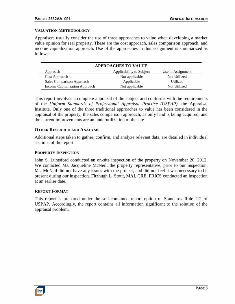
Appraisers usually consider the use of three approaches to value when developing a market
value opinion for real property. These are the cost approach, sales comparison approach, and
income capitalization approach. Use of the approaches in this assignment is summarized as
follows:
Approach Applicability to Subject Use in Assignment
Cost Approach Not applicable Not Utilized
Sales Comparison Approach Applicable Utilized
Income Capitalization Approach Not applicable Not Utilized
APPROACHES TO VALUE
This report involves a complete appraisal of the subject and conforms with the requirements
of the Uniform Standards of Professional Appraisal Practice (USPAP), the Appraisal
Institute. Only one of the three traditional approaches to value has been considered in the
appraisal of the property, the sales comparison approach, as only land is being acquired, and
the current improvements are an underutilization of the site.
OTHER RESEARCH AND ANALYSIS
Additional steps taken to gather, confirm, and analyze relevant data, are detailed in individual
sections of the report.
PROPERTY INSPECTION
John S. Luntsford conducted an on-site inspection of the property on November 20, 2012.
We contacted Ms. Jacqueline McNeil, the property representative, prior to our inspection.
Ms. McNeil did not have any issues with the project, and did not feel it was necessary to be
present during our inspection. Fitzhugh L. Stout, MAI, CRE, FRICS conducted an inspection
at an earlier date.
REPORT FORMAT
This report is prepared under the self-contained report option of Standards Rule 2-2 of
USPAP. Accordingly, the report contains all information significant to the solution of the
appraisal problem.
PARCEL 2632AA -091 MECKLENBURG COUNTY AREA ANALYSIS
PAGE 4
ECONOMIC ANALYSIS
MECKLENBURG COUNTY AREA ANALYSIS
Mecklenburg County is located in southern North Carolina. The county is approximately
526 square miles in size and has a population density of 1,815 persons per square mile.
Mecklenburg County is part of the Charlotte-Gastonia-Concord, NC-SC Metropolitan
Statistical Area, hereinafter called the Charlotte MSA, as defined by the U.S. Office of
Management and Budget.
POPULATION
Mecklenburg County has an estimated 2012 population of 955,170, which represents an
average annual 2.7% increase over the 2000 census of 695,454. Mecklenburg County added
an average of 21,643 residents per year over the 2000-2012 period, and its annual growth rate
exceeded the State of North Carolina rate of 1.6%.
POPULATION TRENDS
Population Compound Ann. % Chng
2000 Census 2012 Est. 2017 Est. 2000 - 2012 2012 - 2017
Mecklenburg County, NC 695,454 955,170 1,052,657 2.7% 2.0%
North Carolina 8,049,313 9,783,974 10,469,175 1.6% 1.4%
Source: Claritas
Looking forward, Mecklenburg County's population is projected to increase at a 2.0% annual
rate from 2012-2017, equivalent to the addition of an average of 19,497 residents per year.
Mecklenburg County's growth rate is expected to exceed that of North Carolina, which is
projected to be 1.4%.
EMPLOYMENT
Total employment in Mecklenburg County is currently estimated at 553,464 jobs. Between
year end 2001 and the present, employment rose by 43,939 jobs, equivalent to an 8.6%
increase over the entire period. There were gains in employment in seven out of the past ten
years despite two national economic downturns during this time. Job growth in Mecklenburg
County turned positive in 2010 and remained so in 2011.
Mecklenburg County's rate of employment growth over the last decade surpassed that of
North Carolina, which experienced an increase in employment of 2.6% or 96,889 jobs over
this period. Trends in employment are a key indicator of economic health and strongly
correlate with real estate demand.
PARCEL 2632AA -091 MECKLENBURG COUNTY AREA ANALYSIS
PAGE 5
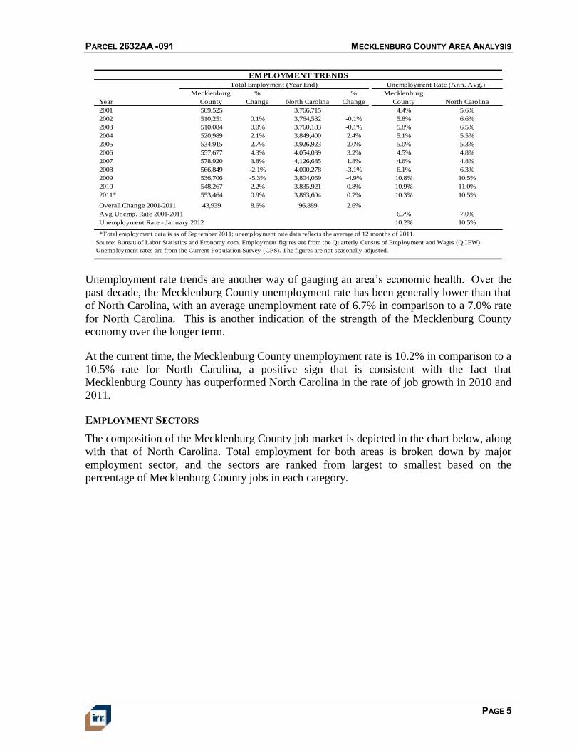
EMPLOYMENT TRENDS
Total Employment (Year End)
Year
Mecklenburg
County
%
Change North Carolina
%
Change
Mecklenburg
County North Carolina
2001 509,525 3,766,715 4.4% 5.6%
2002 510,251 0.1% 3,764,582 -0.1% 5.8% 6.6%
2003 510,084 0.0% 3,760,183 -0.1% 5.8% 6.5%
2004 520,989 2.1% 3,849,400 2.4% 5.1% 5.5%
2005 534,915 2.7% 3,926,923 2.0% 5.0% 5.3%
2006 557,677 4.3% 4,054,039 3.2% 4.5% 4.8%
2007 578,920 3.8% 4,126,685 1.8% 4.6% 4.8%
2008 566,849 -2.1% 4,000,278 -3.1% 6.1% 6.3%
2009 536,706 -5.3% 3,804,059 -4.9% 10.8% 10.5%
2010 548,267 2.2% 3,835,921 0.8% 10.9% 11.0%
2011* 553,464 0.9% 3,863,604 0.7% 10.3% 10.5%
Overall Change 2001-2011 43,939 8.6% 96,889 2.6%
Avg Unemp. Rate 2001-2011 6.7% 7.0%
Unemployment Rate - January 2012 10.2% 10.5%
Unemployment Rate (Ann. Avg.)
Source: Bureau of Labor Statistics and Economy.com. Employment figures are from the Quarterly Census of Employment and Wages (QCEW).
Unemployment rates are from the Current Population Survey (CPS). The figures are not seasonally adjusted.
*Total employment data is as of September 2011; unemployment rate data reflects the average of 12 months of 2011.
Unemployment rate trends are another way of gauging an area’s economic health. Over the
past decade, the Mecklenburg County unemployment rate has been generally lower than that
of North Carolina, with an average unemployment rate of 6.7% in comparison to a 7.0% rate
for North Carolina. This is another indication of the strength of the Mecklenburg County
economy over the longer term.
At the current time, the Mecklenburg County unemployment rate is 10.2% in comparison to a
10.5% rate for North Carolina, a positive sign that is consistent with the fact that
Mecklenburg County has outperformed North Carolina in the rate of job growth in 2010 and
2011.
EMPLOYMENT SECTORS
The composition of the Mecklenburg County job market is depicted in the chart below, along
with that of North Carolina. Total employment for both areas is broken down by major
employment sector, and the sectors are ranked from largest to smallest based on the
percentage of Mecklenburg County jobs in each category.
PARCEL 2632AA -091 MECKLENBURG COUNTY AREA ANALYSIS
PAGE 6
EMPLOYMENT SECTORS - 2011
20.6%
20.5%
12.0%
11.0%
10.6%
9.4%
5.6%
4.3%
3.5%
2.4%
13.5%
18.8%
17.6%
10.6%
5.0%
13.5%
11.3%
4.6%
1.8%
2.4%
0% 5% 10% 15% 20% 25%
Professional and Business Services
Trade; Transportation; and Utilities
Government
Leisure and Hospitality
Financial Activities
Education and Health Services
Manufacturing
Construction
Information
Other Services
Mecklenburg County North Carolina
Source: Bureau of Labor Statistics and Economy.com
Mecklenburg County has greater concentrations than North Carolina in the following
employment sectors:
Professional and Business Services, representing 20.6% of Mecklenburg County payroll
employment compared to 13.5% for North Carolina as a whole. This sector includes
legal, accounting, and engineering firms, as well as management of holding
companies.
Trade; Transportation; and Utilities, representing 20.5% of Mecklenburg County payroll
employment compared to 18.8% for North Carolina as a whole. This sector includes
jobs in retail trade, wholesale trade, trucking, warehousing, and electric, gas, and
water utilities.
Leisure and Hospitality, representing 11.0% of Mecklenburg County payroll employment
compared to 10.6% for North Carolina as a whole. This sector includes employment
in hotels, restaurants, recreation facilities, and arts and cultural institutions.
Financial Activities, representing 10.6% of Mecklenburg County payroll employment
compared to 5.0% for North Carolina as a whole. Banking, insurance, and investment
firms are included in this sector, as are real estate owners, managers, and brokers.
Mecklenburg County is underrepresented in the following sectors:
Government, representing 12.0% of Mecklenburg County payroll employment compared to
17.6% for North Carolina as a whole. This sector includes employment in local, state,
and federal government agencies.
Education and Health Services, representing 9.4% of Mecklenburg County payroll
employment compared to 13.5% for North Carolina as a whole. This sector includes
PARCEL 2632AA -091 MECKLENBURG COUNTY AREA ANALYSIS
PAGE 7
employment in public and private schools, colleges, hospitals, and social service
agencies.
Manufacturing, representing 5.6% of Mecklenburg County payroll employment
compared to 11.3% for North Carolina as a whole. This sector includes all
establishments engaged in the manufacturing of durable and nondurable goods.
Construction, representing 4.3% of Mecklenburg County payroll employment compared
to 4.6% for North Carolina as a whole. This sector includes construction of buildings,
roads, and utility systems.
MAJOR EMPLOYERS
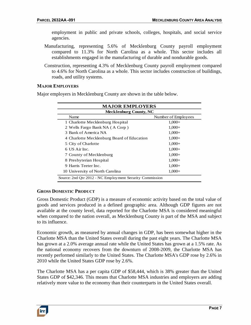
Major employers in Mecklenburg County are shown in the table below.
Mecklenburg County, NC
Name Number of Employees
1 Charlotte Mecklenburg Hospital 1,000+
2 Wells Fargo Bank NA ( A Corp ) 1,000+
3 Bank of America NA 1,000+
4 Charlotte Mecklenburg Board of Education 1,000+
5 City of Charlotte 1,000+
6 US Air Inc. 1,000+
7 County of Mecklenburg 1,000+
8 Presbyterian Hospital 1,000+
9 Harris Teeter Inc. 1,000+
10 University of North Carolina 1,000+
MAJOR EMPLOYERS
Source: 2nd Qtr 2012 - NC Employment Security Commission
GROSS DOMESTIC PRODUCT
Gross Domestic Product (GDP) is a measure of economic activity based on the total value of
goods and services produced in a defined geographic area. Although GDP figures are not
available at the county level, data reported for the Charlotte MSA is considered meaningful
when compared to the nation overall, as Mecklenburg County is part of the MSA and subject
to its influence.
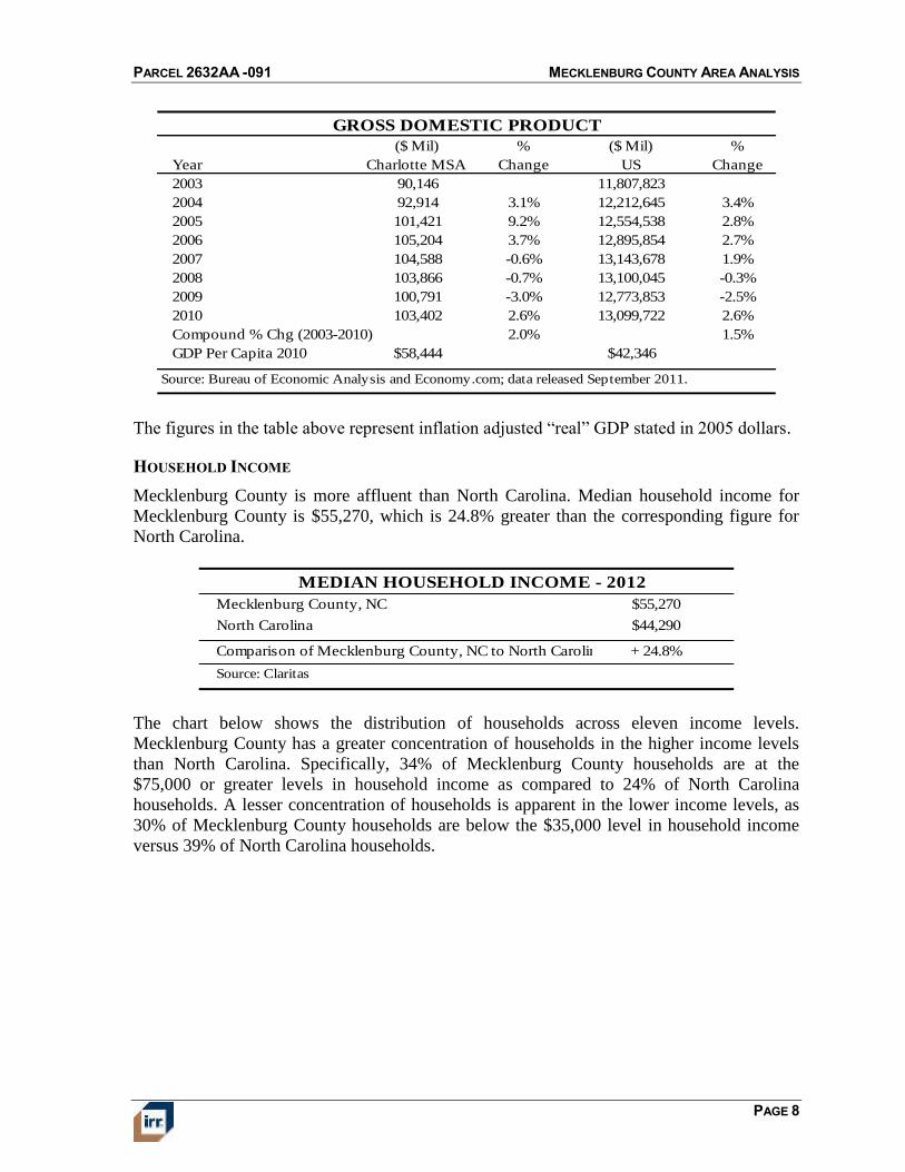
Economic growth, as measured by annual changes in GDP, has been somewhat higher in the
Charlotte MSA than the United States overall during the past eight years. The Charlotte MSA
has grown at a 2.0% average annual rate while the United States has grown at a 1.5% rate. As
the national economy recovers from the downturn of 2008-2009, the Charlotte MSA has
recently performed similarly to the United States. The Charlotte MSA's GDP rose by 2.6% in
2010 while the United States GDP rose by 2.6%.
The Charlotte MSA has a per capita GDP of $58,444, which is 38% greater than the United
States GDP of $42,346. This means that Charlotte MSA industries and employers are adding
relatively more value to the economy than their counterparts in the United States overall.
PARCEL 2632AA -091 MECKLENBURG COUNTY AREA ANALYSIS
PAGE 8
GROSS DOMESTIC PRODUCT
Year
($ Mil)
Charlotte MSA
%
Change
($ Mil)
US
%
Change
2003 90,146 11,807,823
2004 92,914 3.1% 12,212,645 3.4%
2005 101,421 9.2% 12,554,538 2.8%
2006 105,204 3.7% 12,895,854 2.7%
2007 104,588 -0.6% 13,143,678 1.9%
2008 103,866 -0.7% 13,100,045 -0.3%
2009 100,791 -3.0% 12,773,853 -2.5%
2010 103,402 2.6% 13,099,722 2.6%
Compound % Chg (2003-2010) 2.0% 1.5%
GDP Per Capita 2010 $58,444 $42,346
Source: Bureau of Economic Analysis and Economy.com; data released September 2011.
The figures in the table above represent inflation adjusted “real” GDP stated in 2005 dollars.
HOUSEHOLD INCOME
Mecklenburg County is more affluent than North Carolina. Median household income for
Mecklenburg County is $55,270, which is 24.8% greater than the corresponding figure for
North Carolina.
MEDIAN HOUSEHOLD INCOME - 2012
Mecklenburg County, NC $55,270
North Carolina $44,290
Comparison of Mecklenburg County, NC to North Carolina + 24.8%
Source: Claritas
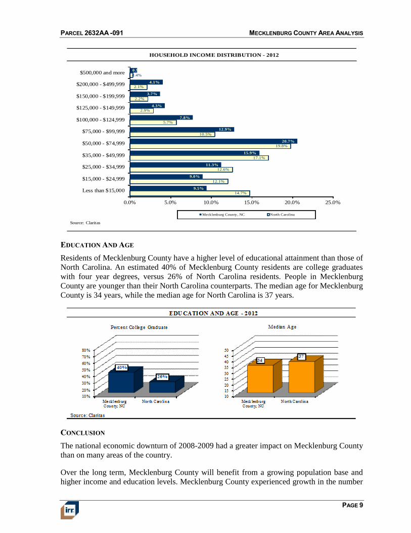
The chart below shows the distribution of households across eleven income levels.
Mecklenburg County has a greater concentration of households in the higher income levels
than North Carolina. Specifically, 34% of Mecklenburg County households are at the
$75,000 or greater levels in household income as compared to 24% of North Carolina
households. A lesser concentration of households is apparent in the lower income levels, as
30% of Mecklenburg County households are below the $35,000 level in household income
versus 39% of North Carolina households.
PARCEL 2632AA -091 MECKLENBURG COUNTY AREA ANALYSIS
PAGE 9
HOUSEHOLD INCOME DISTRIBUTION - 2012
14.7%
12.1%
12.6%
17.1%
19.8%
10.5%
5.7%
2.9%
2.2%
2.1%
0.4%
9.5%
9.0%
11.3%
15.9%
20.7%
12.9%
7.8%
4.3%
3.7%
4.1%
0.9%
0.0% 5.0% 10.0% 15.0% 20.0% 25.0%
Less than $15,000
$15,000 - $24,999
$25,000 - $34,999
$35,000 - $49,999
$50,000 - $74,999
$75,000 - $99,999
$100,000 - $124,999
$125,000 - $149,999
$150,000 - $199,999
$200,000 - $499,999
$500,000 and more
Mecklenburg County, NC North Carolina
Source: Claritas
EDUCATION AND AGE
Residents of Mecklenburg County have a higher level of educational attainment than those of
North Carolina. An estimated 40% of Mecklenburg County residents are college graduates
with four year degrees, versus 26% of North Carolina residents. People in Mecklenburg
County are younger than their North Carolina counterparts. The median age for Mecklenburg
County is 34 years, while the median age for North Carolina is 37 years.
CONCLUSION
The national economic downturn of 2008-2009 had a greater impact on Mecklenburg County
than on many areas of the country.
Over the long term, Mecklenburg County will benefit from a growing population base and
higher income and education levels. Mecklenburg County experienced growth in the number
PARCEL 2632AA -091 MECKLENBURG COUNTY AREA ANALYSIS
PAGE 10
of jobs and has maintained a generally lower unemployment rate than North Carolina over
the past decade. Moreover, Mecklenburg County benefits from being part of the Charlotte
MSA, which exhibits both a higher rate of GDP growth and a higher level of GDP per capita
than the nation overall. Based on these factors, we anticipate that the Mecklenburg County
economy will recover and employment will grow, strengthening the demand for real estate.
PARCEL 2632AA -091 MECKLENBURG COUNTY AREA ANALYSIS
PAGE 11
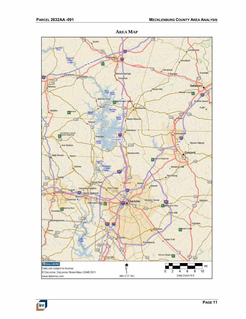
AREA MAP
PARCEL 2632AA -091 SURROUNDING AREA ANALYSIS
PAGE 12
SURROUNDING AREA ANALYSIS
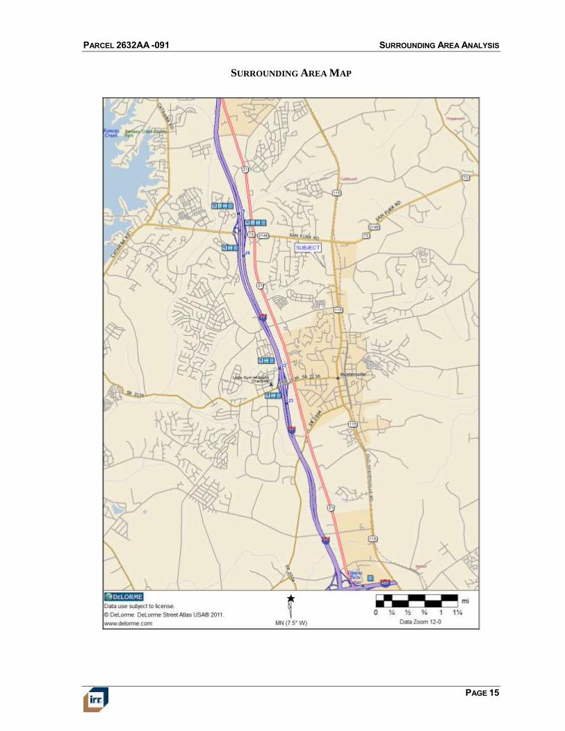
LOCATION
The subject is located in the northern area of Mecklenburg County, within the town limits of
Huntersville. This area is generally delineated as follows:
North Bailey Road
South Stumptown Road
East Old Statesville Road
West Interstate 77
ACCESS AND LINKAGES
Primary access to the area is provided by Interstate 77 (I-77), a major arterial that crosses the
Charlotte metro area in a north/south direction. Access to the subject from I-77 is provided
by exit 25 Huntersville, and travel time from the major arterial to the subject is within
minutes. Overall, vehicular access is good.
Public transportation in the area is provided by Charlotte Area Transportation. The local
market perceives public transportation as average compared to other areas in the region.
However, the primary mode of transportation in this area is the automobile.
The Charlotte/Douglas International Airport is the closest international airport and is located
approximately 20 miles from the subject property. The Charlotte CBD, the economic and
cultural center of the region, is approximately 17 miles from the property.
DEMAND GENERATORS
Major employers in northeast Mecklenburg County include: Wells Fargo, IBM, TIAA-
CREF, UNC-Charlotte and Carolinas Medical Center. Other demand generators in the
subject area are: Concord Mills Mall, Charlotte Motor Speedway, and University Research
Park. In addition to its strong employment base, the area is easily accessible to the Charlotte
CBD submarkets, all within 20 minutes driving time.
RETAIL AND PUBLIC SERVICES
The nearest large scale retail development is Northcross Shopping Center, which provides
the nearest shopping facilities serving the area located at exit 25 off I-77, along Statesville
Road and Sam Furr Road. Northcross Shopping is anchored by Lowe’s Home Improvement,
Harris Teeter grocery store; Old Navy, Kohl’s, Marshall’s and Petco. The shopping center
offers a wide range of convenience goods and personal services as well as the closest
restaurant and lodging facilities. In addition to Northcross Shopping Center, there are
numerous retail and office properties surrounding the shopping center. Across I-77 to the
west is Birkdale Village, an urban village mixed-use development and Birkdale Golf Course.
Local police and fire support services are located within a reasonable distance from the
subject. The closest university is University of North Carolina at Charlotte, which is located
within twenty-five minutes of the subject property depending on traffic conditions. Other
PARCEL 2632AA -091 SURROUNDING AREA ANALYSIS
PAGE 13
colleges in the area are: Davidson, Johnston and Wales Culinary Institute, Queens
University, Charlotte School of Law, Rowan-Cabarrus Community College and Central
Piedmont Community College. All of these schools are located within thirty minutes driving
time depending on traffic conditions.
Proximity to parks, open space and other passive recreation is average.
LAND USE
In the immediate vicinity of the subject, the predominant land uses are commercial, retail,
and office. Some users in the immediate area are: IHOP restaurant; Burger King;
McDonald’s; Chili’s; Longhorn Steakhouse; Mattress Firm; Holiday Inn Express and Suites;
Quality Inn; First Citizens Bank; Wells Fargo Bank; SunTrust Bank; Charlotte Metro Credit
Union; Home Depot; Shell gas station; NorthCross Business Park; North Bay Medical Plaza;
Marshall’s; Homegoods; Sears; Staples; PetCo; Northcross Family Physicians; CMC
Northcross Medical Plaza; and Northcross Professional Park.
Residential subdivisions in the area include Greenfarm; Cambridge Grove; Hamptons; and
Hampton Ridge.
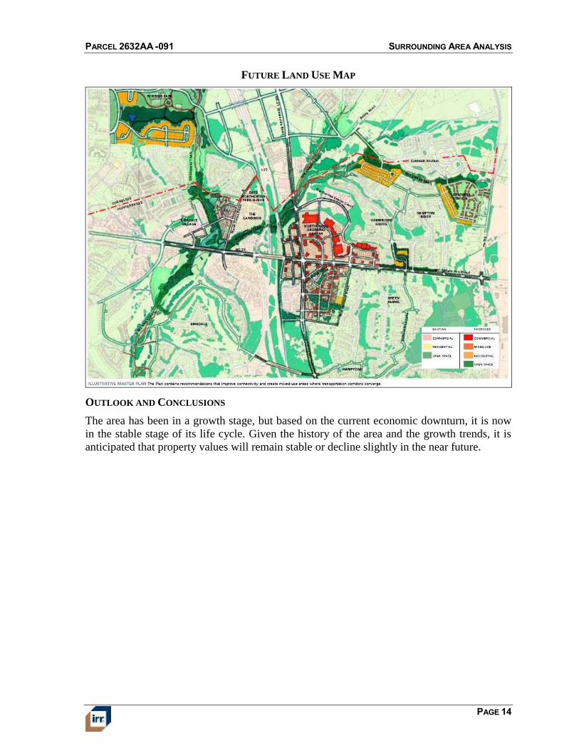
On the southwest corner of Old Statesville Road and Sam Furr Road, there is a retail site that
has been developed with a CVS. There are several other outparcels that have not been
improved on this site. The southeast corner of Old Statesville and Sam Furr Road has
recently been developed with a small retail building. The following map shows the majority
of development that is located to the east and west near the intersection of Sam Furr Road
and Interstate 77.
PARCEL 2632AA -091 SURROUNDING AREA ANALYSIS
PAGE 14
FUTURE LAND USE MAP
OUTLOOK AND CONCLUSIONS
The area has been in a growth stage, but based on the current economic downturn, it is now
in the stable stage of its life cycle. Given the history of the area and the growth trends, it is
anticipated that property values will remain stable or decline slightly in the near future.
PARCEL 2632AA -091 SURROUNDING AREA ANALYSIS
PAGE 15
SURROUNDING AREA MAP
PARCEL 2632AA -091 LAND DESCRIPTION AND ANALYSIS
PAGE 16
PROPERTY ANALYSIS
LAND DESCRIPTION AND ANALYSIS
LOCATION
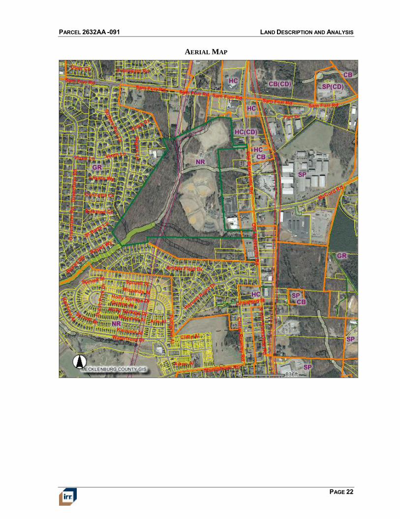
The property is located along the west side of Old Statesville Road, and is located across
from McCord Road.
LAND AREA
The following table summarizes the subject’s land area.
Tax ID Address SF Acres
009-111-19 16131 Old Statesville Road 3,680,820 84.500
LAND AREA SUMMARY
Source: Provided by NCDOT
SHAPE AND DIMENSIONS
The site is irregular in shape. Site utility based on shape and dimensions is below average
based on two portions of the parcel having frontage along Old Statesville Road, while the
majority of the site is located behind other parcels that front Old Statesville Road.
TOPOGRAPHY
The site is generally gently sloping, with some areas being level and at street grade. In
addition, there are some water quality buffers that traverse the site, but the subject’s
topography does not result in any particular development limitations.
DRAINAGE
No particular drainage problems were observed or disclosed at the time of field inspection.
This appraisal assumes that surface water collection, both on-site and in public streets
adjacent to the subject, is adequate.
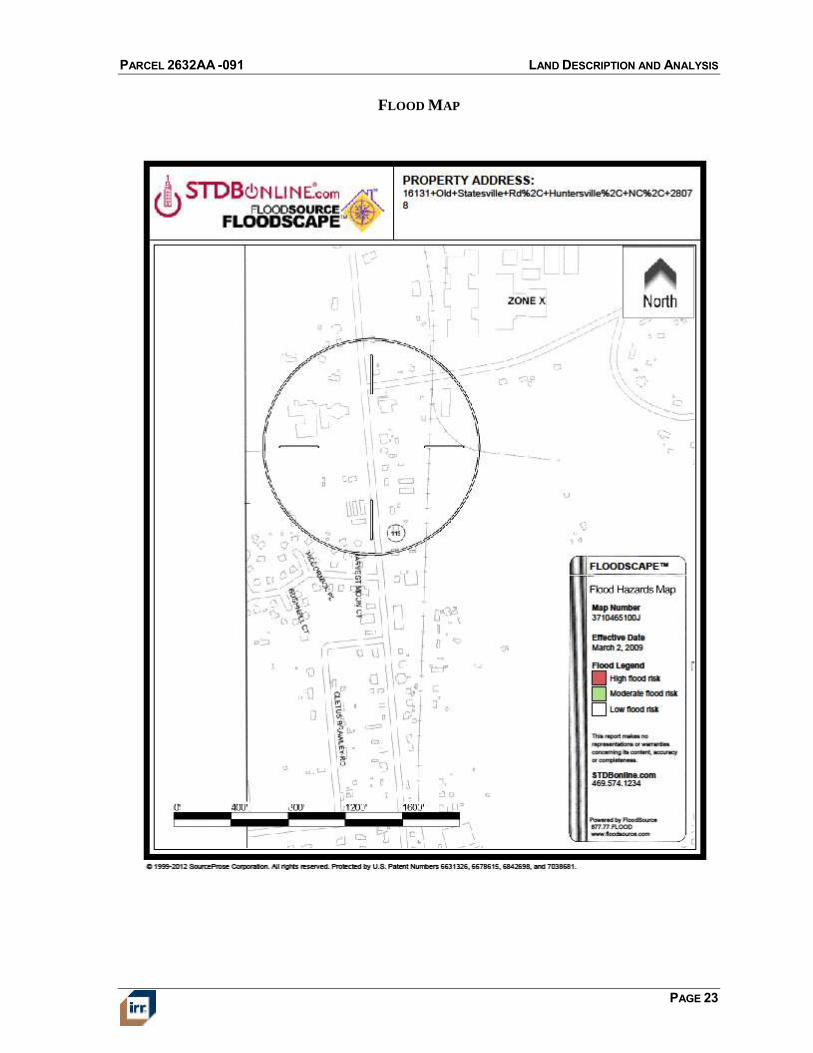
FLOOD HAZARD STATUS
The following table provides flood hazard information.
Community Panel Number 3710464200J
Date March 2, 2009
Zone X
Description Areas determined to be outside 500-year flood plain
Insurance Required? No
FLOOD HAZARD STATUS
PARCEL 2632AA -091 LAND DESCRIPTION AND ANALYSIS
PAGE 17
ENVIRONMENTAL HAZARDS
An environmental assessment report was not provided for review, and during our inspection,
we did not observe any obvious signs of contamination on or near the subject. However,
environmental issues are beyond our scope of expertise. It is assumed that the property is not
adversely affected by environmental hazards.
GROUND STABILITY
A soils report was not provided for our review. Based on our inspection of the subject and
observation of development on nearby sites, there are no apparent ground stability problems.
However, we are not experts in soils analysis. We assume that the subject’s soil bearing
capacity is sufficient to support a variety of uses, including those permitted by zoning.
STREETS, ACCESS AND FRONTAGE
Details pertaining to street access and frontage are provided in the following table.
Street Old Statesville Road
Frontage Feet 211
Paving Asphalt
Curbs No
Sidewalks No
Lanes Two with turn lanes
Direction of Traffic North/south
Condition Good
Traffic Levels High
Signals/Traffic Control Closest - Corner of Sam Furr
(Hwy 73) and Old Statesville
Access/Curb Cuts Two with turn lanes
Visibility Limited
c
STREETS, ACCESS AND FRONTAGE
UTILITIES
The availability of utilities to the subject is summarized in the following table.
UTILITIES
Service Provider
Water City of Charlotte
Sewer City of Charlotte
Electricity Duke Energy
Natural Gas Piedmont Natural Gas
Local Phone Various Providers
PARCEL 2632AA -091 LAND DESCRIPTION AND ANALYSIS
PAGE 18
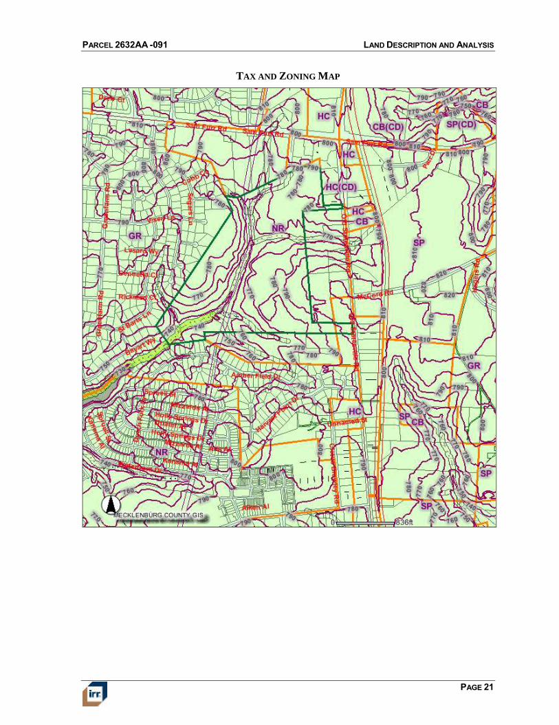
ZONING
The subject is zoned NR, Neighborhood Residential. We spoke with the Huntersville
Planning and Zoning office, and found that this parcel would allow a variety of different uses
that include, but not limited to multifamily, commercial, retirement communities,
government buildings, etc. Specific zoning requirements are summarized in the following
table.
Zoning Jurisdiction
Zoning Designation
Description
Legally Conforming?
Zoning Change Likely?
Permitted Uses
Category Zoning Requirement
Minimum Lot Area Varies per development
Minimum Lot Width (Feet) Varies per development
Minimum Setbacks (Feet) Varies per development
Maximum Building Height Varies per development
Maximum Density Varies per development
Maximum Floor Area Ratio Varies per development
Parking Requirement Varies per development
Other N/A
ZONING SUMMARY
Source:Town of Huntersville Zoning
Variety of residential and commercial uses
Town of Huntersville
NR, Neighborhood Residential
N/A; vacant land
No
The Neighborhood Residential District provides for residential infill development
surrounding the traditional town center and its logical extensions. This district also
provides for town-scaled residential development within walking distance
(generally ½ mile) of satellite village centers, identified on the Land Development
Plan . Streets in the Neighborhood Residential District must be interconnected,
according to Article 5, Streets, and Urban Open Space provided according to
Article 7. A range of housing types is encouraged. Low-intensity business activity
is permitted in mixed-use and commercial buildings at residential scale, according
to locational criteria. The intensity to which permitted uses may be built is
regulated by the building type which corresponds to the use.
OTHER LAND USE REGULATIONS
We are not aware of any other land use regulations that would affect the property.
EASEMENTS, ENCROACHMENTS AND RESTRICTIONS
We were not provided a current title report to review. We are not aware of any easements,
encumbrances, or restrictions that would adversely affect value. Our valuation assumes no
adverse easements, encroachments or restrictions and that the subject has a clear and
marketable title.
IMPROVEMENTS
The site is currently improved with lighted baseball fields, tennis courts and associated site
improvements. These improvements are an underutilization of the site and offer no
contributing value. Consequently, no effort has been made to describe the existing site
improvements.
PARCEL 2632AA -091 LAND DESCRIPTION AND ANALYSIS
PAGE 19
CONCLUSION OF SITE ANALYSIS
Overall, the physical characteristics of the site and the availability of utilities result in
functional utility suitable for a variety of uses including those permitted by zoning. There are
no other particular restrictions on development noted in the analysis.
PARCEL 2632AA -091 LAND DESCRIPTION AND ANALYSIS
PAGE 20
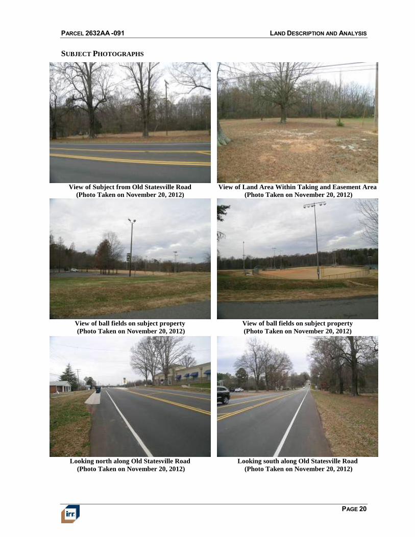
SUBJECT PHOTOGRAPHS
View of Subject from Old Statesville Road
(Photo Taken on November 20, 2012)
View of Land Area Within Taking and Easement Area
(Photo Taken on November 20, 2012)
View of ball fields on subject property
(Photo Taken on November 20, 2012)
View of ball fields on subject property
(Photo Taken on November 20, 2012)
Looking north along Old Statesville Road
(Photo Taken on November 20, 2012)
Looking south along Old Statesville Road
(Photo Taken on November 20, 2012)
PARCEL 2632AA -091 LAND DESCRIPTION AND ANALYSIS
PAGE 21
TAX AND ZONING MAP
PARCEL 2632AA -091 LAND DESCRIPTION AND ANALYSIS
PAGE 22
AERIAL MAP
PARCEL 2632AA -091 LAND DESCRIPTION AND ANALYSIS
PAGE 23
FLOOD MAP
PARCEL 2632AA -091 REAL ESTATE TAX ANALYSIS
PAGE 24
REAL ESTATE TAX ANALYSIS
The subject is located in Huntersville and Mecklenburg County and is subject to both
governmental tax rates. The subject’s tax burden is calculated by dividing the assessed value
by $100 and multiplying the result by the applicable tax rates.
The composite tax rate for the subject for the 2012 tax year is $1.07470 per $100 of assessed
value.
Real estate taxes and assessments for the current tax year are shown in the following table.
Assessed Value Taxes and Assessments
Ad Valorem Direct
Tax ID Land Improvements Total Tax Rate/$100 Taxes Assessments Total
009-111-19 $36,808,200 $340,100 $37,148,300 $1.07470 $399,233 $0 $399,233
TAXES AND ASSESSMENTS - 2012
Based on the concluded market value of the subject, the assessed value for the land is well
above market. Based on the owner being exempt from taxes, a tax appeal is not necessary,
but if the subject was owned by a non-tax exempt entity, a tax appeal would be highly
recommended.
PARCEL 2632AA -091 HIGHEST AND BEST USE ANALYSIS
PAGE 25
HIGHEST AND BEST USE ANALYSIS
HIGHEST AND BEST USE AS VACANT
Legally Permissible
The site is zoned NR, Neighborhood Residential District. A variety of permitted uses are
allowed within this zoning designation including a range of housing types and low-intensity
business activity. To our knowledge, there are no legal restrictions such as easements or deed
restrictions that would effectively limit the use of the property. Given prevailing land use
patterns in the area, only mixed-use is given further consideration in determining highest and
best use of the site, as though vacant.
Physically Possible
The physical characteristics of the site do not appear to impose any unusual restrictions on
development. Since there is limited road frontage, any future retail use would be limited.
Overall, the physical characteristics of the site and the availability of utilities result in
functional utility suitable for a variety of uses.
Financially Feasible
Based on our analysis of the market, there is currently limited demand for additional mixed-
use development in the subject’s area. It appears that a newly developed mixed use on the
site would not have a value commensurate with its cost; therefore, mixed-use is not
considered to be financially feasible. Nevertheless, we expect an eventual recovery of the
market accompanied by a rise in property values to a level that will justify the cost of new
construction. Thus, it is anticipated that mixed-use development will become financially
feasible in the future.
Maximally Productive
There does not appear to be any reasonably probable use of the site that would generate a
higher residual land value than holding the property for future development of a mixed-use.
Accordingly, it is our opinion that holding the property for future mixed- use, based on the
normal market density level permitted by zoning, is the maximally productive use of the
property.
Conclusion
Holding the property for future development of a mixed-use is the only use that meets the
four tests of highest and best use. Therefore, it is concluded to be the highest and best use of
the property as if vacant.
PARCEL 2632AA -091 VALUATION METHODOLOGY
PAGE 26
VALUATION ANALYSIS
VALUATION METHODOLOGY
Appraisers usually consider three approaches to estimating the market value of real property.
These are the cost approach, sales comparison approach and the income capitalization
approach.
The cost approach assumes that the informed purchaser would pay no more than the cost of
producing a substitute property with the same utility. This approach is particularly applicable
when the improvements being appraised are relatively new and represent the highest and best
use of the land, or when the property has unique or specialized improvements for which there
is little or no sales data from comparable properties.
The sales comparison approach assumes that an informed purchaser would pay no more for
a property than the cost of acquiring another existing property with the same utility. This
approach is especially appropriate when an active market provides sufficient reliable data.
The sales comparison approach is less reliable in an inactive market, or when estimating the
value of properties for which no directly comparable sales data is available. The sales
comparison approach is often relied upon for owner-user properties.
The income capitalization approach reflects the market’s perception of a relationship
between a property’s potential income and its market value. This approach converts the
anticipated net income from ownership of a property into a value indication through
capitalization. The primary methods are direct capitalization and discounted cash flow
analysis, with one or both methods applied, as appropriate. This approach is widely used in
appraising income-producing properties.
Reconciliation of the various indications into a conclusion of value is based on an evaluation
of the quantity and quality of available data in each approach and the applicability of each
approach to the property type.
Use of the approaches in this assignment is summarized as follows:
Approach Applicability to Subject Use in Assignment
Cost Approach Not applicable Not Utilized
Sales Comparison Approach Applicable Utilized
Income Capitalization Approach Not applicable Not Utilized
APPROACHES TO VALUE
PARCEL 2632AA -091 LAND VALUATION
PAGE 27
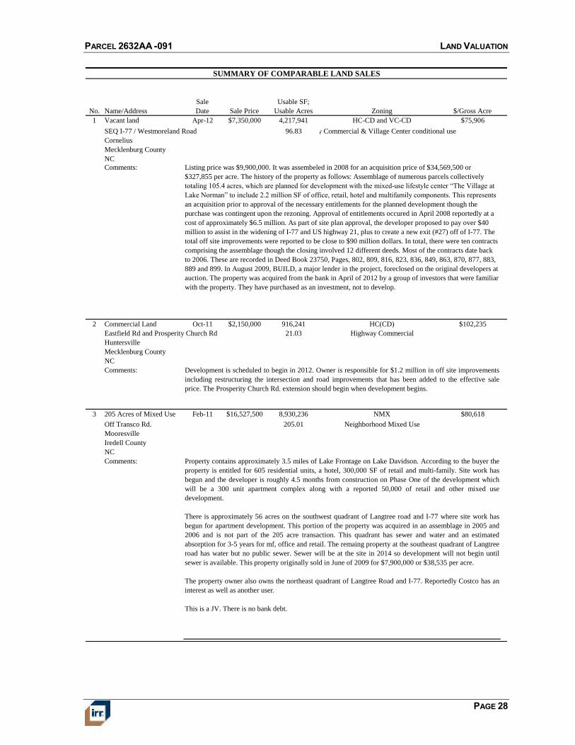
LAND VALUATION
To develop an opinion of the subject’s land value, as vacant and available to be developed to
its highest and best use, we utilize the sales comparison approach. This approach develops an
indication of value by researching, verifying, and analyzing sales of similar properties. Our
sales research focused on transactions within the following parameters:
Location: Northern Mecklenburg County and Surrounding Communities
Size: 20 to 220 acres
Use: Mixed-use
Transaction Date: January 2010 to December 2012
For this analysis, we use price per usable acre as the appropriate unit of comparison because
market participants typically compare sale prices and property values on this basis. The sales
most relevant to analyzing the subject’s land value are summarized in the following table:
PARCEL 2632AA -091 LAND VALUATION
PAGE 28
SUMMARY OF COMPARABLE LAND SALES
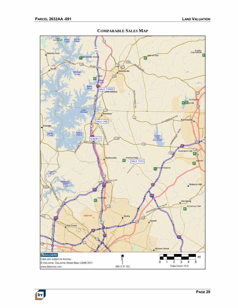
No. Name/Address
Sale
Date Sale Price
Usable SF;
Usable Acres Zoning $/Gross Acre
1 Vacant land Apr-12 $7,350,000 4,217,941 HC-CD and VC-CD $75,906
SEQ I-77 / Westmoreland Road 96.83 Hwy Commercial & Village Center conditional use
Cornelius
Mecklenburg County
NC
Comments:
2 Commercial Land Oct-11 $2,150,000 916,241 HC(CD) $102,235
Eastfield Rd and Prosperity Church Rd 21.03 Highway Commercial
Huntersville
Mecklenburg County
NC
Comments:
3 205 Acres of Mixed Use
Land
Feb-11 $16,527,500 8,930,236 NMX $80,618
Off Transco Rd. 205.01 Neighborhood Mixed Use
Mooresville
Iredell County
NC
Comments:
Development is scheduled to begin in 2012. Owner is responsible for $1.2 million in off site improvements
including restructuring the intersection and road improvements that has been added to the effective sale
price. The Prosperity Church Rd. extension should begin when development begins.
Property contains approximately 3.5 miles of Lake Frontage on Lake Davidson. According to the buyer the
property is entitled for 605 residential units, a hotel, 300,000 SF of retail and multi-family. Site work has
begun and the developer is roughly 4.5 months from construction on Phase One of the development which
will be a 300 unit apartment complex along with a reported 50,000 of retail and other mixed use
development.
There is approximately 56 acres on the southwest quadrant of Langtree road and I-77 where site work has
begun for apartment development. This portion of the property was acquired in an assemblage in 2005 and
2006 and is not part of the 205 acre transaction. This quadrant has sewer and water and an estimated
absorption for 3-5 years for mf, office and retail. The remaing property at the southeast quadrant of Langtree
road has water but no public sewer. Sewer will be at the site in 2014 so development will not begin until
sewer is available. This property originally sold in June of 2009 for $7,900,000 or $38,535 per acre.
The property owner also owns the northeast quadrant of Langtree Road and I-77. Reportedly Costco has an
interest as well as another user.
This is a JV. There is no bank debt.
Listing price was $9,900,000. It was assembeled in 2008 for an acquisition price of $34,569,500 or
$327,855 per acre. The history of the property as follows: Assemblage of numerous parcels collectively
totaling 105.4 acres, which are planned for development with the mixed-use lifestyle center “The Village at
Lake Norman” to include 2.2 million SF of office, retail, hotel and multifamily components. This represents
an acquisition prior to approval of the necessary entitlements for the planned development though the
purchase was contingent upon the rezoning. Approval of entitlements occured in April 2008 reportedly at a
cost of approximately $6.5 million. As part of site plan approval, the developer proposed to pay over $40
million to assist in the widening of I-77 and US highway 21, plus to create a new exit (#27) off of I-77. The
total off site improvements were reported to be close to $90 million dollars. In total, there were ten contracts
comprising the assemblage though the closing involved 12 different deeds. Most of the contracts date back
to 2006. These are recorded in Deed Book 23750, Pages, 802, 809, 816, 823, 836, 849, 863, 870, 877, 883,
889 and 899. In August 2009, BUILD, a major lender in the project, foreclosed on the original developers at
auction. The property was acquired from the bank in April of 2012 by a group of investors that were familiar
with the property. They have purchased as an investment, not to develop.
PARCEL 2632AA -091 LAND VALUATION
PAGE 29
COMPARABLE SALES MAP
PARCEL 2632AA -091 LAND VALUATION
PAGE 30
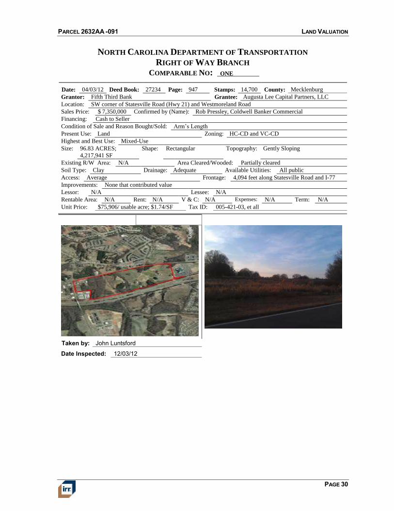
NORTH CAROLINA DEPARTMENT OF TRANSPORTATION
RIGHT OF WAY BRANCH
COMPARABLE NO: ONE
Date: 04/03/12 Deed Book: 27234 Page: 947 Stamps: 14,700 County: Mecklenburg
Grantor: Fifth Third Bank Grantee: Augusta Lee Capital Partners, LLC
Location: SW corner of Statesville Road (Hwy 21) and Westmoreland Road
Sales Price: $ 7,350,000 Confirmed by (Name): Rob Pressley, Coldwell Banker Commercial
Financing: Cash to Seller
Condition of Sale and Reason Bought/Sold: Arm’s Length
Present Use: Land Zoning: HC-CD and VC-CD
Highest and Best Use: Mixed-Use
Size: 96.83 ACRES;
4,217,941 SF
Shape: Rectangular Topography: Gently Sloping
Existing R/W Area: N/A Area Cleared/Wooded: Partially cleared
Soil Type: Clay Drainage: Adequate Available Utilities: All public
Access: Average Frontage: 4,094 feet along Statesville Road and I-77
Improvements: None that contributed value
Lessor: N/A Lessee: N/A
Rentable Area: N/A Rent: N/A V & C: N/A Expenses: N/A Term: N/A
Unit Price: $75,906/ usable acre; $1.74/SF Tax ID: 005-421-03, et all
Taken by: John Luntsford
Date Inspected: 12/03/12
PARCEL 2632AA -091 LAND VALUATION
PAGE 31
NORTH CAROLINA DEPARTMENT OF TRANSPORTATION
RIGHT OF WAY BRANCH
COMPARABLE NO: TWO
Date: 10/31/11 Deed Book: 26851 Page: 677 Stamps: 1,900 County: Mecklenburg
Grantor: Crescent Resources Grantee: GLM Holdings, LLC
Location: Eastfield Road and Rocky Ford Club Rd., Huntersville, NC 28269
Sales Price: $2,150,000* Confirmed by (Name): George Maloomian Cambridge Properties - Buyer
Financing: Cash to Seller
Condition of Sale and Reason Bought/Sold: Arm’s Length
Present Use: Land Zoning: HC-CD
Highest and Best Use: Mixed-Use
Size: 21.03 ACRES;
916,241 SF
Shape: Rectangular Topography: Level
Existing R/W Area: N/A Area Cleared/Wooded: Partially cleared
Soil Type: Clay Drainage: Adequate Available Utilities: All public
Access: Good Frontage: 100’ Eastfield Rd., 780’ on Rocky Ford Club
Rd.
Improvements: None
Lessor: N/A Lessee: N/A
Rentable Area: N/A Rent: N/A V & C: N/A Expenses: N/A Term: N/A
Unit Price: *$102,235/ usable acre; *$2.35/SF Tax ID: 021-191-04
Development was scheduled to begin in 2012. Owner is responsible for $1,200,000 in off site improvements
including restructuring the intersection and road improvements that has been added to the effective sales price. The
Prosperity Church Rd. extension should begin when development begins. Proposed 185,000 square feet of retail
development.
*Effective Price
Taken by: John Luntsford
Date Inspected: 12/4/12
PARCEL 2632AA -091 LAND VALUATION
PAGE 32
NORTH CAROLINA DEPARTMENT OF TRANSPORTATION
RIGHT OF WAY BRANCH
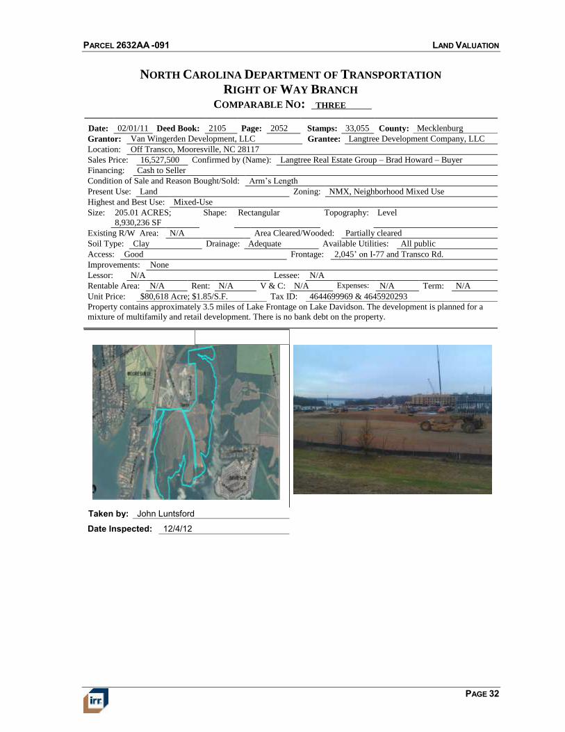
COMPARABLE NO: THREE
Date: 02/01/11 Deed Book: 2105 Page: 2052 Stamps: 33,055 County: Mecklenburg
Grantor: Van Wingerden Development, LLC Grantee: Langtree Development Company, LLC
Location: Off Transco, Mooresville, NC 28117
Sales Price: 16,527,500 Confirmed by (Name): Langtree Real Estate Group – Brad Howard – Buyer
Financing: Cash to Seller
Condition of Sale and Reason Bought/Sold: Arm’s Length
Present Use: Land Zoning: NMX, Neighborhood Mixed Use
Highest and Best Use: Mixed-Use
Size: 205.01 ACRES;
8,930,236 SF
Shape: Rectangular Topography: Level
Existing R/W Area: N/A Area Cleared/Wooded: Partially cleared
Soil Type: Clay Drainage: Adequate Available Utilities: All public
Access: Good Frontage: 2,045’ on I-77 and Transco Rd.
Improvements: None
Lessor: N/A Lessee: N/A
Rentable Area: N/A Rent: N/A V & C: N/A Expenses: N/A Term: N/A
Unit Price: $80,618 Acre; $1.85/S.F. Tax ID: 4644699969 & 4645920293
Property contains approximately 3.5 miles of Lake Frontage on Lake Davidson. The development is planned for a
mixture of multifamily and retail development. There is no bank debt on the property.
Taken by: John Luntsford
Date Inspected: 12/4/12
PARCEL 2632AA -091 LAND VALUATION
PAGE 33
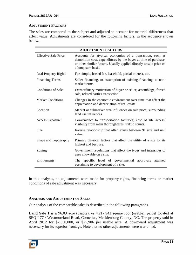
ADJUSTMENT FACTORS
The sales are compared to the subject and adjusted to account for material differences that
affect value. Adjustments are considered for the following factors, in the sequence shown
below.
ADJUSTMENT FACTORS
Effective Sale Price Accounts for atypical economics of a transaction, such as
demolition cost, expenditures by the buyer at time of purchase,
or other similar factors. Usually applied directly to sale price on
a lump sum basis.
Real Property Rights Fee simple, leased fee, leasehold, partial interest, etc.
Financing Terms Seller financing, or assumption of existing financing, at non-
market terms.
Conditions of Sale Extraordinary motivation of buyer or seller, assemblage, forced
sale, related parties transaction.
Market Conditions Changes in the economic environment over time that affect the
appreciation and depreciation of real estate.
Location Market or submarket area influences on sale price; surrounding
land use influences.
Access/Exposure Convenience to transportation facilities; ease of site access;
visibility from main thoroughfares; traffic counts.
Size Inverse relationship that often exists between 91 size and unit
value.
Shape and Topography Primary physical factors that affect the utility of a site for its
highest and best use.
Zoning Government regulations that affect the types and intensities of
uses allowable on a site.
Entitlements The specific level of governmental approvals attained
pertaining to development of a site.
In this analysis, no adjustments were made for property rights, financing terms or market
conditions of sale adjustment was necessary.
ANALYSIS AND ADJUSTMENT OF SALES
Our analysis of the comparable sales is described in the following paragraphs.
Land Sale 1 is a 96.83 acre (usable), or 4,217,941 square foot (usable), parcel located at
SEQ I-77 / Westmoreland Road, Cornelius, Mecklenburg County, NC. The property sold in
April 2012 for $7,350,000, or $75,906 per usable acre. A downward adjustment was
necessary for its superior frontage. Note that no other adjustments were warranted.
PARCEL 2632AA -091 LAND VALUATION
PAGE 34
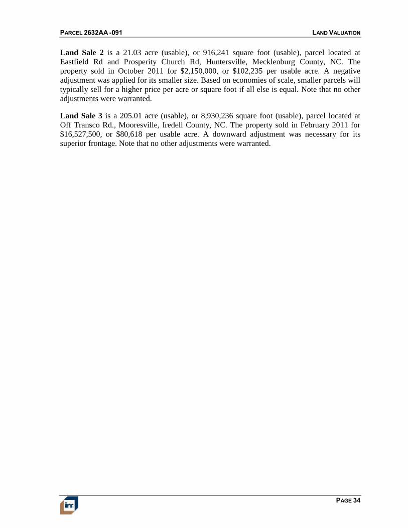
Land Sale 2 is a 21.03 acre (usable), or 916,241 square foot (usable), parcel located at
Eastfield Rd and Prosperity Church Rd, Huntersville, Mecklenburg County, NC. The
property sold in October 2011 for $2,150,000, or $102,235 per usable acre. A negative
adjustment was applied for its smaller size. Based on economies of scale, smaller parcels will
typically sell for a higher price per acre or square foot if all else is equal. Note that no other
adjustments were warranted.
Land Sale 3 is a 205.01 acre (usable), or 8,930,236 square foot (usable), parcel located at
Off Transco Rd., Mooresville, Iredell County, NC. The property sold in February 2011 for
$16,527,500, or $80,618 per usable acre. A downward adjustment was necessary for its
superior frontage. Note that no other adjustments were warranted.
PARCEL 2632AA -091 LAND VALUATION
PAGE 35
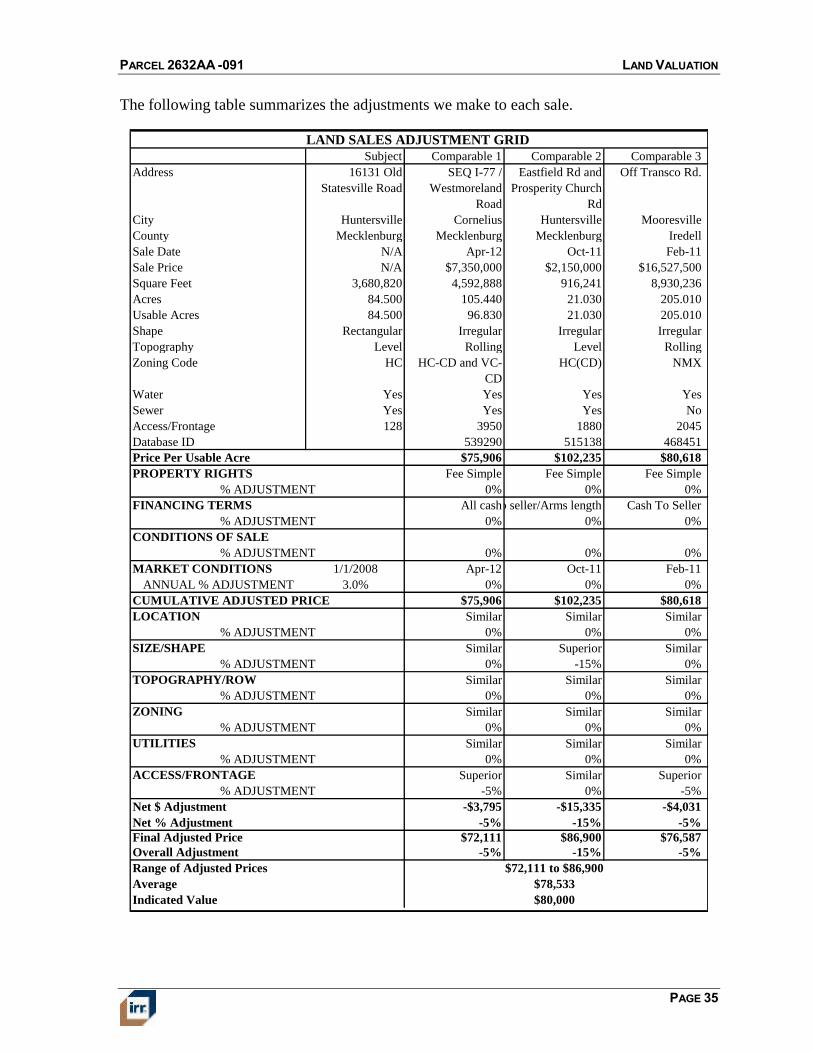
The following table summarizes the adjustments we make to each sale.
LAND SALES ADJUSTMENT GRID
Subject Comparable 1 Comparable 2 Comparable 3
Address 16131 Old
Statesville Road
SEQ I-77 /
Westmoreland
Road
Eastfield Rd and
Prosperity Church
Rd
Off Transco Rd.
City Huntersville Cornelius Huntersville Mooresville
County Mecklenburg Mecklenburg Mecklenburg Iredell
Sale Date N/A Apr-12 Oct-11 Feb-11
Sale Price N/A $7,350,000 $2,150,000 $16,527,500
Square Feet 3,680,820 4,592,888 916,241 8,930,236
Acres 84.500 105.440 21.030 205.010
Usable Acres 84.500 96.830 21.030 205.010
Shape Rectangular Irregular Irregular Irregular
Topography Level Rolling Level Rolling
Zoning Code HC HC-CD and VC-
CD
HC(CD) NMX
Water Yes Yes Yes Yes
Sewer Yes Yes Yes No
Access/Frontage 128 3950 1880 2045
Database ID 539290 515138 468451
$75,906 $102,235 $80,618
Fee Simple Fee Simple Fee Simple
0% 0% 0%
All cashCash to seller/Arms length Cash To Seller
0% 0% 0%
0% 0% 0%
MARKET CONDITIONS 1/1/2008 Apr-12 Oct-11 Feb-11
ANNUAL % ADJUSTMENT 3.0% 0% 0% 0%
$75,906 $102,235 $80,618
Similar Similar Similar
0% 0% 0%
Similar Superior Similar
0% -15% 0%
Similar Similar Similar
0% 0% 0%
Similar Similar Similar
0% 0% 0%
Similar Similar Similar
0% 0% 0%
Superior Similar Superior
-5% 0% -5%
-$3,795 -$15,335 -$4,031
-5% -15% -5%
$72,111 $86,900 $76,587
-5% -15% -5%
% ADJUSTMENT
% ADJUSTMENT
UTILITIES
% ADJUSTMENT
% ADJUSTMENT
SIZE/SHAPE
% ADJUSTMENT
CONDITIONS OF SALE
CUMULATIVE ADJUSTED PRICE
Final Adjusted Price
TOPOGRAPHY/ROW
% ADJUSTMENT
ZONING
LOCATION
Price Per Usable Acre
ACCESS/FRONTAGE
% ADJUSTMENT
PROPERTY RIGHTS
% ADJUSTMENT
FINANCING TERMS
% ADJUSTMENT
Indicated Value
Overall Adjustment
Average
Range of Adjusted Prices
Net $ Adjustment
Net % Adjustment
$72,111 to $86,900
$78,533
$80,000
PARCEL 2632AA -091 LAND VALUATION
PAGE 36
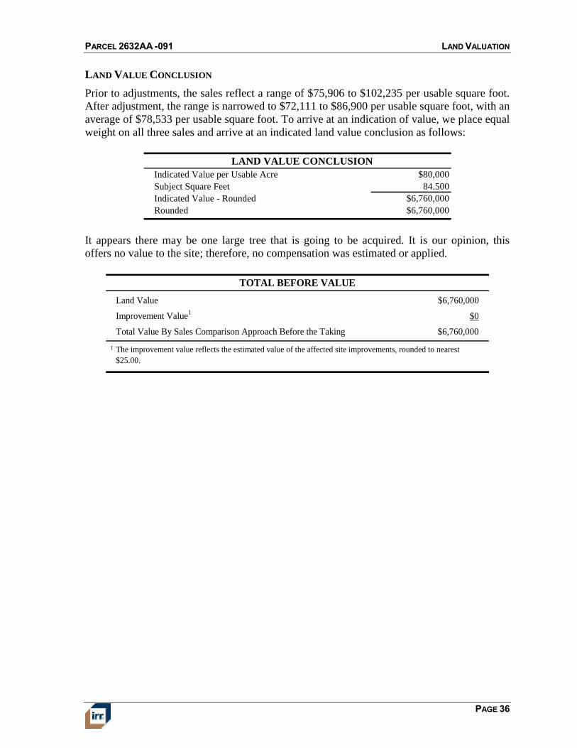
LAND VALUE CONCLUSION
Prior to adjustments, the sales reflect a range of $75,906 to $102,235 per usable square foot.
After adjustment, the range is narrowed to $72,111 to $86,900 per usable square foot, with an
average of $78,533 per usable square foot. To arrive at an indication of value, we place equal
weight on all three sales and arrive at an indicated land value conclusion as follows:
LAND VALUE CONCLUSION
Indicated Value per Usable Acre $80,000
Subject Square Feet 84.500
Indicated Value - Rounded $6,760,000
Rounded $6,760,000
It appears there may be one large tree that is going to be acquired. It is our opinion, this
offers no value to the site; therefore, no compensation was estimated or applied.
Land Value $6,760,000
Improvement Value1
$0
Total Value By Sales Comparison Approach Before the Taking $6,760,000
1 The improvement value reflects the estimated value of the affected site improvements, rounded to nearest
$25.00.
TOTAL BEFORE VALUE
PARCEL 2632AA -091 DESCRIPTION OF THE ACQUISITION
PAGE 37
DESCRIPTION OF THE ACQUISITION
After the taking, the property will have similar utility and shape as before the taking. The
same valuation technique used in the before analysis, will be used in valuing the subject after
the taking.
LAND
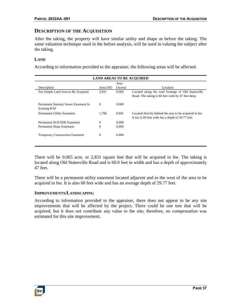
According to information provided to the appraiser, the following areas will be affected.
Description Area (SF)
Area
(Acres) Location
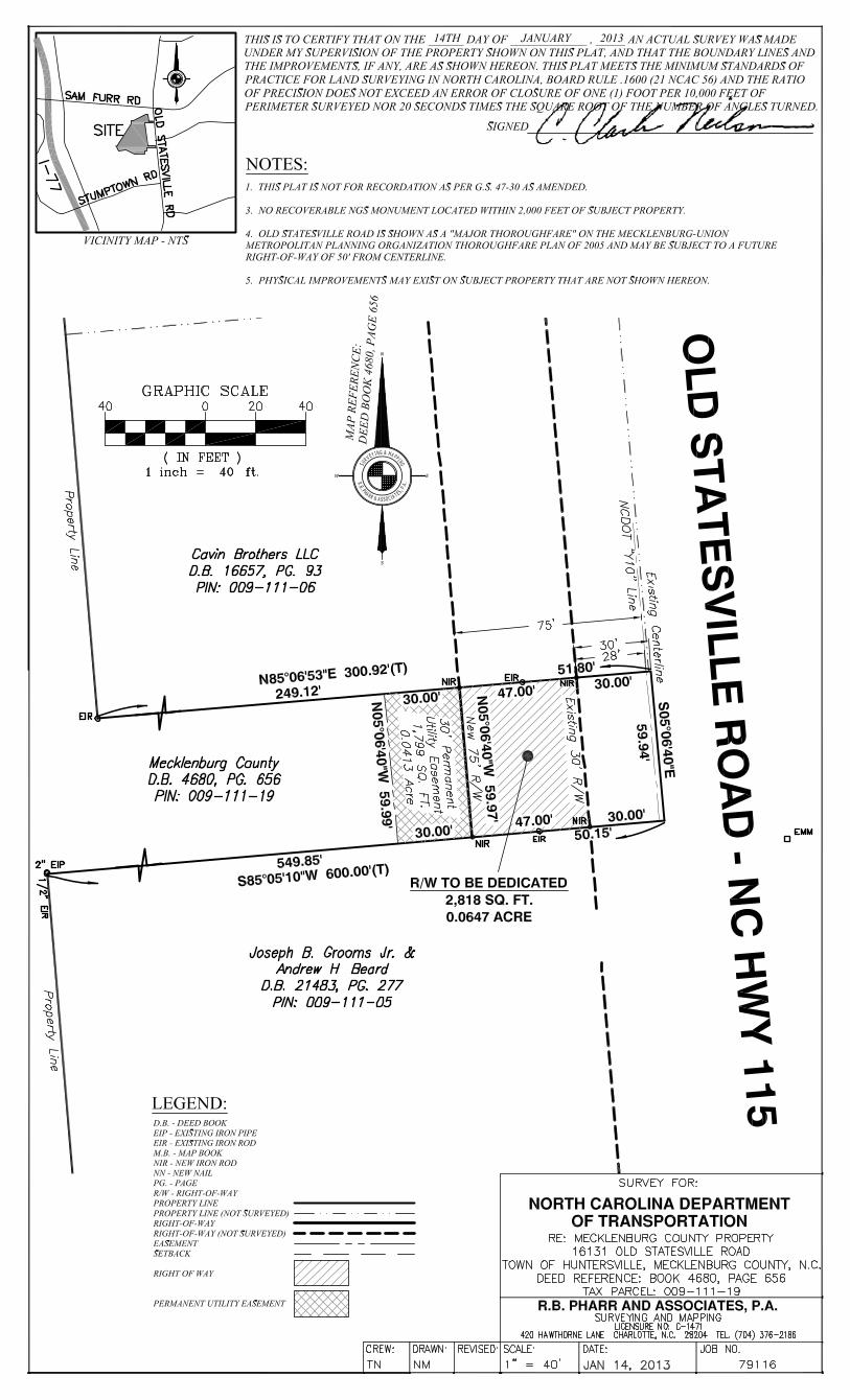
Fee Simple Land Area to Be Acquired 2,831 0.065 Located along the road frontage of Old Statesville
Road. The taking is 60 feet wide by 47 feet deep.
Permanent Sanitary Sewer Easement In
Existing R/W
0 0.000
Permanent Utility Easement 1,786 0.041 Located directly behind the area to be acquired in fee.
It too is 60 feet wide has a depth of 29.77 feet.
Permanent SUE/SDE Easement 0 0.000
Permanent Slope Easement 0 0.000
Temporary Construction Easement 0 0.000
LAND AREAS TO BE ACQUIRED
There will be 0.065 acre, or 2,831 square feet that will be acquired in fee. The taking is
located along Old Statesville Road and is 60.0 feet in width and has a depth of approximately
47 feet.
There will be a permanent utility easement located adjacent and to the west of the area to be
acquired in fee. It is also 60 feet wide and has an average depth of 29.77 feet.
IMPROVEMENTS/LANDSCAPING
According to information provided to the appraiser, there does not appear to be any site
improvements that will be affected by the project. There could be one tree that will be
acquired, but it does not contribute any value to the site; therefore, no compensation was
estimated for this site improvement.
PARCEL 2632AA -091 DESCRIPTION OF THE ACQUISITION
PAGE 38
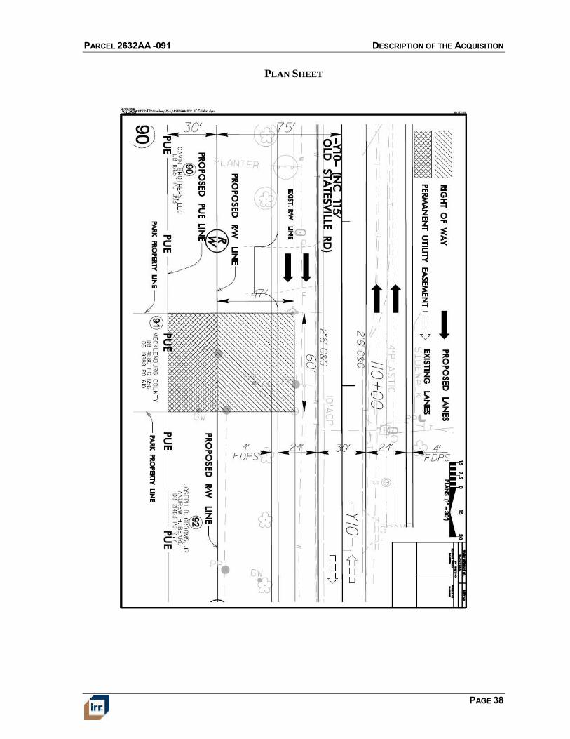
PLAN SHEET
PARCEL 2632AA -091 DESCRIPTION OF THE ACQUISITION
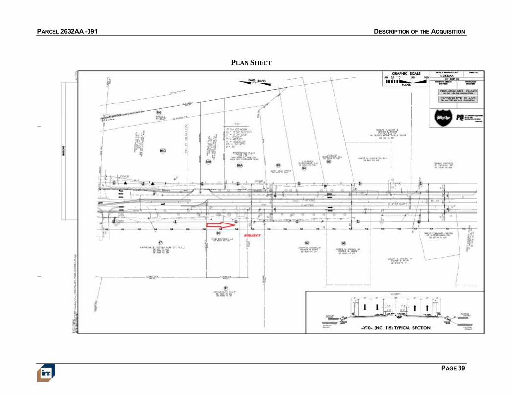
PAGE 39
PLAN SHEET
PARCEL 2632AA -091 DESCRIPTION OF REMAINDER AND EFFECTS OF THE ACQUISITION
PAGE 40
DESCRIPTION OF REMAINDER AND EFFECTS OF THE ACQUISITION
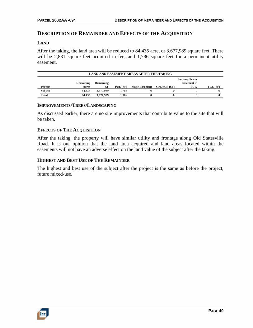
LAND
After the taking, the land area will be reduced to 84.435 acre, or 3,677,989 square feet. There
will be 2,831 square feet acquired in fee, and 1,786 square feet for a permanent utility
easement.
Parcels
Remaining
Acres
Remaining
SF PUE (SF) Slope Easement SDE/SUE (SF)
Sanitary Sewer
Easement in
R/W TCE (SF)
Subject 84.435 3,677,989 1,786 0 0 0 0
Total 84.435 3,677,989 1,786 0 0 0 0
LAND AND EASEMENT AREAS AFTER THE TAKING
IMPROVEMENTS/TREES/LANDSCAPING
As discussed earlier, there are no site improvements that contribute value to the site that will
be taken.
EFFECTS OF THE ACQUISITION
After the taking, the property will have similar utility and frontage along Old Statesville
Road. It is our opinion that the land area acquired and land areas located within the
easements will not have an adverse effect on the land value of the subject after the taking.
HIGHEST AND BEST USE OF THE REMAINDER
The highest and best use of the subject after the project is the same as before the project,
future mixed-use.
PARCEL 2632AA -091 VALUATION OF THE PROPERTY AFTER THE TAKING
PAGE 41
VALUATION OF THE PROPERTY AFTER THE TAKING
The value was estimated in the before valuation analysis using the sales comparison
approach method. In valuing the subject after the taking, we have also used the sales
comparison approach with the same land value in both analyses. The primary difference in
the two scenarios is the land area acquired in fee and the easement that will be placed on the
site..
LAND VALUATION
The total land area of 84.50 acres will be reduced by 2,831 square feet; therefore, reducing
the total land area to 84.435 acres, or 3,677,989. The land was previously valued at $80,000
per acre and converted to $1.83655 per square foot to account for the small land area that is
being affected.
The after the taking per unit land value equals the same as before the taking, $1.83655 per
square foot and the value of the remainder is shown in the following chart.
Remaining Land Area (SF) Unit Value Value - Rounded
3,677,989 $1.83655 $6,754,800
LAND VALUATION (AFTER TAKING)
PERMANENT EASEMENT ANALYSIS
The subject will have one permanent utility easement and one permanent slope easement
located directly behind the area to be acquired in fee off Old Statesville Road. Based on the
fact the NCDOT always has the right to this easement area, we applied a 100% discount to
this area. Although it is not being acquired in feet, it is essentially not developable in the
future.
Easement Area (SF)
Before Unit
Value/SF
After
Value %
After Per
Unit Value After Value
Permanent Utility Easement 1,786 $1.83655 100.0% $0.000 -$3,280
PERMANENT EASEMENT VALUATIONS
PARCEL 2632AA -091 DIFFERENCE IN BEFORE AND AFTER VALUE
PAGE 42
TOTAL VALUE OF THE REMAINDER
The total value of the remainder is as follows.
Land Value
Remaining Land After Taking $6,754,800
Less Permanent Utility Easement -$3,280
Less Permanent Slope Easement $0
Less Temporary Construction Easement $0
Total Land Value $6,751,520
Rounded $6,751,525
Improvement Value
Plus Improvement Value $0
Total Value After Taking $6,751,525
SUMMARY OF VALUE AFTER TAKING
DIFFERENCE IN BEFORE AND AFTER VALUE
The difference in the before and after value is as follows:
Before Value
Land Value $6,760,000
Improvement Value $0
Total Before Value $6,760,000
After Value
Land Value $6,751,525
Improvement Value $0
Total After Value $6,751,525
Difference $8,475
Value of Land Acquired (Including Easements) $8,475
Value of Site Improvements Acquired $0
Damage to the Remainder $0
Benefits to the Remainder $0
Total $8,475
DIFFERENCE IN BEFORE AND AFTER VALUE
ALLOCATION OF VALUE
PARCEL 2632AA -091 RECONCILIATION AND CONCLUSION OF VALUE
PAGE 43
RECONCILIATION AND CONCLUSION OF VALUE
Based on the preceding valuation analysis, and subject to the definitions, assumptions, and
limiting conditions expressed in the report, our value opinions are as follows:
VALUE CONCLUSIONS
Appraisal Premise Interest Appraised Date of Value Value Conclusion
Market Value Fee Simple November 20, 2012 $6,760,000
Market Value After the Taking Fee Simple November 20, 2012 $6,751,525
Difference in Value Before and After the Taking Fee Simple November 20, 2012 $8,475
EXPOSURE AND MARKETING TIMES
Exposure time is the length of time the subject property would have been exposed for sale in
the market had it sold on the effective valuation date at the concluded market value.
Exposure time is always presumed to precede the effective date of the appraisal. Marketing
time is an estimate of the amount of time it might take to sell a property at the estimated
market value immediately following the effective date of value.
Based on our review of recent sales transactions for similar properties and our analysis of
supply and demand in the local market, it is our opinion that the probable exposure time for
the property is 12 months.
We foresee no significant changes in market conditions in the near term; therefore, it is our
opinion that a reasonable marketing period is likely to be the same as the exposure time.
Accordingly, we estimate the subject’s marketing period at 12 months.
PARCEL 2632AA -091 CERTIFICATION
PAGE 44
CERTIFICATION
We certify that, to the best of our knowledge and belief:
1. The statements of fact contained in this report are true and correct.
2. The reported analyses, opinions, and conclusions are limited only by the reported
assumptions and limiting conditions, and are our personal, impartial, and unbiased
professional analyses, opinions, and conclusions.
3. We have no present or prospective interest in the property that is the subject of this
report and no personal interest with respect to the parties involved.
4. We have previously appraised the property that is the subject of this report for the
current client within the three-year period immediately preceding acceptance of this
assignment.
5. We have no bias with respect to the property that is the subject of this report or to the
parties involved with this assignment.
6. Our engagement in this assignment was not contingent upon developing or reporting
predetermined results.
7. Our compensation for completing this assignment is not contingent upon the
development or reporting of a predetermined value or direction in value that favors
the cause of the client, the amount of the value opinion, the attainment of a stipulated
result, or the occurrence of a subsequent event directly related to the intended use of
this appraisal.
8. Our analyses, opinions, and conclusions were developed, and this report has been
prepared, in conformity with the Uniform Standards of Professional Appraisal
practice as well as applicable state appraisal regulations.
9. The reported analyses, opinions, and conclusions were developed, and this report has
been prepared, in conformity with the Code of Professional Ethics and Standards of
Professional Appraisal Practice of the Appraisal Institute.
10. The use of this report is subject to the requirements of the Appraisal Institute relating
to review by its duly authorized representatives.
11. John S. Luntsford made a personal inspection of the property that is the subject of this
report. Fitzhugh L. Stout, MAI, CRE, FRICS has personally inspected the subject.
12. No one provided significant real property appraisal assistance to the persons signing
this certification.
13. We have experience in appraising properties similar to the subject and are in
compliance with the Competency Rule of USPAP.
14. As of the date of this report, Fitzhugh L. Stout, MAI, CRE, FRICS has completed the
continuing education program of the Appraisal Institute.
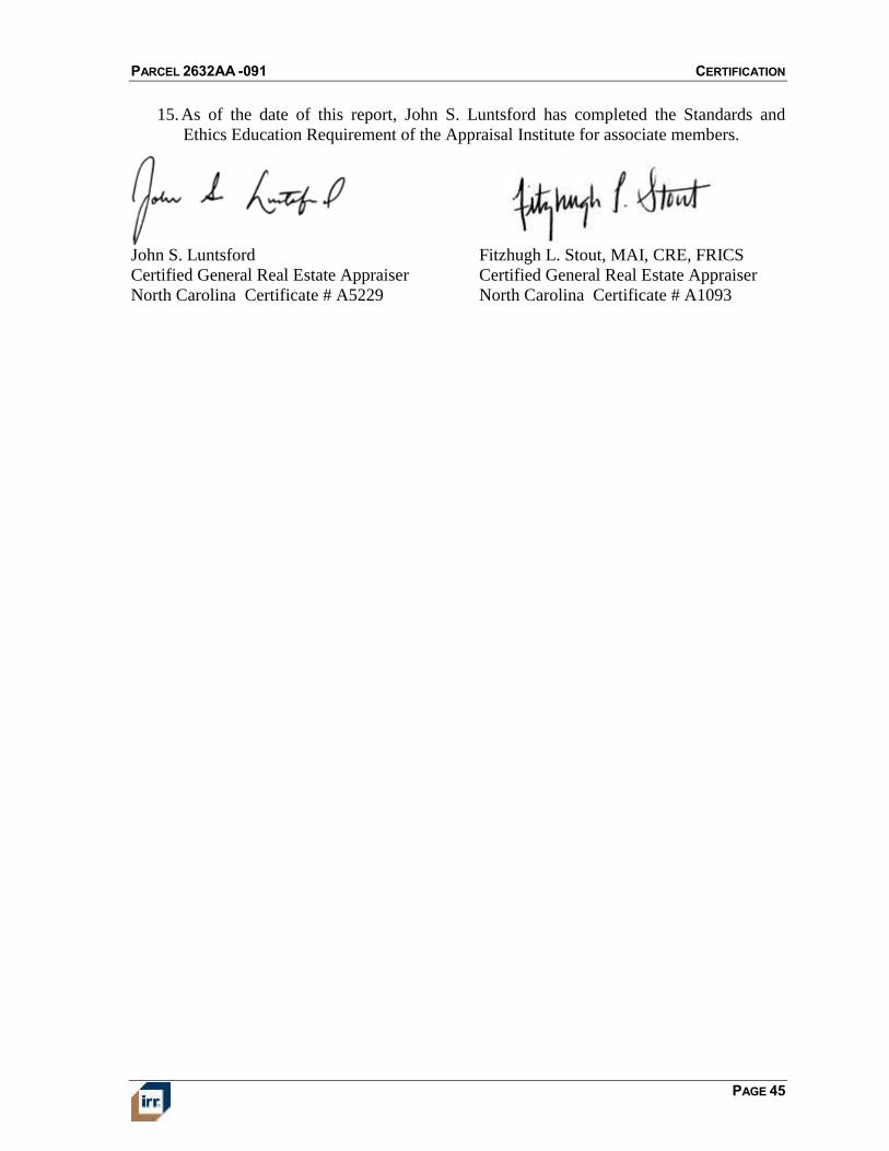
PARCEL 2632AA -091 CERTIFICATION
PAGE 45
15. As of the date of this report, John S. Luntsford has completed the Standards and
Ethics Education Requirement of the Appraisal Institute for associate members.
John S. Luntsford
Certified General Real Estate Appraiser
North Carolina Certificate # A5229
Fitzhugh L. Stout, MAI, CRE, FRICS
Certified General Real Estate Appraiser
North Carolina Certificate # A1093
PARCEL 2632AA -091 ASSUMPTIONS AND LIMITING CONDITIONS
PAGE 46
ASSUMPTIONS AND LIMITING CONDITIONS
This appraisal is based on the following assumptions, except as otherwise noted in the report.
1. The title is marketable and free and clear of all liens, encumbrances, encroachments,
easements and restrictions. The property is under responsible ownership and
competent management and is available for its highest and best use.
2. There are no existing judgments or pending or threatened litigation that could affect
the value of the property.
3. There are no hidden or undisclosed conditions of the land or of the improvements that
would render the property more or less valuable. Furthermore, there is no asbestos in
the property.
4. The revenue stamps placed on any deed referenced herein to indicate the sale price are
in correct relation to the actual dollar amount of the transaction.
5. The property is in compliance with all applicable building, environmental, zoning,
and other federal, state and local laws, regulations and codes.
6. The information furnished by others is believed to be reliable, but no warranty is
given for its accuracy.
This appraisal is subject to the following limiting conditions, except as otherwise noted in the
report.
7. An appraisal is inherently subjective and represents our opinion as to the value of the
property appraised.
8. The conclusions stated in our appraisal apply only as of the effective date of the
appraisal, and no representation is made as to the effect of subsequent events.
9. No changes in any federal, state or local laws, regulations or codes (including, without
limitation, the Internal Revenue Code) are anticipated.
10. No environmental impact studies were either requested or made in conjunction with
this appraisal, and we reserve the right to revise or rescind any of the value opinions
based upon any subsequent environmental impact studies. If any environmental
impact statement is required by law, the appraisal assumes that such statement will be
favorable and will be approved by the appropriate regulatory bodies.
11. Unless otherwise agreed to in writing, we are not required to give testimony, respond
to any subpoena or attend any court, governmental or other hearing with reference to
the property without compensation relative to such additional employment.
12. We have made no survey of the property and assume no responsibility in connection
with such matters. Any sketch or survey of the property included in this report is for
illustrative purposes only and should not be considered to be scaled accurately for
size. The appraisal covers the property as described in this report, and the areas and
dimensions set forth are assumed to be correct.
PARCEL 2632AA -091 ASSUMPTIONS AND LIMITING CONDITIONS
PAGE 47
13. No opinion is expressed as to the value of subsurface oil, gas or mineral rights, if any,
and we have assumed that the property is not subject to surface entry for the
exploration or removal of such materials, unless otherwise noted in our appraisal.
14. We accept no responsibility for considerations requiring expertise in other fields.
Such considerations include, but are not limited to, legal descriptions and other legal
matters such as legal title, geologic considerations such as soils and seismic stability,
and civil, mechanical, electrical, structural and other engineering and environmental
matters.
15. The distribution of the total valuation in the report between land and improvements
applies only under the reported highest and best use of the property. The allocations
of value for land and improvements must not be used in conjunction with any other
appraisal and are invalid if so used. The appraisal report shall be considered only in
its entirety. No part of the appraisal report shall be utilized separately or out of
context.
16. Neither all nor any part of the contents of this report (especially any conclusions as to
value, the identity of the appraisers, or any reference to the Appraisal Institute) shall
be disseminated through advertising media, public relations media, news media or
any other means of communication (including without limitation prospectuses,
private offering memoranda and other offering material provided to prospective
investors) without the prior written consent of the person signing the report.
17. Information, estimates and opinions contained in the report, obtained from third-party
sources are assumed to be reliable and have not been independently verified.
18. Any income and expense estimates contained in the appraisal report are used only for
the purpose of estimating value and do not constitute predictions of future operating
results.
19. If the property is subject to one or more leases, any estimate of residual value
contained in the appraisal may be particularly affected by significant changes in the
economy, of the real estate industry, or of the appraised property at the time these
leases expire or otherwise terminate.
20. No consideration has been given to personal property located on the premises or to the
cost of moving or relocating such personal property; only the real property has been
considered.
21. The current purchasing power of the dollar is the basis for the value stated in our
appraisal; we have assumed that no extreme fluctuations in economic cycles will
occur.
22. The value found herein is subject to these and to any other assumptions or conditions
set forth in the body of this report but which may have been omitted from this list of
Assumptions and Limiting Conditions.
23. The analyses contained in the report necessarily incorporate numerous estimates and
assumptions regarding property performance, general and local business and
economic conditions, the absence of material changes in the competitive environment
and other matters. Some estimates or assumptions, however, inevitably will not
materialize, and unanticipated events and circumstances may occur; therefore, actual
PARCEL 2632AA -091 ASSUMPTIONS AND LIMITING CONDITIONS
PAGE 48
results achieved during the period covered by our analysis will vary from our
estimates, and the variations may be material.
24. The Americans with Disabilities Act (ADA) became effective January 26, 1992. We
have not made a specific survey or analysis of any property to determine whether the
physical aspects of the improvements meet the ADA accessibility guidelines. In as
much as compliance matches each owner’s financial ability with the cost to cure the
non-conforming physical characteristics of a property, we cannot comment on
compliance to ADA. Given that compliance can change with each owner’s financial
ability to cure non-accessibility, the value of the subject does not consider possible
non-compliance. A specific study of both the owner’s financial ability and the cost to
cure any deficiencies would be needed for the Department of Justice to determine
compliance.
25. The appraisal report is prepared for the exclusive benefit of the Client, its subsidiaries
and/or affiliates. It may not be used or relied upon by any other party. All parties who
use or rely upon any information in the report without our written consent do so at
their own risk.
26. No studies have been provided to us indicating the presence or absence of hazardous
materials on the subject property or in the improvements, and our valuation is
predicated upon the assumption that the subject property is free and clear of any
environment hazards including, without limitation, hazardous wastes, toxic
substances and mold. No representations or warranties are made regarding the
environmental good of the subject property and the person signing the report shall not
be responsible for any such environmental conditions that do exist or for any
engineering or testing that might be required to discover whether such conditions
exist. Because we are not experts in the field of environmental conditions, the
appraisal report cannot be considered as an environmental assessment of the subject
property.
27. The person signing the report may have reviewed available flood maps and may have
noted in the appraisal report whether the subject property is located in an identified
Special Flood Hazard Area. We are not qualified to detect such areas and therefore do
not guarantee such determinations. The presence of flood plain areas and/or wetlands
may affect the value of the property, and the value conclusion is predicated on the
assumption that wetlands are non-existent or minimal.
28. Integra Realty Resources – Charlotte is not a building or environmental inspector.
Integra Charlotte does not guarantee that the subject property is free of defects or
environmental problems. Mold may be present in the subject property and a
professional inspection is recommended.
29. The appraisal report and value conclusion for an appraisal assumes the satisfactory
completion of construction, repairs or alterations in a workmanlike manner.
30. It is expressly acknowledged that in any action which may be brought against Integra
Realty Resources – Charlotte, Integra Realty Resources, Inc. or their respective
officers, owners, managers, directors, agents, subcontractors or employees (the
“Integra Parties”), arising out of, relating to, or in any way pertaining to this
engagement, the appraisal reports, or any estimates or information contained therein,
PARCEL 2632AA -091 ASSUMPTIONS AND LIMITING CONDITIONS
PAGE 49
the Integra Parties shall not be responsible or liable for an incidental or consequential
damages or losses, unless the appraisal was fraudulent or prepared with gross
negligence.
31. Integra Realty Resources – Charlotte, an independently owned and operated company,
has prepared the appraisal for the specific purpose stated elsewhere in the report. The
intended use of the appraisal is stated in the General Information section of the report.
The use of the appraisal report by anyone other than the Client is prohibited except as
otherwise provided. Accordingly, the appraisal report is addressed to and shall be
solely for the Client’s use and benefit unless we provide our prior written consent.
We expressly reserve the unrestricted right to withhold our consent to your disclosure
of the appraisal report (or any part thereof including, without limitation, conclusions
of value and our identity), to any third parties. Stated again for clarification, unless
our prior written consent is obtained, no third party may rely on the appraisal report
(even if their reliance was foreseeable).
32. The conclusions of this report are estimates based on known current trends and
reasonably foreseeable future occurrences. These estimates are based partly on
property information, data obtained in public records, interviews, existing trends,
buyer-seller decision criteria in the current market, and research conducted by third
parties, and such data are not always completely reliable. Integra Realty Resources,
Inc. and the undersigned are not responsible for these and other future occurrences
that could not have reasonably been foreseen on the effective date of this assignment.
Furthermore, it is inevitable that some assumptions will not materialize and that
unanticipated events may occur that will likely affect actual performance. While we
are of the opinion that our findings are reasonable based on current market conditions,
we do not represent that these estimates will actually be achieved, as they are subject
to considerable risk and uncertainty. Moreover, we assume competent and effective
management and marketing for the duration of the projected holding period of this
property.
33. All prospective value estimates presented in this report are estimates and forecasts
which are prospective in nature and are subject to considerable risk and uncertainty.
In addition to the contingencies noted in the preceding paragraph, several events may
occur that could substantially alter the outcome of our estimates such as, but not
limited to changes in the economy, interest rates, and capitalization rates, behavior of
consumers, investors and lenders, fire and other physical destruction, changes in title
or conveyances of easements and deed restrictions, etc. It is assumed that conditions
reasonably foreseeable at the present time are consistent or similar with the future.
34. The opinions of value expressed in this report are based on estimates and forecasts
that are prospective in nature and subject to considerable risk and uncertainty. Events
may occur that could cause the performance of the property to materially differ from
our estimates, such as changes in the economy, interest rates, capitalization rates,
financial strength of tenants, and behavior of investors, lenders, and consumers.
Additionally, our opinions and forecasts are based partly on data obtained from
interviews and third party sources, which are not always completely reliable.
Although we are of the opinion that our findings are reasonable based on available
evidence, we are not responsible for the effects of future occurrences that cannot be
reasonably foreseen at this time.
PARCEL 2632AA -091
ADDENDUM A
APPRAISER QUALIFICATIONS/
INTEGRA CORPORATE PROFILE
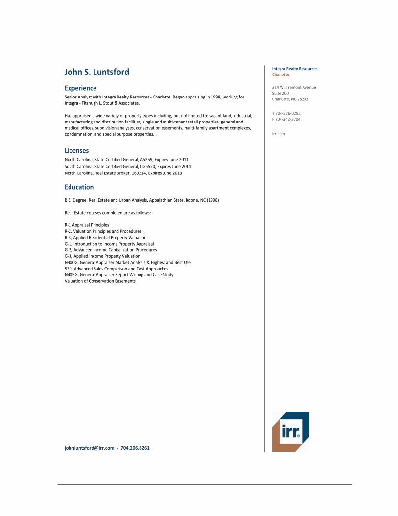
John S. Luntsford Charlotte Integra Realty Resources
irr.com
T 704-376-0295 F 704-342-3704
214 W. Tremont Avenue Suite 200 Charlotte, NC 28203
Experience Senior Analyst with Integra Realty Resources - Charlotte. Began appraising in 1998, working for Integra - Fitzhugh L. Stout & Associates. Has appraised a wide variety of property types including, but not limited to: vacant land, industrial, manufacturing and distribution facilities, single and multi-tenant retail properties, general and medical offices, subdivision analyses, conservation easements, multi-family apartment complexes, condemnation, and special purpose properties.
Licenses North Carolina, State Certified General, A5259, Expires June 2013
South Carolina, State Certified General, CG5520, Expires June 2014
North Carolina, Real Estate Broker, 169214, Expires June 2013
Education
B.S. Degree, Real Estate and Urban Analysis, Appalachian State, Boone, NC (1998) Real Estate courses completed are as follows: R-1 Appraisal Principles R-2, Valuation Principles and Procedures R-3, Applied Residential Property Valuation G-1, Introduction to Income Property Appraisal G-2, Advanced Income Capitalization Procedures G-3, Applied Income Property Valuation N400G, General Appraiser Market Analysis & Highest and Best Use 530, Advanced Sales Comparison and Cost Approaches N405G, General Appraiser Report Writing and Case Study Valuation of Conservation Easements
[email protected] - 704.206.8261
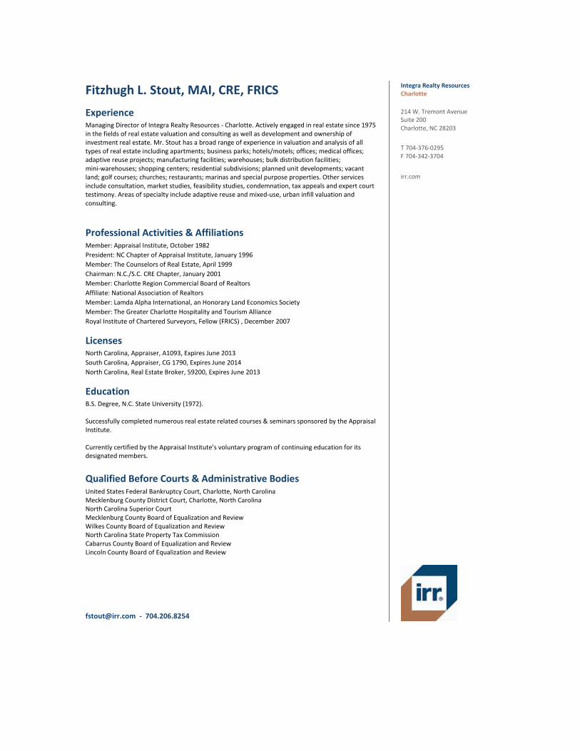
Fitzhugh L. Stout, MAI, CRE, FRICS Charlotte Integra Realty Resources
irr.com
T 704-376-0295 F 704-342-3704
214 W. Tremont Avenue Suite 200 Charlotte, NC 28203
Experience Managing Director of Integra Realty Resources - Charlotte. Actively engaged in real estate since 1975 in the fields of real estate valuation and consulting as well as development and ownership of investment real estate. Mr. Stout has a broad range of experience in valuation and analysis of all types of real estate including apartments; business parks; hotels/motels; offices; medical offices; adaptive reuse projects; manufacturing facilities; warehouses; bulk distribution facilities; mini-warehouses; shopping centers; residential subdivisions; planned unit developments; vacant land; golf courses; churches; restaurants; marinas and special purpose properties. Other services include consultation, market studies, feasibility studies, condemnation, tax appeals and expert court testimony. Areas of specialty include adaptive reuse and mixed-use, urban infill valuation and consulting.
Professional Activities & Affiliations Member: Appraisal Institute, October 1982
President: NC Chapter of Appraisal Institute, January 1996
Member: The Counselors of Real Estate, April 1999
Chairman: N.C./S.C. CRE Chapter, January 2001
Member: Charlotte Region Commercial Board of Realtors
Affiliate: National Association of Realtors
Member: Lamda Alpha International, an Honorary Land Economics Society
Member: The Greater Charlotte Hospitality and Tourism Alliance
Royal Institute of Chartered Surveyors, Fellow (FRICS) , December 2007
Licenses North Carolina, Appraiser, A1093, Expires June 2013
South Carolina, Appraiser, CG 1790, Expires June 2014
North Carolina, Real Estate Broker, 59200, Expires June 2013
Education B.S. Degree, N.C. State University (1972). Successfully completed numerous real estate related courses & seminars sponsored by the Appraisal Institute. Currently certified by the Appraisal Institute’s voluntary program of continuing education for its designated members.
Qualified Before Courts & Administrative Bodies United States Federal Bankruptcy Court, Charlotte, North Carolina Mecklenburg County District Court, Charlotte, North Carolina North Carolina Superior Court Mecklenburg County Board of Equalization and Review Wilkes County Board of Equalization and Review North Carolina State Property Tax Commission Cabarrus County Board of Equalization and Review Lincoln County Board of Equalization and Review
[email protected] - 704.206.8254
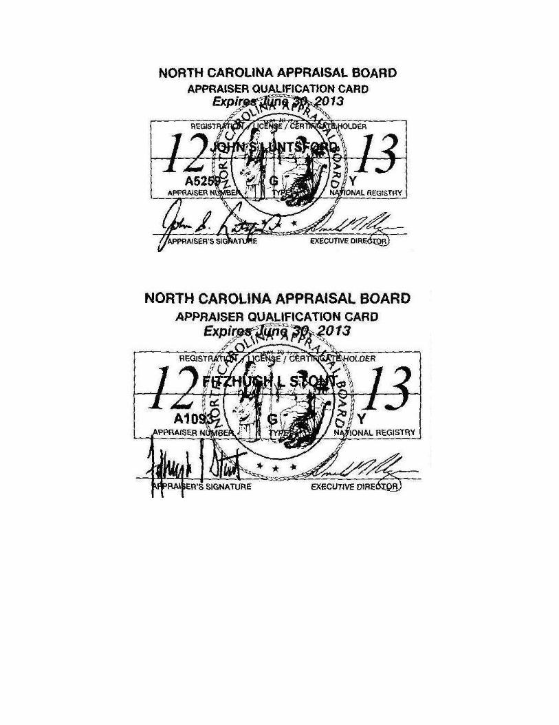

Integra Realty Resources, Inc.
Corporate Profile
Integra Realty Resources, Inc. offers the most comprehensive property valuation and counseling coverage in the United States with 61 independently owned and operated offices in 33 states. Integra was created for the purpose of combining the intimate knowledge of well-established local firms with the powerful resources and capabilities of a national company. Integra offers integrated technology, national data and information systems, as well as standardized valuation models and report formats for ease of client review and analysis. Integra’s local offices have an average of 25 years of service in the local market, and each is headed by a Managing Director who is an MAI member of the Appraisal Institute.
A listing of IRR’s local offices and their Managing Directors follows:
ATLANTA, GA - Sherry L. Watkins., MAI, MRICS AUSTIN, TX - Randy A. Williams, MAI, SR/WA, FRICS BALTIMORE, MD - G. Edward Kerr, MAI, MRICS BOISE, ID - Bradford T. Knipe, MAI, ARA, CCIM, CRE, FRICS BOSTON, MA - David L. Cary, MAI, MRICS CHARLOTTE, NC - Fitzhugh L. Stout, MAI, CRE, FRICS CHICAGO, IL - Gary K. DeClark, MAI, CRE, FRICS CHICAGO, IL - Eric L. Enloe, MAI, MRICS CINCINNATI, OH - Gary S. Wright, MAI, SRA, FRICS CLEVELAND, OH - Douglas P. Sloan, MAI COLUMBIA, SC - Michael B. Dodds, MAI, CCIM, MRICS COLUMBUS, OH - Bruce A. Daubner, MAI, FRICS DALLAS, TX - Mark R. Lamb, MAI, CPA, MRICS DAYTON, OH - Gary S. Wright, MAI, SRA, FRICS DENVER, CO - Brad A. Weiman, MAI, MRICS DETROIT, MI - Anthony Sanna, MAI, CRE, FRICS FORT WORTH, TX - Donald J. Sherwood, MAI, SR/WA, FRICS GREENSBORO, NC – Nancy Tritt, MAI, SRA GREENVILLE, SC - Michael B. Dodds, MAI, CCIM, MRICS HARTFORD, CT - Mark F. Bates, MAI, CRE, FRICS HOUSTON, TX - David R. Dominy, MAI, CRE, FRICS INDIANAPOLIS, IN - Michael C. Lady, MAI, SRA, CCIM, MRICS JACKSONVILLE, FL –Robert Crenshaw, MAI KANSAS CITY, MO/KS - Kenneth Jaggers, MAI, FRICS LAS VEGAS, NV - Shelli L. Lowe, MAI, SRA, MRICS LOS ANGELES, CA - John G. Ellis, MAI, CRE, FRICS LOS ANGELES, CA - Matthew J. Swanson, MAI LOUISVILLE, KY - George M. Chapman, MAI, SRA, CRE, FRICS MEMPHIS, TN - J. Walter Allen, MAI, MRICS MIAMI/PALM BEACH, FL - Scott M. Powell, MAI MINNEAPOLIS, MN - Michael Amundson, MAI, CCIM, MRICS
NAPLES, FL - Carlton J. Lloyd, MAI NASHVILLE, TN - R. Paul Perutelli, MAI, SRA, MRICS NEW JERSEY COASTAL - Anthony M. Graziano, MAI, CRE, FRICS NEW JERSEY NORTHERN - Barry J. Krauser, MAI, CRE, FRICS NEW YORK, NY - Raymond T. Cirz, MAI, CRE, FRICS ORANGE COUNTY, CA - Larry D. Webb, MAI, FRICS ORLANDO, FL - Charles J. Lentz, MAI, MRICS PHILADELPHIA, PA - Joseph Pasquarella, MAI, CRE, FRICS PHOENIX, AZ - Walter Winius, Jr., MAI, CRE, FRICS PITTSBURGH, PA - Paul D. Griffith, MAI, CRE, MRICS PORTLAND, OR - Brian A. Glanville, MAI, CRE, FRICS PROVIDENCE, RI - Gerard H. McDonough, MAI RALEIGH, NC - Chris R. Morris, MAI, MRICS RICHMOND, VA - Kenneth L. Brown, MAI, CCIM, MRICS SACRAMENTO, CA - Scott Beebe, MAI, FRICS ST. LOUIS, MO – P. Ryan McDonald, MAI SALT LAKE CITY, UT - Darrin Liddell, MAI, CCIM, MRICS SAN ANTONIO, TX - Martyn C. Glen, MAI, CRE, FRICS SAN DIEGO, CA - Jeff Greenwald, MAI, SRA, FRICS SAN FRANCISCO, CA - Jan Kleczewski, MAI, FRICS SARASOTA, FL - Carlton J. Lloyd, MAI SAVANNAH, GA - J. Carl Schultz, Jr., MAI, SRA, CRE, FRICS SEATTLE, WA - Allen N. Safer, MAI, MRICS SYRACUSE, NY - William J. Kimball, MAI, FRICS TAMPA, FL - Bradford L. Johnson, MAI, MRICS TULSA, OK - Robert E. Gray, MAI, FRICS WASHINGTON, DC - Patrick C. Kerr, MAI, SRA, FRICS WILMINGTON, DE - Douglas L. Nickel, MAI, FRICS IRR de MEXICO - Oscar J. Franck Terrazas, MRICS IRR CARIBBEAN – James Andrews, MAI, FRICS
Corporate Office 1133 Avenue of the Americas, 27th Floor, New York, New York 10036 Telephone: (212) 255-7858; Fax: (646) 424-1869; E-mail [email protected] Website: www.irr.com
PARCEL 2632AA -091
ADDENDUM B
DEFINITIONS
PARCEL 2632AA -091
DEFINITIONS
The source of the following definitions is The Dictionary of Real Estate Appraisal, Fifth
Edition, Appraisal Institute, Chicago, Illinois, 2010, unless otherwise noted.
As Is Market Value
The estimate of the market value of real property in its current physical condition, use, and
zoning as of the appraisal date.
Disposition Value
The most probable price that a specified interest in real property should bring under the
following conditions:
1. Consummation of a sale within a future exposure time specified by the client.
2. The property is subjected to market conditions prevailing as of the date of valuation.
3. Both the buyer and seller are acting prudently and knowledgeably.
4. The seller is under compulsion to sell.
5. The buyer is typically motivated.
6. Both parties are acting in what they consider to be their best interests.
7. An adequate marketing effort will be made during the exposure time specified by the
client.
8. Payment will be made in cash in U.S. dollars or in terms of financial arrangements
comparable thereto.
9. The price represents the normal consideration for the property sold, unaffected by
special or creative financing or sales concessions granted by anyone associated with
the sale.
This definition can also be modified to provide for valuation with specified financing terms.
Effective Date of Appraisal
The date on which the analyses, opinions, and advice in an appraisal, review, or consulting
service apply.
Entitlement
In the context of ownership, use, or development of real property, the right to receive
governmental approvals for annexation, zoning, utility extensions, construction permits, and
occupancy/use permits. The approval period is usually finite and may require the owner
and/or developer to pay impact and/or user fees in addition to other costs to secure the
entitlement. Entitlements may be transferable, subject to covenants or government protocols,
may constitute vested rights, and may represent an enhancement to a property’s value.
Entrepreneurial Profit
1. A market-derived figure that represents the amount an entrepreneur receives for his or
her contribution to a project and risk; the difference between the total cost of a
PARCEL 2632AA -091
property (cost of development) and its market value (property value after
completion), which represents the entrepreneur’s compensation for the risk and
expertise associated with development. An entrepreneur is motivated by the prospect
of future value enhancement (i.e., the entrepreneurial incentive). An entrepreneur who
successfully creates value through new development, expansion, renovation, or an
innovative change of use is rewarded by entrepreneurial profit. Entrepreneurs may
also fail and suffer losses.
2. In economics, the actual return on successful management practices, often identified
with coordination, the fourth factor of production following land, labor, and capital;
also called entrepreneurial return or entrepreneurial reward.
Exposure Time
1. The time a property remains on the market.
2. The estimated length of time the property interest being appraised would have been
offered on the market prior to the hypothetical consummation of a sale at market
value on the effective date of the appraisal; a retrospective estimate based on an
analysis of past events assuming a competitive and open market.
Fee Simple Estate
Absolute ownership unencumbered by any other interest or estate, subject only to the
limitations imposed by the governmental powers of taxation, eminent domain, police power,
and escheat.
Floor Area Ratio (FAR)
The relationship between the above-ground floor area of a building, as described by the
building code, and the area of the plot on which it stands; in planning and zoning, often
expressed as a decimal, e.g., a ratio of 2.0 indicates that the permissible floor area of a
building is twice the total land area.
Highest and Best Use
The reasonably probable and legal use of vacant land or an improved property that is
physically possible, appropriately supported, financially feasible, and that results in the
highest value. The four criteria the highest and best use must meet are legal permissibility,
physical possibility, financial feasibility, and maximum productivity. Alternatively, the
probable use of land or improved property – specific with respect to the user and timing of
the use – that is adequately supported and results in the highest present value.
Lease
A contract in which rights to use and occupy land or structures are transferred by the owner
to another for a specified period of time in return for a specified rent.
Leased Fee Interest
A freehold (ownership interest) where the possessory interest has been granted to another
party by creation of a contractual landlord-tenant relationship (i.e, a lease).
Leasehold Interest
The tenant’s possessory interest created by a lease.
PARCEL 2632AA -091
Liquidation Value
The most probable price that a specified interest in real property should bring under the
following conditions:
1. Consummation of a sale within a short time period.
2. The property is subjected to market conditions prevailing as of the date of valuation.
3. Both the buyer and seller are acting prudently and knowledgeably.
4. The seller is under extreme compulsion to sell.
5. The buyer is typically motivated.
6. Both parties are acting in what they consider to be their best interests.
7. A normal marketing effort is not possible due to the brief exposure time.
8. Payment will be made in cash in U.S. dollars, or in terms of financial arrangements
comparable thereto.
9. The price represents the normal consideration for the property sold, unaffected by
special or creative financing or sales concessions granted by anyone associated with
the sale.
This definition can also be modified to provide for valuation with specified financing terms.
Marketing Time
An opinion of the amount of time it might take to sell a real or personal property interest at
the concluded market value level during the period immediately after the effective date of an
appraisal. Marketing time differs from exposure time, which is always presumed to precede
the effective date of an appraisal.
Market Value
The most probable price which a property should bring in a competitive and open market
under all conditions requisite to a fair sale, the buyer and seller each acting prudently and
knowledgeably, and assuming the price is not affected by undue stimulus. Implicit in this
definition is the consummation of a sale as of a specified date and the passing of title from
seller to buyer under conditions whereby:
buyer and seller are typically motivated;
both parties are well informed or well advised, and acting in what they consider their
own best interests;
a reasonable time is allowed for exposure in the open market;
payment is made in terms of cash in U.S. dollars or in terms of financial arrangements
comparable thereto; and
the price represents the normal consideration for the property sold unaffected by
special or creative financing or sales concessions granted by anyone associated with
the sale.
(Source: Code of Federal Regulations, Title 12, Chapter I, Part 34.42[g])
PARCEL 2632AA -091
Prospective Opinion of Value
A value opinion effective as of a specified future date. The term does not define a type of
value. Instead, it identifies a value opinion as being effective at some specific future date. An
opinion of value as of a prospective date is frequently sought in connection with projects that
are proposed, under construction, or under conversion to a new use, or those that have not yet
achieved sellout or a stabilized level of long-term occupancy.
PARCEL 2632AA -091
ADDENDUM C
PROPERTY INFORMATION
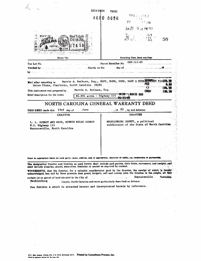
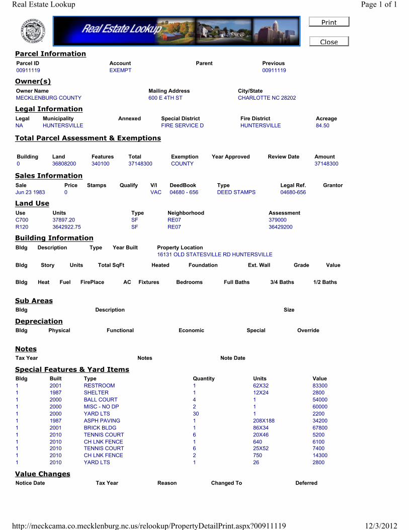
Close
Parcel Information
Parcel ID Account Parent Previous
00911119 EXEMPT 00911119
Owner(s)
Owner Name Mailing Address City/State
MECKLENBURG COUNTY 600 E 4TH ST CHARLOTTE NC 28202
Legal Information
Legal Municipality Annexed Special District Fire District Acreage
NA HUNTERSVILLE FIRE SERVICE D HUNTERSVILLE 84.50
Total Parcel Assessment & Exemptions
Building Land Features Total
0 36808200 340100 37148300
Exemption Year Approved Review Date Amount
COUNTY 37148300
Sales Information
Sale Price Stamps Qualify V/I DeedBook Type Legal Ref. Grantor
Jun 23 1983 0 VAC 04680 - 656 DEED STAMPS 04680-656
Land Use
Use Units Type Neighborhood Assessment
C700 37897.20 SF RE07 379000
R120 3642922.75 SF RE07 36429200
Building Information
Bldg Description Type Year Built Property Location
16131 OLD STATESVILLE RD HUNTERSVILLE
Bldg Story Units Total SqFt Heated Foundation Ext. Wall Grade Value
Bldg Heat Fuel FirePlace AC Fixtures Bedrooms Full Baths 3/4 Baths 1/2 Baths
Sub Areas
Bldg Description Size
Depreciation
Bldg Physical Functional Economic Special Override
Notes
Tax Year Notes Note Date
Special Features & Yard Items
Bldg Built Type Quantity Units Value
1 2001 RESTROOM 1 62X32 83300
1 1987 SHELTER 1 12X24 2800
1 2000 BALL COURT 4 1 54000
1 2000 MISC - NO DP 2 1 60000
1 2000 YARD LTS 30 1 2200
1 1987 ASPH PAVING 1 208X188 34200
1 2001 BRICK BLDG 1 86X34 67800
1 2010 TENNIS COURT 6 20X46 5200
1 2010 CH LNK FENCE 1 640 6100
1 2010 TENNIS COURT 6 25X52 7400
1 2010 CH LNK FENCE 2 750 14300
1 2010 YARD LTS 1 26 2800
Value Changes
Notice Date Tax Year Reason Changed To Deferred
Page 1 of 1Real Estate Lookup
12/3/2012http://meckcama.co.mecklenburg.nc.us/relookup/PropertyDetailPrint.aspx?00911119

PARCEL 2632AA -091
ADDENDUM D
CERTIFICATION
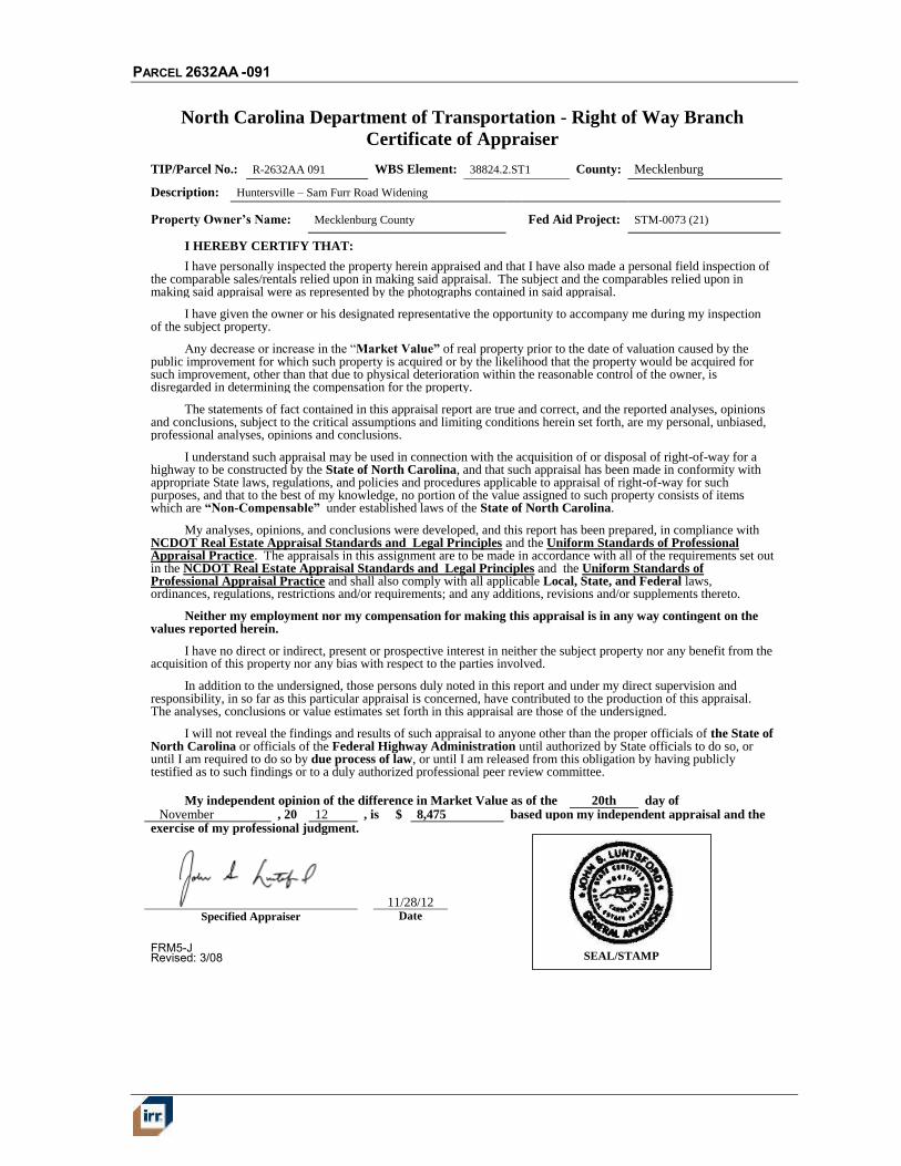
PARCEL 2632AA -091
FRM5-J Revised: 3/08
North Carolina Department of Transportation - Right of Way Branch
Certificate of Appraiser
TIP/Parcel No.: R-2632AA 091 WBS Element: 38824.2.ST1 County: Mecklenburg
Description: Huntersville – Sam Furr Road Widening
Property Owner’s Name: Mecklenburg County Fed Aid Project: STM-0073 (21)
I HEREBY CERTIFY THAT:
I have personally inspected the property herein appraised and that I have also made a personal field inspection of the comparable sales/rentals relied upon in making said appraisal. The subject and the comparables relied upon in making said appraisal were as represented by the photographs contained in said appraisal.
I have given the owner or his designated representative the opportunity to accompany me during my inspection of the subject property.
Any decrease or increase in the “Market Value” of real property prior to the date of valuation caused by the public improvement for which such property is acquired or by the likelihood that the property would be acquired for such improvement, other than that due to physical deterioration within the reasonable control of the owner, is disregarded in determining the compensation for the property.
The statements of fact contained in this appraisal report are true and correct, and the reported analyses, opinions and conclusions, subject to the critical assumptions and limiting conditions herein set forth, are my personal, unbiased, professional analyses, opinions and conclusions.
I understand such appraisal may be used in connection with the acquisition of or disposal of right-of-way for a highway to be constructed by the State of North Carolina, and that such appraisal has been made in conformity with appropriate State laws, regulations, and policies and procedures applicable to appraisal of right-of-way for such purposes, and that to the best of my knowledge, no portion of the value assigned to such property consists of items which are “Non-Compensable” under established laws of the State of North Carolina.
My analyses, opinions, and conclusions were developed, and this report has been prepared, in compliance with NCDOT Real Estate Appraisal Standards and Legal Principles and the Uniform Standards of Professional Appraisal Practice. The appraisals in this assignment are to be made in accordance with all of the requirements set out in the NCDOT Real Estate Appraisal Standards and Legal Principles and the Uniform Standards of Professional Appraisal Practice and shall also comply with all applicable Local, State, and Federal laws, ordinances, regulations, restrictions and/or requirements; and any additions, revisions and/or supplements thereto.
Neither my employment nor my compensation for making this appraisal is in any way contingent on the values reported herein.
I have no direct or indirect, present or prospective interest in neither the subject property nor any benefit from the acquisition of this property nor any bias with respect to the parties involved.
In addition to the undersigned, those persons duly noted in this report and under my direct supervision and responsibility, in so far as this particular appraisal is concerned, have contributed to the production of this appraisal. The analyses, conclusions or value estimates set forth in this appraisal are those of the undersigned.
I will not reveal the findings and results of such appraisal to anyone other than the proper officials of the State of North Carolina or officials of the Federal Highway Administration until authorized by State officials to do so, or until I am required to do so by due process of law, or until I am released from this obligation by having publicly testified as to such findings or to a duly authorized professional peer review committee.
My independent opinion of the difference in Market Value as of the 20th day of November , 20 12 , is $ 8,475 based upon my independent appraisal and the
exercise of my professional judgment.
11/28/12 Specified Appraiser Date
SEAL/STAMP
PARCEL 2632AA -091
FRM5-J
North Carolina Department of Transportation - Right of Way Branch
Certificate of Appraiser
TIP/Parcel No.: R-2632AA 091 WBS Element: 38824.2.ST1 County: Mecklenburg
Description: Huntersville – Sam Furr Road Widening
Property Owner’s Name: Mecklenburg County Fed Aid Project: STM-0073 (21)
I HEREBY CERTIFY THAT:
I have personally inspected the property herein appraised and that I have also made a personal field inspection of the comparable sales/rentals relied upon in making said appraisal. The subject and the comparables relied upon in making said appraisal were as represented by the photographs contained in said appraisal.
I have given the owner or his designated representative the opportunity to accompany me during my inspection of the subject property.
Any decrease or increase in the “Market Value” of real property prior to the date of valuation caused by the public improvement for which such property is acquired or by the likelihood that the property would be acquired for such improvement, other than that due to physical deterioration within the reasonable control of the owner, is disregarded in determining the compensation for the property.
The statements of fact contained in this appraisal report are true and correct, and the reported analyses, opinions and conclusions, subject to the critical assumptions and limiting conditions herein set forth, are my personal, unbiased, professional analyses, opinions and conclusions.
I understand such appraisal may be used in connection with the acquisition of or disposal of right-of-way for a highway to be constructed by the State of North Carolina, and that such appraisal has been made in conformity with appropriate State laws, regulations, and policies and procedures applicable to appraisal of right-of-way for such purposes, and that to the best of my knowledge, no portion of the value assigned to such property consists of items which are “Non-Compensable” under established laws of the State of North Carolina.
My analyses, opinions, and conclusions were developed, and this report has been prepared, in compliance with NCDOT Real Estate Appraisal Standards and Legal Principles and the Uniform Standards of Professional Appraisal Practice. The appraisals in this assignment are to be made in accordance with all of the requirements set out in the NCDOT Real Estate Appraisal Standards and Legal Principles and the Uniform Standards of Professional Appraisal Practice and shall also comply with all applicable Local, State, and Federal laws, ordinances, regulations, restrictions and/or requirements; and any additions, revisions and/or supplements thereto.
Neither my employment nor my compensation for making this appraisal is in any way contingent on the values reported herein.
I have no direct or indirect, present or prospective interest in neither the subject property nor any benefit from the acquisition of this property nor any bias with respect to the parties involved.
In addition to the undersigned, those persons duly noted in this report and under my direct supervision and responsibility, in so far as this particular appraisal is concerned, have contributed to the production of this appraisal. The analyses, conclusions or value estimates set forth in this appraisal are those of the undersigned.
I will not reveal the findings and results of such appraisal to anyone other than the proper officials of the State of North Carolina or officials of the Federal Highway Administration until authorized by State officials to do so, or until I am required to do so by due process of law, or until I am released from this obligation by having publicly testified as to such findings or to a duly authorized professional peer review committee.
My independent opinion of the difference in Market Value as of the 20th day of November , 20 12 , is $ 8,475 based upon my independent appraisal and the
exercise of my professional judgment.
11/28/12 Specified Appraiser Date