office copy 2003 - british columbiaa100.gov.bc.ca/appsdata/acat/documents/r11509/2003... · office...
TRANSCRIPT

OFFICE COPY
2003 KOKANEE STREAM SPAWNER ENUMERATION
OKANAGAN DRAINAGE
by
Jason Webster
INTRODUCTION Enumeration and biological sampling of the Okanagan Valley’s stream spawning kokanee (Oncorhynchus nerka) populations are a continuation of the long-term monitoring of the lake’s salmon populations. Routine monitoring of kokanee escapement has occurred annually since 1974. This data series assists in meeting the objective of restoring Okanagan Lake kokanee stocks under the Okanagan Lake Action Plan (OLAP). This plan was established in 1996 in response to a dramatic decline in the kokanee spawners in Okanagan Lake observed in the late 1980s and early 1990s (Ashley and Shepherd 1996). Also, the current monitoring of stream spawning kokanee populations in Skaha, Wood and Kalamalka Lakes will ensure that any negative population trend will be acted upon immediately. Enumeration of kokanee is based on visual counts and their accuracy is subject to variables such as weather, water clarity and run timing. In spite of this limitation, the long-term data set provides a valuable index of population trends over time. This report summarizes escapement data and carcass samples collected for the year 2003, and incorporates them within the long-term data set.
METHODS Counting In 2003, twenty-one streams within the Okanagan Lake watershed were enumerated. From the top of the watershed, downstream, they include the following: Middle Vernon Duck Lake to Wood Lake Winfield Water source to mouth Coldstream Coldstream Ranch to mouth Vernon Kalamalka Lake to Okanagan Lake Six Mile Accessible length for kokanee Nashwhito Accessible length for kokanee Whiteman Accessible length for kokanee Shorts Accessible length (falls to mouth) for kokanee Lambly Accessible length (falls to mouth) for kokanee Kelowna (Mill) City Works Yard to mouth Mission East Kelowna Road to mouth Smith Accessible length for kokanee Powers Accessible length (falls to mouth) for kokanee Trepanier Accessible length for kokanee Peachland Hardy Falls to mouth Trout Accessible length for kokanee Eneas Accessible length for kokanee Prairie Valley Accessible length for kokanee Naramata Accessible length for kokanee Penticton Eckhart Road Bridge to mouth Okanagan River Channel Okanagan Lake to Skaha Lake

Specifications for the number and dates of the counting days in the 2003 enumeration differed only slightly from those in 2000 (Webster, J. 2000). The count dates covered the same peak period and were conducted every three days in most cases, the exception being Mission Creek, where counts were performed every second day. Total number of kokanee utilizing a stream was derived by multiplying the peak count by an expansion factor of 1.5 to reflect spawner residence period and subsequent spawner replacement through the entire spawning period (Andrusak and Sebastian, in Ashley et. al. 1999). Enumerations in all streams, with the exception of the Okanagan River, were performed by ground counts. The Okanagan River was enumerated by a boat, travelling in the middle of the river channel. Polaroid sunglasses and brimmed hats were worn on all counts to increase visibility and to decrease the glare effect off the water surface. Keeping the sun at the counter’s back whenever possible proved to be most effective. Because fish tend to move upstream when spooked, counting while moving downstream also proved to work well. When possible, counters walked along the stream banks and looked from a higher vantage point, down onto the water surface. Although staying out of the creek bed may have prevented the disturbance of reds, it sometimes could not be avoided. In these situations, foot placement was deliberate. Hand counters (tally whackers) were used to count live and dead kokanee, and chest waders or thigh waders were worn in all the streams. Water temperature was taken at or near the mouth of streams on all counts of 2003. Since a routine was followed during each count, the time of day when taking the temperature was consistent. An accurate, aquarium-styled thermometer was used. Counting methodology varied according to spawner densities. On most occasions, kokanee enumerated this year were counted individually. During some of the counts performed on Coldstream, Middle Vernon, Peachland and Mission Creeks, kokanee were counted ten at a time. Kokanee were counted by hundreds or more during most of the enumerations on the Okanagan River due to the extremely high fish densities in 2003. Sampling A target number of 100 kokanee was to be sampled from each of Mission, Peachland, Powers and Penticton Creeks along with the Okanagan River Channel. All fish were collected by hand or with a dip net and had to be in good physical condition. As many carcasses as possible was taken as dead pitch, or “near dead”. Because of low numbers of kokanee in recent years, live capturing kokanee to meet target sample numbers was not considered an option. Once collected, all samples were placed on a portable measuring board where fork length was measured. Kokanee were sexed by identification of external features and by internal examination. Maturity was recorded as spent for both males and females. The only exceptions were if a significant number of eggs (in relation to the size of the female) were counted or if the fish were live captured. In both of these cases, maturity was noted as ripe. In the case of all female samples collected from Mission Creek, Powers Creek, Penticton Creek and the Okanagan River, any retained eggs were counted individually

after an incision of the body wall. Any special comments on individual fish were also recorded if necessary. Note: A target sample of fifty in-skein females was to be collected from the Mission Creek Spawning Channel in 2003. The methodology and results regarding the in-skein females can be viewed in Webster, 2003. A total of 250 otoliths were to be collected from Mission Creek, Peachland Creek, Penticton Creek, Powers Creek and the Okanagan River (50 each). An incision was made through the top of the head, bisecting it as accurately as possible. An otolith was then removed from the lower portion of the brain cavity with a pair of tweezers, cleaned with water and placed in a scale sample envelope. The envelope was coded and labelled with length, sex of the fish and location and date collected. In most cases only one of the otoliths was collected. Along with otoliths, DNA portions were to be collected from as many of the samples as possible. A small 2cm by 1cm portion of flesh/fin was cut from the caudal/peduncle area of each kokanee sample and placed in a container of preservative. The containers were labelled by creek name and only samples from that specific creek were placed inside. Enumeration Adjustments For Mission Creek, the escapement estimate has been modified to include the entire accessible length of stream. As indicated in the Methods Section of this report, Mission Creek ground counts only extend upstream to the East Kelowna Rd Bridge due to access limitations and time requirements. Historically, ground counts have typically extended no further upstream than the Mission Creek Spawning Channel intake. In order to estimate the number of kokanee utilizing the non-enumerated section of stream, helicopter surveys have been conducted periodically over the years (most recently in 2000). The helicopter estimate is then applied to the ground count estimate for the section of stream downstream of the spawning channel intake (the historical upstream limit for enumerations) to derive a representative proportion of kokanee that spawn in the upstream section. This proportion is then used to calculate the number of fish spawning in the upstream section of creek for those years when aerial or ground surveys are not possible. The helicopter survey indicated that 0.3125 (or 31.25%) of the total fish counted in the downstream section is representative of fish use in the upstream section of Mission Creek. All 2003 information on Six Mile, Nashwito and Whiteman Creeks is provided by the Okanagan Nation Alliance and is not part of this contract. Data from these three creeks, however, will be used in calculating the total number of Okanagan Lake creek spawners in the Results and Discussion section of this report. Poor viewing/counting conditions due to higher water levels and/or suspended sediments occurred on Trout Creek (Sept. 20 and Oct. 2) and Mill (Kelowna) Creek (Sept. 30 and Oct. 7). Upon those dates it is possible that a larger number of kokanee (up to 50% more) may have been present than were actually counted.

The 2003 reach by reach enumeration forms within appendix I of this report are creations of the contractor and may differ slightly from the standard enumeration forms designed by the Ministry of Water, Land and Air Protection (MWLAP). Some of the contractor-designed 2003 forms have been changed in order to give a more detailed breakdown of the enumeration data. However, all of the reach-by-reach enumeration results entered into the MWLAP database conform to MWLAP standards. The following points should be noted: • Numbers entered in the Penticton MWLAP database under Vernon Creek’s reach E
include any kokanee counted between 43rd Street and Kalamalka Lake. • Numbers entered in the Penticton MWLAP database under Middle Vernon Creek’s
reach C include any kokanee counted between Lodge road and Duck Lake. • Numbers entered in the Penticton MWLAP database under Mission Creek’s reach E
do not include kokanee counted within the Mission Creek Spawning Channel’s settling pond. The number of kokanee within the settling pond is included in reach G’s total.
Sampling Adjustments Due to the problem of meeting target sample numbers in past years, carcass sampling was instigated as soon as any dead fish were noticed, not as the peak die off started (as described in the contract).
RESULTS AND DISCUSSION Enumeration Results The estimated total of kokanee creek-spawners for Okanagan Lake in 2003 is 23,725 (table 1). This is drawn from a total of 17 enumerated creeks. The estimated number for each creek is calculated by multiplying the peak count of live fish by a conversion factor of 1.5 (Andrusak and Sebastian, in Ashley et. al. 1999). When using the eight primary streams only to calculate the Okanagan Lake stream escapements, the 2003 escapement estimate total is the fourth lowest total since enumeration data was first recorded in 1971. Only escapement estimates from 1997 to 1999 are lower (figure 1). To further compare, the estimated escapement for the spawners in all the streams in 2002 was 44,488 and in 2001 it was 67,077. Only Penticton, Nashwhito and Whiteman Creeks showed higher returns this year than in 2002. Drawn from counts on the Okanagan River Channel, the estimated run of 2003 creek-spawners in Skaha Lake is 68,985 (table 2). Although almost 28,000 less than last year’s total of 96,480, the 2003 run is still exceptionally high when comparing it to estimated escapements from 1984 to 2002 (figure 2). The 2003 escapement is the second highest on record since 1984, and may have even surpassed runs from the early seventies, when up to 3 million eggs were collected from the Okanagan River Channel for local hatcheries (Steve Matthews, per. comm.). Stream spawners in Kalamalka Lake’s only major tributary, Coldstream Creek, produced an estimated total of 18,703 (table 3), up considerably from the previous year.

Figure 3 indicates a slight downward trend overall in Coldstream Creek kokanee escapements since 1988.
Figure 1. Escapement estimates for Mission Creek and the seven primary Okanagan Lake streams (including Lambly, Naramata, Penticton, Peachland, Trepanier, Powers and Mill (Kelowna) Creeks) where data is available.
Figure 2. Okanagan River estimated kokanee escapements since 1984.
Figure 3. Coldstream Creek estimated kokanee escapements since 1983.
0
50,000
100,000
150,000
200,000
250,000
300,000
350,000
400,00019
71
1974
1975
1976
1977
1978
1979
1980
1981
1983
1984
1985
1986
1987
1988
1989
1990
1991
1992
1993
1994
1995
1996
1997
1998
1999
2000
2001
2002
2003
estim
ated
esc
apem
ent
mission creek
total 8 streams
OK River Escapements since 1984
0100002000030000400005000060000700008000090000
100000
1984
1986
1987
1988
1990
1991
1992
1993
1994
1995
1996
1997
1998
1999
2000
2001
2002
2003
num
ber o
f spa
wne
rs
Coldstream Creek Escapements since 1983
05000
10000150002000025000300003500040000450005000055000
1983
1986
1988
1990
1991
1992
1993
1994
1995
1996
1997
1998
1999
2000
2001
2002
2003
num
ber o
f spa
wne
rs

Winfield and Middle Vernon Creek numbers constitute total creek spawners for Wood Lake (table 4). A total estimated run of 8,921 spawners was calculated for 2003, up more than 2,500 fish from last year’s estimated run of 6,368 but still less than half of the 1999 run of 19,845. Figure 4 demonstrates the rise-and-fall trend of kokanee escapements in Middle Vernon Creek since 1983.
Figure 4. Middle Vernon Creek estimated kokanee escapements since 1983. Table 1. Summary of Enumeration Results 2003 – Okanagan Lake CREEK TEMP(C) COUNTS PEAK DATE ADJ TOTAL Vernon 14 2 46 10/14/03 69 Mission (incl Sp Channel) 11.5 14 9096* 9/24/03 13644 Mission Creek Sp Channel 2857 9/23/03 Powers 12 8 995 9/26/03 1492 Trepanier 13 8 650 9/29/03 975 Peachland 11 8 2767 9/23/03 4150 Eneas 13 2 13 9/23/03 19 Prairie Valley 13 2 0 9/23/03 0 Naramata 13 2 0 9/20/03 0 Penticton 15 8 1210 9/23/03 1815 Shorts n/a 1 dry n/a 0 Kelowna (Mill) 11 7 218 10/10/03 327 Lambly 12 2 27 9/21/03 40 Six Mile (Equesis) n/a 5 463 10/3/03 694 Nashwito n/a 5 205 10/8/03 307 Whiteman n/a 5 67 9/27/03 100 Trout 14 2 50 10/2/03 75 Smith n/a 1 12 9/27/03 18 Total 23725 * Includes estimate of kokanee utilising creek upstream of the East Kelowna Bridge. (see methods section for a description of how this estimate was derived). Table 2. Summary of Enumeration Results 2003 – Skaha Lake CREEK TEMP (C) COUNTS PEAK DATE ADJ TOTAL Okanagan River 11 6 45990 10/25/03 68985 Total 68985
Middle Vernon Creek Escapements since 1984
02000400060008000
100001200014000160001800020000
1983
1986
1988
1990
1991
1992
1993
1994
1995
1996
1997
1998
1999
2000
2001
2002
2003
num
ber o
f spa
wne
rs

Table 3. Summary of Enumeration Results 2003 – Kalamalka Lake CREEK TEMP (C) COUNTS PEAK DATE ADJ TOTALColdstream 10 6 12469 10/14/03 18703 Total 18703 Table 4. Summary of Enumeration Results 2003 – Wood Lake CREEK TEMP(C) COUNTS PEAK DATE ADJ TOTALMiddle Vernon 9 6 5095 10/14/03 7642 Winfield 9 6 853 10/10/03 1279 Total 8921 The peak count of all creeks enumerated in 2003 fell within the enumeration dates outlined in the contract specifications. A complete distribution breakdown, reach by reach, of enumerated kokanee in all creeks was entered in the database of the MWLAP Office in Penticton. For similar information refer to Appendix 1 of this report. Sampling The target number of one hundred carcasses was obtained in Mission, Powers, Peachland Creeks and the Okanagan River. Table 5. Summary of 2003 Kokanee Samples Collected – Skaha Lake (95% C.L.) Mean fecundity and Estimated egg deposition calculated by using the length/fecundity formula of Log Egg # = 3.289 Log length (mm) – 5.275 from Andrusak and Sebastian in Andrusak et al. 2000.
Mean Fecund Total Male Mean Female Mean Egg minus Estimated Estimated
Creek No. Males Females Length (mm) Length (mm) Retent.(%) retention Females egg depo - 2003 OK River 100 52 48 257.7 245.4 9.8 374 33113 12,384,262
Totals 100 52 48 12,384,262 Table 6 Summary of 2003 Kokanee Samples Collected – Okanagan Lake (95% C.L.) Mean fecundity and Estimated egg deposition calculated by using the length/fecundity formula of Log Egg # = 3.289 Log length (mm) – 5.275 from Andrusak and Sebastian in Andrusak et al. 2000.
Mean Total Male Mean Female Mean Egg Fecund minus Estimated Estimated
Creek No. Males Females Length (mm) Length (mm) Retent.(%) retention Females egg depo - 2003
Powers 100 54 46 336.1 284 10.3 558 686 382,788 Penticton 100 52 48 338.4 310.2 14.8 708 871 616,668 Peachland 100 53 47 377.4 354.5 5.8 1216 1950 2,371,200 Mission 100 55 45 355.7 361.6 2 1349 6139 8,281,511
Totals 400 214 186 11,652,167

It should be noted that all carcass sampling performed should be considered as non-random sampling, due to the fact that only carcasses deemed to be in good shape were collected. However, with the exception of Penticton Creek, all of the tributary’s carcass samples are reasonably representative of the actual size distribution. Mean lengths within the four Okanagan Lake streams varied considerably in both the males and females (table 6) (Figures 6 to 10) (Appendix II). Females in Mission Creek averaged over 361 mm, nearly 78mm longer than the average female length in Powers Creek (284 mm). Mission Creek was also the only creek where the mean length of the females was greater than the mean length of the males. Males in Peachland Creek (377 mm) were 41 mm longer on the average than the males in Powers Creek (315mm). The2003 mean lengths are also considerably longer than most mean lengths recorded in years previous to 1997 (Figure 5). The average fish size for each creek appears to be higher mainly due to the large number of assumed 4+ and 5+ year-old fish that were present in the samples. Because results of otolith aging are not available at the time of writing this report, we will assume that the majority of 3+ year-old kokanee do not exceed 310mm in length. Using this standard in Peachland Creek, for example, 71% of the population was at least 4+ year-old fish (Figure 10). In Powers Creek a more typical representation of 33% (based on stream-sample data collected since 1989) of the samples were at least 4+ year-old fish (Figure 9, Appendix II). Finally, regarding the above average stream kokanee lengths in 2003, it is important to note that there were three sampled specimens over 600 mm in length. This total matches the total number of sampled specimens over 600 mm from all stream-sample data collected from1989 to 2002.
Figure 5. Mean size of kokanee from four Okanagan Lake Tributairies since 1986. Note: figure 5 may differ from similar figure in OLAP report due to combining data from both Mission Creek and Mission Creek Channel and errors discovered in the 1993 Penticton Creek data. Due to the fact that most of the accessible spawning portion of Penticton Creek is a concrete flume, the majority of carcasses were collected from the section of the creek close to the mouth, where flows slowed considerably. It was noted that the larger/older
200
250
300
350
400
450
1986
1987
1988
1989
1990
1991
1992
1993
1994
1995
1996
1997
1998
1999
2000
2001
2002
2003
mea
n le
ngth
(mm
)
mission incl spaw nchannelpeachland
pow ers
penticton
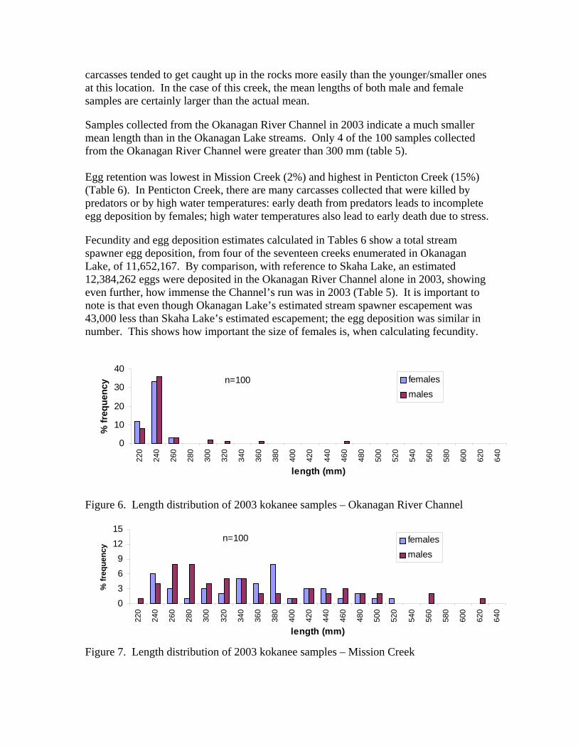
carcasses tended to get caught up in the rocks more easily than the younger/smaller ones at this location. In the case of this creek, the mean lengths of both male and female samples are certainly larger than the actual mean. Samples collected from the Okanagan River Channel in 2003 indicate a much smaller mean length than in the Okanagan Lake streams. Only 4 of the 100 samples collected from the Okanagan River Channel were greater than 300 mm (table 5). Egg retention was lowest in Mission Creek (2%) and highest in Penticton Creek (15%) (Table 6). In Penticton Creek, there are many carcasses collected that were killed by predators or by high water temperatures: early death from predators leads to incomplete egg deposition by females; high water temperatures also lead to early death due to stress. Fecundity and egg deposition estimates calculated in Tables 6 show a total stream spawner egg deposition, from four of the seventeen creeks enumerated in Okanagan Lake, of 11,652,167. By comparison, with reference to Skaha Lake, an estimated 12,384,262 eggs were deposited in the Okanagan River Channel alone in 2003, showing even further, how immense the Channel’s run was in 2003 (Table 5). It is important to note is that even though Okanagan Lake’s estimated stream spawner escapement was 43,000 less than Skaha Lake’s estimated escapement; the egg deposition was similar in number. This shows how important the size of females is, when calculating fecundity.
Figure 6. Length distribution of 2003 kokanee samples – Okanagan River Channel
Figure 7. Length distribution of 2003 kokanee samples – Mission Creek
0
10
20
30
40
220
240
260
280
300
320
340
360
380
400
420
440
460
480
500
520
540
560
580
600
620
640
length (mm)
% fr
eque
ncy females
malesn=100
0369
1215
220
240
260
280
300
320
340
360
380
400
420
440
460
480
500
520
540
560
580
600
620
640
length (mm)
% fr
eque
ncy
femalesmales
n=100

Figure 8. Length distribution of 2003 kokanee samples – Penticton Creek
Figure 9. Length distribution of 2003 kokanee samples – Powers Creek
Figure 10. Length distribution of 2003 kokanee samples – Peachland Creek All data sheets were filled out and submitted at the end of the contract period. All data taken from kokanee samples can be viewed within the Ministry of Environment’s database in Penticton or in Appendix II of this report. Otoliths and DNA flesh/fin portions were also delivered to the Penticton MWLAP office after the final enumeration day. Results of the otolith-aging procedure and DNA analysis were unavailable at the time of writing this report.
0369
1215
220
240
260
280
300
320
340
360
380
400
420
440
460
480
500
520
540
560
580
600
620
640
length (mm)
% fe
quen
cyfemalesmales
n=100
0369
1215
220
240
260
280
300
320
340
360
380
400
420
440
460
480
500
520
540
560
580
600
620
640
length (mm)
% fr
eque
ncy females
malesn=100
0369
1215
220
240
260
280
300
320
340
360
380
400
420
440
460
480
500
520
540
560
580
600
620
640
length (mm)
% fr
eque
ncy females
males
n=100

Flow Observations Creek water levels were a major issue in 2003. A barely adequate amount of water was available for kokanee migration in many of the enumerated streams. Flows in Trout Creek were exceptionally low in 2003. During the initial count on September 20, stream flows were so low that migration was not possible upstream of the Highway Bridge. In fact, only smaller kokanee (approximately less than 300 mm) were able to migrate beyond 100 meters of the confluence with Okanagan Lake. Approximately 15 larger-sized (unspent) kokanee carcasses were viewed near the mouth of the creek on September 20. It is likely these carcasses were easy targets for predators in the low water conditions. Flows in Middle Vernon Creek in 2003 were also exceptionally low. A feeder creek that originates from the hills, west of Winfield supplied all of the water during the entire spawning season. The feeder creek enters Middle Vernon Creek approximately 20 meters downstream of the Beaver Lake Road crossing. No water was available from Duck Lake in 2003. During all of the enumeration dates, hundreds of fresh, unspent kokanee carcasses were observed within the creek. In one particular location, at the upstream end of the Winfield Golf Course, up to 2000 live kokanee and 700 unspent kokanee carcasses were seen crammed into two small pools because immediately upstream, the flows were too low to allow migration through a steeper, rockier section of the creek. Many of the carcasses were predator casualties but most appeared to have died due to oxygen deprivation. No kokanee were viewed during the two counts performed on Naramata Creek in 2003. Although a small amount of water was present in the creek during the two count dates, it is likely that flows were too low to allow any upstream migration. As it was in 2002, flows in Shorts Creek did not allow any migration upstream in 2003. The creek bed went dry approximately 200 meters upstream of the mouth. Flows continued underground, until the confluence with Okanagan Lake. Construction and Silt Sources Construction was viewed around some of the enumerated streams in 2003 but no damage to the streams was noted. A high sediment load was observed within the water of Trout Creek during the 2003 enumeration dates. The source of the sediment loading in Trout Creek is believed to be a perpetually eroding bank in the canyon section of the creek. Fish Presence in Enhanced Sections • The gravel within the Mission Creek Spawning Channel appeared to be in excellent
condition. Approximately thirty percent of the Mission Creek peak run used the spawning channel in 2003 (appendix I).
• Very few kokanee (up to 200 during the peak count – 2.0% of run) were observed
using the enhanced section in Coldstream Creek. Although the weirs and gravel within the enhanced section appear to be in good shape, the kokanee are simply using the large amount of quality spawning habitat downstream instead.

• As the kokanee distribution in Powers Creek shows (appendix I), about 32% of the
kokanee enumerated were found using the enhancement platforms (weirs) and fish ladder pool during the peak count.
• 25% of the kokanee enumerated during the peak in Penticton Creek were viewed in the fish ladders or large weirs.
• Active spawning within the newly installed weirs (2001 and 2002) in Kelowna Creek
was very noticeable. Although, there was no formal tally of kokanee using the enhanced sections, it is estimated that 75% of the fish enumerated in 2003 were viewed on or near the enhanced areas.
• The two Newberry Riffles (NR) located within Mission Creek each had spawning
activity associated with them. Although there was no formal kokanee count performed in the area of the Newberry Riffles, the number of spawners in the area of the riffles seemed only slightly greater than in pre NR years.
Other Notes • Predators like mergansers, blue herons, and loons were seen in moderate numbers
during the 2003 enumeration. Egg-eating ducks were very apparent in 2003.
RECOMMENDATIONS Methods The following corrections should be made on the MWLAP Kokanee Enumeration Sheets to avoid possible confusion by contractors in future enumerations:
• Vernon Creek – A reach ‘F’ should be added or Reach ‘E’ should be extended in order to include the section between Polson Park and Kalamalka Lake.
• Middle Vernon Creek - A reach ‘D’ should be added or reach ‘C’ should be
extended in order to include the section between Beaver Lake Road and Duck Lake. A reach ‘E’ could also be added in order to include the portion of stream accessible to kokanee in Upper Vernon Creek (see following paragraph).
A decision should be made on whether or not to include kokanee spawners observed in Upper Vernon Creek (empties into Duck Lake) as part of the Middle Vernon Creek returns. Although there were no kokanee in Upper Vernon Creek in 2003, experiments performed with dams that halt any upstream migration by kokanee on Middle Vernon Creek during the spawning season show that the kokanee seen in Upper Vernon Creek, are indeed, Wood Lake kokanee. Adding another reach to the Enumeration Form (Appendix I) to include the section between Duck Lake and the Hiram Walker Flume is a solution.
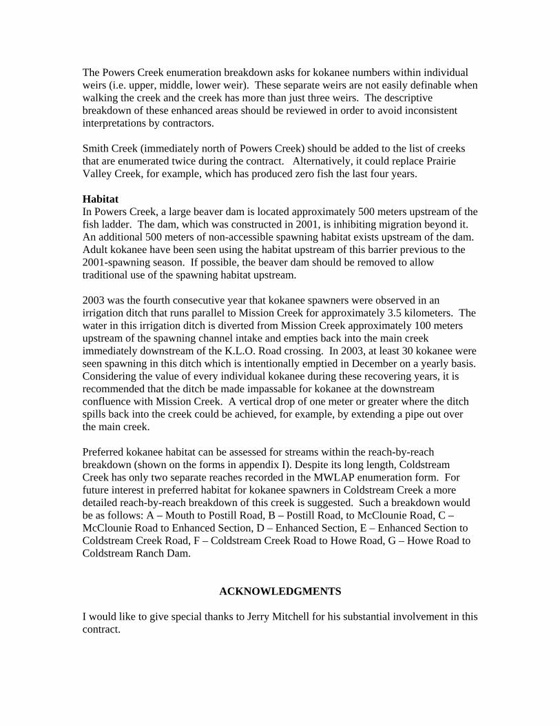
The Powers Creek enumeration breakdown asks for kokanee numbers within individual weirs (i.e. upper, middle, lower weir). These separate weirs are not easily definable when walking the creek and the creek has more than just three weirs. The descriptive breakdown of these enhanced areas should be reviewed in order to avoid inconsistent interpretations by contractors. Smith Creek (immediately north of Powers Creek) should be added to the list of creeks that are enumerated twice during the contract. Alternatively, it could replace Prairie Valley Creek, for example, which has produced zero fish the last four years. Habitat In Powers Creek, a large beaver dam is located approximately 500 meters upstream of the fish ladder. The dam, which was constructed in 2001, is inhibiting migration beyond it. An additional 500 meters of non-accessible spawning habitat exists upstream of the dam. Adult kokanee have been seen using the habitat upstream of this barrier previous to the 2001-spawning season. If possible, the beaver dam should be removed to allow traditional use of the spawning habitat upstream. 2003 was the fourth consecutive year that kokanee spawners were observed in an irrigation ditch that runs parallel to Mission Creek for approximately 3.5 kilometers. The water in this irrigation ditch is diverted from Mission Creek approximately 100 meters upstream of the spawning channel intake and empties back into the main creek immediately downstream of the K.L.O. Road crossing. In 2003, at least 30 kokanee were seen spawning in this ditch which is intentionally emptied in December on a yearly basis. Considering the value of every individual kokanee during these recovering years, it is recommended that the ditch be made impassable for kokanee at the downstream confluence with Mission Creek. A vertical drop of one meter or greater where the ditch spills back into the creek could be achieved, for example, by extending a pipe out over the main creek. Preferred kokanee habitat can be assessed for streams within the reach-by-reach breakdown (shown on the forms in appendix I). Despite its long length, Coldstream Creek has only two separate reaches recorded in the MWLAP enumeration form. For future interest in preferred habitat for kokanee spawners in Coldstream Creek a more detailed reach-by-reach breakdown of this creek is suggested. Such a breakdown would be as follows: A – Mouth to Postill Road, B – Postill Road, to McClounie Road, C – McClounie Road to Enhanced Section, D – Enhanced Section, E – Enhanced Section to Coldstream Creek Road, F – Coldstream Creek Road to Howe Road, G – Howe Road to Coldstream Ranch Dam.
ACKNOWLEDGMENTS I would like to give special thanks to Jerry Mitchell for his substantial involvement in this contract.

LITRATURE CITED
Andrusak, H and Sebastian, D. 2000, MS. Okanagan Lake Kokanee Biology 2000. Okanagan Lake Action Plan, Year 4 (2000) Report. Andrusak, H., S. Matthews, I. McGregor, K. Ashley, G. Wilson, L. Vidmanic, J. Stockner, D. Sebastian, G. Scholten, P. Woodruff, D. Cassidy, J. Webster, K. Rood, A. Kay. 2002. Okanagan Lake Action Plan Year 6 (2001) Report. Fisheries Project Report No. RD 96. Biodiversity Branch, Ministry of Water, Land and Air Protection, Province of British Columbia Ashley, K. and B. Shepherd. 1996 Okanagan Lake Workshop Report and Action Plan. Fisheries Project Report No. RD 45. Univ. BC, Vancouver, BC. K.A. Ashley , McGregor, I. Shepherd B., Sebastian D., Matthews, S.,Vidmanic L. Ward P., Yassien H., McEachern L., Andrusak, H., Lasenby,D.Quirt,J., Whall, J., Taylor E. Kuiper, Troffe A., Wong C., and G.Scholten 1999. Okanagan Lake Action Plan Year 3 (1998) Report. Fisheries Project Report No. 78 1999. Province of British Columbia Ministry of Fisheries, Fisheries Management Cubberley, C and Webster, J. 2001. Estimation of Escapement and Egg Deposition at Mission Creek Spawning Channel, 2001. Contractor Rep. Prep. for Min. Water, Land and Air Protection, Penticton, BC. Webster, J. 2000, MS. Kokanee Spawner Enumeration 2000. Contractor Rep. Prep. for Min. Water, Land and Air Protection, Penticton, BC. Webster, J. 2002. Estimation of Escapement and Egg Deposition at Mission Creek Spawning Channel, 2002. Contractor Rep. Prep. for Min. Water, Land and Air Protection, Penticton, BC. Webster, J. 2003. Estimation of Escapement and Egg Deposition at Mission Creek Spawning Channel, 2003. Contractor Rep. Prep. for Min. Water, Land and Air Protection, Penticton, BC.

APPENDIX I KOKANEE ENUMERATION FORMS
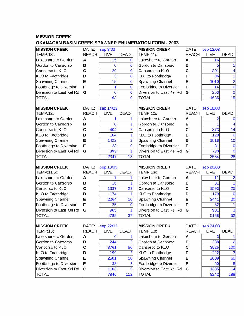
MISSION CREEK OKANAGAN BASIN CREEK SPAWNER ENUMERATION FORM - 2003 MISSION CREEK DATE: sep 8/03 MISSION CREEK DATE: sep 12/03 TEMP:13c REACH LIVE DEAD TEMP:11c REACH LIVE DEAD Lakeshore to Gordon A 15 0 Lakeshore to Gordon A 16 1Gordon to Cansorso B 0 0 Gordon to Cansorso B 5 5Cansorso to KLO C 29 0 Cansorso to KLO C 301 4KLO to Footbridge D 3 0 KLO to Footbridge D 86 1Spawning Channel E 15 0 Spawning Channel E 1010 2Footbridge to Diversion F 1 0 Footbridge to Diversion F 14 0Diversion to East Kel Rd G 0 0 Diversion to East Kel Rd G 253 2TOTAL 63 0 TOTAL 1685 15
MISSION CREEK DATE: sep 14/03 MISSION CREEK DATE: sep 16/03 TEMP:12c REACH LIVE DEAD TEMP:10c REACH LIVE DEAD Lakeshore to Gordon A 1 1 Lakeshore to Gordon A 2 0Gordon to Cansorso B 0 1 Gordon to Cansorso B 1 4Cansorso to KLO C 404 7 Cansorso to KLO C 873 14KLO to Footbridge D 104 1 KLO to Footbridge D 129 0Spawning Channel E 1422 2 Spawning Channel E 1818 10Footbridge to Diversion F 23 0 Footbridge to Diversion F 31 0Diversion to East Kel Rd G 393 1 Diversion to East Kel Rd G 730 0TOTAL 2347 13 TOTAL 3584 28
MISSION CREEK DATE: sep 18/03 MISSION CREEK DATE: sep 20/03 TEMP:11.5c REACH LIVE DEAD TEMP:13c REACH LIVE DEAD Lakeshore to Gordon A 7 1 Lakeshore to Gordon A 11 2Gordon to Cansorso B 16 1 Gordon to Cansorso B 31 1Cansorso to KLO C 1337 23 Cansorso to KLO C 1593 25KLO to Footbridge D 174 1 KLO to Footbridge D 179 0Spawning Channel E 2264 10 Spawning Channel E 2441 20Footbridge to Diversion F 25 0 Footbridge to Diversion F 32 1Diversion to East Kel Rd G 965 1 Diversion to East Kel Rd G 901 3TOTAL 4788 37 TOTAL 5188 52
MISSION CREEK DATE: sep 22/03 MISSION CREEK DATE: sep 24/03 TEMP:13c REACH LIVE DEAD TEMP:13c REACH LIVE DEAD Lakeshore to Gordon A 0 1 Lakeshore to Gordon A 3 1Gordon to Cansorso B 244 2 Gordon to Cansorso B 288 2Cansorso to KLO C 3761 50 Cansorso to KLO C 3525 100KLO to Footbridge D 199 2 KLO to Footbridge D 222 3Spawning Channel E 2501 50 Spawning Channel E 2809 60Footbridge to Diversion F 38 2 Footbridge to Diversion F 60 8Diversion to East Kel Rd G 1103 5 Diversion to East Kel Rd G 1335 14TOTAL 7846 112 TOTAL 8242 188

MISSION CREEK OKANAGAN BASIN CREEK SPAWNER ENUMERATION FORM - 2003 MISSION CREEK DATE: sep 26/03 MISSION CREEK DATE: sep 28/03 TEMP:14c REACH LIVE DEAD TEMP:12c REACH LIVE DEAD Lakeshore to Gordon A 6 6 Lakeshore to Gordon A 0 2Gordon to Cansorso B 198 10 Gordon to Cansorso B 168 10Cansorso to KLO C 3611 300 Cansorso to KLO C 2583 500KLO to Footbridge D 147 20 KLO to Footbridge D 137 25Spawning Channel E 2327 0 Spawning Channel E 1553 300Footbridge to Diversion F 42 18 Footbridge to Diversion F 30 30Diversion to East Kel Rd G 1162 58 Diversion to East Kel Rd G 1020 64TOTAL 7493 412 TOTAL 5491 931
MISSION CREEK DATE: sep 30/03 MISSION CREEK DATE: oct 3/03 TEMP:13c REACH LIVE DEAD TEMP:12c REACH LIVE DEAD Lakeshore to Gordon A 0 1 Lakeshore to Gordon A 0 30Gordon to Cansorso B 546 30 Gordon to Cansorso B 402 250Cansorso to KLO C 2500 500 Cansorso to KLO C 808 950KLO to Footbridge D 319 15 KLO to Footbridge D 39 15Spawning Channel E 909 350 Spawning Channel E 409 300Footbridge to Diversion F 22 21 Footbridge to Diversion F 18 10Diversion to East Kel Rd G 763 10 Diversion to East Kel Rd G 462 59TOTAL 5059 927 TOTAL 2138 1614
MISSION CREEK DATE: MISSION CREEK DATE: TEMP: REACH LIVE DEAD TEMP: REACH LIVE DEAD Lakeshore to Gordon A Lakeshore to Gordon A Gordon to Cansorso B Gordon to Cansorso B Cansorso to KLO C Cansorso to KLO C KLO to Footbridge D KLO to Footbridge D Spawning Channel E Spawning Channel E Footbridge to Diversion F Footbridge to Diversion F Diversion to East Kel Rd G Diversion to East Kel Rd G TOTAL TOTAL
MISSION CREEK DATE: MISSION CREEK DATE: TEMP: REACH LIVE DEAD TEMP: REACH LIVE DEAD Lakeshore to Gordon A Lakeshore to Gordon A Gordon to Cansorso B Gordon to Cansorso B Cansorso to KLO C Cansorso to KLO C KLO to Footbridge D KLO to Footbridge D Spawning Channel E Spawning Channel E Footbridge to Diversion F Footbridge to Diversion F Diversion to East Kel Rd G Diversion to East Kel Rd G TOTAL TOTAL

MILL CREEK OKANAGAN BASIN CREEK SPAWNER ENUMERATION FORM - 2003 MILL CREEK DATE: sept 8/03 MILL CREEK DATE: oct 3/03 TEMP: 13c REACH LIVE DEAD TEMP: 14c REACH LIVE DEAD Abbott to Ellis A 0 0 Abbott to Ellis A 0 0Ellis to Richter B 6 0 Ellis to Richter B 85 4Richter to Ethel C 1 0 Richter to Ethel C 33 2Ethel o Gordon D 5 0 Ethel o Gordon D 20 0Gordon to Harvey E 0 0 Gordon to Harvey E 58 1Harvey to Spall F 0 0 Harvey to Spall F 17 0Spall to City Work Yard G 0 0 Spall to City Work Yard G 0 0TOTAL 12 0 TOTAL 213 7
MILL CREEK DATE: oct 7/03 MILL CREEK DATE: oct
10/03 TEMP: 12c REACH LIVE DEAD TEMP: 11c REACH LIVE DEAD Abbott to Ellis A 0 1 Abbott to Ellis A 0 2Ellis to Richter B 80 8 Ellis to Richter B 94 10Richter to Ethel C 42 5 Richter to Ethel C 39 5Ethel o Gordon D 11 1 Ethel o Gordon D 12 0Gordon to Harvey E 63 2 Gordon to Harvey E 69 4Harvey to Spall F 11 0 Harvey to Spall F 14 1Spall to City Work Yard G 0 0 Spall to City Work Yard G 0 0TOTAL 207 17 TOTAL 218 21
MILL CREEK DATE: oct 14/03 MILL CREEK DATE: sep 24/03 TEMP:10c REACH LIVE DEAD TEMP:13c REACH LIVE DEAD Abbott to Ellis A 0 0 Abbott to Ellis A 0 0Ellis to Richter B 90 14 Ellis to Richter B 46 0Richter to Ethel C 30 11 Richter to Ethel C 30 0Ethel o Gordon D 7 0 Ethel o Gordon D 18 0Gordon to Harvey E 28 5 Gordon to Harvey E 45 0Harvey to Spall F 17 1 Harvey to Spall F 3 0Spall to City Work Yard G 0 0 Spall to City Work Yard G 0 0TOTAL 172 31 TOTAL 142 0
MILL CREEK DATE: sep
27/03 MILL CREEK DATE: sep 30/03
TEMP:15c REACH LIVE DEAD TEMP:14.5c REACH LIVE DEAD Abbott to Ellis A 0 0 Abbott to Ellis A 0 1Ellis to Richter B 76 1 Ellis to Richter B 35 0Richter to Ethel C 32 1 Richter to Ethel C 26 0Ethel o Gordon D 31 0 Ethel o Gordon D 4 0Gordon to Harvey E 64 3 Gordon to Harvey E 46 0Harvey to Spall F 0 0 Harvey to Spall F 5 0Spall to City Work Yard G 0 0 Spall to City Work Yard G 0 0TOTAL 203 5 TOTAL 116 1

PENTICTON AND NARAMATA CREEKS
OKANAGAN BASIN CREEK SPAWNER ENUMERATION FORM - 2003 PENTICTON CREEK DATE: sep 9/03 PENTICTON CREEK DATE: sep 14/03 TEMP:12c REACH LIVE DEAD TEMP:12c REACH LIVE DEADGreyhound Spill to mouth A 0 0 Greyhound Spill to mouth A 69 9Wade footbrdg to greyhnd spill B 2 0 Wade footbrdg to greyhnd spill B 87 1Wade to Ekhart C 2 0 Wade to Ekhart C 89 0TOTAL 4 0 TOTAL 245 10
PENTICTON CREEK DATE: sep 17/03 PENTICTON CREEK DATE: sep 20/03 TEMP:12c REACH LIVE DEAD TEMP:14c REACH LIVE DEADGreyhound Spill to mouth A 201 18 Greyhound Spill to mouth A 297 10Wade footbrdg to greyhnd spill B 280 0 Wade footbrdg to greyhnd spill B 399 3Wade to Ekhart C 146 1 Wade to Ekhart C 331 4TOTAL 627 19 TOTAL 1027 17
PENTICTON CREEK DATE: sep 23/03 PENTICTON CREEK DATE: sep 26/03 TEMP:15c REACH LIVE DEAD TEMP:15c REACH LIVE DEADGreyhound Spill to mouth A 430 28 Greyhound Spill to mouth A 169 11Wade footbrdg to greyhnd spill B 429 6 Wade footbrdg to greyhnd spill B 161 2Wade to Ekhart C 351 4 Wade to Ekhart C 226 2TOTAL 1210 38 TOTAL 556 15
PENTICTON CREEK DATE: sep 29/03 PENTICTON CREEK DATE: oct 2/03TEMP:16c REACH LIVE DEAD TEMP:12c REACH LIVE DEADGreyhound Spill to mouth A 148 40 Greyhound Spill to mouth A 34 10Wade footbrdg to greyhnd spill B 209 18 Wade footbrdg to greyhnd spill B 61 3Wade to Ekhart C 297 14 Wade to Ekhart C 49 3TOTAL 654 72 TOTAL 144 16
PENTICTON CREEK DATE: PENTICTON CREEK DATE: TEMP: REACH LIVE DEAD TEMP: REACH LIVE DEADGreyhound Spill to mouth A Greyhound Spill to mouth A Wade footbrdg to greyhnd spill B Wade footbrdg to greyhnd spill B Wade to Ekhart C Wade to Ekhart C TOTAL TOTAL
NARAMATA CREEK DATE: sep 20/03 NARAMATA CREEK DATE: oct 2/03TEMP:13c LIVE DEAD TEMP:15c LIVE DEAD
0 0 0 0
NARAMATA CREEK DATE: NARAMATA CREEK DATE: TEMP: LIVE DEAD TEMP: LIVE DEAD
POWERS CREEK OKANAGAN BASIN CREEK SPAWNER ENUMERATION FORM - 2003 POWERS CREEK DATE: sep 9/03 POWERS CREEK DATE: sep 14/03 TEMP:13c REACH LIVE DEAD TEMP:12c REACH LIVE DEAD Fish ladder down/str A 77 11 Fish ladder down/str A 160 11Lower Weir B 10 0 Lower Weir B 35 0Middle Weir C 10 0 Middle Weir C 69 0Top Weir (below pool) D 10 1 Top Weir (below pool) D 13 0Pool (below ladder) E 20 1 Pool (below ladder) E 49 2Ladder and Upstream F 24 1 Ladder and Upstream F 23 0TOTAL 151 14 TOTAL 349 13
POWERS CREEK DATE: sep 17/03 POWERS CREEK DATE: sep 20/03 TEMP:10c REACH LIVE DEAD TEMP:11c REACH LIVE DEAD Fish ladder down/str A 291 15 Fish ladder down/str A 510 25Lower Weir B 52 3 Lower Weir B 60 6Middle Weir C 65 2 Middle Weir C 79 3Top Weir (below pool) D 13 0 Top Weir (below pool) D 17 1Pool (below ladder) E 71 3 Pool (below ladder) E 117 5Ladder and Upstream F 25 1 Ladder and Upstream F 49 3TOTAL 517 24 TOTAL 832 43
POWERS CREEK DATE: sep 23/03 POWERS CREEK DATE: sep 26/03 TEMP:12c REACH LIVE DEAD TEMP:14c REACH LIVE DEAD Fish ladder down/str A 598 75 Fish ladder down/str A 635 100Lower Weir B 79 20 Lower Weir B 42 10Middle Weir C 80 2 Middle Weir C 76 2Top Weir (below pool) D 27 0 Top Weir (below pool) D 19 0Pool (below ladder) E 126 7 Pool (below ladder) E 184 10Ladder and Upstream F 50 3 Ladder and Upstream F 39 3TOTAL 960 107 TOTAL 995 125
POWERS CREEK DATE: sep 29/03 POWERS CREEK DATE: oct 2/03 TEMP:12c REACH LIVE DEAD TEMP:11c REACH LIVE DEAD Fish ladder down/str A 519 200 Fish ladder down/str A 320 200Lower Weir B 44 25 Lower Weir B 27 16Middle Weir C 50 5 Middle Weir C 32 4Top Weir (below pool) D 8 1 Top Weir (below pool) D 7 2Pool (below ladder) E 42 10 Pool (below ladder) E 29 6Ladder and Upstream F 187 11 Ladder and Upstream F 111 10TOTAL 850 252 TOTAL 526 238
TROUT, ENEAS, PRARIE VALLEY, LAMBLY AND SMITH CREEKS OKANAGAN BASIN CREEK SPAWNER ENUMERATION FORM - 2003 TROUT CREEK DATE: sep 20/03 TROUT CREEK DATE: oct 2/03 TEMP:16c REACH LIVE DEAD TEMP: 14c REACH LIVE DEAD Below Highway A 36 16 Below Highway A 13 8Above Highway B 10 0 Above Highway B 37 9TOTAL 46 16 TOTAL 50 17
TROUT CREEK DATE: TROUT CREEK DATE: TEMP: REACH LIVE DEAD TEMP: REACH LIVE DEAD Below Highway A Below Highway A Above Highway B Above Highway B TOTAL TOTAL
ENEAS CREEK DATE: sep 23/03 ENEAS CREEK DATE: oct 2/03 TEMP:13c REACH LIVE DEAD TEMP:14c REACH LIVE DEAD Below Highway A 13 1 Below Highway A 7 7Above Highway B 0 0 Above Highway B 0 0TOTAL 13 1 TOTAL 7 7
ENEAS CREEK DATE: ENEAS CREEK DATE: TEMP: REACH LIVE DEAD TEMP: REACH LIVE DEAD Below Highway A Below Highway A Above Highway B Above Highway B TOTAL TOTAL
PRARIE VLLEY CR DATE: sep 23/03 PRARIE VLLEY CR DATE: oct 2/03 TEMP:13c LIVE DEAD TEMP:13c LIVE DEAD
0 0 0 0
LAMBLY CREEK DATE: sep 21/03 LAMBLY CREEK DATE: oct 3/03 TEMP:12c REACH LIVE DEAD TEMP:11c REACH LIVE DEAD Below Highway A 21 0 Below Highway A 13 1Above Highway B 6 0 Above Highway B 8 4TOTAL 27 0 TOTAL 21 5
LAMBLY CREEK DATE: LAMBLY CREEK DATE: TEMP: REACH LIVE DEAD TEMP: REACH LIVE DEAD Below Highway A Below Highway A Above Highway B Above Highway B TOTAL TOTAL
SMITH CREEK DATE: sep 27/03 SMITH CREEK DATE: TEMP:n/a LIVE DEAD TEMP: LIVE DEAD
12 0

TREPANIER AND PEACHLAND CREEKS
OKANAGAN BASIN CREEK SPAWNER ENUMERATION FORM - 2003 TREPANIER CREEK DATE: sep 9/03 TREPANIER CREEK DATE: sep 14/03 TEMP:13c REACH LIVE DEAD TEMP:13c REACH LIVE DEAD Below Highway A 0 0 Below Highway A 10 0Above Highway B 0 0 Above Highway B 30 0TOTAL 0 0 TOTAL 40 0
TREPANIER CREEK DATE: sep
17/03 TREPANIER CREEK DATE: sep 20/03
TEMP:11c REACH LIVE DEAD TEMP:13c REACH LIVE DEAD Below Highway A 47 0 Below Highway A 116 2Above Highway B 79 1 Above Highway B 166 2TOTAL 126 1 TOTAL 282 4
TREPANIER CREEK DATE: sep
23/03 TREPANIER CREEK DATE: sep 26/03
TEMP:12c REACH LIVE DEAD TEMP:14c REACH LIVE DEAD Below Highway A 325 6 Below Highway A 455 30Above Highway B 153 1 Above Highway B 138 6TOTAL 478 7 TOTAL 593 36
TREPANIER CREEK DATE: sep
29/03 TREPANIER CREEK DATE: oct 2/03
TEMP:13c REACH LIVE DEAD TEMP:12c REACH LIVE DEAD Below Highway A 477 50 Below Highway A 274 72Above Highway B 173 5 Above Highway B 105 23TOTAL 650 55 TOTAL 379 95
TREPANIER CREEK DATE: TREPANIER CREEK DATE: TEMP: REACH LIVE DEAD TEMP: REACH LIVE DEAD Below Highway A Below Highway A Above Highway B Above Highway B TOTAL TOTAL
PEACHLAND CR TEMP LIVE DEAD PEACHLAND CR TEMP LIVE DEAD DATE:sep 9/03 11c 819 2 DATE:sep 14/03 11c 1711 23
PEACHLAND CR TEMP LIVE DEAD PEACHLAND CR TEMP LIVE DEAD DATE:sep 17/03 10c 2023 32 DATE:sep 20/03 11c 2507 56
PEACHLAND CR TEMP LIVE DEAD PEACHLAND CR TEMP LIVE DEAD DATE:sep 23/03 11c 2767 125 DATE:sep 26/03 12c 2163 300
PEACHLAND CR TEMP LIVE DEAD PEACHLAND CR TEMP LIVE DEAD DATE:sep 29/03 11c 1855 400 DATE:oct 2/03 12c 1630 550

VERNON AND SHORTS CREEKS OKANAGAN BASIN CREEK SPAWNER ENUMERATION FORM - 2003 VERNON CREEK DATE: oct 6/03 VERNON CREEK DATE: oct
14/03 TEMP:18c REACH LIVE DEAD TEMP:14c REACH LIVE DEADMouth to OK landing rd A 1 0 Mouth to OK landing rd A 14 1OK land rd to BigChief trail prk B 8 1 OK land rd to BigChief trail prk B 26 1BigChief trail prk to sewge plant C 4 0 BigChief trail prk to sewge plant C 1 8Sewage plnt to 43rd st D 1 0 Sewage plnt to 43rd st D 3 043 st to Hyw #97 E 0 0 43 st to Hyw #97 E 2 1Hyw #97 to Vernon golf crs F 0 0 Hyw #97 to Vernon golf crs F 0 0Vernon Golf crs to Kal lake G 0 0 Vernon Golf crs to Kal lake G 0 0TOTAL 14 1 TOTAL 46 11
VERNON CREEK DATE: VERNON CREEK DATE: TEMP: REACH LIVE DEAD TEMP: REACH LIVE DEADMouth to OK landing rd A Mouth to OK landing rd A OK land rd to BigChief trail prk B OK land rd to BigChief trail prk B BigChief trail prk to sewge plant C BigChief trail prk to sewge plant C Sewage plnt to 43rd st D Sewage plnt to 43rd st D 43 st to Hyw #97 E 43 st to Hyw #97 E Hyw #97 to Vernon golf crs F Hyw #97 to Vernon golf crs F Vernon Golf crs to Kal lake G Vernon Golf crs to Kal lake G TOTAL TOTAL
VERNON CREEK DATE: VERNON CREEK DATE: TEMP: REACH LIVE DEAD TEMP: REACH LIVE DEADMouth to OK landing rd A Mouth to OK landing rd A OK land rd to BigChief trail prk B OK land rd to BigChief trail prk B BigChief trail prk to sewge plant C BigChief trail prk to sewge plant C Sewage plnt to 43rd st D Sewage plnt to 43rd st D 43 st to Hyw #97 E 43 st to Hyw #97 E Hyw #97 to Vernon golf crs F Hyw #97 to Vernon golf crs F Vernon Golf crs to Kal lake G Vernon Golf crs to Kal lake G TOTAL TOTAL
SHORTS CREEK DATE: DRY SHORTS CREEK DATE: TEMP: LIVE DEAD TEMP: LIVE DEAD
SHORTS CREEK DATE: SHORTS CREEK DATE: TEMP: LIVE DEAD TEMP: LIVE DEAD

MIDDLE VERNON AND WINFIELD OKANAGAN BASIN CREEK SPAWNER ENUMERATION FORM - 2003 MID VERN. CREEK DATE: sep 28/03 MID VERN. CREEK DATE: oct 1/03 TEMP:15c REACH LIVE DEAD TEMP:11c REACH LIVE DEAD Mouth to No. 1 brdge A 2 0 Mouth to No. 1 brdge A 0 0No. 1 brdge to lodge rd B 317 37 No. 1 brdge to lodge rd B 815 38Lodge rd to beaver lk rd C 0 0 Lodge rd to beaver lk rd C 5 0Beaver lk rd to Duck lk D 0 0 Beaver lk rd to Duck lk D 0 0TOTAL 319 37 TOTAL 820 38
MID VERN. CREEK DATE: oct 6/03 MID VERN. CREEK DATE: oct
10/03 TEMP:10c REACH LIVE DEAD TEMP:9c REACH LIVE DEAD Mouth to No. 1 brdge A 4 1 Mouth to No. 1 brdge A 8 5No. 1 brdge to lodge rd B 2497 116 No. 1 brdge to lodge rd B 2676 280Lodge rd to beaver lk rd C 796 70 Lodge rd to beaver lk rd C 2350 250Beaver lk rd to Duck lk D 0 0 Beaver lk rd to Duck lk D 0 0TOTAL 3297 187 TOTAL 5034 535
MID VERN. CREEK DATE: oct 14/03 MID VERN. CREEK DATE: oct
18/03 TEMP:9c REACH LIVE DEAD TEMP:9c REACH LIVE DEAD Mouth to No. 1 brdge A 3 10 Mouth to No. 1 brdge A 2 10No. 1 brdge to lodge rd B 3082 750 No. 1 brdge to lodge rd B 1500 990Lodge rd to beaver lk rd C 2010 1000 Lodge rd to beaver lk rd C 2007 1850Beaver lk rd to Duck lk D 0 0 Beaver lk rd to Duck lk D 0 0TOTAL 5095 1810 TOTAL 3509 2850
WINFIELD CREEK DATE: sep 28/03 WINFIELD CREEK DATE: oct 1/03 TEMP:12c REACH LIVE DEAD TEMP:9c REACH LIVE DEAD
A 397 20 A 432 25
WINFIELD CREEK DATE: oct 6/03 WINFIELD CREEK DATE: oct 10/03
TEMP:10c REACH LIVE DEAD TEMP:9c REACH LIVE DEAD A 726 60 A 853 49
WINFIELD CREEK DATE: oct 14/03 WINFIELD CREEK DATE: oct 18/03
TEMP:9c REACH LIVE DEAD TEMP:9c REACH LIVE DEAD A 719 60 A 358 100

COLDSTREAM CREEK OKANAGAN BASIN CREEK SPAWNER ENUMERATION FORM - 2003 COLDSTREAM CREEK DATE: sep
28/03 COLDSTREAM CREEK DATE: oct 1/03
TEMP:14c REACH LIVE DEAD TEMP:12c REACH LIVE DEAD Mouth to Postill rd A 142 0 Mouth to Postill rd A 72 2Postill rd to Mclounie rd B 280 0 Postill rd to Mclounie rd B 1020 0Mclounie to Enhncmnt wiers C 404 0 Mclounie to Enhncmnt wiers C 1317 0Enhncmnt wiers D 14 0 Enhncmnt wiers D 22 0Wiers to Coldstrm Cr rd E 80 0 Wiers to Coldstrm Cr rd E 200 0Coldstrm Cr rd to Howe rd F 96 1 Coldstrm Cr rd to Howe rd F 162 2Howe rd to Ranch spillway G 10 0 Howe rd to Ranch spillway G 20 0TOTAL 1026 1 TOTAL 2813 4
COLDSTREAM CREEK DATE: oct 6/03 COLDSTREAM CREEK DATE: oct 10/03 TEMP:10c REACH LIVE DEAD TEMP:9c REACH LIVE DEAD Mouth to Postill rd A 540 40 Mouth to Postill rd A 1360 10Postill rd to Mclounie rd B 3712 12 Postill rd to Mclounie rd B 4516 50Mclounie to Enhncmnt wiers C 2540 0 Mclounie to Enhncmnt wiers C 4020 42Enhncmnt wiers D 60 1 Enhncmnt wiers D 110 1Wiers to Coldstrm Cr rd E 590 8 Wiers to Coldstrm Cr rd E 900 14Coldstrm Cr rd to Howe rd F 500 1 Coldstrm Cr rd to Howe rd F 899 2Howe rd to Ranch spillway G 119 0 Howe rd to Ranch spillway G 35 0TOTAL 8061 62 TOTAL 11840 119
COLDSTREAM CREEK DATE: oct 14/03 COLDSTREAM CREEK DATE: oct 18/03 TEMP:10c REACH LIVE DEAD TEMP:8c REACH LIVE DEAD Mouth to Postill rd A 1440 50 Mouth to Postill rd A 540 300Postill rd to Mclounie rd B 4320 400 Postill rd to Mclounie rd B 3583 1000Mclounie to Enhncmnt wiers C 4260 175 Mclounie to Enhncmnt wiers C 3100 750Enhncmnt wiers D 178 10 Enhncmnt wiers D 103 20Wiers to Coldstrm Cr rd E 820 30 Wiers to Coldstrm Cr rd E 600 40Coldstrm Cr rd to Howe rd F 983 7 Coldstrm Cr rd to Howe rd F 850 200Howe rd to Ranch spillway G 468 10 Howe rd to Ranch spillway G 465 50TOTAL 12469 682 TOTAL 9241 2360

OKANAGAN RIVER CHANNEL
OKANAGAN BASIN CREEK SPAWNER ENUMERATION FORM - 2003 OK RIVER CHANNEL DATE: sep 21/03 OK RIVER CHANNEL DATE: sep 29/03 TEMP:18c REACH LIVE DEAD TEMP:14c REACH LIVE DEAD Skaha Lk to Fairview brdg A 182 2 Skaha Lk to Fairview brdg A 69 10Fairview brdg to Diffuser gravl B 0 0 Fairview brdg to Diffuser gravl B 14 0Sewage diffuser gravel C 63 1 Sewage diffuser gravel C 2 0Diffuser gravl to Rotatilled sect D 22 0 Diffuser gravl to Rotatilled sect D 52 0Rotatilled section E 20 0 Rotatilled section E 196 0Rotatilled sect to railway brdg F 0 0 Rotatilled sect to railway brdg F 86 0Railway brdg to golf brdg G 29 0 Railway brdg to golf brdg G 0 6Golf brdg to enhanced sect H 47 0 Golf brdg to enhanced sect H 1 0Enhanced section I 245 0 Enhanced section I 3 0Enhanced sect to hwy bridge J 11 0 Enhanced sect to hwy bridge J 71 0Hwy bridge to dam K 0 0 Hwy bridge to dam K 10 0TOTAL 619 3 TOTAL 504 16
OK RIVER CHANNEL DATE: oct 8/03 OK RIVER CHANNEL DATE: oct 18/03TEMP:15c REACH LIVE DEAD TEMP:13.5c REACH LIVE DEAD Skaha Lk to Fairview brdg A 300 6 Skaha Lk to Fairview brdg A 1310 16Fairview brdg to Diffuser gravl B 1403 3 Fairview brdg to Diffuser gravl B 2700 0Sewage diffuser gravel C 0 0 Sewage diffuser gravel C 2100 10Diffuser gravl to Rotatilled sect D 0 0 Diffuser gravl to Rotatilled sect D 1150 0Rotatilled section E 0 0 Rotatilled section E 1250 0Rotatilled sect to railway brdg F 0 0 Rotatilled sect to railway brdg F 1500 2Railway brdg to golf brdg G 2 0 Railway brdg to golf brdg G 2050 6Golf brdg to enhanced sect H 80 0 Golf brdg to enhanced sect H 3040 2Enhanced section I 100 0 Enhanced section I 3000 0Enhanced sect to hwy bridge J 990 0 Enhanced sect to hwy bridge J 20300 1Hwy bridge to dam K 0 0 Hwy bridge to dam K 2920 1TOTAL 2893 9 TOTAL 41320 38
OK RIVER CHANNEL DATE: oct 25/03 OK RIVER CHANNEL DATE: oct 30/03TEMP:11c REACH LIVE DEAD TEMP:8c REACH LIVE DEAD Skaha Lk to Fairview brdg A 2300 5 Skaha Lk to Fairview brdg A 500 50Fairview brdg to Diffuser gravl B 1000 10 Fairview brdg to Diffuser gravl B 3180 150Sewage diffuser gravel C 1500 20 Sewage diffuser gravel C 0 0Diffuser gravl to Rotatilled sect D 3500 30 Diffuser gravl to Rotatilled sect D 0 0Rotatilled section E 1000 30 Rotatilled section E 0 0Rotatilled sect to railway brdg F 1200 10 Rotatilled sect to railway brdg F 0 0Railway brdg to golf brdg G 4740 100 Railway brdg to golf brdg G 4060 580Golf brdg to enhanced sect H 5000 50 Golf brdg to enhanced sect H 2060 260Enhanced section I 4000 150 Enhanced section I 2000 100Enhanced sect to hwy bridge J 17400 150 Enhanced sect to hwy bridge J 10200 100Hwy bridge to dam K 4350 15 Hwy bridge to dam K 2400 20TOTAL 45990 570 TOTAL 24400 1260

APPENDIX II KOKANEE SAMPLE DATA

CREEK NAME DATE LENGTH SEX OTOLITH # EGGS PENTICTON 23-Sep 279 F 1 4 PENTICTON 23-Sep 558 M 2 PENTICTON 23-Sep 328 F 3 55 PENTICTON 23-Sep 320 F 4 29 PENTICTON 23-Sep 284 F 5 0 PENTICTON 23-Sep 280 F 6 1 PENTICTON 23-Sep 273 M 7 PENTICTON 23-Sep 272 M 8 PENTICTON 23-Sep 329 M 9 PENTICTON 23-Sep 362 M 10 PENTICTON 23-Sep 272 M 11 PENTICTON 23-Sep 299 F 12 43 PENTICTON 23-Sep 344 F 13 10 PENTICTON 23-Sep 520 M 14 PENTICTON 23-Sep 646 M 15 PENTICTON 23-Sep 549 M 16 PENTICTON 23-Sep 353 M 17 PENTICTON 23-Sep 240 M 18 PENTICTON 23-Sep 308 F 19 3 PENTICTON 23-Sep 266 M 20 PENTICTON 23-Sep 258 F 21 186 PENTICTON 23-Sep 364 M 22 PENTICTON 23-Sep 269 M 23 PENTICTON 23-Sep 324 M 24 PENTICTON 23-Sep 304 M 25 PENTICTON 23-Sep 380 M 26 PENTICTON 23-Sep 268 F 27 302 PENTICTON 23-Sep 379 M 28 PENTICTON 23-Sep 270 F 29 4 PENTICTON 23-Sep 253 F 30 20 PENTICTON 23-Sep 260 F 31 136 PENTICTON 23-Sep 270 M 32 PENTICTON 23-Sep 256 F 33 0 PENTICTON 23-Sep 320 M 34 PENTICTON 23-Sep 286 F 35 9 PENTICTON 23-Sep 285 M 36 PENTICTON 23-Sep 342 M 37 PENTICTON 23-Sep 452 F 38 380 PENTICTON 23-Sep 381 F 39 1208 PENTICTON 23-Sep 286 M 40 PENTICTON 29-Sep 397 F 41 989 PENTICTON 29-Sep 346 M 42 PENTICTON 29-Sep 306 F 43 19 PENTICTON 29-Sep 502 M 44 PENTICTON 29-Sep 405 M 45 PENTICTON 29-Sep 336 F 46 6 PENTICTON 29-Sep 319 M 47 PENTICTON 29-Sep 299 M 48

PENTICTON 29-Sep 307 F 49 12 PENTICTON 29-Sep 262 F 50 0 PENTICTON 29-Sep 331 F 42 PENTICTON 29-Sep 298 M PENTICTON 29-Sep 284 M PENTICTON 29-Sep 339 M PENTICTON 29-Sep 314 M PENTICTON 29-Sep 446 F 960 PENTICTON 29-Sep 302 M PENTICTON 29-Sep 396 M PENTICTON 29-Sep 281 M PENTICTON 29-Sep 280 F 378 PENTICTON 29-Sep 323 M PENTICTON 29-Sep 280 F 9 PENTICTON 29-Sep 276 F 1 PENTICTON 29-Sep 375 M PENTICTON 29-Sep 266 M PENTICTON 29-Sep 389 F 335 PENTICTON 29-Sep 249 F 388 PENTICTON 29-Sep 345 F 0 PENTICTON 29-Sep 277 M PENTICTON 29-Sep 245 M PENTICTON 29-Sep 309 M PENTICTON 29-Sep 266 F 15 PENTICTON 29-Sep 400 F 3 PENTICTON 29-Sep 395 F 8 PENTICTON 29-Sep 391 M PENTICTON 29-Sep 432 M PENTICTON 29-Sep 269 M PENTICTON 29-Sep 253 M PENTICTON 29-Sep 266 F 1 PENTICTON 29-Sep 438 F 1 PENTICTON 29-Sep 319 F 15 PENTICTON 29-Sep 281 M PENTICTON 29-Sep 331 F 272 PENTICTON 29-Sep 336 F 1 PENTICTON 29-Sep 241 F 19 PENTICTON 29-Sep 324 F 3 PENTICTON 29-Sep 347 M PENTICTON 29-Sep 272 M PENTICTON 29-Sep 357 M PENTICTON 29-Sep 291 F 4 PENTICTON 29-Sep 276 F 0 PENTICTON 29-Sep 240 F 13 PENTICTON 8-Oct 329 F 1 PENTICTON 8-Oct 274 M PENTICTON 8-Oct 342 M PENTICTON 8-Oct 234 F 1 PENTICTON 8-Oct 331 F 0 PENTICTON 8-Oct 335 M

PENTICTON 8-Oct 256 F 10 PENTICTON 8-Oct 288 F 10 POWERS 23-Sep 250 F 1 1 POWERS 23-Sep 356 M 2 POWERS 23-Sep 368 M 3 POWERS 23-Sep 255 F 4 1 POWERS 23-Sep 250 F 5 20 POWERS 23-Sep 426 F 6 65 POWERS 23-Sep 502 M 7 POWERS 23-Sep 278 M 8 POWERS 23-Sep 276 M 9 POWERS 23-Sep 385 M 10 POWERS 23-Sep 254 F 11 8 POWERS 23-Sep 241 M 12 POWERS 23-Sep 356 F 13 1288 POWERS 23-Sep 391 M 14 POWERS 23-Sep 460 M 15 POWERS 23-Sep 378 M 16 POWERS 23-Sep 375 F 17 43 POWERS 29-Sep 440 M 18 POWERS 29-Sep 276 M 19 POWERS 29-Sep 438 M 20 POWERS 29-Sep 549 F 21 289 POWERS 29-Sep 559 M 22 POWERS 29-Sep 627 F 23 452 POWERS 29-Sep 445 F 24 384 POWERS 29-Sep 372 M 25 POWERS 29-Sep 432 M 26 POWERS 29-Sep 255 F 27 0 POWERS 29-Sep 287 M 28 POWERS 29-Sep 260 M 29 POWERS 29-Sep 252 F 30 1 POWERS 29-Sep 253 F 31 14 POWERS 29-Sep 265 F 32 2 POWERS 29-Sep 283 M 33 POWERS 29-Sep 265 M 34 POWERS 29-Sep 452 M 35 POWERS 29-Sep 260 F 36 3 POWERS 29-Sep 264 F 37 206 POWERS 29-Sep 424 M 38 POWERS 29-Sep 285 F 39 89 POWERS 29-Sep 269 M 40 POWERS 29-Sep 285 M 41 POWERS 29-Sep 267 F 42 4 POWERS 29-Sep 288 M 43 POWERS 29-Sep 234 M 44 POWERS 29-Sep 281 M 45 POWERS 29-Sep 254 M 46 POWERS 29-Sep 263 M 47 POWERS 29-Sep 230 F 48 1

POWERS 29-Sep 274 M 49 POWERS 29-Sep 251 M 50 POWERS 29-Sep 277 F 0 POWERS 2-Oct 272 M POWERS 2-Oct 272 M POWERS 2-Oct 241 F 4 POWERS 2-Oct 397 F 4 POWERS 2-Oct 364 M POWERS 2-Oct 270 M POWERS 2-Oct 279 F 2 POWERS 2-Oct 383 M POWERS 2-Oct 336 F 0 POWERS 2-Oct 231 F 1 POWERS 2-Oct 270 F 0 POWERS 2-Oct 326 M POWERS 2-Oct 260 M POWERS 2-Oct 245 M POWERS 2-Oct 257 F 0 POWERS 2-Oct 247 F 7 POWERS 2-Oct 292 M POWERS 2-Oct 307 M POWERS 2-Oct 260 F 18 POWERS 2-Oct 266 F 1 POWERS 2-Oct 291 M POWERS 2-Oct 371 M POWERS 2-Oct 296 M POWERS 2-Oct 515 M POWERS 2-Oct 438 M POWERS 2-Oct 227 F 0 POWERS 2-Oct 285 M POWERS 2-Oct 300 F 1 POWERS 7-Oct 303 F 2 POWERS 7-Oct 380 M POWERS 7-Oct 221 F 8 POWERS 7-Oct 221 F 4 POWERS 7-Oct 240 F 0 POWERS 7-Oct 327 M POWERS 7-Oct 325 M POWERS 7-Oct 244 F 0 POWERS 7-Oct 242 F 8 POWERS 7-Oct 234 F 0 POWERS 7-Oct 230 F 0 POWERS 7-Oct 226 F 2 POWERS 7-Oct 225 F 2 POWERS 7-Oct 367 M POWERS 7-Oct 398 M POWERS 7-Oct 241 F 1 POWERS 7-Oct 305 M POWERS 7-Oct 341 M POWERS 7-Oct 248 F 0

POWERS 7-Oct 230 F 0 POWERS 7-Oct 253 F 14 PEACHLAND 23-Sep 403 F 1 5 PEACHLAND 23-Sep 386 M 2 PEACHLAND 23-Sep 430 M 3 PEACHLAND 23-Sep 394 M 4 PEACHLAND 23-Sep 400 F 5 0 PEACHLAND 23-Sep 401 F 6 129 PEACHLAND 23-Sep 387 F 7 0 PEACHLAND 23-Sep 349 M 8 PEACHLAND 23-Sep 362 F 9 0 PEACHLAND 23-Sep 330 F 10 1 PEACHLAND 23-Sep 372 F 11 40 PEACHLAND 23-Sep 479 M 12 PEACHLAND 23-Sep 415 F 13 1974 PEACHLAND 23-Sep 369 F 14 51 PEACHLAND 23-Sep 364 F 15 0 PEACHLAND 23-Sep 499 M 16 PEACHLAND 23-Sep 436 M 17 PEACHLAND 23-Sep 341 F 18 0 PEACHLAND 23-Sep 456 F 19 1 PEACHLAND 23-Sep 344 M 20 PEACHLAND 23-Sep 349 F 21 3 PEACHLAND 23-Sep 240 F 22 0 PEACHLAND 23-Sep 283 M 23 PEACHLAND 23-Sep 403 M 24 PEACHLAND 23-Sep 391 F 25 92 PEACHLAND 26-Sep 370 F 26 16 PEACHLAND 26-Sep 390 M 27 PEACHLAND 26-Sep 444 M 28 PEACHLAND 26-Sep 522 F 29 97 PEACHLAND 26-Sep 247 F 30 0 PEACHLAND 26-Sep 341 M 31 PEACHLAND 26-Sep 350 F 32 1 PEACHLAND 26-Sep 539 F 33 437 PEACHLAND 26-Sep 451 F 34 7 PEACHLAND 26-Sep 440 M 35 PEACHLAND 26-Sep 461 F 36 37 PEACHLAND 26-Sep 408 F 37 4 PEACHLAND 26-Sep 366 M 38 PEACHLAND 26-Sep 278 F 39 0 PEACHLAND 26-Sep 288 M 40 PEACHLAND 26-Sep 248 M 41 PEACHLAND 26-Sep 326 F 42 16 PEACHLAND 26-Sep 296 F 43 0 PEACHLAND 26-Sep 273 F 44 0 PEACHLAND 29-Sep 302 M 45 PEACHLAND 29-Sep 261 F 46 0 PEACHLAND 29-Sep 280 F 47 10 PEACHLAND 29-Sep 389 M 48

PEACHLAND 29-Sep 517 M 49 PEACHLAND 29-Sep 551 M 50 PEACHLAND 29-Sep 323 M PEACHLAND 29-Sep 559 M PEACHLAND 29-Sep 345 F 0 PEACHLAND 29-Sep 310 F 43 PEACHLAND 29-Sep 356 M PEACHLAND 29-Sep 463 F 82 PEACHLAND 29-Sep 357 M PEACHLAND 29-Sep 356 M PEACHLAND 29-Sep 373 F 2 PEACHLAND 29-Sep 321 F 4 PEACHLAND 29-Sep 467 F 51 PEACHLAND 29-Sep 268 F 1 PEACHLAND 29-Sep 381 F 25 PEACHLAND 29-Sep 356 M PEACHLAND 29-Sep 452 M PEACHLAND 29-Sep 371 M PEACHLAND 29-Sep 382 M PEACHLAND 29-Sep 290 M PEACHLAND 29-Sep 322 F 4 PEACHLAND 29-Sep 454 M PEACHLAND 29-Sep 310 F 62 PEACHLAND 29-Sep 274 F 5 PEACHLAND 29-Sep 444 M PEACHLAND 29-Sep 377 F 0 PEACHLAND 29-Sep 431 M PEACHLAND 29-Sep 483 M PEACHLAND 29-Sep 344 F 98 PEACHLAND 29-Sep 301 F 3 PEACHLAND 7-Oct 421 M PEACHLAND 7-Oct 460 F 2 PEACHLAND 7-Oct 360 F 168 PEACHLAND 7-Oct 292 M PEACHLAND 7-Oct 282 M PEACHLAND 7-Oct 258 M PEACHLAND 7-Oct 358 F 23 PEACHLAND 7-Oct 324 M PEACHLAND 7-Oct 290 M PEACHLAND 7-Oct 283 M PEACHLAND 7-Oct 399 F 1 PEACHLAND 7-Oct 310 M PEACHLAND 7-Oct 325 M PEACHLAND 7-Oct 260 F 1 PEACHLAND 7-Oct 241 F 0 PEACHLAND 7-Oct 320 F 18 PEACHLAND 7-Oct 281 F 20 PEACHLAND 7-Oct 374 F 455 PEACHLAND 7-Oct 310 M PEACHLAND 7-Oct 291 M

PEACHLAND 7-Oct 237 F 6 PEACHLAND 7-Oct 460 M MISSION 27-Sep 630 M 1 MISSION 27-Sep 450 F 2 1 MISSION 27-Sep 435 M 3 MISSION 27-Sep 260 F 4 0 MISSION 27-Sep 266 M 5 MISSION 27-Sep 354 M 6 MISSION 27-Sep 262 M 7 MISSION 27-Sep 291 M 8 MISSION 27-Sep 243 F 9 0 MISSION 27-Sep 226 M 10 MISSION 27-Sep 364 M 11 MISSION 27-Sep 269 M 12 MISSION 27-Sep 313 F 13 152 MISSION 27-Sep 333 F 14 35 MISSION 27-Sep 306 M 15 MISSION 27-Sep 289 M 16 MISSION 27-Sep 258 F 17 1 MISSION 27-Sep 502 M 18 MISSION 27-Sep 246 M 19 MISSION 27-Sep 250 M 20 MISSION 27-Sep 251 F 21 2 MISSION 27-Sep 287 M 22 MISSION 27-Sep 532 F 23 9 MISSION 27-Sep 455 M 24 MISSION 27-Sep 420 F 25 0 MISSION 27-Sep 308 F 26 120 MISSION 27-Sep 480 M 27 MISSION 27-Sep 436 M 28 MISSION 27-Sep 420 F 29 26 MISSION 27-Sep 314 M 30 MISSION 27-Sep 340 F 31 18 MISSION 27-Sep 388 M 32 MISSION 27-Sep 343 F 33 32 MISSION 27-Sep 281 M 34 MISSION 27-Sep 264 M 35 MISSION 27-Sep 457 F 36 124 MISSION 27-Sep 381 F 37 48 MISSION 27-Sep 504 M 38 MISSION 27-Sep 316 M 39 MISSION 27-Sep 380 F 40 5 MISSION 27-Sep 275 M 41 MISSION 27-Sep 341 M 42 MISSION 27-Sep 364 F 43 8 MISSION 27-Sep 360 F 44 25 MISSION 27-Sep 432 M 45 MISSION 27-Sep 440 M 46 MISSION 27-Sep 282 M 47 MISSION 30-Sep 516 F 48 113

MISSION 30-Sep 392 F 49 14 MISSION 30-Sep 397 F 50 0 MISSION 30-Sep 297 F 1 MISSION 30-Sep 469 M MISSION 30-Sep 342 F 0 MISSION 30-Sep 484 F 64 MISSION 30-Sep 255 F 2 MISSION 30-Sep 481 F 0 MISSION 30-Sep 394 F 0 MISSION 30-Sep 257 M MISSION 30-Sep 255 F 8 MISSION 30-Sep 361 M MISSION 30-Sep 464 F 158 MISSION 30-Sep 251 F 6 MISSION 30-Sep 264 F 2 MISSION 30-Sep 380 M MISSION 30-Sep 350 F 20 MISSION 30-Sep 417 F 1 MISSION 30-Sep 241 M MISSION 30-Sep 261 M MISSION 3-Oct 241 F 1 MISSION 3-Oct 334 M MISSION 3-Oct 397 F 0 MISSION 3-Oct 569 M MISSION 3-Oct 396 F 64 MISSION 3-Oct 357 F 1 MISSION 3-Oct 335 M MISSION 3-Oct 464 M MISSION 3-Oct 494 M MISSION 3-Oct 263 M MISSION 3-Oct 297 M MISSION 3-Oct 341 M MISSION 3-Oct 331 M MISSION 3-Oct 477 M MISSION 3-Oct 393 F 2 MISSION 3-Oct 575 M MISSION 3-Oct 450 F 1 MISSION 3-Oct 306 M MISSION 3-Oct 376 F 97 MISSION 3-Oct 410 M MISSION 3-Oct 336 M MISSION 3-Oct 281 M MISSION 3-Oct 349 M MISSION 3-Oct 348 M MISSION 3-Oct 272 M MISSION 3-Oct 302 F 38 MISSION 3-Oct 370 F 45 MISSION 3-Oct 425 F 0 MISSION 3-Oct 296 M MISSION 3-Oct 332 M

MISSION 3-Oct 264 F 0 MISSION 3-Oct 330 F 15 OK RIVER 25-Oct 246 M 1 OK RIVER 25-Oct 268 F 2 8 OK RIVER 25-Oct 371 M 3 OK RIVER 25-Oct 255 M 4 OK RIVER 25-Oct 252 F 5 2 OK RIVER 25-Oct 240 M 6 OK RIVER 25-Oct 334 M 7 OK RIVER 25-Oct 243 F 8 0 OK RIVER 25-Oct 258 F 9 1 OK RIVER 25-Oct 245 F 10 39 OK RIVER 25-Oct 252 M 11 OK RIVER 30-Oct 235 F 12 1 OK RIVER 30-Oct 254 F 13 80 OK RIVER 30-Oct 253 M 14 OK RIVER 30-Oct 246 M 15 OK RIVER 30-Oct 254 F 16 0 OK RIVER 30-Oct 247 M 17 OK RIVER 30-Oct 256 F 18 0 OK RIVER 30-Oct 252 F 19 2 OK RIVER 30-Oct 241 F 20 1 OK RIVER 30-Oct 246 F 21 6 OK RIVER 30-Oct 253 F 22 18 OK RIVER 30-Oct 263 F 23 28 OK RIVER 30-Oct 258 F 24 0 OK RIVER 30-Oct 238 F 25 0 OK RIVER 30-Oct 234 F 26 1 OK RIVER 30-Oct 259 M 27 OK RIVER 30-Oct 240 M 28 OK RIVER 30-Oct 308 M 29 OK RIVER 30-Oct 262 M 30 OK RIVER 30-Oct 254 M 31 OK RIVER 30-Oct 246 M 32 OK RIVER 30-Oct 234 M 33 OK RIVER 30-Oct 238 M 34 OK RIVER 30-Oct 252 M 35 OK RIVER 30-Oct 236 M 36 OK RIVER 30-Oct 220 M 37 OK RIVER 30-Oct 240 M 38 OK RIVER 30-Oct 253 F 39 70 OK RIVER 30-Oct 253 F 40 1 OK RIVER 30-Oct 268 F 41 91 OK RIVER 30-Oct 232 F 42 1 OK RIVER 30-Oct 241 F 43 1 OK RIVER 30-Oct 242 F 44 5 OK RIVER 30-Oct 236 F 45 6 OK RIVER 30-Oct 242 F 46 4 OK RIVER 30-Oct 234 F 47 0 OK RIVER 30-Oct 238 M 48

OK RIVER 30-Oct 463 M 49 OK RIVER 30-Oct 255 M 50 OK RIVER 30-Oct 247 M OK RIVER 30-Oct 243 M OK RIVER 30-Oct 254 M OK RIVER 30-Oct 243 M OK RIVER 30-Oct 252 M OK RIVER 30-Oct 268 M OK RIVER 30-Oct 258 M OK RIVER 30-Oct 249 M OK RIVER 30-Oct 254 M OK RIVER 30-Oct 231 M OK RIVER 30-Oct 254 M OK RIVER 30-Oct 250 M OK RIVER 30-Oct 241 M OK RIVER 30-Oct 249 M OK RIVER 30-Oct 266 M OK RIVER 30-Oct 250 M OK RIVER 30-Oct 301 M OK RIVER 30-Oct 247 M OK RIVER 30-Oct 235 M OK RIVER 30-Oct 253 M OK RIVER 30-Oct 242 M OK RIVER 30-Oct 249 M OK RIVER 30-Oct 243 M OK RIVER 30-Oct 242 M OK RIVER 30-Oct 240 F 6 OK RIVER 30-Oct 246 F 43 OK RIVER 30-Oct 253 F 10 OK RIVER 30-Oct 231 F 3 OK RIVER 30-Oct 247 F 2 OK RIVER 30-Oct 229 F 0 OK RIVER 30-Oct 245 F 8 OK RIVER 30-Oct 254 F 2 OK RIVER 30-Oct 255 F 0 OK RIVER 30-Oct 258 F 6 OK RIVER 30-Oct 227 F 3 OK RIVER 30-Oct 244 F 3 OK RIVER 30-Oct 245 F 0 OK RIVER 30-Oct 238 F 2 OK RIVER 30-Oct 240 F 0 OK RIVER 30-Oct 245 F 3 OK RIVER 30-Oct 246 M OK RIVER 30-Oct 257 M OK RIVER 30-Oct 233 M OK RIVER 30-Oct 255 M OK RIVER 30-Oct 226 F 5 OK RIVER 30-Oct 245 F 4 OK RIVER 30-Oct 249 F 0 OK RIVER 30-Oct 248 F 3

OK RIVER 30-Oct 243 F 0 OK RIVER 30-Oct 221 F 0

APPENDIX III PHOTOS
Photo #1. Man-made swim area at Mission Creek approx. 400m D/S of East Kelowna Road Bridge. Section was occupied by 50-300 spawners.
Photo #2. Peachland Creek male kokanee.
