petrogenesis of igneous roks in the eminene knos …
TRANSCRIPT
PETROGENESIS OF IGNEOUS ROCKS IN THE EMINENCE KNOBS REGION: SOUTHWESTERN ST. FRANCOIS MOUNTAINS, MISSOURI
Meszaros, Nicholas1, Mills, James G.1
1Department of Geosciences, DePauw University, 602 South College Ave., Greencastle, Indiana 46135 Contact: [email protected]
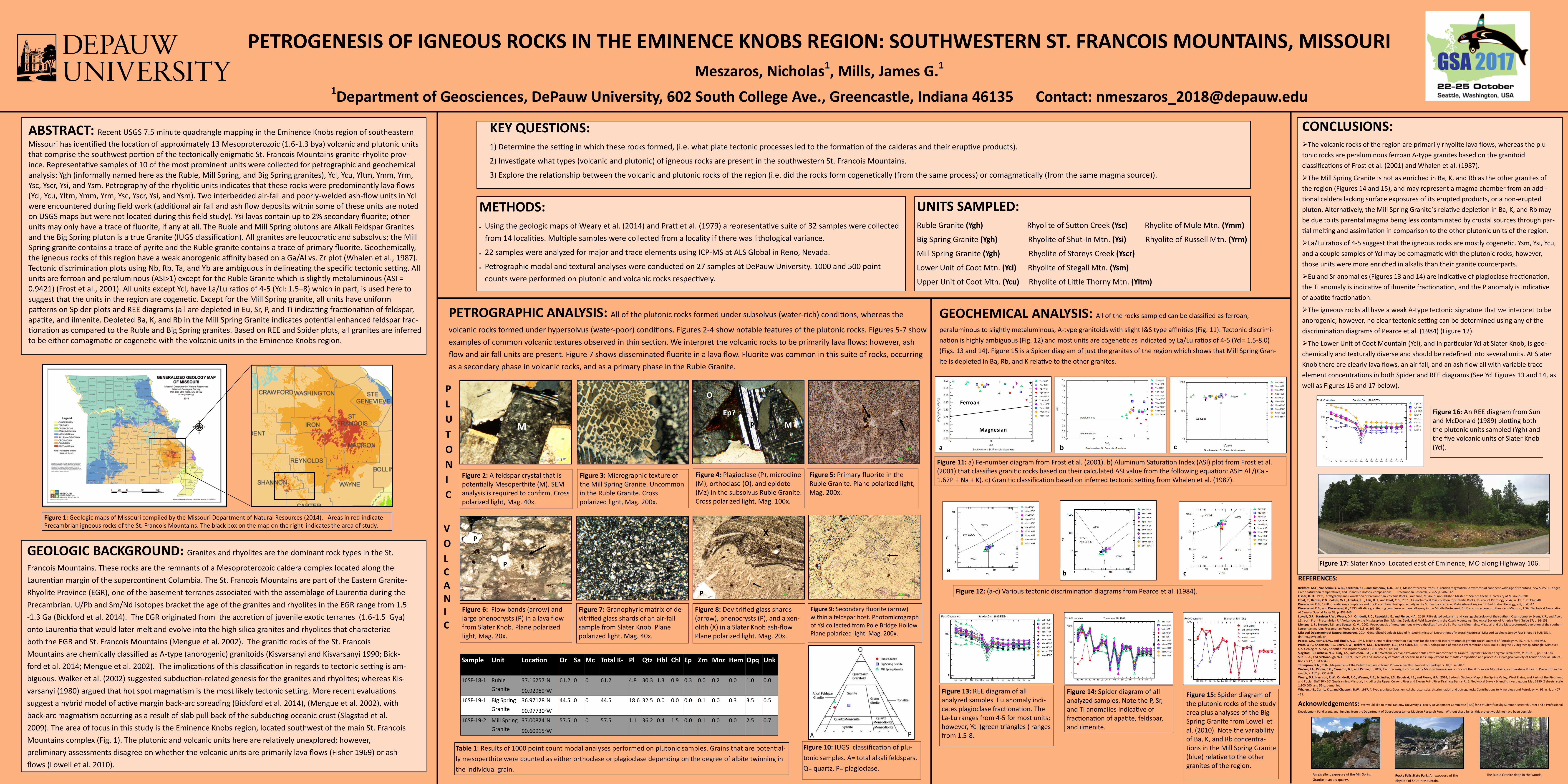
ABSTRACT: Recent USGS 7.5 minute quadrangle mapping in the Eminence Knobs region of southeastern
Missouri has identified the location of approximately 13 Mesoproterozoic (1.6-1.3 bya) volcanic and plutonic units that comprise the southwest portion of the tectonically enigmatic St. Francois Mountains granite-rhyolite prov-ince. Representative samples of 10 of the most prominent units were collected for petrographic and geochemical analysis: Ygh (informally named here as the Ruble, Mill Spring, and Big Spring granites), Ycl, Ycu, Yltm, Ymm, Yrm, Ysc, Yscr, Ysi, and Ysm. Petrography of the rhyolitic units indicates that these rocks were predominantly lava flows (Ycl, Ycu, Yltm, Ymm, Yrm, Ysc, Yscr, Ysi, and Ysm). Two interbedded air-fall and poorly-welded ash-flow units in Ycl were encountered during field work (additional air fall and ash flow deposits within some of these units are noted on USGS maps but were not located during this field study). Ysi lavas contain up to 2% secondary fluorite; other units may only have a trace of fluorite, if any at all. The Ruble and Mill Spring plutons are Alkali Feldspar Granites and the Big Spring pluton is a true Granite (IUGS classification). All granites are leucocratic and subsolvus; the Mill Spring granite contains a trace of pyrite and the Ruble granite contains a trace of primary fluorite. Geochemically, the igneous rocks of this region have a weak anorogenic affinity based on a Ga/Al vs. Zr plot (Whalen et al., 1987). Tectonic discrimination plots using Nb, Rb, Ta, and Yb are ambiguous in delineating the specific tectonic setting. All units are ferroan and peraluminous (ASI>1) except for the Ruble Granite which is slightly metaluminous (ASI = 0.9421) (Frost et al., 2001). All units except Ycl, have La/Lu ratios of 4-5 (Ycl: 1.5–8) which in part, is used here to suggest that the units in the region are cogenetic. Except for the Mill Spring granite, all units have uniform patterns on Spider plots and REE diagrams (all are depleted in Eu, Sr, P, and Ti indicating fractionation of feldspar, apatite, and ilmenite. Depleted Ba, K, and Rb in the Mill Spring Granite indicates potential enhanced feldspar frac-tionation as compared to the Ruble and Big Spring granites. Based on REE and Spider plots, all granites are inferred to be either comagmatic or cogenetic with the volcanic units in the Eminence Knobs region.
KEY QUESTIONS: 1) Determine the setting in which these rocks formed, (i.e. what plate tectonic processes led to the formation of the calderas and their eruptive products).
2) Investigate what types (volcanic and plutonic) of igneous rocks are present in the southwestern St. Francois Mountains.
3) Explore the relationship between the volcanic and plutonic rocks of the region (i.e. did the rocks form cogenetically (from the same process) or comagmatically (from the same magma source)).
GEOLOGIC BACKGROUND: Granites and rhyolites are the dominant rock types in the St.
Francois Mountains. These rocks are the remnants of a Mesoproterozoic caldera complex located along the
Laurentian margin of the supercontinent Columbia. The St. Francois Mountains are part of the Eastern Granite-
Rhyolite Province (EGR), one of the basement terranes associated with the assemblage of Laurentia during the
Precambrian. U/Pb and Sm/Nd isotopes bracket the age of the granites and rhyolites in the EGR range from 1.5
-1.3 Ga (Bickford et al. 2014). The EGR originated from the accretion of juvenile exotic terranes (1.6-1.5 Gya)
onto Laurentia that would later melt and evolve into the high silica granites and rhyolites that characterize
both the EGR and St. Francois Mountains (Mengue et al. 2002). The granitic rocks of the St. Francois
Mountains are chemically classified as A-type (anorogenic) granitoids (Kisvarsanyi and Kisvarsanyi 1990; Bick-
ford et al. 2014; Mengue et al. 2002). The implications of this classification in regards to tectonic setting is am-
biguous. Walker et al. (2002) suggested subduction-related genesis for the granites and rhyolites; whereas Kis-
varsanyi (1980) argued that hot spot magmatism is the most likely tectonic setting. More recent evaluations
suggest a hybrid model of active margin back-arc spreading (Bickford et al. 2014), (Mengue et al. 2002), with
back-arc magmatism occurring as a result of slab pull back of the subducting oceanic crust (Slagstad et al.
2009). The area of focus in this study is the Eminence Knobs region, located southwest of the main St. Francois
Mountains complex (Fig. 1). The plutonic and volcanic units here are relatively unexplored; however,
preliminary assessments disagree on whether the volcanic units are primarily lava flows (Fisher 1969) or ash-
flows (Lowell et al. 2010).
METHODS: Using the geologic maps of Weary et al. (2014) and Pratt et al. (1979) a representative suite of 32 samples were collected
from 14 localities. Multiple samples were collected from a locality if there was lithological variance. 22 samples were analyzed for major and trace elements using ICP-MS at ALS Global in Reno, Nevada. Petrographic modal and textural analyses were conducted on 27 samples at DePauw University. 1000 and 500 point
counts were performed on plutonic and volcanic rocks respectively.
UNITS SAMPLED: Ruble Granite (Ygh) Rhyolite of Sutton Creek (Ysc) Rhyolite of Mule Mtn. (Ymm)
Big Spring Granite (Ygh) Rhyolite of Shut-In Mtn. (Ysi) Rhyolite of Russell Mtn. (Yrm)
Mill Spring Granite (Ygh) Rhyolite of Storeys Creek (Yscr)
Lower Unit of Coot Mtn. (Ycl) Rhyolite of Stegall Mtn. (Ysm)
Upper Unit of Coot Mtn. (Ycu) Rhyolite of Little Thorny Mtn. (Yltm)
PETROGRAPHIC ANALYSIS: All of the plutonic rocks formed under subsolvus (water-rich) conditions, whereas the
volcanic rocks formed under hypersolvus (water-poor) conditions. Figures 2-4 show notable features of the plutonic rocks. Figures 5-7 show
examples of common volcanic textures observed in thin section. We interpret the volcanic rocks to be primarily lava flows; however, ash
flow and air fall units are present. Figure 7 shows disseminated fluorite in a lava flow. Fluorite was common in this suite of rocks, occurring
as a secondary phase in volcanic rocks, and as a primary phase in the Ruble Granite.
P
L
U
T
O
N
I
C
Figure 2: A feldspar crystal that is potentially Mesoperthite (M). SEM analysis is required to confirm. Cross polarized light, Mag. 40x.
M
Figure 3: Micrographic texture of the Mill Spring Granite. Uncommon in the Ruble Granite. Cross polarized light, Mag. 200x.
Figure 5: Primary fluorite in the Ruble Granite. Plane polarized light, Mag. 200x.
V
O
L C A N I C
Figure 6: Flow bands (arrow) and large phenocrysts (P) in a lava flow from Slater Knob. Plane polarized light, Mag. 20x.
Figure 7: Granophyric matrix of de-vitrified glass shards of an air-fall sample from Slater Knob. Plane polarized light. Mag. 40x.
Figure 8: Devitrified glass shards (arrow), phenocrysts (P), and a xen-olith (X) in a Slater Knob ash-flow. Plane polarized light. Mag. 20x.
Figure 9: Secondary fluorite (arrow) within a feldspar host. Photomicrograph of Ysi collected from Pole Bridge Hollow. Plane polarized light. Mag. 200x.
P
P
P
X
Figure 4: Plagioclase (P), microcline (M), orthoclase (O), and epidote (Mz) in the subsolvus Ruble Granite. Cross polarized light, Mag. 100x.
P
O
M
Ep?
GEOCHEMICAL ANALYSIS: All of the rocks sampled can be classified as ferroan,
peraluminous to slightly metaluminous, A-type granitoids with slight I&S type affinities (Fig. 11). Tectonic discrimi-
nation is highly ambiguous (Fig. 12) and most units are cogenetic as indicated by La/Lu ratios of 4-5 (Ycl= 1.5-8.0)
(Figs. 13 and 14). Figure 15 is a Spider diagram of just the granites of the region which shows that Mill Spring Gran-
ite is depleted in Ba, Rb, and K relative to the other granites.
Figure 11: a) Fe-number diagram from Frost et al. (2001). b) Aluminum Saturation Index (ASI) plot from Frost et al. (2001) that classifies granitic rocks based on their calculated ASI value from the following equation: ASI= Al /(Ca - 1.67P + Na + K). c) Granitic classification based on inferred tectonic setting from Whalen et al. (1987).
a b
Ferroan
Magnesian
syn-COLG
WPG
VAG
ORG
.1
1
10
100
.1
1
10
100
Ta
Yb
Ycl-16SF
Ycu-16SF
Ysi-16SF
Ygh-16SF
Ysc-16SF
Yrm-16SF
Yltm-16SF
Ysm-16SF
Ymm-16SF
Yscr-16SF
Figure 12: (a-c) Various tectonic discrimination diagrams from Pearce et al. (1984).
a b c
Figure 16: An REE diagram from Sun and McDonald (1989) plotting both the plutonic units sampled (Ygh) and the five volcanic units of Slater Knob (Ycl).
Figure 13: REE diagram of all analyzed samples. Eu anomaly indi-cates plagioclase fractionation. The La-Lu ranges from 4-5 for most units; however, Ycl (green triangles ) ranges from 1.5-8.
Figure 14: Spider diagram of all analyzed samples. Note the P, Sr, and Ti anomalies indicative of fractionation of apatite, feldspar, and ilmenite.
Figure 15: Spider diagram of the plutonic rocks of the study area plus analyses of the Big Spring Granite from Lowell et al. (2010). Note the variability of Ba, K, and Rb concentra-tions in the Mill Spring Granite (blue) relative to the other granites of the region.
CONCLUSIONS: The volcanic rocks of the region are primarily rhyolite lava flows, whereas the plu-
tonic rocks are peraluminous ferroan A-type granites based on the granitoid
classifications of Frost et al. (2001) and Whalen et al. (1987).
The Mill Spring Granite is not as enriched in Ba, K, and Rb as the other granites of
the region (Figures 14 and 15), and may represent a magma chamber from an addi-
tional caldera lacking surface exposures of its erupted products, or a non-erupted
pluton. Alternatively, the Mill Spring Granite’s relative depletion in Ba, K, and Rb may
be due to its parental magma being less contaminated by crustal sources through par-
tial melting and assimilation in comparison to the other plutonic units of the region.
La/Lu ratios of 4-5 suggest that the igneous rocks are mostly cogenetic. Ysm, Ysi, Ycu,
and a couple samples of Ycl may be comagmatic with the plutonic rocks; however,
those units were more enriched in alkalis than their granite counterparts.
Eu and Sr anomalies (Figures 13 and 14) are indicative of plagioclase fractionation,
the Ti anomaly is indicative of ilmenite fractionation, and the P anomaly is indicative
of apatite fractionation.
The igneous rocks all have a weak A-type tectonic signature that we interpret to be
anorogenic; however, no clear tectonic setting can be determined using any of the
discrimination diagrams of Pearce et al. (1984) (Figure 12).
The Lower Unit of Coot Mountain (Ycl), and in particular Ycl at Slater Knob, is geo-
chemically and texturally diverse and should be redefined into several units. At Slater
Knob there are clearly lava flows, an air fall, and an ash flow all with variable trace
element concentrations in both Spider and REE diagrams (See Ycl Figures 13 and 14, as
well as Figures 16 and 17 below).
Figure 17: Slater Knob. Located east of Eminence, MO along Highway 106.
REFERENCES: Bickford, M.E., Van Schmus, W.R., Karltrom, K.E., and Kamenov, G.D., 2014, Mesoproterozoic-trans-Laurentian magmatism: A synthesis of continent-wide age distributons, new SIMS U-Pb ages, zircon saturation temperatures, and Hf and Nd isotopic compositions: Precambrian Research, v. 265, p. 286-312. Fisher, H. H., 1969, Stratigraphy and Correlation of Precambrian Volcanic Rocks, Eminence, Missouri, unpublished Master of Science thesis: University of Missouri-Rolla
Frost, R., Barnes, C.G., Collins, W.J., Arculus, R.J., Ellis, D. J., and Frost, C.D., 2001, A Geochemical Classification for Granitic Rocks, Journal of Petrology: v. 42, n. 11, p. 2033-2048. Kisvarsanyi, E.B., 1980, Granitic ring complexes and the Precambrian hot spot activity in the St. Francois terrane, Midcontinent region, United States: Geology, v.8, p. 43-47 Kisvarsanyi, E.B., and Kisvarsanyi, G., 1990, Alkaline granite ring complexes and metallogeny in the Middle Proterozoic St. Francois terrane, southeastern Missouri, USA: Geological Association of Canada, Special Paper 38, p. 433-446. Lowell, G.R., Harrison R.W., Weary, D.J., Orndorff, R.C., Repetski, J.E., and Pierce, H.A., 2010, Rift-related volcanism and karst geohydrology of the southern Ozark dome, in Evans, K.R., and Aber, J.S., eds., From Precambrian Rift Volcanoes to the Mississppian Shelf Margin: Geological Field Excursions in the Ozark Mountains: Geological Society of America Field Guide 17, p. 99-158. Mengue, J. F., Brewer, T.S., and Seeger, C. M., 2002, Petrogenesis of metaluminous A-type rhyolites from the St. Francois Mountains, Missouri and the Mesoproterozoic evolution of the southern Laurentian margin: Precambrian Research, v. 113, p. 269-291. Missouri Department of Natural Resources, 2014, Generalized Geologic Map of Missouri: Missouri Department of Natural Resources, Missouri Geologic Survey Fact Sheet #1 PUB 2514, dnr.mo.gov/geology
Pearce, J.A., Harris, B.W., and Tindle, A.G., 1984, Trace element discrimination diagrams for the tectonic interpretation of granitic rocks: Journal of Petrology, v. 25, n. 4, p. 956-983. Pratt, W.P., Anderson, R.E., Berry, A.W., Bickford, M.E., Kisvarsanyi, E.B., and Sides, J.R., 1979, Geologic map of exposed Precambrian rocks, Rolla 1 degree x 2 degrees quadrangle, Missouri: U.S. Geological Survey Scientific Investigations Map I-1161, scale 1:125,000. Slagstad, T., Culshaw, N.G., Daly, J.S., Jamieson, R.A., 2009, Western Grenville Province holds key to midcontinental Granite-Rhyolite Province enigma: Terra Nova, V. 21, n. 3, pp. 181-187
Sun S. -s., and McDonough, W.F., 1989, Chemical and isotopic systematics of oceanic basalts: implications for mantle composition and processes: Geological Society of London Special Publica-tions, v.42, p. 313-345. Thompson, R.N., 1982. Magmatism of the British Tertiary Volcanic Province. Scottish Journal of Geology, v. 18, p. 49-107. Walker, J.A., Pippin, C.G., Cameron, B.I., and Patino, L., 2002, Tectonic insights provided by Mesoproterozoic mafic rocks of the St. Francois Mountains, southeastern Missouri: Precambrian Re-search, v. 117, p. 251-268. Weary, D.J., Harrison, R.W., Orndorff, R.C., Weems, R.E., Schindler, J.S., Repetski, J.E., and Pierce, H.A., 2014, Bedrock Geologic Map of the Spring Valley, West Plains, and Parts of the Piedmont and Poplar Bluff 30’x 60’ Quadrangles, Missouri, Including the Upper Current River and Eleven Point River Drainage Basins: U. S. Geological Survey Scientific Investiagtions Map 3280, 2 sheets, scale 1:100,000, and 55-p. pamphlet. Whalen, J.B., Currie, K.L., and Chappell, B.W., 1987, A-Type granites: Geochemical characteristics, discrimination and petrogenesis: Contributions to Mineralogy and Petrology, v. 95, n. 4, p. 407-
419.
Acknowledgements: We would like to thank DePauw University’s Faculty Development Committee (FDC) for a Student/Faculty Summer Research Grant and a Professional
Development Fund grant, and, funding from the Department of Geosciences James Madison Research Fund. Without these funds, this project would not have been possible.
An excellent exposure of the Mill Spring
Granite in an old quarry. Rocky Falls State Park: An exposure of the
Rhyolite of Shut-In Mountain.
The Ruble Granite deep in the woods.
Sample Unit Location Or Sa Mc Total K- Pl Qtz Hbl Chl Ep Zrn Mnz Hem Opq Unk
16SF-18-1 Ruble
Granite
37.16257ºN
90.92989ºW
61.2 0 0 61.2 4.8 30.3 1.3 0.9 0.3 0.0 0.2 0.0 1.0 0.0
16SF-19-1 Big Spring
Granite
36.97128ºN
90.97730ºW
44.5 0 0 44.5 18.6 32.5 0.0 0.0 0.0 0.1 0.0 0.3 3.5 0.5
16SF-19-2 Mill Spring
Granite
37.00824ºN
90.60915ºW
57.5 0 0 57.5 1.1 36.2 0.4 1.5 0.0 0.1 0.0 0.0 2.5 0.7
c
Table 1: Results of 1000 point count modal analyses performed on plutonic samples. Grains that are potential-
ly mesoperthite were counted as either orthoclase or plagioclase depending on the degree of albite twinning in
the individual grain.
Figure 10: IUGS classification of plu-
tonic samples. A= total alkali feldspars,
Q= quartz, P= plagioclase.