pimpama river catchment study guide - … · pimpama river catchment study guide 4 activity booklet...
TRANSCRIPT

Pimpama River Catchment
Study Guide 2013

Pimpama River Catchment Study Guide
2
Document control sheet Title:
Pimpama River Catchment Study Guide
Authors:
Michael Brett, Sarah Butler, Dionne Coburn, Lucy Fouche, Diana Kiss, Kate Leopold, Linda McLeay, Rosie Palmer, Kieran Richardt, Emma Tait
File reference:
NED12-0013_Pimpama River Catchment Study Guide
Project leader:
Kieran Richardt
Email:
Client:
City of Gold Coast
Client contact:
Roslynne O’Connell
Revision History Version: Purpose: Issued by: Date Reviewer: Date: Draft Client review Natura Pacific 6/5/2013 Roslynne O’Connell 6/5/2013 2nd Draft Client review Natura Pacific 21/5/2013 Roslynne O’Connell 30/5/20133rd Draft Client review Natura Pacific 24/6/2013 Roslynne O’Connell 27/6/2013

Pimpama River Catchment Study Guide
3
Table of contents Section 1 Background ......................................................................................................................... 6
1.1 The Pimpama River Catchment Study Guide ......................................................... 6 1.2 Aims and objectives ................................................................................................ 6 1.3 How to use this study guide .................................................................................... 7
Section 2 The Pimpama River catchment ........................................................................................... 8 2.1 Pimpama River catchment history .......................................................................... 8
2.1.1 The Pimpama River catchment arose from Gondwana .................... 8 2.1.2 Aboriginal cultural heritage ................................................................ 8 2.1.3 European settlement of the catchment ............................................ 10
2.2 Catchment location ................................................................................................ 10 2.3 Environmental features ......................................................................................... 12
2.3.1 Waterways ....................................................................................... 12 2.3.2 Reaches of the catchment ............................................................... 12 2.3.3 Catchment vegetation ...................................................................... 14
2.4 Environmental processes ...................................................................................... 17 2.4.1 Maintenance of water quantity and flood mitigation ........................ 17 2.4.2 Maintenance of water quality ........................................................... 18
2.5 Environmental significance ................................................................................... 18 2.5.1 Areas of environmental significance ................................................ 18 2.5.2 Rare and threatened flora ................................................................ 21 2.5.3 Rare and threatened fauna .............................................................. 24
2.6 Current catchment land use .................................................................................. 28 2.7 Current catchment health ...................................................................................... 28
2.7.1 Catchment health ............................................................................. 28 2.7.2 Estuarine health ............................................................................... 28
2.8 Catchment management issues and management .............................................. 30 2.8.1 Vegetation loss ................................................................................ 30 2.8.2 Stormwater quality and movement .................................................. 32 2.8.3 Drinking water quality and management ......................................... 33
Section 3 Study guide resources ...................................................................................................... 34 3.1 Waterway and catchment health monitoring ......................................................... 34
3.1.1 Macroinvertebrates .......................................................................... 34 3.1.2 Habitat assessment ......................................................................... 43 3.1.3 Physico-chemical testing ................................................................. 46 3.1.4 Recording data ................................................................................ 54 3.1.5 Safety ............................................................................................... 56
3.2 Useful reports ........................................................................................................ 57 3.3 Useful websites ..................................................................................................... 57
Section 4 Activities toolkit .................................................................................................................. 58 4.1 How to use this toolkit ........................................................................................... 58 4.2 Curriculum objectives / links .................................................................................. 58 4.3 Broad learning activities ........................................................................................ 60
Activity 1 Conservation in the Pimpama River Catchment ............................. 61 Activity 2 News flash ....................................................................................... 64 Activity 3 Soundscape exploration .................................................................. 66 Activity 4 Plant identification cards .................................................................. 68 Activity 5 Birds in paradise .............................................................................. 70 Activity 6 Get to know your catchment ............................................................ 72
4.4 Specific learning activities ..................................................................................... 94 4.4.1 Background ...................................................................................... 94 4.4.2 Year level learning activity booklets .............................................. 113

Pimpama River Catchment Study Guide
4
Activity booklet Year 1 and 2: Wildlife protectors! – Catchment conservation ... ............................................................................................ 114
Activity booklet Year 3: Who’s habitat is that? Investigating survival needs 120 Activity booklet Year 4 Activity: The cycle of life – macroinvertebrates ....... 125 Activity booklet Year 5: Riparian rescuers – Healthy catchment vegetation 132 Activity booklet Year 6: Catchments under threat ........................................ 138 Activity booklet Year 7: Specialised adaptations ......................................... 148 Activity booklet Year 8: Physico-chemical testing ........................................ 157 Activity booklet Year 9: Monitoring the Pimpama River Wetlands ............... 165 Activity booklet Year 10: The lay of the land ................................................ 176
Section 5 Bibliography ..................................................................................................................... 181 Section 6 Appendices ...................................................................................................................... 186
Appendix 1 Screenshot of Wildlife Online webpage ........................................ 187 Appendix 2 Historic land cover within the Pimpama River Catchment ............ 188 Appendix 3 Current land cover within the Pimpama River Catchment ............ 189 Appendix 4 Plant identification card ................................................................. 190 Appendix 5 Birds in paradise field identification data sheet ............................ 191 Appendix 6 “How would you manage our catchment?” activity sheet ............. 192 Appendix 7 Healthy vs unhealthy catchment poster ........................................ 193 Appendix 8 Teachers’ answer sheet for Year 3: Who’s habitat is that? –
investigating survival needs .......................................................... 194 Appendix 9 Identification chart for macroinvertebrates ................................... 195 Appendix 10 Teachers’ answer sheet for Year 4: The cycle of life –
macroinvertebrates ....................................................................... 196 Appendix 11 Pimpama River and other Gold Coast catchments ...................... 198 Appendix 12 Current remnant vegetation within the Pimpama River Catchment
...................................................................................................... 199 Appendix 13 Dichotomous key for macroinvertebrates ..................................... 200
List of figures Figure 1 Location and extent of the Pimpama River catchment ........................................................ 11 Figure 2 Upper freshwater reaches of the Pimpama River Catchment: a) relatively undisturbed; and
b) cleared for agricultural land and rural-residential land use. ............................................ 13 Figure 3 Lower freshwater reaches of the Pimpama River Catchment – cleared for sugar cane
farms and grazing. ............................................................................................................... 14 Figure 4 Lower estuarine reaches of the Pimpama River Catchment – relatively undisturbed ......... 14 Figure 5 Remnant vegetation within the Pimpama River Catchment ................................................ 16 Figure 6 Vegetation associated with waterways is called riparian vegetation ................................... 17 Figure 7 Significant environmental areas within the Pimpama River catchment ............................... 20 Figure 8 Pimpama River catchment current land use ....................................................................... 29 Figure 9 Incomplete life cycle: dragonfly ........................................................................................... 35 Figure 10 Complete life cycle: diptera species such as flies ............................................................... 36 Figure 11 pH of commonly found substances. .................................................................................... 48 Figure 12 Dissolved oxygen calculation chart based on water temperature. ...................................... 50 Figure 13 Cross section of a waterway ................................................................................................ 52 Figure 14 Catchment crawl sites .......................................................................................................... 73 Figure 15 Catchment crawl sites for the Upper Catchment Tour Program.......................................... 75 Figure 16 Catchment crawl sites for the Lower to Upper Catchment Tour Program: A ...................... 77 Figure 17 Catchment crawl sites for the Lower to Upper Catchment Tour Program: B ...................... 78 Figure 18 Catchment crawl sites for Upper to Mid Catchment Tour Program ..................................... 80

Pimpama River Catchment Study Guide
5
List of tables Table 1 Structure of the Pimpama River Catchment Study Guide ....................................................... 7 Table 3 Rare or threatened fauna within Pimpama River catchment, where: V = Vulnerable, R =
Rare, S = Special Cultural Significance, M = Migratory. ....................................................... 24 Table 4 Macroinvertebrate habitat types and common species-habitat associations ........................ 38 Table 5 Water quality monitoring – macroinvertebrate identification chart ............................................. Table 6 Water quality monitoring – macroinvertebrate data sheet. ........................................................ Table 7 Correspondence between signal score and environmental rating for macroinvertebrate
sampling................................................................................................................................. 41 Table 8 Connections between macroinvertebrate sample results and water ..................................... 41 Table 9 Health of waterway based on Sensitivity rating method ........................................................ 42 Table 10 Water quality monitoring – habitat assessment guidelines ....................................................... Table 11 Water quality monitoring – habitat assessment data sheet ....................................................... Table 12 Water quality monitoring – chemical data .................................................................................. Table 13 Curricular priorities met by the Pimpama River Catchment Study Guide activities ............... 59 Table 14 Learning activities for the Pimpama River Catchment Study Guide ..................................... 60 Table 15 Upper catchment full day Pimpama River catchment tour itinerary ...................................... 74 Table 16 Lower to upper catchment full day Pimpama River catchment tour itinerary ........................ 76 Table 17 Upper to mid catchment full day Pimpama River catchment tour itinerary ........................... 79 Table 18 Site descriptions for the Pimpama River catchment tour ...................................................... 81 Table 19 Specific learning activities for the Pimpama River Catchment Study Guide ......................... 94 Table 20 Specific learning activity curriculum links Years 1 – 10 ......................................................... 95
List of boxes Box 1 Catchments on the Gold Coast ............................................................................................. 10 Box 2 What is a catchment? ............................................................................................................ 12 Box 3 Major water courses and tributaries of the Pimpama River catchment ................................. 12 Box 4 Threatened species profile: Ormeau bottle tree (Brachychiton sp. Ormeau) ........................ 22 Box 5 Threatened species profile: Plectranthus habrophyllus (no common name) ........................ 23 Box 6 Threatened species profile: Spiny gardenia (Randia moorei) ............................................... 23 Box 7 Threatened species profile: Lesser swamp-orchid (Phaius australis) ................................... 24 Box 8 Threatened species profile: Koala (Phascolarctos cinereus) ................................................ 25 Box 9 Threatened species profile: Wallum sedgefrog (Litoria olongburensis) ................................ 26 Box 10 Threatened species profile: Red goshawk (Erythrotriorchis radiates) ................................... 26 Box 11 Threatened species profile: Oxleyan pygmy perch (Nannoperca oxleyana) ......................... 27 Box 12 Land use influences catchment health .................................................................................. 28 Box 13 Gold Coast Catchment Management .................................................................................... 31 Box 14 You can help your catchment ................................................................................................ 32 Box 15 Example assessment of water quality based on macroinvertebrate signal score ................. 42 Box 16 Note on habitat assessments ................................................................................................ 43 Box 17 QLD water quality guidelines ................................................................................................. 46 Box 18 Eutrophication ........................................................................................................................ 49 Box 19 Safety first .............................................................................................................................. 56 Box 20 Stormwater safety .................................................................................................................. 56

Pimpama River Catchment Study Guide
6
Section 1 Background
1.1 The Pimpama River Catchment Study Guide The Pimpama River Catchment Study Guide is a learning resource designed for schools, particularly those in the Pimpama River catchment. The guide specifies catchment processes, water quality and waterway cultural information and provides activities that can take place in both indoor and outdoor learning environments. This guide can be used as a tool to bridge the gap between classroom-based theory and practical experience of the physical environment upon which the theory is based. As a City of Gold Coast Catchment Management Unit initiative, the study guide is intended to assist students and teachers to undertake catchment management studies that compliment Science, Geography and Sustainability Australian Curriculum Assessment and Reporting Authority (ACARA) curriculum requirements. The Pimpama River catchment is the northern-most complete catchment in the Gold Coast region and has unique value and significance in terms of its natural characteristics, history and land use.
1.2 Aims and objectives The study guide is designed for use by primary, secondary and TAFE students and teachers, particularly those undertaking studies within the Studies of Society and Environment (SOSE). The study guide is also designed to align with relevant environmental programs and initiatives such as the Gold Coast Waterwatch Program. The study guide’s structure and content has been developed to accommodate the current Australian school curriculum to enable the study guide to be utilised within the Queensland schools system. Engaging schools and the wider community is vital to effective water resource and catchment management. The purpose of the Pimpama River Catchment Study Guide is to increase understanding and appreciation of local waterways, their significance and the importance of their protection through proper catchment management.
Specifically, the study guide aims to:
educate and engage school and TAFE students and their teachers; and
raise community awareness of Pimpama River Catchment’s water quality, local flora and fauna, waterway health and catchment management.
By getting to know their catchment through various activities focusing on their local waterways, students develop a sense of stewardship relating to their local environment. The value of nature-based education is highlighted by its potential to ‘lead to place attachment, stewardship, and place identity from both a cultural and ecological point of view’ (Fägerstam 2012).
Source: Natura Education 2012

Pimpama River Catchment Study Guide
7
The study guide provides a tool to investigate the Pimpama River catchment and, in turn, encourage the community’s connection to their catchment. Participants’ decision making may be better informed through the question “how will my actions, or those of people in my community, have an effect on the Pimpama River catchment, for better or worse?”
1.3 How to use this study guide The guide has been developed to assist with the undertaking of classroom and outdoor learning activities that are centred upon the awareness of waterways, their health and their effective management. Outlined below in Table 1 is a breakdown of how the guide is structured to achieve this. Section 2 provides broad information on catchment and waterway health as well as specific information on the Pimpama River catchment. Information on the cultural significance of the Pimpama River catchment and waterways is also provided to assist with learning about the impacts of land use and land use change on waterway health. Section 3 provides resources for teachers to assist with applying the study guide in lessons and learning activities. A series of classroom and outdoor learning activities are provided in Section 4 that are designed to be used for lesson planning and/or to be utilised directly in lessons by educators. Section 5 provides additional resources to be utilised for the activities, including answer sheets, maps and diagrams. Table 1 Structure of the Pimpama River Catchment Study Guide Section Title Objective Page Section 2 Pimpama
River catchment
Provides information on the Pimpama River catchment including processes, history, health and management issues
8
Section 3 Study guide resources
Provides resources to be used by teachers during learning activities including information on water quality testing and safety, data sheets for water quality, references for useful reports, websites and organisations
33
Section 4 Activities toolkit
Provides a series of broad and specific activities to be used by teachers to deliver lessons on the Pimpama River catchment while meeting curriculum outcomes
57
Source: Celeste Twikler 2013
Pimpama River Catchment Study Guide
8
Section 2 The Pimpama River catchment
2.1 Pimpama River catchment history
2.1.1 The Pimpama River catchment arose from Gondwana The present day Pimpama River catchment, from the mountains to the flood plains is the result of a 225 million year history of geological changes that started during the formation of Gondwana (the separation of two super continents: Laurasia and Gondwana). Aside from Australia, the continents that once formed Gondwana include Africa, Antarctica, Arabia and other parts of the Middle East, India, Madagascar, New Guinea, New Zealand and South America. These continents began to separate from Gondwana 180 million years ago, with Australia separating from Antarctica 80 million years ago. Australia moved northwards after separating from Antarctica, resulting in a gradual warming and drying of the climate over millions of years. This caused the rainforest areas to become restricted to cooler and wetter areas in south east Australia and in high altitude mountains in eastern Australia. The Darlington Range, that forms the western boundary of the Pimpama River catchment, was formed from volcanoes 20-23 million years ago as part of the creation of the Tweed Volcanic Rim. These areas were created from multiple lava flow events exiting a large shield volcano centred at where Mt Warning is today in the Tweed valley. The maximum elevation of this volcano was approximately 2,000 metres high, with a width of approximately 80 kilometres. Most of the lava flows were basalt that, over the years, were eroded, transported and deposited to now provide the fertile soils in the valleys of the caldera; land features left after volcanic eruptions and the alluvial flood plain along the coast. Other lava flows included layers of ash and boulders that produced the poor fertility soils found around the McPherson Ranges to the west. After the volcano became dormant, water took over the primary role of forming the landscape. The waterways we see today in the Pimpama River catchment are formed by the erosion of soft rock and soil being gouged from the landscape as rain fell onto the land surface and travelled toward the Pacific Ocean. This erosion of creek beds and subsequent depositing of sediment during heavy rainfall formed the Pimpama River. The remaining hard rocks that eroded more slowly formed the mountain ranges, cliffs and hills of the Gold Coast Hinterland and Darlington Range.
2.1.2 Aboriginal cultural heritage Throughout the south east corner of Queensland there were a number of clans of Aboriginal people and the aboriginal people of the region now known as the Gold Coast existed in an environment of abundant resources such as wild fruits, edible conifers and lilies, seafood and an amazing array of wildlife (Hanlon 1935; Hanlon 1940; Gretsy 1947; Hall et al. 1988). The traditional inhabitants of this region understood the seasons, the ocean tides and how to use animals and plants to provide for a comfortable life (Longhurst 1994). They are known to have created conditions suitable for favoured food plants and left tubers and seedlings for regrowth of their preferred food trees, shrubs and vines (Gresty 1947; Petrie 1992). Fire was used skilfully to promote the growth of edible plants and pasture (Gresty 1947; Petrie 1992) for kangaroos known locally as muni (Watson 1943) and wallabies that would later be hunted. It is said they even cooperated with dolphins which helped them catch fish and trained dingos to help them herd wallabies and kangaroos (Gresty 1947).

Pimpama River Catchment Study Guide
9
Place names Some localities and creek names that are known by their former Aboriginal names are thought to roughly translate to Pimpama (meaning ‘freshwater crayfish’) and Coomera originating from Kumera Kumera – an Aboriginal word for a native species of wattle. In a neighbouring dialect the word referred to blood. All parts of the catchment landscape had significant and well known meanings (Hall et al. 1988). Living from and with the land and waterways Prior to the 1900s the coastal estuaries of the Gold Coast were teeming with life as an abundance of shellfish, dugong, fish, turtles and crabs were readily available (Longhurst 1994, Hall et al. 1988), as shown by middens that lined the banks of the Broadwater and its tributaries. Middens are waste heaps usually composed of the discarded parts of shellfish such as Eugaree or Yugari (Donax deltoides), oysters (known to the locals as caningera or kinyingara), cockles, periwinkles and to a lesser extent fish, crab, turtle and other animal remains (Haglund-Calley and Quinnell 1973, Longhurst 1994 and Watson 1943). A large variety of animal and plant resources could be found within the catchment, freshwater creeks, lagoons and swamps . By the scrubs that bordered the river and the interspersed grassy flats, grazing kangaroos and wallabies were hunted with dogs-dingoes (Watson 1943) and nets (Gresty 1947), while echidnas, possums, flying foxes and bandicoots were captured and roasted, as were koalas (Gresty 1947; Hall et al. 1988) locally called boorabee (Hanlon 1934) or borrobi (Watson 1943). Reptiles also found favour with the locals including carpet snakes, goannas, bearded dragons and turtles. These are confirmed to have been eaten within South East Queensland through remains found in middens (Haglund-Calley and Quinnell 1973; Haglund 1976; Longhurst 1994).
Abundant plant resources supplied fresh fruits, nuts, edible flowers, roots and tubers. Many plants with edible parts can still be found growing along parts of the Pimpama River and throughout the catchment. The Quandong (Elaeocarpus grandis) grows in the freshwater parts of rivers, producing blue edible fruits. Creek figs (Ficus coronata) and larger fig species produced fruit that were a favoured food source (Hall et al. 1988; Steele 1983). Bungwall fern (Blechnum indicum) grew profusely in the swamps beside rivers and in the coastal freshwater wetlands. The swollen starchy roots of this plant (called rhizomes) were considered a staple food in South-East Queensland (Longhurst 1994), essential for a traditional life. Gum trees such as local Eucalyptus and Corymbia species produced gum from wounds in the tree which could be used to haft spear points to shafts. Their crushed leaves could be infused in water to produce a lotion to treat cuts, burns or sores. The Paperbark (Melaleuca quinquenervia) was also a very useful tree for the Aboriginal people, with more than a dozen uses known (Hanlon 1934; Watson 1943; Curr 1887). Aboriginal people throughout Australia usually made spears, digging and fighting sticks, shields, nullas (wooden club) and boomerangs from hard timbers taken from trees including various Acacia and Eucalyptus species, the Whalebone tree (Streblus brunonianus) and the Grey mangrove (Avicennia marina), to name but a few. A range of plants growing close to the water provided fish poisons through their crushed bark or leaves. Fish poison plants such as the Soap tree (Alphitonia excelsa), Foambark (Jagera pseudorhus) and the Tape vine (Stephania japonica) are still commonly found throughout the Pimpama Catchment today. Beautiful baskets, mats, carry bags and other campsite items were skilfully crafted from Common reeds (Phragmites australis), Club rushes, Bulrush (Typha spp.), Flax lilies and Mat rush (Lomandra) species. To the traditional inhabitants, the scrubs and forests adjoining the Pimpama River and its tributaries were a warehouse of resources needed to sustain traditional lifestyles (Gresty 1947; Steele 1983; Leiper 1985; Hall et al. 1988; Petrie 1992).
Pimpama River Catchment Study Guide
10
Box 1 Catchments on the Gold Coast The population of people on the Gold Coast is 515,517 living across an area of 1,400 square kilometres within six main catchments:
Pimpama River catchment Coomera River catchment Broadwater Creeks catchment Nerang River catchment Tallebudgera Creek catchment. Currumbin Creek catchment
All of these catchments are influenced by the same broad land uses but the impacts vary. For example, Pimpama River catchment has more sugar cane farms than the Broadwater Creeks catchment. For more information on protecting our catchments on the Gold Coast visit the Gold Coast City Council’s Catchment Management Unit’s webpage.
2.1.3 European settlement of the catchment
Early European settlement of the Pimpama River catchment area was characterised by agricultural industry. With some of the pioneering families still present today, evidence of their endeavours can be seen in the types of land use, buildings and disused farm equipment. Initially, timber getters came into the upper reaches of the catchment to fell red cedar, with old sawmills for the prized building material still found today; one of which was used until the 1960s. Many areas were stripped of these magnificent trees, placing them at risk of extinction. Today, however, remnants can be found that have self-regenerated, providing valuable habitat for native wildlife. When Europeans, predominantly from Germany, settled in the Pimpama River catchment area they established agricultural industries including cattle grazing, sugar cane, bananas, arrowroot, bamboo and other small crops such as melons. Some wild cattle can still be found in the area; evidence of the grazing that was once very prominent along the Pimpama River for which large tracts of land were cleared. Small crops, like arrowroot, provided a staple food source with the processing plant also being found in the local area. During the war, arrowroot was used as a packing material for ammunitions. Many itinerant workers, people who moved around for employment, found extensive opportunity in the area. Land was extensively cleared to make room for dairy cattle grazing and farm houses were built to house the early families that pioneered the land. The original school house that provided an education to the children from farming families living in this remote area can still be found on Upper Ormeau Road. Sugar cane farming became a significant way of life for inhabitants along the Pimpama River and is still evident today.
2.2 Catchment location The Pimpama River catchment is situated in the northern end of the Gold Coast region, extending from the west in the Darlington Range to the Broadwater in the east which enters the Pacific Ocean near Southport. The catchment is bounded to the north and west by the Albert and Logan River catchments and to the south by the Coomera River catchment, with the Pimpama River catchment covering an area of approximately 13,070 ha (see Figure 1). For more information on catchments on the Gold Coast and what catchments are see Box 1 and 2.

Pimpama River Catchment Study Guide
11
Figure 1 Location and extent of the Pimpama River catchment
PPPIIIMMMPPPAAAMMMAAA RRRIIIVVVEEERRR
HHHOOOTTTHHHAAAMMM CCCRRREEEEEEKKK
MMMcccCCCOOOYYYSSS CCCRRREEEEEEKKK

Pimpama River Catchment Study Guide
12
Box 3 Major water courses and tributaries of the Pimpama River catchment
Pimpama River Hotham Creek McCoys Creek Oppman Drain Norwell Drain Kerkins Drain
2.3 Environmental features
2.3.1 Waterways The total length of waterways in the Pimpama River catchment is 389 km. The major waterway is the Pimpama River, with its upper reaches at Kingsholme in the Darlington Range flowing east through Ormeau and Norwell to the Broadwater between Jacobs Well and Coomera. A number of tributaries feed into the Pimpama River, which together form the Pimpama River catchment (see Box 3). A major tributary is Hotham Creek. There are also a number of drainage canals constructed to drain water away from infrastructure such as:
canal housing estates; golf courses; sugarcane farms; and sand mining storage ponds.
2.3.2 Reaches of the catchment
During the journey from the upper to lower catchment and sub-catchments, water passes through a number of different environments. These environments are defined by the landform that the waterway passes through and the saltiness (salinity) of the waterway. The landform describes the elevation of the land, either upland or lowland, and the level of salinity is divided into freshwater, mixed or estuarine (Healthy Waterways 2013). The Pimpama River catchment has three major reaches: upper freshwater reaches, lower freshwater reaches and estuarine reaches.
Source: Healthy Waterways Partnership
Box 2 What is a catchment? A catchment is an area of land bounded by ridges, hills or mountains from which
all surface run-off water drains into a river, stream, lake, wetland or estuary.
When it rains, water drains to the lowest point of the land due to gravity. This is
like water in a bathtub flowing to the plug hole. In a natural catchment, water
travels downhill through a system of waterways to the lowest point, such as a wetland, lake, junction within a river, or
river mouth where it enters the sea. This allows water to drain from an area that can be many square kilometres in area.

Pimpama River Catchment Study Guide
13
Upper freshwater reaches The majority of freshwater flows in the upper reaches of the catchment are received by the Pimpama River. The upper reaches are characterised by relatively undisturbed narrow creeks, with the geomorphology characteristic of a fast flowing creek with numerous pool riffle systems (see Figure 2a). This area is typically forested and there is good in-stream vegetation cover and structure, good water quality and healthy populations of in-stream and terrestrial fauna. There have been changes to the form and function of the catchment both by indigenous and post-colonial land users which includes fire stick farming, agricultural usage, extractive industries and residential development. These land use changes have impacted the catchment by removing vegetation, increasing erosion, increasing sedimentation of waterways and reducing biodiversity and habitat for fauna. A large pasture area is located at the top of the catchment and is characterised by exotic pasture grasses, herbaceous weeds and pockets of eucalyptus regrowth (see Figure 2b). As this area represents the highest point of the catchment, it therefore acts as a source of weeds, using the waterway as a source of dispersal and acting as a dispersal corridor.
Figure 2 Upper freshwater reaches of the Pimpama River Catchment: a) relatively undisturbed;
and b) cleared for agricultural land and rural-residential land use. Lower freshwater reaches The lower freshwater reaches are characterised by numerous narrow creeks, drainage channels and canals through a low floodplain area largely cleared for sugar cane farming and stock grazing (Figure 3). Water quality in these areas may be influenced by nutrient inputs from fertiliser use, manure from livestock, relatively low aquatic and riparian vegetation cover and high turbidity due to runoff from cleared areas and eroded stream banks. Contaminants and rubbish from stormwater runoff from roads and residential areas in these reaches may also impact water quality.
a)
b)
Source: GCCC 2012

Pimpama River Catchment Study Guide
14
The Kerkin Road tidal floodgate is located four kilometres upstream from the mouth of the river and acts as a weir where the freshwater and estuarine water mixes. The weir impacts water quality by preventing natural tidal flushing, resulting in nutrients, solids, and acid sulfate runoff being concentrated in the Pimpama River upstream of the floodgate for long periods.
Figure 3 Lower freshwater reaches of the Pimpama River Catchment – cleared for sugar cane
farms and grazing. Estuarine reaches Sugarcane farming is the dominant land use in these reaches. There are also livestock grazing, sand mining and residential areas. These land use activities contribute nutrients to the waterways due to fertiliser leaching, agricultural run-off and stormwater impacts. The riparian areas along the estuarine section of the Pimpama River are in relatively good condition (Figure 4). These areas are popular for fishing, boating and recreation. Some areas of the estuarine catchment are protected within the Pimpama Fish Habitat Area.
Figure 4 Lower estuarine reaches of the Pimpama River Catchment – relatively undisturbed
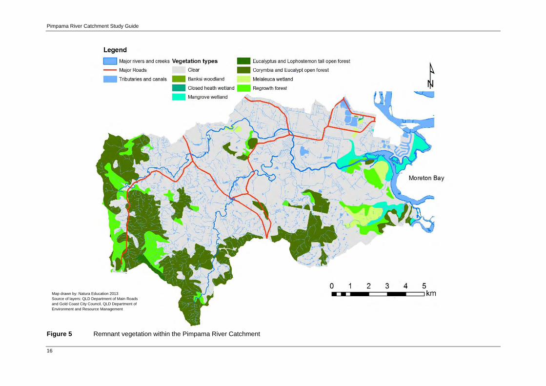
2.3.3 Catchment vegetation Large areas of the upper Pimpama River catchment comprise remnant vegetation, while the mid freshwater and large areas of the lower freshwater and estuarine reaches are cleared (see Figure 5). Remnant vegetation is native vegetation of mature height and cover and contains plant species that are typical of the area. This vegetation may have never been cleared or is very old regrowth. The upper reaches of the catchment is primarily open forests, while the lower freshwater and estuarine reaches are primarily wetland bordered by open forest. There are also large patches of regrowth in both areas. There is a fragmented corridor of remnant open forest along the southern border of the catchment that links the upper and lower reaches. There is also a network of patches of remnant open forest in the middle of the catchment.
Source: GCCC 2012
Source: GCCC 2012

Pimpama River Catchment Study Guide
15
Most of the vegetation in the catchment is eucalyptus forest. There are two types of eucalypt forest in the catchment; wet sclerophyll tall open forest and corymbia and eucalypt open forest. The major differences between the two forest types is that the former type has an understorey dominated by rainforest species and is tall, whereas the latter type has an understory dominated by grasses, shrubs and ferns. The wet sclerophyll tall open forest in the upper reaches of the catchment is dominated by canopy trees including Eucalyputs grandis (Flooded gum), E. microcorys (Tallowwood), E. acmenoides (White mahogany) and Lophostemon confertus (Brush box). The midstorey is primarily rainforest trees including Caldcluvia paniculosa (Soft corkwood), Pittosporum undulatum (Mock orange), Synoum glandulosum (Scentless rosewood) and Cryptocarya glaucescens (Jackwood). Other species include Archontophoenix cunninghamiana (Bangalow palm) and other palms in the understorey and vines. The most common vegetation type is the corymbia and eucalypt open forest. The canopy trees are dominated by Corymbia citriodora (Lemon scented gum), Eucalyptus siderophloia (Grey ironbark) and E. major (Grey gum). Other species are also present depending on the location within the catchment, including E. acmenoides (White mahogany), E. crebra (Narrow leaved ironbark) E. carnea (Thick leaved mahogany) and E. eugenoides (Thin leaved stringy bark). Lophostemon confertus (Brush box) is also often present when the forest is located within gullies. The understorey is a mix of grasses, shrubs and ferns. Within the lower freshwater and estuarine reaches of the catchment there are several patches of melaleuca, eucalyptus and lophostemon open forest. The canopy trees in this forest are dominated by Melaleuca quinquenervia (Broad leaved paperbark), Eucalyptus tereticornis (Forest red gum), Lophostemon suaveolens (Swamp box) and Corymbia intermedia (Pink bloodwood). It has a grassy ground layer dominated by species such as Imperata cylindrical (Blady grass). There are three small patches of banksia woodland, with canopy trees dominated by Banksia aemula (Wallum banksia) and associated species including Corymbia intermedia (Pink blood wood), C. gummifera (Red Bloodwood), Eucalyptus latisinensis (White mahogany), E. robusta (Swamp mahogany), E. tindaliae (Tindale’s stringybark), Lophostemon confertus (Brush box) and Melaleuca quinquenervia (Broad leaved paperbark). There are also several wetland areas, including a closed heath wetland and mangrove wetlands. There is one small patch of closed heath wetland in the north of the estuarine reaches which is comprised of stunted emergent shrubs including banskia species, particularly Banksia robur (Swamp banksia), Boronia falcifolia, Epacris spp., Baeckea frutescens, Schoenus brevifolius, Leptospernum spp., Hakea actites, Melaleuca thymifolia, M. nodosa, Xanthorrhoea fulva. The ground layer is primarily Baloskion spp. and Sporadanthus spp. The mangrove wetlands cover a large proportion of the forested area in the estuarine reaches of the catchment and are found as shrubland and low closed forest. Refer to EHP (2013a) for more details.
Pimpama River Catchment Study Guide
16
Figure 5 Remnant vegetation within the Pimpama River Catchment
Map drawn by: Natura Education 2013 Source of layers: QLD Department of Main Roads and Gold Coast City Council, QLD Department of Environment and Resource Management
Pimpama River Catchment Study Guide
17
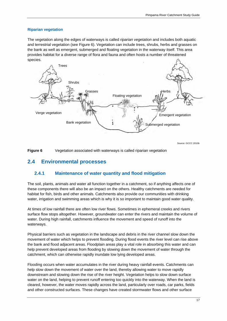
Riparian vegetation The vegetation along the edges of waterways is called riparian vegetation and includes both aquatic and terrestrial vegetation (see Figure 6). Vegetation can include trees, shrubs, herbs and grasses on the bank as well as emergent, submerged and floating vegetation in the waterway itself. This area provides habitat for a diverse range of flora and fauna and often hosts a number of threatened species. Figure 6 Vegetation associated with waterways is called riparian vegetation
2.4 Environmental processes
2.4.1 Maintenance of water quantity and flood mitigation The soil, plants, animals and water all function together in a catchment, so if anything affects one of these components there will also be an impact on the others. Healthy catchments are needed for habitat for fish, birds and other animals. Catchments also provide our communities with drinking water, irrigation and swimming areas which is why it is so important to maintain good water quality. At times of low rainfall there are often low river flows. Sometimes in ephemeral creeks and rivers surface flow stops altogether. However, groundwater can enter the rivers and maintain the volume of water. During high rainfall, catchments influence the movement and speed of runoff into the waterways. Physical barriers such as vegetation in the landscape and debris in the river channel slow down the movement of water which helps to prevent flooding. During flood events the river level can rise above the bank and flood adjacent areas. Floodplain areas play a vital role in absorbing this water and can help prevent developed areas from flooding by slowing down the movement of water through the catchment, which can otherwise rapidly inundate low lying developed areas. Flooding occurs when water accumulates in the river during heavy rainfall events. Catchments can help slow down the movement of water over the land, thereby allowing water to move rapidly downstream and slowing down the rise of the river height. Vegetation helps to slow down surface water on the land, helping to prevent runoff entering too quickly into the waterway. When the land is cleared, however, the water moves rapidly across the land, particularly over roads, car parks, fields and other constructed surfaces. These changes have created stormwater flows and other surface
Shrubs
Herbs Grasses Floating vegetation
Submerged vegetation Bank vegetation
Emergent vegetation Verge vegetation
Trees
Source: GCCC 2010b
Pimpama River Catchment Study Guide
18
water in the form of drains and drainage channels. These constructed and impervious surfaces can have the potential to increase flooding in a catchment. Government authorities, land owners and developers in the catchment can mitigate these issues by maintaining or restoring riparian buffer vegetation.
2.4.2 Maintenance of water quality Catchments also play a critical role in maintaining the water quality. Water quality is closely linked to the surrounding environment and land use. Water quality is generally best in the upper reaches of the catchment where rainfall is often abundant and there is generally less development and high retention of native vegetation. Water quality generally declines as water flows downstream due to the change in land use and associated water-use as well as pollution entering the waterway. Therefore, waterways can act as transportation corridors for pollutants, ultimately discharging into the ocean. However, the retention of riparian vegetation and other mechanisms in a catchment can assist with minimising the amount of sediment, nutrients and other pollutants entering the waterway.
2.5 Environmental significance
2.5.1 Areas of environmental significance The Pimpama River catchment contains several declared areas of environmental significance including City of Gold Coast managed conservation land, State Government managed land, major fauna corridors and City of Gold Coast Public Open Space areas (Figure 7). The significance of these areas is described below. Pimpama River Conservation Area The Pimpama River Conservation Area protects over 6 kilometres of the southern and northern reaches of the Pimpama River, as well as several minor tidal inlets. The undisturbed vegetation communities of the conservation area supply an important buffer and wildlife corridor, provide bank stability and protect water quality values that play an integral part in the estuaries normal functions and characteristics, predominantly as a Fish Habitat Reserve and a High Ecological Value Area (GCCC 2010a). Pimpama River The Pimpama River winds over a coastal plain that developed over the past several thousand years due to sea level variation and shifting estuarine and fluvial regimes. The headwaters begin in the Darlington Range. There are two major tributaries of the Pimpama River; Hotham Creek and McCoys Creek. Hotham Creek originates in the upper catchment east of Wongawallan Mountain; and in the lower catchment, McCoys Creek. The Pimpama River is located at the northern boundary of the Pimpama River Conservation Area and is listed as a Conservation Zone within the Moreton Bay Marine Park. It comprises the Pimpama Fish Habitat Area, is identified as a High Ecological Value Area and is an internationally listed Ramsar wetland site (GCCC 2010a). Wallaby Way Conservation Reserve Wallaby Way Conservation Reserve is a 4.9ha parcel of land within the Pimpama Catchment Area. It was acquired using funding from the EPA’s Coastal Acquisition Fund and Council’s Open Space Planning Levy. The site has been declared an environmental reserve with the City of Gold Coast the appointed trustee. It is also classified as a Moderate Terrestrial Conservation Significance Area (GCCC 2011).

Pimpama River Catchment Study Guide
19

Pimpama River Catchment Study Guide
20
Figure 7 Significant environmental areas within the Pimpama River catchment
Map drawn by: Natura Education 2013 Source of layers: QLD Department of Main Roads and Gold Coast City Council, QLD Department of Environment and Resource Management

Pimpama River Catchment Study Guide
21
Koala Conservation Area The Pimpama River catchment is located in an area designated as a Koala Conservation Area under the Nature Conservation (Koala) Conservation Plan 2006 and Management Program 2006-2016. The Regional Plan aims to protect koala populations and enhance their habitat (EPA 2006). Biodiversity Area of State Significance The South East Queensland Regional Plan (2009-2031) shows parts of Pimpama catchment as being located in a Biodiversity Area of State Significance, demonstrating its importance as a mainland habitat linkage in the Southern Moreton Bay region (DIP 2009). Wildlife Corridors Locally, the Pimpama Conservation Area and Wallaby Way Conservation Reserve provide wildlife corridor linkages running in a north to south direction. These include the North Coomera Flyway, East Kerkin Road Wetland Corridor and Jacobs Well Heath Link. Regionally, the Pimpama River Main Channel Ecological Corridor and the Coomera Corridor are important components of the Pimpama River catchment area (GCCC 2010a). Southern Moreton Bay Islands National Park Woogoompah, Kangaroo and Coomera Islands are part of Southern Moreton Bay Islands National Park which consists of five islands. The southern portion of Moreton Bay is characterised by a network of channels divided by numerous islands and sand bars that form the northern portion of the Gold Coast Broadwater. The important conservation values of the Pimpama River catchment are reflected by fish habitat areas in the adjoining Marine and National Park at the mouth of the Pimpama River (GCCC 2010a). Edward Corbould Reserve and Retreat Nature Refuge The nature refuge is comprised of 5 areas, each of which is the subject of a separate conservation agreement. The nature refuge supports a diverse array of endemic flora and fauna, including 20 identified species of native wildlife prescribed as rare, endangered or vulnerable. Parts of this refuge are located within the Pimpama River catchment.
2.5.2 Rare and threatened flora An abundant assemblage of native flora occurs within the Pimpama River catchment, indicative of the remnant marine and coastal lowland vegetation complexes of southern Moreton Island. This includes mangrove forest and shrubland, saltmarsh and marine flats, coastal sedgelands, Swamp oak (Casurina glaunca) and Paperbark (Meleleuca quinquenervia) open forest and eucalypt coastal woodland (GCCC 2010a). At least 11 flora species considered to be regionally significant are protected within the Pimpama River catchment area (Table 2).

Pimpama River Catchment Study Guide
22
Table 2 Rare or threatened flora located within the Pimpama River catchment Common Name Scientific Name StatusWhite caladenia Caladenia catenata City Wide Significance Bird orchid Chiloglottis sylvestris City Wide Significance Corkwood Endiandra sieberii Locally rare Tall sawsedge Gahnia clarkei City Wide Significance Cabbage palm Livistona australis City Wide Significance Small-leaved paperbark Melaleuca sieberi City Wide Significance Tall broom heath Monotoca sp. “Fraser Island” Locally rare Boobialla Myoporum acuminatum Locally rare Red passionflower Passiflora aurantia City Wide Significance Arrowhead violet Viola betonicifolia City Wide Significance Mistletoe Viscum articulatum City Wide Significance
Adapted from GCCC 2010a
Information on key threatened plant species found in the Pimpama River catchment area is provided in Boxes 4 to 7:
Box 4 Threatened species profile: Ormeau bottle tree (Brachychiton sp. Ormeau) Classified as Endangered (State and National Legislation). This unique tree is found only in the Ormeau Region of South East Queensland where it is estimated there are less than 100 known individual trees left in the wild. A member of the bottle tree family, they can grow to 25m in height. Earning its name by its appearance, the tree trunk is thick, cylindrical, bulbous and looks like a swollen bottle. Hand-like in appearance, the leaves are alternate and hairless with a distinct difference between the juvenile and mature-age plants. Mature trees have a dark rough bark. The crown forms thick green foliage and they produce a woody fruit and greenish white to yellow flowers with five petals that occur in dense clusters at the end of the branch. Land clearing for various types of development can pose a threat to existing Ormeau bottle trees and, to mitigate this, efforts have been made to propagate and replant this significant tree species in its natural habitat. Local Landcare groups have located and sought to protect existing Ormeau bottle trees by encouraging landowners, developers and community members to plant more native trees such as the Ormeau bottle tree.
Leiper eet al 2008
Source: Natura Education 2013

Pimpama River Catchment Study Guide
23
Box 6 Threatened species profile: Spiny gardenia (Randia moorei) Listed in Queensland as Endangered under the Nature Conservation Act 1992. Spiny gardenia is a shrub or small tree growing up to 10 m in height with flowers that are cream to yellow. The outer bark is smooth or scaly and live bark is green and brown with short vertical pale stripes. Flowers are borne in the axils singly or in pairs on 2–6 mm long stalks. The fruits are yellow urn-shaped berries, 6–8 mm long, that later become black when dry. Spiny gardenia grows in subtropical, riverine, littoral and dry stunted rainforests along moist scrubby water courses. The main threats include habitat loss due to land clearing for urban development and agriculture, weed infestation and loss of genetic diversity due to small population size. In 2004, there were 11 sites recorded in Queensland that supported a total of 15 plants. More recent reports show there are additional sites in Queensland supporting approximately 1500 plants in total. A population within the Darlington Range, which forms the headwaters of the Pimpama River Catchment, consists of approximately 60 plants. Part of this population is within the Darlington Reserve.
Box 5 Threatened species profile: Plectranthus habrophyllus (no common name) Listed in Queensland as Endangered under the Queensland Nature Conservation Act 1992. Plectranthus habrophyllus is a woody, square-stemmed herb growing up to 40 cm tall with scented foliage. Leaves are up to 45 mm long, opposite, oval-shaped, with 4-8 teeth on each margin. It is confined to south east Queensland, near Ipswich and near Ormeau and has a distributional range of approximately 40 km. Plants have been recorded growing on chert or sandstone outcrops, in open woodlands often in shaded situations near vine forest. Flowers have been recorded in February, August and December. The main threats to P. habrophyllus are competition from introduced weeds that also increase fuel loads, resulting in increased fire intensity and frequency.
Source: Black Diamond Images 2012
Source: Plant Nerd 2013

Pimpama River Catchment Study Guide
24
2.5.3 Rare and threatened fauna The Pimpama River catchment contains a wide range of vegetation types that provide habitat for a diverse population of native animal species. Surveys conducted by City of Gold Coast in 2009 revealed that 33 species found in the Pimpama River catchment were classified as being of conservation significance under State and Commonwealth legislation (Table 3). Table 3 Rare or threatened fauna within Pimpama River catchment, where: V = Vulnerable, R = Rare, S = Special Cultural Significance, M = Migratory.
Common Name Scientific Name Status Australian reedwarbler Acrocephalus stentoreus M Great egret Ardea alba M Cattle egret Ardea ibis M Sharp-tailed sandpiper Calidris acuminata M Curlew sandpiper Calidris ferruginea M Glossy black cockatoo Calyptorhynchus lathami V Black-necked stork Ephippiorhynchus asiaticus R White-breasted sea eagle Haliaeetus leucogaster M Grey-tailed tattler Heteroscelus brevipes M White-throated needletail Hirundapus caudacutus M Bar-tailed godwit Limosa lapponica M Square-tailed kite Lophoictinia isura R Rainbow bee-eater Merops ornatus M Black-faced monarch Monarcha melanopsis M Satin flycatcher Myiagra cyanoleuca M Turquoise parrot Neophema pulchella V
Box 7 Threatened species profile: Lesser swamp-orchid (Phaius australis) Listed in Queensland as Endangered under the Nature Conservation Act 1992. The Lesser swamp-orchid is endemic to Australia and occurs in southern Queensland and northern NSW. Most populations are sporadically distributed between Coffs Harbour and Fraser Island. The orchid is commonly associated with coastal wet heath/sedgeland wetlands, swampy grassland or swampy forest and often where Broad-leaved Paperbark or Swamp Mahogany are found. The swamp orchid is generally restricted to the swamp-forest margins, where it occurs in swamp sclerophyll forest (Broad-leaved paperbark/Swamp mahogany/Swamp box (Lophostemon suaveolens)), swampy rainforest (often with sclerophyll emergents) or fringing open forest. It is often associated with rainforest elements such as Bangalow palm (Archontophoenix cunninghamiana) or Cabbage tree palm (Livistona australis). The Lesser swamp-orchid is one of Australia's most highly desired orchids and illegal collection of plants and loss of habitat is its biggest threats. Other significant threats to this species include fire and possible suppression by understorey weeds.
Source: Woodard 2010

Pimpama River Catchment Study Guide
25
Common Name Scientific Name Status Powerful owl Ninox strenua V Eastern curlew Numenius madagascariensis R,M Whimbrel Numenius phaeopus M Osprey Pandion haliaetus M Agile wallaby Macropus agilis C Koala Phascolarctos cinereus S,V Grey-headed flying-fox Pteropus poliocephalus V Rufous fantail Rhipidura rufifrons M Caspian tern Sterna caspia M Short-beaked echidna Tachyglossus aculeatus S Marsh sandpiper Tringa stagnatilis M Water mouse Xeromys myoides V
Adapted from GCCC 2010a
Information on key threatened fauna found within the Pimpama River catchment is provided in boxes 8 to 11.
Box 8 Threatened species profile: Koala (Phascolarctos cinereus) Classified as Vulnerable in Queensland and New South Wales (Nature Conservation Act 1992; Threatened Species Conservation Act 1999). Koalas are a small bear-like tree-dwelling marsupial. Koalas eat only certain Eucalyptus leaves (gum leaves) and these leaves are toxic to other animals. Eucalyptus leaves are also a very poor source of energy, so koalas have a low metabolic rate and must sleep a majority of the day. They can sleep up to 18 hours a day and are nocturnal, meaning they are active at night. The name ‘Koala’ means ‘does not drink’ since they get all their hydration from eucalyptus leaves and do not drink water. They will only drink water in times of drought or stress. Koalas have a thick, woolly fur which is usually ash grey but can be brown. They have big furry ears and a big black nose that is very important to help them smell which leaves are less toxic. On average, koalas weigh 9kg and are well adapted for tree-living with strong limbs to help them climb and strong claws for gripping. Next time you see a Eucalyptus tree, look carefully and you may see scratch marks up the trunk indicating a koala has climbed there. Being territorial animals with a limited diet, koalas will travel between the same trees throughout their life. Roads, fences, dogs and tree-removal all pose great threats to the koala, putting this iconic Australian animal at risk of extinction in many regions of Australia, including South East Queensland. There are many laws and organisations that are dedicated to the protection of koalas such as The Australian Koala Foundation who estimate there are only 80 000 koalas left in the wild. Planting koala food trees is one of many ways to help save the koala.
Source: WPSQ n.d.

Pimpama River Catchment Study Guide
26
Box 10 Threatened species profile: Red goshawk (Erythrotriorchis radiates) Listed in Queensland as Endangered under the Nature Conservation (Wildlife) Regulation 1994. The Red Goshawk is a large powerful rufous-brown hawk, growing 45–60 cm in length, with a wingspan of 100–135 cm. It is endemic to Australia and occurs in coastal forests and woodlands and in riverine forests of tropical and warm- temperate Australia. It inhabits areas that support high bird numbers and biodiversity, especially medium to large species that the goshawk requires for prey. The Red Goshawk nests in large trees, frequently the tallest of a tall stand and within 1 km of permanent water. The vegetation types include eucalypt woodland, open forest, tall open forest, gallery rainforest, swamp sclerophyll forest and rainforest margins. In sub tropical areas, the favoured habitat is mixed subtropical rainforest and Melaleuca forest along coastal rivers, often in rugged terrain. Habitat loss is the biggest threat to the Red Goshawk, especially in eastern Australia, particularly of lowland and riverine forests of NSW and Queensland. Forestry practices and coastal development pose notable threats to populations and illegal egg collecting results in the failure of some nests; a potential threat to population productivity.
Box 9 Threatened species profile: Wallum sedgefrog (Litoria olongburensis) Listed in Queensland as Vulnerable under the Nature Conservation Act 1992. The Wallum sedge frog is a small tree-frog occurring from Fraser Island QLD to Woolgoolga NSW. Since European arrival to Australia, the area inhabited has declined by up to 75%, primarily through clearing for agriculture, pine plantations, urban development and sand mining. The wallum sedge frog is usually found in ephemeral and permanent wetlands with emergent reeds, ferns and/or sedges, but also around creeks and freshwater lakes in undisturbed coastal wallum wetland vegetation. At swamp sites, the Wallum sedge frog can be found sheltering amongst sedges, reeds and ferns all year round. Vegetation communities where the species may occur include wet and dry heathlands, sedgelands, woodlands and forests. Breeding usually occurs after rain in spring, summer and autumn when the male’s soft buzzing calls from sedges above the water. Water at breeding sites is usually clear, heavily tannin-stained, acidic (pH< 6.0) and fish species are generally scarce. The most common threats to this species come from habitat loss and degradation, inappropriate fire regimes, predation, use of biocides to control invasive weeds and mosquitos, pig damage, exotic disease and vehicular traffic.
Source: Morris 2008
Source: Sportsman Creek Conservation Area 2013
Pimpama River Catchment Study Guide
27
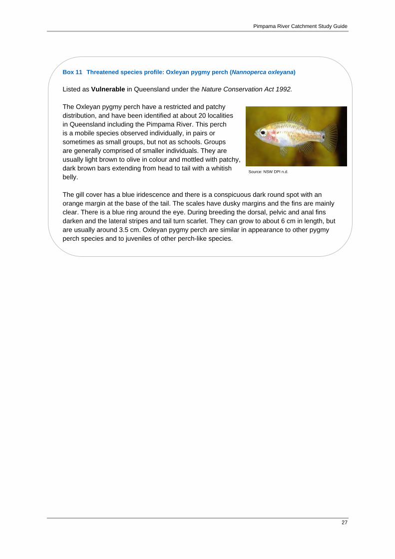
Box 11 Threatened species profile: Oxleyan pygmy perch (Nannoperca oxleyana) Listed as Vulnerable in Queensland under the Nature Conservation Act 1992. The Oxleyan pygmy perch have a restricted and patchy distribution, and have been identified at about 20 localities in Queensland including the Pimpama River. This perch is a mobile species observed individually, in pairs or sometimes as small groups, but not as schools. Groups are generally comprised of smaller individuals. They are usually light brown to olive in colour and mottled with patchy, dark brown bars extending from head to tail with a whitish belly. The gill cover has a blue iridescence and there is a conspicuous dark round spot with an orange margin at the base of the tail. The scales have dusky margins and the fins are mainly clear. There is a blue ring around the eye. During breeding the dorsal, pelvic and anal fins darken and the lateral stripes and tail turn scarlet. They can grow to about 6 cm in length, but are usually around 3.5 cm. Oxleyan pygmy perch are similar in appearance to other pygmy perch species and to juveniles of other perch-like species.
Source: NSW DPI n.d.

Pimpama River Catchment Study Guide
28
Box 12 Land use influences catchment health
Waterway modification Urbanisation, industrialisation,
agriculture Riparian and other vegetation loss Storm water Stream and water flow barriers Introduced plants Introduced animals Erosion of stream banks Sedimentation Point source pollution Diffuse source pollution
Increased nutrient levels
2.6 Current catchment land use The dominant land use of the Pimpama River catchment is agriculture, which is primarily cane fields in the flood plains of the freshwater reaches of the catchment (Figure 8). Grazing land for livestock and rural/residential areas also encompasses a large proportion of the catchment. Mining is also conspicuous in the catchment, with extractive industries active in the upper reaches of the catchment, the mid freshwater reaches and lower freshwater reaches. Urban/residential areas are concentrated along transport corridors, primarily the Pacific Highway, although there is a canal estate where the Pimpama River meets Moreton Bay. For more information on land use impacts to catchments refer to Box 12. Comparison of the land use map (Figure 8) and vegetation map (Figure 6) for the catchment reveals that large areas of native vegetation are within rural/residential and grazing land. There are also a number of small reserves in the catchment; protecting small pockets of significant vegetation (see Figure 7 for location of reserves).
2.7 Current catchment health The Pimpama River catchment’s long history of development pressures began with forest clearance for timber and agriculture. The river itself was used as a mechanism to assist with the transport of felled timber to the lower reaches where it could be picked up as sea cargo. The flood plains and delta of the river provided fertile lands that have since been utilised as agricultural land that firstly supported arrowroot crops, but has since transformed into sugar cane farms. Subsequently, there has also been a long history of agricultural and urban pressures on the waterway and its tributaries. For the purpose of assigning a health score, Healthy Waterways separates catchment and estuarine reaches into two sections titled ‘Pimpama/ Coomera Rivers Catchment and Estuary’ (Healthy Waterways 2013).
2.7.1 Catchment health The health of the Pimpama River Catchment has been assessed by Healthy Waterways as being in decreasing condition with a B- score (Healthy Waterways 2013). This score was down on the B score from 2011. This decrease in health was attributed to decrease in nutrient cycling and ecosystem processes indicators, even though aquatic macroinvertebrate and fish indicators had improved.
2.7.2 Estuarine health The health of the estuarine section of the Pimpama River Catchment was assessed as being in improving condition with a C score (Healthy Waterways 2013). This improvement was attributed to ‘decreased turbidity, algae and nitrogen concentrations, with dissolved oxygen and phosphorus concentration increases’. Ranking assessments began in 2003, where the Pimpama River scored C-. Since 2003 there has been an overall increase in health scores, where it peaked in 2007 and 2008 with a score of C+. In 2011 there was a drop back to C-. A score of C has been the average score during the assessment period.

Pimpama River Catchment Study Guide
29
Figure 8 Pimpama River catchment current land use
Map drawn by: Natura Education 2013 Source of layers: QLD Department of Main Roads and Gold Coast City Council, QLD Department of Environment and Resource Management

Pimpama River Catchment Study Guide
30
2.8 Catchment management issues and management The City of Gold Coast is responsible for managing the majority of the Pimpama River catchment. Several catchment management groups also play a role in managing the Pimpama River catchment, including Coomera River Catchment Group, Gold Coast and Hinterland Environmental Council, Gold Coast Catchment Association (GECKO), North East Albert Landcare and Catchment Group. These volunteer groups undertake riparian restoration programs including revegetation, weed removal, monitoring and maintenance.
2.8.1 Vegetation loss In the past, there has been significant vegetation loss in the catchment as a result of clearing for the timber industry and to create viable agricultural lands for various cropping and grazing industries. Since that time clearing has continued in the maintenance of farmland and the development of urban and commercial areas and quarries. Riparian vegetation loss is of particular concern, which is typically removed for reasons such as:
increase in land available for development; increased water views; extending grazing areas for livestock; extending cultivation areas; creating access for livestock to water source; and infrastructure requirements.
Impacts of riparian vegetation loss The removal of riparian vegetation results in the following impacts:
increase in sediment in the water – impacts aquatic vegetation and fauna and can result in sedimentation further down stream
decrease in bank stability and increased erosion increase in aquatic plant and algae growth with increased light increase nutrient in load – can result from livestock accessing waterway and a
reduction in nutrient uptake in the riparian zone due to the vegetation clearance weed invasion in cleared areas reduces biodiversity and alters ecological
processes. Riparian vegetation protection and rehabilitation Protecting and maintaining riparian vegetation is the best way to reduce these impacts. This can be achieved by managing weeds without promoting bank erosion, fencing off the riparian vegetation and waterway from livestock and reducing the speed of boats and jet skis along water ways. It is also essential to re-establish riparian vegetation in areas where it has been removed. This can help reduce impacts by:
increasing biodiversity – planting native riparian plants helps to create habitat for fauna;
increasing bank stability – plantings improve bank stability through the action of holding soil in the bank and reducing flow velocity; and
Source: Celeste Twikler 2010
Pimpama River Catchment Study Guide
31
Box 13 Gold Coast Catchment Management
There is a number of catchment
associations on the Gold Coast. These volunteers are the backbone of
sustainable efforts to restore and manage our catchments and are much more than just workers. Government provide expertise and support, and
contractors will do much of the work; however nothing will happen without the
community becoming informed and involved. An informed and passionate
community will in turn influence our decision makers and politicians.
For more information on volunteering
visit the Gold Coast Catchment Association’s website.
improving water quality – by reducing light penetration through increased vegetation cover and increasing nutrient uptake by increasing the biomass of plants.
Government roles and responsibilities The City of Gold Coast and State Government is responsible for managing developments and activities that seek to clear riparian vegetation. They use planning schemes, codes and policies that have been developed to ensure a balance between environmental protection, sustainable development and resource allocation. Community roles and responsibilities Individual land owners are responsible for managing riparian vegetation on their own land. People living along waterways are encouraged to plant species native to the area, manage exotic species where damage to the soil will not occur, and restrict access of stock in the riparian area and waterway. Boat owners and jet skiers can also help reduce bank erosion by reducing speed in waterways to minimise boat wash and the resulting wave action against the stream bank. Industry roles and responsibilities Industry is also responsible for managing riparian vegetation. Industry has to follow regulations of the local, state and Federal Government. Some industries recognise the importance of healthy catchments to the community by commencing rehabilitation works on their land. The Pimpama River catchment is fortunate to have a number of industries working towards this goal.
Source: Celeste Twikler 2013

Pimpama River Catchment Study Guide
32
Box 14 You can help your catchment Spend a weekend helping to protect your catchment. You could do this by helping planting trees with catchment groups, beach care or even plant trees in your back yard. For more information visit the following organisations websites:
Griffith University Centre for Coastal Management Beachcare Program
Gold Coast Catchment Association
Gold Coast Parks Beaches to Bushland Program
Gold Coast City Council Catchment Management Unit
Gecko – Gold Coast and Hinterland Environment Council
2.8.2 Stormwater quality and movement Stormwater is rainwater and anything that is carried along with it. In urban areas, stormwater flows from the roof and hard surfaces such as driveways, roads and pavement into gutters and drainage systems and eventually into our waterways. This water is usually untreated when it enters the waterway. In the Pimpama catchment, the primary source of stormwater is runoff from agricultural lands. Stormwater impacts The impact of stormwater to our waterways lies in the increased speed of water entering the waterway as well as from the components that are carried suspended in the water. This includes:
nutrients from fertilizer, garden waste (leaves, grass clippings and animal waste);
sediment from garden beds and housing development sites;
detergents and oils; rubbish; and terrestrial and aquatic weeds.
Government roles and responsibilities The City of Gold Coast uses its planning scheme and management plans to require ecologically sustainable development, which is helping to reduce pressures on our waterways. Several tools that Council uses to manage urban and agricultural pressures are described below:
Water-sensitive urban design (WSUD) guidelines (GCCC n.d.) include the use of erosion and sediment control devices, bio-retention systems, constructed wetlands and vegetated swales.
The Pimpama River Catchment and Stormwater Management Plan is currently being
developed by the Gold Coast City (GCCC n.d.). The final plan will include a series of management actions that will be implemented by the City of Gold Coast.
These tools are designed to assist Council with managing the ecological health, water quality, recreational and economic functions of the Pimpama River catchment. This is achieved by providing a plan for sustainable development and resource allocation that is sensitive to waterway issues.
Community roles and responsibilities Everyone in the community has a role in reducing the amount of waste that enters our waterways:
Dispose rubbish correctly (e.g. put a rubbish bag in the car or dispose of at home); Dispose of all chemicals, oils, pesticides and herbicides correctly (e.g. take them to a Gold
Coast City waste transfer station for correct disposal); Pick up pet droppings and put them in the bin;

Pimpama River Catchment Study Guide
33
Wash cars or boats on the lawn so detergents do not run directly into the stormwater drain; Sweep driveways and paths instead of hosing; Compost garden waste and apply as a soil conditioner to gardens rather than using chemical
fertilizer; and Never dispose garden waste in the stormwater drain (e.g. Gold Coast City transfer station).
2.8.3 Drinking water quality and management
The community within the Pimpama River catchment rely on drinking water from rain water trapped on building roofs and stored in rain water tanks as well as ‘town water’ predominately supplied by the Hinze Dam within the Nerang River catchment. For water livestock they use a combination of dams that trap surface water flows and pumping water from adjacent waterways. Pumping water from creeks and rivers usually requires a license from government authorities. The Hinze Dam it is the major water supply for the Gold Coast and is located approximately 15 kilometres from Nerang. The dam was originally constructed in 1976 to secure water for the Gold Coast. The catchment area for the dam is 207 square kilometres and includes the Numinbah Valley, Springbrook Plateau and part of Lamington National Park. Approximately 77%of this land is covered in natural vegetation in State Forests and National Parks, and 15% is used for agricultural land use including dairy farm pastures. Within the Hinze Dam catchment is the Little Nerang Dam, which has a storage capacity of approximately 9.3 million litres. The large forested areas within the catchment of the Hinze Dam help to keep water quality in relatively good condition by providing water filtration services. People are also restricted from entering much of this area, and farms, factories and golf courses are prohibited from being built in the catchment. Recreational boats are also restricted to electric powered types to minimise the amount of oil and petrol entering the water supply. These management measures have resulted in the Hinze Dam having clean potable water for the Gold Coast including the community within the Pimpama River catchment.
Source: Celeste Twikler 2010

Pimpama River Catchment Study Guide
34
Section 3 Study guide resources
3.1 Waterway and catchment health monitoring Within a catchment, whatever takes place upon the land will affect water quality within the creeks, rivers and ground water. Due to this, it is important to measure catchment waterway health to determine when and how water quality has been impacted. This enables us to improve how we manage the catchment to in turn improve and maintain water quality. A number of water quality parameters are used in conjunction to do this. There are two main types of monitoring used:
Biological; and Physico-chemical.
‘Bio’ means life and so biological monitoring relates to the life that a waterway can support. Biological monitoring looks at the macroinvertebrate and other aquatic indicators as well as riparian and in-stream habitat assessment. Physico-chemical testing involves measuring physical and chemical parameters. These parameters are dissolved oxygen, temperature, turbidity, salinity, phosphates and pH. Care needs to be taken when considering results of physico-chemical testing because these parameters are extremely dependant on the condition of the environment and are, therefore, subject to differences between sites and even between different testing times.
3.1.1 Macroinvertebrates What are macroinvertebrates and why are they important? Macroinvertebrates, also known as water bugs, are creatures without a backbone that, while small, are large enough to see with the naked eye and live in a variety of aquatic environments. Macroinvertebrates exhibit varying sensitivity to pollution and other conditions in their environment making them perfect biological indicators of the health of a waterway. Whether or not a particular macroinvertebrate is found in a waterway can indicate whether this waterway is healthy. The following guide outlines the ecology of macroinvertebrates, which can assist with accurate monitoring.
Hi, I am Hugo the Healthy Waterways Turtle. Did you know that monitoring water quality is really important for making sure that we know our catchments are healthy? Check out water
quality monitoring in this section and for more information visit
www.healthywaterways.com.au
©Healthy Waterways Ltd
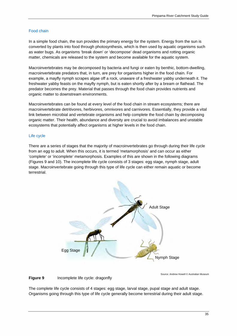
Pimpama River Catchment Study Guide
35
Food chain In a simple food chain, the sun provides the primary energy for the system. Energy from the sun is converted by plants into food through photosynthesis, which is then used by aquatic organisms such as water bugs. As organisms ‘break down’ or ‘decompose’ dead organisms and rotting organic matter, chemicals are released to the system and become available for the aquatic system. Macroinvertebrates may be decomposed by bacteria and fungi or eaten by benthic, bottom-dwelling, macroinvertebrate predators that, in turn, are prey for organisms higher in the food chain. For example, a mayfly nymph scrapes algae off a rock, unaware of a freshwater yabby underneath it. The freshwater yabby feasts on the mayfly nymph, but is eaten shortly after by a bream or flathead. The predator becomes the prey. Material that passes through the food chain provides nutrients and organic matter to downstream environments. Macroinvertebrates can be found at every level of the food chain in stream ecosystems; there are macroinvertebrate detritivores, herbivores, omnivores and carnivores. Essentially, they provide a vital link between microbial and vertebrate organisms and help complete the food chain by decomposing organic matter. Their health, abundance and diversity are crucial to avoid imbalances and unstable ecosystems that potentially affect organisms at higher levels in the food chain. Life cycle There are a series of stages that the majority of macroinvertebrates go through during their life cycle from an egg to adult. When this occurs, it is termed ‘metamorphosis’ and can occur as either ‘complete’ or ‘incomplete’ metamorphosis. Examples of this are shown in the following diagrams (Figures 9 and 10). The incomplete life cycle consists of 3 stages: egg stage, nymph stage, adult stage. Macroinvertebrate going through this type of life cycle can either remain aquatic or become terrestrial.
Figure 9 Incomplete life cycle: dragonfly The complete life cycle consists of 4 stages: egg stage, larval stage, pupal stage and adult stage. Organisms going through this type of life cycle generally become terrestrial during their adult stage.
Source: Andrew Howell © Australian Museum
Egg Stage
Nymph Stage
Adult Stage

Pimpama River Catchment Study Guide
36
These different components of the life cycle require a narrow and stable range of environmental conditions to ensure successful development. Small changes to the aquatic chemistry can have a negative effect on the organism’s health.
Figure 10 Complete life cycle: diptera species such as flies Factors affecting macroinvertebrates Changes in environmental conditions can affect macroinvertebrates which is why they are very useful for indicating water quality by their prevalence or absence. Macroinvertebrates are sensitive to changes in their conditions such as temperature, pH, turbidity, chemical pollutants, phosphates, nitrates and other factors. Their sensitivity is measured on scale of one to ten, with ten being the most sensitive. This scale is broken into three sections:
10 – 6 Sensitive; 5 – 4 Tolerant; and 3 – 1 Very Tolerant.
The more sensitive a species is, the less likely it will be found in polluted water. By assessing the types and prevalence of macroinvertebrates in a given water body, an ‘environmental rating’ can be deduced using a simple equation based on the sensitivity scale. Plecoptera-Ephemoptera-Trichoptera (PET) taxa refer to the top three most ‘Sensitive’ order of macroinvertebrate. These are Plecoptera (stonefly nymph), Ephemeroptera (mayfly nymph) and Trichoptera (caddis fly nymph). PET taxa require extremely good conditions such as high oxygen levels, so they will tend to live in environments that have clean running water, preferably over rocks as this allows oxygen to enter the water. For example, mayfly nymph would not be found in water with high turbidity from, say, erosion as these animals have gills that would become clogged with particles. ‘Tolerant’ species, such as damselfly larvae, are more able to survive in poorer conditions, in fact they may thrive in water bodies that have more organic matter, detritus and sediment. The ‘Very Tolerant’ macroinvertebrates are those that can survive in the most degraded quality of water. For example, the mosquito larvae are quite content to live in stagnant water bodies, even puddles!
Eggs
Larvae
Pupa/emergent
Source: GCCC 2010b

Pimpama River Catchment Study Guide
37
Macroinvertebrate habitat The habitats of macroinvertebrates can range from partially submerged vegetation (creek side), riffles, pools, benthic (creek bed mud) as well as underneath submerged rocks, logs and branches. Various macroinvertebrates living in the same aquatic habitat are known as a ‘biological community’ which inhabit all types of waterways. Biological characteristics dictate macroinvertebrate populations and human activities and exotic organisms can severely impact their health. The habitats of macroinvertebrates include and some examples of species that dwell in these habitats are provided in Table 4 overleaf. Monitoring macroinvertebrates The following steps are undertaken when assessing a macroinvertebrate community of a waterway: 1. Select a site to sample
There are two types of habitats that provide the best macroinvertebrate sampling sites. These are riffles and edge-waters (DERM 2007a). Riffles provide the best habitat conditions for the widest range of macroinvertebrate organisms. These sites are the first choice when choosing a suitable site to sample. If no riffles can be sampled, edge-waters are a suitable alternative (DERM 2007a). It is best to choose a number of sampling sites along a waterway that provide similar habitat opportunities. By comparing data from various sites, negative human impacts can be identified through a sudden change in community structure or drop in sensitive organism populations.
2. Select a method for sampling
The use of a fine net (0.25 – 0.3mm mesh) in the form of triangular or D-frame net is the most effective method to sample macroinvertebrates. Other, more cost effective methods may also be considered for example, pool nets, kitchen sieves or even a coat hanger with a stocking. Consideration should be given however, to sediment being able to move through the net without clogging. The method of use for the net is dependent on the type of sampling site. The ‘Kick Method’ works best for riffles and the ‘Sweep Method’ is most effective for edge-waters.
- Kick method: This method requires a net to be placed in approximately knee deep water,
ensuring the net is pressed firmly into the riverbed. Rocks slightly upstream from the net are disturbed in an effort to dislodge organisms from their hiding places. The force of the stream flow will move the organisms downstream and into the waiting net. Once you see a few organisms in the net, these can be gently transferred into a large container of water.
- Sweep method: This method requires the sampler to move the net through aquatic vegetation in an upwards sweeping motion. This dislodges organisms from their positions and into the waiting net. It is more effective to sweep against the flow of the water.
Once the organisms are collected, they are identified and counted. This count is then used in correlation with the sensitivity grade of the organisms. A calculation is performed and a score is then allocated to that particular section of the river or water body (Signal 2 score). Use the provided macroinvertebrate identification chart and data sheets for monitoring your waterway. These can be printed out and used directly.
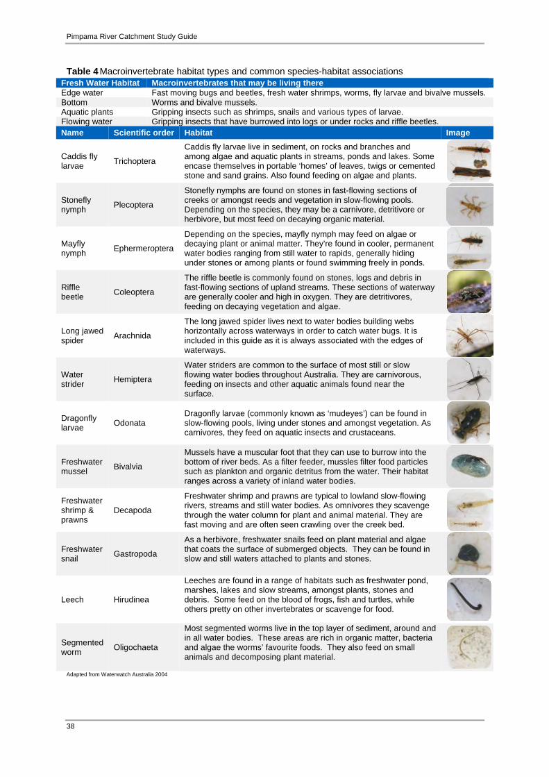
Pimpama River Catchment Study Guide
38
Table 4 Macroinvertebrate habitat types and common species-habitat associations Fresh Water Habitat Macroinvertebrates that may be living thereEdge water Fast moving bugs and beetles, fresh water shrimps, worms, fly larvae and bivalve mussels. Bottom Worms and bivalve mussels. Aquatic plants Gripping insects such as shrimps, snails and various types of larvae. Flowing water Gripping insects that have burrowed into logs or under rocks and riffle beetles. Name Scientific order Habitat Image
Caddis fly larvae Trichoptera
Caddis fly larvae live in sediment, on rocks and branches and among algae and aquatic plants in streams, ponds and lakes. Some encase themselves in portable ‘homes’ of leaves, twigs or cemented stone and sand grains. Also found feeding on algae and plants.
Stonefly nymph Plecoptera
Stonefly nymphs are found on stones in fast-flowing sections of creeks or amongst reeds and vegetation in slow-flowing pools. Depending on the species, they may be a carnivore, detritivore or herbivore, but most feed on decaying organic material.
Mayfly nymph Ephermeroptera
Depending on the species, mayfly nymph may feed on algae or decaying plant or animal matter. They’re found in cooler, permanent water bodies ranging from still water to rapids, generally hiding under stones or among plants or found swimming freely in ponds.
Riffle beetle Coleoptera
The riffle beetle is commonly found on stones, logs and debris in fast-flowing sections of upland streams. These sections of waterway are generally cooler and high in oxygen. They are detritivores, feeding on decaying vegetation and algae.
Long jawed spider Arachnida
The long jawed spider lives next to water bodies building webs horizontally across waterways in order to catch water bugs. It is included in this guide as it is always associated with the edges of waterways.
Water strider Hemiptera
Water striders are common to the surface of most still or slow flowing water bodies throughout Australia. They are carnivorous, feeding on insects and other aquatic animals found near the surface.
Dragonfly larvae Odonata
Dragonfly larvae (commonly known as ‘mudeyes’) can be found in slow-flowing pools, living under stones and amongst vegetation. As carnivores, they feed on aquatic insects and crustaceans.
Freshwater mussel Bivalvia
Mussels have a muscular foot that they can use to burrow into the bottom of river beds. As a filter feeder, mussles filter food particles such as plankton and organic detritus from the water. Their habitat ranges across a variety of inland water bodies.
Freshwater shrimp & prawns
Decapoda
Freshwater shrimp and prawns are typical to lowland slow-flowing rivers, streams and still water bodies. As omnivores they scavenge through the water column for plant and animal material. They are fast moving and are often seen crawling over the creek bed.
Freshwater snail Gastropoda
As a herbivore, freshwater snails feed on plant material and algae that coats the surface of submerged objects. They can be found in slow and still waters attached to plants and stones.
Leech Hirudinea
Leeches are found in a range of habitats such as freshwater pond, marshes, lakes and slow streams, amongst plants, stones and debris. Some feed on the blood of frogs, fish and turtles, while others pretty on other invertebrates or scavenge for food.
Segmented worm Oligochaeta
Most segmented worms live in the top layer of sediment, around and in all water bodies. These areas are rich in organic matter, bacteria and algae the worms’ favourite foods. They also feed on small animals and decomposing plant material.
Adapted from Waterwatch Australia 2004
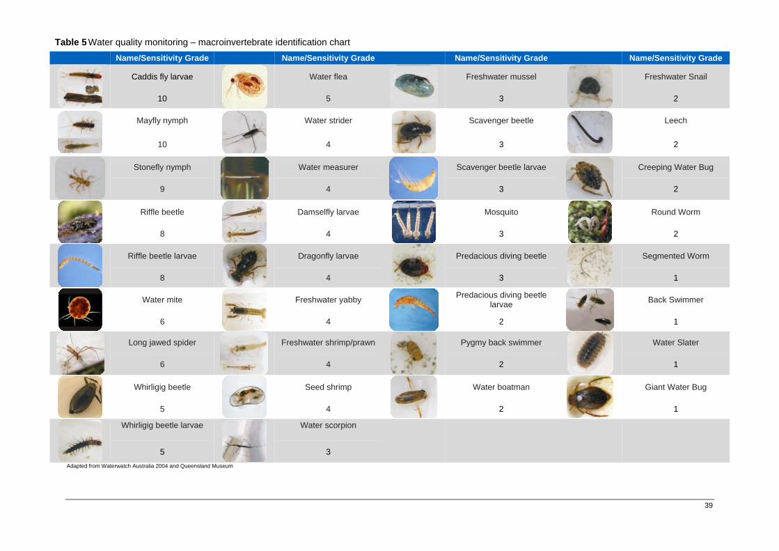
Pimpama River Catchment Study Guide
39
Adapted from Waterwatch Australia 2004 and Queensland Museum
Name/Sensitivity Grade Name/Sensitivity Grade Name/Sensitivity Grade Name/Sensitivity Grade
Caddis fly larvae Water flea
Freshwater mussel Freshwater Snail
10 5 3 2
Mayfly nymph
Water strider
Scavenger beetle
Leech
10 4 3 2
Stonefly nymph Water measurer
Scavenger beetle larvae Creeping Water Bug
9 4 3 2
Riffle beetle Damselfly larvae
Mosquito Round Worm
8 4 3 2
Riffle beetle larvae Dragonfly larvae
Predacious diving beetle Segmented Worm
8 4 3 1
Water mite Freshwater yabby
Predacious diving beetle larvae Back Swimmer
6 4 2 1
Long jawed spider Freshwater shrimp/prawn
Pygmy back swimmer Water Slater
6 4 2 1
Whirligig beetle Seed shrimp
Water boatman Giant Water Bug
5 4 2 1
Whirligig beetle larvae
Water scorpion
5 3
Table 5 Water quality monitoring – macroinvertebrate identification chart

Pimpama River Catchment Study Guide
40
Common name Sensitivity grade Species count Weight
factor
Sensitivity grade
X weight factor
Caddisfly Larvae 10
Mayfly Nymph 10
Stonefly Nymph 9
Riffle Beetle 8
Riffle Beetle larvae 8
Toebiter 8
Water Mite 6
Long Jawed Spider 6
Marsh Beetle Larvae 6
Whirligig Beetle 5
Whirligig Beetle Larvae 5
Water Flea 5
Black Fly Larvae 5
Water Strider 4
Water Measurer 4
Damselfly Larvae 4
Dragonfly Larvae 4
Freshwater Yabby 4
Freshwater Shrimp 4
Seed Shrimp 4
Water Scorpion 3
Freshwater Mussel 3
Scavenger Beetle 3
Scavenger Beetle Larvae 3
Mosquito 3
Scud 3
Non-Biting Midge 3
Predacious Diving Beetle 2
Predacious Diving Beetle Larvae 2
Pygmy Back Swimmer 2
Water Boatman 2
Freshwater Snail 2
Leech 2
Creeping Water Bug 2
Round Worm 2
Segmented Worm 1
Back Swimmer 1
Water Slater 1
Giant Water Bug 1
TOTAL
Table 6 Water quality monitoring – macroinvertebrate data sheet. Group:__________________________________________________________________________________Date:________________ Location:________________________________________________________________________________Time:________________ Teacher:_______________________________________________________________
Signal Scores with weighting= total of grade x weight factor
total of weight factor
Weight Table Number of specimens Weight Factor
1-2 1 3-5 2
6-10 3 11-20 4 > 20 5
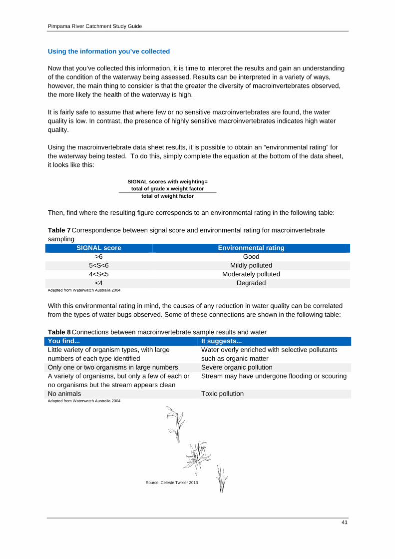
Pimpama River Catchment Study Guide
41
Using the information you’ve collected Now that you’ve collected this information, it is time to interpret the results and gain an understanding of the condition of the waterway being assessed. Results can be interpreted in a variety of ways, however, the main thing to consider is that the greater the diversity of macroinvertebrates observed, the more likely the health of the waterway is high. It is fairly safe to assume that where few or no sensitive macroinvertebrates are found, the water quality is low. In contrast, the presence of highly sensitive macroinvertebrates indicates high water quality. Using the macroinvertebrate data sheet results, it is possible to obtain an “environmental rating” for the waterway being tested. To do this, simply complete the equation at the bottom of the data sheet, it looks like this:
SIGNAL scores with weighting= total of grade x weight factor
total of weight factor Then, find where the resulting figure corresponds to an environmental rating in the following table: Table 7 Correspondence between signal score and environmental rating for macroinvertebrate sampling
SIGNAL score Environmental rating >6 Good
5<S<6 Mildly polluted 4<S<5 Moderately polluted
<4 Degraded Adapted from Waterwatch Australia 2004
With this environmental rating in mind, the causes of any reduction in water quality can be correlated from the types of water bugs observed. Some of these connections are shown in the following table: Table 8 Connections between macroinvertebrate sample results and water You find... It suggests... Little variety of organism types, with large numbers of each type identified
Water overly enriched with selective pollutants such as organic matter
Only one or two organisms in large numbers Severe organic pollution A variety of organisms, but only a few of each or no organisms but the stream appears clean
Stream may have undergone flooding or scouring
No animals Toxic pollution Adapted from Waterwatch Australia 2004
Source: Celeste Twikler 2013
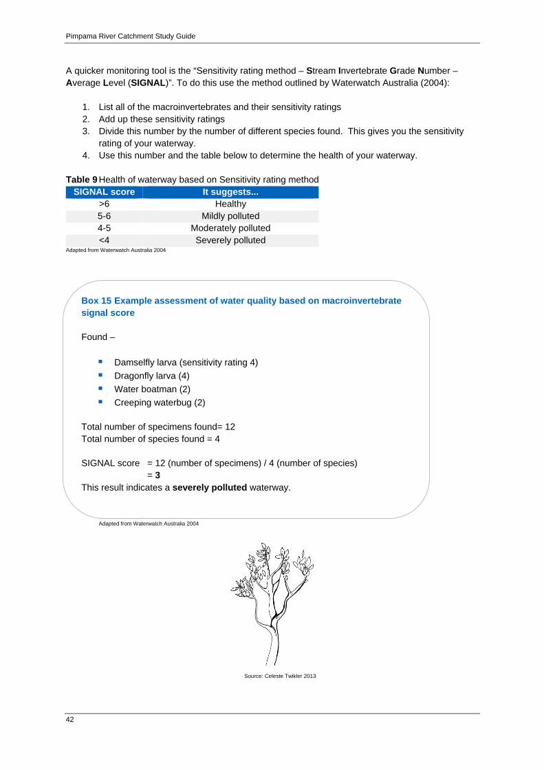
Pimpama River Catchment Study Guide
42
Box 15 Example assessment of water quality based on macroinvertebrate signal score Found –
Damselfly larva (sensitivity rating 4) Dragonfly larva (4) Water boatman (2) Creeping waterbug (2)
Total number of specimens found= 12 Total number of species found = 4 SIGNAL score = 12 (number of specimens) / 4 (number of species)
= 3 This result indicates a severely polluted waterway.
A quicker monitoring tool is the “Sensitivity rating method – Stream Invertebrate Grade Number – Average Level (SIGNAL)”. To do this use the method outlined by Waterwatch Australia (2004):
1. List all of the macroinvertebrates and their sensitivity ratings 2. Add up these sensitivity ratings 3. Divide this number by the number of different species found. This gives you the sensitivity
rating of your waterway. 4. Use this number and the table below to determine the health of your waterway.
Table 9 Health of waterway based on Sensitivity rating method
SIGNAL score It suggests... >6 Healthy 5-6 Mildly polluted 4-5 Moderately polluted <4 Severely polluted
Adapted from Waterwatch Australia 2004
Adapted from Waterwatch Australia 2004
Source: Celeste Twikler 2013

Pimpama River Catchment Study Guide
43
Box 16 Note on habitat assessments This type of assessment is subjective and open to interpretation. More accurate assessments come with practice and experience. It is best to have the same person assessing the habitat at each survey point where comparisons are going to be made. Taking photos can help to smooth out inconsistencies in differing interpretations.
3.1.2 Habitat assessment A habitat assessment is a description of the quality and health of various types of habitat within and adjacent to a waterway or water body. It incorporates visual observations of various factors including; riparian vegetation, in-stream cover, bank stability/erosion and measures the proportion of riffles, bends and pools. The condition of these various types of habitat can influence the physical and chemical parameters within the water. This in turn can alter the structure of biological communities which form an integral part of healthy aquatic ecosystems. Habitat assessments can also be used as historic reference (baseline data) to set a bench mark to be used during ongoing monitoring to flag gradual environmental change or improvement over time. The following steps outline how to undertake a habitat assessment for a waterway.
The assessment is normally undertaken along a transect for approximately 100 metres in length. However, the area of assessment can differ depending on the size of the waterway as the width of riparian vegetation extending away from a waterway varies greatly. Waterways in the upper catchment within narrow valleys generally have relatively narrower riparian zones. Waterways in the lower catchment generally have broader valley widths and tend to meander, resulting in riparian vegetation extending out further. Therefore it is best to assess how wide the assessment area is on a case by case basis;
The various components of habitat are surveyed and assessed against a ‘Habitat Assessment Guide’ (see data sheets overpage) and matched to a level of best fit; and
The individual scores are totaled and a habitat rating is assigned.
The following habitat assessment data sheets are suitable for all types of waterways in the Pimpama River catchment. These can be photocopied and used onsite to record results.
Source: Celeste Twikler 2013

Pimpama River Catchment Study Guide
44
Excellent Good Fair Poor Very Poor Bank Vegetation (10) Mainly undisturbed native vegetation. No signs of alteration.
(8) Mainly native vegetation. little disturbance or no signs of recent site disturbance
(6) Medium cover, mixed native/ introduced. Or one side cleared, the other undisturbed.
(4) Introduced ground cover, little native under or over-storey, predominantly introduced vegetation.
(2) Introduced ground cover with lots of bare ground, occasional tree. Also includes sites with concrete lined channels.
Verge Vegetation (10) Mainly undisturbed native vegetation on both sides of the stream. Verge more than 30m.
(8) Well-vegetated wide verge corridor. Mainly undisturbed native vegetation on both sides of stream; some introduced or reduced cover of native vegetation
(6) Wide corridor of mixed native and exotics, or one side cleared and other wide corridor of native vegetation.
(4) Very narrow corridor of native or introduced vegetation.
(2) Bare cover or introduced cover such as pasture land.
In Stream Cover (10) Abundant cover. Frequent snags, logs or boulders with extensive areas of in-stream, aquatic vegetation and overhanging bank.
(8) A good cover of snags. logs or boulders, with considerable areas of in-stream and overhanging vegetation
(6) Some snags or boulders present and/or occasional areas of in-stream or overhanging vegetation
(4) Only slight cover. The stream is largely cleared, with occasional snags and very little In- stream vegetation. Generally no overhanging vegetation
(2) No cover, no snags, boulders submerged or overhanging vegetation. No undercut banks. Site may have rock or concrete lining.
Bank Erosion and Stability (5) Stable: no erosion/ sedimentation evident. No undercutting of banks, usually gentle bank slopes, lower banks covered with root mat grasses, reeds or shrubs
(4) Only spot erosion occurring, little undercutting of bank, good vegetation cover, usually gentle bank slopes, no significant change to bank structure
(3) Localised erosion evident. A relatively good vegetation cover. No continuous damage to bank structure or vegetation
(2) Significant active erosion evident especially during high flows. Unstable, excessive areas of bare banks, little vegetation cover.
(1) Extensive or almost continuous erosion. Over 50% of banks have some form of erosion: very unstable with little vegetation cover
Riffles, pools and bends (flowing water only) (5) Wide variety of habitats. Riffles and pools present of varying depths, bends present.
(4) Good variety of habitats – e.g.: riffles and pools or bends and pools. Variation in depth of riffle and pool
(3) Some variety of habitats – e.g.: occasional riffle or bend. Some variation in depth
(2) Only slight variety of habitat. All riffle or pool with only slight variation in depth.
(1) Uniform habitat. Straight stream, all shallow riffle or pool of uniform depth e.g.: channelled stream or irrigation channel.
Table 10 Water quality monitoring – habitat assessment guidelines
Adapted from Waterwatch Australia 2004

Pimpama River Catchment Study Guide
45
Table 11 Water quality monitoring – habitat assessment data sheet
Conclusions from results: _____________________________________________________________ _____________________________________________________________ _____________________________________________________________
Group:__________________________________________________________________________________Date:________________ Location:________________________________________________________________________________Time:________________ Teachers:_______________________________________________________________
Stream Habitat Rating Circle your stream’s rating for each factor in the table below
Rating Bank Vegetation
Verge Vegetation
In Stream Cover
Bank Erosion and Stability
Riffles, pools and bends
Excellent (10) (10) (10) (5) (5) Good (8) (8) (8) (4) (4) Fair (6) (6) (6) (3) (3) Poor (4) (4) (4) (2) (2) Very Poor (2) (2) (2) (1) (1)
Interpreting and analysing your results
Excellent Site in natural or virtually natural condition: excellent habitat condition
Good Some alteration from natural state: good habitat conditions
Fair Significant alterations from the natural state, but still offering moderate habitat; stable.
Poor Significant alterations from the natural state, with reduced habitat value; may have erosion or sedimentation problems.
Very Poor Very degraded, often with severe erosion or sedimentation problems.
Rating Score
Excellent 36-40 Good 29-35 Fair 20-28 Poor 12-19 Very Poor 8-11
Add up all the ratings to calculate a Total Score Total score:
Date of Survey/Test Easting Time of Survey/Test Northing Length of Stream Examined
Source: Gold Coast Waterwatch

Pimpama River Catchment Study Guide
46
Box 17 QLD water quality guidelines Chemical and physical parameters can vary between waterways and between sections of the same waterway. For guidelines on what the water quality should be within
waterways in Queensland, refer to; ‘The Queensland water quality guidelines 2009’.
Url: http://www.ehp.qld.gov.au/water/guidelines/queensland_water_quality_guidelines_2009
.html
3.1.3 Physico-chemical testing Physical/chemical testing requires the use of chemical reagents and specialised instrumentation to target specific information (parameters) essential to the ongoing management of water quality. These parameters are often variable and are highly dependent on the immediate environment, so care needs to be taken when comparing results between different sites and even between different times or seasons. The most common types of physical and chemical parameters tested are:
temperature velocity/flow pH electrical conductivity/salinity turbidity/suspended solids nitrates phosphates dissolved oxygen.
Chemical and physical parameters often change in correlation with other parameters (e.g. dissolved oxygen with temperature). This can make it complicated to assess water quality using only one or two parameters. Generally, the greater number of parameters assessed, the more likely an accurate interpretation of water quality can be reached. Care must also be taken when forming conclusions about water quality using chemical or physical data. Often, many parameters fluctuate depending on the time of day, seasons and between sites or location within the catchment. Many parameters also change in direct correlation with other parameters (e.g. dissolved oxygen with temperature) so it is difficult to assess water quality using one or two parameters. Generally all parameters should be measured before an accurate interpretation on water quality can be reached. Physical parameters Temperature
Temperature is the measurement of how hot or cold something is. Water temperature is typically dependant on ambient weather conditions, both through air temperature and sunlight heat/exposure. Riparian vegetation plays an extremely important role in maintaining water temperature at an optimal level. Removal of riparian cover can increase the amount of available sunlight, which subsequently raises water temperature. Thermal pollution from industry can result when warm, hot or cold industrial waters are discharged into a receiving water body, thus modifying the temperature and altering ecological processes. Water temperature has significant effects on both the chemistry and biology of a waterway and can affect the overall water quality in a variety of ways including:
increased solubility of chemicals (e.g. salt (NaCl); decreased solubility of gasses (e.g. dissolved oxygen); changed rate of photosynthesis; and survival of temperature sensitive organisms.

Pimpama River Catchment Study Guide
47
Velocity/Flow Velocity is the speed of which water flows through a waterway. It is expressed in the distance travelled over time (m/s). Flow is a measurement of the amount of water moving through a waterway. Flow is generally expressed as volume over time (l/s). The speed in which water travels is affected by factors such as:
stream depth; stream width; rainfall; dams; weirs; and stormwater inputs.
Velocity and flow have signficant effects on erosion prone areas, especially in times of flood. During high periods of water flow, the physical water parameters affected include:
raised dissolved oxygen; increased erosion and turbidity; altered nutrient levels; altered pH; and temperature changes.
Flow and velocity also influence the types of plants and animals (macroinvertebrate) that can live in a particular waterway. Turbidity Turbidity is a measure of the water clarity and should not be confused with colour (such as tannin rich waters). It can negatively impact on water health in a number of ways such as:
reducing the ability of light to penetrate the water cloumn; trapping sunlight as heat energy, which raises temperature; smothering stream bed with sediment; and clogging gills of fish.
Turbidity is caused by suspended particals in the water column. Suspended material can include:
clay, silt and sand; algae; plankton; micro-organisms; and organic pollutants.

Pimpama River Catchment Study Guide
48
Turbidity generally increases around rainfall events as runoff and associated erosion processes transport sediments into the waterway. Factors that affect turbidity include:
geology/soil type; rainfall; stormwater runoff; stream flow; instream disturbances; and urban development.
Human factors such as tree clearing, industrial and agricultural activities and poor community awareness can increase these processes. Chemical parameters pH The pH of water is a measurement of the acidity of the water in a water body. The term pH is an abbreviation of the term ‘pondus Hydrogenii’, which is a measurement of the proportion of hydronium ion (H3O+) to hydroxide ions (OH-). It is measured on a scale of pH 1 (acidic) – pH 14 (basic), with pH 7 being neutral. Each pH unit is exponential, i.e. pH 4 is 10 times more acidic than pH 5, and pH 3 is 100 times more acidic than pH 5. An example of the pH scale with various pH values is presented below.
14 Most alkaline 13 Caustic soda pH 13.8 12 11 Ammonia pH 11.4 Most Australian soil (pH 3-10) 10 Milk of magnesia pH 10 Australian agricultural soil
(pH 4.5-9) 9
8 Calcium carbonate pH 8.5 Optimal plant
growth (pH 5-7)
7 Neutral 6 5 4 Beer pH 4 3 Vinegar pH 3 2 1 Battery acid pH 1 0 Most acidic Sulfuric acid pH 0
Figure 11 pH of commonly found substances. Most aquatic organisms have a preferred pH range of between 6.5 and 8, though there are some exceptions to this. Fresh water is generally slightly acidic, while marine and estuary waters are generally slightly basic. Changes in pH can place stress on or kill the organisms living in that habitat. It can also affect the solubility of ions and heavy metals and the nutrient uptake of plants. Some soil types (Acid sulfate soils) can affect the pH of water when disturbed, sometimes dropping water to below pH 3. Other factors that can affect pH include:
runoff; industrial, mining and agricultural waste; and acid rain.
Adapted from DERM (2007b)
Pimpama River Catchment Study Guide
49
Box 18 Eutrophication
Eutrophication is a process where water ways become excessively rich in nutrients,
promoting excessive plant growth, especially algae, leading to reduced
dissolved oxygen content.
Electrical Conductivity (EC) The more dissolved ions (salts) in a water sample, the greater the ability to conduct electricity, which is measured as electrical conductivity (EC). Because of this, EC can be used as an indirect method to measure the salinity of water. Fluctuations in the level of salts in a waterbody can cause a number of issues, mostly relating to osmotic factors. Factors most likely to affect EC levels are:
geology; land use; rainfall or lack of; quality of runoff; and tributary and/or groundwater imputs (dilution).
Nutrients (Nitrates/Phosphates) Nutrients form an important part of a healthy ecosystem. In a waterway, nutrients are required for aquatic plants (macrophytes) to function and usually form the limiting factor for growth. When nutrient concentrations become excessive, it can lead to a boom in populations of macrophytes and algae. This often leads to a decline in water quality through a condition known as ‘Eutrophication’ (see Box 18). Factors affecting nutrient concentrations include:
natural weather and biological processes; geological composition; sewage discharge; irresponsible fertiliser applications through
runoff (domestic, commercial and agricultural);
stormwater; and animal waste.
Dissolved Oxygen (DO) The term Dissolved Oxygen refers to the amount of oxygen that is dissolved in water. Living organisms require oxygen for survival and for most aquatic organisms; this is in the form of dissolved oxygen. There are two main ways that oxygen becomes dissolved within the water, through agitation to the water surface or through photosynthesis from macrophytes and algae. The surface of the water can be agitated in a number of ways including; waterfalls, riffles and raindrops. The temperature of water impacts the solubility of oxygen, the warmer the water, the less soluble oxygen becomes. This can be seen in the DO conversion chart in Figure 12. Oxygen can also be removed from water through a number of processes. This can happen through diffusion back to the atmosphere, particularly during the hottest periods in the day. Respiration by aquatic organisms is another way oxygen is removed from the water, primarily bacteria. This can mean that when there is an excess of organic material decaying on the stream bed (organic pollution), it can increase the number of decomposers in the waterway. High numbers of organisms of any type can potentially remove excessive amounts of oxygen in the waterway.

Pimpama River Catchment Study Guide
50
Other considerations that will affect DO levels include:
time of day; salinity levels; altitude; water depth; urban/industrial/agricultural discharge; acid sulfate soils; and aquatic vegetation/weeds.
Figure 12 Dissolved oxygen calculation chart based on water temperature. Taking a Sample The physical/chemical parameters monitored depends on the purpose of the investigation. There are many ways to test these parameters, all offering different levels of both simplicity and accuracy. They can vary from field tests using basic instrumentation and chemical reagents to highly specialised and costly laboratory analysis. For the purposes of this study guide, a more simplified method will be discussed.
Source: Waterwatch Australia 2004
Pimpama River Catchment Study Guide
51
The following steps outline how to undertake physical/chemical water quality monitoring.
1. What you need:
pens, pencils and datasheets; tape measure, stopwatch and tennis ball with hole; sample bottle with holder and extension pole; pH test strips or probe; turbidity tube; electrical conductivity probe; thermometer; dissolved oxygen test kit; nutrients test kits; and solid and liquid waster containers.
If you do not have this equipment contact City of Gold Coast Catchment Management Unit for assistance.
2. Taking a Sample: Before going on site, all probes should be calibrated by an experienced person to ensure accurate readings are taken. The steps for sampling are as follows:
i. insert sample bottle into holder and attach to extension pole;
ii. submerge sample bottle into water in a manner which will not disturb sediments, upside down to ensure airlock prevents any water entering bottle;
iii. push sample bottle to a depth of 20 – 30 centimeters underwater before tilting to the
side and allowing water to enter bottle;
iv. gently transfer sample into another container dedicated to the type of test being conducted (to avoid contamination);
v. analyse sample and immediately record the result onto data sheet;
vi. time permitting, analysis should be repeated multiple times until results remain
constant;
vii. return unused samples to the water;
viii. transfer used samples to a liquid waster container;
ix. rinse all testing equipment and pack up as you found it; and
x. tidy up any solid waste used for analysis and leave environment as you found it.
3. Testing the water
Refer to the following steps for testing water

Pimpama River Catchment Study Guide
52
Temperature Use a basic thermometer or temperature probe. Simply insert into the water sample and leave until the temperature reading stabilises. This should be done relatively fast as the temperature will neutralise to ambient air temperature, potentially giving a false reading.
Velocity (m/s)/flow (l/s) The simplest method to measure velocity is to use what is known as the float method. To do this, find an object that will float in the water and time how long it takes to travel over a known distance. The object will need to be mostly submerged in the water to eliminate wind variables. A piece of fruit, usually an apple or orange is perfect, although a tennis ball that is partly sliced will also work fine (don’t forget to retrieve float device once finished). It is best to keep the distance a round number e.g. 10 metres. If the object travels 10 metres in 60 seconds, this will give a velocity result of 0.16 meters per second. This was determined from the following equation:
10 (metres) ÷ 60 (seconds) = 0.16 metres/second (m/s)
To calculate flow, a cross section of the river needs to be taken. This is done by measuring the depth of the river at even intervals across the river from bank to bank. Once the measurements are taken, you can transfer the results to graph paper to work out the area. This can be done as in the following diagram (Figure 13):
Figure 13 Cross section of a waterway
Source: Waterwatch Australia 2004
Pimpama River Catchment Study Guide
53
To calculate the flow, you multiply the cross-sectional area of the waterway by the velocity.
Flow (m3/s) = cross-sectional area (m2) x velocity (m/s)
Example:
Cross-sectional area = 1.0 m2 Velocity = 0.5 m/s Flow = 1.0 m2 x 0.5 m/s = 0.5 m3/s = 500 L/s
pH There are many methods available for testing pH in the water. The cheapest and simplest method is to use pH indicator strips. To test pH using this method:
i. rinse pH test container several times with the water to be tested; ii. transfer water from sample container to test container; iii. tear off a length of test strip that is long enough to perform the test; iv. submerge the tip of the test strip into the water sample and leave for 1 minute
or as per instructions on container; and v. remove from water sample and compare to colours on the container to
determine the pH level.
Another method available to measure pH is to use a pH test probe. These are easy to use and simply require submerging in the water sample, which gives a reading as a digital display. These instruments require maintenance and regular calibration. For further details on this, refer to instruction manual specific to the probe or refer to the Waterwatch manual at www.waterwatch.org.au.
Electrical conductivity/salinity
Electrical conductivity is measured using an electronic probe. These are easy to use and simply need to have the probe submerged in the water sample, which give a reading as a digital display. These instruments require maintenance and regular calibration to ensure the delivery of accurate results. For further details on this, refer to instruction manual specific to the probe or refer to the Waterwatch manual at www.waterwatch.org.au. Turbidity/suspended solids Turbidity can be measured using a specifically designed turbidity probe or by using a turbidity tube or secchi disk. As with all probes, regular maintenance and calibration is required to ensure accurate results. Secchi disks are a black and white disk that is mounted on a pole or line and lowered slowly into the water. At a certain depth, the B and W pattern is no longer visible and a measure of turbidity is taken at this depth. Secchi disks require the disk to be lowered in over the waterway from a structure like a bridge, which can present safety issues.
The easiest and safest method to measure turbidity is by using a turbidity tube. To use a turbidity tube, you simply join together the two parts and slowly fill with the water sample until the indicator markings on the bottom of the turbidity tube are only barely visible. Once this level is reached, you read off the side of the turbidity tube to give a result in NTU’s (Nephelometric Turbidity Unit).

Pimpama River Catchment Study Guide
54
Nutrients (Nitrates/Phosphates)
The method used for measuring nutrients in the field involves a method called ‘Colourmetric Analysis’. There is no formal method for conducting an analysis using a colourmeter as each test kit manufacturer generally modifies the test procedure slightly. The best method for performing a test of this type is to ensure the test kit has the instructions available, that need to be followed closesly. These kits often use strong reagents so great care is needed when handling them. Dissolved oxygen (DO)
A number of methods are available to analyse DO. A probe may be used however, these instruments require maintenance and regular calibration to ensure the delivery of accurate results. A colourmeter is another method for testing DO though more commonly used is a titration method. This requires a sample to go through a series of reactions before a final reagent is used to produce a colour change (end point). As with the colourmetric analysis, titration kit manufacturers often modify the test procedure so a careful inspection of the instructions is required. These instructions need to be followed step by step as the variations between each kit can be small.
3.1.4 Recording data The most important part of any water quality assessment is the recording of the data. Without a suitable recording strategy, data will become mixed up, confused or at worst, completely lost. If this were to occur, any monitoring would become irrelevant as confidence in the data would be lost. Monitoring of water quality not only provides us with information on the current water health, but also enables us to build solid background data for future reference. From this, trends and seasonal fluctuations can be identified and gradual changes in environmental conditions can be monitored. To aid in the collection/recording of results, data sheets should be developed that are appropriate for the specific type of monitoring. A well designed data sheet should enable one person to collect data and another person to check the datasheet without anything being uncertain. This data should then be filed both electronically and in hard copy for future reference. The following data sheets are suitable for all types of chemical water quality monitoring in the Pimpama River catchment. The can be photocopied and used onsite to record results.
Source: Celeste Twikler 2010

Pimpama River Catchment Study Guide
55
Table 12 Water quality monitoring – chemical data sheet
Group:__________________________________________________________________________________Date:________________ Location:________________________________________________________________________________Time:________________ Teachers:_______________________________________________________________
Air Temp
Cold
Mild
Hot
Rainfall
Nil
Light
Moderate
Heavy
Wind
Nil
Light
Mod
Sky
Sunny
Overcast
Water Surface
Flat
Choppy
Rough
7 Day Rain
Nil
Light
Medium
Heavy
Weather Conditions
Stream Conditions
Flow
Nil
Tidal
Slow
Medium
Fast
Surface Slick
Nil
Slight
Moderate
Heavy
Odour
Nil
Slight
Moderate
Heavy
Floating Matter
Nil
Slight
Moderate
Heavy
Suspended Matter
Nil
Slight
Moderate
Heavy
Appearance
Clean
Murky
Opaque
TEST Site 1 Site 2 Site 3 Site 4
pH pH unit pH unit pH unit pH unit
Electrical Conductivity mS/cm mS/cm mS/cm mS/cm
Turbidity NTU NTU NTU NTU
Dissolved Oxygen Mg/L Mg/L Mg/L Mg/L
Temperature ˚C ˚C ˚C ˚C
Phosphates Mg/L Mg/L Mg/L Mg/L
Flow m/sec m/sec m/sec m/sec
Water Quality Results
Additional observations: ____________________________________________________________
Source: Gold Coast Waterwatch

Pimpama River Catchment Study Guide
56
Box 19 Safety first No water quality testing is so urgent as to place personal safety at risk
or compromise.
Box 20 Stormwater safety
For teachers and students to stay safe around stormwater drains it is
critical to understand their dangers. It is advised that teachers consult the Gold Coast City’s comprehensive
stormwater safety campaign:
http://stormwatersafety.goldcoast.qld.gov.au.
The speed and depth of stormwater
is deceptive and care should be taken no matter what age you are.
Stormwater levels can rise extremely quickly and people can be swept into
drains in seconds. If you see a person or animal become stuck in a
stormwater drain, phone 000 immediately.
When testing, remember:
never test alone do not test during storms. If testing during high flow DO NOT test near
stormwater drains
If you feel unsafe or unsure about an area DO NOT test there.
3.1.5 Safety
Issues of safety, environmental protection and consideration for others are of paramount importance and a proper site risk assessment needs to be conducted prior to and during a monitoring event. The aim of the risk assessment is to identify and mitigate any potential hazards. Risks and hazards will vary depending on site and assessment should be done on a site by site basis. The most important factor in monitoring safely is common sense. If you feel unsafe about testing in a particular area, do not test there.
Risk assessment A basic risk assessment should include the following:
Site specifics; Task being undertaken; People involved; Hazard identification i.e. snakes, steep/unstable
banks, water velocity, flooding; Rsk reduction strategies; Minor emergency contingencies i.e. first aid; and Major emergency contingencies i.e. first aid and
evacuation to nearest hospital. Safety guide
Never test alone; Look for safe access to the water and limit access to
below knee deep; Be sun smart and wear appropriate footwear; carry drinking water, first aid kit and mobile phone; Be mindful of flash flooding; Be cautious with testing chemicals; and Identify hidden hazards i.e. submerged objects,
snakes, holes, electric fences. Environmental guide
Always dispose of used test chemicals and samples responsibly (bring suitable waste containers);
Take your litter home; Avoid damaging vegetation and structures; Return macroinvertebrates as quickly as possible so as to limit any harm, injury or death; and Minimise the number of students collecting macroinvertebrates so as to limit trampling of
riparian vegetation.

Pimpama River Catchment Study Guide
57
Courtesy considerations
Do not enter private property without permission; Do not climb, stretch or move fences; and Leave gates as you found them.
3.2 Useful reports
Foster, D. (1994) Waterwatch Queensland Technical Manual. Brisbane: Queensland Government Department of Primary Industries.
GCCC (2010b) Nerang River Catchment Study Guide. Gold Coast: Gold Coast City Council. GCCC (2010c) Bigger & Loders Catchment Study Guide. Gold Coast: Gold Coast City
Council. GCCC (2008) Coomera River Catchment Study Guide. Gold Coast: Gold Coast City Council. Waterwatch Australia (2003) Waterwatch Australia National Technical Manual. Canberra:
Australian Government. 3.3 Useful websites
City of Gold Coast – www.goldcoast.qld.gov.au Waterwatch – www.waterwatch.org.au South East Queensland Catchments – www.seqcatchments.com.au Healthy Waterways – http://www.healthywaterways.org Gold Coast Catchments Association – www.goldcoastcatchments.org

Pimpama River Catchment Study Guide
58
Section 4 Activities toolkit
4.1 How to use this toolkit The learning activities for the Pimpama River catchment Study Guide have been developed to introduce, educate, raise and extend community awareness of the Pimpama River catchment area. Activities placed in the guide utilise and refer to recent environmental assessments within the catchment area in relation to land use, water quality, overall catchment health and management. This guide has been specifically designed to be used as a learning tool by Primary and Secondary School teachers and students, as well as the broader community and specific action groups (e.g. Landcare) as an up to date resource tool for learning and as a springboard for future direction In relation to catchment management improvements and overall sustainability. Existing waterway and environmental monitoring and education programs such as Gold Coast Waterwatch are referred to throughout this section, with the aim of teachers utilising these organizations and their resources to assist with each activity. The broad learning activities have been designed to be used by a non specific audience allowing for activities to be modified and extended to suit the target audience and their desired outcomes. The specific learning activities within this booklet aimed at Primary and Secondary level students have been specifically written in alignment using the Australian Curriculum Assessment and Reporting Authority (ACARA) Science guidelines. The specific learning activities within this booklet have been designed to educate students about catchment issues specific to the Pimpama River catchment, aiming to increase awareness of their local catchment and inspire a sense of ownership. Activities that have been included within this booklet are cross curricular and can be interrelated and integrated across key curriculum objectives.
4.2 Curriculum objectives / links The learning activities within the study guide meet several of the Australian Curriculum Assessment and Reporting Authority (ACARA) curriculum requirements. Each activity focus is explained and referenced to assist teachers in meeting curriculum requirements for their course work and achievement standards. Broader cross curricular priorities have also been included within this guide. These include:
Aboriginal and Torres Straight Islander histories and cultures; and Sustainability.
A description of these curricular priorities is provided in Table 13 on page 58.

Pimpama River Catchment Study Guide
59
Table 13 Curricular priorities met by the Pimpama River Catchment Study Guide activities Aboriginal and Torres Strait Islander histories and cultures
Aboriginal and Torres Strait Islander communities are strong, rich and diverse. Aboriginal and Torres Strait Islander Identity is central to this priority and is intrinsically linked to living, learning Aboriginal and Torres Strait Islander communities, deep knowledge traditions and holistic world view. A conceptual framework based on Aboriginal and Torres Strait Islander Peoples’ unique sense of Identity has been developed as a structural tool for the embedding of Aboriginal and Torres Strait Islander histories and cultures within the Australian curriculum. This sense of Identity is approached through the interconnected aspects of Country/Place, People and Culture. Embracing these elements enhances all areas of the curriculum. The Aboriginal and Torres Strait Islander priority provides opportunities for all learners to deepen their knowledge of Australia by engaging with the world’s oldest continuous living cultures. This knowledge and understanding will enrich their ability to participate positively in the ongoing development of Australia. The Australian Curriculum: science values Aboriginal and Torres Strait Islander histories and cultures. It acknowledges that Aboriginal and Torres Strait Islander Peoples have longstanding scientific knowledge traditions. Students will have opportunities to learn that Aboriginal and Torres Strait Islander Peoples have developed knowledge about the world through observation, using all the senses; through prediction and hypothesis; through testing (trial and error); and through making generalisations within specific contexts. These scientific methods have been practised and transmitted from one generation to the next. Students will develop an understanding that Aboriginal and Torres Strait Islander Peoples have particular ways of knowing the world and continue to be innovative in providing significant contributions to development in science. They will investigate examples of Aboriginal and Torres Strait Islander science and the ways traditional knowledge and western scientific knowledge can be complementary.
http://www.australiancurriculum.edu.au/CrossCurriculumPriorities/Aboriginal-and-Torres-Strait-Islander-histories-and-cultures
Sustainability
Sustainability addresses the ongoing capacity of Earth to maintain all life. Sustainable patterns of living meet the needs of the present without compromising the ability of future generations to meet their needs. Actions to improve sustainability are both individual and collective endeavours shared across local and global communities. They necessitate a renewed and balanced approach to the way humans interact with each other and the environment. Education for sustainability develops the knowledge, skills, values and world views necessary for people to act in ways that contribute to more sustainable patterns of living. It enables individuals and communities to reflect on ways of interpreting and engaging with the world. Sustainability education is futures-oriented, focusing on protecting environments and creating a more ecologically and socially just world through informed action. Actions that support more sustainable patterns of living require consideration of environmental, social, cultural and economic systems and their interdependence.
http://www.australiancurriculum.edu.au/CrossCurriculumPriorities/Sustainability Source: Australian Government (2013g)

Pimpama River Catchment Study Guide
60
4.3 Broad learning activities The broad learning activities that have been developed for this Study Guide are outlined in Table 14, with the location in the report also provided. Table 14 Learning activities for the Pimpama River Catchment Study Guide
Learning Activity Title Page Number 1 Conservation in the Pimpama River
Catchment 60
2 News flash 63 3 Soundscape exploration 65 4 Plant identification cards 67 5 Birds in paradise 69 6 Get to know your catchment 71
The curriculum links for the broad learning activities are stated at the end of each activity. It should be noted that they are broad links to the curriculum as these activities are designed to be used by all year levels.
Source: Celeste Twikler 2010

Pimpama River Catchment Study Guide
61
Activity 1 Conservation in the Pimpama River Catchment Intro/rationale A number of species of rare and threatened animals live within conservation reserve areas in the Pimpama River catchment area. This activity aims to increase students’ knowledge and appreciation for conservation areas and their wildlife. Objectives Students gain an understanding of the rationale behind establishing conservation and other protected land areas within the catchment. Students familiarise with some of the threatened/endangered fauna within their catchment through producing an action plan for a chosen animal. Method Students work in groups (or individually) to prepare a presentation in PowerPoint, or a similar program to discuss the history of a chosen conservation area and an action plan that has been designed by the students. The action plan may be written for the protection of a particular endangered species, or for an entire conservation area. Equipment
Internet access and Microsoft PowerPoint; Maps of Pimpama River catchment area (Appendix 3); and Field guides for information on wildlife in the area.
Preparation for the teacher Refer to Google Maps to identify some of the conservation areas that are within and surrounding the Pimpama River catchment including:
- Woongoolba Conservation Park; - Pimpama Conservation Area; - Southern Moreton Bay Island National Park; - Corbould Land Trust Nature Refuge; - Coomera Environmental Reserve; - Plunkett Conservation Park; and - Tamborine National Park.
Become familiar with the use of Wildlife Online to search for information about wildlife species recorded within specific areas of the catchment or the conservation areas listed above (see Appendix 1). The length and depth of knowledge in the PowerPoint presentation is up to the teacher and may depend on year level, but two slides for each section are suggested, to keep information concise and clear. Aerial photography, graphs to show field data and site photos may be useful.

Pimpama River Catchment Study Guide
62
Preparation for the student
Familiarise with Wildlife Online search (www.ehp.qld.gov.au/wildlife/wildlife-online/); and Refer to Appendix 1 (screenshot of the Wildlife Online webpage, EHP 2013b).
Vocabulary Conservation area, conservation, endangered species, threatened species, action plan, biodiversity, habitat, environment. Procedure Working in groups, students decide on a conservation area within the Pimpama River catchment area. Start by finding out some background information on the conservation area and generate a map. Students may wish to allocate tasks to bring the presentation together, for example, there are three main sections that would need to be covered – introduction and background, threatened wildlife of the chosen area and action plan (for the area or for a chosen endangered species). Suggested layout for PowerPoint presentation and content Introduction and background
Map showing location of conservation area; and Description of conservation area e.g. When was it established? How big is the area? Is there
vegetation present? Are there other structures or features worth mentioning? Looking at the aerial photography, what kind of features can be seen on surrounding land? Are there any waterways within the conservation area?
Wildlife of the area
What kind of plants and animals might you find in the area (use information from Wildlife Online search);
What kind of habitat might be there? Hollow trees? Fallen branches? What kind of food sources might there be for wildlife?;
Is there a waterway nearby? What might be some impacts on the waterway (positive and negative); and
If you are able to do a site visit, use the field report sheet provided to fill in the information. Action plan
Included in the action plan should be an identification card for the selected endangered species, including the following information:
- Common and scientific name of the species - Conservation status - What does it look like - What type of habitat does it like to live in?
Outline of action plan – what is the topic? Is it a chosen endangered species, or are you
writing an action plan for the entire conservation area? Provide a rationale - why is it important that this area is protected?
Pimpama River Catchment Study Guide
63
What are you going to do about it? What can you or other visitors to the area do to help?
Curriculum links Science The broad learning activities have been designed to be used by a non specific audience allowing for activities to be modified and extended to suit the target audience and their desired outcomes. Additional Resources Wildlife Online - http://www.ehp.qld.gov.au/wildlife/wildlife-online/ Teachers’ note To use Wildlife Online, you will need to provide an email address so they can send you the results in pdf file format. The results are indicative only based on previous recordings of flora and fauna in the specific area. If geographic coordinates are not available, students can search a number of protected areas within the Pimpama River catchment by selecting the first option “Generate a species list for a selected area”. Protected areas can be found by searching Google maps. Refer to Appendix 1 (screenshot of the Wildlife Online webpage, EHP 2013b).

Pimpama River Catchment Study Guide
64
Activity 2 News flash Intro/rationale Students become more familiar with different aspects of the Pimpama River catchment area and the changing environment through exploring changes in land use over time. Students are able to educate the community about the catchment area in which they live. Method Students work individually or in small groups to present a news report or short documentary exploring the history of the Pimpama River catchment area. Students are to develop a short story and use photographs and footage taken in the catchment area to compare and contrast historic land use with present day use. Footage may be general, showing maps, aerial photography, shopping centres, farmland, waterways, housing areas, schools etc, or students may wish to focus on one area or topic. Equipment
Computer & Internet access; Current and historical land cover maps of Pimpama River catchment (Appendix 2 and 3); City of Gold Coast library picture catalogue url:
http://www.goldcoast.qld.gov.au/library/picture-gold-coast-10113.html; Video camera or iPhone; and Basic video editing equipment.
Preparation for the teacher Familiarise with maps and different kinds of land use in the Pimpama River catchment (Appendix 3). Preparation for the student Familiarise with maps and different kinds of land use in the Pimpama River catchment (Appendix 3). Vocabulary Land use, catchment area. Procedure
Investigate land use in the Pimpama River catchment using maps provided (Appendix 3). Identify some of the features of the landscape, such as natural areas, housing/development areas, infrastructure, schools, shopping centres, etc.;
Try to find some historic aerial maps of the catchment and information on the history of the catchment area. When did it start becoming developed? What changes have occurred over time? When did mining start in the area? What about new housing developments, schools, roads etc?;
Develop a storyboard and topics to be covered in the news flash; Get FILMING!; Get EDITING!; and Prepare a class presentation or assessment.
Source: Celeste Twikler 2013
Pimpama River Catchment Study Guide
65
Curriculum links Science The broad learning activities have been designed to be used by a non specific audience allowing for activities to be modified and extended to suit the target audience and their desired outcomes. Additional activity Using a the land cover map of the Pimpama River catchment (Appendix 3), establish how much of the catchment area is taken up by different types of land use, for example housing areas, natural areas, mining areas, roads, schools, shopping centres, railway lines, etc. This may be done by drawing a grid over the area and working out how many grid points are taken up by a particular type of land use. Additional resources
http://www.goldcoast.qld.gov.au/thegoldcoast/pimpama-history-2605.html http://queenslandplaces.com.au/node/1134 http://www.goldcoast.qld.gov.au/documents/bf/koala_conservation_strategy.pdf http://www.goldcoast.qld.gov.au/planning-and-building/gold-coast-planning-scheme-483.html

Pimpama River Catchment Study Guide
66
Activity 3 Soundscape exploration Intro/rationale Students explore some of the changes that have occurred throughout time and with the arrival of humans. Objectives Students gain understanding of some changes that have happened in the Pimpama River catchment area with the arrival of humans. Students present their work at a school presentation/assembly/event or as a class presentation for parents. Method Working as a class or in groups, students compose a soundscape using spoken word, interpretive actions, and song and dance to recreate the sounds that would have been heard throughout the history of the Pimpama River catchment area, beginning 100 years ago, and projecting 100 years into the future. Equipment Cardboard, paints, materials, pencils, paper etc to make props and costumes. Preparation for the teacher
Become familiar with the concept of soundscapes through internet research; and Determine resources that are available for use making props and costumes.
Preparation for the student
Come up with ideas for props and resources to be used in the soundscape creation, using resources provided by the teacher; and
Become familiar with the concept of soundscapes through internet research. Vocabulary Soundscape, historic mapping. Procedure
Millions of years ago, the sounds of Earth and nature would have dominated the soundscape. In some areas of the catchment, this would have been replaced over time by noises of machinery, industry and motor vehicles. Head outside and listen to the modern soundscape. This may be done at the school grounds, at home or at another location within the catchment.
Brainstorm ideas for the soundscape - What did the catchment look/feel/sound like before people arrived? What did it look/feel/sound like when indigenous people arrived? What about when settlement occurred? What could happen in the next 100 years and what changes might happen to the soundscape?
Do you need people to design costumes that represent different elements of the soundscape (e.g. water people, birds and other animals, trees)?
Source: Celeste Twikler 2013

Pimpama River Catchment Study Guide
67
Consider if you need a narrator to guide audience through the soundscape over time? Curriculum links Science The broad learning activities have been designed to be used by a non specific audience allowing for activities to be modified and extended to suit the target audience and their desired outcomes. Additional resources Soundscape information/ ideas:
World Forum for Acoustic Ecology website - http://wfae.proscenia.net/ National Geographic -
http://education.nationalgeographic.com/education/activity/sounscape/?ar_a= Biomusic lesson website – http://www.learnc.org/lp/editions/biomusic/6389

Pimpama River Catchment Study Guide
68
Activity 4 Plant identification cards Intro/rationale Students become familiar with some of the native plants found within their catchment area, as well as some of their traditional and indigenous uses. Students are able to share information with their school community in order to develop an appreciation for the natural environment and its resources. Method Students work individually or in pairs to produce an identification and information card for a chosen plant species found within or adjacent to their school grounds (this may also be done by community groups in a chosen area of the catchment or someone’s backyard). Equipment
Plant identification books and field guides; Internet access; and Cameras.
Preparation for the teacher
Gather resources needed for plant identification; and Decide on a format for the identification cards. You may wish to set up a template for students
to use so that presentation is consistent, particularly if you intend to use these signs around the school to be read by teachers, students and parents (see example in Appendix 4).
Preparation for the student
Get a camera!; and Decide on groups.
Vocabulary Vegetation, native plants, identification. Procedure
Decide on groups – students work individually or in groups of two or three; Walk around school grounds or chosen area to take pictures of a chosen tree or plant. Include
features of the plant including bark, leaves, fruits, flowers, seeds and try to get a picture of the whole plant;
Load pictures onto computer and choose the best ones to use on the information card; Identify plants using field guides, contact a local botanist or Queensland herbarium; Gather information about the plant, including:
- Description (Colour of leaves, bark, flowers, fruit, seeds if present. Height, special
features); - Habitat (Where it is found); and - Use (indigenous use, use by animals, other uses).
Source: Celeste Twikler 2013

Pimpama River Catchment Study Guide
69
Enter photos and information into a Microsoft PowerPoint slide, using the proforma provided by teacher (if applicable).
Curriculum links Science The broad learning activities have been designed to be used by a non specific audience allowing for activities to be modified and extended to suit the target audience and their desired outcomes. Additional resources Refer to Appendix 4.

Pimpama River Catchment Study Guide
70
Activity 5 Birds in paradise Intro/rationale Students become familiar with some of the native bird life found within their catchment area, and where they live. Students are able to share information with their school community in order to develop an appreciation for the natural environment. Method Students undertake a field study with their teacher to a chosen location to identify some of the birds that are found in the Pimpama River catchment. This may be done in the form of a bird watching tour – visiting a number of sites in the one day to compare different species found in different areas and explore why findings may have varied between sites. It may also be done in the school grounds or at another single location. Equipment
Bird identification books and field guides; Bird watching checklist; Cameras; and Binoculars.
Preparation for the teacher Choose location/s for bird survey and become familiar with the survey techniques in the procedures section below.
Preparation for the student Become familiar with the survey techniques in the procedures section below. Vocabulary/ Definition Twitching – the word used for people who have taken up bird watching as a hobby. Conservation status - an indicator of how likely a species is to remain alive at present or in the near future. Many factors are used to assess a species' conservation status, including: the number remaining, the overall increase or decrease in the population over time, breeding success rates and known threats. Procedure
Visit chosen sites and use binoculars to carry out point surveys and active surveys of birds in an area. Check the identification of birds using field guides – look for obvious markings and size estimates;
Check off the species that you see on the species list provided (Appendix 5). The checklist includes bird species that have been recorded within the Pimpama River catchment area;
Tread lightly, as some species will avoid humans, and they can hear you from a long way away! You will get the best results if you carry out the survey in silence;
Source: Celeste Twikler 2013

Pimpama River Catchment Study Guide
71
A point survey is done by sitting quietly in a spot and watching for bird activity. Once you have heard or seen a bird, you can use binoculars to get a better look and try to identify it. Sometimes, you will see small cohorts of different species of birds all moving about the forest together. There may be some little Fairy wrens bouncing around on the forest floor and a Spangled drongo, Grey fantails and/or Butcherbirds all flying high in the trees. Once you see some signs of bird activity, you will know you are in a good spot for a point survey; and
Active surveys are undertaken by recording birds seen as you are walking through an area. You can combine the two methods to get a more comprehensive result.
Curriculum links Science The broad learning activities have been designed to be used by a non specific audience allowing for activities to be modified and extended to suit the target audience and their desired outcomes. Additional resources
Birdlife Australia website - http://www.boca.org.au/

Pimpama River Catchment Study Guide
72
Activity 6 Get to know your catchment Intro/rationale Students will get to know their catchment first hand through a guided catchment tour. This activity aims to assist students with understanding water quality and catchment health issues in their own backyard, the Pimpama River catchment. Students will also observe “on the ground” catchment management strategies. This lesson can be undertaken prior to or after the other lessons to help to reinforce learning’s and help students gain an applied understanding of local catchment issues. This will encourage students to get involved with catchment management. Method
1. Lesson steps Introduce field trip objectives and activities by asking key questions to encourage student
thought about catchment health and management; Relate back to previous lessons (if being undertaken after previous lessons); Hand out task sheets and explain that students will be developing their own list of catchment
management issues for the Pimpama River catchment; and Students will need to provide a table of all the impacts that they have observed and some
management activities to mitigate these impacts. Equipment
Catchment tour itinerary (see Table 15 to 17 for tour options); Map showing location of sites (see Figure 14 to 17); Background information on each site (see Table 18); and Task sheet for assessment item (see Appendix 6).
Preparation for teacher Select the sites to attend during the catchment tour. Three tours are suggested that cater for different resources available. Organise to have a field trip with your class. Invite parents, volunteers, Gold Coast Waterwatch, the local Landcare group and/or City of Gold Coast catchment management officer to attend to assist with the day. This will also provide you with more detailed information about each site and how they fit in with the greater Pimpama River catchment health and management. Follow up activities
Teach students to present well researched persuasive arguments then conduct role play activities where students must convince a member of the general public to take care of their catchment; and
Prepare questions for the management of the Pimpama River catchment.
Source: Queensland Waterwatch 2007
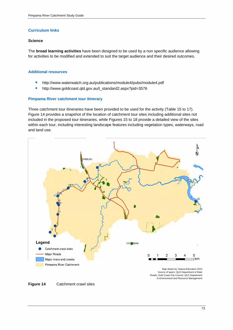
Pimpama River Catchment Study Guide
73
Curriculum links Science The broad learning activities have been designed to be used by a non specific audience allowing for activities to be modified and extended to suit the target audience and their desired outcomes. Additional resources
http://www.waterwatch.org.au/publications/module4/pubs/module4.pdf http://www.goldcoast.qld.gov.au/t_standard2.aspx?pid=3576
Pimpama River catchment tour itinerary Three catchment tour itineraries have been provided to be used for the activity (Table 15 to 17). Figure 14 provides a snapshot of the location of catchment tour sites including additional sites not included in the proposed tour itineraries, while Figures 15 to 18 provide a detailed view of the sites within each tour, including interesting landscape features including vegetation types, waterways, road and land use.
Figure 14 Catchment crawl sites
Map drawn by: Natura Education 2013 Source of layers: QLD Department of Main
Roads, Gold Coast City Council. QLD Department fo Environment and Resource Management
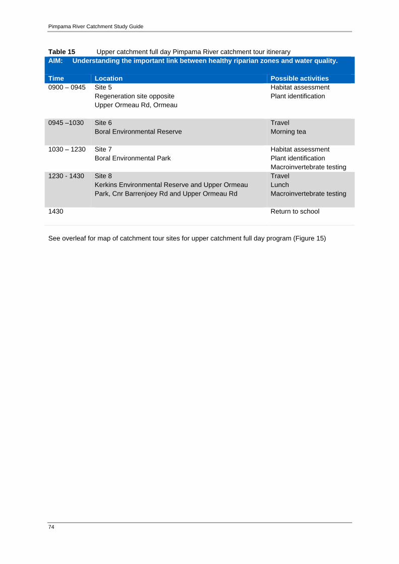
Pimpama River Catchment Study Guide
74
Table 15 Upper catchment full day Pimpama River catchment tour itinerary AIM: Understanding the important link between healthy riparian zones and water quality. Time Location Possible activities 0900 – 0945 Site 5
Regeneration site opposite Upper Ormeau Rd, Ormeau
Habitat assessment Plant identification
0945 –1030 Site 6 Boral Environmental Reserve
Travel Morning tea
1030 – 1230 Site 7 Boral Environmental Park
Habitat assessment Plant identification Macroinvertebrate testing
1230 - 1430 Site 8 Kerkins Environmental Reserve and Upper Ormeau Park, Cnr Barrenjoey Rd and Upper Ormeau Rd
Travel Lunch Macroinvertebrate testing
1430 Return to school
See overleaf for map of catchment tour sites for upper catchment full day program (Figure 15)

Pimpama River Catchment Study Guide
75
Figure 15 Catchment crawl sites for the Upper Catchment Tour Program
Map drawn by: Natura Education 2013 Source of layers: QLD Department of Main
Roads, Gold Coast City Council. QLD Department fo Environment and Resource Management

Pimpama River Catchment Study Guide
76
Table 16 Lower to upper catchment full day Pimpama River catchment tour itinerary AIM: Understanding different regions within a catchment, land use and habitat assessment Time Location Possible activities 0900 – 0945 Site 12
McCoys Creek boat ramp, end of Coleman Rd, Coomera
Observation of lower catchment area Habitat assessment
1115 – 1130 Site 9 Ormeau Ridge Housing Development
Travel Observe from bus
1145 – 1245 Site 8 Kerkins Environmental Reserve and Upper Ormeau Park, Cnr Barrenjoey Rd and Upper Ormeau Rd
Travel Lunch Habitat assessment
1330 – 1430 Site 5 Regeneration site opposite ‘Jacaranda Gardens’ property (private property) Upper Ormeau Rd, Ormeau
Travel Habitat assessment Discuss sites from lower to upper catchment, considering land use, habitat condition
1430 Return to school
See overleaf for map of catchment tour sites for lower to upper catchment full day program (Figure 16 and 17).

Pimpama River Catchment Study Guide
77
Figure 16 Catchment crawl sites for the Lower to Upper Catchment Tour Program: A
Map drawn by: Natura Education 2013 Source of layers: QLD Department of Main
Roads, Gold Coast City Council. QLD Department fo Environment and Resource Management

Pimpama River Catchment Study Guide
78
Figure 17 Catchment crawl sites for the Lower to Upper Catchment Tour Program: B
Map drawn by: Natura Education 2013 Source of layers: QLD Department of Main
Roads, Gold Coast City Council. QLD Department fo Environment and Resource Management

Pimpama River Catchment Study Guide
79
Table 17 Upper to mid catchment full day Pimpama River catchment tour itinerary AIM: Understanding water quality in the upper reaches of the Pimpama River catchment Time Location Possible activities 0900 – 1030 Site 5
Regeneration site Upper Ormeau Rd, Ormeau
Discuss upper catchment features Habitat assessment Macroinvertebrate sample testing Physico-chemical testing
1030 – 1200 Site 7 Boral Environmental Park
Travel Morning tea Habitat assessment
1200 -1430 Site 8 Kerkins Environmental Reserve and Upper Ormeau Park Cnr Barrenjoey Rd and Upper Ormeau Rd
Travel Lunch Habitat assessment Macroinvertebrate sample testing Physico-chemical testing Discuss comparison between sites
1430 Return to school See overleaf for map of catchment tour sites for upper to mid catchment full day program (Figure 18).
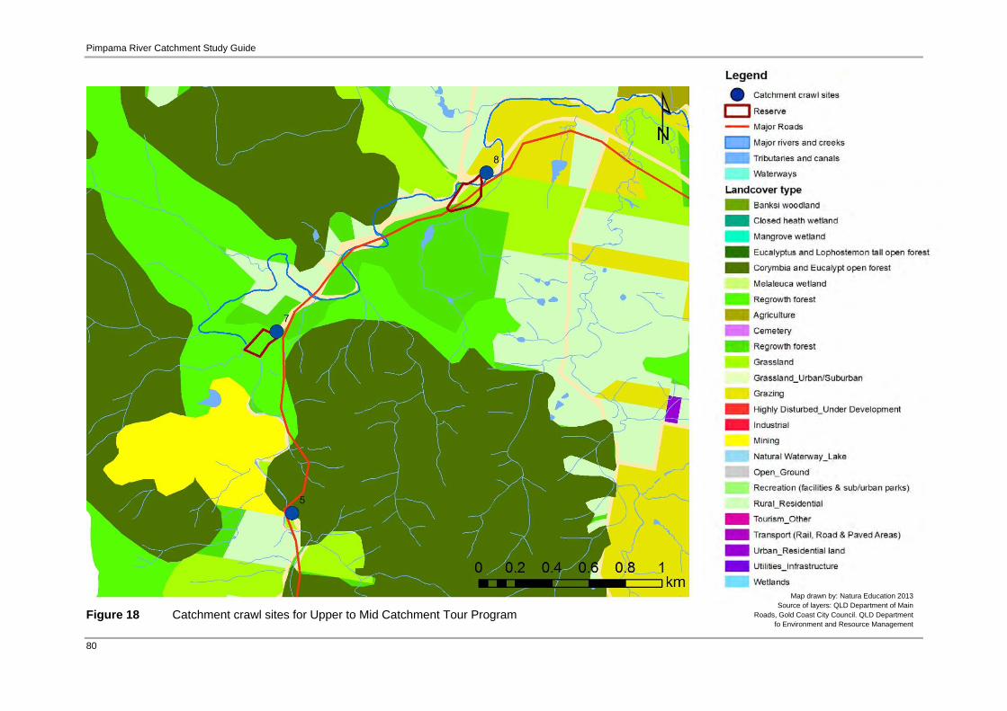
Pimpama River Catchment Study Guide
80
Figure 18 Catchment crawl sites for Upper to Mid Catchment Tour Program
Map drawn by: Natura Education 2013 Source of layers: QLD Department of Main
Roads, Gold Coast City Council. QLD Department fo Environment and Resource Management

Pimpama River Catchment Study Guide
81
Table 18 Site descriptions for the Pimpama River catchment tour Site no. Site name: Reach: Managed by: Location 1 Private property Upper Catchment Private owners How is the site currently managed / used?A privately owned rural-residential property. The owners are committed to long-term regeneration projects. Description of the site and any features / species of interest:A hillside site, from the top of the ridgeline to the north and down to the road way to the south. This property is predominately steep hills and gullies, dominated by regenerating eucalypt-acacia woodland (<25 years old) along the south-facing slopes in combination with regenerating dry rainforest communities in gullies. Running water is continuous even during drought time as it is spring-fed from the hillside. The owners have been told the spring may be coming from as far away as Toowoomba. The owners have put significant effort into regenerating the rainforest community, primarily through ongoing weed control and planting species native to the area. Many species are also now regenerating naturally. Species include: crows ash (Flindersia australis); rough leaved elm (Aphananthe phillippinensis); epiphytes such as staghorn, elkhorn and birdsnest ferns; bangalow palm (Archontophoenix cunninghamiana); tallowwood (Eucalyptus microcorys); red cedar (Toona australis); sandpaper fig (Ficus coronate); and the very rare Ormeau bottle tree (Brachychiton sp. Ormeau). What are the primary management issues? A weed of particular significance here is glycine vine which prevents germination of native plants and smothers native vegetation. Devils fig is also of concern, becoming increasingly common in the valley and spreading down the catchment. Other weeds being controlled are lantana and groundsel. Future management issues include: fire management for conservation and property protection, corridor linkage, and pest management. (pers. comms with property owner). What is the history of disturbance / land use?The first European inhabitants first came here to log the red cedar, cleared nearly to local extinction. Following this, the land was extensively cleared for dairy farming and banana plantations. Much of the property was completely denuded of native vegetation and now is dominated by regrowth <25 years old, with the exception a number of very old remnant tree (e.g. large old fig trees) (pers. comms with property owner). How has the site been regenerated? The initial removal and ongoing weed control has transformed it. Many of the gullies were previously impenetrable due to dense weeds. The site now supports regenerating dry rainforest communities. Many of the native pioneer species are germinating through natural dispersal of seeds by birds. The owners believe that this vegetation community will spread into what is currently woodland given time and ongoing management (pers. comms with property owner). How is the site significant? This site is a good example of what can be achieved through ongoing weed control and regeneration. The site also demonstrates how readily some vegetation communities can regenerate, even after almost complete deforestation. A lot of time and effort has been employed by the owners of the property. The transformation and the potential for even further improvement is wonderful demonstration of what can be accomplished (pers. comms with property owner). Site photos (Source of images: Natura Education 2013)
Regenerating dry rainforest vegetation Old regrowth
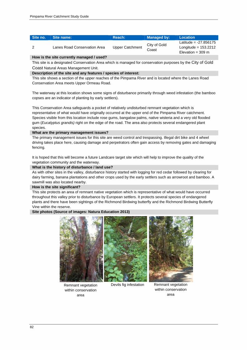
Pimpama River Catchment Study Guide
82
Site no. Site name: Reach: Managed by: Location
2 Lanes Road Conservation Area Upper Catchment City of Gold Coast
Latitude = -27.856175 Longitude = 153.2212 Elevation = 309 m
How is the site currently managed / used?This site is a designated Conservation Area which is managed for conservation purposes by the City of Gold Coast Natural Areas Management Unit. Description of the site and any features / species of interest:This site shows a section of the upper reaches of the Pimpama River and is located where the Lanes Road Conservation Area meets Upper Ormeau Road. The waterway at this location shows some signs of disturbance primarily through weed infestation (the bamboo copses are an indicator of planting by early settlers). This Conservation Area safeguards a pocket of relatively undisturbed remnant vegetation which is representative of what would have originally occurred at the upper end of the Pimpama River catchment. Species visible from this location include rose gums, bangalow palms, native wisteria and a very old flooded gum (Eucalyptus grandis) right on the edge of the road. The area also protects several endangered plant species. What are the primary management issues?The primary management issues for this site are weed control and trespassing. Illegal dirt bike and 4 wheel driving takes place here, causing damage and perpetrators often gain access by removing gates and damaging fencing. It is hoped that this will become a future Landcare target site which will help to improve the quality of the vegetation community and the waterway. What is the history of disturbance / land use?As with other sites in the valley, disturbance history started with logging for red cedar followed by clearing for dairy farming, banana plantations and other crops used by the early settlers such as arrowroot and bamboo. A sawmill was also located nearby. How is the site significant? This site protects an area of remnant native vegetation which is representative of what would have occurred throughout this valley prior to disturbance by European settlers. It protects several species of endangered plants and there have been sightings of the Richmond Birdwing butterfly and the Richmond Birdwing Butterfly Vine within the reserve. Site photos (Source of images: Natura Education 2013)
Remnant vegetation within conservation
area
Devils fig infestation Remnant vegetation within conservation
area

Pimpama River Catchment Study Guide
83
Site no. Site name: Reach: Managed by: Location 3 Private property Upper reaches Property owners How is the site currently managed / used?The site is mostly unmanaged and is dominated at this site by pasture and eucalypt regrowth. This site is sometimes slashed, however the pasture is often overgrown as the area is no longer actively grazed. Description of the site and any features / species of interest:This site represents the absolute top of the Pimpama Catchment being the highest point. From this site there is one of the best views of the Pimpama River valley which extends all the way to Moreton Bay. What are the primary management issues?Primary management issues at this site would centre on weed control, particularly given the location of this site at the very top of the catchment and therefore the potential for weed dispersal throughout the catchment below. Additionally, control of access in order to protect adjacent remnant vegetation is of some concern as there are issues with trespass with the potential to cause significant damage to vegetation and erosion. What is the history of disturbance / land use?This site was originally used for logging. A sawmill located nearby continued to operate until the 1960’s. The area was subsequently cleared for crops and cattle. The property is no longer grazed but there are some wild cattle still in the area. There has also been discussion of using this site as part of a cable-car connection to Tamborine Mountain. Extensive clearing at this site has resulted in some degradation of the watershed at this uppermost part of the catchment. How has the site been regenerated? There has been little or no attempt at active regeneration of vegetation at this site. How is the site significant? Start of the Pimpama River catchment. Site photos (Source of images: Natura Education 2013)
Cleared areas adjacent to old regrowth and
remnant forest

Pimpama River Catchment Study Guide
84
Site no. Site name: Reach: Managed by: Location
4 Conservation Area Top City of Gold Coast NAMU
Latitude = -27.834712 Longitude =153.224556 Elevation =103 m
How is the site currently managed / used?This area of land was purchased by City of Gold Coast under Open Space funding. It is currently managed for the purpose of conservation with a focus on regeneration of the native vegetation. Description of the site and any features / species of interest:Vegetation on the site is primarily undisturbed remnant, including dry rainforest which is very rare within the catchment. What are the primary management issues?The site is being managed to conserve and expand the existing native dry rainforest. Extensive weed control work is being undertaken as well as planting in order to expand the vegetated area. Other management considerations will need to include controlling access through the more sensitive parts of the site and fire management in order to protect this vegetation community which can be extensively damaged by fire. What is the history of disturbance / land use?Although this site has been disturbed by selective logging, it is still of conservation significance in this catchment given that it is one of the few areas that was not completely cleared. How has the site been regenerated? The City of Gold Coast is currently undertaking an active weed control program along with planting native species to regenerate the site. Along the fence line of the site shows a great contrast of where large thickets of lantana have been removed from the Conservation Area yet remain on the private property adjacent. This is a great way to potentially demonstrate ‘before and after’ weed control. However, this also demonstrates the need for collaboration between landholders and governmental authorities to control weed infestations. Given time and without ongoing efforts by council, lantana may re-invade the site. How is the site significant? This site’s primary significance lies in its location at the very top of the Pimpama River catchment along with it containing one of the few largely undisturbed remnants of Dry Rainforest vegetation in the catchment. Site photos (Source of images: Natura Education 2013)
Wildlife friendly fencing
Dry rainforest regeneration
Dry rainforest regeneration

Pimpama River Catchment Study Guide
85
Site no. Site name: Reach: Managed by: Location
5 Upper Ormeau Rd Upper
reaches Private (Landcare) Latitude = -27.825273 Longitude =153.225500 Elevation =81 m
How is the site currently managed / used?This site is privately owned, is a Land for Wildlife property and is currently being regenerated by the local Landcare group. Description of the site and any features / species of interest:This site is another good example of regeneration in the upper reaches of the Pimpama River and provides for easy access to the river. This may be suitable for a first site for the Catchment Crawl activity as it is unlikely a bus could turn around any further up Upper Ormeau Road. This site has historically been cleared of native vegetation and had been overgrown with weeds. The weeds have since been cleared and sprayed before being replanted with local species such as native macadamias, Ormeau Bottle Trees and native figs. There are thought to be several Aboriginal sites in the surrounding area, including sacred sites, a shell midden and several locations where other artefacts have been found. This part of the catchment was likely a rich resource area for the local Aboriginal people, as the valley could be reached by following the river upstream and provided abundant food resources. What are the primary management issues?Ongoing management for this site should focus on weed control with potential for further planting and linkage with nearby vegetation and general ongoing improvement of the riparian strip. What is the history of disturbance / land use?As with other areas in the upper catchment, disturbance history started with logging for red cedar followed by clearing for dairy farming, banana plantations and other crops used by the early settlers such as arrowroot and bamboo. Other crops grown in the area include mangoes, coffee and pineapples. How has the site been regenerated? As discussed, this site was treated extensively to remove weeds and has been planted with many native species local to the area. The site requires ongoing weed control in order to maintain the health of the regenerating community. The weed Devil’s Fig is of particular concern at this site. This weed is becoming increasingly common in the upper catchment and if left unchecked may become a significant problem for the whole catchment. How is the site significant? A good example of vegetation regeneration with easy access to the river. Site photos (Source of images: Natura Education 2013)
Ormeau Bottle Tree Fig Tree Creek bed
New leaf growth

Pimpama River Catchment Study Guide
86
Site no. Site name: Reach: Managed by: Location
6 Boral Environmental Reserve Upper reaches Private - Boral Latitude = -27.823461 Longitude =153.224347 Elevation = 97 m
How is the site currently managed / used?This site is managed for the purposes of conservation and regeneration and is owned by Boral Quarries. Description of the site and any features / species of interest:This site provides an example of the significant contrasts between different land uses within the upper catchment. The site contains a small patch of remnant vegetation, including one of the largest Ormeau Bottle Trees in the valley, and has also undergone active regeneration work through planting and weed control. The site contains several native plant species common to local dry rainforest communities. The river is easily accessible at this site and shows some signs of degradation such as water weed invasion, creek bank erosion, and weed and pest invasion. Additionally, there is significant contrast in condition of the landscape either side of the fence, with the neighbouring property being largely cleared and grazed by cattle. The completely denuded hill in the adjacent property demonstrates what much of the valley may have looked like at one time. What are the primary management issues?Weed control will be an ongoing issue for this site, particularly given the heavily disturbed nature of some of the surrounding areas. Management may also include ongoing planting to increase the size of the patch of remnant vegetation and improve the riparian environment. This may need to include specific plantings or works to prevent further creek bank erosion. What is the history of disturbance / land use?As demonstrated by surrounding properties, there has been a history of clearing for various crops and cattle grazing. The small patch of remnant vegetation remains and has since been expanded with active regeneration. How has the site been regenerated? This site has been worked on to remove weeds and replant native species local to the area. The site requires ongoing weed control in order to maintain the health of the regenerating community. How is the site significant? This site offers a great example of regeneration, particularly in the contrast between a native remnant, regenerating vegetation and farmland in the neighbouring properties. Site photos (Source of images: Natura Education 2013)
Mature Ormeau Bottle Tree
Juvenile Cane Toad
infestation
Native plant regeneration

Pimpama River Catchment Study Guide
87
Site no. Site name: Reach: Managed by: Location
7 Boral Environmental Park Upper
reaches Private – Boral / Holcim/Landcare
Latitude = -27.816307 Longitude = 153.224614 Elevation = 70 m
How is the site currently managed / used?This site is managed by Boral Quarries with the cooperation of Landcare for the purposes of conservation, native vegetation regeneration and recreation. Description of the site and any features / species of interest:It has a history of significant disturbance as a result of the nearby quarry. Boral has worked closely with the local Landcare group to restore the site. As a result this site is a good example of what can be achieved through active restoration. Significant planting has occurred along the sides of the waterway, with many now well established, providing shade and habitat. Planting has also extended from the river further up the hill to create a corridor to the top of the range. Planting at this site has focussed on dry rainforest species native to the area such as fire wheel, scrambling lily and black booyong. What are the primary management issues?Ongoing management will require regular weed control extension of plantings. What is the history of disturbance / land use?It has been heavily disturbed by clearing for farming by early European settlers and by works associated with the adjacent quarry. Large quantities of rock have been dumped in the creek, which is now heavily silted. How has the site been regenerated? Initial works involved restoring the creek bed as well as the extensive removal of weeds, followed by large scale planting of species native to the area. Planting has occurred along both sides of the waterway and has extended up the hillside to create a corridor between the riparian strip and the top of the range. Much of the planting is quite advanced in age, providing shade and leaf litter that will allow natural germination and habitat The riverbed itself is also transforming as a result of the maturing canopy, gradually widened and stabilised. How is the site significant? This site provides great opportunities to demonstrate a study of contrasts in catchment condition:
cleared areas contrast with areas that have been actively regenerated with planting and weed control the older, well established stands contrast with the newer plantings, clearly showing progress areas weed control areas contrast with nearby heavy infested areas shaded and stabilised areas of the creek banks contrasts with exposed, weed infested and eroded
areas. There is also potential to provide students and the community with hands-on experience in tree planting and weed control, with the cooperation of Boral. Site photos (Source of images: Natura Education 2013)
Hard ground revegetation
Juvenile plantings
Immature planting
Mature revegetation
area

Pimpama River Catchment Study Guide
88
Site no. Site name: Reach: Managed by: Location
8 Kerkin Environmental Reserve and Upper Ormeau Park
Upper reaches (lower end)
City of Gold Coast / Landcare
Latitude = -27.808443 Longitude = 153.236217 Elevation =12.6 m
How is the site currently managed / used?Kerkin Environmental Reserve was the first Landcare restoration site in the valley, with work beginning in the early 1990’s. The vegetation is remnant dry rainforest and has been managed for conservation through weed control and restoration. There has also been the installation of signage and a walking trail. The adjacent Upper Ormeau Park is managed by the Gold Coast City for the purposes of recreation as well as conservation and improvement of riparian vegetation along this section of the Pimpama River. Description of the site and any features / species of interest:These two sites are provide a contrast between an area of remnant vegetation which has been the subject of long term regeneration efforts, with an area which is still largely open but with areas of newer revegetation works alongside recreational facilities. Both of these sites offer further contrast with the riparian strip directly across the road, which is degraded and has significant weed infestation. What are the primary management issues?Ongoing management of these sites will need to focus primarily on weed control. There is a substantial seed bank of weed species which will require ongoing and consistent control to allow native species to establish and self-maintain. The weed infested site directly across the road will likely continue to provide weed seeds if some control work is not undertaken. This is currently being investigated by the City of Gold Coast. What is the history of disturbance / land use?There has been a history of logging and clearing for various crops and grazing over the course of settlement in the valley. This tiny remnant has remained and has since been expanded with active regeneration. How has the site been regenerated? These sites have both been the subject of extensive weed control and revegetation works. These works are ongoing and weed control will continue to be a significant challenge here. How is the site significant? This site provides for clear demonstration of the contrast between:
Kerkin Environmental Reserve - a patch of remnant vegetation which has been the subject of long-term restoration efforts within the,
Upper Ormeau Park - an area of relatively new revegetation where weed control will be an ongoing challenge. There is also potential to continue improving the riparian zone into the future
Riparian vegetation – directly opposite, which is degraded and weed infested. There is potential for future tree-planting activities which could involve local schools and community groups. Site photos (Source of images: Natura Education 2013)
Kerkin Environmental
Reserve
Mature plantings in background
Site signage
Upper Ormeau Park

Pimpama River Catchment Study Guide
89
Site no. Site name: Reach: Managed by: Location
9 Housing Development Upper-Mid reaches
Private owners / City of Gold Coast
Latitude = -27.80198 Longitude = 153.25479
How is the site currently managed / used?This site is part of the adjacent Stockland housing development and is managed primarily for residential purposes. The river at this location is managed to provide for stormwater run-off and visual amenity as well as works designed to restore the riverside vegetation after construction and prevent future erosion. Description of the site and any features / species of interest:This site provides an example of large-scale engineered restoration in a location that is now dominated by residential land use. The potential for long-term regeneration of vegetation communities that used to exist here is extremely limited given the proximity to large housing developments. As a consequence, revegetation and structural restoration of the river and riparian zone is more focussed on improving aesthetics and providing engineered solutions to issues such as erosion. What are the primary management issues?Management issues at this site will likely involve management of stormwater run-off from, weed control, waste management and recreational use of the river as a result of the relatively high density of people living in the adjacent residential area. What is the history of disturbance / land use?As with many other parts of the upper and mid-catchment, much of this area would have been almost completely cleared by early European settlers or subsequent farming communities. Both the riparian zone and the surrounding land has been substantially modified by historic land use and now, most significantly, by a large housing estate. How has the site been regenerated? As mentioned, regeneration has focussed more on the practicalities of engineering for infrastructure, stormwater, access and aesthetics rather than restoration of native vegetation communities. How is the site significant? This site demonstrates an alternative approach to riparian restoration. Site photos (Source of images: Natura Education 2013)
Regeneration plantings
Recent plantings
Regeneration plantings in
riparian zone

Pimpama River Catchment Study Guide
90
Site no. Site name: Reach: Managed by: Location
10 Private property Mid reaches Please contact City of Gold Coast or North East Albert Landcare
How is the site currently managed / used?This site is private property and is a working farm which produces sugarcane and beef cattle. The owners have put significant effort into restoring the riparian vegetation on the property and hope to see this work continued. Description of the site and any features / species of interest:This property is dominated by sugarcane plantation and open grazing land but also contains both remnant and revegetated riparian communities along the river banks. There is also old growth eucalypt forest. The property is bordered by urban development and is also transected by the Gold Coast – Brisbane railway line. The family that owns the property have lived and farmed here for several generations. Over the generations, the family has been activity rehabilitating the riparian environment. The owners work closely with Landcare and are enthusiastic about continuing to improve management of their property, the local environment and water quality as well as educate others on how to manage a working farm with sound environmental practices. What are the primary management issues?Primary management issues are weed control as well as impacts of the adjacent expanding urban developments. These developments have impacted the waterway through increased runoff and the subsequent higher than usual water levels and faster moving water during rainfall events. These results in higher risk of erosion and inundation of revegetated areas which would otherwise have remained above flood water levels. Flood waters also carry and spread seed sources for many weed species. What is the history of disturbance / land use?This site has a long history of farming and was originally cleared for this purpose. Prior to the planting of sugar cane much of the farm was used to grow arrowroot. Sugar cane was also historically grown on a far greater proportion of the property but now is primarily grown on the flatter flood plains, with the hills used for grazing. How has the site been regenerated? The property owners have put large effort into replanting and restoring the riparian vegetation, although more recently they have been less able to commit the time required to see this work continued and expanded. They are very keen to support organisations such as North East Albert Landcare and Catchment Group who may be willing to come on to the property and continue the work that they have begun. How is the site significant? This property demonstrates the challenges of managing a working farm in conjunction with rehabilitating and protecting riparian areas and the waterway which runs through it. This challenge is further exacerbated by the impacts of the surrounding and expanding urban development. There is potential to undertake education programs on the property for students and the community about these issues. They already welcome groups of school students to the property through the Jacobs Well Environmental Education Centre. Site photos (Source of images: Natura Education 2013)
Regeneration plantings along Pimpama River
Cane fields
Original farm house

Pimpama River Catchment Study Guide
91
Site no. Site name: Reach: Managed by: Location
11 Pimpama Conservation Area Mid-Lower reaches
City of Gold Coast NAMU
Latitude = -27.8046 Longitude = 153.3387
How is the site currently managed / used?This site is managed for the purposes of conservation of its scenic, natural and cultural heritage values, focusing around bush regeneration, weed control, fire management and restoring and replanting cleared areas. Description of the site and any features / species of interest:This site is a part of the Pimpama River Conservation Reserves cluster, which together cover approximately 447.6 hectares of the lower reaches of the catchment, forming part of a mostly forested corridor from the Moreton Bay islands west into the hinterland. The reserve is surrounded mostly by farmland dominated by sugarcane and cattle grazing, but is also adjoined by a golf course and Pimpama Wastewater Treatment Plant. The reserve contains a variety of habitat types including: Broad-leaved Paperbark open forest; coastal Eucalypt open forest; marine communities such as saltmarsh and mangroves; Swamp Oak open forests; Banksia woodlands; and ephemeral/freshwater wetlands. Much of the forested areas of the reserve is regrowth and of a young age. This area conserves the habitat of rare and threatened mammal species such as: the Water Mouse (Xeromys myoides) which is one of Australia’s rarest mammals, the Agile Wallaby (Macropus agilis), the Koala (Phascolartos cinerius) and the Golden Swamp Wallaby (Wallabia bicolor). A rich diversity of birdlife is present, including rare and threatened species such as: the Eastern Curlew (Numenius madagascariensis), the Glossy Black Cockatoo (Calyptorhynchus lathami), the Square-tailed Kite (Lophoictinia isurs), and the Black-necked Stork (Ephippiorhynchus asiaticus). Significant plant species found in the reserve include the Corkwood (Endiandra sieberii) and many rare ground orchids. What are the primary management issues?There are long-term and ongoing efforts to control and manage major weed infestations throughout the reserve. Some weeds of concern include: lantana (Lantana camara), Groundsel (Baccharis halimifolia); Camphor Laurel (Cinnamomum camphora), Broad-leaved Pepper Tree (Schinus terebinthifolius), and Fireweed (Senecio madagascariensis). Weed control is being accomplished through ongoing weed control programs that involve a variety of techniques suited to each weed species and vegetation community. This program continues to work towards making the native vegetation communities self-sustaining and resilient. Mosquito control operations also occur in the area (through aerial spraying) which may have the potential to impact the invertebrate population. This is an ongoing concern as native invertebrates are a primary food source for local fauna, including rare species such as the Water Mouse (or False Water Rat). Future planning for management include: fire management, vertebrate pest management, protection of the site’s scenic, landscape and catchment values, control and management of recreational use, providing opportunities for research, community involvement and education, and protection of the Aboriginal and European cultural heritage values. City of Gold Coast has completed a plan of management for the Pimpama River Conservation Reserve Cluster (GCCC 2010a). This document contains significant background information about the reserve and details the plans for its management into the future. What is the history of disturbance / land use?This area and its surrounds were first settled by Europeans in the early 1900’s. Since then this site has been altered by a variety of human disturbances / activities such as: draining and clearing of swamp lands, clearing and thinning of forested land, grazing, turf farming, sugar cane, and more recently was the site of a very large wholesale nursery, the infrastructure for which is still being removed from the site. This is a significant area for the protection of water quality in the lower reaches of the catchment given the extensive clearing and disturbance that has occurred within the reserve and continues in many of the areas surrounding it. Protection, management and restoration of native wetland and forest communities may help to offset the possible impacts on water quality resulting from issues such as disturbance of acid sulphate soils from cane farming and degradation and erosion of river banks as a result of boating, fishing and other activities.

Pimpama River Catchment Study Guide
92
How has the site been regenerated? A lot of work has already been done in the reserve to regenerate and expand the areas of native vegetation. This has involved the extensive removal of weed species to allow for natural regeneration, as well as planting, both within the existing vegetation and on a larger scale across areas previously completely cleared. Major plantings have occurred on the site and more is planned for the future, primarily as part of carbon offset programs, with a total of 65,000 native species planted on the site around 18 months ago and large areas now being prepared for planting in the near future. Some parts of the reserve will be maintained as grassland in order to provide habitat and feeding opportunities for macropod (kangaroo & wallaby) species, small ground mammals, grassland birds and birds of prey. How is the site significant? This site is of conservation significance to the lower part of the Pimpama River catchment. It is one of the few larger vegetated areas remaining in this part of the catchment and has the major advantage of being actively managed for conservation into the future. The site provides examples of what can be achieved over time to restore and regenerate native vegetation communities through ongoing and active management and provides hope for the future health of the lower reaches of the Pimpama River catchment. Site photos (Source of images: Natura Education 2013)
Birdlife in riparian area
Cattle on neighbouring property fenced off from conservation area
Pimpama River within the conservation area
Bollards preventing vehicle access to allow regeneration
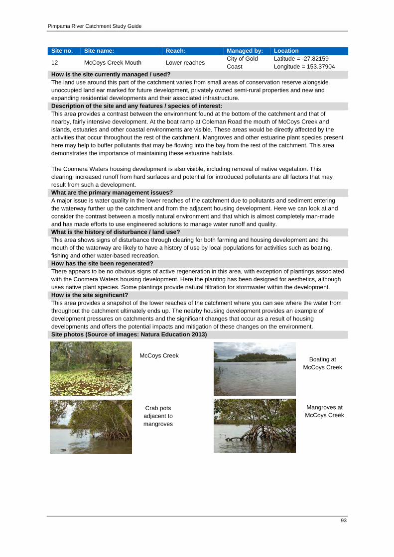
Pimpama River Catchment Study Guide
93
Site no. Site name: Reach: Managed by: Location
12 McCoys Creek Mouth Lower reaches City of Gold Coast
Latitude = -27.82159 Longitude = 153.37904
How is the site currently managed / used?The land use around this part of the catchment varies from small areas of conservation reserve alongside unoccupied land ear marked for future development, privately owned semi-rural properties and new and expanding residential developments and their associated infrastructure. Description of the site and any features / species of interest:This area provides a contrast between the environment found at the bottom of the catchment and that of nearby, fairly intensive development. At the boat ramp at Coleman Road the mouth of McCoys Creek and islands, estuaries and other coastal environments are visible. These areas would be directly affected by the activities that occur throughout the rest of the catchment. Mangroves and other estuarine plant species present here may help to buffer pollutants that may be flowing into the bay from the rest of the catchment. This area demonstrates the importance of maintaining these estuarine habitats. The Coomera Waters housing development is also visible, including removal of native vegetation. This clearing, increased runoff from hard surfaces and potential for introduced pollutants are all factors that may result from such a development. What are the primary management issues?A major issue is water quality in the lower reaches of the catchment due to pollutants and sediment entering the waterway further up the catchment and from the adjacent housing development. Here we can look at and consider the contrast between a mostly natural environment and that which is almost completely man-made and has made efforts to use engineered solutions to manage water runoff and quality. What is the history of disturbance / land use?This area shows signs of disturbance through clearing for both farming and housing development and the mouth of the waterway are likely to have a history of use by local populations for activities such as boating, fishing and other water-based recreation. How has the site been regenerated? There appears to be no obvious signs of active regeneration in this area, with exception of plantings associated with the Coomera Waters housing development. Here the planting has been designed for aesthetics, although uses native plant species. Some plantings provide natural filtration for stormwater within the development. How is the site significant? This area provides a snapshot of the lower reaches of the catchment where you can see where the water from throughout the catchment ultimately ends up. The nearby housing development provides an example of development pressures on catchments and the significant changes that occur as a result of housing developments and offers the potential impacts and mitigation of these changes on the environment. Site photos (Source of images: Natura Education 2013)
Boating at McCoys Creek
McCoys Creek
Crab pots adjacent to mangroves
Mangroves at McCoys Creek
Pimpama River Catchment Study Guide
94
4.4 Specific learning activities
4.4.1 Background The broad learning activities that have been developed for this study guide are outlined in Table 19 below. Table 19 Specific learning activities for the Pimpama River Catchment Study Guide
Learning Activity Title Page Number Year 1/2 Wildlife protectors – catchment conservation 113 Year 3 Who’s habitat is that? Investigation survival needs 119 Year 4 The cycle of life – Macroinvertebrates 124 Year 5 Riparian rescuers – Healthy catchment vegetation 131 Year 6 Catchments under threat 137 Year 7 Specialised adaptations 147 Year 8 Physico-chemical testing 156 Year 9 Monitoring the Pimpama River wetlands 164
Year 10 The lay of the land 175 The Science curriculum link for each Year’s learning activity has been provided in the following table (Table 20) under the headings of:
Science understanding; Science as a human endeavour; and Science inquiry skills for year levels 1 to 10.
These 3 sections enable educators to justify the content of the activities to the Year Level descriptions, related curriculum links and their final achievement standards, these being:
1. individual year level description (Australian Science Curriculum); 2. individual year level achievement standards (Australian Science Curriculum); 3. name of Pimpama River Catchment Study Guide lesson, outline and lesson objectives;
and 4. related science and other specific curriculum links.

Pimpama River Catchment Study Guide
95
Table 20 Specific learning activity curriculum links Years 1 – 10 Year 1/2 level description: The Science Inquiry Skills and Science as a Human Endeavour strands are described across a two-year band. In their planning, schools and teachers refer to the expectations outlined in the Achievement Standards and also to the content of the Science Understanding strand for the relevant year level to ensure that these two strands are addressed over the two-year period. Year 1, students infer simple cause-and-effect relationships from their observations and experiences, and begin to link events and phenomena with observable effects. They observe changes that can be large or small and happen quickly or slowly. They explore the properties of familiar objects and phenomena, identifying similarities and differences. Students begin to value counting as a means of comparing observations, and are introduced to ways of organising their observations. Year 2, students describe the components of simple systems, such as stationary objects subjected to pushes or pulls, or combinations of materials, and show how objects and materials interact through direct manipulation. They observe patterns of growth and change in living things, and describe patterns and make predictions. They explore the use of resources from Earth and are introduced to the idea of the flow of matter when considering how water is used. They use counting and informal measurements to make and compare observations and begin to recognise that organising these observations in tables makes it easier to show patterns. Year 1 and 2 achievement standards: By the end of Year 1, students describe objects and events that they encounter in their everyday lives, and the effects of interacting with materials and objects. They identify a range of habitats. They describe changes to things in their local environment and suggest how science helps people care for environments. Students make predictions, and investigate everyday phenomena. They follow instructions to record and sort their observations and share their observations with others. By the end of Year 2, students describe changes to objects, materials and living things. They identify that certain materials and resources have different uses and describe examples of where science is used in people’s daily lives. Students pose questions about their experiences and predict outcomes of investigations. They use informal measurements to make and compare observations. They follow instructions to record and represent their observations and communicate their ideas to others.

Pimpama River Catchment Study Guide
96
Year 1 /2 Lesson/ activity booklet: Wildlife protectors! – Catchment conservation. Using site investigations, students will learn about what to look for when identifying a living thing. They will revise the meaning of non-living and living things in the context of what can be found living in and near a river. Lesson objectives: Students should be able to;
describe how a living thing differs from a non-living thing; identify some features/ basic needs of living things and what type of environment they need; in the context of a catchment area; and understand why we need to protect some living things from unnatural non-living things, such as litter.
Science understanding Science as a human endeavour Science inquiry skills Year 1 *Living things have a variety of external features (ACSSU017) *Living things live in different places where their needs are met (ACSSU211) *Observable changes occur in the sky and landscape (ACSSU019) Year 2 *Living things grow, change and have offspring similar to themselves (ACSSU030) *Earth’s resources, including water, are used in a variety of ways (ACSSU032)
Year 1 and 2 *Science involves asking questions about, and describing changes in, objects and events (ACSHE021) *People use science in their daily lives, including when caring for their environment and living things (ACSHE022)
*Respond to and pose questions, and make predictions about familiar objects and events (ACSIS024) * Participate in different types of guided investigations to explore and answer questions, such as manipulating materials, testing ideas, and accessing information sources (ACSIS025) * Use a range of methods to sort information, including drawings and provided tables (ACSIS027) *Through discussion, compare observations with predictions (ACSIS212)

Pimpama River Catchment Study Guide
97
*Compare observations with those of others (ACSIS213) *Represent and communicate observations and ideas in a variety of ways such as oral and written language, drawing and role play (ACSIS029)
Year 3 level description: In Year 3, students observe heat and its effects on solids and liquids and begin to develop an understanding of energy flows through simple systems. In observing day and night, they develop an appreciation of regular and predictable cycles. Students order their observations by grouping and classifying; in classifying things as living or non-living they begin to recognise that classifications are not always easy to define or apply. They begin to quantify their observations to enable comparison, and learn more sophisticated ways of identifying and representing relationships, including the use of tables and graphs to identify trends. They use their understanding of relationships between components of simple systems to make predictions. Year 3 achievement standards: By the end of Year 3, students use their understanding of the movement of the Earth, materials and the behaviour of heat to suggest explanations for everyday observations They describe features common to living things. They describe how they can use science investigations to respond to questions and identify where people use science knowledge in their lives. Students use their experiences to pose questions and predict the outcomes of investigations. They make formal measurements and follow procedures to collect and present observations in a way that helps to answer the investigation questions. Students suggest possible reasons for their findings. They describe how safety and fairness were considered in their investigations. They use diagrams and other representations to communicate their ideas. Year 3 Lesson / activity booklet: Who’s habitat is that? – investigating survival needs. Using field guides and site investigations, students will learn about what to look for when identifying an animal that requires a freshwater aquatic habitat to survive. Students will revise why these animals require a clean environment to live in, and how we can protect their habitat.

Pimpama River Catchment Study Guide
98
Lesson objectives: Students should be able to:
describe some animals that live within the Pimpama catchment, and the external features of these animals; identify some basic needs of these animals and what type of environment they need; in the context the Pimpama catchment area; understand why we need to protect the habitat of these animals; and represent these animals in a creative way, conveying the message to others of protecting their habitat.
Science understanding Science as a human endeavour Science inquiry skills *Living things can be grouped on the basis of observable features and can be distinguished from non-living things (ACSSU044)
*Science involves making predictions and describing patterns and relationships (ACSHE050) *Science knowledge helps people to understand the effect of their actions (ACSHE051)
*Suggest ways to plan and conduct investigations to find answers to questions (ACSIS054) *Safely use appropriate materials, tools or equipment to make and record observations, using formal measurements and digital technologies as appropriate (ACSIS055) *Use a range of methods including tables and simple column graphs to represent data and to identify patterns and trends (ACSIS057) *Represent and communicate ideas and findings in a variety of ways such as diagrams, physical representations and simple reports (ACSIS060)

Pimpama River Catchment Study Guide
99
Year 4 level description: In Year 4, students broaden their understanding of classification and form and function through an exploration of the properties of natural and processed materials. They learn that forces include non-contact forces and begin to appreciate that some interactions result from phenomena that can’t be seen with the naked eye. They begin to appreciate that current systems, such as Earth’s surface, have characteristics that have resulted from past changes and that living things form part of systems. They understand that some systems change in predictable ways, such as through cycles. They apply their knowledge to make predictions based on interactions within systems, including those involving the actions of humans. Year 4 achievement standards: By the end of Year 4, students apply the observable properties of materials to explain how objects and materials can be used. They use contact and non-contact forces to describe interactions between objects. They discuss how natural and human processes cause changes to the Earth’s surface. They describe relationships that assist the survival of living things and sequence key stages in the life cycle of a plant or animal. They identify when science is used to ask questions and make predictions. They describe situations where science understanding can influence their own and others’ actions. Students follow instructions to identify investigable questions about familiar contexts and predict likely outcomes from investigations. They discuss ways to conduct investigations and safely use equipment to make and record observations. They use provided tables and simple column graphs to organise their data and identify patterns in data. Students suggest explanations for observations and compare their findings with their predictions. They suggest reasons why their methods were fair or not. They complete simple reports to communicate their methods and findings. Year 4 lesson / activity booklet: The cycle of life – macroinvertebrates. Using site investigations and field guides, students will learn about how to identify the aquatic and terrestrial stages of macroinvertebrates. They will understand the meaning of Complete and Incomplete Metamorphosis and how macroinvertebrates are dependent on their habitat to survive and develop. Lesson objectives: Students should be able to:
identify aquatic and terrestrial stages of some macroinvertebrate lifecycles learn to differentiate between Complete and Incomplete Metamorphosis understand how the habitat of these macroinvertebrates affects how the insects develop through their lifecycle.

Pimpama River Catchment Study Guide
100
Science understanding Science as a human endeavour Science inquiry skills * Living things have life cycles (ACSSU072) * Living things, including plants and animals, depend on each other and the environment to survive (ACSSU073) * Earth’s surface changes over time as a result of natural processes and human activity (ACSSU075)
* Science involves making predictions and describing patterns and relationships (ACSHE061) * Science knowledge helps people to understand the effect of their actions (ACSHE062)
* With guidance, identify questions in familiar contexts that can be investigated scientifically and predict what might happen based on prior knowledge (ACSIS064) * Suggest ways to plan and conduct investigations to find answers to questions (ACSIS065) * Safely use appropriate materials, tools or equipment to make and record observations, using formal measurements and digital technologies as appropriate (ACSIS066) * Use a range of methods including tables and simple column graphs to represent data and to identify patterns and trends (ACSIS068) * Represent and communicate ideas and findings in a variety of ways such as diagrams, physical representations and simple reports (ACSIS071)
Year 5 level description: In Year 5, students are introduced to cause and effect relationships that relate to form and function through an exploration of adaptations of living things. They explore observable phenomena associated with light and begin to appreciate that phenomena have sets of characteristic behaviours. They broaden their classification of matter to include gases and begin to see how matter structures the world around them. Students consider Earth as a component within a solar system and use models for investigating systems at astronomical scales. Students begin to identify stable and dynamic aspects of systems, and learn how to look for patterns and relationships between components of systems. They develop explanations for the patterns they observe.

Pimpama River Catchment Study Guide
101
Year 5 achievement standards: By the end of Year 5, students classify substances according to their observable properties and behaviours. They explain everyday phenomena associated with the transfer of light. They describe the key features of our solar system. They analyse how the form of living things enables them to function in their environments. Students discuss how scientific developments have affected people’s lives and how science knowledge develops from many people’s contributions. Students follow instructions to pose questions for investigation, predict what might happen when variables are changed, and plan investigation methods. They use equipment in ways that are safe and improve the accuracy of their observations. Students construct tables and graphs to organise data and identify patterns. They use patterns in their data to suggest explanations and refer to data when they report findings. They describe ways to improve the fairness of their methods and communicate their ideas, methods and findings using a range of text types. Year 5 lesson/ activity booklet: Riparian rescuers: healthy catchment vegetation. Using field guides and site investigations, students will learn about the types of plants that require a freshwater aquatic environment to survive. Students will gain a deeper understanding of what structures and adaptations these plants develop, and the role plants have on the health of the catchment. Lesson objectives: Students should be able to:
describe some plants that can be found within the Pimpama catchment, and the structures of these plants; identify the role plants have in a catchment; and understand how plants affect the health of the catchments, and why we need to protect the environment within a catchment.
Science understanding Science as a human endeavour Science inquiry skills
* Living things have structural features and adaptations that help them to survive in their environment (ACSSU043)
* Science involves testing predictions by gathering data and using evidence to develop explanations of events and phenomena (ACSHE081) * Scientific knowledge is used to inform personal and community decisions (ACSHE217)
* With guidance, plan appropriate investigation methods to answer questions or solve problems (ACSIS086) * Construct and use a range of representations, including tables and graphs, to represent and

Pimpama River Catchment Study Guide
102
describe observations, patterns or relationships in data using digital technologies as appropriate (ACSIS090) * Communicate ideas, explanations and processes in a variety of ways, including multimodal texts (ACSIS093)
Year 6 level description: In Year 6, students explore how changes can be classified in different ways. They learn about transfer and transformations of electricity, and continue to develop an understanding of energy flows through systems. They link their experiences of electric circuits as a system at one scale, to generation of electricity from a variety of sources at another scale and begin to see links between these systems. They develop a view of Earth as a dynamic system, in which changes in one aspect of the system impact on other aspects; similarly they see that the growth and survival of living things are dependent on matter and energy flows within a larger system. Students begin to see the role of variables in measuring changes and learn how look for patterns and relationships between variables. They develop explanations for the patterns they observe, drawing on evidence. Year 6 achievement standards: By the end of Year 6, students compare and classify different types of observable changes to materials. They analyse requirements for the transfer of electricity and describe how energy can be transformed from one form to another to generate electricity. They explain how natural events cause rapid change to the Earth’s surface. They describe and predict the effect of environmental changes on individual living things. Students explain how scientific knowledge is used in decision making and identify contributions to the development of science by people from a range of cultures. Students follow procedures to develop investigable questions and design investigations into simple cause-and-effect relationships. They identify variables to be changed and measured and describe potential safety risks when planning methods. They collect, organise and interpret their data, identifying where improvements to their methods or research could improve the data. They describe and analyse relationships in data using graphic representations and construct multi-modal texts to communicate ideas, methods and findings. Year 6 lesson/ activity booklet: Catchments under threat. Students will gain an understanding of the impacts of certain land uses and human activities that occur within the Pimpama catchment. They will investigate impacts on the waterway (pollution, erosion and habitat loss) as well as impacts on the land due to the removal of vegetation and modification of natural features.

Pimpama River Catchment Study Guide
103
Students will identify different social and environmental values and perspectives of the usefulness of a catchment/natural resource. They will then be able to make an informed decision on the best way to reduce negative impacts and sustainably manage other’s actions in the catchment. Lesson objectives: Students should be able to:
identify some human activities that occur within the Pimpama catchment and their associated impacts on the catchment; understand the importance of predicting possible effects of human and other activity on the environment, in order to develop strategies that
minimise any negative consequences; and provide solutions to minimise the impacts from human activity in the catchment.
Cross-curriculum priority: Sustainability. * World views that recognise the dependence of living things on healthy ecosystems, and value diversity and social justice are essential for achieving sustainability. * Actions for a more sustainable future reflect values of care, respect and responsibility, and require us to explore and understand environments. * Designing action for sustainability requires an evaluation of past practices, the assessment of scientific and technological developments, and balanced judgments based on projected future economic, social and environmental impacts. * Sustainable futures result from actions designed to preserve and/or restore the quality and uniqueness of environments.
Science understanding Science as a human endeavour Science inquiry skills * The growth and survival of living things are affected by the physical conditions of their environment (ACSSU094)
Science involves testing predictions by gathering data and using evidence to develop explanations of events and phenomena (ACSHE098) * Scientific understandings, discoveries and inventions are used to solve problems that directly affect peoples’ lives (ACSHE100)
* With guidance, pose questions to clarify practical problems or inform a scientific investigation, and predict what the findings of an investigation might be (ACSIS232) * With guidance, plan appropriate investigation methods to answer questions or solve problems (ACSIS103)

Pimpama River Catchment Study Guide
104
* Scientific knowledge is used to inform personal and community decisions (ACSHE220)
* Compare data with predictions and use as evidence in developing explanations (ACSIS221) * Communicate ideas, explanations and processes in a variety of ways, including multi-modal texts (ACSIS110)
Year 7 level description: In Year 7, students explore the diversity of life on Earth and continue to develop their understanding of the role of classification in ordering and organising information. They use and develop models such as food chains, food webs and the water cycle to represent and analyse the flow of energy and matter through ecosystems and explore the impact of changing components within these systems. They consider the interaction between multiple forces when explaining changes in an object’s motion. They explore the notion of renewable and non-renewable resources and consider how this classification depends on the timescale considered. They investigate relationships in the Earth, sun, moon system and use models to predict and explain events. Students make accurate measurements and control variables to analyse relationships between system components and explore and explain these relationships through increasingly complex representations. Year 7achievement standards: By the end of Year 7, students describe techniques to separate pure substances from mixtures. They represent and predict the effects of unbalanced forces, including Earth’s gravity, on motion. They explain how the relative positions of the Earth, sun and moon affect phenomena on Earth. They analyse how the sustainable use of resources depends on the way they are formed and cycle through Earth systems. They predict the effect of environmental changes on feeding relationships and classify and organise diverse organisms based on observable differences. Students describe situations where scientific knowledge from different science disciplines has been used to solve a real-world problem. They explain how the solution was viewed by, and impacted on, different groups in society. Year 7 lesson/ activity booklet: Specialised adaptations. Students identify questions that can be investigated scientifically. They plan fair experimental methods, identifying variables to be changed and measured. They select equipment that improves fairness and accuracy and describe how they considered safety. Students draw on evidence to support their conclusions. They summarise data from different sources, describe trends and refer to the quality of their data when suggesting improvements to their methods. They communicate their ideas, methods and findings using scientific language and appropriate representations.

Pimpama River Catchment Study Guide
105
Using field guides and site investigations, students will carry out scientific investigations of aquatic macroinvertebrates found in the catchment, in order to gain an understanding about how the physical conditions of the catchment affect the survival of living things. Students will gain a deeper understanding of what specialized adaptations these macroinvertebrates have, and the interactions they have with other living things within a food chain. Lesson objectives: Students should be able to:
describe some aquatic macroinvertebrates that can be found within the Pimpama catchment, and the specialized external features of these organisms
identify the role macroinvertebrates have within a food chain classify these organisms according to their physical features, habitat, position in the food chain and sensitivity to pollution understand why the health of the catchment affects the abundance and diversity of aquatic macroinvertebrates, and how we can protect the
environment within a catchment. Cross-curriculum priority: Sustainability. *All life forms, including human life, are connected through ecosystems on which they depend for their wellbeing and survival.
Science understanding Science as a human endeavour Science inquiry skills * There are differences within and between groups of organisms; classification helps organise this diversity (ACSSU111) * Interactions between organisms can be described in terms of food chains and food webs; human activity can affect these interactions (ACSSU112) * Water is an important resource that cycles through the environment (ACSSU222)
* Science understanding influences the development of practices in areas of human activity such as industry, agriculture and marine and terrestrial resource management (ACSHE121)
* Identify questions and problems that can be investigated scientifically and make predictions based on scientific knowledge (ACSIS124) * Construct and use a range of representations, including graphs, keys and models to represent and analyse patterns or relationships, including using digital technologies as appropriate (ACSIS129) * Summarise data, from students’ own

Pimpama River Catchment Study Guide
106
investigations and secondary sources, and use scientific understanding to identify relationships and draw conclusions (ACSIS130)
* Use scientific knowledge and findings from investigations to evaluate claims (ACSIS132) * Communicate ideas, findings and solutions to problems using scientific language and representations using digital technologies as appropriate (ACSIS133)
Year 8 level description: In Year 8, students are introduced to cells as microscopic structures that explain macroscopic properties of living systems. They link form and function at a cellular level and explore the organisation of body systems in terms of flows of matter between interdependent organs. Similarly, they explore changes in matter at a particle level, and distinguish between chemical and physical change. They begin to classify different forms of energy, and describe the role of energy in causing change in systems, including the role of heat and kinetic energy in the rock cycle. Students use experimentation to isolate relationships between components in systems and explain these relationships through increasingly complex representations. They make predictions and propose explanations, drawing on evidence to support their views. Year 8 achievement standards: By the end of Year 8, students compare physical and chemical changes and use the particle model to explain and predict the properties and behaviours of substances. They identify different forms of energy and describe how energy transfers and transformations cause change in simple systems. They compare processes of rock formation, including the time scales involved. They analyse the relationship between structure and function at cell, organ and body system levels. Students examine the different science knowledge used in occupations. They explain how evidence has led to an improved understanding of a scientific idea and describe situations in which scientists collaborated to generate solutions to contemporary problems. Students identify and construct questions and problems that they can investigate scientifically. They consider safety and ethics when planning investigations, including designing field or experimental methods. They identify variables to be changed, measured and controlled. Students construct representations of their data to reveal and analyse patterns and trends, and use these when justifying their conclusions. They explain how modifications to methods could improve the quality of their data and apply their own scientific knowledge and investigation findings to evaluate claims made by others. They use appropriate language and representations to communicate science ideas, methods and findings in a range of text types.
Pimpama River Catchment Study Guide
107
Year 8 lesson/ activity booklet: Physico-chemical testing. Using field resources and site investigations, students will investigate how living and non-living things are connected by exploring how physico-chemical properties can affect the survival of aquatic organisms, as well as the overall health of the waterway. Students will study different pollutants that affect the water quality by impacting on the physical or chemical properties of a waterway. They will then be able to make an informed decision on the best way to reduce negative human impacts and sustainably manage the catchment health. Lesson objectives: Students should be able to:
identify the physico-chemical parameters that must be measured in order to get an accurate interpretation on water quality; distinguish between chemical and physical change and recognize that these properties will change the health of the waterway; understand how the health of the waterways in the catchment can influence the survival of living things; and develop management plans that decrease the impact of human actions on the catchment.
Cross-curriculum priority: Sustainability. *All life forms, including human life, are connected through ecosystems on which they depend for their wellbeing and survival.
Science understanding Science as a human endeavour Science inquiry skills * Chemical change involves substances reacting to form new substances (ACSSU225) * Energy appears in different forms including movement (kinetic energy), heat and potential energy, and causes change within systems (ACSSU155)
* Science knowledge can develop through collaboration and connecting ideas across the disciplines of science (ACSHE226) * Science understanding influences the development of practices in areas of human activity such as industry, agriculture and marine and terrestrial resource management (ACSHE136)
* Identify questions and problems that can be investigated scientifically and make predictions based on scientific knowledge (ACSIS124) * Collaboratively and individually plan and conduct a range of investigation types, including fieldwork and experiments, ensuring safety and ethical guidelines are followed (ACSIS140) * In fair tests, measure and control variables, and select equipment to collect data with accuracy

Pimpama River Catchment Study Guide
108
appropriate to the task (ACSIS141) * Summarise data, from students’ own investigations and secondary sources, and use scientific understanding to identify relationships and draw conclusions (ACSIS145) * Use scientific knowledge and findings from investigations to evaluate claims (ACSIS234) * Communicate ideas, findings and solutions to problems using scientific language and representations using digital technologies as appropriate (ACSIS148)
Year 9 level description: In Year 9, students consider the operation of systems at a range of scales. They explore ways in which the human body as a system responds to its external environment and the interdependencies between biotic and abiotic components of ecosystems. They are introduced to the notion of the atom as a system of protons, electrons and neutrons, and how this system can change through nuclear decay. They learn that matter can be rearranged through chemical change and that these changes play an important role in many systems. They are introduced to the concept of the conservation of matter and begin to develop a more sophisticated view of energy transfer. They begin to apply their understanding of energy and forces to global systems such as continental movement. Year 9 achievement standards: By the end of Year 9, students explain chemical processes and natural radioactivity in terms of atoms and energy transfers and describe examples of important chemical reactions. They describe models of energy transfer and apply these to explain phenomena. They explain global features and events in terms of geological processes and timescales. They analyse how biological systems function and respond to external changes with reference to interdependencies, energy transfers and flows of matter. They describe social and technological factors that have influenced scientific developments and predict how future applications of science and technology may affect people’s lives. Students design questions that can be investigated using a range of inquiry skills. They design methods that include the control and accurate measurement of variables and systematic collection of data and describe how they considered ethics and safety. They analyse trends in data, identify relationships between variables and reveal inconsistencies in results. They analyse their methods and the quality of their data, and explain specific actions to improve the quality of their evidence. They evaluate others’ methods and explanations from a scientific perspective and use appropriate language and representations
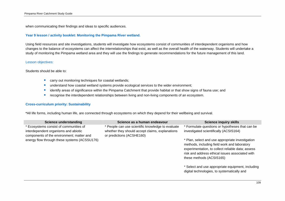
Pimpama River Catchment Study Guide
109
when communicating their findings and ideas to specific audiences. Year 9 lesson / activity booklet: Monitoring the Pimpama River wetland. Using field resources and site investigations, students will investigate how ecosystems consist of communities of interdependent organisms and how changes to the balance of ecosystems can affect the interrelationships that exist, as well as the overall health of the waterway. Students will undertake a study of monitoring the Pimpama wetland area and they will use the findings to generate recommendations for the future management of this land. Lesson objectives: Students should be able to:
carry out monitoring techniques for coastal wetlands; understand how coastal wetland systems provide ecological services to the wider environment; identify areas of significance within the Pimpama Catchment that provide habitat or that show signs of fauna use; and recognise the interdependent relationships between living and non-living components of an ecosystem.
Cross-curriculum priority: Sustainability *All life forms, including human life, are connected through ecosystems on which they depend for their wellbeing and survival.
Science understanding Science as a human endeavour Science inquiry skills * Ecosystems consist of communities of interdependent organisms and abiotic components of the environment; matter and energy flow through these systems (ACSSU176)
* People can use scientific knowledge to evaluate whether they should accept claims, explanations or predictions (ACSHE160)
* Formulate questions or hypotheses that can be investigated scientifically (ACSIS164) * Plan, select and use appropriate investigation methods, including field work and laboratory experimentation, to collect reliable data; assess risk and address ethical issues associated with these methods (ACSIS165) * Select and use appropriate equipment, including digital technologies, to systematically and
Pimpama River Catchment Study Guide
110
accurately collect and record data (ACSIS166) * Analyse patterns and trends in data, including describing relationships between variables and identifying inconsistencies (ACSIS169) * Use knowledge of scientific concepts to draw conclusions that are consistent with evidence (ACSIS170) * Evaluate conclusions, including identifying sources of uncertainty and possible alternative explanations, and describe specific ways to improve the quality of the data (ACSIS171) * Communicate scientific ideas and information for a particular purpose, including constructing evidence-based arguments and using appropriate scientific language, conventions and representations (ACSIS174)
Year 10 level description: In the Year 10 curriculum students explore systems at different scales and connect microscopic and macroscopic properties to explain phenomena. Students explore the biological, chemical, geological and physical evidence for different theories, such as the theories of natural selection and the Big Bang. Atomic theory is developed to understand relationships within the periodic table. Understanding motion and forces are related by applying physical laws. Relationships between aspects of the living, physical and chemical world are applied to systems on a local and global scale and this enables students to predict how changes will affect equilibrium within these systems. Year 10 achievement standards: By the end of Year 10, students analyse how the periodic table organises elements and use it to make predictions about the properties of elements. They explain how chemical reactions are used to produce particular products and how different factors influence the rate of reactions. They explain the concept of energy conservation and represent energy transfer and transformation within systems. They apply relationships between force, mass and acceleration to predict changes in the motion of objects. Students describe and analyse interactions and cycles within and between Earth’s spheres. They evaluate the
Pimpama River Catchment Study Guide
111
evidence for scientific theories that explain the origin of the universe and the diversity of life on Earth. They explain the processes that underpin heredity and evolution. Students analyse how the models and theories they use have developed over time and discuss the factors that prompted their review. Students develop questions and hypotheses and independently design and improve appropriate methods of investigation, including field work and laboratory experimentation. They explain how they have considered reliability, safety, fairness and ethical actions in their methods and identify. Year 10 lesson/ activity booklet: The lay of the land. During this activity the students explore land use within the Pimpama River catchment area and identify the extent of different types of land use through investigations with aerial mapping. Students reflect upon the effects of human activity and discuss how they can create a sustainable balance when planning for the future of the catchment area. Lesson objectives: Students should be able to:
become familiar with major types of land use in their catchment area; and explore ways to ensure a sustainable future for the Pimpama River catchment area.
Science understanding Science as a human endeavour Science inquiry skills
* Scientific understanding, including models and theories, are contestable and are refined over time through a process of review by the scientific community (ACSHE191) * Advances in scientific understanding often rely on developments in technology and technological advances are often linked to scientific discoveries (ACSHE192) * People can use scientific knowledge to evaluate whether they should accept claims, explanations or predictions (ACSHE194)
* Advances in science and emerging sciences and technologies can significantly affect people’s lives, including generating new career opportunities (ACSHE195) * The values and needs of contemporary society can influence the focus of scientific research (ACSHE230)
* Formulate questions or hypotheses that can be investigated scientifically (ACSIS198) * Plan, select and use appropriate investigation methods, including field work and laboratory experimentation, to collect reliable data; assess risk and address ethical issues associated with these methods (ACSIS199) * Select and use appropriate equipment, including digital technologies, to systematically and accurately collect and record data (ACSIS200)
Pimpama River Catchment Study Guide
112
* Analyse patterns and trends in data, including describing relationships between variables and identifying inconsistencies (ACSIS203) * Use knowledge of scientific concepts to draw conclusions that are consistent with evidence (ACSIS204) * Evaluate conclusions, including identifying sources of uncertainty and possible alternative explanations, and describe specific ways to improve the quality of the data (ACSIS205) * Critically analyse the validity of information in secondary sources and evaluate the approaches used to solve problems (ACSIS206) * Communicate scientific ideas and information for a particular purpose, including constructing evidence-based arguments and using appropriate scientific language, conventions and representations

Pimpama River Catchment Study Guide
113
4.4.2 Year level learning activity booklets The learning activity booklets for each year level (Years 1 to 10) are provided in the following section. These are designed to be printed out and used directly by the teachers and students as part of each activity. The booklets include a section for the teacher to assist them with preparing for the activity and a activity booklet for students. Additional material and resources for each activity are referred to in the activity booklet and preliminary section for the teacher. Appropriate references have been provided for each item, such as location in the Appendices, url for a website or reference for a book.

Pimpama River Catchment Study Guide
114
Activity booklet Year 1 and 2: Wildlife protectors! – Catchment conservation For the teacher Lesson overview: Using site investigations, students will learn about what to look for when identifying a living thing. Students will revise the meaning of non-living and living things in the context of what can be found living in and near a river. Lesson objectives: Students should be able to:
describe how a living thing differs from a non-living thing; identify some features/ basic needs of living things and what type of environment they need;
in the context of a catchment area; and understand why we need to protect some living things from unnatural non-living things, such
as litter. Equipment for class:
Pictures of animals and plants living in the catchment area; and ‘Healthy vs unhealthy catchment’ poster (Appendix 7).
Equipment for student: Paper & drawing materials. Preparation: The teacher can refer to information on the Pimpama catchment in the study guide prior to the lesson. Take note on flora and fauna found in the catchment, and what issues need to be maintained to ensure the health of the catchment, and therefore the wildlife living in this area. *The teacher may need to work through the questions with students in order for them to understand all questions and activities. Curriculum links: Year 1 Science Science understanding:
Living things have a variety of external features (ACSSU017); Living things live in different places where their needs are met (ACSSU211); and Observable changes occur in the sky and landscape (ACSSU019).

Pimpama River Catchment Study Guide
115
Year 2 Science Science understanding:
Living things grow, change and have offspring similar to themselves (ACSSU030); and Earth’s resources, including water, are used in a variety of ways (ACSSU032).
Year 1 and 2 Science Science as a human endeavour:
Science involves asking questions about, and describing changes in, objects and events (ACSHE021); and
People use science in their daily lives, including when caring for their environment and living things (ACSHE022).
Science inquiry skills:
Respond to and pose questions, and make predictions about familiar objects and events (ACSIS024);
Participate in different types of guided investigations to explore and answer questions, such as manipulating materials, testing ideas, and accessing information sources (ACSIS025);
Use a range of methods to sort information, including drawings and provided tables (ACSIS027);
Through discussion, compare observations with predictions (ACSIS212); Compare observations with those of others (ACSIS213); and Represent and communicate observations and ideas in a variety of ways such as oral and
written language, drawing and role play (ACSIS029). The activity booklet for students follows.

Pimpama River Catchment Study Guide
116
Year 1 and 2 Activity Booklet: Wildlife protectors! Catchment conservation Part 1: What is a living object? 1. How can we tell when something is alive? List some of the ways we can see when something is
living?
2. Look at the picture below and have a go at grouping the objects you see based on if they are
living or non-living. Colour the living things in green and the non-living objects in red.
Source: edupics 2011

Pimpama River Catchment Study Guide
117
3. Where are some places near you where you have seen the living things found in this picture?
4. What do plants provide for animals and the waterway they are living near?
Part 2: Protecting wildlife in the catchment 5. After looking at the ‘Healthy vs unhealthy catchment’ poster (Appendix 7) poster and discussing
as a class the natural features that create catchments, circle the words below that you think make up a catchment.
river school mountain road shops valley ocean people trees wetland garden waterfall golf course lake farm rocks rainfall dam house erosion boat flood plain water tank estuary park 6. What are some human activities that might change the natural features of a catchment?

Pimpama River Catchment Study Guide
118
7. How might human activities affect the homes of animals and plants that live in or near the catchment? List below, some plants and animals, that you have seen living near a waterway.
8. In the space provided, draw one of these plants or animals that live in the catchment area. Include
their habitat/ home in your drawing and how you think they would like it to look. Think of the kinds of trees, rocks, shelters and waterways that would be in this creature’s habitat.
9. Write down three ways that humans can take responsibility for protecting habitat and its living
things within the catchment.

Pimpama River Catchment Study Guide
119
Follow up activity / advanced activity Students could research further their chosen plant or animal to find out what this living organism eats, where it lives and where it breeds, or what it provides for other living things. They could then create a poster on their creature, informing others on how to look after this living creature’s environment and why it is important (e.g. Platypus).

Pimpama River Catchment Study Guide
120
Activity booklet Year 3: Who’s habitat is that? Investigating survival needs For the teacher Lesson overview: Using field guides and site investigations, students will learn about what to look for when identifying an animal that requires a freshwater aquatic habitat to survive. Students will review why these animals require a clean environment to survive, and how we can protect their habitat. Lesson objectives: Students should be able to:
describe some terrestrial and marine animals that live within the Pimpama River catchment area, and the external features of these animals;
identify some basic needs of these animals and what type of environment they need; in the context the Pimpama River catchment area;
understand why we need to protect the habitat of these animals; and represent these animals in a creative way, conveying the message to others of protecting
their habitat. Equipment for class:
Field guides e.g. Wildlife of Greater Brisbane (Queensland Museum 2007), Mangroves to Mountains (Leiper et al 2008);
Pictures of animals living in the Pimpama River catchment; and ‘Healthy vs unhealthy catchment’ poster (Appendix 7).
Equipment for students:
Paper and drawing materials; Scissors, glue, paint, string and tape; Pre-loved material, cardboard and other craft items; and Recyclable items (cans, egg cartons, plastic bottles, bottle caps, containers).
Preparation: The teacher can refer to information on the Pimpama catchment in the study guide prior to the lesson. Review what a catchment is with the class using the poster of a healthy vs. unhealthy river/catchment (Appendix 7). Take note on what issues need to be maintained to ensure the health of the catchment, and therefore the prevalence of wildlife living in this area. *The teacher may need to work through the questions with students in order for them to understand all questions and activities. Answers for Question 1 in Part 2 of the Activity Booklet are provided in Appendix 8.

Pimpama River Catchment Study Guide
121
Curriculum links Year 3 Science Science understanding:
Living things can be grouped on the basis of observable features and can be distinguished from non-living things (ACSSU044).
Science as a human endeavour:
Science involves making predictions and describing patterns and relationships (ACSHE050); and
Science knowledge helps people to understand the effect of their actions (ACSHE051). Science inquiry skills:
Suggest ways to plan and conduct investigations to find answers to questions (ACSIS054); Safely use appropriate materials, tools or equipment to make and record observations, using
formal measurements and digital technologies as appropriate (ACSIS055); Use a range of methods including tables and simple column graphs to represent data and to
identify patterns and trends (ACSIS057); and Represent and communicate ideas and findings in a variety of ways such as diagrams,
physical representations and simple reports (ACSIS060). The activity booklet for students follows on page 121.

Pimpama River Catchment Study Guide
122
Year 3 Activity Booklet: Whose habitat is that? Investigating survival needs Part 1: Animals living in the Pimpama River catchment 1. After looking at the field guides of animals living in a catchment, write a list of some of these
animals you have seen in the area.
2. Choose one of these animals to investigate in depth (e.g. Platypus). Describe some of the
external features this animal has that allow it to live in the catchment (e.g. why does it need to live in the river, or nearby?).
3. Have a go at drawing this animal, including the special features it has on its body that allow us to
classify this animal from other species, and show us that it is a living thing.

Pimpama River Catchment Study Guide
123
Part 2: Aquatic and terrestrial environments 1. Catchments are made up of aquatic and terrestrial environments. Write the words forests,
deserts, land, terrestrial, aquatic, ponds, oceans, saltwater, freshwater, upper and lower in their correct place in the sentences below:
Terrestrial environments are based on the ____________ , whereas ___________ environments are
based in the water.
Mountaintops, ___________, grasslands, houses and ___________ are all found in a ____________
environment.
Aquatic environments can be ____________ such as seas, ___________, estuaries and salt lakes, or
they can be ____________ aquatic environments such as lakes, _________, creeks and springs. In
an aquatic environment, the __________ parts of the catchment contain the saltwater environments,
whereas the freshwater environments will be found in the _________ parts of the catchment.
2. Have another look at the field guides, and finding your animal, see if you can fill in the chart to
describe its environment. Does it live in an aquatic or terrestrial environment?
Aquatic Terrestrial
What does it eat?
How does it catch its food?
If it lives in water, circle the types of water it prefers;
Deep Shallow Clean Fast moving Still water Dirty
If it lives on land, what types of trees does it prefer to live amongst;
Eucalypt Mangroves Rainforest Scrub

Pimpama River Catchment Study Guide
124
3. Brainstorm: Why do you think this animal needs a clean environment to live in?
4. List some ways that you can help to protect their habitat.
Part 3: Creating catchment-dwelling animals 1. Now it’s time for some art! You are going to make your animals using pre-loved materials,
recycled items and some glue, paint, string, tape or anything else you can find. Make sure to include its special external features and of course, use a whole lot of your imagination!
Follow up activity Students could present their animals to the class, other classes, or at school assembly. They should be able to inform others how to look after this animal’s environment and why it is important to protect the catchment habitat. This could be presented as a class play, including the interactions between different animals found within aquatic and terrestrial environments within the Pimpama River catchment.

Pimpama River Catchment Study Guide
125
Activity booklet Year 4 Activity: The cycle of life – macroinvertebrates For the teacher Lesson objectives: Students should be able to:
identify aquatic and terrestrial stages of some macroinvertebrate lifecycles; learn to differentiate between complete and incomplete metamorphosis; and understand how the habitat of these macroinvertebrates affects how the insects develop
through their lifecycle. Equipment for class: Field guides of macroinvertebrates found in the Pimpama River catchment (Appendix 9). Equipment for student: Writing materials. Preparation for teacher: Teachers can refer to the information provided in the study guide to gain background knowledge. Specifically, focus on the macroinvertebrate species that can be found in a catchment, and the sensitivity of these different species. Review the definition of a catchment with the class and what actions can affect the health of the catchment (Box 2 within Study Guide and Appendix 7). Answers for Question 1 Part 1 and 2 are provided in Appendix 10. Curriculum links Year 4 Science Science understanding:
Living things have life cycles (ACSSU072); Living things, including plants and animals, depend on each other and the environment
to survive (ACSSU073); and Earth’s surface changes over time as a result of natural processes and human activity
(ACSSU075). Science as a human endeavour:
Science involves making predictions and describing patterns and relationships (ACSHE061); and
Science knowledge helps people to understand the effect of their actions (ACSHE062).

Pimpama River Catchment Study Guide
126
Science inquiry skills:
With guidance, identify questions in familiar contexts that can be investigated scientifically and predict what might happen based on prior knowledge (ACSIS064);
Suggest ways to plan and conduct investigations to find answers to questions (ACSIS065);
Safely use appropriate materials, tools or equipment to make and record observations, using formal measurements and digital technologies as appropriate (ACSIS066);
Use a range of methods including tables and simple column graphs to represent data and to identify patterns and trends (ACSIS068); and
Represent and communicate ideas and findings in a variety of ways such as diagrams, physical representations and simple reports (ACSIS071).
The activity booklet for students follows.

Pimpama River Catchment Study Guide
127
Year 4 Activity Booklet: The cycle of life – macroinvertebrates Part 1 – Your catchment: aquatic and terrestrial 1. Catchments are made up of aquatic and terrestrial environments. Write the words healthy, land,
quality, aquatic, dirty, water bugs, freshwater, polluted, environments and lower in their correct place in the sentence below:
Terrestrial environments are based on the _____________, whereas _____________ environments
are based in the water. Within an aquatic environment, the ______________ parts of the catchment
contain the saltwater environments, whereas the _____________ environments will be found in the
upper parts of the catchment. If a catchment area is healthy, the water __________ will be high and it
will be clean. However, if a catchment area becomes ____________, than the quality of the water will
be low and it will be ___________. Within the aquatic ______________ found in a catchment, there
are many species of _______________ living there. Some depend on the catchment being
____________ and unpolluted for their survival.
2. Within the aquatic and terrestrial environments found in a catchment, there are many species of animals. Some insects that can be found in the catchment are aquatic macroinvertebrates. These insects can be seen with the naked eye (macro), and they don’t have a backbone (invertebrate). Instead, they have a strong outer covering or exoskeleton to protect them. Circle the animals you think are the aquatic macroinvertebrates from the following pictures:
Source: Waterwatch Australia 2004
Source: Water and Rivers Commission 2001
Source: Waterwatch Australia 2004
Source: Natura Education 2004
Source: Waterwatch Australia 2004
Source: Natura Education 2006
Source: Waterwatch Australia 2004
Source: Natura Education 2004
Source: Natura Education 2004
Source: Waterwatch Australia 2004
Source: Natura Education 2004
Source: Waterwatch Australia 2004

Pimpama River Catchment Study Guide
128
Part 2 – Macroinvertebrates up close 1. Macroinvertebrates have life cycles where they either metamorphosis into another structure with
four life stages (Complete metamorphosis), or they stay in the same structure with three life stages (Incomplete metamorphosis).
Incomplete Metamorphosis (e.g. water beetle)
1. Egg 2.a) Early Nymph 2.b) Late Nymph 3. Adult
Complete Metamorphosis (e.g. Mosquito)
1. Egg 2. Larvae 3. Pupa 4. Adult
Life cycles of aquatic macroinvertebrates
Mating
Eggs
Nymph Metamorphosis
Adult
Eggs
Larvae
Pupa/emergent
Source: GCCC 2010b
Incomplete metamorphosis
Complete metamorphosis

Pimpama River Catchment Study Guide
129
Looking at the above diagram, fill in the blank spaces in the following statement to understand more about macroinvertebrate lifecycles. nymph, complete, larva, similar, nymph, egg, stages, terrestrial, larva. Incomplete metamorphosis involves the egg hatching into a ________. ___________ metamorphosis
involves the __________ hatching into a ______________. The ______________ looks very different
to the adult, whereas the ______________ looks _____________ to the adult form. Some life
______________ can take place in an aquatic environment, while other stages occur in a
___________________ environment.
2. Below are pictures of three macroinvertebrates, in each of their life stages. Your job is to cut each insect out, and try to assemble the life cycle of each macroinvertebrate into the correct order. Take into account whether each life stage for each macroinvertebrate will occur in an aquatic or terrestrial environment, and write this beside the stage.
Source of images: Murray Darling Basin Authority 2009

Pimpama River Catchment Study Guide
130
Part 3 – Aquatic and terrestrial food chains Living things in terrestrial and aquatic environments depend on each other for survival. We can explore how these animals and plants are connected through food chains. A food pyramid shows who eats who! At the bottom are the producers - plants. Plants are special because they use sunlight and water to produce their own food. In the middle of the pyramid are the primary consumers, the animals that eat the producers (plants). At the top of the food pyramid are the secondary consumers, the animals that eat other animals. The secondary consumers may also eat producers. Macroinvertebrates play a central role in the food chain of waterways, and they can be primary or secondary consumers. 1. Fill in the food pyramid using the organisms listed below, organizing them depending on what
they eat (This may need research). 2. Do you think one of these organisms on your food pyramid could survive without the others?
Why?
Algae
Kookaburra
Caddisfly larva
Southern pygmy perch
Freshwater shrimp
Dragonfly
Freshwater snail
SECONDARY CONSUMERS e.g. Carnivores
PRIMARY CONSUMERS e.g. Herbivores
PRODUCERS e.g. Plants

Pimpama River Catchment Study Guide
131
3. The health of the catchment will affect the food chains of these organisms. If some can’t survive in a polluted catchment area, then others will have no food source. The catchment health will also determine whether these macroinvertebrates can develop through their life cycles or not. List some ways in which the health of their habitat can be maintained.
Follow up activity Contact your local Waterwatch group and partake in a “hands on” field trip. Collect samples of macroinvertebrates and record what is collected and use these species to create a list of consumers in a local waterway. Try to group them based on their food source (are they a primary or secondary consumer?).
http://www.goldcoast.qld.gov.au/council/gold-coast-waterwatch-7429.html http://www.qld.waterwatch.org.au/resources/education.html
Pimpama River Catchment Study Guide
132
Activity booklet Year 5: Riparian rescuers – Healthy catchment vegetation For the teacher Lesson overview: Using field guides and site investigations, students will learn about the types of plants that require a freshwater aquatic environment to survive. Students will gain a deeper understanding of what structures and adaptations of these plants, and the role plants have on the health of the catchment. Lesson objectives: Students should be able to:
describe some plants that can be found within the Pimpama River catchment, and the structures of these plants;
identify the role plants have in a catchment; and understand how plants affect the health of the catchments, and why we need to protect the
environment within a catchment. Equipment for class:
Field guides (e.g. Wild plants of greater Brisbane (Queensland Museum 2003), Mangroves to Mountains (Leiper et. al. 2008);
Pictures of plants growing within the Pimpama River catchment; Some samples of Australian native plants that occur within the Pimpama River catchment;
such as eucalypt, rainforest and estuarine species. These may be collected from around the school grounds, or students may be asked to bring samples from home;
‘Healthy vs unhealthy catchment’ poster (Appendix 7); Gold Coast catchment map (Appendix 11); and Maps of historic and current vegetation within the Pimpama River catchment (Appendix 2 and
12). Equipment for student: Paper and drawing materials. Preparation: The teacher can refer to information on the Pimpama River catchment in the study guide prior to the lesson. Review the definition of a catchment with the class (Box 2 within this study guide) using the Gold Coast catchment map (Appendix 11) and the ‘healthy vs. unhealthy catchment’ poster Appendix 7). Familiarise yourself with the historic and current vegetation types within the Pimpama River catchment (Appendix 2 and 12). Take note on what actions can be taken to ensure the health of the catchment, as well as the abundance and diversity of plants found within the catchment. Vocabulary/ Definition Adaptations: May be structural or functional changes that occur in a plant or animal to help them survive in their environment.

Pimpama River Catchment Study Guide
133
Curriculum links Year 5 Science Science understanding: Living things have structural features and adaptations that help them to survive in their environment (ACSSU043). Science as a human endeavour:
Science involves testing predictions by gathering data and using evidence to develop explanations of events and phenomena (ACSHE081); and
Scientific knowledge is used to inform personal and community decisions (ACSHE217). Science inquiry skills:
With guidance, plan appropriate investigation methods to answer questions or solve problems (ACSIS086);
Construct and use a range of representations, including tables and graphs, to represent and describe observations, patterns or relationships in data using digital technologies as appropriate (ACSIS090); and
Communicate ideas, explanations and processes in a variety of ways, including multi-modal texts (ACSIS093).
The activity booklet for students follows.

Pimpama River Catchment Study Guide
134
Year 5 Activity Booklet: Riparian rescuers – Healthy catchment vegetation Part 1- Your catchment area 1. Look at the Gold Coast catchment map (Appendix 11) and write down what catchment area you
live in. Also include two surrounding catchment areas. My catchment area: ________________________
Two surrounding catchments: ___________________ __________________
2. Have a look at the ‘Healthy vs unhealthy catchment’ poster (Appendix 7) and write down some of
the things that make up a healthy catchment.
Part 2 – Aquatic and terrestrial plants 1. Looking at the Pimpama River catchment vegetation maps, name the different vegetation types
that were historical and are currently within the Pimpama River catchment (Make sure to include the lower and upper reaches of the catchment).
Historic Current
*Teacher note: As a class discuss how catchment processes help to form habitat types in different locations of the catchment; high rainfall helps to form wet rainforest habitats around catchment and low rainfall helps to form dry eucalypt forests. These differing habitats support a wide range of species.

Pimpama River Catchment Study Guide
135
2. Choose one habitat that was historically found in the catchment and write down a plant that can be found within this habitat type (e.g. saltpan wetland, rainforest or eucalypt forest).
Habitat type: Plant found here: 3. You are to research the adaptations of this plant. You will understand how the plant is specially
structured to live in its specific habitat. Once you have found some of the adaptations of your chosen plant, sketch your plant in the space provided including its structural adaptations. Things to include (if relevant to your plant):
Leaf shape and texture (how it feels); Type of trunk (does it have smooth or flaky bark?); What has been adapted to help it collect and store water?;and How does it reproduce? (does it have flowers, or seeds as in a pine cone or a grass?).

Pimpama River Catchment Study Guide
136
4. Complete the table below to gather the details about your chosen plant. What is the name of this plant?
Circle the kind of habitat the plant lives in Eucalypt Rainforest Estuarine Freshwater
Is it living in the lower or upper reaches of the catchment?
Lower Upper
Is it an aquatic or terrestrial plant? Aquatic Terrestrial
If aquatic, circle the types of water the plant prefers to live in;
Fast moving Deep Slow moving Shallow Submerged under water Floating on water surface
Does it like saline (salty) water? Yes No
Is it an Australian native? Yes No
Does it prefer warm or cool air temperature? Yes No
Is a large amount of rainfall required for this plant to grow?
Yes No
How much sunlight does this plant need?
What other plants grow nearby to this one?
What animals might live in the habitat where your plant would be found?

Pimpama River Catchment Study Guide
137
Part 3 – What do plants do? Plants help to maintain the health of the catchment in many ways. See if you can imagine what might happen if these plants were not present (Think about what plants provide for the animals in the area, as well how they maintain the natural environment). 1. What might happen if there were no aquatic plants in the waterways of the Pimpama catchment?
2. List three things that might happen if all the terrestrial plants and trees were removed from the
land in the Pimpama catchment area?
3. What activities could humans do to protect plants and allow them to continue their important role
in maintaining the catchment health?
Follow up activities
Look at plant adaptations specific to; rainfall / fire / drought / flood / saline water / climate; and Experiment using celery in a glass of water to show how plants transport water, and apply this
to the role plants have in a catchment area.

Pimpama River Catchment Study Guide
138
Activity booklet Year 6: Catchments under threat For the teacher Lesson overview: Students will gain an understanding of the impacts of certain land uses and human activities that occur within the Pimpama catchment. They will investigate impacts on the waterway (pollution, erosion and habitat loss) as well as impacts on the land due to the removal of vegetation and modification of natural features. Students will identify different social and environmental values and perspectives of the usefulness of a catchment/natural resource. They will then be able to make an informed decision on the best way to reduce negative impacts and sustainably manage other’s actions in the catchment. Lesson objectives: Students should be able to:
identify some human activities that occur within the Pimpama River catchment and their associated impacts on the catchment;
understand the importance of predicting possible effects of human and other activity on the environment, in order to develop strategies that minimise any negative consequences; and
provide solutions to minimise the impacts from human activity in the catchment. Equipment for class:
‘Healthy vs. unhealthy catchment‘ poster (Appendix 7); Gold Coast catchment map (Appendix 11); and Pimpama River catchment land cover maps detailing historic and current land use and native
vegetation cover within the catchment (Appendix 2 and 3). Equipment for students:
Writing materials; and Computer with internet access.
Preparation: Teachers can refer to information provided in the study guide to gain background knowledge on the history and recent developments in the Pimpama River catchment and what the environmental impacts of these human actions have been on the area. Review land use maps for the catchment (Appendix 3) and identify some areas that have been developed (farm land, residential, shopping centres, etc.). For the class exercise, identify an area of land in the catchment that is on the Pimpama River and that is mostly covered in native vegetation. Identify short term and long term ramifications associated with developing this land, including environmental impacts on the waterway and surrounding natural areas. Lead class to brainstorm different roles and actions of groups involved with land use in the Pimpama River catchment (e.g. Landcare). Do a Wildlife Online search to identify animals in the area to discuss how they will be impacted by the development (see Appendix 1 for an example).
Pimpama River Catchment Study Guide
139
Curriculum links Year 6 Science Science understanding: The growth and survival of living things are affected by the physical conditions of their environment (ACSSU094). Science as a human endeavour:
Science involves testing predictions by gathering data and using evidence to develop explanations of events and phenomena (ACSHE098);
Scientific understandings, discoveries and inventions are used to solve problems that directly affect peoples’ lives (ACSHE100); and
Scientific knowledge is used to inform personal and community decisions (ACSHE220). Science inquiry skills:
With guidance, pose questions to clarify practical problems or inform a scientific investigation, and predict what the findings of an investigation might be (ACSIS232);
With guidance, plan appropriate investigation methods to answer questions or solve problems (ACSIS103);
Compare data with predictions and use as evidence in developing explanations (ACSIS221); and
Communicate ideas, explanations and processes in a variety of ways, including multi-modal texts (ACSIS110).
Cross-curriculum priority: Sustainability:
World views that recognise the dependence of living things on healthy ecosystems, and value diversity and social justice are essential for achieving sustainability;
Actions for a more sustainable future reflect values of care, respect and responsibility, and require us to explore and understand environments;
Designing action for sustainability requires an evaluation of past practices, the assessment of scientific and technological developments, and balanced judgments based on projected future economic, social and environmental impacts; and
Sustainable futures result from actions designed to preserve and/or restore the quality and uniqueness of environments.
The activity booklet for students follows.

Pimpama River Catchment Study Guide
140
Year 6 Activity Booklet: Catchments under threat Part 1- Your catchment area 1. Look at the Gold Coast catchment map and write down what catchment area you live in. Also
include two surrounding catchment areas. My catchment area: ________________________
Two surrounding catchments: _______________________ ______________________
2. Have a look at the ‘Healthy vs unhealthy catchment’ poster (Appendix 7) and write down some of
the things that make up a healthy catchment.
3. What are some material/chemical types that rain would pick up in the catchment as it runs off the
surface of features and the soil before flowing into the river?
4. As a class, discuss the land uses in the Pimpama River catchment using the current land cover
map of the area provided. Predict what effect some of the different land uses in this catchment would have on the water quality in the river (e.g. school stormwater drain litter pollution of waterways.
a. Land use:________________________________
Effect of this action on catchment:

Pimpama River Catchment Study Guide
141
b. Land use: __________________________________ Effect of this action on catchment:
c. Land use: __________________________________
Effect of this action on catchment:
Part 2 – Pimpama Catchment under threat As you can see, there are many effects of human activity in the catchment. Most of these are negatively affecting the health of the catchment in some way. 1. The following activity will be carried out in groups. Form groups of 4/5 students, with each group
representing the actions of different stakeholders in the Pimpama River catchment, such as farmers, builders, householders, factory workers, supermarket workers, developers, conservation workers, animal lovers, young people in the community, older people in the community, national parks rangers to name a few.
The situation: A new subdivision is up for sale in an environmentally sensitive area adjacent to the Pimpama River. The land is currently un-occupied and contains many diverse species of plants and animals. There are various stakeholders who would like to use this land in differing ways. Some suggestions of interested groups include, a property developer, a rural farmer, a community catchment management group, a fisherman, a commercial organic vegetable gardener, a tour company offering kayaking river tours, and an environmental ecologist studying the unique life forms found in the Pimpama River catchment. My group/company’s name: _____________________________ Their intended action on the land:

Pimpama River Catchment Study Guide
142
2. Using the ideas from the class discussion above, choose one group who you have identified as wanting to use this land in the catchment. Focusing on your group’s intended action on the land, answer the following questions about the effect this action may be having on the catchment.
a. Looking at the current land cover of the Pimpama River catchment, what natural features will
be in the surrounding land where this action is taking place?
b. How close is the action to the waterway?
What might some of the impacts be on the waterway?
c. Would any vegetation, such a shrubs, aquatic plants or trees and forests need to be
removed?

Pimpama River Catchment Study Guide
143
d. What kind of habitat might be there?
Will this be affected?
e. What kinds of animals might be living in the area? (Do Wildlife Online search of Pimpama
catchment – see resources)
Would they be affected?
f. If the physical conditions of the catchment were to change through fertilisers used on the soil,
flooding and increased sedimentation due to tree loss, or litter, this would impact the plants growth rates and survival. What effects would this have on the health of the catchment as a whole?

Pimpama River Catchment Study Guide
144
3. Fill in the table below including how the actions of your group will affect the health of the water. Also think of what impacts there will be on the plants and animals in the area. Include the cause of these impacts, as well as the effects of the impacts and then you can debate within your group to find a practical solution. Each group should be able to come up with a possible alternate action that would lead to prevention or minimization of the negative impacts of the groups’ action on the catchment.
One of the groups is completed as an example. Write your group’s answers in the empty columns to the far right:
Group / Company name:
Logging company – ‘Timber Harvesters’
Role / action:
To clear the land for ftimber production.
Problem – Impact on catchment:
There will be less vegetation, which will affect many animals’ habitats. There will also be greater erosion on the land and more run-off of harmful substances into the river
Cause of problem:
Trees cut down for timber production. Trees only grown short term before removing them for industry. There may be chemicals such as fertilizers used during the growing stage of timber harvesting which could enter the waterway. After harvesting run-off may be increased. Erosion, from a reduction in tree roots, may increase leading to greater sediment loads being deposited into the river.
Pimpama River Catchment Study Guide
145
Effects of problem:
Pollutants and sediment will be washed into waterways and can harm aquatic life by changing the oxygen and phosphate levels of the water. Terrestrial animals will have no secure homes in the area, and constantly be disturbed by machinery. They may abandon the area, disrupting food chains and becoming sensitive to threats in new areas.
Solution to problem:
The company should replant as many trees as they remove, and keep this up in a sustainable way that has the smallest effect on the land and surrounding habitat as possible. Some areas of forest, such as old growth or primary forest should be left completely untouched to accommodate species that can’t tolerate life in disturbed forests. They should rehabilitate or leave a stream buffer zone of native vegetation to mitigate erosion and sedimentation inputs into the river.

Pimpama River Catchment Study Guide
146
Part 3 – Sustainable conclusions 1. Now that you have identified some problems with your group’s proposed actions in the catchment,
and how they can most effectively manage these impacts, try and think of some of the benefits of their actions. These may be social, political or economical gains that the group’s actions will create.
a. After weighing up the benefits to the group and society, with the problems their actions may
cause on the health of the catchment, come to a group decision on whether this group should be allowed to go ahead with their proposed plans.
You must discuss balanced judgments based on projected future economic, social and environmental impacts. Sustainable futures result from actions designed to preserve and/or restore the quality and uniqueness of environments. Discuss the proposal and decide whether it is:
good catchment management; or poor catchment management.
b. You will be presenting your group and the decision you have made on whether their plans can
go ahead or not to your classmates. Each group must nominate a scribe, affirmative/negative speakers and a researcher to back up your opinions.
My team is the (group):______________________________ We are for / against the proposed action of:____________________________ Because we think:
2. Now it is time to develop your argument with your team’s chosen stance. You will need to include
valid reasons for your decision. When presenting and developing your argument, remember to explain what you mean to prove, what the scope and implication will be, and why it is true with facts and evidence to support your case.

Pimpama River Catchment Study Guide
147
3. The classroom will become the site of a Pimpama River catchment community gathering. Each team will share their point of view on whether the group they have studied should go ahead with their proposed plan or not. The rest of the class should be observers, as if they were in a community meeting, until it is their turn to speak.
4. At the conclusion of all the teams’ presentations, a class vote should take place to decide on
which group will have the most sustainable actions when using the proposed land up for sale. This can be carried out anonymously by each student writing their choice down on paper and putting their selection into a hat / container. All answers can then be tallied up to find the group with the most support in going ahead with their action plan.
Follow up activities
Write up a catchment management plan, listing current issues/human actions that impact the catchment and how these can be addressed. The plan should include management of vegetation types, conservation areas, riparian vegetation (plants that grow along the bank of the water body), grazing or farm lands, stormwater and erosion (See Broad Learning Activity 1: Conservation in the Pimpama River Catchment);
Participate in a comparative study between the land uses of the Pimpama River catchment with the Coomera or Currumbin catchments, and their associated effects on the health of the catchment;
Visit a nearby water body to explore and identify human activities that may affect the health and quality of this water. You can monitor the water quality to inform management decisions; and
Participate in a revegetation day in your catchment, or within your school to improve the biodiversity and help protect and restore the environmental quality of the catchment area.

Pimpama River Catchment Study Guide
148
Activity booklet Year 7: Specialised adaptations For the teacher Lesson overview: Using field guides and site investigations, students carry out scientific investigations of aquatic macroinvertebrates found in the catchment, in order to gain an understanding about how the physical conditions of the catchment affect the survival of living things. Students gain a deeper understanding of the specialized adaptations macroinvertebrates have and the interactions they have with other living things within a food chain. Lesson objectives: Students should be able to:
describe some aquatic macroinvertebrates that can be found within the Pimpama River catchment, and the specialized external features of these organisms;
identify the role macroinvertebrates have within a food chain; classify these organisms according to their physical features, habitat, position in the food
chain and sensitivity to pollution; and understand why the health of the catchment affects the abundance and diversity of aquatic
macroinvertebrates, and how we can protect the environment within a catchment. Equipment for class:
‘Healthy vs unhealthy catchment’ poster (Appendix 7); Gold Coast catchment map (Appendix 11); Macroinvertebrate identification chart and dichotomous key (Appendix 9 and 13); and Books relating to macroinvertebrate adaptations and habitat preferences e.g. The Waterbug
Book: a Guide to the Freshwater Macroinvertebrates of Temperate Australia (Gooderham and Tsyrlin 2002).
Equipment for student:
Paper & drawing materials; and Computer with internet access.
Preparation: The teacher can refer to information on the Pimpama River catchment in the study guide prior to the lesson. Review the macroinvertebrates that can be found in Gold Coast catchments and their specialized features (Appendix 9 and 13). Familiarise yourself with macroinvertebrate sensitivities to their habitat and how they can be used as biological indicators for the health of a river. Take note on what actions can be carried out to ensure the health of the catchment, as well as to stabilise their abundance and diversity.
Pimpama River Catchment Study Guide
149
Curriculum links Year 7 Science Science understanding:
There are differences within and between groups of organisms; classification helps organise this diversity (ACSSU111);
Interactions between organisms can be described in terms of food chains and food webs; human activity can affect these interactions (ACSSU112); and
Water is an important resource that cycle through the environment (ACSSU222). Science as a human endeavour: Science understanding influences the development of practices in areas of human activity such as industry, agriculture and marine and terrestrial resource management (ACSHE121). Science inquiry skills:
Identify questions and problems that can be investigated scientifically and make predictions based on scientific knowledge (ACSIS124);
Construct and use a range of representations, including graphs, keys and models to represent and analyse patterns or relationships, including using digital technologies as appropriate (ACSIS129);
Summarise data, from students’ own investigations and secondary sources, and use scientific understanding to identify relationships and draw conclusions (ACSIS130);
Use scientific knowledge and findings from investigations to evaluate claims (ACSIS132); and Communicate ideas, findings and solutions to problems using scientific language and
representations using digital technologies as appropriate (ACSIS133). Cross-curriculum priority: Sustainability All life forms, including human life, are connected through ecosystems on which they depend for their wellbeing and survival. The activity booklet for students follows.

Pimpama River Catchment Study Guide
150
Year 7 Activity Booklet: Specialised adaptations Part 1 - Your catchment area: a review 1. Look at the Gold Coast catchment map and write down what catchment area you live in. Also
include two surrounding catchment areas. My catchment area: ________________________
Two surrounding catchments: _______________________ ______________________
2. Have a look at the ‘Healthy vs unhealthy catchment’ poster (Appendix 7) and write down some of
the things that make up a healthy catchment.
3. Which foreign materials and chemicals may be picked up by rainwater runoff as it makes its way
overland before flowing into the waterway?
4. Which human activities do you think would most affect the aquatic animals of the catchment?

Pimpama River Catchment Study Guide
151
Part 2 – Macroinvertebrates up close Macroinvertebrates can be seen with the naked eye (macro), and they don’t have a backbone (invertebrate). Instead, they have a strong outer covering or exoskeleton to protect them. Aquatic plants and logs, branches, bark and leaves that fall into the water provide a habitat for aquatic macroinvertebrates. 1. Looking at the chart of macroinvertebrates below, and research that has been carried out with
your class, choose one macroinvertebrate living in your catchment area that you would like to learn more about.
Caddisfly larvae are worm-like insect larvae with three pairs of legs on the first three body segments. They are usually found in cases made from hollow twigs or bark they have stuck to themselves, with only their head and legs protruding when they move.
Segmented worms resemble earthworms. They are usually a red or brown colour and are found within the sediments. They feed on dead and decomposing plant material.
Water measurers have a long slender body, with long legs and feet, which help them to move across the water surface. They are usually found around emergent vegetation and feed on small animals found at the water surface.
Backswimmers are active swimmers that swim upside down. They break the water surface with their abdomen to collect air. They prey on a range of small aquatic animals.
Non-biting midge larvae are worm-like, have a visible head and 2 pairs of small legs. Some are red in colour. They are found in sediments sometimes in high numbers. They feed on algae and organic material while some are predacious
Mayfly nymphs have three long filament at the end of their abdomen, with wing pads and lateral gills along the abdomen. They have short antennae and a single claw on each foot. They are found under stones in fast flowing water or among plants in slow flowing water.
Freshwater snails feed using a rasping tongue (radula), which grinds and scrapes off algae from rocks and plant material.
Dragonfly larvae are short, with wing pads and internal gills. They are found on plants, among stones and leaf litter, or on the waterbed.
Source of images: Waterwatch Australia 2004 and John Pumpurs 2013

Pimpama River Catchment Study Guide
152
Freshwater prawns / shrimp are small crustaceans with slender legs and claws. They are found among aquatic plants and loose stones. Can be very abundant in some areas and can tolerate low salinities.
Whirligig beetles have very long forelegs, yet their mid and hind legs are short and paddle-like. They are found in still or slow flowing waters. They swim in a whirling motion on the water surface. They are predators and feed on those animals that fall into the water.
Source of images: Waterwatch Australia 2004 and John Pumpurs 2013
Fill out the table below on your chosen organism:
My aquatic macroinvertebrate is:
Does it have legs, if so, how many?
Does it have wings, if so, how many pairs does it have?
What do the mouthparts look like?
The habitat they prefer is: (Circle favored habitat conditions)
Fast flowing water Shade Slow moving water Direct sunlight Warm water Cool water
These conditions are preferred because it provides the creature with: (State reasons they prefer these conditions)
*
*
*
What does it eat? (Is it a carnivore, or a herbivore or something else?)
How has this macroinvertebrate adapted to its specific habitat?
What external features does it have that help it to live in this environment? (e.g. hard shell to protect from predators)
*
*
*

Pimpama River Catchment Study Guide
153
2. Draw a diagram of your macroinvertebrate, including its specialized physical features in detail. (e.g. if they live in fast flowing water they could have powerful suckers or gripping legs). Make sure to include labels to explain these structures.

Pimpama River Catchment Study Guide
154
3. We need to classify species so that we can easily identify them in an accurate, consistent way. We can do this by grouping a variety of organisms on the basis of similarities and differences in particular features. We can classify using hierarchical systems, e.g. kingdom, phylum, class etc. or by using scientific conventions for naming species.
Here we will work on classifying aquatic macroinvertebrates by using a dichotomous key to identify organisms in a habitat. We will do this to recognize organisms based on their specialized physical characteristics.
a. As a class, try and classify the various macroinvertebrates you have chosen to sketch. Once you have cut out or photocopied your sketch from above, see if you can group sketches of similar sized and shaped macroinvertebrates together. These organisms would most likely share the same habitat and perhaps food source.
Animals living in fast-moving water must be able to ‘hang on’ and, at the same time, catch their food. You can often find examples of specialized adaptations such as streamlined bodies, suction parts, special hooks and fine filters. In contrast, animals living in still or slow-moving water don’t have to ‘hang on’ and food is not brought to them in the current. Slow moving waters tend to house macroinvertebrates that are a wider range of sizes and shapes and are more mobile.
b. Once you have grouped your macroinvertebrate with other classmates’ organisms that share physical similarities, have a go at describing the external features that stand out amongst these macroinvertebrates. Use physical features that another person could recognize on a macroinvertebrate from your group.
You can practice classifying organisms based on different characteristics, e.g. presence of different body parts, type of life cycle and how it catches its prey. 4. Aquatic macroinvertebrates require different environmental conditions to survive. Fill in the gaps
to describe the usefulness of these macroinvertebrates’ sensitivities to pollution. Words – macroinvertebrates, absence, indicators, pollution, determine, habitat, high, sensitive, quality.
Some _________________________ can tolerate more _________________________ in their
environment compared to other more _________________________ macroinvertebrates that require
a _________________________ water quality to survive.
This makes macroinvertebrates useful biological _________________________ of water
_________________________.
The presence or _________________________ of particular macroinvertebrates can help
_________________________waterway and _________________________ health.

Pimpama River Catchment Study Guide
155
5. Macroinvertebrates have a sensitivity rating that is based on their tolerance for pollution in the waterway. The sensitivity scale ranges from 1-10, with 1 being the least sensitive (tolerates more pollution) and 10 being the most sensitive. Use the macroinvertebrate identification chart (Appendix 9 and 13) to determine what the sensitivity rating of your macroinvertebrate under study is. The sensitivity rating can be found immediately to the left of the picture of the macroinvertebrate on the chart. Fill in the blanks about the scoring.
a. My macroinvertebrate is ____________________ to pollution. It has a score of ___ /10 and
the colour behind the picture on the identification chart is __________. This means the
__________________________species requires _________________water in order to
survive.
b. Once you have organized all your macroinvertebrates according to their habitat preference and consequent body shape, size and features, try classifying all of the macroinvertebrates by their sensitivity to polluted water.
Part 3 – Food chains Living things depend on each other for survival. We can explore how these animals and plants are connected through food chains and we can classify organisms according to their position in the food chain. First are the producers, plants, as they produce their own energy from the sun. The primary consumers, or herbivores eat plants. Some species eat plants and animals, omnivores. Omnivores are called secondary consumers, along with most carnivores that eat herbivores. There is also another level of the food chain called tertiary consumers. The tertiary consumers are the carnivores that only eat other carnivores and omnivores but not herbivores. Macroinvertebrates play a role in the food chain of waterways, and they can be primary or secondary consumers. 1. Draw a line to match up the organisms listed on the right below, with the different positions in the
food chain. Organise them depending on what they eat (You may have to do some research). TERTIARY CONSUMERS SECONDARY CONSUMERS PRIMARY CONSUMERS PRODUCERS
Algae
Kookaburra
Caddisfly larva
Banksia tree
Southern pygmy perch
Turtle
Freshwater shrimp
Dragonfly
Freshwater snail
Detritus/ leaf litter

Pimpama River Catchment Study Guide
156
2. What might happen to animals at the top of the food chain if the plants are removed from the environment?
3. What are some things that might impact on the survival of plants and animals in the catchment?
4. The health of the catchment will affect the food webs of these organisms. If some can’t survive in
a polluted catchment area, then others will have no food source. List some ways in which you can protect food chains from becoming disrupted in your catchment area.
*Bonus activity: Try to organize all your macroinvertebrates into their correct placement in the food chain. You could make a class food chain, including aquatic plants that are producers, as well as primary and secondary consumers. This could be presented at your school assembly to inform others of the important interactions between living things and how we can protect these relationships. Follow up activities Students can design a poster or presentation using Powerpoint, or an equivalent program to make people aware of how to care for their catchment. They can include ideas of how to reduce the impact of human activities and why this is important to protect the health of the catchment and living things within this area. Ask students to suggest places where the posters can be placed, and identify the intended audience. For example, the intended audience could be early childhood students, teachers, parents, or community members. Discuss with students how the text needs to be appropriate for the audience. Students can participate in biological sampling of the presence of macroinvertebrates in a selected fresh water body near to the school. This can be recorded over a period of time to determine if the health or quality of the waterway is improving, stable or declining.

Pimpama River Catchment Study Guide
157
Activity booklet Year 8: Physico-chemical testing For the teacher Lesson overview: Using field resources and site investigations, students will investigate how living and non-living things are connected by exploring how physio-chemical properties can affect the survival of aquatic organisms, as well as the overall health of the waterway. Students will study different pollutants that affect the water quality by impacting on the physical or chemical properties of a waterway. They will then be able to make an informed decision on the best way to reduce negative human impacts and sustainably manage the catchment health. Lesson objectives: Students should be able to:
identify the physio-chemical parameters that must be measured in order to get an accurate interpretation on water quality;
distinguish between chemical and physical change and recognize that these properties will change the health of the waterway;
understand how the health of the waterways in the catchment can influence the survival of living things; and
develop management plans that decrease the impact of human actions on the catchment. Equipment for class:
‘Healthy vs. unhealthy catchment‘ poster (Appendix 7); Gold Coast catchment map (Appendix 11); Pimpama River catchment current land cover map (Appendix 3); and Equipment for physical and chemical tests for dissolved oxygen, temperature, pH, electrical
conductivity, turbidity, flow and nutrients. Equipment for student:
Paper & drawing materials; Pimpama River Catchment Study Guide resources section for carrying out physio-chemical
water testing; and Physio-chemical data sheet (Table 9 in the study guide).
Preparation: The teacher can refer to information on the Pimpama River catchment in the study guide prior to the lesson. Review the physio-chemical parameters that can be tested and used as indicators for the health of a river. Take note on what land use actions affect the physical and chemical properties of a waterway and how these actions can be sustainably managed to ensure the health of the catchment.

Pimpama River Catchment Study Guide
158
Curriculum links Year 8 Science Science understanding:
Chemical change involves substances reacting to form new substances (ACSSU225); and Energy appears in different forms including movement (kinetic energy), heat and potential
energy, and causes change within systems (ACSSU155). Science as a human endeavour:
Science knowledge can develop through collaboration and connecting ideas across the disciplines of science (ACSHE226); and
Science understanding influences the development of practices in areas of human activity such as industry, agriculture and marine and terrestrial resource management (ACSHE136).
Science inquiry skills:
Identify questions and problems that can be investigated scientifically and make predictions based on scientific knowledge (ACSIS124);
Collaboratively and individually plan and conduct a range of investigation types, including fieldwork and experiments, ensuring safety and ethical guidelines are followed (ACSIS140);
In fair tests, measure and control variables, and select equipment to collect data with accuracy appropriate to the task (ACSIS141);
Summarise data, from students’ own investigations and secondary sources, and use scientific understanding to identify relationships and draw conclusions (ACSIS145);
Use scientific knowledge and findings from investigations to evaluate claims (ACSIS234); and Communicate ideas, findings and solutions to problems using scientific language and
representations using digital technologies as appropriate (ACSIS148). Cross-curriculum priority: Sustainability All life forms, including human life, are connected through ecosystems on which they depend for their wellbeing and survival. The activity booklet for students follows.

Pimpama River Catchment Study Guide
159
Year 8 Activity Booklet: Physico-chemical testing Part 1- Your catchment area 1. Look at the Gold Coast catchment map and write down what catchment area you live in. Also
include two surrounding catchment areas. My catchment area: ________________________
Two surrounding catchments: _______________________ ______________________
2. Refer to ‘Healthy vs. unhealthy catchment‘ poster (Appendix 7) and write down some of the things
that make up a healthy catchment.
3. What types of materials/chemicals would rain pick up as it runs through the catchment before
flowing into the river?
4. As a class, discuss the land uses in the Pimpama River catchment using the land use map of the
area provided. Predict the effects some of the different land uses in this catchment would have on the water quality in the river.
a. Land use:_______________________________
Effect of this action on catchment:
b. Land use: ______________________________ Effect of this action on catchment:

Pimpama River Catchment Study Guide
160
c. Land use: _____________________________ Effect of this action on catchment:
Part 2 – Assessing catchment health You can assess the health of your catchment area by using biological indicators within the waterway. An important biological indicator is aquatic macroinvertebrates as some can be very sensitive to pollution, while others are quite tolerant. You can also get a bigger picture of the health of your catchment by looking at non-living things, such as the physical and chemical aspects of a waterway as well. 1. Why might it be important to carry out physio-chemical testing of the water in your catchment
area?
2. What are some ways that might indicate the water is polluted?
3. What impact might there be on the living things if a waterway in your catchment area became
polluted?
4. What are some human activities that might cause your catchment area to become polluted?

Pimpama River Catchment Study Guide
161
Part 3 – Solving the clues Here are some of the effects of pollution on the physio-chemical properties of the waterway: Pollutant Effect on water Fertiliser - disrupts nutrient levels and pH Manure / septic tank discharge
- disrupts nutrient levels and pH - increased bacteria; affects oxygen content
Introduced species of vegetation
- seeds can be distributed by water - can out compete native vegetation - affects oxygen content - clogs up waterways
Oil and petrol - poisons flora and fauna - disrupts nutrient levels and pH
Pesticides and insecticides
- kills flora and fauna - water becomes unsuitable for drinking or recreational use
Detergent - contains phosphates - strips the protective coating from the skin of frogs and fish
Litter
- clogs up waterway, increasing risk of flooding - stagnation - bacteria growth - wildlife can mistake it for food
Dirt, sand and gravel run-off
- siltation of waterway reducing flow and increasing flooding - prevent sunlight from reaching aquatic plants, reducing photosynthesis - clogs gills of fish and macroinvertebrates - can contain seeds of weeds
Toxic chemicals - water becomes unsuitable for drinking and recreation - kills aquatic plants and animals
Lawn clippings and leaves
- oxygen depletion as they decompose - increased nutrient levels

Pimpama River Catchment Study Guide
162
Below are the physio-chemical properties that can be tested and how they can affect water quality: Parameter Effect on water
Temperature - changes rate of photosynthesis - can affect survival of temperature sensitive organisms - influences dissolution rates of gases (such as oxygen)
Velocity; distance traveled over time (m/s) / Flow; volume over time (l/s)
- stream depth and width - dams - type of plants and animals living in waterway During high water levels: - raised dissolved oxygen - increased erosion and turbidity - altered nutrient levels - altered pH
Turbidity
- reduce ability of light to penetrate water - increased water temperature - sedimentation - clogging fish gills - nutrients - plant growth
pH (0 = Most acidic, 14 = Most alkaline)
- place stress on or kill the organisms living in a habitat - release of metals
Electrical Conductivity
- salinity content - affects osmosis through amount of dissolved ions (salts) in waterbody
Nutrients (Nitrates / Phosphates)
- Eutrophication: algal blooms - leads to reduced dissolved oxygen content.
Dissolved Oxygen - high numbers of any type of organism can remove oxygen from water - changes to plant/animal life survival ability
By using the tables on pages 160 and 161, have a go at determining the effect some human actions would have on the health of the waterway. Make sure to include the impact the action would have on the physio-chemical properties of the water. Once you have determined the effects, find an alternative action that would have a lesser effect on the water quality and living things within the waterway. Choose four scenarios from the list below to identify what is being affected in the waterway.
a) Invasion of weeds in river; b) Erosion from stream banks into waterway and therefore build up of sediment; c) Agricultural practices of grazing animals on waterway banks; d) Removal of riparian vegetation so increased exposure to direct sunlight; e) Sewage discharge into waterway; f) Washed car on driveway where run-off entered the stormwater system; g) Mining waste dumped near waterway; h) Runoff from surrounding agricultural land during flood; i) Lack of rainfall in area lasting over several months; j) Industry discharges water into waterway at a different temperature to receiving
waters; k) Runoff from domestic garden fertilisers into stormwater system; and l) Excess of organic material decaying on the stream bed.
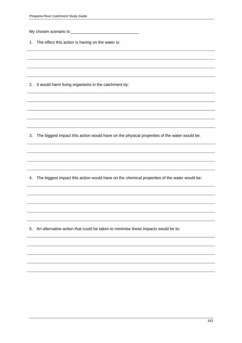
Pimpama River Catchment Study Guide
163
My chosen scenario is:______________________________ 1. The effect this action is having on the water is:
2. It would harm living organisms in the catchment by:
3. The biggest impact this action would have on the physical properties of the water would be:
4. The biggest impact this action would have on the chemical properties of the water would be:
5. An alternative action that could be taken to minimise these impacts would be to:

Pimpama River Catchment Study Guide
164
Part 4 – Taking action 1. Complete the table below by thinking of some actions that could improve the physio-chemical
properties of the waterway if it was polluted. Management Action: How could you increase the amount of dissolved oxygen in the waterway?
How could you prevent or reduce the amount of phosphates entering the waterway?
How could you improve the ability for sunlight to penetrate the water, to help aquatic plants grow?
How could you prevent pollutants such as petrol and oil from entering the waterway?
2. Now it is time to participate in your own field investigation! This will be a chance to use your skills in scientific testing to assess the quality of a waterway near you. This will be done by measuring the physio-chemical properties of a waterway. You can also assess human disruption in your study site such as erosion and pollution. You will need to ensure you test different sites at the same time of day and in the exact same way to maintain validity and reliability with your results. Many parameters may change when in direct contact with other parameters, (e.g. dissolved oxygen will influence temperature) so it is difficult to assess water quality using only one or two parameters. Use the Pimpama River Catchment Study Guide resources section for more information on how to test each parameter, and to record the results on physio-chemical data sheet provided. Follow up activities Students can analyse their results taken to assess the waterway health. Once they have come to a conclusion, they can work on identifying the human effects that have contributed to the health of the waterway under study. Proposed action plans can then be drawn up to suggest ways to improve or maintain the waterway health.

Pimpama River Catchment Study Guide
165
Activity booklet Year 9: Monitoring the Pimpama River Wetlands For the teacher Lesson overview: Using field resources and site investigations, students will investigate how ecosystems consist of communities of interdependent organisms and how changes to the balance of ecosystems can affect the inter-relationships that exist, as well as the overall health of the waterway. Students will undertake a study of monitoring the Pimpama wetland area and they will use the findings to generate recommendations for future management. Lesson objectives: Students should be able to:
carry out monitoring techniques for coastal wetlands; understand how coastal wetland systems provide ecological services to the wider
environment; identify areas of significance within the Pimpama catchment that provide habitat or that show
signs of fauna use; and recognise the interdependent relationships between living and non-living components of an
ecosystem. Equipment for class:
‘Healthy vs. unhealthy catchment‘ poster (Appendix 7); Gold Coast catchment map (Appendix 11); Field guides e.g. Wild Plants of Greater Brisbane (Queensland Museum 2003), Mangroves To
Mountains: A Field Guide To The Native Plants Of South East Queensland (Leiper et. al. 2008)
Equipment for monitoring: 1m x1m quadrats, string, tent pegs, mallet, camera; Historic land cover map (Appendix 2) and current vegetation map (Appendix 12) for the
Pimpama River catchment; and Computer access with Microsoft office.
Equipment for student:
Paper & drawing materials; and Data record sheet.
Preparation: The teacher can refer to information on the Pimpama River catchment in the study guide prior to the lesson. Review the areas of wetlands that can be found in the Pimpama catchment (Appendix 2 and 12) and select a suitable study site alongside the Pimpama River that was historically a saltpan wetland (Appendix 2). Familiarise yourself with different habitat types that are currently in this area (Appendix 12), including what organisms are present, as well as the species of some common native trees. Take note on what human impacts have affected the waterway and how these actions can be sustainably managed to ensure the health of the catchment.
Pimpama River Catchment Study Guide
166
Vocabulary/ Definition Predatory, symbiotic, parasitic, competitive. Quadrat: a quadrat is a m2 grid frame, used to isolate and survey a sample area for plants or slow moving animals.
Curriculum links Year 9 Science Science understanding:
Ecosystems consist of communities of interdependent organisms and abiotic components of the environment; matter and energy flow through these systems (ACSSU176);
Science as a Human Endeavour; and People can use scientific knowledge to evaluate whether they should accept claims,
explanations or predictions (ACSHE160). Science inquiry skills:
Formulate questions or hypotheses that can be investigated scientifically (ACSIS164); Plan, select and use appropriate investigation methods, including field work and laboratory
experimentation, to collect reliable data; assess risk and address ethical issues associated with these methods (ACSIS165);
Select and use appropriate equipment, including digital technologies, to systematically and accurately collect and record data (ACSIS166);
Analyse patterns and trends in data, including describing relationships between variables and identifying inconsistencies (ACSIS169);
Use knowledge of scientific concepts to draw conclusions that are consistent with evidence (ACSIS170);
Evaluate conclusions, including identifying sources of uncertainty and possible alternative explanations, and describe specific ways to improve the quality of the data (ACSIS171); and
Communicate scientific ideas and information for a particular purpose, including constructing evidence-based arguments and using appropriate scientific language, conventions and representations (ACSIS174).
Cross-curriculum priority: Sustainability
All life forms, including human life, are connected through ecosystems on which they depend for their wellbeing and survival.
The activity booklet for students follows.

Pimpama River Catchment Study Guide
167
Year 9 Activity Booklet: Monitoring the Pimpama River Wetlands Part 1 – Your catchment area 1. Look at the Gold Coast catchment map and write down what catchment area you live in. Also
include two surrounding catchment areas. My catchment area; ________________________
Two surrounding catchments; _______________________ ______________________
2. Have a look at the ‘Healthy vs. unhealthy catchment‘ poster (Appendix 7) and write down some of
the things that make up a healthy catchment.
3. What are some material/chemical types that rain would pick up as it runs off the surface of the
catchment before flowing into the river?
4. As a class, discuss the land uses in the Pimpama River catchment using the land cover map of
the area provided. Predict what effect some of the different land uses in this catchment would have on the water quality in the river.
a. Land use:_____________________________
Effect of this action on catchment:
b. Land use: _____________________________ Effect of this action on catchment:
c. Land use: ___________________________ Effect of this action on catchment:

Pimpama River Catchment Study Guide
168
Part 2 – Monitoring catchment health You can assess the condition of an area of a catchment by performing a basic field assessment to monitor what is present there (method adapted from EHP 2013c). We will focus on a wetland area of the Pimpama River catchment. The field assessment will look at five main areas of study; groundcover vegetation, plant litter, native trees, crab burrows and snail density. 1. As a class, select an area of wetland within the Pimpama River catchment. Choose a site
alongside the stream bank that is approximately 100 metres in length. Ensure it contains within it areas that are environmentally sensitive, having been subject to human impacts associated with accessing the waterway. Within the site, select an area deemed by the class to have minimum disturbance from human impacts to also monitor as a control.
2. Quadrats are to be approximately 1 x 1 metre in size, marked with string tied to a tree or held by
tent pegs. These same quadrats can be used for further studies over subsequent monitoring events to highlight trends and add statistical weight to findings. Setting up a photo monitoring point within each quadrat is also a good idea to show visual changes over time.
3. Students are to form five groups, with each group being responsible for monitoring what is
present within one quadrat. The five quadrats can be measured out at 25 metre intervals on the string that will be running alongside the stream bank for 100 m. This is a form of systematic sampling that will allow us to notice any change in abundance of plant species and organisms’ habitat preference along one section of the Pimpama River.
4. Within each of the five quadrats, groups will be making estimated recordings of the five areas
under study. These include: Ground cover vegetation Ground cover is an estimate of the proportion of living vegetation covering the ground within the 1 x 1 metre quadrat. For greater accuracy, divide the quadrat into 10 x 10cm sub-quadrats. A percentage estimate is taken within each quadrat by counting each sub-quadrat with greater than 50% vegetation cover. This method can then be used to give a percentage value for the total quadrat, as percentage cover is equal to the number of sub-quadrats that have been marked as having greater than 50% cover.
(For example; if 60 of the 100 sub-quadrats had over 50% vegetation cover within each one, than the percentage of that whole quadrat would be 60%).

Pimpama River Catchment Study Guide
169
Plant litter Plant litter is dead vegetation such as dead leaves and branches. It can provide habitat for fauna and breaks down to release nutrients into the soil which are taken up by living plants. The same method as the ‘ground cover vegetation’ method can be used for estimating the percentage of cover in each quadrat. Native trees Each quadrat can be monitored for the abundance and frequency of native tree cover. Ensure you are familiar with the different native tree species found in the Pimpama wetland areas and choose 5 species that you will look to identify within your quadrat study site. It is not necessary to measure the number of plants of each species within your quadrat but only to record their presence or absence. A species counts as present if any part of the plant lies within the quadrat. Results are expressed as the percentage of the total number of species present in the quadrat out of the five native species under observation. Crab burrows Students will divide each quadrat into 10 x 10 cm sub-quadrats to aid with counting. Active burrows will be counted (don’t count inactive burrows) within each sub quadrat before all sub quadrats are added together. This will give a total of the crab burrows within each quadrat. An active crab burrow can be identified by disturbed sand and sediment around the mouth of the burrows and sharp burrow edges. If the burrow appears worn and there is no fresh sediment deposited around the entrance, it may be assumed that the burrow is no longer used. Snail density This can be counted using the sub quadrats used for the crab burrows. After you have finished counting the snails present in each sub quadrat, these can then be added together to give a total for the snails present within the whole quadrat. 5. Data collection
a. Once the above data is collected it can be entered into the data record sheet provided overleaf.

Pimpama River Catchment Study Guide
170
Data record sheet– Pimpama Wetland monitoring Name: ___________________________ Date: _________________ Time: ________________
Weather (circle): Sunny / Overcast / Raining
My group’s quadrat results Vegetation cover % 1m x 1m
Plant litter % 1m x 1m
Species of native trees present (fill in each box with name of tree species if present in quadrat) % (no. present out of possible 5 tree species selected)
_______ /5 = _______ x 100 = _______%
Crab burrows (no. in each sub quadrat) Average
(Total of all sub quadrats) _______ /10 = _______
Snail density (no. in each sub quadrat) Average
(Total of all sub quadrats) _______ /10 = _______
b. Now that you have monitored your quadrat in the five areas under study, you can add up all
the results from each quadrat to reach an overall total for the wetland site. This can be done as a class and then copied into your own table. You can also divide these totals by 5 (the amount of quadrats used), to gain an average for each of the areas you have monitored in the quadrats.
My totals: The sum of all five quadrats for;
- Vegetation cover %: ____________ /5 = ___________% - Plant litter %: ___________ /5= ___________% - Native tree species present %: ___________ /5= ___________% - Amount of crab burrows: ___________ /5= ___________ - Snail density: ___________ /5= ___________

Pimpama River Catchment Study Guide
171
The following tables can be used to develop a score:
Vegetation cover conversion table Average % cover per 1x1m
< 25 25 - 50 50 - 75 > 75
Score 1 (very low) 2 (low) 4 (medium) 5 (high) Plant litter conversion table
Average % cover per 1x1m
> 50 > 25 - 50 5 - 25 < 5
Score 1 (very low) 2 (low) 4 (medium) 5 (high) Native tree conversion table
Average % cover Present per 1x1m
< 25 25 - 50 50 - 75 > 75
Score 1 (very low) 2 (low) 4 (medium) 5 (high) Crab burrow conversion table
Average burrows per 10x10cm
0 0 - 2 2 - 4 > 4
Score 0 (very low) 1 (low) 2 (medium) 3 (high) Snail density conversion table
Snail density per 10x10cm
0 0 - 5 > 5 - 20 > 20
Score 0 (very low) 1 (low) 2 (medium) 3 (high) The above conversions can now be entered into the following table to provide a final score for the wetland site under study:
Wetland condition index Cover score Plant litter score Native species score Crab burrow score Snail density score Total / 21 x 100 = % EQUATION:
Wetland Condition Index = (sum of scores / sum of high scores for all parameters) x 100 Use the table below to interpret the wetland condition index.
Wetland condition interpretation > 85% Excellent condition. Very high vegetation and native species density, very
high plant litter, very high density of crab burrows and snails > 65 – 85% Very good condition. High vegetation and native species density, high plant
litter, very high density of crab burrows and snails > 55% - 65% Good condition. Medium vegetation and native species density, medium plant
litter, medium-high density of crab burrows and snails 35 – 55% Poor condition. Low vegetation and native species density, medium- low plant
litter, very low density of crab burrows and snails < 35% Very poor condition. Very low vegetation and native species density, medium
– very low plant litter, very low density of crab burrows and snails Adapted from EHP 2013c

Pimpama River Catchment Study Guide
172
6. Coming to conclusions
a. Now that you have recorded, calculated and interpreted your results, you can display your findings using tables and graphs. Line graphs can be used to compare the five different quadrat sample sites used in the study area, as well as comparing the averages found in the five areas that were investigated within each quadrat. A pie chart showing the five different averages that were found within your quadrat sample is also a good way to display the features making up that sample site. This will give you a clearer picture and a more accurate idea of what you have found out about the condition of the wetland under study in the Pimpama River catchment. You may like to do this using Microsoft Word or Excel on the computer.
b. You will also need to discuss your results and look at possible reasons for your findings.
There may have been large differences between the quadrat samples taken in the amount of human impact on the land, which could have a dramatic effect on the results. Areas such as weather events and management strategies for data collection can be discussed in this section. Also include any relationships between the five areas, including tree coverage and organism density studied within each quadrant, as they could have been interdependent.
Discussion based on the results found:
c. Try and suggest some ways that you could improve the wetland condition through actions
carried out on the surrounding land.
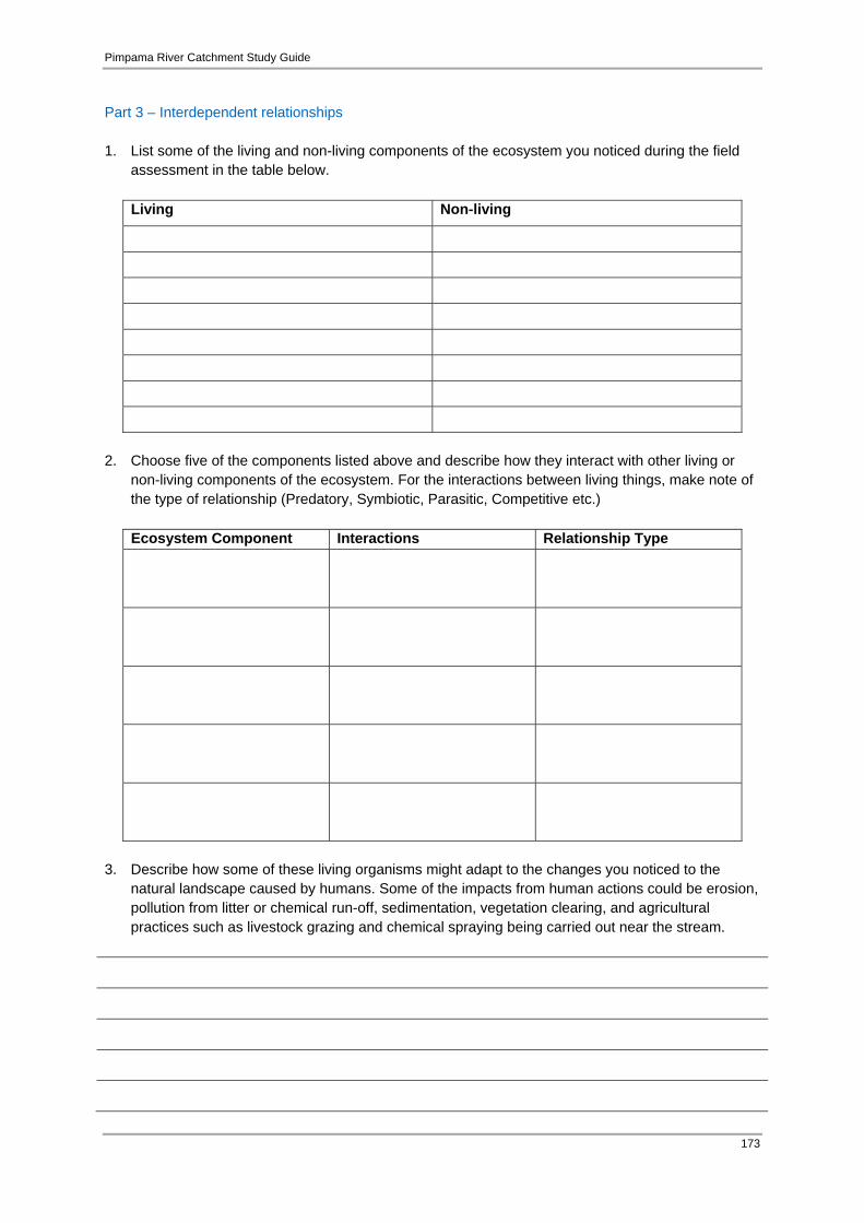
Pimpama River Catchment Study Guide
173
Part 3 – Interdependent relationships 1. List some of the living and non-living components of the ecosystem you noticed during the field
assessment in the table below.
Living Non-living
2. Choose five of the components listed above and describe how they interact with other living or
non-living components of the ecosystem. For the interactions between living things, make note of the type of relationship (Predatory, Symbiotic, Parasitic, Competitive etc.)
Ecosystem Component Interactions Relationship Type
3. Describe how some of these living organisms might adapt to the changes you noticed to the
natural landscape caused by humans. Some of the impacts from human actions could be erosion, pollution from litter or chemical run-off, sedimentation, vegetation clearing, and agricultural practices such as livestock grazing and chemical spraying being carried out near the stream.

Pimpama River Catchment Study Guide
174
4. If some of the non-living or living components you noticed in this ecosystem were removed, what are the effects this may have on the health of the catchment as a whole?
5. Consider the species present in the area, their interactions with other living organisms and with
non-living factors and how this forms an interlinking natural system. How will human influences you observed affect the system?
6. What actions could you take to minimise or manage the effect human actions are having on the
inter-relationships that exist in the ecosystem, as well as the overall health of the catchment?
Follow up activities
Students can complete another field assessment of the wetland area, this time monitoring upstream or downstream or on the opposite side of the bank of the river. The differences in the wetland condition can be compared to the first assessment carried out and the human activities in the two different sites can be compared to come to conclusions on the impacts they are having on the condition of the wetland, and therefore the health of the catchment.
Students could also carry out a biological analysis of what is present in the ecosystem under
study. They could focus on an organism that is adapted to living within the Pimpama wetland area. They could draw and describe the features on the organism that makes it suited to

Pimpama River Catchment Study Guide
175
surviving and thriving in the wetland environment. The type of adaptation must be identified as behavioural, structural or otherwise.
Students could use the calculations from their results to go further and try to estimate the
percentages of vegetation cover, plant litter, native tree coverage, and crab burrow and snail density using a larger area of 1 km length of string to place quadrats along, with an area of 10m x 10m per quadrat.
Additional resources
Jacobs Well Environmental Education Centre: http://jacobseec.eq.edu.au/wcms/

Pimpama River Catchment Study Guide
176
Activity booklet Year 10: The lay of the land For the teacher Lesson overview: Through investigating different study sites within the Pimpama River catchment, students will broaden their knowledge of activities within their catchment area and potential impacts on the environment, which will be consolidated by the preparation of a management plan. Students will explore land use within the Pimpama River catchment and identify the extent of different types of land use through investigations with aerial mapping. Students reflect upon the effects of human activity and discuss how they can create a sustainable balance when planning for the future of the catchment. Lesson objectives: Students become familiar with major types of land use in their catchment area and explore ways to ensure a sustainable future for the Pimpama River catchment. Equipment for students:
Colour photocopies of aerial photograph indicating catchment area for each student; Ruler; Pencil and other writing materials; Whiteboard and markers; Historic and current land cover maps of the Pimpama River catchment (Appendix 2 and 3);
and Pimpama, Ormeau and Jacobs Well Domain Maps (Pimpama River catchment) within the
Gold Coast Planning Scheme: http://www.goldcoast.qld.gov.au/gcplanningscheme_1111/maps_domain.html.
Preparation for the teacher: Become familiar with the different land use types within the Pimpama River catchment as identified in the Gold Coast Planning Scheme (see above for web URL) or Appendix 3 in the study guide and compare to the historic land cover map of the catchment (Appendix 2). Preparation for the student: Collect materials required for land use investigation. Vocabulary land use theme, catchment, aerial photograph.

Pimpama River Catchment Study Guide
177
Curriculum links Year 10 Science Science understanding:
Scientific understanding, including models and theories, are contestable and are refined over time through a process of review by the scientific community (ACSHE191);
Advances in scientific understanding often rely on developments in technology and technological advances are often linked to scientific discoveries (ACSHE192); and
People can use scientific knowledge to evaluate whether they should accept claims, explanations or predictions (ACSHE194).
Science as a human endeavour:
Advances in science and emerging sciences and technologies can significantly affect people’s lives, including generating new career opportunities (ACSHE195); and
The values and needs of contemporary society can influence the focus of scientific research (ACSHE230).
Science inquiry skills:
Formulate questions or hypotheses that can be investigated scientifically (ACSIS198); Plan, select and use appropriate investigation methods, including field work and laboratory
experimentation, to collect reliable data; assess risk and address ethical issues associated with these methods (ACSIS199);
Select and use appropriate equipment, including digital technologies, to systematically and accurately collect and record data(ACSIS200);
Analyse patterns and trends in data, including describing relationships between variables and identifying inconsistencies (ACSIS203);
Use knowledge of scientific concepts to draw conclusions that are consistent with evidence(ACSIS204);
Evaluate conclusions, including identifying sources of uncertainty and possible alternative explanations, and describe specific ways to improve the quality of the data(ACSIS205);
Critically analyse the validity of information in secondary sources and evaluate the approaches used to solve problems (ACSIS206); and
Communicate scientific ideas and information for a particular purpose, including constructing evidence-based arguments and using appropriate scientific language, conventions and representations.
The activity booklet for students follows.
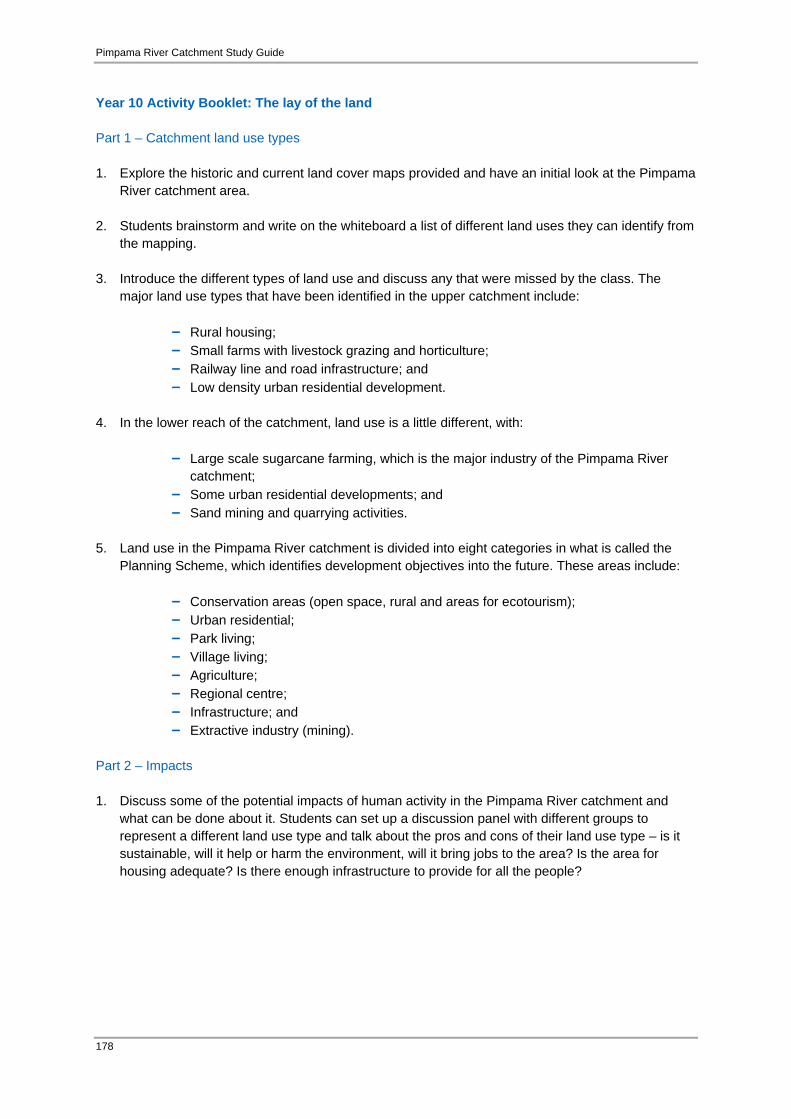
Pimpama River Catchment Study Guide
178
Year 10 Activity Booklet: The lay of the land Part 1 – Catchment land use types 1. Explore the historic and current land cover maps provided and have an initial look at the Pimpama
River catchment area. 2. Students brainstorm and write on the whiteboard a list of different land uses they can identify from
the mapping. 3. Introduce the different types of land use and discuss any that were missed by the class. The
major land use types that have been identified in the upper catchment include:
- Rural housing; - Small farms with livestock grazing and horticulture; - Railway line and road infrastructure; and - Low density urban residential development.
4. In the lower reach of the catchment, land use is a little different, with:
- Large scale sugarcane farming, which is the major industry of the Pimpama River catchment;
- Some urban residential developments; and - Sand mining and quarrying activities.
5. Land use in the Pimpama River catchment is divided into eight categories in what is called the
Planning Scheme, which identifies development objectives into the future. These areas include:
- Conservation areas (open space, rural and areas for ecotourism); - Urban residential; - Park living; - Village living; - Agriculture; - Regional centre; - Infrastructure; and - Extractive industry (mining).
Part 2 – Impacts 1. Discuss some of the potential impacts of human activity in the Pimpama River catchment and
what can be done about it. Students can set up a discussion panel with different groups to represent a different land use type and talk about the pros and cons of their land use type – is it sustainable, will it help or harm the environment, will it bring jobs to the area? Is the area for housing adequate? Is there enough infrastructure to provide for all the people?

Pimpama River Catchment Study Guide
179
2. Estimating how much land for what? Have a look at the current land cover map and draw a grid over it with grid points at 1 cm intervals. Use different coloured pens/pencils to shade over different land use areas. Use a different colour for each land use type. Work out the proportion of land use types by adding up the number of squares for each colour and dividing by the total number of grid squares. An example equation for this is as follows:
Consider if all the areas that looked like sugar cane fields were coloured green and this added up to be 60 grid squares out of 180 total grid squares over the area, the proportion (%) of land use would be as follows -
% land use (for colour/land use type)
= (Total # green squares/total # of squares) x 100
= (60 / 180) x 100
= 33.3 %
This could be represented in a pie chart, as follows;
Sugar cane
Other land‐use
3. For each land use type, look at the different proportions and discuss. Which is the greatest land
use type? Is this positive? What would happen if this continued to increase?

Pimpama River Catchment Study Guide
180
4. Are there any types of land use that may be unsustainable? How can we ensure that the Pimpama River catchment area continues to be developed in a sustainable way?
5. Come back to the panel discussion and expand, taking into account the findings of the land use
mapping task.
Pimpama River Catchment Study Guide
181
Section 5 Bibliography Australian Government (2013a) Erythrotriorchis radiatus — Red goshawk [SPRAT Profile] Available from: http://www.environment.gov.au/cgi-bin/sprat/public/publicspecies.pl?taxon_id=942 [Accessed 23/01/013]. Australian Government (2013b) Litoria olongburensis — Wallum sedge frog [SPRAT Profile] Available from: http://www.environment.gov.au/cgi-bin/sprat/public/publicspecies.pl?taxon_id=1821 [Accessed 23/01/013]. Australian Government (2013c) Nannoperca oxleyana — Oxleyan pygmy perch [SPRAT Profile] Available from: http://www.environment.gov.au/cgi-bin/sprat/public/publicspecies.pl?taxon_id=64468 [Accessed 23/01/013]. Australian Government (2013d) Phaius australis — Lesser swamp-orchid [SPRAT Profile] Available from: http://www.environment.gov.au/cgi-bin/sprat/public/publicspecies.pl?taxon_id=5872 [Accessed 23/01/013]. Australian Government (2013e) Plectranthus habrophyllus [SPRAT Profile] Available from: http://www.environment.gov.au/cgi-bin/sprat/public/publicspecies.pl?taxon_id=64589 [Accessed 23/01/013]. Australian Government (2013f) Randia moorei - Spiny gardenia [SPRAT Profile] Available from: http://www.environment.gov.au/cgi-bin/sprat/public/publicspecies.pl?taxon_id=10577 [Accessed 23/01/013]. Australian Government (2013g) Australian Curriculum [Data file] Australian Government. Available from: http://www.australiancurriculum.edu.au [Accessed 5/01/013]. Australian Koala Foundation (n.d.) The Koala: Endangered or not? [Media release] Available from: https://www.savethekoala.com/about-koalas/koala-endangered-or-not [Accessed 23/01/013]. Black Diamond Images (2012) Randia moorei - Spiny Gardenia [Image] Available from: http://www.flickr.com/photos/blackdiamondimages/7436918326/ [Accessed 23/01/2013]. Curr, E.M. (1886) The Australian Race: its origin, languages, customs, place of landing in Australia and the routes by which it spread itself over the continent, Volume 2. Melbourne: John Ferres Government Printer. Dann, E. (1990) Aboriginal Place Names in Brisbane: Misplaced, Mispronounced and Misunderstood. Brisbane, Brisbane History Group, History Group Papers No. 9. Department of Environment (1996) Nature Conservation (Protected Areas) Amendment Regulation (No.6) – Subordinate Legislation 1996 No. 281. Brisbane: Queensland Government. DERM (2007a) Queensland community water quality monitoring manual. Brisbane: Queensland Government Department of Environment and Resource Management. DERM (2007b) What are Acid Sulfate Soils? [Fact Sheet] Queensland Department of Environment and Resource Management. Available from: http://www.derm.qld.gov.au/land/ass/what_are_ass.html [Accessed 30/01/013].

Pimpama River Catchment Study Guide
182
DIP (2009) South East Queensland Regional Plan 2009-2031. Brisbane: Queensland Government Department of Infrastructure and Planning. Edupics (2011) Colouring page to angle [Image] Available from: http://www.edupics.com/coloring-page-to-angle-i22609.html [Accessed 5/04/013]. EHP (2013a) Regional Ecosystems Maps/ Regrowth Vegetation Maps and PMAVs [Data File] Queensland Government Department of Environment and Heritage Protection. Available from: http://www.ehp.qld.gov.au/ecosystems/biodiversity/regional-ecosystems/maps/index.php [Accessed 23/01/013]. EHP (2013b) Wildlife Online [Data File] Queensland Government Department of Environment and Heritage Protection. Available from: www.ehp.qld.gove.au/wildlife/wildlife-online/ [Accessed 23/01/013]. EHP (2013c) Wetland Info: Monitoring pressure and state (extent and condition) [Fact Sheet] Queensland Government Department of Environment and Heritage Protection. Available from: http://wetlandinfo.ehp.qld.gov.au/wetlands/assessment/monitoring/ [Accessed 15/01/013]. EPA (2006) Nature Conservation (Koala) Conservation Plan 2006 and Management Program 2006-2016. Brisbane: Queensland Government Environmental Protection Agency. Fägerstam, E. (2012) Children and young people’s experience of the natural world: Teachers’ perceptions and observations. Australian Journal of Environmental Education, 28(1), pp. 1-16. Available from: http://liu.diva-portal.org/smash/record.jsf?pid=diva2:551531. Foster, D. (1994) Waterwatch Queensland Technical Manual. Brisbane: Queensland Government Department of Primary Industries. GCCC (2008) Coomera River Catchment Study Guide. Gold Coast: Gold Coast City Council. GCCC (2010a) Pimpama River Conservation Reserves Management Plan. Gold Coast, Gold Coast City Council. GCCC (2010b) Nerang River Catchment Study Guide. Gold Coast: Gold Coast City Council. GCCC (2010c) Bigger and Loders Creek Catchment Study Guide. Gold Coast, Gold Coast City Council. GCCC (2011) Gold Coast Planning Scheme 2003,Version 1.2. Gold Coast: Gold Coast City Council. GCCC (n.d.) Indigenous History & Heritage [Fact Sheet] Gold Coast City Council. Available from http://cultural.goldcoast.qld.gov.au/indigenous-history-heritage-10258.html [Accessed 18/02/013]. GCCC (n.d.b) Pimpama River Catchment and Stormwater Management Plan [Fact Sheet] Gold Coast City Council. Available from http://www.goldcoast.qld.gov.au/council/pimpama-river-catchment-and-stormwater-management-plan-2192.html [Accessed 6/05/013]. GCCC (n.d.) Nature Conservation Strategy (2009-2019) [Fact Sheet] Gold Coast City Council. Available from: http://www.goldcoast.qld.gov.au/nature-conservation-strategy-2009-2019-4542.html [Accessed 25/01/013].

Pimpama River Catchment Study Guide
183
GCCC (n.d.) Open space preservation [Fact Sheet] Gold Coast City Council. Available from: http://www.goldcoast.qld.gov.au/environment/open-space-preservation-4145.html [Accessed 17/01/013]. GCCC (n.d.) Water sensitive urban design [Fact Sheet] Gold Coast City Council. Available from: http://www.goldcoast.qld.gov.au/environment/water-sensitive-urban-design-3924.html [Accessed 10/03/013]. Greening Australia (n.d.) Latest News Ormeau’s Bottle Tree Back from the brink [Fact Sheet] Available from: http://www.greeningaustralia.org.au/community/news-item?newsItemId=311&state=4&newsListingUrl=community/qld&nationalId=7 [Accessed 23/01/013]. Gresty, J.A. (1947) The Numinbah Valley: its geographical history and Aboriginal associations, Queensland Geographical Journal, 51, pp. 57-72. Hall, P., Yaun, D., Gilmont, N. (1988) Numinbah Valley: A Social and Natural History 1840’s – 1988. South Tweed Heads: Numinbah Valley Bicentennial Committee. Hanlon, W.E. (1935) The Early Settlement of the Logan and Albert Districts. Historical Society of Queensland Journal, 2, pp. 205-262. Hanlon, W.E. (1940) Early Day of Nerang Heads, and Southport’s Infancy. Unpublished Manuscript. Haglund, L. (1976) The Broadbeach Burial Ground – An archaeological analysis of the Broadbeach Aboriginal burial ground. St Lucia: University of Queensland Press. Haglund-Calley, L. and Quinnell, M.C. (1973) A Midden at Cascade Gardens, Broadbeach. Memoirs of the Queensland Museum, 16(3), pp. 399-409. Healthy Waterways (2013) Pimpama/ Coomera Rivers Catchment and Estuary [Fact Sheet] Available from: http://www.healthywaterways.org/EcosystemHealthMonitoringProgram/2010ReportCardResults/CatchmentResults/SouthernCatchments/Pimpama/CoomeraRiversCatchmentandEstuary.aspx [Accessed 15/01/013]. Howell, A. (2009) Dragonfly life cycle [Image] Australian Museum. Available from: http://www.australianmuseum.net.au/image/Dragonfly-life-cycle [Accessed 30/5/2013]. Leiper, G. (1985) Mutooroo – Plant Use by Australian Aboriginal People. Eagleby: Eagleby South State School. Leiper, G., Glazebriik, J., Cox, D. and Rathie, K. (2008) Mangroves to mountains: a field guide to the native plants of South-east Queensland. Browns Plains: Society for Growing Australian Plants (Qld Region), Logan River Branch. Longhurst, R.I. (1994) Nerang Shire, A History to 1949. Nerang: Albert Shire Council. Morris, I. (2008) Red Goshawk [Image] Available from: http://www.landmanager.org.au/management-guidelines-red-goshawk-erythrotriorchis-radiatus [Accessed 23/01/013]. Murray Darling Basin Authority (2009) Bug guide [Image] Available from: http://www.mdfrc.org.au/bugguide/ [Accessed 15/05/011].

Pimpama River Catchment Study Guide
184
Murray, T. (2006) Bug Guide, Beetle Pupa – synchroa punctata [Image] Available from: http://bugguide.net/node/view/53446 [Accessed 15/12/012]. NSW DPI (n.d.) Endangered species – Oxleyan pygmy perch [Fact Sheet] NSW Government Department of Primary Industries. Available from: http://www.dpi.nsw.gov.au/fisheries/species-protection/conservation/what-current/endangered-species/oxleyan-pygmy-perch [Accessed 23/01/2013]. Petrie, C.C. (1992) Tom Petrie’s Reminiscences of Early Queensland. St Lucia: University of Queensland Press (Orig publication 1904). Plant nerd (2010) Plectranthus habrophyllus [Image] Available from: http://www.flickr.com/photos/plantnerd/5168768782/ [Accessed 23/01/013]. Queensland Government (2009) Wetland Info: Brachychiton sp. (Ormeau) [Fact Sheet] Available from: http://wetlandinfo.ehp.qld.gov.au/wetlands/ecology/components/species/?brachychiton-sp-ormeau-l-h-bird-aq435851 [Accessed 23/01/013]. Queensland Museum (2003) Wild plants of greater Brisbane. Brisbane: Queensland Museum. Queensland Museum (2007) Wildlife of greater Brisbane. Brisbane: Queensland Museum. Queensland Waterwatch (2007) The Healthy/unhealthy catchment poster [Image] Available from: http://www.qld.waterwatch.org.au/resources/graphics.html [Accessed 23/01/013]. Sportsman Creek Conservation Area (2009) Olongburra frog (Litoria olongburensis) [Image] Available from: http://sportsmancreek.org/wordpress/wp-content/uploads/2009/12/Olungburra-Frog.jpg [Accessed 23/01/013]. Steele, J.G. (1983) Aboriginal Pathways in Southeast Queensland and the Richmond River. St Lucia: The University of Queensland Press. Turnix (2010) Bahrs Scrub Cultural Heritage Study. Gold Coast: Gold Coast City Council and Turnix Pty Ltd. Gooderham, J. and Tyserin, E. (2002) The waterbug book – a guide to the freshwater macroinvertebrates of temperate Australia. Canberra: CSIRO Publishing. Water and Rivers Commission (2001) Water facts, 2nd Edition [Fact Sheet] Available from http://nynrm.sa.gov.au/portals/7/pdf/landandsoil/17.pdf [Accessed 25/01/013]. Waterwatch Australia (2004) Waterwatch Australia National Technical Manual. Canberra: Australian Government Department of Environment and Heritage. Watson, F.J. (1943) Vocabularies of Four Representative Tribes of South Eastern Queensland. Journal of the Royal Geographical Society of Australasia (Queensland), 48, Supplement. Woodward, P. (2010) Phaius australis flowers [Image] Sydney Royal Botanic Gardens. Available from: http://upload.wikimedia.org/wikipedia/commons/2/27/Phaius_australis_flowers.jpg [Accessed 23/01/013].

Pimpama River Catchment Study Guide
185
WPSQ (n.d.) Koala. Wildlife Preservation Society of Queensland [Image] Wildlife Preservation Society Queensland. Available from: http://www.wildlife.org.au/wildlife/speciesprofile/mammals/koala.html [Accessed 23/01/013].

Pimpama River Catchment Study Guide
186
Section 6 Appendices
Appendix 1 Screenshot of Wildlife Online webpage Appendix 2 Historic land cover within the Pimpama River Catchment Appendix 3 Current land cover within the Pimpama River Catchment Appendix 4 Plant identification card Appendix 5 Birds in paradise field identification data sheet Appendix 6 “How would you manage your catchment” activity sheet Appendix 7 Healthy vs unhealthy catchment poster Appendix 8 Teachers’ answer sheet for Year 3: Whose habitat is that? – investigating
survival needs Appendix 9 Identification chart for macroinvertebrates Appendix 10 Teachers’ answer sheet for Year 4: The cycle of life – macroinvertebrates Appendix 11 Pimpama River and other Gold Coast catchments Appendix 12 Current vegetation within the Pimpama River catchment Appendix 13 Dichotomous key for macroinvertebrates

Pimpama River Catchment Study Guide
187
Appendix 1 Screenshot of Wildlife Online webpage
Source: EHP 2013b

Pimpama River Catchment Study Guide
188
Appendix 2 Historic land cover within the Pimpama River Catchment
Map drawn by: Natura Education 2013 Source of layers: QLD Department of Main Roads and Gold Coast City Council, QLD Department of Environment and Resource Management

Pimpama River Catchment Study Guide
189
Appendix 3 Current land cover within the Pimpama River Catchment
LegendCatchment crawl sitesReserveMajor rivers and creeksTributaries and canalsMajor Roads
Landcover typeBanksi woodlandClosed heath wetlandMangrove wetlandEucalyptus and Lophostemon tall open forestCorymbia and Eucalypt open forestMelaleuca wetlandRegrowth forestAgricultureCemeteryRegrowth forestGrasslandGrassland Urban/Suburban
GrazingHighly Disturbed_Under DevelopmentIndustrialMiningNatural Waterway_LakeOpen_GroundRecreation (facilities & sub/urban parks)Rural_ResidentialTourism_OtherTransport (Rail, Road & Paved Areas)Urban_Residential landUtilities_InfrastructureWetlands
Map drawn by: Natura Education 2013 Source of layers: QLD Department of Main Roads and Gold Coast City Council, QLD Department of Environment and Resource Management

Pimpama River Catchment Study Guide
190
Appendix 4 Plant identification card
Source: Natura Education 2013

Pimpama River Catchment Study Guide
191
Appendix 5 Birds in paradise field identification data sheet Site Details
Name Forest Type (circle if applicable): Date Rainforest Park
Location Forest >15 m tall Waterway Shrubland <15 m tall Coastal environment Grasslands Other:
Present Common name Scientific name Conservation status Australian magpie Cracticus tibicen Common Bar-shouldered dove Geopelia humeralis Common Brown quail Coturnix ypsilophora Common Channel-billed cuckoo Scythrops novaehollandiae Common Chestnut-breasted mannikin Lonchura castaneothorax Common Common myna Sturnus tristis Common Crested pigeon Ocyphaps lophotes Common Dollarbird Eurystomus orientalis Common Double-barred finch Taeniopygia bichenovii Common Eastern yellow robin Eopsaltria australis Common Fan-tailed cuckoo Cacomantis flabelliformis Common Golden-headed cisticola Cisticola exilis Common Grey fantail Rhipidura albiscapa Common Grey shrike-thrush Colluricincla harmonica Common Leaden flycatcher Myiagra rubecula Common Lewin's rail Lewinia pectoralis Near Threatened Magpie-lark Grallina cyanoleuca Common Masked lapwing Vanellus miles Common Noisy miner Manorina melanocephala Common Pale-headed rosella Platycercus adscitus Common Pheasant coucal Centropus phasianinus Common Red- backed fairy-wren Malurus melanocephalus Common Red-browed finch Neochmia temporalis Common Rufous whistler Pachycephala rufiventris Common Scarlet honeyeater Myzomela sanguinolenta Common Silvereye Zosterops lateralis Common Superb fairy-wren Malurus cyaneus Common Tawny grassbird Megalurus timoriensis Common Torresian crow Corvus orru Common Whistling kite Haliastur sphenurus Common White-bellied sea-eagle Haliaeetus leucogaster Common White-breasted woodswallow Artamus leucorynchus Common White-browed scrubwren Sericornis frontalis Common White-throated gerygone Gerygone albogularis Common Willie wagtail Rhipidura leucophrys Common Yellow-faced honeyeater Caligavis chrysops Common Zebra finch Taeniopygia guttata Common
Source: Natura Education 2013
Pimpama River Catchment Study Guide
192
Appendix 6 “How would you manage our catchment?” activity sheet How would you look after our catchment if it had the following management issues? Management issues How can this be a problem for a catchment? What are your management solutions? 1 Pollution from:
- Fertiliser, detergent - Oil and petrol - Pesticides and insecticides - Litter
2 Introduced vegetation and weeds
3 Erosion
4 Land clearing
5 Illegal dumping
6 Flooding
7 Water quality
8 Land uses including: - Farming/agriculture - Industry - Residential development - Parkland

Pimpama River Catchment Study Guide
193
Appendix 7 Healthy vs unhealthy catchment poster
Source: Queensland Waterwatch 2007
Pimpama River Catchment Study Guide
194
Appendix 8 Teachers’ answer sheet for Year 3: Who’s habitat is that? – investigating survival needs Part 2: Aquatic and terrestrial environments 1. Catchments are made up of aquatic and terrestrial environments. Write the words forests,
deserts, land, terrestrial, aquatic, ponds, oceans, saltwater, freshwater, upper and lower in their correct place in the sentences below:
Terrestrial environments are based on the land, whereas aquatic environments are based in the water. Mountaintops, forests, grasslands, houses and deserts are all found in a terrestrial environment. Aquatic environments can be saltwater such as seas, oceans, estuaries and salt lakes, or they can be freshwater aquatic environments such as lakes, ponds, creeks and springs. In an aquatic environment, the lower parts of the catchment contain the saltwater environments, whereas the freshwater environments will be found in the upper parts of the catchment.

Pimpama River Catchment Study Guide
195
Appendix 9 Identification chart for macroinvertebrates Name/Sensitivity Grade Name/Sensitivity Grade Name/Sensitivity Grade Name/Sensitivity Grade
Caddis fly larva
Water flea
Freshwater mussel
Freshwater Snail
10 5 3 2
Mayfly nymph
Water strider
Scavenger beetle
Leech
10 4 3 2
Stonefly nymph
Water Measurer
Scavenger beetle larva
Creeping Water Bug
9 4 3 2
Riffle beetle
Damselfly larva
Mosquito
Round Worm
8 4 3 2
Riffle beetle larva
Dragonfly larva
Predacious diving beetle
Segmented Worm
8 4 3 1
Water mite
Freshwater yabby
Predacious diving beetle larva
Back Swimmer
6 4 2 1
Long jawed spider
Freshwater shrimp/prawn
Pygmy back swimmer
Water Slater
6 4 2 1
Whirligig beetle
Seed shrimp
Water boatman
Giant Water Bug
5 4 2 1
Whirligig beetle larvae 5
Water scorpion 3
Adapted from Waterwatch Australia 2004 and Queensland Museum

Pimpama River Catchment Study Guide
196
Appendix 10 Teachers’ answer sheet for Year 4: The cycle of life – macroinvertebrates Part 1 – Your catchment; aquatic and terrestrial 1. Catchments are made up of aquatic and terrestrial environments. Write the words healthy, land, quality, aquatic, dirty, water bugs, freshwater, polluted, environments and lower in their correct place in the sentence below: Terrestrial environments are based on the land, whereas aquatic environments are based in the water. Within an aquatic environment, the lower parts of the catchment contain the saltwater environments, whereas the freshwater environments will be found in the upper parts of the catchment. If a catchment area is healthy, the water quality will be high and it will be clean. However, if a catchment area becomes polluted, than the quality of the water will be low and it will be dirty. Within the aquatic environments found in a catchment, there are many species of water bugs living there. Some depend on the catchment being healthy and unpolluted for their survival. Part 2 – Macroinvertebrates up close Correct order for three macroinvertebrates life stages:
Source of images: Murray Darling Basin Authority 2009
1
Eggs Adult 2
Eggs Larvae Nymph Adult
3
Eggs Adult
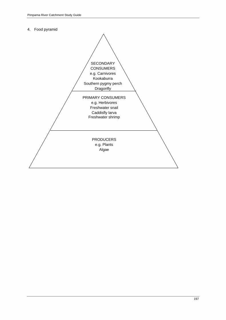
Pimpama River Catchment Study Guide
197
4. Food pyramid
SECONDARY CONSUMERS e.g. Carnivores
Kookaburra Southern pygmy perch
Dragonfly
PRIMARY CONSUMERS e.g. Herbivores Freshwater snail Caddisfly larva
Freshwater shrimp
PRODUCERS e.g. Plants
Algae

Pimpama River Catchment Study Guide
198
Appendix 11 Pimpama River and other Gold Coast catchments
Map drawn by: Natura Education 2013 Source of layers: QLD Department of Main Roads and Gold Coast City Council

Pimpama River Catchment Study Guide
199
Appendix 12 Current remnant vegetation within the Pimpama River Catchment
Map drawn by: Natura Education 2013 Source of layers: QLD Department of Main Roads and Gold Coast City Council, QLD Department of
Environment and Resource Management

Pimpama River Catchment Study Guide
200
Appendix 13 Dichotomous key for macroinvertebrates
Source: Education Queensland

Pimpama River Catchment Study Guide
201
Source: Education Queensland