policies map booklet - ealing · policies map booklet ... this page has been left intentionally...
TRANSCRIPT
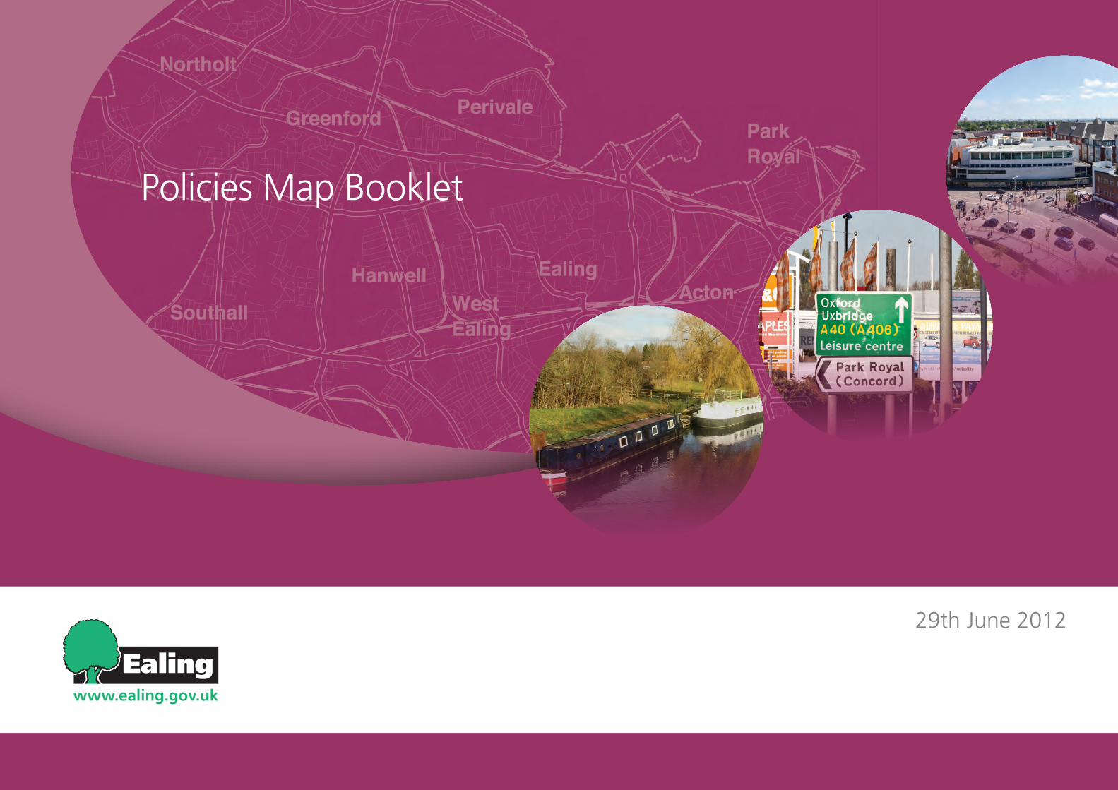
Policies Map Booklet
29th June 2012

Development Sites DPD Final Proposals Consultation June 2012 i
TABLE OF CONTENTS
Map Sheet
1 OPEN SPACE
2 DEFICIENCY MAPPING – LOCAL/DISTRICT
3 DEFICIENCY MAPPING – METROPOLITAN
4 NATURE CONSERVATION
5 ANCIENT MONUMENTS AND ARCHAEOLOGICAL INTEREST AREAS
6 INDUSTRIAL LOCATIONS
7 SHOPPING AND TOWN CENTRES
8 VIEWS AND LANDMARKS
Corresponding Schedules
1 Green Belt
2 Metropolitan Open Land
3 Public Open Space (Including Proposed POS)
4 Community Open Space
NA
NA
5 Sites of Metropolitan, Borough and Local Importance
6 Ancient Monuments
6 Archaeological Interest Ares
7 Strategic Industrial Locations & Locally Significant Sites
8 Town Centres
8 Shopping Frontages
9 Local Viewpoints
9 Landmarks

ii Development Sites DPD Final Proposals Consultation June 2012
This page has been left intentionally blank

Development Sites DPD Final Proposals Consultation June 2012 1
INTRODUCTION
What is the Policies Map? Covering the whole borough, the Policies Map (formerly the Proposals Map DPD) will show geographically all land use policies set out in the adopted DPDs. In this regard it will:
identify areas of protection, such as Green Belt and nature conservation sites, defined through • the development plan process.
Allocate sites for particular land use and development proposals included in any adopted • development plan document, and set out the areas to which specific policies apply.
Whilst the Policies Map is a separate Development Plan Document in its own right, it essentially forms the graphical representations of the other Development Plan Documents.
The Policies Map comprises a large scale map sheet (approximately A0 size), prepared on an Ordnance Survey base, at a scale which is sufficient to allow the policies and proposals to be clearly illustrated. This main map sheet is also supplemented by a separate map booklet (i.e. this document), comprising schedules of all sites/designations, and accompanying map sheets.
What is the purpose of this document?With regard to the paper version of the Policies Map, whilst the large scale policies map illustrates the key policies designations, for reasons of legibility it is not possible to illustrate every designation, or sub categories of individual designations on the main map sheet. Moreover, there are a number of contextual layers, which could helpfully accompany the main map sheet. This detail is therefore better provided on separate map sheets. The maps and accompanying schedules in this document have been grouped into general thematic headings.
Please note the cartography illustrated in the attached maps is of a lower quality (particularly in respect of the resolution of the mapping) than that which will be used in the final published version once adopted. Moreover a number of the maps are incomplete, awaiting the outcome of a separate review exercise. Any further changes will be published for consultation in early autumn. The maps are included here in their incomplete form however for illustrative purposes only, indicating the scope and coverage of the mapping.
In addition to the print version of this plan, an online interactive version of the Policies Map will be available at the point of adoption. This will contain all of the detail contained in the paper version. In addition other potential planning constraints maintained outside of the development plan process, including for example conservation areas, listed Buildings, flood Zones, transport safeguarding Areas etc, will be viewable in the interactive document.

2 Development Sites DPD Final Proposals Consultation June 2012
This page has been left intentionally blank

3
Map Sheet 1

4
Table 1 - Green Belt
Ref. No. Name & Location Consolidated Area Size (ha) 1 Down Barns/ W London Shooting Grounds 81.4713 2 Lime Tree Park - A40 59.2513 3 Western Avenue Parkway (part) Western Avenue Parkway 1.42602 4 Western Avenue Parkway (part) Western Avenue Parkway 0.529757 5 Western Avenue Parkway (part) Western Avenue Parkway 14.6534 6 Western Avenue Parkway (part) Western Avenue Parkway 0.770698 7 Area S of Rectory Fields Northolt-Greenford Countryside Park 3.82417 8 Canal adjacent to Marnham Fields Northolt-Greenford Countryside Park 1.41615 9 Rectory Fields Northolt-Greenford Countryside Park 24.4191
10 Northala Fields Northolt-Greenford Countryside Park 17.691 11 Northolt Golf Course & Medlar Fields Northolt-Greenford Countryside Park 11.2664 12 Belvue Park & adjoining OS & moorings Northolt-Greenford Countryside Park 12.2817 13 Northolt Manor Northolt-Greenford Countryside Park 2.78643 14 Marnham Fields Northolt-Greenford Countryside Park 12.1625 15 Smith's Farm Northolt-Greenford Countryside Park 7.77222 16 Islip Manor-A40 31.6797 17 King Georges Field Spikes Bridge - King George's Field 12.0008 18 Spikes Bridge Park Spikes Bridge - King George's Field 9.92867 19 Hayes Bridge Leisure Gardens 2.93561
Table 2 - Metropolitan Open Land
Ref. No. Name & Location Consolidated Area Size (ha) 1 Fitzherbert Walk & east of R. Brent Brent River Park 8.78531 2 Brent Meadow/Conolly Dell Brent River Park 5.32644 3 East central area of BRP Brent River Park 66.5693 4 W Middx Golf Course Brent River Park 34.3694 5 Greenford Park Cemetery & allotments & playing field Brent River Park 15.573 6 W of R Brent at Cardinal Wiseman School Brent River Park 4.50839 7 Golf Course, central BRP Brent River Park 47.6025 8 Ruislip Rd E at Brentside School Brent River Park 1.65245 9 Northernmost area BRP Brent River Park 0.593703
10 Northernmost area BRP Brent River Park 0.56589 11 Ealing Golf Course N of R Brent Brent River Park 36.7022 12 Ealing Golf Course etc S of R Brent Brent River Park 53.0142 13 River Board Depot, adj Viaduct Inn Brent River Park 0.23773 14 Elthorne Park & Elthorne Waterside, Hanwell W7 Brent River Park 29.1266 15 Perivale Park Brent River Park 51.0147 16 Gurnell Pool Open Space & waterside Brent River Park 11.0364 17 Island W of Mayfield School Brent River Park 0.217844 18 Island S of Hanwell Bridge Brent River Park 0.129252 19 Trailfinders Sports Ground, Vallis Way, W13 Brent River Park 7.42828 20 Glade Lane Canalside Park Brent River Park 12.1439 21 Acton Park - Bromyard Avenue Area 29.299 22 Hanger Hill Hanger Hill 13.6748 23 Chatsworth Wood Hanger Hill 3.01164 24 Hanger Hill Hanger Hill 15.1859 25 Ealing Common (part) Ealing Common 1.64476 26 Ealing Common (part) Ealing Common 0.218057 27 Ealing Common (part) Ealing Common 0.752213 28 Ealing Common (part) Ealing Common 14.4863
5
Ref. No. Name & Location Consolidated Area Size (ha) 29 Twyford Abbey 6.7195 30 Guinness Open Space setting 7.04921 31 Ealing Green, Walpole & Lammas Parks 25.9203 32 RBKC Cemetery Hanwell Cemeteries 6.27101 33 City of Westminster Cemetery Hanwell Cemeteries 8.98215 34 Area adjoining Gunnersbury Park (Old Actonians SG) 2.77024 35 Horsenden Hill (part) Horsenden Hill 28.8522 36 Horsenden Hill (part) Horsenden Hill 132.531 37 Horsenden Hill (part) Horsenden Hill 13.3031 38 Ealing Northern 21.5669 39 r/o Halsbury Rd East 3.43741 40 Norwood Green - Osterley & Tentelow Lane Sports Ground Norwood Green - Osterley 57.6485 41 Tentelow Lane Open Space Norwood Green - Osterley 0.215109 42 Warren Farm/Jubilee Meadow/Long Wood Norwood Green - Osterley 66.0001 43 Birch Wood/GSK Sports Ground New addition as part of Development Strategy (form 17.2925 44 Greenford Lagoons New addition as part of Development Strategy 4.41233 45 Tentelow Lane/Canal towpath Brent River Park 1.09385
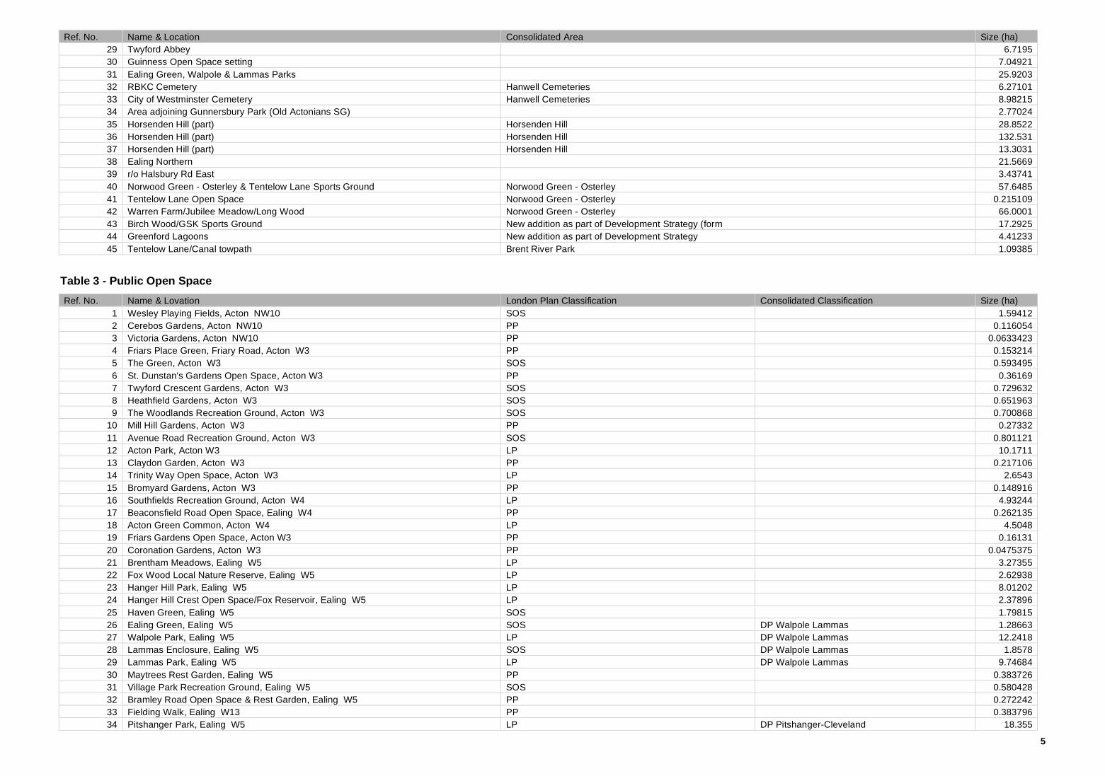
Table 3 - Public Open Space
Ref. No. Name & Lovation London Plan Classification Consolidated Classification Size (ha) 1 Wesley Playing Fields, Acton NW10 SOS 1.59412 2 Cerebos Gardens, Acton NW10 PP 0.116054 3 Victoria Gardens, Acton NW10 PP 0.0633423 4 Friars Place Green, Friary Road, Acton W3 PP 0.153214 5 The Green, Acton W3 SOS 0.593495 6 St. Dunstan's Gardens Open Space, Acton W3 PP 0.36169 7 Twyford Crescent Gardens, Acton W3 SOS 0.729632 8 Heathfield Gardens, Acton W3 SOS 0.651963 9 The Woodlands Recreation Ground, Acton W3 SOS 0.700868
10 Mill Hill Gardens, Acton W3 PP 0.27332 11 Avenue Road Recreation Ground, Acton W3 SOS 0.801121 12 Acton Park, Acton W3 LP 10.1711 13 Claydon Garden, Acton W3 PP 0.217106 14 Trinity Way Open Space, Acton W3 LP 2.6543 15 Bromyard Gardens, Acton W3 PP 0.148916 16 Southfields Recreation Ground, Acton W4 LP 4.93244 17 Beaconsfield Road Open Space, Ealing W4 PP 0.262135 18 Acton Green Common, Acton W4 LP 4.5048 19 Friars Gardens Open Space, Acton W3 PP 0.16131 20 Coronation Gardens, Acton W3 PP 0.0475375 21 Brentham Meadows, Ealing W5 LP 3.27355 22 Fox Wood Local Nature Reserve, Ealing W5 LP 2.62938 23 Hanger Hill Park, Ealing W5 LP 8.01202 24 Hanger Hill Crest Open Space/Fox Reservoir, Ealing W5 LP 2.37896 25 Haven Green, Ealing W5 SOS 1.79815 26 Ealing Green, Ealing W5 SOS DP Walpole Lammas 1.28663 27 Walpole Park, Ealing W5 LP DP Walpole Lammas 12.2418 28 Lammas Enclosure, Ealing W5 SOS DP Walpole Lammas 1.8578 29 Lammas Park, Ealing W5 LP DP Walpole Lammas 9.74684 30 Maytrees Rest Garden, Ealing W5 PP 0.383726 31 Village Park Recreation Ground, Ealing W5 SOS 0.580428 32 Bramley Road Open Space & Rest Garden, Ealing W5 PP 0.272242 33 Fielding Walk, Ealing W13 PP 0.383796 34 Pitshanger Park, Ealing W5 LP DP Pitshanger-Cleveland 18.355
6
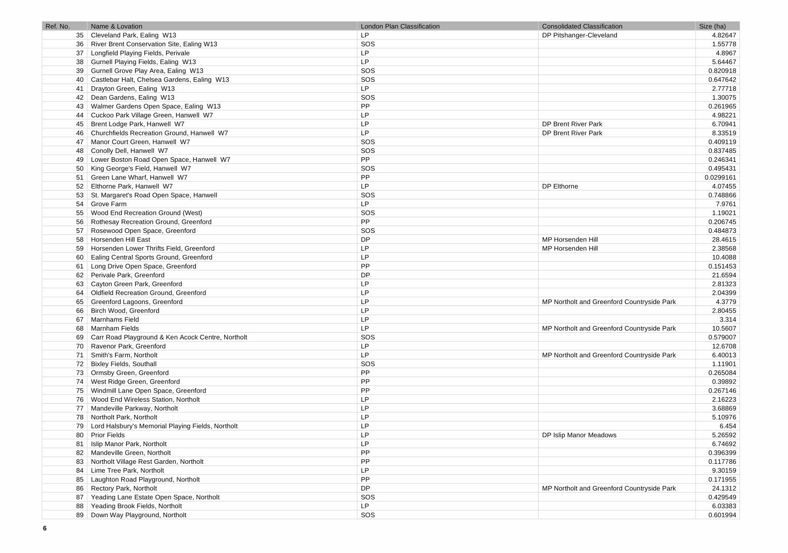
Ref. No. Name & Lovation London Plan Classification Consolidated Classification Size (ha) 35 Cleveland Park, Ealing W13 LP DP Pitshanger-Cleveland 4.82647 36 River Brent Conservation Site, Ealing W13 SOS 1.55778 37 Longfield Playing Fields, Perivale LP 4.8967 38 Gurnell Playing Fields, Ealing W13 LP 5.64467 39 Gurnell Grove Play Area, Ealing W13 SOS 0.820918 40 Castlebar Halt, Chelsea Gardens, Ealing W13 SOS 0.647642 41 Drayton Green, Ealing W13 LP 2.77718 42 Dean Gardens, Ealing W13 SOS 1.30075 43 Walmer Gardens Open Space, Ealing W13 PP 0.261965 44 Cuckoo Park Village Green, Hanwell W7 LP 4.98221 45 Brent Lodge Park, Hanwell W7 LP DP Brent River Park 6.70941 46 Churchfields Recreation Ground, Hanwell W7 LP DP Brent River Park 8.33519 47 Manor Court Green, Hanwell W7 SOS 0.409119 48 Conolly Dell, Hanwell W7 SOS 0.837485 49 Lower Boston Road Open Space, Hanwell W7 PP 0.246341 50 King George's Field, Hanwell W7 SOS 0.495431 51 Green Lane Wharf, Hanwell W7 PP 0.0299161 52 Elthorne Park, Hanwell W7 LP DP Elthorne 4.07455 53 St. Margaret's Road Open Space, Hanwell SOS 0.748866 54 Grove Farm LP 7.9761 55 Wood End Recreation Ground (West) SOS 1.19021 56 Rothesay Recreation Ground, Greenford PP 0.206745 57 Rosewood Open Space, Greenford SOS 0.484873 58 Horsenden Hill East DP MP Horsenden Hill 28.4615 59 Horsenden Lower Thrifts Field, Greenford LP MP Horsenden Hill 2.38568 60 Ealing Central Sports Ground, Greenford LP 10.4088 61 Long Drive Open Space, Greenford PP 0.151453 62 Perivale Park, Greenford DP 21.6594 63 Cayton Green Park, Greenford LP 2.81323 64 Oldfield Recreation Ground, Greenford LP 2.04399 65 Greenford Lagoons, Greenford LP MP Northolt and Greenford Countryside Park 4.3779 66 Birch Wood, Greenford LP 2.80455 67 Marnhams Field LP 3.314 68 Marnham Fields LP MP Northolt and Greenford Countryside Park 10.5607 69 Carr Road Playground & Ken Acock Centre, Northolt SOS 0.579007 70 Ravenor Park, Greenford LP 12.6708 71 Smith's Farm, Northolt LP MP Northolt and Greenford Countryside Park 6.40013 72 Bixley Fields, Southall SOS 1.11901 73 Ormsby Green, Greenford PP 0.265084 74 West Ridge Green, Greenford PP 0.39892 75 Windmill Lane Open Space, Greenford PP 0.267146 76 Wood End Wireless Station, Northolt LP 2.16223 77 Mandeville Parkway, Northolt LP 3.68869 78 Northolt Park, Northolt LP 5.10976 79 Lord Halsbury's Memorial Playing Fields, Northolt LP 6.454 80 Prior Fields LP DP Islip Manor Meadows 5.26592 81 Islip Manor Park, Northolt LP 6.74692 82 Mandeville Green, Northolt PP 0.396399 83 Northolt Village Rest Garden, Northolt PP 0.117786 84 Lime Tree Park, Northolt LP 9.30159 85 Laughton Road Playground, Northolt PP 0.171955 86 Rectory Park, Northolt DP MP Northolt and Greenford Countryside Park 24.1312 87 Yeading Lane Estate Open Space, Northolt SOS 0.429549 88 Yeading Brook Fields, Northolt LP 6.03383 89 Down Way Playground, Northolt SOS 0.601994

7
Ref. No. Name & Lovation London Plan Classification Consolidated Classification Size (ha) 90 Viking Primary School Open Space, Northolt SOS 0.42072 91 Fairview Playground, Northolt SOS 0.810753 92 King George's Playing Field, Southall LP 6.47363 93 Greenford Recreation Ground, Greenford LP 2.09641 94 Windmill Lane Recreation Ground, Greenford PP 0.289579 95 Jubilee Park, Southall LP 4.68863 96 Mount Pleasant Leisure Gardens, Southall LP 3.325 97 Cranleigh Park/Gardens, Southall SOS 0.7663 98 Spikes Bridge Park (Southall Municipal Sports Ground), Southall LP 8.20895 99 Southall Park, Southall LP 10.1147
100 The Crescent Open Space, Southall PP 0.147648 101 Spencer Street Open Space, Southall PP 0.221703 102 Southall Recreation Ground, Southall LP 7.17236 103 Manor House Grounds, Southall SOS 1.13076 104 Glade Lane Canalside Park, Southall LP 7.95527 105 Brent Meadow, Southall LP DP Brent River Park 3.06251 106 Fitzherbert Walk & Hanwell Island, Southall SOS 1.57026 107 Blackberry Corner & Jubilee Meadow, Southall LP 6.8298 108 Long Wood, Southall LP 2.50671 109 Tentelow Wood & Playing Fields, Southall LP 5.04988 110 Havelock Road Open Space, Southall SOS 0.700055 111 Canalway Park, Southall PP 0.283623 112 Wolf Fields, Southall SOS 1.4149 113 Norwood Green, Southall LP 2.94856 114 North Acton Playing Fields LP 8.98311 115 West Gate Open Space PP 0.320978 116 Bittern's Field LP 9.14402 117 Brent Valley Sports Ground LP 3.77941 118 Dormers Wells, Moated Manor LP 2.72945 119 Paradise Fields LP MP Horsenden Hill 10.5465 120 Horsenden Farm & Visitor Centre, Horsenden Hill LP MP Horsenden Hill 2.4248 121 Islip Manor Meadows LP DP Islip Manor Meadows 18.5664 122 Ruislip Road East LP 2.85877 123 Perivale Meadows East SOS 0.986053 124 Cranleigh Wood SOS 0.621092 125 Ellis Road SOS 0.689694 126 Queen's Road Public Open Space PP 0.0462215 127 Wolf Green PP 0.0516802 128 Western Road Open Space PP 0.0775239 129 North Road Island PP 0.166643 130 Dormers Wells Green SOS 1.27632 131 Ridding Lane SOS 1.27743 132 Whitton Drive Open Space PP 0.0498815 133 Montpelier Park SOS 1.85364 134 Chatsworth Wood LP 3.44539 135 Inglis Road Open Space PP 0.0723458 136 Warwick Dene PP 0.291169 137 Ealing Common LP 15.9054 138 Brentham Green Open Space PP 0.0262904 139 Green Lane Open Space PP 0.0534279 140 Blondin Park, Ealing W5 LP 8.74445 141 Crown Street Open Space PP 0.0682001 142 Springfield Gardens LP 2.16894 143 Alexandra Rest Gardens PP 0.0530534 144 Trumpers Field LP 3.14862

8
Ref. No. Name & Lovation London Plan Classification Consolidated Classification Size (ha) 145 Bridge Farm Open Space SOS 1.1557 146 Mayfield LP 2.61267 147 Greenford River Side LP 4.39306 148 Horsenden Hill West DP MP Horsenden Hill 46.8817 149 Northolt Village Green SOS 0.798967 150 Wood End Recreation Ground (East) PP 0.389574 151 Northolt Manor & Belvue Park LP 6.86273 152 Oldfield Lane Open Space PP 0.157245 153 South Park SOS 0.525534 154 Bollo Brook Open Space SOS 0.570609 155 St. Bernard's Conservation Strip PP 0.194017 156 Northala Fields incl. Medlar DP MP Northolt and Greenford Countryside Park 20.7417 157 Midland Terrace Gardens, Acton NW10 PP 0.102627 158 Frogmore Green (Alms PP 0.126716 159 Elthorne Waterside, Hanwell W7 DP DP Elthorne 21.9115 160 South Acton Recreation Ground SOS 1.64288 161 Windmill Lane Green Corridor PP 0.349958 162 St Mary’s Burial Ground SOS 0.408221
Table 4 - Community Open Space
Ref. No. Name & Location COS Classification Size (ha) 1 Acton High School Sports Ground, Gunnersbury Lane, Acton W3 Sports Ground/Golf Course 1.1635 2 Alwyn Gardens Sports Ground, Alwyn Gardens, Acton W3 Sports Ground/Golf Course 1.07616 3 Ascott 1 & 2 Allotments, Ranelagh Road/Queen Anne's Gardens, Ealing W5 Allotments 4.94205 4 Billet Hart Allotments, Green Lane, Hanwell W7 Allotments 1.48076 5 Bixley Field Alloments, Merrick Road, Southall Allotments 2.31989 6 Braund Avenue Allotments, Ruislip Road, Greenford Allotments 0.44652 7 Brent Meadow Allotments, Brentvale Avenue, Southall Allotments 0.48798 8 Brentham Allotments, Brunswick Road, Ealing W5 Allotments 4.50631 9 Brentham Estate Allotments, r/o 2-20 North View, Ealing W5 Allotments 0.125348
10 Fowlers Walk, Ealing W5 Allotments 0.100008 11 Denison Road West, Ealing W5 Allotments 0.09023 12 Denison Road East, Ealing W5 Allotments 0.184972 13 Brunner Road, Ealing W5 Allotments 0.187585 14 Brighton Drive Allotments, Lewes Close, Northolt Allotments 0.177681 15 Perryn Allotments (Formerly Bromyard Avenue), Acton W3 Allotments 0.309637 16 Cayton Road Playing Field (part), Greenford Sports Ground/Golf Course 3.92428 17 Chilton Avenue South Allotments South, Chilton Avenue, Ealing W5 Allotments 0.037157 18 Cleveley Crescent Allotments, Clevely Crescent, Ealing W5 Allotments 0.456133 19 Connell Crescent Allotments, Connell Crescent, Ealing W5 Allotments 0.169846 20 Costons Lane Allotments, Costons Lane, Greenford Allotments 0.454199 21 Durdans Park Allotments, off Lady Margaret Road, Southall Allotments 0.558567 22 Durston House School Playing Field, Carlton Road, Ealing W5 Sports Ground/Golf Course 1.26815 23 Ealing Cricket Club, Corfton Road, Ealing W5 Sports Ground/Golf Course 2.05452 24 Northfields Allotments, Northfield Avenue, Ealing W5 Allotments 2.77628 25 Ealing Lawn Tennis Club, Daniel Road, Ealing W5 Sports Ground/Golf Course 1.21088 26 The Vale Allotments, Oak Way, Acton W3 Allotments 0.84182 27 Framfield Allotments, Dryden Avenue, Hanwell W7 Allotments 2.73786 28 Goldsmiths Close Allotments, East Churchfield Road, Acton W3 Allotments 0.222358 29 Horn Lane, Great Western Allotments, Horn Lane, Acton W3 Allotments 0.871126 30 Greenford Hall Allotments, Greenford Road, Greenford Allotments 0.575033 31 Gunnersbury Avenue (Riding School Land), Ealing W5 Sports Ground/Golf Course 1.12449 32 GWR Sports Ground, Vallis Way, W13 Sports Ground/Golf Course 7.42828 33 Haberdashers Askes Sports Ground, Queens Drive, Acton W3 Sports Ground/Golf Course 2.54788

9
Ref. No. Name & Location COS Classification Size (ha) 34 Hanger Hill Garden Estate Sports Ground, Acton W3 Sports Ground/Golf Course 0.870099 35 Haslemere Wildlife Reserve, Clitherow Avenue, Hanwell W7 Other 0.348295 36 Hayes Bridge Allotments, Beaconsfield Road, Southall Allotments 0.668592 37 High Lane Allotments, High Lane, Hanwell W7 Allotments 0.686113 38 Horn Lane Sports Ground, Acton Main Line Station, Horn Lane, Acton W3 Sports Ground/Golf Course 2.41517 39 Horsenden Allotments, Melville Avenue, Greenford Allotments 1.03597 40 Moat Place Allotments, Acton W3 Allotments 0.451371 41 Iveagh Avenue, Acton NW10 Sports Ground/Golf Course 0.241879 42 Jerome Allotments, Hanbury Road, Acton W3 Allotments 0.324317 43 Jubilee Road Allotments, Bilton Road, Perivale Allotments 1.22781 44 Lime Trees 1 Allotments, Laughton Road, Northolt Allotments 0.484866 45 Lime Trees 2 Allotments, Hawtrey Avenue, Northolt Allotments 0.534192 46 Liverpool Victoria Sports Ground, Carbery Avenue, Acton W3 Sports Ground/Golf Course 2.41624 47 Ludlow Road Allotments, r/o 12-34 Ludlow Road, Ealing W5 Allotments 0.119489 48 Manor Way Allotments, Manor Way, Southall Allotments 0.255624 49 Mansell Road Allotments, Mansell Road, Greenford Allotments 0.273872 50 Noel Road (The Chestnuts) Allotments, Noel Road, Acton W3 Allotments 0.453696 51 Noel Road Open Space, Alwyn Gardens, Acton W3 Sports Ground/Golf Course 0.474065 52 Oldfield Allotments, Carr Road, Northolt Allotments 2.1888 53 Osterley Lane open space, Southall Sports Ground/Golf Course 0.870624 54 Perivale West Allotments, Stockdove Way, Perivale Allotments 0.576267 55 Pitshanger Allotments, Perivale Gardens, Ealing W13 Allotments 3.37548 56 Pleasant Way Allotments, Pleasant Way, Perivale Allotments 0.399918 57 Popes Lane Allotments, Beech Gardens, Ealing W5 Allotments 0.088368 58 The Link, Acton W3 Allotments 0.180365 59 Haslemere Avenue Allotments, Ealing W13 Allotments 2.47838 60 South Acton Allotments West, Palmerston Road, Acton W3 Allotments 0.261086 61 South Ealing Cemetery, South Ealing Road, Ealing W5 Cemetery 9.3953 62 Western Gardens, Springfield Bowls Club, Western Gardens, Ealing W5 Sports Ground/Golf Course 0.433944 63 St Anne's Gardens Allotments, St Anne's Gardens, Acton NW10 Allotments 0.1324 64 St. Dunstan's Allotments, East Acton Lane, Acton W3 Allotments 0.138262 65 Stanhope Park Allotments, Oldfield Lane South, Greenford Allotments 0.515746 66 Stanley Avenue Allotments, Stanley Avenue, Greenford Allotments 0.395444 67 Tentelow Lane Allotment site, Southall Allotments 0.310893 68 Boundary Nature Area, Clitherow Avenue, Hanwell W7 Other 0.278403 69 The Crescent Allotments, The Crescent, Acton W3 Allotments 0.131621 70 Twyford Avenue Sports Ground, Acton W3 Sports Ground/Golf Course 9.92447 71 Village Park Allotments, Popes Lane, Ealing W5 Allotments 0.287087 72 West Acton Primary School Playing Field, Noel Road, Acton W3 Sports Ground/Golf Course 1.41176 73 Haslemere Avenue Sports Ground, Mervyn Road, Ealing W13 Sports Ground/Golf Course 1.36591 74 Western Avenue Allotments, r/o 356-386 Western Avenue, Acton W3 Allotments 0.216536 75 Western Road Allotments, Western Road, Southall Allotments 0.22433 76 Whitton Drive Allotments, Whitton Avenue East, Greenford Allotments 0.755697 77 Whitton Place Allotments, Melville Avenue, Greenford Allotments 0.487521 78 Windmill Lane Allotments, Windmill Lane, Greenford Allotments 2.09008 79 Wolf Fields Allotments, Norwood Road, Southall Allotments 0.963236 80 St. Margarets Road Community Open Space Allotments 0.290026 81 Tennyson Road Other 0.197769 82 GSK Sports Ground Sports Ground/Golf Course 14.2188 83 Ravenor Park Allotments 0.473955 84 Beekeeper's/Argyle Road Other 0.52033 85 Searchlight Allotment Allotments 0.075453 86 Chilton Avenue North Allotments Allotments 0.022038 87 Bromyard Avenue Allotments Allotments 0.20197 88 Braid Avenue Allotments 0.110141
10
Ref. No. Name & Location COS Classification Size (ha) 89 Saxon Drive Allotments 0.028298 90 Walton Gardens Allotments 0.08408 91 Chestnuts Allotments (Formerly Bromyard Avenue) Allotments 0.644638 92 Howard Close Allotments Allotments 0.110296 93 St Andrew's Allotments Allotments 0.121108 94 Bromyard Open Space, Acton W3 Sports Ground/Golf Course 2.73067 95 The Park Club/East Acton Lane Sports Ground/Golf Course 7.05538 96 Old Actonians Sports Ground Sports Ground/Golf Course 2.38529 97 Baron's Pond, Ealing W5 Other 0.221858 98 Ealing Golf Course N of R Brent Sports Ground/Golf Course 37.5623 99 Brentham Club Sports Ground/Golf Course 4.97575
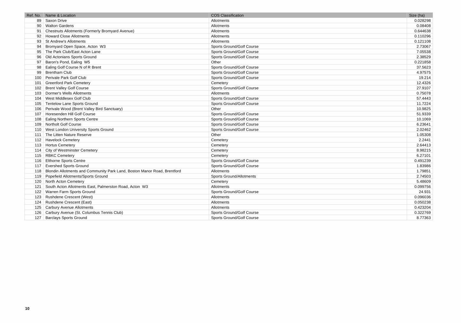
100 Perivale Park Golf Club Sports Ground/Golf Course 19.214 101 Greenford Park Cemetery Cemetery 12.4326 102 Brent Valley Golf Course Sports Ground/Golf Course 27.9107 103 Dormer's Wells Allotments Allotments 0.75078 104 West Middlesex Golf Club Sports Ground/Golf Course 57.4443 105 Tentelow Lane Sports Ground Sports Ground/Golf Course 11.7224 106 Perivale Wood (Brent Valley Bird Sanctuary) Other 10.9825 107 Horesenden Hill Golf Course Sports Ground/Golf Course 51.9339 108 Ealing Northern Sports Centre Sports Ground/Golf Course 10.1069 109 Northolt Golf Course Sports Ground/Golf Course 6.23641 110 West London University Sports Ground Sports Ground/Golf Course 2.02462 111 The Litten Nature Reserve Other 1.05308 112 Havelock Cemetery Cemetery 2.2441 113 Hortus Cemetery Cemetery 2.64413 114 City of Westminster Cemetery Cemetery 8.98215 115 RBKC Cemetery Cemetery 6.27101 116 Elthorne Sports Centre Sports Ground/Golf Course 0.491239 117 Evershed Sports Ground Sports Ground/Golf Course 1.83986 118 Blondin Allotments and Community Park Land, Boston Manor Road, Brentford Allotments 1.79851 119 Popefield Allotments/Sports Ground Sports Ground/Allotments 2.74503 120 North Acton Cemetery Cemetery 5.48609 121 South Acton Allotments East, Palmerston Road, Acton W3 Allotments 0.099756 122 Warren Farm Sports Ground Sports Ground/Golf Course 24.931 123 Rushdene Crescent (West) Allotments 0.096036 124 Rushdene Crescent (East) Allotments 0.050238 125 Carbury Avenue Allotments Allotments 0.423204 126 Carbury Avenue (St. Columbus Tennis Club) Sports Ground/Golf Course 0.322769 127 Barclays Sports Ground Sports Ground/Golf Course 8.77363

11
Map 2

12
Map 3

13
Map 4

14
Table 5 - Nature Conservation Sites
Ref. No. Name & Location Grade GLA Ref. Size (ha) 1 Acton Railsides 1 EaBI19 48.4748 2 Avenue Road hedge L EaL04 0.514945 3 Barons Pond L EaL19 0.234184 4 Blondin Park Nature Area & Allotments L EaL29 4.12599 5 Boundary Stream & The Aviary 1 EaBI09 5.17925 6 Brent River Park North: Brent Valley Golf Club to Uxbridge Road 1 EaBI14C 119.461 7 Brent River Park: Elthorne Waterside 1 EaBI10B 14.7643 8 Brent River Park: Glade Lane Park 1 EaBI10C 9.02861 9 Brent River Park: Greenford Line to Marnham Fields 1 EaBI14B 68.201
10 Brent River Park: Hanger Lane to Greenford Line 1 EaBI14A 56.1898 11 Brent River Park: Hanwell Flight 1 EaBI10A 19.9476 12 Carbery Avenue Allotments L EaL42 0.424502 13 Central Line, West Ruislip Branch 2 EaBII16 56.7812 14 Christ Church School nature area L EaL24 0.042521 15 Cleveley Crescent Allotments L EaL16 0.463094 16 Connell Crescent Allotments L EaL18 0.170827 17 Cranleigh Park Rough L EaL37 0.137638 18 Down Way Park L EaL40 0.046975 19 Ealing Broadway to Hanwell Railsides 2 EaBII17 11.2868 20 Ealing Central Sports Ground L EaL36 1.77718 21 Ealing Reservoir 2 EaBII13 1.53817 22 Fields and wood between Osterley Lane & St Mary's Avenue South 2 EaBII06 1.55422 23 Former Guinness Mounds 2 EaBII15 1.63182 24 Fox Wood & Hanger Hill Park 1 EaBI15 10.9245 25 Framfield Allotments L EaL43 2.74606 26 Greenford Birch Wood 1 EaBI06 3.76014 27 Greenford Park Cemetery 2 EaBII24 12.3175 28 Grove Farm 1 EaBI11 11.2245 29 Gunnersbury Triangle M M115 Ea 0.496997 30 Gurnell Grove & Castlebar Park 2 EaBII10 4.40819 31 Halsbury Road Cutting 1 EaBI08 6.497 32 Hanger Hill Wood 1 EaBI16 3.45405 33 Hanger Lane Gyratory L EaL17 1.18566 34 Hanwell (City of Westminster) Cemetery 1 EaBI13 9.00985 35 Haslemere Wildlife Reserve L EaL28 0.31548 36 Havelock Cemetery 2 EaBII23 2.25108 37 Hayes By-Pass Roughs 2 EaBII02 6.21218 38 Heathfield Gardens L EaL20 0.26905 39 Holy Cross Churchyard, Greenford L EaL08 0.602992 40 Horsenden Hill M M044 139.254 41 Hortus Cemetery L EaL44 2.65227 42 Islip Manor (Ealing part) M M037 Ea 24.849 43 Islip Manor Park L EaL03 0.887779 44 Jerome Allotments L EaL41 0.388617 45 Kensington & Chelsea (Hanwell) Cemetery 2 EaBII09 6.29191 46 Lammas Park nature area & enclosure L EaL14 0.829692
London's Canals M M006 Ea 52.971 47 Long Drive grassland 1 EaBI07 0.407776 48 Long Wood and meadow 1 EaBI12 21.825 49 Lyons tree belt 2 EaBII08 2.59647 50 Mason's Green Lane 2 EaBII26 1.97267 51 Montpelier Park wood 2 EaBII11 0.511785

15
Ref. No. Name & Location Grade GLA Ref. Size (ha) 52 North Acton Cemetery L EaL21 5.51255 53 Northfield Avenue L EaL12 3.20182 54 Northolt Manor & Belvue Park 2 EaBII04 8.25997 55 Northolt Meadow L EaL46 1.70202 56 Norwood Hall woodland L EaL05 3.31872 57 Oldfield Primary School L EaL45 1.33879 58 Perivale Community Centre 2 EaBII21 2.48529 59 Perivale Wood M M008 11.7405 60 Piccadilly & District Lines in Ealing 2 EaBII19 36.4454 61 Popefield Playing Fields L EaL34 2.7496 62 Ravenor Park nature area & stream L EaL07 0.838185 63 Northolt/Greenford Countryside Park 2 EaBII28 29.8148 64 Ridding Lane Open Space L EaL35 1.44599 65 River Brent at Hanger Lane 2 EaBII22 1.83747 66 Silverlink Metro & Dudding Hill Loop in Ealing 2 EaBII20 13.6833
67 Smith's Farm, Marnham Fields, Bridge Farm Open Space & Greenford Lagoons 1 EaBI03 22.5325
68 South Ealing Cemetery 2 EaBII12 9.47672 69 Southall Park Nature Conservation Area L EaL26 0.332012 70 Southall Railsides 2 EaBII18 16.0631 71 Southfields Recreation Ground nature area L EaL31 1.02249 72 St Augustine's Priory 2 EaBII27 3.17954 73 St Bernard's Hospital walls 2 EaBII25 0.134246 74 St Mary the Virgin Churchyard, Norwood Green 1 EaBI18 0.162848 75 St Mary's Churchyard, Ealing L EaL15 0.195884 76 Sudbury Lane L EaL10 0.331902 77 Tentelow Lane woodland & meadow 1 EaBI04 9.32634 78 The Grange Estate pond L EaL13 0.322875 79 The Litten Nature Reserve 2 EaBII07 1.05634 80 The West London Academy nature area L EaL32 3.56413 81 Trinity Way Recreation Ground L EaL30 2.46287 82 Twyford Abbey Grounds 2 EaBII14 5.43272 83 Wall at Factory Yard L EaL33 0.059312 84 Walmer Gardens Open Space L EaL27 0.29845 85 Wesley Playing Fields L EaL39 1.4926 86 West London Shooting Grounds & Downe Barn Moat 1 EaBI01 30.1246 87 Whittle Road Park L EaL38 1.05193 88 Wyncote Farm 1 EaBI20 2.98963 89 Yeading Brook Fields M M051 Ea 30.6299 90 Lime Trees Golf Course 2 EaBII01A 28.759 91 Lime Trees Park 2 EaBII01B 8.70131 92 Brent Side L EaL47 0.682629 93 Cayton Road Hedge L EaL48 0.081345 94 Rosewood L EaL49 2.24203 95 Beekeepers L EaL50 0.255849 96 Argyle Road Hedge L EaL51 0.269164 97 Ealing Common L EaL25 5.67652 98 Ascott Allotments L EaL52 4.93659 99 Boundary Nature Area L EaL53 0.218555
100 Acton Park & Acton Lane Sports Ground L EaL22 5.15635 101 Lady Margaret Road L EaL54 0.110507 102 Mount Carmel School Nature Area L EaL55 0.210859

16
Map 5

17
Table 6 – Archeaological Interest Areas
Ref. No Name 1 Central Acton 2 Creffield Road 3 East Acton Lane 4 Horn Lane/Gipsy Corner 5 Avenue Gardens/Heathfield Road 6 Twyford Abbey 7 Westfields Road/N. Acton Playing Fields 8 Acton Green Common 9 Blondin Park/Junction Road/Whitestile Road
10 Gunnersbury Lane/Popes Lane 11 Walpole Park/Ealing Common 12 West Hanwell 13 Oaklands Road 14 Horsenden Hill 15 Downe Barns 16 Ferrymead Gardens/Oldfield Lane South 17 Northolt Village Green/Belvue Park 18 Manor Farm Road, Perivale 19 Brent River Valley 20 Farm Close, Dormers Wells 21 The Green, Southall 22 High Street, Southall 23 Tentelow Lane/Canal/Boston Road
18
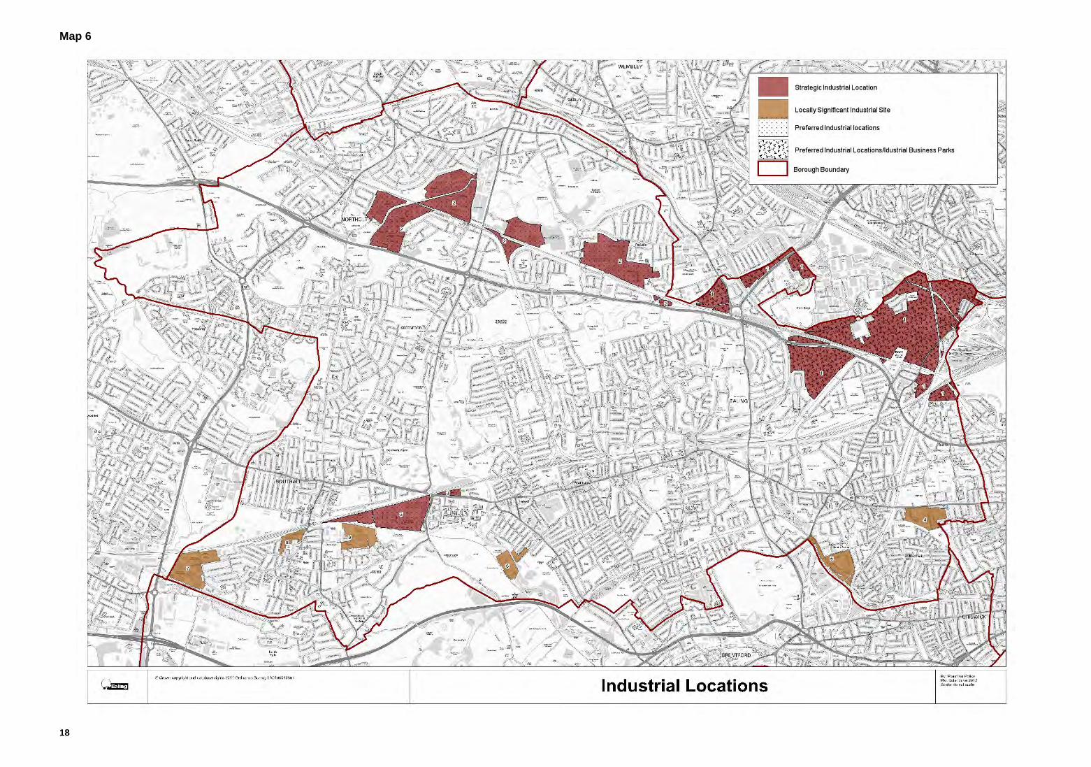
Map 6
19
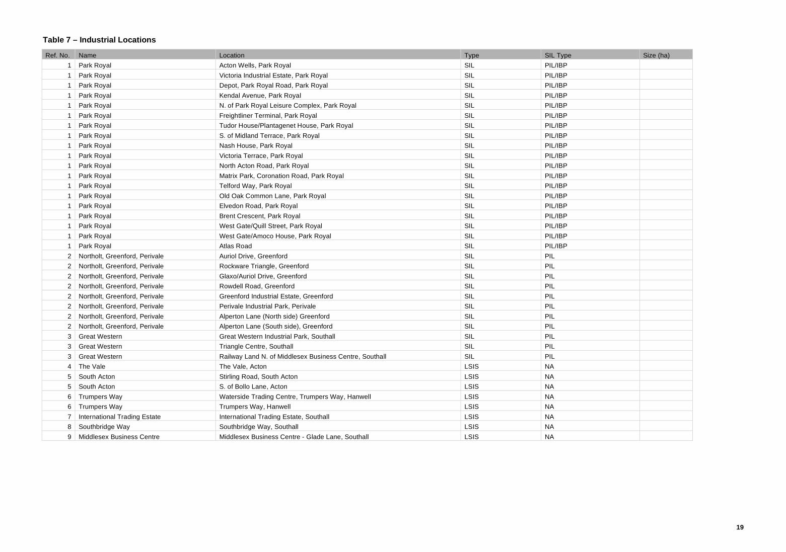
Table 7 – Industrial Locations
Ref. No. Name Location Type SIL Type Size (ha)
1 Park Royal Acton Wells, Park Royal SIL PIL/IBP
1 Park Royal Victoria Industrial Estate, Park Royal SIL PIL/IBP
1 Park Royal Depot, Park Royal Road, Park Royal SIL PIL/IBP
1 Park Royal Kendal Avenue, Park Royal SIL PIL/IBP
1 Park Royal N. of Park Royal Leisure Complex, Park Royal SIL PIL/IBP
1 Park Royal Freightliner Terminal, Park Royal SIL PIL/IBP
1 Park Royal Tudor House/Plantagenet House, Park Royal SIL PIL/IBP
1 Park Royal S. of Midland Terrace, Park Royal SIL PIL/IBP
1 Park Royal Nash House, Park Royal SIL PIL/IBP
1 Park Royal Victoria Terrace, Park Royal SIL PIL/IBP
1 Park Royal North Acton Road, Park Royal SIL PIL/IBP
1 Park Royal Matrix Park, Coronation Road, Park Royal SIL PIL/IBP
1 Park Royal Telford Way, Park Royal SIL PIL/IBP
1 Park Royal Old Oak Common Lane, Park Royal SIL PIL/IBP
1 Park Royal Elvedon Road, Park Royal SIL PIL/IBP
1 Park Royal Brent Crescent, Park Royal SIL PIL/IBP
1 Park Royal West Gate/Quill Street, Park Royal SIL PIL/IBP
1 Park Royal West Gate/Amoco House, Park Royal SIL PIL/IBP
1 Park Royal Atlas Road SIL PIL/IBP
2 Northolt, Greenford, Perivale Auriol Drive, Greenford SIL PIL
2 Northolt, Greenford, Perivale Rockware Triangle, Greenford SIL PIL
2 Northolt, Greenford, Perivale Glaxo/Auriol Drive, Greenford SIL PIL
2 Northolt, Greenford, Perivale Rowdell Road, Greenford SIL PIL
2 Northolt, Greenford, Perivale Greenford Industrial Estate, Greenford SIL PIL
2 Northolt, Greenford, Perivale Perivale Industrial Park, Perivale SIL PIL
2 Northolt, Greenford, Perivale Alperton Lane (North side) Greenford SIL PIL
2 Northolt, Greenford, Perivale Alperton Lane (South side), Greenford SIL PIL
3 Great Western Great Western Industrial Park, Southall SIL PIL
3 Great Western Triangle Centre, Southall SIL PIL
3 Great Western Railway Land N. of Middlesex Business Centre, Southall SIL PIL
4 The Vale The Vale, Acton LSIS NA
5 South Acton Stirling Road, South Acton LSIS NA
5 South Acton S. of Bollo Lane, Acton LSIS NA
6 Trumpers Way Waterside Trading Centre, Trumpers Way, Hanwell LSIS NA
6 Trumpers Way Trumpers Way, Hanwell LSIS NA
7 International Trading Estate International Trading Estate, Southall LSIS NA
8 Southbridge Way Southbridge Way, Southall LSIS NA
9 Middlesex Business Centre Middlesex Business Centre - Glade Lane, Southall LSIS NA

20
Map 7

21
Table 8 – Shopping Parades
Detail to follow

22
Map 8 – Views & Landmarks

23
Table 9 – Views and Landmarks
Detail to follow

accessionaccessions o c i a l e n t e r p r i s e
Designed & produced by Accessionwww.accessionpartnership.com
For further copies of this document or any of Ealing’s local development frameworkdocuments, please contact:
Planning PolicyEaling CouncilPerceval House14/16 Uxbridge RoadLondon W5 2HL
Tel: 020 8825 5882
Email: [email protected]: www.ealinginlondon.com
For further copies of this document please contact:
Planning PolicyEaling CouncilPerceval House14/16 Uxbridge RoadLondon W5 2HL
Tel: 020 8825 5882
Email: [email protected]: www.ealinginlondon.com