preliminary study: an assessment of hazardous weather
TRANSCRIPT

Preliminary Study: An Assessment of Hazardous Weather Impact on
Traffic Flow in the Kansas City Metropolitan Area
15th Annual High Plains AMS/NWA Conference Wichita, KS
4-6 August 2011 Adam Jones *
Matthew Dux ** Suzanne M. Fortin **
* The University of Oklahoma/National Weather Service Pleasant Hill, Missouri ** National Weather Service Pleasant Hill, Missouri

Motivation
• A few recent events highlighted the fact that impacts don’t always follow the “rules”
• Mirroring similar studies. • High density network of traffic data available to
analyze and compare with weather data. – KC Scout: Traffic Flow Data – ASOS: Weather Information
• Previous Studies: Hultquist and Schmit, 2010; Graham et al., 2006, Stern et al., 2003, Cools et al., 2010; DOT 2006-2009
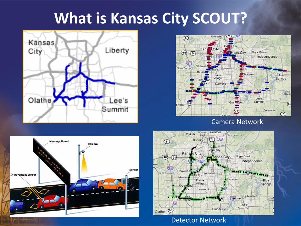
What is Kansas City SCOUT?
Camera Network
Detector Network
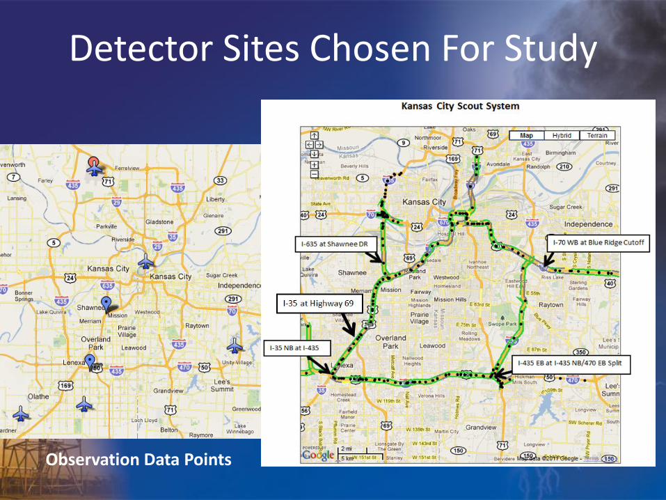
Detector Sites Chosen For Study
Observation Data Points

February 1-2, 2011 Blizzard and Record Snowfall Event

February 1-2, 2011 Blizzard and Record Snowfall Event

Daily snowfall from 1-2 February 2011 & Previous
Records
Kansas City International 47 mph 4:54 PM
St. Joseph (Rosecrans) 51 mph 5:04 PM
Olathe (Johnson County Executive) 44 mph 1:07 PM
Olathe (New Century Air Center) 45 mph 4:42 PM
Chillicothe 41 mph 8:21 PM
Kirksville 52 mph 8:27 PM
Lee's Summit 46 mph 8:28 PM
Whiteman AFB 35 mph 4:07 PM
Peak Official Wind Gusts:

February 1-2, 2011 Blizzard Traffic Impacts
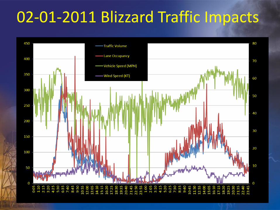
02-01-2011 Blizzard Traffic Impacts

January 10, 2011

January 10, 2011

January 10, 2011 – Widespread Snow
•Long duration snow event over 3 days •Snow totals between 4-8” •Snow Advisory

01/10/2011 Snow Advisory Traffic Impacts

01/10/2011 Snow Advisory Traffic Impacts
Visibility (SM)
Snow Begins Afternoon
Break

01/10/2011 Snow Advisory Traffic Impacts
Wind Speed (kt)
Afternoon Break

01/10/2011 Snow Advisory Traffic Impacts
Pavement Temperatures

April 22, 2010 Heavy Rain and Flooding
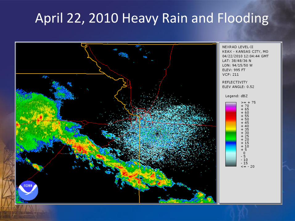
April 22, 2010 Heavy Rain and Flooding

April 22, 2010 Heavy Rain and Flooding

April 22, 2010 Heavy Rain and Flooding Traffic Impacts

0
10
20
30
40
50
60
70
80
0
100
200
300
400
500
600
700
0:0
00
:50
1:4
02
:30
3:2
04
:10
5:0
05
:50
6:4
07
:30
8:2
09
:10
10
:…1
0:…
11
:…1
2:…
13
:…1
4:…
15
:…1
5:…
16
:…1
7:…
18
:…1
9:…
20
:…2
0:…
21
:…2
2:…
23
:…0
:10
1:0
01
:50
2:4
03
:30
4:2
05
:10
6:0
06
:50
7:4
08
:30
9:2
01
0:…
11
:…1
1:…
Traffic Volume
Lane Occupancy
Vehicle Speed (MPH)
Visibility (SM)
April 22, 2010 Heavy Rain and Flooding Traffic Impacts

June 8, 2010 Severe Weather and Flooding

June 8, 2010 Severe Weather and Flooding
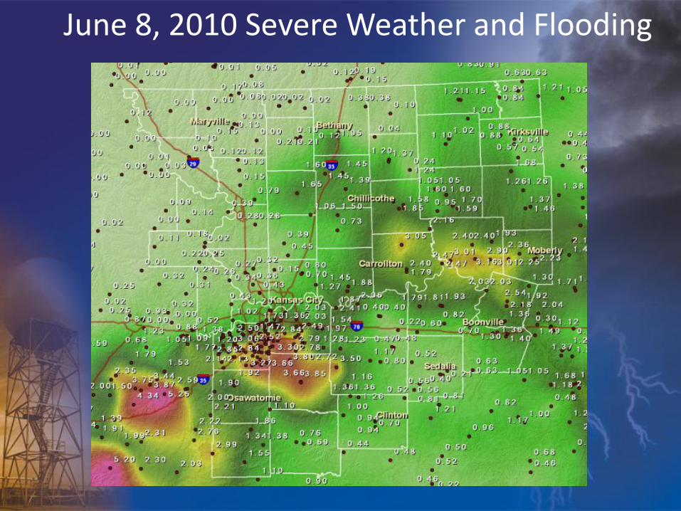
June 8, 2010 Severe Weather and Flooding

June 8, 2010 Traffic Impacts from Severe Weather and Flooding

June 8, 2010 Traffic Impacts

June 8, 2010 Traffic Impacts

Findings
• Qualitatively – weather appears to have an impact!
• Traffic Impact (accidents, travel time ) less when well advertised warning in effect
• Traffic impact greater during advisory/sub-advisory events
• No strong correlation of one weather element being more impactful…though some evidence that wind speeds greater than 10 kts in combination with weather disrupted traffic flow
• Sample size limited…for now

Future Work
• Analysis of more events – winter, rain, severe weather
• Integration of local mesonet data in proximity to KC Scout sites
• Utilize large database of events to perform regression analysis to determine which elements have greatest impact
• KC Scout system will be expanded along I-70 from St Louis to Kanarado, KS; I-44 from Joplin, MO to Tulsa, OK thus findings may have relevance for other NWS County Warning Areas