purification,
TRANSCRIPT

SR
‘HEMEQZQB
United States Patent [191 Serra et al.
KR
4,646,240 Feb. 24, 1987
[11] Patent Number:
[45] Date of Patent:
[54] METHOD AND APPARATUS FOR DETERMINING GEOLOGICAL FACIES
[76] Inventors: Oberto Serra, STS, 11th Floor Pub Building, Somerset Road, Singapore, Singapore, 0923; Hayden Abbott, 805
' Holland Road, Singapore, Singapore, 1027; Yves Kerbart, 46 Rue des Champs Elysees, 94250 Gentilly; Philippe Vincent, 9 Place Alexandre lER de Yougoslavie, 78000 Versailles, both of France
‘ [21] Appl. No.: 851,302
[22] Filed: Apr. 7, 1986
Related US. Application Data
[63] Continuation of Ser. No. 768,171, Aug. 22, 1985, aban doned, which is a continuation of Ser. No. 462,586, Jan. 31, 1983, abandoned.
[30] Foreign Application Priority Data Feb. 2, 1982 [FR] France .............................. .. 82 01658
[51] Int. Cl.4 ...................... .. G01V 1/30; G01V 11/00 [52] U3. Cl. ............................... .. 364/422; 324/323 [58] Field of Search .............. .. 364/421, 422; 324/323;
367/86
[56] References Cited U.S. PATENT DOCUMENTS
4,283,953 8/1981 Plona . . . . . . . . . . . . . . .. 367/86 X
4,320,458 3/1982 Vincent 364/422 - 4,495,604 l/ 1985 Dumanoir 364/422 X
BO
Selection at groups at canseculive levels turnishina stable log MEGSIIYCRIEMS
Main component malysts
83 Change at coordinates
Dimensional compression
Le
84
88 Loed mode mm eaneression
Denaagtum distance GWlySiS
Terminal mode selection
89
/98
FOREIGN PATENT DOCUMENTS
2060882 7/1981 United Kingdom .............. .. 340/860
OTHER PUBLICATIONS
Serra, O. et al., “Sedimentological Analysis of Shale- Sand Series from Well Logs”, SPWLA Sixteenth An nual Logging Symposium, Jun. 1975, 1-23. Serra, O. et al., “The Contribution of Logging Data to Sedimentology and Stratigraphy”, 55th Annual Fall Technical Conference of SPE, Sep. 1980, l-l9. Goetz, J. F. et al., “Reservoir Delineation by Wireline Techniques”, Sixth Annual Convention of the Indone sian Petroleum Association, May 1977, 140.
Primary Examiner--Jerry Smith Assistant Examiner—-Clark A. Jablon Attorney, Agent, or Firm-Cox & Smith Incorporated
[57] ABSTRACT In a method and apparatus for obtaining a recording of facies of geological formations, logging instruments are moved in a borehole to produce log measurements at successive levels of the borehole. With each level is associated a reference sample whose coordinates are constituted by the respective measurements in a multidi mensional space de?ned by the different logs. The scat ter of samples thus obtained is analyzed to distinguish modes characteristic of clusters in which the concentra tion of samples is the highest. The samples may then be associated with selected modes to form classes each characteristic of a respective facie, and the facies then displayed as a function of the depth of the respective associated sample.
24 Claims, 20 Drawing Figures
Association at paints with
terminal modes, dlsltihulidn into classes
Assignnent 01 PCI value
as class index
i Associatian at levels not
used initially with a class
Purification, ‘ Stepped pilot curve ,
logl ic e tes retin lnq
Re?mqulanzalion
Correlation with products 01
diameter measurement Gttwhlc output. dlagmm o1
litho-tactes

‘US. Patent Feb. 24, 1987 Sheet 1 <>f17~ 4,646,240
35
Description
Small yvhite spots in a lumachelle level
Dark grey, calcareous fossiliferous clay
3| (mainly lamellibranchia) u‘ H Lumachelle in clayey matrix ' f’ —Change of facies
|9 ]726_ filling of grey marl in 22 limestone= perforated surface
2| 20 ~ .
l8 ’ . . . .
o o Alternation of sublithographic
?y\ HI |727_ (micritic) ‘limestone and % bioelastic limestone (wackestone)
’ < \/ _ material A \ |2‘ , R —some clayey to marly inter-bed
L/ i728—@ —many subvertical fissures A/ —frequentstylolithic joints A” //l0 l N ' .
/ \ll /l _ 32
2 / / i!
Q l5 )Q / - l730
g \ls & —Change of facies '/ > I (disappearance of lumachelle beds)
1 — . . .
> . 73' éqélzg Alternation of sublithographic 9% H2 _ limestone and dark grey marl
'/ 33

U.S. Patent _ Feb. 24, 1987
'50
LOG TYPE I
Sheet 2 of 17 I
COMPARATIVE IMPORTANCE OF GEOLOGICAL PARAMETERS SI
4,646,240
55
RESISTIVITY
SPONTANEOUS POTENTIAL
ELECTROMAGNETIC WAVE PROPAGATION TIME
ELECTROMAGNETIC WAVE ATTENUATION
NATURAL GAMMA- RAY
NATURAL GAMMA-RAY SPECTROMETRY
HYDROGEN INDEX
BULK DENSITY MEASUREMENT
PHOTO EL ECTRIC CAPTUR E CROSS SECTION ‘
THERMAL NEUTRON CAPTURE CROSS SECTION
SONIC TRANSIT ‘TIME
SONIC ATTENUATION
INELASTIC GAMMA — RAY
SPECTROMETRY
DIPMETER
CALIPER
THER MOMETER
O
O
E ZYI 52 55 2 I
(R) I MINERALOGY
(SPI I MINERALOGY
<EPT°I I MINERALOGY
<EPT°I I MINERALOGY
‘GR’ I MI NERALOGY
‘NW’ I MINERALOGY
(CNL°) I: MINERALOGY
LDTI I MINERALOGY
<LDT°> I MINERALOGY
WWI I MINERALOGY
IBHC°I I MINERALOGY
IBHC") [ MINERALOGY
. IFS") I MINE RALOGY
IHDT") I MINERALOGY
I c > I MINERALOGY
(HRTOI I MINERALOGY
IFIICGL 3
TEXTURE
TEXTURE
TEXTURE
TEXTURE
TEXTURE
TEXTURE
TEXTURE
TEXTURE
TEXTURE
TEXTURE
TEXTURE
TEXTURE
TEXTURE
I TEXTURE
TEXTURE
TEXTUR E
STRUCTURE
STRUCTURE
STRUCTURE
STRUCTURE
STRUCTURE
STRUCTURE
sTRUcTURE
sTRUcTURE
sTRUcTURE
sTRUcTURE
sTRUcTURE
STRUCTURE
STRUCTURE
STRUCTURE
STRUCTURE
STRUCTURE
FLUID
FLUID
FLUID
FLUID
FLUID
FLUID
FLUID
FLUID
FLUID
FLUID
FLUID :I
FLUID]
FLUID]
FLU-ID 1 FLUID 1
FLUID]


US. Patent Feb. 24, 1987 Sheet 5 of 17 4,646,240
DEPART CLUST
DONNEES joo
2o2\ dk — NEIGH KD|5T
I 204\ 206
MODES ‘20K LOCMOD ‘ LMSA LOC'AUX V \ |
207
RATTACH \EIO
FIG.|6 UPLINK,AG_GREG /2'2
214 M THRESHQLD ‘ NFAC
CUTLNK /2I6
FIG.|7 \ FAC _ RENUM /2|8

U.S. Patent Feb. 24, 1987 Sheet 6 of 17 4,646,240
PHIN
RHOB
I90 I92 160
g I97 {95 196
11311653.?


U.S. Patent Feb. 24, 1987 Sheet9ofl7 4,646,240
[FM-3-1111 1B3

U.S. Patent Feb. 24, 1987 Sheet 10 of 1-7 4,646,240'
POROSITY RESISTIVIT‘Y DIP ANGLE DEPTH OTHER LOGS LOGS LOGS AND DIRECTION
1/200 GR RHOB ' MSFL Mitre .
O (GAP) I50 L9 (GCC)
SP
(NV)
30 40 506070
F 1K6. 112 A

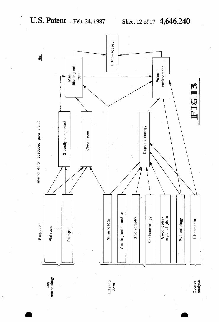
Sheet 12 ofl7 4,646,240
EwEcS 3cm lowEQ
otuulofj Bun. 6:052 \EQQEQQQ
>926 zwoawa
mBSTOEJ
fqoatubw cozoEh? 505.2 0 m 0
US. Patent Feb. 24, 1987
320552
23 .520
mm: .8522;
E8888 2:506 I
I
366523 @3363
wQEum
Son 6525
$365 @3255
29:96 3600 Bow 6E 25 320599.: 91 .

US. Patent Feb. 24, 1987
504
Basic
data litho- facies
522
External data
Sheet 13 of 17 4,646,240
intell
Deduction
process (application of rules) artificial
igence
Most plausible litho- fa cies
5016 . . I Updating of basic H9?
dam for conditions
I hole conditions
5l2
Data base,updated data
l 5,6 5|4 \
Coarse lithological Measurement
analysis Dom Hogs)
5l8 \
Litho- data
520
Log morphology
plausible litho -facies and assignment of litho'facies
to eac
Calculation of distance from measurement points to most
h point
l l 532 I
Litho- facies of each level (represented as a function of depth (diagraml)
M

US. Patent Feb. 24, 1987 Sheet‘l_4 of 17 4,646,240‘
Qun/ 9 Kusue


US. Patent ' Feb. 24, 1987
376
Fccies
(I)
370
Mode
4|
so so
42 I4
66
48
2o 32
. e3
26
l s
63 29
34
27
3 s
372
Level
622
793 924
634
I94
I I47
768
273 845
I023 342
250
I I00 392
502
369
88 OOOOOOOOOOOOOOOOOO TERMINAL MODES
378
7 DK
Sheet 17 of 17 4,646,240
363 Number) of levels
I 76 _
27
59 I02
I46
I7 20
85.
I6
34
63 I2
I25
55
l 37
25
H5122
360 362 364
éaordinole of main components .886
.822
.404
.693
.479
.230
.482
.396
.43I
.567
.864
.950
.285
.368
.349
.724
.974.
.522
.54I
.263
.78I
.O5I
.004
.935
.4I4
.023
. I32
.238
.006
. I I6
.799
.257
.730
.255
.204
0.
.I88
.0I0
.II6
.222
.I78
.0I0
.480
.224
.I99
.749
.II7
.024
.05I
.398
.372
.I54
.279
256

4,646,240 1
METHOD AND APPARATUS FOR DETERMINING GEOLOGICAL FACIES
This application is a continuation of co-pending appli cation Ser. No. 768,171, ?led on Aug. 22, 1985 and abandoned, which is a continuation of co-pending appli cation Ser. No. 462,586, ?led on Jan. 31, 1983 and aban cloned.
BACKGROUND OF THE INVENTION
This invention relates to the geological study of sub soils notably‘for the location and exploitation of mineral deposits.
Mineral and petroleum prospecting is based upon the geological study and observation of formations of the earth’s crust. Correlations have long been established between geological phenomena and the formation of mineral deposits which are suf?ciently dense to make their exploitation economically pro?table.
In this endeavor, the study of the facies of the rocks encountered takes on particular importance. By facies, notably of a sedimentary rock, is meant a set of charac teristics and properties of a rock which result from the physical, chemical and biological conditions involved in the formation of the sediment and which have givenit its distinctive appearance with respect to other sedi ments. This set of characteristics provides information on the origin of the deposits, their distribution channels and the environment within which they were produced. For example, sedimentary deposits can be classi?ed according to their location (continental, shoreline or marine), according to their origin (?uviatile, lacustrine, eolian) and according to the environment within which they occurred (estuaries, deltas, marshes, etc.). This information in turn makes it possible to detect, for ex ample, zones in which the probability of hydrocarbon accumulation is high. There are various sources of information on the facies
of formations. It may be provided by surface or subsoil observations, and notably by the study of core samples taken from rock studies, for example during the drilling of a borehole for an oil well. The geological characteristics used for recognizing a
facie include, in addition to the fossil fauna and ?ora: The mineralogy, i.e. the mineral composition of the
rock; silicate, carbonate, evaporite, etc.; - The texture: grain size, sorting and morphology,
degree of compaction, of cementation, etc.; these pa rameters can be of decisive importance as concerns the permeability of rocks also exhibiting porosity values and other similar ones; they are related to the micro scopic appearance of the rocks; The structure: thickness of beds, their alternation,
presence of stones, lenses, fractures, degree of parallel ism of laminations, thickness of strata, etc.: all of which are parameters related to the macroscopic appearance of the rocks. The petrophysical and petrographic characteristics
of a rock, excluding the paleontological data, constitute the lithe-facies of the rock. This consequently includes the descriptive characteristics of the rock independent of the genetics of formation and notably of deposition. Other types of information coming from the subsoil
can be used by the geologist for the investigation of facies. Such information can be provided by drill cut tings sent up to the surface from the bottom of a well by
10
50
55
65
2 means of a fluid (generally mud) injected near the dril¢ ling tool.
It has already been noted that certain measurements of the physical characteristics of the formations tra versed by a borehole made it possible to obtain valuable information for the interpretation of the facies. Such measurements for determining the physical
characteristics of the geological formations traversed by boreholes are presently carried out on a very large scale, notably in oil wells. They are carried out by means of sondes moved in the borehole, and the signals transmitted by the sonde give a recording (log) as a function of depth. They may involve highly varied characteristics resulting either from natural phenomena, such as the spontaneous potential or the natural emis sion of gamma rays, or from a prior stimulation of the formation by the sonde by the emission of electric cur rent or acoustic waves, electromagnetic waves, nuclear particles, etc.
_In the case of petroleum prospecting, the logs are useful in determining accurately the hydrocarbon-bear ing strata and at investigating, in addition to the nature and quantity of such strata, the possibility of extracting the hydrocarbons from the rocks in which they are contained. A substantial part of the log interpretation efforts up
to the present time has tended toward the evaluation of the porosity of the reservoir rocks or matrices and their permeability, as well as the ‘fraction of the pore volume occupied by these hydrocarbons. These so-called for mation evaluation techniques generally also bring out other parameters such as the average matrix rock grain density and clay content. These interpretation studes have also demonstrated
and used correlations between the measurements fur nished by logging tools and certain compositional char acteristics of the rocks traversed by boreholes. For example, it is common to plot certain information on the readily identi?able lithology of the formations encoun tered as a function of borehole depth, a prime example being the proportion of limestone and dolomite of a rock at a given level of the well. More recent studies have shown that very clear rela
tions could in fact exist between the appearance or thre evolution of certain characteristics in logging measu/re ments and certain parameters of the litho-facies/
This raised the question as to whether it would not be possible to establish a correspondence between the dif ferent facies or lithe-facies encountered within a forma tion interval and all the logging data obtairlable in this interval so as to establish an “Electro-facies” or a “para facies” constituting an image of the facies or of the litho-facies of the rock as seen through the logs.
This idea is based upon the notion according to which each log represents a response spectrum characteristic of the facies of the different zones along which it has been~ established, and that all these logs represent a respective “signature” of these facies or lithe-facies.
It has however not been possible up to the present time to develop a method which, in a relatively con stant, reliable and systematic manner, makes it possible to establish, from only the logging measurements made in a borehole over a given depth interval, a recording or a respresentation notably in the form of a graph which furnishes, as a function of depth, an image of the succes sion of the litho-facies present within this interval. More speci?cally, it would be desirable to be able, on
the basis of log measurements over a given depth inter

4,646,240 3
val in a borehole, to show within this borehole a set of sections or zones capable of being classi?ed in corre spondence (at least approximate) with the different facies or litho-facies present in the interval, so that all the zones corresponding to a similar facies or litho facies belong to the same class.
SUMMARY OF THE INVENTION
It is the object of the present invention to provide a method and apparatus making it possible to obtain, in a reasonably reliable and essentially automatic manner, such a distinction and classi?cation from log measure ments over a depth interval of a borehole in order to produce one or more representations, notably graphs, characteristics of the facies present in this interval.
This method includes in particular the following steps: Logs are made over a plurality of levels within an
interval along the borehole in order to obtain a group of several measurements for each of these levels. With each such level of the borehole interval is asso
ciated a sample within a multidimensional space de?ned by the different logs. The sample’s coordinates are a function of the logging values measured at this level. The sammples thus obtained will form a scatter diagram within this multidimensional space, The samples of this scatter diagram are investigated
in order to determine a plurality of characteristics modes each corresponding to a zone of maximum den sity in the distribution of these samples; each is regarded as a characteristic of a respective cluster and all the samples of this cluster are related to it, and A recording is made, as a function of depth, for exam
ple in graphic form, of a geological or physical charac teristic of the formations within the borehole interval, assigning to each level a characteristic value set as a function of the mode to which the representative sam ple of said level has been related within the multidimen sional space considered. According to one feature of the invention, the explo
ration of the scatter diagram is done by analyzing the position of each of these samples in relation with the neighboring samples to de?ne a respective density in dex, and the characteristic modes are determined by selecting local maxima of these density indices within the scatter diagram. According to one embodiment of the invention, a
facies or litho-facies is designated for each of the modes thus characterized and a graphic respresentation is pro duced as a function of the depth of the succession of facies or litho-facies thus obtained, for example by means of suitable graphic codes. According to a preferred embodiment, the character
istic modes of each cluster or terminal modes are made up of samples coming from the measurements them selves. Each mode is thus characterized by log values actually obtained during the measurement. Advantageously the selection of said characteristic
modes is effected in two phases. In a ?rst phase, one determines a set of local modes on the basis of the analy sis of the local density maxima mentioned earlier. In av second phase, from among these local modes is chosen a small number of terminal modes on the basis of their mutual distance according to a predetermined relation ship. In particular, by a clustering technique, one‘ deter mines the local modes which exhibit the greatest overall dissimilarities. These terminal modes are each consid ered to be characteristic of a super-cluster. To each of
O
20
25
40
4 these terminal modes is related a sub-group of local modes previously determined. Thanks to this method, a limited number of classes is
de?ned, each corresponding to one of the selected ter minal modes which is characterized by a high density of representative points within this space and distinctive characteristics or dissimilarities which are clearly marked, according to the mutual distance of these modes in this space. In this way it is possible to enter each point of this space associated with a respective level in a class which can if necessary be characterized by a number or a set of values within the multidimen sional space considered. These values are, of course, directly derived from the logging measurements and represent an “electro-facies” whose determination de pends only on these measurements. As each level is related to a class, it is possible to plot
a graphic representation of this electro-facies as a func tion of depth, in which each level is assigned an index corresponding to the class to which it is related. After such a procedure, ‘it is observed that the values thus attached to the levels are ordered according to a stepped curve in which the distance of each step from the depth axis corresponds to the index of a respective class. Each step covers several adjacent levels which fall within identical classes on thickness zone of varying size, each corresponding to a different electro-facies, with several zones representing the same electro-facies being capable of being located along the interval con sidered, separated by zones of different facies. From a designation of the litho-facies corresponding to each class, it is possible to plot a pattern of litho-facies as a function of depth. p Using the just described method, it has been possible to reveal a remarkable correspon dence between geological facies, as they may be deter mined for example from the analysis of core samples in a given interval, and electro#facies de?ned by respec tive sections in the interval and their respective classes. Thanks to this method, experimentation thus con
?rms the hypothesis formulated above whereby a deter mination, at least approximate, of the geological litho facies can be derived from a suitable treatment of the logging measurements obtained within an interval of geological formations traversed by a borehole. The technique recommended here can be realized by
means of the main types of logs now existing (e.g. resis tivity, conductivity, density, neutron porosity sonic velocity, 'etc.) which will be referred to here as standard logs.
This technique is moreover enhanced remarkably by the use of the results of dipmetering measurements which contain considerable structural information. This use can take on various forms. It is possible for example to integrate dipmetering results directly with the other logs. These results can then be expressed in the form of so-called synthetic logs which result from the extrac tion of special characteristics of dipmeter measure ments. It is also possible to compare them with the I depth of the transitions between electro-facies after a ?rst processing in order to re?ne, according to an itera tive process, the criteria making it possible to distribute the measurement samples in relatively uniform classes.
In general, the technique just described can be ap plied on the level of a ?eld in which are made several boreholes or wells which encounter formations exhibit ing analogies from the geological viewpoint. Of course, there are preferred embodiments of the
method according to the invention and these will be