recent paleoseismic investigations in northern and western ... · 4. historical seismicity...
TRANSCRIPT

Key words paleoseismicity – active faulting –Thailand
1. Introduction
Due to a lack of large, damaging earth-quakes during historical time, Thailand has not been considered to be a seismically activecountry. Although there are a number of ac-counts of historical earthquake damage (Nuta-laya et al., 1985), the locations and sizes of mostof these events are not well constrained. It islikely that some historical earthquake damagein Thailand may have been the result of large
earthquakes on distant faults such as the Sa-gaing Fault in Myanmar and faults in SouthernChina, which have been the locus of severalmagnitude (unspecified scale) > 6.0 earthqua-kes during historical time (Le Dain et al.,1984). Recent seismicity in Thailand has beenconfined to low to moderate levels with no clearassociation with existing mapped faults (Bott etal., 1997). In areas like Thailand, where there isno reliable, long-term earthquake record and anabsence of historical fault surface ruptures, it isnecessary to examine the geologic and geomor-phic record, in order to quantify the activity onsuspected active faults, and thereby determinetheir contribution to the seismic hazards of theregion.
A fault is deemed active and is consideredto be a potential source of future earthquakes ifthe fault: 1) displays geomorphic features in-dicative of recent fault activity; 2) there is evi-
957
ANNALS OF GEOPHYSICS, VOL. 46, N. 5, October 2003
Mailing address: Dr. Clark H. Fenton, URS Corporation,500 12th Street, Suite 200, Oakland, CA 94607, U.S.A.; e-mail:[email protected]
Recent paleoseismic investigations in Northern and Western Thailand
Clark H. Fenton (1), Punya Charusiri (2) and Spencer H. Wood (3)(1) URS Corporation, Oakland, CA, U.S.A.
(2) Department of Geology, Chulalongkorn University, Bangkok, Thailand(3) Department of Geosciences, Boise State University, Boise, ID, U.S.A.
AbstractRecent paleoseismic investigations have identified a number of active faults in Northern and Western Thailand.Northern Thailand is an intraplate basin and range province, comprised of north-south-trending Cenozoic inter-montane grabens and half grabens, bounded by north- to northwest-striking normal to normal-oblique faults andnortheast-striking left-lateral strike-slip faults. The basin-bounding normal faults are marked by steep, linearrange fronts with triangular facets and wineglass canyons and have slip rates of 0.1 to 0.8 mm/yr. Based on limi-ted data, the average vertical displacement-per-event is about 1.0 to 1.5 m. These faults are characterized byrecurrence intervals of thousands to tens of thousands of years and are capable of generating earthquakes up tomoment magnitude (M) 7, and larger. The northeast-striking strike-slip faults are marked by shutter ridges, anddeflected drainages. Slip rates are 3 mm/yr or less. Western Thailand is dissected by a number of northwest- andnorth-northwest-striking, right-lateral strike-slip faults related to the Sagaing Fault in Myanmar. Although show-ing much less activity than the faults in neighboring Myanmar, these faults display abundant evidence for lateQuaternary movement, including shutter ridges, sag ponds, and laterally offset streams. The slip rate on thesefaults is estimated to be 0.5 to 2.0 mm/yr. These faults are considered capable of generating maximum earth-quakes of up to M 71/2.

dence for displacement in young (Late Qua-ternary) deposits or surfaces; and/or 3) is asso-ciated with a moderate- to large-magnitude his-torical earthquakes or a pattern of micro-earthquakes suggestive of an active fault.
In this paper, we summarize the results ofseveral recent investigations of active faults inNorthern and Western Thailand. The evidencefor active faulting, illustrated by examples fromthe Thoen, Pua, Mae Chan, and Three Pagodasfaults, and the characteristics of these faults arediscussed.
2. Tectonic setting
The contemporary tectonic framework ofSoutheast Asia is a consequence of the inter-action between the Indo-Australian and Eura-sian plates (fig. 1), and the more distant Philip-pine and West Pacific plates. The Eurasianplate, within which Thailand is situated, issurrounded by convergent margins, includingthe Andaman thrust and Sunda arc, to the westand south, respectively. Australia is movingnorthward (along a vector of 010° to 020°),towards Southeast Asia, with a convergencerate of 65 to 70 mm/yr (McCaffrey, 1996). Inaddition, Southeast Asia may also be movingtowards Eurasia at a rate of 10 mm/yr. De-formation across these plate margins is dif-fuse. Partitioning of oblique convergence alongthe Andaman and Sumatra-Java margins givesrise to broad, complex zones of deformation (fig.1) involving both subduction and transform fault-ing (Malod and Kemal, 1996), the most notableof the latter being the Sumatra Fault. Persistentdeformation within the Eurasian plate is illustrat-ed by the number of seismogenic faults in thisregion (Molnar and Deng, 1984).
Thailand occupies an intraplate settingwithin the Eurasian plate. The present tectonicstress regime in Thailand is one of transten-sion, with opening along north-south orientedbasins and right-lateral and left-lateral slip onnorthwest- and northeast-striking faults, respe-ctively (Polachan et al., 1991; Packham, 1993).This regime of transtensional faulting was initiat-ed sometime between the Late Cretaceous andEarly Tertiary (Polachan et al., 1991; McCabe et
958
Clark H. Fenton, Punya Charusiri and Spencer H. Wood
Fig. 1. Major tectonic elements in Southeast Asiaand Southern China. Arrows show relative directionsof motion of crustal blocks during the Late Cenozoic.MPFZ - Mae Ping Fault Zone; NTFZ - NorthernThailand Fault Zone; TPFZ - Three Pagodas FaultZone; UFZ - Uttaradit Fault Zone. Modified fromPolachan et al. (1991).
al., 1988). The Cenozoic tectonics of Thailand,and Southeast Asia as a whole, are a conse-quence of collision of India with Eurasia.Collision began about 50 Ma (Middle Eocene)and has resulted in 2000 to 3000 km of short-ening across the Himalayan orogen (Peltzerand Tapponnier, 1988). As India drove into thesouthern margin of Eurasia, Indochina wasrotated clockwise about 25° and extruded to thesoutheast by approximately 800 km along theRed River and Wang Chao-Three Pagodas

fault zones during the first 20-30 million yearsof collision (Peltzer and Tapponnier, 1988).Extrusion migrated northwards onto the AltynTagh Fault as collision progressed. Rotation ofIndochina continued, reversing the sense ofmotion of the Red River Fault from left-lateralto right-lateral (Allen et al., 1984; Peltzer andTapponnier, 1988). Differential slip betweenthe main strike-slip faults, from north to south,the Red River, Mae Ping, Three Pagodas, andSumatra fault zones (fig. 1), created a transten-sional regime that resulted in the opening of theTertiary basins in Southeast Asia (Ducrocq etal., 1992).
The Tertiary basins of Thailand are grabensor half grabens, typically bounded by north to northwest-striking normal faults (Polachan et al., 1991; Lorenzetti et al., 1994). The loca-tion and geometry of the basins are controlled bythe north-south structural grain in pre-Triassicrocks and pre-existing northwest-striking, strike-slip faults (O’Leary and Hill, 1989). Basin evo-lution throughout Thailand follows a roughlysimilar sequence of events. The main phase ofstrike-slip tectonism, resulting in rapid exten-sion, with widespread fluvial sedimentation(Oligocene-Early Miocene), was followed bylacustrine sedimentation as basins becameincreasingly isolated (Early-Middle Miocene).Lacustrine sedimentation ended, and there wasan influx of coarse terrigenous clastics suggest-ing a period of rapid, localized uplift (Middle-Late Miocene). Finally, following a brief periodof basin inversion that resulted in a widely recognized Late Miocene unconformity, fluvialsedimentation, generally coarsening upward, re-sumed (Late Miocene-Recent) (Polachan et al., 1991; Remus et al., 1993; Alderson et al.,1994). The climax of extensional tectonism ismarked by the eruption of Late Tertiary andEarly to Middle Quaternary alkaline basalts(Hoke and Campbell, 1995). Paleomagneticdata, showing localized rotations during theTertiary, indicates that the opening of these ba-sins appears to have been fairly complex(McCabe et al., 1988, 1993; Richter et al., 1993).
With the exception of the lignite-bearingMae Moh basin (e.g., Ratanasthien, 1986), fewnon-proprietary studies have been carried outto determine the detailed tectonic development
of these basins. The total amount of extensionacross the region is unknown; Olinstad et al.(1989) estimate about 50 km of Cenozoicextension at the northern end of the Gulf ofThailand. In addition, the thickness of basin-fill sediments is poorly constrained and thegeometry of the basin-bounding faults are notwell known. Many of the basins, however, arebounded by linear escarpments that display anumber of geomorphic features suggesting thatthey may still be active structures (Siribhakdi,1986).
3. Seismotectonic provinces
We have modified the seismotectonic zonesof Nutalaya et al. (1985), incorporating geolog-ic, heat flow, and fault activity data, to betterrepresent the seismotectonic character ofThailand (fig. 2). Most of Northern Thailandfalls within what, on account of its tectonic sim-ilarities with the Basin and Range Province ofthe Western United States, Fenton et al. (1997)have called the Northern Basin and RangeProvince. This is a region of extended crust,forming basin and range topography (Mac-Donald et al., 1993). Heat flow is presentlymoderate to locally high and probably has beensince the initiation of rifting in the earlyTertiary (Raksaskulwong and Thienprasert,1991). To the west the Northern Basin andRange is bounded by the Western Highlands, aregion of lower heat flow, comprising upliftedand complexly folded and faulted metamorphicrocks. This province is traversed by a number ofnorthwest- to north-northwest-striking right-lateral strike-slip faults, including the ThreePagodas and Mae Ping faults, which splay fromthe Sagaing Fault in Eastern Myanmar (fig. 1).To the east of the Northern Basin and Range is the Loei or Eastern Fold Belt, a transitionalzone between the extended crust of the NorthernBasin and Range and the Korat Plateau, an uplift-ed plateau region with subdued topography, lowheat flow, and apparent tectonic quiescence. Tothe south the Northern Basin and Range transi-tions into the Central Plain (also known as theChao Praya Basin) which in turn transitions intothe Gulf of Thailand. Each of these provinces is a
959
Recent paleoseismic investigations in Northern and Western Thailand

region of extended crust, distinguished by anincreasing amount of extension and subsidencetowards the south. Whereas the Northern Basinand Range comprises a number of distinct basins,separated by intervening ranges, the Central Plainhas extended to the point where it has created asingle, broad, alluvium-filled topographic basin.North of the Northern Basin and Range is aregion dominated by left-lateral strike-slip defor-mation. This is called the Mae Chan Provinceafter the active strike-slip fault that appears tomark the southern boundary of this deformation.
4. Historical seismicity
Contemporary seismicity in the NorthernBasin and Range province is diffusely distrib-uted, of low to moderate levels, does not appearto be associated with currently mapped faults(fig. 3), and is probably confined to the upper10 to 20 km of the crust (Bott et al., 1997).Although the historical earthquake recordextends back to at least 1300 A.D. (year 1843B.E., Thai calendar), the largest known earth-quake in Thailand has probably not exceededRichter magnitude (ML) 61/2. Associating seis-micity with specific geologic structures, partic-ularly mapped faults, is extremely difficult inNorthern Thailand because of the large locationuncertainties of individual earthquakes (Bott et al., 1997). In fact, in common with the Basinand Range Province in the Western UnitedStates, much of the widely distributed seismic-ity in Northern Thailand is probably associatedwith faults that have no clear surface expres-sion (Bott et al., 1997). In the Basin and RangeProvince, these so-called background earth-quakes can be as large as M 6 to 61/2 (dePolo,1994).
5. Previous fault studies
With the exception of limited ground crack-ing accompanying the 1983 ML 5.9 reservoir-induced earthquake at Srinagarind reservoir(Klaipongpan et al., 1991), there are no reportsof historical surface faulting events in Thailand.Nutalaya (1994) and Hinthong (1995, 1997) ini-tially compiled data on active faults in Thailand,identifying 22 active, potentially active, or sus-pected active faults, based primarily on geomor-phic expression and thermoluminescence agesobtained from fault gouges. Subsequent inves-tigations have added to the inventory of activeand suspected active faults in Thailand (fig. 4).Thiramongkol (1986) presented evidence forHolocene movement on the Bang Pakong Faulton the eastern margin of the Central Plain. LeDain et al. (1984) suggested that the northwest-striking Papun (Moei or Mae Ping) Fault mightalso be active, based on recent seismicity re-corded in the Myanmar-Thailand border region
960
Clark H. Fenton, Punya Charusiri and Spencer H. Wood
Fig. 2. Seismotectonic provinces in Thailand (afterWoodward-Clyde Federal Services, 1996).

961
Recent paleoseismic investigations in Northern and Western Thailand
Fig. 3. Late Cenozoic faults and historical seismicity (1362 to 1996) of the Northern Basin and Range seis-motectonic province. Figure modified from Bott et al. (1997).

(fig. 1). Earthquake focal mechanisms suggestthat this fault is a right-lateral, strike-slip fault(Le Dain et al., 1984). Woodward-Clyde Feder-al Services (1996) carried out extensive fault
investigations in Northern Thailand that showedrecent activity on the Mae Chan, Pua, Phrae,Phrae Basin, Thoen, Nam Pat, Long, andPhayao faults (fig. 3). Rhodes et al. (1996)reported young faulting within Cenozoic sedi-ments along the margin of the Chiang Maibasin, west of the city of Chiang Mai. Perez et al. (1999) inferred recent movement on theMae Kuang Fault, northeast of Chiang Mai,from the offset of three tributaries of the MaeKuang River. Wood (1995, 2001) providedstrong geomorphic evidence for Late Quater-nary left-lateral displacement along the MaeChan Fault. Recent trenching investigationshave confirmed Late Quaternary faulting on theMae Chan Fault (Rymer et al., 1997). Wood-ward-Clyde Federal Services (1998) highlightedevidence for recent movement on the ThreePagodas Fault in Western Thailand and also onthe Tavoy, Tenasserin, and Kungyaungale faultsin neighboring peninsular Myanmar.
6. Approach of recent investigations
The identification of active faults in Thai-land has been hampered by: 1) the comparativelack of fault studies; 2) extensive weathering ofbedrock and extremely active erosion actingtogether to prevent the preservation of all butthe most resistant geomorphic features; 3)large areas of thick forest vegetation, and 4) the probable low slip rates of the intraplatefaults in Thailand. Combined, these factors re-sult in a lack of recognizable, long-lived surface-faulting geomorphic features (Fenton et al., 1999).Despite these shortcomings, paleoseismic inves-tigations in Thailand have been successful andindicate that Late Quaternary deformation isongoing and that these active faults pose a signi-ficant seismic hazard (e.g., Wong et al., 1997).
Lacking a well-defined Late Quaternaryframework for Northern Thailand, recent stud-ies (e.g., Fenton et al., 1997) concentrated onthe geomorphic expression of faulting, and thecomparison with the features observed alongother active faults in similar tectonic settingsworldwide. These features included fault scarps,faceted spurs, and offset terraces and drainages.These geomorphic data were supplemented by
962
Clark H. Fenton, Punya Charusiri and Spencer H. Wood
Fig. 4. Active and suspected active faults in Thailand.Modified from Hinthong (1995).

paleoseismic data obtained from limited trench-ing and fault zone exposures (Woodward-ClydeFederal Services, 1996; Fenton et al., 1999).
Ideally, investigations of active faults prog-ress from a regional, through a local, to a site-specific scale. In areas where there is some dataon the regional neotectonic setting, the empha-sis of such studies is on the local and site-spe-cific scale. In Thailand, where damaging earth-quakes are infrequent and possibly there are nosurface-faulting events in historical time, theregional, as well as local seismotectonic settingis not well understood. Therefore, investiga-tions have to start at a regional level, andprogress through a series of logical stepstowards detailed site-specific studies.
Initial studies involved remote sensing in-terpretation, starting at small scales with satel-lite imagery, progressing to detailed stereoscop-ic aerial photographs to locate zones of activedeformation (Wood, 1995, 2001; Fenton et al.,1997). Once these zones were identified, de-tailed mapping of Quaternary landforms anddeposits along a zone of deformation was car-ried out. The Quaternary stratigraphic frame-work was then established and landform stylesidentified. Based on the estimated ages of thesefeatures and/or deposits, they were used to meas-ure the amount and the rates of displacementacross faults (Wood, 1995, 2001). Geomorphicmapping aided in evaluating the location ofactive faults and the nature of the faulting, iden-tifying the number of paleo-events, and theapproximate size and timing of these events(Fenton et al., 1999).
Finally, when there was sufficient know-ledge of the local Quaternary stratigraphy andgeomorphology with which to evaluate the re-sults of detailed trench logging, we excavatedand logged a number natural fault zone expo-sures. A number of the faults investigated, evenafter detailed geomorphic studies, were notconsidered suitable for trenching studies be-cause of the lack of preservation of youngdeposits along the fault zones. These faults,although having very prominent geomorphicexpressions, usually as topographic escarpmentswith faceted spurs with oversteepened bases(Hamblin, 1976), are rarely expressed in younggeologic materials.
These studies have allowed us to estimate anumber of fault parameters including: the totalamount of offset across fault zones; slip-per-event; fault slip rates; recurrence intervals; faultsegmentation, and bracket the age of faultingevents. The geomorphic evidence for Late Qua-ternary faulting in Thailand is discussed in thefollowing sections, illustrated by examplesfrom the Thoen, Pua, Mae Chan, and ThreePagodas fault zones.
7. Thoen Fault
The 120 km long Thoen Fault Zone (fig. 3)is a series of north- to northeast-striking faultsthat traverse the region between the Phrae Ba-sin to the east and the Lampang, Mae Moh, andThoen basins to the west (Piyasin, 1974; Cha-roenprawat et al., 1994). Two faults within this
Recent paleoseismic investigations in Northern and Western Thailand
Fig. 5. Simplified map of the Thoen Fault Systemshowing fault segments and localities mentioned inthe text.
963

system display a number of structural, strati-graphic, and geomorphic features indicatingrecent movement. They are the fault boundingthe eastern margins of the Mae Moh, Lampang,and Thoen basins, herein called the Thoen Fault,and the fault bounding the western side of theLong Valley, the Long Fault (fig. 5).
On aerial photographs and Landsat TM sa-tellite imagery, the Thoen Fault is a well-de-fined, sharp lineament. The predominantly ver-tical offset across the fault is highlighted by thecontrast between the deep incision by streamsin the uplifting footwall compared to the lack ofincision on the same streams in the subsidingfootwall, i.e. denudation and aggradation in thefootwall and hangingwall, respectively, of anactive fault. The Thoen Fault can be divided intofour segments, based on geomorphic expres-sion, structural style, and sense of offset. From
north to south these are the Ban Mai, Doi TonNgun, Mae Tan, and Thoen segments (fig. 5).
Over much of its length, the Thoen Faultforms a northwest-facing bedrock escarpmentthat varies in height from 400 to 600 m. Theescarpment comprises a series of faceted spursinterrupted by several benches or erosional ped-iment remnants (fig. 6). Hamblin (1976) hasshown that such features were the result of epi-sodic fault movement; the facets forming dur-ing periods of fault movement and the benchesduring periods of tectonic stability, erosion andfault scarp retreat (fig. 7). Studies of faults inthe Mae Moh Basin, immediately to the west ofthe Thoen Fault, have shown that extensionbegan sometime in the Early Oligocene (Vella,1983; Ratanasthien, 1986). These faults show acomplex history of movement throughout theTertiary, however, they now appear to be rela-
Clark H. Fenton, Punya Charusiri and Spencer H. Wood
Fig. 6. Triangular faceted spurs along the Thoen Fault escarpment east of Ban San Pa Pao. Note the oversteepenedbase and the development of several erosional benches along the escarpment.
964

Progressive steepening towards the base of afault scarp or escarpment shows repeated faultmovement, the steeper bevels representingmore recent (less eroded fault scarps) faultingepisodes (McCalpin, 1996).
Several streams crossing the Ban Mai Seg-ment exhibit wine-glass canyon profiles. Thisresults from renewed uplift or an increased rateof uplift of the footwall in a normal fault sys-tem (fig. 8). In order to equilibrate their profilesacross a fault-produced knickpoint, streams mayhave to cut down rapidly when fault movementeither resumes after a period of tectonic quies-cence or when the rate of movement increases.The result of this rapid down-cutting is the for-mation of a narrow slot canyon or stem of thewine-glass. The presence of wineglass canyonsin addition to the marked steepening of thefaceted spurs at the base of the escarpment,indicate that, at least along the Ban Mai Seg-ment, the Thoen Fault is undergoing renewed orincreasing vertical displacement. Vertical offsethas also resulted in a sudden widening of drain-age valleys as they cross from the footwall intothe hangingwall. These valley floors and theadjacent ridge crests also show left-lateral offsetacross the fault. Valley walls are offset in a left-lateral sense by approximately 200 to 400 m.
At Ban Mai, the Thoen Fault crosses theactive floodplain of the Mae Mai River (fig. 5)and vertically offsets an alluvial terrace surface,down-to-the-northwest, by approximately 6 m.The absolute age of this terrace surface is un-known; however, from the preservation of theterrace and the relatively immature soil devel-opment on the terrace surface (a Bw horizonwith only limited rubification), we consider this surface to be Holocene in age. Assumingapproximately 6 m of vertical offset during theHolocene, this gives a vertical displacementrate of about 0.6 mm/yr for the Ban Mai Seg-ment.
A road cut about 1 km west of the mainescarpment at Ban Mai (fig. 5) exposes a nor-mal fault offsetting, down-to-the-west, a se-quence of alluvial gravels and lacustrine clays.The fault dips about 80°W and strikes N48°E.Total vertical displacement exposed in the cut is1.3 to 1.6 m. The number of events and theamount of slip-per-event is unknown, as the top
965
Recent paleoseismic investigations in Northern and Western Thailand
Fig. 7. Development of faceted spurs produced byepisodic vertical tectonic movement. I - undissectedfault scarp. II - development of faceted spurs bystreams cutting across the fault scarp. III - period oftectonic quiescence with slope retreat, and develop-ment of a narrow pediment. IV - renewed faultmovement. V - dissection of the new fault scarp bymajor streams and streams developed on the facesof the faceted spurs developed at stage II. VI - a newperiod of tectonic quiescence, with the developmentof another narrow pediment within the footwallblock at the base of the range front. VII - renewedfault movement. VIII - dissection of the fault scarpproduced at stage VII resulting in a line of smallfaceted spurs at the base of the range front.Remnants of narrow pediments (benches) are pre-served at the apices of each set of faceted spurs.Progressive slope retreat is accompanied by adecrease in the slope angle of the faceted spurs.Modified from Hamblin (1976).
tively inactive (Ratanasthien, 1986). The mostrecent movement, therefore, appears to havebeen confined to the margins of the basin alongthe main Thoen Fault.
Along the Ban Mai Fault Segment, the low-est faceted spurs are about 250 to 350 m high.These facets themselves are not planar, butcomprise at least three beveled planes thatsteepen towards the base of the escarpment.

of the section has been eroded. Young, unfault-ed gravel (probably Holocene in age) has beendeposited across this eroded surface and is notoffset by the fault. Faulting is assumed to beLate Quaternary in age on account of the poor-ly developed soils both in the unfaulted unitcrossing the fault and also within the upper off-set units. The relationship between this faultand the main Thoen Fault is unknown. Its loca-tion and geometry suggest that it must be a syn-thetic fault, i.e. it has the same dip and sense ofmovement as the main fault. A lack of geomor-phic expression and the pre-Holocene offset,however, indicates that it is less active than themain basin-bounding fault.
With the exception of these two localities,no other faulting is found in young deposits
along the Ban Mai Segment. The lack of ob-served recent faulting over much of the north-ern segment of the Thoen Fault is due to the rel-ative absence of young deposits along the faulttrace. Where present, mainly along moderndrainage courses, these deposits are very young,most likely less than a few thousand years old(Woodward-Clyde Federal Services, 1996). Inaddition, rice farming has extensively modifiedthese deposits. The high rates of erosion inNorthern Thailand result in very little aggrada-tion along active drainages in upland regions(Kiernan, 1991).
The 25 km long east-west-striking Doi TonNgun Fault Segment forms a 300 m high rangefront with well-developed triangular facets andwine-glass canyons (fig. 5). The facets havethree well-developed bevels: the lowest is about3 to 5 m high and dips 45°; the intermediatebevel is about 25° to 30° and about 100 m high;and the upper bevel is 15° to 20° and extends tothe crest of the range. The lowest bevel corre-sponds to a prominent scarp observed on aerialphotographs (Fenton et al., 1997). All streamscrossing this fault splay show marked incisionon the footwall, indicating vertical offset. Noevidence for lateral offset is observed. With theexception of some minor faulting and tilting ofalluvial gravels in a borrow pit at the easternend of this segment, no faulting was observedin young deposits. Displacement appears to dieout rapidly westwards. The Late Pliocene-EarlyPleistocene Kho Kha basalts (Sutthirat et al.,1995) are offset by less than 1 m, and the faultdoes not appear to cut through the entire se-quence of basalt flows.
The Mae Than Segment of the Thoen Faultis comprised of a number of splays that strikenortheast to east-northeast (fig. 5). These splaysbound the Tertiary Mae Than Basin. The mainfault, bounding the southeastern side of thebasin, forms a 600 m high, northwest-facingescarpment characterized by well-developedtriangular facets and wineglass canyons (fig. 6).A well-developed bench is observed at theapices of 280 m high triangular facets. Thesefacets show progressive steepening towardstheir bases. Drainages crossing the fault showextensive footwall incision, but no evidence forlateral displacement. These drainages appear to
966
Clark H. Fenton, Punya Charusiri and Spencer H. Wood
Fig. 8. Formation of a wineglass canyon. From Wood-ward-Clyde Federal Services (1996). 1 - Tributary drai-nage crosses normal faulted basin margin at grade. 2 - Normal faulting event. Tributary drainage offset ver-tically. 3 - Drainage erodes down to new base level. 4 - Repeated fault movement. Scarp height increases, asdoes depth of slot canyon if rate of faulting is greaterthan erosion.
1 2
3 4
1234

have been ponded within the graben as shownby the sudden widening of their respectiveflood plains as they flow in and then narrowagain as they flow out of the graben. No faultexposures were found in young alluvial depos-its. Exposures in the Mae Than lignite mine (fig.5) show that none of the faults on the northwestside of the graben have been active during LateQuaternary time.
South of Mae Than, at the base of the mainfault escarpment, at least two, possibly three,Late Cenozoic, down-to-the-northwest fault-ing events are preserved as stacked colluvialwedges in a sequence of alluvial fan gravels ex-posed in a stream cut-bank. The age of these de-posits is unknown; however, the degree of red-dening and cementation of these gravels almostcertainly precludes them from being Holocene.Clasts size, mainly cobbles and boulders, is alsoincompatible with the size of the presentdrainages issuing from the footwall block. Weconclude, therefore, that these gravels are Plio-Pleistocene in age. The thickness of individualcolluvial wedges, approximately 1.0 to 1.5 m,indicates faulting events with comparableamount throw. Assuming a similar 0.6 mm/yrvertical displacement rate, as calculated for theBan Mai segment, this would suggest that thereturn period for the Mae Than segment isabout 2500 years.
To the south of Sop Prap (fig. 5), some indi-cation of the total vertical offset across the MaeThan Segment is shown by the displacement ofa pre-Tertiary peneplain surface. Assuming the600 to 800 m vertical displacement of this sur-face has occurred since the initiation of normalfaulting in Northern Thailand, approximately33 Ma (Charusiri, 1989), this gives a long-termvertical displacement rate of 0.02 mm/yr. Thisvalue, however, averages older, slower rates ofactivity with the higher, more recent rate thathas produced the faceted spurs and wine-glasscanyons. Therefore, this slip rate must be con-sidered a minimum value.
South of Sop Prap, the Thoen Fault stepsright and follows the base of the Doi Mae Puanrange front (fig. 5). This segment of the fault,although marked by a linear range front, ismuch more subdued than the other fault seg-ments, suggesting that it has a lower slip rate.
8. Pua Fault
The Pua Fault is a 68 km long, north-strik-ing, west-dipping normal fault bounding theeastern margin of the Tertiary Pua Basin (figs. 3and 9). On aerial photographs and Landsat TMsatellite imagery, the fault forms a very promi-nent west-facing escarpment that gradually de-creases in height and definition from north tosouth. The fault has three distinct segments: thelinear northern Thung Chang Segment; the con-cave-west central Pua Segment; and the linearsouthern Santi Suk Segment (fig. 9). The mostprominent tectonic geomorphology is observedalong the northern and central segments wherethe fault is marked by a steep, west-facing es-carpment with triangular facets and wineglasscanyons. The base of the escarpment is pro-gressively oversteepened. Drainages crossingthe escarpment are deeply incised in the foot-wall and have little or no incision in the hang-ingwall. Terrace fragments are preserved alongseveral drainages within the footwall block.The geomorphic expression of the southernsegment of the fault is less pronounced. Thefault is still marked by a prominent oversteep-ening at the base of the escarpment. The escarp-ment gradually decreases in height toward thesouth until the fault no longer has any topo-graphic expression. The fault may continue tothe south for another 5 km as a prominent bed-rock fracture striking north-northeast – south-southwest.
The Thung Chang Segment (fig. 9) of thefault is marked by a linear escarpment, com-prising triangular faceted spurs and wine-glasscanyons. The facets show a marked steepeningtowards the base of the escarpment and have atleast two bevels at higher elevations. The steep-ened section at the base of the escarpment is upto 10 m high. Where alluvial fans are betterdeveloped, this steepening is manifest as awarping, down-to-the-west, of the fan surfacecreating low-angle (about 10 to 15°) scarps (fig.10). A number of drainages along this segmentof the fault have been beheaded, suggesting thatthere is also a lateral component of slip. Theoffset of these drainages is ambiguous, thus, thesense of lateral slip is not clear. The offsets ofterrace margins along one drainage appear to be
967
Recent paleoseismic investigations in Northern and Western Thailand

The 24 km long Pua Segment is concave tothe west (fig. 9). The central part of this faultsegment displays the highest and steepest trian-gular facets found along the Pua Fault, and alsodisplays some of the best-developed wine-glasscanyons in Northern Thailand (fig. 11). Thisincreased definition of the fault escarpment iscoincident with a widening of the Pua Basin(fig. 9). The base of the escarpment is over-steepened and small terrace fragments appear tohave been stranded along tributary drainages asa result of footwall uplift. Assuming that theseuplifted terrace fragments were formed at simi-lar elevations to the alluvial fan surfaces withinthe basin (hangingwall), then the terrace frag-ments along the Khun and Khwang rivers havebeen offset vertically by at least 50 m. The ageof these terrace surfaces, however, is unknownand therefore they cannot be used to determinethe fault slip rate. No evidence for lateral move-ment has been found along this segment of the fault. At Ban Nam Khrai, the fault againchanges orientation to a more north-northweststrike (fig. 9) and the height of the escarpmentdecreases markedly. This bend in the fault cor-responds with an intrabasin high and it alsomarks the boundary between the Pua and SantiSuk segments of the fault.
The Santi Suk Segment (fig. 9) comprisesthe most subdued topography along the PuaFault, although the fault escarpment displaysthe same geomorphic features indicative ofactive faulting found along the other two faultsegments. This segment is marked by anescarpment that decreases in height from about200 to 100 m over a distance of about 12 km. At its northern end, this escarpment has welldefined triangular facets with oversteepenedbases. The oversteepened bevel at the base ofthe escarpment is about 6 m high. The lowfaceted spurs at the southern end of the SantiSuk Segment show at least three bevels, thelowest and steepest (approximately 22°) ofwhich is about 6 m high. This bevel is uniform-ly well developed along the entire Santi SukSegment. The age of alluvial surfaces offset bythis bevel is unknown; however, the lack ofincision and preservation of these surfaces sug-gests that they are likely to be Holocene in age(Fenton et al., 1997). Assuming that the bevel at
968
Clark H. Fenton, Punya Charusiri and Spencer H. Wood
Fig. 9. Simplified map of the Pua Fault System show-ing fault segments and localities mentioned in thetext.
right-lateral. The amount of lateral offset, how-ever, is relatively small (< 10 m) compared withthe vertical offset. The southern end of theThung Chang Segment is marked by a promi-nent fault bend where the strike of the rangefront changes from north to northwest.

Recent paleoseismic investigations in Northern and Western Thailand
Fig. 10. Low angle fault scarp on surface of Late Quaternary alluvial fan, Thung Chang Segment, Pua Fault.
Fig. 11. Wine-glass canyon developed where the Nam Khun crosses the Pua Fault. Compare canyon profilewith fig. 8.
969
the base of the escarpment has formed duringthe Holocene, this 6 m offset implies a mini-mum vertical displacement rate of about 0.6mm/yr.
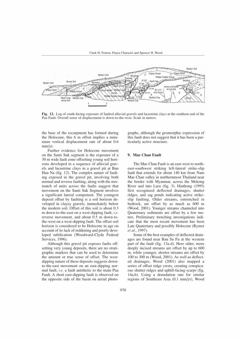
Further evidence for Holocene movementon the Santi Suk segment is the exposure of a30 m wide fault zone offsetting young soil hori-zons developed in a sequence of alluvial grav-els and lacustrine clays in a gravel pit at BanHua Na (fig. 12). The complex nature of fault-ing exposed in the gravel pit, involving bothnormal and reverse faulting, along with the mis-match of units across the faults suggest thatmovement on the Santi Suk Segment involves a significant lateral component. The youngestdeposit offset by faulting is a soil horizon de-veloped in clayey gravels, immediately belowthe modern soil. Offset of this soil is about 0.3m down-to-the-east on a west-dipping fault, i.e.reverse movement, and about 0.5 m down-to-the-west on a west-dipping fault. The offset soilhorizon is considered to be Holocene in age onaccount of its lack of reddening and poorly deve-loped rubification (Woodward-Clyde FederalServices, 1996).
Although this gravel pit exposes faults off-setting very young deposits, there are no strati-graphic markers that can be used to determinethe amount or true sense of offset. The west-dipping nature of these deposits suggests down-to-the-east movement on an east-dipping nor-mal fault, i.e. a fault antithetic to the main PuaFault. A short east-dipping fault is observed onthe opposite side of the basin on aerial photo-
graphs, although the geomorphic expression ofthis fault does not suggest that it has been a par-ticularly active structure.
9. Mae Chan Fault
The Mae Chan Fault is an east-west to north-east-southwest striking left-lateral strike-slipfault that extends for about 140 km from NamMae Chan valley in northernmost Thailand nearthe border with Myanmar, across the MekongRiver and into Laos (fig. 3). Hinthong (1995)first recognized deflected drainages, shutterridges, and sag ponds indicating active strike-slip faulting. Older streams, entrenched inbedrock, are offset by as much as 600 m (Wood, 2001). Younger streams channeled intoQuaternary sediments are offset by a few me-ters. Preliminary trenching investigations indi-cate that the most recent movement has beenLate Quaternary and possibly Holocene (Rymer et al., 1997).
Some of the best examples of deflected drain-ages are found near Ban Su Fu at the westernpart of the fault (fig. 13a-d). Here older, moredeeply incised streams are offset by up to 600m, while younger, shorter streams are offset by100 to 300 m (Wood, 2001). As well as deflect-ed drainages, Wood (2001) also mapped aseries of offset ridge crests, creating conspicu-ous shutter ridges and uphill-facing scarps (fig.14a,b). Using a denudation rate for similarregions of Southeast Asia (0.1 mm/yr), Wood
970
Clark H. Fenton, Punya Charusiri and Spencer H. Wood
Modern Soil
Pebble Gravel
Clayey Gravel
StonelineFracturedPebbles
Clayey Gravel
Clayey Gravel Clayey Sand
Modern Soil
BeddingPebble-Cobble Gravel
Aligned Clasts
Mottled Clay
Mottled Clay Slump
356° to 013°vertical fractures
Numerous small fractureswith small offsets
Clay Gouge
80°/209° 73°/334°
90°/040°90°/043°
Water seepalong fault
Mottled Clay
Buried Soil Stoneline
Modern Soil
Colluvial Wedge?
Pebble-Cobble Gravel
50 mm
20 mm
0.4 mm
0.2 mm0.2 mm
SlumpClayey Sand L
L
KH
G0,8 mK
0 5Mottled Clay
G0.75 m B
BB
E
FD
D
B
D
L
L
AA
BB
A
CC
L
J
Fig. 12. Log of south-facing exposure of faulted alluvial gravels and lacustrine clays at the southern end of thePua Fault. Overall sense of displacement is down-to-the-west. Scale in meters.

971
Recent paleoseismic investigations in Northern and Western Thailand
Fig. 13a-d. a) Landsat image of the Mae Chan Fault and Mekong River in northernmost Thailand. River flowsfrom top of image to the southwest (image processed and furnished by Michael J. Rymer, U.S. GeologicalSurvey, Menlo Park, California). b) Offset streams, shutter ridges, and water gaps along the Western Mae ChanFault. c) Detail of stream offsets near Ban Su Fu. d) Graph of offset versus stream length. One group of streams0.5-to-0.7 km long is offset 100 to 300 m, while another group 1.1-to-1.8 km long is offset about 600 m.
c
d
a
b

(2001) calculated that a time of 200 ka is re-quired to erode a valley extending 1.4 km intothe saprolite-mantled granitic upland south ofthe fault. This assumes a trapezoid-shaped vol-ume of sediment removed to form the valley 60 m deep and 500 m wide at the range front.These streams are typically offset 600 m (fig.13d), implying a slip rate of 3 mm/yr. Becauseof the many uncertainties in our geomorphic-based estimate of valley age and fault-slip rate,at this point in our studies we believe the sliprate is between 0.3 and 3 mm/yr.
The Mekong River crosses the Mae ChanFault (fig. 13a). From the top of the image, theriver flows southward to the Golden Triangle ina straight bedrock canyon 600 m deep thatforms the Laos-Myanmar border. Fifteen kilo-meters north of the mouth of the Kok River thevalley floor of the Mekong River broadens to analluvial plain about 4 km wide. At the mouth of the Kok River, there is a NE-SW elongate(14 km by 5 km) marshy depression known asWiang Nong that extends southwest along thenorth side of the fault (fig. 13a). We interpretthis depression as a tectonic pull-apart basin orsag consistent with left-lateral motion of the
fault. East of the mouth of the Kok River, theriver course deflects east 25 km (in a left-later-al sense) forming two broad loops north of thefault. The first loop is in an alluvial plain about8 km wide, and the second is in a bedrock can-yon about 400 m deep. The offset river then resumes a southerly course in the bedrock can-yon and crosses the fault about 10 km north ofChiang Khong, Thailand (fig. 13a). We agreewith Lacassin et al. (1998) that at this crossingthe river course appears left-laterally deflectedno more than 1.5 km. The fault has clearly af-fected the course of the Mekong River, but wedo not know if the entire 25 km deflection is aresult of tectonic shift. At this point in our stud-ies we do not have a detailed explanation for theabrupt change in the river course at the mouthof the Kok River and the s-loops north of thefault. As the river interacted with the fault itmust have continued to flow in the canyons pre-viously incised 300 m through the northeast-southwest-trending ranges. If a significant partof the 25 km deflection is tectonic, it is difficultto explain why the actual fault crossing showsonly a 1.5 km deflection. It is possible that anolder course of the Mekong River lies to the
972
Clark H. Fenton, Punya Charusiri and Spencer H. Wood
Fig. 14a,b. a) Ridge crest offset creating shutter ridge along the Mae Chan Fault 3 km west of Ban Su Fu. b) Looking north along the crest of the offset ridge crest.
a b

east on the south side of the fault, but is nowcovered by a Quaternary-aged basalt field thatcovers a 15-square-km area in Laos just southof where the fault crosses the Mekong. A K-Arage on the basalt is 1.7 Ma (Barr and MacDo-nald, 1981).
Lacassin et al. (1998) interpret the unusualhairpin loops of the Mekong River crossing theactive Nam Ma Fault 60 km upriver to be theresult of Late Cenozoic slip-sense inversion. Theysuggest that the Nam Ma Fault changed from aright-lateral to a left-lateral slip at some timebetween 5 and 20 Ma. They noted the 1.5 km shiftin the Mekong on the Mae Chan Fault crossing,but did not address the larger deflection of 25 km noted here. Slip on the order of 25 km since Late Cenozoic is consistent with the slip rate of 3 mm/yr we derived for the small streamsnear Ban Su Fu. This is corresponds to the upperbound slip rates calculated by Lacassin et al.(1998) from river channel restoration along simi-lar strike-slip faults to the north in Myanmar,Laos, and Yunnan Province, China.
10. Three Pagodas Fault
The Three Pagodas Fault Zone (TPFZ) is a350 km long, 25 km wide, northwest-strikingzone of distributed faulting extending from just south of Moulmein, Myanmar, across theThree Pagodas Pass, along the Mae Nam KhwaeNoi/Mae Nam Khwae Yai (River Kwai) drain-age basin, and towards the Gulf of Thailand (fig. 15). At its northern end, the TPFZ eithermerges with the Sagaing Fault system (fig. 1),or a splay of that fault, in the Andaman Sea atabout 16°N (fig. 15). Tapponnier et al. (1982)proposed that the TPFZ and the Mae Ping Fault(MPFZ in fig. 1) to the north accommodated the majority of movement along the MalayPeninsula during the early phase (50-20 Ma) of India-Eurasia collision. During this phase of tectonism, movement on these faults wasleft-lateral, with a total offset of approximate-ly 300 km (Peltzer and Tapponnier, 1988). Re-cent thermochronologic studies in Western Thai-land have revealed that this phase of left-lateralslip ended about 36 to 33 Ma on the TPFZ(Lacassin et al., 1997). The subsequent change
in the plate motion between India and Eurasiacausing a reversal in the rotation of SoutheastAsia initiated east-west extension across Cen-tral and Northern Thailand (Peltzer and Tap-ponnier, 1988). Coeval with this, movement onthe northwest-striking faults on the MalayPeninsula reversed a right-lateral displacement.Right-lateral movement on the TPFZ beganabout 24 Ma (Lacassin et al., 1997). Earthquakefocal mechanisms in the region indicate thatright-lateral strike-slip faulting persists to thepresent day (Le Dain et al., 1984).
Initial investigations of the TPFZ usingLandsat imagery concluded that the fault wasinactive (EBASCO, 1984). However, Shrestha(1987) identified a number of suspected activefault traces along the Mae Nam Khwae Noi(fig. 16), including one that was claimed to offset an alluvial fan by 1.5 km. Hetrakul et al. (1991) suggested that reservoir-induced seismicity in the area of Khao Laem reservoirmay have occurred on a segment of the ThreePagodas Fault. The Yunnan SeismologicalBureau (1997) identified three fault splaysalong the TPFZ that have been active sinceMiddle Pleistocene (240-160 ka) and estimateda slip rate of 0.19 mm/yr.
Woodward-Clyde Federal Services (1998)carried out reconnaissance investigations of the TPFZ between Three Pagodas Pass andKanchanaburi (fig. 16). Using aerial photo-graphs and satellite imagery and field recon-naissance, they identified numerous geomor-phic features indicative of active faulting,including lateral drainage deflections, scarps onalluvium, shutter ridges, and faceted spurs.Between Three Pagodas Pass and Sangkhlaburi(fig. 16), the fault has a well-defined trace onlya few hundred meters wide. South of the inter-national border, the fault zone comprises twoparallel strands. The western strand appears tooffset a number of small streams in a right-lat-eral manner. The amount of offset is on theorder of several meters to several tens ofmeters. About 6 km north of Sangkhlaburi, theeastern fault trace forms a prominent break-in-slope and side-hill along the northeastern sideof a fault line valley. Streams crossing this faultsplay show a minor amount of right-lateral offset.
973
Recent paleoseismic investigations in Northern and Western Thailand

At Sangkhlaburi, the strike of the faultchanges to a more north-south direction. Im-mediately north of Khao Laem Reservoir thefault is marked by a prominent west-facingescarpment that steepens towards its base.Aggradation of small alluvial fans at the base ofthis escarpment and incision of the drainagesrunning out of the escarpment are indicative ofa component of vertical down-to-the-west dis-
placement. The northern end of this escarpmentforms a shutter ridge that deflects drainage in aright-lateral manner.
Further south, below Khao Laem Dam, theeasternmost trace of the TPFZ forms a south-west-facing escarpment that bounds a smallalluvium-filled basin. This escarpment displayswell-developed triangular facets with a steppedor benched profile indicating by Hamblin’s
974
Clark H. Fenton, Punya Charusiri and Spencer H. Wood
Fig. 15. Active faults in Western Thailand and Myanmar.

(1976) criteria that this section of the fault hasundergone episodic uplift.
At its confluence with the Huai Mae NamNoi, the Mae Nam Khwae Noi is deflected in anapparent right-lateral manner (fig. 16). Severalreaches of the river downstream also appear tobe fault controlled, as are reaches of the MaeNam Khwae Yai (Woodward-Clyde FederalServices, 1998).
Over most of its length, the TPFZ is ex-pressed in bedrock, or bedrock covered with athin veneer of Late Holocene alluvium. Thereare very few exposures of the fault in LateCenozoic deposits. Along strike from a bedrockscarp, near Rong Rian Yang Thon (fig. 16),Plio-Pleistocene lacustrine and alluvial depositsexposed in a gravel pit are warped and increasein dip from 10° to 21° to the west. There is no
975
Recent paleoseismic investigations in Northern and Western Thailand
Fig. 16. Simplified map of the Three Pagodas Fault Zone showing localities mentioned in the text.

indication of slope movement or any othergravitational instability, therefore this increasein dip, beyond the angle of repose for alluvialsediments, is most likely tectonic in origin.
Based on deflected drainages near Sang-khlaburi, where assumed Late Pleistocene chan-nels are laterally displaced by up to 10 m, the sliprate on the TPFZ is estimated at about 0.1 mm/yr(Woodward-Clyde Federal Services, 1998). Acrossthe border in Myanmar, the stronger geomorphicexpression of the fault and greater deflection ofstreams indicates that the slip rate may be as highas 2 mm/yr (Woodward-Clyde Federal Services,1998). This is similar to the level of activity ob-served on other faults in peninsular Myanmar(Woodward-Clyde Federal Services, 1998).
11. Discussion
Recent investigations have identified anumber of faults in Northern and WesternThailand that all display evidence for Late Ce-nozoic movement. These Late Quaternary faultsare considered capable of producing largeearthquakes.
The Thoen, Pua, Mae Chan, and Three Pa-godas fault zones show abundant geomorphicand stratigraphic evidence for Late Quaternaryactivity. Fault scarps on Quaternary alluvial andcolluvial deposits; vertical displacement of Qua-ternary terrace surfaces; faulting in recent allu-vial gravels; well-developed triangular facetsalong fault escarpments with progressive steep-ening towards the base of the escarpments; wine-glass canyon profiles; and lateral offset ofstream courses and ridge crests are all testamentto Late Quaternary movement along these faults.Many of these features are also found along thePhrae, Phrae Basin, Nam Pat, Long, and Phayaofaults (Fenton et al., 1997).
The predominant displacement on the basin-bounding faults of Northern Thailand, with theexception of the Mae Chan Fault, is normal dip-slip while in Western Thailand the predominantfault movement is strike-slip. The Pua Fault andthe Ban Mai Segment of the Thoen Fault, how-ever, show evidence for lateral displacement.Displacement along the Mae Chan Fault innorthernmost Thailand is predominantly left-
lateral. We believe that this fault lies within adifferent seismotectonic province, dominatedby strike-slip faulting. With the exception of thePhrae Basin Fault, and small fault splays alongthe Thoen Fault Zone, recent faulting has beenconfined to relatively narrow zones along rangefronts (Woodward-Clyde Federal Services,1996). This is similar to the style of faultingthat is observed in the Basin and Range Prov-ince of the Western United States (dePolo et al.,1991).
The structural complexity and geomorphic het-erogeneity of these basin-bounding faults sug-gests that, like the normal faults in the Basinand Range Province, they are segmented. TheThoen Fault is comprised of four segments (fig.5). The northern (Ban Mai) segment shows asubordinate left-lateral component of slip whilethe remainder of the fault shows no apparentlateral offset. The three remaining fault seg-ments are defined on fault geometry (strike anddip of the fault plane) and on the geomorphicexpression of the fault (fault scarp heights,scarp angles, etc.); better-defined fault geomor-phology indicates a more recently active faultsegment. The segmentation of the other faults inNorthern Thailand (e.g., the Pua Fault) is alsobased on similar evidence (Fenton et al., 1997).
Although most seismicity appears diffuse(fig. 3), Bott et al. (1997) consider that only the1980 earthquake sequence south of Phrae and the 1994 Phan earthquake may be associated withmapped faults; the Phrae and Phayao faults, re-spectively. The Basin and Range Province in theWestern United States shows a similar relationshipbetween mapped faults and contemporary seis-micity (e.g., Smith and Arabasz, 1991).
Only three focal mechanisms have beencomputed to date for earthquakes in NorthernThailand (Bott et al., 1997). These mechanismsare consistent with the geologic data presented inthis paper, showing that this region is undergo-ing east-west to northwest-southeast extensionon north- to northeast-striking normal or nor-mal-oblique faults. Focal mechanisms fromWestern Thailand indicate strike-slip faulting(Le Dain et al., 1984).
The Holocene slip rates for the basin-bound-ing normal faults in Northern Thailand rangebetween 0.1 and 0.6 mm/yr (table I). The Mae
976
Clark H. Fenton, Punya Charusiri and Spencer H. Wood

Chan strike-slip fault may have a slip rate ashigh as 3 mm/yr, however this has not beenconfirmed by paleoseismic trenching (Wood,2001). Slip rates were calculated from the off-set of the youngest geomorphic features orstratigraphic units. Long-term slip rates forthese faults, calculated from the cumulativethrow across the basin margins (i.e., the sum ofsediment thickness within the basin and theheight of the range front escarpment along thebasin margin), are between 0.02 and 0.07mm/yr. The average long-term slip rate is,therefore, about an order of magnitude less thanthe contemporary slip rate. This suggests thatthe Late Quaternary has been a period of in-creased fault activity or renewed activity fol-lowing a period of quiescence. This is support-ed by the presence of wineglass canyons anddownward-steepening facets along the fault escarpments of prominent range fronts. Fromthese slip rate values and the relatively rare slip-per-event data for faults in Northern Thailand,we estimate that the recurrence for large earth-
quakes on these faults is of the order of thou-sands to tens of thousands of years. Slip ratesfor faults in Western Thailand are less well con-strained, but appear to be of the same order ofmagnitude as those in Northern Thailand (tableI). The slip rate for the Three Pagodas Fault isabout an order of magnitude less than the re-cently identified active strike-slip faults acrossthe border in peninsular Myanmar (Woodward-Clyde Federal Services, 1998).
Maximum magnitudes estimates for eachfault are based on empirical relations betweenexpected rupture dimensions (Wells and Cop-persmith, 1994). Maximum magnitude is com-monly estimated through a comparison of faultrupture length and magnitude. However, consid-erable uncertainty often exists in the selection ofthe appropriate rupture length to be used in theanalysis (Schwartz et al., 1984). Rupture lengthsof past surface-rupture events on a specific faultmay provide direct evidence. No such data existsfor Thailand. In the absence of definitive data tothe contrary, we conservatively assume that the
Recent paleoseismic investigations in Northern and Western Thailand
Table I. Seismic source parameters of active faults in Northern and Western Thailand.
Fault Length (1) Age of most recent Long-term Slip rate Slip-per- Recurrence Maximum(km) movement (2) slip rate (3) (mm/yr) (4) event (5) (6) credible
(mm/yr) (m) (kyr) earthquake(7) (M)
Long 56 Late Pleistocene 0.04 0.1 – – 7Nam Pat 35 Late Pleistocene 0.04 0.1 – – 7Phayao 28 Late Pleistocene 0.05 0.1 – – 7Phrae 51 Late Pleistocene 0.07 0.1 – – 7Phrae Basin 59 Late Pleistocene 0.07 0.1 1.2-1.5 12-15 7Pua 68 Holocene 0.06 0.6 – – 71/4
Thoen 120 Holocene 0.02 0.6 1.0-1.5 1.7-2.5 71/2
Mae Chan 140 Holocene – 0.3-3.0 – – 71/2
Three Pagodas 350 (8) Holocene? – 0.5-2.0 – – 71/2
(1) Fault length exhibiting recent faulting.(2) Relative age estimated from geomorphic relationships and pedologic development.(3) Total vertical displacement across the fault (range height + basin depth) divided by time since basin opening, approx-imately 33 Ma (Charusiri, 1989). Uncertainties on these slip rate values are at least ± 50%.(4) Total offset of youngest geomorphic feature or stratigraphic unit divided by its relative age. Uncertainties on thesevalues are at least ± 50%.(5) Determined from paleoseismic trench excavations(6) Estimated by dividing slip-per-event by slip rate.(7) Estimated moment magnitude from empirical relationships among rupture length, rupture area, and magnitude (Wellsand Coppersmith, 1994). Uncertainties in magnitude values are ± 1/4.(8) Total fault length. The complex geometry of this fault suggests that it is very unlikely that the entire fault ruptures ina single event. Maximum magnitude is based on the segmentation model of Woodward-Clyde Federal Services (1998).
977

maximum rupture length corresponds to themaximum length of the mapped active fault traceor trace of identified fault segments.
Maximum magnitude estimates also arecomputed based upon rupture area, which incor-porates the maximum rupture length and maxi-mum rupture width. The dip of the fault andthickness of the seismogenic crust are requiredto estimate down-dip width of the rupture plane.Neither of these properties are well constrainedin Northern Thailand. However, because of thesimilarities between the tectonic setting andcrustal properties of Northern Thailand and theWestern United States, we use data from the lat-ter to estimate the dip of active faults and thethickness of the seismogenic layer. Doser andSmith (1989) determined that the approximateaverage dip of normal faults in the interior ofthe Western United States is about 60°, with arange from about 40 to 90°. For faults in theNorthern Basin and Range Province of Nort-hern Thailand, we used a dip of 60° ± 15° inorder to calculate rupture areas.
Moderate-to-large Basin and Range Prov-ince earthquakes occur at or near the base of theseismogenic crust, and nearly all of the eventshave focal depths of 15 km or less (Doser andSmith, 1989). Many continental areas withyouthful mountains appear to be characterizedby a seismogenic thickness of 15 ± 5 km, whichcorresponds with crustal temperatures less than350 ± 100°C, the upper limit for brittle failureand earthquake generation (Chen and Molnar,1983). Thus, we assumed 15 ± 5 km as thethickness of the seismogenic crust for NorthernThailand (Bott et al., 1997).
The empirical relationships for surface rup-ture length and rupture area used in this maxi-mum magnitude assessment are those developedby Wells and Coppersmith (1994). The max-imum moment magnitude (M) for each fault isgiven in table I.
12. Conclusions
Recent geologic studies show Late Quater-nary activity along a number of north- to north-east-striking Cenozoic basin-bounding faults inthe Northern Basin and Range seismotectonic
province in Northern Thailand and along strike-slip faults in the Western Highlands and MaeChan provinces. Geomorphic indicators ofactive faulting, including fault scarps on collu-vium/alluvium, faceted spurs, wine-glass can-yons, linear range fronts, stream knickpoints,and faulted Late Quaternary deposits, are found along six major faults in Northern Thai-land. The sense of slip along these faults is pre-dominantly normal dip-slip. The Pua and Thoen faults, however, have minor componentsof lateral slip. These geomorphic data, and theevidence from limited paleoseismic excava-tions, show that the most recent surface ruptur-ing events on these faults are either LatePleistocene or Holocene. From the slip-per-event along the Thoen and Phrae Basin faults,approximately 1.5 m, and the range of slip ratescalculated for these faults, we infer that thereturn period for surface rupturing events onthese faults is on the order of 2500 to 15.000years (table I). Empirical relationships betweenrupture length and earthquake magnitude indi-cate that these faults are capable of generatingearthquakes as large as M 7. Thus, like the tec-tonically-similar Basin and Range extensionalprovince of the Western United States, North-ern Thailand is characterized by faults with low slip rates, long recurrence intervals, andlarge magnitude paleoearthquakes. The MaeChan Fault in northernmost Thailand and theThree Pagodas Fault Zone in Western Thai-land are both marked by scarps on alluvium,deflected drainages, shutter ridges, and sagponds. Displacement of geomorphic featuresindicates slip rates between 0.1 mm/yr to 3mm/yr for these strike-slip faults. Based onfault segment lengths, both of these faults arecapable of generating large, damaging earth-quakes of up to M 71/2.
Acknowledgements
This paper arose from several seismic haz-ards studies carried out for proposed and exist-ing dam sites in Northern and Western Thai-land. The financial and management support of the Royal Irrigation Department (RID), theDepartment of Mineral Resources (DMR), and
978
Clark H. Fenton, Punya Charusiri and Spencer H. Wood

the Electricity Generating Authority of Thailand(EGAT) are gratefully appreciated. ChaiyanHinthong, Apichard Lumjuan, and Suwit Ko-suwan of DMR, and Supawan Klaipongpan of EGAT are thanked for facilitating these inves-tigations and for providing stimulating discus-sions on the tectonics of Thailand and SoutheastAsia. C. Fenton thanks his many colleagues atURS who participated in various aspects of theseinvestigations. S. Wood thanks the faculty of theDepartment of Geological Sciences of ChiangMai University for help and hospitality duringhis sabbatical leave there. The efforts of IvanWong and two anonymous reviewers are appre-ciated for improving on earlier drafts of thispaper.
REFERENCES
ALDERSON, A., N.A. HOLMES and C. MURPHY (1994): A summary of the biostratigraphy and biofacies for theTertiary sequence, Gulf of Thailand, in Proceedings of theInternational Symposium on Stratigraphic Correlation of Southeast Asia, edited by P. ANGSUWATHANA, T.WONGWANICH, W. TANSATHIEN, S. WONGSOMSAK and J.TULYATID, International Geological Correlation Project306, 292-295
ALLEN, C.R., A.R. GILLESPIE, H. HUAN, K.E. SIEH, Z.BUCHNAN and Z. CHENGNAN (1984): Red River and asso-ciated faults, Yunnan Province, China: Quaternary geolo-gy, slip rates, and seismic hazard, Geol. Soc. Am. Bull.,95, 686-700.
BARR, S.M. and A.S. MACDONALD (1981): Geochemistry andgeochronology of Late Cenozoic basalts of SoutheastAsia, Geol. Soc. Am. Bull., 92, Part II, 1069-1142
BOTT, J., I. WONG, S. PRACHUAB, B. WECHBUNTHUNG, C.HINTHONG and S. SARAPIROME (1997): Contempo-rary seismicity in Northern Thailand and its tectonicimplications, in Proceedings of the InternationalConference on Stratigraphy and Tectonic Evolution of Southeast Asia and the South Pacific, edited by P. DHEERADILOK, C. HINTHONG, P. CHAODUMRONG, P.PUTTHAPIBAN, W. TANSATHIEN, C. UTHA-AROON, N.SATTYARAK, T. NUCHANONG and S. TECHAWAN (Departmentof Mineral Resources), 453-464.
CHAROENPRAWAT, A., S. CHUAVIROJ, C. HINTHONG and C.CHONGLAKMANI (1994): Geological Map of ChangwatLampang Quadrangle Scale 1:250.000 (Geological SurveyDivision, Department of Mineral Resources, Bangkok,Thailand).
CHARUSIRI, P. (1989): Lithophile metallogenic epochs in Thai-land: a geological and geochronological investigation,Unpublished Ph.D. Thesis, Queen’s University, pp. 819.
CHEN, W. and P. MOLNAR (1983): Focal depths of intracon-tinental and intraplate earthquakes and its implicationsfor the thermal and mechanical properties of the litho-sphere, J. Geophys. Res., 88, 4183-4214.
DEPOLO, C.M. (1994): The maximum background earth-quake for the Basin and Range Province, WesternNorth America, Bull. Seismol. Soc. Am., 84, 466-472.
DEPOLO, C.M., D.G. CLARK, D.B. SLEMMONS and A.R.RAMELLI (1991): Historical surface faulting in the Basinand Range Province, Western North America: implica-tions for fault segmentation, J. Struct. Geol., 13, 123-136.
DOSER, D.I. and R.B. SMITH (1989): An assessment of sourceparameters of earthquakes in the Cordillera of the WesternUnited States, Bull. Seismol. Soc. Am., 79, 1383-1409.
DUCROCQ, S., E. BUFFETAUT, H. BUFFETAUT-TONG, Y. CHAI-MANEE, J.J. JAEGER, R. LACASSIN and V. SUTEETHORN
(1992): Tertiary continental basins of Thailand as a resultof strike-slip motions induced by the India-Asia collision,J. Southeast Asian Earth Sci., 7, 260.
EBASCO (1984): Evaluation of seismicity in the Kan-chanaburi Province, Stage 1 Final Report (unpublishedreport prepared for Electricity Generating Authority ofThailand).
FENTON, C.H., P. CHARUSIRI, C. HINTHONG, A. LUMJUAN andB. MANGKONKARN (1997): Late Quaternary faulting inNorthern Thailand, in Proceedings of the InternationalConference on Stratigraphy and Tectonic Evolution ofSoutheast Asia and the South Pacific, edited by P.DHEERADILOK, C. HINTHONG, P. CHAODUMRONG, P.PUTTHAPIBAN, W. TANSATHIEN, C. UTHA-AROON, N. SAT-TYARAK, T. NUCHANONG and S. TECHAWAN (Departmentof Mineral Resources), 436-452.
FENTON, C.H., P. CHARUSIRI and C. HINTHONG (1999): Lowslip rates versus high erosion rates: recognition and char-acterization of active faults in a tropical environment,Seismol. Res. Lett., 70, 266.
HAMBLIN, W.K. (1976): Patterns of displacement along theWasatch Fault, Geology, 4, 619-622.
HETRAKUL, N., B. TANITTIRAPORN, R. SITTIPOD and P.VIVATTANANON (1991): Post evaluation on reservoir trig-gered seismicity of Khao Laem Dam, in ProceedingsSecond International Conference on Recent Advances inGeotechnical Earthquake Engineering and Soil Dynam-ics, edited by S. PRAKASH, 1347-1355.
HINTHONG, C. (1995): The study of active faults in Thailand,in Technical Conference on the Progression and Vision ofMineral Resources Development (Department of MineralResources), 129-140.
HINTHONG, C. (1997): The study of active faults in Thailand,in Report of EANHMP, an Approach to Natural Hazardsin Eastern Asia, edited by Y. SHIMAZAKI (Eastern AsiaNatural Hazards Mapping Project (EANHMP) andGeological Survey of Japan), 17-22.
HOKE, L. and H.J. CAMPBELL (1995): Active mantle meltingbeneath Thailand?, in Proceedings of the InternationalConference on Geology, Geotechnology, and Min-eral Resources of Indochina, edited by W. YOUNGME,C. BUAPHAN, K. SRISUK and R. LERTSIRIVORAKUL (Depart-ment of Geotechnology, Khon Kaen University), 13-22.
KIERNAN, K. (1991): Tropical mountain geomorphology andlandscape evolution in north-west Thailand, Z. Geo-morphol., 35, 187-206.
KLAIPONGPAN, S., V. CHAKRAMANONT, J. PINRODE and P.CHITTRAKARN (1991): Geological and seismicity evalua-tion of Srinagarind Dam, in Proceedings Second Inter-national Conference on Recent Advances in GeotechnicalEarthquake Engineering and Soil Dynamics, 1357-1363.
979
Recent paleoseismic investigations in Northern and Western Thailand

LACASSIN, R., A. REPLUMAZ and P.H. LELOUP (1998): Hairpinriver loops and slip-sense inversion on Southeast Asianstrike-slip faults, Geology, 26, 703-706.
LACASSIN, R., H. MALUSKI, P.H. LELOUP, P. TAPPONNIER, C.HINTHONG, K. SIRIBHAKDI, S. CHUAVIROJ and A.CHAROENRAVAT (1997): Tertiary diachronic extrusion anddeformation of Western Indochina: Structural and40Ar/39Ar evidence from NW Thailand, J. Geophys. Res.,102, 10,013-10,037.
LE DAIN, A.Y., P. TAPPONIER and P. MOLNAR (1984): Activefaulting and tectonics of Burma and surrounding regions,J. Geophys. Res., 89, 453-472.
LORENZETTI, E.A., P.A. BRENNAN and S.C. HOOK (1994):Structural styles in rift basins: interpretation methodologyand examples from Southeast Asia, Bull. Am. Assoc. Pet.Geol., 78, 1,152.
MACDONALD, A.S., S.M. BARR, G.R. DUNNING and W.YAOWANOIYOTHIN (1993): The Doi Inthanon metamorphiccore complex in NW Thailand: age and tectonic signifi-cance, J. Southeast Asian Earth Sci., 8 (1-4), 117-125.
MALOD, J.A. and B.M. KEMAL (1996): The Sumatra margin:oblique subduction and lateral displacement of the accre-tionary prism, in Tectonic Evolution of Southeast Asia,edited by R. HALL and D.J. BLUNDELL, Geol. Soc. Spec.Publ., 106, 19-28.
MCCABE, R., M. CELAYA, J. COLE, H.-C. HAN, T. OHNSTAD, V.PAIJITPRAPAPON and V. THITIPAWARN (1988): Extensiontectonics: the Neogene opening of the north-south trend-ing basins of Central Thailand, J. Geophys. Res., 93,11,899-11,910.
MCCABE, R., S. HARDER, J.T. COLE and E. LUMADYO (1993):The use of paleomagnetic studies in understanding thecomplex Tertiary tectonic history of east and southeastAsia, J. Southeast Asian Earth Sci., 8 (1-4), 257-268.
MCCAFFREY, R. (1996): Slip partitioning at convergent plateboundaries of SE Asia, in Tectonic Evolution of SoutheastAsia, edited by R. HALL and D.J. BLUNDELL, Geol. Soc.Spec. Publ., 106, 3-18
MCCALPIN, J.P. (1996): Paleoseismology (Academic Press),pp. 588.
MOLNAR, P. and Q. DENG (1984): Faulting associated withlarge earthquakes and the average rate of deformation inCentral and Eastern Asia, J. Geophys. Res., 89, 6,203-6,227.
NUTALAYA, P. (1994): Assessment and mitigation of earth-quakes: selected areas of Southeast Asia, in Reduction inAsia and the Pacific, vol. II: Seismic and Volcanic Haz-ards, Disaster Mitigation and Monitoring Systems (U-nited Nations Economic and Social Commission for Asiaand the Pacific), 205-260
NUTALAYA, P., S. SODSRI and E.P. ARNOLD (1985): Thai-land, Series on Seismology, (Southeast Asia Associationof Seismology and Earthquake Engineering), vol. II,pp. 403.
O’LEARY, J. and G.S. HILL (1989): Tertiary basin developmentin the Southern Central Plains, Thailand, in Proceedingsof the International Symposium on Intermontaine Basins:Geology and Resources, edited by T. THANASUTHIPITAK
and P. OUNCHANUM (Chiang Mai University), 254-264.OLINSTAD, T., T. MORIARTY, S. HARDER and R. MCCABE
(1989): Cenozoic rifting in Thailand, Eos, Trans. Am.Geophys. Un., 70 (suppl.), 1343.
PACKHAM, G.H. (1993): Plate tectonics and the development of
sedimentary basins of the dextral regime in WesternSoutheast Asia, J. Southeast Asian Earth Sci., 8 (1-4),497-511.
PELTZER, G. and P. TAPPONNIER (1988): Formation and evolu-tion of strike-slip faults, rifts, and basins during the India-Asia collision: an experimental approach, J. Geophys.Res., 93, 15,085-15,117.
PEREZ, R.R., B.P. RHODES, J.R. LILES, A. LUMJUAN and S.KOSUWAN (1999): The Mae Kuang Fault: an active strike-slip fault in Northern Thailand, Abstracts with Program,Geol. Soc. Am., 31, A-428.
PIYASIN, S. (1974): Geological Map of Thailand, ChangwatUttaradit Scale 1:250 000 (Geological Survey Division,Department of Mineral Resources, Bangkok, Thailand).
POLACHAN, S., S. PRADIDTAN, C. TONGTAOW, S. JANMAHA, K.INTRAWIJITR and C. SANGSUWAN (1991): Development ofCenozoic basins in Thailand, Mar. Pet. Geol., 8, 84-97.
RAKSASKULWONG, M. and A. THIENPRASERT (1991): Heat flowstudies and geothermal energy development in Thailand,J. Thai Geosci., 2, 111-123.
RATANASTHIEN, B. (1986): The effect of Pleistocene volcanicactivity to Mae Moh coal-bearing formation, in Pro-ceedings of the Workshop on Economic Geology,Tectonics, Sedimentary Processes and Environment of the Quaternary of Southeast Asia, edited by N. THIRA-MONGKOL (International Geological Correlation Program),45-52.
REMUS, D., M. WEBSTER and K. KEAWKAN (1993): Rift archi-tecture and sedimentology of the Phetchabun intermon-taine basin, Central Thailand, J. Southeast Asian EarthSci., 8 (1-4), 421-432.
RHODES, B. P., J.A. BLUM and T.R. DEVINE (1996): Tecton-ic implication of Miocene (?) stretching in the WesternRanges metamorphic core complex, Northern Thailand,28, Geol. Soc. Am., Abstracts with Programs, A-371.
RICHTER, B., M. FULLER, E. SCHMIDTKE, U.T. MYINT, U.T.NGWE, U.M. WIN and S. BUNOPAS (1993): Pale-omagnetic results from Thailand and Myanmar: im-plications for the interpretation of tectonic rotations insoutheast Asia, J. Southeast Asian Earth Sci., 8 (1-4),247-255.
RYMER, M.J., R.J. WELDON II, C.S. PRENTICE, S. KOSUWAN, A.LUMJUAN and N. MUANGNOICHAROEN (1997): Tectonicsetting and Late Quaternary activity along the Mae ChanFault, Northern Thailand and Western Laos, Geol. Soc.Am., Abstracts with Programs, 29, 229-230.
SCHWARTZ, D.P., K.J. COPPERSMITH and F.H. SWAN III (1984):Methods for estimating maximum earthquake magnitu-des, in Proceedings of the Eighth World Conference onEarthquake Engineering (Prentice-Hall), 279-285.
SHRESTHA, P.M. (1987): Investigation of active faults inKanchanaburi Province, Thailand: Bangkok, AsianInstitute of Technology, Unpublished M.Sc. Thesis,pp. 106.
SIRIBHAKDI, K. (1986): Seismogenic of Thailand and periph-ery, in 1st Workshop on Earthquake Engineering andHazard Mitigation, edited by P. LUKKUNAPRASIT, K.CHANDRANGSU, S. POOBRASERT and M. MAHASUVERA-CHAI (Southeast Asia Association of Seismology andEarthquake Engineering (SEASEE) and National Earth-quake Committee of Thailand), 151-158.
SMITH, R.B. and W.J. ARABASZ (1991): Seismicity of theIntermountain Seismic Belt, in Neotectonics of North
980
Clark H. Fenton, Punya Charusiri and Spencer H. Wood

America, edited by D.B. SLEMMONS, E.R. ENGDAHL,M.D. ZOBACK and D.D. BLACKWELL (Geological Societyof America Decade Map), vol. 1, 185-228.
SUTTHIRAT, C., P. CHARUSIRI, W. PONGSAPITCH, E. FARRAR
and R. LANDGRIDGE (1995): A Late Pliocene Ko Kha -Sop Prap and Nam Cho basaltic eruption, Northern Thai-land: evidences from geology and 40Ar/39Ar geochronolo-gy, in Proceedings of the International Conference onGeology, Geotechnology, and Mineral Resources ofIndochina, edited by W. YOUNGME, C. BUAPHAN, K.SRISUK and R. LERTSIRIVORAKUL (Department of Geo-technology, Khon Kaen University), 247-253.
TAPPONNIER, P., G. PELTZER, L.Y. LEDAIN, R. ARMIJO and P.COBBOLD (1982): Propagating extrusion tectonics inAsia: new insights from simple experiments with plas-ticine, Geology, 10, 611-616.
THIRAMONGKOL, N. (1986): Neotectonism and rate of upliftin the eastern margin of the lower central plain ofThailand, in Proceedings of the Workshop on Econom-ic Geology, Tectonics, Sedimentary Processes and En-vironment of the Quaternary of Southeast Asia, editedby N. THIRAMONGKOL (International Geological Correla-tion Program), 35-44.
VELLA, P. (1983): Tensional faults in Tertiary strata, MaeMoh, Thailand, J. Geol. Soc. Thailand, 6, 13-15.
WELLS, D.L. and K.J. COPPERSMITH (1994): New empiricalrelationships among magnitude, rupture length, rupturewidth, rupture area, and surface displacement, Bull.Seismol. Soc. Am., 84, 974-1002.
WONG, I.G., C.H. FENTON, J.D.J. BOTT, A.M. BECKER, R.K.GREEN, C. HINTHONG and S. SARAPIROME (1997):Seismic hazards in Northern Thailand, Seismol. Res.Lett., 68, 316.
WOOD, S.H. (1995): Late Cenozoic faulting in mountainousregions of low but persistant historic seismicity: HellsCanyon (NW U.S.A.) and Northern Thailand and themeaning of «active fault», in IUGG XXI GeneralAssembly, Abstracts Week B, B344.
WOOD, S.H. (2001): Slip-rate estimate from offset streams,valley volumes, and denudation rate: Mae Chan Fault,Northern Thailand, Eos, Trans. Am. Geophys. Un.,82, 932.
WOODWARD-CLYDE FEDERAL SERVICES (1996): Seismic haz-ards evaluation, environmental impact assessment: geo-logical aspect, Kaeng Sua Ten Dam Project, ChangwatPhrae, Unpublished Report prepared by GMT Con-sultants and Others for Department of Mineral Re-sources, 4 vols. (English and Thai).
WOODWARD-CLYDE FEDERAL SERVICES (1998): Preliminaryseismic hazard evaluation of Khao Laem and Srini-garind dams, Thailand, Unpublished Report preparedfor Electricity Generating Authority of Thailand, Bang-kruay, Nontaburi 11000.
YUNNAN SEISMOLOGICAL BUREAU (1997): Report on ThreePagoda Fault Zone from downstream of Khao Laem damto Sai Yok waterfall: Seismological Bureau of YunnanProvince, China, Unpublished Report prepared forElectricity Generating Authority of Thailand, pp. 29.
981
Recent paleoseismic investigations in Northern and Western Thailand

.ajjglkjshfljkshfg