salmon identification - washingtonatlantic salmon have large black spots on the gill covers and...
TRANSCRIPT
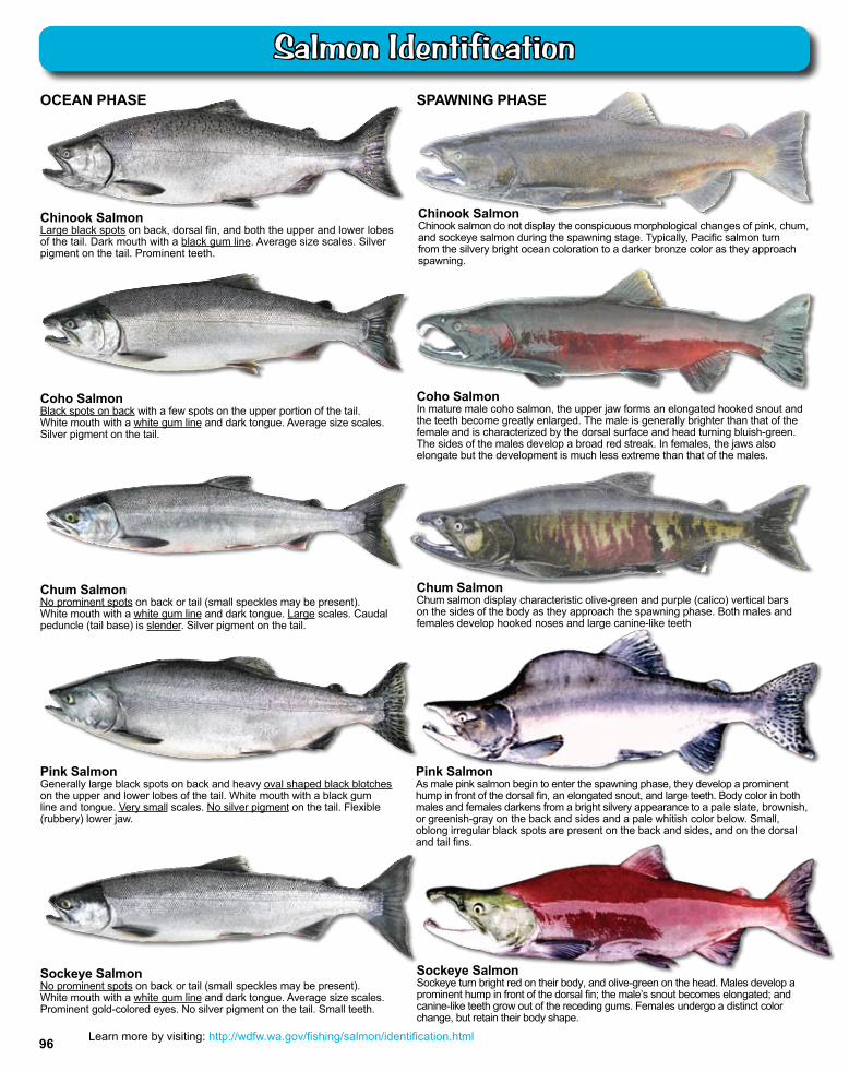
OCEAN PHASE
Chinook SalmonChinook salmon do not display the conspicuous morphological changes of pink, chum, and sockeye salmon during the spawning stage. Typically, Pacific salmon turn from the silvery bright ocean coloration to a darker bronze color as they approach spawning.
Coho SalmonIn mature male coho salmon, the upper jaw forms an elongated hooked snout and the teeth become greatly enlarged. The male is generally brighter than that of the female and is characterized by the dorsal surface and head turning bluish-green. The sides of the males develop a broad red streak. In females, the jaws also elongate but the development is much less extreme than that of the males.
Chum SalmonNo prominent spots on back or tail (small speckles may be present). White mouth with a white gum line and dark tongue. Large scales. Caudal peduncle (tail base) is slender. Silver pigment on the tail.
Chum SalmonChum salmon display characteristic olive-green and purple (calico) vertical bars on the sides of the body as they approach the spawning phase. Both males and females develop hooked noses and large canine-like teeth
Pink SalmonGenerally large black spots on back and heavy oval shaped black blotches on the upper and lower lobes of the tail. White mouth with a black gum line and tongue. Very small scales. No silver pigment on the tail. Flexible (rubbery) lower jaw.
Pink SalmonAs male pink salmon begin to enter the spawning phase, they develop a prominent hump in front of the dorsal fin, an elongated snout, and large teeth. Body color in both males and females darkens from a bright silvery appearance to a pale slate, brownish, or greenish-gray on the back and sides and a pale whitish color below. Small, oblong irregular black spots are present on the back and sides, and on the dorsal and tail fins.
Sockeye SalmonNo prominent spots on back or tail (small speckles may be present). White mouth with a white gum line and dark tongue. Average size scales. Prominent gold-colored eyes. No silver pigment on the tail. Small teeth.
Sockeye SalmonSockeye turn bright red on their body, and olive-green on the head. Males develop a prominent hump in front of the dorsal fin; the male’s snout becomes elongated; and canine-like teeth grow out of the receding gums. Females undergo a distinct color change, but retain their body shape.
SPAWNING PHASE
Coho SalmonBlack spots on back with a few spots on the upper portion of the tail. White mouth with a white gum line and dark tongue. Average size scales. Silver pigment on the tail.
Chinook SalmonLarge black spots on back, dorsal fin, and both the upper and lower lobes of the tail. Dark mouth with a black gum line. Average size scales. Silver pigment on the tail. Prominent teeth.
Learn more by visiting: http://wdfw.wa.gov/fishing/salmon/identification.html96
Salmon Identification
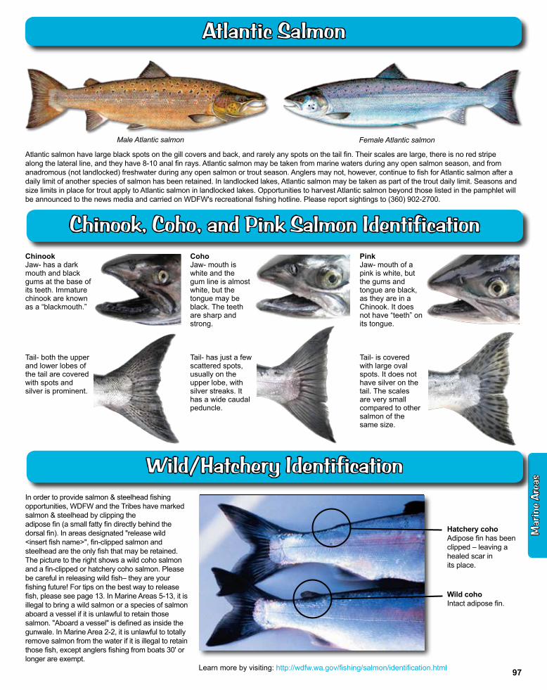
Atlantic salmon have large black spots on the gill covers and back, and rarely any spots on the tail fin. Their scales are large, there is no red stripe along the lateral line, and they have 8-10 anal fin rays. Atlantic salmon may be taken from marine waters during any open salmon season, and from anadromous (not landlocked) freshwater during any open salmon or trout season. Anglers may not, however, continue to fish for Atlantic salmon after a daily limit of another species of salmon has been retained. In landlocked lakes, Atlantic salmon may be taken as part of the trout daily limit. Seasons and size limits in place for trout apply to Atlantic salmon in landlocked lakes. Opportunities to harvest Atlantic salmon beyond those listed in the pamphlet will be announced to the news media and carried on WDFW's recreational fishing hotline. Please report sightings to (360) 902-2700.
Male atlantic salmon Female atlantic salmon
In order to provide salmon & steelhead fishing opportunities, WDFW and the Tribes have marked salmon & steelhead by clipping the adipose fin (a small fatty fin directly behind the dorsal fin). In areas designated "release wild <insert fish name>", fin-clipped salmon and steelhead are the only fish that may be retained. The picture to the right shows a wild coho salmon and a fin-clipped or hatchery coho salmon. Please be careful in releasing wild fish– they are your fishing future! For tips on the best way to release fish, please see page 13. In Marine Areas 5-13, it is illegal to bring a wild salmon or a species of salmon aboard a vessel if it is unlawful to retain those salmon. "Aboard a vessel" is defined as inside the gunwale. In Marine Area 2-2, it is unlawful to totally remove salmon from the water if it is illegal to retain those fish, except anglers fishing from boats 30' or longer are exempt.
Hatchery coho Adipose fin has been clipped – leaving a healed scar in its place.
Wild cohoIntact adipose fin.
PinkJaw- mouth of a pink is white, but the gums and tongue are black, as they are in a Chinook. It does not have “teeth” on its tongue.
Tail- is covered with large oval spots. It does not have silver on the tail. The scales are very small compared to other salmon of the same size.
ChinookJaw- has a dark mouth and black gums at the base of its teeth. Immature chinook are known as a “blackmouth.”
Tail- both the upper and lower lobes of the tail are covered with spots and silver is prominent.
CohoJaw- mouth is white and the gum line is almost white, but the tongue may be black. The teeth are sharp and strong.
Tail- has just a few scattered spots, usually on the upper lobe, with silver streaks. It has a wide caudal peduncle.
Learn more by visiting: http://wdfw.wa.gov/fishing/salmon/identification.html
Mar
ine
Are
as
97
Atlantic Salmon
Chinook, Coho, and Pink Salmon Identification
Wild/Hatchery Identification
VESSEL LIMITS MARINE AREAS 1-6: Anglers aboard a boat may only possess one daily limit of fish or SHELLFISH in fresh form.
SALMON - Two daily limits of fresh SALMON. An additional 40 pounds of salmon may be possessed in a frozen or processed form (see pages 10-11).
TROUT - Two daily limits of hatchery STEELHEAD.
STURGEON - Two daily limits in any form. Statewide annual limit 5.
BOTTOMFISH - Two daily limits in any form.
HALIBUT - Two daily limits in any form, except only one limit while aboard the fishing vessel. For HALIBUT caught in Canadian waters, contact Department of Fisheries and Oceans Canada (DFO) or visit their website at http://www.pac.dfo-mpo.gc.ca/recfish/Opportunities/finfish_e.htm. for updated Canadian regulations.
TUNA - ALBACORE, YELLOWFIN, SKIPJACK, and NORTHERN BLUEFIN and MACKEREL - No possession limit or daily limit.
SHELLFISH - One daily limit of fresh SHELLFISH. Additional SHELLFISH may be possessed in a frozen or processed form. See page 124 for Shellfish/Seaweed rules and page 127 for the shellfish health advisory.
FORAGE FISH (HERRING, ANCHOVIES, SARDINES, SAND LANCE, and SMELT) - Two daily limits in fresh form. Additional FORAGE FISH may be possessed in frozen or processed form. CLOSED to fishing for Columbia River SMELT (eulachon). See description on next page.
Hatchery STEELHEAD may be caught and released until the daily limit is retained. If a fish has swallowed the hook or is hooked in the gill, eye, or tongue, it should be kept if legal to do so. Wild STEELHEAD must be released.
SALMON - Barbless hooks only. Only single-point hooks and a hand-held rod and line may be used in Areas 1-13. Minimum size for CHINOOK in Areas 1-4 is 24", in Areas 5-13, 22", except no minimum size in the Hoodsport Hatchery Zone. Minimum size for COHO in Areas 1-4 is 16"; except in Area 2-1 after July 31 and Area 2-2 east of the buoy 13 line after Sept. 15, the minimum size is 12" for all SALMON. Other Marine Areas and species - no minimum size. Handling Rule: in Areas 5-13, it is illegal to bring a wild SALMON or a species of SALMON aboard a vessel if it is unlawful to retain those SALMON. "Aboard a vessel" is defined as inside the gunwale. Also see special Handling Rule for Area 2-2 for Sept. 16-Nov. 30.
WHITE STURGEON - Only one single-point barbless hook and bait is allowed when fishing for STURGEON. Catch-and-release open year-round. Refer to specific Marine Area rules for retention dates. Green STURGEON may not be retained.
HALIBUT - Hook and line angling and spearfishing only. A hand-held line is permitted. Only one line with up to two hooks may be used. HALIBUT may be shot or harpooned while landing. May not be landed in a port closed to HALIBUT fishing except HALIBUT lawfully caught in Canada; angler must have Canadian license. See page 12, Fish & Shellfish caught in Canada.
BOTTOMFISH, TUNA, AND MACKEREL - Hook and line angling, spearfishing, and bow and arrow fishing only.
ROCKFISH - You may not land YELLOWEYE or CANARY rockfish into any port in Washington. Unlawful to fish for or retain rockfish in Areas 6-13.
UNCLASSIFIED MARINE FISH - CLOSED
OTHER FOOD FISH - These are species which occur in our waters irregularly, usually in coastal areas and include BARRACUDA, WHITE SEA BASS, BONITO, YELLOWTAIL, and POMFRET. Daily limit is two of each species.
SIxGILL SHARK - It is illegal to retain or remove SIXGILL SHARKS from the water in Areas 5-13.
Species Rules
Possession Limits
1 . . . . Season and Daily Hours: During an open season, marine waters are open 24 hours per day, except as noted for night closures.
2 . . . . Quota Management: SALMON, HALIBUT, and some SHELLFISH are managed by quotas in many marine areas. These fisheries close when the quotas have been taken. Closures will be announced to local news media and will be included in the Fishing Hotline and Shellfish Rule Change Hotline messages.
FORAGE FISH - Forage fish jig or forage fish dip net only. Only one dip net may be used at a time. Gear must be held by the rigid handle at all times and may not be used from a vessel while under power. Anglers with the reduced-fee license or a Designated Harvester Card may use a forage fish dip net with a hand-operated gate. Jig gear may have up to three treble hooks or nine single-point hooks, not to exceed ⅜" between point and shank. While fishing in Areas 5-11 &13, a second line using forage fish jig gear may be used to fish for forage fish.
You may use forage fish jig gear in Columbia River waters from the Buoy 10 line to the Rocky Point/Tongue Point line.
Species RulesALL FISHING GEAR - Must be kept in immediate control, and gear may not be left unattended while fishing.
HOOK AND LINE ANGLING - Unless noted differently, only one line with up to 2 hooks is allowed. Barbless hooks are required for all species in Marine Areas 5-13, except forage fish jig gear. When fishing for SALMON in Marine Areas 1-13, only single-point barbless hooks may be used.
FORAGE FISH DIPNET - A section of netting (maximum mesh size is ⅝" stretched mesh) dis-tended by a rigid frame not exceeding 36" across and directly attached to a rigid handle. May only be used for forage fish or squid.
LANDING A FISH - A club or dipnet (landing net) may be used to assist landing a legal fish taken by legal gear. A gaff may only be used to land a legally hooked HALIBUT, TUNA, or DOGFISH SHARK that will be retained. HALIBUT may be shot or harpooned while landing.
DOWNRIGGERS - May be used with a line if the line releases from the downrigger while playing and landing the fish.
RODHOLDERS - May be used; the rod must be easily removed without delay; rod may be left in the holder while playing the fish.
ELECTRIC REELS - May be used if designed for sport fishing and attached to a fishing rod.
SPEARFISHING - The diver must be swimming or floating in the water while spearfishing. The use of explosives or bullets attached to the spear ("bang sticks") is prohibited.
Rules listed below are General Rules. Specific Area Rules are listed by area.
NOTE: Emergency rules may occur throughout the year and will supersede the rules contained in this pamphlet. Changes can be found by calling the WDFW Fishing Hotline (360) 902-2500 or Shellfish Rule Change Hotline (866) 880-5431, contacting statewide customer service (360) 902-2700, or by visiting the WDFW website http://wdfw.wa.gov.
Tackle/Gear Rules
In Washington waters where a saltwater license is valid, each angler aboard a vessel may continue to deploy angling gear or shellfish gear until the daily limit of fish and shellfish for all licensed and juvenile anglers aboard has been achieved.
98
Marine Area Rules

NEAH BAY
SEKIU MOUTH OF
SEKIU RIVER
LAPUSH
PORT ANGELES
OCEAN SHORES HOQUIAM ABERDEEN
GRAYS HARBOR BUOY 13
CAPE SHOAL W A TER
OL YMPIA
T ACOMA
NOR TH HEAD
BUOY 10
SOUTH JETTY
PT. BROWN
WESTPOR T
LEADBETTER POINT
BONILLA-TATOOSH LINE
V ANCOUVER ISLAND
BREMER T ON SEA TTLE
POR T T OWNSEND
BELLINGHAM
BLAINE
CANADA
ORCAS ISLAND
SAN JUAN ISLAND
ORCAS ISLAND ORCAS ISLAND ORCAS ISLAND ORCAS ISLAND
LOPEZ ISLAND
7
12
5
4
6
9
8-2
8-1
10
13
1 1
2-2
2
3
CAPE ALAVA
MOUTH OF QUEETS
RIVER
4
2-1
1
N COMMENCEMENT
BAY
LAKE WASHINGTON
HOOD CANAL
BUDD INLET
EVERETT
WHIDBEY ISLAND
LOW POINT
ANACOR TES
ROCKY POINT
T ONGUE POINT
AREA DEFINITIONS AND CODES
1. ILWACO - west of the Buoy 10 line at the Columbia River mouth, north to Leadbetter Point.
2. WESTPORT-OCEAN SHORES- from Leadbetter Point north to the Queets River, excluding Willapa Bay and Grays Harbor.
2-1. WILLAPA BAY - east of a line from Leadbetter Point to Cape Shoalwater.
2-2. GRAYS HARBOR - east of a line from the outermoust tip of the north jetty to outermost exposed end of the south jetty.
3. LAPUSH - from the Queets River north to Cape Alava.
4. NEAH BAY - from Cape Alava north and inside Juan de Fuca Strait to the Sekiu River.
5. SEKIU AND PILLAR POINT - from mouth of the Sekiu River east to Low Point, mouth of the Lyre River.
6. EAST JUAN DE FUCA STRAIT - from Low Point east to the Partridge Point - Point Wilson line, north to the line from Trial Island (near Victoria B.C.) - Vessel Traffic Separation Buoy "R" - Smith Island to the Lawson Reef Buoy, to Northwest Island, to the Initiative 77 marker on Fidalgo Island.
7. SAN JUAN ISLANDS - all marine waters north of the Trial Island line (described under Area 6) to the United States-Canada boundary.
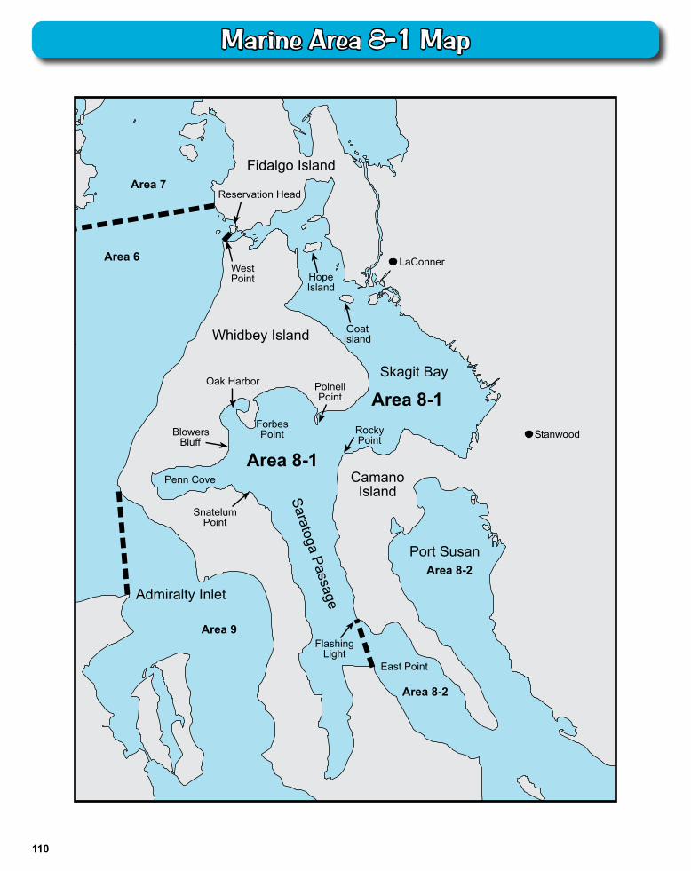
8-1. DECEPTION PASS, HOPE ISLAND, AND SKAGIT BAY - from West Point to Reservation Head eastward through Deception Pass, including all waters of Swinomish Slough and Skagit Bay, and the portion of Saratoga Passage north and west of a line from East Point Light to light on Camano Island (Saratoga Pass Light #4Fl Red 4 Sec.).
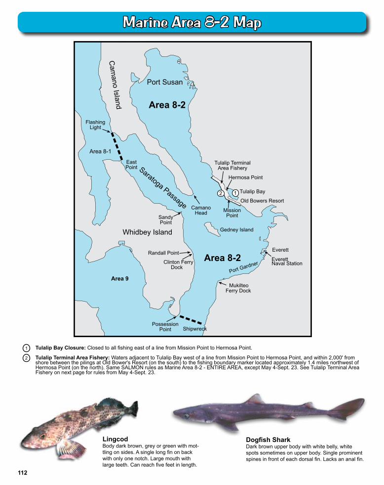
8-2. PORTS SUSAN AND GARDNER - east of East Point Light-Camano Island Light line (described in 8-1 above) and north of the Possession Point-Shipwreck line (described in 9 below).
9. ADMIRALTY INLET - all waters inside and south of the Partridge Point - Point Wilson line, south and west of a line from Possession Point 110° true to shipwreck, north of the Hood Canal Bridge, and north of the Apple Cove Point-Edwards Point line.
10. SEATTLE-BREMERTON AREA - south from the Apple Cove Point-Edwards Point line to a line projected true east- west through the north tip of Vashon Island.
11. TACOMA-VASHON ISLAND - south from a line projected true east west through the north tip of Vashon Island to the northernmost Tacoma Narrows Bridge.
12. HOOD CANAL - all waters south of the Hood Canal Bridge.
13. SOUTH PUGET SOUND - all waters south of northernmost Tacoma Narrows Bridge.
Surf Smelt
Size: up to 8"Color: silver with a stripe along the side.Look for: small adipose fin and stripe on the side.
Size: up to 13"Color: bluish on upper half with silvery white sides and belly.Look for: grooves on gill cover, skinny head, speckeled tail.
Columbia River Smelt (eulachon)
Mar
ine
Are
as
99
Marine Area Rules Marine Area Definitions and Codes
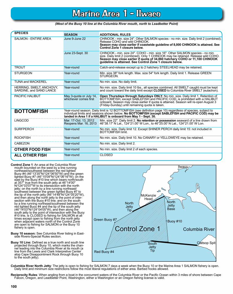
Control Zone 1: An area at the Columbia River mouth bounded on the west by a line running northeast/southwest between the red lighted Buoy #4 (46°13'35"N/124°06'50"W) and the green lighted Buoy #7 (46°15'09"N/124°06'16"W); on the east by the Buoy #10 line which bears north/south at 357° true from the south jetty at 46°14'00" N/124°03'07"W to its intersection with the north jetty; on the north by a line running northeast/southwest between the green lighted Buoy #7 to the tip of the north jetty (46°14'48"N/124°05'20"W), and then along the north jetty to the point of inter-section with the Buoy #10 line; and on the south by a line running northeast/southwest between the red lighted Buoy #4 and the tip of the south jetty (46°14'03"N/124°04'05"W), and then along the south jetty to the point of intersection with the Buoy #10 line, is CLOSED to fishing for SALMON at all times except open to fishing from the north jetty when adjacent waters north of the Control Zone are open to fishing for SALMON or the Buoy 10 fishery is open.
Buoy 10 season: See Columbia River listing in East-
side Rivers-Special Rules section. Buoy 10 Line: Defined as a true north and south line
projected through Buoy 10, which marks the chan-nel leading into the Columbia River at its mouth (a line from the Lewis and Clark Interpretive Center atop Cape Disappointment Rock through Buoy 10 to the south jetty).
(West of the Buoy 10 line at the Columbia River mouth, north to Leadbetter Point)
SPECIES SEASON ADDITIONAL RULESSALMON - ENTIRE AREA June 9-June 22 CHINOOK - min. size 24". Other SALMON species - no min. size. Daily limit 2 (combined).
Release COHO and wild CHINOOK. Season may close earlier if coastwide guideline of 8,000 CHINOOK is attained. See Control Zone 1 closure below.
June 23-Sept. 30 CHINOOK - min. size 24". COHO - min. size 16". Other SALMON species - no min. size. Daily limit 2 (combined). Only 1 CHINOOK may be retained. Release wild COHO. Season may close earlier if quota of 34,860 hatchery COHO or 11,100 CHINOOK guideline is attained. See Control Zone 1 closure below.
TROUT Year-round Catch-and-release except up to 2 hatchery STEELHEAD may be retained.
STURGEON Year-round Min. size 38" fork length. Max. size 54" fork length. Daily limit 1. Release GREEN STURGEON.
TUNA and MACKEREL Year-round No min. size. No daily limit.
HERRING, SMELT, ANCHOVY, SARDINE, and SAND LANCE
Year-round No min. size. Daily limit 10 lbs., all species combined. All SMELT caught must be kept and count toward the daily limit except CLOSED to Columbia River SMELT (eulachon).
PACIFIC HALIBUT May 3-quota or July 14,whichever comes first
Open Thursdays through Saturdays ONLY. No min. size. Daily limit 1. Retention of BOTTOMFISH, except SABLEFISH and PACIFIC COD, is prohibited with a HALIBUT onboard. Season may close earlier if quota is attained. Season will re-open August 3 (Friday-Sunday) until remaining quota is taken.
BOTTOMFISH Year-round season. Daily limit is 12 BOTTOMFISH (see definition page 10) regardless of species, subject to individual limits and seasons shown below. No BOTTOMFISH (except SABLEFISH and PACIFIC COD) may be landed in Area 1 if a HALIBUT is onboard from May 1 - Sept. 30.
LINGCOD Mar. 17-Oct. 13, 2012Reopens Mar. 16, 2013
Min. size 22". Daily limit 2. No retention or possession seaward of a line drawn from 46°38.17' N Lat., 124°21.00' W Lon., to 46°25.00' N Lat., 124°21.00' W Lon.
SURFPERCH Year-round No min. size. Daily limit 12. Except SHINER PERCH daily limit 15: not included in BOTTOMFISH limit.
ROCKFISH Year-round No min. size. Daily limit 10. No CANARY or YELLOWEYE may be retained.
CABEZON Year-round No min. size. Daily limit 2.
OTHER FOOD FISH Year-round No min. size. Daily limit 2 of each species.
ALL OTHER FISH Year-round CLOSED
Ilwaco
McKenzie Head
NorthJettyBase
Buoy #10
Columbia River
NorthJettyTip
Green Buoy #7
Red Buoy #4
SouthJettyTip
Clatsop Spit
Control Zone 1Control Zone 1
Columbia River North Jetty: The jetty is open to fishing for SALMON 7 days a week when the Buoy 10 or the Marine Area 1 SALMON fishery is open. Daily limit and minimum size restrictions follow the most liberal regulations of either area. Barbed hooks allowed.
Reciprocity Rules: When angling from a boat in the concurrent waters of the Columbia River or the Pacific Ocean within 3 miles of shore between Cape Falcon, Oregon, and Leadbetter Point, Washington, either a Washington or an Oregon fishing license is valid.
100
Marine Area 1 - Ilwaco
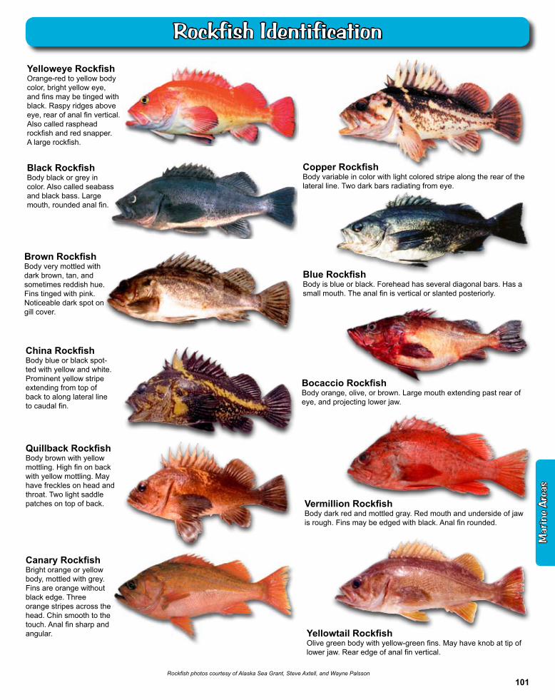
Yelloweye RockfishOrange-red to yellow body color, bright yellow eye, and fins may be tinged with black. Raspy ridges above eye, rear of anal fin vertical. Also called rasphead rockfish and red snapper. A large rockfish.
Canary RockfishBright orange or yellow body, mottled with grey. Fins are orange without black edge. Three orange stripes across the head. Chin smooth to the touch. Anal fin sharp and angular.
Black RockfishBody black or grey in color. Also called seabass and black bass. Large mouth, rounded anal fin.
Quillback RockfishBody brown with yellow mottling. High fin on back with yellow mottling. May have freckles on head and throat. Two light saddle patches on top of back.
Copper RockfishBody variable in color with light colored stripe along the rear of the lateral line. Two dark bars radiating from eye.
Blue RockfishBody is blue or black. Forehead has several diagonal bars. Has a small mouth. The anal fin is vertical or slanted posteriorly.
Rockfish photos courtesy of Alaska Sea Grant, Steve Axtell, and Wayne Palsson
Bocaccio RockfishBody orange, olive, or brown. Large mouth extending past rear of eye, and projecting lower jaw.
China RockfishBody blue or black spot-ted with yellow and white. Prominent yellow stripe extending from top of back to along lateral line to caudal fin.
Brown RockfishBody very mottled with dark brown, tan, and sometimes reddish hue. Fins tinged with pink. Noticeable dark spot on gill cover.
Vermillion RockfishBody dark red and mottled gray. Red mouth and underside of jaw is rough. Fins may be edged with black. Anal fin rounded.
Yellowtail RockfishOlive green body with yellow-green fins. May have knob at tip of lower jaw. Rear edge of anal fin vertical.
Mar
ine
Are
as
101
Rockfish Identification
Marine Area 2-1 (Willapa Bay) and Marine Area 2-2 (Grays Harbor)Marine Area 2 Definition: from Leadbetter Point north to the Queets River, excluding Willapa Bay and Grays Harbor
Marine Area 2-1 (Willapa Bay) Definition: east of a line from Cape Shoalwater to Leadbetter PointMarine Area 2-2 (Grays Harbor) Definition: east of a line from the tip of the north jetty to exposed end of the south jetty
Buoy 13 Line: A line drawn true north-south through Buoy 13 near the entrance of Grays Harbor.
Grays Harbor Control Zone: An area at the entrance to Grays Harbor bounded by a line from the lighthouse 1 mile south of the south jetty to buoy #2 to buoy #3 to the tip of the north jetty to the tip of the exposed end of the south jetty.
Westport Boat Basin: A portion of Grays Harbor lying inside the boat basin breakwater and inside lines drawn from lighted day markers 10 to 11 and 1 to 2.
Northern Nearshore HALIBUT Fishery: Open to HALIBUT fishing beginning May 6, seven days per week until the sub-quota is reached or Sept. 30 for those waters from 47°31.70' N. latitude south to 46°58.00'N. latitude and east of a line approximating 30 fathoms as defined by the following coordinates: 47°31.70'N, 124°37.03'W, 47°25.67'N, 124°34.79'W, 47°12.82'N, 124°29.12'W, 46°58.00'N, 124°24.24'W
SPECIES SEASON ADDITIONAL RULESSALMON - AREA 2 June 9-June 23 CHINOOK - min. size 24". Other SALMON species - no min. size. Daily limit 2 (combined).
Release COHO and wild CHINOOK. Season may close earlier if coastwide guideline of 8,000 CHINOOK is attained.
June 24-Sept. 23 Open Sundays through Thursdays ONLY. CHINOOK - min. size 24". COHO - min. size 16". Other SALMON species - no min. size. Daily limit 2 (combined). Only 1 CHINOOK may be retained. Release wild COHO. Season may close earlier if quota of 25,800 hatchery COHO or 25,600 CHINOOK guideline is attained.
AREA 2-1(east of a line from Cape Shoalwater to Leadbetter Pt.)
June 9-July 31 Open concurrent with the ocean (Area 2) for SALMON. Area 2 rules apply.Aug. 1-Jan. 31 Min. size 12". Daily limit 6. Up to 3 adults may be retained. Release wild CHINOOK and
CHUM. Anglers may fish with two poles with Two-Pole Endorsement.AREA 2-2 (west of Buoy 13 line) June 9-Sept. 23 Open concurrent with the ocean (Area 2) for SALMON. Area 2 rules apply.AREA 2-2
(east of the Buoy 13 line)ALL SALMON required to be released may not be totally removed from the water, except anglers fishing from boats 30' or longer as listed on either their state or Coast Guard registration are exempt.Sept. 16-Oct. 7 Min. size 12". Daily limit 3 of which only 1 may be a CHINOOK and 2 may be wild
COHO. Release CHUM.Oct. 8-Nov. 30 Min. size 12". Daily limit 3 of which only 2 may be wild COHO. Release CHINOOK and
CHUM.Westport Boat Basin and Ocean Shores Boat Basin
Aug. 16-Jan. 31 Min. size 12". Daily limit 6. No more than 4 adults may be retained. Release wild CHINOOK. Night closure and anti-snagging rule. Only single-point barbless hooks may be used.
TROUT Year-round Catch-and-release except up to 2 hatchery STEELHEAD may be retained.STURGEON Year-round Min. size 38" fork length. Max. size 54" fork length. Daily limit 1. Release GREEN
STURGEON.TUNA and MACKEREL Year-round No min. size. No daily limit.HERRING, SMELT, ANCHOVY, SARDINE, and SAND LANCE
Year-round No min. size. Daily limit 10 lbs., all species combined. All SMELT caught must be kept and count toward the daily limit except CLOSED to Columbia River SMELT (eulachon).
PACIFIC HALIBUT May 6-quota or Sept. 30, whichever comes first
Open Sunday May 6, Sundays and Tuesdays ONLY, except CLOSED May 27, 29. If sufficient quota remains, the fishery will re-open June 3 and or June 5. No min. size. Daily limit 1. See Northern Nearshore HALIBUT Fishery and HALIBUT and BOTTOMFISH closure areas below.
BOTTOMFISH Year-round season. Daily limit is a total of 12 BOTTOMFISH (see definition page 10) regardless of species, subject to individual limits and seasons shown below. See HALIBUT and BOTTOMFISH closure areas and 30 fathom restriction below.
LINGCOD Mar. 17-Oct. 13, 2012Reopens Mar. 16, 2013
Min. size 22". Daily limit 2. No retention or possession seaward of a line approximating 30 fathoms March 15-June 15 (except when the primary HALIBUT season is open). See 30 fathom restriction below. No retention or possession south of 46°58' N. and seaward of 30 fathoms on Fridays and Saturdays July 1-Aug. 31. No retention or possession seaward of a line drawn from, 47°31.70' N Lat., 124°45.00' W Lon. to 46°38.17' N Lat., 124°30.00' W Lon. (except when the primary HALIBUT season is open).
SURFPERCH Year-round No min. size. Daily limit 12. Except SHINER PERCH daily limit 15: not included in BOTTOMFISH limit.
ROCKFISH Year-round No min. size. Daily limit 10. No CANARY or YELLOWEYE may be retained. CABEZON Year-round No min. size. Daily limit 2.
OTHER FOOD FISH Year-round No min. size. Daily limit 2 of each species.
ALL OTHER FISH Year-round CLOSED
30 fathom restrictionMar. 15-June 15: fishing for or possession of BOTTOM FISH, except ROCKFISH, is prohibited seaward of a line approximating 30 fathoms, except LINGCOD retention permitted on days primary HALIBUT season is open. SABLEFISH, and PACIFIC COD permitted May 1-June 15 from Queets River south to Leadbetter Pt., as described by the following coordinates:47°31.70'N, 124°37.03'W,47°25.67'N, 124°34.79'W,47°12.82'N, 124°29.12'W,46°52.94'N, 124°22.58'W,46°44.18'N, 124°18.00'W,46°38.17'N, 124°15.88'W.
HALIBUT and BOTTOMFISH Closure AreasFishing for HALIBUT and BOTTOMFISH is closed and anglers may not fish for SALMON with BOTTOMFISH aboard in these areas: South Coast YRCA described beginning at:46°58.00'N, 124°48.00'W, and continuing to46°55.00'N, 124°48.00'W, then to46°55.00'N, 124°49.00'W, then to46°58.00'N, 124°49.00'W, then toand back to the point of origin.Westport Offshore YRCA beginning at:46°54.30'N, 124°53.40'W, and continuing to46°54.30'N, 124°51.00'W, then to46°53.30'N, 124°51.00'W, then to46°53.30'N, 124°53.40'W
NOTE: In Areas 2-1 and 2-2, anglers may use either a freshwater, saltwater, or combination license.
102
Marine Area 2 - Westport - Ocean Shores
(From the Queets River north to Cape Alava)
HALIBUT and BOTTOMFISH Closure Area ("C"-shaped YRCA) Fishing for HALIBUT and BOTTOMFISH is closed, and anglers may not fish for SALMON with BOTTOMFISH aboard in the area described as an eastward facing “C” beginning at:48°18'N, 125°18'W and continuing to 48°18'N, 124°59'W, then to48°11'N, 124°59'W, then to48°11'N, 125°11'W, then to48°04'N, 125°11'W, then to48°04'N, 124°59'W, then to48°00'N, 124°59'W, then to48°00'N, 125°18'W, and back to the point of origin.
SPECIES SEASON ADDITIONAL RULESSALMON - ENTIRE AREA June 16-June 30 CHINOOK - min. size 24". Other SALMON species - no min. size. Daily limit 2
(combined). Release COHO and wild CHINOOK.Season may close earlier if coastwide guideline of 8,000 CHINOOK is attained.
July 1-Sept. 23 CHINOOK - min. size 24". COHO - min. size 16". Other SALMON species - no min. size. Daily limit 2 (combined). Release wild COHO. Season may close earlier if sub-quota of 1,760 hatchery COHO or 2,050 CHINOOK guideline is attained. Note: season may change depending on inseason catch projections. See wdfw.wa.gov.
LaPush Late Season Area(see below for boundaries)
Sept. 29-Oct. 14 CHINOOK - min. size 24". COHO - min. size 16". Other SALMON species - no min. size. Daily limit 2 (combined). Release wild COHO. Season may close earlier if sub-quota of 50 hatchery COHO or 50 CHINOOK quota is attained.
TROUT Year-round Catch-and-release except up to 2 hatchery STEELHEAD may be retained.
STURGEON Year-round Min. size 38" fork length. Max. size 54" fork length. Daily limit 1. Release GREEN STURGEON.
TUNA and MACKEREL Year-round No min. size. No daily limit.
HERRING, SMELT, ANCHOVY, SARDINE, and SAND LANCE
Year-round No min. size. Daily limit 10 lbs., all species combined. All SMELT caught must be kept and count toward the daily limit except CLOSED to Columbia River SMELT (eulachon).
PACIFIC HALIBUT May 10-quota Open Thursdays and Saturdays ONLY through May 19. HALIBUT fishery CLOSED May 24-26. If sufficient quota remains, the fishery will re-open May 31 and or June 2. Additional openings may occur with sufficient quota see wdfw.wa.gov. No min. size. Daily limit 1. See HALIBUT and BOTTOMFISH closure area below.
BOTTOMFISH Year-round season. Daily limit is a total of 12 BOTTOMFISH (see definition page 10) regardless of species, subject to individual limits and seasons shown below. No retention or possession of BOTTOMFISH seaward of line approximating 20 fathoms June 1-Sept. 30 (except when HALIBUT is open). See 20 fathom restriction below. Note HALIBUT and BOTTOMFISH Closure Area below.
LINGCOD Mar. 17-Oct. 13, 2012Reopens Mar. 16, 2013
Min. size 22". Daily limit 2.
SURFPERCH Year-round No min. size. Daily limit 12. Except SHINER PERCH daily limit 15: not included in BOTTOMFISH limit.
ROCKFISH Year-round No min. size. Daily limit 10. No CANARY or YELLOWEYE may be retained.
CABEZON Year-round No min. size. Daily limit 2.
OTHER FOOD FISH Year-round No min. size. Daily limit 2 of each species.
ALL OTHER FISH Year-round CLOSED
20 fa
thom
s
30 fa
tho
ms
Mouth of Queets River
Cape Alava
Bonilla-Tatoosh Line
Mouth of Sekiu River
Area 3
Kydaka Point
Shipwreck Point
Area 4
Halibut & Bottomfish Closure Area
Area 5
Leadbetter Point
20 fathom restriction (BOTTOMFISH)June 1-Sept. 30: fishing for or possession of BOTTOM FISH is prohibited (except when HALIBUT is open) seaward of a line approximating 20 fathoms from the Bonilla-Tatoosh line south to the Queets River, (Marine Area 3 and 4) as described by the following coordinates:48°23.90' N, 124°44.20' W,48°23.60' N, 124°44.90' W,48°18.60' N, 124°43.60' W,48°18.60' N, 124°48.20' W,48°10.00' N, 124°48.80' W,48°02.40' N, 124°49.30' W,47°37.60' N, 124°34.30' W,47°31.70' N, 124°32.40' W.
LaPush Late Season Area - SALMON fishery restricted to the area north of 47°50'N. latitude and south of 48°00'N. latitude. Same season and rules as Marine Area 3 - ENTIRE AREA except Sept. 29-Oct. 14. See above for rules.
Mar
ine
Are
as
103
Marine Area 3 - LaPush
(From Cape Alava north and inside Juan de Fuca Strait to the Sekiu River)
Bonilla-Tatoosh Line: A line running from the western end of Cape Flattery 48°22.863'N, 124°43.907'W. to Tatoosh Island Lighthouse 48°23.493'N, 124°44.207'W, then in a straight line to Bonilla Point on Vancouver Island 48°35.73'N, 124°43.00'W. See map on previous page.
Kydaka Point Closure: June 16-Sept. 23: waters south of a line from Kydaka Point westerly approximately 4 miles to Shipwreck Point CLOSED to fishing for SALMON. See map on page 106.
SPECIES SEASON ADDITIONAL RULESSALMON West of the Bonilla-Tatoosh Line
June 16-June 30 CHINOOK - min. size 24". Other SALMON species - no min. size. Daily limit 2 (combined). Release COHO and wild CHINOOK. Season may close earlier if coastwide guideline of 8,000 CHINOOK is attained.
July 1-Sept. 23 CHINOOK - min. size 24". COHO - min. size. 16". Other SALMON species - no min. size. Daily limit 2 (combined). Release wild COHO. Beginning Aug. 1 release CHUM. Note: season may change depending on inseason catch projections. See wdfw.wa.gov.
East of the Bonilla-Tatoosh Line June 16-June 30 CHINOOK - min. size 24". Other SALMON species - no min. size. Daily limit 2 (combined). Release COHO and wild CHINOOK. Season may close earlier if coastwide quota of 8,000. CHINOOK is attained. East of a true north-south line through Sail Rock CLOSED to SALMON fishing. See Kydaka Point Closure below.
July 1-July 31 CHINOOK - min. size 24". COHO - min. size. 16". Other SALMON species - no min. size. Daily limit 2 (combined). Release wild COHO. East of a true north-south line through Sail Rock CLOSED to SALMON fishing. See Kydaka Point Closure below. Note: season may change depending on inseason catch projections. See wdfw.wa.gov.
Aug. 1-Sept. 23 COHO - min. size. 16". Other SALMON species - no min. size. Daily limit 2. Release CHINOOK, wild COHO and CHUM. See Kydaka Point Closure below. Note: season may change depending on inseason catch projections. See wdfw.wa.gov.
July-Sept. seasons may close earlier if quota of 7,250 hatchery COHO or 4,700 CHINOOK guideline is attained.
TROUT Year-round Catch-and-release except up to 2 hatchery STEELHEAD may be retained.
STURGEONWest of Bonilla-Tatoosh Line Year-round Min. size 38" fork length. Max. size 54" fork length. Daily limit 1. Release GREEN
STURGEON.East of Bonilla-Tatoosh Line Year-round
June 1-June 30Sept. 1-Oct. 15
Catch-and-release.
Min. size 38" fork length. Max. size 54" fork length. Daily limit 1. Release GREEN STURGEON.
TUNA and MACKEREL Year-round No min. size. No daily limit.
HERRING, SMELT, ANCHOVY, SARDINE, and SAND LANCE
Year-round No min. size. Daily limit 10 lbs., all species combined. All SMELT caught must be kept and count toward the daily limit except CLOSED to Columbia River SMELT (eulachon). For SMELT: East of the Bonilla-Tatoosh line - jig gear may be used 7 days a week. Dipnets may be used 8:00 a.m. Fridays through 8:00 a.m. Wednesdays. West of the Bonilla-Tatoosh line - dipnets and jigs may be used 7 days a week.
PACIFIC HALIBUT May 10-quota Open Thursdays and Saturdays ONLY through May 19. HALIBUT fishery CLOSED May 24-26. If sufficient quota remains, the fishery will re-open May 31 and or June 2. Additional openings may occur with sufficient quota see wdfw.wa.gov. No min. size. Daily limit 1. See HALIBUT and BOTTOMFISH closure on previous page.
BOTTOMFISHWest of Bonilla-Tatoosh Line Year-round Daily limit is a total of 12 BOTTOMFISH (see definition page 10), regardless of
species, subject to individual limits and seasons shown below. See HALIBUT and BOTTOMFISH Closure Area and 20 fathom restriction on previous page.
East of Bonilla-Tatoosh Line Year-round Daily limit is a total of 10 BOTTOMFISH (see definition page 10), regardless of species, subject to individual limits and seasons shown below. Fishing for BOTTOMFISH prohibited in waters deeper than 120'. See BOTTOMFISH Closure next page.
LINGCOD Apr. 16-Oct. 13, 2012Re-opens Apr. 16, 2013
Min. size 24". Daily limit 2. West of the Bonilla-Tatoosh Line: no retention or possession of LINGCOD seaward of line approximating 20 fathoms June 1-Sept. 30 (except when HALIBUT is open). See 20 fathom restriction on previous page. East of Bonilla-Tatoosh line: See BOTTOMFISH closure next page.
SURFPERCH Year-round No min. size. Daily limit 12. Except SHINER PERCH daily limit 15: not included in BOTTOMFISH limit.
ROCKFISHWest of Bonilla-Tatoosh Line
East of Bonilla-Tatoosh Line
Year-round
Year-round
No min. size. Daily limit 10. No CANARY or YELLOWEYE may be retained. No retention or possession of rockfish seaward of a line approximating 20 fathoms June 1-Sept. 30 (except when HALIBUT is open). See 20 fathom restriction on previous page.No min. size. Daily limit 6. Only BLUE and BLACK may be retained. See BOTTOMFISH Closure next page.
CABEZON Year-round No min. size. Daily limit 2.
WOLF-EEL CLOSED
OTHER FOOD FISH Year-round No min. size. Daily limit 2 of each species.
ALL OTHER FISH Year-round CLOSED
104
Marine Area 4 - Neah Bay
SPECIES SEASON ADDITIONAL RULESSALMON - ENTIRE AREA July 1-Aug. 15 CHINOOK - min. size 22". Other SALMON species - no min. size. Daily limit 2
(combined). Release wild CHINOOK, wild COHO, and CHUM. See Kydaka Point Closure below.
Aug. 16-Sept. 14 No min. size. Daily limit 2 (combined). Release CHINOOK, wild COHO, and CHUM. See Kydaka Point Closure below.
Sept. 15-Sept. 30 No min. size. Daily limit 2 (combined). Release CHINOOK and CHUM. See Kydaka Point Closure below.
Oct. 1-Oct. 31 CHINOOK - min. size 22". Other SALMON species - no min. size. Daily limit 2 (combined). Only 1 CHINOOK may be retained. See Kydaka Point Closure below.
Feb. 16-Apr. 10 CHINOOK - min. size 22". Other SALMON species - no min. size. Daily limit 1.
TROUT Year-round Catch-and-release except up to 2 hatchery STEELHEAD may be retained.
STURGEON Year-round
June 1-June 30Sept. 1-Oct. 15
Catch-and-release.
Min. size 38" fork length. Max. size 54" fork length. Daily limit 1. Release GREEN STURGEON.
TUNA and MACKEREL Year-round No min. size. No daily limit.
HERRING, SMELT, ANCHOVY, SARDINE, and SAND LANCE
Year-round No min. size. Daily limit 10 lbs., all species combined. All SMELT caught must be kept and count toward the daily limit except CLOSED to Columbia River SMELT (eulachon). For SMELT: Jig gear may be used 7 days a week. Dipnets may be used 8:00 a.m. Fridays through 8:00 a.m. Wednesdays.
PACIFIC HALIBUT May 24-June 23 May 24-May 28: Thursday through Monday ONLY. May 31-June 23: Open Thursdays through Saturdays ONLY. No min. size. Daily limit 1.
BOTTOMFISH Daily limit is a total of 15 BOTTOMFISH (see definition page 10) regardless of species, subject to individual limits and seasons shown below. Fishing for BOTTOMFISH prohibited in waters deeper than 120 feet. See BOTTOMFISH Closure below.
LINGCOD May 1-June 15May 21-June 15
Hook and line season. Min. size 26". Max. size 36". Daily limit 1.Spearfishing season. Max. size 36". Daily limit 1.
SURFPERCH Year-round No min. size. Daily limit 10. Except SHINER PERCH daily limit 15: not included in BOTTOMFISH limit.
ROCKFISHWest of Slip Point May 1-Sept. 30 No min. size. Daily limit is the first 3 BLACK or BLUE rockfish caught. May 1-June 15
spearfishing allowed.East of Slip Point May 1-Sept. 30 No min. size. Daily limit is the first BLACK or BLUE rockfish caught. May 1-June 15
spearfishing allowed.PACIFIC COD, POLLOCK, HAKE Year-round No min. size. Daily limit 2 of each species.
CABEZON May 1-Nov. 30 No min. size. Daily limit 2.
WOLF-EEL, SIXGILL SHARK CLOSED SIXGILL SHARK may not be removed from the water.
OTHER FOOD FISH Year-round No min. size. Daily limit 2 of each species.
ALL OTHER FISH Year-round CLOSED
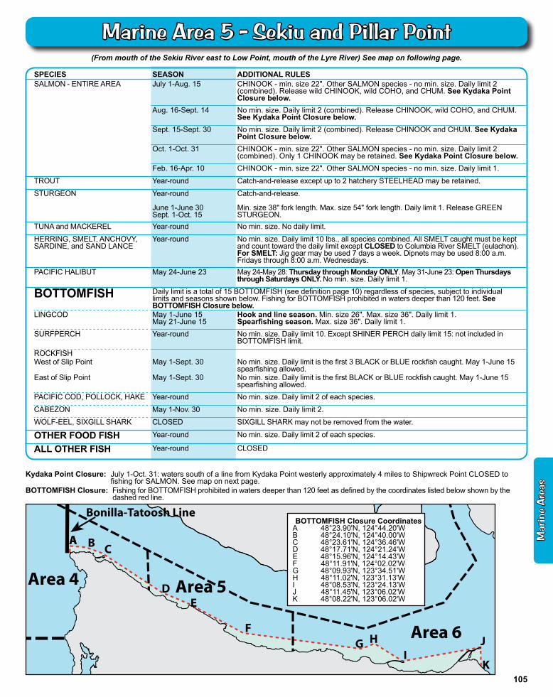
(From mouth of the Sekiu River east to Low Point, mouth of the Lyre River) See map on following page.
Kydaka Point Closure: July 1-Oct. 31: waters south of a line from Kydaka Point westerly approximately 4 miles to Shipwreck Point CLOSED to fishing for SALMON. See map on next page.
Mouth of Queets River
Bonilla-Tatoosh Line
Area 3
Area 4
Halibut & Bottomfish Closure Area
Area 5
Leadbetter Point
Area 6
AA B C
DE
FG H
I J
K
BOTTOMFISH Closure CoordinatesA 48°23.90'N, 124°44.20'WB 48°24.10'N, 124°40.00'WC 48°23.61'N, 124°36.46'WD 48°17.71'N, 124°21.24'WE 48°15.96'N, 124°14.43'WF 48°11.91'N, 124°02.02'WG 48°09.93'N, 123°34.51'WH 48°11.02'N, 123°31.13'WI 48°08.53'N, 123°24.13'WJ 48°11.45'N, 123°06.02'WK 48°08.22'N, 123°06.02'W
BOTTOMFISH Closure: Fishing for BOTTOMFISH prohibited in waters deeper than 120 feet as defined by the coordinates listed below shown by the dashed red line.
Mar
ine
Are
as
105
Marine Area 5 - Sekiu and Pillar Point
Protection Island
Rocky Point
TravisSpit
McCurdyPoint
PortTownsend
BayDiscovery Bay
Sequim Bay
Gibson Spit
Beckett Point
GardinerBoat Ramp
Dunge
ness
Spit
Dungeness
Bay
Dun
gene
ssR i
ver
Dungeness Spit Light
#2 RedBuoy
Port WilliamsBoat Ramp
Ediz Hook
Port AngelesHarbor Green
Point
AngelesPoint
# 2 Buoy
Discovery Bay Shrimp District:Waters south of a line from McCurdy Point on the Quimper Peninsula to the northern tip of Protection Island then from the western end of Protection Island to Rocky Point on the Miller Peninsula and all waters of Discovery Bay.
Port Angeles Harbor Closure: Waters of Port Angeles Harbor west of a line from the tip of Ediz Hook to the ITT Rayonier Dock.
Dungeness Bay Fishery and Closure: Waters of Dungeness Bay inside of a line from Dungeness Spit Lighthouse to the #2 Red Buoy, then to the Port Williams boat ramp. Oct. 1-Oct. 31: open to fishing for COHO SALMON. See rules next page. CLOSED to fishing for SALMON at all other times.
Area 4
Area 6
Kydaka Pt.
Pillar Pt.Low Point
Sekiu Pt.Slip Pt.
Clallam BayMouth of Sekiu River
Sekiu Area 5
Shipwreck Point
Crescent Bay
Port AngelesFreshwater Bay
Sequim Bay Discovery Bay
Victoria
(Approx. 48º19.8′N123º12.2’W)
(Approx. 48º16.4′N123º 0.67’W)
PartridgePoint
PortTownsend
PointWilson
Area 7
Chinook Selective Fishery Area (Shown in white)
Ediz Hook
ReservationHead
WestPoint
(Approx. 123°49.6'W)
(Approx. 124°23.7'W)
Tag Location The department is tagging sixgill sharks to learn more about their behavior and abundance. The tags are colored disks about the size of a quarter.
If you see or catch a tagged SIXGILL shark in Washington waters, do not remove the tag, but please report the color and tag number by calling (360) 902-2700.
Size: up to 15'Color: dark brown or gray.Look for: one fin on back situated towards tail. Six gill slits on each side of head.
Sixgill Shark
It is unlawful to remove a SIXGILL shark from the water
106
Marine Area 5 and 6 Map
(From Low Point east to the Partridge Point – Point Wilson line north to the line from Trial Island (near Victoria B.C.) – Vessel Traffic Separation Buoy “R” – Smith Island to the Lawson Reef Buoy to Northwest Island to the Initiative 77 marker on Fidalgo Island and west of the
line from Reservation Head to West Point)
CLOSURES: Dungeness Bay Fishery and Closure: Waters of Dungeness Bay inside of a line from Dungeness Spit Lighthouse to the #2 Red Buoy, then to the Port Williams boat ramp. Oct. 1-Oct. 31: OPEN to fishing for COHO SALMON. CLOSED to fishing for SALMON at all other times. See
Dungeness Bay Fishery above for rules. Freshwater Bay Closure: July 1-Oct. 31: waters of Freshwater Bay south of a line from Angeles Point westerly approximately 4 miles to
Observatory Point (Bachelor Rock) closed to fishing for ALL finfish. Port Angeles Harbor Closure: July 1-Oct. 31: waters of Port Angeles Harbor west of a line from the tip of Ediz Hook to the ITT Rayonier Dock
closed to fishing for SALMON. Sequim Bay Closure: Oct. 1-Oct. 31: waters of Sequim Bay south of a line from the southern end of Gibson Spit to the west end of Travis Spit
CLOSED to fishing for SALMON. Discovery Bay Closure: Oct. 1-Oct. 31: waters of Discovery Bay south of a line from the Gardiner boat ramp to Beckett Point CLOSED to fishing
for SALMON.
SPECIES SEASON ADDITIONAL RULESSALMON(CHINOOK Selective Fishery)
West of a true north/south line through the #2 Buoy immediately east of Ediz Hook
July 1-Aug. 15 CHINOOK - min. size 22". Other SALMON species - no min. size. Daily limit 2 (combined). Release wild CHINOOK, wild COHO, and CHUM. See closures below.
(CHINOOK Release Area)East of a true north/south line through the #2 Buoy immediately east of Ediz Hook
July 1-Aug. 15 No min. size. Daily limit 2 (combined). Release CHINOOK, wild COHO, and CHUM. See closures below.
ENTIRE AREA Aug. 16-Sept. 30 No min. size. Daily limit 2 (combined). Release CHINOOK, wild COHO, and CHUM. See closures below.
Oct. 1-Oct. 31 CHINOOK - min. size 22". Other SALMON species - no min. size. Daily limit 2 (combined). Only 1 CHINOOK may be retained. See closures below. See Dungeness Bay Fishery and Closure below.
Dec. 1-Apr. 10 CHINOOK - min. size 22". Other SALMON species - no min. size. Daily limit 2. Release wild CHINOOK. See Dungeness Bay Fishery and Closure below.
Dungeness Bay Fishery(see below for boundaries)
Oct. 1-Oct. 31 No min. size. Daily limit 2 COHO only.
TROUT Year-round Catch-and-release except up to 2 hatchery STEELHEAD may be retained. See Freshwater Bay Closure below.
STURGEON Year-round
June 1-June 30Sept. 1-Oct. 15
Catch-and-release.
Min. size 38" fork length. Max. size 54" fork length. Daily limit 1. Release GREEN STURGEON.
MACKEREL Year-round No min. size. No daily limit.
HERRING, SMELT, ANCHOVY, SARDINE, and SAND LANCE
Year-round No min. size. Daily limit 10 lbs., all species combined. All SMELT caught must be kept and count toward the daily limit except CLOSED to Columbia River SMELT (eulachon). HERRING - CLOSED Jan. 16-Apr. 15 south of a line from Ediz Hook to Partridge Point. For SMELT: Jig gear may be used 7 days a week. Dipnets may be used 8:00 a.m. Fridays through 8:00 a.m. Wednesdays.
PACIFIC HALIBUT May 3--June 2 May 3-May 19: Open Thursdays through Saturdays ONLY. May 24-May 28: Thursday through Monday ONLY. May 31-June 2: Thursday through Saturday ONLY. No min. size. Daily limit 1.
*Check the WDFW website at wdfw.wa.gov or call (360) 902-2700 in March 2013 for updates on the 2013 opening for PACIFIC HALIBUT.
BOTTOMFISH Year-round season. Daily limit is a total of 15 BOTTOMFISH (see definition page 10) regardless of species, subject to individual limits and seasons shown below. See Freshwater Bay Closure below. Fishing for BOTTOMFISH prohibited in waters deeper than 120 feet.
LINGCOD May 1-June 15May 21-June 15
Hook and line season. Min. size 26". Max. size 36". Daily limit 1.Spearfishing season. Max. size 36". Daily limit 1.
SURFPERCH Year-round No min. size. Daily limit 10. Except SHINER PERCH daily limit 15: not included in BOTTOMFISH limit.
ROCKFISH CLOSED
PACIFIC COD, POLLOCK, HAKE Year-round No min. size. Daily limit 2 of each species.
CABEZON May 1-Nov. 30 No min. size. Daily limit 2.
WOLF-EEL, SIXGILL SHARK CLOSED SIXGILL SHARK may not be removed from the water.
OTHER FOOD FISH Year-round No min. size. Daily limit 2 of each species.
ALL OTHER FISH Year-round CLOSEDM
arin
e A
reas
107
Marine Area 6 - East Juan de Fuca Strait
1
2
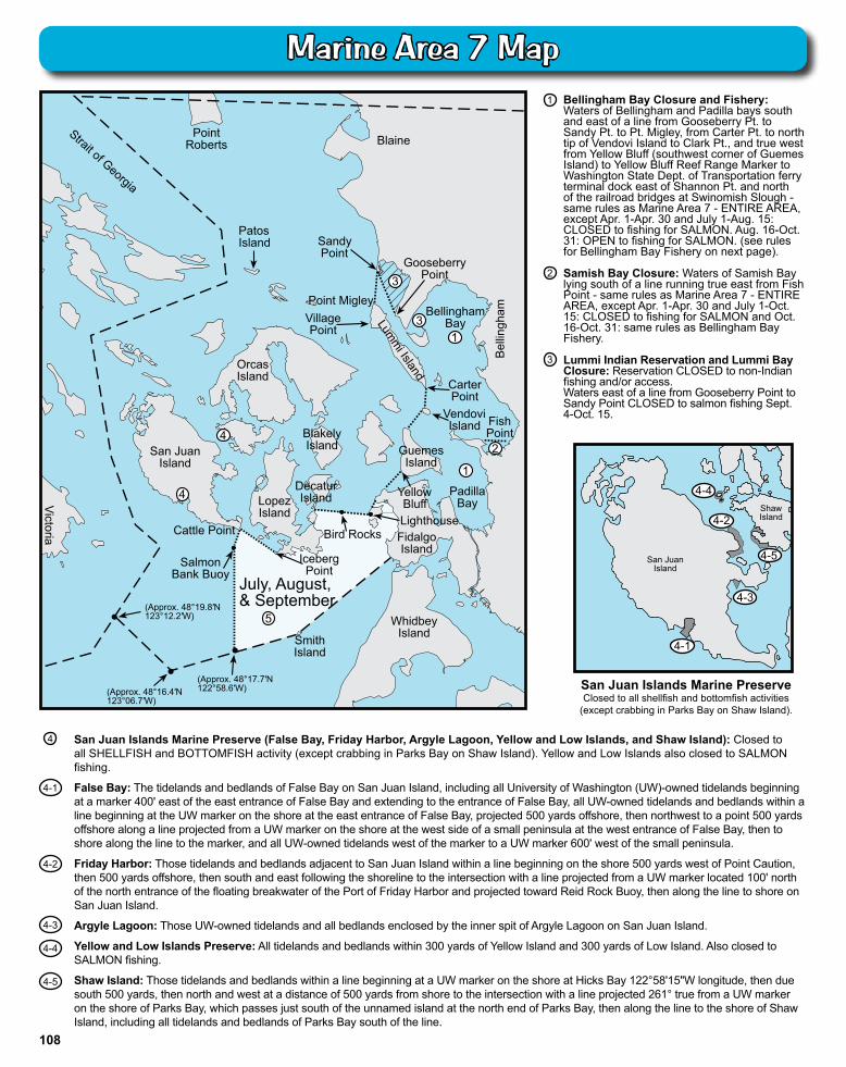
San Juan Islands Marine Preserve (False Bay, Friday Harbor, Argyle Lagoon, Yellow and Low Islands, and Shaw Island): Closed to all SHELLFISH and BOTTOMFISH activity (except crabbing in Parks Bay on Shaw Island). Yellow and Low Islands also closed to SALMON fishing.
False Bay: The tidelands and bedlands of False Bay on San Juan Island, including all University of Washington (UW)-owned tidelands beginning at a marker 400' east of the east entrance of False Bay and extending to the entrance of False Bay, all UW-owned tidelands and bedlands within a line beginning at the UW marker on the shore at the east entrance of False Bay, projected 500 yards offshore, then northwest to a point 500 yards offshore along a line projected from a UW marker on the shore at the west side of a small peninsula at the west entrance of False Bay, then to shore along the line to the marker, and all UW-owned tidelands west of the marker to a UW marker 600' west of the small peninsula.
Friday Harbor: Those tidelands and bedlands adjacent to San Juan Island within a line beginning on the shore 500 yards west of Point Caution, then 500 yards offshore, then south and east following the shoreline to the intersection with a line projected from a UW marker located 100' north of the north entrance of the floating breakwater of the Port of Friday Harbor and projected toward Reid Rock Buoy, then along the line to shore on San Juan Island.
Argyle Lagoon: Those UW-owned tidelands and all bedlands enclosed by the inner spit of Argyle Lagoon on San Juan Island.
Yellow and Low Islands Preserve: All tidelands and bedlands within 300 yards of Yellow Island and 300 yards of Low Island. Also closed to SALMON fishing.
Shaw Island: Those tidelands and bedlands within a line beginning at a UW marker on the shore at Hicks Bay 122°58'15"W longitude, then due south 500 yards, then north and west at a distance of 500 yards from shore to the intersection with a line projected 261° true from a UW marker on the shore of Parks Bay, which passes just south of the unnamed island at the north end of Parks Bay, then along the line to the shore of Shaw Island, including all tidelands and bedlands of Parks Bay south of the line.
4-2
4-3
4-4
4-5
3
ShawIsland
San JuanIsland
4-1
4-4
4-3
4-5
4-2
San Juan Islands Marine PreserveClosed to all shellfish and bottomfish activities
(except crabbing in Parks Bay on Shaw Island).
4-1
3
2
July
July, August, & September
1
5
Sandy Point
Point Roberts
Strait of Georgia
Blaine
Gooseberry Point
Bellingham Bay
Point Migley
Lumm
i Island Carter Point
Bel
lingh
am
Village Point
Orcas Island
Fish Point
Vendovi Island
Guemes Island
Padilla Bay
Blakely Island
Decatur Island Yellow
Bluff Lopez Island
Bird Rocks Lighthouse Fidalgo Island
Iceberg Point
San Juan Island
Cattle Point
Salmon Bank Buoy
Smith Island
Whidbey Island
Victoria
(Approx. 48°16.4′N 123°06.7′W)
(Approx. 48°19.8′N 123°12.2′W)
(Approx. 48°17.7′N 122°58.6′W)
1
4
4
PatosIsland
3
Bellingham Bay Closure and Fishery: Waters of Bellingham and Padilla bays south and east of a line from Gooseberry Pt. to Sandy Pt. to Pt. Migley, from Carter Pt. to north tip of Vendovi Island to Clark Pt., and true west from Yellow Bluff (southwest corner of Guemes Island) to Yellow Bluff Reef Range Marker to Washington State Dept. of Transportation ferry terminal dock east of Shannon Pt. and north of the railroad bridges at Swinomish Slough - same rules as Marine Area 7 - ENTIRE AREA, except Apr. 1-Apr. 30 and July 1-Aug. 15: CLOSED to fishing for SALMON. Aug. 16-Oct. 31: OPEN to fishing for SALMON. (see rules for Bellingham Bay Fishery on next page). Samish Bay Closure: Waters of Samish Bay lying south of a line running true east from Fish Point - same rules as Marine Area 7 - ENTIRE AREA, except Apr. 1-Apr. 30 and July 1-Oct. 15: CLOSED to fishing for SALMON and Oct. 16-Oct. 31: same rules as Bellingham Bay Fishery. Lummi Indian Reservation and Lummi Bay Closure: Reservation CLOSED to non-Indian fishing and/or access. Waters east of a line from Gooseberry Point to Sandy Point CLOSED to salmon fishing Sept. 4-Oct. 15.
4
108
Marine Area 7 Map
(All marine waters north of the Trial Island line described under Area 6 to the United States-Canada boundary)
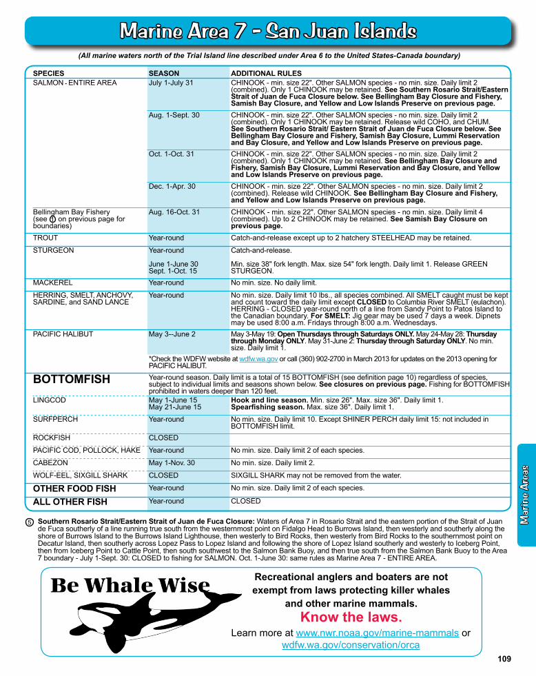
SPECIES SEASON ADDITIONAL RULESSALMON - ENTIRE AREA July 1-July 31 CHINOOK - min. size 22". Other SALMON species - no min. size. Daily limit 2
(combined). Only 1 CHINOOK may be retained. See Southern Rosario Strait/Eastern Strait of Juan de Fuca Closure below. See Bellingham Bay Closure and Fishery, Samish Bay Closure, and Yellow and Low Islands Preserve on previous page.
Aug. 1-Sept. 30 CHINOOK - min. size 22". Other SALMON species - no min. size. Daily limit 2 (combined). Only 1 CHINOOK may be retained. Release wild COHO, and CHUM. See Southern Rosario Strait/ Eastern Strait of Juan de Fuca Closure below. See Bellingham Bay Closure and Fishery, Samish Bay Closure, Lummi Reservation and Bay Closure, and Yellow and Low Islands Preserve on previous page.
Oct. 1-Oct. 31 CHINOOK - min. size 22". Other SALMON species - no min. size. Daily limit 2 (combined). Only 1 CHINOOK may be retained. See Bellingham Bay Closure and Fishery, Samish Bay Closure, Lummi Reservation and Bay Closure, and Yellow and Low Islands Preserve on previous page.
Dec. 1-Apr. 30 CHINOOK - min. size 22". Other SALMON species - no min. size. Daily limit 2 (combined). Release wild CHINOOK. See Bellingham Bay Closure and Fishery, and Yellow and Low Islands Preserve on previous page.
Bellingham Bay Fishery (see 1 on previous page for boundaries)
Aug. 16-Oct. 31 CHINOOK - min. size 22". Other SALMON species - no min. size. Daily limit 4 (combined). Up to 2 CHINOOK may be retained. See Samish Bay Closure on previous page.
TROUT Year-round Catch-and-release except up to 2 hatchery STEELHEAD may be retained.
STURGEON Year-round
June 1-June 30Sept. 1-Oct. 15
Catch-and-release.
Min. size 38" fork length. Max. size 54" fork length. Daily limit 1. Release GREEN STURGEON.
MACKEREL Year-round No min. size. No daily limit.
HERRING, SMELT, ANCHOVY, SARDINE, and SAND LANCE
Year-round No min. size. Daily limit 10 lbs., all species combined. All SMELT caught must be kept and count toward the daily limit except CLOSED to Columbia River SMELT (eulachon). HERRING - CLOSED year-round north of a line from Sandy Point to Patos Island to the Canadian boundary. For SMELT: Jig gear may be used 7 days a week. Dipnets may be used 8:00 a.m. Fridays through 8:00 a.m. Wednesdays.
PACIFIC HALIBUT May 3--June 2 May 3-May 19: Open Thursdays through Saturdays ONLY. May 24-May 28: Thursday through Monday ONLY. May 31-June 2: Thursday through Saturday ONLY. No min. size. Daily limit 1.
*Check the WDFW website at wdfw.wa.gov or call (360) 902-2700 in March 2013 for updates on the 2013 opening for PACIFIC HALIBUT.
BOTTOMFISH Year-round season. Daily limit is a total of 15 BOTTOMFISH (see definition page 10) regardless of species, subject to individual limits and seasons shown below. See closures on previous page. Fishing for BOTTOMFISH prohibited in waters deeper than 120 feet.
LINGCOD May 1-June 15May 21-June 15
Hook and line season. Min. size 26". Max. size 36". Daily limit 1.Spearfishing season. Max. size 36". Daily limit 1.
SURFPERCH Year-round No min. size. Daily limit 10. Except SHINER PERCH daily limit 15: not included in BOTTOMFISH limit.
ROCKFISH CLOSED
PACIFIC COD, POLLOCK, HAKE Year-round No min. size. Daily limit 2 of each species.
CABEZON May 1-Nov. 30 No min. size. Daily limit 2.
WOLF-EEL, SIXGILL SHARK CLOSED SIXGILL SHARK may not be removed from the water.
OTHER FOOD FISH Year-round No min. size. Daily limit 2 of each species.
ALL OTHER FISH Year-round CLOSED
Southern Rosario Strait/Eastern Strait of Juan de Fuca Closure: Waters of Area 7 in Rosario Strait and the eastern portion of the Strait of Juan de Fuca southerly of a line running true south from the westernmost point on Fidalgo Head to Burrows Island, then westerly and southerly along the shore of Burrows Island to the Burrows Island Lighthouse, then westerly to Bird Rocks, then westerly from Bird Rocks to the southernmost point on Decatur Island, then southerly across Lopez Pass to Lopez Island and following the shore of Lopez Island southerly and westerly to Iceberg Point, then from Iceberg Point to Cattle Point, then south southwest to the Salmon Bank Buoy, and then true south from the Salmon Bank Buoy to the Area 7 boundary - July 1-Sept. 30: CLOSED to fishing for SALMON. Oct. 1-June 30: same rules as Marine Area 7 - ENTIRE AREA.
5
Recreational anglers and boaters are not exempt from laws protecting killer whales
and other marine mammals.Know the laws.
Learn more at www.nwr.noaa.gov/marine-mammals or wdfw.wa.gov/conservation/orca
Mar
ine
Are
as
109
Marine Area 7 - San Juan Islands
Area 7
Area 6
Fidalgo Island
Reservation Head
W est Point Hope
Island
Goat Island
LaConner
Whidbey Island
Polnell Point
Oak Harbor
Penn Cove
Admiralty Inlet
Saratoga Passage
Port Susan
Skagit Bay
Area 8-1
Area 8-1
Snatelum Point
Rocky Point
Forbes Point
Flashing Light
Area 8-2
Area 9
S t anwood
Camano Island
East Point
Area 8-2
Blowers Bluff
110
Marine Area 8-1 Map
(From West Point to Reservation Head eastward through Deception Pass, including all waters of Swinomish Slough and Skagit Bay, and the portion of Saratoga Passage north and west of a line from East Point Light to light on Camano Island
(Saratoga Pass light #4 FI Red 4 Sec))
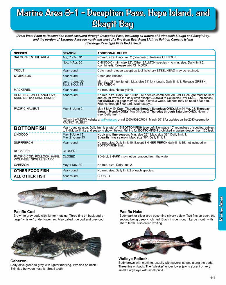
SPECIES SEASON ADDITIONAL RULESSALMON - ENTIRE AREA Aug. 1-Oct. 31 No min. size. Daily limit 2 (combined). Release CHINOOK.
Nov. 1-Apr. 30 CHINOOK - min. size 22". Other SALMON species - no min. size. Daily limit 2 (combined). Release wild CHINOOK.
TROUT Year-round Catch-and-release except up to 2 hatchery STEELHEAD may be retained.
STURGEON Year-round
June 1-June 30Sept. 1-Oct. 15
Catch-and-release.
Min. size 38" fork length. Max. size 54" fork length. Daily limit 1. Release GREEN STURGEON.
MACKEREL Year-round No min. size. No daily limit.
HERRING, SMELT, ANCHOVY, SARDINE, and SAND LANCE
Year-round No min. size. Daily limit 10 lbs., all species combined. All SMELT caught must be kept and count toward the daily limit except CLOSED to Columbia River SMELT (eulachon). For SMELT: Jig gear may be used 7 days a week. Dipnets may be used 8:00 a.m. Fridays through 8:00 a.m. Wednesdays.
PACIFIC HALIBUT May 3--June 2 May 3-May 19: Open Thursdays through Saturdays ONLY. May 24-May 28: Thursday through Monday ONLY. May 31-June 2: Thursday through Saturday ONLY. No min. size. Daily limit 1.
*Check the WDFW website at wdfw.wa.gov or call (360) 902-2700 in March 2013 for updates on the 2013 opening for PACIFIC HALIBUT.
BOTTOMFISH Year-round season. Daily limit is a total of 15 BOTTOMFISH (see definition page 10) regardless of species, subject to individual limits and seasons shown below. Fishing for BOTTOMFISH prohibited in waters deeper than 120 feet.
LINGCOD May 1-June 15May 21-June 15
Hook and line season. Min. size 26". Max. size 36". Daily limit 1.Spearfishing season. Max. size 36". Daily limit 1.
SURFPERCH Year-round No min. size. Daily limit 10. Except SHINER PERCH daily limit 15: not included in BOTTOMFISH limit.
ROCKFISH CLOSED
PACIFIC COD, POLLOCK, HAKE,WOLF-EEL, SIXGILL SHARK
CLOSED SIXGILL SHARK may not be removed from the water.
CABEZON May 1-Nov. 30 No min. size. Daily limit 2.
OTHER FOOD FISH Year-round No min. size. Daily limit 2 of each species.
ALL OTHER FISH Year-round CLOSED
Walleye PollockBody brown with mottling, usually with several stripes along the body. Three fins on back. The “whisker” under lower jaw is absent or very small. Large eye with small pupil.
Pacific HakeBody dark or silver grey becoming silvery below. Two fins on back, the second being deeply notched. Black inside mouth. Large mouth with sharp teeth. Also called whiting.
CabezonBody olive green to grey with lighter mottling. Two fins on back.Skin flap between nostrils. Small teeth.
Pacific CodBrown to grey body with lighter mottling. Three fins on back and a large “whisker” under lower jaw. Also called true cod and grey cod. M
arin
e A
reas
111
Marine Area 8-1 - Deception Pass, Hope Island, and Skagit Bay
Whidbey Island
Area 8-2Area 8-2
Sandy Point
Port SusanPort Susan
Area 8-1
Saratoga Passage
Cam
ano Island
Flashing Light
East Point
Area 9
Possession Point Shipwreck
Mukilteo Ferry Dock
Everett
Camano Head
T ulalip T erminal Area Fishery
Hermosa Point
Mission Point
Old Bowers Resort
Gedney Island
Area 8-2 Port Gardner
T ulalip Bay
1
1 2
Clinton Ferry Dock
Randall Point Everett Naval Station
Tulalip Bay Closure: Closed to all fishing east of a line from Mission Point to Hermosa Point.
Tulalip Terminal Area Fishery: Waters adjacent to Tulalip Bay west of a line from Mission Point to Hermosa Point, and within 2,000' from shore between the pilings at Old Bower's Resort (on the south) to the fishing boundary marker located approximately 1.4 miles northwest of Hermosa Point (on the north). Same SALMON rules as Marine Area 8-2 - ENTIRE AREA, except May 4-Sept. 23. See Tulalip Terminal Area Fishery on next page for rules from May 4-Sept. 23.
1
2
LingcodBody dark brown, grey or green with mot-tling on sides. A single long fin on back with only one notch. Large mouth with large teeth. Can reach five feet in length.
Dogfish SharkDark brown upper body with white belly, white spots sometimes on upper body. Single prominent spines in front of each dorsal fin. Lacks an anal fin.
112
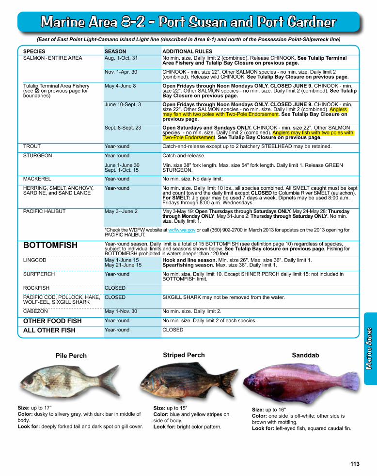
Marine Area 8-2 Map
(East of East Point Light-Camano Island Light line (described in Area 8-1) and north of the Possession Point-Shipwreck line)
SPECIES SEASON ADDITIONAL RULESSALMON - ENTIRE AREA Aug. 1-Oct. 31 No min. size. Daily limit 2 (combined). Release CHINOOK. See Tulalip Terminal
Area Fishery and Tulalip Bay Closure on previous page.
Nov. 1-Apr. 30 CHINOOK - min. size 22". Other SALMON species - no min. size. Daily limit 2 (combined). Release wild CHINOOK. See Tulalip Bay Closure on previous page.
Tulalip Terminal Area Fishery(see 2 on previous page for boundaries)
May 4-June 8 Open Fridays through Noon Mondays ONLY. CLOSED JUNE 9. CHINOOK - min. size 22". Other SALMON species - no min. size. Daily limit 2 (combined). See Tulalip Bay Closure on previous page.
June 10-Sept. 3 Open Fridays through Noon Mondays ONLY. CLOSED JUNE 9. CHINOOK - min. size 22". Other SALMON species - no min. size. Daily limit 2 (combined). Anglers may fish with two poles with Two-Pole Endorsement. See Tulalip Bay Closure on previous page.
Sept. 8-Sept. 23 Open Saturdays and Sundays ONLY. CHINOOK - min. size 22". Other SALMON species - no min. size. Daily limit 2 (combined). Anglers may fish with two poles with Two-Pole Endorsement. See Tulalip Bay Closure on previous page.
TROUT Year-round Catch-and-release except up to 2 hatchery STEELHEAD may be retained.
STURGEON Year-round
June 1-June 30Sept. 1-Oct. 15
Catch-and-release.
Min. size 38" fork length. Max. size 54" fork length. Daily limit 1. Release GREEN STURGEON.
MACKEREL Year-round No min. size. No daily limit.
HERRING, SMELT, ANCHOVY, SARDINE, and SAND LANCE
Year-round No min. size. Daily limit 10 lbs., all species combined. All SMELT caught must be kept and count toward the daily limit except CLOSED to Columbia River SMELT (eulachon). For SMELT: Jig gear may be used 7 days a week. Dipnets may be used 8:00 a.m. Fridays through 8:00 a.m. Wednesdays.
PACIFIC HALIBUT May 3--June 2 May 3-May 19: Open Thursdays through Saturdays ONLY. May 24-May 28: Thursday through Monday ONLY. May 31-June 2: Thursday through Saturday ONLY. No min. size. Daily limit 1.
*Check the WDFW website at wdfw.wa.gov or call (360) 902-2700 in March 2013 for updates on the 2013 opening for PACIFIC HALIBUT.
BOTTOMFISH Year-round season. Daily limit is a total of 15 BOTTOMFISH (see definition page 10) regardless of species, subject to individual limits and seasons shown below. See Tulalip Bay closure on previous page. Fishing for BOTTOMFISH prohibited in waters deeper than 120 feet.
LINGCOD May 1-June 15 May 21-June 15
Hook and line season. Min. size 26". Max. size 36". Daily limit 1.Spearfishing season. Max. size 36". Daily limit 1.
SURFPERCH Year-round No min. size. Daily limit 10. Except SHINER PERCH daily limit 15: not included in BOTTOMFISH limit.
ROCKFISH CLOSED
PACIFIC COD, POLLOCK, HAKE,WOLF-EEL, SIXGILL SHARK
CLOSED SIXGILL SHARK may not be removed from the water.
CABEZON May 1-Nov. 30 No min. size. Daily limit 2.
OTHER FOOD FISH Year-round No min. size. Daily limit 2 of each species.
ALL OTHER FISH Year-round CLOSED
Size: up to 17"Color: dusky to silvery gray, with dark bar in middle of body.Look for: deeply forked tail and dark spot on gill cover.
Pile Perch
Size: up to 15"Color: blue and yellow stripes on side of body.Look for: bright color pattern.
Striped Perch Sanddab
Size: up to 16"Color: one side is off-white; other side is brown with mottling.Look for: left-eyed fish, squared caudal fin.
Mar
ine
Are
as
113
Marine Area 8-2 - Port Susan and Port Gardner
Whidbey Island
Admiralty Inlet
PossessionPoint
Shipwreck
Port Susan
Area 9
Area8-2
Area8-2
Area10
Area12
Area8-1
HoodCanalBridge
Port Ludlow
Olele Pt.
IndianIsland
Killisut Harbor
45PointWilson
Partridge Point
Apple CovePoint
DoubleBluff
PointNo Point
FoulweatherBluff
3
1&2Edmonds
EdwardsPoint
6
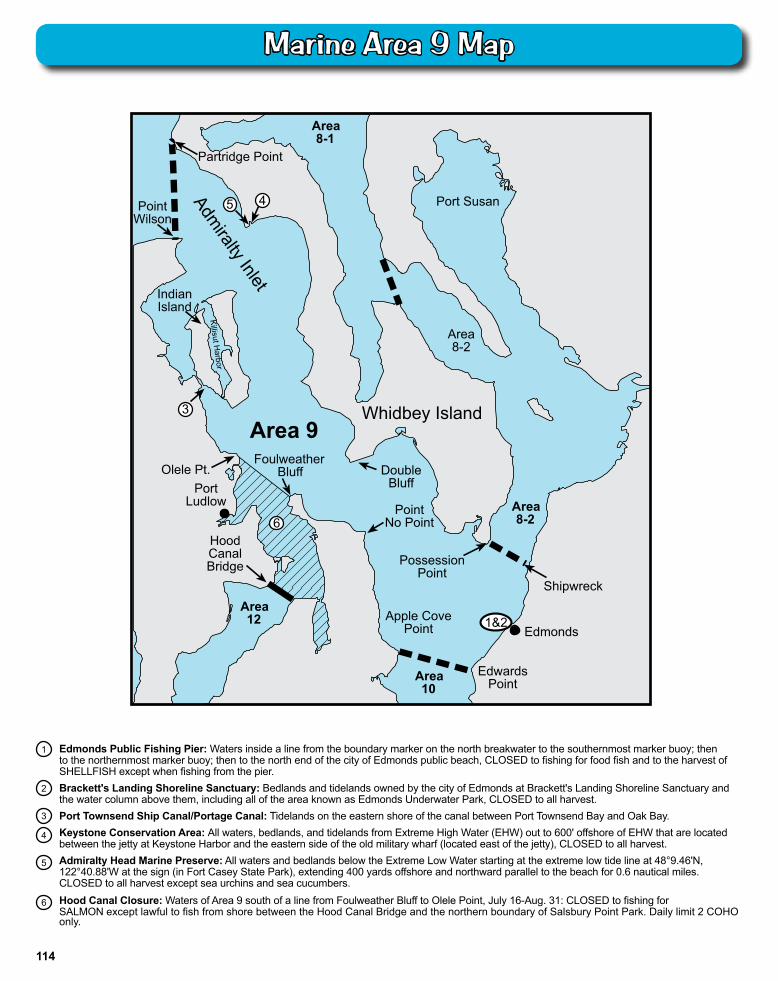
Edmonds Public Fishing Pier: Waters inside a line from the boundary marker on the north breakwater to the southernmost marker buoy; then to the northernmost marker buoy; then to the north end of the city of Edmonds public beach, CLOSED to fishing for food fish and to the harvest of SHELLFISH except when fishing from the pier.Brackett's Landing Shoreline Sanctuary: Bedlands and tidelands owned by the city of Edmonds at Brackett's Landing Shoreline Sanctuary and the water column above them, including all of the area known as Edmonds Underwater Park, CLOSED to all harvest.Port Townsend Ship Canal/Portage Canal: Tidelands on the eastern shore of the canal between Port Townsend Bay and Oak Bay.Keystone Conservation Area: All waters, bedlands, and tidelands from Extreme High Water (EHW) out to 600' offshore of EHW that are located between the jetty at Keystone Harbor and the eastern side of the old military wharf (located east of the jetty), CLOSED to all harvest.Admiralty Head Marine Preserve: All waters and bedlands below the Extreme Low Water starting at the extreme low tide line at 48°9.46'N, 122°40.88'W at the sign (in Fort Casey State Park), extending 400 yards offshore and northward parallel to the beach for 0.6 nautical miles. CLOSED to all harvest except sea urchins and sea cucumbers.Hood Canal Closure: Waters of Area 9 south of a line from Foulweather Bluff to Olele Point, July 16-Aug. 31: CLOSED to fishing for SALMON except lawful to fish from shore between the Hood Canal Bridge and the northern boundary of Salsbury Point Park. Daily limit 2 COHO only.
1
2
3
4
5
6
114
Marine Area 9 Map
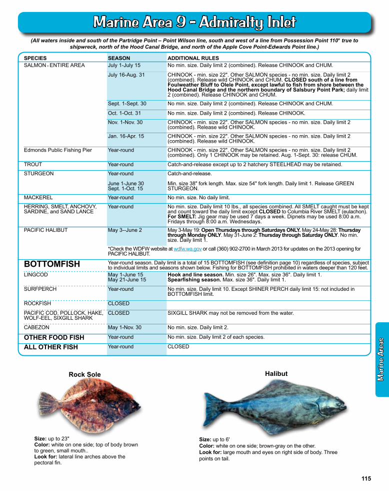
(All waters inside and south of the Partridge Point – Point Wilson line, south and west of a line from Possession Point 110° true to shipwreck, north of the Hood Canal Bridge, and north of the Apple Cove Point-Edwards Point line.)
SPECIES SEASON ADDITIONAL RULESSALMON - ENTIRE AREA July 1-July 15 No min. size. Daily limit 2 (combined). Release CHINOOK and CHUM.
July 16-Aug. 31 CHINOOK - min. size 22". Other SALMON species - no min. size. Daily limit 2 (combined). Release wild CHINOOK and CHUM. CLOSED south of a line from Foulweather Bluff to Olele Point, except lawful to fish from shore between the Hood Canal Bridge and the northern boundary of Salsbury Point Park; daily limit 2 (combined). Release CHINOOK and CHUM.
Sept. 1-Sept. 30 No min. size. Daily limit 2 (combined). Release CHINOOK and CHUM.
Oct. 1-Oct. 31 No min. size. Daily limit 2 (combined). Release CHINOOK.
Nov. 1-Nov. 30 CHINOOK - min. size 22". Other SALMON species - no min. size. Daily limit 2 (combined). Release wild CHINOOK.
Jan. 16-Apr. 15 CHINOOK - min. size 22". Other SALMON species - no min. size. Daily limit 2 (combined). Release wild CHINOOK.
Edmonds Public Fishing Pier Year-round CHINOOK - min. size 22". Other SALMON species - no min. size. Daily limit 2 (combined). Only 1 CHINOOK may be retained. Aug. 1-Sept. 30: release CHUM.
TROUT Year-round Catch-and-release except up to 2 hatchery STEELHEAD may be retained.
STURGEON Year-round
June 1-June 30Sept. 1-Oct. 15
Catch-and-release.
Min. size 38" fork length. Max. size 54" fork length. Daily limit 1. Release GREEN STURGEON.
MACKEREL Year-round No min. size. No daily limit.
HERRING, SMELT, ANCHOVY, SARDINE, and SAND LANCE
Year-round No min. size. Daily limit 10 lbs., all species combined. All SMELT caught must be kept and count toward the daily limit except CLOSED to Columbia River SMELT (eulachon). For SMELT: Jig gear may be used 7 days a week. Dipnets may be used 8:00 a.m. Fridays through 8:00 a.m. Wednesdays.
PACIFIC HALIBUT May 3--June 2 May 3-May 19: Open Thursdays through Saturdays ONLY. May 24-May 28: Thursday through Monday ONLY. May 31-June 2: Thursday through Saturday ONLY. No min. size. Daily limit 1.
*Check the WDFW website at wdfw.wa.gov or call (360) 902-2700 in March 2013 for updates on the 2013 opening for PACIFIC HALIBUT.
BOTTOMFISH Year-round season. Daily limit is a total of 15 BOTTOMFISH (see definition page 10) regardless of species, subject to individual limits and seasons shown below. Fishing for BOTTOMFISH prohibited in waters deeper than 120 feet.
LINGCOD May 1-June 15May 21-June 15
Hook and line season. Min. size 26". Max. size 36". Daily limit 1.Spearfishing season. Max. size 36". Daily limit 1.
SURFPERCH Year-round No min. size. Daily limit 10. Except SHINER PERCH daily limit 15: not included in BOTTOMFISH limit.
ROCKFISH CLOSED
PACIFIC COD, POLLOCK, HAKE,WOLF-EEL, SIXGILL SHARK
CLOSED SIXGILL SHARK may not be removed from the water.
CABEZON May 1-Nov. 30 No min. size. Daily limit 2.
OTHER FOOD FISH Year-round No min. size. Daily limit 2 of each species.
ALL OTHER FISH Year-round CLOSED
Size: up to 6'Color: white on one side; brown-gray on the other.Look for: large mouth and eyes on right side of body. Three points on tail.
HalibutRock Sole
Size: up to 23"Color: white on one side; top of body brown to green, small mouth..Look for: lateral line arches above the pectoral fin.
Mar
ine
Are
as
115
Marine Area 9 - Admiralty Inlet
Puget Sound Naval Shipyard at Bremerton: All waters within 150' of the pier head line CLOSED to fishing for food fish at all times.
Chittenden Locks Closure: Waters between Chittenden Locks and the Burlington-Northern Railroad bridge CLOSED to fishing. It is illegal to fish for food fish east of a line which is parallel to the Burlington-Northern Railroad bridge and approximately 175' west of the bridge, and which runs through the wooden piling tower structure near the south shore (west of the Chittenden Locks).
Elliott Bay Public Fishing Pier: Waters within 100 yards of the Elliott Bay Public Fishing Pier CLOSED to fishing for food fish and the harvest of SHELLFISH except when fishing from the pier.
Duwamish Waterways Special Rules: a) Downstream of 1st Ave. South Bridge is part of Marine Area 10. Record SALMON caught here as Marine Area 10 on your catch record card. b) July 1-Aug. 31: CLOSED to fishing for SALMON. c) Sept. 1-Oct. 31: same rules as Area 10 Entire Area plus the additional restrictions listed in this section. d) Nov. 1-June 30: same rules as Area 10 Entire Area. e) Additional restrictions Sept.-Oct. 31: from the 1st Ave. South Bridge downstream to an east-west line through SW Hanford St. on Harbor Island (including waters at the Spokane St. Bridge) - night closure, unlawful to use forage fish jig gear, anti-snagging rule, and only salmon hooked inside the mouth may be retained.
Orchard Rocks Conservation Area: Waters and bedlands of Rich Passage within a 400 yard radius of Orchard Rocks CLOSED to all harvest. Closure does not affect privately owned fish in net pens and the harvest of clams, oysters, and mussels by tideland owners and their families.
Agate Pass Area: Jan. 1-Mar. 31: catch-and-release and fly fishing only in waters west of a line from Point Monroe to Indianola and east of a line from Point Bolin to Battle Point. Lead-core line prohibited.
Shilshole Bay Closure: July 1-Aug. 31: waters of Shilshole Bay southeast of a line from Meadow Point to West Point CLOSED to fishing for SALMON.
Elliott Bay Closure: Waters of Elliott Bay east of a line from West Point to Alki Point July 1-Aug. 31: CLOSED to fishing for SALMON.
Sinclair Inlet Fishery: Waters of Sinclair Inlet and Port Orchard south of the Manette Bridge in Bremerton, south of a line drawn true west from Battle Point, and west of a line drawn true south from Point White - same rules as Marine Area 10 - ENTIRE AREA, except July 1-Sept. 30.
Seattle Marine Preserves: Note signs at beach entrances. The area from high tide to minus 4.5' (extreme low water) between the coordinates listed below is CLOSED to harvest except for finfish by hook and line.
A Carkeek Park Marine Preserve 122°22'49.0"W, 47°42'31.7"N to a sign at 122°22'47.41"W, 47°42'43.51"N AND 200 yards of beach starting 300 yards north
of 122°22'47.41"W, 47°42'43.51"N
B Golden Gardens Marine Preserve 122°24'07.2"W, 47°41'51.8"N south to the
walkway sign
C Discovery Park Marine Preserve 122°25'31.7"W, 47°39'26.8"N northeast to the sign at sidewalk AND 122°25'20.7"W, 47°40'3.3"N to a sign posted at 122°25'4.2"W, 47°40'11.1"N
D Richey Viewpoint Marine Preserve From the north edge of the park at 122°25'8.8"W,
47°34'30.0"N to 122°24'49.0"W, 47°34'20.2"N
E Emma Schmitz Memorial Marine Preserve The residential property fence at 122°24'26.5"W,
47°33'53.5"N south to SW Oregon St.
F Lincoln Park Marine Preserve The flagpole at 122°24'05.0"W, 47°31'49.8"N to
the sign posted at 122°23'40.4"W, 47°31'33.1"N
BainbridgeIsland
Area 10
Apple CovePoint Edwards Point
Area 9
PointWells
IndianolaAgatePass
Bridge
PointBolin
BattlePoint
PointMonroe
MeadowPoint
Lake Washington Ship Canal
Port
Orc
hard
Port
Orc
hard
Sinclair Inlet
Sinclair Inlet
ElliottBay
ElliottBay
PointWhite
ManetteBridge
SouthworthFerry Dock
BlakeIsland
VashonIsland
Area 11
Aprox. 600yds. south of
Brace Pt.
1st Ave. SBridge
DuwamishWaterway
LakeUnion
DuwamishHead
AlkiPoint
WestPoint
Pier 91
9
15
4
2
3
7
8
6
E
C
F
BA
D
WatermanPier
SeacrestPier
SW Hanford
St.
Spokane St. Bridge
1
2
3
4
7
5
6
See DOH Fish Consumption advisories for Dyes Inlet (Ostrich Bay), Eagle Harbor, King County, Manchester State Park, and Sinclair
Inlet, page 20.
9
8
116
Marine Area 10 Map
(From the Apple Cove Point-Edwards Point to a line projected true east-west through the north tip of Vashon Island)
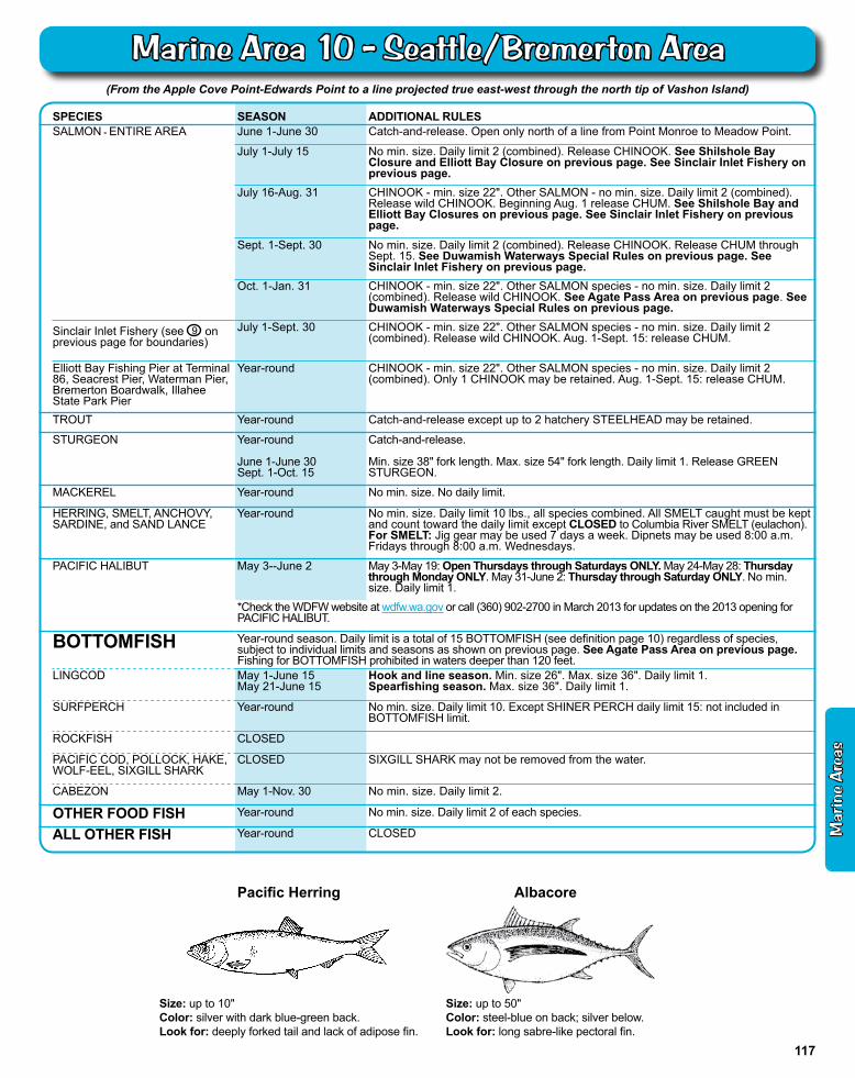
SPECIES SEASON ADDITIONAL RULESSALMON - ENTIRE AREA June 1-June 30 Catch-and-release. Open only north of a line from Point Monroe to Meadow Point.
July 1-July 15 No min. size. Daily limit 2 (combined). Release CHINOOK. See Shilshole Bay Closure and Elliott Bay Closure on previous page. See Sinclair Inlet Fishery on previous page.
July 16-Aug. 31 CHINOOK - min. size 22". Other SALMON - no min. size. Daily limit 2 (combined). Release wild CHINOOK. Beginning Aug. 1 release CHUM. See Shilshole Bay and Elliott Bay Closures on previous page. See Sinclair Inlet Fishery on previous page.
Sept. 1-Sept. 30 No min. size. Daily limit 2 (combined). Release CHINOOK. Release CHUM through Sept. 15. See Duwamish Waterways Special Rules on previous page. See Sinclair Inlet Fishery on previous page.
Oct. 1-Jan. 31 CHINOOK - min. size 22". Other SALMON species - no min. size. Daily limit 2 (combined). Release wild CHINOOK. See Agate Pass Area on previous page. See Duwamish Waterways Special Rules on previous page.
Sinclair Inlet Fishery (see 9 on previous page for boundaries)
July 1-Sept. 30 CHINOOK - min. size 22". Other SALMON species - no min. size. Daily limit 2 (combined). Release wild CHINOOK. Aug. 1-Sept. 15: release CHUM.
Elliott Bay Fishing Pier at Terminal 86, Seacrest Pier, Waterman Pier, Bremerton Boardwalk, Illahee State Park Pier
Year-round CHINOOK - min. size 22". Other SALMON species - no min. size. Daily limit 2 (combined). Only 1 CHINOOK may be retained. Aug. 1-Sept. 15: release CHUM.
TROUT Year-round Catch-and-release except up to 2 hatchery STEELHEAD may be retained.
STURGEON Year-round
June 1-June 30Sept. 1-Oct. 15
Catch-and-release.
Min. size 38" fork length. Max. size 54" fork length. Daily limit 1. Release GREEN STURGEON.
MACKEREL Year-round No min. size. No daily limit.
HERRING, SMELT, ANCHOVY, SARDINE, and SAND LANCE
Year-round No min. size. Daily limit 10 lbs., all species combined. All SMELT caught must be kept and count toward the daily limit except CLOSED to Columbia River SMELT (eulachon). For SMELT: Jig gear may be used 7 days a week. Dipnets may be used 8:00 a.m. Fridays through 8:00 a.m. Wednesdays.
PACIFIC HALIBUT May 3--June 2 May 3-May 19: Open Thursdays through Saturdays ONLY. May 24-May 28: Thursday through Monday ONLY. May 31-June 2: Thursday through Saturday ONLY. No min. size. Daily limit 1.
*Check the WDFW website at wdfw.wa.gov or call (360) 902-2700 in March 2013 for updates on the 2013 opening for PACIFIC HALIBUT.
BOTTOMFISH Year-round season. Daily limit is a total of 15 BOTTOMFISH (see definition page 10) regardless of species, subject to individual limits and seasons as shown on previous page. See Agate Pass Area on previous page. Fishing for BOTTOMFISH prohibited in waters deeper than 120 feet.
LINGCOD May 1-June 15May 21-June 15
Hook and line season. Min. size 26". Max. size 36". Daily limit 1.Spearfishing season. Max. size 36". Daily limit 1.
SURFPERCH Year-round No min. size. Daily limit 10. Except SHINER PERCH daily limit 15: not included in BOTTOMFISH limit.
ROCKFISH CLOSED
PACIFIC COD, POLLOCK, HAKE,WOLF-EEL, SIXGILL SHARK
CLOSED SIXGILL SHARK may not be removed from the water.
CABEZON May 1-Nov. 30 No min. size. Daily limit 2.
OTHER FOOD FISH Year-round No min. size. Daily limit 2 of each species.
ALL OTHER FISH Year-round CLOSED
Size: up to 50"Color: steel-blue on back; silver below.Look for: long sabre-like pectoral fin.
Albacore
Size: up to 10"Color: silver with dark blue-green back.Look for: deeply forked tail and lack of adipose fin.
Pacific Herring
Mar
ine
Are
as
117
Marine Area 10 - Seattle/Bremerton Area
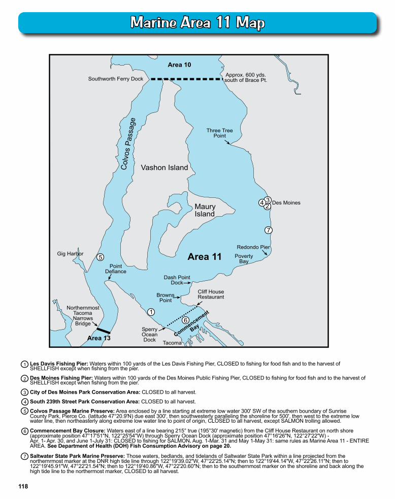
Les Davis Fishing Pier: Waters within 100 yards of the Les Davis Fishing Pier, CLOSED to fishing for food fish and to the harvest of SHELLFISH except when fishing from the pier.
Des Moines Fishing Pier: Waters within 100 yards of the Des Moines Public Fishing Pier, CLOSED to fishing for food fish and to the harvest of SHELLFISH except when fishing from the pier.
City of Des Moines Park Conservation Area: CLOSED to all harvest.
South 239th Street Park Conservation Area: CLOSED to all harvest.
Colvos Passage Marine Preserve: Area enclosed by a line starting at extreme low water 300' SW of the southern boundary of SunriseCounty Park, Pierce Co. (latitude 47°20.9'N) due east 300', then southwesterly paralleling the shoreline for 500', then west to the extreme low water line, then northeasterly along extreme low water line to point of origin, CLOSED to all harvest, except SALMON trolling allowed.
Commencement Bay Closure: Waters east of a line bearing 215° true (195°30' magnetic) from the Cliff House Restaurant on north shore (approximate position 47°17'51"N, 122°25'54"W) through Sperry Ocean Dock (approximate position 47°16'26"N, 122°27'22"W) - Apr. 1- Apr. 30, and June 1-July 31: CLOSED to fishing for SALMON. Aug. 1-Mar. 31 and May 1-May 31: same rules as Marine Area 11 - ENTIRE AREA. See Department of Health (DOH) Fish Consumption Advisory on page 20.
Saltwater State Park Marine Preserve: Those waters, bedlands, and tidelands of Saltwater State Park within a line projected from the northernrmost marker at the DNR high tide line through 122°19'39.02"W, 47°22'25.14"N; then to 122°19'44.14"W, 47°22'26.11"N; then to 122°19'45.91"W, 47°22'21.54"N; then to 122°19'40.86"W, 47°22'20.60"N; then to the southernmost marker on the shoreline and back along the high tide line to the northermost marker, CLOSED to all harvest.
1
2
3
4
5
Maury Island
1
Poverty Bay Area 1 1
Area 13
Northernmost Tacoma Narrows Bridge
V ashon Island Col
vos
Pass
age
Area 10
Southworth Ferry Dock Approx. 600 yds. south of Brace Pt.
Three T ree Point
Des Moines
Clif f House Rest aurant
2
Gig Harbor 5 Point
Defiance
Commencement
Bay S perry Ocean Dock T acoma
Browns Point
Redondo Pier
Dash Point Dock
6
3 4
7
6
7
118
Marine Area 11 Map
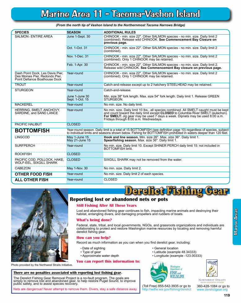
(From the north tip of Vashon Island to the Northernmost Tacoma Narrows Bridge)
SPECIES SEASON ADDITIONAL RULESSALMON - ENTIRE AREA June 1-Sept. 30 CHINOOK - min. size 22". Other SALMON species - no min. size. Daily limit 2
(combined). Release wild CHINOOK. See Commencement Bay Closure on previous page.
Oct. 1-Oct. 31 CHINOOK - min. size 22". Other SALMON species - no min. size. Daily limit 2 (combined).
Nov. 1-Dec. 31 CHINOOK - min. size 22". Other SALMON species - no min. size. Daily limit 2 (combined). Only 1 CHINOOK may be retained.
Feb. 1-Apr. 30 CHINOOK - min. size 22". Other SALMON species - no min. size. Daily limit 2. Release wild CHINOOK. See Commencement Bay closure on previous page.
Dash Point Dock, Les Davis Pier, Des Moines Pier, Redondo Pier, Point Defiance Boathouse Dock
Year-round CHINOOK - min. size 22". Other SALMON species - no min. size. Daily limit 2 (combined). Only 1 CHINOOK may be retained.
TROUT Year-round Catch-and-release except up to 2 hatchery STEELHEAD may be retained.
STURGEON Year-round
June 1-June 30Sept. 1-Oct. 15
Catch-and-release.
Min. size 38" fork length. Max. size 54" fork length. Daily limit 1. Release GREEN STURGEON.
MACKEREL Year-round No min. size. No daily limit.
HERRING, SMELT, ANCHOVY, SARDINE, and SAND LANCE
Year-round No min. size. Daily limit 10 lbs., all species combined. All SMELT caught must be kept and count toward the daily limit except CLOSED to Columbia River SMELT (eulachon). For SMELT: Jig gear may be used 7 days a week. Dipnets may be used 8:00 a.m. Fridays through 8:00 a.m. Wednesdays.
PACIFIC HALIBUT CLOSED
BOTTOMFISH Year-round season. Daily limit is a total of 15 BOTTOMFISH (see definition page 10) regardless of species, subject to individual limits and seasons shown below. Fishing for BOTTOMFISH prohibited in waters deeper than 120 feet.
LINGCOD May 1-June 15 May 21-June 15
Hook and line season. Min. size 26". Max. size 36". Daily limit 1.Spearfishing season. Max. size 36". Daily limit 1.
SURFPERCH Year-round No min. size. Daily limit 10. Except SHINER PERCH daily limit 15: not included in BOTTOMFISH limit.
ROCKFISH CLOSED
PACIFIC COD, POLLOCK, HAKE,WOLF-EEL, SIXGILL SHARK
CLOSED SIXGILL SHARK may not be removed from the water.
CABEZON May 1-Nov. 30 No min. size. Daily limit 2.
OTHER FOOD FISH Year-round No min. size. Daily limit 2 of each species.
ALL OTHER FISH Year-round CLOSED
Still Fishing After All These Years Lost and abandoned fishing gear continues to fish, impacting marine animals and destroying their habitat, entangling divers, and damaging propellers and rudders of boats.
What’s being done?Federal, state, tribal, and local governments, NGOs, and grassroots organizations and individuals are collaborating to protect and restore Washington marine resources by locating and removing harmful derelict fishing gear.
How can you help?Record as much information as you can when you find derelict gear, including:
You can report this information to:
Reporting lost or abandoned nets or pots
• Date of sighting• Type of gear• Approximate water depth
• General location• Latitude (example 48.34333)• Longitude (example -123.00333)
Photo provided by the Northwest Straits Initiative.
360-428-1084 or go to www.derelictgear.org
(Toll Free) 855-542-3935 or go to http://wdfw.wa.gov/fishing/derelict
There are no penalties associated with reporting lost fishing gear.
The Derelict Fishing Gear Removal Project is a no-fault program. The goals are simply to remove lost and abandoned gear, to help restore Puget Sound, to improve public safety, and to assist species recovery.Nets are dangerous! Never attempt to remove them. Divers, stay a safe distance away.
Mar
ine
Are
as
119
Marine Area 11 - Tacoma-vashon Island
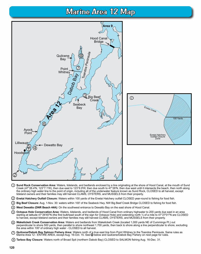
7
Sund Rock Conservation Area: Waters, tidelands, and bedlands enclosed by a line originating at the shore of Hood Canal, at the mouth of Sund Creek (47°26.4'N, 123°7.1'W), then due east to 123°6.9'W, then due south to 47°26'N, then due west until it intersects the beach, then north along the ordinary high water line to the point of origin, including all of the underwater feature known as Sund Rock, CLOSED to all harvest, except tideland owners and their families may still harvest CLAMS, OYSTERS, and MUSSELS from their property.Enetai Hatchery Outfall Closure: Waters within 100 yards of the Enetai Hatchery outfall CLOSED year-round to fishing for food fish.Big Beef Closure: Aug. 1-Nov. 30: waters within 100' of the Seabeck Hwy. NW Big Beef Creek Bridge CLOSED to fishing for food fish.West Dewatto (DNR Beach 44A): On the southwest entrance to Dewatto Bay on the east shore of Hood Canal.Octopus Hole Conservation Area: Waters, tidelands, and bedlands of Hood Canal from ordinary highwater to 200 yards due east in an area starting at latitude 47°26'40"N (the first bulkhead south of the sign for Octopus Hole) and extending north ⅓ of a mile to 47°27'01"N are CLOSED to harvest, except tideland owners and their families may still harvest CLAMS, OYSTERS, and MUSSELS from their property.Waketickeh Creek Conservation Area: Waters and bedlands from Waketickeh Creek (located 1,000 yards NE of Cummings Pt.) out perpendicular to shore 500 yards, then parallel to shore northeast 1,700 yards, then back to shore along a line perpendicular to shore, excluding the area within 100' of ordinary high water - CLOSED to all harvest.Quilcene/Dabob Bay Salmon Fishery Area: Waters north of a true east line from Point Whitney to the Toandos Peninsula. Same rules as Marine Area 12 - ENTIRE AREA, except Aug. 16-Oct. 15. See 8 below and Quilcene/Dabob Bay Fishery on next page for rules.
Tarboo Bay Closure: Waters north of Broad Spit (northern Dabob Bay) CLOSED to SALMON fishing Aug. 16-Dec. 31.
1
2
3
4
5
Enetai Creek
Enetai Hatchery Outfall Closure
Zone
100 Yards
Dab
ob B
ay
Area 1
2
Dewatto Bay
6 A yock Point
Lilliwaup
Hoodsport
Seabeck Bay
Big Beef Creek
Point Whitney
Quilcene Bay
Hood Canal Bridge
T oan
dos
Peni
nsul
a
Area 9
2
4 5 1
3
7
8
6
2
8
120
Marine Area 12 Map
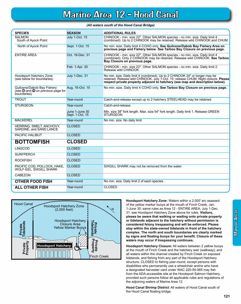
(All waters south of the Hood Canal Bridge)
SPECIES SEASON ADDITIONAL RULESSALMON South of Ayock Point
July 1-Oct. 15 CHINOOK - min. size 22". Other SALMON species - no min. size. Daily limit 4 (combined). Up to 2 CHINOOK may be retained. Release wild CHINOOK and CHUM.
North of Ayock Point Sept. 1-Oct. 15 No min. size. Daily limit 4 COHO only. See Quilcene/Dabob Bay Fishery Area on previous page and Fishery below. See Tarboo Bay Closure on previous page.
ENTIRE AREA Oct. 16-Dec. 31 CHINOOK - min. size 22". Other SALMON species - no min. size. Daily limit 4 (combined). Only 2 CHINOOK may be retained. Release wild CHINOOK. See Tarboo Bay Closure on previous page.
Feb. 1-Apr. 30 CHINOOK - min. size 22". Other SALMON species - no min. size. Daily limit 2. Release wild CHINOOK.
Hoodsport Hatchery Zone (see below for boundaries)
July 1-Dec. 31 No min. size. Daily limit 4 (combined). Up to 2 CHINOOK 24" or longer may be retained. Release wild CHINOOK. July 1-Oct. 15: release CHUM. Night closure. Please respect private property adjacent to hatchery (see map and description below).
Quilcene/Dabob Bay Fishery (see 7 and 8 on previous page for boundaries)
Aug. 16-Oct. 15 No min. size. Daily limit 4 COHO only. See Tarboo Bay Closure on previous page.
TROUT Year-round Catch-and-release except up to 2 hatchery STEELHEAD may be retained.
STURGEON Year-round
June 1-June 30Sept. 1-Oct. 15
Catch-and-release.
Min. size 38" fork length. Max. size 54" fork length. Daily limit 1. Release GREEN STURGEON.
MACKEREL Year-round No min. size. No daily limit.
HERRING, SMELT, ANCHOVY, SARDINE, and SAND LANCE
CLOSED
PACIFIC HALIBUT CLOSED
BOTTOMFISH CLOSEDLINGCOD CLOSED
SURFPERCH CLOSED
ROCKFISH CLOSED
PACIFIC COD, POLLOCK, HAKE,WOLF-EEL, SIXGILL SHARK
CLOSED SIXGILL SHARK may not be removed from the water.
CABEZON CLOSED
OTHER FOOD FISH Year-round No min. size. Daily limit 2 of each species.
ALL OTHER FISH Year-round CLOSED
N
Hood Canal Hoodsport Hatchery Zone(2,000 feet)
Hoodsport HatcheryClosure Area
Yellow Marker Buoys
Finch Creek
PrivateProperty
Priv
ate
Prop
erty
Hoodsport Hatchery
Priv
ate
Tide
land
s PrivateTidelands
Hoodsport Hatchery Zone: Waters within a 2,000' arc seaward of the yellow marker buoys at the mouth of Finch Creek, Jan. 1-June 30: same rules as Area 12 - ENTIRE AREA; July 1-Dec. 31: see Hoodsport Hatchery Zone above for rules. Visitors, please be aware that walking or wading onto private property or tidelands adjacent to the hatchery without permission is considered felony trespassing and will be enforced. Please stay within the state-owned tidelands in front of the hatchery complex. The north and south boundaries are clearly marked by signs and floating buoys for your benefit. Closure of these waters may occur if trespassing continues.
Hoodsport Hatchery Closure: All waters between 2 yellow buoys at the mouth of Finch Creek and the hatchery weir (walkway); and all waters within the channel created by Finch Creek on exposed tidelands, and fishing from any part of the Hoodsport Hatchery structure, CLOSED to fishing year-round, except persons with disabilities who permanently use a wheelchair and/or who have a designated harvester card under WAC 220-55-065 may fish from the ADA-accessible site at the Hoodsport Salmon Hatchery, provided such persons follow all applicable rules and regulations of the adjoining waters of Marine Area 12.
Hood Canal Shrimp District: All waters of Hood Canal south of the Hood Canal floating bridge.
Mar
ine
Are
as
121
Marine Area 12 - Hood Canal
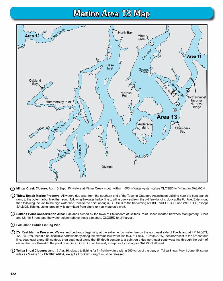
Hood Canal
Area 13
Oakland Bay
Anderson Island
Olympia
Bud
d In
let
Eld Inlet
T otten Inlet
Hammersley Inlet
Case Inlet
North Bay
Carr I
nlet
Fox Island Hale Passage Northernmost
Tacoma Narrows Bridge
Area 12
Chambers Bay
Minter Creek
3
5
4
2
6
Area 11
Penrose Point
Green Point
1
2
Minter Creek Closure: Apr. 16-Sept. 30: waters at Minter Creek mouth within 1,000' of outer oyster stakes CLOSED to fishing for SALMON.
Titlow Beach Marine Preserve: All waters due west from the southern end of the Tacoma Outboard Association building near the boat launch ramp to the outer harbor line, then south following the outer harbor line to a line due west from the old ferry landing dock at the 6th Ave. Extension, then following the line to the high water line, then to the point of origin, CLOSED to the harvesting of FISH, SHELLFISH, and WILDLIFE, except SALMON fishing, using lures only, is permitted from shore or non-motorized craft.
Saltar's Point Conservation Area: Tidelands owned by the town of Steilacoom at Saltar's Point Beach located between Montgomery Street and Martin Street, and the water column above these tidelands, CLOSED to all harvest.
Fox Island Public Fishing Pier
Z's Reef Marine Preserve: Waters and bedlands beginning at the extreme low water line on the northeast side of Fox Island at 47°14.56'N, 122°35.98'N, then 0.5 nautical mile northwesterly along the extreme low water line to 47°14.96'N, 122°36.37'W, then northeast to the 85' contour line, southeast along 85' contour, then southeast along the 85' depth contour to a point on a due northeast-southwest line through the point of origin, then southwest to the point of origin, CLOSED to all harvest, except for fly fishing for SALMON allowed.
Toliva Shoal Closure: June 16-Apr. 30: closed to fishing for fin fish in waters within 500 yards of the buoy on Toliva Shoal. May 1-June 15: same rules as Marine 13 - ENTIRE AREA, except all rockfish caught must be released.
3
4
5
6
1
122
Marine Area 13 Map
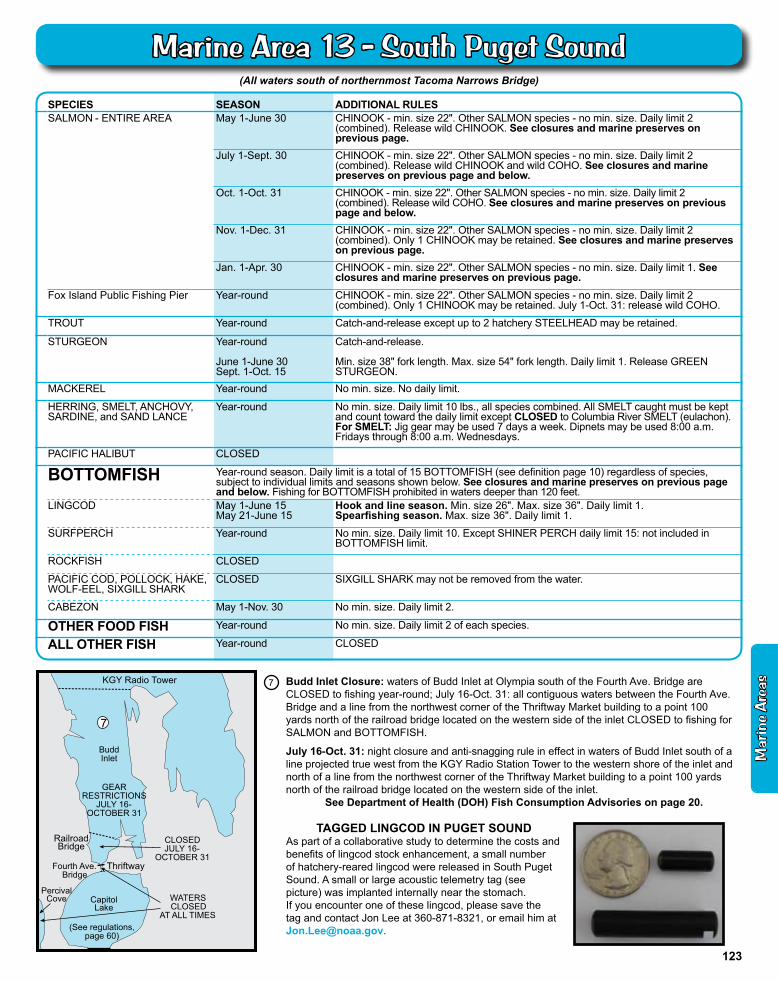
Railroad Bridge
KGY Radio T ower
Thriftway
Capitol Lake
Percival Cove
7
WATERS CLOSED
AT ALL TIMES
CLOSED JULY 16-
OCTOBER 31
GEAR RESTRICTIONS
JULY 16- OCTOBER 31
(See regulations,page 60)
Fourth Ave. Bridge
Budd Inlet
(All waters south of northernmost Tacoma Narrows Bridge)
Budd Inlet Closure: waters of Budd Inlet at Olympia south of the Fourth Ave. Bridge are CLOSED to fishing year-round; July 16-Oct. 31: all contiguous waters between the Fourth Ave. Bridge and a line from the northwest corner of the Thriftway Market building to a point 100 yards north of the railroad bridge located on the western side of the inlet CLOSED to fishing for SALMON and BOTTOMFISH.
July 16-Oct. 31: night closure and anti-snagging rule in effect in waters of Budd Inlet south of a line projected true west from the KGY Radio Station Tower to the western shore of the inlet and north of a line from the northwest corner of the Thriftway Market building to a point 100 yards north of the railroad bridge located on the western side of the inlet.
See Department of Health (DOH) Fish Consumption Advisories on page 20.
SPECIES SEASON ADDITIONAL RULESSALMON - ENTIRE AREA May 1-June 30 CHINOOK - min. size 22". Other SALMON species - no min. size. Daily limit 2
(combined). Release wild CHINOOK. See closures and marine preserves on previous page.
July 1-Sept. 30 CHINOOK - min. size 22". Other SALMON species - no min. size. Daily limit 2 (combined). Release wild CHINOOK and wild COHO. See closures and marine preserves on previous page and below.
Oct. 1-Oct. 31 CHINOOK - min. size 22". Other SALMON species - no min. size. Daily limit 2 (combined). Release wild COHO. See closures and marine preserves on previous page and below.
Nov. 1-Dec. 31 CHINOOK - min. size 22". Other SALMON species - no min. size. Daily limit 2 (combined). Only 1 CHINOOK may be retained. See closures and marine preserves on previous page.
Jan. 1-Apr. 30 CHINOOK - min. size 22". Other SALMON species - no min. size. Daily limit 1. See closures and marine preserves on previous page.
Fox Island Public Fishing Pier Year-round CHINOOK - min. size 22". Other SALMON species - no min. size. Daily limit 2 (combined). Only 1 CHINOOK may be retained. July 1-Oct. 31: release wild COHO.
TROUT Year-round Catch-and-release except up to 2 hatchery STEELHEAD may be retained.
STURGEON Year-round
June 1-June 30Sept. 1-Oct. 15
Catch-and-release.
Min. size 38" fork length. Max. size 54" fork length. Daily limit 1. Release GREEN STURGEON.
MACKEREL Year-round No min. size. No daily limit.
HERRING, SMELT, ANCHOVY, SARDINE, and SAND LANCE
Year-round No min. size. Daily limit 10 lbs., all species combined. All SMELT caught must be kept and count toward the daily limit except CLOSED to Columbia River SMELT (eulachon). For SMELT: Jig gear may be used 7 days a week. Dipnets may be used 8:00 a.m. Fridays through 8:00 a.m. Wednesdays.
PACIFIC HALIBUT CLOSED
BOTTOMFISH Year-round season. Daily limit is a total of 15 BOTTOMFISH (see definition page 10) regardless of species, subject to individual limits and seasons shown below. See closures and marine preserves on previous page and below. Fishing for BOTTOMFISH prohibited in waters deeper than 120 feet.
LINGCOD May 1-June 15 May 21-June 15
Hook and line season. Min. size 26". Max. size 36". Daily limit 1.Spearfishing season. Max. size 36". Daily limit 1.
SURFPERCH Year-round No min. size. Daily limit 10. Except SHINER PERCH daily limit 15: not included in BOTTOMFISH limit.
ROCKFISH CLOSED
PACIFIC COD, POLLOCK, HAKE,WOLF-EEL, SIXGILL SHARK
CLOSED SIXGILL SHARK may not be removed from the water.
CABEZON May 1-Nov. 30 No min. size. Daily limit 2.
OTHER FOOD FISH Year-round No min. size. Daily limit 2 of each species.
ALL OTHER FISH Year-round CLOSED
7
TAGGED LINGCOD IN PUGET SOUNDAs part of a collaborative study to determine the costs and benefits of lingcod stock enhancement, a small number of hatchery-reared lingcod were released in South Puget Sound. A small or large acoustic telemetry tag (see picture) was implanted internally near the stomach.If you encounter one of these lingcod, please save the tag and contact Jon Lee at 360-871-8321, or email him at [email protected].
Mar
ine
Are
as
123
Marine Area 13 - South Puget Sound