saturday, september 22, 2018 8:30 a.m. edtdaily+ops+briefing+09-22-2018.pdf · 9/22/2018 ·...
TRANSCRIPT

Saturday, September 22, 2018
8:30 a.m. EDT

Significant Activity – Sep 21-22Significant Events: Hurricane Florence response
Tropical Activity:
• Atlantic – Tropical Depression Eleven; Disturbance 1: Medium (60%); Disturbance 2: Low (30%); Disturbance 3: High
(70%)
• Eastern Pacific – Disturbance 1: Medium (60%)
• Central Pacific – Tropical cyclone activity is not expected during next 48 hours
• Western Pacific – No activity affecting U.S. interests
Significant Weather:
• Flash flooding possible – Southern Plains to Lower Mississippi and Tennessee valleys
• Critical and elevated fire weather – CA, NV, UT, WY, ID & MT
• Red Flag Warnings – NV, UT, ID, CO, WY & SD
Declaration Activity:
• Major Disaster Declaration request – U.S. Territory of Guam
• Amendment No. 1 to FEMA-4388-DR-MT
• Amendment No. 1 to FEMA-4394-DR-SC
• Amendment No. 1 to FEMA-3402-EM-CNMI
• FMAG approved – Bald Mountain Fire, UT

Florence – Lifelines/Response
Safety & Security: NC: Dams are stabilizing as flood levels decrease through
watersheds; assessments ongoing and Civil Air Patrol flying missions as needed by
state dam regulators for situational awareness
Food, Water and Shelter:
• NC: 34 (-18) shelters open with 2,885 (-2,337) occupants
• SC: 15 shelters open with 204 occupants
• KY: 1 shelter open with 8 occupants; TN: 2 shelter open with 14 occupants
Health and Medical: 40 Confirmed fatalities in NC & SC
• SC: All hospitals open in affected area; monitoring hospitals and 4 nursing homes in
potential inundation area
Energy:
• NC: 55,232 (1.1%) total outages reported statewide; largest concentration of
customer outages in New Hanover County
• NC: 14% (-2) of gas stations out-of-service due to lack of fuel and/or power; fuel
outages are concentrated in Wilmington and Greenville/New Bern/Washington Area
(35% reporting no fuel)
Communications: NC: 22% (-2) of broadband internet service out in impacted
counties, largely attributed to lack of power
Transportation:
• NC: Approximately 649 (-164) roads closed due to flooding; to include closures on I-
95, I-40 and US-70; 9 of 11 bridges to Barrier Islands re-opened
• SC: 169 road closures; US-501 re-opened north of Conway; flood mitigation work
continues on US-17; detours in place for flooded portions of I-95
Hazardous Waste: NC: At least 28 wastewater treatment plants (WWTPs) impacted,
affecting at least 26 counties; state engaged with WWTPs on generator requirements
and fuel delivery
FEMA HQ
• NRCC at Level III (Day shift); Enhanced Watch (Night shift)
• National IMAT East-1 deployed to NC EOC
• Composite IMAT deployed to SC EOC
• MERS assets deployed
• Region VIII IMAT deployed to NC EOC
• Region V IMAT demobilizing from FEMA HQ today
Region IV
• RRCC at Level III with select ESFs (Day shift)
• RWC at Steady State
• LNOs deployed to NC & SC
• DCO/DCE deployed to NC & SC
• IMAT 1 deployed to NC; IMAT 2 deployed to SC
North Carolina (FEMA-4393-DR-NC & 3401-EM-NC):
• EOC at Full Activation; State of Emergency declared
• US&R: Red IST, 2 – Type 3; 3 – MRP Water Teams
South Carolina (FEMA-4394-DR-SC & FEMA-3400-EM-SC):
• EOC at Full Activation; State of Emergency declared
• US&R: 2 – Type 1; 1 MRP Water Team; 1 HEPP
Tennessee & Kentucky: EOCs at Monitoring (EMAC support)
Region III
• 2 IMATs (Type III) demobilized from VA
• Virginia (FEMA-3403-EM-VA): EOC at Monitoring
NC
SC
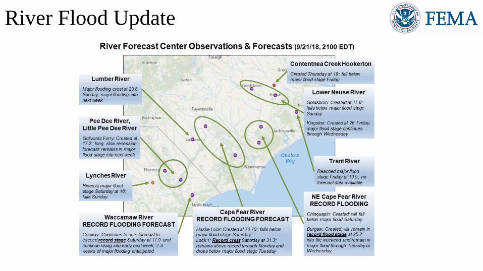
River Flood Update

Tropical Outlook – Atlantic
Tropical Depression Eleven (Advisory #2 as of 5:00 a.m. EDT)
• Located 505 miles E of the Windward Islands
• Moving W at 5 mph
• Maximum sustained winds 35 mph
• Expected to dissipate east of the Lesser Antilles by Sunday night
Disturbance 1 (as of 8:00 a.m. EDT)
• Located 500 miles S of the southern Cabo Verde Islands
• Moving W at 20 mph; tropical depression appears to be forming
• Formation chance through 48 hours: High (80%)
• Formation chance through 5 days: High (80%)
Disturbance 2 (as of 8:00 a.m. EDT)
• Located 200 miles S of Bermuda; moving W then WNW
• Formation chance through 48 hours: Low (10%)
• Formation chance through 5 days: Low (30%)
Disturbance 3 (as of 8:00 a.m. EDT)
• Located 900 miles WSW of the Azores; meandering over central Atlantic Ocean
• Subtropical or tropical cyclone is likely to form by early next week
• Formation chance through 48 hours: Medium (60%)
• Formation chance through 5 days: High (70%)
5-Day
3
70%
1
80%
2
30%

Tropical Outlook – Eastern Pacific
Disturbance 1 (as of 8:00 a.m. EDT)
• Expected to form in a couple of days well to the south of the
southern coast of Mexico
• Tropical depression could form by middle of next week
• Formation chance through 48 hours: Low (near 0%)
• Formation chance through 5 days: Medium (60%)
5-Day
48 hour
1
60%
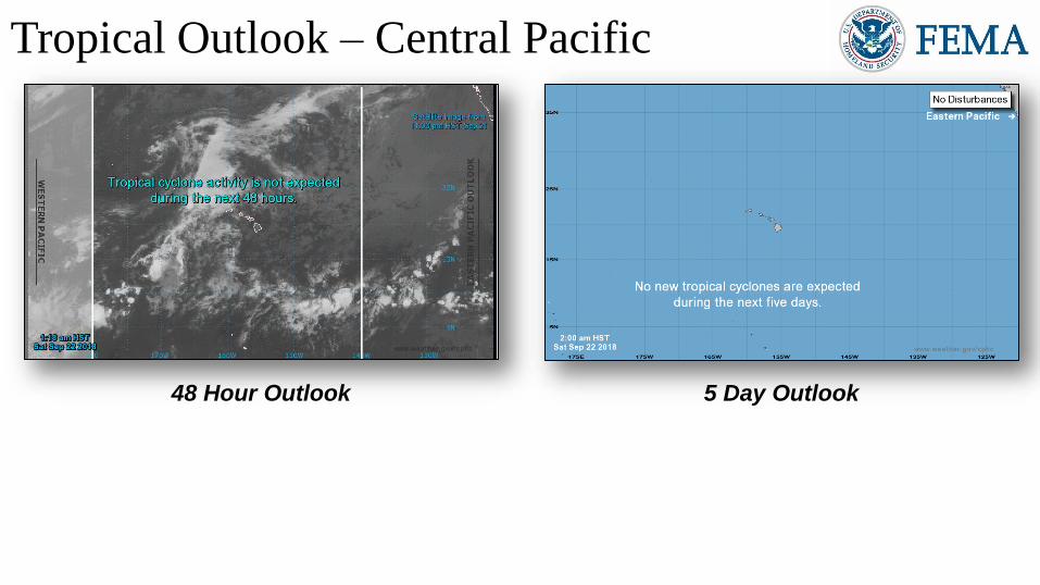
Tropical Outlook – Central Pacific
48 Hour Outlook 5 Day Outlook
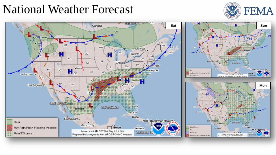
National Weather ForecastSun
Mon
Sat

Severe Weather OutlookSat Sun
Mon

Precipitation / Excessive Rainfall Forecast
Mon
Sat
Sun
Sat – Mon

Fire Weather Outlook
Saturday Sunday

Hazards Outlook – Sep 24-28

Space Weather
Space Weather
Activity
Geomagnetic
Storms
Solar
Radiation
Radio
Blackouts
Past 24 Hours Minor G1 None None
Next 24 Hours Minor G1 None None
For further information on NOAA Space Weather Scales refer to: http://www.swpc.noaa.gov/noaa-scales-explanation
HF Communication Impact Sunspot Activity

Bald Mountain Fire – UT
Current Situation
• Fire began August 24, 2018 and is threatening communities in
and around Utah County (pop. 592k) and is burning on federal
(94%), State (2%), and private (4%) land
• Threatening homes, Nebo Loop Road (tourist attraction) and a
flood control diversion dam
• At least two watersheds have been destroyed
• Mandatory and voluntary evacuations are in effect for
approximately 6,000 people
Response• UT EOC at Partial Activation (wildfires)
• Region VIII at Steady State but continues to monitor
Fire Name
(County)
FMAG # /
Approved
Acres
burned
Percent
Contained
Evacuations
(Residents)
Structures Fatalities
/
InjuriesThreatened Damaged Destroyed
Bald Mountain Fire
(Utah)
XXXX-FM-UT
Sept 21 ,201818,502 18%
Mandatory
(6,000)2,600 homes 0 0 0 / 0

Wildfire SummaryFire Name
(County)
FMAG
Number
Acres
Burned
Percent
Contained Evacuations
Structures Fatalities /
InjuriesThreatened Damaged Destroyed
Wyoming (1)
Roosevelt Fire
(Sublette)5276-FM-WY
34,411
(+2,730)
15%
(+15%)Mandatory
472
(251 homes)0
4 (+3)
(2 homes)0 / 0

Joint Preliminary Damage Assessments
RegionState /
LocationEvent IA / PA
Number of CountiesStart – End
Requested Completed
III
PASevere Weather
July 21 – 27, 2018
IA 12 9 (+3) 9/19 – TBD
PA 14 8 (+2) 9/20 – TBD
PASevere Weather
August 10 – 15, 2018
IA 14 9 (+3) 9/19 – TBD
PA 13 5 (+1) 9/20 – TBD
V WIFlooding and Severe Weather
August 17 – September 14, 2018
IA 16 0 9/24 – TBD
PA 15 0 9/24 – TBD
VII KSSevere Storms and Flooding
September 1 – 8, 2018
IA N/A N/A N/A
PA 9 0 9/24 - TBD
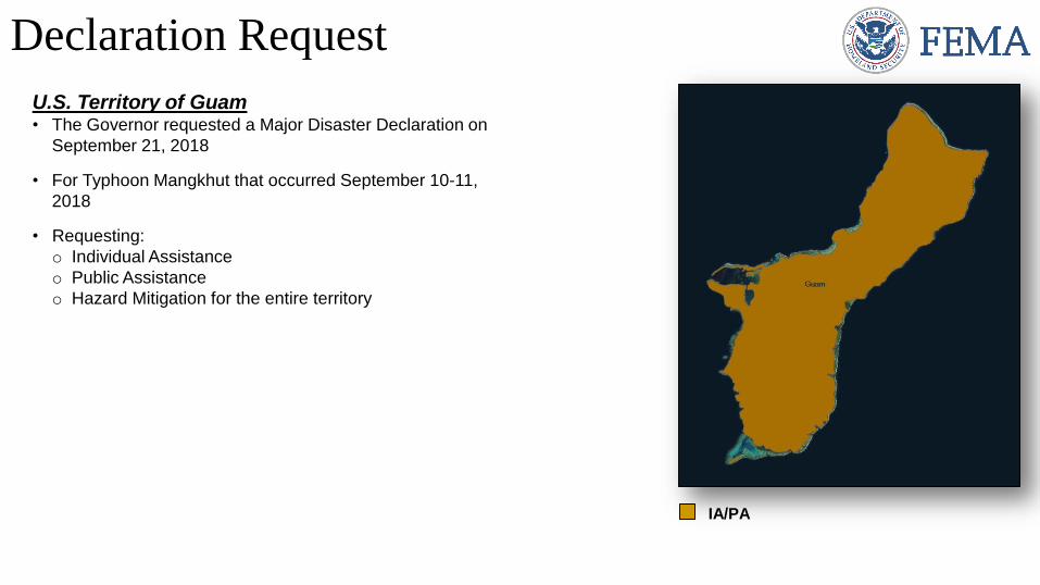
Declaration Request
U.S. Territory of Guam• The Governor requested a Major Disaster Declaration on
September 21, 2018
• For Typhoon Mangkhut that occurred September 10-11,
2018
• Requesting:
o Individual Assistance
o Public Assistance
o Hazard Mitigation for the entire territory
IA/PA

Declaration Requests in ProcessRequests
APPROVED(since last report)
Requests
DENIED(since last report)
7 IA PA HM Date Requested 0 0
LA – DR Flooding X X June 29, 2018
NJ – DR Severe Storms and Flooding X X August 30, 2018
HI – DR Hurricane Lane and Wildfires X X X September 5, 2018
PA – (Appeal) DR Severe Storms, Flooding, and Landslides X X September 7, 2018
NY – DR Severe Storms and Tornadoes X X September 9, 2018
CNMI – DR Typhoon Mangkhut X X X September 20, 2018
Guam – DR Typhoon Mangkhut X X X September 21, 2018
Disaster Requests & Declarations

Disaster Amendments
Amendment Date Issued Action
Amendment No. 1 to FEMA-4388-DR-MT September 18, 2018 Adds one county for Public Assistance
Amendment No. 1 to FEMA-4394-DR-SC September 21, 2018
Adds 4 counties for Individual Assistance, and 2 counties for
emergency protective measures (Category B), including direct
federal assistance, under the PA program
Amendment No. 1 to FEMA-3402-EM-CNMI September 21, 2018 Closes the incident period effective September 11, 2018

Readiness – Deployable Teams and Assets
National
IMATs*(1-2 Teams)
East 1: Deployed
Composite: Deployed
West: B-2
Regional
IMATs(< 3 Teams)
Assigned: 13
Available: 3
PMC / NMC: 4 (+1)
Deployed: 6 (-1)
National
ISBs(0 Teams)
Team A Deployed
Team B Deployed
Team C Deployed
US&R(< 33%)
Assigned: 28
Available: 8
PMC / NMC: 11
Deployed: 9
MERS(33-65%)
Assigned: 36
Available: 22 (+1)
PMC / NMC: 0
Deployed: 14 (-1)
FCO(≤ 1 Type I)
Assigned: 33
Available: 15 (+2)
PMC / NMC: 3 (+1)
Deployed: 15 (-3)
FDRC(< 3)
Assigned: 14
Available: 1
PMC / NMC: 3
Deployed: 10
* B-2 Status: Assemble ≤ 2-hrs, On Site ≤ 18-hrs; B-48 Status: Assemble and deploy ≤ 48hrs; Charlie Status: No team assemble time requirement
Resource Force Strength Available Deployed Other Cadres with 25% or Less Availability
IM Workforce 11,935 2,079 17% 6,351 3,505DSA 12% (103/836); EHP 8% (33/412); ER 0% (0/44); FL 20% (32/157); FM 19% (50/267);
HM 22% (210/970); HR 7% (16/235); IA 19% (528/2,809); IT 9% (59/633); LOG 10% (112/1,161);
OPS 15% (40/266); PA 9% (171/1,819); PLAN 10% (34/336); SAF 4% (2/53); SEC 6% (6/109)

FEMA Readiness – Activation Teams
StatusActivated
Team
Activation
Level
Activation
TimesReason / Comments
NWC Steady State Enhanced WatchDay shift
(beginning Sep 24)U.N. General Assembly
NRCC Activated BlueLevel III
Enhanced Watch
Day shift
Night shiftTropical Cyclone Florence
HLT Activated
RWC / MOCs(10 Regions)
Available
RRCCs(10 Regions)
Activated Region IV Level III Day shift Tropical Cyclone Florence

FEMA’s mission is helping people
before, during, and after disasters.