schedule 6: rural subdivision design guide rural
TRANSCRIPT

SCHEDULE 6: Rural Subdivision Design Guide
Horowhenua District Plan Schedule 6-1
RURAL SUBDIVISION DESIGN GUIDE
SCHEDULE 6: Rural Subdivision Design Guide
Schedule 6-2 Horowhenua District Plan
This page has been intentionally left blank.

www.horowhenua.govt.nz
Horowhenua - Rural Subdivision and Development Design Guide
September 2015


RURAL SUBDIVISION AND DEVELOPMENT DESIGN GUIDE 2015 3
This Design Guide is organised into the following fi ve sections:
1. Introduction2. Process3. Guidelines4. Outcomes5. Appendices
The Introduction explains the purpose of the Design Guide including how it should be applied.
The Process section sets out the process steps that anyone considering undertaking a subdivision or land use consent for development within an Outstanding Natural Landscape or a landscape with high amenity should follow before lodging an application.
The Guidelines section provides details on design methods and practical solutions that are intended to assist in achieving the objectives and policies set out within the District Plan.
The Outcomes section contains details of the objectives and policies contained in the Rural Environment section of the Plan that the Guidelines seek to achieve.
The Appendices include useful references and sources of information to assist in the subdivision and development design process.
How to use this Design Guideline
Document Structure

RURAL SUBDIVISION AND DEVELOPMENT DESIGN GUIDE 20154
This Design Guide is relevant to all rural zoned properties in the Horowhenua District Plan. The Design Guide has been developed to provide guidance for those undertaking subdivision and development within the rural environment and in doing so promote and encourage well designed developments that sensitively respond to their surroundings. The Design Guide provides a set of guidelines to inform landowners, developers, potentially affected people and the wider community about rural subdivision and development expectations within the Horowhenua rural environment.
The Design Guide does not seek to impose rules on new development, or to prescribe specifi c design solutions. Rather, it offers a fl exible framework within which developers and surveyors can work to achieve good design outcomes. Based on the existing character of the rural environment, this framework identifi es key subdivision design principles to assist the integration of new subdivision development into the surrounding context and to enhance the character of the area. This means that while development proposals are expected to demonstrate a commitment to enhancing the character and quality of the area, this Design Guide provides options for how this may be achieved through the design of the subdivision or development.
This Design Guide also provides advice on the design of buildings in Outstanding Natural Landscapes and landscapes with high amenity, including guidance on building site selection and measures to reduce the visual impact of buildings.
The Design Guide serves as a method to implement the objectives and policies of the District Plan. It is intended to assist applicants in designing subdivision and development proposals that are consistent with the objectives and policies.
The illustrations in the guide are intended to further clarify principles and outcomes outlined in the text, and are not intended to represent actual design solutions.
Advisory Note: It is noted that the Design Guide covers a wide range of issues. Not all issues addressed in this Design Guide will apply to every subdivision or development, therefore, some of the guidelines will not be applicable in every situation. For example, if there are no waterbodies within, adjacent to or near the subject site, the applicant would not be expected to demonstrate that the subdivision design is in accordance with the guidelines relating to waterbodies.
Purpose
1.0 Introduction 1.0 Introduction

RURAL SUBDIVISION AND DEVELOPMENT DESIGN GUIDE 2015 5
Read through the Design Guide so you are familiar with the format and content of the document and then begin by working through the
process steps as set out in Section 2 of this Design Guide.
You will fi nd it useful to refer to Section 3 throughout the Design
Options phase of the process steps.
How it AppliesThere are a number of objectives and policies within the District Plan which are relevant to subdivision and development in the Rural zone. The policies most relevant to development in the Rural zone are contained within Chapter 2 (Rural Environment) of the District Pan. These policies articulate what it is that Council seeks in the rural environment. Objectives and policies contained within other chapters of the District Plan including the Coastal Environment, Natural Features and Values, Historic Heritage, and Natural Hazards, can also be relevant when considering development in the rural environment.
The rural subdivision rules require that subdivisions are designed in accordance with the Design Guide for Restricted Discretionary, Discretionary and Non-Complying subdivisions. It will still be relevant and benefi cial to Controlled Activity subdivisions, although a Controlled Activity application can not be declined on the basis that it is not in accordance with this Design Guide. Specifi c assessment criteria relating to the Rural Zone also direct Council to assess the extent to which a subdivision or land use proposal is in accordance with the Rural Subdivision and Development Design Guide.
To demonstrate that the subdivision design is in accordance with the Design Guide, applicants need to document and demonstrate to the Council that the subdivision is in accordance with the following:
1. Consistency with the Process of the Design Guide.2. Consistency with the Guidelines of the Design Guide.
1.0 Introduction

RURAL SUBDIVISION AND DEVELOPMENT DESIGN GUIDE 20156
Coastal Sand Country
The coastal sand country forms the western edge to the Horowhenua. The key characteristics of the coastal sand country are the dune formations, including the fragile and dynamic foredunes through to the more stable and defi ned inland dunes, the interdunal fl ats and wetlands and coastal lakes. These features are highly valued and contribute to the character and identity of the Horowhenua. It is important the nature, intensity and design of any subdivision recognises and is integrated with this character.
Important issues to consider when designing subdivisions in coastal areas include:
• The impact of earthworks and erosion on sensitive dune landforms• The provision of water, stormwater, greywater and wastewater
infrastructure• The visual integration of structures into the dune formations• The protection and enhancement of coastal wetlands, lakes and native
vegetation
Restrictions on building height and building on dunes apply in the Coastal Environment and Coastal Lakes Landscape Domains, excluding buildings used for primary production activities and temporary activities. Restrictions on building height also apply to any land identifi ed as an Outstanding Natural Feature or Landscape in the District Plan.
Important issues to consider when building or developing within coastal areas include:
• The visual and locational integration of structures into the coastal landscape.• Designing structures that sensitively respond to their coastal location.
Inland Plains and River Terraces
The inland plains and river terraces are located centrally within the district. The inland plains have a characteristic of fl at to gently rolling landform with river terraces. The overall landscape has a “green”, vegetated, farmed character refl ecting the fertile soils and their productive use. The existing landholding and land use creates a patchwork effect across this landscape. Subdivision is to be carefully managed to protect the productive use of this land resource, while also providing the ability to provide for discrete small scale rural living.
Important issues to consider when designing subdivisions on the inland plains and river terraces include:
• The retention of productive landuses• The retention of highly versatile soil for existing or future productive
landuses• The impact of earthworks on the distinctive river terraces• The reduced opportunities to visually integrate development into the
landscape (except where there are signifi cant areas of trees or where the land backs onto the hill country)
• The preservation and enhancement of natural values including those of waterways, remnant bush and wetlands
• The potential risk of fl ooding• Groundwater levels and ponding which affects building and stormwater,
greywater and wastewater sites
Which Rural Land Type?
The Horowhenua’s rural area is a varied environment with three broad land types: being the distinctive coastal sand country characterised by sand dune formations and natural features; the inland plains and river terraces comprising fl at fertile land; and the hill country that forms the backdrop to the District.
1.0 Introduction

RURAL SUBDIVISION AND DEVELOPMENT DESIGN GUIDE 2015 7
Inland Plains and River Terraces
Coastal Sand Country
Hill Country
The hill country provides a backdrop along the eastern edge of the Horowhenua. This backdrop is characterised by steep hills with a mixed large scale land use pattern, with dry stock grazing, plantation forestry and remnant and regenerating indigenous vegetation predominating. As a backdrop, any subdivision needs to consider the highly visible nature of new access, earthworks and buildings.
Other issues to consider include:
• Erosion and siltation of rivers• Inappropriate landuses on steep, exposed or highly prominent land• Enhancing public recreational activities and links to the Conservation
estate.
Restrictions on building height and building below important ridgelines apply in the Hill Country Landscape Domain excluding buildings used for primary production activities and temporary activities. Restrictions on building height also apply to any land identifi ed as an Outstanding Natural Feature or Landscape in the District Plan.
Important issues to consider when developing within the Hill Country Landscape Domain include:
• The visual and locational integration of structures into the hill country landscape.
• Designing structures that sensitively respond to their hill country location.
Hill Country
1.0 Introduction

RURAL SUBDIVISION AND DEVELOPMENT DESIGN GUIDE 20158
Horowhenua’s Landscape
Types
1.0 Introduction

RURAL SUBDIVISION AND DEVELOPMENT DESIGN GUIDE 2015 9
2.0 Process
Process Steps
A design process has been developed to guide applicants in preparing and designing subdivisions or developments. Historically subdivision design methods have focused on maximising the number of lots based on the minimum lot size and other standards set out in the District Plan. The design process intended for development in the rural environment and set out in this Design Guide differs from the historic approach.
By following the process below, applicants will fi nd it easier and will be more likely to achieve the guidelines in this Design Guide.
RESEARCH
step
one
COMMUNICATE/CONSULT
step
two
1
2GATHER INFORMATION
step
thre
e
ASSESS + EVALUATE
step
four
34
DOCUMENT PROCESS
step
six 6 PROCEED TO RESOURCE CONSENT PROCESS
DESIGN OPTIONS
stepfi v
e 5
1. Research
• Read the Design Guide• Identify consent requirements, for both subdivision and landuse consents.• Identify any encumbrances registered on the certifi cate of title such as
covenants or consent notices.• Visit the site including the surrounding area and become familiar with it in the
context of the Design Guide.
2. Communicate and Consult
• Discuss your development ideas with Council offi cers and other potentially affected parties. It may be necessary to meet with the Council Offi cers more than once to develop a suitable design that can be lodged as a resource consent application. Council offi cers encourage pre-application meetings to help identify all necessary considerations.
• Make contact with Horizons Regional Council to discuss your proposal as some activities associated with subdividing or developing rural land may require Horizons consent.
• Consider your neighbour’s interests. Discuss your development with them especially if your application is likely to be notifi ed. You may fi nd they have some really worthwhile local knowledge or ideas that could help your development.
RURAL SUBDIVISION AND DEVELOPMENT DESIGN GUIDE 201510
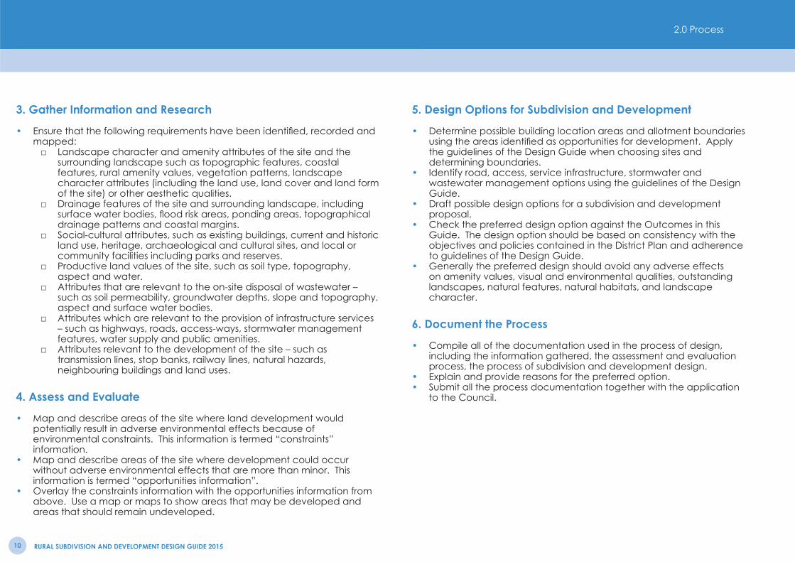
3. Gather Information and Research
• Ensure that the following requirements have been identifi ed, recorded and mapped:
□ Landscape character and amenity attributes of the site and the surrounding landscape such as topographic features, coastal features, rural amenity values, vegetation patterns, landscape character attributes (including the land use, land cover and land form of the site) or other aesthetic qualities.
□ Drainage features of the site and surrounding landscape, including surface water bodies, fl ood risk areas, ponding areas, topographical drainage patterns and coastal margins.
□ Social-cultural attributes, such as existing buildings, current and historic land use, heritage, archaeological and cultural sites, and local or community facilities including parks and reserves.
□ Productive land values of the site, such as soil type, topography, aspect and water.
□ Attributes that are relevant to the on-site disposal of wastewater – such as soil permeability, groundwater depths, slope and topography, aspect and surface water bodies.
□ Attributes which are relevant to the provision of infrastructure services – such as highways, roads, access-ways, stormwater management features, water supply and public amenities.
□ Attributes relevant to the development of the site – such as transmission lines, stop banks, railway lines, natural hazards, neighbouring buildings and land uses.
4. Assess and Evaluate
• Map and describe areas of the site where land development would potentially result in adverse environmental effects because of environmental constraints. This information is termed “constraints” information.
• Map and describe areas of the site where development could occur without adverse environmental effects that are more than minor. This information is termed “opportunities information”.
• Overlay the constraints information with the opportunities information from above. Use a map or maps to show areas that may be developed and areas that should remain undeveloped.
5. Design Options for Subdivision and Development
• Determine possible building location areas and allotment boundaries using the areas identifi ed as opportunities for development. Apply the guidelines of the Design Guide when choosing sites and determining boundaries.
• Identify road, access, service infrastructure, stormwater and wastewater management options using the guidelines of the Design Guide.
• Draft possible design options for a subdivision and development proposal.
• Check the preferred design option against the Outcomes in this Guide. The design option should be based on consistency with the objectives and policies contained in the District Plan and adherence to guidelines of the Design Guide.
• Generally the preferred design should avoid any adverse effects on amenity values, visual and environmental qualities, outstanding landscapes, natural features, natural habitats, and landscape character.
6. Document the Process
• Compile all of the documentation used in the process of design, including the information gathered, the assessment and evaluation process, the process of subdivision and development design.
• Explain and provide reasons for the preferred option.• Submit all the process documentation together with the application
to the Council.
2.0 Process

RURAL SUBDIVISION AND DEVELOPMENT DESIGN GUIDE 2015 11
Landforms and Contours
1 Consider contouring any necessary earthworks on site to harmonise with the surrounding landforms.
2 Avoid major changes to existing natural landforms.
3 Use the existing landforms (such as sand dunes or terraces) and vegetation as a backdrop for new building sites.
4 Consider clustering new buildings to ensure that the development does not detract from the surrounding natural landscape character and to maintain the open rural character.
5 On elevated dune sites, consider locating buildings below the ridgeline or dune top to maintain landform character.
6Carefully consider the use of gully and catchment areas for new lots as these areas can be ecologically sensitive but can offer opportunities for ecological enhancement as part of a subdivision to add character and value.
7 Look at the existing roading, agricultural, vegetation, development and drainage patterns in the broader landscape and use these to guide the design of the subdivision.
8On fl at sites at the foot of a hill or terrace consider locating new building sites near the base of the hill or terrace. This will provide a backdrop to the buildings and help retain rural open space on the fl at land.
9 On elevated Hill Country or Coastal Landscape sites, make the subdivision fi t the land. Consider varying and adjusting allotment sizes to fi t the landforms and contours.
10 Provide roads and access that curve with the landform and avoid hill or dune tops to ensure a good landscape fi t.
11 On rolling or sloping land avoid straight roads that visually disrupt the landform. A uniform subdivision layout can obliterate the existing landform character on these sites.
Landforms, Contours and Landscape FeaturesRiparian Vegetation
Area with High Natural Character
Existing Woody Vegetation
Existing Road
InlandDune
Inland Dune
CoastalForedunes
Stream
Estuarine Area
Sandy Beach
Avoid changing the existing
contour of the site
Retain existing vegetation and enhance them
as part of the subdivision
CoastalForedunesForForForororForororororororedededededededuededeedeFo dd
StreamSSS
Sandy SBeachBBBBBB
3.0 Guidelines
RURAL SUBDIVISION AND DEVELOPMENT DESIGN GUIDE 201512
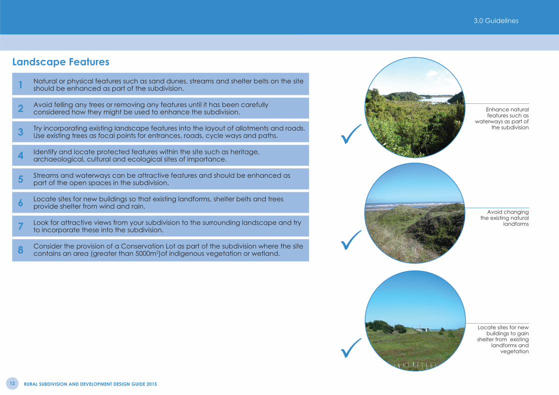
Landscape Features
Locate sites for new buildings to gain
shelter from existing landforms and
vegetation
Avoid changing the existing natural
landforms
Enhance natural features such as
waterways as part of the subdivision
1 Natural or physical features such as sand dunes, streams and shelter belts on the site should be enhanced as part of the subdivision.
2 Avoid felling any trees or removing any features until it has been carefully considered how they might be used to enhance the subdivision.
3 Try incorporating existing landscape features into the layout of allotments and roads. Use existing trees as focal points for entrances, roads, cycle ways and paths.
4 Identify and locate protected features within the site such as heritage, archaeological, cultural and ecological sites of importance.
5 Streams and waterways can be attractive features and should be enhanced as part of the open spaces in the subdivision.
6 Locate sites for new buildings so that existing landforms, shelter belts and trees provide shelter from wind and rain.
7 Look for attractive views from your subdivision to the surrounding landscape and try to incorporate these into the subdivision.
8 Consider the provision of a Conservation Lot as part of the subdivision where the site contains an area (greater than 5000m2)of indigenous vegetation or wetland.
3.0 Guidelines

RURAL SUBDIVISION DESIGN GUIDE 2011 13
Existing Road
Water, Drainage and Stormwater
1 Consider creating an esplanade reserve or access strip along a waterway.
2Ensure that riparian planting is carried out along any river or stream. Generally speaking 10 metres planting each side is recommended, however the steeper the land adjacent to the stream the faster the runoff so a wider riparian strip will be necessary.
3 Use appropriate species for riparian planting – the Environmental Guidelines for Rural Living (2001) provides guidance for the different environments within the Horowhenua.
4Minimise the ‘hard’ stormwater management network (such as pipes and culverts) through the use of swales for collecting, channeling and soakage of stormwater runoff from roads and paths.
5Ensure that the appropriate ecological input is provided for the size, confi guration, edge, slope, plant material, management and maintenance of any wetland to be utilised for stormwater management.
6 Consider opportunities to enhance the natural systems such as wetlands, waterways and low lying areas for their habitat value and as part of recreational networks.
7 Retain the natural drainage characteristics of the landscape including drainage contours, wetlands and streams and integrate them into the network for stormwater management.
8Consider the use of on-site stormwater detention in the management of stormwater to enhance ground water replenishment and/or to provide an alternative source of non-potable water for a range of uses including fi refi ghting and irrigation.Note: (Refer to the New Zealand Fire Service Firefi ghting Water Supplies Code of Practice SNZ PAS 4509:2008 for specifi c details regarding fi refi ghting water supply).
9 Use low impact stormwater design solutions.
10 Fence off riparian margins to prevent stock access to waterways.
11 Avoid earthworks in close proximity to surface water bodies.
12 Provide separation distances between the margins of waterways and building development.
Water, Drainage and StormwaterRiparian Vegetation Adjacent Existing Waterway
Potential Location for On-site Stormwater Storage
Area Suitable For Combined Sewage Treatment
Incorporate existing waterways
as part of the subdivision, ensure riparian planting is
carried out
3.0 Guidelines

RURAL SUBDIVISION AND DEVELOPMENT DESIGN GUIDE 201514
Wastewater
Minimise ‘hard’ stormwater solutions
Ensure riparian planting is located
along any river or stream
Consider on-site stormwater
detention
1Ensure that the disposal fi eld of any wastewater system is located on terrain that is suitable for the disposal of wastewater in terms of soil permeability, drainage, slope, groundwater depth, waterways proximity and aspect.
2 Locate disposal systems so that they do not compromise or become compromised by existing or proposed features including waterways, roads and buildings.
3Encourage effl uent disposal fi elds to be planted and landscaped through thoughtful siting of the disposal fi elds. The Environmental Guidelines for Rural Living (2001) provides a list of species that are suitable for fi ltration planting.
Water Supply
1 Encourage water conservation principles such as rainwater storage and stormwater detention in the design and layout of the subdivision.
2 Collect and store rainwater from roofs of buildings and impermeable surfaces.
3Consider specifi cally collecting and retaining stormwater for non-potable uses such as irrigation and fi refi ghting.Note: (Refer to the New Zealand Fire Service Firefi ghting Water Supplies Code of Practice SNZ PAS 4509:2008 for specifi c details regarding fi refi ghting water supply).
3.0 Guidelines
RURAL SUBDIVISION DESIGN GUIDE 2011 15
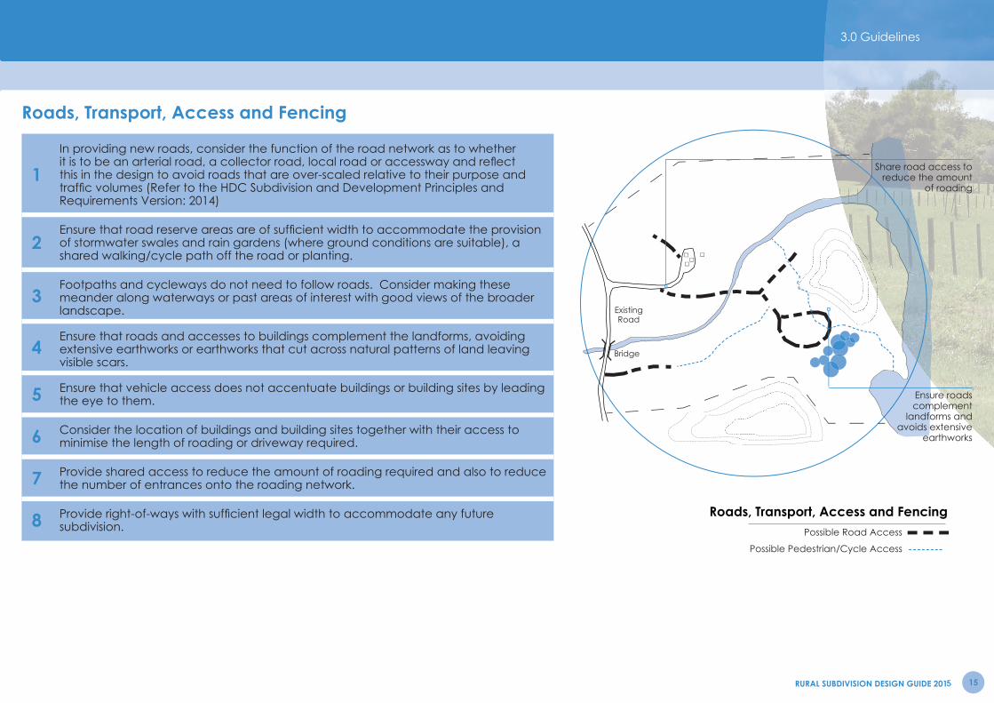
Roads, Transport, Access and Fencing
1In providing new roads, consider the function of the road network as to whether it is to be an arterial road, a collector road, local road or accessway and refl ect this in the design to avoid roads that are over-scaled relative to their purpose and traffi c volumes (Refer to the HDC Subdivision and Development Principles and Requirements Version: 2014)
2Ensure that road reserve areas are of suffi cient width to accommodate the provision of stormwater swales and rain gardens (where ground conditions are suitable), a shared walking/cycle path off the road or planting.
3Footpaths and cycleways do not need to follow roads. Consider making these meander along waterways or past areas of interest with good views of the broader landscape.
4Ensure that roads and accesses to buildings complement the landforms, avoiding extensive earthworks or earthworks that cut across natural patterns of land leaving visible scars.
5 Ensure that vehicle access does not accentuate buildings or building sites by leading the eye to them.
6 Consider the location of buildings and building sites together with their access to minimise the length of roading or driveway required.
7 Provide shared access to reduce the amount of roading required and also to reduce the number of entrances onto the roading network.
8 Provide right-of-ways with suffi cient legal width to accommodate any future subdivision.
Roads, Transport, Access and FencingPossible Road Access
Possible Pedestrian/Cycle Access
Existing Road
Bridge
Share road access to reduce the amount
of roading
Ensure roads complement
landforms and avoids extensive
earthworks
3.0 Guidelines
RURAL SUBDIVISION AND DEVELOPMENT DESIGN GUIDE 201516
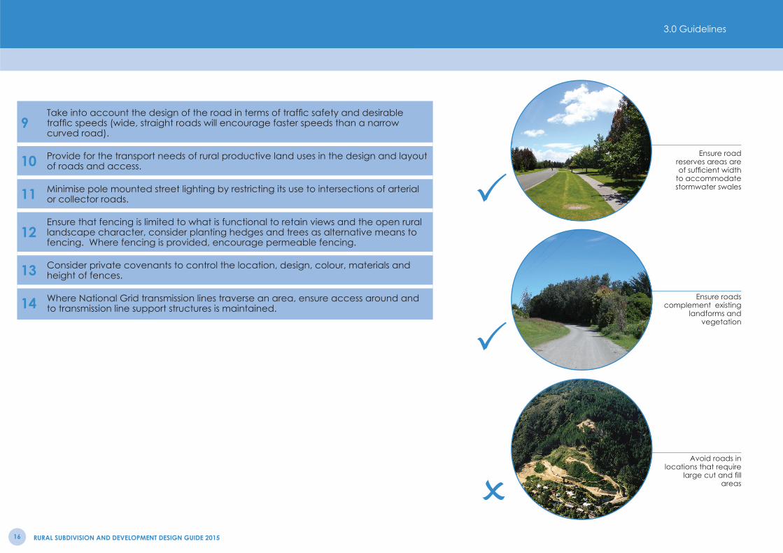
Avoid roads in locations that require
large cut and fi ll areas
Ensure roads complement existing
landforms and vegetation
Ensure road reserves areas are of suffi cient width
to accommodate stormwater swales
9Take into account the design of the road in terms of traffi c safety and desirable traffi c speeds (wide, straight roads will encourage faster speeds than a narrow curved road).
10 Provide for the transport needs of rural productive land uses in the design and layout of roads and access.
11 Minimise pole mounted street lighting by restricting its use to intersections of arterial or collector roads.
12Ensure that fencing is limited to what is functional to retain views and the open rural landscape character, consider planting hedges and trees as alternative means to fencing. Where fencing is provided, encourage permeable fencing.
13 Consider private covenants to control the location, design, colour, materials and height of fences.
14 Where National Grid transmission lines traverse an area, ensure access around and to transmission line support structures is maintained.
3.0 Guidelines

RURAL SUBDIVISION DESIGN GUIDE 2011 17
Allotment Layout and Boundaries
1Provide a variety of allotment shapes and sizes, which are in keeping with landscape values, the topography of the site and the landscape character of the surrounding environment.
2 Look to determine allotment boundaries based on natural landscape contours and geographic features.
3 Determine allotment boundaries with a view to minimising the potential for adverse cross-boundary effects between current and future rural productive uses.
4 Ensure that versatile land is not fragmented by allotment boundaries in a manner that would prevent it from being utilised for existing or future productive land uses.
5 Ensure that allotments for primary production on versatile land are of a practical shape suitable for primary production activities.
6 Consider the siting of boundaries to ensure that impermeable fences are not sited in elevated and prominent locations against the backdrop of the skyline.
7 Ensure allotments containing existing buildings can accommodate all existing services.
8 Where large balance lots are provided as part of the subdivision ensure that the layout and design of the balance lot complements the other lots in the subdivision.
9 Where a Conservation Lot is provided as part of the subdivision, consider providing a buffer area between the protected feature and the allotment boundary.
10Ensure that areas and features with historic heritage value are protected by considering the use of such measures as heritage covenants, setting the area aside as a reserve, excluding the area from the subdivision lot layout and avoiding earthworks where archaeological and other heritage values are present.
11Where National Grid transmission lines traverse an area, ensure that safe buffer distances from the transmission corridor are incorporated into the landscape design for future buildings/structures and associated landscaping (contact Transpower New Zealand for further guidance on developing near high voltage transmission lines).
Allotment Layout and BoundariesProposed Allotment Locations
Existing Contours/Coastal Sand Dunes
Existing Vegetation
Existing Road
Cluster allotments to maximise area
of open space and rural outlook
3.0 Guidelines

RURAL SUBDIVISION AND DEVELOPMENT DESIGN GUIDE 201518
Avoid planting that does not refl ect the existing patterns of
the landscape
Retain existing trees and vegetation to
give instant maturity and identity to a
subdivision
Determine allotment boundaries based
on the natural landscape contours
and site features
Planting and Vegetation
1 Use planting to not only mitigate the adverse effects of development but also to positively enhance the site or landscape.
2 Ensure that remnant or regenerating areas of native vegetation or larger exotic trees are retained within the subdivision layout.
3Look to integrate existing trees and new vegetation within the development to provide focal points or provide privacy or shelter for buildings. Existing vegetation can give ‘instant’ maturity to a subdivision.
4Consider the provision of planting within the subdivision development that will provide a vegetation ‘framework’ providing defi nition to building sites and screening between properties.
5Ensure that trees and plant types are appropriate for the local conditions – the Environmental Guidelines for Rural Living (2001) provides a list of species that are suitable for the different environments within the Horowhenua. Avoid species which do not refl ect the typical vegetation character of the area.
6 Provide a range of plant species to encourage increased biodiversity.
3.0 Guidelines
RURAL SUBDIVISION DESIGN GUIDE 2011 19
Planting and Vegetation
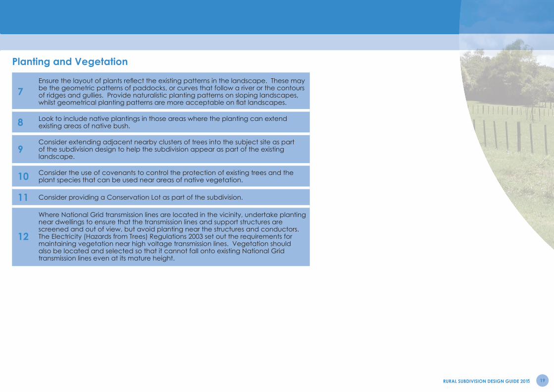
7Ensure the layout of plants refl ect the existing patterns in the landscape. These may be the geometric patterns of paddocks, or curves that follow a river or the contours of ridges and gullies. Provide naturalistic planting patterns on sloping landscapes, whilst geometrical planting patterns are more acceptable on fl at landscapes.
8 Look to include native plantings in those areas where the planting can extend existing areas of native bush.
9Consider extending adjacent nearby clusters of trees into the subject site as part of the subdivision design to help the subdivision appear as part of the existing landscape.
10 Consider the use of covenants to control the protection of existing trees and the plant species that can be used near areas of native vegetation.
11 Consider providing a Conservation Lot as part of the subdivision.
12
Where National Grid transmission lines are located in the vicinity, undertake planting near dwellings to ensure that the transmission lines and support structures are screened and out of view, but avoid planting near the structures and conductors. The Electricity (Hazards from Trees) Regulations 2003 set out the requirements for maintaining vegetation near high voltage transmission lines. Vegetation should also be located and selected so that it cannot fall onto existing National Grid transmission lines even at its mature height.
RURAL SUBDIVISION DESIGN GUIDE 201120
Building Location
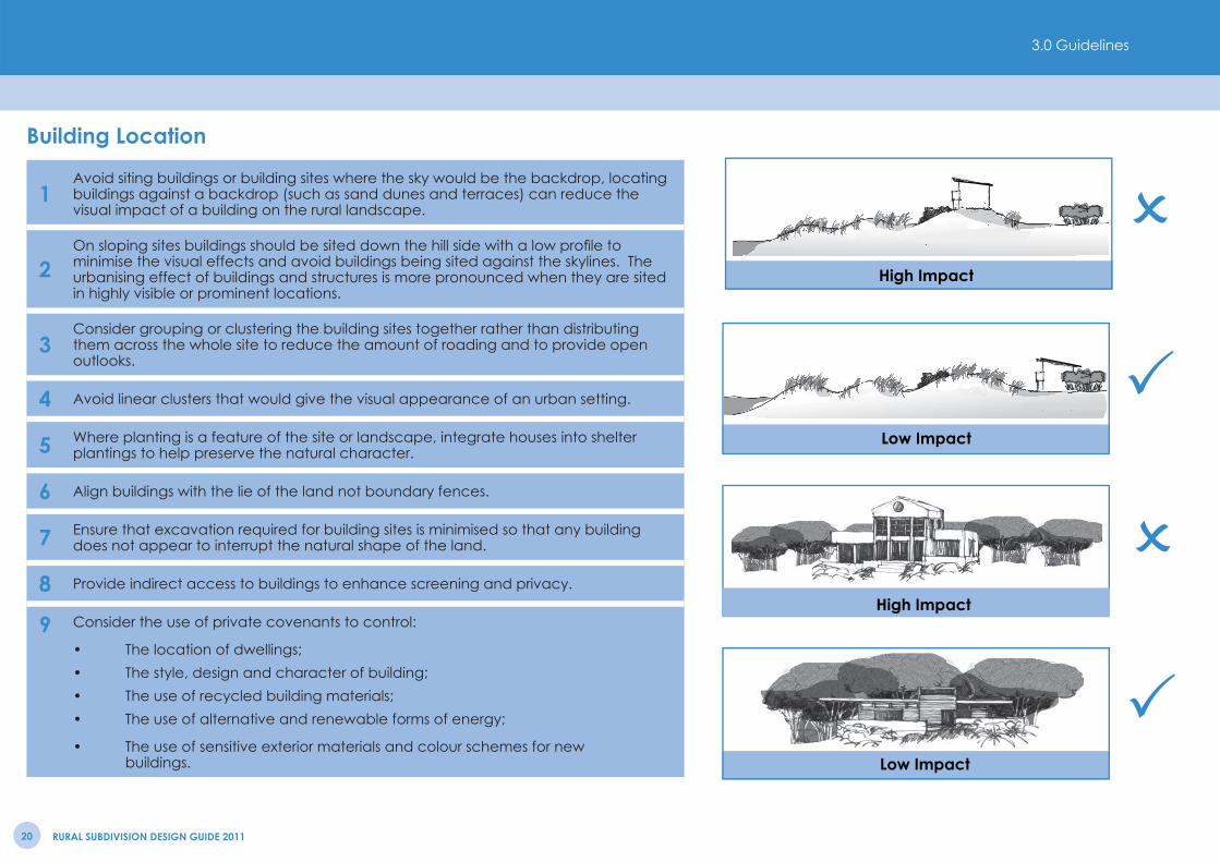
1Avoid siting buildings or building sites where the sky would be the backdrop, locating buildings against a backdrop (such as sand dunes and terraces) can reduce the visual impact of a building on the rural landscape.
2On sloping sites buildings should be sited down the hill side with a low profi le to minimise the visual effects and avoid buildings being sited against the skylines. The urbanising effect of buildings and structures is more pronounced when they are sited in highly visible or prominent locations.
3Consider grouping or clustering the building sites together rather than distributing them across the whole site to reduce the amount of roading and to provide open outlooks.
4 Avoid linear clusters that would give the visual appearance of an urban setting.
5 Where planting is a feature of the site or landscape, integrate houses into shelter plantings to help preserve the natural character.
6 Align buildings with the lie of the land not boundary fences.
7 Ensure that excavation required for building sites is minimised so that any building does not appear to interrupt the natural shape of the land.
8 Provide indirect access to buildings to enhance screening and privacy.
9 Consider the use of private covenants to control:
• The location of dwellings;• The style, design and character of building;• The use of recycled building materials;• The use of alternative and renewable forms of energy;
• The use of sensitive exterior materials and colour schemes for new buildings.
High Impact
Low Impact
High Impact
Low Impact
3.0 Guidelines
RURAL SUBDIVISION AND DEVELOPMENT DESIGN GUIDE 2015 21
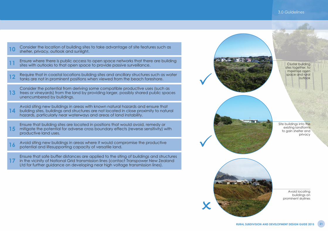
Avoid locating buildings on
prominent skylines
Site buildings into the existing landforms
to gain shelter and privacy
Cluster building sites together, to
maximise open space and rural
outlook
10 Consider the location of building sites to take advantage of site features such as shelter, privacy, outlook and sunlight.
11 Ensure where there is public access to open space networks that there are building sites with outlooks to that open space to provide passive surveillance.
12 Require that in coastal locations building sites and ancillary structures such as water tanks are not in prominent positions when viewed from the beach foreshore.
13Consider the potential from deriving some compatible productive uses (such as trees or vineyards) from the land by providing larger, possibly shared public spaces unencumbered by buildings.
14Avoid siting new buildings in areas with known natural hazards and ensure that building sites, buildings and structures are not located in close proximity to natural hazards, particularly near waterways and areas of land instability.
15Ensure that building sites are located in positions that would avoid, remedy or mitigate the potential for adverse cross boundary effects (reverse sensitivity) with productive land uses.
16 Avoid siting new buildings in areas where it would compromise the productive potential and lifesupporting capacity of versatile land.
17Ensure that safe buffer distances are applied to the siting of buildings and structures in the vicinity of National Grid transmission lines (contact Transpower New Zealand Ltd for further guidance on developing near high voltage transmission lines).
3.0 Guidelines

RURAL SUBDIVISION AND DEVELOPMENT DESIGN GUIDE 201522
Building Design and Appearance in Outstanding Natural Landscapes and Landscape Domains of High Amenity
1 Ensure residential buildings are of a similar or smaller scale to surrounding rural buildings to avoid visual dominance.
2 Encourage ‘breaks’ in the walls and roofs of larger buildings to avoid the visual impact of continuous straight/hard lines or surfaces.
3 Encourage building styles that integrate with the surrounding landscape.
4 Minimise light refl ection by recessing windows into walls, integrating windows into roofl ines and increasing the depth of overhanging eaves.
5Consider using darker colours that absorb the light or materials and colours with natural tonings that complement the surrounding landscape (e.g. natural timber fi nishes, stone and paint fi nishes with neutral shades).
Use building materials with natural
tones and colours particularly darker
roofs.
Design building to integrate into existing
landscape

RURAL SUBDIVISION DESIGN GUIDE 2011 23
Production Values
1 Retain land that has high productive values (highly versatile soil) for present or future productive land uses.
2Separate and/or buffer existing and future potential rural productive activities from residential land use activities so that residential activities will not result in undue restriction on those rural productive activities.
3Ensure that productive land including versatile land is retained in unfragmented landholdings, to maximise existing and future opportunities to use the land for rural productive purposes.
4 Ensure that the productive potential of versatile land is not compromised through the siting of new boundaries or buildings.
5Remove and replace quality topsoil from underneath buildings or areas to be hardsurfaced to places on the site where it may be re-used for rural productive purposes.
Highly Versatile Land, Conservation Land and Public AccessHighly Productive Farm Land
Land for Protection or Enhancement
Land Suitable for Development
Possible House Locations
Public Access
Retain highly productive soils
Provide public access and open
space networks
3.0 Guidelines

RURAL SUBDIVISION AND DEVELOPMENT DESIGN GUIDE 201524
Clearly defi ne ownership and
management of shared and public
areas
Retain land that has high productive
values
Use natural features such as wetland
areas for open space networks and
public access
Recreation, Conservation, Open Space and Public Access
1 Consider the use of natural features such as wetland areas, waterways, gullies, coastal margins, ridgelines and hilltops, for open space networks and public access.
2 Consider how open space networks and associated improvements may provide ecological benefi ts such as opportunities for linking between habitat areas.
3 Consider providing large contiguous open spaces in common ownership with low maintenance landscape treatment as part of the subdivision.
4 Seek to provide public open space areas for recreation, conservation and/or amenity to encourage social interaction and healthy livable communities.
5 Ensure the design of open space has taken into account the impact of the sun and wind on the open space and how the space will be used.
6 Provide sight lines from open spaces and public access ways to rural outlooks or to features such as the coastline or Tararua Ranges.
7 Integrate open space areas with other design outcomes, such as effective stormwater management, riparian enhancement and landscape protection.
8Where National Grid transmission lines traverse an area, consider the use of any land intended to serve as a separation buffer for access, open space or passive recreational purposes.
Long Term Management
1 Clearly defi ne ownership and management responsibilities of shared or public areas within the subdivision.
2 Consider the development of a management plan detailing the long-term maintenance and use of the land where there is shared ownership of an unbuilt area.
3Clearly defi ne the long term ownership, management, maintenance and funding responsibilities of infrastructural services such as water supply and waste management systems.
3.0 Guidelines

RURAL SUBDIVISION AND DEVELOPMENT DESIGN GUIDE 2015 25
The guidelines contained in this design guide provide extra assistance to applicants seeking to achieve the relevant objectives and policies in respect of rural subdivision and development.
The table below sets out the design considerations with the corresponding guidelines that may be applicable for rural subdivision and development, and includes cross references to the related objectives and district wide policies that are found in the Rural Environment section of the Plan. These objectives and policies set out the outcomes that subdivision and development through a carefully considered design should achieve.
Objectives and policies contained in other sections of the Plan may also be relevant for subdivision and development in the Rural zone. For example the Heritage section of the Plan contains policies that are relevant for a subdivision involving a heritage feature and the Natural Features and Values Section contains policies that are relevant for a land use consent for a building breaching a rule in an Outstanding Landscape. Reference should be made to the landscape domain policies, to ensure that the guidelines set out in this guide have been correctly applied in the context of the relevant landscape domain.
Subdivision and Development Outcomes
4.0 Outcomes

RURAL SUBDIVISION AND DEVELOPMENT DESIGN GUIDE 201526
Design Considerations Guidelines Related Objectives & PoliciesAmenity Values Landscape Features
Allotment Layouts & BoundariesPlanting & VegetationRecreation, Conservation, Open Space & Public Access
Policies 2.1.7, 2.4.10 Objectives 2.1.1, 2.4.1
Archaeological, Heritage & Cultural Values Landscape Features Policy 2.1.9Biodiversity, Natural Features & Habitats, Natural Character, Outstanding Landscapes & Features,
Landforms & ContoursLandscape FeaturesPlanting & VegetationBuilding LocationBuidling Appearance
Policies CE.9, 2.1.9, 2.1.10, 2.1.11, 3.1.2, 3.1.4, 3.1.5, 3.1.8, 3.1.9Objective 3.1.1
Infrastructure and Transportation Landforms & ContoursRoads, Transport, Access & FencingLong Term Management
Policies 2.1.16, 2.1.17, 2.1.18, 2.3.2, 2.4.18, 12.1.9, 12.2.14 Objective 2.1.1
Landscape Character and Values Landscape FeaturesRoads, Transport, Access & FencingAllotment Layouts & Boundaries
Policies 2.1.3, 2.1.4, 2.1.5, 2.1.7, 2.1.9Objective 2.1.1
Natural Hazards Building Location Policies 2.3.3, 2.3.5, 5.3.3Objective 2.3.1, 5.3.1
Production Values and Versatile Land Allotment Layouts & Boundaries Building LocationProduction Values
Policies 2.1.8, 2.1.19, 2.2.3, 2.2.5, 2.2.6, 2.2.7, 2.2.8, 2.2.9, 2.2.10Objective 2.2.1
Reverse Sensitivity Allotment Layouts & Boundaries Production Values
Policies 2.1.20, 2.3.3, 2.3.4, 2.3.6, 2.4.15, 2.4.11, 2.4.21, 2.4.22
Rural Character, Open Space, & Built Elements
Landforms & ContoursRoads, Transport, Access & FencingBuilding LocationRecreation, Conservation, Open Space & Public AccessLong Term Management
Policies 2.1.6, 2.1.7, 2.1.8, 2.1.19, 2.4.7, 2.4.10, 20.1.21 Objective 2.1.1
Sustainable Soil Management Allotment Layouts & BoundariesProduction Values
Policies 2.2.2, 2.2.3Objective 2.2.1
Wastewater Management WastewaterLong Term Management
Policy 2.1.15
Water Conservation and Supply Water SupplyLong Term Management
Policy 2.1.14
Waterways, Stream and River Environments Landscape FeaturesWater, Drainage & Stormwater
Policies 2.1.12, 2.1.13
4.0 Outcomes4.0 Outcomes

RURAL SUBDIVISION AND DEVELOPMENT DESIGN GUIDE 2015 27
5.0 Appendices
Road Section Details
Scale 1:200 @ A4
A - parcelF - 7m carriageway (8m inc. sealed shoulder)M - landscape berm with 1.8m wide cyclepath to one side of carriageway only - to be min. 1.5m from parcel edge.N - grassed swale centre to be min. 2m from edge of sealO - 0.5m shoulder (not sealed)P - 0.5m shoulder (sealed)
total road reserve dimension - 20m
Note:
Tree root barriers to be considered in detail design to avoid service / construction conflicts. All trees subject to specific HDC approval or requirement.
Carriageway in accordance with HDC MES
A - parcelM - landscape berm N - grassed swale centre to be min. 2m from edge of sealP - 0.5m shoulder (sealed)O - 0.5m shoulder (not sealed)Q - 5m carriageway (6m inc. sealed shoulder)
total road reserve dimension - 20m
Rural Local6m
FA A
R O A D R E S E R V E
M N O O N M
QA A
R O A D R E S E R V E
M P MP
ural Localm carriageway
P P
N N
max 20% slopes
max 20% slopes
max 20% slopes
max 20% slopes
OO
Rural Collector8m Carriageway
Rural Local6m Carriageway
RURAL SUBDIVISION AND DEVELOPMENT DESIGN GUIDE 201528
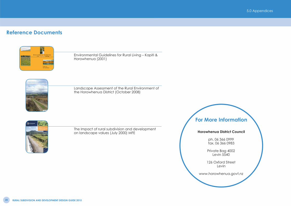
Reference Documents
For More Information
Horowhenua District Council
ph. 06 366 0999fax. 06 366 0983
Private Bag 4002Levin 5540
126 Oxford StreetLevin
www.horowhenua.govt.nz
Ruralfor Rural LivingEnvironmental Guidelines
Kapiti &Horowhenua
R.R.P. $3.00
LANDSCAPE ASSESSMENT OF THE RURAL ENVIRONMENT OF THE
October 2008
Environmental Guidelines for Rural Living – Kapiti & Horowhenua (2001)
Landscape Assessment of the Rural Environment of the Horowhenua District (October 2008)
The Impact of rural subdivision and development on landscape values (July 2000) MFE
5.0 Appendices