standard operating procedure wwsop04001 effective date: 04/01/2013 kentucky watershed watch low...
TRANSCRIPT
Standard Operating ProcedureWWSOP04001
Effective Date: 04/01/2013
KENTUCKY WATERSHED WATCH LOW GRADIENT
STREAM HABITAT ASSESSMENT

This presentation is based on the “Kentucky Watershed Watch Low Gradient Stream Habitat Assessment Standard Operating Procedure WWSOP04001”
SOP statement

What is a watershed?
Introduction to Habitat and Water Quality

Smaller watersheds combineto create larger watersheds
Introduction to Habitat and Water Quality

Land use in watersheds affects stream habitat
Introduction to Habitat and Water Quality

Introduction to Habitat and Water Quality
More impervious cover Increased runoff

Increased Erosion
Introduction to Habitat and Water Quality

Turbidity and Sedimentation
Introduction to Habitat and Water Quality

Incised channel
Stream connection
to floodplain
Introduction to Habitat and Water Quality
Normal channel

Stream Types in Kentucky
Differences in Gradient = Differences in Habitat Types
Low Gradient High Gradient

• You will receive materials from program coordinators or by mail
• Read instructions upon receipt! (Critical info on sample times included)
You will receive for sampling:• Instructions• Field Records• Field Data Sheets• Calculation Sheet
Pre-sampling Information

Reach Selection
The Habitat Assessment is performed on the same 100 meter reach selected for the Biological Assessment…
…and should be performed immediately following the Biological Assessment.
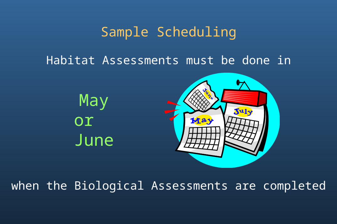
Sample Scheduling
Habitat Assessments must be done in
when the Biological Assessments are completed
Mayor June
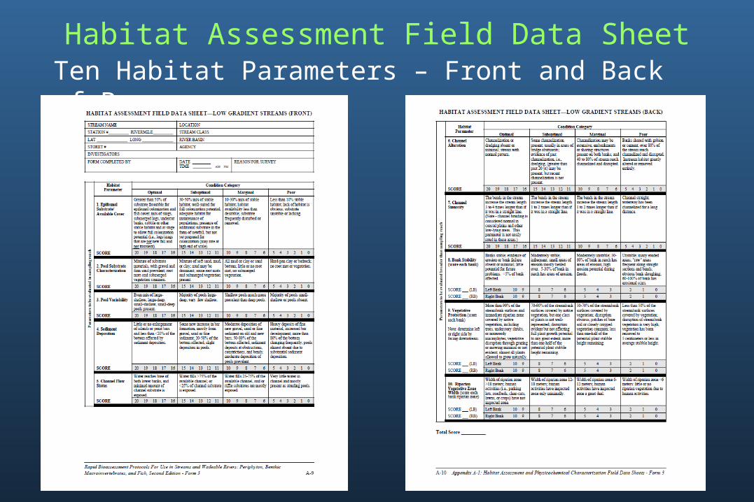
Habitat Assessment Field Data SheetTen Habitat Parameters – Front and Back of Page

Habitat Parameters
Habitat Parameters
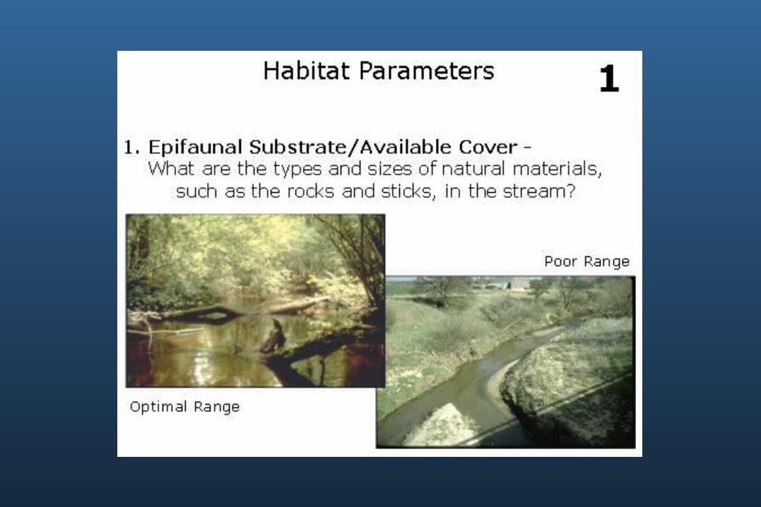
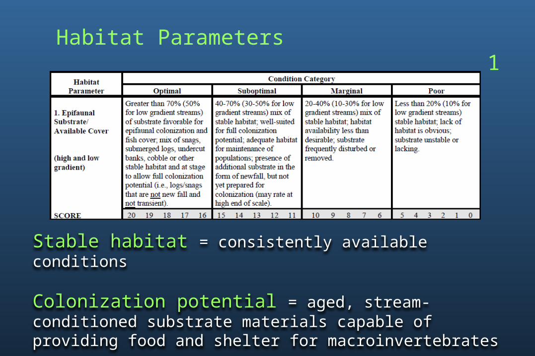
1. Epifaunal Substrate/Available Cover
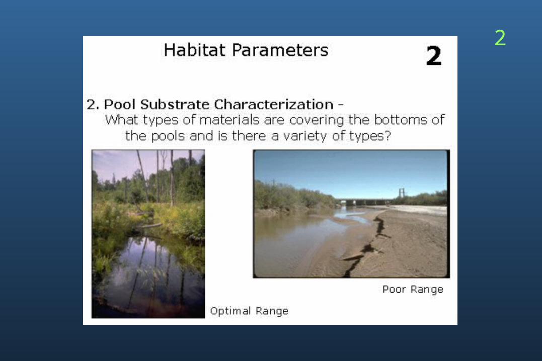
2. Pool Substrate Characterization
3. Pool Variability4. Sediment Deposition5. Channel Flow Status6. Channel Alteration 7. Channel Sinuosity8. Bank Stability9. Vegetative Protection10.Riparian Vegetative Zone
Width

Habitat Parameters
1. Epifaunal Substrate/Available Cover
2. Pool Substrate Characterization
3. Pool Variability4. Sediment Deposition5. Channel Flow Status
6. Channel Alteration 7. Channel Sinuousity8. Bank Stability9. Vegetative Protection10.Riparian Vegetative Zone
Width
• Parameters 1 – 5 evaluate the same 100 m used for the Biological Assessment (this 100 m includes the grab sampling location)
• Parameters 6 – 10 evaluate the 100 m assessed in 1 – 5, plus an additional 100 m upstream

Condition Category
Score
Condition Categories and Scores
Condition Categories• Optimal (16-20)• Suboptimal (11-15)• Marginal (6-10)• Poor (0-5)
Scores• Range from 20-0• Highest is best

Habitat Parameters 1
What is Epifaunal Substrate?
Epi - on top of
Fauna - animals
Substrate – material on the bottom
Habitat Parameters 1
Stable habitat = consistently available conditions
Colonization potential = aged, stream-conditioned substrate materials capable of providing food and shelter for macroinvertebrates
2

Habitat Parameters 2
Sand
Gravel
Mud
Hard-panclay
Clay

Habitat Parameters 2
Gravel = bigger than a bb, but smaller than your fist Sand = sediment with particle sizes smaller than a bb but still with gritty texture Mud = silt and clay mixtureClay = sediment with particle sizes that will form ribbons when rubbed between thumb and fingers Hard-pan clay = compacted clay deposits on a stream bottom that give the appearance of bedrock, but have a hard gummy surface
3

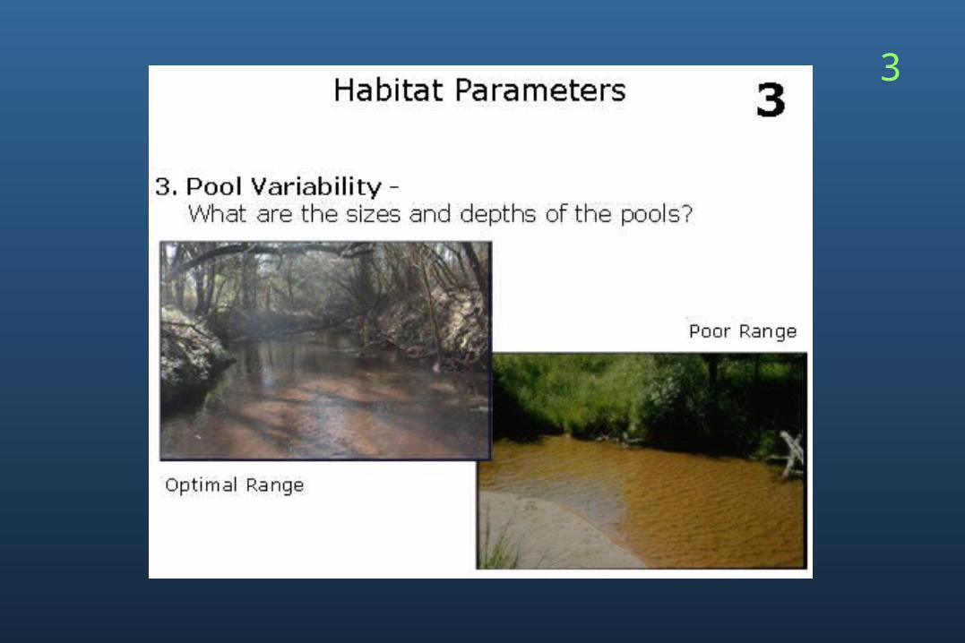
Habitat Parameters 3

Habitat Parameters 3
Mix = well-balanced combination of all four pool types present in the reachDeep/shallow = very dependent on watershed size; deep at the beginning of a stream may be only 0.5 meter, and deep in a larger stream may be one meter or more


Habitat Parameters 4
Point Bar
Island

Habitat Parameters 4
Point bar = a curved ridge of sediment deposited by a stream on the inside of a bend (can be located below the surface of the water or extend above it)
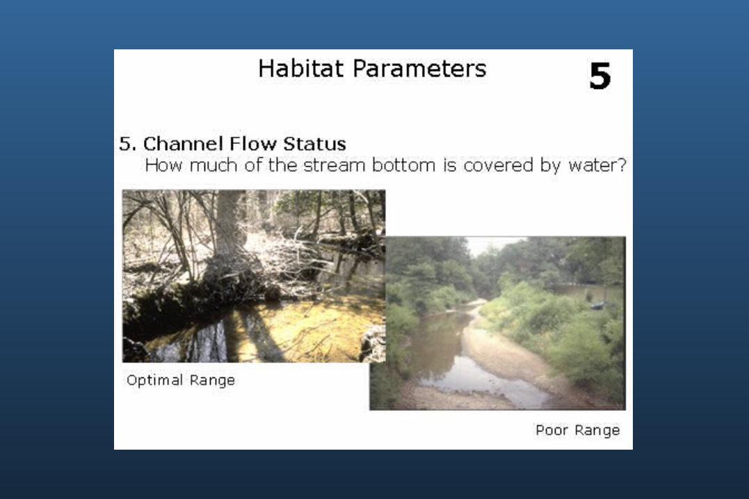

Habitat Parameters 5
Base of lower bank = the point at which the stream bed ends and the stream bank begins

Habitat Parameters
NOTE: = Parameters six through ten should evaluate an area from approximately 100 m upstream of (and in addition to) the original 100 m sampling reach (for a total of 200 m). This whole area should be evaluated as a composite.
200 meter reach
original 100 meters additional 100 meters
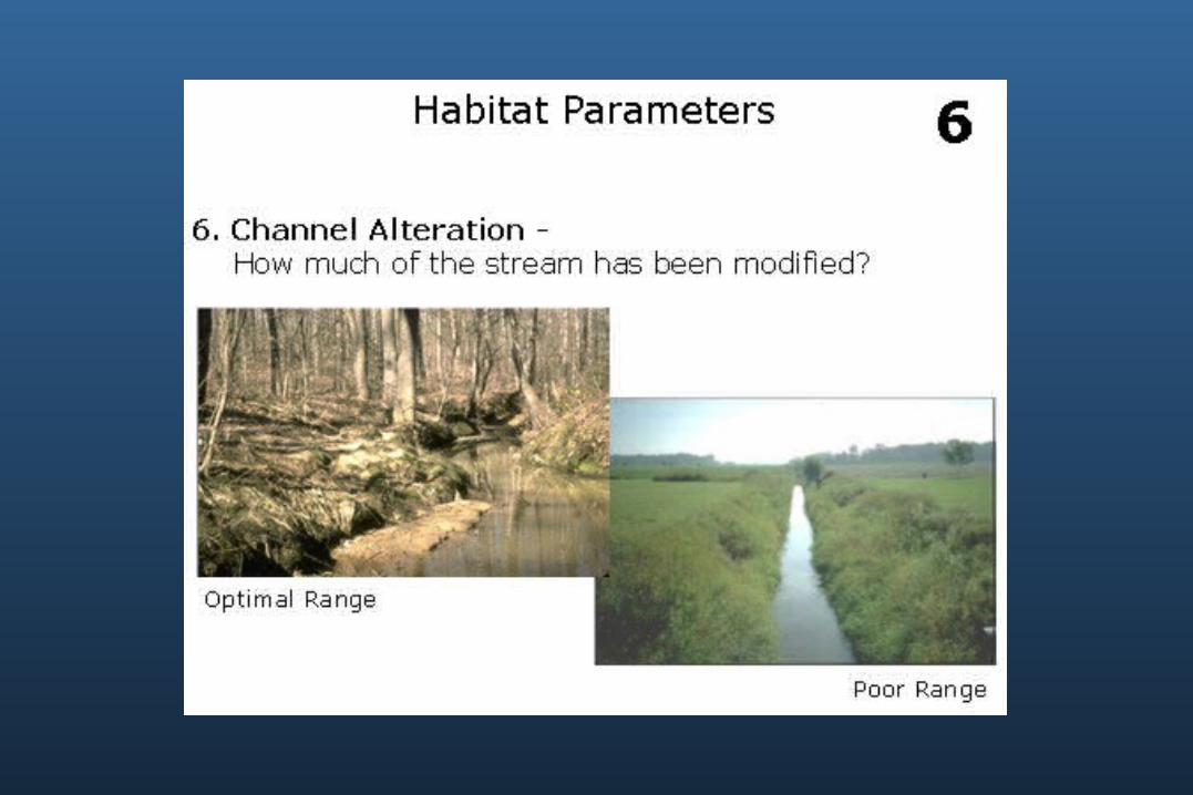

Habitat Parameters 6
Dredging = physical removal of material from stream bed, usually done with heavy equipment Embankment = a stream bank that has been raised to hold back water, carry a roadway, etc.Bridge abutment = a structure that supports a bridge and is built in or near the streamGabion = a metal cage containing natural materials (usually rock) that are stacked to support stream banks


Habitat Parameters 7
Channel Sinuosity
200 meter reach length
Straight line distance=
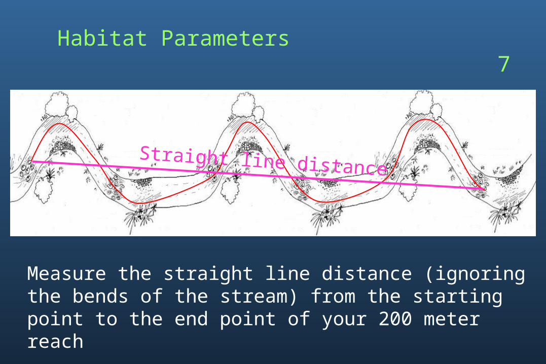
Habitat Parameters 7
Measure the straight line distance (ignoring the bends of the stream) from the starting point to the end point of your 200 meter reach
Straight line distance

Habitat Parameters 7
120 meters
200 meter reach
Channel Sinuosity
200 meter reach length
Straight line distance=
1.67 200 meter reach
120 meters=

Habitat Parameters 7

Habitat Parameters 8 through 10are scored for each bank
Which bank is left and which is right?


Habitat Parameters 8
Erosion = loss of soil or rock material from the stream bank due to the flow of waterBank Failure/Sloughing = events that cause large scale displacement of soil or rock material due to support material being undercut or weakened by erosion due to saturation“Raw” areas = stream bank locations with recently exposed soil


Habitat Parameters 9

Habitat Parameters 9
Native vegetation = the plants that have developed over time to exist in a particular geographic area without human intervention and are adapted to survive in a balance in the specific local conditionsUnderstory shrub = a woody plant of low height having several stems arising from the base that grows beneath the tree canopyNonwoody macrophytes = soft-stemmed plants that are visible to the naked eye


Habitat Parameters 10
Optimal width is around 18 meters
= ~60 feet

Habitat Parameters 10
Riparian area = the land along and adjacent to a stream or river

Field Data Sheet Completion
Add the scores from parameters 1-10 on your Field Data Sheet (both sides) to determine your Total Habitat Score
This step does not have to be completed at the stream

Field Record Completion
At the stream, record the time and date that you perform your Habitat Assessment
Date
Time
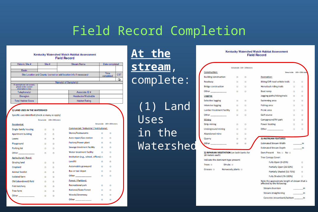
Field Record Completion
At thestream, complete: (1) Land Uses in the Watershed

Field Record Completion
And, at the stream, complete: (2) Riparian Vegetation
and
(3) Instream Features

Field Record CompletionTransfer the Total Habitat Score from the Field Data Sheet to the box labeled “Total Habitat Score” on your Field Record

Field Record Completion
Determine and record your headwater or wadeable classification in the box labeled “Headwater/Wadeable”
These classifications are based on the watershed size (or area) measured from your sampling location

Field Record CompletionDetermining Headwater/ Wadeable Classification
From the Watershed Watch Data Management page URL: http://eppcapp.ky.gov/watershed/
Use the “Watershed Watch Site Locations” link to determine your site’s latitude and longitude

Field Record CompletionDetermining Watershed Size
Use the “Kentucky Watershed Viewer”URL: http://gis.gapsky.org/watershed/
to locate your sampling site using the “Find an Address”
icon

Field Record CompletionDetermining Watershed Size
Using the “Kentucky Watershed Viewer,”
click the yellow line to determine “SQMI:” (watershed size in square miles)
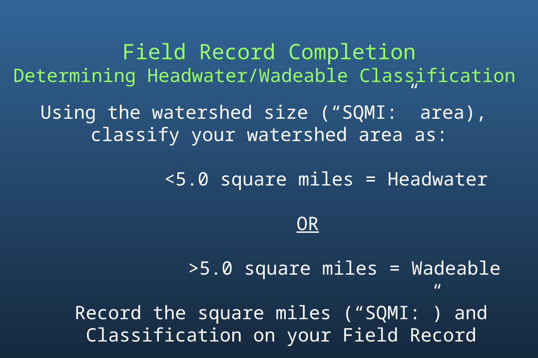
Using the watershed size (“SQMI:” area), classify your watershed area as:
<5.0 square miles = Headwater
OR
>5.0 square miles = Wadeable
Record the square miles (“SQMI:”) andClassification on your Field Record
Field Record CompletionDetermining Headwater/Wadeable Classification

Using your Total Habitat Score, Bioregion, and Headwater or Wadeable classification, determine on Table 2 the Habitat Rating for your site and record in the box labeled “Habitat Rating” on your Field Record
Field Record Completion

Following each Habitat Assessment event, please mail a copy of all completed forms to:
KY Water Watch Office200 Fair Oaks Lane, 4th Floor
Frankfort, KY 40601
Watershed Watch forms are maintained by the KY Water Watch program and electronically filed for safekeeping
If you have any questions or difficulties, please contact the KY Water Watch office at:1-800-928-0045
FORM SUBMITTAL

The Watershed Watch Stream Habitat Assessment examines the condition of ten habitat parameters to make supporting conclusions about the health of the aquatic system.
INTERPRETATION

INTERPRETATION
Diverse macroinvertebrate community
Undisturbed riparian habitat
High quality instream habitat

Disturbed riparian habitat
Altered instream habitat
INTERPRETATION
Less diverse macroinvertebrate
community

• Typically shallow and narrow• Direct influence by adjacentwatershed• Watershed disturbance leadsto rapid, extensive stream impacts
Headwater
• Typically wider and deeper• Also influenced by multiple
headwater watersheds• Watershed disturbance effects
buffered/magnified by multiple headwater watersheds
Wadeable
INTERPRETATION

INTERPRETATION
IF
THEN look further to water quality results to attempt to explain the impacts

INTERPRETING DATA STATEWIDEHabitat Assessment Scores
44 - 57
58 - 70
71 - 83
84 - 96
97 - 109
110 - 122
123 - 135
136 - 148
149 - 161

Phase 2 (Biological and Habitat Assessment) Training:
Your sampling and assessment skills are considered current after completing WWKY-approved training
You will be notified that training updates are required if modifications are made to WWKY methods
RECERTIFICATION
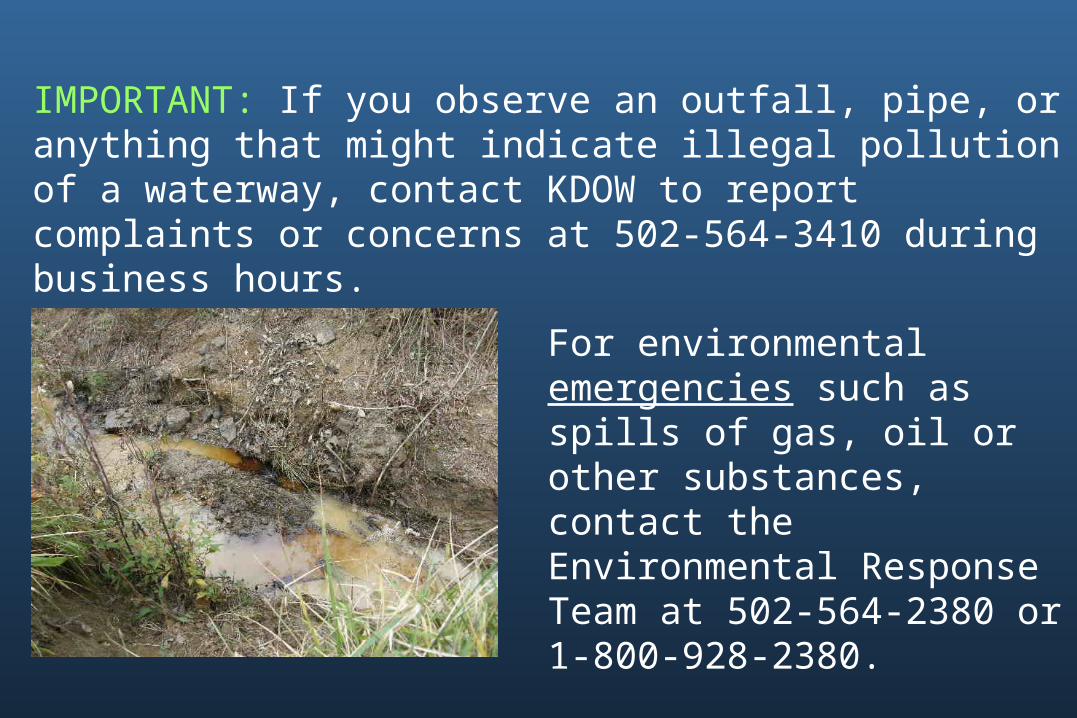
IMPORTANT: If you observe an outfall, pipe, or anything that might indicate illegal pollution of a waterway, contact KDOW to report complaints or concerns at 502-564-3410 during business hours.
For environmental emergencies such as spills of gas, oil or other substances, contact the Environmental Response Team at 502-564-2380 or 1-800-928-2380.