strategic initiative to introduce commercial land based
TRANSCRIPT

Strategic Initiative to Introduce Commercial Land Based Wind Energy Development to the Western Cape
TTOOWWAARRDDSS AA RREEGGIIOONNAALL MMEETTHHOODDOOLLOOGGYY FFOORR WWIINNDD EENNEERRGGYY SSIITTEE SSEELLEECCTTIIOONN
REPORT 6: PROPOSED PROJECT LEVEL METHODOLOGY
MAY 2006
Strategic Initiative to Introduce Commercial Land Based Wind Energy Development to the Western Cape
TTOOWWAARRDDSS AA RREEGGIIOONNAALL MMEETTHHOODDOOLLOOGGYY FFOORR WWIINNDD EENNEERRGGYY SSIITTEE SSEELLEECCTTIIOONN
REPORT 6: PROPOSED PROJECT LEVEL METHODOLOGY
prepared for
Provincial Government of the Western Cape 1 Dorp Street, Cape Town, 8000
Tel: +2721 483-3185 Fax: +2721 483-4373
by
CNdV africa planning & design environmental planning, landscape architecture, urban design
72 Barrack Street, Cape Town, 8000 Tel: +2721 461-6302 Fax: +2721 461-6466
Email: [email protected]
MAY 2006

Wind Energy Landscapes : Specialist Study: Report 6 – Site Level Methodology - CNdV africa May 2006
page 2
“It is not possible for this guidance to be exhaustive or absolute in content because of the very complex issues arising from (wind) technology and the environmental resource. Alternatively, this guidance aims to provide an initial level of information against which proposals can be assessed. This can then be supplemented with further references to both literature and expert consultants.”
(Source: Guidelines on the Environmental Impacts of Windfarms and Small Hydroelectric Schemes: Scottish Natural Heritage (Feb 2001)
Wind Energy Landscapes : Specialist Study: Report 6 – Site Level Methodology - CNdV africa May 2006
page i
OVERALL STRUCTURE OF REPORTS LIST OF REPORTS
Report 1 Wind Energy Landscape Study Summary Report
Report 2 Report on Methodology 1 (Criteria Based Assessment)
Report 3 Report on Methodology 2 (Landscape Assessment)
Report 4 Comparative Assessment of Methodologies 1 & 2
Report 5 Proposed Regional Methodology
Report 6 Proposed Site Level Methodology (This report)
Report 7 Annexure Reports
1. The Brief
2. Overseas Study Report
3. GIS / Software Report
4. Towards a Provincial Policy Framework for Wind Energy Development
5. References
CONTENTS : REPORT 6: PROPOSED PROJECT METHODOLOGY
1. INTRODUCTION
1.1 Report Structure
1.2 Context
1.3 Objectives
1.4 Purpose
1.5 Scope
1.6 Integration with the Regional Methodology
1.7 Conceptual Framework
2. THE REGULATORY & LEGAL CONTEXT
2.1 Regulatory Hierarchy
2.2 Wind Energy Development Planning and Regulatory Process
2.3 The EIA Regulations in Terms of NEMA
2.4 Land Use Planning And Other Legal Implications -
3. EIA AND VIA CONSIDERATIONS FOR PROJECT LEVEL ASSESSMENT
3.1 Background
3.2 EIA Procedural Stages
3.3 Wind Plan Context
3.4 Specialist Visual Assessment
3.5 Summary
4 . LOCAL CRITERIA; SITE AND LAYOUT FACTORS
4.1 The Wind Resource
Wind Energy Landscapes : Specialist Study: Report 6 – Site Level Methodology - CNdV africa May 2006
page ii
4.2 Site Factors
4.3 Design and Layout Aspects
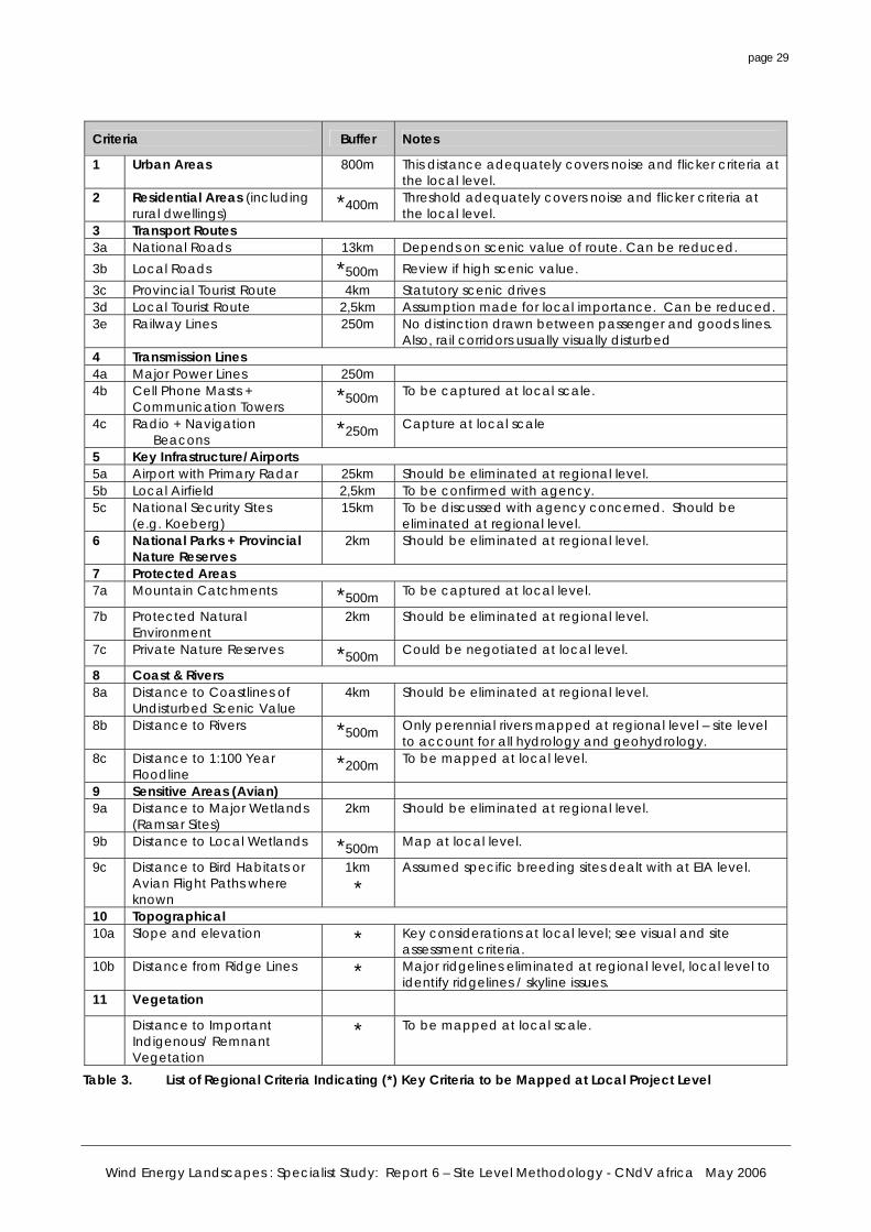
4.4 Reference to Regional Criteria
4.5 Scale of Analysis
5. SUBMISSION PROCESS
5.1 Anticipated Submission Process for Wind Energy
5.2 Pre-Application Submission
5.3 Formal Submission
5.4 Approval Process
6. GUIDELINE SUMMARY OF REQUIREMENTS FOR WIND ENERGY DEVELOPMENT AT THE LOCAL LEVEL
6.1 Regional Context
6.2 Site Information
6.3 Site Environment
6.4 Visual and Criteria Based Analysis
6.5 Technical Data
6.6 Wind Farm Layout
6.7 Major Substation and Transmission Corridors
6.8 Socio-Economic Assessment
6.9 Environmental Management
7. CONCLUSIONS AND RECOMMENDATIONS
7.1 Conclusions
7.2 Recommendations
LIST OF APPENDICES Appendix A Abbreviations / Glossary
Appendix B Common EIA (VIA) Terms and Concepts
Appendix C References (Report 6 Site Level Method)
Appendix D Guideline Checklist for Environmental Impact Assessment for Windfarms
LIST OF FIGURES
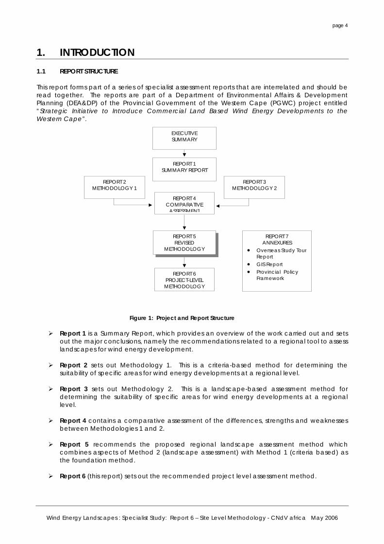
Figure 1. Project and Report Structure
Figure 2. Conceptual diagram illustrating expected fine tuning of Wind Turbine Project based on further stages of Planning Refinement
Wind Energy Landscapes : Specialist Study: Report 6 – Site Level Methodology - CNdV africa May 2006
page iii
Figure 3. The wind energy planning and regulatory framework
Figure 4. Overall Impact of Wind Energy Project
Figure 5. Specialist Assessments in EIA Process for Wind Energy Development
LIST OF TABLES Table 1. EIA (NEMA) Process Summary
Table 2. Overall Framework for Local Level Project Assessment
Table 3. List of Regional Criteria Indicating (*) Key Criteria to be Mapped at Local Project Level
ACKNOWLEDGEMENTS This report was produced by Derek Chittenden, Ebrahim Daniels, Soraya Sabera and Reinhold Viljoen of CNdV Africa under the guidance of a Provincial Task Team comprising Paul Hardcastle, Ayub Mohamed and Raudhiyah Waggie. The input of the project Reference Group to the project is acknowledged with thanks. The authors also wish to thank those organisations and individuals throughout the world that provided valuable advice and guidance to this work.
Wind Energy Landscapes : Specialist Study: Report 6 – Site Level Methodology - CNdV africa May 2006
page 4
1. INTRODUCTION 1.1 REPORT STRUCTURE This report forms part of a series of specialist assessment reports that are interrelated and should be read together. The reports are part of a Department of Environmental Affairs & Development Planning (DEA&DP) of the Provincial Government of the Western Cape (PGWC) project entitled “Strategic Initiative to Introduce Commercial Land Based Wind Energy Developments to the Western Cape”.
Figure 1: Project and Report Structure
Report 1 is a Summary Report, which provides an overview of the work carried out and sets out the major conclusions, namely the recommendations related to a regional tool to assess landscapes for wind energy development.
Report 2 sets out Methodology 1. This is a criteria-based method for determining the
suitability of specific areas for wind energy developments at a regional level. Report 3 sets out Methodology 2. This is a landscape-based assessment method for
determining the suitability of specific areas for wind energy developments at a regional level.
Report 4 contains a comparative assessment of the differences, strengths and weaknesses
between Methodologies 1 and 2.
Report 5 recommends the proposed regional landscape assessment method which combines aspects of Method 2 (landscape assessment) with Method 1 (criteria based) as the foundation method.
Report 6 (this report) sets out the recommended project level assessment method.
REPORT 4 COMPARATIVE
ASSESSMENT
REPORT 1 SUMMARY REPORT
REPORT 6 PROJECT-LEVEL METHODOLOGY
REPORT 2 METHODOLOGY 1
REPORT 3 METHODOLOGY 2
EXECUTIVE SUMMARY
REPORT 7 ANNEXURES
• Overseas Study TourReport
• GIS Report • Provincial Policy
Framework
REPORT 5 REVISED
METHODOLOGY
Wind Energy Landscapes : Specialist Study: Report 6 – Site Level Methodology - CNdV africa May 2006
page 5
Report 7 is comprised of several Annexure reports including a comprehensive report on the overseas study tour carried out by DEA&DP officials and the consultants, and a report on the GIS software investigation carried out as a precursor to the analysis.
Wind Energy Landscapes : Specialist Study: Report 6 – Site Level Methodology - CNdV africa May 2006
page 6
1.2 CONTEXT This report is focused at the local project level and is aimed primarily at provincial and local authorities and wind energy developers who intend to develop wind farms within the Western Cape Province. It must be read in the context of the other reports in this series. The proposed Regional Methodology (see Report 5) is intended to be a Provincial planning tool that lays the groundwork for the identification of areas appropriate for wind energy development. Once this has been done and wind energy developers have selected potential sites (based on a variety of other factors, particularly the available wind resourse), the local level method is critical for assisting in the environmental impact assessment process of individual wind farms. 1.3 OBJECTIVES
The development of a guidance for local level procedures has two objectives: • To enable local and provincial authorities to efficiently and effectively assess wind energy
development applications.
• To assist wind energy developers and specialist consultants in preparing detailed proposals for wind energy development within the Province.
1.4 PURPOSE
The purpose of this report is to set out the following: • A brief review of the regulatory context of wind energy development and environmental
assessment in South Africa and the roles and responsibilities of the regulatory authorities in relation to wind energy development (Section 2).
• Key considerations for EIA and VIA at the project level (Section 3).
• Key submission requirements and guidelines for the wind energy developer or environmental consultant in specific regard to visual impact mitigation (Sections 3 and Appendix D).
• A local-level environmental assessment methodology for wind energy developments (Section 3).
• Key criteria and layout factors to be considered (Section 4, and Appendix D). 1.5 SCOPE The local level procedure is focused on detailed design and siting issues given the assumption that the project site will have (ideally) already been identified by a Regional Landscape Study and Wind Energy plan (see 1.6). The recommendations and guidelines in this report are generic and may need elaboration and extension based on the specific nature of the receiving environment. The scope of this report is limited to the elaboration of the project-level procedures and guidelines but not the various products (e.g. ZVI analysis or photomontage techniques) required for application of these procedures at the local scale. 1.6 INTEGRATION WITH THE REGIONAL METHODOLOGY The Regional Methodology will ideally provide a map of Wind Energy Zones that indicates preferred, negotiated and restricted zones for wind energy development. This output should ideally be integrated directly into the local and district Spatial Development Frameworks.
Wind Energy Landscapes : Specialist Study: Report 6 – Site Level Methodology - CNdV africa May 2006
page 7
The Wind Energy zone map is thus the departure point for the local level EIA’s. It establishes whether a wind farm is appropriate in a particular area from a regional landscape perspective. It does not however imply that all sites within designated zones are suitable for wind energy development. The wind resource and other local criteria will strongly influence the utility of designated sites. (Refer to Report 5)
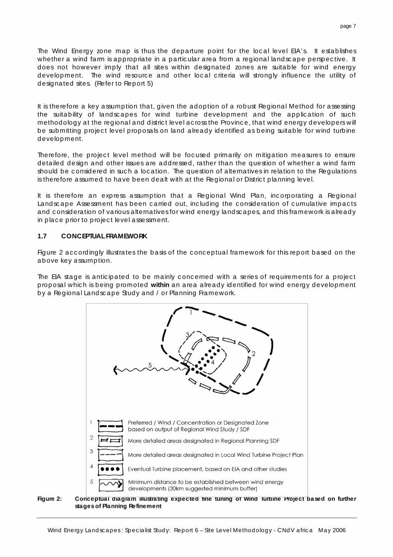
It is therefore a key assumption that, given the adoption of a robust Regional Method for assessing the suitability of landscapes for wind turbine development and the application of such methodology at the regional and district level across the Province, that wind energy developers will be submitting project level proposals on land already identified as being suitable for wind turbine development. Therefore, the project level method will be focused primarily on mitigation measures to ensure detailed design and other issues are addressed, rather than the question of whether a wind farm should be considered in such a location. The question of alternatives in relation to the Regulations is therefore assumed to have been dealt with at the Regional or District planning level. It is therefore an express assumption that a Regional Wind Plan, incorporating a Regional Landscape Assessment has been carried out, including the consideration of cumulative impacts and consideration of various alternatives for wind energy landscapes, and this framework is already in place prior to project level assessment. 1.7 CONCEPTUAL FRAMEWORK Figure 2 accordingly illustrates the basis of the conceptual framework for this report based on the above key assumption. The EIA stage is anticipated to be mainly concerned with a series of requirements for a project proposal which is being promoted within an area already identified for wind energy development by a Regional Landscape Study and / or Planning Framework.
Figure 2: Conceptual diagram illustrating expected fine tuning of Wind Turbine Project based on further
stages of Planning Refinement
Wind Energy Landscapes : Specialist Study: Report 6 – Site Level Methodology - CNdV africa May 2006
page 8
2. THE REGULATORY & LEGAL CONTEXT 2.1 REGULATORY HIERARCHY The South African energy industry is evolving rapidly, with numerous changes to legislation, and the entry of public and private role-players in the industry. The regulatory hierarchy consists of three tiers of authority who exercise control through both statutory and non-statutory instruments. The tiers are National, Provincial and Local. These tiers are increasingly integrated, both at the planning and delivery stages. As wind energy development is a multi-sectoral issue (encompassing economic, spatial biophysical, and cultural dimensions) various statutory bodies are likely to be involved in the approval process for wind farm location and the statutory environmental assessment process related thereto. 2.1.1 National Level At this level the main regulatory agencies are: • Department of Minerals and Energy (DME). This department is responsible for policy relating to
all energy forms, including renewable energy. Wind energy is considered under a White Paper for Renewable Energy1 and the Department undertakes research in this regard. It is the controlling authority in terms of the Electricity Act (No 41 of 1987).
• National Energy Regulator (NER). This body is the successor of the National Electricity Regulator and is responsible for regulating all aspects of the electricity sector, including licensing and tariffs. This agency will issue licenses for wind energy developments to generate electricity.
• Department of Environment and Tourism (DEAT). This Department is responsible for environmental policy and is the controlling authority in terms of the National Environmental Management Act (NEMA) and the recently published Regulations in terms of Chapter 5 of NEMA. (Act No. 107 of 1998)
• Department of Transport (DOT) : Civil Aviation Authority. This department is responsible for aircraft movements and radar, aspects that influence wind energy planning.
• The Protected Areas Act (PAA) (Act 57 of 2003, Section 17) is intended to, inter alia, protect natural landscapes.
• The National Heritage Resources Act (NHRA) (Act No. 25 of 1999) and the associated provincial regulations provides legislative protection for listed or proclaimed sites, such as urban conservation areas, nature reserves and proclaimed scenic routes.
2.1.2 Provincial Level At this level the main regulatory agencies are: • Provincial Government of the Western Cape (PGWC) – Department of Environment and
Planning (DEA&DP). This is the principal authority involved in the Environmental Impact Assessment (EIA) process and determines many aspects of Provincial Environmental policy. The department is the authorizing agency in terms of the new NEMA regulations.
• Regional Electricity Distributor (RED). The RED’s are now responsible for the planning and distribution of electricity at a regional level, taking over the functions of both the municipalities and ESKOM. The first RED (RED 1) has been established in the Western Cape.
1 White Paper on Renewable Energy. Department of Minerals and Energy, November 2003.
Wind Energy Landscapes : Specialist Study: Report 6 – Site Level Methodology - CNdV africa May 2006
page 9
ELECTRICITY ACT
Regional Wind Energy Plan
LOCAL AUTHORITY
Spatial Development Plan
NER PGWC/DEA&DP EIA Regs
NATIONAL ENVIRONMENTAL MANAGEMENT ACT
WIND ENERGY DEVELOPER EIA Submission
Preferred Wind Energy Zones
Licensing
NATIONAL ENERGY PLANNING
2.1.3 Local Level At this third tier level the local and municipal authorities are the principal regulatory authorities, responsible for planning, land use and the environment. In the Western Cape both Municipalities and District Municipalities play a role. • In terms of the Municipal Systems Act, (Act 32 of 2000) it is compulsory for all municipalities to
go through an Integrated Development Planning process to prepare a five-year strategic development plan for the area under their control. The IDP process, specifically the spatial component (Spatial Development Framework), in the Western Cape Province is based on a bioregional planning approach to achieve continuity in the landscape and to maintain important natural areas and ecological processes.
• Bioregional planning involves the identification of priority areas for conservation and their placement within a planning framework of core, buffer and transition areas. These could include reference to visual and scenic resources and the identification of areas of special significance, together with visual guidelines for the area covered by these plans.
• By-laws and policies have been formulated by local authorities to protect visual and aesthetic resources relating to urban edge lines, scenic drives, special areas, signage, communication masts, etc.
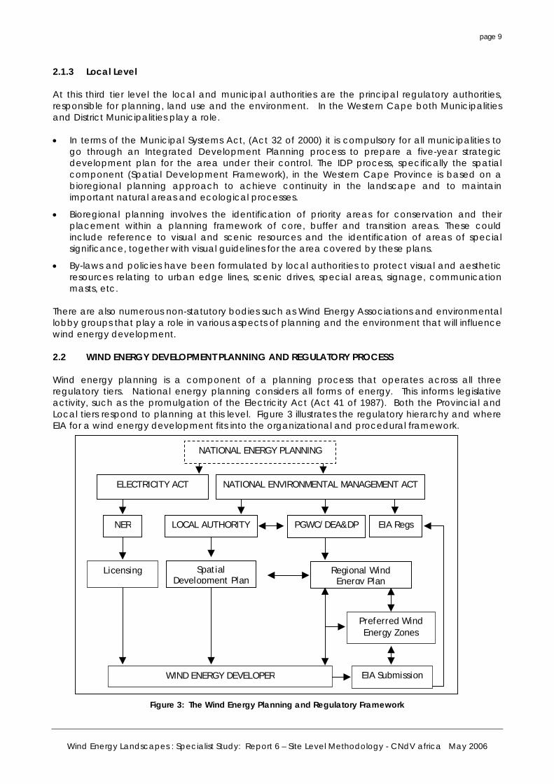
There are also numerous non-statutory bodies such as Wind Energy Associations and environmental lobby groups that play a role in various aspects of planning and the environment that will influence wind energy development. 2.2 WIND ENERGY DEVELOPMENT PLANNING AND REGULATORY PROCESS Wind energy planning is a component of a planning process that operates across all three regulatory tiers. National energy planning considers all forms of energy. This informs legislative activity, such as the promulgation of the Electricity Act (Act 41 of 1987). Both the Provincial and Local tiers respond to planning at this level. Figure 3 illustrates the regulatory hierarchy and where EIA for a wind energy development fits into the organizational and procedural framework.
Figure 3: The Wind Energy Planning and Regulatory Framework
Wind Energy Landscapes : Specialist Study: Report 6 – Site Level Methodology - CNdV africa May 2006
page 10
2.2.1 Roles and Responsibilities
1. National level – The primary role at the national level is the development of national energy and conservation strategies. Key responsibilities are energy resource estimation, future energy provision scenarios, licensing and establishment of appropriate tariffs. The provision of data is a further vital responsibility.
It is anticipated that in the future, provincial targets will be set at national level for renewable energy production.
2. Provincial level – The primary role at this level is strategic planning and authorization of
development that is not delegated to the local level. Responsibilities will include the preparation of Provincial wind energy development plans and the integration of these plans with Regional Level Spatial Development Plans.
3. Local level – The primary role at this level is local planning and development control.
Key responsibilities are the interpretation of National and Provincial plans, the preparation of Local and District Plans, the adjudication of applications and providing guidance for developers.
2.3 THE EIA REGULATIONS IN TERMS OF NEMA This will be the critical legal framework to be complied with in terms of environmental planning and landscape issues related to wind energy location, and is dealt with in depth in the following sections of this report.
The old regulations promulgated in terms of the Environmental Conservation Act will be replaced in 2006 by new Regulations in terms of Chapter 5 of NEMA. The regulations make provision for either a “Basic Assessment” or a full “Scoping and Environmental Impact Assessment”. 2.3.1 Basic Assessment In terms of the list of activities and competent authorities published in the schedules; a wind turbine development will trigger a BASIC ASSESSMENT in terms of the following: • The construction of facilities or infrastructure (including associated structures and infrastructure)
for the generation of electricity, where the output is more than 10 megawatts but less than 20 megawatts. (Clause 1(a))
• The transmission and distribution of electricity above ground with a capacity of more than 33 kilovolts and less than 120 kilovolts (Clause 1(c))
• The removal or damaging of indigenous vegetation of more than 10 m² within a distance of 100 metres inland of the high water mark of the sea (Clause 5). (Note: given that coastal locations will be a highly sought after location for wind turbines, this Clause will be triggered given the foundation size of a turbine.)
• Note that the transformation or removal of indigenous vegetation of 3 hectares or more (Clause 12) should not be triggered as these sensitive areas should be eliminated in the Regional Wind Plan.
• Note that Clause 14 relating to the construction of “masts” of any height, will possibly be triggered by the erection of (temporary) wind measurement instruments. (This issue should be clarified with DEAT / DEA&DP)
• The construction of access roads wider than 4 metres (Clause 15).
Wind Energy Landscapes : Specialist Study: Report 6 – Site Level Methodology - CNdV africa May 2006
page 11
• The subdivision of land exceeding 9 hectares in size into portions of 5 hectares or less (Clause 18).
• The decommissioning or recommissioning of existing facilities or infrastructure for electricity generation (Clauses 23 and 24(a)). Note this will only apply in the long term as windfarms may be decommissioned.
2.3.2 Full Scoping and EIA In terms of Regulations 27 to 36, an application for full scoping and EIA is required where: • The construction of facilities or infrastructure (including associated structures and infrastructure)
for the generation of electricity where (i) the output is 20 megawatts or more; or (ii) the facility covers a combined area in excess of 1 hectare (Clause 1(a)).
• The transmission and distribution of above ground electricity with a capacity of 120 kilovolts or more.
• Any development activity, including associated structure and infrastructure where the total developed area exceeds 20 hectares (Clause 2).
2.3.3 Summary In terms of the New EIA Regulations, it is anticipated that any windfarm application should trigger a full EIA and scoping, notwithstanding that it may be less than 10 megawatts (no process required) or less than 20 megawatts (basic assessment) in size, for the simple reason that the scale of turbines will at least necessitate a VIA. *(Note that a 9 megawatt windfarm, which would hypothetically not trigger a basic EIA assessment, could involve 6 large 1,5 meg turbines. However, larger scale windfarms will exceed the 20 hectare threshold.) This anticipated outcome is provided for in both Regulations 5 and 21 of the new Regulations where the competent authority, “may give the applicant or EAP access to any guidelines and information on practices that have been developed”, and “advise the applicant … of the nature and extent of any of the processes that must be followed…” (Reg 5) or, “must take into account any guidelines applicable to the activity.” (Reg 20(1)a) However, the other aspects related to a windfarm development, such as the construction of access roads, should remain part of a Basic Assessment process. 2.4 LAND USE PLANNING AND OTHER LEGAL IMPLICATIONS 2.4.1 Introduction Given the current lack of integration situation between land use planning and environmental assessment law, and notwithstanding that the EIA / NEMA Regulations will drive the assessment / authorisation process, there are at least two other land use planning aspects that will need to be dealt with as part of a wind energy development. These are: • Rezoning and Subdivision in terms of LUPO (Ordinance 15 of 1985)
• Subdivision in terms of Act 70 of 1970 (Subdivision of Agricultural Land Act)
There may be other requirements triggered based on the particular site. The LUPO and agricultural subdivision issues are dealt with briefly below:
Wind Energy Landscapes : Specialist Study: Report 6 – Site Level Methodology - CNdV africa May 2006
page 12
2.4.2 Rezoning Application Given that most wind energy development will be taking place in the Western Cape province on land that is zoned for agricultural use, a rezoning in terms of Section 17 of LUPO to an alternative appropriate zone will be required. • Applicable Zones On the assumption that most wind energy developments will be made outside of local authority town planning schemes (where a host of different zoning categories would apply), it is anticipated that any wind energy development would require a rezoning to either: Industrial Zone 1 or Special Zone as defined in the Scheme Regulations in terms of Section 8 of LUPO. (Government Gazette December 1988): o “Industry: means an enterprise defined in the regulations made in terms of Section 35 of the
Machinery and Occupational Safety Act (Act 6 of 1983)” (note, these Regulations include any ‘electrical installation’).”
o “Special Usage: means a use which is such, or in respect of which the land use restrictions are such, that it is not catered for in these regulations, and which is set out in detail … by means of conditions of approval, or by means of conditions applicable to the special zone.”
It is highly recommended that a new SPECIAL ZONE (Wind Energy) is created in the LUPO Scheme Regulations. • Departures Note that a Departure is only applicable to temporary use and will not be suitable for a windfarm. • Provincial Zoning Scheme Model By-Law (Draft 2002) This draft By-Law provides for a number of different zones than those applicable under the existing Section 8 Regulations. The following zones may have relevance: o Industrial Zone 1 is designated for light industry, however, a manufacturing bias is evident, so
this zone may be of limited use. o The Authorities Zone 2 provides for a public utilities use including; “the objective being to
reserve land for utility services such as electrical substations.” It appears as if the option of a separate UTILITIES ZONE (Wind Energy) may therefore be an option.
2.4.3 Subdivision It is anticipated that wind developers will ideally require separate title by means of freehold or long term lease to secure long term tenure of a wind energy site. In this case, the Subdivision of Agricultural Land Act (Act 70 of 70) will apply for subdivision of all agricultural land in the Province and will have to be in place prior to any subdivision approval in terms of Section 24 and 17 of LUPO. As indicated in Section 2.3, any subdivision of land greater than 9ha in extent will in any event also trigger an EIA. 2.4.4 Heritage Assessment In terms of the South African Heritage Resources Agency (SAHRA), a heritage assessment may be triggered depending on the scale of the project or the existence of cultural or natural heritage assets, and this requirement needs to be identified at an early stage. In terms of integrated decision making, any heritage assessment should run in parallel with the EIA. Obviously, any important heritage resources should have been screened out at the regional level (SEA).
Wind Energy Landscapes : Specialist Study: Report 6 – Site Level Methodology - CNdV africa May 2006
page 13
3. EIA AND VIA CONSIDERATIONS FOR PROJECT LEVEL ASSESSMENT
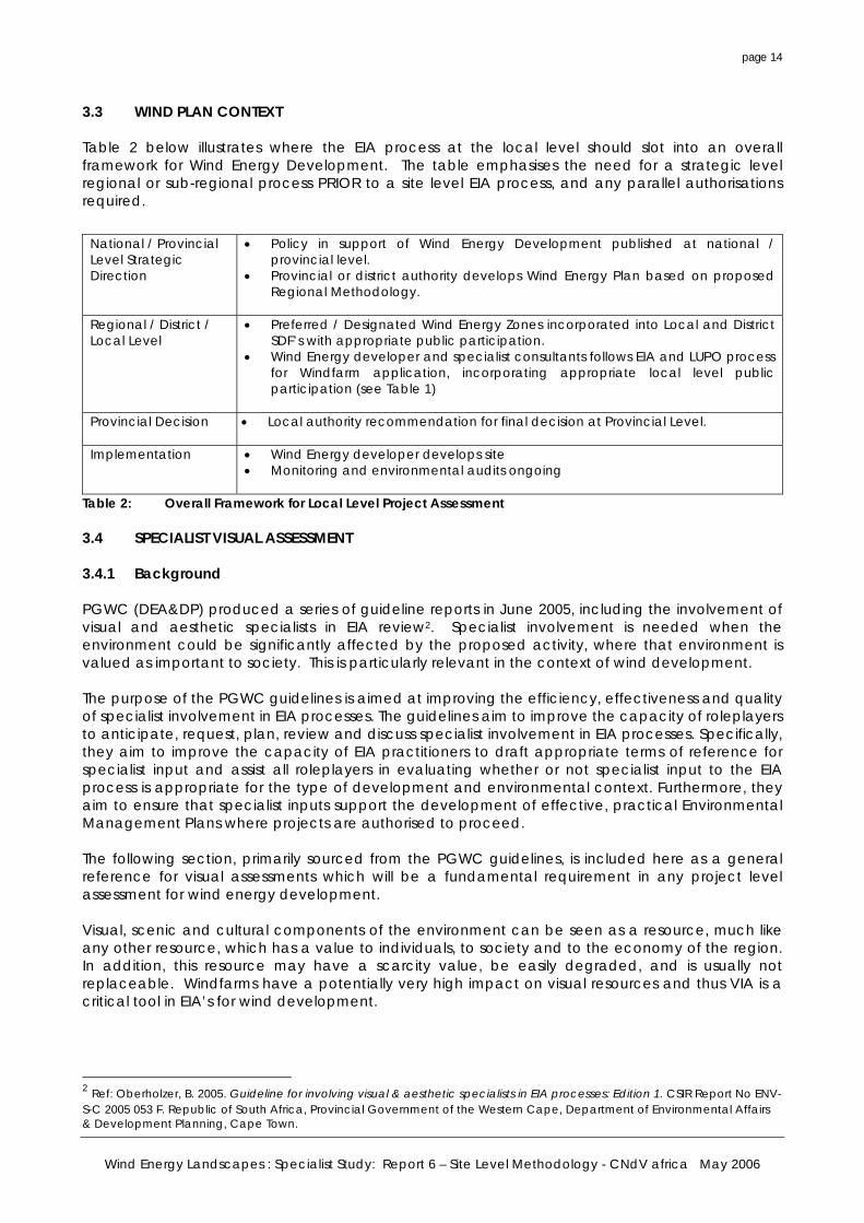
3.1 BACKGROUND The purpose of an Environmental Impact Assessment (EIA) is to provide decision-makers (be they government authorities, the project proponent or financial institutions) with adequate and appropriate information about the potential positive and negative impacts of a proposed development and associated management actions in order to make an informed decision whether or not to approve, proceed with or finance the development. The regulations governing EIA in South Africa are to be as per the Regulations promulgated in Terms of Chapter 5 of NEMA (1998), as read with the Schedules thereto. (These have replaced the previous EIA Regulations in terms of the Environmental Conservation Act.) It is not the purpose of this report to deal with the Regulations, but to map out the detailed issues that should be dealt with in an EIA for wind turbine development. However, a brief general background is provided in this section, with particular reference to visual impact specialist study. Appendix B contains a useful reference list of common terms related to EIA and VIA. (See also Appendix A for abbreviations.) 3.2 EIA PROCEDURAL STAGES The Regulations promulgated in terms of Chapter 5 of NEMA define the procedural stages to be followed in a full scoping and EIA process. In broad terms, the following overall process should apply for a thorough scoping and EIA process in terms of the NEMA Regulations. (source DEAT presentation):
Step Action Responsibility 1. Submit application form and prescribed documents to authority. Applicant / consultant 2. Conduct basic public participation and compile Scoping Report and
Plan of Study for EIA Consultant
3. Submit Scoping Report and Plan of Study (PoS) to authority Consultant 4. Authority considers and accepts Scoping Report and PoS for EIA or
notifies applicant of any required amendments. Authority (30 days)
5. Conduct EIA in line with approved PoS and compile EIA Report and Draft EMP. Submit
Consultant
6. Authority considers reports : either accept (7A) or refer to specialist review (7B). Notify applicant of outcome.
Authority (60 days)
7A. Authority issues decision with conditions and notification of appeal provisions
Authority (45 days)
7B. Specialist conduct reviews and submit to authority. Specialists 7C. For 7B – issue decision with conditions and notification of appeal
provisions. Authority (45 days)
8. Notify I&APs of decision Consultant (5 days) 9. If applicable, consider and respond to any appeals received. Minister / MEC Note: This table illustrates the EIA process only, there will be a number of parallel / integrated applications facing the wind developer, including heritage legislation, and planning legislation including rezonings (in terms of LUPO) or subdivision of agricultural land.
Table 1: EIA (NEMA) Process Summary
Wind Energy Landscapes : Specialist Study: Report 6 – Site Level Methodology - CNdV africa May 2006
page 14
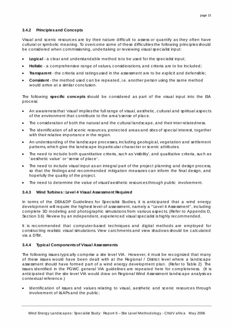
3.3 WIND PLAN CONTEXT Table 2 below illustrates where the EIA process at the local level should slot into an overall framework for Wind Energy Development. The table emphasises the need for a strategic level regional or sub-regional process PRIOR to a site level EIA process, and any parallel authorisations required.
National / Provincial Level Strategic Direction
• Policy in support of Wind Energy Development published at national / provincial level.
• Provincial or district authority develops Wind Energy Plan based on proposed Regional Methodology.
Regional / District / Local Level
• Preferred / Designated Wind Energy Zones incorporated into Local and District SDF’s with appropriate public participation.
• Wind Energy developer and specialist consultants follows EIA and LUPO process for Windfarm application, incorporating appropriate local level public participation (see Table 1)
Provincial Decision • Local authority recommendation for final decision at Provincial Level.
Implementation • Wind Energy developer develops site
• Monitoring and environmental audits ongoing
Table 2: Overall Framework for Local Level Project Assessment 3.4 SPECIALIST VISUAL ASSESSMENT 3.4.1 Background PGWC (DEA&DP) produced a series of guideline reports in June 2005, including the involvement of visual and aesthetic specialists in EIA review2. Specialist involvement is needed when the environment could be significantly affected by the proposed activity, where that environment is valued as important to society. This is particularly relevant in the context of wind development. The purpose of the PGWC guidelines is aimed at improving the efficiency, effectiveness and quality of specialist involvement in EIA processes. The guidelines aim to improve the capacity of roleplayers to anticipate, request, plan, review and discuss specialist involvement in EIA processes. Specifically, they aim to improve the capacity of EIA practitioners to draft appropriate terms of reference for specialist input and assist all roleplayers in evaluating whether or not specialist input to the EIA process is appropriate for the type of development and environmental context. Furthermore, they aim to ensure that specialist inputs support the development of effective, practical Environmental Management Plans where projects are authorised to proceed. The following section, primarily sourced from the PGWC guidelines, is included here as a general reference for visual assessments which will be a fundamental requirement in any project level assessment for wind energy development. Visual, scenic and cultural components of the environment can be seen as a resource, much like any other resource, which has a value to individuals, to society and to the economy of the region. In addition, this resource may have a scarcity value, be easily degraded, and is usually not replaceable. Windfarms have a potentially very high impact on visual resources and thus VIA is a critical tool in EIA’s for wind development.
2 Ref: Oberholzer, B. 2005. Guideline for involving visual & aesthetic specialists in EIA processes: Edition 1. CSIR Report No ENV-S-C 2005 053 F. Republic of South Africa, Provincial Government of the Western Cape, Department of Environmental Affairs & Development Planning, Cape Town.
Wind Energy Landscapes : Specialist Study: Report 6 – Site Level Methodology - CNdV africa May 2006
page 15
3.4.2 Principles and Concepts Visual and scenic resources are by their nature difficult to assess or quantify as they often have cultural or symbolic meaning. To overcome some of these difficulties the following principles should be considered when commissioning, undertaking or reviewing visual specialist input: • Logical - a clear and understandable method is to be used for the specialist input;
• Holistic - a comprehensive range of values, considerations, and criteria are to be Included;
• Transparent - the criteria and ratings used in the assessment are to be explicit and defensible;
• Consistent - the method used can be repeated, i.e. another person using the same method would arrive at a similar conclusion.
The following specific concepts should be considered as part of the visual input into the EIA process: • An awareness that 'visual' implies the full range of visual, aesthetic, cultural and spiritual aspects
of the environment that contribute to the area's sense of place.
• The consideration of both the natural and the cultural landscape, and their inter-relatedness.
• The identification of all scenic resources, protected areas and sites of special interest, together with their relative importance in the region.
• An understanding of the landscape processes, including geological, vegetation and settlement patterns, which give the landscape its particular character or scenic attributes.
• The need to include both quantitative criteria, such as 'visibility', and qualitative criteria, such as ‘aesthetic value’ or ‘sense of place’.
• The need to include visual input as an integral part of the project planning and design process, so that the findings and recommended mitigation measures can inform the final design, and hopefully the quality of the project.
• The need to determine the value of visual/aesthetic resources through public involvement. 3.4.3 Wind Turbines : Level 4 Visual Assessment Required In terms of the DEA&DP Guidelines for Specialist Studies, it is anticipated that a wind energy development will require the highest level of assessment, namely a “Level 4 Assessment”, including complete 3D modeling and photographic simulations from various aspects. (Refer to Appendix D, Section 3.6) Review by an independent, experienced visual specialist is highly recommended. It is recommended that computer-based techniques and digital methods are employed for constructing realistic visual simulations. View catchments and view shadows should be calculated via a DTM. 3.4.4 Typical Components of Visual Assessments The following issues typically comprise a site level VIA. However, it must be recognized that many of these issues would have been dealt with at the Regional / District level where a landscape assessment should have formed part of a wind energy development plan. (Refer to Table 2) The issues identified in the PGWC general VIA guidelines are repeated here for completeness. (It is anticipated that the site level VIA would draw on Regional Wind Assessment landscape analysis as contextual reference.) • Identification of issues and values relating to visual, aesthetic and scenic resources through
involvement of I&APs and the public;
Wind Energy Landscapes : Specialist Study: Report 6 – Site Level Methodology - CNdV africa May 2006
page 16
• Identification of landscape types, landscape character and sense of place, generally based on geology, landforms, vegetation cover and land use patterns;
• Identification of viewsheds, view catchment area and the zone of visual influence, generally based on topography;
• Identification of important view points and view corridors within the affected environment, including sensitive receptors;
• Indication of distance radii from the proposed project to the various view points and receptors;
• Determination of the visual absorption capacity (VAC) of the landscape, usually based on topography, vegetation cover or urban fabric in the area;
• Determination of the relative visibility, or visual intrusion, of the proposed project.
• Determination of the relative compatibility or conflict of the project with the surroundings;
• A comparison of the existing situation with the probable effect of the proposed project, through visual simulation, generally using photo-montages.
3.4.5 Specific Criteria for Visual Impact Assessments The following criteria, extracted from the PGWC guidelines (adapted from the criteria provided by Department of Environmental Affairs and Tourism, 1998), is repeated here with comment in italics with reference to wind energy development.
Visibility of the project – the geographic area from which the project will be visible, or view catchment area. (The actual zone of visual influence of the project may be smaller because of screening by existing trees and buildings). • High visibility – visible from a large area (e.g. several square kilometres) – (most likely with a wind
project given turbine height) • Moderate visibility – visible from an intermediate area (e.g. several hectares) – (unlikely) • Low visibility – visible from a small area around the project site – (very unlikely) Visual exposure – based on distance from the project to selected viewpoints. Exposure or visual impact tends to diminish exponentially with distance. • High exposure – dominant or clearly noticeable – (to be avoided / eliminated at regional study
level) • Moderate exposure – recognisable to the viewer – (most likely with a wind project) • Low exposure – not particularly noticeable to the viewer – (possible, given landscape type and
distance to viewpoint exceeding 15 to 20km) Visual sensitivity of the area – the inherent visibility of the landscape, usually determined by a combination of topography, landform, vegetation cover and settlement pattern. This translates into visual sensitivity. • High visual sensitivity – highly visible and potentially sensitive areas in the landscape – (should be
eliminated at regional level) • Moderate visual sensitivity – moderately visible areas in the landscape – (may be included at
regional level) • Low visual sensitivity – minimally visible areas in the landscape – (should be identified by
regional level study) Visual sensitivity of Receptors – The level of visual impact considered acceptable is dependent on the type of receptors. • High sensitivity – e.g. residential areas, nature reserves and scenic routes or trails – (should be
eliminated at regional level) • Moderate sensitivity – e.g. sporting or recreational areas, or places of work – (may be included
at regional level
Wind Energy Landscapes : Specialist Study: Report 6 – Site Level Methodology - CNdV africa May 2006
page 17
• Low sensitivity – e.g. industrial, mining or degraded areas – (should be identified by regional level study)
Visual absorption capacity (VAC) - the potential of the landscape to conceal the proposed project, i.e. • High VAC – e.g. effective screening by topography and vegetation – (should be positively
identified at regional level study, e.g. long, flat agricultural landscapes) • Moderate VAC - e.g. partial screening by topography and vegetation • Low VAC - e.g. little screening by topography or vegetation – (should be avoided for wind
project) Visual intrusion – the level of compatibility or congruence of the project with the particular qualities of the area, or its 'sense of place'. This is related to the idea of context and maintaining the integrity of the landscape or townscape. (Note that due to the size of a wind turbine, the notion of achieving compatibility is remote, except for existing “technology landscapes” or “vertically disturbed landscapes”) • High visual intrusion – results in a noticeable change or is discordant with the surroundings • Moderate visual intrusion – partially fits into the surroundings, but clearly noticeable – (may be
included at regional level) • Low visual intrusion – minimal change or blends in well with the surroundings – (should be
identified by regional level study) 3.4.6 Criteria Used for the Assessment of Impacts The assessment of impacts is based on a synthesis of the following assessment criteria. (source: Adapted from the criteria provided by Department of Environmental Affairs and Tourism, 1998) Again, comment is provided in italics relates to wind energy development: Nature of the impact - an appraisal of the visual effect the activity would have on the receiving environment. This description should include visual and scenic resources that are affected, and the manner in which they are affected, (both positive and negative effects). (The Regional Level Wind Study should have eliminated high negative impact areas.) Extent – the spatial or geographic area of influence of the visual impact, i.e.: • site-related: extending only as far as the activity; • local: limited to the immediate surroundings; • regional: affecting a larger metropolitan or regional area; (this will be the likely extent of any
wind turbine development) • national: affecting large parts of the country; • international: affecting areas across international boundaries. (this situation could pertain if
development close to the border of the country) Duration - the predicted life-span of the visual impact: • short term, (e.g. duration of the construction phase); • medium term, (e.g. duration for screening vegetation to mature); • long term, (e.g. lifespan of the project); (this is the likely duration of a wind project. Technology
changes in the long term may lead to eventual decommissioning of the windfarm) • permanent, where time will not mitigate the visual impact. Intensity – the magnitude of the impact on views, scenic or cultural resources. • low, where visual and scenic resources are not affected; • medium, where visual and scenic resources are affected to a limited extent; (this situation will
pertain) • high, where scenic and cultural resources are significantly affected. (this situation should be
eliminated at the regional level) Probability – the degree of possibility of the visual impact occurring: • improbable, where the possibility of the impact occurring is very low;
Wind Energy Landscapes : Specialist Study: Report 6 – Site Level Methodology - CNdV africa May 2006
page 18
• probable, where there is a distinct possibility that the impact will occur; • highly probable, where it is most likely that the impact will occur; or • definite, where the impact will occur regardless of any prevention measures. (this situation will
pertain with wind energy development) Significance – The significance of impacts can be determined through a synthesis of the aspects produced in terms of their nature, duration, intensity, extent and probability, and be described as: • low, where it will not have an influence on the decision; • medium, where it should have an influence on the decision unless it is mitigated; or (this
situation will pertain with wind energy development) • high, where it would influence the decision regardless of any possible mitigation. (this situation
will pertain with wind energy development) 3.4.7 Establishing Thresholds of Significance Thresholds of significance define the level or limit at which point an impact changes from low to medium significance, or medium to high significance. These thresholds are often determined by current societal values which define what would be acceptable or unacceptable to society and may be expressed in the form of legislated standards, guidelines or objectives. In particular, in regard to wind energy development, the question of relative costs and benefits come into play in relation to clear energy and climate change issues. (This issue is explored in more detail in Report 1 of this series.) There are a number of problems relating to the use of thresholds, including: • Unlike water quality or air quality, thresholds for visual or scenic quality cannot be easily
quantified, as they tend to be abstract, and often relate to cultural values or perceptions.
• Natural, rural and urban landscapes are constantly changing, and the assessment will therefore need to consider this in determining the significance of impacts.
• The probable divergence of opinion on what constitutes 'acceptable' change, by the individual, the community or society in general.
Again, it is strongly emphasized that, provided a good quality, Wind Energy Development plan (incorporating a Regional Landscape Assessment), is in place (as recommended in Report 5 of this series) and which includes an effective and well informed “value based” assessment of landscape quality, then the receiving environment and threshold of relative significance for the proposal should already have been identified as suitable for wind development. 3.4.8 Recommending Management Actions The visual assessment should provide recommendations to mitigate or enhance impacts/benefits so that these can inform the design of the project, including the siting and scale of structures and roads, the choice of materials and colours, and measures for screening where necessary. (Refer to Appendix D) Management actions should be seen as an integral and necessary part of the planning and design phase of the project, rather than as ad hoc measures applied at the end. Appropriate types of management actions for different types of developments in different contexts are outlined below, with commentary in italic related to wind development. • Avoidance Consideration should be given to avoiding potential visual impacts altogether. This may be achieved by re-examining the need for the proposed project, relocating the project, or redesigning the project. These would obviously have to be considered feasible by the proponent.
Wind Energy Landscapes : Specialist Study: Report 6 – Site Level Methodology - CNdV africa May 2006
page 19
The ‘avoidance’ option should not apply given the fact that the EIA/VIA should only be carried out on areas identified as appropriate in the Regional Wind Energy Study. • Mitigation Measures to mitigate or reduce the effect of negative visual impacts should be considered. These may include adjustments to the siting and design of the project, the careful selection of finishes and colours, the use of earthworks (such as berms) and planting to provide visual screening. Those mitigations, which are mandatory or essential to the project, should be indicated, along with those that are optional. There are a host of possible mitigation options that apply to wind energy development explored in the following sections of this report. • Compensation and offsets Where avoidance or mitigation cannot achieve the desired effect, various forms of compensation could be considered. These may include land swaps, appropriation or financial compensation. A number of these mechanisms have been developed in the UK and Europe; refer to the overseas study report included in this series. • Rehabilitation and restoration Both on-site and off-site landscape rehabilitation of areas affected by the project should be considered as part of the visual impact management. This may include re-instating landforms and natural vegetation, provision of landscaped open space, or other agreed upon facilities. Given the scale of wind turbines, and the desire to eliminate landscape forms that would create undesirable turbulence or surface friction, it is unlikely that these management options will apply. • Enhancement Where the proposed project is located in run-down areas, or degraded landscapes, the improvement of these areas could form part of the visual management actions for the project. This issue is taken up in detail in the proposed regional method. 3.4.9 Monitoring Programmes Monitoring must be carried out to: • Ensure that mitigation or enhancement measures are implemented;
• Evaluate whether mitigation or enhancement is having the expected and desired effect;
• Improve available data or information;
• Determine whether or not predicted impacts are occurring and/or whether or not the models or other tools used to predict impacts are appropriate and useful;
• Check compliance with legal and/or other requirements with regard to environmental quality (compliance monitoring);
• Determine the intensity of impacts and allow for timeous and effective remedial action where necessary, particularly where prediction of such impacts was uncertain because of lack of prior experience and/or scientific knowledge.
• Detect warning signs that significance thresholds or environmental targets are being exceeded or will be exceeded, to allow for prompt remedial action and/or adaptive management through the life of the project to minimise negative effects.
• Evaluate the accuracy of the EIA and particularly VIA in predicting impacts, and allow for changes to an EMP or EMS accordingly.
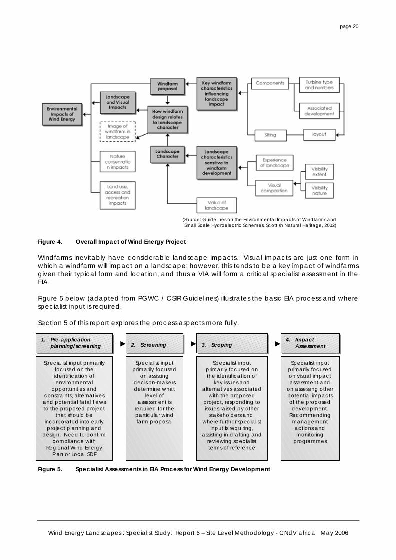
3.5 SUMMARY Figure 4 (source: Guidelines on the Environmental Impacts of Windfarms and Small Scale Hydroelectric Schemes, Scottish Natural Heritage) shows the various interlinked environmental impacts of windfarm developments.
Wind Energy Landscapes : Specialist Study: Report 6 – Site Level Methodology - CNdV africa May 2006
page 20
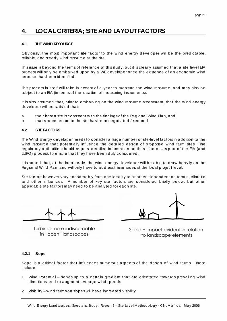
Figure 4. Overall Impact of Wind Energy Project Windfarms inevitably have considerable landscape impacts. Visual impacts are just one form in which a windfarm will impact on a landscape; however, this tends to be a key impact of windfarms given their typical form and location, and thus a VIA will form a critical specialist assessment in the EIA. Figure 5 below (adapted from PGWC / CSIR Guidelines) illustrates the basic EIA process and where specialist input is required. Section 5 of this report explores the process aspects more fully. Figure 5. Specialist Assessments in EIA Process for Wind Energy Development
(Source: Guidelines on the Environmental Impacts of Windfarms andSmall Scale Hydroelectric Schemes, Scottish Natural Heritage, 2002)
1. Pre-application planning/screening
Specialist input primarily focused on the identification of environmental
opportunities and constraints, alternatives and potential fatal flaws to the proposed project
that should be incorporated into early project planning and
design. Need to confirm compliance with
Regional Wind Energy Plan or Local SDF
2. Screening
Specialist input primarily focused
on assisting decision-makers determine what
level of assessment is
required for the particular wind farm proposal
3. Scoping
Specialist input primarily focused on the identification of
key issues and alternatives associated
with the proposed project, responding to issues raised by other
stakeholders and, where further specialist
input is requiring, assisting in drafting and
reviewing specialist terms of reference
4. Impact Assessment
Specialist input primarily focused on visual impact assessment and
on assessing other potential impacts of the proposed development.
Recommending management actions and monitoring
programmes
Wind Energy Landscapes : Specialist Study: Report 6 – Site Level Methodology - CNdV africa May 2006
page 21
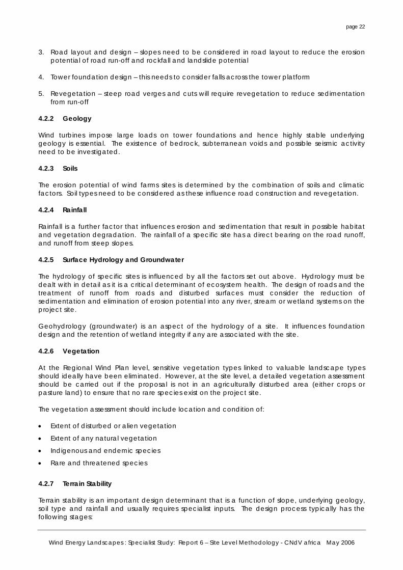
4. LOCAL CRITERIA; SITE AND LAYOUT FACTORS 4.1 THE WIND RESOURCE Obviously, the most important site factor to the wind energy developer will be the predictable, reliable, and steady wind resource at the site. This issue is beyond the terms of reference of this study, but it is clearly assumed that a site level EIA process will only be embarked upon by a WE developer once the existence of an economic wind resource has been identified.
This process in itself will take in excess of a year to measure the wind resource, and may also be subject to an EIA (in terms of the location of measuring instruments). It is also assumed that, prior to embarking on the wind resource assessment, that the wind energy developer will be satisfied that: a. the chosen site is consistent with the findings of the Regional Wind Plan, and b. that secure tenure to the site has been negotiated / secured. 4.2 SITE FACTORS The Wind Energy developer needs to consider a large number of site-level factors in addition to the wind resource that potentially influence the detailed design of proposed wind farm sites. The regulatory authorities should request detailed information on these factors as part of the EIA (and LUPO) process, to ensure that they have been duly considered. It is hoped that, at the local scale, the wind energy developer will be able to draw heavily on the Regional Wind Plan, and will only have to address these issues at the local project level. Site factors however vary considerably from one locality to another, dependent on terrain, climatic and other influences. A number of key site factors are considered briefly below, but other applicable site factors may need to be analysed for each site. 4.2.1 Slope Slope is a critical factor that influences numerous aspects of the design of wind farms. These include: 1. Wind Potential – slopes up to a certain gradient that are orientated towards prevailing wind
directions tend to augment average wind speeds 2. Visibility – wind farms on slopes will have increased visibility
Wind Energy Landscapes : Specialist Study: Report 6 – Site Level Methodology - CNdV africa May 2006
page 22
3. Road layout and design – slopes need to be considered in road layout to reduce the erosion potential of road run-off and rockfall and landslide potential
4. Tower foundation design – this needs to consider falls across the tower platform 5. Revegetation – steep road verges and cuts will require revegetation to reduce sedimentation
from run-off 4.2.2 Geology Wind turbines impose large loads on tower foundations and hence highly stable underlying geology is essential. The existence of bedrock, subterranean voids and possible seismic activity need to be investigated. 4.2.3 Soils The erosion potential of wind farms sites is determined by the combination of soils and climatic factors. Soil types need to be considered as these influence road construction and revegetation. 4.2.4 Rainfall Rainfall is a further factor that influences erosion and sedimentation that result in possible habitat and vegetation degradation. The rainfall of a specific site has a direct bearing on the road runoff, and runoff from steep slopes. 4.2.5 Surface Hydrology and Groundwater The hydrology of specific sites is influenced by all the factors set out above. Hydrology must be dealt with in detail as it is a critical determinant of ecosystem health. The design of roads and the treatment of runoff from roads and disturbed surfaces must consider the reduction of sedimentation and elimination of erosion potential into any river, stream or wetland systems on the project site. Geohydrology (groundwater) is an aspect of the hydrology of a site. It influences foundation design and the retention of wetland integrity if any are associated with the site. 4.2.6 Vegetation At the Regional Wind Plan level, sensitive vegetation types linked to valuable landscape types should ideally have been eliminated. However, at the site level, a detailed vegetation assessment should be carried out if the proposal is not in an agriculturally disturbed area (either crops or pasture land) to ensure that no rare species exist on the project site. The vegetation assessment should include location and condition of:
• Extent of disturbed or alien vegetation
• Extent of any natural vegetation
• Indigenous and endemic species
• Rare and threatened species
4.2.7 Terrain Stability Terrain stability is an important design determinant that is a function of slope, underlying geology, soil type and rainfall and usually requires specialist inputs. The design process typically has the following stages:
Wind Energy Landscapes : Specialist Study: Report 6 – Site Level Methodology - CNdV africa May 2006
page 23
1. Determination of rainfall data for the site (including extreme weather conditions)
2. Determination of slopes by gradient classes
3. Determination of natural watercourses
4. Determination of rocky areas
Determination of soil type and permeability
5. Determination of areas of potential erosion
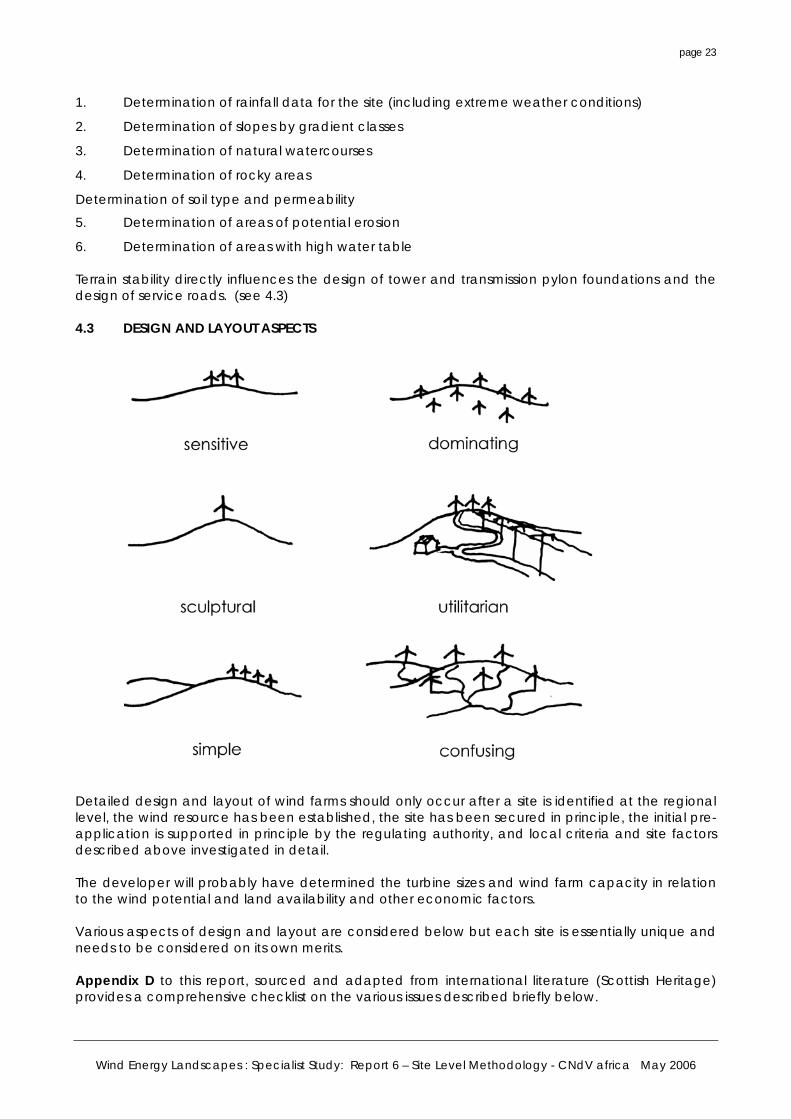
6. Determination of areas with high water table Terrain stability directly influences the design of tower and transmission pylon foundations and the design of service roads. (see 4.3) 4.3 DESIGN AND LAYOUT ASPECTS Detailed design and layout of wind farms should only occur after a site is identified at the regional level, the wind resource has been established, the site has been secured in principle, the initial pre-application is supported in principle by the regulating authority, and local criteria and site factors described above investigated in detail. The developer will probably have determined the turbine sizes and wind farm capacity in relation to the wind potential and land availability and other economic factors. Various aspects of design and layout are considered below but each site is essentially unique and needs to be considered on its own merits. Appendix D to this report, sourced and adapted from international literature (Scottish Heritage) provides a comprehensive checklist on the various issues described briefly below.
Wind Energy Landscapes : Specialist Study: Report 6 – Site Level Methodology - CNdV africa May 2006
page 24
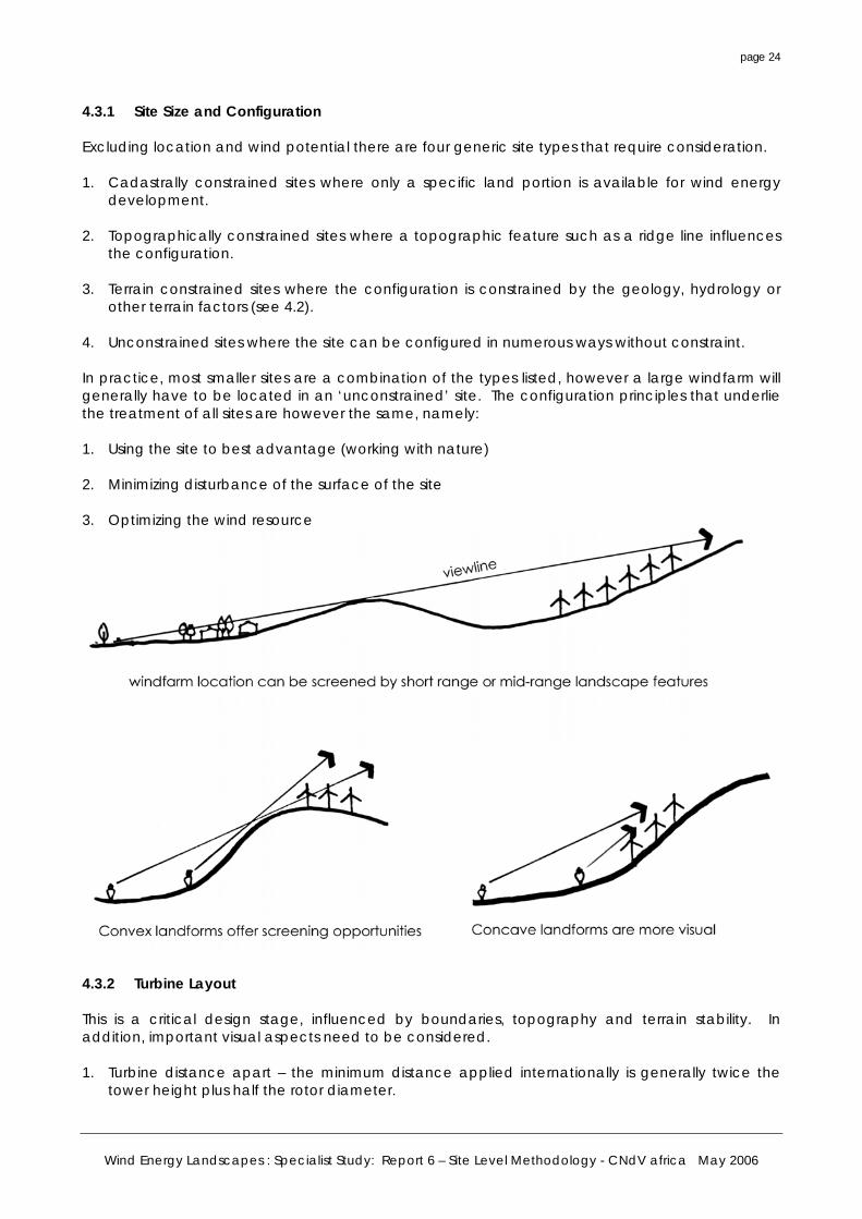
4.3.1 Site Size and Configuration Excluding location and wind potential there are four generic site types that require consideration. 1. Cadastrally constrained sites where only a specific land portion is available for wind energy
development. 2. Topographically constrained sites where a topographic feature such as a ridge line influences
the configuration. 3. Terrain constrained sites where the configuration is constrained by the geology, hydrology or
other terrain factors (see 4.2). 4. Unconstrained sites where the site can be configured in numerous ways without constraint. In practice, most smaller sites are a combination of the types listed, however a large windfarm will generally have to be located in an ‘unconstrained’ site. The configuration principles that underlie the treatment of all sites are however the same, namely: 1. Using the site to best advantage (working with nature) 2. Minimizing disturbance of the surface of the site 3. Optimizing the wind resource 4.3.2 Turbine Layout This is a critical design stage, influenced by boundaries, topography and terrain stability. In addition, important visual aspects need to be considered. 1. Turbine distance apart – the minimum distance applied internationally is generally twice the
tower height plus half the rotor diameter.
Wind Energy Landscapes : Specialist Study: Report 6 – Site Level Methodology - CNdV africa May 2006
page 25
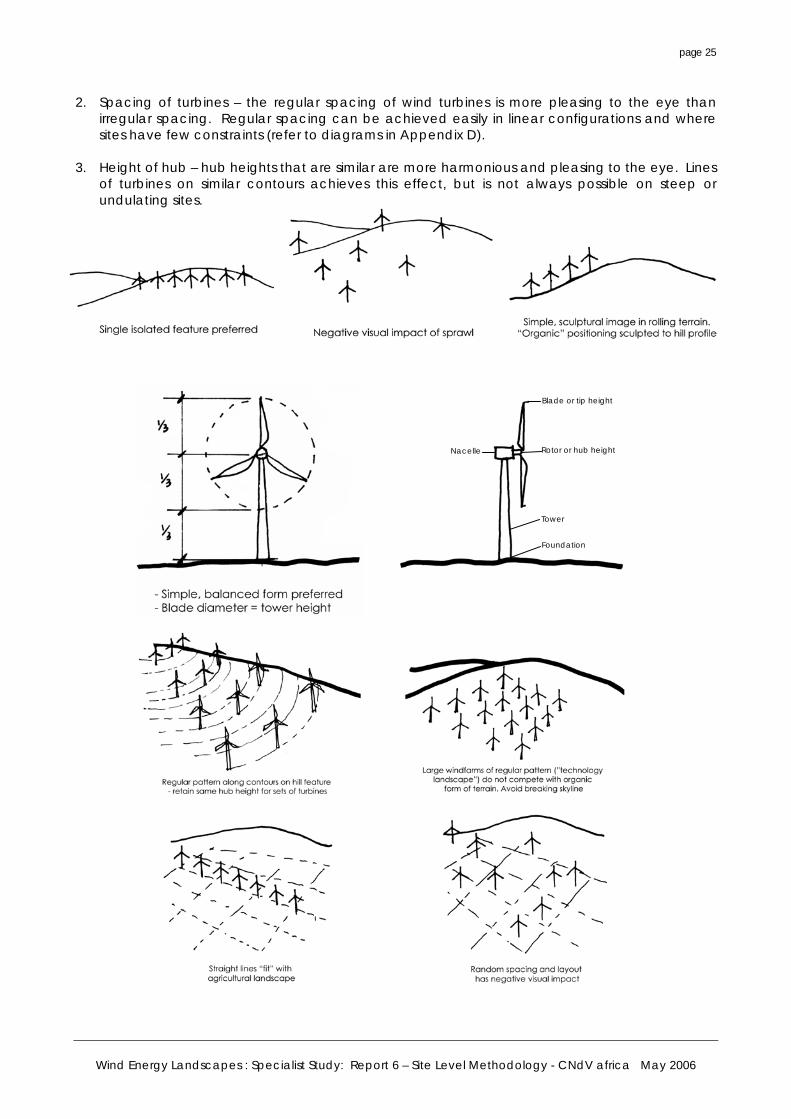
2. Spacing of turbines – the regular spacing of wind turbines is more pleasing to the eye than irregular spacing. Regular spacing can be achieved easily in linear configurations and where sites have few constraints (refer to diagrams in Appendix D).
3. Height of hub – hub heights that are similar are more harmonious and pleasing to the eye. Lines
of turbines on similar contours achieves this effect, but is not always possible on steep or undulating sites.
Blade or tip height
Rotor or hub height
Tower
Foundation
Nacelle
Wind Energy Landscapes : Specialist Study: Report 6 – Site Level Methodology - CNdV africa May 2006
page 26
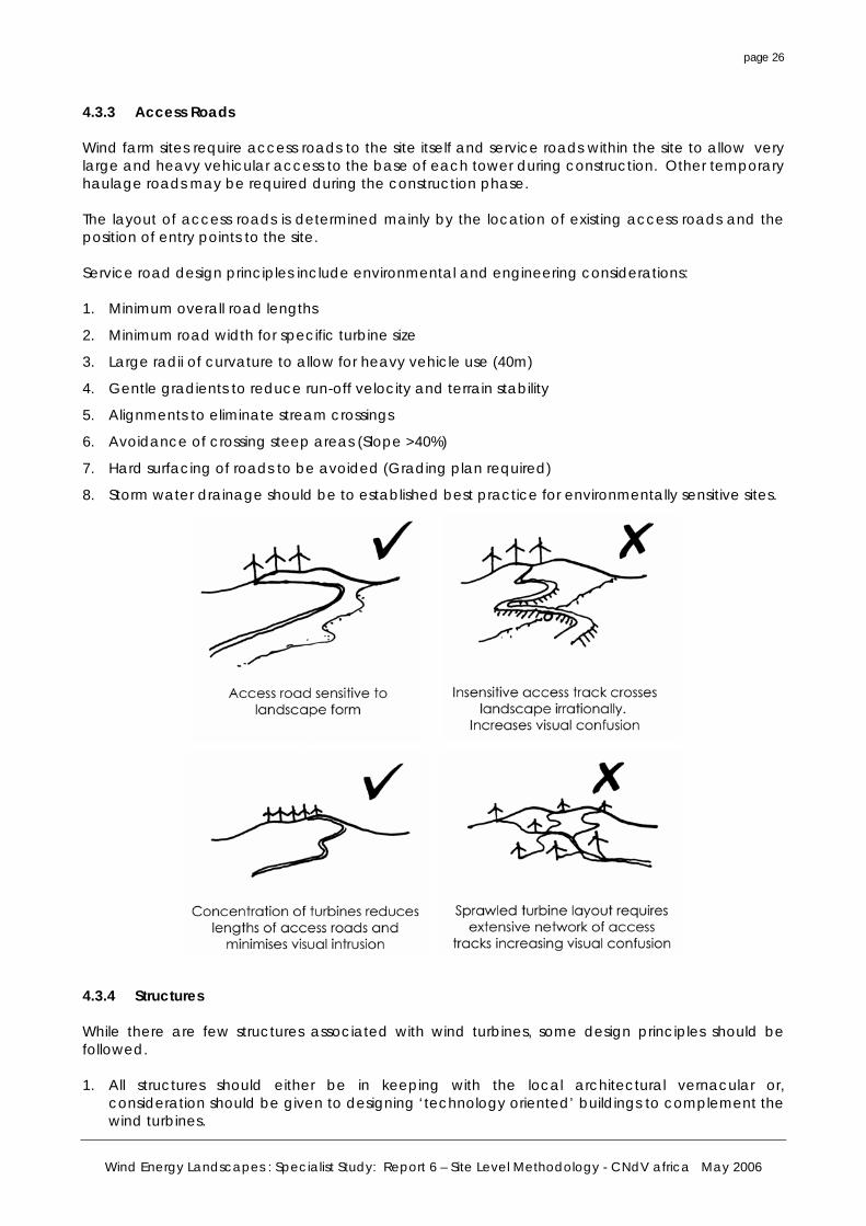
4.3.3 Access Roads Wind farm sites require access roads to the site itself and service roads within the site to allow very large and heavy vehicular access to the base of each tower during construction. Other temporary haulage roads may be required during the construction phase. The layout of access roads is determined mainly by the location of existing access roads and the position of entry points to the site. Service road design principles include environmental and engineering considerations: 1. Minimum overall road lengths
2. Minimum road width for specific turbine size
3. Large radii of curvature to allow for heavy vehicle use (40m)
4. Gentle gradients to reduce run-off velocity and terrain stability
5. Alignments to eliminate stream crossings
6. Avoidance of crossing steep areas (Slope >40%)
7. Hard surfacing of roads to be avoided (Grading plan required)
8. Storm water drainage should be to established best practice for environmentally sensitive sites.
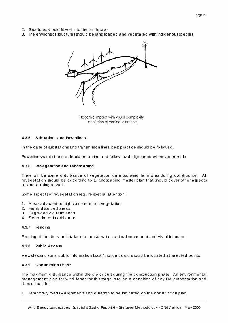
4.3.4 Structures While there are few structures associated with wind turbines, some design principles should be followed. 1. All structures should either be in keeping with the local architectural vernacular or,
consideration should be given to designing ‘technology oriented’ buildings to complement the wind turbines.
Wind Energy Landscapes : Specialist Study: Report 6 – Site Level Methodology - CNdV africa May 2006
page 27
2. Structures should fit well into the landscape 3. The environs of structures should be landscaped and vegetated with indigenous species 4.3.5 Substations and Powerlines In the case of substations and transmission lines, best practice should be followed. Powerlines within the site should be buried and follow road alignments wherever possible 4.3.6 Revegetation and Landscaping There will be some disturbance of vegetation on most wind farm sites during construction. All revegetation should be according to a landscaping master plan that should cover other aspects of landscaping as well. Some aspects of revegetation require special attention: 1. Areas adjacent to high value remnant vegetation 2. Highly disturbed areas 3. Degraded old farmlands 4. Steep slopes in arid areas 4.3.7 Fencing Fencing of the site should take into consideration animal movement and visual intrusion. 4.3.8 Public Access Viewsites and /or a public information kiosk / notice board should be located at selected points. 4.3.9 Construction Phase The maximum disturbance within the site occurs during the construction phase. An environmental management plan for wind farms for this stage is to be a condition of any EIA authorisation and should include: 1. Temporary roads – alignments and duration to be indicated on the construction plan
Wind Energy Landscapes : Specialist Study: Report 6 – Site Level Methodology - CNdV africa May 2006
page 28
2. Quarries and borrow pits – location, extent and remediation to be indicated 3. All topsoil to be set aside and reused
4.4 REFERENCE TO REGIONAL CRITERIA The regional assessment identified a number of criteria to be taken into account in the preparation of a Regional Plan for Wind Energy Site Selection. These criteria are repeated below Table 3 and should be confirmed at the local level. In particular, those issues that were deemed too detailed to be dealt with at the regional level are highlighted and should be addressed at the local level assessment. 4.5 SCALE OF ANALYSIS At the local level, the scale of site and contextual analysis is determined by the key issues to be resolved as well as the scale and size of the windfarm. The following scales are suggested as a guideline only: • The windfarm site itself must be illustrated at an appropriate scale probably 1:2000 or 1:5000
dependant on the size of the development and the topography. Contour mapping showing at least one metre intervals is required. All site level analysis will be done at this scale.
• The local level criteria (refer to Table 3) should ideally be mapped at a scale of 1:10 000, up to 1:50 000 depending on the local context area requiring analysis.
• The Zone of Visual Influence (ZVI) of the windfarm should be analysed at an appropriate scale to reflect at least a 15km radius from the site, up to 30km for a large windfarm 9exceeding 20 turbines).
Wind Energy Landscapes : Specialist Study: Report 6 – Site Level Methodology - CNdV africa May 2006
page 29
Criteria Buffer Notes
1 Urban Areas 800m This distance adequately covers noise and flicker criteria at the local level.
2
Residential Areas (including rural dwellings) *400m Threshold adequately covers noise and flicker criteria at
the local level. 3 Transport Routes 3a National Roads 13km Depends on scenic value of route. Can be reduced. 3b Local Roads *500m Review if high scenic value. 3c Provincial Tourist Route 4km Statutory scenic drives 3d Local Tourist Route 2,5km Assumption made for local importance. Can be reduced. 3e Railway Lines 250m No distinction drawn between passenger and goods lines.
Also, rail corridors usually visually disturbed 4 Transmission Lines 4a Major Power Lines 250m 4b
Cell Phone Masts + Communication Towers *500m To be captured at local scale.
4c Radio + Navigation Beacons *250m Capture at local scale
5 Key Infrastructure/Airports 5a Airport with Primary Radar 25km Should be eliminated at regional level. 5b Local Airfield 2,5km To be confirmed with agency. 5c
National Security Sites (e.g. Koeberg)
15km To be discussed with agency concerned. Should be eliminated at regional level.
6
National Parks + Provincial Nature Reserves
2km Should be eliminated at regional level.
7 Protected Areas 7a Mountain Catchments *500m To be captured at local level.
7b Protected Natural Environment
2km Should be eliminated at regional level.
7c Private Nature Reserves *500m Could be negotiated at local level.
8 Coast & Rivers 8a
Distance to Coastlines of Undisturbed Scenic Value
4km Should be eliminated at regional level.
8b Distance to Rivers *500m Only perennial rivers mapped at regional level – site level to account for all hydrology and geohydrology.
8c
Distance to 1:100 Year Floodline *200m To be mapped at local level.
9 Sensitive Areas (Avian) 9a Distance to Major Wetlands
(Ramsar Sites) 2km Should be eliminated at regional level.
9b Distance to Local Wetlands *500m Map at local level.
9c Distance to Bird Habitats or Avian Flight Paths where known
1km
*
Assumed specific breeding sites dealt with at EIA level.
10 Topographical 10a Slope and elevation * Key considerations at local level; see visual and site
assessment criteria. 10b Distance from Ridge Lines * Major ridgelines eliminated at regional level, local level to
identify ridgelines / skyline issues. 11 Vegetation
Distance to Important Indigenous/ Remnant Vegetation
* To be mapped at local scale.
Table 3. List of Regional Criteria Indicating (*) Key Criteria to be Mapped at Local Project Level
Wind Energy Landscapes : Specialist Study: Report 6 – Site Level Methodology - CNdV africa May 2006
page 30
5. SUBMISSION PROCESS This section briefly elaborates the various submission requirements as already outlined in Section 1 (Regulatory Framework).
5.1 ANTICIPATED SUBMISSION PROCESS FOR WIND ENERGY DEVELOPMENT This section deals briefly with the submission by the Wind Energy Developer. All wind energy developments will involve a submission of a series of interrelated applications to the various competent authorities in each case. • For EIA: PGWC : DEA&DP
• For subdivision of agricultural land : Department of Agriculture
• For rezoning and subdivision : Local authority (if wind energy deemed non-delegated use for decision by PGWC)
It is assumed that applications will be by bona-fide wind energy developers who are fully conversant with all aspects of wind energy and will undertake the required parallel applications in terms of other legislation. It is assumed that the wind energy developer will be conversant with: • The appropriate Regional Wind Energy Plan indicating wind energy planning zones
• Guidelines on wind energy developments
• Environmental management guidelines
• Visual management guidelines The envisaged submission process is described below. 5.2 PRE-APPLICATION SUBMISSION It is highly recommended that wind energy developers and their planning and EIA consultants ensure that a pre-application consultation is held at an early stage with DEA&DP officials. Such consultation is to be preliminary and without prejudice to DEA&DP’s views on any eventual formal application. The pre-application phase should include a Statement of Intent from the Wind Energy developer, followed by an informal advisory response from the regulatory authority (DEA&DP). 5.2.1 Statement of Intent
Prior to commencement with detailed planning, the wind energy developer should submit a statement of intent to DEA&DP and the Local Authority. This should contain a summary of the following information. • Location of the site
• Demonstrate that appropriate regional assessment has been carried out to designate site for wind energy development.
• Current land use and zoning of the site
• Proposed capacity, size and anticipated number of turbines in the development
• Other pertinent information such as negotiations on PPA’s.
Wind Energy Landscapes : Specialist Study: Report 6 – Site Level Methodology - CNdV africa May 2006
page 31
DEA&DP will circulate this statement of intent to other key government role players.
5.2.2 Advisory DEA&DP and the Local Authority will advise the wind energy developer of their stance and the further process to be followed. Guidance from the provincial authority should assist the local planning authority and/or developer and should, include a statement indicating whether a proposal is either:
a. unlikely to be appropriate for this location due to specific concerns and DEA&DP is likely to therefore recommend that any planning EIA application be refused permission;
b. raises particular environmental or planning issues which need to be addressed by any proposal; or
c. insufficient information has been provided to form an initial view.
The advisory response will only provide an indication of concerns, as detailed comments should be fed through other informal or formal discussions;
The advice should include direction on the scope of the Environmental Impact Assessment. Rejection of inappropriate proposals at this stage will save all parties fruitless expenditure on the extensive EIA process. 5.3 FORMAL SUBMISSION There will be a number of interrelated applications, but the EIA (NEMA) Regulations outlined in Section 2 of this report will provide the main thrust of the formal process. 5.3.1 Critical Information The submission by the wind energy developer in terms of the EIA Regulations will include all aspects outlined in the previous section relating to site factors and location and design issues. Annexure D contains a comprehensive list of questions that need to be answered during the EIA process. 5.3.2 Local Criteria Analysis Concurrently with the above, local criteria need to be mapped within the study area and buffers indicated. Refer to Table 3 and Section 4.4 above. 5.3.3 Visual Impact Assessment The visual assessment component of the submission should comply with the VIA specialist guidelines outlined in Section 3 above and must include: • Description of landscape character of site and study area
• Assessment of points of public sensitivity or visual significance to and near the study area
• Viewsheds from viewpoints in and adjacent to study area, including from scenic drives
• Total viewshed and sensitive view points
• Scenic quality of study area
• Nature and extent of visual impacts
• Visual mitigation measures
Wind Energy Landscapes : Specialist Study: Report 6 – Site Level Methodology - CNdV africa May 2006
page 32
5.3.4 Other Factors Other factors to be dealt with will be highlighted during scoping and may include aspects such as traffic impacts or specialist faunal or floral studies. 5.4 APPROVAL PROCESS Refer to Section 3.3 and Tables 1 and 2.
Wind Energy Landscapes : Specialist Study: Report 6 – Site Level Methodology - CNdV africa May 2006
page 33
6. GUIDELINE SUMMARY OF REQUIREMENTS FOR WIND ENERGY DEVELOPMENT AT THE LOCAL LEVEL
A comprehensive guideline checklist has been included as Appendix D to this report. The following requirements should form the basis of any wind development application: 6.1 REGIONAL CONTEXT A clear demonstration of how the proposed site fits into a Regional Plan for wind energy development must be presented. 6.2 SITE INFORMATION
• Location of the site – to be described and mapped on a locality map at 1:50 000 scale indicating where site falls on Regional Wind Development Plan.
• Area – this is the area of the site, or sites if not contiguous. Separate areas must be given for the cadastral area of the property and the wind farm site itself.
• The property must be described as per Title Deed description.
• The ownership of the site must be described in terms of freehold, leasehold or other contractual relationship with the property owner.
• Existing land uses – the existing land uses on the wind farm site and the property as a whole must be described and mapped at an appropriate scale.
• Built form – all buildings and major services should be described and mapped at the appropriate scale, inclusive of photographs.
• Zoning – all zoning in terms of Ordinances must be indicated.
• Any land-use designation in terms of Draft or Statutory Land Use Plans must be indicated.
• Any historical or heritage information applicable.
6.3 SITE ENVIRONMENT A detailed description of the natural environment of the site must be provided. This should include (see Section 4): • Topography – contours, slopes and landforms at appropriate scale • Rivers and streams – indicating which are perennial and flood lines in the case of major rivers
(may require specialist study) • Dams and wetlands – constructed dams (all sizes) and all forms of wetlands (may require
specialist study) • Soils and underlying geology (may require specialist study) • Natural vegetation (may require specialist study) • Avian species with attention to nesting and migratory patterns (will require specialist study if
relevant) • Faunal species with attention to special habitats (may require specialist study)
Wind Energy Landscapes : Specialist Study: Report 6 – Site Level Methodology - CNdV africa May 2006
page 34
6.4 VISUAL AND CRITERIA BASED ANALYSIS This is an area surrounding the proposed site in which a mapping exercise must be undertaken in terms of the criteria identified at both regional and local scales. The extent of the study area is dependent of the nature of the wind farm proposed: • Small windfarms – turbines of less that 750kW and 10 in number – 15 kilometre radius
• Large windfarms – 30 kilometre radius The study area may be expanded or reduced by DEA&DP depending on local conditions. The Visual Impact Analysis (VIA) is the critical tool at this level. A detailed visual impact analysis of the wind farm must be undertaken (in accordance with the specialist guidelines summarised in Section 3) and include: • Viewshed analysis – within a zone of visual influence (ZVI) within a 20- 30km radius dependent
on turbine sizes.
• Shadow flicker – on all main / provincial roads (other than internal site access roads) and any residence within a 500m radius of the turbines
• Visually significant points – ridgelines and landforms within the study area
• Key viewpoints within study area – from which visually significant points and wind farm will be visible
• Photomontages of turbines on the proposed windfarm site – at the correct scale, colour and layout
• Cumulative impact – of all other major industrial developments, or other windfarms within the study area
6.5 TECHNICAL DATA The following technical data must be submitted: • Total planned capacity of the wind farm (in phases if necessary)
• Turbine manufacturer
• Turbine type, output and model
• Tower type
• Hub height
• Rotor Diameter
• Total tip height
• Foundation details
6.6 WIND FARM LAYOUT With reference to Appendix D and Section 4 above, the following information must be provided: • Site plan - mapped to appropriate scale
• Layout configuration – description and footprint analysis
• Exact position of turbines
Wind Energy Landscapes : Specialist Study: Report 6 – Site Level Methodology - CNdV africa May 2006
page 35
• Turbine base heights (plan to note metres above sea level (MSI) for each turbine foundation)
• Substations
• Other buildings
Access Roads
6.7 MAJOR SUBSTATION AND TRANSMISSION CORRIDORS In the case of larger wind farms (where applicable), the following must be indicated: • Major substations – description and mapped to 1:10 000 scale, or as appropriate (to 1:50 000)
• New transmission corridors – mapped to 1:10 000 scale, or as appropriate (to 1:50 000)
6.8 SOCIO-ECONOMIC ASSESSMENT Information on anticipated local job creation and local economic multipliers, procurement policies etc. must be provided and should form part of the overall assessment.
6.9 ENVIRONMENTAL MANAGEMENT The EMP will be a fundamental component of any approval and must address: • Minimization of impact on the landscape
Minimization of impact on avian and faunal species
• Minimum disturbance of natural vegetation and wetlands
• Minimum disturbance of cultural factors
• Remediation of degraded vegetation and soils
Wind Energy Landscapes : Specialist Study: Report 6 – Site Level Methodology - CNdV africa May 2006
page 36
7. CONCLUSIONS AND RECOMMENDATIONS 7.1 CONCLUSIONS The site-level processes and assessment guidelines to be followed pose unique challenges as no commercial wind farms have been developed in South Africa as yet. Indeed, the first proposal in the Western Cape followed a particularly time consuming and controversial path, being finally approved on appeal at the national level. Many aspects of regulation, interaction, submission and design thus need to be tested in real-world situations. Under these conditions, any gaps in the process will be revealed and should be addressed on an ongoing basis. The main conclusions of this report are: 1. The procedures recommended are consistent, being derived directly from existing
environmental legislation and the proposed Regional Methodology of this programme. 2. The site-level procedures will require clear lines of communication between DEA&DP, the Local
Authority, the wind energy developer, and key I&APs. 3. A critical first step in communication with the wind energy industry will be the work required
towards the various Regional Wind Energy Plans eventually depicting preferred / designated zones for wind development. Thereafter, these site level guidelines should be confirmed.
Based on the ongoing review of the international situation, it is clear that the procedure at local EIA level needs to resolve a number of issues that are often diametrically opposed. • The residents and observers viewpoints – these are likely to revolve around either limiting the
scale of the proposed windfarm development or opposing it entirely.
• The wind energy developers viewpoint – this is generally the desire to optimize the siting of wind turbines in relation to the wind resource and optimize the number of turbines within the wind farm.
• The government and authority viewpoint which should be directed at encouraging renewable energy development but, in the context of wind energy, will undoubtedly conflict with the objective of protecting sensitive landscapes from visual intrusion. (Recent controversial decisions in the UK have highlighted this anomaly – see press cuttings from RTPI Journal overleaf)
International experience indicates that there is no easy resolution of these issues, but that a transparent and informative process is essential. Hopefully, the fundamental locational issues (in particular cumulative impact) can be dealt with at the regional scale to ensure that only detailed design and siting issues are dealt with at the local EIA level. 7.2 RECOMMENDATIONS 1. The role of Local Authorities in the process of commercial wind energy development should be
clarified. (Refer to competent authorities designated in final NEMA Regulations). 2. A set of formal guidelines based on the recommendations in this report should be published for
the wind energy industry and local / provincial authorities to assist in the design and assessment of wind energy development at the local scale.
3. That PGWC / DEA&DP consider introducing a new Special Zone (Wind Energy) in terms of the
Schedule 8 Regulations of LUPO. Such a zone will provide the approving authority with a
Wind Energy Landscapes : Specialist Study: Report 6 – Site Level Methodology - CNdV africa May 2006
page 37
mechanism whereby special and site specific directives, land use parameters, and design parameters may be established both for the wind energy development sector in general, but also to specific sites or areas. The Special Zone can be further applied by publishing special directives or guidelines in an annexure to a new by-law.
Alternatively, should the revised Provincial Zoning Scheme be finalised a new OVERLAY ZONE for wind energy development could be created.
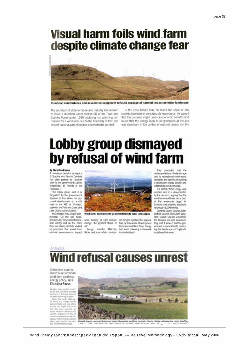
Wind Energy Landscapes : Specialist Study: Report 6 – Site Level Methodology - CNdV africa May 2006
page 38
Wind Energy Landscapes : Specialist Study: Report 6 – Site Level Methodology - CNdV africa May 2006
page 39
Assessing Cumulative Landscape and Visual Impacts The purpose of a Cumulative Landscape and Visual Impact Assessment (CLVIA), which will normally form part of an Environmental Assessment, is to describe, visually represent and assess the ways in which a proposed windfarm would have additional impacts when considered together with other existing, consented or proposed windfarms. The focus of the assessment should be the proposed windfarm. The stages in a CLVIA will normally be: • Preparation of a base plan, showing all existing, consented or publicly proposed windfarms
within a range of the proposed windfarm. As ZVI analysis is normally undertaken out to 30km from a windfarm, it is recommended that this base plan includes all proposals out to 60km from the proposed windfarm, so that any potential cumulative effects towards the edge of a 30km zone of influence can be identified.
• ZVI analysis, identifying separately the areas where two, three or more windfarms would be visible.
• Selecting appropriate viewpoints at which to assess the nature and significance of combined visibility effects, and appropriate routes or journeys through the area for which to assess sequential visibility effects.
• Preparing photomontage or wireline representation to describe and illustrate the nature and degree of cumulative effects.
• Describing and assessing the nature and significance of cumulative visual effects. Describing and assessing the nature and significance of cumulative landscape effects.