tanap project offshore fisheries livelihood … fisheries livelihood restoration plan...
TRANSCRIPT
OFFSHORE FISHERIES LIVELIHOOD RESTORATION PLAN CIN-PLN-SOC-GEN-002
Rev-P3-0 Rev: P3-0 Status: IAA Date: 10 July 2017
TANAP
TRANS ANATOLIAN NATURAL GAS PIPELINE PROJECT
OFFSHORE FISHERIES LIVELIHOOD RESTORATION PLAN
Agreement No INEA/CEF/ENER/M2014/0019
CIN-PLN-SOC-GEN-002 Rev-P3-0 107 Pages
Rev Status Date Status Description Issued
by
Checked
by
Approved
by
P3-0 IAA 10.07.2017 Issued as Approved
DEME ARSO ARTF MANE UNAV
ATIE
ARSO
AKYH
P3-H Re-IFR 05.07.2017 Re-Issued for review
DEME ARSO ARTF MANE UNAV ATIE
ARSO
AKYH
P3-G Re-IFR 20.06.2017 Re-Issued for review
DEME ARSO ARTF MANE UNAV
ATIE
ARSO
AKYH
OFFSHORE FISHERIES LIVELIHOOD RESTORATION PLAN CIN-PLN-SOC-GEN-002
Rev-P3-0
Rev: P3-0 Status: IAA Date: 10 July 2017 Page ii / iii
P3-F Re-IFR 10.05.2017 Re-Issued for review
DEME ARSO ARTF MANE UNAV ATIE
ARSO
AKYH
P3-E Re-IFR 17.02.2017 Re-Issued for review
DEME ARSO ARTF MANE UNAV
ATIE
ARSO
AKYH
P3-D Re-IFR 09.02.2017 Re-Issued for review
DEME ARSO ARTF MANE UNAV ATIE
ARSO
AKYH
P3-C IFR 23.12.2016 Issued for review
DEME ARSO ARTF MANE UNAV ATIE
ARSO
AKYH
P3-B IDC 22.12.2016 Inter discipline check
DEME ARSO ARTF MANE UNAV ATIE
ARSO
AKYH
P3-A DIC 22.12.2016 Discipline Internal
Check
DEME ARSO ARTF MANE UNAV ATIE
ARSO
AKYH

OFFSHORE FISHERIES LIVELIHOOD RESTORATION PLAN CIN-PLN-SOC-GEN-002
Rev-P3-0
Rev: P3-0 Status: IAA Date: 10 July 2017 Page iii / iii
DOCUMENT REVISION HISTORY SHEET
Rev REVISION DESCRIPTION DATE ISSUED UPDATE / AMENDMENT DETAILS
P3-C IFR 23.12.2016 Issued firstly
P3-D Re-IFR 09.02.2017 Revised based on “TANAP-TNP-TRA-CIN-0204 (18/01/2017)”
P3-E Re-IFR 17.02.2017 Revised based on “TANAP-TNP-TRA-CIN-0206 (16/02/2017)”
P3-F Re-IFR 10.05.2017 Revised based on comments of World Bank
P3-G Re-IFR 20.06.2017 Revised based on comments of World Bank
P3-H Re-IFR 05.07.2017 Revised based on comments of World Bank
P3-0 IAA 10.07.2017 Issued as approved by “TANAP-TNP-TRA-CIN-0217 (07/07/2017)”
iv
TANAP Project Offshore Fisheries Livelihood Restoration Plan (Final)
2017

TABLE OF CONTENTS
TABLE OF CONTENTS v
LIST OF TABLES viii
LIST OF FIGURES ix
ABBREVIATIONS x
GLOSSARY xi
EXECUTIVE SUMMARY xii
1. INTRODUCTION 1
2. PROJECT OVERVIEW 2
2.1. Project Description 2
2.2. Project’s Offshore Facilities 3
2.3. Overview of the Fishing Resources, Activities and Fishing Based Livelihoods 4
2.3.1. Socio-Economic Context and Local Capacity 4
2.3.2. Reflections of the common effects of the present situation on the project 13
3. LEGAL FRAMEWORK 16
3.1. National Legislation 16
3.2. International Standards 19
4. LIVELIHOOD SYSTEMS OF PROJECT AFFECTED VILLAGES 21
5. FISH HABITAT AND RESOURCES 33
5.1. Fish Habitat 33
5.2. Fish Resources 34
6. IDENTIFICATION OF STAKEHOLDERS 36
6.1. Communities 36
6.1.1. PAPs Impacted Directly 36
6.1.2. PAPs Impacted Indirectly 37
6.1.3. Unimpacted Community Groups 37
6.2. Institutional Stakeholders 38
6.2.1. Public Institutions 38
6.2.2. Civil Society 38
6.2.3. Private Sector 39
7. LIVELIHOOD IMPACT ASSESSMENT 40
7.1. Potential Impacts 43
7.1.1. Moving away of target commercial fish species from the area where turbidity and sedimentation is expected 43
7.1.2. Permanent loss of seagrass meadows 45
7.1.3. Disturbance of sun light penetration causing the limitation of photosynthetic
activities 46
7.1.4. Moving away of target commercial fish species from the area around the construction activities 46
7.1.5. Hardship to access to fishing grounds and narrowing of the fishing areas 47
7.1.6. Increased traffic on the fishing area due to the transportation activities 48
7.2. Assessing the Potential Impacts on Livelihood 49
8. LIVELIHOOD RESTORATION STRATEGY 52
8.1. Strategic Principles 52
8.2. Stakeholder Feedback in the Preparation of the Livelihood Restoration Strategy 52
8.3. Mitigation Measures 54
8.4. Compensation 55
8.4.1. Compensation alternatives considered 55
8.4.2. Fuel Support 56
8.5. Eligibility for Compensation 56
9. LRP IMPLEMENTATION 57
9.1. Methods of Mitigation Measures 57
9.2. Implementation Method of Fuel Support 58
9.3. Roles & Responsibilities 58
9.4. Actions of LRP Implementation 59
10. COMMUNITY ENGAGEMENT AND GRM 63
10.1. Consultation Activities 63
10.2. Community Engagement During Implementation 64
10.3. Grievance Redress Mechanism 64
11. MONITORING AND EVALUATION 66
12. BUDGET 68
REFERENCES 69
Appendix 1 Methodology of Field Study of LRP 73
1. Introduction 73
2. Scope 73
3. Field Study 74
3.1. Pilot Study 74
3.2. Sampling 74
3.3. Limitations 76
3.4. Data collection tools 77
Appendix 2 Tables and Graphs Of Socioeconomic Baseline Survey 78
1. Socioeconomic Characteristics of Affected Villages 78
1.1. Demographic Composition of Affected Villages 78
1.2. Household Demographic Composition 80
1.3. Economic Profile 82
1.3.1. Agriculture and Husbandry 84
1.3.2. Income indicators 88
2. Fishery Systems 90
2.1. Small Scale Fisheries 90
2.3.1. Amateur fishing 90
2.3.2. Characterization of amateur fishers 90
2.2. Fishing Based Livelihoods 91
Appendix 3 Survey Questionnaires 95
A. Cooperative Questionnaire 95
B. Commercial Fishermen Questionnaire 97
C. Amateur Fishermen Questionnaire 103
LIST OF TABLES
Table 2-1 Anticipated Construction Schedule .......................................................4
Table 2-2 Fishery Typology of the Region ............................................................6
Table 2-3 Main characteristics of fishery cooperatives located in the project area ......... 12
Table 4-1 Proportional distribution of reasons for starting fishery among the interviewed fishermen ............................................................................................... 24
Table 4-2 Technical and operational features of small and medium scale fishing vessels .. 26
Table 4-3 Fishing gears, target species type of vessels and fishing areas in Çanakkale Strait ........................................................................................................... 26
Table 4-4 Amount of yearly catches by species of fishers interviewed, 2016 ................ 29
Table 5-1 Biocenoses in the LSA and the facies they contain, RAC/SPA codes, the areas they cover and their percentage (%) in the total LSA ............................................ 34
Table 6-1 Numbers of the directly impacted groups ............................................. 36
Table 6-2 Numbers of the indirectly impacted groups ........................................... 37
Table 7-1 Description of the affected groups ..................................................... 41
Table 7-2 Impact Sources and their Potential Impacts During the Construction of Offshore Facilities ................................................................................................ 41
Table 7-3 Categorization of Sensitivity Levels .................................................... 42
Table 7-4 Categorization of the Magnitude of Impacts........................................... 42
Table 7-5 Impact Significance Matrix ............................................................... 43
Table 7-6 Offshore Facilities Construction Schedule and Fishing ............................... 44
Table 7-7 Impact Assessment and Strategies ...................................................... 50
Table 8-1 Compensations benchmark summary ................................................... 53
Table 8-2 Supports Preferred by Fishermen in case of Low Productive Season .............. 53
Table 9-1 Fishery activities during the summer period of construction ....................... 61
Table 9-2 LRP Implementation Schedule ........................................................... 62
Table 10-1 Summary of Stakeholder Consultations ............................................... 63
Table 11-1 Monitoring Plan for FLRP implementation ............................................ 66
LIST OF FIGURES
Figure 2-1 Site location map showing SCP, TANAP and TAP .......................................2
Figure 2-2 TANAP Project Route .......................................................................3
Figure 2-3 İÇDAŞ Port Exclusion Zone ............................................................... 10
Figure 3-1 Fishing License for Real Persons ........................................................ 17
Figure 3-2 Fishing License for Vessels .............................................................. 18
Figure 3-3 Amateur (Recreational) Fishing Document ............................................ 18
Figure 4-1 Land Use Map of Affected Villages ..................................................... 22
Figure 4-2 Preference and distribution of fishing gear of interviewed fishermen ........... 28
Figure 4-3 Fishing Areas in the Region (1) ......................................................... 30
Figure 4-4 Fishing Areas in the Region (2) ......................................................... 31
Figure 4-5 Sinker opening process ................................................................... 32
Figure 4-6 Net knitting process ...................................................................... 32
Figure 6-1 Stakeholders Identified .................................................................. 36
Figure 7-1 Temporary 500m Safety Distance Zone of TANAP Pipeline Route ................. 47
Figure 7-2 Map of ship traffic during construction activities .................................... 48
ABBREVIATIONS
BOTAŞ Petroleum Transportation Company with Pipelines
GDFA General Directorate of Fisheries and Aquaculture
DFAD Directorate of Fisheries and Aquaculture Department
DI Deep Interview
ESIA Environmental and Social Impact Assessment
FAO-GFCM The World Food Organization-General Fisheries Council of Mediterranean
FGD Focus Group Discussion
GFCM General Fisheries Council of Mediterranean
GRM Grievance Mechanism
IFC International Finance Corporation
LRP Livelihood Restoration Plan
LSA Local Study Area
OSID Online Stakeholder Interaction Database
PAP Project Affected Person
SEGE Socio-Economic Development Index
SSF Small-Scale Fisheries
TANAP Trans Anatolian Natural Gas Pipeline
TGPS Turkey-Greece Natural Gas Pipeline
TUIK Turkish Statistical Institute
TURFs Territorial Use Right Fisheries
MFAL The Ministry of Food, Agriculture and Livestock

xi
GLOSSARY
Amateur fisheries (Recreational fisheries) is defined as a non-commercial (i.e. not for sale, barter or trade) subset of capture/harvest fisheries; motivated by catching fish for fun, pleasure or sport.1 However, in this study it is seen that amateur fishery in the region is done for commercial purposes and not in accordance with its general definition. Thus, “amateur fishermen” term in this document represent the amateur-looking unlicensed commercial fishing activity.
Compensation refers to payments made by those causing specified and agreed loss to those who suffer the impairment of access to land, waters and other critical natural resources and livelihoods, or damage to, or destruction of, community members’ individual or collective assets of any kind, whether accidental or planned.
Economic Displacement2 refers to loss of income streams or means of livelihood resulting from land acquisition or obstructed access to resources (land, water, or forest) resulting from the construction or operation of a project or its associated facilities.
Eligibility refers to criteria identifying which affected persons are entitled to receive compensation, resettlement assistance and/or other benefits as a result resettlement. Usually established either by law or via policies of International Financial Institutions (IFIs).
Livelihood refers to the full range of means that individuals, families, and communities utilize to make a living, such as wage based income, agriculture, fishing, foraging, other natural resource based livelihoods, petty trade, and bartering.
Livelihood Restoration Actions or programs designed to restore, substitute and/or improve project affected persons’ livelihoods, e.g.
Project-affected person (PAP)3 refers to any person who, as a result of the implementation of a project, loses the right to own, use, or otherwise benefit from a built structure, land (residential, agricultural, or pasture), annual or perennial crops and trees, or any other fixed or moveable asset, either in full or in part, permanently or temporarily.
Purse-Seiners4 refer to the large-scale vessels which usually has a length of more than 12 meters and use purse seines as fishing gear. Purse seiners are the most important and most effective vessels to catch aggregating species near the surface. The vessel surrounds the shoal with a deep curtain of netting and then the bottom of the net is pursed (closed) underneath the shoal by hauling a wire which runs from the vessel through rings on the bottom of the net and back to the vessel. Searching for shoals and assessing the size and direction of movement of it are the most important part of the fishing operation.
Small-Scale Fisheries (SSF) refers to a small scale, low cost and labor-intensive fishery in which the catch is generally consumed locally. Small-scale vessels can both have a length of 5-9.9 m (small-size vessels) and 10-12 m (medium-size vessels). The term also refers to artisanal fisheries which can be subsistence or commercial fisheries, providing for local consumption or export.
Stakeholder refers to individuals, groups, organizations, and institutions interested in and potentially affected by a project or having the ability to influence a project.
Mitigation measure refers to the measures to be taken in order to minimize the negative effects of impacts on livelihoods of the affected people.
1 Recreational Fisheries in the Mediterranean Countries, General Fisheries Commission for The Mediterranean 2 IFC Handbook for Preparing a Resettlement Action Plan
3 IFC Handbook for Preparing a Resettlement Action Plan
4 Definition of Food and Agriculture Organization of the United Nations http://www.fao.org/fishery/vesseltype/140/en
xii
EXECUTIVE SUMMARY
Trans Anatolian Natural Gas Pipeline (TANAP) Project is part of the Southern Gas Corridor, and aims to transport the Azeri natural gas from Shah Deniz 2 Gas Field and other fields in the southern Caspian Sea to Turkey and Europe through the TAP Project. The offshore section of the Project is about 17.5 km long and the Anatolian landfall is located 2,5 km north east of the fishing village of Kemer.
This LRP aims to identify the impacts of project's offshore facilities on fishing communities, lay out their socio economic baseline data and define mitigation measures or compensation strategies to eliminate the impacts identified during the study. The main objective of this LRP is to prevent any loss of livelihood due to the project activities of the fishery which is the main livelihood in the region, to ensure that the households whose income depends largely on fishery are not adversely affected and the living standards can be maintained in the same way.
Kemer, Değirmencik and Aksaz villages are included in scope of study since they are affected by the project's offshore facilities. During the field study executed between November 14-17, surveys were conducted with households engaged in fishing in these three villages, interviews were held with fisheries-related institutions and cooperatives, and focus group meetings were held with women.
The overall socio-economic situation is assessed by comparing the potential environmental and social impacts of the project, and this report presents actions to be taken to minimize or eliminate the identified impacts.
The main livelihood in the region depends on fishing and agriculture, which are usually carried out together according to seasonal conditions. However, the field study shows that, fishing is the primary source of livelihood for the people of the region, as income return is higher than in agriculture. Due to the existence of ancient ruins of archeological importance and the limited agricultural fields, farming in Kemer village is less intense compared to other neighboring villages. Despite the fact that in Değirmencik and Aksaz villages, the number of households with the main subsistence agriculture and animal husbandry is higher, almost all of these households engage in fishing activities. Paid labor is also an important source of livelihood because of the abundance of industrial facilities in the region. It has been learned that some members of fishing households are also working as paid workers in İÇDAŞ plant, which is located in the region.
There are many factors affecting fishing activity in the region. The artificial reefs placed by İÇDAŞ thermal power plant in the sea contributed to the increase of the fish population. Although İÇDAŞ port prohibited large-scale fishermen (purse-seiners) to fish under exclusion zone, small scale fishermen are allowed to catch fish with fishing hooks.
On the other hand, the state provides the opportunity to buy discounted fuel for all scales of fisheries, which is especially very beneficial to commercial fishermen since their fuel consumption is higher than the others. Also, the government's vessel withdrawing program has resulted in many fishermen selling large vessels and buying small vessels. Government initiatives regarding fisheries and investments made in the region in recent years have resulted in increase in the number of small scale fisheries while the number of large scale fisheries has been adversely affected.
During the field study, vessel owners of small scale fishing activities are identified as likely to be affected directly by the Project in terms of livelihood. Crew of licensed small scale vessels and amateur fishers are identified as indirectly affected groups. Purse seiners and crew of purse seines are not expected to be affected by the Project and so they are defined as "un-impacted groups". Any vulnerable group has not been identified in the
xiii
project-affected area. Small-scale fishing activities in the region are usually carried out by extension nets and fishing hooks. Fish species such as bonito, bluefish, shrimp and sardine are among frequently caught fish. Field survey indicates that fishing grounds of fishers from Kemer and Değirmencik villages overlap with the project’s construction area. Although there exists an intensive fishing activity in the region, the Project may affect the fishery income to a limited extent because the anticipated impacts of the Project’s offshore construction activities will be low and limited to a certain period.
No livelihood impacts on fisheries are anticipated during the operation phase of the Project. Impacts that will occur during the construction phase are anticipated to affect the fishery livelihood of fishing communities to a limited extent. Sediment and turbidity impacts that will occur during trenching, post trenching and backfilling are anticipated to cause commercial fish species to move away from the area or to create hardship in seeing into the sea due to turbidity. These impacts will occur in a very limited area and for a short time, however it is likely that the impact will be higher during the period when trenching activities and pulling pipeline activity coincides. Both activities will limit the movement of fisheries as well as limiting the access to coastal fishing grounds (up to 500 meters from coast) for a short period of time. Other environmental impacts of the construction activities were defined as permanent loss of sea grass meadows, disturbance of sunlight penetration, increased traffic, noise and light. However, the level (in terms of magnitude and sensitivity) of these environmental impacts on fishing based livelihoods are assessed to be "negligible to low", yet some mitigation measures based on informing stakeholders have been developed.
According to the construction schedule, possible impacts within the coastal zone will have a larger impact on small scale fishing activities than the large scale fisheries. Initial construction activities will be realized during the fishing restriction season when no large scale vessel is allowed by law to operate. During this season small scale fishery activities are not prohibited however the intensity is comparatively low due to scarcity of commercial fish population. Although some of the construction activities will be realized during the winter season, when there is no fishing ban, large scale fisheries are not expected to be affected by the project impacts since they already go further distances in this season rather than catching on the coastal area. It is anticipated that the impacts on fishing based livelihoods due to trenching, pipe laydown, rock placement and back filling activities will occur within a 63-day period. During this period, the fishermen will have to change their fishing grounds and have to travel further, since there will either be a sedimentation impact preventing fishing activities or access to the fishing area up to 500 meters from the coast will be prohibited or limited for 63 days (in total for both impacts). In order to compensate for the possible economic losses due to Project’s construction activities a livelihood restoration strategy was deemed necessary. Several alternatives were discussed and evaluated in a participatory manner among the TANAP Social Impact Team and consultants responsible for preparing the LRP and local stakeholders. Among the alternatives considered were; compensation for income loss, equipment support, maintenance and repair support, and fuel support to be provided to small scale vessel owners. As a conclusion, for various reasons fuel support was selected as a compensation method. Small scale fishermen who will have to travel further distances to fish will be provided with fuel support for the afore mentioned 63 days where livelihood impacts are anticipated. As the calculation of additional travel expenses made by each vessel would not be possible to calculate, the fuel support will be provided to each eligible small scale vessel owner for the entire duration of the 63 days that the livelihood impact is anticipated. The fuel expense to be compensated will be calculated according to vessel capacity and its total daily fishing hours per day in the specified seasons. The compensation will not only the cover the extra distances travelled but also the entire
xiv
average daily fishing hours (predetermined according to season by the Port Authority) spent by the subject vessel. Vessel owners who currently benefit from the government’s fuel support will be compensated based on the discounted fuel rates through submission of their fuel books whereas other vessel owners who do not benefit from the government support will be compensated on regular fuel rates through the submission of fuel receipts collected during the time of impact. In order to be eligible for the fuel support; all small scale vessel owners will need to apply to the support program which provided to compensate the fuel expenses by submitting an application form along with supporting documents which will be specified earlier by the Project. Eligible small scale vessel owners (who meet the specified criteria) will be compensated under the maximum limits defined in the content of support program for their fuel expenses which incurred during the announced construction dates (63 days). . The maximum limit of compensation will be determined according to the specifications of the vessel including motor capacity and with standard average daily working hours (6 or 8 hours) defined for each season the impacts will occur.
In addition to the compensation for fuel support, the Project’s livelihood strategy will also include some mitigation measures such as awareness raising and informative meetings to be held prior to intense sea traffic periods and coastal area limitations due to construction activities. Meetings will be held in Project nearby villages to inform all local fishers regarding sea traffic and the usage conditions of the coastal zone. All activities will be realized in consultation and coordination with relevant stakeholders including fishers.
The livelihood restoration strategy adopted by the Project has been developed, consulted and agreed upon with local stakeholders during meetings held on site. Thus, the strategy takes into consideration the needs and solutions to overcome these needs of small scale vessel owners. In line with international standards and best practices, mitigation measures and the compensation method chosen aims to provide a fair and transparent approach to overcoming any livelihood impact that may arise from the offshore construction activities of the Project.
1
1. INTRODUCTION
The Fisheries Livelihood Restoration Plan (Fisheries LRP) prepared for Trans Anatolian Pipeline (TANAP) Project’s Offshore provides information regarding the potential impacts on fishing activities and fishing based livelihoods in Çanakkale Province during construction the Project’s offshore facilities, as well as introducing applicable mitigation measures and means of compensation along with defining the roles and responsibilities to implement the proposed Livelihood Restoration Strategy.
The Fisheries LRP identifies communities, small scale fishery groups and amateur fishers who are anticipated to experience fishing based livelihood impacts due to the Project and who will require support to maintain or improve their livelihoods during the period of construction and operation. A livelihood restoration strategy composed of several mitigation measures and compensation are proposed to prevent the possible impacts to livelihoods and to offset expected hardships that may be experienced by fishing communities.
The data used for the analysis of impacts on fishery activities and fishing based livelihoods were obtained from baseline studies which carried out under the RAP (Resettlement Action Plan) and ESIA (Environmental and Social Impact Assessment), literature reviews, the field survey and stakeholder interviews which conducted on 14-17 November 2016. The analysis of the data collected provides the baseline from which anticipated future impacts can be monitored. The effectiveness of the fisheries livelihood restoration strategy will be monitored and evaluated through a set of indicators again presented in this Plan.
2
2. PROJECT OVERVIEW
2.1. Project Description
Trans Anatolia Natural Gas Pipeline (TANAP) project intends to transport natural gas from various gas fields located in Azerbaijan, including the Shah Deniz 2 field, and other neighboring countries through Turkey to Europe.
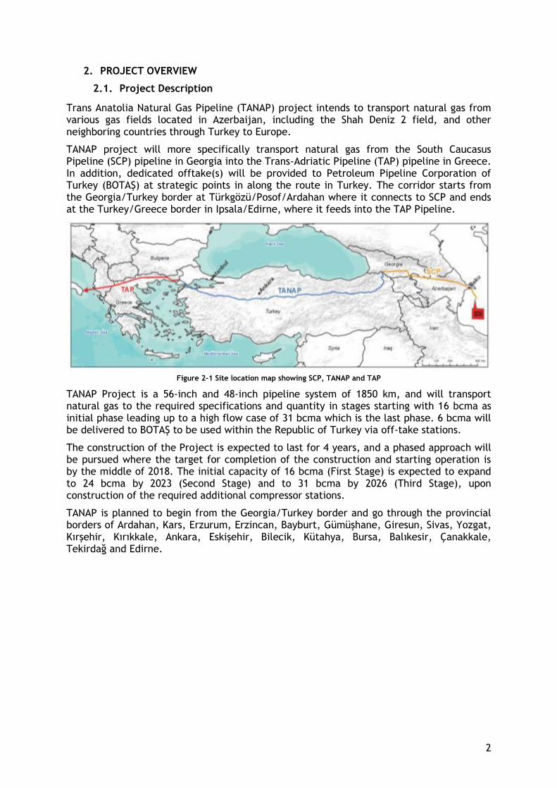
TANAP project will more specifically transport natural gas from the South Caucasus Pipeline (SCP) pipeline in Georgia into the Trans-Adriatic Pipeline (TAP) pipeline in Greece. In addition, dedicated offtake(s) will be provided to Petroleum Pipeline Corporation of Turkey (BOTAŞ) at strategic points in along the route in Turkey. The corridor starts from the Georgia/Turkey border at Türkgözü/Posof/Ardahan where it connects to SCP and ends at the Turkey/Greece border in Ipsala/Edirne, where it feeds into the TAP Pipeline.
Figure 2-1 Site location map showing SCP, TANAP and TAP
TANAP Project is a 56-inch and 48-inch pipeline system of 1850 km, and will transport natural gas to the required specifications and quantity in stages starting with 16 bcma as initial phase leading up to a high flow case of 31 bcma which is the last phase. 6 bcma will be delivered to BOTAŞ to be used within the Republic of Turkey via off-take stations.
The construction of the Project is expected to last for 4 years, and a phased approach will be pursued where the target for completion of the construction and starting operation is by the middle of 2018. The initial capacity of 16 bcma (First Stage) is expected to expand to 24 bcma by 2023 (Second Stage) and to 31 bcma by 2026 (Third Stage), upon construction of the required additional compressor stations.
TANAP is planned to begin from the Georgia/Turkey border and go through the provincial borders of Ardahan, Kars, Erzurum, Erzincan, Bayburt, Gümüşhane, Giresun, Sivas, Yozgat, Kırşehir, Kırıkkale, Ankara, Eskişehir, Bilecik, Kütahya, Bursa, Balıkesir, Çanakkale, Tekirdağ and Edirne.

3
Figure 2-2 TANAP Project Route
2.2. Project’s Offshore Facilities
The offshore section of the Project is about 19 km long, with maximum water depth of approximately 70 m. The offshore pipeline battery limits are defined on the Anatolian landfall of the Marmara Sea to the area located 500 m inland of the European landfall. The Anatolian landfall is located approximately 2.5 km north east of the fishing village of Kemer and 5 km west of the port town of Biga. The pipeline route crosses the shipping channel between KP 1720 and KP 1725 before reaching the European landfall at KP 1727. The European landfall is located 13 km south west of Şarköy. The European landfall approach is located approximately 2 km from the designated shipping channel.
The pipeline consists of two 36 inch pipelines, the Northern pipeline and the Southern pipeline. Within the Anatolian landfall section, the two pipelines are spaced 5 m apart. With increasing distance offshore the spacing distance between the two pipelines increases to 100 m. As the two pipelines reach the European landfall the spacing distance decreases back to 5 m. Four fiber optic (FO) cables will also be installed with the pipeline. All FO cables will be located approximately 40 m on the outside of each pipeline.
Whereas there are settlements and areas where fishing activities are carried out by fishermen in the vicinity of Anatolian landfall, European landfall is not situated in or around fishing areas. The closest settlement to European Landfall whose residents are carrying out fishing activities is Kavakköy. However, the fishermen in Kavakköy perform their fishery activities in the Gulf of Saros located on the northern side of Gallipoli (the European landfall is situated in the southern side of Gallipoli). Thus, it is anticipated that the fishermen of Kavakköy will not be affected by the Project. Therefore, this LRP will focus only the impacts on the fishery activities around the Anatolian landfall.
According to the current construction plan, the construction work is scheduled to start in mid June 2017. The construction activities that will be performed in Anatolian landfall and are considered to affect the fishing activities in the area are detailed below:

4
● Trenching: It is planned that trenching activities will last for 20 days (between 14 June and 5 July). During the trenching activities, restriction to approach due to safety zone to the barge, increase in turbidity & change in sedimentation patterns are the potential impacts.
● Pipe laydown: Pipelines will be pulled to the coast from the point in the sea 500m away from the coastline. The duration of this activity is expected as 8 days (between 19 and 26 July). It is considered that fishing activities will be affected in a way that a limitation of use coastal line during this construction activity.
● Rock placement: It is planned that rock placement will last for 10 days (between 28 December 2017 and 7 February 2018). During this activity, it is expected only restriction to approach due to safety zone to the vehicle to be worked for rock placement on the sea.
● Pulling Fiber Optic Cables: Fiber optic cables will be pulled after post-trenching activities to the coast from the point in the sea 500m away from the coastline. This activity is planned to be completed in 1 day. It is considered that fishing activities will be affected in a way that a limitation of use coastal line during this construction activity.
● Burial including Backfill: It is planned that burial including backfill activities will last for 25 days (between 7 January and 1 February 2018). During this activity, restriction to approach due to safety zone to the barge, increase in turbidity & change in sedimentation patterns are considered as the potential impacts.
Table 2-1 Anticipated Construction Schedule
There will be no additional restrictions during the operation phase. Fishery activities will not be interrupted even during any routine maintenance works during the operation phase.
2.3. Overview of the Fishing Resources, Activities and Fishing Based Livelihoods
2.3.1. Socio-Economic Context and Local Capacity
Project affected villages; Kemer, Değirmencik and Aksaz which are located in the affected area are among the important fishery villages in Çanakkale Province.
The comparison of provincial and settlement based data indicate that the proportion of active population in project affected settlements is rather higher than the provincial statistics (see Appendix 2; Figure A2-1 and Table A2-1). Industrial facilities in the region have provided employment opportunities and also have contributed to the fish population by executing a reef project in the harbor. Both have had positive influence in maintaining the active and young population of the region to migrate to urban areas.
Increasing industrial job opportunities in the region have prevented migration from the villages however have reduced the rate of young laborers in fishery activities by laboring the young population. Considerable amounts of the young labor force in the affected area
Year
# of Months
Month
Week 1 2 3 4 1 2 3 4 1 2 3 4 1 2 3 4 1 2 3 4 1 2 3 4 1 2 3 4 1 2 3 4 1 2 3 4 1 2 3 4 1 2 3 4 1 2 3 4 1 2 3 4 1 2 3 4
Trenching
Pipe Laydown
Pulling Fiber Optic Cables X
Rock Placement
Burial / Backfill
14
Feb
2018
Construction Schedule
2 3 4 10 11 12 13
2017
Jan
1 5 6 7 8 9
Jul Aug Sep Oct Nov DecJan Febr Mar Apr May Jun
5
have started carrying out fishery activities as a secondary income source.
Appendix 2; Figure A2-4 also indicates that labor force participation rate varies by gender in the affected region. Female labor force participation rate is very low with 15% while male labor force participation is 94%. Economical activities including fisheries are carried out by male-dominant labor force. The role of women in the fishery system is explained in detail in Chapter 4.
The education level of the affected region is primary or lower than the primary education (75%). The rate of the educated and skilled labor force in fisheries is very low in the affected region. There are a few young people who are member of households engaged in fishery and have continued post-secondary education on Fisheries and Aquaculture, Accounting etc. They are working as accountant or as middlemen during the post-harvest and the marketing process of local fishery system.
In summary, the field survey conducted for the Fisheries LRP reveals that that majority of the interviewed fishermen (engaged in small-scale fishery) are in their mid-40s, almost all of them have social security (96%) and a house (91%), the monthly average fishery income of this group is about 1,500 TL.
Project affected settlements’ livelihood system depends on fisheries and agricultural-livestock activities which are carried on together due to the priorities of seasonal conditions.
Another significant source of income is paid labor. There are two industrial enterprises on the coast of region; İÇDAŞ Bekirli Thermal Power Plant and İÇDAŞ Iron Energy Shipyard Factory. İÇDAŞ Iron and Steel Plant which is located within the affected area provides employment opportunities to labor force. In Değirmencik, although agriculture is the main income source, most of the young labor force in the village have been employed by İÇDAŞ in the plant as worker. Most of young labor force of Kemer and Aksaz is also employed in power plant.
Aside from these livelihood activities, there are no trade axes or followed by intense commercial activities in the affected villages. There is no other commercial activity beside a few small food markets and traditional coffeehouses.
Importance of Fishery in the Livelihood System
In the affected villages, the level of income obtained from the fishing activities varies according to how they are engaged in the fishery system.
In Aksaz and Değirmencik, monthly fishing based income of the vessel owners is lower than Kemer. The fact that fishermen in Kemer have limited opportunities to deal with agriculture and livestock due to the soil structure and geographical constraints make fishery the main source of income in this village. Within the limits and possibilities, the rate of fishermen who are engaged in fishing as main source of income and as full time working is higher than in Kemer.
Level of fishing income also differs according to annual number of fishing days of small-scale fishermen. In the affected settlements, average fishing day of the fishermen is approximately 151 days. The minimum number of fishing days is 30 and can reach up to an entire year (365 days). The level income increases in parallel with the increase in the number of fishing days. The majority of fishermen who state their annual average for fishing day is less than 90, engage in fishing as a secondary income source and part time economic activity.
6
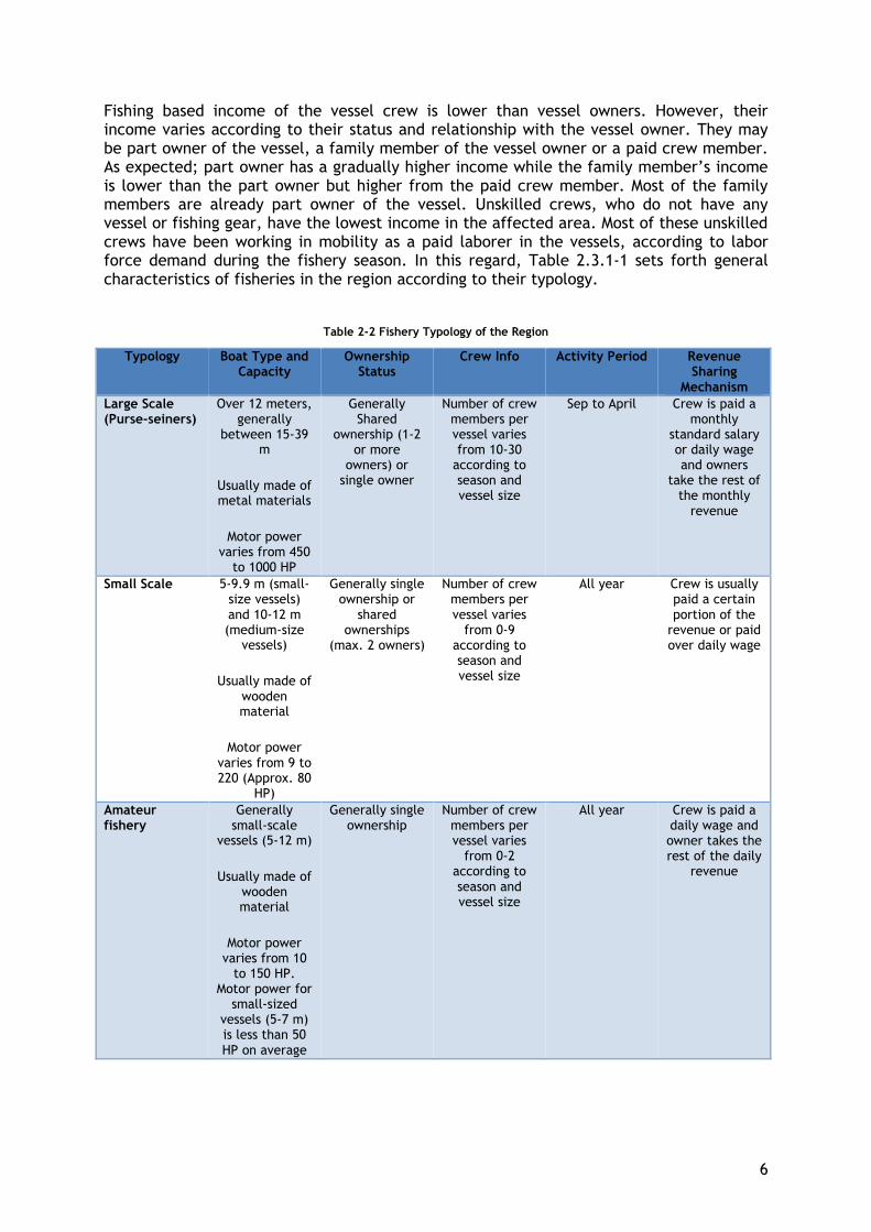
Fishing based income of the vessel crew is lower than vessel owners. However, their income varies according to their status and relationship with the vessel owner. They may be part owner of the vessel, a family member of the vessel owner or a paid crew member. As expected; part owner has a gradually higher income while the family member’s income is lower than the part owner but higher from the paid crew member. Most of the family members are already part owner of the vessel. Unskilled crews, who do not have any vessel or fishing gear, have the lowest income in the affected area. Most of these unskilled crews have been working in mobility as a paid laborer in the vessels, according to labor force demand during the fishery season. In this regard, Table 2.3.1-1 sets forth general characteristics of fisheries in the region according to their typology.
Table 2-2 Fishery Typology of the Region
Typology Boat Type and Capacity
Ownership Status
Crew Info Activity Period Revenue Sharing
Mechanism
Large Scale (Purse-seiners)
Over 12 meters, generally
between 15-39 m
Usually made of metal materials
Motor power varies from 450
to 1000 HP
Generally Shared
ownership (1-2 or more
owners) or single owner
Number of crew members per vessel varies from 10-30
according to season and vessel size
Sep to April Crew is paid a monthly
standard salary or daily wage and owners
take the rest of the monthly
revenue
Small Scale 5-9.9 m (small-size vessels) and 10-12 m (medium-size
vessels)
Usually made of wooden material
Motor power varies from 9 to 220 (Approx. 80
HP)
Generally single ownership or
shared ownerships
(max. 2 owners)
Number of crew members per vessel varies
from 0-9 according to season and vessel size
All year Crew is usually paid a certain portion of the
revenue or paid over daily wage
Amateur fishery
Generally small-scale
vessels (5-12 m)
Usually made of wooden material
Motor power varies from 10
to 150 HP. Motor power for
small-sized vessels (5-7 m) is less than 50 HP on average
Generally single ownership
Number of crew members per vessel varies
from 0-2 according to season and vessel size
All year Crew is paid a daily wage and owner takes the rest of the daily
revenue
7
Based on the field survey, there are no households engaged fishing that operate by renting a vessel.
According to field survey, in Aksaz nearly half of the households engage in agriculture and in Değirmencik agriculture is a more predominant income source than the other villages. Among the crops cultivated in the affected villages, wheat, barley, oat, clover, corn is the most common in addition to rice, vegetables and olive. Agriculture is mostly executed on dry lands, which is a significant indicator of a low income source. These crops are mostly cultivated as livestock feed in Aksaz and Değirmencik. Therefore, husbandry has been more predominant as an economic activity than agriculture. In terms of fishing, considering the cultivated crops provide low income, fishery and thus the fishing income contributes significantly to the household income in areas where agriculture dominates.
Seasonal influences
Seasonal influences on fishery in the affected region are described in Chapter 4 Livelihood Systems. The fishing season for the small scale fishery is the entire year. These fishermen have stated that there are no seasonal limits or restrictions that apply to them during the year. However, fishing activities are regulated according to seasonal prohibited species. In this cycle the most intensive periods of the fishing activity are between September and April. In addition to this period, it was stated that Sardine season falls between July and August for small scale fishery.
Although there is no prohibited season for small scale vessels, large scale vessels are obliged to quit fishing from the beginning of May until the end of August. At the end of the prohibited season (as of September) large scale vessels sail to catch Sardines. Consequently, the Sardine season ends for small scale vessels due to the high harvest potential of the large vessels. During this period small scale vessels cannot catch enough Sardines to cover the expenses of vessel and workforce. Thus, small scale fishery focus on other seasonal target fish species by the fall season.
Market and value chain
Marketing as part of commercial fishing operations have limited possibilities in the
affected region. Local middlemen are the most important contact for local fishermen in
marketing their products to consumers.
There is only one fish restaurant and 1 small fish&bread seller in Aksaz. Fish is either sold to restaurants directly or they are given to middlemen. During shrimp season, some companies from Çanakkale and Bursa (Önemtaş, Kerevitaş etc.) purchase shrimp from fishermen with certain prices. It is more profitable for fishermen to sell fish to companies, since middlemen offer lower prices. However, the income of fishermen has decreased compared to the previous years due to the decrease in shrimp population in the region and the low demand of companies for other fish species.
Since there are not many local active restaurants, fish processing companies or fish markets in the affected villages, there is no direct mean to market fish harvest. Majority of the fishermen (90%) in the affected region sell fish through middlemen. Local and national salesmen, restaurants in Çanakkale or other provinces are the consumers of the fishery products. Transportation and delivery to final consumers is also carried out by local middleman. The field survey reveals that local middlemen have a very important share in the marketing process.
8
Middlemen themselves are also fishermen who catch high amount of fish in the fishing season and have a considerably high income from it. Middlemen are engaged in both purchase and sales activities as well as the fishing activity itself as a part of their family business. It was stated that working as a middleman increases the fishing based income. Thus, young and more educated labor force within the fishery households engage in the marketing process carried out by their middlemen parents or become middlemen themselves.
Fishermen in the affected area have complained of the low market prices and limited possibilities for marketing fishery products. Majority of the fishers agree that this is one of the significant problems encountered during local fishing activities.
Investments, Local Capacity, Infrastructure and Services in the Affected Region
Fishery activities in the affected area have been shaped and changed due to other investments in the region, implementations of government and existing local capacity. Additionally, past experiences and similar projects implemented in the region are also influential in forming an opinion towards the Project for local fishermen.
In the recent past, more than one energy project and a port project was carried out in the region. Certain government policies carried out and other investments, as well as the infrastructural situation, played an important role in forming the current socio-economic structure in terms of fisheries. The positive and negative effects of these projects, investments and policies on fisheries are discussed in detail in the sections below.
Turkey-Greece Pipeline System (TGPS)
The affected area has already been introduced to similar projects such as the Turkey-Greece Pipeline System (TGPS) Project owned and operated by BOTAŞ. TGPS which is already in operation has had similar impacts on local community and fishing activities in the region. Therefore, local people are familiar with the implications of such pipeline projects. The fact that the TGPS passes very close to the planned TANAP route, allows people living in the directly affected village of Kemer to have knowledge of what the possible effects of such a pipeline project might be.
Turkey-Greece natural gas pipeline sea passage was constructed by Öztaş Construction Company between 01.11.2005 and 15.07.2007. 36 "in diameter, 60 meters in depth, the total length of the pass is 17 km. The onshore section of the pipeline is 330 meters. In addition to the pipeline, 17 km of undersea fiber optic cable was also installed. During interviews with fishermen in Kemer Village, it was learnt that the project did not have negative impacts on small scale fisheries activity.
Local people and stakeholders have stated no complaints regarding the TGPS project and
its impacts on fishing based livelihoods. Interviews with fishermen have revealed that the
construction of the offshore components of TGPS pipeline has not adversely affected
fishing activities.
Vessel Withdrawal Program
The vessel withdrawal program of the Government has highly affected fishery activities in the region and discouraged the engagement of fishers in fishery.
“In the first period of the program, which was initiated during 2012, 364 vessels larger than 12 m, 446 vessels larger than 10 m and 191 vessels larger than 10 m were withdrawn respectively by the end of 2013, 2014 and 2015. Thus a total of 1,001 vessels were retired

9
from the Turkish fishing fleet. Cost of the program was approx. US$ 45 million. In the three-year program, vessels between 10-20 m were the most removed (948 vessels), and vessels larger than 31 m the least (5 vessels). Many large-scale fishers did not show interest in the program. According to results of the first two withdrawal programs (interviews were still going on with the vessel owners from the third program during the preparation of this abstract), 1/3rd of fishers who participated in the program had other operational vessels, and sold their inactive vessels. Nearly 61.5% of the recipients stated they would remain in the industry, and 1/4 of recipients purchased new small-sized vessels (<10 m) with the money received from the buyback program.”
Data verified from the General Directorate of Fisheries and Aquaculture (Ankara) revealed that 58 fishing vessels were withdrawn from Çanakkale during the three vessel withdrawal programs implemented between 2013-2015. In 2013, 8 vessels with lengths varying between 12-20 meters were taken. In 2014, among the 40 vessels taken, 39 of them were between 10-20 meters, and 1 was between 21-30 meters. In 2015, 10 vessels with the length range being 10-20 meters were taken. This information suggests a trend towards large-scale fisheries to small-scale fisheries in the province of Çanakkale where Kemer, the place where a total of 10 large-scale vessels were sold to the state. It has been found that almost all of the fishermen who sell their vessels either buy a new smaller vessel, or already have a second one.
İÇDAŞ Bekirli Thermal Power Plant
Other significant investment projects conducted in the affected area are İÇDAŞ Bekirli Thermal Power Plant (about 1.5 km south of Kemer village) and İÇDAŞ Iron and Steel Plant (about 1 km north of Değirmencik village). The thermal power plant, which started operation in 2011, has a harbor near Kemer village. The area around the harbor was previously the fishing ground of Kemer village, but after the power plant was established, it was declared as an exclusion site by the Commercial Aquaculture Communiqué.
İÇDAŞ, the owner company of the thermal power plant has implemented an artificial reef application that has significantly increased the fish population by providing nesting and nutrition to the fish population. It was also stated that the discharge of the thermal power plant’s cooling water to sea had increased the water temperature which attracts certain fish species such as bluefish and small bluefish. This has resulted in a significant increase in commercial target spice population of local fishery.
In this process, İÇDAŞ Power Plant Coastal zone where the reef area is located was declared as a prohibited area for hunting. However, during stakeholder interviews, it was learnt that small-scale fishermen were allowed to catch fish with fishing hooks in the exclusion zone around the harbor permits, but large-scale fishermen (purse-seiners) and netting are not allowed (see Figure 2-3).
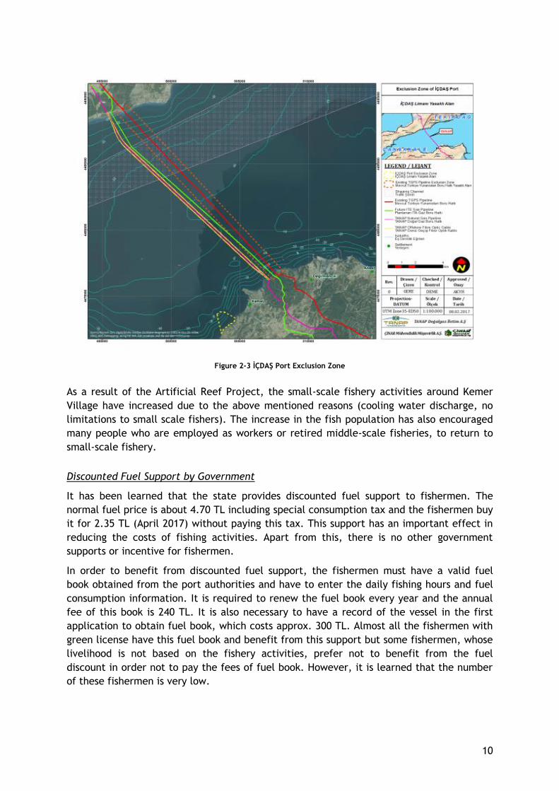
10
Figure 2-3 İÇDAŞ Port Exclusion Zone
As a result of the Artificial Reef Project, the small-scale fishery activities around Kemer
Village have increased due to the above mentioned reasons (cooling water discharge, no
limitations to small scale fishers). The increase in the fish population has also encouraged
many people who are employed as workers or retired middle-scale fisheries, to return to
small-scale fishery.
Discounted Fuel Support by Government
It has been learned that the state provides discounted fuel support to fishermen. The
normal fuel price is about 4.70 TL including special consumption tax and the fishermen buy
it for 2.35 TL (April 2017) without paying this tax. This support has an important effect in
reducing the costs of fishing activities. Apart from this, there is no other government
supports or incentive for fishermen.
In order to benefit from discounted fuel support, the fishermen must have a valid fuel
book obtained from the port authorities and have to enter the daily fishing hours and fuel
consumption information. It is required to renew the fuel book every year and the annual
fee of this book is 240 TL. It is also necessary to have a record of the vessel in the first
application to obtain fuel book, which costs approx. 300 TL. Almost all the fishermen with
green license have this fuel book and benefit from this support but some fishermen, whose
livelihood is not based on the fishery activities, prefer not to benefit from the fuel
discount in order not to pay the fees of fuel book. However, it is learned that the number
of these fishermen is very low.
11
Kemer Port
In addition to the above, the incomplete Kemer Port project can be considered as an
adverse impact on fishery activities in Kemer Village. Kemer Village has a planned fishing
port project which was commenced however not completed due to archeological findings
(from Pharion Ancient City located within the village boundaries, dating back to the Roman
Empire) that have been encountered during the fishing port construction. Currently the
port is incomplete and out of use.
Local Fishery Cooperatives
There is one fishery cooperative in the affected villages which are located in Kemer
village. Besides the Kemer Fishery Cooperative, there are also fishery cooperatives in
Karabiga and Lapseki Districts which are settlements close to the affected villages. Other
fishery cooperatives in the neighbor settlements and main characteristics of these
cooperatives are shown in the table below.
It was determined that there is dramatic decrease in the number of members in almost all
fishery cooperatives. For instance, number of cooperative members was 55 in Karabiga
Fishery Cooperative in 2013. However, it is only 25 today. Similarly, head of Kemer Fishery
Cooperative has pointed out that almost half of the cooperative members have left the
cooperatives due to the several reasons; the cooperative does not provide concrete
benefits to its members, the cooperative gives priority to the purse seiners rather than
paying attention on equity among members since the head of cooperative is also a purse
seiner, the cooperative does nothing rather than attending meetings etc. Cooperation rate
is quite low. Although only 17.6% of respondents indicate that they are cooperative
members, actual cooperation rate in Kemer is 48%. It is 62% in Karabiga, 60% in Lapseki
and the highest (70%) in Çardak. Main characteristics of these cooperatives are shown in
the table below.
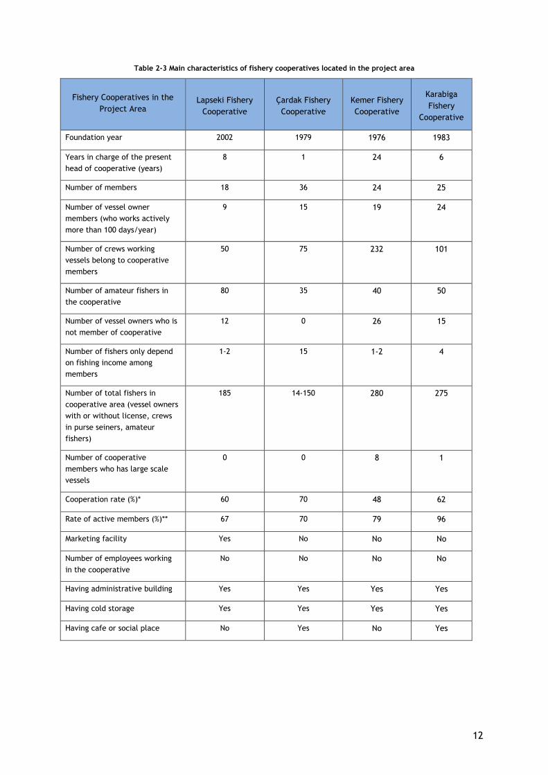
12
Table 2-3 Main characteristics of fishery cooperatives located in the project area
Fishery Cooperatives in the
Project Area Lapseki Fishery
Cooperative
Çardak Fishery
Cooperative
Kemer Fishery
Cooperative
Karabiga
Fishery
Cooperative
Foundation year 2002 1979 1976 1983
Years in charge of the present
head of cooperative (years)
8 1 24 6
Number of members 18 36 24 25
Number of vessel owner
members (who works actively
more than 100 days/year)
9 15 19 24
Number of crews working
vessels belong to cooperative
members
50 75 232 101
Number of amateur fishers in
the cooperative
80 35 40 50
Number of vessel owners who is
not member of cooperative
12 0 26 15
Number of fishers only depend
on fishing income among
members
1-2 15 1-2 4
Number of total fishers in
cooperative area (vessel owners
with or without license, crews
in purse seiners, amateur
fishers)
185 14-150 280 275
Number of cooperative
members who has large scale
vessels
0 0 8 1
Cooperation rate (%)* 60 70 48 62
Rate of active members (%)** 67 70 79 96
Marketing facility Yes No No No
Number of employees working
in the cooperative
No No No No
Having administrative building Yes Yes Yes Yes
Having cold storage Yes Yes Yes Yes
Having cafe or social place No Yes No Yes
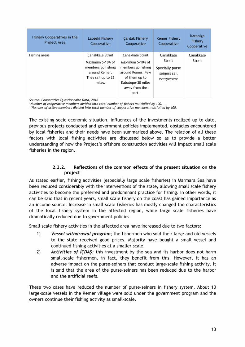
13
Fishery Cooperatives in the
Project Area Lapseki Fishery
Cooperative
Çardak Fishery
Cooperative
Kemer Fishery
Cooperative
Karabiga
Fishery
Cooperative
Fishing areas Çanakkale Strait
Maximum 5-10% of
members go fishing
around Kemer.
They sail up to 26
miles.
Çanakkale Strait
Maximum 5-10% of
members go fishing
around Kemer. Few
of them up to
Kabatepe-30 miles
away from the
port.
Çanakkale
Strait
Specially purse
seiners sail
everywhere
Çanakkale
Strait
Source: Cooperative Questionnaire Data, 2016 *Number of cooperative members divided into total number of fishers multiplied by 100. **Number of active members divided into total number of cooperative members multiplied by 100.
The existing socio-economic situation, influences of the investments realized up to date,
previous projects conducted and government policies implemented, obstacles encountered
by local fisheries and their needs have been summarized above. The relation of all these
factors with local fishing activities are discussed below so as to provide a better
understanding of how the Project’s offshore construction activities will impact small scale
fisheries in the region.
2.3.2. Reflections of the common effects of the present situation on the project
As stated earlier, fishing activities (especially large scale fisheries) in Marmara Sea have
been reduced considerably with the interventions of the state, allowing small scale fishery
activities to become the preferred and predominant practice for fishing. In other words, it
can be said that in recent years, small scale fishery on the coast has gained importance as
an income source. Increase in small scale fisheries has mostly changed the characteristics
of the local fishery system in the affected region, while large scale fisheries have
dramatically reduced due to government policies.
Small scale fishery activities in the affected area have increased due to two factors:
1) Vessel withdrawal program; the fishermen who sold their large and old vessels
to the state received good prices. Majority have bought a small vessel and
continued fishing activities at a smaller scale.
2) Activities of İÇDAŞ; this investment by the sea and its harbor does not harm
small-scale fishermen, in fact, they benefit from this. However, it has an
adverse impact on the purse-seiners that conduct large-scale fishing activity. It
is said that the area of the purse-seiners has been reduced due to the harbor
and the artificial reefs.
These two cases have reduced the number of purse-seiners in fishery system. About 10
large-scale vessels in the Kemer village were sold under the government program and the
owners continue their fishing activity as small-scale.
14
As stated above, another important effect of the Power Plant on the fishery is increasing
the fish population, especially blue fish which is a high-yielding target specie. İÇDAŞ’s reef
Project has resulted both in the increase of fish population and increase in amateur-
looking hand-line fishing which actually aims to sustain an income. This has led to an
increasing amount of unlicensed commercial fishing activities performed by amateur
fishermen (amateur-looking) around the harbor area.
Interviews have revealed that, amateur fishing intensely performed by local people who
are also occupied in other jobs as unskilled workers or agricultural laborers. In other
words, local people who have left fishery activities and are currently employed in other
jobs, actually continue to practice fishing activities as "amateurs" to provide additional
income. When it is considered that amateur fishery, in other words, illegal fishing
activities, is carried out as an income-generating activity, it presents difficulties in
evaluating the project effects and defining the eligibility criteria and identifying
beneficiaries. For this reason, a compensation plan, considering the distinctive conditions
among different types of fisheries, has been developed with respect to the legal
framework governing fishery activities in order to provide a fair compensation to relevant
target groups.
As another impact on local fisheries, job opportunities provided to local people by İÇDAŞ
industry investments has decreased the number of people engaging in fishery activities.
Currently, many people in the affected villages have been working both in the iron and
steel plant in addition to engaging in part time fishery. Industrial employment has
decreased the labor force not only in fisheries but also in agriculture as well. Besides,
although the young labor force in the affected area is usually employed as paid labor in the
industrial job opportunities, they have started carrying out fishery activities as a secondary
income source because of the increasing tendency towards fishing activity as a result of
the above-mentioned effects. Fishing is carrying out increasingly as a secondary or
seasonal income source or amateur-looking fishing by industrial workers in the affected
villages.
Another highlight on the field is that even though small scale fishery is intensively carried
out, the small scale fishermen are not members of the existing fishery cooperative and do
not have a cooperative of their own. The Kemer Fisheries Cooperative, located in Kemer is
a cooperative formed by purse-seiners which defends the rights of large scale fisheries.
The fact that small-scale fisheries do not have their own co-operative creates an obstacle
for the representation of small-scale fisheries in the affected area, thus there is no legal
entity to contact as a stakeholder.
One of the important issues is past experiences about the similar projects in affected area.
When previous project experiences were questioned, small-scale vessel owners and
stakeholders indicated that the TGPS project did not have a positive or negative effect on
the livelihood of small scale fisheries.
During site visits carried out to the region, cumulative effects of existing projects, socio-
economic conditions, infrastructural deficiencies and needs of fishermen community have
been identified and considered, independent of the possible impacts of TANAP Project. As
a result, Project impacts on fishing based livelihoods will be very limited and take place
15
during a short period. There will also be no impacts at community level and involving
vulnerable groups. Based on these assessments, community level support alternatives
provided in the following paragraphs have been suggested as beneficial working areas that
can be used to address existing problems, not in relation to Project impacts.
Possible livelihood support initiatives at community level were identified on the basis of
the necessities and deficiencies of communities stated during interviews carried out with
fishermen and stakeholders, but they were not revealed as a need or action for mitigating
the Project’s impacts.
Social facility needs: According to Head of Çanakkale Regional Association of Fishery
Cooperatives, there is an example of social facility in the Lapseki village which also has a
cold storage and a sales counter. This social facility was supported by Çanakkale Provincial
Directorate of Food, Agriculture and Livestock. Head of the institution, who stated that
fisheries in Çanakkale region are using modern techniques, also stated that the main
problem is the lack of social facilities and fisheries cannot improve because social facilities
are not built.
However, in the affected villages, in Kemer and Aksaz, the village coffee house is thought
to have fulfilled a certain amount of this function. Also, there is no stakeholder covering
all the fishers that will operate a social facility. The lack of a NGO or cooperative
representing small fishermen can be regarded as a shortcoming in establishing or allocating
a social space for fishery activities.
Improvements for the Fishing Port: The biggest deficiency of the Kemer fishermen is the
fishing port. Head of Fisheries and Aquaculture Unit of Directorate stated that any
construction activity on the fishing port cannot be done due to the site being a registered
archaeological asset. A construction activity had been started in the past, but it was
cancelled due to the historical columns on the bottom of the sea where the fishing port is
located. Additionally, in the interviews held in Aksaz village, it was stated that the existing
fishing port does not provide protection to vessels in windy weather conditions and could
not meet the needs of sufficient level.
It was seen that harbor improvements for the needs of small fishers were important in
terms of facilitating fishing activities and providing a sheltered area in difficult seasonal
conditions.
Fuel tank station and/or local house for use: During the interview with Head of Kemer
Fishery Cooperative, it has been learned that the cooperative has an administrative
building and a 90-ton capacity fuel tank located within it. Administrative building has a
licensing problem that prevents fishermen to use it and thus, the fuel tank cannot be
utilized as well. The procurement of fuel for both small-scale and large scale fisheries is a
major problem in the affected villages. In general, fuel is purchased from various fuel
stations located in the vicinity of these villages. Upon the demand of several fishermen
fuel stations are contacted to bring fuel via tankers to the villages. Support for making a
fishery local house and/or for reusing the existing fuel tank are stated as ‘highly
important’ needs for Kemer fishery cooperative and for all local fishermen.
16
3. LEGAL FRAMEWORK
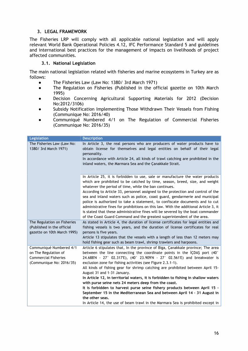
The Fisheries LRP will comply with all applicable national legislation and will apply relevant World Bank Operational Policies 4.12, IFC Performance Standard 5 and guidelines and international best practices for the management of impacts on livelihoods of project affected communities.
3.1. National Legislation
The main national legislation related with fisheries and marine ecosystems in Turkey are as follows:
● The Fisheries Law (Law No: 1380/ 3rd March 1971) ● The Regulation on Fisheries (Published in the official gazette on 10th March
1995) ● Decision Concerning Agricultural Supporting Materials for 2012 (Decision
No:2012/3106) ● Subsidy Notification Implementing Those Withdrawn Their Vessels from Fishing
(Communique No: 2016/40) ● Communiqué Numbered 4/1 on The Regulation of Commercial Fisheries
(Communique No: 2016/35)
Legislation Description
The Fisheries Law (Law No:
1380/ 3rd March 1971)
In Article 3, the real persons who are producers of water products have to
obtain license for themselves and legal entities on behalf of their legal
personality.
In accordance with Article 24, all kinds of trawl catching are prohibited in the
inland waters, the Marmara Sea and the Çanakkale Strait.
In Article 25, it is forbidden to use, sale or manufacture the water products
which are prohibited to be catched by time, season, breed, size, and weight
whatever the period of time, while the ban continues.
According to Article 33, personnel assigned to the protection and control of the
sea and inland waters such as police, coast guard, gendarmerie and municipal
police is authorized to take a statement, to confiscate documents and to cut
administrative fines for prohibitions on this law. With the additional Article 3, it
is stated that these administrative fines will be severed by the boat commander
of the Coast Guard Command and the greatest superintendent of the area.
The Regulation on Fisheries
(Published in the official
gazette on 10th March 1995)
As stated in Article 4, the duration of license certificates for legal entities and
fishing vessels is two years, and the duration of license certificates for real
persons is five years.
Article 13 stipulates that the vessels with a length of less than 12 meters may
hold fishing gear such as beam trawl, shrimp trawlers and harpoons.
Communiqué Numbered 4/1
on The Regulation of
Commercial Fisheries
(Communique No: 2016/35)
Article 6 stipulates that, In the province of Biga, Çanakkale province; The area
between the line connecting the coordinate points in the İÇDAŞ port (40°
24.688'N - 27° 02.317'E), (40° 23.909'N - 27° 02.561'E) and breakwater is
exclusion zone for fishing activities (see Figure 2.3.1-1).
All kinds of fishing gear for shrimp catching are prohibited between April 15-
August 31 and 1-31 January.
In Article 12, in territorial waters, it is forbidden to fishing in shallow waters
with purse seine nets 24 meters deep from the coast.
It is forbidden to harvest purse seine fishery products between April 15 –
September 15 in the Mediterranean Sea and between April 14 – 31 August in
the other seas.
In Article 14, the use of beam trawl in the Marmara Sea is prohibited except in
17
Legislation Description
shrimp catching.
According to Article 18, Sardinian catching with extension nets is free
throughout the period.
As stated in Article 19, in all territorial waters, from 1 April to 31 August,
catching bonito is prohibited with any kind of fishing gear.
Article 26 states that all territorial waters except Marmara Sea are prohibited
from catching shrimp with beam trawl in the Bosphorus and Çanakkale Strait.
Decision Concerning Agricultural Supporting Materials for 2012 (Decision No:2012/3106)
According to Article 4, in order to protect and sustainable operation of the aquatic resources and to reduce the fishing pressure on stocks, the vessel owners with aquaculture authorization certificate who have vessels of twelve meters and over are paid an amount according to the ship's length in support of the withdraw of the vessels from the fishing.
Subsidy Notification
Implementing Those
Withdrawn Their Vessels
From Fishing (Communique
No: 2016/40)
As stated in Article 1, the purpose of this communiqué is to provide the
procedures for works and operations related to the support of the ship-owners
who intentionally sold the fishing vessels ten meters or more in order to protect
the stocks, reduce the fishing pressure and ensure sustainable fishery in
accordance with the Decision of the Agricultural Supports to be made in 2016
put into effect by the Decision of the Council of Ministers.
Article 4 stipulates that the vessels registered in Fishery Products Information
System (SUBIS) with a length of ten meters or more, which are licensed by the
Ministry of Food, Agriculture and Livestock and to be engaged in fishing
activities in the seas and which are still valid, are in the scope of support.
Procedures related to the Fishing License are carried out within the framework of the relevant provisions of the Fisheries Law No. 1380 and the Fishing Regulation.
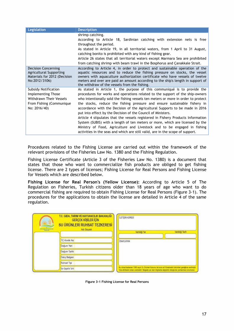
Fishing License Certificate (Article 3 of the Fisheries Law No. 1380) is a document that states that those who want to commercialize fish products are obliged to get fishing license. There are 2 types of licenses; Fishing License for Real Persons and Fishing License for Vessels which are described below.
Fishing License for Real Person's (Yellow License): According to Article 5 of The Regulation on Fisheries, Turkish citizens older than 18 years of age who want to do commercial fishing are required to obtain Fishing License for Real Persons (Figure 3-1). The procedures for the applications to obtain the license are detailed in Article 4 of the same regulation.
Figure 3-1 Fishing License for Real Persons

18
Fishing License for Vessels (Green License): According to Article 4 for The Regulation on Fisheries, real persons or legal entities who want to perform production of aquaculture products are required to obtain “Fishing License for Vessels” for their vessels (Figure 3-2). The procedures for the applications to obtain the license are detailed in Article 4 of the same regulation.
Figure 3-2 Fishing License for Vessels
According to Article 4 of Communiqué Numbered 4/2 on The Regulation of Amateur Fisheries (Communiqué No: 2016/36), Turkish citizens who will produce aquaculture products for non-commercial purposes are not required to obtain a license. However, Amateur (Recreational) Fishing Document5 (which will be valid for 5 years after the date of issue) can be given by provincial and district directorates to the fishermen who apply for the document (Figure 3-3).
Figure 3-3 Amateur (Recreational) Fishing Document
5 During the field study it was observed that these document holders are also fishing for income. Most of them
are fishing in artificial reef area of İÇDAŞ Thermal Power Plant.
19
3.2. International Standards
The international standards underlying this work are as follows: ● International Finance Corporation (IFC) Performance Standards (PS1 & PS5) ● The World Bank Operational Policies 4.12 (Involuntary Resettlement)
This plan has been designed to comply with IFC’s relevant performance standards, PS1 and PS5, and World Bank Operational Policy 4.12 associated with the preparation of a LRP and related engagement activities.
International Finance Corporation Performance Standards (PS1 & PS5)
The Sustainability Framework, an integral part of the International Finance Corporation's (IFC) risk management approach, sets out IFC's strategic commitment to sustainable development. The Sustainability Framework consists of IFC's Environmental and Social Sustainability Policy and Performance Standards and the Information Access Policy.
The Environmental and Social Sustainability Policy defines IFC's commitments, roles and responsibilities related to environmental and social sustainability. The Information Access Policy reflects the commitment to transparency and good governance of IFC's activities and includes the obligation to inform the public about IFC's investment and consulting services. Performance Standards are intended to guide customers in identifying risks and impacts as well as helping to mitigate, mitigate and manage the risks and impacts of sustainable operations, including the client's stakeholder engagement in terms of project activities and the obligation to inform the public.
IFC’s Performance Standard 1 (PS1) includes the requirements for stakeholder engagement. Performance Standard 1 sets out the importance of making a comprehensive assessment of projects' environmental and social impacts, identifying risks and opportunities, publicizing project-related information and consulting them directly on issues affecting local communities and managing the environmental and social performance of the client throughout the project.
Performance Standard 5 (PS5) recognizes that project-related land acquisition and restrictions on land use can have adverse impacts on communities and persons that use this land. Involuntary resettlement refers both to physical displacement (relocation of loss or shelter) and economic displacement (loss of assets or access to assets that leads to loss of income sources or other means of livelihood) as a result of project-related land acquisition and/or restrictions on land use. Resettlement is considered involuntary when affected persons or communities do not have the right to refuse land acquisition or restrictions on land use that result in physical or economic displacement.
PS5 identifies the improving or restoring the livelihoods and standards of living of displaced persons as a main objective. According to the PS5, when displacement cannot be avoided, the client will offer displaced communities and persons compensation for loss of assets at full replacement cost and other assistance to help them improve or restore their standards of living or livelihoods. Also, it requires collecting socio-economic baseline data to identify the persons who will be displaced by the project, determine who will be eligible for compensation and assistance, and discourage ineligible persons, such as opportunistic settlers, from claiming benefits.
In the case of projects involving economic displacement only, it requires to develop a Livelihood Restoration Plan to compensate affected persons and/or communities and offer other assistance that meet the objectives of this Performance Standard. The LRP will establish the entitlements of affected persons and/or communities and will ensure that these are provided in a transparent, consistent and equitable manner. The mitigation of economic displacement will be considered complete when affected persons or
20
communities have received compensation and other assistance according to the requirements of LRP and the Performance Standard.
According to the PS5, economically displaced persons whose livelihoods or income levels are adversely affected will be provided opportunities to improve, or at least restore, their means of income-earning capacity, production levels, and standards of living:
● For persons whose livelihoods are land-based, replacement land that has a combination of productive potential, locational advantages, and other factors at least equivalent to that being lost should be offered as a matter of priority.
● For persons whose livelihoods are natural resource-based and where project-related restrictions on access envisaged, implementation of measures will be made to either allow continued access to affected resources or provide access to alternative resources with equivalent livelihood-earning potential and accessibility. Where appropriate, benefits and compensation associated with natural resource usage may be collective in nature rather than directly oriented towards individuals or households.
● If circumstances prevent the client from providing land or similar resources as described above, alternative income earning opportunities may be provided, such as credit facilities, training, cash, or employment opportunities. Cash compensation alone, however, is frequently insufficient to restore livelihoods.
The World Bank Operational Policies 4.12 (Involuntary Resettlement)
As required by the World Bank Operational Policies, two Resettlement Action Plan (RAP),
one for pipeline and one for above ground installations, were prepared and disclosed by
TANAP. In line with the RAP requirements, this Fisheries LRP as a complementary
document was prepared to provide further information and propose strategies on the
restoration and improvement of livelihoods as a part of the RAP.
21
4. LIVELIHOOD SYSTEMS OF PROJECT AFFECTED VILLAGES
Economic Activities Carried Out by Fishery Households
Fishery activities constitute an important part of the income generating activities in the project affected area. Other sources of livelihood depend on agriculture, husbandry and paid labor.
According to the field survey, fishery is the primary source of income in the affected region. Aside from fishery, waged labor, agriculture and husbandry, retirement income was also stated to be one of the significant income sources in the villages.
The primary source of income for the affected region is as follows; 55% fisheries, 19% employed in local industry 10% retirement pension and only 3% agricultural activities (Appendix 2; Figure A2-6).
Secondary income sources for the affected region are listed respectively; 38% retirement, 34% fishery and 12% agricultural activities.
In addition to the above, there are also households (14%) with seasonal income in the affected region. Details to seasonal income have been provided in Appendix 2; Figure A2-5 and Figure A2-6. Within the seasonal income, agriculture holds the highest rate with 44%. Fishery is also among a seasonal income source with the rate of 37%. According to data collected, seasonal income earned from husbandry is 19%.
Interviews with households engaged in fishery activities have revealed that fishery is carried out together with other economic activities. Although 27% of the fishermen interviewed stated that they were engaged in agriculture, only 3% of the households stated agriculture as a main source of income.
The majority of the agricultural land in the affected villages is characterized as dry land which is not fertile as irrigated lands and not suitable to cultivate high income products. In affected villages waged labor, fishery and also husbandry provide higher income for households than the agriculture.
It was observed that the intensity of economic activities and prioritization vary among the affected villages. In Kemer Village fishery is the dominant economic activity, in Aksaz and in Değirmencik, agriculture and husbandry activities play more important role in livelihood compared to Kemer.
According to agricultural records of Biga District Directorate of Agriculture, 45% of Kemer Village’s lands are agricultural land (4,725 da), and 74% of this land is dry land (3,530 da). There is no pasture land in Kemer Village. Official data states that, 13% of the village population is engaged in agriculture. In comparison with the other two affected villages, agriculture is carried out at low intensity and as a second source of income in Kemer.
In Değirmencik, agriculture is the main source of income and 20% of the village population is engaged in agriculture. Among the total village land, 23% is agricultural land (5,994 da), and 78% of it is dry agricultural land (4,700 da). Değirmencik Village has 419 da pasture land. Agriculture and husbandry activities are undertaken at high density in Değirmencik.
According to agricultural records of Biga District Directorate of Agriculture, 11% of the total village land is agricultural land (2,560 da), and 94% of land is dry agricultural land (2,400 da). 19% of the village population is engaged in agriculture. There are 113,54 da pasture land in Aksaz Village.
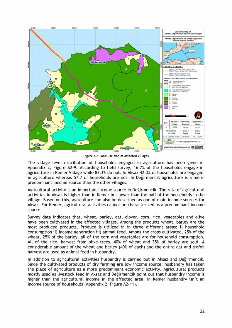
22
Figure 4-1 Land Use Map of Affected Villages
The village level distribution of households engaged in agriculture has been given in Appendix 2; Figure A2-9. According to field survey, 16.7% of the households engage in agriculture in Kemer Village while 83.3% do not. In Aksaz 42.3% of households are engaged in agriculture whereas 57.7 of households are not. In Değirmencik agriculture is a more predominant income source than the other villages.
Agricultural activity is an important income source in Değirmencik. The rate of agricultural activities in Aksaz is higher than in Kemer but lower than the half of the households in the village. Based on this, agriculture can also be described as one of main income sources for Aksaz. For Kemer, agricultural activities cannot be characterized as a predominant income source.
Survey data indicates that, wheat, barley, oat, clover, corn, rice, vegetables and olive have been cultivated in the affected villages. Among the products wheat, barley are the most produced products. Produce is utilized in in three different areas; i) household consumption ii) income generation iii) animal feed. Among the crops cultivated, 25% of the wheat, 25% of the barley, all of the corn and vegetables are for household consumption. All of the rice, harvest from olive trees, 40% of wheat and 35% of barley are sold. A considerable amount of the wheat and barley (40% of each) and the entire oat and trefoil harvest are used as animal feed in husbandry.
In addition to agricultural activities husbandry is carried out in Aksaz and Değirmencik. Since the cultivated products of dry farming are low income source, husbandry has taken the place of agriculture as a more predominant economic activity. Agricultural products mostly used as livestock feed in Aksaz and Değirmencik point out that husbandry income is higher than the agricultural income in the affected area. In Kemer husbandry isn’t an income source of households (Appendix 2, Figure A2-11).

23
Fishery in Affected Villages
The most important commercial target species for small-scale fisheries are bluefish, small bluefish, bonito, sardine, horse mackerel, angler, garfish, shrimp, mackerel, whiting and inkfish.
All affected villages carry out the fishery activities using the same methods, however the intensity of the fishery activity differs according to villages. Fishery activities in the villages are influenced by the secondary and seasonal income generating activities.
The results of the field study carried out in Kemer, Değirmencik and Aksaz, reveal that 57.3% of the interviewees have stated fishery to be their main occupation and 56% have stated to be full-time fishers. However, as stated earlier in previous section, only 21% of small-scale fisheries are fully dependent on a fishing income (Appendix 2; Table 12), while the rest have expressed additional incomes such as pensions, agriculture, etc.
Significance of fishing activities in the affected villages are described briefly below:
KEMER: 80% of the households (approx. 180 households) are engaged in fishing activities temporarily, permanently or on a seasonal basis. Fishery is the main source of income in Kemer. Small scale fishery is carried out intensively. As stated during the stakeholder interviews, Kemer village is one of the villages with the highest fishing income.
DEĞİRMENCİK: Değirmencik has the least rate of fishery activities within the affected area. There is only one small-scale vessel registered in the village.
AKSAZ: In Aksaz Village, approximately 20% of the households (30 households) are engaged in fishing. Fishery activities are carried out along with the husbandry and agriculture activities. Again local people from the village are provided with employment opportunities by İÇDAŞ Iron and Steel Plant which is located in the west of Aksaz Village.
Specific Characteristics of Small Scale Fishery
Main characteristics of the small scale fishery in the affected area can be listed as follows:
i) majority is family owned businesses6, ii) half of the people engaged continue it as a family occupation, iii) low production costs, iv) labor intensive but low number of crew working in vessels, v) locally consumed harvest and vi) connection to local commercial networks.
Small scale fishing usually requires a day trip and it is generally executed on the coast and a few miles away. There are some small-scale fisheries who catch 25-30 miles away from their ports. However, the highest expense items within the annual operational costs were stated to be the fuel cost. Table A2-15 in Appendix 2, demonstrates that fuel (diesel) costs constitute 96% of the total costs.
It has been stated by 62% of the small scale fisheries that fishing based income has increased in the recent years. Two reasons were pointed out for the increase; i) positive impact of the İÇDAŞ reefs and thermal power plant and ii) improved equipment used by the fisheries.
In addition to the group who has stated an increase in fishery income, 22% of the
6 According to survey data, 49% of the vessel owners have stated that at least one family member has been working as crew on vessels (Appendix 2; Figure 15).
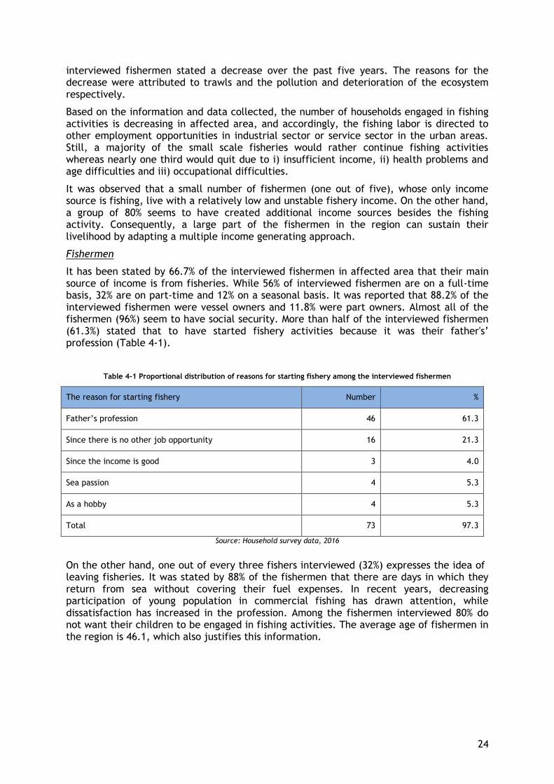
24
interviewed fishermen stated a decrease over the past five years. The reasons for the decrease were attributed to trawls and the pollution and deterioration of the ecosystem respectively.
Based on the information and data collected, the number of households engaged in fishing activities is decreasing in affected area, and accordingly, the fishing labor is directed to other employment opportunities in industrial sector or service sector in the urban areas. Still, a majority of the small scale fisheries would rather continue fishing activities whereas nearly one third would quit due to i) insufficient income, ii) health problems and age difficulties and iii) occupational difficulties.
It was observed that a small number of fishermen (one out of five), whose only income source is fishing, live with a relatively low and unstable fishery income. On the other hand, a group of 80% seems to have created additional income sources besides the fishing activity. Consequently, a large part of the fishermen in the region can sustain their livelihood by adapting a multiple income generating approach.
Fishermen
It has been stated by 66.7% of the interviewed fishermen in affected area that their main source of income is from fisheries. While 56% of interviewed fishermen are on a full-time basis, 32% are on part-time and 12% on a seasonal basis. It was reported that 88.2% of the interviewed fishermen were vessel owners and 11.8% were part owners. Almost all of the fishermen (96%) seem to have social security. More than half of the interviewed fishermen (61.3%) stated that to have started fishery activities because it was their father's’ profession (Table 4-1).
Table 4-1 Proportional distribution of reasons for starting fishery among the interviewed fishermen
The reason for starting fishery Number %
Father’s profession 46 61.3
Since there is no other job opportunity 16 21.3
Since the income is good 3 4.0
Sea passion 4 5.3
As a hobby 4 5.3
Total 73 97.3
Source: Household survey data, 2016
On the other hand, one out of every three fishers interviewed (32%) expresses the idea of leaving fisheries. It was stated by 88% of the fishermen that there are days in which they return from sea without covering their fuel expenses. In recent years, decreasing participation of young population in commercial fishing has drawn attention, while dissatisfaction has increased in the profession. Among the fishermen interviewed 80% do not want their children to be engaged in fishing activities. The average age of fishermen in the region is 46.1, which also justifies this information.
25
Features of the Vessel Types and the Fishing Fleet in the Affected Area
Fishery system in the affected villages is described by the vessel types, fishing fleet in the affected region, gear types and fishing manners detailed below. The technical characteristics and types of the vessels directly affect the fishery system and also the regional characteristics of the fishery as a source of livelihood.
In a study carried out in 2006 (Özekinci and others, 2006), was reported that the length distribution of vessels using commercial extension nets in Çanakkale vary between 7-12m and 86% of these vessels use Çanakkale Strait as fishing ground. In this study, the engine powers of the 65 fishing vessels participating in the survey study varied between 28-185 HP, and it was reported that 2-7 personnel work in these vessels depending on size and motor power. Within the scope of the mentioned project, 9,177 fishermen (ownership of fisheries licenses for real persons) and 818 fishing vessels were reported in Çanakkale Province in the questionnaires held in 2016 and interviews with administrative units. However, according to records of Çanakkale Fisheries and Aquaculture Department, which is the source of the above mentioned figures, the number of active fishermen in the Province is around 6,000. A total of 818 vessels in the fishing fleet, only 20 vessels are over 12 meters, 68 are 10-12 meters long medium-scale vessels and 730 vessels are lower than 10 meters. In the light of these data, it can be said that fishing in the region is dominated by small-scale fishery. This situation is presented clearly in Kemer and Aksaz as well.
Another type of fishery is amateur fishing which is very common in Çanakkale Province, has gained another form in the affected area. Stakeholders interviewed in the field study emphasized the intensity of unlicensed commercial fishing activity performed by amateur fishermen. It is noted that this situation has negative impacts on the Marmara Sea. This statement also supported by a scientific study (Ünal and others, 2010) carried out in the same area.
It is learned that illegal fishing is mostly carried out with “amateur-looking7”. The owners of ‘white amateur fishing license’ fish more than the legal limits and can perform fishery activities in closed fishing seasons. This situation was a problem for small scale fishery because of unfair competition.
The number of amateur-looking fishermen is increasing. Newcomers were encountered during field work. The reason of this increase in the number of amateur-looking fishermen is the increase in blue fish population in İÇDAŞ port as a result of the reef Project.
There are 8 (7 in Kemer, 1 in Aksaz) purse-seiners in the region. It has been determined that about 200 crew members are working on these vessels, which are included in the large-scale fishing category. Large-scale fishing is performed by large-scale vessels over 12 meters, using active-moving fishing gears, requiring much higher investment than small-scale fishery and enables catching large quantities of fish in a single operation. In many countries fishing with trawlers and purse-seines (including Turkey) is included in this category.
The characteristics of the fishing fleet in Kemer, Aksaz and Değirmencik villages are given in Table 4-2 below. Engine forces vary in proportion to vessel length.
Small-scale vessels have a length of 5-9.9 m small-size vessels and 10-12 m medium-size vessels. Besides small-scale vessels, there are purse seiners 15-48 m which are out of scope of the plan.
7 Amateur-looking is the unlicensed commercial fishery activity performed by amateur fishermen.
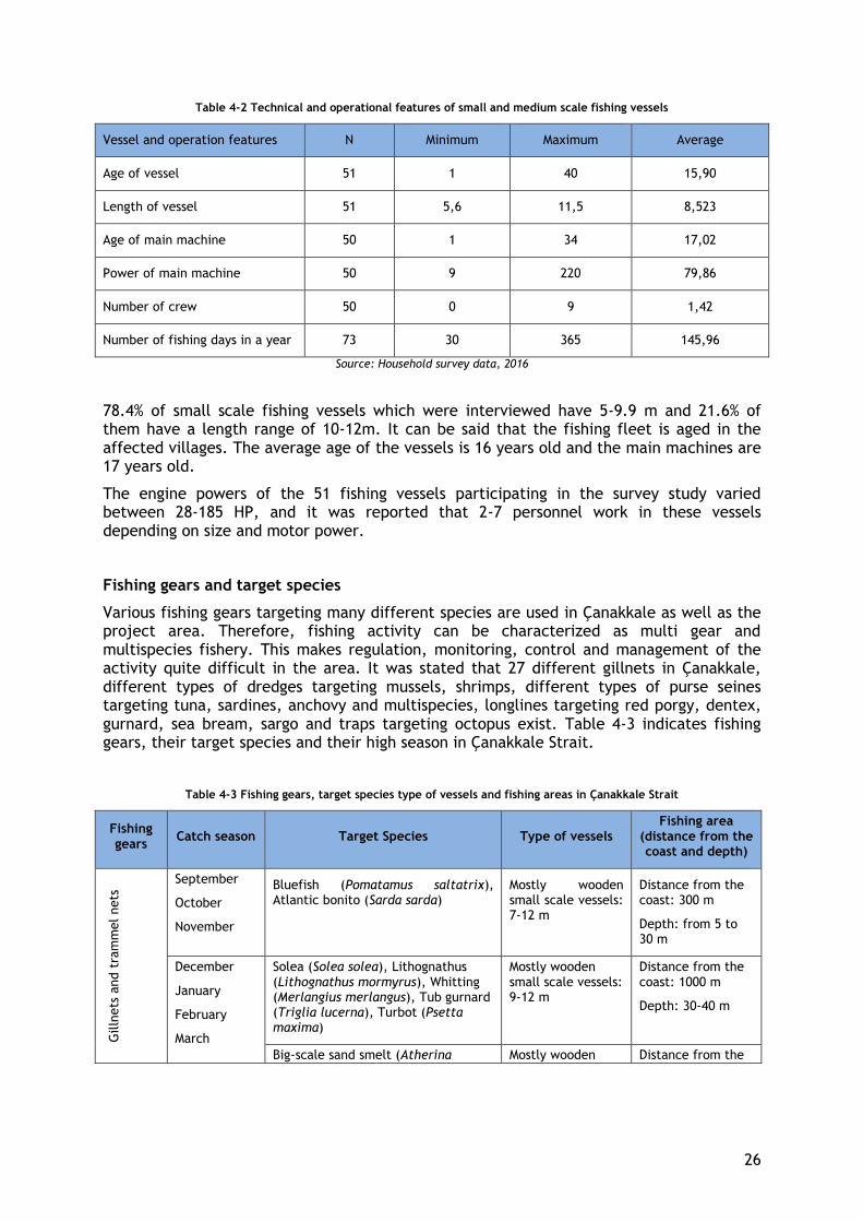
26
Table 4-2 Technical and operational features of small and medium scale fishing vessels
Vessel and operation features N Minimum Maximum Average
Age of vessel 51 1 40 15,90
Length of vessel 51 5,6 11,5 8,523
Age of main machine 50 1 34 17,02
Power of main machine 50 9 220 79,86
Number of crew 50 0 9 1,42
Number of fishing days in a year 73 30 365 145,96
Source: Household survey data, 2016
78.4% of small scale fishing vessels which were interviewed have 5-9.9 m and 21.6% of them have a length range of 10-12m. It can be said that the fishing fleet is aged in the affected villages. The average age of the vessels is 16 years old and the main machines are 17 years old.
The engine powers of the 51 fishing vessels participating in the survey study varied between 28-185 HP, and it was reported that 2-7 personnel work in these vessels depending on size and motor power.
Fishing gears and target species
Various fishing gears targeting many different species are used in Çanakkale as well as the project area. Therefore, fishing activity can be characterized as multi gear and multispecies fishery. This makes regulation, monitoring, control and management of the activity quite difficult in the area. It was stated that 27 different gillnets in Çanakkale, different types of dredges targeting mussels, shrimps, different types of purse seines targeting tuna, sardines, anchovy and multispecies, longlines targeting red porgy, dentex, gurnard, sea bream, sargo and traps targeting octopus exist. Table 4-3 indicates fishing gears, their target species and their high season in Çanakkale Strait.
Table 4-3 Fishing gears, target species type of vessels and fishing areas in Çanakkale Strait
Fishing gears
Catch season Target Species Type of vessels Fishing area
(distance from the coast and depth)
Gilln
ets
and t
ram
mel nets
September
October
November
Bluefish (Pomatamus saltatrix), Atlantic bonito (Sarda sarda)
Mostly wooden small scale vessels: 7-12 m
Distance from the coast: 300 m
Depth: from 5 to 30 m
December
January
February
March
Solea (Solea solea), Lithognathus (Lithognathus mormyrus), Whitting (Merlangius merlangus), Tub gurnard (Triglia lucerna), Turbot (Psetta maxima)
Mostly wooden small scale vessels: 9-12 m
Distance from the coast: 1000 m
Depth: 30-40 m
Big-scale sand smelt (Atherina Mostly wooden Distance from the
27
Fishing gears
Catch season Target Species Type of vessels Fishing area
(distance from the coast and depth)
boyeri), The garfish (Belone belone), Bogue (Boops boops), Mugilidae, Sea bass (Dicentrarchus labrax)
small scale vessels: 6-9 m
coast: 50-100 m
Depth: maximum 15 m
March
April
May
White seabream (Diplodus sargus),Puntazzo Diplodus puntazzo, Common pandora (Pagellus acarne), Dentex (Dentex dentex),
Mostly wooden small scale vessels: 6-9 m
Distance from the coast: up to 50-100 m
Depth: 15-20 m
June
July
August
Atlantic mackerel (Scomber scombrus), Chup mackerel (Scomber japonicus), Red mullet (Mullus barbatus), Striped red mullet (Mullus surmuletus) European pilchard (Sardina pilchardus), Common pandora (Pagellus acarne), Bogue (Boops boops), Trachurus (Trachurus trachurus), Penaeus semisulcatus
Mostly wooden small scale vessels: 6-9 m
Distance from the coast: up to 150m
Depth: 25 m
Winter season (except for the Solea, Its fishing is prohibited in January and December
Solea (Solea solea), Whitting (Merlangius merlangus), Tub gurnard (Triglia lucerna)
Mostly wooden small scale vessels: 9-12 m
Distance from the coast: 1000 m
Depth: 30-40 m
They are not caught in the Project impact area
Swordfish (Xiphias gladius), (Dentex dentex), Turbot (Psetta maxima)
- -
Purs
e s
ein
es
November
December
January
Bluefish (Pomatamus saltatrix)
Large scale vessels: 15-48m
Distance from the coast: if depth is deeper than 24 m (legal depth for purse seiners), they can fish so close by coast
Depth: 24-30 m
September
October
Atlantic bonito (Sarda sarda) Large scale vessels: 15-48m
Distance from the coast: if depth is deeper than 24 m (legal depth for purse seiners), they can fish so close by coast
September
October
November
December
January
February
Atlantic mackerel (Scomber scombrus), European pilchard (Sardina pilchardus), Tranchurus (Trachurus trachurus)
Large scale vessels: 15-48m
Distance from the coast: if depth is deeper than 24 m (legal depth for purse seiners), they can fish so close by coast
Depth: 24-40 m
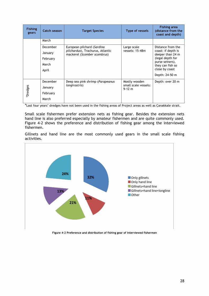
28
Fishing gears
Catch season Target Species Type of vessels Fishing area
(distance from the coast and depth)
March
December
January
February
March
April
European pilchard (Sardina pilchardus), Trachurus, Atlantic mackerel (Scomber scombrus)
Large scale vessels: 15-48m
Distance from the coast: if depth is deeper than 24 m (legal depth for purse seiners), they can fish so close by coast
Depth: 24-50 m
*Dre
dges
December
January
February
March
Deep sea pink shrimp (Parapeanus longirostris)
Mostly wooden small scale vessels: 9-12 m
Depth: over 20 m
*Last four years’ dredges have not been used in the fishing areas of Project areas as well as Çanakkale strait.
Small scale fishermen prefer extension nets as fishing gear. Besides the extension nets hand line is also preferred especially by amateur fishermen and are quite commonly used. Figure 4-2 shows the preference and distribution of fishing gear among the interviewed fishermen.
Gillnets and hand line are the most commonly used gears in the small scale fishing activities.
Figure 4-2 Preference and distribution of fishing gear of interviewed fishermen
29
The species most commonly caught through small-scale fishing activities with the mentioned fishing gear are bluefish, small bluefish, bonito, sardine, horse mackerel, angler, garfish, shrimp, mackerel, whiting and inkfish. Especially bluefish-small bluefish is the most important commercial type in the area. Table 4-4 shows the averages of catches by species of 67 fishermen interviewed according to survey data with small-scale fishermen.
Table 4-4 Amount of yearly catches by species of fishers interviewed, 2016
Species Piece of catch by interviewed fisher
(average)
Bonito 1996
Bluefish 108
Species Amount (kg) of catch by interviewed fisher (average)
Small bluefish 33
Sardine 1766
Horse-mackerel 261
Angler 261
Garfish 411
Ink fish 285
Red mullet 50
Hake 33
Seabass 108
Mackerel 780
Source: Household survey data, 2016
Fishing Areas
The geographical distribution of fishing grounds around the project area is shown in Figure 4-3, based on the data obtained from the questionnaires applied to 51 small-scale vessel owner during the field study.

30
Figure 4-3 Fishing Areas in the Region (1)
The map in Figure 4-4 shows:
- The maximum distance from the shore is 1-1.5 km (around 20m depth) for small scale fishers. It is shown in the figure above that the most preferred fishing areas for small-scale traditional fishing where high proportion of fishing effort allocated.
- Fishing areas of local purse-seiners are beyond the 24 meters’ depth according to the recent fishing notification.
- Fishermen from Aksaz go fishing mostly in eastern side of the village nearby Karabiga which is far away from the project area.
- Fishing grounds of fishermen from Kemer and Değirmencik are overlapped with the project area.
In addition, Figure 4-4 shows the vessel movements in transition restriction period.

31
Figure 4-4 Fishing Areas in the Region (2)
Gender Division in Fishery Activities
According to the household survey, it was observed that there are women headed households in the affected villages. In addition, the vast majority of women are not engaged in any income-generating employment.
The gender division of labor in fishery activities vary according to the nature of the work. In the region, most of the women who are married and not in labor force are categorized as housewives. In the affected areas, female labor force participation rate is very low according to men. According to the survey data, labor force participation rate for women is 15%. For male, this rate is 94%.
Women undertake most of the domestic work and duties. Child care, cooking, cleaning and washing are among the most common daily chores of the women in the affected area. Women also work as unpaid family workers if households are engaged in fishery, agriculture or husbandry.
Women play an important role in the fishing activities by carrying out several tasks within the house. Women support fishing activities by knitting fishing nets, equipping fishing nets, preparing sinkers and disentangling fishing nets. In cases where the household is high, this support is provided by women only to help out with the household fishing activities, however if the household income is low, then women work extra hours to knit and prepare fishing nets upon orders placed by regional fisheries. Although these supporting activities are carried out by women, they do not directly sell the products, instead the products are sold to other fishermen through their husbands and therefore they do not earn an income of their own.
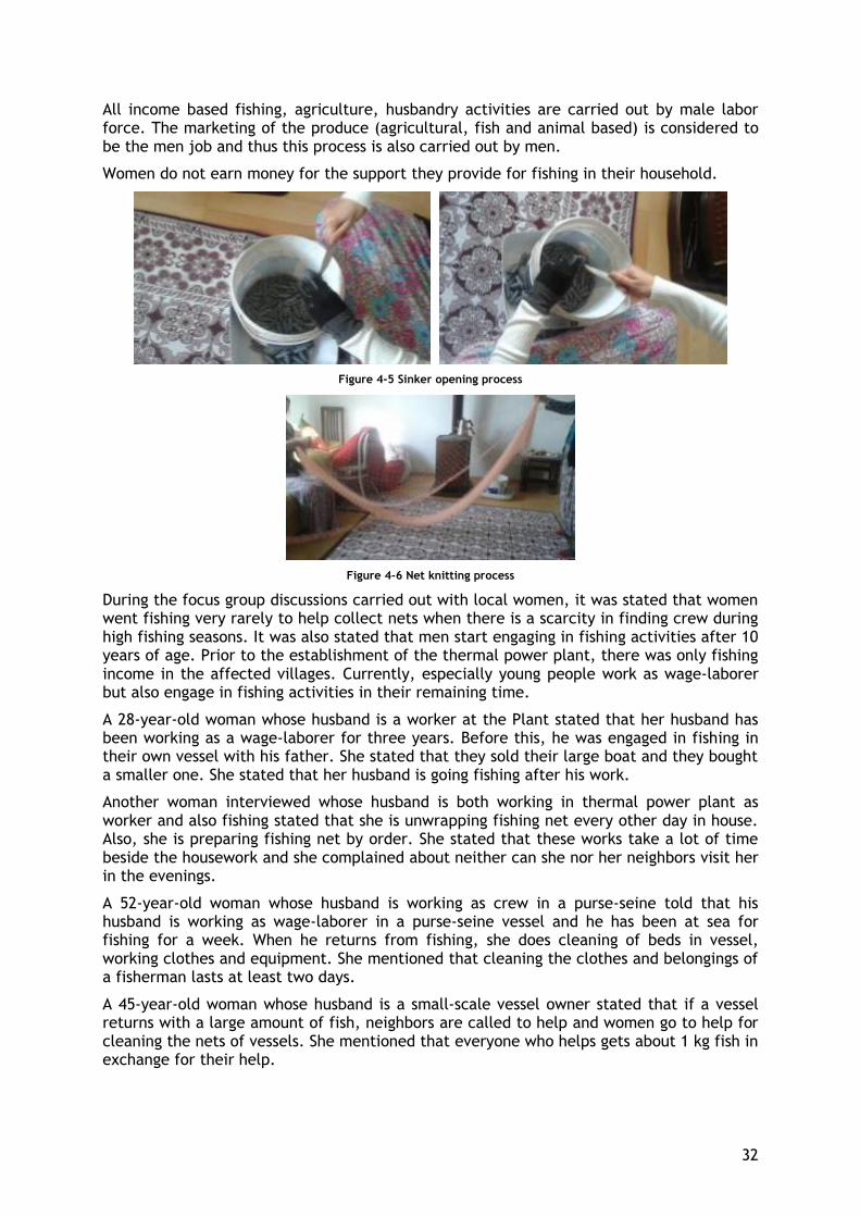
32
All income based fishing, agriculture, husbandry activities are carried out by male labor force. The marketing of the produce (agricultural, fish and animal based) is considered to be the men job and thus this process is also carried out by men.
Women do not earn money for the support they provide for fishing in their household.
Figure 4-5 Sinker opening process
Figure 4-6 Net knitting process
During the focus group discussions carried out with local women, it was stated that women went fishing very rarely to help collect nets when there is a scarcity in finding crew during high fishing seasons. It was also stated that men start engaging in fishing activities after 10 years of age. Prior to the establishment of the thermal power plant, there was only fishing income in the affected villages. Currently, especially young people work as wage-laborer but also engage in fishing activities in their remaining time.
A 28-year-old woman whose husband is a worker at the Plant stated that her husband has been working as a wage-laborer for three years. Before this, he was engaged in fishing in their own vessel with his father. She stated that they sold their large boat and they bought a smaller one. She stated that her husband is going fishing after his work.
Another woman interviewed whose husband is both working in thermal power plant as worker and also fishing stated that she is unwrapping fishing net every other day in house. Also, she is preparing fishing net by order. She stated that these works take a lot of time beside the housework and she complained about neither can she nor her neighbors visit her in the evenings.
A 52-year-old woman whose husband is working as crew in a purse-seine told that his husband is working as wage-laborer in a purse-seine vessel and he has been at sea for fishing for a week. When he returns from fishing, she does cleaning of beds in vessel, working clothes and equipment. She mentioned that cleaning the clothes and belongings of a fisherman lasts at least two days.
A 45-year-old woman whose husband is a small-scale vessel owner stated that if a vessel returns with a large amount of fish, neighbors are called to help and women go to help for cleaning the nets of vessels. She mentioned that everyone who helps gets about 1 kg fish in exchange for their help.

33
5. FISH HABITAT AND RESOURCES
Fish habitat and resources were determined and assessed according to the results of desktop studies and field surveys performed during the preparation of ESIA Report.
5.1. Fish Habitat
The ESIA baseline study is mainly focused on the 500 m wide pipeline route corridor, and defined as the Local Study Area (LSA). For offshore section, the LSA is considered as the 1,000 m wide, which corresponds to the field study area.
The offshore marine field study intends to provide information on the typology and distribution of marine habitats within the local study area. This was fulfilled by preparing the biocenotic map of the local study area. Particular attention was paid to the critical habitats potentially existing in the LSA.
The information compiled in this document was obtained from the results of the side-scan sonar study conducted on 26.05.2012 and of the specimens taken from the area on 02.09.2013, and from the observations contributed during the dives.
The data obtained from benthic samplings, dives and the side-scan sonar were used in identifying the habitat structure of the region and preparing the biocenotic map. Maps containing the existing different biocenoses in the local study area were determined by ArcMap GIS and AutoCAD based on the side-scan sonar mosaic shades. The collected data enabled the accurate interpretation of the acoustic data in the LSA and mapping of the features of the seabed.
The side-scan sonar results revealed that hard substratum covered a very limited area in the LSA. However, the observations made via video recordings and dives revealed no hard substratum in these areas.
Soft substratum covers 100% of the LSA. 323 zoobenthic species were identified in the LSA: 162 Polychaeta species, 97 Mollusca species, 33 Crustacea species, 8 Sipuncula species, 7 Echinodermata species, 7 Cnidaria species, 4 Nemertini species, 2 Porifera species, 1 Platyhelminthes species, 1 Nematoda species and 1 Phoronida species. Cymodocea nodosa and Zostera spp. beds are observed on the shallow waters of the LSA (on the European and Anatolian landfalls).
Based on the geological (granulometric) and biological data, 3 types of habitat [fine sand (RAC/SPA code: III.2), sand (RAC/SPA code: IV.2) and mud (RAC/SPA code: IV.1)], 3 types of biocenoses and 4 types of facies were identified in the local study area. Such biocenoses are well-sorted fine sand biocenosis, coastal detritic bottom and coastal terrigenous mud Table 5-1). The fine sand habitat contains 1 biocenosis (well-sorted fine sand biocenosis), the sand habitat contains 1 biocenosis (coastal detritic bottom), and the mud habitat contains 1 biocenosis (coastal terrigenous mud). Lithothamnion and fragments of dead bivalves are observed on the coastal detritic bottom. This covers an area of 1,739 km2 in the local study area (10.15% of the total area).
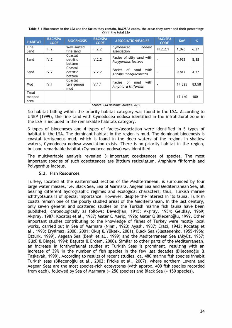
34
Table 5-1 Biocenoses in the LSA and the facies they contain, RAC/SPA codes, the areas they cover and their percentage (%) in the total LSA
HABITAT RAC/SPA
CODE BIOCENOSIS
RAC/SPA CODE
ASSOCIATION/FACIES RAC/SPA
CODE Km2 %
Fine Sand
III.2 Well-sorted fine sand
III.2.2 Cymodocea nodosa association
III.2.2.1 1,076 6.27
Sand IV.2 Coastal detritic bottom
IV.2.2 Facies of silty sand with Polygordius lacteus
- 0.922 5,38
Sand IV.2 Coastal detritic bottom
IV.2.2 Facies of sand with Antalis inaequicostata
- 0.817 4.77
Mud IV.I Coastal terrigenous mud
IV.1.1 Facies of mud with Amphiura filiformis
- 14,325 83.58
Total mapped area
17,140 100
Source: EIA Baseline Studies, 2013
No habitat falling within the priority habitat category was found in the LSA. According to UNEP (1999), the fine sand with Cymodocea nodosa identified in the infralittoral zone in the LSA is included in the remarkable habitats category.
3 types of biocenoses and 4 types of facies/association were identified in 3 types of habitat in the LSA. The dominant habitat in the region is mud. The dominant biocenosis is coastal terrigenous mud, which is found in the deep waters of the region. In shallow waters, Cymodocea nodosa association exists. There is no priority habitat in the region, but one remarkable habitat (Cymodocea nodosa) was identified.
The multivariable analysis revealed 3 important coexistences of species. The most important species of such coexistences are Bittium reticulatum, Amphiura filiformis and Polygordius lacteus.
5.2. Fish Resources
Turkey, located at the easternmost section of the Mediterranean, is surrounded by four large water masses, i.e. Black Sea, Sea of Marmara, Aegean Sea and Mediterranean Sea, all bearing different hydrographic regimes and ecological characters; thus, Turkish marine ichthyofauna is of special importance. However, despite the interest in its fauna, Turkish coasts remain one of the poorly studied areas of the Mediterranean. In the last century, only seven general and scattered studies on the Turkish marine fish fauna have been published, chronologically as follows: Devedjian, 1915; Akşıray, 1954; Geldiay, 1969; Akşıray, 1987; Kocataş et al., 1987; Mater & Meriç, 1996; Mater & Bilecenoğlu, 1999. Other important studies contributing to the knowledge of fishes of Turkey were mostly local works, carried out in Sea of Marmara (Ninni, 1923; Ayaşlı, 1937; Erazi, 1942; Kocataş et al., 1993; Eryılmaz, 2000, 2001; Okuş & Yüksek, 2001), Black Sea (Slastenenko, 1955-1956; Öztürk, 1999), Aegean Sea (Benli et al., 1999) and the Mediterranean Sea (Akyüz, 1957; Gücü & Bingel, 1994; Başusta & Erdem, 2000). Similar to other parts of the Mediterranean, an increase in ichthyofaunal studies at Turkish Seas is prominent, resulting with an increase of 39% in the number of fish species in the few last decades (Bilecenoğlu & Taşkavak, 1999). According to results of recent studies, ca. 480 marine fish species inhabit Turkish seas (Bilecenoğlu et al., 2002; Fricke et al., 2007), where northern Levant and Aegean Seas are the most species-rich ecosystems (with approx. 400 fish species recorded from each), followed by Sea of Marmara (≈ 250 species) and Black Sea (≈ 150 species).
35
As a result of the underwater observations carried out within the site of the pipeline which shall traverse from the Anatolian landfall to the European landfall of the Çanakkale Strait under the scope of the ESIA, 9 fish species belonging to 6 families were determined. Pelagic fish species were not encountered at any of the stations during the diving operations. All of the species identified were benthic. The identified species belonging to the families of Sygnathidae, Serranidae, Labridae, Callionymidae and Gobiidae are not of any commercial value. The only species possessing commercial value observed during such diving operation is Merlangius merlangus (whiting).
During the first field work carried out on the May 23, 2013, a total of 38 individuals belonging to 5 fish species, 4 families and 5 genera were observed; as for the second field work carried out on the September 2, 2013, a total 53 individuals belonging to 6 fish species, 4 families and 6 genera were observed. The similarity between two field works is noteworthy. The most crucial result revealed once these figures are taken into consideration is that the fish fauna at the coast where the pipeline shall pass over is very poor. At the LSA, no breeding area has been observed at both Anatolian and European landfall.
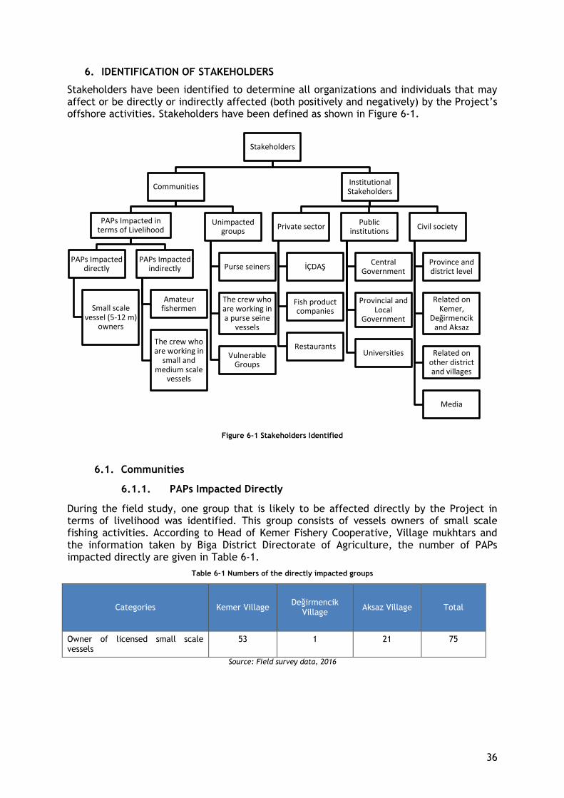
36
6. IDENTIFICATION OF STAKEHOLDERS
Stakeholders have been identified to determine all organizations and individuals that may affect or be directly or indirectly affected (both positively and negatively) by the Project’s offshore activities. Stakeholders have been defined as shown in Figure 6-1.
Figure 6-1 Stakeholders Identified
6.1. Communities
6.1.1. PAPs Impacted Directly
During the field study, one group that is likely to be affected directly by the Project in terms of livelihood was identified. This group consists of vessels owners of small scale fishing activities. According to Head of Kemer Fishery Cooperative, Village mukhtars and the information taken by Biga District Directorate of Agriculture, the number of PAPs impacted directly are given in Table 6-1.
Table 6-1 Numbers of the directly impacted groups
Categories Kemer Village Değirmencik
Village Aksaz Village Total
Owner of licensed small scale vessels
53 1 21 75
Source: Field survey data, 2016
Stakeholders
Communities
PAPs Impacted in
terms of Livelihood
PAPs Impacted
directly
Small scale
vessel (5-12 m) owners
PAPs Impacted
indirectly
Amateur
fishermen
The crew who are working in
small and medium scale
vessels
Unimpacted
groups
Purse seiners
The crew who are working in a purse seine
vessels
Vulnerable
Groups
Institutional Stakeholders
Private sector
İÇDAŞ
Fish product companies
Restaurants
Public
institutions
Central
Government
Provincial and
Local Government
Universities
Civil society
Province and district level
Related on Kemer,
Değirmencik and Aksaz
Related on
other district and villages
Media
37
Small scale vessel owners
✓ All of them have official (green) fishing license for vessels ✓ They live in Kemer, Değirmenci and Aksaz village ✓ A significant proportion of their livelihoods are based on fisheries
There are individuals who contribute to fishing among the other members of the household
6.1.2. PAPs Impacted Indirectly
During the field study, two groups that are likely to be affected indirectly by the Project in terms of livelihood were identified. These groups consist of crew of licensed small scale vessels and amateur fisher. According to Head of Kemer Fishery Cooperative, Village mukhtars and the information taken by Biga District Directorate of Agriculture, the approximate number of PAPs impacted indirectly are given in Table 6-2. While the number of crew working on small-scale vessels may vary according to seasonal conditions, the number given below reflects the data received during the field survey. Crew working on small scale vessels is likely to prefer to work on purse seine vessels during unproductive fishing season. Also during these periods small scale vessel owners can go fishing without their crew.
Table 6-2 Numbers of the indirectly impacted groups
Categories Kemer Village Değirmencik
Village
Aksaz Village Total
Crew of licensed small scale
vessels
50 1 20 71
Amateur fishers 40 10 10 60
Source: Field survey data, 2016
The crew who are working in small scale vessels
✓ They have yellow license for real persons ✓ Most of them are working as unpaid family workers
Amateur fishers
The non-official information obtained through statements made by Head of Kemer Fishery Cooperative and Village mukhtars on the numbers of amateur fishermen are presented in Table 6.1.2-1.
Stakeholder consultations have showed that all of the fishermen with or without an amateur fishing license (since it is not mandatory) who live in Kemer, Değirmencik and Aksaz, are engaged in fishing activities for commercial purposes as well. This fact is considered to likely create a conflict between licensed commercial fishers and amateur fishers.
6.1.3. Unimpacted Community Groups
Purse Seiners
There are 7 and 1 large-scale vessels in Kemer and Aksaz village, respectively. Only two of the large-scale vessels in Kemer Village were in the village during the field survey. The others were fishing in distant places such as Bosphorus and Black Sea. Due to having a broad fishing area, no significant livelihood impact of the project is anticipated. As a result
38
of the exclusion zone of the existing TGPS Pipeline which is a 1,000 m (500 m wide to north and south) corridor situated next to the TANAP pipeline route in the northern direction, purse seiners can no longer fish in the project area.
The crew who are working in purse seiners
The same reasons apply to crew.
Vulnerable groups
In the affected area, there are no vulnerable groups affected by the project activities. There are also no households engaged in fishing which are female headed households.
There are 3 disabled people in the Kemer Village and 2 people in Aksaz Villages. It's stated that 2 of 3 people in Kemer village is a member of a fishery household. The households are engaged in small-scale fishery. None of the disabled people live alone, all live together with their family.
Vulnerable groups in the affected area are not directly affected by the project. Additionally, there are no poor and elderly population (above 65 years old) that live alone and do not have any income and property; it is stated that poor, old and disabled people who do not have any income and property, live with their families.
6.2. Institutional Stakeholders
6.2.1. Public Institutions
● Central Government: o Ministry of Food, Agriculture and Livestock-General Directorate of Fisheries
and Aquaculture ● Provincial and Local Government:
o Çanakkale Governorship o Çanakkale Provincial Directorate of Food, Agriculture and Livestock o Çanakkale Port Authority o Biga District Governorship o Biga District Directorate of Food, Agriculture and Livestock and Aquaculture o Karabiga Port Authority o Çanakkale Municipality o Biga Municipality
● Çanakkale 18 Mart University
6.2.2. Civil Society
● Province and District level o Çanakkale Regional Association of Fishery Cooperatives o Karabiga Fishery Cooperative o Çanakkale Marine Products and Small Fisheries Conservation Association
● Related on Kemer, Değirmencik and Aksaz o Kemer Village Fishery Cooperative
● Related on other district and villages o Lapseki Fishery Cooperative o Çardak Fishery Cooperative
● Media

39
o National press o Local press
6.2.3. Private Sector
● Companies operating in the area o İÇDAŞ o Fish product companies o Restaurants
40
7. LIVELIHOOD IMPACT ASSESSMENT
The potential impacts of the construction and operation phase of the TANAP project on fisheries livelihoods in the region have been assessed in this section. The assessment takes into consideration the following; i) the magnitude of environmental impacts that will differ in certain phases of the construction activities ii) indirect livelihood impacts that these environmental effects will have, iii) groups that will be affected the most and level of impact according to catching areas. The impact assessment is based on the comparison of environmental impacts indicated in various sections of the ESIA report and existing fishery baseline data regarding the Project affected villages.
As mentioned in the former sections of this Plan, no livelihood impacts on fisheries are anticipated during the operation phase of the Project, thus only impacts during construction of offshore facilities have been discussed below.
Various data sources have been utilized in the impact assessment;
● review of ESIA studies, ● review of official records and statistics retrieved by various institutions ● consultations and interviews with key stakeholder groups, village leaders, owners
and operators of fishing vessels, fishermen and crew with regard to key activities (i.e., equipment and input supply, fishing, processing, marketing)
The assessment of the Project’s impacts on fisheries and fishing based livelihoods provides the following:
(i) the description of affected group, and (ii) the project’s direct/indirect impacts, (iii) the significance and consequences of any anticipated impacts.
Each affected group utilizes certain type of gear during their activities. Small-scale fisheries and amateur fishermen in Kemer, Aksaz and Değirmencik Villages are the main target groups of this LRP. Types of fishing gears which are used by these target groups vary according to the target species. Small-scale fisheries include small-scale vessel owners and crew members who work in small scale vessels. Fishery category that are likely to be impacted during the offshore construction activities of the Project are listed in Table 7-1 below.
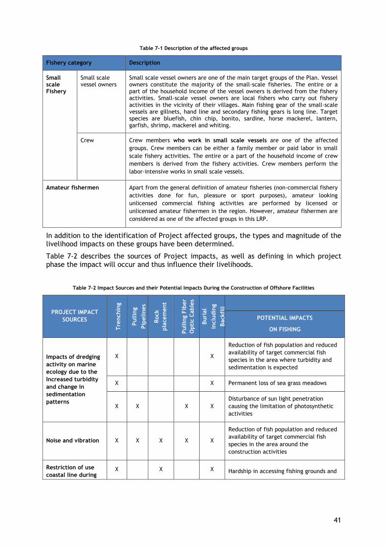
41
Table 7-1 Description of the affected groups
Fishery category Description
Small scale Fishery
Small scale vessel owners
Small scale vessel owners are one of the main target groups of the Plan. Vessel owners constitute the majority of the small-scale fisheries. The entire or a part of the household income of the vessel owners is derived from the fishery activities. Small-scale vessel owners are local fishers who carry out fishery activities in the vicinity of their villages. Main fishing gear of the small-scale vessels are gillnets, hand line and secondary fishing gears is long line. Target species are bluefish, chin chip, bonito, sardine, horse mackerel, lantern, garfish, shrimp, mackerel and whiting.
Crew Crew members who work in small scale vessels are one of the affected
groups. Crew members can be either a family member or paid labor in small
scale fishery activities. The entire or a part of the household income of crew
members is derived from the fishery activities. Crew members perform the
labor-intensive works in small scale vessels.
Amateur fishermen Apart from the general definition of amateur fisheries (non-commercial fishery
activities done for fun, pleasure or sport purposes), amateur looking
unlicensed commercial fishing activities are performed by licensed or
unlicensed amateur fishermen in the region. However, amateur fishermen are
considered as one of the affected groups in this LRP.
In addition to the identification of Project affected groups, the types and magnitude of the livelihood impacts on these groups have been determined.
Table 7-2 describes the sources of Project impacts, as well as defining in which project phase the impact will occur and thus influence their livelihoods.
Table 7-2 Impact Sources and their Potential Impacts During the Construction of Offshore Facilities
PROJECT IMPACT
SOURCES
Tre
nchin
g
Pullin
g
Pip
elines
Rock
pla
cem
ent
Pullin
g F
iber
Opti
c C
able
s
Buri
al
inclu
din
g
Backfi
ll
POTENTIAL IMPACTS
ON FISHING
Impacts of dredging
activity on marine
ecology due to the
Increased turbidity
and change in
sedimentation
patterns
X X
Reduction of fish population and reduced
availability of target commercial fish
species in the area where turbidity and
sedimentation is expected
X X Permanent loss of sea grass meadows
X X X X
Disturbance of sun light penetration
causing the limitation of photosynthetic
activities
Noise and vibration X X X X X
Reduction of fish population and reduced
availability of target commercial fish
species in the area around the
construction activities
Restriction of use
coastal line during X X X Hardship in accessing fishing grounds and
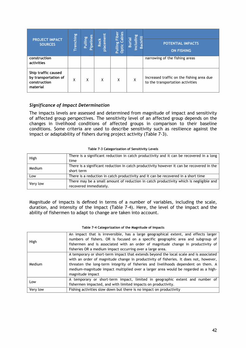
42
PROJECT IMPACT
SOURCES
Tre
nchin
g
Pullin
g
Pip
elines
Rock
pla
cem
ent
Pullin
g F
iber
Opti
c C
able
s
Buri
al
inclu
din
g
Backfi
ll
POTENTIAL IMPACTS
ON FISHING
construction
activities
narrowing of the fishing areas
Ship traffic caused
by transportation of
construction
material
X X X X X Increased traffic on the fishing area due
to the transportation activities
Significance of Impact Determination
The impacts levels are assessed and determined from magnitude of impact and sensitivity of affected group perspectives. The sensitivity level of an affected group depends on the changes in livelihood conditions of affected groups in comparison to their baseline conditions. Some criteria are used to describe sensitivity such as resilience against the impact or adaptability of fishers during project activity (Table 7-3).
Table 7-3 Categorization of Sensitivity Levels
High There is a significant reduction in catch productivity and it can be recovered in a long
time
Medium There is a significant reduction in catch productivity however it can be recovered in the
short term
Low There is a reduction in catch productivity and it can be recovered in a short time
Very low There may be a small amount of reduction in catch productivity which is negligible and
recovered immediately.
Magnitude of impacts is defined in terms of a number of variables, including the scale, duration, and intensity of the impact (Table 7-4). Here, the level of the impact and the ability of fishermen to adapt to change are taken into account.
Table 7-4 Categorization of the Magnitude of Impacts
High
An impact that is irreversible, has a large geographical extent, and effects larger
numbers of fishers. OR is focused on a specific geographic area and subgroup of
fishermen and is associated with an order of magnitude change in productivity of
fisheries OR a medium impact occurring over a large area.
Medium
A temporary or short-term impact that extends beyond the local scale and is associated
with an order of magnitude change in productivity of fisheries. It does not, however,
threaten the long-term integrity of fisheries and livelihoods dependent on them. A
medium-magnitude impact multiplied over a larger area would be regarded as a high-
magnitude impact
Low A temporary or short-term impact, limited in geographic extent and number of
fishermen impacted, and with limited impacts on productivity.
Very low Fishing activities slow down but there is no impact on productivity
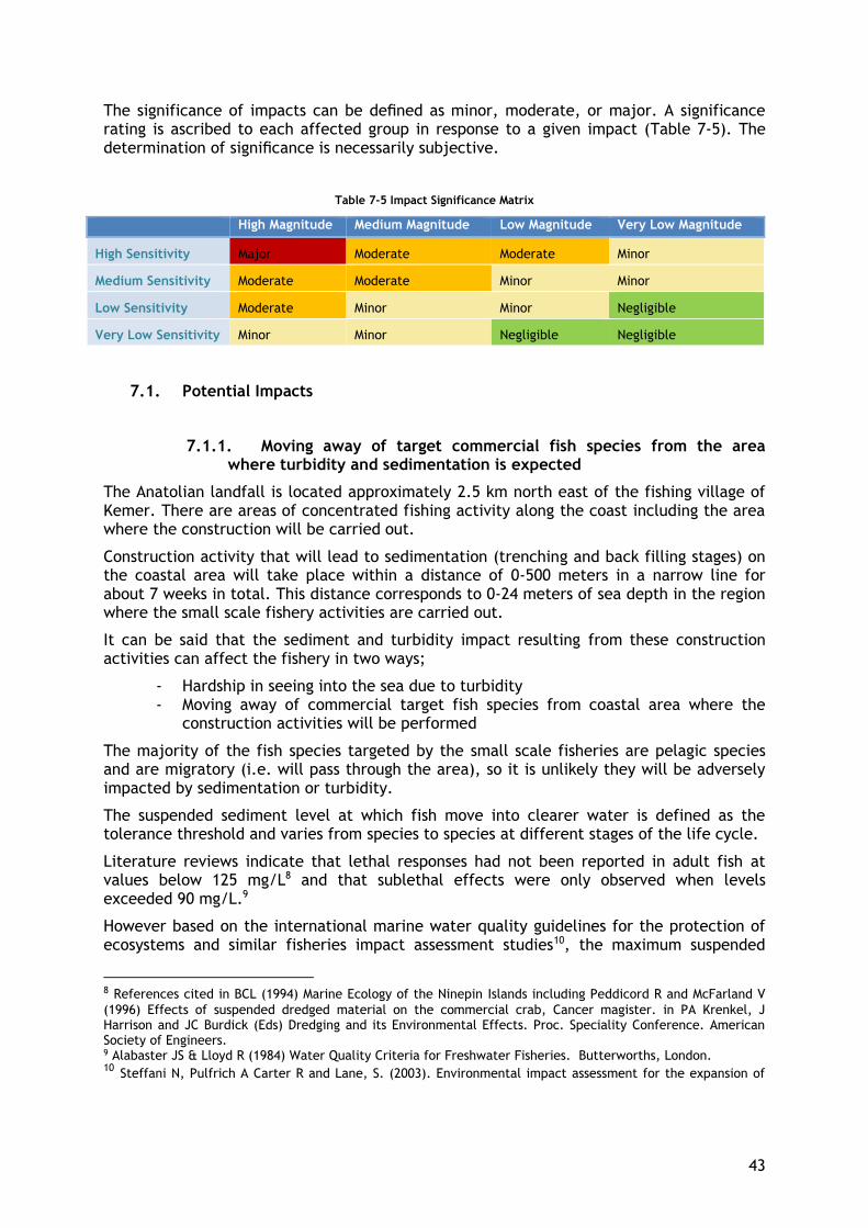
43
The significance of impacts can be defined as minor, moderate, or major. A significance rating is ascribed to each affected group in response to a given impact (Table 7-5). The determination of significance is necessarily subjective.
Table 7-5 Impact Significance Matrix
High Magnitude Medium Magnitude Low Magnitude Very Low Magnitude
High Sensitivity Major Moderate Moderate Minor
Medium Sensitivity Moderate Moderate Minor Minor
Low Sensitivity Moderate Minor Minor Negligible
Very Low Sensitivity Minor Minor Negligible Negligible
7.1. Potential Impacts
7.1.1. Moving away of target commercial fish species from the area where turbidity and sedimentation is expected
The Anatolian landfall is located approximately 2.5 km north east of the fishing village of Kemer. There are areas of concentrated fishing activity along the coast including the area where the construction will be carried out.
Construction activity that will lead to sedimentation (trenching and back filling stages) on the coastal area will take place within a distance of 0-500 meters in a narrow line for about 7 weeks in total. This distance corresponds to 0-24 meters of sea depth in the region where the small scale fishery activities are carried out.
It can be said that the sediment and turbidity impact resulting from these construction activities can affect the fishery in two ways;
- Hardship in seeing into the sea due to turbidity - Moving away of commercial target fish species from coastal area where the
construction activities will be performed
The majority of the fish species targeted by the small scale fisheries are pelagic species and are migratory (i.e. will pass through the area), so it is unlikely they will be adversely impacted by sedimentation or turbidity.
The suspended sediment level at which fish move into clearer water is defined as the tolerance threshold and varies from species to species at different stages of the life cycle.
Literature reviews indicate that lethal responses had not been reported in adult fish at values below 125 mg/L8 and that sublethal effects were only observed when levels exceeded 90 mg/L.9
However based on the international marine water quality guidelines for the protection of ecosystems and similar fisheries impact assessment studies10, the maximum suspended
8 References cited in BCL (1994) Marine Ecology of the Ninepin Islands including Peddicord R and McFarland V
(1996) Effects of suspended dredged material on the commercial crab, Cancer magister. in PA Krenkel, J Harrison and JC Burdick (Eds) Dredging and its Environmental Effects. Proc. Speciality Conference. American Society of Engineers. 9 Alabaster JS & Lloyd R (1984) Water Quality Criteria for Freshwater Fisheries. Butterworths, London. 10 Steffani N, Pulfrich A Carter R and Lane, S. (2003). Environmental impact assessment for the expansion of

44
sediment concentration of 50 mg/L (based on half of the no observable effect concentration) is accepted as threshold level in this assessment.
According to conclusions of sediment plume modeling studies, which were performed for
different seasons (winter and summer) and wave scenarios, sediment plume will be present
throughout the trenching activities which are planned to be carried out in summer for 20
days in total, but disperse and suspended sediment concentration decreases below 50
mg/L approximately 1 day after activities end. The affected distance which will have
suspended sediment concentration of 50 mg/L will be at a location 200 m east and also 200
m west of the trenching footprint at the Anatolian landfall.
As for the trenching, the duration for suspended sediment concentrations are reasonably
similar for back-filling scenarios, with the easterly and westerly locations experiencing
similar durations of exceedance. Back-filling activities which are planned to be carried out
in winter for 25 days in total, but disperse and suspended sediment concentration
decreases below 50 mg/L approximately 1 day after activities end.
In addition, the sediment deposition area as defined by the 1 mm layer thickness at the
Anatolian landfall stretches laterally to the headland to the west and around 500 m to the
east from the trenching footprint, as well as offshore to depths exceeding 30 m (Sediment
Plume Modeling Report, 2015).
Therefore, the results of the sediment plume modeling studies show that the impact of
turbidity pattern change will affect northeast of the dredging zone in Anatolian landfall.
Both impacts which are caused by the dredging activities, may adversely affect the activity
of small-scale fishermen but throughout a short period and in a limited area.
The table below shows the construction schedule along with the fishing seasons by type of
fisheries and the expected turbidity and sediment impact duration.
Table 7-6 Offshore Facilities Construction Schedule and Fishing
Change in sediment patterns will be a temporary impact and influence a limited area.
According to the construction schedule, during the trenching and pipe laydown stages,
the container terminal stacking area at the Port of Cape Town – Marine ecological aspects. Draft report by Pisces Environmental Services, R Carter Specialist Consultant, and Sue Lane and Associates
Year
# of Months
Month
Week 1 2 3 4 1 2 3 4 1 2 3 4 1 2 3 4 1 2 3 4 1 2 3 4 1 2 3 4 1 2 3 4 1 2 3 4 1 2 3 4 1 2 3 4 1 2 3 4 1 2 3 4 1 2 3 4
Trenching
Pipe Laydown
Pulling Fiber Optic Cables X
Rock placement
Burial / Backfill
Small scale fisheries
Purse-seiners
Offshore construction facilities
Fishing season permitted
Fishing banprohibited
13
Feb Mar Apr May Jun Oct Nov De
11 12
Jan
2 3 4 10
2018
Fishing Season
14
Feb
Construction Schedule
2017
Jan
1 5 6 7 8 9
Jul Aug Sep

45
(June 14-July 26), small-scale fishing activities will be carried out however not intensely11
and fishing is forbidden for purse seiners. Besides, it is foreseen that this threshold value
will be a maximum of 600-700 meters from the shore considering that the trenching
activity is to occur in the area up to 500 meters from the shore and even at the farthest
point; 50 mg/L sediment will spread up to 200 meters in east and west direction of the
trenching footprint. It is not expected that the purse seiners will be affected by the
sediment and turbidity impact, even during the backfilling phase in winter, when there is
no fishing ban, since the suspended sediment concentration spread beyond 600-700 meters
from shore is predicted to be very low. Therefore, no adverse livelihood impact on purse
seiners is expected.
The movement of fish is an important effect in the literature. However, stakeholder
interviews have revealed an important feature of the Dardanelles Strait. Accordingly, it is
not possible for the fish population to leave the region because the Strait is a narrow and
forced migration route for the target commercial fish species. For this reason, the fish can
only move away from the construction site to the non-construction area, that is, to the
fishermen's’ hunting grounds. This information has been especially revealed by experts
working in the Canakkale Port Authority and confirmed at other negotiations.
The magnitude of impact should be stated as "low" for small scale vessel owners and
amateur fisheries.
When the sensitivity is assessed, small scale vessel owners are the group that will be most
affected by the sediment impact. Due to fish moving away from the area where sediment
impact is expected, small scale vessel owners will be directly impacted. However, as
mentioned above, the impact, which is expected to be in a short period and in a limited
spatial extent, will cause a reduction in catch productivity which can be recovered in a
short time. Consequently, sensitivity of small scale vessel owners is determined as
"low". Thus, the impact level is assessed as “minor” for small scale vessel owners.
Since crew will not be directly affected by this impact, sensitivity of crew is determined
as "very low" and impact level is evaluated as “negligible”.
Regarding amateur fishermen, main target species is bluefish that is a high value fish
product. Besides, it has been observed that bluefish catching takes place predominantly in
the İÇDAŞ artificial reef area by amateur fishermen. Considering that this activity is being
carried out for commercial purposes and not for recreational purpose and it is mainly
realized outside the impact area, sensitivity of amateur fishermen is determined as
"very low" and impact level is “negligible”.
7.1.2. Permanent loss of seagrass meadows
Damage to the zostera meadows in the sea bed, in the 500-meter linear area extending
from the shore to a depth of 24 meters may impact the feeding and breeding process of
some species. Seagrass provides facilities for feeding and hiding for many species and
therefore it is anticipated that the habitat effect will be reflected indirectly and at low
11
Interviews with small fishermen have revealed that the most intensive season for fishing is between
September and April.
46
level on the target commercial species populations.
These impacts can be described as below:
● During construction works; it can be said that there will be a compensatory loss of biomass on fixed living species due to the temporary abandonment of living environments by living species on the seabed. It is estimated that the recreation of marine habitat will occur after the completion of the construction activity since the impact is low and can be compensated. A monitoring plan has been prepared and will be implemented by Engineering Procurement Construction (EPC) Contractor for tracking this formation and marine habitat.
● Reduction of fish population in the affected area: It is expected that a reduction in the shrimp population in a fairly narrow area. The data show that shrimp catching is carried out at a low density of 4% on June-July-August by small scale vessels by using shrimp trammel nets. According to assessment, magnitude and sensitivity level is determined as “very low” for small scale vessel owners, crew and amateur fisheries. And thus, impact level is determined as “negligible” for all affected groups.
7.1.3. Disturbance of sun light penetration causing the limitation of photosynthetic activities
The most important effect that will occur during dredging and backfilling operations to be done in marine environment is turbidity. According to the clarity of the sea water, the sun rays reach the depths of the water and the oxygen in the air dissolves from the sea surface and spreads to the depths. This is the most important factor for the continuity of the aquatic ecosystem. When evaluated in this respect, turbidity prevents sunlight to reach the depths of the sea and restricting the oxygen in the air to dissolve in seawater and spread to depths.
When turbidity increases, it changes the direction of the light, so that the light scatters, illuminating the particles in the water. Any change to light penetration will adversely affect the respiratory strength and photosynthetic activities of living organisms underwater.
Due to turbidity, respiratory distress may be seen in macroalgae, but this will not affect the overall population and the impact will be “negligible” for all affected groups.
7.1.4. Moving away of target commercial fish species from the area around the construction activities
It is stated in ESIA Chapter 8 that the noise resulted by construction activities may cause fish species move away from the area where construction activities are performed. Construction activities will continue throughout the day and night for three months. It is planned to use lighting on the barge during work. Considering the effect of light on pelagic species, it is predicted that the bonito, which is an important economic species in the region, will not come to the coastal zone of construction due to lighting. According to data obtained via interviews, bonito is caught at a depth of 30 m or more in recent years, it can only be caught at 5 m during the night. Hence, the coastal fishers catch bonito during the night. Due to project related light impact at nighttime hours, Atlantic Bonito catching performed at coastal regions might be negatively affected. However, this impact will occur in a very limited spatial extent (surrounding the barge) and will only continue during construction activities in the fishing area. Additionally, during the trenching and pipe
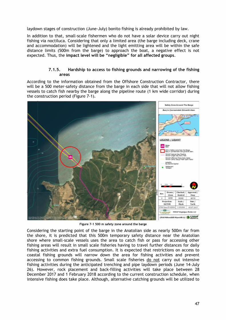
47
laydown stages of construction (June-July) bonito fishing is already prohibited by law.
In addition to that, small-scale fishermen who do not have a solar device carry out night fishing via noctiluca. Considering that only a limited area (the barge including deck, crane and accommodation) will be lightened and the light emitting area will be within the safe distance limits (500m from the barge) to approach the boat, a negative effect is not expected. Thus, the impact level will be “negligible” for all affected groups.
7.1.5. Hardship to access to fishing grounds and narrowing of the fishing areas
According to the information obtained from the Offshore Construction Contractor, there will be a 500 meter-safety distance from the barge in each side that will not allow fishing vessels to catch fish nearby the barge along the pipeline route (1 km wide corridor) during the construction period (Figure 7-1).
Figure 7-1 500 m safety zone around the barge
Considering the starting point of the barge in the Anatolian side as nearly 500m far from the shore, it is predicted that this 500m temporary safety distance near the Anatolian shore where small-scale vessels uses the area to catch fish or pass for accessing other fishing areas will result in small scale fisheries having to travel further distances for daily fishing activities and extra fuel consumption. It is expected that restrictions on access to coastal fishing grounds will narrow down the area for fishing activities and prevent accessing to common fishing grounds. Small scale fisheries do not carry out intensive fishing activities during the anticipated trenching and pipe laydown periods (June 14-July 26). However, rock placement and back-filling activities will take place between 28 December 2017 and 1 February 2018 according to the current construction schedule, when intensive fishing does take place. Although, alternative catching grounds will be utilized to
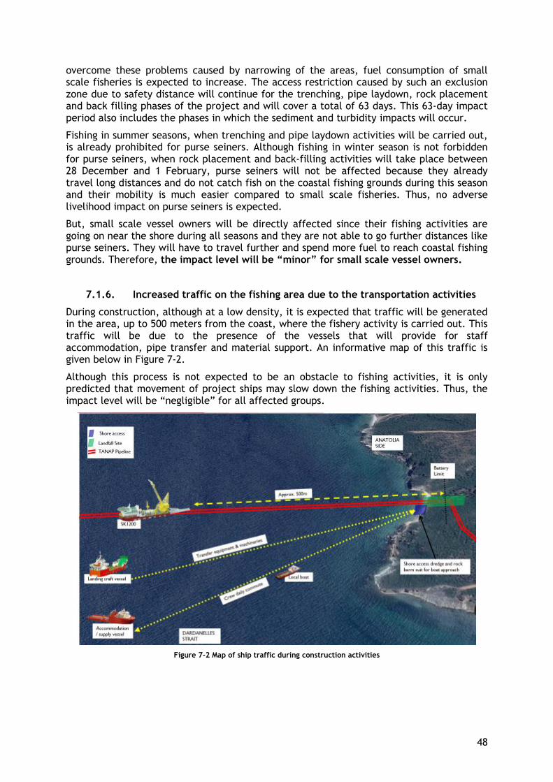
48
overcome these problems caused by narrowing of the areas, fuel consumption of small scale fisheries is expected to increase. The access restriction caused by such an exclusion zone due to safety distance will continue for the trenching, pipe laydown, rock placement and back filling phases of the project and will cover a total of 63 days. This 63-day impact period also includes the phases in which the sediment and turbidity impacts will occur.
Fishing in summer seasons, when trenching and pipe laydown activities will be carried out, is already prohibited for purse seiners. Although fishing in winter season is not forbidden for purse seiners, when rock placement and back-filling activities will take place between 28 December and 1 February, purse seiners will not be affected because they already travel long distances and do not catch fish on the coastal fishing grounds during this season and their mobility is much easier compared to small scale fisheries. Thus, no adverse livelihood impact on purse seiners is expected.
But, small scale vessel owners will be directly affected since their fishing activities are going on near the shore during all seasons and they are not able to go further distances like purse seiners. They will have to travel further and spend more fuel to reach coastal fishing grounds. Therefore, the impact level will be “minor” for small scale vessel owners.
7.1.6. Increased traffic on the fishing area due to the transportation activities
During construction, although at a low density, it is expected that traffic will be generated in the area, up to 500 meters from the coast, where the fishery activity is carried out. This traffic will be due to the presence of the vessels that will provide for staff accommodation, pipe transfer and material support. An informative map of this traffic is given below in Figure 7-2.
Although this process is not expected to be an obstacle to fishing activities, it is only predicted that movement of project ships may slow down the fishing activities. Thus, the impact level will be “negligible” for all affected groups.
Figure 7-2 Map of ship traffic during construction activities
49
7.2. Assessing the Potential Impacts on Livelihood
The Project’s offshore construction activities are expected to have a temporary impact on the fishing activities carried out in the region. This temporary interruption is anticipated to result in negligible to minor impacts on fishing based livelihoods.
The project impact sources and potential environmental impacts described above were tabulated and summarized together with corresponding impacts on fishing based livelihoods in Table 7-7 below.
Table 7-7 also depicts impact level and magnitude according to affected groups and proposes a strategy to overcome these impacts on livelihoods. Strategies proposed for each impact are discussed in detail under Chapter 8 “Fisheries Livelihood Restoration Strategy”.
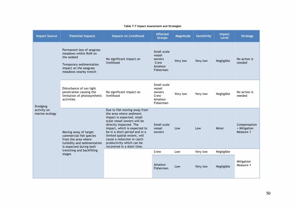
50
Table 7-7 Impact Assessment and Strategies
Impact Source Potential Impacts Impacts on Livelihood Affected Groups
Magnitude Sensitivity Impact Level
Strategy
Dredging activity on marine ecology
Permanent loss of seagrass meadows within RoW on the seabed Temporary sedimentation impact on the seagrass meadows nearby trench
No significant impact on livelihood
Small scale vessel owners Crew Amateur Fishermen
Very low Very low Negligible No action is needed
Disturbance of sun light penetration causing the limitation of photosynthetic activities
No significant impact on livelihood
Small scale vessel owners Crew Amateur Fishermen
Very low Very low Negligible No action is needed
Moving away of target commercial fish species from the area where turbidity and sedimentation is expected during both trenching and backfilling stages
Due to fish moving away from the area where sediment impact is expected, small scale vessel owners will be directly impacted. The impact, which is expected to be in a short period and in a limited spatial extent, will cause a reduction in catch productivity which can be recovered in a short time.
Small scale vessel owners
Low Low Minor Compensation + Mitigation Measure-1
Crew Low Very low Negligible
Mitigation Measure-1 Amateur
Fishermen Low Very low Negligible
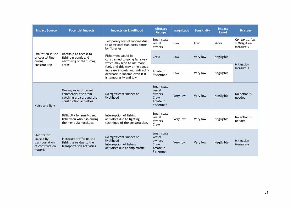
51
Impact Source Potential Impacts Impacts on Livelihood Affected Groups
Magnitude Sensitivity Impact Level
Strategy
Limitation in use of coastal line during construction
Hardship to access to fishing grounds and narrowing of the fishing areas
Temporary loss of income due to additional fuel costs borne by fisheries Fishermen would be constrained to going far away which may lead to use more fuel, and this may bring about increase in costs and indirectly decrease in income even if it is temporarily and low
Small scale vessel owners
Low Low Minor Compensation + Mitigation Measure-1
Crew Low Very low Negligible
Mitigation Measure-1
Amateur Fishermen
Low Very low Negligible
Noise and light
Moving away of target commercial fish from catching area around the construction activities
No significant impact on livelihood
Small scale vessel owners Crew Amateur Fishermen
Very low Very low Negligible No action is needed
Difficulty for small-sized fishermen who fish during the night via noctiluca.
Interruption of fishing activities due to lighting technique of the construction.
Small scale vessel owners Crew
Very low Very low Negligible No action is needed
Ship traffic caused by transportation of construction material
Increased traffic on the fishing area due to the transportation activities
No significant impact on livelihood Interruption of fishing activities due to ship traffic.
Small scale vessel owners Crew Amateur Fishermen
Very low Very low Negligible Mitigation Measure-2
52
8. LIVELIHOOD RESTORATION STRATEGY
This section sets out the proposed essentials of the fisheries livelihood restoration strategy. The strategy establishes principles and mechanisms through which livelihoods may be restored or improved in the context of residual Project impacts. This section proposes a strategic approach to be followed by the Project for compensation mechanisms, through physical interventions or financial payments.
The objectives of the fisheries livelihood restoration strategy are to:
● Establish financial compensation and offset measures whose value to the Small scale fisher matches or exceeds the loss of income and / or benefits as a result of Project related activities;
● Ensure that both the timescale for the delivery and the duration of benefits are in keeping with the nature of impacts;
● Ensure that the administration of financial compensation and delivery of offset measures are practical and implementable within the resources and time frame available;
● Ensure that both compensation and offset are transparent, cost effective and result in benefits to receptors in keeping with their cost of delivery;
● Support the compensation proposal with mitigation measures to avoid long-term possible loss of productivity.
8.1. Strategic Principles
In line with the above listed objectives, LRP proposes a combination of mitigation measures and compensation as a part of its livelihood strategy.
Mitigation measures: Mitigation measures have been proposed with the aim of supporting income based on fisheries in the long term, when the activity is negligible but the sensitivity or magnitude level is low instead of very low. These have been aligned with the natural environment, national laws and plans.
Compensation: For impacts that cannot be removed with the mitigation measures, a compensation plan has been presented. In this way, it is aimed to remove the minor effect on the livelihood.
A community level program was not planned under the strategy due to Project impacts being low/negligible, involving a very small group and for a limited duration. Since there were no impacts identified at the community level, the strategy is limited to mitigation measures and vessel-based compensation. Components of the livelihood restoration strategy are based on the following basic criteria:
● To be fair, ● To be applicable, ● To be adequate, ● To be consistent with national laws and policies
8.2. Stakeholder Feedback in the Preparation of the Livelihood Restoration
Strategy
Several alternatives for the prevention of livelihood impacts and improvement of fishing based livelihoods were developed and discussed with local fishermen. Table 8-1 lists the preferences made by the fishermen with regard to the Livelihood Strategies criteria discussed above. The table also reveals that among the alternatives Fuel Support is the most appropriate compensation.
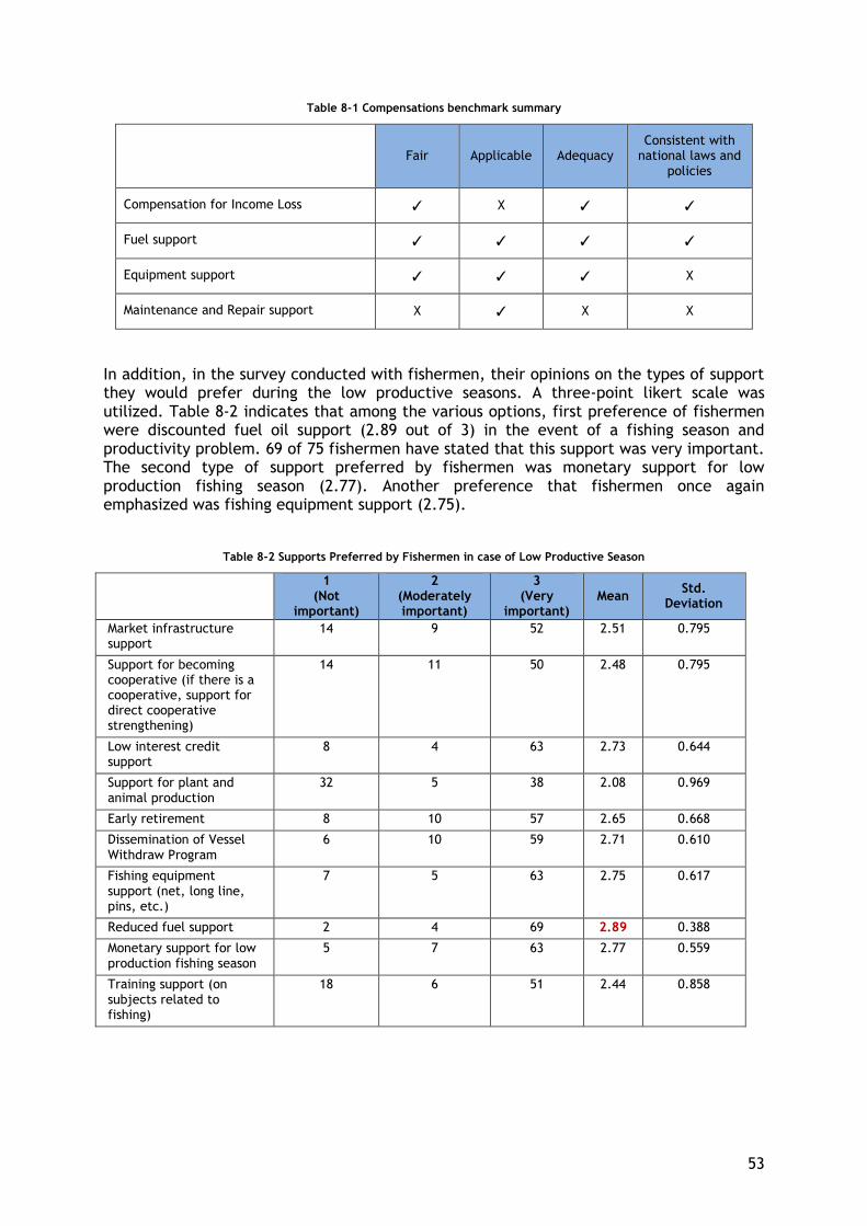
53
Table 8-1 Compensations benchmark summary
Fair Applicable Adequacy
Consistent with national laws and
policies
Compensation for Income Loss ✓ X ✓ ✓
Fuel support ✓ ✓ ✓ ✓
Equipment support ✓ ✓ ✓ X
Maintenance and Repair support X ✓ X X
In addition, in the survey conducted with fishermen, their opinions on the types of support they would prefer during the low productive seasons. A three-point likert scale was utilized. Table 8-2 indicates that among the various options, first preference of fishermen were discounted fuel oil support (2.89 out of 3) in the event of a fishing season and productivity problem. 69 of 75 fishermen have stated that this support was very important. The second type of support preferred by fishermen was monetary support for low production fishing season (2.77). Another preference that fishermen once again emphasized was fishing equipment support (2.75).
Table 8-2 Supports Preferred by Fishermen in case of Low Productive Season
1 (Not
important)
2 (Moderately important)
3 (Very
important) Mean
Std. Deviation
Market infrastructure support
14 9 52 2.51 0.795
Support for becoming cooperative (if there is a cooperative, support for direct cooperative strengthening)
14 11 50 2.48 0.795
Low interest credit support
8 4 63 2.73 0.644
Support for plant and animal production
32 5 38 2.08 0.969
Early retirement 8 10 57 2.65 0.668
Dissemination of Vessel Withdraw Program
6 10 59 2.71 0.610
Fishing equipment support (net, long line, pins, etc.)
7 5 63 2.75 0.617
Reduced fuel support 2 4 69 2.89 0.388
Monetary support for low production fishing season
5 7 63 2.77 0.559
Training support (on subjects related to fishing)
18 6 51 2.44 0.858
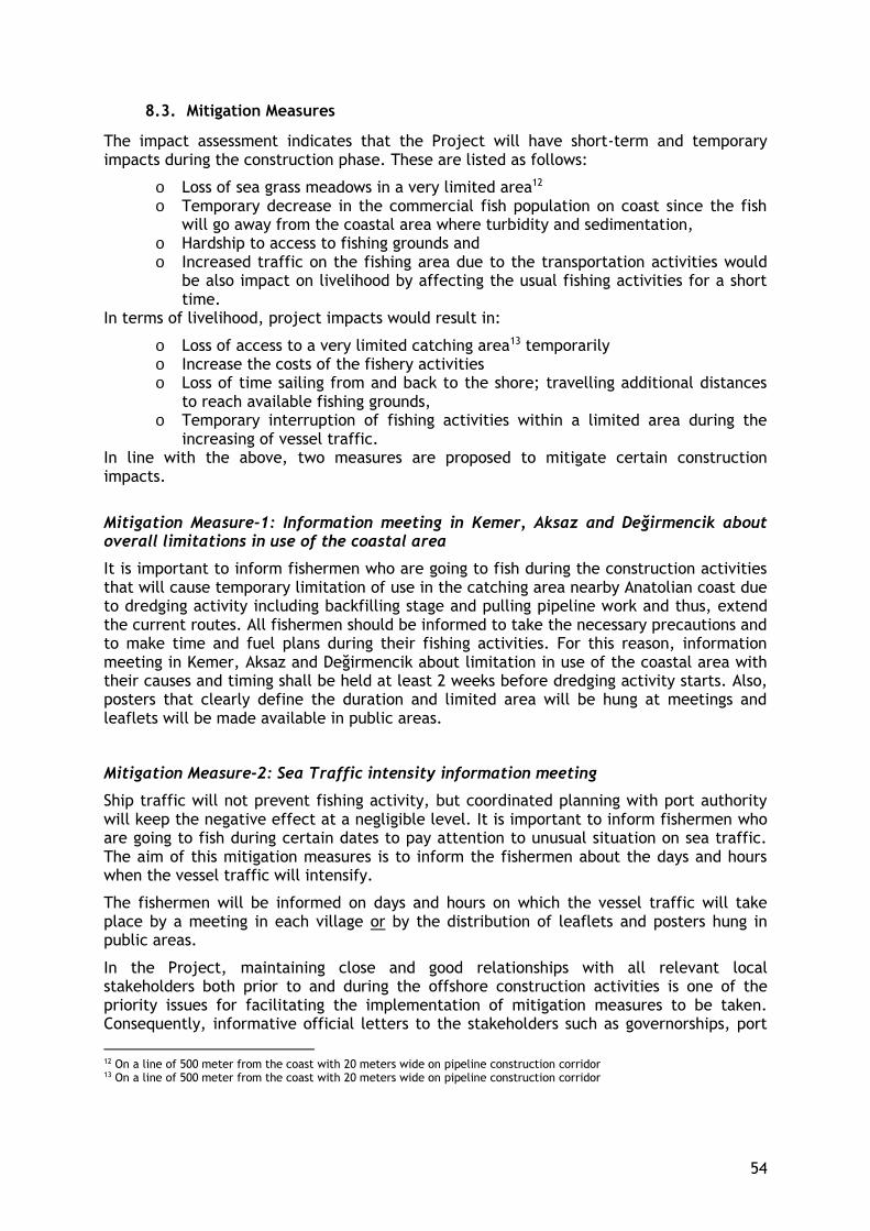
54
8.3. Mitigation Measures
The impact assessment indicates that the Project will have short-term and temporary impacts during the construction phase. These are listed as follows:
o Loss of sea grass meadows in a very limited area12 o Temporary decrease in the commercial fish population on coast since the fish
will go away from the coastal area where turbidity and sedimentation, o Hardship to access to fishing grounds and o Increased traffic on the fishing area due to the transportation activities would
be also impact on livelihood by affecting the usual fishing activities for a short time.
In terms of livelihood, project impacts would result in:
o Loss of access to a very limited catching area13 temporarily o Increase the costs of the fishery activities o Loss of time sailing from and back to the shore; travelling additional distances
to reach available fishing grounds, o Temporary interruption of fishing activities within a limited area during the
increasing of vessel traffic. In line with the above, two measures are proposed to mitigate certain construction impacts.
Mitigation Measure-1: Information meeting in Kemer, Aksaz and Değirmencik about overall limitations in use of the coastal area
It is important to inform fishermen who are going to fish during the construction activities that will cause temporary limitation of use in the catching area nearby Anatolian coast due to dredging activity including backfilling stage and pulling pipeline work and thus, extend the current routes. All fishermen should be informed to take the necessary precautions and to make time and fuel plans during their fishing activities. For this reason, information meeting in Kemer, Aksaz and Değirmencik about limitation in use of the coastal area with their causes and timing shall be held at least 2 weeks before dredging activity starts. Also, posters that clearly define the duration and limited area will be hung at meetings and leaflets will be made available in public areas.
Mitigation Measure-2: Sea Traffic intensity information meeting
Ship traffic will not prevent fishing activity, but coordinated planning with port authority will keep the negative effect at a negligible level. It is important to inform fishermen who are going to fish during certain dates to pay attention to unusual situation on sea traffic. The aim of this mitigation measures is to inform the fishermen about the days and hours when the vessel traffic will intensify.
The fishermen will be informed on days and hours on which the vessel traffic will take place by a meeting in each village or by the distribution of leaflets and posters hung in public areas.
In the Project, maintaining close and good relationships with all relevant local stakeholders both prior to and during the offshore construction activities is one of the priority issues for facilitating the implementation of mitigation measures to be taken. Consequently, informative official letters to the stakeholders such as governorships, port
12 On a line of 500 meter from the coast with 20 meters wide on pipeline construction corridor 13 On a line of 500 meter from the coast with 20 meters wide on pipeline construction corridor
55
authority, relevant provincial/district level directorates, cooperatives etc. will be sent to coordinate and plan for coastal area use and sea traffic intensity in certain periods when necessary.
8.4. Compensation
8.4.1. Compensation alternatives considered
As a part of the livelihood restoration strategy several compensation alternatives were considered. The main focus of compensation is to restore the loss of income and/or to substitute for general fishery expenses made by the fishermen. Below are the alternatives considered as compensation and reasons to why they have been eliminated from the strategy.
a. Income loss compensation: Determining and compensating for possible loss of income is a compensation method. However, interviews with both fishermen and other stakeholders have shown that it is difficult to calculate revenues for fisheries. Lack of official records and up to date information on fishery revenues is an obstacle in front of revenue estimation. It was suggested by stakeholders that an approach based on the calculation of daily or monthly expenses of fisheries would be healthier in defining a compensation. It is more likely to retrieve accurate information on the expenditures of local fisheries. Factors that make the income estimation for fisheries difficult are; Boat characteristics, season and weather conditions, fish flow. Additionally, the construction activities are not expected to cause a reduction in the amount of fish population. Instead, due to the sediment and turbidity impact and coastal restrictions in the temporary exclusion zone, the coastal movements of small-scale fishermen will be hampered resulting in additional fuel consumption for small scale fisheries. Therefore, compensation for income loss was considered irrelevant for the Project. Other significant reasons for why income based compensation was not proposed are; i) to avoid possible conflicts among local fishers; those who cannot benefit from this support may also cause disputes ii) individual compensation estimated for each small scale vessel owner in advance may lead to objectionable results iii) income compensation does not contribute to sustaining fishing activities.
b. Equipment support: Equipment support may always be welcomed by fishermen, but it is a support that carries some handicaps. Increasing the catching capacities of fishermen will increase the fishing pressure in Marmara Sea. This is not environmentally sustainable. In order to reduce the fishing pressure in Marmara Sea, the state is implementing vessel withdraw program. For this reason, it is not compatible with national policies.
c. Maintenance and Repair support: This is for fishing vessels to cover annual
machine and net repairing/maintenance expenses. 31% of fishermen stated maintenance and repair costs but the majority (69%) did not specify annual maintenance and repair costs. According to this data, the average annual maintenance costs of fishermen are about 955 TL. However, it is not a preferred option since the obtained data is not sufficient.
56
8.4.2. Fuel Support
Among the compensation alternatives, providing fuel support to small scale vessel owners who would need to travel further distances to catch fish (due to coastal restrictions) and would face with a reduction in their catch productivity (due to sediment and turbidity) during construction activities was considered to be the best solution. Fuel support provided to the small-scale vessel owners will indirectly compensate the impact on livelihood of members in their households and livelihood of crew working in their vessels. In addition, providing this compensation will ensure the small scale vessel owners to continue their fishing activities without lowering the number of fishing days and thus, the income of the crew working mainly with daily payment will not be adversely impacted.
The fuel support to be provided for each vessel will be based on the calculation made by considering the engine capacity of the vessel and the daily average time spent at sea. The daily average time will be calculated separately for high fishing and low fishing seasons (details to the calculation method are presented in Section 9.4 below). The compensation will cover the entire daily fuel expense made by the vessel owner and not just the expense made for the extra distance due to project impact.
As explained earlier, there is an existing discounted fuel support program of the state for fisheries. The existing program of the state only supports the fishers who perform legal commercial fishing activities. Another reason for preferring fuel support as compensation method is that the existing program of the state supports the legal source of livelihood by excluding illegal fisheries. Therefore, the fuel support compensation will be realized in line with the existing support program of the state. However, there may also be licensed vessels operating without the state’s fuel support, they will also be eligible for compensation as explained below.
8.5. Eligibility for Compensation
The compensation method of fuel support is intended to cover the affected groups with
the minor impact levels and to compensate the potential adverse impact on fishery-based
livelihoods, which can be defined as increase in fuel consumption and thus, cost of daily
fishing activity. The compensation strategy that can be simply defined as “reduction of
fuel consumption-induced cost” was built on the owner of the small scale vessels. At this
point, the fuel support compensation will benefit the following groups:
- The legal owner of the small scale vessel,
- Members of households who receive income from the small scale vessel,
- The crew and their household members who receive income from the small scale
vessel.
The most important eligibility criterion is “to fish in Kemer, Aksaz or Değirmencik”. The
list of small scale vessels fishing surrounding these three villages was made during field
study. However, since it may be possible to find a few fishermen except those identified
during the field study, the expression "fishing in Kemer, Aksaz and Değirmencik" is
embodied as follows:
➢ The official registration of the small scale vessel is in Kemer, Aksaz or Değirmencik;
➢ Or, the residence registration of the small scale vessel owner is in Kemer, Aksaz or
Değirmencik.
57
Secondly, the green license used for fishing vessels and the yellow license used for real
persons must be obtained or renewed to the cut-off date. Cut-off date is determined as
two weeks after the date of the fuel support-focused community informative meeting. A
draft list of eligible fishermen was prepared based on data collected for LRP site visits
(December 2016 and April 2017). However, this list needs to be updated before
implementation starts in order to be able to cover the current situation. So, during the
information meeting to be held prior to construction activities, the most recent ‘eligible
small scale fishery’ list will be posted in the mukhtars office and coffee house walls for 15
days so that all small scale fisheries including those who are not on the list and who are
fulfilling the criteria will be encouraged to come forward to apply for this compensation
support. During these application days, all small-scale vessel owners who would like to
benefit from this support should fill the Application Form with all requested supportive
documents and submit to the assigned CLO so that eligibility of the small scale fishers
applied for the support can be evaluated and added on the list of final eligible small scale
fishers. The finalized list will be posted on the common places in the villages and when the
relevant construction activities causing the defined impacts on fishery-based livelihoods
are over, small-scale vessel owners are requested to submit their fuel books or fuel
receipts for the impacted dates.
Compensation will be delivered at vessel level; not at individual level (each fisherman).
Only one application for each small-scale vessel will be accepted as eligible as per the
criteria mentioned above.
9. LRP IMPLEMENTATION
9.1. Methods of Mitigation Measures
The mitigation measures of information meeting in Kemer, Aksaz and Değirmencik will be basically held for informing small scale vessel owners, their crew and amateur fishermen in the region about limitation in use of coastal area and sea traffic intensity.
Mitigation Measure 1
It is planned fishers to be appropriately and timely informed through community meetings in each village; Kemer, Aksaz and Değirmencik, preferably two weeks before starting limitation in use of the coastal area due to construction activities which are trenching, pulling pipeline and backfilling stages.
Culturally appropriate materials such as poster and leaflet will be prepared for each meeting. All materials prepared will provide information that is clear and relevant. It will be ensured that fishermen who cannot attend the meetings are properly informed or provided with the information materials.
As soon as dates and areas of restriction are determined, related informative materials primarily leaflet will be timely distributed to fishermen.
Mitigation Measure 2
Sea traffic intensity information meeting will be held in Kemer, Aksaz ve Değirmencik to announce the day and hour when the ship traffic will intensify. Dates, hours and traffic dense area will be determined and related materials will be distributed.
58
9.2. Implementation Method of Fuel Support
According to the results of the impact assessment, the most significant ones among all impacts are those that apply to the small-scale fishers. The mentioned livelihood impacts will be caused by construction activities to be carried out within the fishing grounds of these fisheries that will result in extra travel of the vessels in the northeast and southwest directions; but only for a very short period of time.
For that reason, it is worth noting that there will be an increase in the fuel consumption of small scale vessel owners that should be compensated within the LRP framework. Having to travel longer distances to catch the similar amount of fish will most probably increase the amount of fuel needed (caused by both coastal restriction and sediment/turbidity impacts) and consequently, increase in their total fuel expenses is expected.
Compensation to provide fuel support planned under the scope of this LRP will be realized by meeting the entire amount of fuel purchased daily by eligible small scale vessels during the 63 days of project impact as mentioned in Section 7.1.5. After the trenching and pipe laydown phases in June and July 2017 are over, there will be a 28-day compensation and 35 days will be compensated after the rock placement and backfilling works are finished in February 2018.
Vessel owners will be required to submit a fuel receipt (if not benefiting from the state’s fuel support program) or a copy of the discounted fuel book (if benefiting from the state’s fuel support program) received within the specified period of 28 and 35 days separately in order to benefit from the support. Based on the average daily fishing hours and vessel capacity, a total of 63 (28+35) days of fuel expense compensation will be made to eligible vessel owners.
Eligible vessel owners will be requested to provide a bank account for the compensation payment. All vessel owners are anticipated to have existing bank accounts. Should any vessel owner not have an existing bank account they will be asked to open one in any bank of their preference which will not require any fees to be paid. Any transaction costs that may apply during the transfer of compensation payment will be covered by TANAP. Direct payment to the vessel owner’s personal bank account will allow immediate access to compensation.
The method for the payment of compensation will be disclosed in detail to the vessel owners in the first Fuel Support-focused Community Informative Meeting to be held in May 2017 in parallel to delivery of initial information on the construction and responsibilities, contacts in relation to both LRP Implementation and GRM.
9.3. Roles & Responsibilities
The management and implementation of the mitigation measures and fuel support compensation described in this LRP will be locally carried out by the assigned community liaison officer (CLO) at site under the supervision of TANAP Social Impact Department. TANAP will closely follow-up the implementation and ensures that actions are taken in compliance with this Fisheries LRP.
Tasks of the assigned CLO for mitigation measures
● Organizing community meeting to inform fishers of Kemer, Aksaz and Değirmencik about limitation in use of the coastal area including sediment & turbidity impacts
● Preparing and distributing informative materials and ensuring that these materials are delivered to the interested parties.

59
● Ensuring that PAPs are fully informed of the implementation process, contact people and existing GRM, should they need to lodge any grievances.
● Keeping all records on the community information meetings and any concerns being raised during these meetings for reporting the current situation to TANAP Social Impact Department; particularly, the RAP Specialist.
Tasks of the assigned CLO for fuel support compensation
● Organizing a community meeting to inform small-scale vessel owners in Kemer, Aksaz and Değirmencik about implementation details of the fuel support compensation
● Preparing and distributing informative materials and ensuring that the materials are delivered to the interested parties.
● Posting the eligible small scale vessel owners’ list on the wall of the village coffee houses and mukhtar buildings.
● Receiving and evaluating the fuel support applications for their eligibility ● Finalizing the eligible vessel owners list and posting again the finalized list ● Receiving other supplementary documents which are fuel books and fuel receipts
for these days, and bank account etc docs for payment ● Reporting any grievances of small scale vessel owners in the scope of LRP
Implementation ● Keeping all fuel support-related records ● Reporting regularly the current situation /progress to the current situation to
TANAP Social Impact Department; particularly, the RAP Specialist.
9.4. Actions of LRP Implementation
Mitigation Measure 1: Information meeting in Kemer, Aksaz and Değirmencik about overall limitations in use of the coastal area
● Leaflet, poster and official letters that includes information on the restricted dates and area and on grievance mechanism will be prepared, hung in public areas and distributed to PAPs and other stakeholders such as governorships, related provincial and district level directorates, cooperatives etc.
● Meeting date will be announced one week before in each village, and announcement will be refreshed one day before via muhktars and fishery community leaders
● Three meetings will be conducted in Kemer, Aksaz and Değirmencik 2 weeks before the start date of restriction and restriction date, area and also community safety information will be provided to PAPs
Mitigation Measure 2: Sea Traffic intensity information meeting
● Leaflet, poster and official letters that include information on the dates and locations regarding traffic intensity and on grievance mechanism will be prepared, hung in public areas and distributed to PAPs and other stakeholders such as governorships, related provincial and district level directorates, cooperatives etc.
● Meeting date will be announced one week before in each village, and announcement will be refreshed one day before via muhktars and fishery community leaders
● Three meetings will be conducted in Kemer, Aksaz and Değirmencik 2 weeks before the intensity occurs, area and also community safety information will be provided
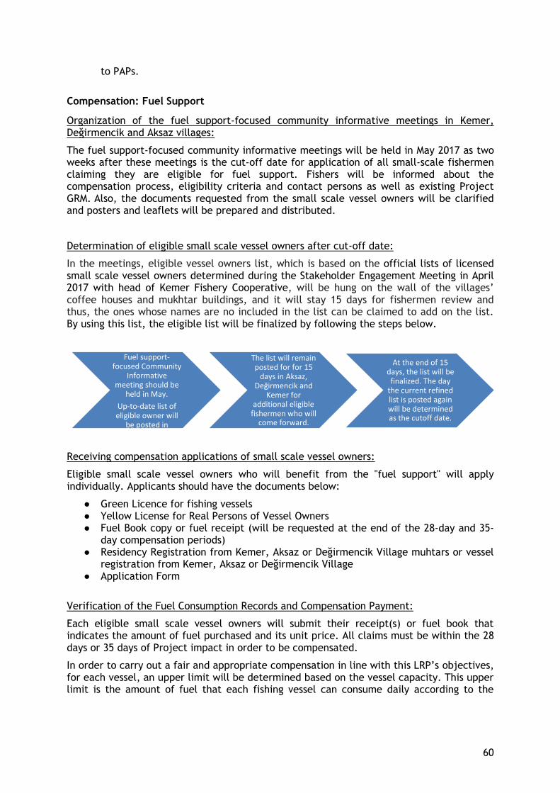
60
to PAPs.
Compensation: Fuel Support
Organization of the fuel support-focused community informative meetings in Kemer, Değirmencik and Aksaz villages:
The fuel support-focused community informative meetings will be held in May 2017 as two weeks after these meetings is the cut-off date for application of all small-scale fishermen claiming they are eligible for fuel support. Fishers will be informed about the compensation process, eligibility criteria and contact persons as well as existing Project GRM. Also, the documents requested from the small scale vessel owners will be clarified and posters and leaflets will be prepared and distributed.
Determination of eligible small scale vessel owners after cut-off date:
In the meetings, eligible vessel owners list, which is based on the official lists of licensed small scale vessel owners determined during the Stakeholder Engagement Meeting in April 2017 with head of Kemer Fishery Cooperative, will be hung on the wall of the villages’ coffee houses and mukhtar buildings, and it will stay 15 days for fishermen review and thus, the ones whose names are no included in the list can be claimed to add on the list. By using this list, the eligible list will be finalized by following the steps below.
Receiving compensation applications of small scale vessel owners:
Eligible small scale vessel owners who will benefit from the "fuel support" will apply individually. Applicants should have the documents below:
● Green Licence for fishing vessels ● Yellow License for Real Persons of Vessel Owners ● Fuel Book copy or fuel receipt (will be requested at the end of the 28-day and 35-
day compensation periods) ● Residency Registration from Kemer, Aksaz or Değirmencik Village muhtars or vessel
registration from Kemer, Aksaz or Değirmencik Village ● Application Form
Verification of the Fuel Consumption Records and Compensation Payment:
Each eligible small scale vessel owners will submit their receipt(s) or fuel book that indicates the amount of fuel purchased and its unit price. All claims must be within the 28 days or 35 days of Project impact in order to be compensated.
In order to carry out a fair and appropriate compensation in line with this LRP’s objectives, for each vessel, an upper limit will be determined based on the vessel capacity. This upper limit is the amount of fuel that each fishing vessel can consume daily according to the
Fuel support-focused Community
Informative meeting should be
held in May. Up-to-date list of eligible owner will
be posted in villages.
The list will remain posted for for 15
days in Aksaz, Değirmencik and
Kemer for additional eligible
fishermen who will come forward.
At the end of 15 days, the list will be finalized. The day
the current refined list is posted again will be determined as the cutoff date.
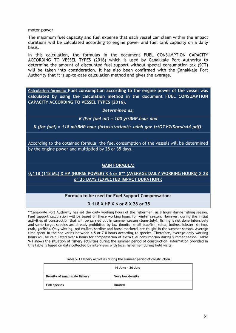
61
motor power.
The maximum fuel capacity and fuel expense that each vessel can claim within the impact durations will be calculated according to engine power and fuel tank capacity on a daily basis.
In this calculation, the formulas in the document FUEL CONSUMPTION CAPACITY ACCORDING TO VESSEL TYPES (2016) which is used by Çanakkale Port Authority to determine the amount of discounted fuel support without special consumption tax (SCT) will be taken into consideration. It has also been confirmed with the Çanakkale Port Authority that it is up-to-date calculation method and gives the average.
Calculation formula: Fuel consumption according to the engine power of the vessel was
calculated by using the calculation method in the document FUEL CONSUMPTION
CAPACITY ACCORDING TO VESSEL TYPES (2016).
Determined as;
K (For fuel oil) = 100 gr/BHP.hour and
K (for fuel) = 118 ml/BHP.hour (https://atlantis.udhb.gov.tr/OTV2/Docs/s44.pdf).
According to the obtained formula, the fuel consumption of the vessels will be determined
by the engine power and multiplied by 28 or 35 days.
MAIN FORMULA:
0,118 (118 ML) X HP (HORSE POWER) X 6 or 8** (AVERAGE DAILY WORKING HOURS) X 28
or 35 DAYS (EXPECTED IMPACT DURATION);
Formula to be used for Fuel Support Compensation:
0,118 X HP X 6 or 8 X 28 or 35
**Çanakkale Port Authority has set the daily working hours of the fishermen, as 8 hours during fishing season. Fuel support calculation will be based on these working hours for winter season. However, during the initial activities of construction that will be carried out in summer season (June-July), fishing is not done intensively and some target species are already prohibited by law (bonito, small bluefish, solea, bothus, lobster, shrimp, crab, garfish). Only whiting, red mullet, sardine and horse mackerel are caught in the summer season. Average time spent in the sea varies between 4-5 or 7-8 hours according to species. Therefore, average daily working hours will be calculated over 6 hours for compensation of extra fuel consumption during summer season. Table 9-1 shows the situation of fishery activities during the summer period of construction. Information provided in this table is based on data collected by interviews with local fishermen during field visits.
Table 9-1 Fishery activities during the summer period of construction
14 June – 26 July
Density of small scale fishery Very low density
Fish species limited
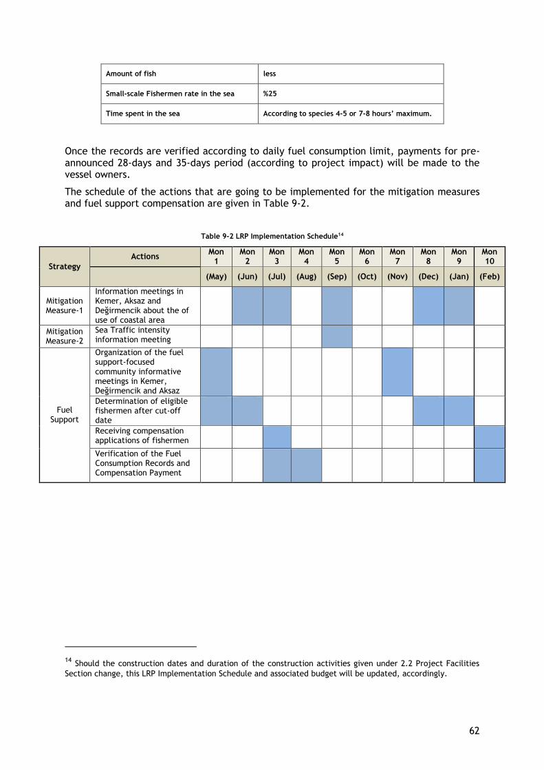
62
Amount of fish less
Small-scale Fishermen rate in the sea %25
Time spent in the sea According to species 4-5 or 7-8 hours’ maximum.
Once the records are verified according to daily fuel consumption limit, payments for pre-announced 28-days and 35-days period (according to project impact) will be made to the vessel owners.
The schedule of the actions that are going to be implemented for the mitigation measures and fuel support compensation are given in Table 9-2.
Table 9-2 LRP Implementation Schedule14
Strategy
Actions Mon
1 Mon
2 Mon
3 Mon
4 Mon
5 Mon
6 Mon
7 Mon
8 Mon
9 Mon 10
(May) (Jun) (Jul) (Aug) (Sep) (Oct) (Nov) (Dec) (Jan) (Feb)
Mitigation Measure-1
Information meetings in Kemer, Aksaz and Değirmencik about the of use of coastal area
Mitigation Measure-2
Sea Traffic intensity information meeting
Fuel Support
Organization of the fuel support-focused community informative meetings in Kemer, Değirmencik and Aksaz
Determination of eligible fishermen after cut-off date
Receiving compensation applications of fishermen
Verification of the Fuel Consumption Records and Compensation Payment
14 Should the construction dates and duration of the construction activities given under 2.2 Project Facilities
Section change, this LRP Implementation Schedule and associated budget will be updated, accordingly.
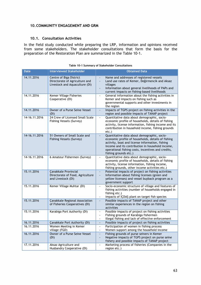
63
10. COMMUNITY ENGAGEMENT AND GRM
10.1. Consultation Activities
In the field study conducted while preparing the LRP, information and opinions received from some stakeholders. The stakeholder consultations that form the basis for the preparation of the Restoration Plan are summarized in the Table 10-1.
Table 10-1 Summary of Stakeholder Consultations
Date Interviewed Stakeholder Obtained Data
14.11.2016 Centre of Biga District Directorate of Agriculture and Livestock and Aquaculture (DI)
- Name and addresses of registered vessels - Land use rates of Kemer, Değirmencik and Aksaz
villages - Information about general livelihoods of PAPs and
current impacts on fishing-based livelihoods
14.11.2016 Kemer Village Fisheries Cooperative (DI)
- General information about the fishing activities in Kemer and impacts on fishing such as governmental supports and other investments in the region
14.11.2016 Owner of a Purse Seine Vessel (DI)
- Impacts of TGPS project on fishing activities in the region and possible impacts of TANAP project
14-16.11.2016 24 Crew of Licensed Small Scale Fishing Vessels (Survey)
- Quantitative data about demographic, socio-economic profile of households, details of fishing activity, license information, fishing income and its contribution in household income, fishing grounds etc.)
14-16.11.2016 51 Owners of Small Scale and Fishing Vessels (Survey)
- Quantitative data about demographic, socio-economic profile of households, details of fishing activity, boat and license information, fishing income and its contribution in household income, operational fishing costs, incentives and credits, fishing grounds etc.)
14-16.11.2016 6 Amateur Fishermen (Survey) - Quantitative data about demographic, socio-economic profile of households, details of fishing activity, license information, fishing income, fishing grounds, other income activities etc.)
15.11.2016 Çanakkale Provincial Directorate of Food, Agriculture and Livestock (DI)
- Potential impacts of project on fishing activities - Information about fishing licenses (green and
yellow licenses) and vessel buyback program as a government support
15.11.2016 Kemer Village Muhtar (DI) - Socio-economic structure of village and features of fishing activities (number of households engaged in fishing etc.)
- Impacts of İÇDAŞ plant on target fish species
15.11.2016 Çanakkale Regional Association of Fisheries Cooperatives (DI)
- Possible impacts of TANAP project and other similar experiences in the region on fishing activities
15.11.2016 Karabiga Port Authority (DI) - Possible impacts of project on fishing activities - Fishing grounds of Karabiga fishermen - Illegal fishing and lack of effective enforcement
16.11.2016 Çanakkale Port Authority (DI) - Possible impacts of project on fishing activities
16.11.2016 Women Meeting in Kemer village (FGD)
- Participation of women in fishing process - Women support among the household income
16.11.2016 Owner of a Purse Seine Vessel (DI)
- Fishing grounds of purse seiners in Kemer - Negative impacts of TGPS project on purse seine
fishery and possible impacts of TANAP project
17.11.2016 Aksaz Agriculture and Husbandry Cooperative (DI)
- Marketing process of fisheries (Companies in the region etc.)
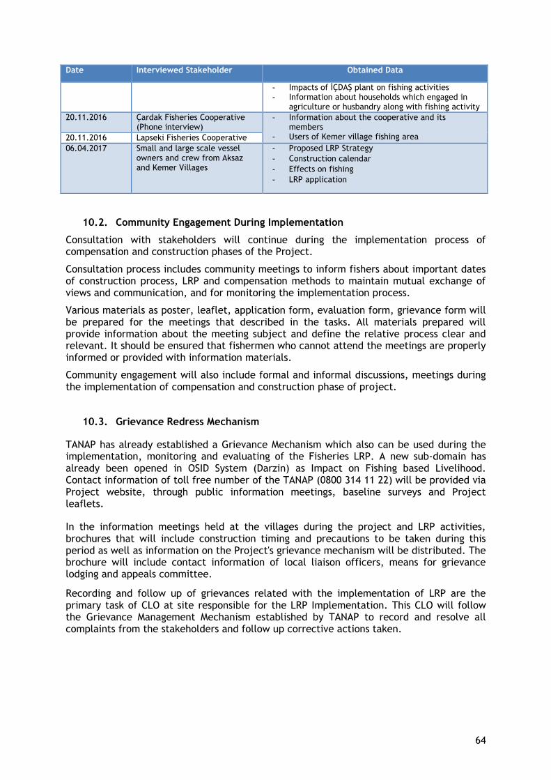
64
Date Interviewed Stakeholder Obtained Data
- Impacts of İÇDAŞ plant on fishing activities - Information about households which engaged in
agriculture or husbandry along with fishing activity
20.11.2016 Çardak Fisheries Cooperative (Phone interview)
- Information about the cooperative and its members
- Users of Kemer village fishing area 20.11.2016 Lapseki Fisheries Cooperative
06.04.2017 Small and large scale vessel owners and crew from Aksaz and Kemer Villages
- Proposed LRP Strategy
- Construction calendar
- Effects on fishing
- LRP application
10.2. Community Engagement During Implementation
Consultation with stakeholders will continue during the implementation process of compensation and construction phases of the Project.
Consultation process includes community meetings to inform fishers about important dates of construction process, LRP and compensation methods to maintain mutual exchange of views and communication, and for monitoring the implementation process.
Various materials as poster, leaflet, application form, evaluation form, grievance form will be prepared for the meetings that described in the tasks. All materials prepared will provide information about the meeting subject and define the relative process clear and relevant. It should be ensured that fishermen who cannot attend the meetings are properly informed or provided with information materials.
Community engagement will also include formal and informal discussions, meetings during the implementation of compensation and construction phase of project.
10.3. Grievance Redress Mechanism
TANAP has already established a Grievance Mechanism which also can be used during the implementation, monitoring and evaluating of the Fisheries LRP. A new sub-domain has already been opened in OSID System (Darzin) as Impact on Fishing based Livelihood. Contact information of toll free number of the TANAP (0800 314 11 22) will be provided via Project website, through public information meetings, baseline surveys and Project leaflets.
In the information meetings held at the villages during the project and LRP activities, brochures that will include construction timing and precautions to be taken during this period as well as information on the Project's grievance mechanism will be distributed. The brochure will include contact information of local liaison officers, means for grievance lodging and appeals committee.
Recording and follow up of grievances related with the implementation of LRP are the primary task of CLO at site responsible for the LRP Implementation. This CLO will follow the Grievance Management Mechanism established by TANAP to record and resolve all complaints from the stakeholders and follow up corrective actions taken.
65
Grievance Management Process
- Receiving and registering grievance into OSID system by using Complaint register form and a hard copy of the form.
- All corrective actions suggested by the Complainant are taken under registration - All grievances are reviewed to be classified whether they are genuine and related to
Project activities or not. - Eligible complaints are responded according to Project social requirements which are
identified in ESIA. - All grievances received through the toll free number, direct phone calls, emails and
face to face meetings/communications are taken under registration. - TANAP has ten (10) business days to investigate and respond the complaints. - Necessary corrective actions shall satisfy the complainant. - When the complainants disagree on the suggested strategy, their comments are
evaluated according to project rules. - All parties get an agreement on the corrective actions during solution process. - Signature of the complainant is received regarding the termination of the complaint
and the proof documents of the corrective actions (photos from the site or other evidence documents) taken are collected.
Closed complaints are checked via field audits or telephone checks to validate the corrective actions are valuable to close the complaints or other mitigation measures are necessary not to get additional complaints on the same issue.
Should there be a dissatisfaction in the resolution of grievances, PAPs (vessel owners) will be able to apply to the Appeals Committee established for Lot 4 which will be responsible for mediating the re-evaluation process of unresolved grievances. Among the individual specialists forming the appeals committee for this Lot, a fisheries expert will also be included to assess any unresolved complaints regarding the Fisheries Livelihood Restoration Program. The fisherman of the region will be informed of the Appeals Committee and contact information during the public meetings held prior to the implementation of the LRP in May and June 2017.
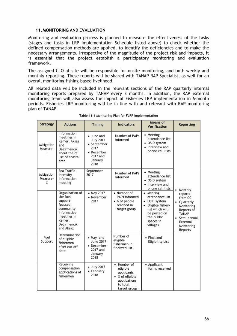
66
11. MONITORING AND EVALUATION
Monitoring and evaluation process is planned to measure the effectiveness of the tasks (stages and tasks in LRP Implementation Schedule listed above) to check whether the defined compensation methods are applied, to identify the deficiencies and to make the necessary arrangements. Irrespective of the magnitude of the project risk and impacts, it is essential that the project establish a participatory monitoring and evaluation framework.
The assigned CLO at site will be responsible for onsite monitoring, and both weekly and monthly reporting. These reports will be shared with TANAP RAP Specialist, as well for an overall monitoring fishing-based livelihood.
All related data will be included in the relevant sections of the RAP quarterly internal monitoring reports prepared by TANAP every 3 months. In addition, the RAP external monitoring team will also assess the impact of Fisheries LRP implementation in 6-month periods. Fisheries LRP monitoring will be in line with and relevant with RAP monitoring plan of TANAP.
Table 11-1 Monitoring Plan for FLRP implementation
Strategy Actions Timing Indicators Means of
Verification Reporting
Mitigation Measure-
1
Information meetings in Kemer, Aksaz and Değirmencik about the of use of coastal area
June and July 2017
September 2017
December 2017 and January 2018
Number of PAPs informed
Meeting attendance list
OSID system
Interview and phone call lists
Monthly reports from CC
Quarterly Monitoring Reports of TANAP
Semi-annual External Monitoring Reports
Mitigation Measure-
2
Sea Traffic intensity information meeting
September 2017 Number of PAPs
informed
Meeting attendance list
OSID system
Interview and phone call lists
Fuel Support
Organization of the fuel support-focused community informative meetings in Kemer, Değirmencik and Aksaz
May 2017
November 2017
Number of PAPs informed
% of people reached in target group
Meeting attendance list
OSID system
Eligible fishery list which will be posted on the public spaces in villages
Determination of eligible fishermen after cut-off date
May and June 2017
December 2017 and January 2018
Number of eligible fishermen in finalized list
Finalized Eligibility List
Receiving compensation applications of fishermen
July 2017
February 2018
Number of eligible applicants
% of eligible applications to total target group
Applicant forms received
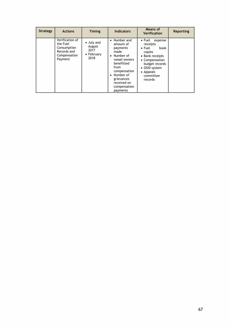
67
Strategy Actions Timing Indicators Means of
Verification Reporting
Verification of the Fuel Consumption Records and Compensation Payment
July and August 2017
February 2018
Number and amount of payments made
Number of vessel owners benefitted from compensation
Number of grievances received on compensation payments
Fuel expense receipts
Fuel book copies
Bank receipts
Compensation budget records
OSID system
Appeals committee records

68
12. BUDGET
The overall estimated budget for the implementation of fuel support compensation and necessary informative meetings described in this LRP is totally 1.424.749,00 TL including contingency with the rate of 10%.
69
REFERENCES
1. TANAP Environmental and Social Impact Assessment Report (ESIA), “Assessment of Socio-Economic Environment – Offshore”, Chapter 7.3.6, 2013
2. TANAP Environmental and Social Impact Assessment Report (ESIA), “Social Characteristics – Offshore”, Chapter 8.6, 2013
3. Sediment Plume Modeling Report, WRP-REP-ENV-DAR-001, Chapter 8, 2015 4. Socio-Economic Development Gradation(SEGE) , Ministry of Development, 2011 5. PAWSON, et.al (2008) The Definition of Marine Recreational Fishing in Europe 6. EIFAC Code of Practice for Recreational Fisheries, FAO, 2008 7. Addressing Project Impacts on Fishing Based Livelihoods, IFC, 2015 8. AKYOL, O., CEYHAN, T., UNAL, V. 2006. Datça-Bozburun Peninsula (Aegean Sea)
Surveys on Coastal Fisheries and Fisheries Resources, İzmir 9. AKŞIRAY, F., 1954. Marine fishes of Turkey and a key to species, Istanbul University,
Science Faculty, Hydrobiology Research Institute Publications, Istanbul, 277 pp. [in Turkish].
10. AKŞIRAY, F., 1987. “Key to identify marine fish of Turkey”, Istanbul University Rektorate Publications, Istanbul, 811 pp. [in Turkish].
11. AKTAN, Y., 2012. “On the occurrence of coralligenous algae in the Johnston Bank (Aegean Sea)”, J. Black Sea/Mediterranean Environment, 18: 414-419.
12. AKYÜZ, E., 1957. “Observations on Iskenderun red mullet (Mullus barbatus) and its environment”, GFCM Proceedings and Technical Papers, 4 (38), 305-326.
13. AYAŞLI, S., 1937. “Fishes of the Bosphorus”, Cumhuriyet Printing, Istanbul, 72 pp. [in Turkish].
14. AYSEL, V., 1997. “Marine flora of the Turkish Mediterranean Coast. II. Brown algae (Phaeophyceae)”, Turk. J. Bot., 21: 329-334.
15. AYSEL, V., B. DURAL, A. GONUZ, A. ARTUK & DUZYATAN, K.C., 1997. “Marine Flora of Urla Port and around (Izmir Bay, Aegean Sea, Turkey)”, IX. National Aquacultural Products Symposium (18-19 September 1997. Egirdir/Isparta) Booklet, pp: 340-350.
16. AYSEL, V., B. DURAL, A. SUKATAR, H. GUNER & ERDUGAN, H., 1996. “Marine algae of Zonguldak (Black Sea, Turkey)”, XIII. National Biology Congress (17-20 September 1996, Istanbul). Hydrobiology Section, 5: 311-321.
17. AYSEL, V., ERDUĞAN, H., OKUDAN, E.Ş. & ERK, H., 2005. “Marine algae and seagrasses of Bozcaada (Çanakkale, Aegean Sea, Turkey)”, EU Journal of Fisheries & Aquatic Science 22 (1,2): 59-68 (in Turkish).
18. AYSEL, V., H. GUNER & DURAL, B., 1993. “The flora of the Sea of Marmara, Turkey, II. Phaeophyta and Rhodophyta”, J. Fish. Aqua. Sci., Ege Univ., 10: 115-167.
19. BALLESTEROS, E., 2006. “Mediterranean coralline assemblages: a synthesis of present knowledge”, Oceanography and Marine Biology: An Annual Review, 44: 123-195.
20. BAŞUSTA, N., ERDEM, U., 2000. “A study on the pelagic and demersal fishes of Iskenderun Bay”, Turkish Journal of Zoology, 24, 1-19. [in Turkish].
21. BENLİ, H.A., CİHANGİR, B., BİZSEL, K.C., 1999. “Investigations on the some demersal fishery resources in the Aegean Sea”, Istanbul University Marine Products Journal (special issue), 301-369. [in Turkish].
22. BİLECENOĞLU, M., TAŞKAVAK, E., 1999. “General characteristics of the Turkish marine ichthyofauna”, Zoology in the Middle East, 18, 41 - 56.
23. BİLECENOĞLU, M., TAŞKAVAK, E., MATER, S. & KAYA, M., 2002. “Checklist of marine fish of Turkey”, Zootaxa, 113, 1–194.
24. BÖK, T.D., GÖKTÜRK, D., KAHRAMAN, A.E., ALIÇLI, T.Z., ACUN, T., ATEŞ, C., 2011. “Length-weight relationships of 34 fish species from the Sea of Marmara, Turkey”, Journal of Animal and Veterinary Advances, 10: 3037-3042.
25. BOUDOURESQUE, C.F., 2004. “Marine biodiversity in the Mediterranean: status of species, populations and communities”, Sci. Rep. Port-Cros natl. Park, Fr., 20: 97-146.
70
26. DEMİR, M., 1952-1954. “Benthic Invertebrates of the Coasts of Bosphorus and Islands”, Istanbul Univ., Faculty of Science, Hydrobiology Research Institute Publ. No. 3. (in Turkish).
27. DEMİREL, N., DALKARA, E.M., 2012. “Weight−length relationships of 28 Fish species in the Sea of Marmara”, Turk J Zool, 36(6): 785-791.
28. DEVEDJIAN, K., 1915. Fish and fisheries, Istanbul, 440 pp. [in Ottoman]. 29. ERAZI, R.A.R., 1942. “Marine fishes found in the Sea of Marmara and in the
Bosphorus”, Revue de la Faculte des Sciences de L'universite D'Istanbul, 7(1/2), 103-114.
30. ERGEN, Z. & ÇINAR, M.E., 1994. “Researching the Cystoseira facies distributed in the Aegean Sea in qualitative and quantitative terms”, 12th National Biology Congress, Edirne, p. 138-149.
31. ERYILMAZ, L.S., 2000. “A study on the cartilaginous fishes caught with the bottom trawling and their morphologies in the south of the Sea of Marmara”, University of Istanbul Journal of Biology, 62, 25-44.
32. FISCHER, W., BAUCHOT, M. L. & SCHNEIDER, M., 1987. Fiches FAO d’identification des espèces pour les besoins de la pêche. Méditerranée et mer Noire. Zone de pêche 37. FAO & EEC, Rome: 761-1530.
33. FRICKE, R., BİLECENOĞLU, M., SARI, H.M., 2007. “Annotated checklist of fish and lamprey species of Turkey, including a Red List of threatened and declining species”, Stuttgarter Beitrage zur Naturkunde, Serie A (Biologie), 706: 1-169.
34. GELDİAY, R., 1969. “Primary fish found in Izmir Gulf and their possible invasions”, Ege University Science Faculty Monographies, Izmir, 135 pp. [in Turkish].
35. GÜCÜ, A.C., BİNGEL, F., 1994. “Trawlable species assemblages on the continental shelf of the northeastern Levant Sea (Mediterranean) with an emphasis on Lesseptian migration”, Acta Adriatica, 35(1/2), 83-100.
36. KESKİN, Ç., GAYGUSUZ, Ö., 2012. “Length-Weight Relationships of Fishes in Shallow Waters of Erdek Bay (Sea of Marmara, Turkey)”, IUFS Journal of Biology, 69, 2, 87-94.
37. KOÇ, H.T, ÜSTÜN, F., ERDOĞAN, Z., ARTÜZ, L., 2012. “Species composition of benthic fish fauna in the Sea of Marmara, Turkey” Journal of Applied Ichtyology, doi: 10.1111/j.1439-0426.2012.02037.
38. KOÇ, H.T., 2004. “An Investigation on Fishes of Bandırma Bay (Sea of Marmara)”, BAÜ Fen Bil. Enst. Dergisi, 6, 2, 13-26.
39. MEINESZ A., BOUDOURESQUE C.F., FALCONETTI C., ASTIER J.M., BAY D., BLANC J.J., BOURCIER M., CINELLI F., CİRİK S., CRISTIANI G., DI GERONIMO I., GIACCONE G., HARMELIN J.G., LAUBIER L., LOVRIC A.Z., MOLINIER R., SOYER J. & VAMVAKAS C., 1983. “Normalisation des symboles pour la représentation et la cartographie des biocénoses benthiques littorales de Méditerranée”, Ann. Inst. océanogr., Paris, 59 (2): 155-172.
40. NINNI, E., 1923. Primo contributo allo studio dei pesci e della pesca nelle acque dell'impero Ottomano. Missione Italiana Per L'esplorazione Dei Mari Di Levante, Venezia, 187 pp.
41. OKUŞ, E. & YÜKSEK, A., 2001. “General characteristics of the Sea of Marmara”, Underwater Days -2001, Dokuz Eylül University, Izmir, 8-25. [in Turkish].
42. ÖZTÜRK, B. & BOURGUET, J. P., 1990. “Données préliminaires sur le corail noir de la Mer de Marmara (Turquie) Gerardia savaglia (Bertolini, 1819)”, Ist. Univ. Journal of Fisheries 4: 45-48.
43. ÖZTÜRK, B., 1999. Black Sea biological diversity - Turkey. Black Sea Environmental Series, United Nations Publications, Istanbul, 144 pp.
44. SLASTENENKO, E., 1955-1956. “Fishes of Black Sea basin”, Meat and Fish Institution Publications, Istanbul, 711 pp. [in Turkish].
45. UNEP/MAP/RAC-SPA, 2006. Classification of benthic marine habitat types for the

71
Mediterranean Region. RAC/SPA, Tunis, 13 pp. 46. YAZICI, M.F., İŞMEN, A., ALTINAĞAÇ, U., AYAZ, A., 2006. “A Study Regarding Prey
Composition of Shrimp Dredge and Untargeted Prey in Black Sea”, E.U. Aquatic Products Journal, Volume. 23, Issue. (3-4), p. 269–275.

APPENDICES
73
APPENDIX 1 METHODOLOGY OF FIELD STUDY OF LRP
1. Introduction
This appendix sets out the methods and techniques of field study to obtain the data necessary for the preparation of the Livelihood Restoration Plan. The data obtained in the fieldwork carried out in the districts and villages of Çanakkale (Biga, Karabiga, Çanakkale City Centre, Aksaz, Değirmencik and Kemer) between 14 and 17 November 2016 have provided information on the situation of the fishery in the region and how it will be affected from the project. An expert team has conducted the field study. Members of the team are:
● Assoc. Prof. Dr. Vahdet Ünal (Fishery Economist) ● Prof. Dr. Ela Atış (Fishery/Agriculture Economist) ● Dr. Elif Manav Tüfekci (Hydrobiologist) ● Özlem Ersavaş Ataçay (Sociologist) ● Feray Artar (Sociologist) ● Ebru Demir (Sociologist) ● Interviewers
2. Scope
Quantitative and qualitative data were collected from various stakeholders during the field study conducted. Mixed and flexible site study design has been used. For this reason, development of data collection tools, samples and coverage continued during the field study.
According to the information obtained from stakeholders, the biggest impact will be to the villagers of Kemer because it is the closest fishing village to the project area. Side income activities such as livestock and agriculture are less than other villages. In Aksaz Village, fishery activities are going on along with the husbandry and agriculture activities. Değirmencik has the least rate of fishery activities among the villages. Only one small scale registered vessel is in the village. There are vessels from villages other than Kemer, Aksaz and Değirmencik coming to the Kemer coasts for fishing. However, it has been seen that these vessels can continue fishing activities elsewhere by following the same distances they already have which does not increase their costs. However, due to the project, the vessels in the villages of Kemer, Değirmencik and Aksaz will need to take more distance to sustain their existing fishing activities. For this reason, fishermen living in Kemer, Değirmencik and Aksaz were included in the sample and included in the LRP.
The scope of this LRP is limited to small-scale and artisanal fisheries. The information which supports this scope was obtained from local institutional authorities:
● Mukhtars of Kemer, Aksaz, Değirmencik Villages. ● Kemer Fishery Cooperative ● Association of Çanakkale Fishery Cooperatives ● Karabiga Fishery Cooperative ● Çanakkale General Directorate of Fisheries and Aquaculture ● Karabiga Port Authority ● Çanakkale Port Authority ● Lapseki Fishery Cooperative ● Çardak Fishery Cooperative
74
3. Field Study
3.1. Pilot Study
A pilot study was carried out on 14.12.2016 at site. Key issues emerged during the pilot study were:
● Fishermen who carry out amateur commercial fishing activities want to hide the fact that they earn an income.
● It has been observed that those who engage in unlicensed or amateur commercial fishing activities also earn an income from a second job.
● An ongoing conflict between unlicensed and amateur fishermen and licensed fishermen exists. For this reason, amateur fishermen are able to catch fish in limited quantities both in restricted areas and during fishing closed season whereas licensed fishermen cannot carry out fishing activities either.
The questionnaires were revised as a result of the pilot study.
3.2. Sampling
Interviews and observations performed during the first days of field work showed that it was not possible to identify the unlicensed fishing activity because it was carried out under the name “amateur fishing”. Based on the obtained data and observations, it can be said that amateur fishing is carried out to earn an income which is different from the characteristics in the main definition. Observations reveal that there is no clear distinction between subsistence fishing (fishing activities carried out only for nutritional needs) and amateur fishing. The entire population who engages in fishing activities also have a household consumption, yet there are no groups or individuals that only engage in fishing for household consumption. Some authorities and experts interviewed during the field study have emphasized the intensity of unlicensed fishing activities. During the interviews, it was learnt that amateur-looking commercial fishery activities earn an unfair income since it can be continued during fishing-closed seasons. Furthermore, they sell their catch which is prohibited by government.
It is learned that illegal fishing is mostly carried out with amateur-looking. The owners of ‘white amateur fishing license’ who we interviewed in Kemer Village also said that they were get income from fishing. This situation was a problem for small fishermen because of unfair competition. For this reason, giving primacy to licensed fisheries is important in the compensation plan for a fair approach.
The main income source of Kemer Village is fishery. It was stated by the head of Kemer Fishery Cooperative, Mustafa Çiftçi, that fishermen come from various provinces, towns and villages (Aksaz, Değirmencik, Bekirli, Şevketiye, Lapseki, Çardak, Gelibolu, Çanakkale and Bandırma) to Kemer Village for fishing.
It was learnt that the fishermen from some of these settlements are usually real amateur fishermen who use only handline (Gelibolu, Çanakkale and Bandırma for example).
According to interviews with the heads of fishery cooperatives from Lapseki and Çardak, only 5-10% of the fishers of these fishing districts or fishery cooperatives rarely use the fishing grounds of the affected area. Also, this is not a regular use. For this reason, it is not possible to identify the fishermen who rarely come from remote settlements to coasts of Kemer village. Moreover, fishermen who volunteered to take the distance between the settlements (except of Aksaz and Değirmencik) and Kemer were considered to be excluded because they could catch the fish in the same amount, spending same time and fuel and taking same distance in another similar fishing area.
Head of Karabiga Fishery Cooperative and head of Karabiga Port Authority both indicated that fishermen from nearby Karabiga do not go to Kemer for fishing for last seven years. No project-
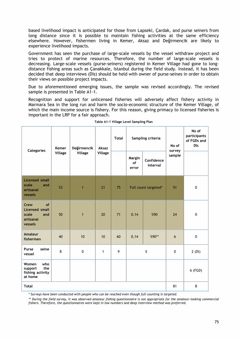
75
based livelihood impact is anticipated for those from Lapseki, Çardak, and purse seiners from long distance since it is possible to maintain fishing activities at the same efficiency elsewhere. However, fishermen living in Kemer, Aksaz and Değirmencik are likely to experience livelihood impacts.
Government has seen the purchase of large-scale vessels by the vessel withdraw project and tries to protect of marine resources. Therefore, the number of large-scale vessels is decreasing. Large-scale vessels (purse-seiners) registered in Kemer Village had gone to long-distance fishing areas such as Çanakkale, Istanbul during the field study. Instead, it has been decided that deep interviews (DIs) should be held with owner of purse-seines in order to obtain their views on possible project impacts.
Due to aforementioned emerging issues, the sample was revised accordingly. The revised sample is presented in Table A1-1.
Recognition and support for unlicensed fisheries will adversely affect fishery activity in Marmara Sea in the long run and harm the socio-economic structure of the Kemer Village, of which the main income source is fishery. For this reason, giving primacy to licensed fisheries is important in the LRP for a fair approach.
Table A1-1 Village Level Sampling Plan
Categories Kemer
Village
Değirmencik
Village
Aksaz
Village
Total Sampling criteria
No of
survey
sample
No of
participants
of FGDs and
DIs
Margin
of
error
Confidence
interval
Licensed small
scale and
artisanal
vessels
53 1 21 75 Full count targeted* 51 0
Crew of
Licensed small
scale and
artisanal
vessels
50 1 20 71 0,14 %90 24 0
Amateur
fishermen 40 10 10 60 0,14 %90** 6 0
Purse seine
vessel 8 0 1 9 X 0 2 (DI)
Women who support the fishing activity at home
6 (FGD)
Total 81 8
* Surveys have been conducted with people who can be reached even though full counting is targeted.
** During the field survey, it was observed amateur fishing questionnaire is not appropriate for the amateur-looking commercial fishers. Therefore, the questionnaires were kept in low numbers and deep interview method was preferred.
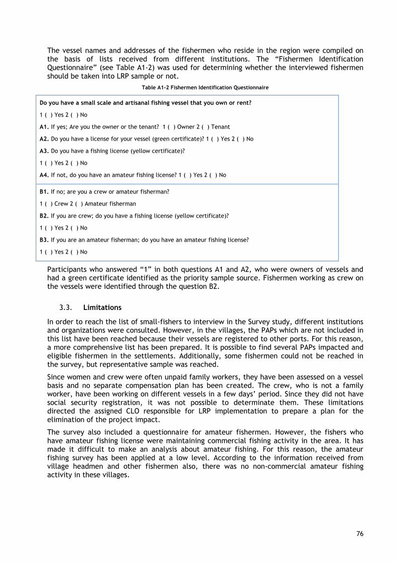
76
The vessel names and addresses of the fishermen who reside in the region were compiled on the basis of lists received from different institutions. The “Fishermen Identification Questionnaire” (see Table A1-2) was used for determining whether the interviewed fishermen should be taken into LRP sample or not.
Table A1-2 Fishermen Identification Questionnaire
Do you have a small scale and artisanal fishing vessel that you own or rent?
1 ( ) Yes 2 ( ) No
A1. If yes; Are you the owner or the tenant? 1 ( ) Owner 2 ( ) Tenant
A2. Do you have a license for your vessel (green certificate)? 1 ( ) Yes 2 ( ) No
A3. Do you have a fishing license (yellow certificate)?
1 ( ) Yes 2 ( ) No
A4. If not, do you have an amateur fishing license? 1 ( ) Yes 2 ( ) No
B1. If no; are you a crew or amateur fisherman?
1 ( ) Crew 2 ( ) Amateur fisherman
B2. If you are crew; do you have a fishing license (yellow certificate)?
1 ( ) Yes 2 ( ) No
B3. If you are an amateur fisherman; do you have an amateur fishing license?
1 ( ) Yes 2 ( ) No
Participants who answered “1” in both questions A1 and A2, who were owners of vessels and had a green certificate identified as the priority sample source. Fishermen working as crew on the vessels were identified through the question B2.
3.3. Limitations
In order to reach the list of small-fishers to interview in the Survey study, different institutions and organizations were consulted. However, in the villages, the PAPs which are not included in this list have been reached because their vessels are registered to other ports. For this reason, a more comprehensive list has been prepared. It is possible to find several PAPs impacted and eligible fishermen in the settlements. Additionally, some fishermen could not be reached in the survey, but representative sample was reached.
Since women and crew were often unpaid family workers, they have been assessed on a vessel basis and no separate compensation plan has been created. The crew, who is not a family worker, have been working on different vessels in a few days’ period. Since they did not have social security registration, it was not possible to determinate them. These limitations directed the assigned CLO responsible for LRP implementation to prepare a plan for the elimination of the project impact.
The survey also included a questionnaire for amateur fishermen. However, the fishers who have amateur fishing license were maintaining commercial fishing activity in the area. It has made it difficult to make an analysis about amateur fishing. For this reason, the amateur fishing survey has been applied at a low level. According to the information received from village headmen and other fishermen also, there was no non-commercial amateur fishing activity in these villages.
77
3.4. Data collection tools
After determination of the sample, the following data was retrieved through structured questionnaires (See Appendix 3-B Survey Questionnaire):
● Demographic information of the vessel owner and the crew’s households ● Socio-economic profile of the household ● Details of the fishing activity ● Vessel and license information ● Fishing income and its contribution to household income ● Operational fishing costs ● Location of the fishing activity on the coasts ● Incentives and credits ● Relations with fisheries profession ● Agricultural activity status
In addition to the data obtained in Kemer, Değirmencik and Aksaz villages, interviews with stakeholders, organizations and authorities were used as important data collection sources. A semi-structured questionnaire on fishing activities was conducted with the authorities of the fishery cooperatives in the region (see Appendix 3-A Cooperative Questionnaire);
● Kemer Fishery Cooperative ● Karabiga Fishery Cooperative ● Lapseki Fishery Cooperative ● Çardak Fishery Cooperative
DIs and FGDs were also held with the authorities of institutions and organizations. At this unstructured consultations and meetings, information was obtained on; the role of the institution about the project, possible impacts on the fishery economy and household income, the suggestions on sampling (numbers and information about purse seiners, small scale fishermen, etc.).
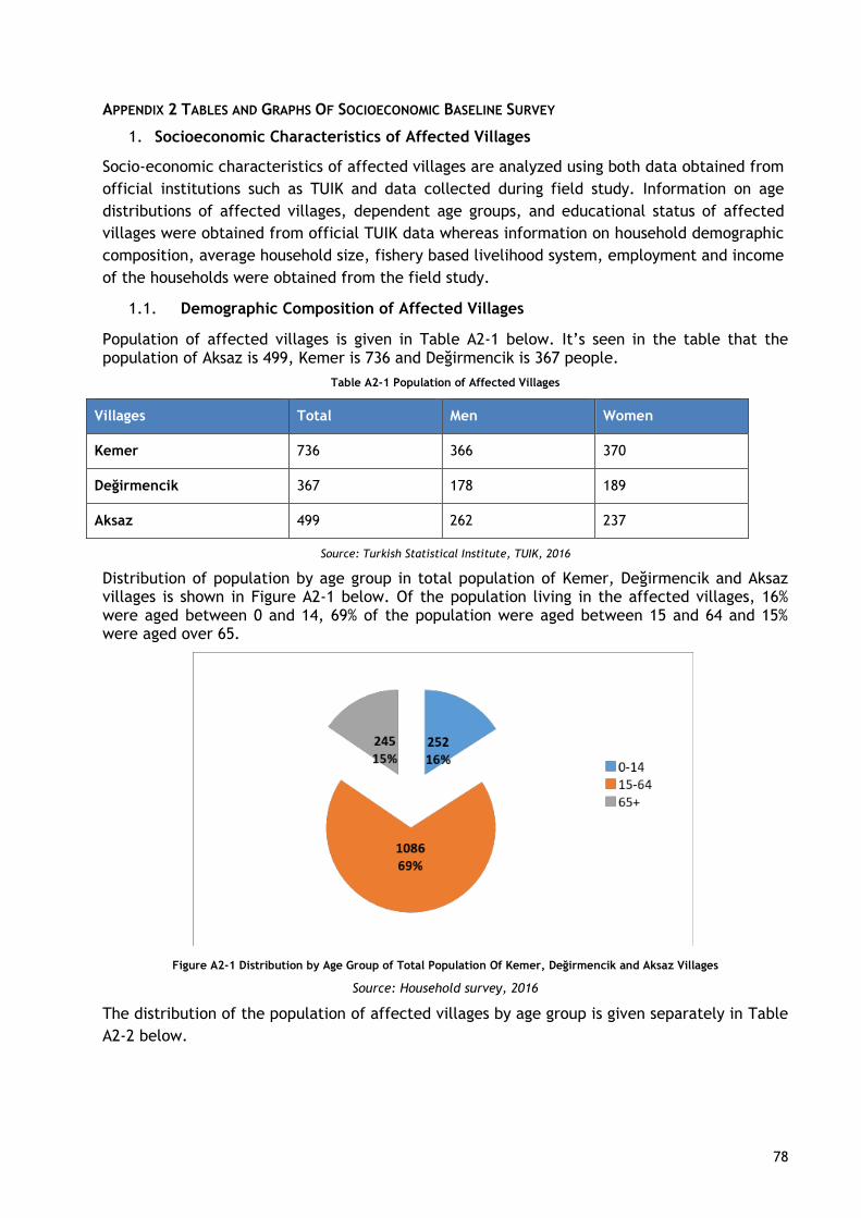
78
APPENDIX 2 TABLES AND GRAPHS OF SOCIOECONOMIC BASELINE SURVEY
1. Socioeconomic Characteristics of Affected Villages
Socio-economic characteristics of affected villages are analyzed using both data obtained from
official institutions such as TUIK and data collected during field study. Information on age
distributions of affected villages, dependent age groups, and educational status of affected
villages were obtained from official TUIK data whereas information on household demographic
composition, average household size, fishery based livelihood system, employment and income
of the households were obtained from the field study.
1.1. Demographic Composition of Affected Villages
Population of affected villages is given in Table A2-1 below. It’s seen in the table that the population of Aksaz is 499, Kemer is 736 and Değirmencik is 367 people.
Table A2-1 Population of Affected Villages
Villages Total Men Women
Kemer 736 366 370
Değirmencik 367 178 189
Aksaz 499 262 237
Source: Turkish Statistical Institute, TUIK, 2016
Distribution of population by age group in total population of Kemer, Değirmencik and Aksaz villages is shown in Figure A2-1 below. Of the population living in the affected villages, 16% were aged between 0 and 14, 69% of the population were aged between 15 and 64 and 15% were aged over 65.
Figure A2-1 Distribution by Age Group of Total Population Of Kemer, Değirmencik and Aksaz Villages
Source: Household survey, 2016
The distribution of the population of affected villages by age group is given separately in Table
A2-2 below.
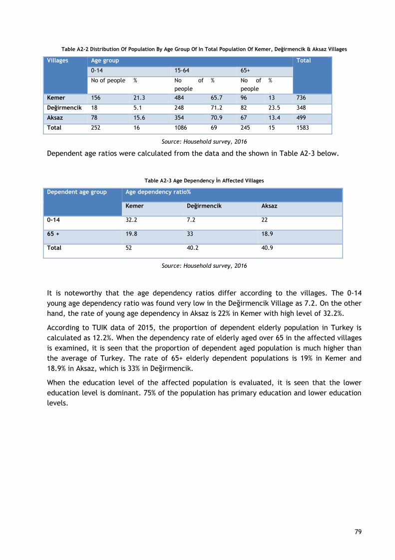
79
Table A2-2 Distribution Of Population By Age Group Of In Total Population Of Kemer, Değirmencik & Aksaz Villages
Villages Age group Total
0-14 15-64 65+
No of people % No of
people
% No of
people
%
Kemer 156 21.3 484 65.7 96 13 736
Değirmencik 18 5.1 248 71.2 82 23.5 348
Aksaz 78 15.6 354 70.9 67 13.4 499
Total 252 16 1086 69 245 15 1583
Source: Household survey, 2016
Dependent age ratios were calculated from the data and the shown in Table A2-3 below.
Table A2-3 Age Dependency İn Affected Villages
Dependent age group Age dependency ratio%
Kemer Değirmencik Aksaz
0-14 32.2 7.2 22
65 + 19.8 33 18.9
Total 52 40.2 40.9
Source: Household survey, 2016
It is noteworthy that the age dependency ratios differ according to the villages. The 0-14
young age dependency ratio was found very low in the Değirmencik Village as 7.2. On the other
hand, the rate of young age dependency in Aksaz is 22% in Kemer with high level of 32.2%.
According to TUIK data of 2015, the proportion of dependent elderly population in Turkey is
calculated as 12.2%. When the dependency rate of elderly aged over 65 in the affected villages
is examined, it is seen that the proportion of dependent aged population is much higher than
the average of Turkey. The rate of 65+ elderly dependent populations is 19% in Kemer and
18.9% in Aksaz, which is 33% in Değirmencik.
When the education level of the affected population is evaluated, it is seen that the lower
education level is dominant. 75% of the population has primary education and lower education
levels.
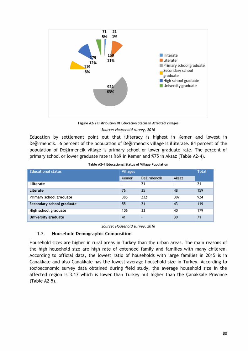
80
Figure A2-2 Distribution Of Education Status In Affected Villages
Source: Household survey, 2016
Education by settlement point out that illiteracy is highest in Kemer and lowest in
Değirmencik. 6 percent of the population of Değirmencik village is illiterate. 84 percent of the
population of Değirmencik village is primary school or lower graduate rate. The percent of
primary school or lower graduate rate is %69 in Kemer and %75 in Aksaz (Table A2-4).
Table A2-4 Educational Status of Village Population
Educational status Villages Total
Kemer Değirmencik Aksaz
Illiterate - 21 - 21
Literate 76 35 48 159
Primary school graduate 385 232 307 924
Secondary school graduate 55 21 43 119
High school graduate 106 33 40 179
University graduate 41 - 30 71
Source: Household survey, 2016
1.2. Household Demographic Composition
Household sizes are higher in rural areas in Turkey than the urban areas. The main reasons of
the high household size are high rate of extended family and families with many children.
According to official data, the lowest ratio of households with large families in 2015 is in
Çanakkale and also Çanakkale has the lowest average household size in Turkey. According to
socioeconomic survey data obtained during field study, the average household size in the
affected region is 3.17 which is lower than Turkey but higher than the Çanakkale Province
(Table A2-5).
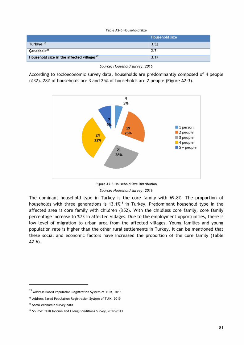
81
Table A2-5 Household Size
Household size
Türkiye 15 3.52
Çanakkale16 2.7
Household size in the affected villages17 3.17
Source: Household survey, 2016
According to socioeconomic survey data, households are predominantly composed of 4 people
(%32). 28% of households are 3 and 25% of households are 2 people (Figure A2-3).
Figure A2-3 Household Size Distribution
Source: Household survey, 2016
The dominant household type in Turkey is the core family with 69.8%. The proportion of
households with three generations is 13.1%18 in Turkey. Predominant household type in the
affected area is core family with children (%52). With the childless core family, core family
percentage increase to %73 in affected villages. Due to the employment opportunities, there is
low level of migration to urban area from the affected villages. Young families and young
population rate is higher than the other rural settlements in Turkey. It can be mentioned that
these social and economic factors have increased the proportion of the core family (Table
A2-6).
15 Address Based Population Registration System of TUIK, 2015
16 Address Based Population Registration System of TUIK, 2015
17 Socio-economic survey data
18 Source: TUIK Income and Living Conditions Survey, 2012-2013

82
Table A2-6 Household Type
Household types Frequency Percent
Extended family 15 20
Core family with children 39 52
Core family without children 16 21
Living alone 4 5
Non-family household 1 1
Total 75 100
Source: Household survey, 2016
1.3. Economic Profile
Female labor force participation rate is very low in the affected villages with the %15. Labor
force participation rate for male is %94. It’s seen that total labor force participation rate is
%59 in the affected region which is higher than the labor force participation rate in Turkey
(52.6%)19. But also labor force participation rate for female is 33.1% in Turkey and affected
vilages rate is half of the Turkey rate.
In the region women who married and not in labor force are categorized as housewives.
Women are carrying out domestic works. Women also work as unpaid family worker if
households are engaged in fishery, agriculture or husbandry (Figure A2-4).
Figure A2-4 Labor Force Participation Rate By Gender
Source: Household survey, 2016
“Table A2-7” illustrates not only fishermen but also all household members in the fishery
households. For all member’s income sources are characterized as main income source,
secondary income source and seasonal income source according to distribution rate of within
all income. According to survey, %59 of the household members is income earner. %41 of the
19
http://www.turkstat.gov.tr/HbGetirHTML.do?id=21579
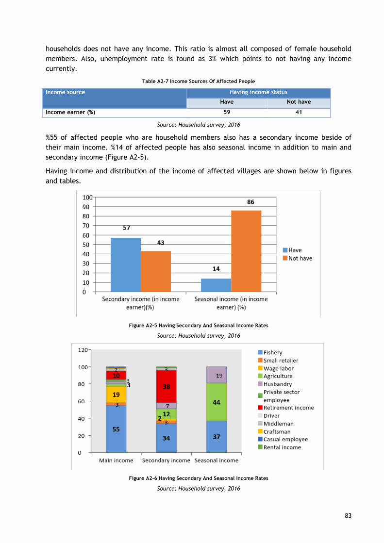
83
households does not have any income. This ratio is almost all composed of female household
members. Also, unemployment rate is found as 3% which points to not having any income
currently.
Table A2-7 Income Sources Of Affected People
Income source Having income status
Have Not have
Income earner (%) 59 41
Source: Household survey, 2016
%55 of affected people who are household members also has a secondary income beside of
their main income. %14 of affected people has also seasonal income in addition to main and
secondary income (Figure A2-5).
Having income and distribution of the income of affected villages are shown below in figures
and tables.
Figure A2-5 Having Secondary And Seasonal Income Rates
Source: Household survey, 2016
Figure A2-6 Having Secondary And Seasonal Income Rates
Source: Household survey, 2016
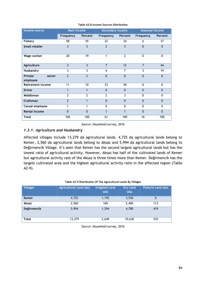
84
Table A2-8 Income Sources Distribution
Income source Main income Secondary income Seasonal income
Frequency Percent Frequency Percent Frequency Percent
Fishery 58 55 22 34 6 37
Small retailer 3 3 2 3 0 0
Wage worker 20 19 1 2 0 0
Agriculture 3 3 7 12 7 44
Husbandry 3 3 4 7 3 19
Private sector
employee
2 2 0 0 0 0
Retirement income 11 10 23 38 0 0
Driver 1 1 0 0 0 0
Middleman 2 2 2 3 0 0
Craftsman 2 1 0 0 0 0
Casual employee 1 1 0 0 0 0
Rental income 0 0 1 1 0 0
Total 106 100 61 100 16 100
Source: Household survey, 2016
1.3.1. Agriculture and Husbandry
Affected villages include 13,279 da agricultural lands. 4,725 da agricultural lands belong to
Kemer, 2,560 da agricultural lands belong to Aksaz and 5,994 da agricultural lands belong to
Değirmencik Village. It’s seen that Kemer has the second largest agricultural lands but has the
lowest ratio of agricultural activity. However, Aksaz has half of the cultivated lands of Kemer
but agricultural activity rate of the Aksaz is three times more than Kemer. Değirmencik has the
largest cultivated area and the highest agricultural activity ratio in the affected region (Table
A2-9).
Table A2-9 Distribution Of The Agricultural Lands By Villages
Villages Agricultural Land (da) Irrigated Land
(da)
Dry Land
(da)
Pasture Land (da)
Kemer 4,725 1,195 3,530 0
Aksaz 2,560 160 2,400 113
Değirmencik 5,994 1,294 4,700 419
Total 13,279 2,649 10,630 532
Source: Household survey, 2016
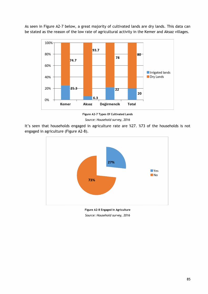
85
As seen in Figure A2-7 below, a great majority of cultivated lands are dry lands. This data can
be stated as the reason of the low rate of agricultural activity in the Kemer and Aksaz villages.
Figure A2-7 Types Of Cultivated Lands
Source: Household survey, 2016
It’s seen that households engaged in agriculture rate are %27. %73 of the households is not
engaged in agriculture (Figure A2-8).
Figure A2-8 Engaged In Agriculture
Source: Household survey, 2016
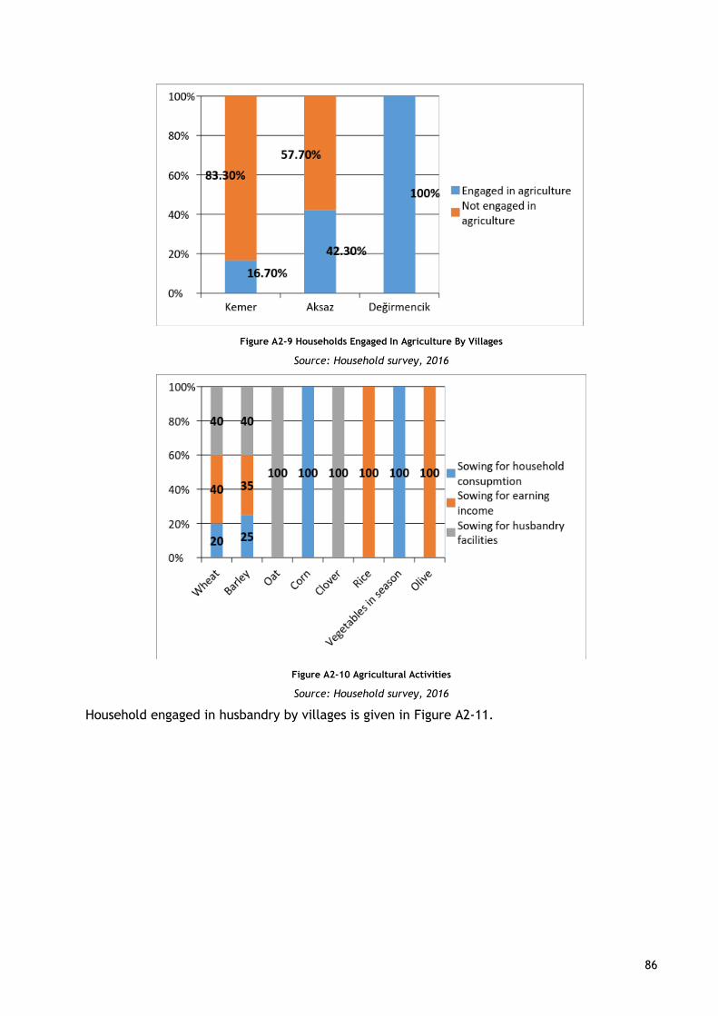
86
Figure A2-9 Households Engaged In Agriculture By Villages
Source: Household survey, 2016
Figure A2-10 Agricultural Activities
Source: Household survey, 2016
Household engaged in husbandry by villages is given in Figure A2-11.
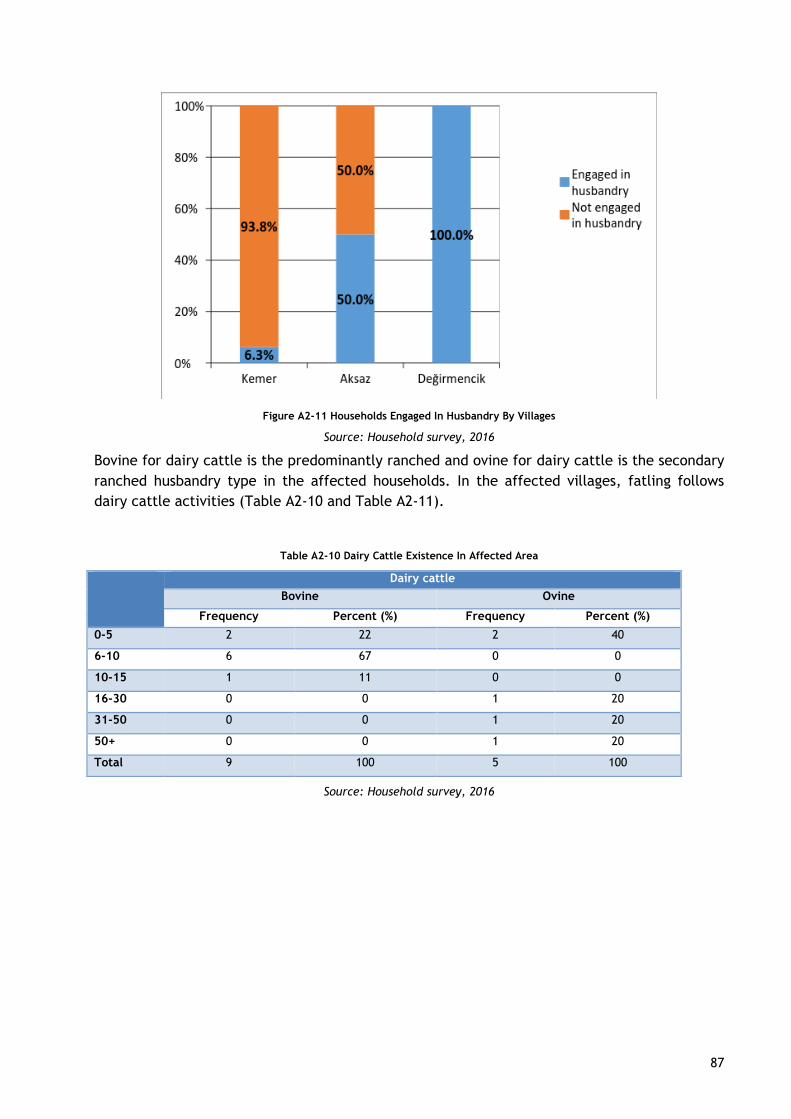
87
Figure A2-11 Households Engaged In Husbandry By Villages
Source: Household survey, 2016
Bovine for dairy cattle is the predominantly ranched and ovine for dairy cattle is the secondary
ranched husbandry type in the affected households. In the affected villages, fatling follows
dairy cattle activities (Table A2-10 and Table A2-11).
Table A2-10 Dairy Cattle Existence In Affected Area
Dairy cattle
Bovine Ovine
Frequency Percent (%) Frequency Percent (%)
0-5 2 22 2 40
6-10 6 67 0 0
10-15 1 11 0 0
16-30 0 0 1 20
31-50 0 0 1 20
50+ 0 0 1 20
Total 9 100 5 100
Source: Household survey, 2016
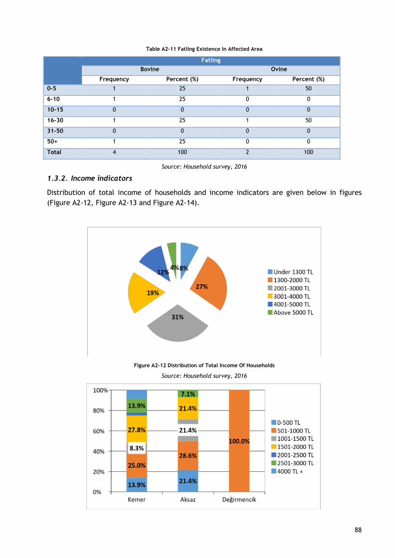
88
Table A2-11 Fatling Existence In Affected Area
Fatling
Bovine Ovine
Frequency Percent (%) Frequency Percent (%)
0-5 1 25 1 50
6-10 1 25 0 0
10-15 0 0 0 0
16-30 1 25 1 50
31-50 0 0 0 0
50+ 1 25 0 0
Total 4 100 2 100
Source: Household survey, 2016
1.3.2. Income indicators
Distribution of total income of households and income indicators are given below in figures
(Figure A2-12, Figure A2-13 and Figure A2-14).
Figure A2-12 Distribution of Total Income Of Households
Source: Household survey, 2016

89
Figure A2-13 Fishery Income Distribution Of Vessel Owner By Villages
Source: Household survey, 2016
Figure A2-14 Fishery Income Distribution Of Crews By Villages
Source: Household survey, 2016
Table A2-12 Average Of Fishery Income Distribution By Type Of Fishery
Vessel Owner Crews
Frequencies 51 24
Mean 1,679.80 1,162
Source: Household survey, 2016
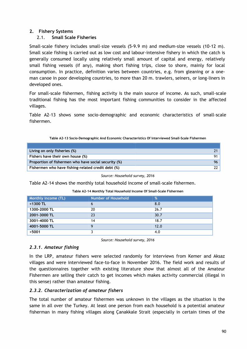
90
2. Fishery Systems
2.1. Small Scale Fisheries
Small-scale fishery includes small-size vessels (5-9.9 m) and medium-size vessels (10-12 m).
Small scale fishing is carried out as low cost and labour-intensive fishery in which the catch is
generally consumed locally using relatively small amount of capital and energy, relatively
small fishing vessels (if any), making short fishing trips, close to shore, mainly for local
consumption. In practice, definition varies between countries, e.g. from gleaning or a one-
man canoe in poor developing countries, to more than 20 m. trawlers, seiners, or long-liners in
developed ones.
For small-scale fishermen, fishing activity is the main source of income. As such, small-scale
traditional fishing has the most important fishing communities to consider in the affected
villages.
Table A2-13 shows some socio-demographic and economic characteristics of small-scale
fishermen.
Table A2-13 Socio-Demographic And Economic Characteristics Of Interviewed Small-Scale Fishermen
Living on only fisheries (%) 21
Fishers have their own house (%) 91
Proportion of fishermen who have social security (%) 96
Fishermen who have fishing-related credit debt (%) 22
Source: Household survey, 2016
Table A2-14 shows the monthly total household income of small-scale fishermen.
Table A2-14 Monthly Total Household Income Of Small-Scale Fishermen
Monthly income (TL) Number of Household %
<1300 TL 6 8.0
1300-2000 TL 20 26.7
2001-3000 TL 23 30.7
3001-4000 TL 14 18.7
4001-5000 TL 9 12.0
>5001 3 4.0
Source: Household survey, 2016
2.3.1. Amateur fishing
In the LRP, amateur fishers were selected randomly for interviews from Kemer and Aksaz
villages and were interviewed face-to-face in November 2016. The field work and results of
the questionnaires together with existing literature show that almost all of the Amateur
Fishermen are selling their catch to get incomes which makes activity commercial (illegal in
this sense) rather than amateur fishing.
2.3.2. Characterization of amateur fishers
The total number of amateur fishermen was unknown in the villages as the situation is the
same in all over the Turkey. At least one person from each household is a potential amateur
fisherman in many fishing villages along Çanakkale Strait (especially in certain times of the

91
year).
Some of the vessel-based fishers indicated that they had been inspected by the authority at
least once in a year. Some other vessel-based fishers had never been controlled during the
year. Furthermore, none of the shore based amateur fishermen have ever been inspected by
the authority. This means that amateur fishers are not controlled and inspected properly in
the project area and they perform fishing commercially rather than an amateur activity.
2.2. Fishing Based Livelihoods
Fisheries in the project area may be the most affected sector due to the construction of the
pipeline into their fishing ground. Some of the fishers’ livelihood may be directly or indirectly
affected from the project. Therefore, fishing based livelihood, fishing income, and relevant
socio-economic features of the fishers as well as the structure of the fisheries have been
identified. Since the overall impact of the project on the fisheries value chain is considered to
be negligible, this LRP only focuses on small-scale fishing.
Table A2-15 Main Source Of Income Of Interviewed Fishermen
Number %
Fishery 50 66.7
Small trader income (1-4 personnel) 1 1.3
Factory worker- labor income 12 16.0
Agriculture-farming income 3 4.0
Husbandary income 3 4.0
Private sector desk-top employee income 1 1.3
Retirement income 4 5.3
Middlemen income 1 1.3
Total 75 100.0
Source: Household survey, 2016
Small scale fishery is carried out as a family business in the villages. Presence of family
workers as crew on the vessels presented in Figure A2-15 below,
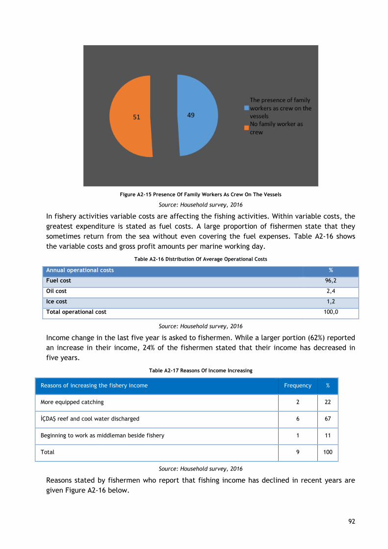
92
Figure A2-15 Presence Of Family Workers As Crew On The Vessels
Source: Household survey, 2016
In fishery activities variable costs are affecting the fishing activities. Within variable costs, the
greatest expenditure is stated as fuel costs. A large proportion of fishermen state that they
sometimes return from the sea without even covering the fuel expenses. Table A2-16 shows
the variable costs and gross profit amounts per marine working day.
Table A2-16 Distribution Of Average Operational Costs
Annual operational costs %
Fuel cost 96,2
Oil cost 2,4
Ice cost 1,2
Total operational cost 100,0
Source: Household survey, 2016
Income change in the last five year is asked to fishermen. While a larger portion (62%) reported
an increase in their income, 24% of the fishermen stated that their income has decreased in
five years.
Table A2-17 Reasons Of Income Increasing
Reasons of increasing the fishery income Frequency %
More equipped catching 2 22
İÇDAŞ reef and cool water discharged 6 67
Beginning to work as middleman beside fishery 1 11
Total 9 100
Source: Household survey, 2016
Reasons stated by fishermen who report that fishing income has declined in recent years are
given Figure A2-16 below.
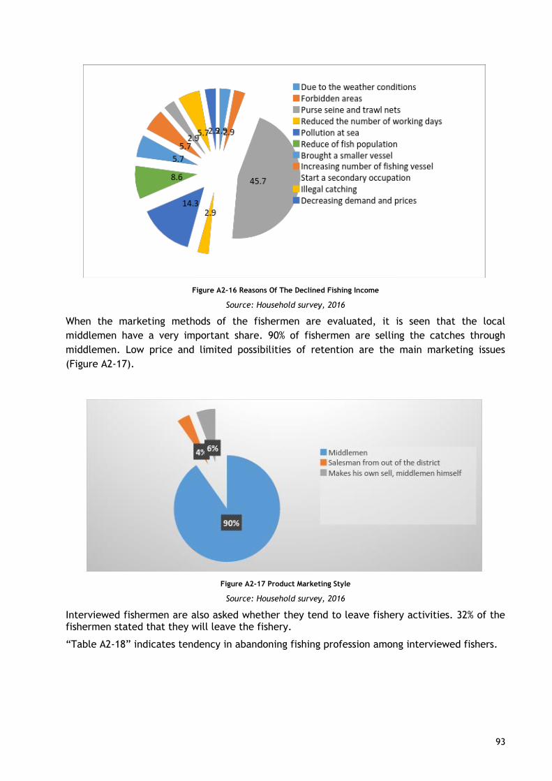
93
Figure A2-16 Reasons Of The Declined Fishing Income
Source: Household survey, 2016
When the marketing methods of the fishermen are evaluated, it is seen that the local
middlemen have a very important share. 90% of fishermen are selling the catches through
middlemen. Low price and limited possibilities of retention are the main marketing issues
(Figure A2-17).
Figure A2-17 Product Marketing Style
Source: Household survey, 2016
Interviewed fishermen are also asked whether they tend to leave fishery activities. 32% of the fishermen stated that they will leave the fishery.
“Table A2-18” indicates tendency in abandoning fishing profession among interviewed fishers.
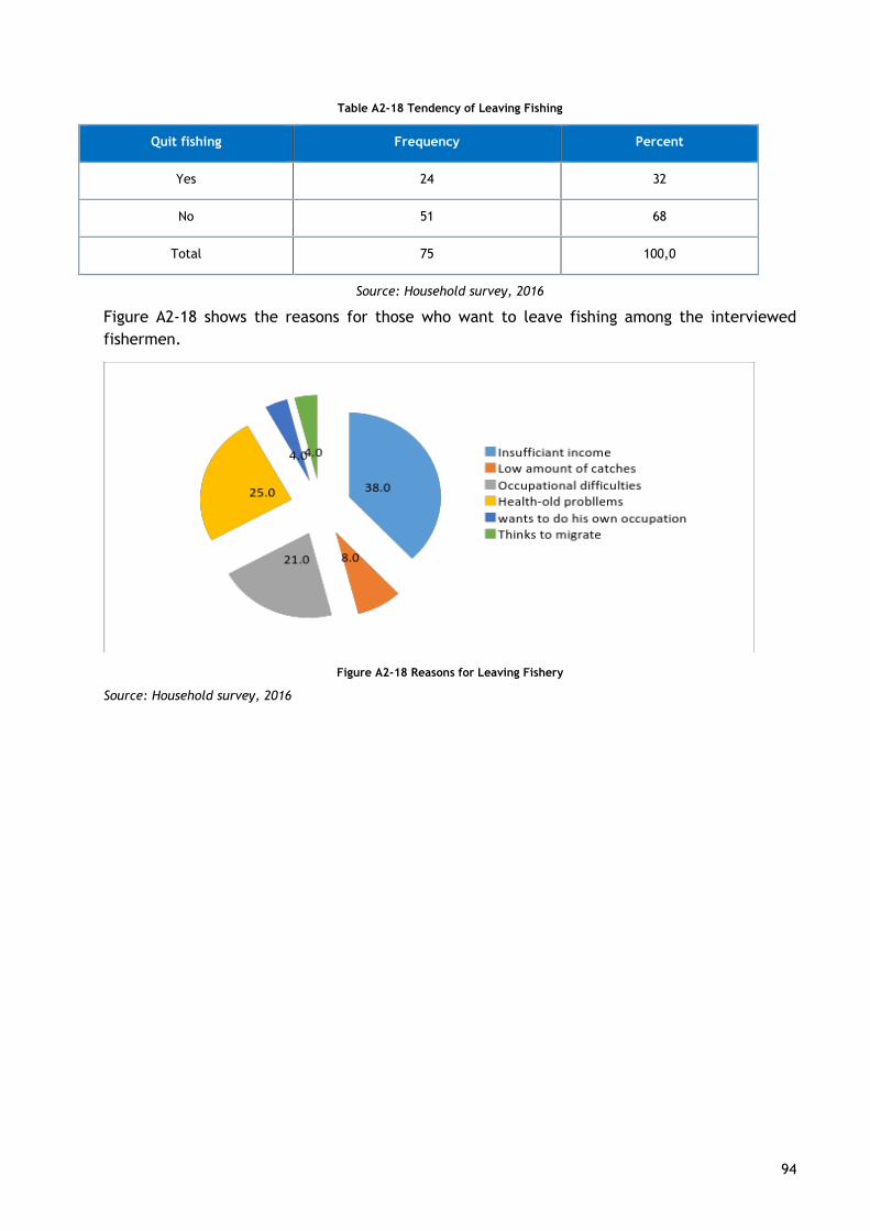
94
Table A2-18 Tendency of Leaving Fishing
Quit fishing Frequency Percent
Yes 24 32
No 51 68
Total 75 100,0
Source: Household survey, 2016
Figure A2-18 shows the reasons for those who want to leave fishing among the interviewed
fishermen.
Figure A2-18 Reasons for Leaving Fishery
Source: Household survey, 2016
95
APPENDIX 3 SURVEY QUESTIONNAIRES
A. Cooperative Questionnaire
1. Cooperative name
2. Foundation year
3. What are the facilities / services provided for fishermen since its establishment?
4. The possibilities of the cooperative
- Equipment:
- Structure, material:
- Human source:
Number of salaried employees in the cooperative:________
Tasks:______________________________________________________________
- Financial situation:
- Technical equipment:
5. How has the number of members of the cooperative changed in the last 3 years?
What is the reason if it declined?
_____________________________________________________________________
What is the rate of fisheries abandonment in the last 3 years?
_____________________________________________________________________
What is the turnover rate for amateur fisheries?
_____________________________________________________________________
What kind of livelihood has the fishermen turned towards?
_____________________________________________________________________
Did the abandonment of the fishery cause a migration from the village?
_____________________________________________________________________
Educational status of Head? • Pre • Mid • High • College • University
6. Was the co-operative established with external assistance or with the fishermen's
own will?
7. Ownership number of boats
8. Number of active partners (only active boats and boats, more than 100 days a year)
Summer: _____________ Winter:___________
9. Number of active partners (active working boat owner + number of member crew)
10. Only the number of members living on fisheries
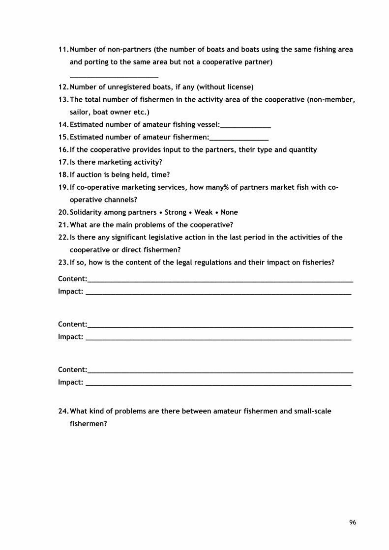
96
11. Number of non-partners (the number of boats and boats using the same fishing area
and porting to the same area but not a cooperative partner)
_____________________
12. Number of unregistered boats, if any (without license)
13. The total number of fishermen in the activity area of the cooperative (non-member,
sailor, boat owner etc.)
14. Estimated number of amateur fishing vessel:____________
15. Estimated number of amateur fishermen:______________
16. If the cooperative provides input to the partners, their type and quantity
17. Is there marketing activity?
18. If auction is being held, time?
19. If co-operative marketing services, how many% of partners market fish with co-
operative channels?
20. Solidarity among partners • Strong • Weak • None
21. What are the main problems of the cooperative?
22. Is there any significant legislative action in the last period in the activities of the
cooperative or direct fishermen?
23. If so, how is the content of the legal regulations and their impact on fisheries?
Content:_______________________________________________________________
Impact: _______________________________________________________________
Content:_______________________________________________________________
Impact: _______________________________________________________________
Content:_______________________________________________________________
Impact: _______________________________________________________________
24. What kind of problems are there between amateur fishermen and small-scale
fishermen?
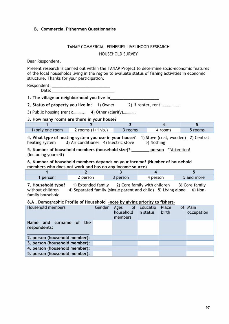
97
B. Commercial Fishermen Questionnaire
TANAP COMMERCIAL FISHERIES LIVELIHOOD RESEARCH
HOUSEHOLD SURVEY
Dear Respondent,
Present research is carried out within the TANAP Project to determine socio-economic features of the local households living in the region to evaluate status of fishing activities in economic structure. Thanks for your participation.
Respondent: __________________________ Date:____________________________
1. The village or neighborhood you live in______________________
2. Status of property you live in: 1) Owner 2) If renter, rent:……….……
3) Public housing (rent):……….. 4) Other (clarify)…………
3. How many rooms are there in your house?
1 2 3 4 5
1/only one room 2 rooms (1+1 vb.) 3 rooms 4 rooms 5 rooms
4. What type of heating system you use in your house? 1) Stove (coal, wooden) 2) Central heating system 3) Air conditioner 4) Electric stove 5) Nothing
5. Number of household members (household size)? ________ person **Attention! (Including yourself)
6. Number of household members depends on your income? (Number of household members who does not work and has no any income source)
1 2 3 4 5
1 person 2 person 3 person 4 person 5 and more
7. Household type? 1) Extended family 2) Core family with children 3) Core family without children 4) Separated family (single parent and child) 5) Living alone 6) Non-family household
8.A . Demographic Profile of Household -note by giving priority to fishers-
Household members Gender Ages of household members
Education status
Place of birth
Main occupation
Name and surname of the respondents: _________________________
2. person (household member):
3. person (household member):
4. person (household member):
5. person (household member):
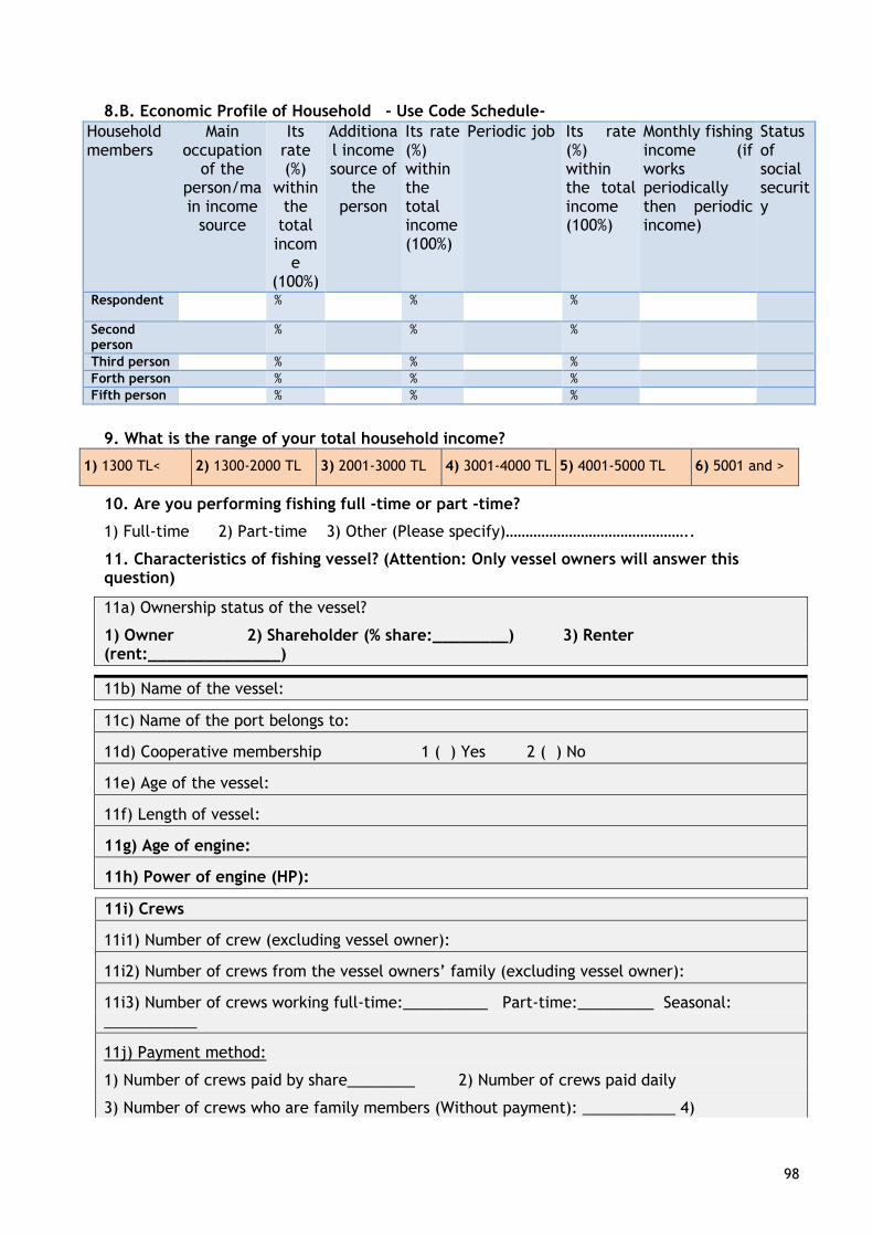
98
8.B. Economic Profile of Household - Use Code Schedule-
Household members
Main occupation
of the person/main income
source
Its rate (%)
within the
total incom
e (100%)
Additional income source of
the person
Its rate (%) within the total income (100%)
Periodic job Its rate (%) within the total income (100%)
Monthly fishing income (if works periodically then periodic income)
Status of social security
Respondent % % %
Second person
% % %
Third person % % %
Forth person % % %
Fifth person % % %
9. What is the range of your total household income?
1) 1300 TL< 2) 1300-2000 TL 3) 2001-3000 TL 4) 3001-4000 TL 5) 4001-5000 TL 6) 5001 and >
10. Are you performing fishing full -time or part -time?
1) Full-time 2) Part-time 3) Other (Please specify)………………………………………..
11. Characteristics of fishing vessel? (Attention: Only vessel owners will answer this question)
11a) Ownership status of the vessel?
1) Owner 2) Shareholder (% share:________) 3) Renter (rent:______________)
11b) Name of the vessel:
11c) Name of the port belongs to:
11d) Cooperative membership 1 ( ) Yes 2 ( ) No
11e) Age of the vessel:
11f) Length of vessel:
11g) Age of engine:
11h) Power of engine (HP):
11i) Crews
11i1) Number of crew (excluding vessel owner):
11i2) Number of crews from the vessel owners’ family (excluding vessel owner):
11i3) Number of crews working full-time:__________ Part-time:_________ Seasonal: ___________
11j) Payment method:
1) Number of crews paid by share________ 2) Number of crews paid daily
3) Number of crews who are family members (Without payment): ___________ 4)
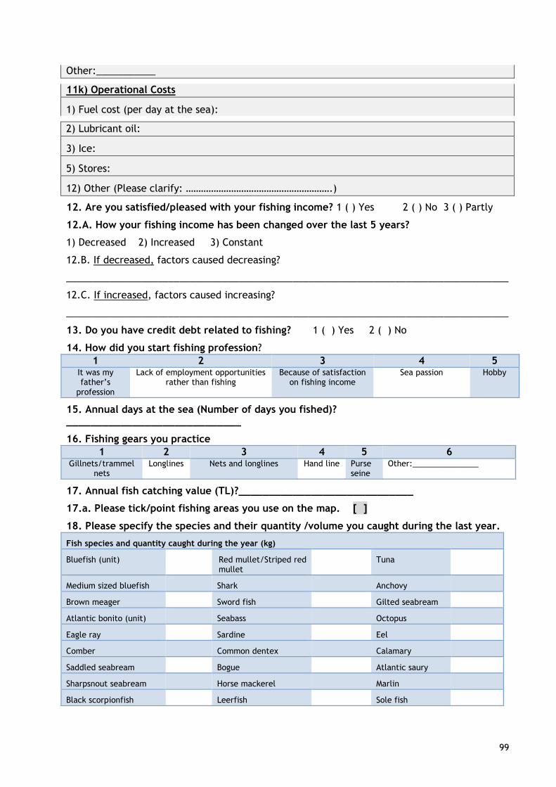
99
Other:___________
11k) Operational Costs
1) Fuel cost (per day at the sea):
2) Lubricant oil:
3) Ice:
5) Stores:
12) Other (Please clarify: ………………………………………………….)
12. Are you satisfied/pleased with your fishing income? 1 ( ) Yes 2 ( ) No 3 ( ) Partly
12.A. How your fishing income has been changed over the last 5 years?
1) Decreased 2) Increased 3) Constant
12.B. If decreased, factors caused decreasing?
__________________________________________________________________________________
12.C. If increased, factors caused increasing?
__________________________________________________________________________________
13. Do you have credit debt related to fishing? 1 ( ) Yes 2 ( ) No
14. How did you start fishing profession?
1 2 3 4 5 It was my father’s
profession
Lack of employment opportunities rather than fishing
Because of satisfaction on fishing income
Sea passion Hobby
15. Annual days at the sea (Number of days you fished)? _____________________________
16. Fishing gears you practice
1 2 3 4 5 6 Gillnets/trammel
nets Longlines Nets and longlines Hand line Purse
seine Other:_______________
17. Annual fish catching value (TL)?_____________________________
17.a. Please tick/point fishing areas you use on the map. [ ]
18. Please specify the species and their quantity /volume you caught during the last year.
Fish species and quantity caught during the year (kg)
Bluefish (unit) Red mullet/Striped red mullet
Tuna
Medium sized bluefish Shark Anchovy
Brown meager Sword fish Gilted seabream
Atlantic bonito (unit) Seabass Octopus
Eagle ray Sardine Eel
Comber Common dentex Calamary
Saddled seabream Bogue Atlantic saury
Sharpsnout seabream Horse mackerel Marlin
Black scorpionfish Leerfish Sole fish
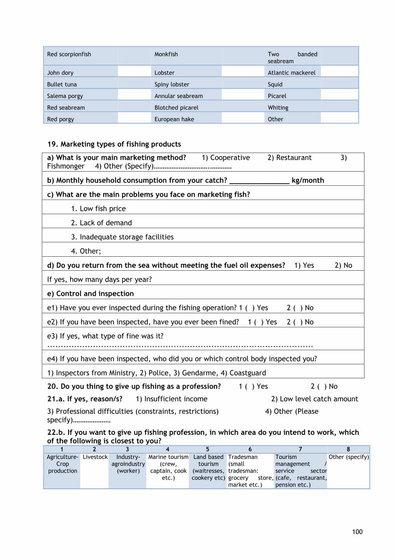
100
Red scorpionfish Monkfish Two banded seabream
John dory Lobster Atlantic mackerel
Bullet tuna Spiny lobster Squid
Salema porgy Annular seabream Picarel
Red seabream Blotched picarel Whiting
Red porgy European hake Other
19. Marketing types of fishing products
a) What is your main marketing method? 1) Cooperative 2) Restaurant 3) Fishmonger 4) Other (Specify)………………………….…………
b) Monthly household consumption from your catch? ______________ kg/month
c) What are the main problems you face on marketing fish?
1. Low fish price
2. Lack of demand
3. Inadequate storage facilities
4. Other;
d) Do you return from the sea without meeting the fuel oil expenses? 1) Yes 2) No
If yes, how many days per year?
e) Control and inspection
e1) Have you ever inspected during the fishing operation? 1 ( ) Yes 2 ( ) No
e2) If you have been inspected, have you ever been fined? 1 ( ) Yes 2 ( ) No
e3) If yes, what type of fine was it? ...................................................................................................
e4) If you have been inspected, who did you or which control body inspected you?
1) Inspectors from Ministry, 2) Police, 3) Gendarme, 4) Coastguard
20. Do you thing to give up fishing as a profession? 1 ( ) Yes 2 ( ) No
21.a. If yes, reason/s? 1) Insufficient income 2) Low level catch amount
3) Professional difficulties (constraints, restrictions) 4) Other (Please specify)…………………
22.b. If you want to give up fishing profession, in which area do you intend to work, which of the following is closest to you?
1 2 3 4 5 6 7 8
Agriculture-Crop
production
Livestock Industry-agroindustry
(worker)
Marine tourism (crew,
captain, cook etc.)
Land based tourism
(waitresses, cookery etc)
Tradesman (small tradesman: grocery store, market etc.)
Tourism management / service sector (cafe, restaurant, pension etc.)
Other (specify)
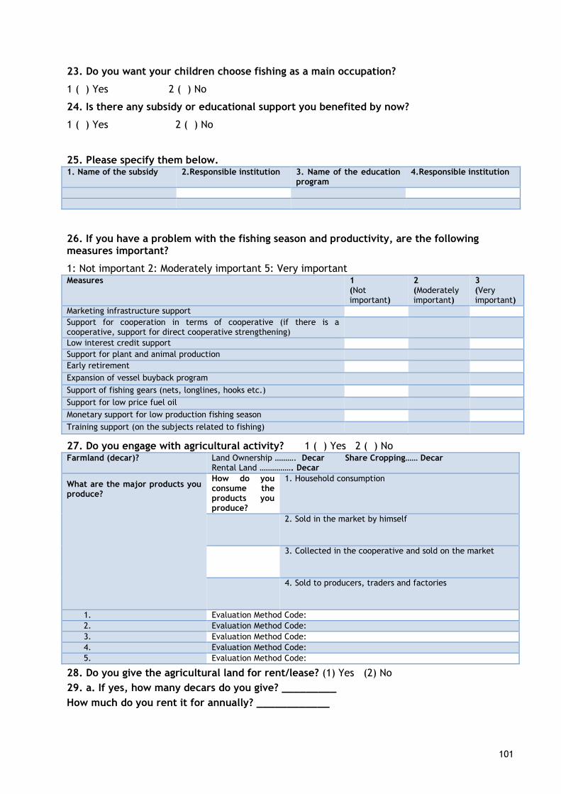
101
23. Do you want your children choose fishing as a main occupation?
1 ( ) Yes 2 ( ) No
24. Is there any subsidy or educational support you benefited by now?
1 ( ) Yes 2 ( ) No
25. Please specify them below. 1. Name of the subsidy 2.Responsible institution 3. Name of the education
program 4.Responsible institution
26. If you have a problem with the fishing season and productivity, are the following measures important?
1: Not important 2: Moderately important 5: Very important Measures 1
(Not important)
2 (Moderately important)
3 (Very important)
Marketing infrastructure support
Support for cooperation in terms of cooperative (if there is a cooperative, support for direct cooperative strengthening)
Low interest credit support
Support for plant and animal production
Early retirement
Expansion of vessel buyback program
Support of fishing gears (nets, longlines, hooks etc.)
Support for low price fuel oil
Monetary support for low production fishing season
Training support (on the subjects related to fishing)
27. Do you engage with agricultural activity? 1 ( ) Yes 2 ( ) No Farmland (decar)? Land Ownership ………. Decar Share Cropping…… Decar
Rental Land ……………. Decar
What are the major products you produce?
How do you consume the products you produce?
1. Household consumption
2. Sold in the market by himself
3. Collected in the cooperative and sold on the market
4. Sold to producers, traders and factories
1. Evaluation Method Code:
2. Evaluation Method Code:
3. Evaluation Method Code:
4. Evaluation Method Code:
5. Evaluation Method Code:
28. Do you give the agricultural land for rent/lease? (1) Yes (2) No
29. a. If yes, how many decars do you give? _________
How much do you rent it for annually? ____________
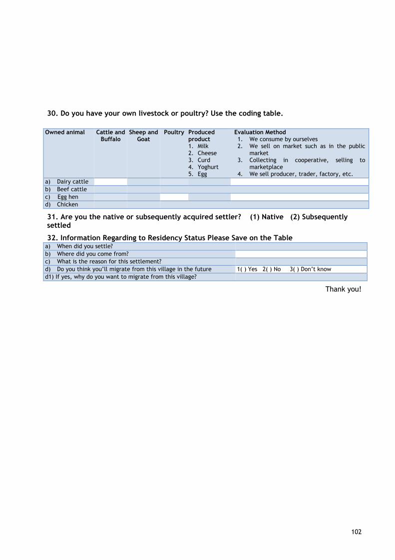
102
30. Do you have your own livestock or poultry? Use the coding table.
Owned animal Cattle and
Buffalo Sheep and
Goat Poultry Produced
product 1. Milk 2. Cheese 3. Curd 4. Yoghurt 5. Egg
Evaluation Method 1. We consume by ourselves 2. We sell on market such as in the public
market 3. Collecting in cooperative, selling to
marketplace 4. We sell producer, trader, factory, etc.
a) Dairy cattle
b) Beef cattle
c) Egg hen
d) Chicken
31. Are you the native or subsequently acquired settler? (1) Native (2) Subsequently settled
32. Information Regarding to Residency Status Please Save on the Table a) When did you settle?
b) Where did you come from?
c) What is the reason for this settlement?
d) Do you think you’ll migrate from this village in the future 1( ) Yes 2( ) No 3( ) Don’t know
d1) If yes, why do you want to migrate from this village?
Thank you!
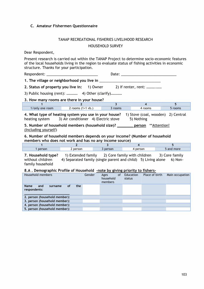
103
C. Amateur Fishermen Questionnaire
TANAP RECREATIONAL FISHERIES LIVELIHOOD RESEARCH
HOUSEHOLD SURVEY
Dear Respondent,
Present research is carried out within the TANAP Project to determine socio-economic features of the local households living in the region to evaluate status of fishing activities in economic structure. Thanks for your participation.
Respondent: __________________________ Date: ____________________________
1. The village or neighborhood you live in _______________________________
2. Status of property you live in: 1) Owner 2) If renter, rent: ……….……
3) Public housing (rent): ………… 4) Other (clarify)…………
3. How many rooms are there in your house? 1 2 3 4 5
1/only one room 2 rooms (1+1 vb.) 3 rooms 4 rooms 5 rooms
4. What type of heating system you use in your house? 1) Stove (coal, wooden) 2) Central heating system 3) Air conditioner 4) Electric stove 5) Nothing
5. Number of household members (household size)? ________ person **Attention! (Including yourself)
6. Number of household members depends on your income? (Number of household members who does not work and has no any income source)
1 2 3 4 5
1 person 2 person 3 person 4 person 5 and more
7. Household type? 1) Extended family 2) Core family with children 3) Core family without children 4) Separated family (single parent and child) 5) Living alone 6) Non-family household
8.A . Demographic Profile of Household -note by giving priority to fishers- Household members Gender Ages of
household members
Education status
Place of birth Main occupation
Name and surname of the respondents: _________________________
2. person (household member):
3. person (household member):
4. person (household member):
5. person (household member):
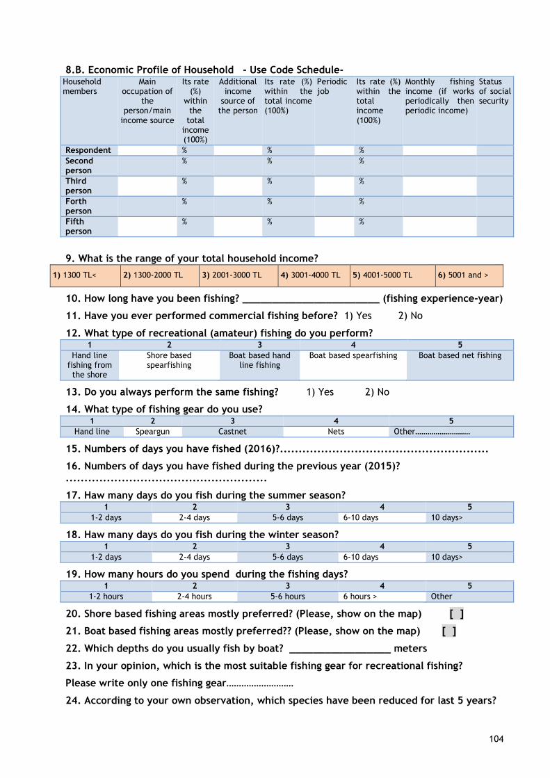
104
8.B. Economic Profile of Household - Use Code Schedule- Household members
Main occupation of
the person/main
income source
Its rate (%)
within the
total income (100%)
Additional income
source of the person
Its rate (%) within the total income (100%)
Periodic job
Its rate (%) within the total income (100%)
Monthly fishing income (if works periodically then periodic income)
Status of social security
Respondent % % %
Second person
% % %
Third person
% % %
Forth person
% % %
Fifth person
% % %
9. What is the range of your total household income?
1) 1300 TL< 2) 1300-2000 TL 3) 2001-3000 TL 4) 3001-4000 TL 5) 4001-5000 TL 6) 5001 and >
10. How long have you been fishing? _______________________ (fishing experience-year)
11. Have you ever performed commercial fishing before? 1) Yes 2) No
12. What type of recreational (amateur) fishing do you perform? 1 2 3 4 5
Hand line fishing from the shore
Shore based spearfishing
Boat based hand line fishing
Boat based spearfishing Boat based net fishing
13. Do you always perform the same fishing? 1) Yes 2) No
14. What type of fishing gear do you use? 1 2 3 4 5
Hand line Speargun Castnet Nets Other………………………
15. Numbers of days you have fished (2016)?........................................................
16. Numbers of days you have fished during the previous year (2015)? ......................................................
17. Haw many days do you fish during the summer season? 1 2 3 4 5
1-2 days 2-4 days 5-6 days 6-10 days 10 days>
18. Haw many days do you fish during the winter season? 1 2 3 4 5
1-2 days 2-4 days 5-6 days 6-10 days 10 days>
19. How many hours do you spend during the fishing days? 1 2 3 4 5
1-2 hours 2-4 hours 5-6 hours 6 hours > Other
20. Shore based fishing areas mostly preferred? (Please, show on the map) [ ]
21. Boat based fishing areas mostly preferred?? (Please, show on the map) [ ]
22. Which depths do you usually fish by boat? _________________ meters
23. In your opinion, which is the most suitable fishing gear for recreational fishing?
Please write only one fishing gear………………………
24. According to your own observation, which species have been reduced for last 5 years?

105
Reasons?
The one reduced 1. Species: ___________________ reason for reducing:
___________________________
The one reduced 2. Species: ___________________ reason for reducing:
___________________________
The one reduced 3. Species: ___________________ reason for reducing:
___________________________
25. Which species have been reduced for last 5 years? Reasons?
The one increased 1. Species:___________________ reason for increasing:
__________________________
The one increased 2. Species:___________________ reason for increasing:
__________________________
The one increased 3. Species:___________________ reason for increasing:
__________________________
26. Please specify the catch amount of species caught during the 2016.
Fish species and quantity caught during the year (kg) Species d. How do you evaluate your catch?
1.Household consumption %
3.Selling % 4.Discarding % 5. Other %
Sea bream
Sea bass
Bluefish
Common sea bream
Mugils
Leerfish
Common two banded sea bream
Barracuda
Atlantic bonito
Horse mackerel
Picarel
Sword fish
Atlantic mackerel
Mackerel
Grouper
Dusky grouper
Palamut
Sole fish
Common dentex
Tuna
Red mullet
Annular sea bream
27. Please indicates fishing areas you generally use on the map [ ]
28. Does your fishing activity contributes to family income? (1) Yes (2) No
28.a. If yes, how much does it contributes?
(1) Provide additional income (2) Food contributions (3) Both income and food contributions
106
29. Do you know legal catch size of the fishes? (1) Yes (2) No 3) Partly
30. Do you have fishing notification which regulates fishing activities? (1) Yes (2) No
31. Have you ever controlled by inspectors during the fishing opration? (1) Yes (2) No
32.a If you were controlled, who did you controlled you?..............................................................
33. Are you member of any recreational fishing club or associations? (1) Yes (2) No
34. Please especify below if you face difficulties and problems with small scale fishers. ___________________________________________________________________
1. ___________________________________________________________________ 2. ___________________________________________________________________
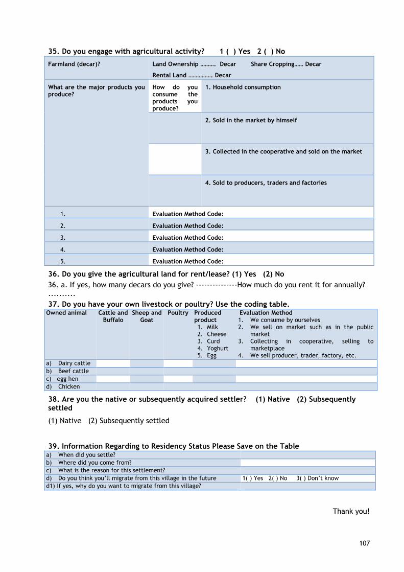
107
35. Do you engage with agricultural activity? 1 ( ) Yes 2 ( ) No
Farmland (decar)? Land Ownership ………. Decar Share Cropping…… Decar
Rental Land ……………. Decar
What are the major products you produce?
How do you consume the products you produce?
1. Household consumption
2. Sold in the market by himself
3. Collected in the cooperative and sold on the market
4. Sold to producers, traders and factories
1. Evaluation Method Code:
2. Evaluation Method Code:
3. Evaluation Method Code:
4. Evaluation Method Code:
5. Evaluation Method Code:
36. Do you give the agricultural land for rent/lease? (1) Yes (2) No
36. a. If yes, how many decars do you give? ---------------How much do you rent it for annually? ..........
37. Do you have your own livestock or poultry? Use the coding table. Owned animal Cattle and
Buffalo Sheep and
Goat Poultry Produced
product 1. Milk 2. Cheese 3. Curd 4. Yoghurt 5. Egg
Evaluation Method 1. We consume by ourselves 2. We sell on market such as in the public
market 3. Collecting in cooperative, selling to
marketplace 4. We sell producer, trader, factory, etc.
a) Dairy cattle
b) Beef cattle
c) egg hen
d) Chicken
38. Are you the native or subsequently acquired settler? (1) Native (2) Subsequently settled
(1) Native (2) Subsequently settled
39. Information Regarding to Residency Status Please Save on the Table a) When did you settle?
b) Where did you come from?
c) What is the reason for this settlement?
d) Do you think you’ll migrate from this village in the future 1( ) Yes 2( ) No 3( ) Don’t know
d1) If yes, why do you want to migrate from this village?
Thank you!