the ghana enterprise land information system (gelis) … · nsdi (the nsdi secretariat in the...
TRANSCRIPT
THE GHANA ENTERPRISE LAND INFORMATION SYSTEM (GELIS) AS A
COMPONENT OF NATIONAL GEOSPATIAL POLICY
GRAHAM DEANE, ROBERT OWEN
Airbus Defence and Space, United Kingdom
BENJAMIN QUAYE
Ministry of Lands and Natural Resources –
Land Administration Project
Paper prepared for presentation at the
“2017 WORLD BANK CONFERENCE ON LAND AND POVERTY”
The World Bank - Washington DC, March 20-24, 2017
Copyright 2017 by authors. All rights reserved. Readers may make verbatim copies of this
document for non-commercial purposes by any means, provided that this copyright notice
appears on all such copies.
Abstract
The Government of Ghana, through the Ministry of Lands and Natural Resources, is implementing the
Land Administration Project 2 (LAP-2) which builds upon the foundations laid under LAP-1. Central to
LAP-2 has been the development of a National Geospatial Policy and the implementation of GELIS, the
Ghana Enterprise Land Information System. This paper attempts to summarise these activities and
demonstrate how they will help Ghana to achieve its objective of developing a comprehensive land
administration system leading ultimately to a National Spatial Data Infrastructure (NSDI).
In developing the National Geospatial Policy (NGP), which is currently in the adoption process through
Cabinet, there was a thorough review of the current progress and problems. The NGP provides the basis
for building the strategy to develop an NSDI implementation plan.
In parallel has been the initial implementation of GELIS which, eventually, will enable all users from the
relevant Ministries and Agencies to carry out their day-to-day business processes efficiently in a digital
environment, using common databases. Once complete, GELIS will present a One-Stop-Shop for all
stakeholders, including the general public, irrespective of where they are. GELIS, therefore, forms a vital
component of implementing the geospatial policy and the achievement of an NSDI.
Key Words:
Geospatial, Ghana, Information System, Land Administration, Policy

1. INTRODUCTION
The Government of Ghana through the Ministry of Lands and Natural Resources is implementing the
Land Administration Project 2 (LAP-2) with funds provided by the International Development
Association (IDA), the Department of Foreign Affairs, Trade and Development, Canada and the
Government of Ghana. The Project Development Objective is to “consolidate and strengthen land
administration and management systems for efficient and transparent land service delivery”. LAP-2
builds upon the foundations laid under LAP-1.
Central to the activities of LAP-2 has been the development of national policies for mapping and
geospatial data, and, the implementation of GELIS, the Ghana Enterprise Land Information System. This
paper attempts to summarise these recent activities and to demonstrate how, together, they will help
Ghana to achieve its objective of developing a comprehensive land administration system including
achieving a National Geospatial Policy (NGP) modelled on but extending beyond a National Spatial Data
Infrastructure (NSDI).
The National Land Policy of Ghana (1999) provides for the “judicious use of the nation’s land and all its
natural resources by all sections of the Ghanaian society in support of various socio-economic activities
undertaken in accordance with sustainable resource management principles and in maintaining viable
ecosystems”. The Land Policy envisages that a geospatial framework database or NSDI would be
established to serve as a backbone to an integrated land information system that would link and network
all the land related agencies in the country.
More recently, LAP-2 has identified the benefit of combining the draft NSDI policy created in 2013 with
the Survey and Mapping Policy, also created in 2013, and the Geodetic Reference Network Policy created
in 2014 as a consolidated National Geospatial Policy (NGP). This policy, prepared in early 2016,
provides the foundation for the future development of an NSDI in Ghana that will avoid costly
duplication of effort and will realise the benefits from sharing and being able to access and use up-to-date,
reliable and high quality geospatial data.
2. BACKGROUND TO NATIONAL GEOSPATIAL POLICY FORMULATION
The current situation in Ghana is one in which there are many aspects of geospatial policy already in
place or being formed. There are a number of activities and projects that are NSDI-related with a number
of organisations actively engaged but on an individual basis. It is also recognised that some stakeholders
are aware of NSDI but appear to have varying degrees of understanding and commitment. This leads to a
situation in which implementation is only partial, leading to the current problems of duplication and lack
of data and knowledge sharing, thereby not allowing the full benefits of NSDI to be enjoyed. A high level
policy was therefore needed in order to pull all of these various strands together into a single agreed
purpose; combined to bring about a shared vision and provide a solid foundation for the way forward.
In developing the National Geospatial Policy, which is currently in the adoption process through Cabinet,
there was a thorough review of the current problems, including: gaps in data types, incomplete coverage,
out-of-date data, poor quality data, a preliminary data audit of the main geospatial data suppliers and users
and a data exchange audit of who was using what and from whom. The work also reviewed the problems
of having some spatial data but without knowing exactly what exists, where they are, what quality they
are, how they can be accessed and what conditions apply if they are used. The NGP, therefore, also
provides the information from which to develop an NSDI strategy and implementation plan, under which
it will be clear to all stakeholders who should do what and how it will be organised and governed,
financed and resourced.
But, in addition, in an attempt to place geospatial data at the heart of government and the economy, a
significant step was also taken to identify specific projects and applications, and other related national
policies to see the important interdependencies and to strengthen the awareness of geospatial benefits.
This identified a range of ongoing projects, initiatives and problems to be addressed in such diverse areas
as illegal mining, flooding, use of agricultural land for residential building, deforestation, oil extraction,
resilience planning, “Smart City” development, land use zoning, etc. A key consideration was also given
to those organisations who could form the nucleus of the governing framework to implement the NGP.
The policy starting point was to examine all of the related previous policy work including the three main
constituent elements and contributions from the Survey and Mapping Policy, the NSDI policy and the
Geodetic Reference Policy that had already been carried out including the many other related projects that
already had been actioned. And then to clearly identify how they were related and contributed to the
National Geospatial Policy. It became clear as happens in many circumstances that much had already
been achieved and many of the building blocks were already in place, but that more needed to be done to
make people and organisations aware and to work together. This is shown in Figure 1.
3. KEY ELEMENTS OF THE NATIONAL GEOSPATIAL POLICY
The NGP policy was designed as a stand-alone document based upon the existing NSDI policy but
incorporating key elements of the S&M policy and GRN policy. By remaining “high level” the lower
level policy documents can be changed from time to time, if required, without affecting the top-level
policy. The structure was developed on the basis of other national policies in Ghana, the National Land
Policy in particular, and was written and agreed after detailed formal and informal meetings, discussions,
workshops and presentations to all sectors of the economy – public, private, academic, utilities and
professional institutions. What was clear was the in-depth understanding and technical expertise of all
participants, the commitment of all to the overall objectives and indeed of the benefits to be gained. What
was less apparent was how to get there and how to balance different aspirations and timescales.
The final policy addressed these concerns by setting out the key elements in a threefold document
covering: a framework and objectives which provided the foundation, and top level guidance, for the
establishment of an National Geospatial Policy; the guidelines or statements derived from the policy
objectives which are intended to guide policy; and in pursuing the stated policy objectives, the policy
actions which will be implemented by Government according to an implementation plan in the short,
medium and long-term.
The policy framework was created in a manner that: would meet the demands of its users and
stakeholders, including all levels of government; be founded on principles defined by the United Nations
Economic Commission for Africa (UNECA); reflect developing international standards and best practice
with the intention of promoting gender equality and empowering women; and ensure the many
advantages of data sharing (collected at taxpayers’ expense) were clearly recognised and enshrined in the
policy.
The guidelines (i.e. the policy statements) that emerged from these objectives were set out in eight
different major components which described those essential policies and commitments to be implemented
and actioned. These eight components, set out with descriptive sub-clauses and definitions, covered:
governance, geospatial data, access to geospatial data, interoperability, finance, legal issues, human
capacity needs and communication and awareness. To commence the whole process it was recognised
that the first of these, Governance, including the organisation and administrative structure, was the most
important one.
In any new environment or situation where policy implementation is crucial it is important to ensure that
those responsible operate at the top level, are independent of vested interests, have the necessary authority
recognised by all stakeholders and can ensure and encourage the participation of all towards the ultimate
objective. An organisational and administrative structure for the NSDI to be established under the overall
responsibility of the Office of the President was agreed and is shown below at Figure 2. The importance
of involving a wide cross section of the geospatial community is also apparent in order to provide the
necessary overall management, technical and advisory roles. It includes:
a. An executive role – to steer and guide the development of NSDI (NSDI Committee);
b. A management role – to co-ordinate the project management of NSDI implementation across the
range of stakeholders involved (NSDI Implementation Managers);
c. An operational role – to perform day-to-day administration and technical implementation of the
NSDI (The NSDI Secretariat in the Office of the President and an NSDI Technical Team); and
d. An advisory role - teams of experts in specialist fields to provide analysis and recommendations
(NSDI Work Groups).
4. POLICY IMPLEMENTATION PLAN
The policy development was not an academic exercise but a practical and operational solution to well-
known and acknowledged sets of problems designed to ensure greater efficiency across many sectors. It
was to build upon existing experience and significant technical skills and indeed on previous and current
“mini” NSDI’s operated by some organisations. Therefore the actions arguably formed the most
important part of the policy document. This third component of the policy comprised the Action and
Implementation Plan with great emphasis placed on the identification of a series of “quick wins”, short,
medium and long term strategies all of which were debated and described at length.
This action plan covered each of the eight main components of the guiding principles noted above and
was delivered at two levels - at a high level and by a more detailed table of actions to be carried out and
implemented with assigned responsibilities for each item in the plan. Some examples where this greater
detail is required are on the definition of core or fundamental datasets, staffing of the management unit,
pricing and licensing policies, etc.
As noted above the first of these guiding principles is the governance of a clear institutional framework
for the development of an SDI with leadership a key factor for that crucial first step of getting things
moving and in a collaborative spirit. It was recommended that the potential key leaders operating under
the auspices of the Office of the President should be:
National Information Technology Agency – because the ICT infrastructure, standards and
geospatial delivery is reliant on this organisation;
Survey and Mapping Division (of Lands Commission) – because it is the main geospatial data
provider and has already seen its operational guiding principles defined under a Survey and
Mapping Policy As the national mapping agency it is central to the development, improvement
and accessibility of geospatial data;
National Development Planning Commission – because it has a high level, cross-government
responsibility to plan, manage, budget, implement and monitor;
Environmental Protection Agency – because it has taken the initiative to create an environmental
SDI, complete with interoperable data and a data sharing agreement – in many ways a first NSDI,
from which many lessons have been learnt
Ghana Statistical Service – because the organisation has a long history of using GIS to create
national datasets (e.g. Districts / Enumeration Areas).
The second major area for action was the availability and knowledge about what geospatial data exists,
especially through the provision of metadata. For example the lack of metadata makes it impossible or
difficult for potential users to know if data exist or not. Even if the data exists it is difficult to evaluate its
fitness for use, due to a lack of a proper metadata description and standard. A metadata policy had already
been created for Ghana however, so this was an area in which a “quick win” was possible. A related task
was to overcome the lack of a proper access mechanism to see the existing geospatial data. Adopting a
standardised web-based service architecture and publishing metadata and data are the keys to overcoming
this obstacle. Here again work had been carried out to assess what metadata was held by stakeholders,
using which standard and a pilot metadata service had been created. The NGP policy on metadata was
therefore to state that:
a) Metadata and metadata registries will be created and maintained according to the ISO19115
Ghana Modified Metadata Standard;
b) Metadata will be created and published for all geospatial datasets included in the NSDI according
to the ISO19115 Ghana Modified Metadata Standard, and provided [and made available free of
charge] to the clearinghouse by data and service providers for certification and inclusion; and,
c) Metadata will be updated when the geospatial data is updated and will be provided to users with
each supply of the relevant data
Further emphasis is given by the inclusion of a policy statement that organisations needing to access and
use geospatial data for their own purposes should determine which datasets exist (through the NSDI
metadata search service) and always use such data rather than creating new/duplicate data.
“Quick wins” are those that can be implemented quickly! And along with these and the identified short
term actions, they can be used to overcome the tendency to see the ultimate goal as too far in the future
and too complicated to insert into current business plans. And so a third area for action and a “quick win”
is the adoption of a simple Data Sharing agreement between stakeholders which could be a simple
Memorandum of Understanding and would be very straightforward to draft. This could quickly overcome
the tendency in many countries where poor partnerships and cooperation are considered to be the biggest
problem – the “silo mentality” – where many organisations fear that they will lose their autonomy when
participating in an NSDI. There is then often limited cooperation between the different organisations.
Such action would also be enabled by the appointment of a senior staff member of organisations to
assume responsibility for their involvement to the NGP.
Linked to this is where it is clearly recognised that there is a consistent need for geospatial data to be
shared and used by different organisations. There is then an argument for a “marketing exercise” to
determine what these needs are and to what timescale. An example which was examined was the case of
Survey and Mapping Division (SMD), the National Mapping Agency, whose products were in great
demand by other organisations. Such a “marketing exercise” can be used to develop a more detailed plan
which can be used to develop the simple Data Sharing agreement referred to above.
Additionally, at this interim stage a one-off project related co-operative agreement could be put in place
that would begin to increase the quality and quantity of the national geospatial data. For example, a
proposed SMD / Ghana Statistical Service collaboration is a superb example of how agencies, working
together towards a common goal in a positive way, can make a big impact. National, up to date and
maintained administrative boundaries are important for census and local authority service provision but
the information is not widely available and perhaps ownership and responsibility for management and
updating is unclear. It could be made available with appropriate collaboration and become a valuable
dataset for many applications. A relatively small procedural change, and collaboration, has then the
possibility to have a big impact and should be applauded. There may be other examples, and the
possibilities should be explored rather than waiting for a formal instruction via a new law.
Finally perhaps, the component which would give authority and impact to the adoption, (or even before
adoption) of policy is the legal instrument. The drafting of the appropriate Legal Instrument does not
need detailed decisions to be made but can largely be based upon the high level statements contained with
the Policy.
The debate on implemented actions clearly showed that, whilst the development of a full national
geospatial policy could take a number of years, a step by step approach would yield recognizable
incremental benefits which would boost support for continuing action towards the ultimate goal.
5. IMPLEMENTATION UPDATE
Following the preparation of the National Geospatial Policy document, a Cabinet memorandum was
submitted to the previous government for approval for its implementation. However, the previous Cabinet
could not fully consider the Policy document for approval before the recent change in government (in
December 2016). Once the new Cabinet is constituted, the Cabinet memorandum will be resubmitted for
consideration and approval.
Given the wide ranging impacts of this Policy, upon Cabinet’s policy approval, a number of high intensity
activities are going to be undertaken including:
a) The Key Stakeholders identified by the NGP will sign a declaration of commitment which will be
a public statement of stakeholders’ commitment to put resources and energies into the NSDI. To
this end, a Key Stakeholders Workshop will be organised to allow all those involved to be present
and to discuss the declaration. In addition, the NSDI implementation team would be decided and
agreed;
b) Undertaking training engagements with a range of stakeholders across the country on the content
of the Policy and how it will impact on the provisions of geospatial information for effective land
administration and governance. These include Ministries, Departments and Agencies,
Metropolitan, Municipal & District Assemblies and especially those involved directly in land
administration, mining, forestry, infrastructure development and the utilities;
c) In the short term a detailed Strategy and Implementation Plan for the NSDI will be drawn up.
This will provide the detailed activities and specific funding costs required for the NSDI. It will
give clarity over who does what, the human resources required, the timescales involved and the
inter-dependencies between activities. Individual organisations involved in NSDI implementation
will incorporate the requirements into their annual work plans and budgets;
d) The governance structure described in the policy will be established and the Office of the
President shall co-ordinate the Secretariat. Detailed roles and responsibilities for all components
of the governance and administration structure will be drafted and appropriate terms of reference
developed;
e) The Secretariat will present a detailed analysis of required costs to the Presidency and approval
sought for a ring fenced funding of NSDI implementation for an initial 5-year period. In that
period further studies will identify subsequent costs and measures aimed at ensuring long-term
sustainability and
f) A National Geospatial Act will be introduced to provide legal backing for the actions described in
this Policy.
Recognising that the National Geospatial Policy is the first, but crucial step in developing a NSDI in
Ghana and gaining the benefits of more accessible, up to date, high quality geospatial data, it is
encouraging to observe that the current government has given some indication that it is poised to see to
the implementation of some of the policy statements in the NGP. Even before the Draft Policy document
is approved for implementation, portions of it are being implemented. For example, in order to pursue the
government’s agenda of providing a digital address database for the country, the office of the Vice
President has convened a meeting of key stakeholders, most of whom have been identified in the draft
NGP, to deliberate on the technical and legal issues in harnessing the power of modern geo-spatial
technology to be used as alternatives to current practices. As a result of the meeting, a Technical
Committee, to work directly under the office of the Vice President, has been formed and tasked with the
responsibility of outlining a realistic action plan for the realisation of the vision of the government on
addressing.
As further evidence of sustained commitment, when the Policy is approved, the Ministry of Lands &
Natural Resources will roll out a comprehensive communication strategy, which provides for all round
communication to both internal and external stakeholders. Upon approval, copies of the Policy will be
distributed to all stakeholders and followed by a series of stakeholder workshops to disseminate and
explain the contents of the National Geospatial Policy. The messages will be disseminated in a
comprehensive manner including the use of local languages to facilitate understanding and cooperation of
stakeholders. This strategy will be coordinated by the Public Relations Unit of the Ministry of Lands &
Natural Resources and senior officers of the Ministry shall be deployed. To give extra impetus and
commitment the stakeholders to be involved will be extended to include Traditional Authorities, The
Judiciary, Civil Society and Non-Governmental Organisations and the Media.
6. GELIS BACKGROUND AND OBJECTIVES
In addition to further strengthening the policy framework for Land Administration and geospatial
information management, LAP-2 has also focused on decentralising and improving business and service
delivery processes and improving maps and spatial data. The Ghana Enterprise Land Information System
(GELIS) is central to this activity.
Reliable land information is essential to support effective land administration and management; however,
if the system is to support efficient data analysis and decision making, equally important is the ability to
access this information quickly, and, link different data sets in the information system. Providing for rapid
access and ease of data retrieval is best achieved by developing a computer-based land information
system containing both graphical (spatial) and linked textual (attribute) data. Under LAP-I, a Land
Information System (LIS), with five sub-systems using the same database structure, was developed for the
Divisions of the Lands Commission as a core system that allowed users to enter and process data that
were newly generated from Systematic Land Titling (SLT) campaigns, based partly on existing manual
records and maps. The LIS sub-systems were intended to allow each Land Sector Agency during day-to-
day business, to process electronically its own (unique and non-redundant) data in a format acceptable to
the LIS and using its unique (and separate from other Divisions) parcel number (UPN). These sub-
systems were, however, developed based on the old business processes of the previous autonomous
agencies. In reality these sub-systems have not been used operationally and most of the Divisions have
continued using paper folders and documents in their business processes.
In addition to the stage one LIS, there have been other information systems developed, such as the Land
Use Planning and Management Information System (LUPMIS), the Urban Management Land
Information System (UMLIS), a customised software for Rating Valuation and an intelligent scanning
and records management system (based on the LaserFiche software). Also, some of the regional offices of
the divisions of the LC have initiated computerisation of some aspects of their processes (especially to
facilitate the tracking of transactions). Under LAP-1 some records held at the Lands Commission had
been scanned and stored in a digital format. The LC, with assistance from FAO, also completed the
development of prototype Open Source software for land administration (SOLA). Under LAP-2,
however, it was recognised that the development of a comprehensive integrated Ghana Enterprise LIS
(GELIS) would be a priority, with functionality based on a comprehensive analysis of the business
processes and data flows of the agencies. It was also imperative that a number of LC technical
developments and service innovations were taken account of and factored into the solution.
The Terms of Reference (TOR) for the provision of the required system elements of GELIS, including
hardware, networking and data conversion, loading, migration and ingestion, as well as the training and
capacity building essential to achieving full operationalisation were issued by LAP-2, and, following
completion of the tendering process, the build of GELIS commenced in the first half of 2016.
Unfortunately as a result of budget limitations at that time, the scope of the initial GELIS build and
associated data capture had to be reduced to certain priority items. However the design is such that the
foundations for a more comprehensive information management system have been laid down and the full
scope of GELIS can be built in the future.
7. KEY ELEMENTS OF GELIS
GELIS is a major project which will have significant impact upon the future operation of the Lands
Commission and stakeholders in the Land Sector Agencies. As such, comprehensive and detailed
specifications were produced by LAP-2 which set out the requirements of the main component parts of
the GELIS implementation project, which are:
a. Development, testing and deployment of the GELIS software system;
b. Procurement, installation and commissioning of hardware at the central National Land
Information Centre in Accra;
c. Data conversion and loading of data to permit effective functioning at the selected
regional/district offices, and, roll-out of the software to these selected offices;
d. Knowledge Transfer and Capacity Building to ensure long-term sustainability of GELIS within
Ghana’s land sector.
The specifications clearly described the context and technical environment within which the development
and implementation of the software is expected to take place. They make clear the requirements in
relation to the principles of Modularity, Flexibility, Scalability, Interoperability, Security, Web
technology, Open International Standards, and Open Source software principles which will ensure the
successful initial development of a software suite. However, these principles are also vital to the long-
term sustainability of GELIS as they ensure that the system put in place has a solid framework that can be
extended in capacity and functionality as demand develops.
GELIS is also designed in such a way that enables LC staff to be fully involved in these future
developments by developing their knowledge and skills through working alongside the development
team. However, as indicated below, the initial capacity of GELIS has been somewhat curtailed by budget
restrictions and time constraints and so the current activities do not fully meet all the initial objectives of
GELIS. Whilst this is, of course, disappointing all parties are working to ensure that these initial steps are
carried out within the requirements of the ‘philosophy of GELIS’ so that these first components fully
meet the design goals and expectations of the fully developed GELIS in the future; and, of course, the
first components will also pave the way for the eventual roll-out of GELIS to cover the whole of Ghana.
In terms of hardware the requirement is also reduced in this first phase of GELIS with LC taking back the
direct responsibility for procuring some elements as part of the development of the new National Land
Information Centre (NLIC). However, the comprehensive overall design is being adhered to so that those
elements now being procured as part of the contract will fully meet the central requirements of the NLIC,
when completed.
Similarly the requirements for data capture and conversion as part of the GELIS project are, at first
assessment, fairly straightforward but the actual data volumes, contents, conditions, formats and data
types are inevitably difficult to quantify and describe fully. This is due to the disparate nature of the data,
multiple locations and separate offices together with an unknown relationship between data types and the
ID’s associated with unique items of data managed by the different agencies within LC. This complexity
is illustrated in Figure 3.
This diagram illustrates the types of document typical of the various Divisions of the Lands Commission,
including Job Survey Forms (JSF) of the Survey and Mapping Division (SMD) and documents from the
Land Registration Division (LRD) and Valuation Division (LVD). The primary tools have been digital
scanning for documents with production lines set up at various offices; vector data capture using GIS
tools; and, indexing/data capture using software called SmartGED.
Within the current GELIS activity many of these elements have become better understood and it has been
possible to refine the methodologies of capture for most document types. However, again as a result of
budget restrictions, the current level of data capture is very much below that originally envisaged for this
stage in the development of GELIS; the focus has therefore been on understanding what is available, the
development of procedures and planning for the future. In this phase of the development of GELIS
around 920,000 pages have been scanned and information on some 40,000 parcels is due to be delivered
in the next month or so.
For the full development of GELIS, the data capture and conversion component will form a very sizeable
part of the project and should not be underestimated. The work currently being carried out will enable the
extent of the remaining tasks to be assessed accurately so that detailed and realistic plans can be
developed for the future. This will ensure the most efficient means of data capture are employed for
different data sources and ensure the maximum benefit from future budgets for completing the data
capture tasks.
As already indicated on of the most important elements in the current GELIS activities is the knowledge
transfer and capacity building; it is this element that will ensure the long term future for the GELIS
developments and its role as a major component of Ghana’s spatial data infrastructure. This involves all
aspects from software development, through the hardware build and maintenance to the successful
capture and conversion of all relevant data types within the LC, and its component parts. For example,
part of the current activity has been to involve LC staff in the document scanning, digitising and data
capture processes, alongside the local GELIS project technicians so that they gain experience of these
tasks which can be passed on to other LC staff as part of the GELIS roll-out process.
8. GELIS PROGRESS
As indicated earlier, the current activity on GELIS is reduced from the original scope and requirements in
order to fit in with the budget and time restrictions applicable at the end of the LAP-2 project cycle. This
has meant that the current activity has had to focus on specific functional elements of the software and
shortened programme of data capture and conversion; the data capture and to some extent the software
development are therefore more of a pilot implementation than originally envisaged for GELIS at this
stage in its development. The main elements of the GELIS software functionality and those not included
in the current GELIS project are indicated in Table 1.
The result of budget constraints is that only about 60 per cent of the originally envisaged software
functionality is currently included within the active GELIS programme. The excluded elements such as,
for example, the Valuation Register sub-system and the Rent Collection and Management Sub-system (as
indicated in the table) are both vital components for a fully-developed GELIS but have, for the moment,
been left out of the development process. It is envisaged that they will be developed in the future and an
important aspect of the current development is that it must ensure that no constraints to the future
requirements are introduced under the current GELIS build.
The development of these essential components began in the middle of 2016. There have inevitably been
some delays in capture of the detailed requirements and preparation of the required hardware
infrastructure, for such a complex information management system. The go-live of GELIS is now
anticipated for mid-2017, followed by user training with initial roll-out to selected regions (as listed
below under data capture) to be completed in the following two months.
The data capture and conversion element of the current project has been reduced to around 10 per cent of
that originally planned, and is primarily focused on parts of Greater Accra. It is also essential that there is
some visibility of the aims and objectives of GELIS outside Accra and so there is some data capture
underway for Koforidua (Eastern Region), Sekondi-Takoradi (Western Region),Tamale (Northern
Region), Bolgatanga (Upper East Region), Savelugu (Northern Region) and Tema (Greater Accra
Region). At this level, the activity is most accurately described as a pilot; however the value of such a
pilot is developing the methodologies and identifying the important issues including training and
knowledge transfer elements, so that once full production can be initiated the problems likely to be
encountered are much better understood and much more accurate future schedules can be achieved.
Within the curtailed programme the time constraint has become much more significant, as in a two-year
programme (as originally planned) there is usually scope for recovering from setbacks and unplanned
events such as power outages or unexpected issues in the data capture process. The current GELIS
schedule leaves very little room for manoeuvre whilst trying to maintain the project timelines; whether it
is related to the contractor adapting to setbacks or whether it is the stakeholders adapting to and absorbing
the impacts of change and knowledge transfer. In such circumstances it is essential for all parties to be
flexible in their approach so that the maximum can be achieved in the time available. This is, for example,
apparent with LC’s development of the Client Service and Access Units (CSAU) software which
progressed significantly in the period before GELIS got underway; GELIS is therefore adapted to
leverage benefits from integrating with the CSAU application.
9. GELIS AS A COMPONENT OF NSDI
The ultimate goal is that GELIS will eventually present a complete, self-updating, efficient, transparent
and accessible One-Stop Shop for all stakeholders including the general public, irrespective of where they
are and what language or alphabet system they use. The design concept is the GELIS will form a vital part
of the Ghana’s National Spatial Data Infrastructure. The project has already made significant progress in
this regard.
As international consultants with experience of several different developments, it is our (Airbus)
understanding that in many countries there is usually a reluctance to share data, to part with information
and data that is seen as the property of the “owner” organisation, even though the “owner” is in fact the
government and, ultimately therefore, the citizens themselves. The requirements of GELIS necessitate the
loading and access of data sets across multiple stakeholders and these include those vital to the successful
operation of the One-Stop Shop principle.
An important dataset in his regard is, for example, the data held by Town and Country Planning
Department managed and accessed through LUPMIS. Together with the other datasets which will be held
and managed within GELIS, it is our view that the concept of an NSDI for Ghana can, with careful
development, management, discussion and agreements on data sharing, and, not forgetting the political
aspects, become a reality accepted by the broad base of geospatial stakeholders in Ghana.
10. THE WAY FORWARD
The National Geospatial Policy is moving towards implementation and setting the scene for a much wider
use of digital technology across a range of Ministries, Departments and Agencies and the build-up of a
spatial data infrastructure based on accurate, tested and, hopefully, widely available datasets. It will be the
conduit for linking together many of the projects developed under LAP-2 and also, as already stated,
many of the future initiatives and projects being planned. However there is also a clear need to
demonstrate as quickly as possible a successful application, that sharing data leads to greater efficiency.
GELIS, despite its currently restricted scope can provide that successful application. It is being built in
such a way as to be not only a pilot of the means of implementing a system for managing land
administration data, it is also conceived, designed and implemented in such a way as to be fully in tune
with the national policy and the ultimate goals of achieving an NSDI. Reference has already been made to
the development towards an NSDI in the first part of this paper and the support from the office of the
Vice President to encourage cooperation and data sharing. Therefore the signs are there that significant
progress is being made.
11. CONCLUSIONS
The development of the National Geospatial Policy, within LAP-2, has the potential for a very positive
impact upon the implementation and uptake of GELIS as it has put the use of the technology at the
forefront of discussions about how to use digital data and how to share its benefits across a wide range of
stakeholders through potential applications and improvements to business-as-usual activities. Although
the implementation of GELIS is still at a very early stage, and has occurred much later in LAP-2 than
originally planned, it will serve as the pilot for more detailed development and expansion as further
resources become available and the main LC stakeholders demonstrate that it has benefits for managing
the land and access to land and markets, and, consequently brings significant benefits to all citizens of
Ghana. At this time the adoption of the policy and the fledgling implementation of GELIS will impact
upon other initiatives and therefore act as a “beacon and way forward” for future strategies.
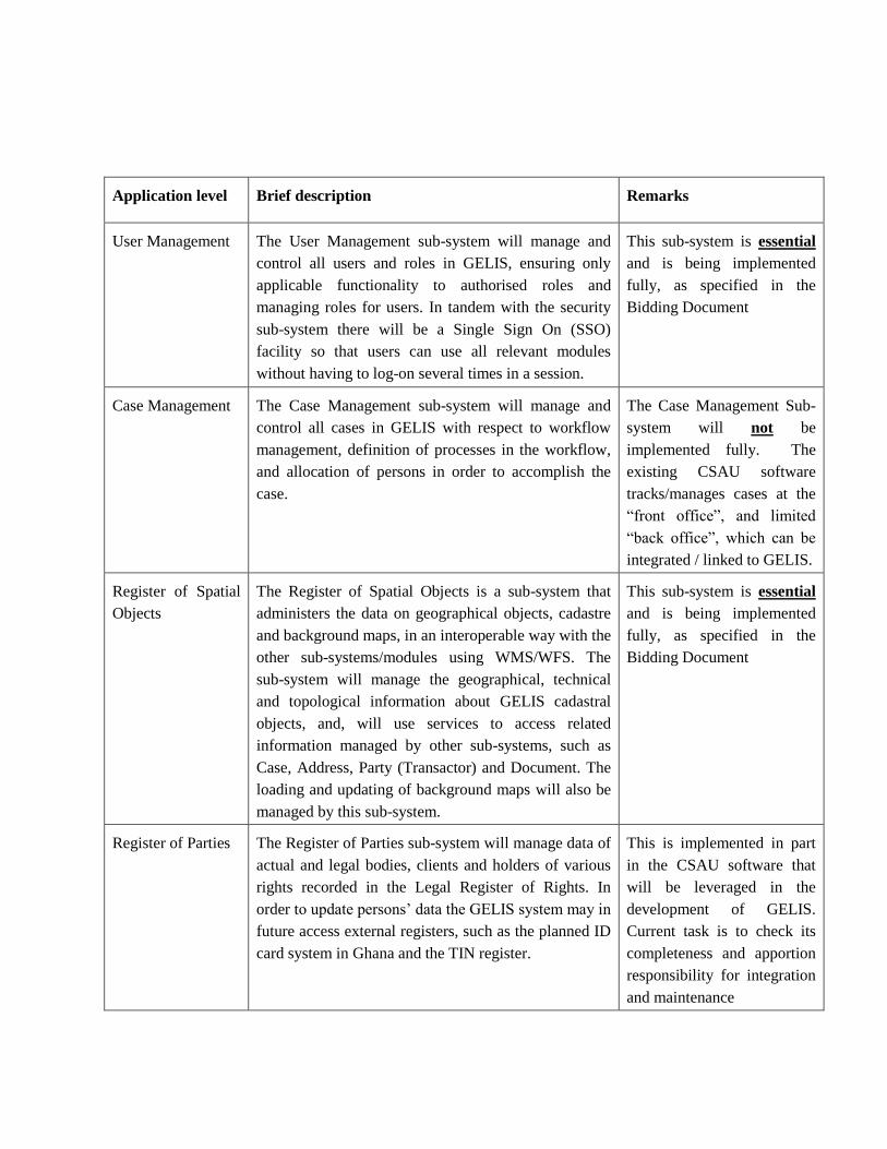
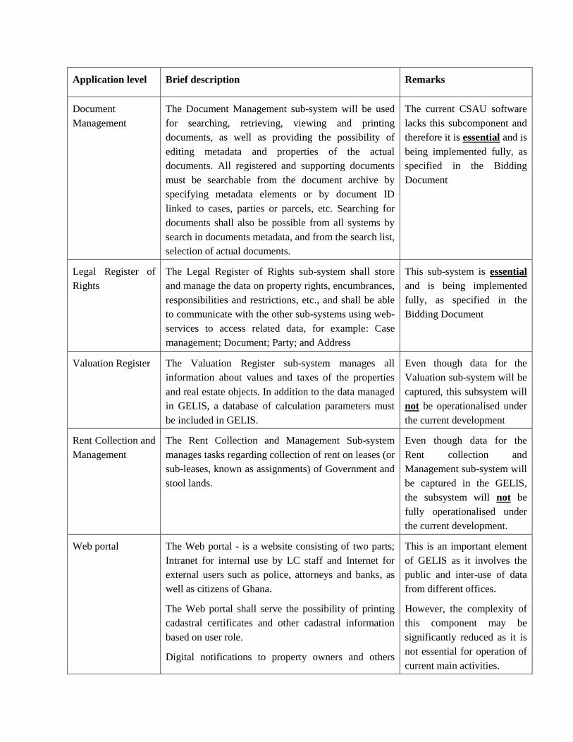
Application level Brief description Remarks
User Management The User Management sub-system will manage and
control all users and roles in GELIS, ensuring only
applicable functionality to authorised roles and
managing roles for users. In tandem with the security
sub-system there will be a Single Sign On (SSO)
facility so that users can use all relevant modules
without having to log-on several times in a session.
This sub-system is essential
and is being implemented
fully, as specified in the
Bidding Document
Case Management The Case Management sub-system will manage and
control all cases in GELIS with respect to workflow
management, definition of processes in the workflow,
and allocation of persons in order to accomplish the
case.
The Case Management Sub-
system will not be
implemented fully. The
existing CSAU software
tracks/manages cases at the
“front office”, and limited
“back office”, which can be
integrated / linked to GELIS.
Register of Spatial
Objects
The Register of Spatial Objects is a sub-system that
administers the data on geographical objects, cadastre
and background maps, in an interoperable way with the
other sub-systems/modules using WMS/WFS. The
sub-system will manage the geographical, technical
and topological information about GELIS cadastral
objects, and, will use services to access related
information managed by other sub-systems, such as
Case, Address, Party (Transactor) and Document. The
loading and updating of background maps will also be
managed by this sub-system.
This sub-system is essential
and is being implemented
fully, as specified in the
Bidding Document
Register of Parties The Register of Parties sub-system will manage data of
actual and legal bodies, clients and holders of various
rights recorded in the Legal Register of Rights. In
order to update persons’ data the GELIS system may in
future access external registers, such as the planned ID
card system in Ghana and the TIN register.
This is implemented in part
in the CSAU software that
will be leveraged in the
development of GELIS.
Current task is to check its
completeness and apportion
responsibility for integration
and maintenance
Application level Brief description Remarks
Document
Management
The Document Management sub-system will be used
for searching, retrieving, viewing and printing
documents, as well as providing the possibility of
editing metadata and properties of the actual
documents. All registered and supporting documents
must be searchable from the document archive by
specifying metadata elements or by document ID
linked to cases, parties or parcels, etc. Searching for
documents shall also be possible from all systems by
search in documents metadata, and from the search list,
selection of actual documents.
The current CSAU software
lacks this subcomponent and
therefore it is essential and is
being implemented fully, as
specified in the Bidding
Document
Legal Register of
Rights
The Legal Register of Rights sub-system shall store
and manage the data on property rights, encumbrances,
responsibilities and restrictions, etc., and shall be able
to communicate with the other sub-systems using web-
services to access related data, for example: Case
management; Document; Party; and Address
This sub-system is essential
and is being implemented
fully, as specified in the
Bidding Document
Valuation Register The Valuation Register sub-system manages all
information about values and taxes of the properties
and real estate objects. In addition to the data managed
in GELIS, a database of calculation parameters must
be included in GELIS.
Even though data for the
Valuation sub-system will be
captured, this subsystem will
not be operationalised under
the current development
Rent Collection and
Management
The Rent Collection and Management Sub-system
manages tasks regarding collection of rent on leases (or
sub-leases, known as assignments) of Government and
stool lands.
Even though data for the
Rent collection and
Management sub-system will
be captured in the GELIS,
the subsystem will not be
fully operationalised under
the current development.
Web portal The Web portal - is a website consisting of two parts;
Intranet for internal use by LC staff and Internet for
external users such as police, attorneys and banks, as
well as citizens of Ghana.
The Web portal shall serve the possibility of printing
cadastral certificates and other cadastral information
based on user role.
Digital notifications to property owners and others
This is an important element
of GELIS as it involves the
public and inter-use of data
from different offices.
However, the complexity of
this component may be
significantly reduced as it is
not essential for operation of
current main activities.
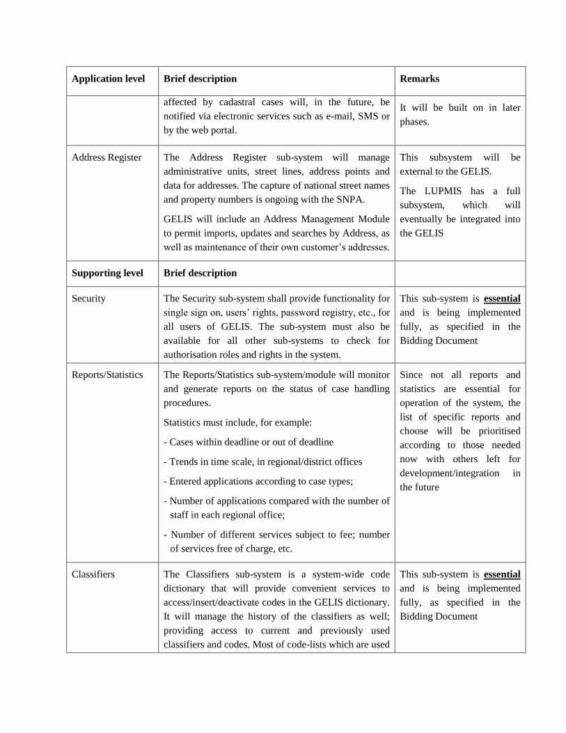
Application level Brief description Remarks
affected by cadastral cases will, in the future, be
notified via electronic services such as e-mail, SMS or
by the web portal.
It will be built on in later
phases.
Address Register The Address Register sub-system will manage
administrative units, street lines, address points and
data for addresses. The capture of national street names
and property numbers is ongoing with the SNPA.
GELIS will include an Address Management Module
to permit imports, updates and searches by Address, as
well as maintenance of their own customer’s addresses.
This subsystem will be
external to the GELIS.
The LUPMIS has a full
subsystem, which will
eventually be integrated into
the GELIS
Supporting level Brief description
Security The Security sub-system shall provide functionality for
single sign on, users’ rights, password registry, etc., for
all users of GELIS. The sub-system must also be
available for all other sub-systems to check for
authorisation roles and rights in the system.
This sub-system is essential
and is being implemented
fully, as specified in the
Bidding Document
Reports/Statistics The Reports/Statistics sub-system/module will monitor
and generate reports on the status of case handling
procedures.
Statistics must include, for example:
- Cases within deadline or out of deadline
- Trends in time scale, in regional/district offices
- Entered applications according to case types;
- Number of applications compared with the number of
staff in each regional office;
- Number of different services subject to fee; number
of services free of charge, etc.
Since not all reports and
statistics are essential for
operation of the system, the
list of specific reports and
choose will be prioritised
according to those needed
now with others left for
development/integration in
the future
Classifiers The Classifiers sub-system is a system-wide code
dictionary that will provide convenient services to
access/insert/deactivate codes in the GELIS dictionary.
It will manage the history of the classifiers as well;
providing access to current and previously used
classifiers and codes. Most of code-lists which are used
This sub-system is essential
and is being implemented
fully, as specified in the
Bidding Document

Application level Brief description Remarks
in the other sub-systems will be managed by the
Classifiers sub-system, accessible by web services.
Operation level Brief description
Enterprise Service
Bus (ESB)
The ESB is a software architecture model used for
designing and implementing the interaction and
communication between mutually interacting software
applications in service-oriented architecture. A light-
weight ESB must be implemented as part of the system
to ensure future linkages and easier incorporation of
new services.
The full “Enterprise Service
Bus” need not be
implemented, but there are
some “service oriented
architecture” requirements,
which should remain.
Table 2: Priorities for GELIS development
(Source: LAP-2 Project Management Unit, 2016)
Figure 1 The hierarchy of policies and implemented projects
(Source: Consultancy Service for the Development of National Geospatial Policy,
Final Report, Airbus, 2016)

Figure 2 Proposed organisational and administrative structure
(Source: Consultancy Service for the Development of National Geospatial Policy,
Final Report, Airbus, 2016)
Figure 3 Documents for data capture
(Source: GELIS Development working document, Airbus, 2016)