the inhs idot programs · inhs idot programs 2013 staff list heske, edward j., phd program advisor...
TRANSCRIPT

T h e I N H S I D O T P r o g r a m sA n n u a l R e p o r t 2 0 1 3
In This Issue:• Floodplain Forest Restoration• Mussels of Illinois• Illiana Expressway• 30 Years of T&E Plant Discoveries

INHS IDOT Programs 2013 Staff ListHeske, Edward J., PhD Program Advisor
Wetlands Vegetation and Soils ProgramWilm, Brian, MA Wetlands Program Leader
Marcum, Paul B., MS Wetlands Program, Asst. Leader — Botany Beas, Ben, PhD BotanistEngelhardt, Meg, MS Botanist Handel, William, MS BotanistKetzner, David M., MS BotanistMcIntyre, Susan, MS BotanistNieset, Julie, MS BotanistSivicek, Valerie A., MS Botanist
Wiesbrook, Scott M., BS Wetlands Program, Asst. Leader — SoilsGeatz, George, MS Soil scientistKeene, Dennis, BS Soil scientistKurylo, Jesse, MS Soil scientistTsai, Jenwei, MS Soil scientist
Skultety, Dennis, BS GIS/database specialistSass, Laura, MS Database specialistJessop, Jordan, BS Graduate assistant
Szafoni, Diane, MS GIS specialistZercher, Brad, MS GPS/GIS specialistAdomaitis, Jeannine, BS Data entry
Biological Surveys and Assessment ProgramMerritt, Joseph F., PhD Biological Surveys Program Leader, Senior mammalogist
Enstrom, David A., PhD OrnithologistMengelkoch, Jean, MS MammalogistSchelsky, Wendy, PhD Ornithologist
Taylor, Steven J., PhD Biological Surveys Program, Coordinator — Aquatic systems; Invertebrate ecologist
Cummings, Kevin, MA MalacologistKuhns, Andrew R., MS HerpetologistTaylor, Chris, PhD Icthyologist, AstacologistTiemann, Jeremy, MS Aquatic zoology specialistWetzel, Mark J., MS Macroinvertbrates, Water quality specialist
Taft, John B., PhD Biological Surveys Program, Coordinator — Botany
Carroll-Cunningham, Connie, MS BotanistHill, Steven R., PhD BotanistMurphy, Michael J. C., MS Botanist Ulaszek, Eric, MS Botanist
Barnes, Jeannie, BS Natural Heritage Database coordinatorJarvis, Janet, BS GIS specialistMayer, Christine A., BS Data coordinator, database and collection manager
Dmitriev, Dmitry, PhD Collections manager — insectsPhillippe, Rick, PhD Collections manager — herbariumWylie, Daniel, MS Collections manager — non-insect zoology
Contributing authors and images
2013 Annual Report
Editors: Ed Heske, Irenka Carney, Charles Warwick
Cover and Layout Design: Irenka Carney
Contributors:Jeannie Barnes, Ben Beas, Connie Carroll-Cunningham, Kevin Cummings, David Enstrom, Bill Handel, Ed Heske, Dave Ketzner, Andy Kuhns, Paul Marcum, Chris Mayer, Susan McIntyre, Jean Mengelkoch, Joe Merritt, Michael Murphy, Julie Nieset, Laura Sass, Wendy Schelsky, Valerie Sivicek, John Taft, Chris Taylor, Steve Taylor, Jeremy Tiemann, Jenwei Tsai, Eric Ulaszek, Mark Wetzel, Scott Wiesbrook, Brian Wilm
Photo, map, and graph credits:Kevin Cummings, Connie Carroll-Cunningham, Meg Engelhardt, Bill Handel, Ed Heske, Richard Mickson, Janet Jarvis, Mike Jeffords, Ron Kanter, Dennis Keene, Paul Marcum, Jeff Matthews, Susan McIntyre, Jean Mengelkoch, Joe Merritt, Michael Murphy, Julie Nieset, Cassandra Rodgers, Dennis Skultety, John Taft, Chris Taylor, Steve Taylor, Mark Wetzel
1 2013 | IDOT
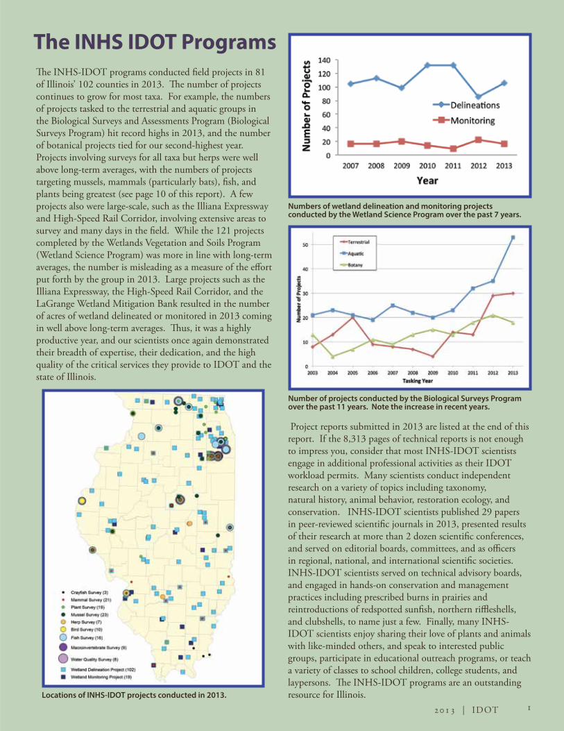
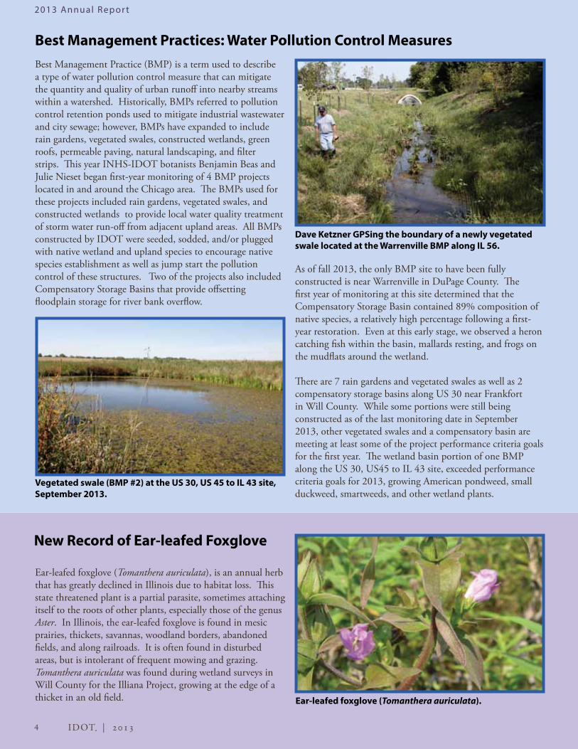
The INHS-IDOT programs conducted field projects in 81 of Illinois’ 102 counties in 2013. The number of projects continues to grow for most taxa. For example, the numbers of projects tasked to the terrestrial and aquatic groups in the Biological Surveys and Assessments Program (Biological Surveys Program) hit record highs in 2013, and the number of botanical projects tied for our second-highest year. Projects involving surveys for all taxa but herps were well above long-term averages, with the numbers of projects targeting mussels, mammals (particularly bats), fish, and plants being greatest (see page 10 of this report). A few projects also were large-scale, such as the Illiana Expressway and High-Speed Rail Corridor, involving extensive areas to survey and many days in the field. While the 121 projects completed by the Wetlands Vegetation and Soils Program (Wetland Science Program) was more in line with long-term averages, the number is misleading as a measure of the effort put forth by the group in 2013. Large projects such as the Illiana Expressway, the High-Speed Rail Corridor, and the LaGrange Wetland Mitigation Bank resulted in the number of acres of wetland delineated or monitored in 2013 coming in well above long-term averages. Thus, it was a highly productive year, and our scientists once again demonstrated their breadth of expertise, their dedication, and the high quality of the critical services they provide to IDOT and the state of Illinois.
Project reports submitted in 2013 are listed at the end of this report. If the 8,313 pages of technical reports is not enough to impress you, consider that most INHS-IDOT scientists engage in additional professional activities as their IDOT workload permits. Many scientists conduct independent research on a variety of topics including taxonomy, natural history, animal behavior, restoration ecology, and conservation. INHS-IDOT scientists published 29 papers in peer-reviewed scientific journals in 2013, presented results of their research at more than 2 dozen scientific conferences, and served on editorial boards, committees, and as officers in regional, national, and international scientific societies. INHS-IDOT scientists served on technical advisory boards, and engaged in hands-on conservation and management practices including prescribed burns in prairies and reintroductions of redspotted sunfish, northern riffleshells, and clubshells, to name just a few. Finally, many INHS-IDOT scientists enjoy sharing their love of plants and animals with like-minded others, and speak to interested public groups, participate in educational outreach programs, or teach a variety of classes to school children, college students, and laypersons. The INHS-IDOT programs are an outstanding resource for Illinois.
Numbers of wetland delineation and monitoring projects conducted by the Wetland Science Program over the past 7 years.
Number of projects conducted by the Biological Surveys Program over the past 11 years. Note the increase in recent years.
Locations of INHS-IDOT projects conducted in 2013.
The INHS IDOT Programs

2013 Annual Repor t
2 IDOT | 2013
Wetland Science Program 2013Wetland Science Program scientists spent 2013 working across the state of Illinois, delineating more than 1,693 acres of wetlands in 58 counties plus an additional 1,448 acres in Brown County alone. Wetland delineations consist of determinations of hydrophytic vegetation, hydric soil, and wetland hydrology, and dominated much of the work load; however, new regulatory requirements and additional responsibilities added to the work required for many of these delineation projects. Transect sampling of all habitats, not just wetlands, is now required for some delineations. Upland habitats adjacent to wetlands must be sampled in addition to the wetlands themselves for many other delineations. In other areas, farmed wetlands must be delineated using historical Farm Service Agency aerial photography in addition to field delineation. Waters of the United States also must now be determined and delineated in many projects; specifically, non-wetland waters (lakes, streams, borrow pits, non-wetland ponds, and even some drainage ditches) must be mapped and classified. Wetlands are now evaluated as potential habitat for the federally threatened eastern
I-55 Wetland Survey
A wetland survey was conducted for the proposed work on I‐55 (FAI 55) in Will, DuPage, and Cook counties, Illinois. Construction work will add one new travel lane in each direction. The project was 24 miles long and it took 17 days to conduct the fieldwork. Ninety-eight wetlands were mapped in this corridor and 5 of the sites met the criteria for HQAR sites. A wetland site mapped near the I-55 and I-355 interchange.
Counties and acres of wetland delineated in 2013.
Jenwei Tsai taking a soil core sample at the Stevens Creek Bikeway Mitigation Site.
Paul Marcum and Brian Wilm surveying wetland vegetation at the LaGrange Wetland Mitigation Bank.
prairie fringed orchid (Platanthera leucophaea) and entire project corridors are examined for presence of suitable habitat for the Indiana bat (Myotis sodalis) and northern long-eared bat (Myotis septentrionalis).
Field investigation of the proposed Illiana Expressway corridor in Will County, south of Chicago, involved virtually all Wetland Science Program personnel. Countless hours were spent in the field, through a variety of inclement weather, culminating in reports totaling over 1,700 pages. Scientists also spent time conducting assessments to determine site suitability for constructing or restoring wetlands for mitigation purposes. In addition, monitoring was begun on the first 4 BMP (Best Management Practices) sites in the Chicago area, as well as Phase II of the Sugar Camp Creek Wetland Mitigation Bank Site in Franklin County. This new phase more than doubles the area of restoration/creation that must be monitored, bringing the total area to well over 100 acres. Twenty-four miles of Interstate 55 from Bolingbrook to I-90/94 also was investigated in 2013, in addition to nearly 200 miles of railroad rights-of-way sampled for various high-speed rail projects. Overall, it was a busy year!

3 2013 | IDOT
2013 Annual Repor t
Wetland Mitigation Monitoring: Focus on the Morris Wetland BankWetland Science Program scientists monitored 16 wetland mitigation projects in 15 Illinois counties during 2013. These included site-specific wetland compensation projects (some just a few acres in size), as well as two large wetland mitigation banks established along the Illinois River, the largest of which (LaGrange Wetland Mitigation Bank in Brown County) is approximately 1,500 acres in size. The other large mitigation bank is the Morris Wetland Bank located in Grundy County near the confluence of the Illinois and Mazon Rivers. As of 2013, the Morris site has been monitored for 10 years. Goals at this site called for the restoration of one continuous tract of floodplain forest, and to this end 109 acres were planted with approximately 8,000 native trees and shrubs. Regular monitoring efforts at the site have included live planted tree counts, wetland determinations, and floristic composition and vegetative cover surveys.
Tree survival has stabilized between 60–65% of the planted tree total. For years, the tree-planted areas were mowed to minimize competition from other vegetation while the trees were young; recently however, mowing has ceased and native trees species have readily volunteered across the site. A few exotic, invasive species have consistently been prevalent at the Morris Wetland Bank. Reed canary grass (Phalaris arundinacea), field thistle (Cirsium arvense), and Siberian elm (Ulmus pumila) are all potential long-term issues to the floristic quality at the site, however, it is hoped that natural floodplain forest succession will help minimize and mitigate their influence over time.
Morris Wetland Bank in Grundy County.
Brian Wilm, Paul Marcum, and Susan McIntyre at the LaGrange Wetland Mitigation Bank in Brown County.
After the initial 5-year monitoring period, the Army Corps of Engineers granted IDOT wetland credits for restoration within the Morris Wetland Bank. Wetland Science Program scientists will continue to monitor the site until such time as all credits have been used. While providing important floodplain wetland functions through floodwater storage and sediment removal, the site also is now part of a large, publically-owned riparian corridor that is of great value to wildlife. In 2009, ownership was transferred to the Illinois Department of Natural Resources which will continue to manage the site into the future. Counting trees at the LaGrange Wetland Mitigation Bank.
The Illinois Natural Heritage Database stores information on significant natural features within the state. The database houses information on 484 state and federally listed endangered and threatened species, 92 high-quality natural community types, and special features such as heron rookeries and large forest blocks. Threatened or endangered species observed in the course of field work are required to be reported to the Natural Heritage Database.
In 2013, INHS staff working on IDOT projects for the Wetland Science Program and Biological Surveys Program reported 655 sightings of threatened or endangered species, including 350 invertebrates, 212 reptiles and amphibians, 14 plants, 68 fish, 3 mammals, and 8 birds. Of the 655 threatened and endangered species sightings reported, 48 were records of new species or new locations added to the database.
2013 Updates to the Illinois Natural Heritage Database
2013 Annual Repor t
4 IDOT | 2013
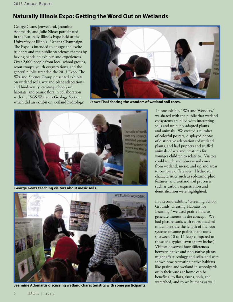
Best Management Practices: Water Pollution Control MeasuresBest Management Practice (BMP) is a term used to describe a type of water pollution control measure that can mitigate the quantity and quality of urban runoff into nearby streams within a watershed. Historically, BMPs referred to pollution control retention ponds used to mitigate industrial wastewater and city sewage; however, BMPs have expanded to include rain gardens, vegetated swales, constructed wetlands, green roofs, permeable paving, natural landscaping, and filter strips. This year INHS-IDOT botanists Benjamin Beas and Julie Nieset began first-year monitoring of 4 BMP projects located in and around the Chicago area. The BMPs used for these projects included rain gardens, vegetated swales, and constructed wetlands to provide local water quality treatment of storm water run-off from adjacent upland areas. All BMPs constructed by IDOT were seeded, sodded, and/or plugged with native wetland and upland species to encourage native species establishment as well as jump start the pollution control of these structures. Two of the projects also included Compensatory Storage Basins that provide offsetting floodplain storage for river bank overflow.
New Record of Ear-leafed Foxglove
Ear-leafed foxglove (Tomanthera auriculata), is an annual herb that has greatly declined in Illinois due to habitat loss. This state threatened plant is a partial parasite, sometimes attaching itself to the roots of other plants, especially those of the genus Aster. In Illinois, the ear-leafed foxglove is found in mesic prairies, thickets, savannas, woodland borders, abandoned fields, and along railroads. It is often found in disturbed areas, but is intolerant of frequent mowing and grazing. Tomanthera auriculata was found during wetland surveys in Will County for the Illiana Project, growing at the edge of a thicket in an old field. Ear-leafed foxglove (Tomanthera auriculata).
As of fall 2013, the only BMP site to have been fully constructed is near Warrenville in DuPage County. The first year of monitoring at this site determined that the Compensatory Storage Basin contained 89% composition of native species, a relatively high percentage following a first-year restoration. Even at this early stage, we observed a heron catching fish within the basin, mallards resting, and frogs on the mudflats around the wetland.
There are 7 rain gardens and vegetated swales as well as 2 compensatory storage basins along US 30 near Frankfort in Will County. While some portions were still being constructed as of the last monitoring date in September 2013, other vegetated swales and a compensatory basin are meeting at least some of the project performance criteria goals for the first year. The wetland basin portion of one BMP along the US 30, US45 to IL 43 site, exceeded performance criteria goals for 2013, growing American pondweed, small duckweed, smartweeds, and other wetland plants.
Dave Ketzner GPSing the boundary of a newly vegetated swale located at the Warrenville BMP along IL 56.
Vegetated swale (BMP #2) at the US 30, US 45 to IL 43 site, September 2013.
2013 Annual Repor t

5 2013 | IDOT
2013 Annual Repor t
Comparing Restoration Practices for Floodplain ForestIn July 2013, Susan McIntyre and Jeff Matthews conducted floristic surveys on the Joslin Mitigation Wetland Site near the Rock River. The site was designed in 1998 by Cassandra Rodgers of the IDOT District 2 office in Dixon, IL to compare 4 tree-planting methods to restore wet floodplain forest. The 15-acre site was divided into approximately 1-acre strips, each planted with 1 of 4 tree sizes (in order of cost per tree: balled and burlapped (BB) trees, bareroot (BR) trees, seedlings, and acorns) or left unplanted as a control. A mature wet floodplain forest partially surrounding the project provided a buffer and potential seed source.
IDOT mitigation site standards were followed for 5 years after establishment. Flooding, competition with invasive reed canarygrass (Phalaris arundinacea), and other environmental pressures took their toll. The unplanted and acorn plots failed to regenerate forest. Seedlings and BR trees fared better but required considerable replanting. BB trees exhibited the highest survivorship and grew the most quickly. BB trees were considerably larger than BR trees at planting; their larger size permitted wider spacing and fewer trees planted, so cost per acre was actually lower than with BR trees. After 5 years, researchers reported the BB trees “had the best success rate and were the easiest (cheapest) to maintain.” To make up for the lack of tree growth on the acorn plots, BB trees were planted on those plots as well.
We returned to the Joslin site to investigate how the treatments had fared after a 15-year timespan. We compared tree density, tree basal area, tree size distribution, plant species richness, and biomass of invasive reed canarygrass (RCG) in sample
Experimental treatments at the Joslin Mitigation Wetland Site.
Balled and burlapped tree treatment (2003).
Acorn planting treatment (2002).
Mature wet floodplain forest reference site (2012).
plots in each treatment and the reference forest. Higher-cost treatments had higher tree density, less RCG, and greater species richness, providing the highest quality restoration relative to the reference site. Planting large (BB) or moderately large, densely-spaced (BR) trees provided protection from invasive RCG and later shaded out the invasive species, presumably allowing higher species diversity. On the other hand, even after 15 years, treatment areas with lower-cost restoration methods continued to be dominated by dense, species-poor stands of reed canarygrass and few trees.
Forests take decades to establish, but mitigation policy requires replacement in a short time period. Although initial cost correlated positively with our measures of success, extra investment may only provide greater improvements up to a point. Our study lacked sufficient data to determine an investment optimum, but it provides valuable information as we continue assessing restoration methods.
2013 Annual Repor t
6 IDOT | 2013
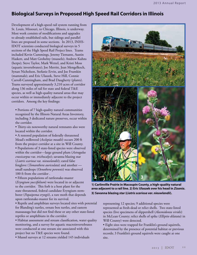
George Geatz, Jenwei Tsai, Jeannine Adomaitis, and Julie Nieset participated in the Naturally Illinois Expo held at the University of Illinois –Urbana Champaign. The Expo is intended to engage and excite students and the public on science themes by having hands-on exhibits and experiences. Over 2,000 people from local school groups, scout troops, youth organizations, and the general public attended the 2013 Expo. The Wetland Science Group presented exhibits on wetland soils, wetland plant adaptations and biodiversity, creating schoolyard habitats, and prairie flora in collaboration with the ISGS Wetlands Geology Section, which did an exhibit on wetland hydrology.
Naturally Illinois Expo: Getting the Word Out on Wetlands
In one exhibit, “Wetland Wonders,” we shared with the public that wetland ecosystems are filled with interesting soils and uniquely adapted plants and animals. We created a number of colorful posters, displayed photos of distinctive adaptations of wetland plants, and had puppets and stuffed animals of wetland creatures for younger children to relate to. Visitors could touch and observe soil cores from wetland, mesic, and upland areas to compare differences. Hydric soil characteristics such as redoximorphic features, and wetland soil processes such as carbon sequestration and denitrification were highlighted.
In a second exhibit, “Greening School Grounds: Creating Habitats for Learning,” we used prairie flora to generate interest in the concept. We had picture cards with ropes attached to demonstrate the length of the root systems of some prairie plant roots (between 10 to 15 feet) compared to those of a typical lawn (a few inches). Visitors observed how differences between native and non-native plants might affect ecology and soils, and were shown how recreating native habitats like prairie and wetland in schoolyards or in their yards at home can be beneficial to flora, fauna, soils, the watershed, and to we humans as well.
Jenwei Tsai sharing the wonders of wetland soil cores.
Jeannine Adomaitis discussing wetland characteristics with some participants.
George Geatz teaching visitors about mesic soils.

7 2013 | IDOT
2013 Annual Repor t
Plant ecologist Bill Handel and soil scientists Jenwei Tsai and Scott Wiesbrook shared their expertise with participants in the 33rd Annual Central States Forest Soils Workshop at Eagle Ridge Resort and Spa near Galena, Illinois, on 15–17 October. The workshop focused on sustainable practices relating to conservation, preservation, and restoration for private and local forest tracts with an appreciation for soil-landscape relationships. The 2013 workshop was sponsored by the Illinois Soils Classifiers Association; Jerry and Marge Misek, owners of Acorn Acres; Bill Handel and Vicki Stretton, who shared their private property and experience in restoration; Duck’s Misery water fowl refuge; and IDNR-Mississippi. One of the featured speakers at this year’s workshop, Bill Handel described the plant communities that were to be observed during the workshop, led discussions on forestry management and
Soil Science: Forest Soils Workshop and Soil Judging Competition
Mississippi Palisades State Park — Louis Point —Bill Handel, INHS Plant Ecologist, discusses plant ecology and Mississippi floodplain management.
Wetland botanist Julie Nieset coordinated construction of a small wetland at Dater Montessori Elementary School in Cincinnati, Ohio, in 2012. Details of this project were described in The INHS IDOT Programs Annual Report 2012. The wetland offers teachers an alternative classroom setting and a space to immerse students in nature-based learning. Students grew additional wetland plants to supplement the ones seeded and planted during construction, learned about wetland ecology, made observations about plants, and sampled macroinvertebrates. In a “Powered by Nature” camp in June 2013, 50 students from 5 Montessori schools studied macroinvertebrates in the wetland. Their survey indicated that after just 9 months, the wetland already supports a thriving community. Students will conduct surveys over successive years to compare how species composition and abundance change over time.
Update on Dater Schoolyard Wetland
Learning about aquatic macroinvertebrates at the Dater Schoolyard Wetland.
Jenwei Tsai, Scott Weisbrook, and Doug Gains (President, ISCA) totally digging the Forest Soils Workshop.
prairie remnant-forest ecology, and provided historical perspectives on how forest communities have changed over time in the understory as well as the tree stratum. Part of the workshop was spent at the Handel family property near Mississippi Palisades State Park, observing forest restoration on sites with and without prescribed burns.
Jenwei and Scott helped coach the University of Illinois Soil Judging Team this year as well. The team placed fourth at the American Society of Agronomy regional contest held in Stevens Point, WI. Scott also coached the Black Hawk College, East Campus (BHE) soil judging team to their fourth consecutive national championship at the contest in Lubbock, TX. A student from BHE won the individual national championship for the fifth straight year.

8 IDOT | 2013
Illinois MusselsOf the approximately 860 known species of freshwater mussels worldwide, 300 occur in the United States. As a result of anthropogenic changes to the environment, freshwater mussels are one of the most endangered groups of animals in North America. Illinois is or was home to 81 species, 18 of which are listed as State Endangered (some of which are also Federally Endangered) and 8 as Illinois Threatened. An additional 16 species are either extirpated (gone) from Illinois or are globally extinct. Freshwater mussels occur in almost all types of aquatic habitats, from ponds and lakes to creeks and rivers, but the vast majority (about 90%) are typically found in flowing waters. They also occur in varying substrate types; some prefer muddy, silty bottoms whereas others prefer gravelly or sandy streambeds.
Freshwater mussels have a parasitic life cycle that is unique among bivalves. The parasitic larval stage known as a glochidium (plural: glochidia) is released from the female via the excurrent aperature into the water column. Glochidia then attach to a host, typically a fish, undergo metamorphosis, and complete their development to juveniles. Amphibians also are rarely used as hosts. The degree of host specificity varies widely among species, from generalists to single-species specialists. Freshwater mussels exhibit a fantastic array of strategies and morphological adaptations to attract host fish and increase the likelihood of their larvae contacting a host. These include broadcasting glochidia, releasing bundles (conglutinates) of eggs and larvae that resemble food items, and host attraction through prey mimicry via elaborately evolved mantle modifications.
Saving Endangered Mussels
The recovery plan for the federally endangered northern riffleshell (Epioblasma rangiana) and clubshell (Pleurobema clava) included the Vermilion River in Illinois as a potential location for reintroduction. A bridge construction project on the Allegheny River in Pennsylvania, which could kill mussels underneath it, provided an opportunity for translocation of both species to Champaign and Vermilion counties. In cooperation with Pennsylvania state agencies and the U.S. Fish and Wildlife Service, INHS-IDOT scientists Jeremy Tiemann and Kevin Cummings collected and moved mussels in 2010, 2012, and 2013. All mussels were affixed with passive integrated transponder tags, which allowed researchers to monitor their fate. To date, 1,349 northern riffleshell and 958 lubshell have been translocated to 8 sites in the Vermilion River basin (5 in the Middle Fork and 3 in the Salt Fork). The detection rate per survey per site has varied from 18% to 100% for the northern
Freshwater mussels are filter-feeders and comparison of stable isotope ratios of freshwater mussel tissues with potential food sources indicate that the food they assimilate is derived from the fine particulate organic matter (bacteria and green algae) that they clear from the water. Freshwater mussels are among the most long-lived animals in the world, and most North American species are thought to live for decades. In general, thin-shelled species grow faster and have shorter life spans than thick-shelled species.
Freshwater mussels have been harvested for a variety of purposes by humans, including for food, buttons, natural pearls, and as seed material for commercial production of cultured pearls. They were collected and utilized by Native Americans, particularly the mound-building tribes of the Midwest as early as 5,400 years ago.
There are 4 species of exotic freshwater bivalves in Illinois (2 Asian clam species — Corbicula sp., and 2 zebra mussel species — Dreissena sp.). The opposite page shows 6 species of mussels native to Illinois.
Kevin Cummings and members of his lab are active in research examining the ecology, systematics, and conservation of Illinois mussels.
Austin Haskett, Kevin Cummings, Jeremy Tiemann, and Rachel Vinsel assessing survival of translocated mussels.
riffleshell and from 37% to 100% for the clubshell; 56% of the northern riffleshell and 78% of the clubshell located and examined were still alive. This project is funded, in part, by a natural resource damage assessment settlement (Hegeler Zinc—Lyondell Basell Companies) to the USFWS and the state of Illinois.
2013 Annual Repor t

9 2013 | IDOT
1) The spike (Elliptio dilatata) is an Illinois Threatened species. Historically widespread in Illinois, it is now only occasionally found in small to medium-sized streams in the Kankakee, Fox, Kaskaskia, Rock, and a few other drainages.
2) The butterfly (Ellipsaria lineolata) is an Illinois Threatened species found exclusively in large rivers and is now restricted tosmall sections of the Mississippi, Ohio, and Rock rivers.
3) The plain pocketbook (Lampsilis cardim) is one of the most widespread and common species of mussel in Illinois. It is typically found in medium to large rivers in mixed gravel, sand, and mud. It is one of the freshwater mussel species that uses a “lure” to attract a host fish.
4) The sheepnose (Plethobasus cyphyus) is a Federally Endangered species that at one time was widespread in Illinois but is now found only in the Mississippi, Kankakee, and Rock rivers.
5) The Higgins eye (Lampsilis higginsii) is a Federally Endangered mussel. Once found from Minnesota to southern Illinois, this mussel is now present only in parts of the Mississippi River in Jo Davies, Rock Island, and Whiteside counties.
6) The pink heelsplitter (Potamilus alatus) is one of the “winged” species found in Illinois. It also is found in medium to large rivers in gravel and mud substrates. This handsome species has a lustrous pink nacre that gives it its common name.
6
4
21
3
5
2013 Annual Repor t

2013 Annual Repor t
10 IDOT | 2013
INHS-IDOT scientists sampled fish communities at 16 sites in Whiteside, Lee, Winnebago, and Will counties during 2013. Forty-seven species of fish were recorded, including the state endangered weed shiner (Notropis texanus) and state threatened banded killifish (Fundulus diaphanus) at one location in the Rock River drainage in Whiteside County. Species diversity of fish at sampling sites ranged from 2 to 23 and was highly correlated with stream size. The banded killifish had not been collected from the Rock River drainage of Illinois in over 100 years and was thought to be extirpated from it. This record demonstrates that we still have much to learn about native fish communities in Illinois.
Water quality monitoring in streams associated with IDOT projects Water quality monitoring in aquatic habitats involves using a handheld multiprobe meter, calibrated prior to each sampling period, to measure ambient and water temperatures, dissolved oxygen (including % saturation), hydrogen ion concentration as pH, specific conductivity, total dissolved solids, salinity, and turbidity at each site. Raw water samples are collected in Nalgene, polyplastic, or glass bottles, preserved in the field following established protocols, placed on ice, then shipped the same day as collection to an independent environmental testing laboratory holding Environmental Laboratory Accreditation Program certification and listed as an approved laboratory by the Illinois EPA for additional chemical analyses. During 2013, water quality monitoring was conducted at 18 stream sites in Cook, Hancock, Will, and Winnebago counties.
Fish Surveys Uncover Species Thought Extirpated from Rock River
Dan Swanson taking water quality measurements in Will Co.
The INHS-IDOT Aquatic Zoology Group continues to provide leading experts on water quality, aquatic macroinvertebate, mussel, fish, crayfish, and herpetological assessment. During 2013, the group was assigned 5 herp projects, 17 fish and crayfish projects, 23 mussel projects, 8 macroinvertebrate projects, and 5 water-quality monitoring projects. The number of projects for all but herps increased considerably over previous years, with the numbers of mussel and fish surveys particularly high. The largest individual project was a second year of surveys for aquatic resources associated with streams within the 35-mile long Illiana Expressway Project corridor.
A total of 2,490 specimens of aquatic invertebrates was collected and identified in 2013, representing 4 phyla, 6 classes, 18 orders, 34 families, and >70 taxa. Three of the 5 herp projects pertained to estimating the distribution and abundance of crayfish burrows, which serve as hibernacula for the eastern massasauga rattlesnake, and did not require faunal surveys. Two turtle species, 1 snake species, 1 lizard species, and 3 frog species were recorded at the other 2 sites.
Aquatic Zoology Surveys in 2013
Numbers of projects completed by the Biological Surveys Program in 2013 separated by taxon.
Chris Taylor and Ben May seine-netting for fish.
2011 | IDOT
Body Text Body Text
2013 Annual Repor t
11 2013 | IDOT
Biological Surveys in Proposed High Speed Rail Corridors in Illinois
Development of a high-speed rail system running from St. Louis, Missouri, to Chicago, Illinois, is underway. Most work consists of modifications and upgrades to already established rails, but sidings and parallel lines are proposed in some sections. In 2013, INHS-IDOT scientists conducted biological surveys in 5 sections of the High Speed Rail Project lines. Teams included Kevin Cummings, Jeremy Tiemann, Austin Haskett, and Matt Grohelny (mussels); Andrew Kuhns (herps); Steve Taylor, Mark Wetzel, and Kristi Moss (aquatic invertebrates); Joe Merritt, Jean Mengelkoch, Synan Nicholson, Stefanie Ervin, and Joe Frumkin (mammals); and Eric Ulaszek, Steve Hill, Connie Carroll-Cunningham, and Brad Daugherty (plants). Teams surveyed approximately 3,210 acres of corridor along 136 miles of rail for state and federal T&E species, as well as high-quality natural areas that may occur within or immediately adjacent to the project corridors. Among the key findings:
• Portions of 7 high-quality natural communities recognized by the Illinois Natural Areas Inventory, including 3 dedicated nature preserves, occur within the corridor.• Thirty-six noteworthy natural remnants also were located within the corridor. • A restored population of federally threatened Mead’s milkweed (Asclepias meadii) occurs 200 ft from the project corridor at a site in Will County.• Populations of 3 state-listed species were observed within the corridor—large ground plum (Astragalus crassicarpus var. trichocalyx); savanna blazing star (Liatris scariosa var. nieuwlandii); eared false foxglove (Tomanthera auriculata) and another — small sundrops (Oenothera perennis) was observed 100 ft from the corridor .• Fifteen populations of rattlesnake-master (Eryngium yuccifolium) were located in or adjacent to the corridor. This forb is a host plant for the state threatened, federal candidate Eryngium stem-
1) Carlinville Prairie in Macoupin County, a high-quality natural area adjacent to a rail line. 2) Eric Ulaszek over his head in Zizania. 3) Savanna blazing star (Liatris scariosa var. nieuwlandii).borer (Papaipema eryngii), a rare moth that depends
upon rattlesnake-master for its survival. • Reptile and amphibian surveys located sites with potential for Blanding’s turtles, ornate box turtles, and eastern massasauga but did not find these or any other state-listed reptiles or amphibians in the corridor.• Habitat assessment and stream classification, water quality monitoring, and a survey for aquatic macroinvertebrates were conducted at one stream site associated with this project but no T&E species were found.• Mussel surveys at 12 streams yielded 145 individuals
representing 12 species; 9 additional species were represented as fresh-dead or relict shells. Two state-listed species (live specimens of slippershell (Alasmidonta viridis) in McLean County; relict shells of spike (Elliptio dilatata) in Will County) were detected.• Eight sites were trapped for Franklin’s ground squirrels, determined by the presence of potential habitat or previous records; 3 Franklin’s ground squirrels were caught at one site.
1
2 3

2013 Annual Repor t
12 IDOT | 2013
It was another busy year for summer bat surveys and it appears it is going to get even busier. This year the INHS-IDOT bat team had 10 bat projects, including one (Illiana) that involved mist netting 9 different sites. The increase in the number of bat projects can mostly be attributed to concern about White-Nose Syndrome (WNS). WNS is a disease caused by a species of fungus, Pseudogymnoascus destructans, which attacks bats while they are hibernating. The mortality rate in affected hibernacula can be >90%.
Bats
Franklin’s ground squirrels
The high speed rail corridor, Tier 4, runs from Pontiac to Lincoln, Illinois, a distance of about 70 miles. In spring 2013, the INHS-IDOT mammal group surveyed this rail corridor for the state threatened Franklin’s ground squirrel (Poliocitellus franklinii). We set Havahart live traps in suitable habitat along this corridor and ran each trap line for 4 days. We recorded weight, gender, and reproductive activity of all ground squirrels captured, as well as location of capture. We captured, marked, and released 3 females and 3 males, all residing along the railroad right-of-way. We attribute our trapping success to the use of generous amounts O-KE-DOKE cheese-flavored popcorn as bait.
Marsh rice ratsSeveral years ago, IL Route 146 was expanded into a 4-lane divided highway between IL 3 and the East Corporate limits of East Cape Girardeau. In 2008, prior to the expansion, the INHS-IDOT mammal group surveyed the site and found the state-threatened marsh rice rat (Oryzomys palustris). In accordance with the ITA agreement with IDNR, we trapped for marsh rice rats again in 2013 at the road site and the adjacent mitigation site. We set Sherman live traps in suitable habitat along the road and in the mitigation site and trapped for 3 nights. We captured 9 adult males, 8 adult females, and 5 juvenile females. Other species we caught included the deer mouse (Peromyscus maniculatus), house mouse (Mus musculus), and the prairie vole (Microtus ochrogaster).
As a result of the mass mortality, the number of hibernating bats has been declining dramatically. In October 2013, the U.S. Fish and Wildlife Service proposed to list the northern long-eared bat (NLEB; Myotis septentrionalis) as endangered under the Endangered Species Act. The NLEB is expected to be officially listed in the autumn of 2014.
Historically, the INHS-IDOT bat surveys have focused on the federally endangered Indiana bat. NLEBs and Indiana bats utilize similar summer maternity habitat, therefore, it is likely that survey protocols will be similar for both species. However, as bat populations decline in Illinois, survey protocols will become more intensive and time-consuming.
Hibernating tri-colored bats (Perimyotis subflavus).
Ed Heske and Joe Merritt swabbing hibernating bats for the WNS fungus.
Jean Mengelkoch shows off a Franklin’s ground squirrel (Poliocitellus franklinii).
Joe Merritt with a marsh rice rat (Oryzomys palustris).

2013 Annual Repor t
13 2013 | IDOT
Bird Surveys Focus on Bald Eagles and Wetland BirdsThe INHS-IDOT ornithology group worked on 7 bird projects in 2013. Additional surveys for Bald Eagles were conducted in the Illiana Project corridor, as well as near bridges along the Mississippi and Illinois Rivers adjacent to National Fish and Wildlife Refuges. The Upper Mississippi National Fish and Wildlife Refuge in Savanna, Illinois, is home to numerous nesting Bald Eagles. Unlike most other species that begin nesting in late spring and early summer, Bald Eagles will begin building new and revisiting old nests as early as October and November throughout Illinois. They are typically finished breeding by early to late June, unlike many other species that do not even begin breeding until that time.
The ornithology group continued their quest to document wetland species, many of which are Species in Greatest Need of Conservation in Illinois. Dave Enstrom surveyed the Eola and Night Heron marshes near the BNSF rail yard in Cook, DuPage, and Kane counties for nesting herons and egrets. Regrettably, none were found nesting at the marshes.
Wendy Schelsky continued the 4-season monitoring for the LaGrange Wetland Bank Site (LGWB) in Brown County, Illinois, along the Illinois and La Moine rivers. The site has been managed for over 10 years in hope of attracting nesting wetland and marsh birds. The LGWB is a 1,648-acre floodplain consisting of former agricultural land. In 2005, acreage in row crops was greatly reduced and annual herbaceous plants covered much of the previously tilled land. In 2006, wetland tree species were planted in many sections of old field. Planted trees had nearly zero survival due to above average flooding in the years following the planting. In 2011–2012, new raised gravel roads were added, areas were re-graded to maintain low-lying wet areas and hundreds of
The Biological Surveys and Assessment Program launched their new website in spring 2013. This site provides up-to-date information about staff, projects, research, and publications for the program. Each staff page includes contact information and areas of expertise for that person. A projects page highlights key recent or ongoing projects including significant assessment surveys, education and outreach, species conservation activities, and ongoing research. A research page lists key publications by people involved with the program. Publications are organized by topic and links are provided where possible. The website also includes an extensive photo gallery of people at work; plants, animals, and habitats observed in the field; and collections maintained by the program. Visit the website at: http://wwx.inhs.illinois.edu/research/biosurveys
Biological Surveys and Assessment Program Website Launched
new wetland tree species were planted throughout the site. Forested riparian corridors occur along the Illinois and La Moine rivers and a small section of upland forest is present in the southwest corner of the LGWB. The area also includes part of Big Lake (a shallow body of open water) and several drainage ditches. One hundred sixty-six bird species have been documented at the site since monitoring began in 2000. The goal of establishing wetland/marshland bird communities has been slow to develop because of significant flooding in 2010, 2011, and 2013 that scoured established marsh vegetation. These floods, although detrimental to the development of marsh habitat, have been attractive to many migrating shorebirds and waterbirds and provide great stopover habitat for these species. Species of interest found at the site in 2013 included Least Terns, Common Terns, Black-bellied Plovers, Ruddy Turnstone, Short- and Long-billed Dowitchers, American White Pelicans, Bald Eagles, and Northern Harriers. Grassland habitat at LGWB also has been productive for Dickcissels and has attracted a few Grasshopper Sparrows.
The new Biological Surveys and Assessment Program home page.
Bald Eagles (Haliaeetus leucocephalus) are becoming more common in Illinois.

14 IDOT | 2013
WILL COUNTY
KANKAKEE COUNTY
Jordan Creek
Forked Creek
Kankakee R
iver
Trim
Cre
ek
Rock C
reek
Blac
k W
alnu
t Cre
ek
Pike
Cre
ek
South Branch Forked Creek
Addendum A
Addendum B
Addendum C
Addendum D
The Illiana Expressway is a proposed toll road that would connect Interstate 65 in northwest Indiana to Interstate 55 in northeast Illinois. Within Illinois, the Illiana Project area encompassed approximately 17,350 acres, with all but 38 acres occurring in Will County. During the 2012 and 2013 growing seasons, INHS scientists with the IDOT Wetlands and Biological Surveys groups searched this area intensively for threatened and endangered plants and animals, wetlands, and high-quality remnant natural communities. Deposits of wind-blown sand characterize much of the region in which the Illiana study area is located, and several unique habitats occur here.
FishesWho: Chris Taylor, Jeremy Tiemann, Stephanie Kilburn, Austin Haskett, Andrew StitesPerson days: 16What we found: We collected a total of 43 fish species in 9 families. None of the species we collected were listed as threatened or endangered and all of them were common inhabitants of north central Illinois streams.
HerpetofaunaWho: Andy Kuhns, Jeremy Tiemann, Chris PhillipsPerson Days: 16, including 1,667 hours of turtle trapping and 1,287 hours of amphibian trapping.What we found: 4 amphibian and 5 reptile species, including the state endangered Blanding’s turtle (Emydoidea blandingii). The state threatened mudpuppy was also detected but it was outside of the impact area.
Mammals Who: Joe Merritt and Jean Mengelkoch, with assistance from hourly staff, volunteers, and members of the Wetlands GroupPerson Days: 91What we found: We surveyed for the state threatened Franklin’s ground squirrel and the federally endangered Indiana bat within the project corridor and at nearby Will County Forest Preserves, and we surveyed for Indiana bat habitat within the corridor. No threatened or endangered species were found, but one thirteen-lined ground squirrel and three species of bats were caught, including the northern long-eared bat, which has since been proposed for listing as endangered. Habitat assessment for the northern long-eared bat was conducted throughout the project corridor in conjunction with a consulting company.
I l l i a n a E x p r e s s w a y
Person day:
1 person in the field for 1 day; excludes all work done in the office or lab
BirdsWho: Dave EnstromPerson days: 12What we found: Recent Bald Eagle nest sites were identified within and near the proposed corridor, but no nests are currently active in the area. IDOT, USFW, and ILEPA were consulted concerning the potential for the Illiana Expressway to contribute to noise pollution at the Midewin National Tallgrass Prairie. The species of primary concern at Midewin is the Loggerhead Shrike (state endangered), but a number of species of conservation concern are common at the site. A long-term study of Loggerhead Shrikes at Midewin will allow us to address this question. In cooperation with Dr. Amy Chabot (Eastern Loggerhead Shrike Recovery, Canada) and T. J. Benson (INHS) we will examine nest placement and nesting success of the Midewin Loggerhead Shrikes with regard to anthropogenic noise sources. This will be among the first studies to look at the effects of large and persistent changes in the soundscape on a songbird species.

15 2013 | IDOT
WILL COUNTY
KANKAKEE COUNTY
Jordan Creek
Forked Creek
Kankakee R
iver
Trim
Cre
ek
Rock C
reek
Blac
k W
alnu
t Cre
ek
Pike
Cre
ek
South Branch Forked Creek
Addendum A
Addendum B
Addendum C
Addendum D
Botanical Surveys Who: Michael MurphyPerson Days: 55What we found: • Approximately 650 vascular plant species (553 native and 97 non-native)• Nearly 7.5 acres of grade A, B, and C remnant prairie habitats• Approximately 11 acres of grade A and B natural areas (remnant prairie and woodland bluff communities) identified that were also habitat to threatened and endangered species• New populations of 4 threatened and endangered species, including forked aster (Aster furcatus), grass pink orchid (Calopogon tuberosus), tubercled orchid (Platanthera flava var. herbiola), and eared false foxglove (Tomanthera auriculata)• Populations of 2 vascular plant species previously unknown to the Chicago Region: awned sand oval sedge (Carex straminea) and small buttercup (Ranunculus pusillus), and a large population one sedge hybrid previously unknown from Illinois (Carex straminea X C. longii)
Water Quality and Aquatic Invertebrates Who: Mark Wetzel and Steve TaylorPerson Days: 34What we found: We completed habitat assessments and stream characterizations, and we conducted water quality monitoring and surveys for aquatic macroinvertebrates at 17 stream sites. A total of 2,520 aquatic macroinvertebrates representing 6 phyla, 8 classes, 21 orders, 45 families, and over 90 species were identified. While several taxa represent new county records, most are common to streams in north central Illinois, and none are listed as endangered or threatened. Water quality monitoring includes measurement for 10 field parameters, and the collection of water samples for laboratory analyses (40 organic and inorganic constituents, including metals). Additional water quality monitoring was also conducted at 3 of these sites during the winter months to document changes in water quality resulting from the application of de-icing compounds to highways near Wilmington.
WetlandsWho: Brian Wilm, Scott Wiesbrook, and 16 othersPerson Days: Several hundredWhat we found: We surveyed 448 sites, where we found 285 wetlands and 77 waters of the United States. Wetland types included wetland pond, farmed wetland, wet shrubland, wet floodplain forest, forested wetland, wet meadow, marsh, sedge meadow, wet forbland, and seep. Waters types included stream, river, lake, non-wetland pond, and drainage ditch. We found 3 state-threatened species: eared false foxglove (Tomanthera auriculata), forked aster (Aster furcatus), and Blanding’s turtle (Emydoidea blandingii). We also collected a specimen of the federally endangered sheepnose (Plethobasus cyphyus).
Mussels Who: Kevin Cummings and Jeremy TiemannPerson days: Approximately 15What we found: 24 live species. Two additional species, spike (Elliptio dilatata — a state threatened species) and lilliput (Toxolasma parvum), were only represented by dead or relict shells. Three live state-listed species were found: black sandshell (Ligumia recta), purple wartyback (Cyclonaias tuberculata) and slippershell (Alasmidonta viridis). Subsequent to our survey, members of the INHS wetlands group collected mussel shells from a site on the Kankakee River, including a specimen of the federally endangered sheepnose (Plethobasus cyphyus). Tissue was still attached to the adductor scars and along the edge of the shell, indicating that it was recently alive and probably died within the previous few weeks.

IDOT | 2011
Body Text
Body text
With Illinois having such a long and extensive history of natural resource inventory and documentation, it is sometimes easy to think that few new discoveries pertaining to the state’s flora and fauna remain to be made. However, surveys within IDOT project areas frequently yield new and often surprising data that vastly increase our knowledge and understanding of Illinois’ natural heritage. Discoveries can include new populations of T&E species (often new county records), species unknown from particular regions of the state, species previously unknown to the entire state, and species historically documented from Illinois but believed extirpated.
During our botanical surveys of the Illiana Expressway corridor, several new botanical discoveries were made, including:
New Botanical Discoveries in the Illiana Expressway Corridor
Figure 1 a. Specimen of small spearwort (Ranunculus pusillus), a species known to occur in southern Illinois, but unknown from the Chicago Region; 1b. Sandy wetland habitat where this species was found in the Illiana project area.
Figure 2 a. One of the sand prairie habitats where this species was found; 2 b. Specimen of awned oval sedge (Carex straminea), a rare sedge species within Illinois, and a species for which very little is known. Previously unknown from the Chicago Region, 3 populations of this species were found in the Illiana project area, occurring in high-quality, remnant sand communities
2a 2b
1b
1a
2013 Annual Repor t
16 IDOT | 2013

2011 | IDOT
Body Text Body Text
Figure 3 a. Specimen of the state threatened forked aster (Aster furcatus) from a new and relatively large population of this species found within the Illiana project area, along the bluffs of the Kankakee River (Fig. 3 b).
Figure 4 a. Photograph of a population of Carex straminea X C. longii occurring in a high-quality remnant sand prairie community; 4 b. Specimen of a rare, un-named hybrid sedge Carex straminea X C. longii, from a population found in the Illiana project area. Previously unknown from Illinois, both parents of this hybrid occur in sand habitats within the state, and C. straminea is very rare.
Figure 5. The state- endangered grass pink orchid (Calopogon tuberosus); 1 new population of this species was found within the Illiana project area on the margins of a high-quality remnant sand prairie community.
Figure 6. The state-threatened ear-leaved false foxglove (Tomanthera auriculata); 1 new population of this species was found within the Illiana project area, on the margin of a degraded wetland.
17 2013 | IDOT
2013 Annual Repor t
5 6
3a
3b
4a
4b

2013 Annual Repor t
18 IDOT | 2013
The INHS-IDOT botany group has conducted surveys for high-quality natural communities and threatened or endangered plant species in nearly all of the 102 counties in Illinois for 30 years. Currently, there are 332 plant species listed as threatened or endangered in Illinois, including 9 federally listed species. A total of 126 T&E taxa have been documented from IDOT project areas, or about 38% of all listed species. Although wetland habitats are often a focus of botanical surveys, a slightly greater proportion of the T&E species discovered are upland species. Thus far, 62 (49%) of the T&E plants found on IDOT project sites are upland species, 57 (45%) are classified as wetland species, and an additional 7 (5.6%) are equally likely to occur in wetland or upland habitats. Fifteen taxa documented from project areas have been delisted by the Illinois Endangered Species Protection Board primarily because they were found to be more common than previously believed. Botanical surveys not only provide the opportunity to avoid or minimize impacts to rare species but also improve our understanding of the distribution and ecology of native species, including documenting a few never before known from Illinois.
30 Years of Discovery: Threatened and Endangered Plants in IDOT Project Areas
Figure 1. Examples of threatened and endangered species encountered in IDOT project areas throughout Illinois including a) pink milkwort (Polygala incarnata), b) queen-of-the-prairie (Filipendula rubra), c) Illinois flatsedge (Cyperus grayioides), d) shining false indigo (Amorpha nitens), e) Sangamon phlox (Phlox pilosa ssp. sangamonensis).
1a 1b
1c
1d 1e

2013 Annual Repor t
T&E species encountered in IDOT project areas not only are from a wide range of habitats, but also from a wide range of taxonomic groups including 52 plant families. Chief plant families include the sedges (Cyperaceae), with 21 threatened and endangered species (15 in the genus Carex); the aster family (Asteraceae), with 9 taxa; 8 orchids (Orchidaceae); 7 legumes (Fabaceae); 6 grasses (Poaceae); and 5 members each from the figwort (Scrophulariaceae) and rose (Rosaceae) families.
While the state list of T&E species is longer, there often is a focus on federally listed species. During the 1990s, searches for the decurrent false aster (Boltonia decurrens), a species that is largely restricted to wetlands along the Illinois River, were emphasized. More recently, emphasis has been on the eastern prairie fringed orchid (Platanthera leucophaea) and we are working to refine search criteria for this seldom-seen orchid.
19 2013 | IDOT
Figure 3. Examples of species discovered new to the Illinois flora from populations in IDOT project areas: a) Arkansas sedge (Carex arkansana), b) Crawford’s sedge (Carex crawfordii), and c) white nymph (Trepocarpus aethusae).
Figure 2. Decurrent false aster (Boltonia decurrens) is a species nearly limited to wetland habitats along the Illinois River and listed as threatened by the U.S. Fish and Wildlife Service and Illinois Endangered Species Protection Board.
2
3a 3b
3c

18 IDOT | 2013
2013 Annual Repor t 4b
2013 Annual Repor t
IDOT | 201320
Figure 4. Examples of species formerly listed as state threatened or endangered but which have been delisted by the Illinois Endangered Species Board because they were found to be more common than previously believed including: a) wheat sedge (Carex atherodes), b) goldenseal (Hydrastis canadensis), c) ginseng (Panax quinquefolia), and d) Hill’s thistle (Cirsium hillii).
4a 4c 4d
4b

2011 | IDOT
Body Text Body TextThe eastern prairie fringed orchid (Platanthera leucophaea, EPFO), listed as threatened by the U.S. Fish and Wildlife Service, occurs in a variety of prairie and wetland habitats. The orchid historically was documented from 31 counties in the northern half of Illinois. Since 2002, however, only 34 occurrences in 10 counties in northeastern Illinois have been recorded. The USFWS recognizes that highly degraded wetlands likely will not support this species. Consequently, criteria suggested by the USFWS for determining survey sites include a Floristic Quality Index > 20 or Mean Coefficient of Conservatism > 3.5 and presence of 4 or more recognized associate species from a list of 23. EPFO survey protocols require searches of each qualifying site during 3 nonconsecutive days throughout the blooming period, usually 26 June to 11 July in northeastern Illinois. INHS-IDOT botanists have conducted EPFO surveys at 42 IDOT project areas, mostly in Cook, Kane, Lake, McHenry, and Will counties. Despite intensive survey efforts, searches at 41 of the 42 project areas, with a multitude (> 200) of qualifying wetland and prairie habitats, have yet to discover any individuals of the EPFO (the lone exception is a project within the Eastern Prairie Fringed Orchid Nature Preserve where the species was already known to occur).
In Search of Practical Search Criteria for the Eastern Prairie Fringed Orchid
What explains the failure to uncover additional populations of the EPFO? Is it because most populations are already known and it is simply a very rare species, are the search criteria employed by the USFWS too broad, or both? There are 2 FQA programs in Illinois, the original method designed explicitly for the Chicago region and a revised method intended for statewide application. The USFWS bases their EPFO survey criteria on the Chicago Region Method and does not account for non-native species in the FQA calculations. Wetland species in the Chicago region rank significantly higher than the statewide values, leading to a potential wetland bias in northeastern Illinois where the great majority of EPFO surveys are conducted. Discounting non-native species also creates the potential to qualify highly degraded sites with small populations of just 4 EPFO associates for surveys. While it is good to be cautious when evaluating habitat potential for rare species, it may be more productive to focus more clearly on habitats with greater floristic integrity. Until new populations of the eastern prairie fringed orchid are discovered and their habitats evaluated, determining optimal search criteria will continue to be elusive.
Degraded marsh habitat strongly dominated by the adventive narrow-leaved cat-tail (Typha anustifolia) and reed canary grass (Phalaris arundinacea) yet meeting the minimum U.S. and Fish and Wildlife Service qualitative criteria for eastern prairie fringed orchid surveys.
Eastern prairie fringed orchid (Platanthera leucophaea) is an orchid of wetland and prairie habitats primarily in northeastern Illinois listed as threatened by the U.S. Fish and Wildlife Service and endangered by the Illinois Endangered Species Protection Board.
21 2013 | IDOT
2013 Annual Repor t4b

• In 2013, 15 INHS-IDOT scientists published 29 papers in peer-reviewed journals, and 16 scientists presented or co-authored 40 invited seminars or oral presentations and posters at scientific conferences. Scientists also participated in dozens of educational events and gave presentations to public groups interested in conservation.
• Kevin Cummings received the Outstanding Public Servant Award for 2013 from the Prairie Rivers Network.
• Mark Wetzel received the Society for Freshwater Science Distinguished Service Award, recognizing members who have made a genuine and lasting contribution to the betterment of the Society.
• The following INHS-IDOT scientists serve as Technical Expert Consultants to the Illinois Endangered Species Protection Board: Kevin Cummings, Jeremy Tiemann, Ed Heske, Joe Merritt, Paul Marcum, Loy R. Phillippe, Steve Taylor. John Taft serves on the Board.
• Paul Marcum and Connie Carroll-Cunningham served on the Board of the Illinois Native Plant Society. Connie also is President of the Forest Glen Chapter of the Illinois Native Plant Society and Membership Chair and Past President of the state board.
• Kevin Cummings served on the Illinois Wildlife Preservation Fund Review Committee.
• Joe Merritt served a third year as Editor of the Journal of Mammalogy, the primary publication of the American Society of Mammalogists.
• Mark Wetzel was reappointed as Associate Editor of Megadrilogica, the journal of oligochaete biology, for the years 2013 and 2014; he also serves as the journal’s webmaster.
• Julie Nieset was elected to a 2-year term as Secretary-Treasurer for the Society of Wetland Scientists North Central Chapter.
• Ed Heske served as President of the American Society of Mammalogists.
• Scott Wiesbrook served as Finance Committee Chair and was elected Vice President of the Illinois Soil Classifiers Association.
• Jeremey Tiemann served on the American Fisheries Society’s Endangered Species Committee and chaired the Ictalurid Technical Committee of the North-Central Division of the American Fisheries Society.
• Jeremy Tiemann served as co-chair of the Freshwater Mollusk Conservation Society’s Gastropod Distribution and Status Committee, and is on the Editorial Board for Walkerania, the publication of the Freshwater Mollusk Conservation Society.
• Mark Wetzel and Dr. John Reynolds (Oligochaetology Lab, Kitchener, Ontario, Canada) launched the 2nd edition of Nomenclatura Oligochaetologica - Editio Secunda, a global, web-based catalog of oligochaete worms, including names, descriptions, and type specimens.
• Scott Wiesbrook coached the Black Hawk College Soil Judging Team to their 4th consecutive national championship; a BHC team member also won high individual for the 5th consecutive year.
• Jenwei Tsai taught the soil judging course at the University of Illinois in spring 2013, and was joined by Scott Wiesbrook and George Geatz in fall 2013. The UIUC soil judging team placed 11th nationally in the spring and 4th regionally in the fall.
• John Taft and Ed Heske were elected to the UIUC List of Teachers Ranked as Excellent by their students for classes taught in 2013.
• Jenwei Tsai became faculty advisor for the UIUC Soil and Water Conservation Student Chapter.
2 0 1 3 M i l e s t o n e s a n d C h a n g e s
2013 Annual Repor t
IDOT | 201322

Bibl iography
Geatz, G., D. Ketzner, S. McIntyre, and D. Skultety. 2013. Wetland delineation report: IL 9 (FAP 685), Hancock County, Illinois. INHS/IDOT Wetlands Vegetation and Soils Program Report 2013 (23):1–13.
Geatz, G., D. Ketzner, J. Tsai, and D. Skultety. 2013. Wetland delineation report: IL 108 (FAP 769), Montgomery County, Illinois. INHS/IDOT Wetlands Vegetation and Soils Program Report 2013 (104):1–16.
Geatz, G., P. Marcum, B. Beas, and B. Zercher. 2013. Wetland delineation report: IL 132 (FAP 541), Addendum B, Lake County, Illinois. INHS/IDOT Wetlands Vegetation and Soils Program Report 2013 (5):1–25.
Geatz, G., P. Marcum, B. Beas, and B. Zercher. 2013. Wetland delineation report: US 54 (Bridge over Miss. River), Pike County, Illinois. INHS/IDOT Wetlands Vegetation and Soils Program Report 2013 (20):1–66.
Geatz, G., P. Marcum, B. Beas, and B. Zercher. 2013. Wetland delineation report: IL 132 (FAP 541) at Fairfield Road, Addendum C, Lake County, Illinois. INHS/IDOT Wetlands Vegetation and Soils Program Report 2013 (47):1–35.
Geatz, G., V. Sivicek, D. Ketzner, and D. Skultety. 2013. Wetland delineation report: IL 13 (FAP 331), Jackson and Williamson counties, Illinois. INHS/IDOT Wetlands Vegetation and Soils Program Report 2013 (59):1–46.
Engelhardt, M., G. Geatz, Z. Pleasant, and B. Zercher. 2013. Wetland delineation report: IL 47 (FAP 326) from I-74 north to US 136, Champaign County, Illinois. INHS/IDOT Wetlands Vegetation and Soils Program Report 2013 (60):1–33.
Engelhardt, M., J. Kurylo, Z. Pleasant, and B. Zercher. 2013. Wetland delineation report: Union Pacific Railroad, Chenoa to Bloomington, McLean and Livingston counties, Illinois. INHS/IDOT Wetlands Vegetation and Soils Program Report 2013 (81):1–30.
Engelhardt, M., J. Kurylo, and D. Skultety. 2013. Wetland delineation report: Union Pacific RR (IL HSR), Dwight to Pontiac, Livingston County, Illinois. INHS/IDOT Wetlands Vegetation and Soils Program Report 2013 (39):1–34.
Engelhardt, M., J. Tsai, and B. Zercher. 2013. Wetland delineation report: Old Galena Road and State Street (CH 60R&CH 59R), Peoria County, Illinois. INHS/IDOT Wetlands Vegetation and Soils Program Report 2013 (83):1–26.
Geatz, G., B. Beas, P. Marcum, and D. Skultety. 2013. Wetland delineation report: Deerpath Road (FAP 346) from US 41 to Skokie River, Lake County, Illinois. INHS/IDOT Wetlands Vegetation and Soils Program Report 2013 (33):1–19.
Geatz, G., B. Beas, and B. Zercher. 2013. Wetland delineation report: CH 7 (FAS 1600) over Bear Creek, Adams County, Illinois. INHS/IDOT Wetlands Vegetation and Soils Program Report 2013 (87):1–15.
Technical Reports Submitted by the Wetland Science Program, 2013
Beas, B., P. Marcum, D. Keene, and B. Zercher. 2013. Wetland mitigation monitoring report: IL 146 (FAP 312) Cape Girardeau Site, 2012 year, Alexander County, Illinois. INHS/IDOT Wetlands Vegetation and Soils Program Report 2013 (12):1–39.
Beas, B., G. Geatz, and B. Zercher. 2013. Wetland delineation report: East Side Highway, Addendum C, McLean County, Illinois. INHS/IDOT Wetlands Vegetation and Soils Program Report 2013 (75):1–17.
Beas, B., G. Geatz, B. Zercher, and D. Keene. 2013. Wetland delineation report: US 66 (FAS 1488), McLean County, Illinois. INHS/IDOT Wetlands Vegetation and Soils Program Report 2013 (79):1–18.
Beas, B., J. Tsai, P. Marcum, B. Zercher, and D. Szafoni. 2013. Wetland delineation report: US 20 (FAP 345) & Addendum C, Kane County, Illinois. INHS/IDOT Wetlands Vegetation and Soils Program Report 2013 (36):1–40.
Beas, B., J. Tsai, B. Zercher, and P. Marcum. 2013. Wetland delineation report: US 34 (FAP 591), Kendall County, Illinois. INHS/IDOT Wetlands Vegetation and Soils Program Report 2013 (29):1–26.
2013 | IDOT 23
• Jeannie Barnes taught ornithology and nature interpretation, Eric Ulaszek and Rick Phillippe taught about prairies, and Scott Wiesbrook taught the soils section for various Illinois Master Naturalists classes.
• Paul Marcum was promoted to Assistant Project Leader for Botany in the Wetlands Science Program, and Brian Wilm was promoted to Project Leader.
• Jessie Kurylo left the Wetlands Science Program to begin studies for a PhD at the University of Melbourne, Australia. Good luck, Jessie!
• Christine Bertz left the Biological Surveys Program Botany Group and is now a Research Associate at the University of Memphis.
• George Geatz began study for a PhD and Dennis Skultety began study for a MS degree in the Department of Natural Resources and Environmental Science at the University of Illinois.
• Eric Ulaszek joined the Biological Surveys Program Botany Group and Vince Hamer joined the INHS-IDOT Program as a Natural Resources Surveys Coordinator.

IDOT | 2011
Bibl iography
Ketzner, D., D. Keene, and B. Zercher. 2013. Wetland delineation report: CR 1100 N (TR 383) over Little Dry Fork, Wayne County, Illinois. INHS/IDOT Wetlands Vegetation and Soils Program Report 2013 (53):1–23.
Ketzner, D., D. Keene, and B. Zercher. 2013. Wetland delineation report: Village of Williamsville Railroad Overpass, Sangamon County, Illinois. INHS/IDOT Wetlands Vegetation and Soils Program Report 2013 (106):1–21.
Ketzner, D., J. Tsai, D. Skultety, and B. Wilm. 2013. Wetland delineation report: Illinois Route 47 (FAP 326) at O’Brien/Vanderkarr Road and Thayer Road, McHenry County, Illinois. INHS/IDOT Wetlands Vegetation and Soils Program Report 2013 (69):1–52.
Kurylo, J., M. Engelhardt, S. McIntyre, and B. Zercher. 2013. Wetland delineation report: Stevens Creek Bikeway, Addendum A, Macon County, Illinois. INHS/IDOT Wetlands Vegetation and Soils Program Report 2013 (37):1–35.
Kurylo, J., W. Handel, S. McIntyre, P. Marcum, B. Wilm, S. Wiesbrook, and D. Szafoni. 2013. Wetland delineation report: IL 47 (FAP 326), Addendum B, Reed Road to US 14, McHenry County, Illinois. INHS/IDOT Wetlands Vegetation and Soils Program Report 2013 (64):1–84.
Kurylo, J., J. Nieset, and D. Skultety. 2013. Wetland delineation report: TR 426, Wayne County, Illinois. INHS/IDOT Wetlands Vegetation and Soils Program Report 2013 (26):1–28.
Kurylo, J., S. McIntyre, W. Handel, and B. Zercher. 2013. Wetland delineation report: Union Pacific Railroad —Wilmington to Braidwood, Will County, Illinois. INHS/IDOT Wetlands Vegetation and Soils Program Report 2013 (82):1–141.
Kurylo, J., S. McIntyre, and D. Skultety. 2013. Wetland delineation report: Farnam Station Road (TR 275), Edgar County, Illinois. INHS/IDOT Wetlands Vegetation and Soils Program Report 2013 (22):1–20.
Keene, D., S. McIntyre, and B. Zercher. 2013. Wetland delineation report: Wyanet Connection to Rock Island on IAIS Railroad, Addendum B, Rock Island, Henry, and Bureau counties, Illinois. INHS/IDOT Wetlands Vegetation and Soils Program Report 2013 (89):1–83.
Keene, D., S. McIntyre, B. Zercher, M. Engelhardt, D. Ketzner, J. Nieset, P. Marcum, and D. Skultety. 2013. Wetland delineation report: Wyanet Connection to Rock Island on IAIS RR, Rock Island, Henry, and Bureau counties, Illinois. INHS/IDOT Wetlands Vegetation and Soils Program Report 2013 (15):1–316.
Keene, D., V. Sivicek, S. McIntyre, and D. Skultety. 2013. Wetland delineation report: Wasson Road (CH 36) from Thomas Road to Raleigh Road, Saline County, Illinois. INHS/IDOT Wetlands Vegetation and Soils Program Report 2013 (25):1–50.
Ketzner, D., G. Geatz, S. McIntyre, and B. Zercher. 2013. Wetland delineation report: North 450th Road (FAS 435) over a branch of Troublesome Creek, McDonough County, Illinois. INHS/IDOT Wetlands Vegetation and Soils Program Report 2013 (44):1–13.
Ketzner, D., D. Keene, and D. Skultety. 2013. Wetland delineation report: I-70 (FAP 999) east of the Poplar Street Bridge, St. Clair County, Illinois. INHS/IDOT Wetlands Vegetation and Soils Program Report 2013 (88):1–50.
Ketzner, D., D. Keene, and B. Zercher. 2013. Wetland mitigation monitoring report: FAP 14 (Eckmann/Bischoff), 2012 year, Madison County, Illinois. INHS/IDOT Wetlands Vegetation and Soils Program Report 2013 (10):1–33.
Ketzner, D., D. Keene, and B. Zercher. 2013. Wetland mitigation monitoring report: Fairmont City Wetland Compensation Site, 2012 year, St. Clair County, Illinois. INHS/IDOT Wetlands Vegetation and Soils Program Report 2013 (11):1–32.
Ketzner, D., D. Keene, and B. Zercher. 2013. Wetland delineation report: U.S. Route 50 (FAP 327) over Big Muddy Creek, Clay, and Richland counties, Illinois. INHS/IDOT Wetlands Vegetation and Soils Program Report 2013 (52):1–47.
Handel, W., J. Kurylo, S. McIntyre, and B. Zercher. 2013. Wetland delineation report: Chapman Lane (TR 293) over Crane Creek, Schuyler County, Illinois. INHS/IDOT Wetlands Vegetation and Soils Program Report 2013 (71):1–14.
Handel, W., J. Kurylo, and B. Zercher. 2013. Wetland delineation report: US 52 (FAS 169) over Little Vermilion River, LaSalle County, Illinois. INHS/IDOT Wetlands Vegetation and Soils Program Report 2013 (55):1–20.
Handel, W., S. McIntyre, J. Tsai, and B. Zercher. 2013. Wetland delineation report: New Avenue (FAU 361), Will County, Illinois. INHS/IDOT Wetlands Vegetation and Soils Program Report 2013 (84):1–26.
Handel, W., J. Tsai, B. Zercher, and B. Beas. 2013. Wetland delineation report: US 6 (FAU 297) at Gougar Road, Will County, Illinois. INHS/IDOT Wetlands Vegetation and Soils Program Report 2013 (21):1–25.
Handel, W., S. Wiesbrook, S. McIntyre, and B. Zercher. 2013. Wetland delineation report: US 20 and IL 73, Jo Daviess and Stephenson counties, Illinois. INHS/IDOT Wetlands Vegetation and Soils Program Report 2013 (85):1–46.
Keene, D., D. Ketzner, P. Marcum, and B. Zercher. 2013. Wetland mitigation monitoring report: Harrisburg Site 2, FAP 857 (IL 14), Fox River Bridge replacement, 2012 year, Saline County, Illinois. INHS/IDOT Wetlands Vegetation and Soils Program Report 2013 (3):1–42.
Keene, D., D. Ketzner, and B. Zercher. 2013. Wetland delineation report: County Highway 9 (Wringe Road), Clinton County, Illinois. INHS/IDOT Wetlands Vegetation and Soils Program Report 2013 (28):1–19.
Keene, D., D. Ketzner, and B. Zercher. 2013. Wetland delineation report: IL 130 (FAP 116), Edwards County, Illinois. INHS/IDOT Wetlands Vegetation and Soils Program Report 2013 (51):1–14.
Keene, D., P. Marcum, D. Skultety, and W. Handel. 2013. Wetland delineation report: DuPage River Trail, Will County, Illinois. INHS/IDOT Wetlands Vegetation and Soils Program Report 2013 (73):1–22.
24 IDOT | 2013

2011 | IDOT
Bibl iography
25 2013 | IDOT
Kurylo, J., J. Zylka, P. Marcum, and B. Zercher. 2013. Wetland mitigation monitoring report: Swan Road (TR 222), 2012 year, Perry County, Illinois. INHS/IDOT Wetlands Vegetation and Soils Program Report 2013 (1):1–26.
Marcum, P., G. Geatz, B. Beas, and D. Skultety. 2013. Wetland delineation report: US 30 (FAP 573) from Dugan Road to IL 47, Kane County, Illinois. INHS/IDOT Wetlands Vegetation and Soils Program Report 2013 (78):1–116.
Marcum, P., G. Geatz, B. Zercher, and B. Beas. 2013. Wetland delineation report: IL 131 (FAP 880/2711), Addendum A, Lake County, Illinois. INHS/IDOT Wetlands Vegetation and Soils Program Report 2013 (38):1–113.
Marcum, P., J. Kurylo, J. Zylka, and B. Zercher. 2013. Wetland mitigation monitoring report: FAS 864 (Pyatt’s Blacktop) Pyramid Monitoring Site EC25, 2012 year, Perry County, Illinois. INHS/IDOT Wetlands Vegetation and Soils Program Report 2013 (9):1–44.
Marcum, P., J. Tsai, and B. Zercher. 2013. Wetland delineation report: Lewis University Airport, Will County, Illinois. INHS/IDOT Wetlands Vegetation and Soils Program Report 2013 (103):1–28.
Marcum, P., S. Wiesbrook, and D. Skultety. 2013. Wetland delineation report: Metropolis Municipal Airport, Addendum A, Massac County, Illinois. INHS/IDOT Wetlands Vegetation and Soils Program Report 2013 (48):1–14.
Marcum, P., S. Wiesbrook, and D. Skultety. 2013. Wetland delineation report: TR 78A over Whiteside Branch, Pope County, Illinois. INHS/IDOT Wetlands Vegetation and Soils Program Report 2013 (77):1–15.
Marcum, P., S. Wiesbrook, D. Szafoni, B. Zercher, and D. Skultety. 2013. Wetland delineation report: U.S. 51 (FAP 322), Addendum D, Christian, Shelby, Fayette, Marion, Clinton, and Washington counties, Illinois. INHS/IDOT Wetlands Vegetation and Soils Program Report 2013 (4):1–168.
McIntyre, S., G. Geatz, D. Ketzner, and D. Skultety. 2013. Wetland delineation report: US 136 (FAP 315), Hancock County, Illinois. INHS/IDOT Wetlands Vegetation and Soils Program Report 2013 (32):1–41.
McIntyre, S., G. Geatz, D. Ketzner, and B. Zercher. 2013. Wetland delineation report: US 24 (FAP 317) at tributary to Crooked Creek, Schuyler County, Illinois. INHS/IDOT Wetlands Vegetation and Soils Program Report 2013 (35):1–18.
McIntyre, S., D. Keene, D. Ketzner, and B. Zercher. 2013. Wetland delineation report: CH R40 (FAS 383) — Princeville/Jubilee Road over Kickapoo Creek, Peoria County, Illinois. INHS/IDOT Wetlands Vegetation and Soils Program Report 2013 (108):1–13.
McIntyre, S., D. Keene, V. Sivicek, and D. Skultety. 2013. Wetland mitigation monitoring report: former Weber property — US 20 (FAP 301) Freeport Bypass West, 2012 year, Stephenson County, Illinois. INHS/IDOT Wetlands Vegetation and Soils Program Report 2013 (7):1–22.
McIntyre, S., D. Keene, and B. Zercher. 2013. Wetland delineation report: TR 474A over Shaw Point Branch, Macoupin County, Illinois. INHS/IDOT Wetlands Vegetation and Soils Program Report 2013 (90):1–18.
McIntyre, S., J. Kurylo, W. Handel, and B. Zercher. 2013. Wetland delineation report: IL 60/83 (FAP 335), Addendum A, Lake County, Illinois. INHS/IDOT Wetlands Vegetation and Soils Program Report 2013 (74):1–81.
Nieset, J., D. Keene, D. Skultety, and M. Engelhardt. 2013. Wetland delineation report: Prairie Fields Trail, Champaign County, Illinois. INHS/IDOT Wetlands Vegetation and Soils Program Report 2013 (61):1–56.
Nieset, J., J. Kurylo, and B. Zercher. 2013. Wetland delineation report: TR 114 over Prairie Creek, White County, Illinois. INHS/IDOT Wetlands Vegetation and Soils Program Report 2013 (40):1–23.
Nieset, J., J. Kurylo, and B. Zercher. 2013. Wetland delineation report: TR 124 over Prairie Creek, White County, Illinois. INHS/IDOT Wetlands Vegetation and Soils Program Report 2013 (41):1–26.
Nieset, J., J. Tsai, D. Ketzner, and D. Skultety. 2013. Wetland delineation report: I-70 (FAP 999), St. Clair County, Illinois. INHS/IDOT Wetlands Vegetation and Soils Program Report 2013 (68):1–51.
Plocher, A., I. Draheim, D. Ketzner, D. Skultety, and S. Wiesbrook. 2013. Wetland delineation report: IL 132/Des Plaines River (FAP 0541), Lake County, Illinois. INHS/IDOT Wetlands Vegetation and Soils Program Report 2013 (66):1–48.
Sivicek, V., I. Draheim, G. Geatz, J. Zylka, D. Ketzner, and B. Zercher. 2013. Wetland delineation report: IL 161 (FAP 805) over Crooked Creek, Clinton County, Illinois. INHS/IDOT Wetlands Vegetation and Soils Program Report 2013 (56):1–44.
Sivicek, V., G. Geatz, and D. Skultety. 2013. Wetland delineation report: US 20 (FAP 525) at West Union Road and at Coral Road, McHenry County, Illinois. INHS/IDOT Wetlands Vegetation and Soils Program Report 2013 (58):1–31.
Sivicek, V., G. Geatz, D. Skultety, and B. Zercher. 2013. Wetland delineation report: North Garden Prairie Road (FAS 1030), Boone County, Illinois. INHS/IDOT Wetlands Vegetation and Soils Program Report 2013 (80):1–32.
Sivicek, V., D. Keene, S. McIntyre, and B. Zercher. 2013. Wetland delineation report: Makanda Road (FAS 919), Jackson County, Illinois. INHS/IDOT Wetlands Vegetation and Soils Program Report 2013 (16):1–16.
Sivicek, V., D. Ketzner, D. Keene, J. Kurylo, S. McIntyre, D. Skultety, and D. Szafoni. 2013. Wetland delineation report: US 50 (FAP 327), Lawrence and Richland counties, Illinois. INHS/IDOT Wetlands Vegetation and Soils Program Report 2013 (14):1–513.

Bibl iography
26 IDOT | 2013
Wiesbrook, S., M. Engelhardt, and B. Zercher. 2013. Mitigation site assessment: US 45 (FAP 332), Saline County, Illinois. INHS/IDOT Wetlands Vegetation and Soils Program Report 2013 (109):1–47.
Wiesbrook, S., W. Handel, S. McIntyre, and D. Skultety. 2013. Wetland delineation report: CH 51 (Canal Road) over Walbridge Creek, LaSalle County, Illinois. INHS/IDOT Wetlands Vegetation and Soils Program Report 2013 (54):1–18.
Wiesbrook, S., W. Handel, S. McIntyre, and B. Zercher. 2013. Wetland delineation report: Wyanet Connection, Addendum E, Bureau County, Illinois. INHS/IDOT Wetlands Vegetation and Soils Program Report 2013 (67):1–24.
Wiesbrook, S., J. Nieset, and D. Skultety. 2013. Wetland delineation report: I-74/I-57 (FAI 74/57), Champaign County, Illinois. INHS/IDOT Wetlands Vegetation and Soils Program Report 2013 (30):1–69.
Wiesbrook, S., P. Marcum, and D. Skultety. 2013. Wetland delineation report: TR 221 over Lower Sandy Slough, White County, Illinois. INHS/IDOT Wetlands Vegetation and Soils Program Report 2013 (70):1–19.
Wiesbrook, S., P. Marcum, D. Skultety, B. Beas, and B. Wilm. 2013. Wetland delineation report: US 30 (FAP 349) (Baseline Road), Kane and Kendall counties, Illinois. INHS/IDOT Wetlands Vegetation and Soils Program Report 2013 (50):1–84.
Wiesbrook, S., P. Marcum, and B. Zercher. 2013. Wetland delineation report: TR 94 (Farthing Road) over Turkey Creek, Marion County, Illinois. INHS/IDOT Wetlands Vegetation and Soils Program Report 2013 (72):1–17.
Wiesbrook, S., V. Sivicek, and B. Zercher. 2013. Wetland delineation report: North CR 2400 E (CH 3) over Polecat Creek, Coles County, Illinois. INHS/IDOT Wetlands Vegetation and Soils Program Report 2013 (92):1–14.
Sivicek, V., S. Wiesbrook, D. Ketzner, M. Engelhardt, and B. Zercher. 2013. Wetland mitigation monitoring report: Max Creek, 2012 year, Johnson County, Illinois. INHS/IDOT Wetlands Vegetation and Soils Program Report 2013 (13):1–24.
Sivicek, V., S. Wiesbrook, B. Wilm, and D. Skultety. 2013. Wetland mitigation monitoring report: I-57/TR 1000 N Interchange, 2012 year, Coles County, Illinois. INHS/IDOT Wetlands Vegetation and Soils Program Report 2013 (8):1–34.
Sivicek, V., S. Wiesbrook, and B. Zercher. 2013. Wetland delineation report: North 1200th Street (TR 158) and Addendum A, Edgar County, Illinois. INHS/IDOT Wetlands Vegetation and Soils Program Report 2013 (95):1–28.
Skultety, D., G. Geatz, and V. Sivicek. 2013. Wetland delineation report: Telegraph Road (FAS 1057), Winnebago County, Illinois. INHS/IDOT Wetlands Vegetation and Soils Program Report 2013 (57):1–20.
Skultety, D., W. Handel, D. Keene, and P. Marcum. 2013. Wetland delineation report: Bell Road/143rd Street (FAP 0356/FAU 1600) Intersection, Addendum A, Will County, Illinois. INHS/IDOT Wetlands Vegetation and Soils Program Report 2013 (76):1–34.
Skultety, D., D. Keene, and V. Sivicek. 2013. Wetland delineation report: CH 4 (FAS 531) Monticello Road, Piatt County, Illinois. INHS/IDOT Wetlands Vegetation and Soils Program Report 2013 (17):1–9.
Skultety, D., J. Nieset, and J. Tsai. 2013. Wetland delineation report: IL 143 (FAP 793) over Shoal Creek, Bond County, Illinois. INHS/IDOT Wetlands Vegetation and Soils Program Report 2013 (101):1–25.
Tsai, J., W. Handel, B. Beas, B. Zercher, and D. Skultety. 2013. Wetland delineation report: TR 105 (Spring Road) over Mazon River, Grundy County, Illinois. INHS/IDOT Wetlands Vegetation and Soils Program Report 2013 (19):1–18.
Tsai, J., D. Ketzner, G. Geatz, and D. Skultety. 2013. Wetland delineation report: Greenmount Road (FAU 9170), St. Clair County, Illinois. INHS/IDOT Wetlands Vegetation and Soils Program Report 2013 (97):1–15.
Tsai, J., D. Ketzner, D. Skultety, P. Marcum, J. Nieset, W. Handel, B. Wilm, D. Szafoni, B. Beas, G. Geatz, and S. McIntyre. 2013. Wetland delineation report: I-55 (FAI 55) from I-355 to I-94, Will, DuPage, and Cook counties, Illinois. INHS/IDOT Wetlands Vegetation and Soils Program Report 2013 (91):1–582.
Tsai, J., D. Ketzner, B. Wilm, and B. Zercher. 2013. Wetland delineation report: Cumberland Road (SBI 11A) over Embarras River Overflow, Cumberland County, Illinois. INHS/IDOT Wetlands Vegetation and Soils Program Report 2013 (46):1–23.
Tsai, J., J. Nieset, and D. Skultety. 2013. Wetland delineation report: 500 North Road (TR 361) over Mitchell Creek, Shelby County, Illinois. INHS/IDOT Wetlands Vegetation and Soils Program Report 2013 (96):1–16.
Tsai, J., J. Nieset, and D. Skultety. 2013. Wetland delineation report: Falcon Road over Little Beaucoup Creek, Perry County, Illinois. INHS/IDOT Wetlands Vegetation and Soils Program Report 2013 (102):1–16.
Tsai, J., S. McIntyre, D. Skultety, and B. Zercher. 2013. Wetland delineation report: IL 120 (FAP 342), O’Plaine Road to Knight Avenue, Lake County, Illinois. INHS/IDOT Wetlands Vegetation and Soils Program Report 2013 (6):1–61.
Tsai, J., B.Wilm, I. Draheim, W. Handel, and B. Zercher. 2013. Wetland delineation report: US 20 (FAP 301), Jo Daviess County, Illinois. INHS/IDOT Wetlands Vegetation and Soils Program Report 2013 (105):1–25.
Wiesbrook, S., B. Beas, and D. Skultety. 2013. Wetland delineation report: CH 1 (FAS 519) Dewey Fisher Road, Champaign County, Illinois. INHS/IDOT Wetlands Vegetation and Soils Program Report 2013 (100):1–19.

27 2013 | IDOT
Bibl iography
Wiesbrook, S., B. Wilm, S. Benton, and B. Zercher. 2013. Wetland mitigation monitoring report: FAU 5822 (Milan Beltway), Rock Island Site, 2012 year, Rock Island County, Illinois. INHS/IDOT Wetlands Vegetation and Soils Program Report 2013 (2):1–43.
Wiesbrook, S., B. Wilm, and B. Zercher. 2013. Wetland delineation report: Union Pacific Railroad, Logan, Sangamon, and Macoupin counties, Illinois. INHS/IDOT Wetlands Vegetation and Soils Program Report 2013 (24):1–41.
Wiesbrook, S., B. Wilm, and B. Zercher. 2013. Wetland delineation report: IL 100 (FAP 304) over Otter Creek, Jersey County, Illinois. INHS/IDOT Wetlands Vegetation and Soils Program Report 2013 (62):1–18.
Wilm, B., J. Tsai, D. Ketzner, D. Skultety, and B. Zercher. 2013. Wetland delineation report: US 14 (FAP 066) over Lawrence Creek Tributary, McHenry County, Illinois. INHS/IDOT Wetlands Vegetation and Soils Program Report 2013 (43):1–24.
Wilm, B., J. Tsai, D. Ketzner, and B. Zercher. 2013. Wetland delineation report: 300 N (FAS 1697) over Honey Creek, Crawford County, Illinois. INHS/IDOT Wetlands Vegetation and Soils Program Report 2013 (45):1–25.
Wilm, B., J. Tsai, B. Zercher, and G. Geatz. 2013. Wetland delineation report: IL 92 (FAP 599), Andalusia to IL 192, Rock Island County, Illinois. INHS/IDOT Wetlands Vegetation and Soils Program Report 2013 (93):1–29.
Wilm, B., J. Tsai, B. Zercher, and D. Ketzner. 2013. Wetland delineation report: TR 215 over Leineke Branch, Brown County, Illinois. INHS/IDOT Wetlands Vegetation and Soils Program Report 2013 (99):1–19.
Wilm, B., S. Wiesbrook, P. Marcum, and B. Zercher. 2013. Wetland delineation report: IL 72 (FAP 341) Higgins Road 2.3 miles east of IL 47, Kane County, Illinois. INHS/IDOT Wetlands Vegetation and Soils Program Report 2013 (49):1–27.
Wilm, B., S. Wiesbrook, D. Szafoni, and P. Marcum. 2013. Wetland delineation report: Illiana Corridor, Addendum C, Will County, Illinois. INHS/IDOT Wetlands Vegetation and Soils Program Report 2013 (63):1–175.
Wilm, B., S. Wiesbrook, D. Szafoni, V. Sivicek, and B. Zercher. 2013. Wetland delineation report: Illiana Corridor, Addendum D, Will County, Illinois. INHS/IDOT Wetlands Vegetation and Soils Program Report 2013 (86):1–28.
Wilm, B., S. Wiesbrook, D. Szafoni, J. Tsai, D. Ketzner, J. Kurylo, P. Marcum, J. Nieset, M. Engelhardt, S. McIntyre, B. Beas, D. Skultety, G. Geatz, B. Zercher, V. Sivicek, J. Adomaitis, W. Handel, and I. Draheim. 2013. Wetland delineation report: Illiana, Will County, Illinois. INHS/IDOT Wetlands Vegetation and Soils Program Report 2013 (42):1–1505.
Wilm, B., S. Wiesbrook, and B. Zercher. 2013. Wetland delineation report: Gentry Road (TR 360) over East Branch Kaskaskia River, Marion County, Illinois. INHS/IDOT Wetlands Vegetation and Soils Program Report 2013 (31):1–23.
Zercher, B., B. Beas, and G. Geatz. 2013. Wetland delineation report: Old Dam Road (SBI 1) over Little Vermilion River, Vermilion County, Illinois. INHS/IDOT Wetlands Vegetation and Soils Program Report 2013 (98):1–23.
Zercher, B., B. Beas, and G. Geatz. 2013. Wetland delineation report: Union Pacific Railroad, East Jackson Street to I 80, Will County, Illinois. INHS/IDOT Wetlands Vegetation and Soils Program Report 2013 (94):1–10.
Zercher, B., B. Beas, D. Keene, and P. Marcum. 2013. Wetland delineation report: South County Line Road (FAU 6779), Knox and Warren counties, Illinois. INHS/IDOT Wetlands Vegetation and Soils Program Report 2013 (18):1–19.
Zercher, B., B. Beas, J. Tsai, and P. Marcum. 2013. Wetland delineation report: Farrell Road (TR 246) over Spring Creek, Will County, Illinois. INHS/IDOT Wetlands Vegetation and Soils Program Report 2013 (65):1–22.
Zercher, B., W. Handel, D. Keene, and D. Ketzner. 2013. Wetland delineation report: US 66 (FAS 1488 and FAS 294), McLean County, Illinois. INHS/IDOT Wetlands Vegetation and Soils Program Report 2013 (27):1–26.
Zercher, B., D. Ketzner, and J. Tsai. 2013. Wetland delineation report: CH D29 (Brimfield-Jubilee Road), Peoria County, Illinois. INHS/IDOT Wetlands Vegetation and Soils Program Report 2013 (34):1–14.
Zercher, B., P. Marcum, and J. Tsai. 2013. Wetland delineation report: CH 17 (FAU 4300) over North Branch of Grant Creek, Will County, Illinois. INHS/IDOT Wetlands Vegetation and Soils Program Report 2013 (107):1–20.
Technical Reports Submitted by the Biological Surveys and Assessment Program, 2013
Bertz, C.A., W.C. Handel, and S.R. Hill. 2013. Botanical survey of Wyanet Connection to Rock Island on IAIS Railroad, MP 131 to 181 (Sequence #17345) Bureau, Henry, and Rock Island counties. INHS/IDOT Statewide Biological Survey & Assessment Program Report 2013(4):1–14.
Cummings, K.S., C.A. Taylor, and J.S. Tiemann. 2013. Survey for freshwater mussels and fishes in the Kishwaukee River at the North Garden Prairie Road (IDOT FAS 1030) Bridge, Boone County, Illinois. INHS/IDOT Statewide Biological Survey & Assessment Program Report 2013(76):1–13.
Cummings, K.S., and J.S. Tiemann. 2013. A limited assessment of the unionid mussel fauna associated with streams in the IDOT Illiana Expressway Project corridor in Will County, Illinois. INHS/IDOT Statewide Biological Survey & Assessment Program Report 2013(15):1–24.
Cummings, K.S., and J.S. Tiemann. 2013. Survey for the state threatened black sandshell (Ligumia recta) in the Rock, Kishwaukee, Leaf, and Kyte rivers, Illinois. INHS/IDOT Statewide Biological Survey & Assessment Program Report 2013(28):1–12.

28 IDOT | 2013
Cummings, K.S., and J.S Tiemann. 2013. Survey for freshwater mussels in Kilbuck Creek at the proposed Edson Road (IDOT TR 59, 59A, MS 800) Bridge site, Ogle/Winnebago counties, Illinois. INHS/IDOT Statewide Biological Survey & Assessment Program Report 2013(83):1–8.
Cummings, K.S., and J.S Tiemann. 2013. Survey for freshwater mussels of the Mississippi River at the Savanna- Sabula U.S. 53 / IL 64 (IDOT FAP 17) Bridge, Carroll County, Illinois. INHS/IDOT Statewide Biological Survey & Assessment Program Report 2013(91):1–13.
DeWalt, R.E., A.D. Yanahan, and S.J. Taylor. 2013. Survey of stoneflies (Insecta: Plecoptera) of the Kankakee River within the IDOT Illiana Expressway Project corridor northwest of Wilmington in Will County, Illinois. INHS/IDOT Statewide Biological Survey & Assessment Program Report 2013(17):1–11.
Dietrich, C.H. 2013. A limited assessment of endangered and threatened insects associated with the IDOT Illiana Expressway Project corridor in Will County, Illinois. INHS/IDOT Statewide Biological Survey & Assessment Program Report 2013(13):1–6.
Enstrom, D.A. 2013. US 54 (FAP 321), US 54 bridge at Louisiana, SN 075-9900 over the Mississippi River, Job No.: D-96-165-10 (Seq. No.: 17263), Contract No.: 72D37, Pike County. INHS/IDOT Statewide Biological Survey & Assessment Program Report 2013(38):1–13.
Enstrom, D.A. 2013. Illiana Corridor Addendum C, I-5 at Wilmington to Indiana state line, 099-0001, 099-0002, 099-0151, 099-0193, 099-0240, 099-0241, 099-0305, 099-2000, 099-4641; Job No.: P-91-749-10 (Seq. No.: 16651C); Will, Kankakee, Grundy, and Kendall counties. INHS/IDOT Statewide Biological Survey & Assessment Program Report 2013(50):1–5.
Enstrom, D.A. 2013. (Illiana Corridor), Addendum B, I-55 at Wilmington to Indiana State Line, Job No.: P-91-749-10 (Seq. No.: 16651B); Will, Kankakee, Grundy, and Kendall counties. INHS/IDOT Statewide Biological Survey & Assessment Program Report 2013(53):1–3.
Enstrom, D.A. 2013. Avian assessment, including additional surveys for Bald Eagles, Illiana Corridor, Addendum D, from I-55 @ Wilmington to Indiana state line, Will County (Seq. No.: 16651D). INHS/IDOT Statewide Biological Survey & Assessment Program Report 2013(75):1–4.
Handel, W.C., and C.A. Bertz. 2013. High-Speed Rail Chicago to St. Louis, Auburn to Lincoln (Tier 3) and Lincoln to Pontiac (Tier 4): Botanical survey, Sangamon, Logan, McLean, and Livingston counties. INHS/IDOT Statewide Biological Survey & Assessment Program Report 2013(11):1–25.
Hill, S.R. 2013. Results of searches for eastern prairie fringed orchid (Platanthera leucophaea) at IL 31 (FAU 336), Addendum C, Bull Valley Road to IL 176, Job No: P-91-135-99, Sequence # 1340C, McHenry County, Illinois. INHS/IDOT Statewide Biological Survey & Assessment Program Report 2013(33):1–21.
Hill, S.R. 2013. Results of botanical surveys at IL 13 (FAP 331) east of Giant City Road in Carbondale to Shawnee Trail west of Carterville, Job No: C-99-023-12, Sequence No. 17931, Jackson and Williamson Counties, Illinois. INHS/IDOT Statewide Biological Survey & Assessment Program Report 2013(49):1–38.
Hill, S.R. 2013. Botanical survey and results of eastern prairie fringed orchid and Eryngium yuccifolium searches at the UPRR—High Speed Rail project, West Coal City Road (MP 54.85) in Wilmington to Main Street (MP 57.31) in Braidwood, Seq. No. 17985, Will County, Illinois (Revised). INHS/IDOT Statewide Biological Survey & Assessment Program Report 2013(82):1–58.
Hill, S.R. 2013. Botanical survey of the US 20 and IL 73 (FAP 301 & FAS 1087) Project corridor 0.2 miles west of Jo Daviess County line to 0.4 miles west of Flansburg Road, Job No. P-92-081-09 (Seq. No.: 17856), Jo Daviess and Stephenson Counties, Illinois. INHS/IDOT Statewide Biological Survey & Assessment Program Report 2013(89):1–45.
Bibl iography
Johnson, K.P. . 2013. Bird survey, Illiana Corridor, I-55 to I-65, Job No: P-91-749-10 (Seq. No.: 16651), Will, Kankakee, Grundy, and Kendall counties. INHS/IDOT Statewide Biological Survey & Assessment Program Report 2013(1):1–9.
Kuhns, A.R. 2013. An assessment of the herpetofaunal species associated with the IDOT Illiana Expressway Project corridor in Will County, Illinois. INHS/IDOT Statewide Biological Survey & Assessment Program Report 2013(14):1–28.
Kuhns, A.R. 2013. Herpetofaunal resources of the UPRR—High Speed Rail corridor from West Coal City Road (MP 54.85) in Wilmington to East Main Street (MP 57.31) in Braidwood, Will County, Illinois. INHS/IDOT Statewide Biological Survey & Assessment Program Report 2013(57):1–27.
Kuhns, A.R. 2013. Post construction monitoring of massasauga rattlesnake habitat along the Cisco-Monticello Road (IDOT FAS 1531), Piatt County, Illinois. INHS/IDOT Statewide Biological Survey & Assessment Program Report 2013(61):1–17.
Kuhns, A.R. 2013. Surveys for eastern massasauga rattlesnake habitat along U.S. Route 50 (IDOT FAP 327) from Huey Road to Creek Road, Clinton County, Illinois. INHS/IDOT Statewide Biological Survey & Assessment Program Report 2013(85):1–12.
Kuhns, A.R. 2013. Eastern massasauga rattlesnake habitat along IL-47 from Cisco to Monticello (IDOT FAS 1531), Piatt County, Illinois. INHS/IDOT Statewide Biological Survey & Assessment Program Report 2013(92):1–14.
Mengelkoch, J.M., and S. Ervin. 2013. Indiana bat habitat assessment, IL 161 (FAP 805), 7BR, over Crooked Creek, 8.6 miles east of IL 127, Job No.: D-98-024-05 (Seq. No.: 15667B), Contract No.: 76887, Clinton County. INHS/IDOT Statewide Biological Survey & Assessment Program Report 2013(59):1–18.

Bibl iography
29 2013 | IDOT
Mengelkoch, J.M., and S. Ervin. 2013. Indiana bat habitat assessment, IL 100 (FAP 304), 4-BY, 4B-1, Bridge over Otter Creek, Job No.: D-98-053-13 (Seq. No.: 17977), Contract No.: 76G49, Jersey County. INHS/IDOT Statewide Biological Survey & Assessment Program Report 2013(62):1–15.
Mengelkoch, J.M., and S. Ervin. 2013. Indiana bat survey, US-66 (FAS 1488), (17, B2) BR, Station 157+00 to Station 162+50, 057-0003, Job No.: C-95-054-06 (Seq. No.: 17998), Contract No.: 70534, McLean County. INHS/IDOT Statewide Biological Survey & Assessment Program Report 2013(67):1–16.
Mengelkoch, J.M., S. Ervin, and S. Nicholson. 2013. Memorandum: Indiana bat and Franklin’s ground squirrel survey at Eastside Highway, Addendum C, I-55 near Towanda to I-74 southeast of Bloomington, IL, Sequence No. 16141C, McLean County, IL. INHS/IDOT Statewide Biological Survey & Assessment Program Report 2013:1.
Mengelkoch, J.M., S. Ervin, and S. Nicholson. 2013. Gentry Road (TR 360) Indiana bat habitat assessment, TR 360 crosses East Branch Kaskaskia River, Structure No.: 061-3150 (Seq. No.: 17776), Marion County, Illinois. INHS/IDOT Statewide Biological Survey & Assessment Program Report 2013(10):1–13.
Mengelkoch, J.M., S. Ervin, and S. Nicholson. 2013. Indiana bat habitat assessment, TR 114, Section 06-09122-00-BR, SN 097-3058 over Prairie Creek, Seq. No.: 17820, White County. INHS/IDOT Statewide Biological Survey & Assessment Program Report 2013(36):1–15.
Mengelkoch, J.M., S. Ervin, and S. Nicholson. 2013. Indiana bat habitat assessment, TR 124, Section 10-09127-00-BR, SN 097-3061 over Prairie Creek, Seq. No.: 17821, White County. INHS/IDOT Statewide Biological Survey & Assessment Program Report 2013(37):1–14..
Mengelkoch, J.M., and J.F. Merritt. 2013. Franklin’s ground squirrel habitat assessment, Illiana Corridor, I-55 to I-65, Job No.: P-92-749-20 (Seq. Nos.: 16651A and 16651B), Will, Kankakee, Grundy, and Kendall counties. INHS/IDOT Statewide Biological Survey & Assessment Program Report 2013(19):1–10.
Mengelkoch, J.M., and J.F. Merritt. 2013. Franklin’s ground squirrel trapping survey, Illiana Corridor, I-55 to I-65, Job No.: P-92-749-20 (Seq. Nos.: 16651A and 16651B), Will, Kankakee, Grundy, and Kendall counties. INHS/IDOT Statewide Biological Survey & Assessment Program Report 2013(8):1–13.
Mengelkoch, J.M., and J.F. Merritt. 2013. Indiana bat survey, Illiana Corridor, Addendum C, I-55 at Wilmington to Indiana state line, 099-0001, 099-0002, 099-0151, 099-0193, 099-0240, 099-0241, 099-0305, 099-2000, 099-4641, Job No.: P-91-749-10 (Seq. No.: 16651C), Will, Kankakee, Grundy, and Kendall counties. INHS/IDOT Statewide Biological Survey & Assessment Program Report 2013(52):1–7.
Mengelkoch, J.M., and J.F. Merritt. 2013. Indiana bat habitat assessment, Illiana Corridor, Addendum D, I-55 at Wilmington to Indiana state line, Job No.: P-91-749-10 (Seq. No.: 16651D), Will County. INHS/IDOT Statewide Biological Survey & Assessment Program Report 2013(68):1–5.
Mengelkoch, J.M., J.F. Merritt, S. Nicholson, S. Ervin, and J. Frumkin. 2013. Franklin’s ground squirrel surveys, High Speed Rail, Tier 4, Pontiac, IL to Lincoln, IL, Livingston, McLean, and Logan counties. INHS/IDOT Statewide Biological Survey & Assessment Program Report 2013(25):1–24.
Mengelkoch, J.M., J.F. Merritt, S. Nicholson, J. Frumkin, and S. Ervin. 2013. Indiana bat survey, Illiana Corridor, I-55 to I-65, Job No.: P-92-749-20 (Seq. No.: 16651A and 16651B), Will, Kankakee, Grundy, and Kendall counties. INHS/IDOT Statewide Biological Survey & Assessment Program Report 2013(31):1–35.
Merritt, J.F. 2013. Habitat assessment results for the Indiana bat (Myotis sodalis) in the 1200 East Road (TR 158), 11-14126-00-BR, Sta 2+50 to Sta 17-00, 023-5300, Seq. No.: 18015, Illinois Department of Transportation (IDOT) project area, Edgar County, IL. INHS/IDOT Statewide Biological Survey & Assessment Program Report 2013(42):1–13.
Merritt, J.F. 2013. Habitat assessment results for the Indiana bat (Myotis sodalis) at the St. Louis Regional Airport (Seq. No.: 17441A), Illinois Department of Transportation (IDOT) project area, Madison County, IL. INHS/IDOT Statewide Biological Survey & Assessment Program Report 2013(39):1–15.
Merritt, J.F. 2013. Habitat Assessment Results for the Indiana bat (Myotis sodalis), in the Old Dam Road (SBI 1), S26R, 092--0098, Job No: C-95-031-13, Seq. No.: 18022, Contract No.:70A41, Illinois Department of Transportation (IDOT) project area, Vermilion County, IL. INHS/IDOT Statewide Biological Survey & Assessment Program Report 2013(41):1–12.
Merritt, J.F. 2013. Indiana bat habitat assessment, SN 075-9900 over the Mississippi River, US 54 (FAP 321), Seq. No.: 17263, Pike County. INHS/IDOT Statewide Biological Survey & Assessment Program Report 2013(43):1–13.
Merritt, J.F., and J.M. Mengelkoch. 2013. Indiana bat survey, Illiana Corridor, I-55 to I-65, Job No.: P-92-749-20 (Seq. No.: 16651A), Will, Kankakee, Grundy, and Kendall counties. INHS/IDOT Statewide Biological Survey & Assessment Program Report 2013(3):1–34.
Merritt, J.F., and J.M. Mengelkoch. 2013. Indiana bat habitat assessment, Wyanet Connection, BNSF and IAIS Railroads, Chicago to Iowa City, Seq. No.: 15795,Bureau County. INHS/IDOT Statewide Biological Survey & Assessment Program Report 2013(7):1–16.

30 IDOT | 2013
Bibl iography
Merritt, J.F., and J.M. Mengelkoch. 2013. Franklin’s ground squirrel trapping survey, Illiana Corridor, Addendum C, I-55 @ Wilmington to Indiana State Line, 099-001, 099-0002, 099-0151, 099-0193, 099-0240, 099-0241, 099-0305, 099-2000, 099-4641, Job No.: P-91-749-10 (Seq. No.:16651C), Contract No.:, Will, Kankakee, Grundy, and Kendall counties. INHS/IDOT Statewide Biological Survey & Assessment Program Report 2013(54):1–8.
Merritt, Joseph F., and J.M. Mengelkoch. 2013. Franklin’s ground squirrel habitat assessment Illiana Corridor, Addendum D, I-55 @ Wilmington to Indiana state line, 099-001, 099-0002, 099-0151, 099-0193, 099-0240, 099-0241, 099-0305, 099-2000, 099-4641, Job No.: P-91-749-10 (Seq. No.:16651D), Contract No.:, Will County. INHS/IDOT Statewide Biological Survey & Assessment Program Report 2013(63):1–3.
Merritt, J.F., S. Nicholson. 2013. Crawford County Airport, Job No: (Seq. No: 17698A), City of Robinson, Crawford County, IL. INHS/IDOT Statewide Biological Survey & Assessment Program Report 2013(40):1–16.
Merritt, J.F., S. Nicholson. 2013. Prairie Fields Trail, 13-00024-00-BT, Colbert Park to Curtis Road and Wesley Ave to 1st Street, Seq. No.:17956, Contract No.: NA, Champaign County, IL. INHS/IDOT Statewide Biological Survey & Assessment Program Report 2013(44):1–9.
Murphy, M.J.C. 2013. U.S. Route 51 (FA 322), Addendum D, EIS, botanical survey and assessment of additional areas along U.S. Route 51, occurring in Christian, Shelby, Fayette, Marion, Clinton, Washington, and Jefferson counties, Illinois. INHS/IDOT Statewide Biological Survey & Assessment Program Report 2013(2):1–29.
Murphy, M.J.C., and J.L. Jarvis. 2013. Botanical survey and assessment of the IDOT Illiana Study Area (2012 Survey Area and 2013 Addendum B), in Will and Kankakee counties, Illinois. INHS/IDOT Statewide Biological Survey & Assessment Program Report 2013(18):1–120.
Murphy, M.J.C., and J.L. Jarvis. 2013. Botanical survey results for the eastern prairie fringed orchid (Platanthera leucophaea) in the IDOT Illiana study area (Addenda A, B, and C) in Will County, Illinois. INHS/IDOT Statewide Biological Survey & Assessment Program Report 2013(35):1–28.
Murphy, M.J.C., and J.L. Jarvis. 2013. Botanical survey and assessment of the IDOT 2013 Illiana Addendum C study area, in Will County, Illinois. INHS/IDOT Statewide Biological Survey & Assessment Program Report 2013(51):1–39.
Murphy, M.J.C., and J.L. Jarvis. 2013. Botanical survey and assessment of the 2013 IDOT Wyanet Connection Addendum E study area, Bureau County, Illinois. INHS/IDOT Statewide Biological Survey & Assessment Program Report 2013(56):1–26.
Murphy, M.J.C., and J.L. Jarvis. 2013. Botanical survey and assessment of the East Side Highway, I-55 near Towanda to I-74 Southeast of Bloomington, IDOT study area, McLean County, Illinois (Addendum C). INHS/IDOT Statewide Biological Survey & Assessment Program Report 2013(66):1–4.
Murphy, M.J.C., and J.L. Jarvis. 2013. Botanical survey and assessment of the IDOT 2013 Illiana Addendum D study area, in Will County, Illinois. INHS/IDOT Statewide Biological Survey & Assessment Program Report 2013(70):1–12.
Schelsky, W.M. 2013. Results of the 2012–2013 four seasons avian monitoring surveys conducted at the LaGrange Wetland Banking Site, Brown County, Illinois: IDOT BDE Seq. No. 9579. INHS/IDOT Statewide Biological Survey & Assessment Program Report 2013(5):1–37.
Schelsky, W.M. 2013. Nesting Bald Eagle survey at IL 104 (FAP 754), Section 123B-2, Meredosia Bridge, Meredosia, IL, Morgan & Pike counties: SN 069-0016 over the Illinois River, Job No.: D-96-016-08 (Seq. No.: 14216), Contract No.: 72B58. INHS/IDOT Statewide Biological Survey & Assessment Program Report 2013(9):1–7.
Schelsky, W.M. 2013. An interim report of a nesting Bald Eagle survey at US 52/IL 64 (FAP 17) Savanna, IL Bridge Structure No. 008-6000 over Mississippi River in Carroll County, IL and Jackson County, IA, Job No.: P-92-001-11, Seq. No. 16154. INHS/IDOT Statewide Biological Survey & Assessment Program Report 2013(29:1–5.
Taft, J.B. 2013. Botanical survey results for the eastern prairie fringed orchid (Platanthera leucophaea) in the IL Route 31 (FAU 3887; Sequence #14479) Illinois Department of Transportation (IDOT) Project area, Kane County, Illinois. INHS/IDOT Statewide Biological Survey & Assessment Program Report 2013(32):12.
Taft, J.B. 2013. Botanical survey results for the Sheffer Road (FAU 2421; Sequence #17536) Illinois Department of Transportation (IDOT) Project area in Kane County. INHS/IDOT Statewide Biological Survey & Assessment Program Report 2013(55):1–11.
Taft, J.B. 2013. Botanical survey results for the eastern prairie fringed orchid (Platanthera leucophaea) in the IL Route 53 at Old Hicks Road (FAU 1261; Sequence 17260) Illinois Department of Transportation project area in Lake County. INHS/IDOT Statewide Biological Survey & Assessment Program Report 2013(58):1–9.
Taylor, C.A. 2013. A limited assessment of fishes associated with streams in the IDOT Illiana Expressway Project corridor in Will County, Illinois. INHS/IDOT Statewide Biological Survey & Assessment Program Report 2013(16):1–18.
Taylor, C.A. 2013. A limited assessment of the fishes occurring in an unnamed tributary of Hickory Creek near Stuenkel Road and Interstate 57 in Will County, Illinois. INHS/IDOT Statewide Biological Survey & Assessment Program Report 2013(26):1–7.
Taylor, C.A. 2013. Survey for Indiana crayfish (Orconectes indianensis) in Spring Valley Creek at the Illinois Hwy 34 (IDOT FAP 778) Bridge, Saline County, Illinois. INHS/IDOT Statewide Biological Survey & Assessment Program Report 2013(88):1–6.

31 2013 | IDOT
Bibl iography
Taylor, C.A., and J.S. Tiemann. 2013. Post-construction monitoring for fishes in Coon Creek at the Star Road (IDOT FAS 2192) Bridge near Prophetstown, Whiteside County, Illinois. INHS/IDOT Statewide Biological Survey & Assessment Program Report 2013(90):1–8.
Taylor, S.J., and M.J. Wetzel. 2013. Aquatic invertebrates and water quality along the IDOT FAP 351 Addendum F project corridor from Gougar Road to 94th Avenue in Cook and Will counties, Illinois. INHS/IDOT Statewide Biological Survey & Assessment Program Report 2013(60):1–27.
Taylor, S.J., and M.J. Wetzel. 2013. Aquatic invertebrates and water quality in Railroad Creek near U.S. Hwy 136 (IDOT FAP 315) in Hamilton, Hancock County, Illinois. INHS/IDOT Statewide Biological Survey & Assessment Program Report 2013(87):1–31.
Taylor, S.J., M.J. Wetzel, K.S. Cummings, J.S. Tiemann, and C.A. Taylor. 2013. A limited assessment of aquatic resources associated with areas delineated by Addendum C of the IDOT East Side Highway Project area—Interstate 74 southeast of Bloomington to Interstate 55 near Towanda, McLean County, Illinois. INHS/IDOT Statewide Biological Survey & Assessment Program Report 2013(22):1–3.
Taylor, S.J., M.J. Wetzel, K.S. Cummings, J.S. Tiemann, and C.A. Taylor. 2013. Additional habitat assessments and surveys for aquatic macroinvertebrates, freshwater mussels, and fishes in streams associated with the IDOT Expressway Addenda A & B Project corridor in Will County, Illinois. INHS/IDOT Statewide Biological Survey & Assessment Program Report 2013(79):1–52.
Taylor, S.J., M.J. Wetzel, A.R. Kuhns, K.S. Cummings, J.S. Tiemann, and C.A. Taylor. 2013. A limited assessment of aquatic resources associated with areas delineated by Addendum C of the IDOT Illiana Expressway Project corridor — Interstate 55 at Wilmington east to the Illinois/ Indiana state line in Will, Kankakee, Grundy, and Kendall counties, Illinois. INHS/IDOT Statewide Biological Survey & Assessment Program Report 2013(23):1–6.
Taylor, S.J., M.J. Wetzel, A.R. Kuhns, K.S. Cummings, J.S. Tiemann, and C.A. Taylor. 2013. Aquatic resource assessment for Addendum D of the IDOT Illiana Expressway Project corridor (Will County, Illinois). INHS/IDOT Statewide Biological Survey & Assessment Program Report 2013(65):1–5.
Tiemann, J.S. 2013. Survey for fishes in an unnamed tributary of Willow Creek adjacent to Illinois Route 173 (IDOT FA 303) from Rock Cut State Park to Forest Hills Road, east of Machesney Park, Winnebago County, Illinois. INHS/IDOT Statewide Biological Survey & Assessment Program Report 2013(21):1–7.
Tiemann, J.S. 2013. Survey for freshwater mussels in Tyler Creek at Illinois Route 72 (IDOT FAP 341; Higgins Road), 2.3 miles east of Illinois Route 47, Kane County, Illinois. INHS/IDOT Statewide Biological Survey & Assessment Program Report 2013(34):1–9.
Tiemann, J.S. 2013. Survey for freshwater mussels (Mollusca, Unionidae) in Brushy Fork at the Illinois Route 49 (IDOT FAP 836) Bridge, Edgar and Douglas counties, Illinois. INHS/IDOT Statewide Biological Survey & Assessment Program Report 2013(46):1–10.
Tiemann, J.S. 2013. Surveys for fishes and freshwater mussels in streams associated with the IDOT FAP 351 Project corridor along U.S. Highway 6 / Illinois Route 7 / 159th Street in Cook County, Illinois. INHS/IDOT Statewide Biological Survey & Assessment Program Report 2013(47):1–8.
Tiemann, J.S. 2013. Survey for freshwater mussels in Spring Creek at Farrell Road (IDOT TR 246), Will County, Illinois. INHS/IDOT Statewide Biological Survey & Assessment Program Report 2013(72):1–9.
Tiemann, J.S. 2013. Survey for freshwater mussels along the U.S. Highway 30 (IDOT FAP 573) corridor from Dugan Road to Illinois Route 47, Kane County, Illinois. INHS/IDOT Wetlands Vegetation and Soils Program Report 2013(71):1–10.
Tiemann, J.S. 2013. Survey for freshwater mussels in an unnamed Mackinaw River tributary at the IDOT TR 608 Bridge, McLean County, Illinois. INHS/IDOT Wetlands Vegetation and Soils Program Report 2013(73):1–13.
Tiemann, J.S. 2013. Survey for fishes and freshwater mussels in the Little Vermilion River at the Old Dam Road (IDOT SBI 1), south of Georgetown, Vermilion County, Illinois. INHS/IDOT Statewide Biological Survey & Assessment Program Report 2013(80):1–19.
Tiemann, J.S. 2013. Survey for fishes in Railroad Creek at the U.S. Highway 136 (IDOT FAP 315) bridge in Hamilton, Hancock County, Illinois. INHS/IDOT Statewide Biological Survey & Assessment Program Report 2013(84):1–9.
Tiemann, J.S., and K.S. Cummings. 2013. Survey for freshwater mussels (Mollusca, Unionidae) in Beaver Creek at the Orth Road (IDOT FAU 5208) Bridge, Boone County, Illinois. INHS/IDOT Statewide Biological Survey & Assessment Program Report 2013(48):1–10.
Tiemann, J.S., and K.S. Cummings. 2013. Survey for freshwater mussels in Mazon River at the IDOT TR 105 (Spring Road) Bridge, Grundy County, Illinois. INHS/IDOT Statewide Biological Survey & Assessment Program Report 2013(69):1–9.
Tiemann, J.S., and K.S. Cummings. 2013. Survey for freshwater mussels in the Rock River at the U.S. Highway 20 (IDOT FAP 301) Bridge, Rockford, Winnebago County, Illinois. INHS/IDOT Statewide Biological Survey & Assessment Program Report 2013(74):1–16.
Tiemann, J.S., and K.S. Cummings. 2013. Survey for freshwater mussels in the Illinois River at the Illinois Route 104 (IDOT FAP 745) Bridge at Meredosia, Morgan and Pike counties, Illinois. INHS/IDOT Statewide Biological Survey & Assessment Program Report 2013(86):1–13.
Tiemann, J.S., C.A. Taylor and K.S. Cummings. 2013. Survey for fishes and freshwater mussels in the Rock River at the abandoned railroad trestles in Dixon, Lee County, Illinois. INHS/IDOT Statewide Biological Survey & Assessment Program Report 2013(77):1–18.

28 IDOT | 2012 30 IDOT | 2012
Bibl iography
32 IDOT | 2013
Ulaszek, E., J.B. Taft, and C. Carroll-Cunningham. 2013. Botanical survey results in the IL Route 92 (FAP 599) Illinois Department of Transportation Project area, Rock Island County, Illinois. INHS/IDOT Statewide Biological Survey & Assessment Program Report 2013(81):1–15.
Wetzel, M.J., K.S. Cummings, and J.S. Tiemann. 2013. Water quality and freshwater mussels in streams along the Illiana Expressway corridor between Interstate 55 near Wilmington and the Indiana state line in Will County, Illinois. INHS/IDOT Statewide Biological Survey & Assessment Program Report 2013(64):1–27.
Wetzel, M.J., and S.J. Taylor. 2013. A limited water quality assessment and stream characterization of an unnamed tributary of Willow Creek at North Perryville Road, Winnebago County, Illinois. INHS/IDOT Statewide Biological Survey & Assessment Program Report 2013(6):1–23.
Wetzel, M.J., and S.J. Taylor. 2013. A limited assessment of aquatic macroinvertebrates and water quality associated with streams in the IDOT Illiana Expressway Project corridor in Will County, Illinois. INHS/IDOT Statewide Biological Survey & Assessment Program Report 2013(12):1–67.
Wetzel, M.J., and S.J. Taylor. 2013. A limited assessment of aquatic resources of an un-named tributary of Hickory Creek near Stuenkel Road and Interstate 57 in Will County, Illinois. INHS/IDOT Statewide Biological Survey & Assessment Program Report 2013(24):1–22.
Wetzel, M.J., and S.J. Taylor. 2013. A limited assessment of aquatic resources of an un-named tributary of Willow Creek along the North Side of Illinois Route 173 near Rock Cut State Park, Winnebago County, Illinois. INHS/IDOT Statewide Biological Survey & Assessment Program Report 2013(27):1–32.
INHS-IDOT scientists in the field : 1) Bill Handel and Paul Marcum, 2) Mark Wetzel, 3) Jeremy Tiemann and Andy Stites, 4) Susan McIntyre
1 2
3 4

Prairie Research InstituteWilliam Shilts, Executive Director
Illinois Natural History SurveyBrian D. Anderson, DirectorForbes Natural History Building1816 South Oak StreetChampaign, Illinois 61820217-333-6880
Citation:Illinois Natural History Survey 2014. The INHS IDOT Programs 2013 Annual Report. Illinois Natural History Survey, Champaign. 36 pp.
For permissions: contact the Prairie Research Institute.
© 2014 University of Illinois Board of Trustees. All rights reserved.Printed with soy ink on recycled and recyclable paper.
The University of Illinois will not engage in discrimination or harassment against any person because of race, color, religion, national origin, ancestry, age, marital status, disability, sexual orientation including gender identity, unfavorable discharge from the military or status as a protected veteran and will comply with all federal and state nondiscrimination, equal opportunity and affirmative action laws, orders and regulations. This nondiscrimination policy applies to admissions, employment, access to and treatment in University programs and activities.
University complaint and grievance procedures provide employees and students with the means for the resolution of complaints that allege a violation of this Statement. Inquiries or complaints may be addressed to the Director and Assistant Chancellor, Office of Equal Opportunity and Access, 601 East John Street, Swanlund Administration Building, (217) 333-0885, fax (217) 244-9136, TTY (217) 244-9850 or the Associate Provost and Director, Academic Human Resources, Henry Administration Building, (217) 333-6747, fax (217) 244-5584. For other University of Illinois information, contact University Directory Assistance at 333-1000.
A gray tree frog (Hyla versicolor) blends in with the bark on a tree branch while carefully eyeing IDOT surveyors at work. Photo by Dennis Keene.

IDOT | 2011
Body Text
Body text