the knowledge of precedents and their influence on ... · their influence on professional...
TRANSCRIPT

US Army Corps of EngineersBUILDING STRONG®
The knowledge of precedents and their influence on professional developmentPete Shaffner, P.G.Senior Engineering GeologistRisk Management CenterU.S. Army Corps of EngineersDenver, Colorado
Gregg Scott, P.E.Civil EngineerScott ConsultingLakewood, CO
Camara dam
Thursday, May 16, 13Reasons for this presentation include observations of a trend towards decreased quality of subsurface data essential for understanding dam foundations and performing analysis. Data is often collected without a focus on specific questions tied to performance and potential problems. This happened to some extent for each of the dam failure case histories presented.
The entire dam safety community must continue to emphasize the importance of the geologic evaluation process and the key products (especially essential drawings) to the next generation.
Dam foundation evaluation experience may be harder to come by due to fewer new construction projects and mentoring is our obligation, especially with the large pending turnover in the Dam Safety community.
The risk assessment process provides focus on specific issues and an opportunity to improve the foundation evaluation process and drawings by bringing together diverse teams.

BUILDING STRONG®2
Purpose of this Presentation:
• Emphasize why knowledge of case histories is critical. (Data by itself does not solve problems or prevent failures)
• Provide brief intro to many other important case histories and potential failure modes analysis• Open discussion of the value of case histories and role of geologists in dam safety
Thursday, May 16, 13

BUILDING STRONG®3
“We would do well to recall and examine the attributes necessary for the successful practice of subsurface engineering.
These are at least three: knowledge of precedents, familiarity with soil mechanics, and a working knowledge of geology.
Of these, familiarity with precedents is by far the most important”
Dr. Ralph Peck (The Art and Science of Subsurface Engineering)
Thursday, May 16, 13Dr. Peck continually emphasized that advanced degrees do not make a successful subsurface engineer. A PhD in soil mechanics is no more likely to make you an expert in subsurface engineering than an engineering geology degree. What makes an expert or successful subsurface engineer is a diverse experience that helps develop astute observational skills combining all the sciences and engineering along with construction and design experience. In this paper he discusses the difference between 20 years of experience and one year of experience repeated for 20 years. He also discusses his concern that there have been more failures recently that could correlate with more advanced soil mechanics academic studies if engineers think such studies create expertise in subsurface engineering. The path towards obtaining the RIGHT experiences is outlined by Dr. Peck in this important short paper which is highly recommended. Most importantly, he emphasizes the importance of studying case histories or precedents as a critical aspect of developing into a successful subsurface engineer.

BUILDING STRONG®4
“Sophisticated calculation is too often substituted for painstaking subsurface investigation…….”
-Ralph Peck
Thursday, May 16, 13All too often, complex models and analysis are performed far in advance of a true understanding of foundation geology and associated material variations. These nuances and variations may completely control the result, yet we rush to the analysis stage far too fast in many cases. Past failures are important to study and understand to help avoid the pitfalls of the mistakes or our predecessors and truly value the importance of careful, meticulous subsurface evaluations and critical thinking about geologic uncertainties.

BUILDING STRONG®5
Additional Case Histories of Dam Failures important to advancing dam safety
• Vaiont Dam landslide • Baldwin Hills Dam subsidence and cracking• Lower San Fernando Dam liquefaction• Camara Dam abutment failure• Shefield Dam liquefaction• Lake Lanier Arch Dam thrust block failure• Ashley Dam piping failure beneath buttress dam• Castlewood Dam overtopping erosion• Zerbino concrete dam overtopping• Swift Dam internal erosion
Thursday, May 16, 13These lists are just the tip of the iceberg. There are dozens of additional important case histories that should be sought and understood. Reading case histories from other disciplines is also very important for development of a well rounded dam safety professional. These are simply the dams that came up in a 10 minute conversation one day when discussing what to share during this workshop.
Note that those case histories presented in this workshop are not listed. These include Teton, Fontenelle, St. Francis, A.V. Watkins, Silver Lake Dam, Malpasset, Austin and Horsetooth.

BUILDING STRONG®6
Additional Case Histories of Dam Failures important to advancing dam safety
• Walter Bouldin Dam embankment slide • Banqiao Dam, 170,000 killed in China • South Fork (overtopping, Jamestown flood)• Vega de Terra (structural failure, Spain)• Frias Dam overtopping (Argentina)• Gleno multiple arch structural failure (Italy)• Lawn Lake conduit piping, Colorado• Moyie River Dam, concrete overtopping, Idaho• Fort Peck static liquefaction in hydraulic fill• Hell Hole rockfill overtopping during construction• Taum Sauk overtopping
Thursday, May 16, 13China has the worst safety record of any major dam building country. In the period from 1954 to 2003, 3,484 of the country’s 85,300 dams collapsed. In 1975, China experienced the world’s worst dam disaster ever. The Banqiao Dam in Henan province collapsed in a typhoon in early August, along with more than 60 smaller dams. According to a report by Human Rights Watch, 85,000 people were killed by the flood wave from the reservoirs, and a further 145,000 people perished in the epidemics and famine that struck in the aftermath of the dam failures.

BUILDING STRONG®7
Additional Case Histories of Dam Incidents important to advancing dam safety
• Arupuni Dam drilling induced erosion• Matahina Dam internal erosion• Wolf Creek karst seepage and erosion• Pillager Spillway sliding• Steinaker internal erosion• Swinging Bridge sinkhole from penstock leakage• Zipingpu reservoir triggers 7.9 earthquake• Anita Dam outlet piping• Big Sandy stagnation pressure failure
Thursday, May 16, 13

BUILDING STRONG®8
Additional Case Histories of Dam Incidents important to advancing dam safety
• B.F. Sisk (San Luis Dam) foundation sliding• Hebgen Lake (and Quake Lake) seismic• Gibson Dam overtopping• Wister Dam foundation deformation and cracking• Pacoima seismic cracking of arch dam• East Branch piping of foundation• Mississinewa karst seepage and erosion• Red Willow differential settlement and cracking• Willow Creek piping into spillway tunnel• Pishkun Dikes conduit piping
Thursday, May 16, 13

BUILDING STRONG®9
Important summaries of historical dam failures:
Thursday, May 16, 13Excellent resources for a wealth of information of dam incidents from the University of New South Wales.

BUILDING STRONG®10
International Workshop on Dam FailuresPurdue University
August 6, 1985
Published in Engineering Geology Volume 24 (1987)
• Baldwin Hills• Teton• Vajont• Malpasset
Thursday, May 16, 13This 1985 conference was a milestone gathering of world expertise in dam safety who discussed these four very important dam failures in great detail. It should be read by every dam safety geologist and geotechnical engineer interested in becoming a successful subsurface engineer.

BUILDING STRONG®11
Camara Dam Failure: 2004
Failures still happen – what have we failed to learn?
Thursday, May 16, 13BRAZIL: The 55-meter-high Camará Dam, an irrigation dam in Brazil´s semi-arid northeastern state of Paraíba, burst on June17, sending a wall of water down the Mamanguape River. The 19 million cubic meters of water it unleashed killed five and left 3,200 homeless.The state’s Water Resources Department blamed a “construction flaw” for causing a 100-square-foot hole in the dam. Despite heavy rains, Camará dam was only at 65% of its capacity at the time of the accident. The owner over-ruled the designers wishes to stop the reservoir filling when major seepage occurred on the left abutment. The dam had been budgeted to cost about US$5 million, but final costs were in excess of $10 million when its reservoir began to fill in December 2002. Investigators are looking into whether structural flaws were ignored in a rush to inaugurate the dam to benefit electoral candidates.
Analyses and design can still happen in a vacuum, completely ignorant of past problems and failure modes and design standards if engineers and geologists do not study important case histories.
This dam was not keyed into the foundation and the open and weak foliation planes parallel to abutment were obvious during construction. The geometry is remarkably similar to the St. Francis dam left abutment.
We are doomed to repeat the past if we don’t learn from it.
How can designers today not be familiar with this failure mode? This can only happen due to a lack of familiarity with very well documented case histories.

BUILDING STRONG®
Potential Failure Mode Analysis Reclamation performed initial deterministic studies for all
of its dams by the early 1990’s. The head of the Dam Safety Office was ready to retire and wanted to have a good way to look after the dams long term.
Previous teams had tried to develop “minimum instrumentation requirements”, but could not agree on what they should be, and surveillance was ignored.
Larry Von Thun was asked to develop a process to address the long term monitoring issues.
Jay Stateler and Gregg Scott were enlisted, and the “Performance Parameter” process was developed.
The PFMA process was a direct outgrowth (Larry Von Thun continued development as an independent
12
Thursday, May 16, 13This history of the development of potential failure mode analysis is important in the context of applying knowledge of past incidents (and all available information) to the understanding of potential vulnerabilities.
Critical thinking about potential failure modes is essential for guiding everything from screening level dam safety assessments to complex exploration programs and advanced analysis. Without this reliance on understanding potential failure modes it is difficult for any dam safety program to remain clearly focused on public safety.
It can often be shown that past failures were the result of not comprehending the potential failure modes.

BUILDING STRONG®13
Examination of Past Failures It is interesting to note that post-Teton dam safety laws
were targeted toward changes in the state-of-the-art, seismic loading, and floods, the latter two of which could be analyzed, and the first being difficult to define.
Teton Dam (and many dams) failed by internal erosion, but this failure mode was not directly mentioned.
Standards based analyses are not the complete dam safety picture.
Thursday, May 16, 13Standards can serve an important purpose, but they can be of limited value when attempting to sort priorities in an existing inventory of dams. It is often difficult for organizations to keep their written standards current with the ever-changing state of the art.Blind reliance on established design standards can limit creativity and imagination and create a problematic “cookbook” mentality for dam design and analysis.

BUILDING STRONG®14
Example
Thursday, May 16, 13Dam at the head of a river system (storage dam). Every day someone looked at the (water gage on) concrete dam, but not the earth dam. The earth dam foundation consisted of three types: concrete cutoff wall, sheet pile cutoff wall, cutoff trench.

BUILDING STRONG®15
Example (cont.)
Thursday, May 16, 13Eight safety inspections @ 5 year intervals only mention settlement on first filling. This propagated through all the reports. This photograph of the “settlement” was in the files.

BUILDING STRONG®16
Example (cont.)
Thursday, May 16, 13Sheet piling at the same stationing as the sink hole. This is sheet piling they tried to install, but had trouble driving and pulled it out, and then supposedly re-installed it. After the sink hole, they drove sheet piling into and through embankment at the hole, then filled in on either side.

BUILDING STRONG®17
Example (cont.)
Thursday, May 16, 13It is important to develop detailed descriptions of potential failure modes instead of relying on oversimplified and uninformative general descriptions. This type of detailed description helps focus critical thinking and discussions on each aspect of the failure development so it can be broken down and better-understood. Without these details it is difficult to have a complete understanding of all the events necessary for this failure mode to initiate, continue and progress to failure. The description reflects how an event tree might be developed for further evaluation of these steps required to reach failure.

BUILDING STRONG®17
Example (cont.) Unedited (insufficient detail): Piping from the embankment
into the foundation
Edited: During a period of high reservoir elevation, piping of the embankment core initiates at the gravel foundation interface in the shallow cutoff trench near Station 2+35 (where problems with the sheet pile and sinkhole occurred). Material might or might not exit at the toe of the dam. Backward erosion occurs until a “pipe” forms through the core exiting upstream below the reservoir level. Rapid erosion enlargement of the silty material forming the pipe occurs until the crest of the dam collapses into the void, and the dam erodes down to the rock foundation.
Thursday, May 16, 13It is important to develop detailed descriptions of potential failure modes instead of relying on oversimplified and uninformative general descriptions. This type of detailed description helps focus critical thinking and discussions on each aspect of the failure development so it can be broken down and better-understood. Without these details it is difficult to have a complete understanding of all the events necessary for this failure mode to initiate, continue and progress to failure. The description reflects how an event tree might be developed for further evaluation of these steps required to reach failure.

BUILDING STRONG®18
Example (cont.)
Thursday, May 16, 13In addition to verbal descriptions of failure modes, simple sketches are extremely valuable to help communicate concepts and discuss the details and steps of the failure progression. A well-developed understanding of dam failure case histories is essential to combine science, engineering and empirical information so that potential failure modes can be carefully defined and evaluated. This is just one example of a backwards erosion and piping failure mode. The use of detailed geologic cross sections showing material properties and sampling locations is very helpful for understanding and depicting in foundation and embankment conditions.

BUILDING STRONG®19
Analysis For each potential failure mode: List adverse or “more likely” factors List favorable or “less likely” factors Flesh them out so they can be understood by
others and years down the road (ask, “why did we say that?,” and write down the answer)
Thursday, May 16, 13This process of presenting both sides of the arguments for adverse and favorable conditions is a powerful tool to help generate more detailed thinking. Capturing these discussions in the official records is valuable.

BUILDING STRONG®20
Review Consequences of Failure If the Dam were to breach by this mechanism, at risk
would be a highway, a railroad, two bridges, farmhouses, a gas pumping station, an aggregate plant, a barley mill, a transmission line, and the town of Ledger. There is little recreation activity downstream of the dam. The total population at risk is estimated at about 1400. Some direct loss of life would be expected.
Thursday, May 16, 13Understanding, defining and communicating dam safety risks involves an understanding of the consequences of failure, which in turn helps define dam safety priorities, especially within large inventories. All too often the consequence portion of the risk equation is not given the proper scrutiny and evaluation. Evacuation predictions in flooded municipalities can be a complicated analysis requiring a great deal of critical evaluation and much discussion. Local emergency expertise is often essential to fully comprehend the chain of events required to evacuate a population, and the problems associated with most emergency actions of this nature.

BUILDING STRONG®21
Screening
The risk for each potential failure mode can be screened at this point using the semi-quantitative approach.
Thursday, May 16, 13This is a method of using a team elicitation to estimate the likelihood of failure and probable consequences downstream semi-quantitatively as a screening tool. When there is a large discrepancy in opinions identified by this process, this can lead to valuable additional discussions to understand the problem in different ways. The different failure modes are all evaluated and plotted to understand what the team believes may be driving the overall project risks.

BUILDING STRONG®22
Why Geologic Data Alone is Not Enough by Itself
Thursday, May 16, 13For many dam failures, there was an abundance of geologic data, but the process of turning data into knowledge did not always occur and requires a very special skill set that does not come from academia. This skill of the successful subsurface engineer only comes from highly diverse experiences over many years and a familiarity with many case histories.
Developing the correct set of QUESTIONS before collecting or assembling data is extremely important to provide correct focus to dam vulnerabilities. Potential failure mode analysis is an important tool to help develop essential questions based on defined uncertainties.
Without this focus on the most important questions, data collection may be less focused and not reduce uncertainty.
The use of detailed studies of potential failure modes can help focus data collection on the most important foundation issues.
Foundation stability and deformation analysis is sometimes performed without a good understanding of the foundation material properties, geology and continuity. There is a disturbing tendency to over-analyze using complex modeling before the geology and material property variation is properly understood. Ralph Peck continually warned the profession of his concern with this tendency
A lack of focus on failure modes and geology can lead to very poor major decisions and has led to dam failure in many cases.

BUILDING STRONG®22
Why Geologic Data Alone is Not Enough by Itself
Data must be synthesized (summary of the most useful information using geologic drawings)
Data must be understood in terms of the dam’s vulnerabilities and potential failure modes
The significance of the information must be clearly communicated to everyone (through construction)
Geologists must take responsibility for understanding, portraying and communicating uncertainty
Communications can require assertiveness
Thursday, May 16, 13For many dam failures, there was an abundance of geologic data, but the process of turning data into knowledge did not always occur and requires a very special skill set that does not come from academia. This skill of the successful subsurface engineer only comes from highly diverse experiences over many years and a familiarity with many case histories.
Developing the correct set of QUESTIONS before collecting or assembling data is extremely important to provide correct focus to dam vulnerabilities. Potential failure mode analysis is an important tool to help develop essential questions based on defined uncertainties.
Without this focus on the most important questions, data collection may be less focused and not reduce uncertainty.
The use of detailed studies of potential failure modes can help focus data collection on the most important foundation issues.
Foundation stability and deformation analysis is sometimes performed without a good understanding of the foundation material properties, geology and continuity. There is a disturbing tendency to over-analyze using complex modeling before the geology and material property variation is properly understood. Ralph Peck continually warned the profession of his concern with this tendency
A lack of focus on failure modes and geology can lead to very poor major decisions and has led to dam failure in many cases.

BUILDING STRONG®23
Thursday, May 16, 13This is an example of a mapped downstream abutment that identified a removable block 50 years after construction. This failure mode was not evaluated by the designers.
The lessons from Malpasset Dam were not incorporated into concrete dam design in the United States for over a decade and many dams were built in this era that require additional evaluations for this failure mode.
Simply knowing when the dam was designed and constructed can provide important clues to the designer’s focus and potential vulnerabilities that may not have been evaluated. This requires knowledge of precedents and dam failure case histories.
The need to continually seek out these previously unrecognized potential failure modes cannot be over emphasized. This is the essence of a dam safety program and the reason why the work is never complete. This is where the imagination of the subsurface engineer is essential.
BUILDING STRONG®24
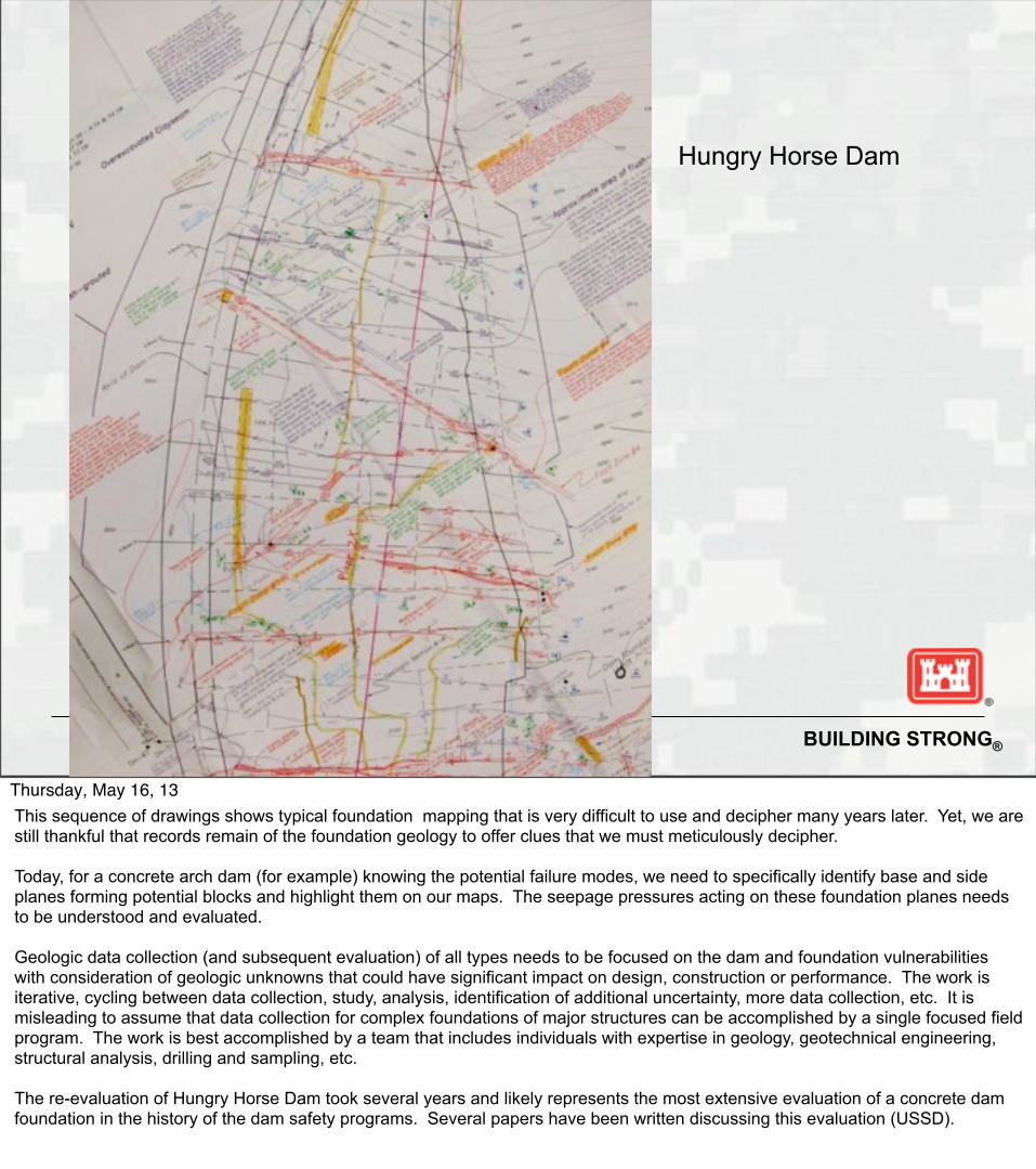
Hungry Horse Dam
Thursday, May 16, 13This sequence of drawings shows typical foundation mapping that is very difficult to use and decipher many years later. Yet, we are still thankful that records remain of the foundation geology to offer clues that we must meticulously decipher.
Today, for a concrete arch dam (for example) knowing the potential failure modes, we need to specifically identify base and side planes forming potential blocks and highlight them on our maps. The seepage pressures acting on these foundation planes needs to be understood and evaluated.
Geologic data collection (and subsequent evaluation) of all types needs to be focused on the dam and foundation vulnerabilities with consideration of geologic unknowns that could have significant impact on design, construction or performance. The work is iterative, cycling between data collection, study, analysis, identification of additional uncertainty, more data collection, etc. It is misleading to assume that data collection for complex foundations of major structures can be accomplished by a single focused field program. The work is best accomplished by a team that includes individuals with expertise in geology, geotechnical engineering, structural analysis, drilling and sampling, etc.
The re-evaluation of Hungry Horse Dam took several years and likely represents the most extensive evaluation of a concrete dam foundation in the history of the dam safety programs. Several papers have been written discussing this evaluation (USSD).

BUILDING STRONG®25
Thursday, May 16, 13Reviewing and using these types of foundation maps is difficult and tedious. The maps must be carefully searched for key weaknesses, particularly low angle base planes that may daylight downstream along with continuous side planes that may form foundation blocks of concern that are removable. Knowledge of precedents and case histories helps subsurface investigators understand potential failure modes and focus on key elements of the foundation.

BUILDING STRONG®26
Thursday, May 16, 13Very detailed foundation map could be much more useful if specific failure modes (removable foundation blocks) where searched for and identified when mapping. Today, foundations need to be mapped looking specifically for these vulnerabilities and not just recording all geologic structure independent of engineering value.
Often it may be what lies directly below the mapped surface that is the most concern, making the mapping of the daylighting downstream features critical. This was an important lesson from Malpasset Dam.
Geologic sections must be developed with these foundation maps in order to interpret, display and communicate foundation conditions that are not always evident in the plan map alone. Construction photos are often some of the most critical information available.
There have been many cases where geologists and geotechnical engineers failed to understand the failure modes and failed to make sense of the foundation mapping. There are other cases where the most important features lay hidden just below the mapped surface. Drill hole information and all other data needs to be synthesized to develop a comprehensive understanding and depiction of the entire foundation.

BUILDING STRONG®27
This is the full sized drawing
Thursday, May 16, 13This original construction mapping is valuable, but deciphering this data 50 years later is difficult in terms of finding base planes and side planes for potential foundation blocks.
It is important for geologists to be focused how the maps should be used now and in the future. Knowing case histories and potential failure modes, a geologist mapping today should highlight the most important data so it stands out on the map.
There have been several cases where geologists mapped in this tedious detail, but completely missed the importance of key features to dam stability.
This type of mapping has little value if the geologist is not engaged in the design of the dam with an understanding of how geologic structure influences stability. The working relationship between geologists and engineers is critical to maximize the usefulness of geologic investigations and assure all investigators are focused on and searching for key vulnerabilities and discussing possible significant geologic unknowns.

BUILDING STRONG®28
Thursday, May 16, 13

BUILDING STRONG®29
Auburn Dam Foundation Model, 1970’sThursday, May 16, 13The Auburn dam Plexiglas model is an example of the high quality engineering geology and attention to detail required to adequately understand and analyze a concrete dam foundation.
It is remarkable that this highly functional, extremely focused team of geologists, geotechnical engineers and structural engineers worked together for years to understand this foundation in the 1970’s. This happened during the very same era and in the same organization as the design and construction of Teton Dam. This pocket of excellence within the organization is an example of what a few smart, focused individuals with strong personalities can do when they truly understand the significance of the foundation geology modeling. It did not require a directive or a policy for this team to succeed. It required dedication to excellence and a focus on potential failure modes.
At Auburn, basic volcanic rock was interspersed with faults and shear, most of which had continuous seams of gouge that varied from paper thin to several feet in thickness, and with other rock anomalies each with individual deformation moduli. The resulting anisotropy required a definitive analyses to obtain the existing foundation modulus, and then a determination of which and how much of the geologic discontinuities need to be treated to obtain acceptable deformation moduli throughout the foundation.

BUILDING STRONG®30
Thursday, May 16, 13Geologists and engineers worked together daily to incorporate all new information from drilling as it was obtained in order to guide the exploration and the design. Everyone on the team was learning from everyone else in an intense cross-mentoring environment.
The excellence experienced on the concrete dam side of the organization was driven by 3 or 4 very experienced people who understood the value this inter-dependency collaboration and insisted everyone understand the design goals and geologic conditions influencing major design decisions.
This emphasizes how organizational culture, even within smaller groups, directly influences the quality of investigations, design and analysis.
BUILDING STRONG®31
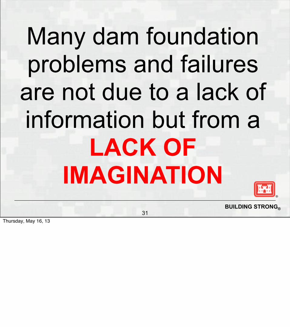
Many dam foundation problems and failures
are not due to a lack of information but from a
LACK OF IMAGINATION
Thursday, May 16, 13

BUILDING STRONG®32
“Over the years it became increasingly apparent to me that the difference between success and failure resided not in the quality or quantity of theoretical studies, but in the success with which the fundamental properties of the geological materials had been evaluated originally or could be determined as a result of field observations during and even after construction.” -Ralph Peck
Thursday, May 16, 13

BUILDING STRONG®33
“No man can hope to be truly an artist in the practice of subsurface engineering without a rich background of personal experience, or with an adequate knowledge of the experiences of his contemporaries and predecessors.”
-Ralph Peck(Art and Science in Subsurface Engineering)
Thursday, May 16, 13

BUILDING STRONG®34
ReferencesAustin Dam
Greene, B. H., and Christ, C. A., 1998, Mistakes of Man; The Austin Dam Disaster of 1911: Pennsylvania Geology, Vol. 29, No. 2-3, pp. 7-14.
Martt, D. F., Shakoor, A., and Greene, B. H., 2005, Austin Dam, Pennsylvania; The Sliding Failure of a Concrete Gravity Dam: Environmental and Engineering Geoscience, Vol. 11, No. 1, pp. 61-72.
Taylor, T. U., 1900, The Austin Dam: U. S. Geological Survey Water-Supply Paper W-0040, 52 p.
Baldwin Hills Dam
Flagg, C. G., 1979, Geological Causes of Dam Incidents: Bulletin of Engineering Geology and the Environment, No. 20, pp. 196-201.
Jansen, R. B., 1987, A Review of the Baldwin Hills Reservoir Failure; Dam Failures: Engineering Geology, Vol. 24, No. 1-4, pp. 7-81.
Leps, T. M., 1987a, Failure of Baldwin Hills Reservoir, 1963; Interpretaton of Step-By-Step Failure Sequence; Dam Failures: Engineering Geology, Vol. 24, No. 1-4, pp. 83-88.
Leps, T. M., 1987b, The Baldwin Hills Reservoir Failure in Retrospect; Discussion Modified; Dam Failures: Engineering Geology, Vol. 24, No. 1-4, pp. 89-92.
Leps, T. M., 1987c, Baldwin Hills Reservoir Failure; Discussion Modified; Dam Failures: Engineering Geology, Vol. 24, No. 1-4, pp. 93-95.
Leps, T. M., 1987d, Failure of Baldwin Hills Reservoir; Invited Discusser's Responses to Prepared Questions; Dam Failures. Engineering Geology, Vol. 24, No. 1-4, pp. 97-102.
Leps, T. M., 1987e, Ground Subsidence Analysis Prior to the Baldwin Hills Reservoir Failure; Dam Failures: Engineering Geology, Vol. 24, No. 1-4, pp. 143-154.
Leps, T. M., and Jansen, R. B., 1988, Lessons from Notable Events; The Baldwin Hills Reservoir Failure. In R. B. Jansen (Ed.), Advanced Dam Engineering for Design, Construction, and Rehabilitation: Van Nostrand Reinhold, New York, NY, United States, pp. 8-16.
Muhunthan, B., and Schofield, A. N., 2000, Liquefaction and Dam Failures: Geotechnical Special Publication No. 101, pp. 266-280.
Scott, R. F., 1987a, Baldwin Hills Reservoir Failure in Review; Dam Failures: Engineering Geology, Vol. 24, No. 1-4, pp. 103-125.
Scott, R. F., 1987b, The Baldwin Hills Reservoir Failure; Dam Failures: Engineering Geology, Vol. 24, No. 1-4, pp. 155-159.
Stapledon, D. H., and Gordon, F. R., 1976, Geological Hazards and Water Storage; Symposium 113, Geological Hazards and the Environment: Bulletin Engineering Geology and the Environment, No. 14, pp. 249-262.
Wilson, S. D., 1987a, A Discussion of the Baldwin Hills Reservoir Failure; Dam Failures: Engineering Geology, Vol. 24, No. 1-4, pp. 127-141.
Thursday, May 16, 13

BUILDING STRONG®35
ReferencesFontenelle Dam
Murray, B. C., and Browning, S. E., 1984, Unique Monitoring of Possible Recurring Foundation Problems at Fontenelle Dam; Safety of Dams; in Proeceedings, International Conference on Safety of Dams, Coimbra, Portugal: A.A. Balkema, Rotterdam, Netherlands, pp. 227-234.
Bureau of Reclamation Experience in Stabilizing Embankment of Fontenelle Earth Dam, B.P. Bellport, Ninth International Congress on Large Dams, Istanbul, Turkey,
September 4-8, 1967.
Design Considerations for Dam Embankment, Fontenelle Dam, Seedskadee Project, Wyoming, Bureau of Reclamation, Denver, Colorado, May 1961.
Snorteland, N.J, Shaffner, P.T, and Paul, D, 2009, ASDSO
Malpasset Dam
Boyer, D. D., and Ferguson, K. A., 2000, Important Factors to Consider in Properly Evaluating the Stability of Rock Slopes: Geotechnical Special Publication No. 101, pp. 58-71.
Fishman, Y. A., 2008, Features of Shear Failure of Brittle Materials and Concrete Structures on Rock Foundations: International Journal of Rock Mechanics and Mining Sciences, Vol. 45, No. 6, pp. 976-992.
Flagg, C. G., 1979, Geological Causes of Dam Incidents: Bulletin of Engineering Geology and the Environment, No. 20, pp. 196-201.
Goodman, R. E., and Powell, C., 2003, Investigations of Blocks in Foundations and Abutments of Concrete Dams: Journal of Geotechnical and Geoenvironmental Engineering, Vol. 129, No. 2, pp. 105-116.
Habib, P., 1987, The Malpasset Dam Failure; Dam Failures: Engineering Geology, Vol. 24, No. 1-4, pp. 331-338.
James, L. B., 1988, Lessons from Notable Events; The Failure of Malpasset Dam; In Jansen, R. B., Ed., Advanced Dam Engineering for Design, Construction, and Rehabilitation: Van Nostrand Reinhold, New York, NY, United States, pp. 17-27.
Londe, P., 1973, Analysis of the Stability of Rock Slopes: The Quarterly Journal of Engineering Geology, Vol. 6, No. 1, pp. 93-124.
Thursday, May 16, 13

BUILDING STRONG®36
References(Malpasset Dam continuted…)
Post, G., and Bonazzi, D., 1987a, Latest Thinking on the Malpasset Accident; Dam Failures: Engineering Geology, Vol. 24, No. 1-4, pp. 339-353.
Post, G., and Bonazzi, D., 1987b, Malpasset Dam; Dam Failures: Engineering Geology, Vol. 24, No. 1-4, pp. 395-398.
Serafim, J. L., 1987, Malpasset Dam Discussion; Remembrances of Failures of Dams; Dam Failures: Engineering Geology, Vol. 24, No. 1-4, pp. 355-366.
Stapledon, D. H., and Gordon, F. R., 1976, Geological Hazards and Water Storage; Symposium 113, Geological Hazards and the Environment: Bulletin Engineering Geology and the Environment, No. 14, pp. 249-262.
Wittke, W., 1987, Malpasset Dam; Dam Failures. Engineering Geology, Vol. 24, No. 1-4, pp. 399-400.
Wittke, W., and Leonards, G. A., 1987a, Modified Hypothesis for Failure of Malpasset Dam; Dam Failures: Engineering Geology, Vol. 24, No. 1-4, pp. 367-394.
Wittke, W., and Leonards, G. A., 1987, Modified Hypothesis for Failure of the Malpasset dam; Dam Failures: Engineering Geology, Vol. 24, No. 1-4, pp. 407-421.
Quail Creek Dike
Gourley, C., 1992, Geological Aspects of the Quail Creek Dike Failure; Engineering and Environmental Geology of Southwestern Utah: Utah Geological Association Publication, Vol. 21, pp. 17-38.
Johnson, K. S., 2008, Gypsum-Karst Problems in Constructing Dams in the USA: Environmental Geology, Vol. 53, No. 5, pp. 945-950.
O'Neill, A. L., and Gourley, C., 1991, Geologic Perspectives and Cause of the Quail Creek Dike Failure: Bulletin of the Association of Engineering Geologists, Vol. 28, No. 2, pp. 127-145.
Payton, C. C., Hansen, M. N., 2003, Gypsum Karst in Southwestern Utah; Failure and Reconstruction of Quail Creek Dike; in Johnson K. S., Neal J. T., Eds., Evaporite karst and Engineering/Environmental Problems in the United States: Oklahoma Geological Survey Circular 109, pp. 293-303.
Payton, C. C., 1992, Geotechnical Investigation and Foundation Design for the Reconstruction of Quail Creek Dike; Engineering and Environmental Geology of Southwestern Utah: Utah Geological Association Publication 21, pp. 39-51.
Picard, M. D., 1993, The Fall of Quail Creek Dike: Journal of Geological Education, Vol. 41, No. 1, pp.52-56.
Thursday, May 16, 13

BUILDING STRONG®37
ReferencesSaint Francis Dam
Boyer, D. D., and Ferguson, K. A., 2000, Important Factors to Consider in Properly Evaluating the Stability of Rock Slopes: Geotechnical Special Publication No. 101, pp. 58-71.
Clements, T., 1966, Saint Francis Dam Failure of 1928; Engineering Geology in Southern California: Association of Engineering Geologists, Southern California Section, Glendale, California.
Fife D. L., Eagen J. T. and Hollon C. E., 1978, Failure of the St. Francis Dam; San Francisquito Canyon Near Saugus: Association of Engineering Geologists, Southern California Section, Glendale, California, 41p.
Hill, L. C., 1929, Essential Facts Concerning the Failure of the Saint Francis Dam California; report of committee: Proceedings of the American Society of Civil Engineers, Vol. 55, No. 8, 2147-2163.
Jansen, R. B., 1988, Lessons from Notable Events; The St. Francis Dam Failure; in Jansen, R. B., Ed., Advanced Dam Engineering for Design, Construction, and Rehabilitation: Van Nostrand Reinhold, New York, NY, United States, pp. 28-34.
Longwell, C. R., 1928, Lessons from the Saint Francis Dam, California: Fort Hays Studies, New Series, Science Series, Vol. 67, pp. 36-37.
Louderback, G. D., 1928, The Geology of the Saint Francis Dam Site: American Society of Civil Engineers, San Francisco Section, Vol. 24, No. 3, pp. 9-10.
Outland, C. F., 1977, Man-Made Disaster; The Story of St. Francis Dam; Its Place in Southern California's Water System, Its Failure and the Tragedy in the Santa Clara River Valley, March 12 and 13, 1928: Arthur H. Clark Co., Glendale, CA, United States, 275 p.
Petroski, H., 2003, St. Francis Dam: American Scientist, Vol. 91, No. 2, pp. 114-118.
Ransome, F. L., 1928, Geology of the Saint Francis Dam Site: Economic Geology, Vol. 23, No. 5, pp. 553-563.
Rogers, J. D., 1992, Reassessment of St. Francis Dam Failure; Engineering Geology Practice in Southern California: Association of Engineering Geologists Special Publication 4, pp. 639-666.
Rogers, J.D., 2006, Lessons Learned from the St. Francis Dam Failure: Geo-Strata, Vol. 6, No. 2, pp. 14-17.
Stapledon, D. H., and Gordon, F. R., 1976, Geological Hazards and Water Storage; Symposium 113, Geological Hazards and the Environment: Bulletin Engineering Geology and the Environment, No. 14, pp. 249-262.
Thursday, May 16, 13

BUILDING STRONG®38
References Teton Dam Aberle, P. P., 1976, Pressure Grouting Foundation on Teton Dam Rock Engineering for Foundations and Slopes; in Proceedings, Rock Engineering for Foundations and Slopes,
Boulder, Colorado, Vol. 1: American Society of Civil Engineers, New York, NY, United States, pp. 245-263. Arthur, H. G., 1977, Teton Dam Failure; in Proceedings, The Evaluation of Dam Safety, Pacific Grove, California: American Society of Civil Engineers, New York, NY, United States,
pp. 61-68. Boffey, P. M., 1976, Teton Dam Collapse; Was it a Predictable Disaster?: Science, Vol. 193, No. 4247, pp. 30-32. Fecker, E., 1980, The Influence of Jointing on Failure of Teton Dam; A Review and Commentary: Bulletin of Engineering Geology and the Environment, No. 21, pp. 232-238. Flagg, C. G., 1979, Geological Causes of Dam Incidents: Bulletin of Engineering Geology and the Environment, No. 20, pp. 196-201. Fucik, E. M., 1987, The Teton Dam Failure; A Discussion; Dam Failures: Engineering Geology, Vol. 24, No. 1-4, pp. 207-215. Hilf, J. W., 1987, The Wet Seam and The Teton Dam Failure; Dam Failures: Engineering Geology, Vol. 24, No. 1-4, pp. 265-281. Leonards, G. A., and Davidson, L. W., 1984, Reconsideration of Failure Initiating Mechanisms for Teton Dam; in Proceedings, International Conference on Case Histories in
Geotechnical Engineering, St. Louis, MO, Vol. 3: University of Missouri-Rolla, Rolla, MO, United States, pp. 1103-1113. Leps, T. M., 1987, Failure of Teton Dam, 1976; Invited Discusser's Responses to Prepared Questions; Dam Failures: Engineering Geology, Vol. 24, No. 1-4, pp. 217-220. Leps, T. M., 1988, Lessons From Notable Events; Failure of Teton Dam; in Jansen R. B., Ed., Advanced Dam Engineering for Design, Construction, and Rehabilitation: Van Nostrand
Reinhold, New York, NY, United States, pp. 34-41. Muhunthan, B., and Schofield, A. N., 2000, Liquefaction and Dam Failures; Slope Stability 2000: Geotechnical Special Publication No. 101, pp. 266-280. Muthunthan, B., and Pillai, S., 2008, Teton dam, USA; Uncovering the Crucial Aspect of its Failure; Learning from Failures; in Proceedings of the Institution of Civil Engineers: Civil
Engineering, Vol. 161, Special issue 2, pp. 35-40. Penman, A. D. M., 2005, Dams Designed to Fail: International Journal on Hydropower and Dams, Vol. 12, No. 2, pp. 148-155. Penman, A. D. M., 1987a, Teton Investigation; A Review of Existing Findings; Dam Failures: Engineering Geology, Vol. 24, No. 1-4, pp. 221-237. Penman, A. D. M., 1987b, The Teton Dam Failure; Dam Failures: Engineering Geology, Vol. 24, No. 1-4, pp. 257-259.
Thursday, May 16, 13

BUILDING STRONG®39
References
(Teton Dam continued…)
erry, E. B., 1991, The Teton Dam Failure; Problems with the Use of Loess Material in Earth Dam Structures; Discussion Modified: Engineering Geology, Vol. 31, No. 2, pp. 205-206.
Rogers, C. D. F., Dijkstra, T. A., Smally, I. J., and Sowers, G. F., 1994, Human Factors in Civil and Geotechnical Engineering Failures; Discussion and Closure: Journal of Geotechnical Engineering, Vol. 120, No. 8, pp. 1446-1449.
Sasiharan, N., Muhunthan, B., and Pillai, V., 2006, Failure Report: International Water Power and Dam Construction, Vol. 58, No. 9, pp. 28-33.
Schuster, R. L., 1980, Discussion of "Geological Causes of Dam Incidents" by Flagg, C. G.: Bulletin of Engineering Geology and the Environment, No. 21, pp. 231-232.
Seed, H. B., and Duncan, J. M., 1982, The Teton Dam Failure; A Retrospective Review; in Proceedings of the tenth international conference on soil mechanics and foundation engineering: A.A. Balkema, Rotterdam-Boston, pp. 219-238.
Seed, H. B., and Duncan, J. M., 1987, The Failure of Teton Dam; Dam Failures: Engineering Geology, Vol. 24, No. 1-4, pp. 173-205.
Sherard, J. L., 1987, Lessons from the Teton Dam Failure; Dam Failures: Engineering Geology, Vol. 24, No. 1-4, pp. 239-256.
Sherard, J. L., 1987, Teton Dam Failure; Dam Failures: Engineering Geology, Vol. 24, No. 1-4, pp. 283-293.
Smalley, I. J., and Dijkstra, T. A., 1991, The Teton Dam (Idaho, U.S.A.) Failure; Problems with the Use of Loess Material in Earth Dam Structures: Engineering Geology, Vol. 31, No. 2, pp. 197-203.
Smalley, I., 1992, The Teton Dam; Rhyolite Foundation + Loess Core = Disaster: Geology Today, Vol. 8, No. 1, pp. 19-22.
Teton Dam Failure Review Group, 1977, Failure of Teton Dam; a Report of Findings by United States Department of the Interior: U.S. Government Printing Office, Washington, D.C., United States, 745 p.
Teton Dam Failure Review Group, 1980, Failure of Teton Dam; Final Report: U.S. Government Printing Office, Washington, D.C., United States, 800 p.
U. S. Congress, House Committee on Government Operation, 1976, Teton Dam Disaster; Thirtieth Report Modified: U. S. Government Printing Office, Washington, D.C., United States, 37 p.
U. S. Congress, House Subcommittee on Conservation, Energy, and Natural Resource, 1976, Teton Dam Disaster: U. S. Government Printing Office, Washington, D.C., 678 p.
U. S. Congress, Senate Subcommittee on Energy Research and Development, 1977, Oversight; Teton Dam Disaster: U. S. Government Printing Office, Washington, D.C., United States, 315 p.
U. S. Congress, Senate Subcommittee on Energy Research and Development, 1977, Teton Dam Failure: U. S. Government Printing Office, Washington, D.C., United States, 96 p.
U. S. Congress, Senate Subcommittee on Energy Research and Water Resources, 1976, Teton Dam: U. S. Government Printing Office, Washington, D.C., United States, 69 p.
Williams, R. P., 1978, Effects of the Teton Dam Failure: U. S. Geological Survey Professional Paper P1100, 211 p.
Thursday, May 16, 13

BUILDING STRONG®40
ReferencesVaiont (or Vajont) Dam Belloni, L. G., and Stefani, R., 1987, The Vajont Slide; Instrumentation, Past Experience and the Modern Approach; Dam Failures: Engineering Geology, Vol. 24, No. 1-4, pp. 445-474. Chowdhury, R. N., 1987, Aspects of the Vajont Slide; Dam Failures: Engineering Geology, Vol. 24, No. 1-4, pp. 533-540. Flagg, C. G., 1979, Geological Causes of Dam Incidents: Bulletin of Engineering Geology and the Environment, No. 20, pp. 196-201. Hendron, A. J. and Patton, F.D., 1985, The Vajont Slide, a Geotechnical Analysis Based on New Geologic Observations of the Failure Surface: Technical Report GL-85-5, Department of the Army, U.S. Army Corps of Engineers, Washington, D.C., two volumes. Hendron, A. J.,Jr, and Patton, F. D., 1987, The Vaiont Slide; a Geotechnical Analysis Based on New Geologic Observations of the Failure Surface; Dam Failures: Engineering Geology, Vol. 24, No. 1-4, pp. 475-491. Jaeger, C., 1970, Engineering and Rock Mechanics, Part One: Water Power, Vol. 22, No. 5-6, pp. 203-209. Kaliser, B. N., 1969, Slips Showing: Utah Geological and Mineralogical Survey Quarterly Review, Vol. 3, No. 1, p. 3. Kiersch, G. A., 1976, The Vaiont Reservoir Disaster; in Tank R. W., Ed., Focus on Environmental Geology; a Collection of Case Histories and Readings from Original Sources: Oxford University Press, London, United Kingdom, pp. 132-143. Kiersch, G. A., 1988, Lessons from Notable Events; Vaiont Reservoir Disaster; in Jansen, R. B., Ed., Advanced Dam Engineering for Design, Construction, and Rehabilitation: Van Nostrand Reinhold, New York, NY, United States, pp. 41-53.
Lo, K. Y., Lee, C. F., and Gelinas, P., 1972, Alternative Interpretation of the Vaiont Slide; Stability of Rock Slopes: Proceedings - Symposium on Rock Mechanics, Vol. 13, pp. 595-617. Earth System Sciences, Vol. 10, No. 4, pp. 865-873. Mantovani, F., and Vita-Finzi, C., 2003, Neotectonics of the Vajont Dam Site; Studies on Large Volume Landslides: Geomorphology, Vol. 54, No. 1-2, pp. 33-37. Mueller-Salzburg, L., 1987a, The Vajont Catastrophe; a Personal Review; Dam Failures: Engineering Geology, Vol. 24, No. 1-4, pp. 423-444. Mueller-Salzburg, L., 1987b, The Vajont Slide; Dam Failures: Engineering Geology, Vol. 24, No. 1-4, pp. 513-523. Nonveiller, E., 1987, The Vajont Reservoir Slope Failure; Dam Failures: Engineering Geology, Vol. 24, No. 1-4, pp. 493-512. Petley, D. N., and Petley, D. J., 2006, On the Initiation of Large Rockslides; Perspectives from a New Analysis of the Vaiont Movement Record; Landslides from Massive Rock Slope Failure: NATO Science Series IV, Earth and Environmental Sciences, Vol. 49, pp. 77-84.
Thursday, May 16, 13

BUILDING STRONG®41
References(Vaiont Dam continued…)
Stamatopoulos, C., and Aneroussis, S., 2006, Back Analysis of the Vaiont Slide Using a Multi-Block Sliding Model; Monitoring, Simulation, Prevention and Remediation of Dense and Debris Flows: WIT Transactions on Ecology and the Environment, Vol. 90, pp. 261-269. Semenza, E., and Ghirotti, M., 2000, History of the 1963 Vaiont Slide; The Importance of Geological Factors: Bulletin of Engineering Geology and the Environment, Vol. 59, No. 2, pp. 87-97. Stapledon, D. H., and Gordon, F. R., 1976, Geological Hazards and Water Storage; Symposium 113, Geological Hazards and the Environment: Bulletin Engineering Geology and the Environment, No. 14, pp. 249-262. Superchi, L., Floris, M., Ghirotti, M., Genevois, R., Jaboyedoff, M., and Stead, D., 2010, Technical note: Implementation of a Geodatabase of Published and Unpublished Data on the Catastrophic Vaiont Landslide: Natural Hazards
Publications including multiple dam failure discussions:
Flagg, C.G., Geological Causes of Dam Breaks and Failures, Bulletin of the International Association of Engineering Geology, No. 20, p. 196-201, 1979
Stapleton, D.H., Geological Hazards and Water Storage, Bulletin of the International Association of Engineering Geology, No. 14, p. 249-262, Krefeld 1976
Jansen, Robert, B., Dams and Public Safety, U.S. Department of the Interior, Bureau of Reclamation, 1980
Thursday, May 16, 13

BUILDING STRONG®42
The following slides were not part of the AEG Shlemon presentation.
They are included here to generate additional thought for subsequent discussions.
Thursday, May 16, 13

BUILDING STRONG®43
Vaoint Dam(
Thursday, May 16, 13•Enormous landslide into reservoir in 1963• Dam 860 ft tall (328 ft wave over dam)• Dam survives, 2600 lives lost by overtopping• Sliding was being monitored closely up to failure• Creep measured as 40 inches per day before failure• Designers ignored seriousness of slide• Failure blamed on geologists and engineers

BUILDING STRONG®43
Vaoint Dam(
•
Thursday, May 16, 13•Enormous landslide into reservoir in 1963• Dam 860 ft tall (328 ft wave over dam)• Dam survives, 2600 lives lost by overtopping• Sliding was being monitored closely up to failure• Creep measured as 40 inches per day before failure• Designers ignored seriousness of slide• Failure blamed on geologists and engineers

BUILDING STRONG®44
Landslide Scarp
Landslide Mass
First Filled 1959
1963 landslide killed 2,600 people
Vaoint Dam
Thursday, May 16, 13

BUILDING STRONG®45
Langarone Italy
Thursday, May 16, 13

BUILDING STRONG®46
1963; 2600 people killed
Thursday, May 16, 13

BUILDING STRONG®47
The dam itself and the foundation were not the issue
.
265 m high(869 ft.)
Thursday, May 16, 13Why case histories are criticalMany smart engineers and geologists, didn’t understand the failure mode until it was too late
Prior to the landslide that caused the over-topping flood, the creep had been 0.4 inches per week. During September this creep reached 10.0 inches per day until finally, the day before the landslide, the creep was measured at 40.0 inches (1 metre) The enormous consequences associated with a massive landslide into the reservoir were not accounted for.
Politics played a major role in operating the dam with known sliding issues.
This was a failure of the imagination
Enormous landslide scarp in limestone on left side of Vaoint Reservoir.
Volume estimated to be 340 million cu. yds
Resulted in a wave approximately 328 feet tall overtopping the dam.

BUILDING STRONG®48
Vaiont Landslide Summary Facts
Thursday, May 16, 13

BUILDING STRONG®48
Vaiont Landslide Summary Facts• Pre-existing gullies and saddles defined the ancient slide mass on topo maps and aerial photos, but the aerial photos were likely not used
Thursday, May 16, 13

BUILDING STRONG®48
Vaiont Landslide Summary Facts• Pre-existing gullies and saddles defined the ancient slide mass on topo maps and aerial photos, but the aerial photos were likely not used• By 1963 it was obvious that a large landslide was moving. The toe had stopped moving and was “locked” but the upper mass continued to move
Thursday, May 16, 13

BUILDING STRONG®48
Vaiont Landslide Summary Facts• Pre-existing gullies and saddles defined the ancient slide mass on topo maps and aerial photos, but the aerial photos were likely not used• By 1963 it was obvious that a large landslide was moving. The toe had stopped moving and was “locked” but the upper mass continued to move• No individual or group had the political willpower to stop the project
Thursday, May 16, 13
BUILDING STRONG®48
Vaiont Landslide Summary Facts• Pre-existing gullies and saddles defined the ancient slide mass on topo maps and aerial photos, but the aerial photos were likely not used• By 1963 it was obvious that a large landslide was moving. The toe had stopped moving and was “locked” but the upper mass continued to move• No individual or group had the political willpower to stop the project•At the time of failure, a drainage tunnel was being constructed and the reservoir was restricted – the slide was a known “concern”.
Thursday, May 16, 13

BUILDING STRONG®48
Vaiont Landslide Summary Facts• Pre-existing gullies and saddles defined the ancient slide mass on topo maps and aerial photos, but the aerial photos were likely not used• By 1963 it was obvious that a large landslide was moving. The toe had stopped moving and was “locked” but the upper mass continued to move• No individual or group had the political willpower to stop the project•At the time of failure, a drainage tunnel was being constructed and the reservoir was restricted – the slide was a known “concern”.• Like many other failures, the design of Vaoint Dam failed to account for the geologic uncertainties
Thursday, May 16, 13

BUILDING STRONG®48
Vaiont Landslide Summary Facts• Pre-existing gullies and saddles defined the ancient slide mass on topo maps and aerial photos, but the aerial photos were likely not used• By 1963 it was obvious that a large landslide was moving. The toe had stopped moving and was “locked” but the upper mass continued to move• No individual or group had the political willpower to stop the project•At the time of failure, a drainage tunnel was being constructed and the reservoir was restricted – the slide was a known “concern”.• Like many other failures, the design of Vaoint Dam failed to account for the geologic uncertainties• There was no independent review with authority to take serious and drastic action to protect the public.
Thursday, May 16, 13

BUILDING STRONG®49
Vaiont Landslide Summary Facts
Thursday, May 16, 13

BUILDING STRONG®49
• Geologic work and slope stability first studied in 1928
Vaiont Landslide Summary Facts
Thursday, May 16, 13

BUILDING STRONG®49
• Geologic work and slope stability first studied in 1928• Eminent university professor was expert in dolomites
Vaiont Landslide Summary Facts
Thursday, May 16, 13

BUILDING STRONG®49
• Geologic work and slope stability first studied in 1928• Eminent university professor was expert in dolomites• 1959 Refraction survey concluded a slide plane did not exist
Vaiont Landslide Summary Facts
Thursday, May 16, 13

BUILDING STRONG®49
• Geologic work and slope stability first studied in 1928• Eminent university professor was expert in dolomites• 1959 Refraction survey concluded a slide plane did not exist• 1960 team of geologists reported evidence of a major ancient landslide on the left bank, noting a remnant mass and a mylonite zone
Vaiont Landslide Summary Facts
Thursday, May 16, 13

BUILDING STRONG®49
• Geologic work and slope stability first studied in 1928• Eminent university professor was expert in dolomites• 1959 Refraction survey concluded a slide plane did not exist• 1960 team of geologists reported evidence of a major ancient landslide on the left bank, noting a remnant mass and a mylonite zone • Geologists considered a large slide mass a possibility
Vaiont Landslide Summary Facts
Thursday, May 16, 13

BUILDING STRONG®49
• Geologic work and slope stability first studied in 1928• Eminent university professor was expert in dolomites• 1959 Refraction survey concluded a slide plane did not exist• 1960 team of geologists reported evidence of a major ancient landslide on the left bank, noting a remnant mass and a mylonite zone • Geologists considered a large slide mass a possibility• Three boreholes were drilled and the slide plane was not recovered
Vaiont Landslide Summary Facts
Thursday, May 16, 13

BUILDING STRONG®49
• Geologic work and slope stability first studied in 1928• Eminent university professor was expert in dolomites• 1959 Refraction survey concluded a slide plane did not exist• 1960 team of geologists reported evidence of a major ancient landslide on the left bank, noting a remnant mass and a mylonite zone • Geologists considered a large slide mass a possibility• Three boreholes were drilled and the slide plane was not recovered• Assumed the slide if it existed was “stable”
Vaiont Landslide Summary Facts
Thursday, May 16, 13

BUILDING STRONG®49
• Geologic work and slope stability first studied in 1928• Eminent university professor was expert in dolomites• 1959 Refraction survey concluded a slide plane did not exist• 1960 team of geologists reported evidence of a major ancient landslide on the left bank, noting a remnant mass and a mylonite zone • Geologists considered a large slide mass a possibility• Three boreholes were drilled and the slide plane was not recovered• Assumed the slide if it existed was “stable”• October 1960 noted accelerated slope movements and large scarp
Vaiont Landslide Summary Facts
Thursday, May 16, 13

BUILDING STRONG®49
• Geologic work and slope stability first studied in 1928• Eminent university professor was expert in dolomites• 1959 Refraction survey concluded a slide plane did not exist• 1960 team of geologists reported evidence of a major ancient landslide on the left bank, noting a remnant mass and a mylonite zone • Geologists considered a large slide mass a possibility• Three boreholes were drilled and the slide plane was not recovered• Assumed the slide if it existed was “stable”• October 1960 noted accelerated slope movements and large scarp• Failed in 1963
Vaiont Landslide Summary Facts
Thursday, May 16, 13

BUILDING STRONG®50
What would geologists do today that was not done at Vaoint Dam in the late 1950’s and early 1960’s?
Thursday, May 16, 13

BUILDING STRONG®50
What would geologists do today that was not done at Vaoint Dam in the late 1950’s and early 1960’s?
• In steep terrain, look specifically for potential sliding in the reservoir and evaluate the hazard using maps and aerial photographs
Thursday, May 16, 13

BUILDING STRONG®50
What would geologists do today that was not done at Vaoint Dam in the late 1950’s and early 1960’s?
• In steep terrain, look specifically for potential sliding in the reservoir and evaluate the hazard using maps and aerial photographs• Capitalize on knowledge of the Vaiont Failure to help focus attention on the need for robust geological investigations beyond the dam footprint.
Thursday, May 16, 13

BUILDING STRONG®50
What would geologists do today that was not done at Vaoint Dam in the late 1950’s and early 1960’s?
• In steep terrain, look specifically for potential sliding in the reservoir and evaluate the hazard using maps and aerial photographs• Capitalize on knowledge of the Vaiont Failure to help focus attention on the need for robust geological investigations beyond the dam footprint.• Pay more attention to instrumentation thresholds and establish “triggers” for emergency actions
Thursday, May 16, 13

BUILDING STRONG®50
What would geologists do today that was not done at Vaoint Dam in the late 1950’s and early 1960’s?
• In steep terrain, look specifically for potential sliding in the reservoir and evaluate the hazard using maps and aerial photographs• Capitalize on knowledge of the Vaiont Failure to help focus attention on the need for robust geological investigations beyond the dam footprint.• Pay more attention to instrumentation thresholds and establish “triggers” for emergency actions• Be more involved in design decisions and account for geologic uncertainty in the design
Thursday, May 16, 13

BUILDING STRONG®50
What would geologists do today that was not done at Vaoint Dam in the late 1950’s and early 1960’s?
• In steep terrain, look specifically for potential sliding in the reservoir and evaluate the hazard using maps and aerial photographs• Capitalize on knowledge of the Vaiont Failure to help focus attention on the need for robust geological investigations beyond the dam footprint.• Pay more attention to instrumentation thresholds and establish “triggers” for emergency actions• Be more involved in design decisions and account for geologic uncertainty in the design•
Thursday, May 16, 13

BUILDING STRONG®51
Where were the geologists?
Camara Dam
Thursday, May 16, 13Smooth foliation surfaces left untreated in the foundation of Camara Dam led to a foundation failure upon first filling. These planes were not recognized as a failure mode. The understanding of the foundation was obviously inadequate.

BUILDING STRONG®52
Two days after first filling and failure
Camara Dam
Thursday, May 16, 13 During reservoir filling the dam showed several abnormalities as: artesian conditions and dirty water in some drain holes, leakage through the concrete and to the gallery, inundation of the gallery by clogging of the drain holes, leakage at the left abutment, etc.).
The designer recommended emptying the reservoir several times. The state authority did not empty it, (mainly for political reasons as the cities around were in demand for the water). No personal were maintained at the site. The reservoir was about 3/4 full, it failed.

BUILDING STRONG®53
Camara Dam
Thursday, May 16, 13

BUILDING STRONG®54
Camara Dam
Thursday, May 16, 13

BUILDING STRONG®55
View of left abutment from downstream
Camara Dam
Thursday, May 16, 13The failure occurred at the foundation of the left abutment, through a continuous infilled plane of the micaceous silty clay (that same one that was thought during construction to extend only 3m inside the abutment).
It was a great geological interpretation mistake.

BUILDING STRONG®56
View along crest showing failed bridge and continuous infilled fracture plane at left abutment
Camara Dam
Thursday, May 16, 13

BUILDING STRONG®57
Note Oil Field
Baldwin Hills Dam
Thursday, May 16, 13

BUILDING STRONG®58
Baldwin Hills Dam
Thursday, May 16, 13

BUILDING STRONG®59
Baldwin Hills Dam failure flood
Thursday, May 16, 13

BUILDING STRONG®
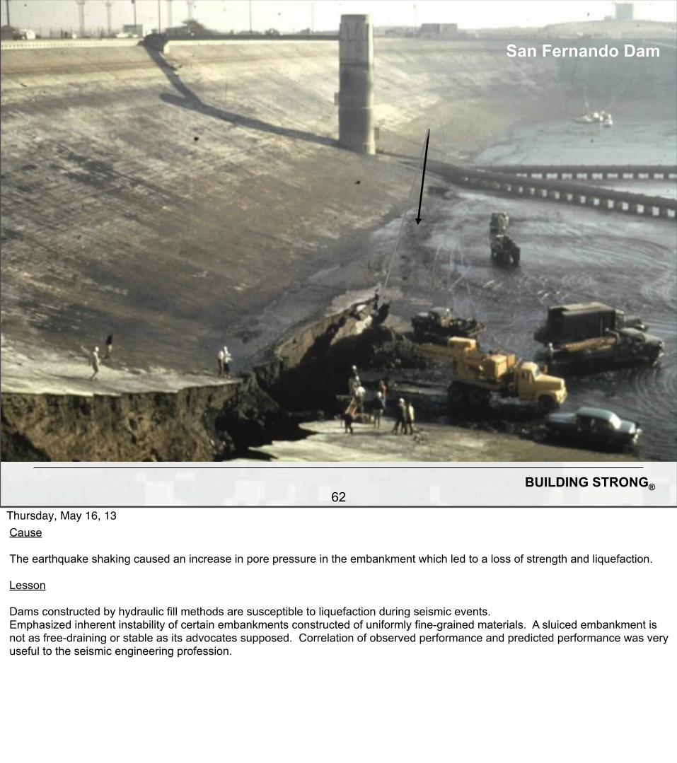
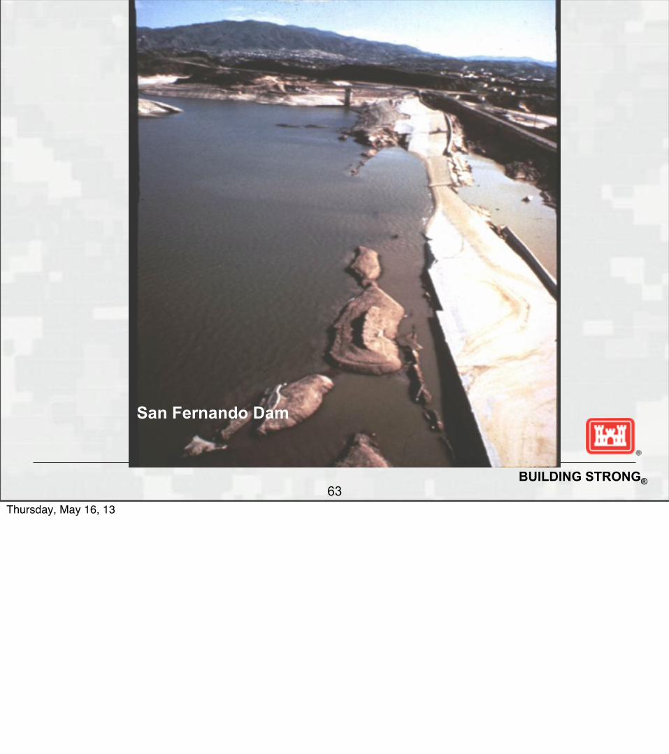
San Fernando Dam after reservoir pumped down
Following1971 earthquake
Thursday, May 16, 13Lower San Fernando Dam was an embankment dam constructed near Los Angeles, California in 1912 and later raised in 1921. The dam was built by hydraulic fill techniques and the fill was placed directly on the natural unconsolidated alluvium. The dam was 140 feet (43 m) high and the reservoir had a storage capacity of 20,000 acre-feet (25 million m3). This was very close to the worst dam failure incident in U.S. history.

BUILDING STRONG®61
San Fernando deformation
Thursday, May 16, 13Incident In 1971, an earthquake with a Richter magnitude of 6.6 occurred with its epicenter approximately 8-1/2 miles (14 km) from the dam. The earthquake produced 15 seconds of strong shaking with a maximum acceleration of 0.6 g in the foundation. A major slide occurred in the upstream portion of the embankment and the reservoir came within a few feet of breaching the dam. Practically all the upstream slope and the top 30 feet of the fill slumped and spread into the reservoir. Fortunately, the reservoir had been restricted by the State of California to the elevation of the downstream berm (approximately 35 feet (11 m) below the original crest). Storage was half of maximum. Five feet of freeboard remained. The upper dam was also damaged, and if it failed would certainly overtop and fail the lower dam. Over 80,000 people were evacuated from downstream areas. The reservoir required about 4 days to be drawn down to a safe level. Pumps were needed to draw the reservoir down because both outlet-works towers had been disabled by the failure. It has been speculated that a few more seconds of shaking would likely have failed this dam.
BUILDING STRONG®62
San Fernando Dam
Thursday, May 16, 13Cause The earthquake shaking caused an increase in pore pressure in the embankment which led to a loss of strength and liquefaction. Lesson Dams constructed by hydraulic fill methods are susceptible to liquefaction during seismic events.Emphasized inherent instability of certain embankments constructed of uniformly fine-grained materials. A sluiced embankment is not as free-draining or stable as its advocates supposed. Correlation of observed performance and predicted performance was very useful to the seismic engineering profession.
BUILDING STRONG®63
San Fernando Dam
Thursday, May 16, 13

BUILDING STRONG®64
San Fernando Dam
Thursday, May 16, 13

BUILDING STRONG®65
San Fernando Dam
Thursday, May 16, 13Note the housing development downstream and associated consequences.

BUILDING STRONG®66
Thursday, May 16, 13

BUILDING STRONG®67
Thursday, May 16, 13

BUILDING STRONG®68
• Five Geologic Reports were developed by Professor Corroy, Univ. of Marsailles - 2 reports prior to construction and 3 reports during construction
Malpasset Dam
Thursday, May 16, 13

BUILDING STRONG®68
• There were no plan, sections or borehole logs included in any reports
• Five Geologic Reports were developed by Professor Corroy, Univ. of Marsailles - 2 reports prior to construction and 3 reports during construction
Malpasset Dam
Thursday, May 16, 13

BUILDING STRONG®68
• There were no plan, sections or borehole logs included in any reports• The geologic language was likely NOT understood by design engineers
• Five Geologic Reports were developed by Professor Corroy, Univ. of Marsailles - 2 reports prior to construction and 3 reports during construction
Malpasset Dam
Thursday, May 16, 13

BUILDING STRONG®68
• There were no plan, sections or borehole logs included in any reports• The geologic language was likely NOT understood by design engineers• Prof. Corroy obviously had no understanding of engineering
• Five Geologic Reports were developed by Professor Corroy, Univ. of Marsailles - 2 reports prior to construction and 3 reports during construction
Malpasset Dam
Thursday, May 16, 13

BUILDING STRONG®68
• There were no plan, sections or borehole logs included in any reports• The geologic language was likely NOT understood by design engineers• Prof. Corroy obviously had no understanding of engineering• He was investigating a dam site without knowing the type of dam being considered
• Five Geologic Reports were developed by Professor Corroy, Univ. of Marsailles - 2 reports prior to construction and 3 reports during construction
Malpasset Dam
Thursday, May 16, 13

BUILDING STRONG®68
• There were no plan, sections or borehole logs included in any reports• The geologic language was likely NOT understood by design engineers• Prof. Corroy obviously had no understanding of engineering• He was investigating a dam site without knowing the type of dam being considered• No discussion of forces, direction of forces, angles, stresses, deformation, etc.
• Five Geologic Reports were developed by Professor Corroy, Univ. of Marsailles - 2 reports prior to construction and 3 reports during construction
Malpasset Dam
Thursday, May 16, 13

BUILDING STRONG®68
• There were no plan, sections or borehole logs included in any reports• The geologic language was likely NOT understood by design engineers• Prof. Corroy obviously had no understanding of engineering• He was investigating a dam site without knowing the type of dam being considered• No discussion of forces, direction of forces, angles, stresses, deformation, etc.• Even during the subsequent inquiry into the failure the comments by the geologists indicate a complete lack of understanding of the engineering aspects
• Five Geologic Reports were developed by Professor Corroy, Univ. of Marsailles - 2 reports prior to construction and 3 reports during construction
Malpasset Dam
Thursday, May 16, 13

BUILDING STRONG®69
Geologic Lessons Learned from Malpasset Dam Failure
Thursday, May 16, 13

BUILDING STRONG®69
Geologic Lessons Learned from Malpasset Dam Failure
• Geology must not be treated as a separate and independent science, it must be integrated into answering the important engineering questions
Thursday, May 16, 13
BUILDING STRONG®69
Geologic Lessons Learned from Malpasset Dam Failure
• Geology must not be treated as a separate and independent science, it must be integrated into answering the important engineering questions• Collecting geologic data without consideration of the most important engineering questions is not productive or very useful
Thursday, May 16, 13

BUILDING STRONG®69
Geologic Lessons Learned from Malpasset Dam Failure
• Geology must not be treated as a separate and independent science, it must be integrated into answering the important engineering questions• Collecting geologic data without consideration of the most important engineering questions is not productive or very useful• Understanding a structure’s vulnerabilities (potential failure modes) is key to focusing data collection and exploration priorities
Thursday, May 16, 13

BUILDING STRONG®69
Geologic Lessons Learned from Malpasset Dam Failure
• Geology must not be treated as a separate and independent science, it must be integrated into answering the important engineering questions• Collecting geologic data without consideration of the most important engineering questions is not productive or very useful• Understanding a structure’s vulnerabilities (potential failure modes) is key to focusing data collection and exploration priorities • Critical weaknesses may not be visible in the foundation excavation. Mapping downstream abutments is important.
Thursday, May 16, 13

BUILDING STRONG®69
Geologic Lessons Learned from Malpasset Dam Failure
• Geology must not be treated as a separate and independent science, it must be integrated into answering the important engineering questions• Collecting geologic data without consideration of the most important engineering questions is not productive or very useful• Understanding a structure’s vulnerabilities (potential failure modes) is key to focusing data collection and exploration priorities • Critical weaknesses may not be visible in the foundation excavation. Mapping downstream abutments is important.• It is usually impossible to investigate, understand and communicate foundation conditions without detailed geologic sections and plan maps.
Thursday, May 16, 13

BUILDING STRONG®70
Geologic Lessons Learned from Malpasset Dam Failure
Thursday, May 16, 13

BUILDING STRONG®70
Geologic Lessons Learned from Malpasset Dam Failure
• Uplift forces acting on the foundation block were not understood or accounted for (“new” vulnerability?).
Thursday, May 16, 13

BUILDING STRONG®70
Geologic Lessons Learned from Malpasset Dam Failure
• Uplift forces acting on the foundation block were not understood or accounted for (“new” vulnerability?).• The geometry of the “system” was not understood or analyzed
Thursday, May 16, 13

BUILDING STRONG®70
Geologic Lessons Learned from Malpasset Dam Failure
• Uplift forces acting on the foundation block were not understood or accounted for (“new” vulnerability?).• The geometry of the “system” was not understood or analyzed• Today we would incorporate grouting upstream and drainage downstream
Thursday, May 16, 13

BUILDING STRONG®70
Geologic Lessons Learned from Malpasset Dam Failure
• Uplift forces acting on the foundation block were not understood or accounted for (“new” vulnerability?).• The geometry of the “system” was not understood or analyzed• Today we would incorporate grouting upstream and drainage downstream• Geologic mapping of the foundation and downstream abutments to define the geologic discontinuities and potential sliding blocks is essential
Thursday, May 16, 13

BUILDING STRONG®70
Geologic Lessons Learned from Malpasset Dam Failure
• Uplift forces acting on the foundation block were not understood or accounted for (“new” vulnerability?).• The geometry of the “system” was not understood or analyzed• Today we would incorporate grouting upstream and drainage downstream• Geologic mapping of the foundation and downstream abutments to define the geologic discontinuities and potential sliding blocks is essential• Some of these lessons were not incorporated into the investigations, design and construction of concrete dams for over a decade
Thursday, May 16, 13

BUILDING STRONG®70
Geologic Lessons Learned from Malpasset Dam Failure
• Uplift forces acting on the foundation block were not understood or accounted for (“new” vulnerability?).• The geometry of the “system” was not understood or analyzed• Today we would incorporate grouting upstream and drainage downstream• Geologic mapping of the foundation and downstream abutments to define the geologic discontinuities and potential sliding blocks is essential• Some of these lessons were not incorporated into the investigations, design and construction of concrete dams for over a decade• Some of these lessons are still being ignored today
Thursday, May 16, 13

BUILDING STRONG®71
The Auburn Dam Geologic Exploration Philosophy
Thursday, May 16, 13

BUILDING STRONG®71
The Auburn Dam Geologic Exploration Philosophy
• Integrated team of geologists, engineers and technicians
Thursday, May 16, 13

BUILDING STRONG®71
The Auburn Dam Geologic Exploration Philosophy
• Integrated team of geologists, engineers and technicians• Real Time updating of plans, sections and 3D physical model
Thursday, May 16, 13

BUILDING STRONG®71
The Auburn Dam Geologic Exploration Philosophy
• Integrated team of geologists, engineers and technicians• Real Time updating of plans, sections and 3D physical model• Principal leadership by experienced individual versed in understanding failure mode case histories and analytical requirements: Guru teacher concept
Thursday, May 16, 13

BUILDING STRONG®71
The Auburn Dam Geologic Exploration Philosophy
• Integrated team of geologists, engineers and technicians• Real Time updating of plans, sections and 3D physical model• Principal leadership by experienced individual versed in understanding failure mode case histories and analytical requirements: Guru teacher concept• Geology collected, analyzed, synthesized and used for ongoing engineering analyses rapidly on site
Thursday, May 16, 13
BUILDING STRONG®71
The Auburn Dam Geologic Exploration Philosophy
• Integrated team of geologists, engineers and technicians• Real Time updating of plans, sections and 3D physical model• Principal leadership by experienced individual versed in understanding failure mode case histories and analytical requirements: Guru teacher concept• Geology collected, analyzed, synthesized and used for ongoing engineering analyses rapidly on site• Mentoring and teaching was a critical aspect of all work, complete with site-specific training manuals explaining how and why things are done
Thursday, May 16, 13

BUILDING STRONG®72
What would geologists do today that was not done at St. Francis Dam?
Thursday, May 16, 13

BUILDING STRONG®72
What would geologists do today that was not done at St. Francis Dam?• Use aerial photographs to specifically map scarps and search for paleo landslides at the dam and reservoir
Thursday, May 16, 13

BUILDING STRONG®72
What would geologists do today that was not done at St. Francis Dam?• Use aerial photographs to specifically map scarps and search for paleo landslides at the dam and reservoir• Look specifically for daylighting planes in the foundation that could result in failures (map downstream abutments!)
Thursday, May 16, 13

BUILDING STRONG®72
What would geologists do today that was not done at St. Francis Dam?• Use aerial photographs to specifically map scarps and search for paleo landslides at the dam and reservoir• Look specifically for daylighting planes in the foundation that could result in failures (map downstream abutments!)• Define rock lithology and structure in terms of the dam’s vulnerabilities and potential failure modes
Thursday, May 16, 13

BUILDING STRONG®72
What would geologists do today that was not done at St. Francis Dam?• Use aerial photographs to specifically map scarps and search for paleo landslides at the dam and reservoir• Look specifically for daylighting planes in the foundation that could result in failures (map downstream abutments!)• Define rock lithology and structure in terms of the dam’s vulnerabilities and potential failure modes• Perform more detailed investigations specifically targeting potential weaknesses
Thursday, May 16, 13

BUILDING STRONG®72
What would geologists do today that was not done at St. Francis Dam?• Use aerial photographs to specifically map scarps and search for paleo landslides at the dam and reservoir• Look specifically for daylighting planes in the foundation that could result in failures (map downstream abutments!)• Define rock lithology and structure in terms of the dam’s vulnerabilities and potential failure modes• Perform more detailed investigations specifically targeting potential weaknesses• Design for geologic uncertainty tied to potential failure modes and past case histories!
Thursday, May 16, 13
BUILDING STRONG®73
“Sophisticated calculation is too often substituted for painstaking subsurface investigation. The ease or the fascination of carrying out calculations taking into account complex loadings, geometrics, and soil conditions leads many of us to believe that realistic results will somehow emerge even if vital subsurface characteristics are undetected, ignored, or oversimplified. Unwarranted comfort is often taken in the delusion that a range of assumed values, possibly all of which overlook a vital feature, guarantees that the correct result will be bracketed by the calculated ones. Not only does this practice lead to erroneous conclusions in specific instances, but it breeds a distaste for the painstaking field work that may be required to disclose and evaluate those subsurface features that will determine safety and performance” –Ralph Peck
Thursday, May 16, 13

BUILDING STRONG®74
Baldwin Hills DamCalifornia
• Completed in 1951, Failed in 1963• 5 fatalities, 1000 homes damaged• Over 11 million in property damage• Reservoir had earth lining sandwiched between asphaltic membranes and poor monitoring of drain• Several minor, steeply dipping faults were mapped as passing through the reservoir• Differential settlement likely from oil wells or fault consolidation• Failed to account for geologic conditions
Thursday, May 16, 13

BUILDING STRONG®75
Thursday, May 16, 13

BUILDING STRONG®76
Baldwin Hills DamCalifornia
Aseismic Movementof Fault
Thursday, May 16, 13Constructed between 1947 and 1951 in Los AngelesBuilt in a ravine, it was a continuous homogeneous compacted embankment 232 feet high.The reservoir floor was a compacted earth lining sandwiched between asphaltic membranes. An underdrain system collected seepage passing through the lining.During construction several minor, steeply dipping faults were mapped as passing through the reservoir.
The dam failed on Dec 14, 1963,Heavy water flow was noted from the underdrain system at 11:45 amAn attempt to lower the reservoir was made, but 24 hours would be required.By 1:00 pm seepage increased greatly and a crack was noted in the lining on the upstream faceEvacuation was initiatedSandbags were used unsuccessfully to seal the crack.The dam was breached at 3:30 pm and the reservoir was empty by 5:00 pm.5 people were killed, 1000 homes were damaged.Over 11 million in property damage
No earthquake involved. Theory 1: Aseismic movement of fault from pumping of petroleum from deep formations disrupted asphalt liner and drain system. Theory 2: Differential settlement due to fractured and loosened fault zone material
(Another dam in Iceland had similar thing happen with no catastrophic release)

BUILDING STRONG®77
Note Population at risk: Evacuation saved many lives
Thursday, May 16, 13