thematic mapping of vanuatu's coastline by means of spot
TRANSCRIPT

THEMATIC MAPPING OF VANUATU'S COASTLINE BY MEANS OF SPOT IMAGERY: PRELIMINARY FINDINGS
G. David
1 .O Introduction.
An experimental programme for thematic mapping of the coastline of Vanuatu by means of satellite imagery was set up in 1986 by ORSTOM and Institut Français de Recherche Scientifique pour le Dkveloppement en Coopération (French Scientific Research Institute for Co-operative Develop- ment) in conjunction with the Vanuatu Fisheries Department. The primary objective was to assess the potential use of the SPOT system in studying the coastal environment, aiming in particular at Vanuatu, an island nation in the South Pacific. The study was deliberately limited to a spatially re- stricted area; only one scene, extending over the northern part of Malekula, was used, with a specific objective in view: the mapping of mangroves and the neighbouring environment.
,
The results of the study were deemed t o be of interest, and in1988 it was resolved to change the scale of work and to implement a far more ambitious programme extending over all of Vanuatu. The full cost of the research will be met by the French Ministry of Foreign Affairs and ORSTOM. Image processing will be carried out at LATICAL in Noumea, as Vanuatu does not have the facilities to do so.
This paper describes the findings from the mapping operations carried out on the mangroves of northern Malekula and includes some thoughts as to the information that can be gleaned from satellite imagery to assist the South Pacific countries in the management of their natural heritage.
2.0 An Example: Mapping of the Malekula Mangroves
2.1 Puipose of the Researclz
Mangroves act as an interface between the land environment and the marine environment and play a triple role of protection, nutrition and fertilization of the coastal environment and the resident species. In this regard, mangroves are of significant economic interest to a young Pacific island nation such as Vanuatu. Because of access problems and because mangroves are ex.tensive and difficult to penetrate, so far no detailed mapping and inventory has ever been carried out on the mangroves of Vanuatu. The application of high resolution imagery by means of the SPOT satellite offers interesting possibilities in this respect.
2.2 Equipment and Method
2.2.1 The Area o f Researclz
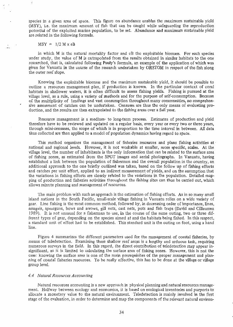
The research zone includes most of the central-eastern area of Malekula. It extends over some fifty kilometres of coastline, from Norsup Bay (16" 3' S, 167" 23' E) to the north, to Sarmette Bay (1 6" 12' S, 167" 33' E) to the south, and includes the main concentrations of mangroves in the country, around Port Stanley and Crab Bay, as well as a zone of significant economic activity with the Norsup-Lakatoro urban coniplex and the Norsup coconut plantations (Figure 1 ).
2.2.2 Tlze SPOT Data
The 60 x GO sq km SPOT scene used for the operation covers all of the northern part of Malekula. Three sub-images of the research zone were obtained. The scene was shot on 4 March 1987 in the multispectral mode. This system is equipped with three channels known as XS1, XS2 and XS3, which
28
correspond, respectively, to green and yellow bands (from 0.50 to 0.59 micrometres), red bands (from 0.6 1 to 0.68 micrometres) and infra-red bands (from 0.79 to 0.89 micrometres). The sampling interval on the ground is 20 m; thus, each picture element, or pixel, the smallest single element of the image that can be analysed, covers an area of 20 x 20 sq m.
The wavebands selected for each o f the channels are best suited to pick up the electromagnetic radiation transmitted by chlorophyl, the spectral signature of which is typified by a peak response in the green, absorption in the red and a marked response in the near infra-red. These bands are there- fore particularly well suited for studying land environments. The question is, do they perform just as well when carrying out research into an environment as complex as a coastal area that combines three inter-related zones (part landmass, part marine area and an earth/sea interface consisting, in our area of research, of the mangroves and the reef shelves)? In actual fact, evaluating the marine environment and the landmass requires totally different approaches.
Indeed, water interference is significant: first, in the electromagnetic radiation transmitted by the sea-bed and the suspended solid particles in the section of water, and second, in the satellite sensors. For instance, the near infra-red, which is the main indicator of chlorophyl presence and abundance on land, is totally absorbed by water. The XS3 channel is therefore entirely non-functional for determin- ing underwater features, which is left solely to the XS1 and XS2 channels, with the constraint that they can only perform down to an average depth of 5 to 10 metres. Below that, the electromagnetic radiation transmitted by the sea-bed is totally absorbed by the water.
Sea-bed reconnaissance is not the only use for the SPOT system in a marine environment. It can also be appiied to the water interval and the surface. In the former most of the information relates to identifying the turbid zones. Such data are obtained through the XS 1 channel, which is very receptive to the radiation of incident light from the solid particles suspended in the water. In the latter, the information pertabis to the propagation of swells and waves. These hydrological occurrences can be clearly identified with the XS3 channel and have considerable bearing on sediment movement.
Finally, it should be noted that in the tidal zone, the instant shoreline between submerged and immerged zones can be clearly outlined by the XS3 channel.
In summary, any study of the coastline in multispectral mode can be seen as a combination of four complementary approaches : the identification of underwater features through the XS2 and XS3 channels, the analysis of the dynamics of sedimentation by means of the XS1 and XS3 channels, the detennination of the instant shoreline through the XS3 channel and the outline of land features, mainly by means of the XS3 channel.
2.2.3 Data Use
As LATICAL in Noumea was not then operational, the processing of the SPOT scene was carried out at the IFREMER Centre in Brest (France) on a VAX 780 system - a microVAX using the GRINGO programme established by IFREMER. The pictures were displayed on a COMTAL monitor “
in colour composite with the XS1, XS2 and XS3 channels showing up in blue, green and red, re- spectively.
After drawing a shield on the monitor over the clouds and shadows thrown, and reverting the relevant pixels to zero, the first stage of the processing consisted in stratifying the image into three sections: the sea, the mangroves and the land.
The near infra-red being substantially absorbed by the water, a first stratification was obtained by thresholding the XS3 channel and isolating the maritime area from the landmass. There remained one area to be defined: the fringing shore of the landmass and the plant populated maritime area consisting of the reef shelf, the mangroves and associated mudbanks.
By putting a shield over the first two layers, the histographic content of the XS3 channel was highlighted and the spectral signatures of the mangroves, the shelf and the coastal fringe of the land area were thresholded. By allocating the substrata “reef shelf“ and “coastal fringe” to the strata “sea” and “land”, respectively, an automatic outlining of the ‘cmangroves-miidbank” strata was carried out after setting up a shield. This outline was then reviewed by visual interpretation of the trichromatic picture on the monitor.
29
The second stage of processing involved stratifying the mangroves by thresholding the histogram of the XS3 channel. Four spectral categories were identified, each related to vegetation density and land hydromorphism: the mud banks, the zone of Rhizophora, the zone of Ceriops and the edge of the mangroves.
In the third stage, the mangroves environment was highlighted both from the point of view of its In addition to the “mudbank-mangroves”
complex, various components of the land and sea areas could be seen on trichromatic pictures. Visual interpretation thereof was facilitated by applying a high range filter to each clminel of the gross image then enhancing it. The image interpreter went on to identify the homogeneous zones on the basis of five criteria: colour, intensity, texture, shape and structure.
- biological components and its anthropic components.
2.3 Results and Discussioiz
The processing results were condensed in the form of a map with keys and comments. Three aspects were highlighted on this map: the floristic content of the mangroves, their spatial distribution and their environment.
2.3.1 Floristic Content of the Mangroves
Rhizophora inhabit that part of the mangroves that is flooded with each tide. It consists of thickets. The main species. is Rlzizophora stylosa. It can occasionally be associated with Avicennia marina, Rhizophora mucronata and Sonneratia caseolaris. The trees do not exceed five metres in heigli t.
The area of Ceriops tagal consists of small wooded clumps. They cover a broad spectrum of positions in the mangroves, from the sea-front to the mangroves edge. In the low-lying areas, Ceriops tagal is made up of pure settlements, sometimes .associated with Avicennia marina. In the higher regions, the ground of the woods is often covered with a fern, Acrostichuin aureum. Depending on the soil depth, the trees vary in size between 3 and 10 metres.
The inudbanks are situated either beyond the section of Rhizoplzora, along the mangroves edge along the shore or within the mangroves fringe when the woods are thicker.
The edge of the mangroves consists of species that are typical of the higher regions, such as Xylocarpzis graizatzm-2, and pioneer land species particular to the coastal forests that have invaded the higher range of the mangroves following an uplift of the coastline caused by violent earthquakes in 1965. We find, in particular, Barriizgtorzia species, Caesalpinia bonduc, Cordia subcordata, Clerodeiidron iizerrne, Derris trifoliata, Excoecaria agalldclza and Heritiera littoralis.
’
2.3.2 Spatial Distribution of the Mangroves
Overall within the research zone, the “mud/swamp-mangroves” complex covers 1,037 ha, of which 4 per cent are under bare mud, 17 per cent are covered by the Rhizophora bushes, 69 per cent by the Cei.iops woods and 10 per cent by the fringe. This zone is divided into three areas: the Port Stanley mangroves (545 ha), the Crab Bay mangroves (256 ha) and the line forest, which fringes the coastline (236 ha; see Table 1).
2.3.3 The Marzgroves Environment
Mangroves, by providing fertilization to the coastal environment and food and shelter to the juvenile marine species population, have an impact on the maritime sphere that extends well beyond the adjoining waters. On the map, the marine environment is shown as a filtered colour composition at higher, then raised, levels. It comprises three groups: the shelf and the algae crest, which extends from the mangroves to the breaker line and dissipates the energy from the waves; the zone of peaks and troughs and the non-striated platform, which covers the first ten metres of water; and the area beyond, opaque to the SPOT satellite sensors, which comprises the surface water, and clearly shows up the propagating waves of swell to the coast.
For optimum growth, mangroves require loose soils and sheltered exposure to the offshore swell and the tradewinds. The se,diments upon which they thrive originate from the soil erosion following
30

Table 1. Spatial distribution of mangroves
Port Stanley Crab Bay Sea front fringe Total
ha % ha % ha % ha % -
Bare mud 25 5 15 6 1 O 41 4 Rh izoph ora forest 105 19 59 23 14 6 178 17 Ceriops thickets 360 66 169 66 186 79 715 69 Landward edge 5 5 10 13 5 35 15 103 10
Total 545 1 O0 256 1 O0 236 1 O0 1,037 100
~ ~ ~~~ ~ ~
Bare mud Rhiz op h ora Ceriops Landward edge Total
Port Stanley 61 Crab Bay 37 Sea front fringe 2
59 33
8
50 24 26
53 52.5 13 24.5 34 23 .O
Total 1 O0 1 O0 1 O0 1 O0 100.0
drainage by the network of waterways and rivers. Their extensiveness depends on rainfall, topography of the land and the pedological features of the drainage basins (Figure 2). These basins cover three major land tracts: the complex of coastal forest, wooded fallow land and food crop gardens (Figure l), the coastal coconut plantations and the high forest of the leeward slopes.
The anthropic environment of the mangroves is a major factor for consideration if their con- tinued existence is to be ensured for the whole of the planet. Mangroves actually represent a wetland that is suffering greatly from human depradation. At the present time, there is no serious threat to the mangroves along the central eastern coast of Malekula. Their main use is for fishing activities. It is true that the Port Stanley and Crab Bay areas, which contain the main growths of mangroves, are only sparsely populated, but the more densely populated areas around Norsup and Lakatoro cor- respond t o coastlines that are unsuited to mangroves expansion. On Figure 1, the mangroves anthro- pic environment is represented by the Norsup airport, the network of roads and the villages.
3.0 Assessment and Prospects
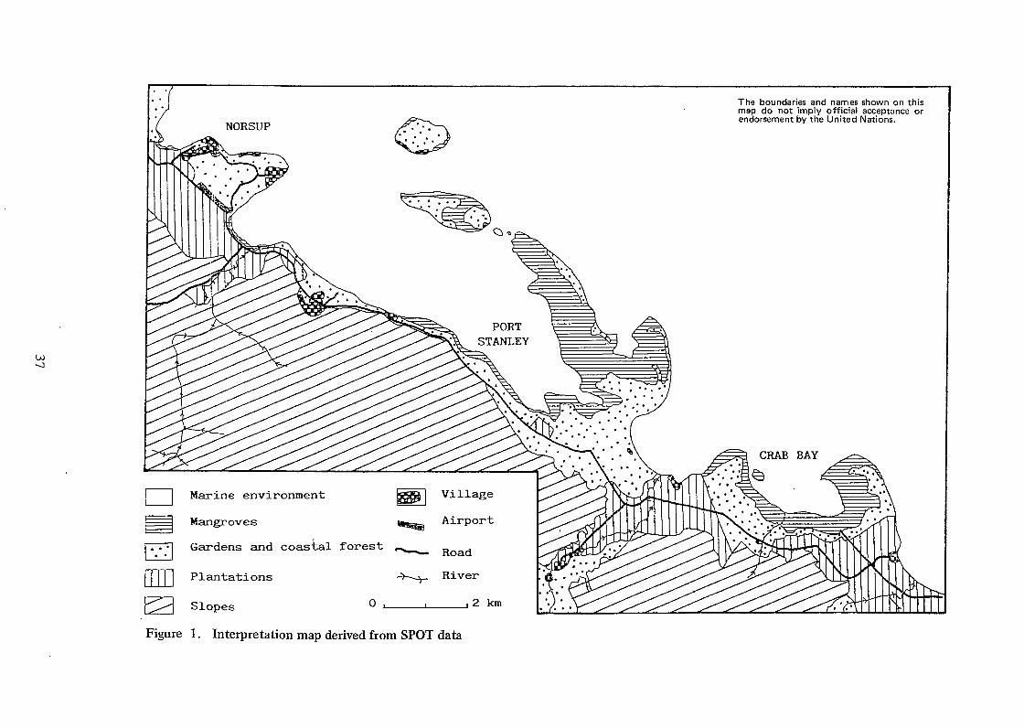
Figure 2 shows the importance of SPOT satellite images for the purpose of studying coastal zones. A variety of applications for the SPOT images in respect of the coastal zones of Vanuatu can be deduced from the identification and then classification of such information.
Three types of information can be gathered from Figure 2: dynamic processes, static states and the interactions between the dynamic processes and the static states. Following this approach, a SPOT image is associated with a space made up of a mosaic of homogeneous zones and flows of a physical or anthropic nature (Figure 3). These homogeneous zones would not appear to be subject to any notable increase or decrease in size on a day-to-day or weekly basis. They therefore correspond t o a static element of space. The flows, however, represent fast movements of matter in space, regardless of the physical or anthropic nature of such matter. They correspond to a dynamic element of space.
Whether dealing with static elements, dynamic processes or interactions between the two, the ... information is of a dual nature, both spatial and temporal.
31

3.1 Information of a Spatial Nature
Only the physical flows will be covered here.
..*
Six dynamic processes can be identified in the coastal areas: wind, rainfall, surface waters (mostly run off), rivers and streams, sea currents, swells and waves. Only the first two cannot be identified in SPOT images, the users giving priority t o scenes with only minor haziness. Identifying the other dynamic processes depends very‘much on the me- teorological conditions over the previous days. If conditions have been dry, only the rivers and surface sea streams can be distinguished. Apart from their location, other items of information can be gleaned from the pictures, including the possible flow of rivers; estimated on the basis of their length, the extent of their drainage basins and the breadth of the river mouths; the expanse of area covered by the waves and swells and the direction in which these flows propagate; and the wave lengths of the waves and swells, as shown by the interval between two crests and the expanse of water affected by these water movements, the maximum depth being equal to one half of a wave length.
Under wet conditions, more information is available. The same information as in dry conditions can be gathered, added to which there are more specific elements, in relation mainly to the trails of turbidity that are visible at the river mouths. The extent of such trails provides information about the actual flow of the rivers at “t” time of the satellite passage. Their extent and the level of turbid- ity, which can be assessed by means of the XS1 channel, provide information as to the volume of landward input originating from run-off water from the land, which is closely related to the amount of rainfall, the angle of slope in the drainage basins and the vegetation density. The direction of the turbidity trails provides information on the direction and strength of the sea currents, especially the coastal drift.
Static elements correspond to homogeneous zones, identified during the passage of the satellite by their location and extent and their spectral signature, reflecting various factors, the most significant of which are the biological or morphological features, the depth and, in some instances, the physiologi- cal conditions.
Therefore, two zones of different natures, situated at the same depth, with one comprising live corals and the other muddy sands covered with sea plants, will show two completely different spectral signatures. The same will apply to two zones of white sand situated at varying depths, and also for two zones of coral of the same nature, situated at the same depth, but under contrary physiological conditions, one comprising live coral, the other dead coral.
As a rule, the study of the static elements of space shown on a SPOT scene consists of two sequential operations: identifying the homogeneous zones by their spectral signature and assessment of the area covered.
Interactions between the dynamic and static elements are generally medium to long term, except under particular circumstances, for instance cyclones or tidal waves. They occur mainly in the direc- tion of “dynamic processes” toward “static state” and in two forms, one being quantitative, the other qualitative, with both forms being combined on occasion. The first form shows up as a decrease or an increase of the area covered by the static elements, the most common example being erosion or tile sediments washed into the sandy zone by the coastal drift. The second shows up as a change in the physiological or inorphological features of the relevant zone, depending on whether it comprises organic matter or minerals. For instance, a cyclone is liable to kill off the greater part of live coral in any given area.
3.2 Information o f a Temporal Nature
As with aerial photographs, a satellite image reproduces a fixed situation, set in time, at the passage of the satellite or the aircraft; the temporal information, therefore, is logically less dense than the spatial information. Most of the temporal information provided by a picture can only be accessed indirectly by interpreting the resulting spatial information. For instance, a thick trail of turbidity at the mouth of a river can immediately be interpreted as the result of heavy rainfall mer the previous days.
Seldom can temporal information be deduced directly. It corresponds to the presence on the same picture of areas of naked land caused by intense logging or massive clearing along highly turbid
32
coastal zones, the latter being the result of the former. In a diagram, the cleared area and the marine area can be associated, respectively, with a transmitter and a receiver of a flow with a particularly marked temporal dimension, as expressed by a causal relation.
4.0 Use of the ' Ate Data
The only studies taken into account are those relating t o the maritime environment and the inter- face (land/sea environment). Five useful applications can be found for the SPOT satellite data in this particular field: studying the dynamics of sedimentation and erosion along the coast; ecological in- ventory taking; management of the fish resources; natural resource accounting; and studying the impact, with regard to urban development, of forestry development projects, agricultural development and aquacultural development.
4.1 The Dynamics of Coastal Sedimentation and Erosion
Generally speaking, Vanuatu is relatively free of coastal erosion problems, except for a few stretches of road that have been built on rocky outcrops or along beach cliffs that are likely to col- lapse. Studying the dynamics of sedimentation is therefore of interest at another level: the location of mangrove areas, expanses of sea plants and coral reefs. Mangroves and, to a lesser degree the sea plant fields, are particularly dense in sheltered areas where the energy from the waves and the swells is only felt as an aftermath, in a weak form, thus encouraging sedimentation. As opposed t o this, corals re- quire very clear water for their growth and are extremely sensitive to turbidity over any lengthy period of time.
4.2 Ecological Inventory Ta king
Ecological inventory taking is the main application for SPOT data in the field of fisheries. It is governed by a simple principle. Given a species that is of interest to fishermen, the process involves five stages: identifying a reference zone containing the relevant species and establishing the associated sea-bed feature or features; identifying the spectral signatures of those features; finding identical features on a broader scale, around an island or throughout the country, by picking out the corre- sponding spectral signatures and then calculating their overall surface area; calculating the population density for the chosen species, initially in the reference zone, then in those areas presenting identical features, in order to extrapolate the results to the island or to the country; and extrapolating the results to the overall sea-bed features as assessed for the whole island or country.
Given the difficulty in distinguishing sea-bed features below five metres, inventories can only be taken of species living in shallower waters. In Vanuatu, the Fisheries Department's requirements in- volve mainly the trochus and the sea slug. Due to the scarcity of lagoons and the narrowness of the fringing reefs, the ground resolution of the SPOT satellite (20 m in multispectral mode) is often in- adequate to properly identify the sea-bed features. In this respect, the reefs at Port Stanley and Crab Bay are hardly representative of the general prevailing situation in the country. In most cases, the width of the fringing reef varies between 20 and 100 m, corresponding to a bracket of one to five pixels, which is not enough to carry out a detailed inventory.
The solution is to use satellite data and aerial photographs in conjunction with each other. In this respect, the satellite picture is used for a rapid assessment of all the reef areas and identification of the sea-bed features associated with the relevant species in reef zones that are sufficiently extensive. Aerial photographs are used for detection purposes to establish the sea-bed features of reference sites. To be able to extrapolate the results thereby obtained to all of the reef zone, it is necessary to establish a carefully laid out sampling programme. The photointerpretation depends on distinguishing four main criteria: the intensity of the grey colours, the shapes, the textures and the structures. It also refers to the processing of satellite images in respect of the larger expanses of reef zones.
4.3 Management of Fish Resources
Management of fish resources is a direct application of the ecological inventories, which allow determination of the exploitable biomass (eB), also known as abundance, of a species or group of
33
species in a given area of space. This figure on abundance enables the rnaximum sustainable yield (MSY), i.e. the maximum amount of fish that can be caught while safeguarding the reproduction potential of the exploited marine population, to be set. Abundance and maximum sustainable yield are related in the following formula.
MSY = 1 / 2 M x e B
in which M is the natural mortality factor and eB the exploitable biomass. For each species under study, the value of M is extrapolated from the results obtained in similar habitats to the one researched, that is, calculated following Pauly’s formula, an example of the: application of which was given for Vanuatu in the course of the research undertaken by ORSTOM in respect of the fish along the outer reef slope.
Knowing the exploitable biomass and the maximum sustainable yield, it should be possible to outline a resources management plan, if production is known. In the particular context of coral habitats in shallower waters, it is often difficult to assess fishing yields. Fishing is pursued at the village level, as a rule, using a variety of methods and for the purpose of self-consumption. Because of the multiplicity of landings and vast consump tion throughout many communities, no comprehen- sive assessment of catches can be undertaken. Censuses are thus the only means of evaluating pro- duction, and the results are then extrapolated to the fishing areas over a full year.
Resource management is a medium- to long-term process. Estimates of production and yield therefore have to be reviewed and updated on a regular basis, every year or every two or three years, through mini-censuses, the scope of which is in proportion to the time interval in between. All data thus collected are then applied to a model of population dynamics having regard to space.
This method organizes the management of fisheries resources and plans fishing activities at national and regional levels. However, it is not workable at smaller, more specific, scales. At the village level, the number of inhabitants is the only information that can be related to the surface area of fishing zones, as estimated from the SPOT images and aerial photographs. In Vanuatu, having established a link between the population of fishermen and the overall population in the country, an additional approach to the one briefly outlined was taken, based on the follow up of fishing efforts and catches per unit effort, applied to an indirect measuremect of yields, and 02 the assumption that the variations in fishing efforts are closely related to the variations in the population. Detailed map- ping of production and fisheries activities throughout the fishing sites can thus be carried out, which allows minute planning and management of resources.
The main problem with such an approach is the estimation of fishing efforts. As in so many small island nations in the South Pacific, small-scale village fishing in Vanuatu relies on a wide variety of gear. Line fishing is the most common method, followed by, in decreasing order of importance, lines, assegais, spearguns, bows and arrows, gill nets, cast nets, pots and fish traps (David and Cillaurren 1989). It is not unusual for a fisherman to use, in the course of the same outing, two or three dif- ferent types of gear, depending on the species aimed at and the habitats being fished. In this respect, a standard unit of effort had to be established. This standard unit is the outing on foot, using a hand line.
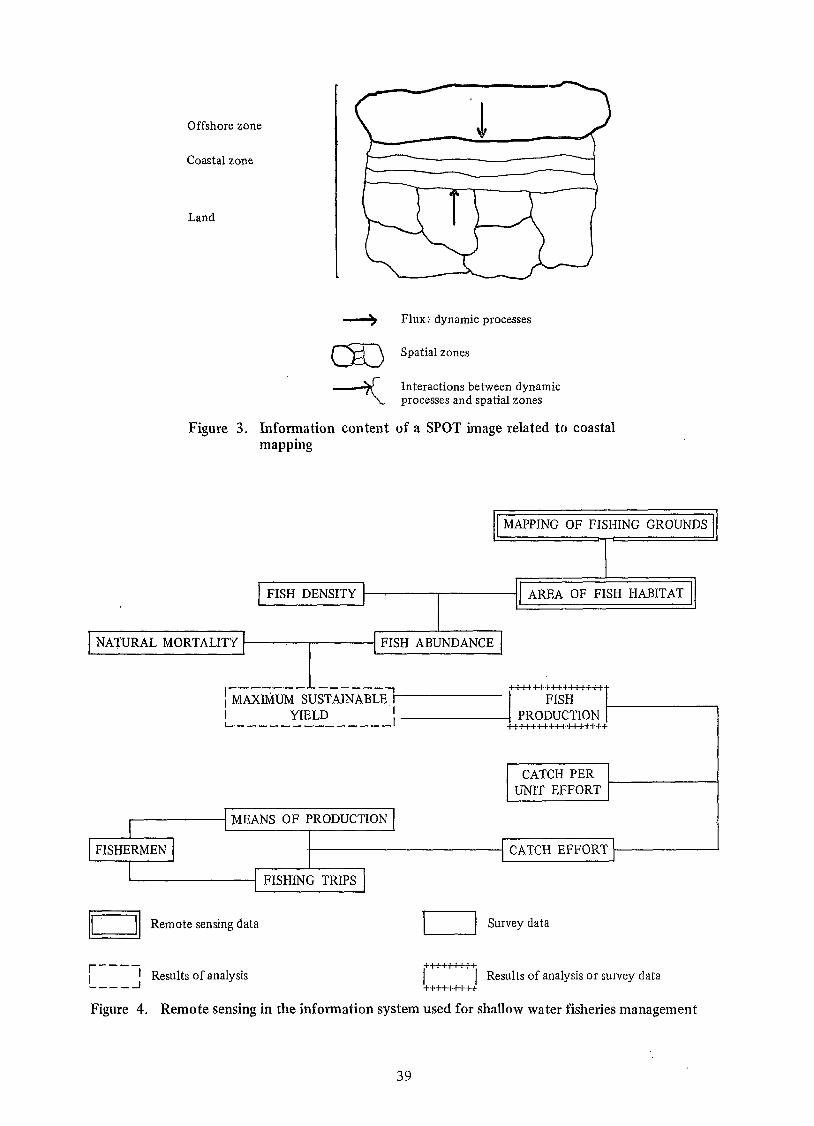
Figure 4 summarizes the different parameters used for the management of coastal fisheries, by means of teledetection. Examining these shallow reef areas is a lengthy and arduous task, requiring numerous surveys in the field. In this regard, the direct contribution of teledetection may appear in- significant, as it is limited to calculating the surface area of fishing zones. However, this is not the case: knowing the surface area is one of the main prerequisites of the proper management and plan- ning of coastal fisheries resources. To be really effective, this has to be done at the village or village group level.
4.4 Natural Resources Accounting
Natural resources accounting is a new approach in physical planning and natural resources manage- ment. Halfway between ecology and economics, it is based on ecological inventories and purports to allocate a monetary value to the natural environment. Teledetection is mainly involved in the first stage of the evaluation, in order to determine and map the components of the relevant natural environ-
34
nient, the natural and aiitliropic environment and the flows issuing from this environment toward the relevant area of research.
By putting a price on any natural environment, natural resource accounting enables us t o clearly advise the public authorities of the often unsuspected wealth of their natural heritage. This represents a significant tool in decision making, with respect to physical planning. So often in the past, the fragile coastal environmtxits such as mangroves or coral reefs were sacrificed for the purpose of urban development and expansion or agricultural or forest projects. The lack of pricing used t o be associated with a lack of inherent value, whereby natural resources could not be expre.ssed in monetary terms, and the public authorities did not hesitate to replace a natural space that they deemed t o be of no value with an anthropic space that cost money to set up and was meant to be a source of profits later on.
In truth, any natural environment can be compared to a biological and economic asset accruing yearly interest; Thus, the: mangrove asset constitutes, all in one, a shelter; a breeding space; a nursery for young fish; a source of energy and food for the fish population to be found there or downstream, whereby the mangroves p:lay a significant role of fertilization of the coastal marine environment; and a shield agaiast the erosive action of the waves, against gales and against the severe turbidity that can, at times, put downstream coral reefs in jeopardy.
Each year, this asset produces interest in the shape of animal and plant populations. Intuitively, the simplest way of setting the price of the mangroves is to estimate financially the interest generated by the mangroves on the basis of their use by mankind, in particular fishing and fuelwood gathering. The main question is then to decide over what period of time the value of such interest should be estimated.
A yearly estimate leads to considerable underrating of the actual value of the natural heritage. It is similar to associating the price of a house with its yearly rental income. But, unlike manmade things, a biological asset does not depreciate with the passage of time if it is properly and rationally managed (maximum sustainable yield). I t would appear quite feasible to speak of amortizing the asset over a generation (25 to 30 years). On this assumption, the price of a natural heritage such as the mangroves would correspond to the accrued interest generated by said asset over a period of 25 to 30 years.
Another method can be used t o work out the price of a natural environment, based solely on the value of the asset. This involves considering the cost of the technological infrastructure required to carry out the same functions as the natural heritage in the event that the latter should be destroyed. In the particular instance of the mangroves, three stages of facilities have t o be considered: anti- erosion installations t o ensure the shielding function of the mangroves; fish aggregating devices set up off shore or artificial reefs established in shallow waters and intended t o match the fish production of the mangroves; and aquaculture to generate fish larvae in order to replenish sea stocks. Over and above the cost .of such facilities, other occasional expenses have t o be included for maintenance of the facilities and the spraying of chemical fertilizers in order t o offset the reduced nutrient content of the water following destruction of the mangroves.
4.5 Impact Studies
Impact studies are intended to assess the direct and induced effects of anthropic installations in the natural environment. These require specific knowledge and understanding of the ecological in- ventories carried out in the area to be developed; the biological, hydrological and morphological features of the drainage basins adjoining t h e said area; and the sedimentation dynamics existing prior to development, in particular in order to project the sedimentation dynamics following development. In this respect, teledetection is essential.
In the same way as natural resource accounting, impact studies represent a significant tool for decision making in relation to physical planning. A wise approach would be to combine these two tools, with natural resource accounting for pricing an environment and impact studies for evaluating the destruction it may be subject to.
35

5.0 Conclusion
Given the initial results achieved in Malekula and from the quick review here of its informative content and some of its potential applications in. coastal areas, high resolution SPOT satellite tele- detection would appear t o offer interesting possibilities for a small island nation such as Vanuatu in the fields of thematic mapping, resource management and physical planning. Because of the narrowness of the reef strip and the complexity of the coastal ecosystems and the human activities carried out there, the use of satellite teledetection can only be fully effective if it is combined with aerial pho- tography and quantitative land analyses, particularly in the fields of ecology, morphology and socio- economics. The most suitable combination method for all these data is undoubtedly the geographic in formation system. At this stage, the geographic information system/satellite teledetection interfaces are still underdeveloped, probably because they are fairly new techniques. ‘There is a future to build on..
Reference
David, G. and E. Cillaunen. A survey of village subsistence fishing in Vanuatu. ORSTOM Mission in Port Vila, Notes and Documents on Oceanography, 19: 1989. p. 1 1-25.
36
c,
c, In al k O
4-l
"o
k P 2 a In c O -4
c, (d c,
r-l a s
37

The boundaries and names shown on this map do not imply official acceptance or endorsement by the United Nations.
O 100 km
Perhumid s l o p e s o f a l t i t u d e
Windward s l o p e s , a l t i t u d e lower than 500 m
~m L____.
i.........;
Leeward s l o p e s , a l t i t u d e h i g h e r than 400 m
Low p l a t e a u x s h e l t e r e d from t h e t r a d e winds
A l l u v i a l and reef terraces s h e l t e r e d from t h e trade winds
- _ _ _ _ I I
Figure 2. Morphoclimatic map of Malekula
38
Offshore zone
Coastal zone
FISH DENSITY
Land
AREA OF FISH HABITAT
s 4 Flux: dynamic processes a Spatial zones
Interactions between dynamic processes and spatial zones
Figure 3. Information content of a SPOT image related to coastal mapping
+mu++++++++ FISH 7 -.---.-.-- 1 ------ I N.IAXIMuM SUSTAlNABLE, I
I YIELD ' -1 PRODUCTION L _ _ _ _ _ _ _ _ . _ _ _ _ _ _ - I ' +++++++++++HU++
FI SHE M E N CATCH EFFOIZT
1
)Il Remote sensing data
r---- I I Results of analysis *---A
1-1 Survey data
i 1 Results of analysis o r survey data +++++++++
Figure 4. Remote sensing in the information system used for shallow water fisheries management
39