united states department of the interior bureau of … july13sdfo_finale… · united states...
TRANSCRIPT

United States Department of the Interior
Bureau of Land Management
Environmental Assessment DOI-BLM-MT-C040-2013-0010-EA
Project Title: Oil and Gas Lease Parcel Sale, July 16, 2013
Location: South Dakota Field Office –
Harding, Meade, and Fall River counties
U.S. Department of the Interior
Bureau of Land Management
South Dakota Field Office
310 Roundup Street
Belle Fourche, SD 57717
Phone: 605-892-7000
FAX: 605-892-7015

South Dakota Field Office Oil and Gas Lease Sale EA
DOI-BLM- MT-C040-2013-0010-EA
CONTENTS
Page
1.0 PURPOSE and NEED................................................................................................................5
1.1 Introduction ...................................................................................................................5
1.2 Purpose and Need for the Proposed Action ..................................................................6
1.3 Conformance with BLM Land Use Plan(s) ..................................................................7
1.4 Public Scoping and Identification of Issues ..................................................................7
2.0 DESCRIPTION OF ALTERNATIVES, INCLUDING PROPOSED ACTION ......................9
2.1 Alternative A – No Action ............................................................................................9
2.2 Alternative B- Proposed Action ....................................................................................9
2.3 Alternative C-BLM Preferred .......................................................................................9
2.4 Additional Considerations for Alternatives B and C…………………… ………… 9
3.0 AFFECTED ENVIRONMENT ..............................................................................................10
3.1 Introduction .................................................................................................................10
3.2 Air Resources ..............................................................................................................10
3.3 Soil Resources .............................................................................................................18
3.4 Water Resources .........................................................................................................18
3.5 Vegetation Resources..................................................................................................19
3.6 Special Status Species .................................................................................................21
3.7 Fish and Wildlife.........................................................................................................27
3.8 Cultural Resources ......................................................................................................28
3.9 Native American Religious Concerns .........................................................................31
3.10 Paleontology ..............................................................................................................32
3.11 Visual Resources ........................................................................................................34
3.12 Livestock Grazing ......................................................................................................35
3.13 Recreation and Travel Management ..........................................................................35
3.14 Lands and Realty........................................................................................................36
3.15 Minerals .....................................................................................................................36
3.16 Special Designations ..................................................................................................38
3.17 Social and Economic Conditions ...............................................................................38
4.0 ENVIRONMENTAL IMPACTS ...........................................................................................42
4.1 Assumptions and Reasonably Foreseeable Development Scenario Summary ............43
4.2 Alternative A (No Action) ..........................................................................................47
4.3 Alternative B (Proposed Action) .................................................................................49
4.4 Alternative C (BLM Preferred) ....................................................................................78
5.0 CONSULTATION AND COORDINATION .........................................................................84
5.1 Persons, Agencies, and Organizations Consulted ........................................................84
5.2 Summary of Public Participation .................................................................................85
5.3 List of Preparers ...........................................................................................................85
6.0 REFERENCES ........................................................................................................................86
7.0 DEFINITIONS ........................................................................................................................ 93

APPENDICES
Appendix A – Descriptions of Lease Parcels and Lease Stipulations
Appendix B - Stipulations Applied
Appendix C – Maps
Vicinity Map of Lease Sale Parcels – (VicinityMap_July2013)
Map of Parcels in Harding County - 1 – Aerial Photo Based Map –
(Map1_HardingCty_July2013)SD_July_2012_Sale_Harding_aerial)
Map of Parcels in Meade County - 2 – Contour Map –
(Map2_MeadeCty_July2013SD_July_2012_Sale_Harding_contour_2)
Map of Parcel in Fall River County – (Map3_FallRiverCty_July2013)
TABLES
Table 3.2.1.1: Air Quality Index Report – Analysis Area Summary (2008-2010)
Table 3.6.1.1: Aquatic sensitive or specials status wildlife species in the analysis area
Table 3.6.1.2: Analysis area occurrence of BLM terrestrial sensitive species and USFWS
threatened, endangered, candidate or proposed terrestrial species
Table 3.6.2.1: SD Rare Species of Concern and BLM Sensitive Plants on or near Lease parcels
Table 3.9.1: List of Native American Tribes with aboriginal ties or interests in the area
Table 3.12.1: Lease parcels located within BLM grazing allotments
Table 3.15.1: Existing Development Activity
Table 3.15.2: Oil and Gas Leasing and Existing Development within Townships Containing
Lease Parcels
Table 3.17.2.1: Current Contributions of Federal Oil and Gas Leasing, Exploration,
Development, and Production to the Local Economy
Table 4.1.1 Disturbance Associated with New Drilled Wells and Existing Active Wells in
Planning Area (Short-Term Disturbance – Two Years)
Table 4.1.2: Disturbance Associated with New Drilled Wells and Existing Active Wells (Long-
Term Disturbance).
Table 4.2.2.1: Summary Comparison of Estimated Average Annual Economic Impacts

Table 4.3.3.1.2.1: BLM projected annual emissions of GHGs associated with oil and gas
exploration and development activity in the SDFO.
Table 4.3.3.2.1: Selected Methane Emission Reductions Reported Under the EPA Natural Gas
STAR Program
Table 4.3.20.2.1.1: Projected non-BLM GHG emissions associated with the SDFO Reasonably
Foreseeable Development Scenario for fluid mineral exploration and development
Table 5.2.1: List of Preparers
Table 5.2.2: List of Reviewers
FIGURES
Figure A. Visibility trends on haziest and clearest days, 2000-2009
Figure B. Regional climate summary of spring temperatures (March-May) for the West North
Central Region (MT, ND, SD, WY), from 1895-2007. (Source: NOAA website –
Figure C. Regional climate summary of spring temperatures (March-May) for the West North
Central Region (MT, ND, SD, WY), from 1991-2005. (Source: NOAA website –

5
South Dakota Field Office Oil and Gas Lease Sale EA
DOI-BLM- MT-C040-2013-0010-EA
1.0 PURPOSE AND NEED
1.1 Introduction It is the policy of the Bureau of Land Management (BLM) to make mineral resources available
for use and to encourage development of mineral resources to meet national, regional, and local
needs. This policy is based on various laws, including the Mineral Leasing Act of 1920 and the
Federal Land Policy and Management Act of 1976. The Federal Onshore Oil and Gas Leasing
Reform Act of 1987 Sec. 5102(a)(b)(1)(A) directs the BLM to conduct quarterly oil and gas
lease sales in each state whenever eligible lands are available for leasing. The Montana State
Office conducts mineral estate lease auctions for lands managed by the federal government,
whether the surface is managed by the Department of the Interior (BLM or Bureau of
Reclamation), United States Forest Service, or other departments and agencies. In some cases
the BLM holds subsurface mineral rights on split estate lands where the surface estate is owned
by another party, other than the federal government. Federal mineral leases can be sold on such
lands as well. The Montana State Office has historically conducted five lease sales per year.
Members of the public file Expressions of Interest (EOI) to nominate parcels for leasing by the
BLM. From these EOIs, the Montana State Office provides draft parcel lists to the appropriate
field offices for review. BLM field offices then review legal descriptions of nominated parcels
to determine: if they are in areas open to leasing; if new information has come to light which
might change previous analyses conducted during the land use planning process; if there are
special resource conditions of which potential bidders should be made aware; and which
stipulations should be identified and included as part of a lease. Ultimately, all of the lands in
proposed lease sales are nominated by private individuals, companies, or the BLM, and therefore
represent areas of high interest.
This environmental assessment (EA) has been prepared to disclose and analyze the potential
environmental consequences from leasing all 7 nominated lease parcels located in the South
Dakota Field Office (SDFO) decision space (Vicinity Map), to be included as part of a
competitive oil and gas lease sale tentatively scheduled to occur on July 16, 2013. The EA will
use three alternatives to discuss different leasing scenarios that address resource concerns.
The analysis area includes the 3 nominated parcels: SDM 97300-H3, SDM 97300-H4, SDM
97300-H5 in Harding County (Map 1), 3 parcels: SDM 97300-JU, SDM 97300-JV, SDM
97300-JW, in Meade County (Map 2), and 1 parcel: SDM 97300-KU, in Fall River County
(Map3).
There are certain characteristics which define and influence social and economic activity taking
place in South Dakota. These characteristics may include local populations, the presence and
proximity of cities or regional business centers, longstanding industries, infrastructure,
predominant land and water features, and amenities unique to the area. While the exploration and
development of federal mineral estates may take place on well-defined parcels, the social and
economic impacts of these activities may extend well beyond parcel boundaries. In order to
6
accurately portray the relationship of current BLM management, and examine the effects of
leasing additional parcels for mineral development, the geographic scope of this analysis had to
be extended. While there are only three South Dakota counties (Fall River, Harding, and Meade)
which have parcels nominated for the July 2013 lease sale; Butte, Custer, and Pennington
counties were identified as likely to be impacted by additional leasing. While the distribution of
effects stemming from additional fluid minerals leasing will vary across the impact area, the
distribution of economic effects stemming from the sale will be based on the number of acres
leased, levels of production, and the business patterns of these counties.
1.2 Purpose and Need for the Proposed Action The purpose of offering parcels for competitive oil and gas leasing is to provide opportunities for
private individuals or companies to explore for and develop federal oil and gas resources after
receipt of necessary approvals and to sell the oil and gas in public markets.
This action is needed to help meet the energy needs of the people of the United States. By
conducting lease sales, the BLM provides for the potential increase of energy reserves for the
U.S., a steady source of income, and at the same time meets the requirement identified in the
Energy Policy Act, Sec. 362(2), Federal Oil and Gas Leasing Reform Act of 1987, and the
Mineral Leasing Act of 1920, Sec. 17.
The decision to be made is whether to sell and issue oil and gas leases on the lease parcels
identified, and, if so, identify stipulations that would be included with specific lease parcels at
the time of lease sale.
Another purpose of this environmental assessment is to address more areas for which existing
stipulations will be applied due to changing knowledge and new inventory data. Thus, this
environmental assessment will maintain the Miles City District Oil and Gas RMP/EIS
Amendment, which adopted these stipulations. Stipulations for which maintenance is being
done, includes the following: (NSO 11-2) Surface occupancy and use is prohibited within
riparian areas, 100-year floodplains of major rivers, and on water bodies and streams; (TL 13-1)
Surface use is prohibited from December 1 to March 31 within crucial winter range for wildlife,
(LN 14-11) Greater Sage Grouse Habitat Lease Notice - The lease may, in part or in total,
contain important greater sage grouse habitats as identified by the BLM, either currently or
prospectively. The operator may be required to implement specific measures to reduce impacts
of oil and gas operations on the greater sage grouse populations and habitat quality. Such
measures shall be developed during the application for permit to drill on-site and environmental
review process and will be consistent with the lease rights granted.; and (LN 14-15) Sprague’s
Pipit Lease Notice - The lease area may contain habitat for the federal candidate Sprague’s pipit.
The operator may be required to implement specific measures to reduce impacts of oil and gas
operations on Sprague’s pipits, their habitat and overall population. Such measures would be
developed during the application for permit to drill and environmental review processes,
consistent with lease rights. If the U.S. Fish and Wildlife Service lists the Sprague’s pipit as
threatened or endangered under the Endangered Species Act, the BLM would enter into formal
consultation on proposed permits that may affect the Sprague’s pipit and its habitat. Restrictions,
modifications, or denial of permits could result from the consultation process. .

7
1.3 Conformance with Land Use Plan(s)
This EA is tiered to and conforms to the information and analysis contained in the Land Use
Plans: Final South Dakota Resource Management Plan, approved in April 1986, and the Miles
City District Oil and Gas RMP/EIS Amendment (otherwise referred to as the MCDO document),
approved on February 2, 1994.
The proposed action is in conformance with the applicable LUPs because it is specifically
provided for in the following LUP decisions: See the Summary on page iii of the Miles City
District Oil and Gas RMP/EIS, which gives the lands subject to leasing under various
stipulations provided for in the preferred alternative, the section in Appendix B, pages 139-175,
which gives the lease forms and stipulations for alternatives, and map numbers 3, 4, and 5, which
shows where stipulations apply. Lease stipulations are commonly added to lease parcels. Lease
terms are added to all lease parcels.
Analysis of the 7 parcels is documented in this EA, and was conducted by South Dakota Field
Office, Miles City Field Office, and Montana State Office resource specialists who relied on
professional knowledge of the areas involved and review of current databases and file
information to ensure that appropriate stipulations were recommended for a specific parcel.
Analysis has also identified the need to defer entire or partial parcels from leasing pending
further environmental review. A new resource management plan is being prepared by the South
Dakota Field Office, which has identified new management actions needed to protect resources.
In certain cases, parcels must be deferred to protect resources pending completion of the RMP.
No parcels are being deferred in this case.
At the time of this review it is unknown whether a particular parcel will be sold and a lease
issued. It is unknown when, where, or if future well sites, roads, and facilities might be
proposed. Assessment of potential activities and impacts was based on potential well densities
discerned from the Reasonably Foreseeable Development (RFD) Scenario developed for the
South Dakota Field Office. Detailed site-specific analysis and mitigation of activities associated
with any particular lease would occur when a lease holder submits an application for permit to
drill (APD). A more complete description of mitigation, BMPs, and conditions of approval
related to oil and gas lease activities can be found in the Final South Dakota Resource
Management Plan, approved in April 1986, and the Miles City District Oil and Gas RMP/EIS
Amendment approved on February 2, 1994, the Surface Operating Standards and Guidelines for
Oil and Gas Exploration and Development-The Gold Book, and online at
http://www.blm.gov/wo/st/en/prog/energy/oil_and_gas/best_management_practices. html.
Offering the parcels for sale and issuing leases would not be in conflict with any local, county, or
state laws or plans.
1.4 Public Scoping and Identification of Issues
Public scoping for this project was conducted through a 15-day scoping period advertised on the
BLM Montana State Office website and posted on the South Dakota Field Office website
National Environmental Policy Act (NEPA) notification log. Scoping was initiated December

8
17, 2012; and the comment period was open through January 2, 2013. No scoping comments
were received.
Internal scoping related to oil and gas leasing identified the following issues: protection of
cultural and tribal areas; minimization of surface (soil) disturbance and protection measures for
sensitive or limited soils and steep slopes; protection of jurisdictional waters of the U.S. from
operations, identification of mitigation measures to minimize impacts from operations, and
wildlife habitat concerns including sage grouse.

9
2.0 DESCRIPTION OF ALTERNATIVES, INCLUDING PROPOSED ACTION
2.1 Alternative A - No Action
For EAs on externally initiated Proposed Actions, the No Action Alternative generally means
that the Proposed Action would not take place. In the case of a lease sale, this would mean that
all expressions of interest to lease (parcel nominations) would be denied or rejected.
The No Action Alternative would exclude all 7 parcels within the South Dakota Field Office
from the lease sale. Surface management would remain the same and ongoing oil and gas
development would continue on surrounding federal, private, and state leases.
2.2 Alternative B – Proposed Action
The Proposed Action Alternative would be to offer 7 parcels of federal minerals for oil and gas
leasing, covering 939.58 acres of federal minerals administered by the South Dakota Field
Office, in conformance with the existing land use planning decisions. The parcels are located in
Harding, Meade, and Fall River Counties, South Dakota. Parcel number, size, and detailed
locations and associated stipulations are listed in Appendix A. Maps 1 and 2 indicate the
detailed location of each parcel.
Of the 939.58 acres of federal mineral estate considered in this EA, 1 parcel contains 40 acres of
surface lands managed by the BLM. The remaining 6 parcels are all split estate (private surface
with federal mineral estate).
2.3 Alternative C - BLM Preferred Alternative
Under the BLM Preferred Alternative, 7 lease parcels, containing 939.58 acres of federal
minerals, would be offered with RMP lease stipulations and/or lease notices as necessary
(Appendix A) for competitive oil and gas lease sale and lease issuance.
No lease parcels would be deferred.
2.4 Additional Considerations for Alternatives B and C
In the instance of the parcels which are split estate, the BLM provided courtesy notification to
private landowners that their lands are considered in this NEPA analysis and would be
considered for inclusion in an upcoming lease sale. If any activity were to occur on such split
estate parcels, the lessee and/or operator would be responsible for adhering to BLM requirements
as well as reaching an agreement with the private surface landowners regarding access, surface
disturbance and reclamation. Standard lease terms, stipulations, conditions, and operating
procedures would apply to these parcels.
Standard operating procedures, best management practices and required conditions of approval
(COA) and the application of lease stipulations change over time to meet overall RMP
objectives. The COA’s would be attached to permits for oil and gas lease operations to address

10
site-specific concerns or new information not previously identified in the land use planning
process. In some cases new lease stipulations may need to be developed and these types of
changes may require an RMP amendment. There is no relief from meeting RMP objectives if
local conditions were to become drier and hotter during the life of the RMP. In this situation,
management practices might need to be modified to continue meeting overall RMP management
objectives. An example of a climate related modification is the imposition of additional
conditions of approval to reduce surface disturbance and implement more aggressive dust
treatment measures. Both actions reduce fugitive dust, which would otherwise be exacerbated
by the increasingly arid conditions that could be associated with climate change.
Oil and gas leases would be issued for a 10-year period and would continue for as long thereafter
as oil or gas is produced in paying quantities. If a lessee fails to produce oil and gas, does not
make annual rental payments, does not comply with the terms and conditions of the lease, or
relinquishes the lease, ownership of the minerals leased would revert back to the federal
government, and the lease could be resold.
Drilling of wells on a lease would not be permitted until the lease owner or operator secures
approval of a drilling permit and a surface use plan specified at 43 CFR 3162.
3.0 AFFECTED ENVIRONMENT
3.1 Introduction
This chapter describes the affected existing environment (i.e., the physical, biological, social, and
economic values and resources) within the analysis area, which includes the 7 nominated parcels
in Harding, Meade, and Fall River Counties, which could be affected by implementation of the
alternatives described in Chapter 2.
The existing environment is described by the different resources found throughout the analysis
area. Within each resource description, lease parcels containing the resource will be listed and
analyzed further in Chapter 4. If the lease parcel does not contain the resource, then the lease
parcel will be omitted from the description of that specific resource.
Unless otherwise stated, resource analysis in this chapter, and Chapter 4, will be described in
approximate acres due to the scaling and precision parameters associated with the Geographic
Information System (GIS), in addition to being referenced to a different land survey.
Only those aspects of the affected environment that are potentially impacted by this project are
described in detail. The following aspects of the existing environment were determined to be not
present or not potentially impacted by this project include: lands with wilderness characteristics,
cave and karst resources, wild and scenic rivers; wilderness study areas (WSAs); hazardous
wastes or solids. These resources and resource uses will not be discussed further in this EA.
3.2 Air Resources

11
Air resources include air quality, air quality related values (AQRVs), and climate change. As
part of the planning and decision making process, the BLM considers and analyzes the potential
effects of BLM and BLM-authorized activities on pollutant emissions and on air resources.
The Environmental Protection Agency (EPA) has the primary responsibility for regulating air
quality, including seven criteria air pollutants subject to National Ambient Air Quality Standards
(NAAQS). Pollutants regulated under NAAQS include carbon monoxide (CO), lead, nitrogen
dioxide (NO2), ozone, particulate matter with a diameter less than or equal to 10 microns (PM10),
particulate matter with a diameter less than or equal to 2.5 microns (PM2.5), and sulfur dioxide
(SO2). Two additional pollutants, nitrogen oxides (NOx) and volatile organic compounds
(VOCs) are regulated because they form ozone in the atmosphere. Regulation of air quality is
also delegated to some states. Air quality is determined by pollutant emissions and emission
characteristics, atmospheric chemistry, dispersion meteorology, and terrain. AQRVs include
effects on soil and water, such as sulfur and nitrogen deposition and lake acidification, and
aesthetic effects, such as visibility.
Climate is the composite of generally prevailing weather conditions of a particular region
throughout the year, averaged over a series of years. Climate change includes both historic and
predicted climate shifts that are beyond normal weather variations.
3.2.1 Air Quality
Based on data from a monitor in Meade County and nearby monitor in Custer County, air quality
within Fall River, Harding, and Meade counties is believed to be much better than required by
the NAAQS. The EPA air quality index (AQI) is an index used for reporting daily air quality
(http://www.epa.gov/oar/data/geosel.html) to the public. The index tells how clean or polluted
an area’s air is and whether associated health effects might be a concern. The EPA calculates the
AQI for five criteria air pollutants regulated by the Clean Air Act (CAA): ground-level ozone,
particulate matter, carbon monoxide, sulfur dioxide, and nitrogen dioxide. For each of these
pollutants, EPA has established NAAQS to protect public health. An AQI value of 100
generally corresponds to the primary NAAQS for the pollutant. The following terms help
interpret the AQI information:
Good – The AQI value is between 0 and 50. Air quality is considered satisfactory and air
pollution poses little or no risk.
Moderate – The AQI is between 51 and 100. Air quality is acceptable; however, for
some pollutants there may be a moderate health concern for a very small number of
people. For example, people who are unusually sensitive to ozone may experience
respiratory symptoms.
Unhealthy for Sensitive Groups – When AQI values are between 101 and 150,
members of “sensitive groups” may experience health effects. These groups are likely to
be affected at lower levels than the general public. For example, people with lung
disease are at greater risk from exposure to ozone, while people with either lung disease
or heart disease are at greater risk from exposure to particle pollution. The general public
is not likely to be affected when the AQI is in this range.

12
Unhealthy – The AQI is between 151 and 200. Everyone may begin to experience some
adverse health effects, and members of the sensitive groups may experience more serious
effects.
Very Unhealthy – The AQI is between 201 and 300. This index level would trigger a
health alert signifying that everyone may experience more serious health effects.
AQI data show that there is little risk to the general public from air quality in the analysis area
(Table 3.2.1.1). Based on available aggregate data for Meade and Custer counties (the nearest
counties with monitoring data) for years 2009–2011, more than 98 percent of the days were rated
“good” and the three-year median daily AQI was 34-35 for monitors in Custer and Meade
counties.
Table 3.2.1.1: Air Quality Index Report – Analysis Area Summary (2009-2011)
County1
# Days
in
Period
Median
AQI
# Days
rated
Good
Percent of
Days
Rated
Good
# Days
Rated
Moderate
# Days
Rated
Unhealthy
for Sensitive
Groups
# Days
Rated
Unhealthy
# Days
Rated
Very
Unhealthy
Custer 1,095 35 1,071 98% 19 1 3 1
Meade 1,071 34 1,065 99% 6 0 0 0
Source: EPA Air Quality Index Report (http://www.epa.gov/airquality/airdata/ad_rep_aqi.html),
access on January 6, 2013.
Emissions within Fall River, Harding, and Meade counties are low, due to a small populations
and little industrial activity. Based on 2008 emission inventory data available from the EPA
National Emission Inventory, emissions were: 8,410 tons per year (tpy) CO, 3,089 tpy NOx,
3,699 tpy PM10 , 374 tpy PM2.5, 44 tpy SO2, and 1,823 tpy VOC. As described above, these
emissions occur in an area with good air quality.
Air resources also include visibility, which can be degraded by regional haze caused in part by
sulfur, nitrogen, and particulate emissions. Based on trends identified during 2000-2009,
visibility has improved slightly near the analysis area on the haziest and clearest days. Blue-
shaded circles in Figure A indicate negative deciview (dv) changes, which mean that people can
see more clearly at greater distances.

13
Source: IMPROVE 2011.
Figure A. Visibility trends on haziest and clearest days, 2000-2009.

14
3.2.2 Climate Change
Climate change is defined by the Intergovernmental Panel on Climate Change (IPCC) as “a
change in the state of the climate that can be identified (e.g., by using statistical tests) by changes
in the mean and/or the variability of its properties, and persist for an extended period, typically
decades or longer. It refers to any change in climate over time, whether due to natural variability
or as a result of human activity.” (IPCC 2007). Climate change and climate science are
discussed in detail in the Climate Change Supplementary Information Report for Montana, North
Dakota, and South Dakota, Bureau of Land Management (Climate Change SIR, 2010). This
document is incorporated by reference into this EA.
The Intergovernmental Panel on Climate Change (Climate Change SIR, 2010) states, “Warming
of the climate system is unequivocal, as is now evident from observations of increases in global
average air and ocean temperatures, widespread melting of snow and ice, and rising global
average sea level.” Global average temperature has increased approximately 1.4°F since the
early 20th
century (Climate Change SIR 2010). Warming has occurred on land surfaces, oceans
and other water bodies, and in the troposphere (lowest layer of earth’s atmosphere, up to 4-12
miles above the earth). Other indications of global climate change described by the IPCC
(Climate Change SIR 2010) include:
Rates of surface warming increased in the mid-1970s and the global land surface has
been warming at about double the rate of ocean surface warming since then;
Eleven of the last 12 years rank among the 12 warmest years on record since 1850;
Lower-tropospheric temperatures have slightly greater warming rates than the earth’s
surface from 1958-2005.
As discussed and summarized in the Climate Change SIR, earth has a natural greenhouse effect
wherein naturally occurring gases such as water vapor, CO2, methane, and N2O absorb and retain
heat. Without the natural greenhouse effect, earth would be approximately 60°F cooler (Climate
Change SIR 2010). Current ongoing global climate change is caused, in part, by the atmospheric
buildup of greenhouse gases (GHGs), which may persist for decades or even centuries. Each
GHG has a global warming potential that accounts for the intensity of each GHG’s heat trapping
effect and its longevity in the atmosphere (Climate Change SIR 2010). Increased GHG
emissions of CO2, methane, N2O, and halocarbons since the start of the industrial revolution
have substantially increased atmospheric concentrations of these compounds compared to
background levels. At such elevated concentrations, these compounds absorb more energy from
the earth’s surface and re-emit a larger portion of the earth’s heat back to the earth rather than
allowing the heat to escape into space than would be the case under more natural conditions of
background GHG concentrations.
A number of activities contribute to the phenomenon of climate change, including emissions of
GHGs (especially carbon dioxide and methane) from fossil fuel development, large wildfires,
activities using combustion engines, changes to the natural carbon cycle, and changes to
radiative forces and reflectivity (albedo) due to soot deposition and other surface changes. It is
important to note that GHGs will have a sustained climatic impact over different temporal scales
due to their differences in global warming potential (described above) and lifespans in the
15
atmosphere. For example, CO2 may last 50 to 200 years in the atmosphere while methane has an
average atmospheric life time of 12 years (Climate Change SIR, 2010).
With regard to statewide GHG emissions, South Dakota ranks in the lowest decile when
compared to all states. The estimate of South Dakota’s 2007 GHG emissions of 31.6 million
metric tons (MMt) of carbon dioxide equivalent (CO2e) accounted for approximately 0.45
percent of the U.S. GHG emissions (WRI 2012).
Some information and projections of impacts beyond the project scale are becoming increasingly
available. Chapter 3 of the Climate Change SIR describes impacts of climate change in detail at
various scales, including the state scale when appropriate. The following summary characterizes
potential changes identified by the EPA (EPA, 2008) that are expected to occur at the regional
scale, where the Proposed Action and its alternatives could occur. The EPA identifies South
Dakota as part of the Great Plains region (EPA 2008):
The region is expected to experience warmer temperatures with less snowfall.
Temperatures are expected to increase more in winter than in summer, more at night than
in the day, and more in the mountains than at lower elevations.
Earlier snowmelt means that peak stream flow would be earlier, weeks before the peak
needs of ranchers, farmers, recreationalist, and others. In late summer, rivers, lakes, and
reservoirs would be drier.
More frequent, more severe, and possibly longer-lasting droughts are expected to occur.
Crop and livestock production patters could shift northward; less soil moisture due to
increased evaporation may increase irrigation needs.
Drier conditions would reduce the range and health of ponderosa and lodgepole pine
forests, and increase the susceptibility to fire. Grasslands and rangelands could expand into
previously forested areas.
Ecosystems would be stressed and wildlife such as the mountain lion, black bear, long-nose
sucker, marten, and bald eagle could be further stressed.
Other impacts could include:
Increased particulate matter in the air as drier, less vegetated soils experience wind erosion.
Shifts in vegetative communities which could threaten plant and wildlife species.
Changes in the timing and quantity of snowmelt which could affect both aquatic species
and agricultural needs.
Projected and documented broad-scale changes within ecosystems of the U.S. are summarized in
the Climate Change SIR. Some key aspects include:
Large-scale shifts have already occurred in the ranges of species and the timing of the
seasons and animal migrations. These shifts are likely to continue (USGCRP 2009, as
cited by Climate Change SIR 2010). Climate changes include warming temperatures
throughout the year and the arrival of spring an average of 10 days to two weeks earlier
through much of the U.S. compared to 20 years ago. Multiple bird species now migrate
north earlier in the year.

16
Fires, insect epidemics, disease pathogens, and invasive weed species have increased and
these trends are likely to continue. Changes in timing of precipitation and earlier runoff
increase fire risks.
Insect epidemics and the amount of damage that they may inflict have also been on the
rise. The combination of higher temperatures and dry conditions have increases insect
populations such as pine beetles, which have killed trees on millions of acres in western
U.S. and Canada. Warmer winters allow beetles to survive the cold season, which would
normally limit populations; while concurrently, drought weakens trees, making them more
susceptible to mortality due to insect attack.
More specific to South Dakota, additional projected changes associated with climate change
described in Section 3.0 of the Climate Change SIR (2010) include:
Temperature increases in Montana are predicted to be between 3 to 5°F at the mid-21st
century.
Precipitation may increase in winter and spring by up to 25 percent and 20 percent,
respectively. Precipitation may decrease by as much as 5 percent during summer and fall.
Predicted median runoff for 2041–2060 compared to 1901–1970 is expected to decrease by
2–5 percent throughout South Dakota.
South Dakota’s wetland extent and quality is predicted to remain fairly stable if
temperature increases are limited to approximately 2C or if a temperature increase of up
to 4C were accompanied by a 10 percent increase in precipitation.
Wildland fire risk is predicted to continue to increase due to climate change effects on
temperature, precipitation, and wind. One study predicted an increase in median annual
area burned by wildland fires in western South Dakota based on a 1°C global average
temperature increase to be 393 percent.
While long-range regional changes might occur within this analysis area, it is impossible to
predict precisely when they could occur. The following example summarizing climate data for
the West North Central Region (MT, ND, SD, and WY) illustrates this point at a regional
scale. A potential regional effect of climate change is earlier snowmelt and associated runoff.
This is directly related to spring-time temperatures. Over a 112-year record, overall warming
is clearly evident with temperatures increasing 0.21 degrees per decade (Figure B). This
would suggest that runoff may be occurring earlier than in the past. However, data from 1991-
2005 indicates a 0.45 degree per decade cooling trend (Figure C). This example is not an
anomaly, as several other 15-year windows can be selected to show either warming or cooling
trends. Some of these year-to-year fluctuations in temperature are due to natural processes,
such as the effects of l i os, a i as, and the eruption of large volcanoes (Climate Change
SIR 2010). This information illustrates the difficulty of predicting actual short-term regional
or site-specific changes or conditions which may be due to climate change during any specific
time frame.

17
Figure B. Regional climate summary of spring temperatures (March-May) for the West North Central
Region (MT, ND, SD, WY), from 1895-2007. (Source: NOAA website –
http://www.ncdc.noaa.gov/oa/climate/research/cag3/wn.html)

18
Figure C. Regional climate summary of spring temperatures (March-May) for the West North Central
Region (MT, ND, SD, WY), from 1991-2005. (Source: NOAA website –
http://www.ncdc.noaa.gov/oa/climate/research/cag3/wn.html)
3.3 Soil Resources
Soils are investigated to determine erosion hazard and reclamation suitability by evaluating slope
and soil properties such as texture, organic matter content, structure, permeability, depth,
available water capacity, and salt concentration. Detailed soil surveys have been published by the
Natural Resources Conservation Service (NRCS) for South Dakota.
The soil-forming factors (climate, parent material, topography, biota, and age) are variable across
the planning area, which results in soils with diverse physical, chemical, and biotic properties.
Important properties of naturally functioning soil systems include biotic activity, diversity, and
productivity; water capture, storage, and release; nutrient storage and cycling; contaminant
filtration, buffering, degradation, immobilization, and detoxification; and biotic system habitat.
Key management concerns regarding soil resources are surface use effects on steep slopes and
sensitive soils. As slopes become steeper, the risk of soil instability increases. Actions that alter
soil characteristics, such as plant cover, soil structure, permeability, and bulk density and
compaction, may increase erosion. Sensitive soils are determined based on low fugitive dust
resistance and low restoration potential. Sensitive soil characteristics are defined to include:
erodibility (by water and wind), compaction, hydric status, fugitive dust resistance, and
restoration potential. Soils in the lease parcels commonly have some limitations, such as high
sodium and other salt content, poor water holding capacity, inadequate rotting depth, and highly
erosive qualities, resulting in difficulties in establishing vegetation and reclaiming a disturbed
surface. Sensitive soils would require unconventional and/or site-specific reclamation measures.
3.4 Water Resources
3.4.1 Surface Hydrology
Surface water quality in the planning area is variable due to the highly erratic discharge and
highly erosive nature of the geologic parent material and soils. Ephemeral streams cross three
parcels, as two intermittent streams cross two parcels with the Clarks Fork Creek and Frozen
Man Creek. Runoff from the ephemeral and intermittent tributaries results from snowmelt or
intense summer storms. Since many of the smaller tributaries are underlain by Pierre shale or
other heavy clay soils, runoff from intense rainfall is rapid and can change from zero to flood
stage within a single day.
Total dissolved solids (TDS) range from 200 parts per million (PPM) at high flows to 4,000 PPM
during low flows. Sodium and sulfate concentrations in the heavy clay soils and irrigation return
flows contribute to an increase in the TDS levels. Major ions include calcium, magnesium,
sodium, and sulfate. In late summer, TDS in small water impoundments can approach levels that
are toxic for livestock and other animals. The planning area has high suspended sediment
concentrations and discharges due to highly erosive soils and less resistant types of bedrocks that

19
formed as sedimentary deposits. Occasionally, a spring or seep can be found near floodplains
along drainageways, but these are small and have limited potential.
3.4.2 Groundwater
The quality and availability of ground water varies greatly across South Dakota. Residents in
western South Dakota commonly get their ground water from aquifers consisting of
unconsolidated, alluvial valley-fill materials or consolidated sedimentary rock formations.
Aquifers that residents most commonly use in this area include the Fort Union, Hell Creek, and
the Fox Hills formations. In much of the project area, near-surface thick shale deposits such as
the Pierre, Mowry, and Belle Fourche, severely limit the economic availability of water wells, or
provide water of quality too poor for most uses. The water in some shallow aquifers is suitable
only for livestock consumption. Shallow western South Dakota aquifers typically yield less
water and water produced is more salty, or mineralized compared to some moderately deep
formations that are expensive to drill but produce palatable water.
3.5 Vegetation Resources
The mixed grassland community is dominated by perennial grasses. Perennial grasses can be
both warm season and cool season grasses. Furthermore, these perennial grasses can be both tall
and short grasses. The mixed grass prairie within the planning area consists of multiple
ecological sites, varying from clayey and shallow clay to thin upland and sandy ecological sites.
3.5.1 Western Wheatgrass (Clayey Ecological Sites)
The identified clayey ecological sites primarily have a climax plant cover of western wheatgrass
(Pascopyrum smithii) and green needlegrass (Nassella viridula). The deeper soils have an
understory of blue grama (Bouteloua gracilis), buffalograss (Bouteloua dactyloides), and
sedges (Carex sp.). Forbs such as black sampson (Echinacea angustifolia) and American vetch
(Vicia americana) may be present on some of the sites.
Wyoming big sagebrush (Artemisia tridentata ssp. Wyomingensis) is a minor component of the
clayey ecological sites and may become significant on the claypan sites. The low lying
Wyoming big sagebrush is often found in the slick spots. While Wyoming big sagebrush is a
minor component of the plant community, it is an important habitat component for many wildlife
species.
3.5.2 Sandreed and Bluestem ( Sandy Ecological Sites and Thin Claypan Ecolgical Sites)
The sandy ecological sites contains a unique climax plant cover. The dominant warm season
grasses are prairie sandreed (Calamovilfa longifolia), sand bluestem (Andropogon hallii), and
little bluestem (Schizachyrium scoparium). Cool season grasses primarily include needle-and-
thread (Hesperostipa comata) and western wheatgrass. Shrubs can include sand sagebrush
(Artemisia filifolia). Thin claypan ecological sites may contain little bluestem along with needle-
and-thread, blue grama, sideoats grama (Bouteloua curtipendula), threadleaf sedge (Carex
filifolia), western wheatgrass, prairie sandreed and forbs such as sageworts (Artemisia spp.).
3.5.3 Wetland-Riparian

20
Riparian-wetland areas are a small part of a larger area composed primarily of the rolling prairies
of the Great Plains. Literature defines riparian and wetland areas as those saturated or inundated
at a frequency and duration sufficient to produce vegetation typically adapted for life in saturated
soil conditions. These areas are also transitional areas between permanently saturated wetlands
and upland areas often referred to as riparian areas; these transition areas have vegetation or
physical characteristics reflective of permanent surface or subsurface water influence (Prichard
et. al 1999).
Wetlands provide watering points for wildlife and livestock and provide habitat diversity.
Riparian-wetland areas are among the most productive and important ecosystems, comprising
approximately one percent of the public lands. Riparian and wetland areas are commonly
associated with lakes, reservoirs, estuaries, potholes, springs, bogs, and wet meadows as well as
ephemeral, intermittent, or perennial streams. Within wetlands, riparian areas are those areas
geographically delineated by distinctive resource values and characteristics that compose aquatic
and riparian ecosystems. Perennial streams flow continuously and are generally associated with a
water table in the localities through which they flow. Intermittent streams flow only at certain
times of the year when the area receives water from springs or some surface source (such as
melting snow or rain events). Ephemeral streams flow only in direct response to precipitation
because the associated channels are above the water table. Intermittent and ephemeral streams
are not classified separately for riparian areas until assessments have been conducted for each
stream reach. Characteristically, riparian-wetland areas display a greater diversity of plant, fish,
wildlife, and other animal species and vegetative structure than adjoining ecosystems.
Some of the common vegetative species that occur in riparian-wetland areas include prairie
cordgrass (Spartina pectinata), inland saltgrass (Distichlis spicata), three-square bulrush
(Scirpus pungens) and baltic rush (Juncus balticus). Many riparian areas in the analysis area do
not support woody vegetation species, however sandbar willow (Salix exigua), peachleaf willow
(Salix amygdaloides), plains cottonwood (Populus deltoides), green ash (Fraxinus
pennsylvanica) and boxelder (Acer negundo) can be found in some sites. Healthy riparian
systems filter and purify water as it moves through the riparian-wetland zone, reduce sediment
loads and enhance soil stability, provide micro-climate moderation when contrasted to
temperature extremes in adjacent areas, and contribute to ground water recharge and base flow
(Hansen et. al. 1995).
3.5.4 Invasive, Non-Native Species
Competition from invasive, non-native plants constitutes a potential threat to native plant species
and wildlife habitat within the project area. Several invasive, non-native plant species occupy
the project area including: Canada thistle (Cirsium arvense), leafy spurge (Euphorbia esula), salt
cedar (Tamarix ramonsissima), crested wheatgrass (Agropyron cristatum), field brome (Bromus
arvensis), cheatgrass/downy brome (Bromus tectorum), and foxtail barley (Hordeum jubatum).
Crested wheatgrass occurs in areas as a result of being planted to increase forage production or to
stabilize soils by reducing erosion. Cheatgrass/downy brome, field brome, and foxtail barley are
all aggressive invasive species that out-compete desirable vegetation for water and soil nutrients.
These species may also reduce cattle grazing performance, wildlife habitat quality, and native
species diversity. Cheatgrass/downy brome is an invasive species well known for completely
replacing native vegetation and changing fire regimes.
3.5.5 Noxious Weeds

21
Noxious weeds occur in scattered isolated populations throughout the planning area. The most
common species of noxious weeds are salt cedar, leafy spurge, and Canadian thistle. Noxious
weed control is the responsibility of the Surface Management Agency in cooperation with the
local county weed and pest board. Chemical, mechanical and biological control methods are
utilized with chemical control being the more predominant.
3.5.6 Forest and Woodland Resources
Forests, as such, do not occur on the lands nominated for lease. Small quantities of deciduous
trees occur in some draws, and pine and juniper trees occur in the foothills parcels of the Cave
Hills and Slim Buttes. They have no commercial value. Woody areas are of some value to
numerous species as wildlife habitat.
3.6 Special Status Species
A number of bird, fish, mammal, and insect species are considered special status species for
BLM within the planning area. The State of South Dakota’s sensitive species are given the
designation of state listed or species of management concern. B M’s special status species
include sensitive, state listed, federally listed, proposed to be listed, and candidate species.
3.6.1 Special Status Animal Species
3.6.1.1 Aquatic Wildlife
Table 3.6.1.1: Aquatic sensitive or specials status wildlife species in the analysis area
Species
Scientific Name USFWS/BLM
Sensitive
In Range
Suitable
Habitat
present Pallid sturgeon Scaphirhynchus albus Endangered No N/A
Topeka shiner Notropis topeka Endangered No N/A
Blue sucker Cycleptus elongatus Sensitive No N/A
Northern Redbelly X
Finescale Dace Sensitive No N/A
Paddlefish Polyodon spathula Sensitive No N/A
Pearl dace Margariscus
margarita Sensitive Unlikely Unlikely
Sicklefin chub Macrhybopsis meeki Sensitive No N\A
Sturgeon Chub Macrhybopsis gelida Sensitive Yes Yes
Snapping Turtle Cheldy serpentine Sensitive Yes Yes
Spiny softshell turtle Apalone spinifera Sensitive Unlikely possible
Northern leopard frog Rana pipiens Sensitive Yes Yes
Plains spadefoot Spea bombifrons Sensitive Yes Yes
3.6.1.2 Terrestrial Wildlife
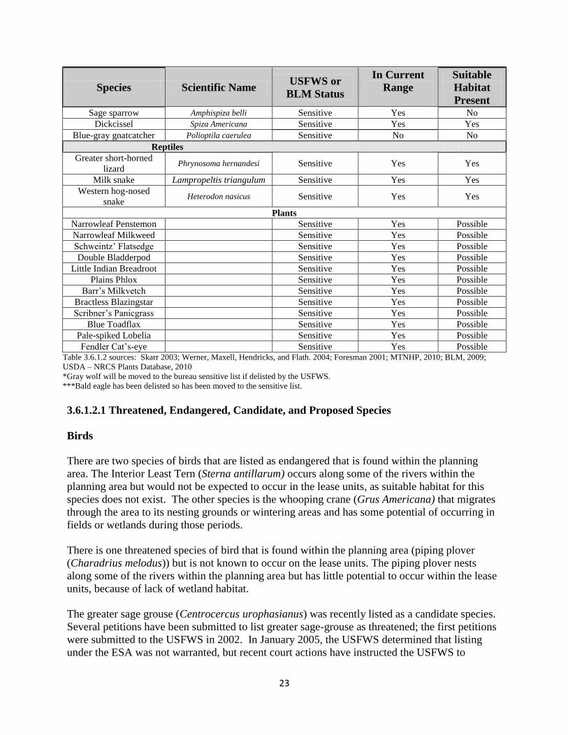
Table 3.6.1.2:: Analysis area occurrence of BLM terrestrial sensitive species and USFWS
threatened, endangered, candidate or proposed terrestrial species

22
Species Scientific Name USFWS or
BLM Status
In Current
Range
Suitable
Habitat
Present Mammals
Gray Wolf* Canis lupus Endangered No No
Black-footed ferret Mustela nigripes Endangered Unlikely possible
Black-tailed prairie dog Cynomys ludovicianus Sensitive Yes possible
River Otter Lutra canadensis No No
Swift fox Vulpes velox Sensitive Yes Yes
Long-legged Myotis Myotis evotis Sensitive Yes Yes
Long-eared Myotis Myotis vollans Sensitive Yes Yes
Fringe-tailed Myotis Myotis thysanodes
pahasapensis Sensitive No No
Northern Myotis Myotis septentrionalis Sensitive Yes Yes
Townsend’s big-eared
bat Corynorhinus townsendii Sensitive Yes Yes
Birds
Common loon Gavia immer Sensitive Yes Yes
Franklin’s gull Laris pipixcan Sensitive Yes Yes
Interior least tern Sterna antillarum athalassos Endangered Yes No
Black tern Chlidonias niger Sensitive Yes Yes
White-faced ibis Plegadis chihi Sensitive Yes Yes
Whooping crane Grus americana Endangered Yes Yes
Yellow rail Coturnicops noveboracensis Sensitive Yes Yes
Piping plover Charadrius melodus Threatened Yes No
Marbled godwit Limosa fedoa Sensitive Yes Yes
Long-billed curlew Numenius americanus Sensitive Yes Yes
Bobolink Dolichonnyx oryzivorus Sensitive Yes Yes
Greater sage-grouse Centrocercus urophasianus Sensitive Yes Yes
Burrowing owl Athene cunicularia Sensitive Yes Yes
Three-toed woodpecker Picoides tridactylus Sensitive No No
Trumpeter swan Cygnus buccinator Sensitive Yes Yes
Bald eagle*** Haliaeetus leucocephalus Sensitive Yes Yes
Golden eagle Aquila chrysaetos Sensitive Yes Yes
Ferruginous hawk Buteo regalis Sensitive Yes Yes
Swainson’s hawk Buteo swainsoni Sensitive Yes Yes
Peregrine falcon Falco peregrinus Sensitive Yes Unlikely
Northern goshawk Accipiter gentilis Sensitive Yes Unlikely
Sage thrasher Oreoscoptes montanus Sensitive Yes No
Sprague’s pipit Anthus spragueii Sensitive Yes Yes
Loggerhead shrike Lanius ludovicianus Sensitive Yes Yes
Chestnut-collared
longspur Calcarius ornatus Sensitive Yes Yes
McCown’s longspur Calcarius mccownii Sensitive Yes Unlikely
Baird’s sparrow Ammodramus bairdii Sensitive Yes Yes
Brewer’s sparrow Spizella breweri Sensitive Yes No
eConte’s sparrow Ammodramus leconteii Sensitive Yes Yes
Prairie falcon Falco mexicanus None Yes Yes
Yellow-billed Cuckoo Coccyzus americanus Sensitive Yes Yes
ewis’s woodpecker Melanerpes lewis None No No
Red-headed woodpecker Melanerpes erythrocephalus Sensitive Yes Yes
Black-backed
woodpecker Picoides arcticus Sensitive No No
23
Species Scientific Name USFWS or
BLM Status
In Current
Range
Suitable
Habitat
Present Sage sparrow Amphispiza belli Sensitive Yes No
Dickcissel Spiza Americana Sensitive Yes Yes
Blue-gray gnatcatcher Polioptila caerulea Sensitive No No
Reptiles
Greater short-horned
lizard Phrynosoma hernandesi Sensitive Yes Yes
Milk snake Lampropeltis triangulum Sensitive Yes Yes
Western hog-nosed
snake Heterodon nasicus Sensitive Yes Yes
Plants
Narrowleaf Penstemon Sensitive Yes Possible
Narrowleaf Milkweed Sensitive Yes Possible
Schweintz’ Flatsedge Sensitive Yes Possible
Double Bladderpod Sensitive Yes Possible
Little Indian Breadroot Sensitive Yes Possible
Plains Phlox Sensitive Yes Possible
Barr’s Milkvetch Sensitive Yes Possible
Bractless Blazingstar Sensitive Yes Possible
Scribner’s Panicgrass Sensitive Yes Possible
Blue Toadflax Sensitive Yes Possible
Pale-spiked Lobelia Sensitive Yes Possible
Fendler Cat’s-eye Sensitive Yes Possible Table 3.6.1.2 sources: Skarr 2003; Werner, Maxell, Hendricks, and Flath. 2004; Foresman 2001; MTNHP, 2010; BLM, 2009;
USDA – NRCS Plants Database, 2010
*Gray wolf will be moved to the bureau sensitive list if delisted by the USFWS.
***Bald eagle has been delisted so has been moved to the sensitive list.
3.6.1.2.1 Threatened, Endangered, Candidate, and Proposed Species
Birds
There are two species of birds that are listed as endangered that is found within the planning
area. The Interior Least Tern (Sterna antillarum) occurs along some of the rivers within the
planning area but would not be expected to occur in the lease units, as suitable habitat for this
species does not exist. The other species is the whooping crane (Grus Americana) that migrates
through the area to its nesting grounds or wintering areas and has some potential of occurring in
fields or wetlands during those periods.
There is one threatened species of bird that is found within the planning area (piping plover
(Charadrius melodus)) but is not known to occur on the lease units. The piping plover nests
along some of the rivers within the planning area but has little potential to occur within the lease
units, because of lack of wetland habitat.
The greater sage grouse (Centrocercus urophasianus) was recently listed as a candidate species.
Several petitions have been submitted to list greater sage-grouse as threatened; the first petitions
were submitted to the USFWS in 2002. In January 2005, the USFWS determined that listing
under the ESA was not warranted, but recent court actions have instructed the USFWS to

24
reconsider that decision. On March 5, 2010, the USFWS determined that the greater sage-grouse
is warranted (for listing) but precluded by more precarious listing needs, making it a candidate
species. Greater sage-grouse conservation is a priority for the BLM, and emphasis has been
placed on planning efforts throughout their range in North America, including South Dakota.
Greater sage-grouse are found mainly in the two northwestern South Dakota counties of Butte
and Harding.The proposed lease parcels in Meade and Fall River Counties would not be
expected to provide habitat for sage grouse. The lease parcels located in Harding County would
likely be considered as “unpreferred” habitat for sage grouse because of the overall lack of
sagebrush canopy cover; however, they may provide limited brood-rearing habitat. The South
Dakota population is considered non-migratory and is mainly associated with big and silver
sagebrush communities.
The Sprague’s pipit (Anthus spragueii ) in September 2010 became warranted (for listing) but
precluded, making it a candidate species. This pipit is known to occur in Harding, Perkins, and
Stanley counties and could potentially be found in other northwestern South Dakota counties.
Sprague’s pipit use grasslands of intermediate height and sparse to intermediate vegetation
densities with other habitat features of low visual obstruction, moderate litter cover and little or
no woody vegetation (Effects of Management Practices on Grassland Birds: Sprague’s Pipit,
2004). The proposed lease parcels in Harding and Meade counties may provide habitat for
Sprague’s pipits, although the occurrence of this species on BLM administered surface or
minerals is unknown.
Mammals
Two species of mammals that are listed as endangered may be found within the planning area but
not within the proposed lease units. The Black-footed Ferret (Mustela nigripes) has been
reintroduced in South Dakota into parts of their former range from a captive breeding population.
These reintroduction sites are not within the proposed lease units. The historic range of the ferret
in South Dakota corresponds to the range of the black-tailed prairie dog (see discussion under
sensitive mammal species). The historic range of gray wolves (Canis lupus) included all of
South Dakota; currently, breeding populations of wolves exist in the adjoining states of
Wyoming, Minnesota, and Montana, and some individuals move from these populations into and
through South Dakota.
Fish
Two fish species listed as endangered occur in the South Dakota RMP planning area. These
species are not known to occupy BLM lands and would not occupy the proposed lease units or
be affected by BLM management of federal minerals. Of these two species, the Pallid Sturgeon
(Scaphirhynchus albus) is found in the Missouri River in South Dakota. The other, the Topeka
shiner (Notropis Topeka) is found mainly in eastern rivers and tributaries of South Dakota.
3.6.1.2.2 Other Sensitive Species

25
There are 33 bird species considered sensitive by BLM in the South Dakota planning area, with
almost all of them having the potential to occur on BLM surface or federal mineral, split-estate
parcels. They include birds that use grasslands, water, or forested areas.
Grassland birds. Sagebrush canopy cover is limited within the lease parcels, and sagebrush
obligate species would not be expected to occupy these habitat types; however, the proposed
lease parcels have good habitat for a large number of the sensitive bird species that use the short,
and midgrass prairie habitats. These birds may occur on these units for some or all of their life
cycle.
Baird’s Sparrow (Ammodramus bairdii)
e Conte’s Sparrow (Ammodramus leconteii)
Chestnut-collared longspur (Calcarius ornatus)
Dickcissel (Spiza americana)
Bobolink (Dolichonyx oryzivorus)
Loggerhead shrike (Lanius ludovicianus)
Long-billed Curlew (Numenius americanus)
Marbled Godwit (Limosa fedoa)
Swainson’s hawk (Buteo swainsoni)
Ferruginous Hawk (Buteo regalis)
Golden Eagle (Aquila chrysaetos)
Burrowing Owl (Athene cunicularia)
Trumpeter Swan (Cygnus buccinators)
Mammals
The two sensitive mammal species that have the potential to occur in the proposed lease parcels
are the Swift Fox and the Black-tailed Prairie Dog. Both species are associated with prairie
communities and are found in western South Dakota.
Swift fox are found within the western part of South Dakota and have the potential to occur in
the proposed lease area. There is a small native population in Fall River County and a re-
introduced population on the Bad River Ranch in Stanley County in central South Dakota. There
also has been documented movement of individuals across western South Dakota. The Swift fox
uses large tracts of short or mid-grass prairie for its habitat.
The Black-tailed Prairie Dog is found in colonies in the open grasslands of the planning area.
There are no known prairie dog colonies in the proposed lease units but there is potential for
them to occur.
Reptiles and Amphibians
There are four sensitive species of reptiles and amphibians listed by BLM that have potential to
occur on the proposed lease units.
26
The snapping turtle is highly aquatic and found mainly in permanent water with soft mud
bottoms and aquatic vegetation across South Dakota. This species inhabits aquatic areas across
the planning area and has the potential to occur in all lease units.
The Western hog-nosed snake generally uses open prairies or sandy areas near floodplains or
water but will burrow in grasslands with well-drained soils. It can be observed throughout the
planning area and has the potential to occur in all lease units.
The short-horned lizard is a ground-dwelling lizard that inhabits semiarid shortgrass or sage
prairies with rocky or sandy areas. This species is distributed over the northwest and southwest
corners of South Dakota, inhabiting many of the butte and badland areas. It can be observed
throughout the planning area and has the potential to occur in all lease units.
The plains spadefoot, which inhabits grassland and floodplain areas with sandy or loose soil, are
sporadically distributed throughout western South Dakota in most west river counties. They
have the potential to occur on all proposed lease units.
The northern leopard frog is South Dakota’s most familiar frog and is found throughout South
Dakota in a variety of habitats from temporary wetlands to large lakes. Populations in the
planning area appear to be healthy. They have the potential to occur on all proposed lease units.
Fish
There are nine sensitive fish species live in the planning area but do not occur on the proposed
lease units. The species are banded killifish, blacknose shiner, blue sucker, longnose sucker,
northern redbelly dace x finescale dace hybrid, paddlefish, pearl dace, sicklefin chub, and
sturgeon chub.
3.6.2 Special Status Plant Species
Following is a list of South Dakota’s rare and BLM’s sensitive plants that may have existing
populations and/or suitable habitat on or near the lease parcels by county:
Table 3.6.2.1: SD Rare Species of Concern and BLM Sensitive Plants on or near Lease
parcels Plant Name Counties it may occur
in
Habitat description
White-veined
wintergreen
Lawrence
Dakota buckwheat West river counties Badlands outcrops of western SD
Sand Puffs Harding Prairie sand and blowouts of northwest SD
Bahia
Marsh Alkali Aster
Inflated Sedge
Great Basin Navarretia

27
3.7 Fish and Wildlife
Falling within the Northern Great Plains ecosystem, the proposed lease parcels are important to
many wildlife species due to habitat diversity which supports breeding populations.
The assortment of topography, vegetation, and climate occurring in the planning area provides
habitats for a variety of wildlife species. The presence of any species may be seasonal or year-
round based on individual species requirements. Wildlife found within this area is representative
of those species found within the Northern Great Plains ecosystem, including grasslands,
sagebrush, and riparian habitats.
Riparian and wetland habitats are used extensively by wildlife, including neotropical migrant
birds (species that breed in North America and over-winter in Central and South America), such
as finches, warblers, thrushes, and orioles in the spring and fall. Buttes and rock areas are
utilized by roosting and nesting golden eagles and prairie falcons, along with many other bird
species. These butte and rock areas are also provide important cover for large mammals, such as
mountain lions and bobcats and for small mammals such as ground squirrels and rabbits.
3.7.1 General Wildlife
Raptors
Approximately 25 species of raptors could use the proposed lease parcels during migration and
as breeding habitat. Raptors (predatory birds such as hawks, eagles, owls, and falcons) can be
found throughout much of the area.
Common breeding species include the red-tailed hawk (Buteo jamaicensis), prairie falcon (Falco
mexicanus), American kestrel (Falco sparverius), northern harrier (Circus cyaneus), and great-
horned owl (Bubo virginianus). Other less common breeding species that may be found locally
include the ferruginous hawk (Buteo regalis), and long-eared owl (Asio otus). Nesting habitats
are found across the grassland, shrub-land, and buttes, and in cottonwood, ash, and ponderosa
pine where available. Prey species are more likely to be available for a wide range of raptors
when plant communities are structurally diverse and support mixtures of grasses, forbs, and
shrubs. Some of the breeding species also winter within the planning area; however, the rough-
legged hawk (Buteo lagopus) only uses the proposed lease units for its wintering grounds.
Grassland and Neotropical Birds
The proposed lease units support a wide variety of grassland and neotropical migrant bird species
(more than 250 species). Populations of some of these species are declining as a consequence of
land use practices and other factors. Many species of grassland birds nest and raise their young
on these lease parcels. Neotropical migrants exhibit quite variable habitat requirements and are
found in most habitat types.
Upland birds

28
The upland game bird species are the most popular game birds in the South Dakota planning area
and are hunted in parts of this area. The sharp-tailed grouse (Tympanuchus phasianellus) is
native to the proposed lease areas along with slight potential for the greater sage grouse
(discussed in the sensitive species section). The other upland gamebird that may occur is gray
partridge (Perdix perdix). These species are generally in the area yearlong.
Waterfowl, Shorebirds and Wading Birds
Approximately 70 species of birds may utilize wetlands within or adjacent to the proposed lease
parcels when surface water is present during migration and as breeding habitat. Representative
breeding species include the Canada goose (Branta canadensis), mallard (Anas platyrhynchos),
gadwall (A. strepera), American avocet (Recurvirostra americana), and Wilson’s phalarope
(Steganopus tricolor). Vegetation cover for nest concealment from predators and for protection
from other disturbances is important to these species during the breeding season.
Mammals
Many species of mammals that occur on these lease parcels are small terrestrial mammals such
as rabbits, skunks, weasels, squirrels, gophers, mice, voles, and shrews, along with several
species of bats which are not as visible but play an important ecological role in their associated
habitats. The proposed lease parcels also provide habitat for many species of medium sized
mammals, including coyote, red fox, bobcat, badger, and raccoon which are the main predators
of the area. These species play an important ecological role in their associated habitats. The
larger mammals that may occur on these lease unit and are much more visible are, mule deer,
pronghorn antelope and white-tailed deer. These species concentrate within wintering habitat
where increased stress from disturbance may affect the population.
3.8 Cultural Resources
The BLM is responsible for identifying, protecting, managing, and enhancing cultural resources
which are located on public lands, or that may be affected by BLM undertakings on non-Federal
lands, in accordance with the National Historic Preservation Act (NHPA) of 1966, as amended.
The procedures for compliance with the NHPA are outlined in regulation under 36 CFR 800.
Cultural resources include archaeological, historic, and architectural properties, as well as
traditional life-way values and/or traditional cultural properties important to Native American
groups.
Common prehistoric archaeological site types in Harding, Meade, and Fall River counties of
western South Dakota are rock art, artifact scatters, burials, bison or antelope bone beds, eagle-
trapping pits, tool stone procurement and tool manufacture. Also, these areas contain numerous
rock cairns, rock shelters, stone alignments, stone circles, vision quest locales, and camp or
occupation areas. Common historic archaeological sites are the remains of farmsteads,
homesteads, depressions, artifact scatters, foundations, cabins, sheepherder camps, line camps,
CCC camps, wells and historic inscriptions (Sundstrom 2009).

29
A literature search (Level I or Class I) of records at the South Dakota Archaeological Research
Center was conducted for each of the 7 nominated lease parcels and a one-mile search radius.
Records were reviewed to determine what types and numbers of known cultural resources are
present within or adjacent to the lease parcels. Additional cultural resource information was
reviewed for the general area in the 1986 South Dakota Resource Management Plan and the
South Dakota Statewide Comprehensive Historic Preservation Plan (Sundstrom 2009). Requests
were made to tribal historic preservation offices in South Dakota, North Dakota, and Montana
for additional cultural information.
There are 3 lease parcels in Harding County that are being considered for this Environmental
Analysis. Based on the review of available information, none of the 476.29 acres of surface
areas within the identified lease parcels have been previously inventoried for cultural resources.
There is one 10-acre small block survey adjacent and one highway survey in the vicinity.
Records also indicate there are no previously recorded cultural resource sites located within or
surrounding the lease parcels inside a 4-mile radius.
Three of the lease parcels, with a total of 423.29 acres, are located in Meade County,
approximately 4-miles south of Mud Butte. There are 5 previous cultural resource inventory
projects surrounding these proposed leases; however none of the lease parcels have been
previously surveyed for cultural resources. The surveys were completed for a 10-acre small
block, BLM parcel block surveys, and NRCS range improvements. The nearest previously
recorded cultural resource site is 39MD2054 approximately 1-mile southeast. Site 39MD2054 is
a portion of the Bismarck to Deadwood Wagon Trail that is considered eligible for the NRHP.
The site consists of a portion of the Trail or ruts in the road that are visible. There is a marker for
the trail by the road. There are no other previously known cultural resource sites in the 1-mile
radius.
The remaining 40-acre lease parcel in Fall River County is located adjacent to the Cheyenne
River, 2-miles from Edgemont, South Dakota. There is no previous cultural resource survey
coverage inside the parcel. Cultural surveys were completed for land exchanges and
transmission lines in the vicinity. There are no previously documented cultural resource sites
inside the lease parcels; however, the bluff top along the river to the northeast has numerous
previously recorded cultural resource sites including:
39FA0464: Site is a large habitation area located at the base of the southeast corner of a large
elongated knoll on a flat ridge. The site has been disturbed by water runoff from the knoll and
the runoff has cut three small washes through the site. Previously determined not eligible for
NRHP, based on deflation and 1-negative shovel test; however,there is a good chance of buried
material at the base of the knoll and the actual site size is larger. A projectile point recovered
from the site is corner-notched, finely made and generally placed as post-Mckean Complex. A
point midsection was found but could not be placed to any particular time period. Material types:
Hogback Quartzite, unid chert, Morrison Silicifed siltstone, plate chalcedony, Minnelusa Chert.
39FA1361: Unevaluated prehistoric occupation site. Site is located on a high ridge top
overlooking the Cheyenne River to the west. It consists of a dense lithic scatter/procurement
area. It also contains various size gravels, sandstone, and 75+ flakes, 14 stone tools, and 4

30
prehistoric type features. FCR is scattered about the site with one small concentration. A Besant
projectile point base, and Oxbow Projectile point were found. Features include a quartzite
cobble concentration, rock alignment, knapping station, and a rock cairn. Site is undisturbed.
39FA1362: Unevaluated prehistoric occupation and historic artifact scatter. Site is located on a
ridge above the Cheyenne River. Artifacts observed include 65+ flakes, 20+ FCR, 15+ tooth
enamel, a thinning flake concentration, 1-projectile point, possibly Duncan or Hanna affiliation,
a hammerstone, a .303 savage cartridge casing, and a modern whiskey bottle. Two features were
found, a stone circle and a cobble concentration. Site is undisturbed.
39FA1363: Unevaluated prehistoric occupation site. Site consists of area a where 26 flakes, 2
projectile points, 1 uniface, 1 core, 1 retouched flake, 1 hammerstone, 1 piece of tooth enamel,
and 2 bifaces were found. Area B contains shell fragments, 85+ flakes, 30+ shatter, 15+ FCR,
15+ bone fragments, 7 hearth features, FCR and bone concentration areas. Site is located on the
first terrace overlooking the Cheyenne River to the southwest. Area A and B are separated by a
drainage and both are being eroded. Many buried soil horizons exhibit cultural material eroding
out. Cultural deposits were found down to 75 to 100 centimeters below the surface.
Additional numerous cultural resource sites have been previously documented in the surrounding
vicinity especially to the north and east toward the Black Hills and Red Canyon.
The list above displays known cultural resource sites in the one-mile radius of the lease parcel.
The four prehistoric occupation sites are located on top the bluff on the north side of the
Cheyenne River. Likely the bluff on the south side of the Cheyenne River would contain the
same type of historic properties. Lease parcel SDM 97300-KU is located at the base of these
slopes on the floodplain of the Cheyenne River and likely cultural resources related to these sites
is not present in this location.
There are seven lease parcels that are proposed for the July 2013 oil lease sale. No cultural
resource surveys have covered any of the nominated parcels. Of the 5 known previously
recorded cultural resource sites in the one-mile radius of the 7-lease parcels, 1 is considered
eligible for consideration to the NRHP, as part of the Bismark to Deadwood Historic Wagon
Trail. The remaining sites are all prehistoric occupation sites located along the Cheyenne River
bluff top. One is considered not eligible for nomination to the National Register of Historic
Places and three have not been evaluated. None of the previously documented cultural resource
sites are located in an area of potential affect for the proposed leases.
The Bureau of Land Management follows standard procedures for the consideration of potential
impacts to cultural resources resulting from Oil and Gas leasing and development projects.
These procedures allow for a “phased” approach to the identification and evaluation of cultural
properties. The detailed Level I/Class I overview of cultural resource information (previous
survey and known sites) was compiled for all proposed lease parcels identified from Expressions
of Interest (EOIs). In addition, tribal consultation efforts were initiated to identify culturally
significant areas or traditional cultural properties in close proximity to the proposed lease parcels
that may be of particular concern to tribes. This information is then compiled into this

31
Environmental Assessment and a decision is made to lease the parcel or defer leasing on the
parcel.
In all cases the Standard Lease Notice and the following stipulation identified in IM-2005-003
would be attached to the leases recommended for sale:
“This lease may be found to contain historic properties and/or resources protected under
the National Historic Preservation Act (NHPA), American Indian Religious Freedom
Act, Native American Graves Protection and Repatriation Act, E.O. 13007, or other
statutes and executive orders. The BLM will not approve any ground disturbing activities
that may affect any such properties or resources until it completes its obligations under
applicable requirements of the NHPA and other authorities. The BLM may require
modification to exploration or development proposals to protect such properties, or
disapprove any activity that is likely to result in adverse effects that cannot be
successfully avoided, minimized or mitigated.”
Once a parcel has been leased, a Level III/Class III cultural resources inventory is required prior
to any ground disturbing activities. Any cultural properties identified within the Area of
Potential Effect (APE) are evaluated for significance and eligibility to the National Register of
Historic Places. In a majority of cases, potential impacts to cultural resources are avoided
through project abandonment or redesign. In rare instances, potential impacts are mitigated
through other means in consultation with the South Dakota State Historic Preservation Office,
the Advisory Council on Historic Preservation, and tribes that have expressed interest or
concern. Specific “Guidance for Cultural Resource Investigations on Oil and Gas Projects” has
been outlined in Instruction Memo MT-2006-040.
3.9 Native American Religious Concerns
B M’s management of ative American Religious concerns is guided through its 8120 Manual:
Tribal Consultation Under Cultural Resources Authorities and 8120 Handbook: Guidelines for
Conducting Tribal Consultation. Further guidance for consideration of fluid minerals leasing is
contained in BLM Washington Office Instruction Memorandum 2005-003: Cultural Resources,
Tribal Consultation, and Fluid Mineral Leasing. The 2005 memo notes leasing is considered an
undertaking as defined in the National Historic Preservation Act. Generally areas of concern to
ative Americans are referred to as “Traditional Cultural Properties” (TCPs) which are defined
as cultural properties eligible for the National Register because of its association with cultural
practices or beliefs that (a) are rooted in that community’s history and (b) are important in
maintaining the continuing cultural identity of the community.
Cultural resource and Traditional Cultural Property (TCP) information was reviewed for the
lease parcel areas in the 1986 South Dakota Resource Management Plan and the South Dakota
Statewide Comprehensive Historic Preservation Plan (Sundstrom 2009). Requests were also
made to tribal historic preservation offices in South Dakota, North Dakota, and Montana for
additional cultural information or areas of concern. Presently, there is one known TCP, Slim
Buttes, and the sacred Black Hills within 10 miles of the lease parcels in Harding and Fall River
32
Counties. Mud Butte, a prominent topographic feature, which are typically considered culturally
sensitive areas, is located 4 miles north of the proposed parcels in Meade County.
According to Bulletin #38 of the National Register, sites of traditional cultural significance refer
to “beliefs, customs, and practices of a living community of people that have been passed down
through the generations, usually orally or through practice. The traditional cultural significance
of a historic property, then, is significance derived from the role the property plays in a
community’s historically rooted beliefs, customs, and practices.” Critical issues related to TCPs
as cultural sites include continuity over time, community identity, and traditional use. A TCP
can be defined generally as a place “that is eligible for inclusion in the ational Register because
of its association with cultural practices or beliefs of a living community that (a) are rooted in
that community’s history and (b) are important in maintaining the continuing cultural identity of
the community.”
Past information exchange during previous projects has resulted in a good record of topographic
areas in South Dakota that are considered culturally sensitive to some Native American Tribes.
Summary reports that included the cultural resource site and survey information as well as
surrounding prominent topographic features for each lease parcel were sent to Tribal Historic
Preservation Officers. Copies were also sent to Tribal Chairmen or Tribal Presidents from tribes
in the Table below. These summary report cover letters requested any additional information,
concerns, or comments for culturally sensitive areas that may be affected by leasing the parcels
(letters dated November 15, 2012; December 07, 2012).
Table 3.9.1: List of Native American Tribes with aboriginal ties or interests in the area.
Cheyenne River Sioux Tribe
Crow Creek Tribe
Fort Peck Tribes
Lower Brule Sioux Tribe
Northern Cheyenne Tribe
Oglala Sioux Tribe
Rosebud Sioux Tribe
Sisseton-Wahpeton Oyate Tribes
Standing Rock Sioux Tribe
Three Affiliated Tribe, (Mandan, Hidatsa, Arikara Nations)
Yankton Sioux Tribe
No comments have been received from these tribes to date.
3.10 Paleontology
The geologic formations present in the western part of South Dakota extend into several of the
neighboring states and Canada, with only minor sedimentary or depositional differences. The
formations encompass the last of the dinosaurs in the Cretaceous Period to the rapid development
of early mammals in the Paleocene and Eocene Epochs of the Tertiary Period. These formations
are found in eastern Montana, northeastern Wyoming, northwestern Nebraska, western South
Dakota and North Dakota, and southernmost Saskatchewan and Manitoba.

33
The key geologic formations found in the South Dakota area containing significant
paleontological resources falls into three main ages:
(1) The upper Jurassic Morrison Formation and the overlying lower Cretaceous Lakota
Sandstone contain well-known dinosaur material. The Lakota Sandstone is also noted for the
fossil plant material it contains. The Morrison Formation and Lakota Sandstone are found in
the terrain surrounding the Black Hills, although exposures are mostly small in extent and
somewhat difficult to explore.
(2) The second interval includes the late Cretaceous Hell Creek Formation and the overlying
Ludlow Formation, which contain records of the last of the dinosaurs (Hell Creek Fm) and
the beginning of the radiation of the mammals (Ludlow Fm). These formations occur
throughout the northwestern corner of South Dakota, although exposures are not as extensive
as in neighboring Montana and Wyoming.
(3) The third major time frame is represented by the Slim Buttes Formation and the various
formations combined into the White River Group and the Arikaree Group, spanning the
Eocene to Miocene Epochs. The Slim Buttes Formation is limited in exposure and also
occurs in the northwest corner of the state. The White River and Arikaree Groups occur in
many portions of western South Dakota and neighboring states. Outside of Badlands
National Park, exposures tend to be found as ridgelines, sides of buttes, or other actively
eroding surfaces, with large areas of alluvium or deep soils covering the bedrock in most
areas.
The Eocene/Oligocene/Miocene formations have also produced a huge number of significant
mammal fossils over the last 130 years.
Areas in South Dakota were grouped together where the exposed or underlying bedrock had the
potential to produce significant numbers of the material of interest. Values were assigned based
on potential fossil yield of vertebrates or other scientifically significant fossils in bedrock
formations known for South Dakota. These values are as follows:
(1) Very Low – Class 1: Igneous and metamorphic geologic units-not likely to contain
recognizable fossils.
(2) Low – Class 2: Sedimentary geologic units- not likely to contain vertebrate fossils or
scientifically significant non-vertebrate fossils.
(3) Moderate or Unknown –Class 3: Fossiliferous sedimentary geologic units – content
varies in significance, abundance, and predictable occurrence. Some units of unknown
potential.
(4) High –Class 4: are considered Class 5 fossils that do not have the potential for human or
natural degradation.
(5) Very High –Class 5: Highly fossiliferous geologic units- regularly produce vertebrate
fossils or scientifically significant vertebrate fossils. Situated to be subject to human or
natural degradation.

34
The northern boundary of the state in the western half encompasses the tertiary deposits, which
contain some significant or rare fossils. These deposits were designated a Class 4 grading to a
Class 3. Included in this grouping are the following formations; Slim Buttes, Tongue River,
Cannonball, and Ludlow.
South of these formations is the Hell Creek. This is a very significant formation with numerous
vertebrate fossils of the upper Cretaceous. Among these fossils are dinosaurs, plants, small
mammals, reptiles, and birds. This formation and the thin overlying material was rated a Class 5.
Of primary concern would be the regions where the Hell Creek is exposed with no plant cover.
Included in this group are the Hell Creek and Fox Hills formations.
South of the Hell Creek formation is the Pierre Shale and its related formations. These are
marine shales that do produce some invertebrates along with some marine vertebrates and fish.
Included are the Pierre Shale, Niobrara, Carlile, Greenhorn, and Belle Fourche formations. This
area was assigned a Class 3 to Class 4.
Review of Potential Fossil Yield Category (PFYC) formation Classes indicates 6 lease parcels
are located within PFYC formations rated Class 4 or 5. The parcels were identified within the
Hell Creek, Ludlow, and Slim Buttes formations that are considered significant PFYC
formations to the field office. Previous research projects and paleontological surveys in
southwestern North Dakota and northwestern South Dakota on BLM land and other lands have
located significant fossil remains. The remaining parcel is located in PFYC Class 3. Although
formations in the Class 3 category are not considered as prospective as the Hell Creek and
Ludlow formations, they do have potential to produce and are basically unknown until better
field survey can define the presence or absence of fossil remains.
Most paleontological localities recorded with BLM offices resulted from researchers performing
field work. A few localities have been found during BLM-required mitigation of surface-
disturbing activities. Some localities are simply local knowledge. Investigating illegal collecting
activities has revealed the locations of some fossil resources. There are presently no known
localities or previous research areas for fossil or paleontological resources inside or adjacent to
the nominated parcels.
3.11 Visual Resources
Visual Resource Management (VRM) is the system used to designate and manage the visual
resources on public land. A Class II VRM area classification means that the character of the
landscape has unique combinations of visual features such as land, vegetation, and water. The
existing character of the landscape should be retained. Activities or modifications of the
environment should not be evident or attract the attention of the casual observer. Changes
caused by management activities must repeat the basic elements of form, line, color, and texture
found in the predominant natural features of the characteristic landscape.
A Class III VRM area classification means the level of change to the character of the landscape
should be moderate. Changes caused by management activities should not dominate the view of
the casual observer and should not detract from the existing landscape features. Any changes

35
made should repeat the basic elements found in the natural landscape such as form, line, color
and texture.
A Class IV VRM area classification means that the characteristic landscape can provide for
major modification of the landscape. The level of change in the basic landscape elements can be
high. However, every attempt should be made to minimize the impact of these activities through
careful location, minimal disturbance, and repeating the basic elements.
No Visual Resource Management (VRM) classes have been established in the project area by a
formal written decision document. The South Dakota RMP revision will formally address VRM
through a range of alternatives based on the VRI data, however in the interim, and as directed by
BLM Manual 8400 (Visual Resource Management), the affected environment is described using
the existing Visual Resource Inventory (VRI) classes. The BLM acres included in the lease
parcels are thereby assigned VRI class IV, allowing modification to the characteristic landscape.
VRI is only applied to federally managed surface acres; therefore the affected environment for
visual resources only consists of 40 acres of the 939.58 acres in the proposed action.
3.12 Livestock Grazing
There are two of the lease parcels located within one BLM grazing allotment located in Harding
County. The allotment is grazed with cow calf pairs allocated 178 AUMs of BLM administered
lands. The allotment has several range improvements including fences, pipelines, stock ponds,
wells, roads and windmills. Table 3.12.1 identifies allotment specific information for each of the
lease parcels and whether or not they are part of an allotment or unallocated for livestock
grazing.
Table 3.12.1: Lease parcels located within BLM grazing allotments
Parcel ID Allotment Name and Number Livestock Kind Season of Use
Allotment Category Surface Ownership
SDM-97300-H3 SDM-97300-H5
Jones Creek Allotment #01725 Cattle
03/01 to 02/28 Custodial
Private surface with unfenced BLM in allotment
SDM-97300-KU Unallocated for livestock grazing
The remaining lease parcels are not located within grazing allotments.
3.13 Recreation and Travel Management Recreational opportunities and experiences managed for by the BLM are only available on
BLM-administered surface. The affected environment consists of 40 acres of BLM-administered
public lands (surface).
None of the 7 lease parcels fall within SRMAs or recreation areas.
The 40 BLM-administered acres proposed for lease consist of one small and isolated tract with
limited legal public access (i.e., no public easements or rights-of-way across private property).
The lack of public access limits use of the BLM parcels for recreational use by the general

36
public. The types of limited public use on these parcels can be characterized as casual, dispersed
recreational activities including hiking, and hunting. However, parcel SDM-97300-KU contains
public land on both sides of the Cheyenne River. The river is considered a public highway
(South Dakota codified law 43-17-2). Since access to the BLM parcel is public, the use on this
parcel may be more extensive than the other parcels. No activity may limit the public use or
access to this parcel.
3.14 Lands and Realty
Lands and realty actions will only occur on BLM-administered surface. The affected
environment consists of 40 acres of BLM-administered public lands (or 4 percent of the total
acreage proposed for lease).
The 40 BLM-administered acres proposed for lease consist of one small and isolated tract.
There are no Rights-of-Ways across the one 40 acre BLM parcel in Fall River County.
3.15 Minerals
3.15.1 Fluid Minerals
It is the policy of the BLM to make mineral resources available for disposal and to encourage
development of these resources to meet national, regional, and local needs, consistent with
national objectives of an adequate supply of minerals at reasonable prices. At the same time, the
BLM strives to assure that mineral development occurs in a manner which minimizes
environmental damage and provides for the reclamation of the lands affected.
Currently there are 180 federal oil and gas leases covering approximately 136,360 acres in the
SDFO. The number of acres leased and the number of leases can vary on daily basis as leases
are relinquished, expired, or are terminated. Existing production activity occurs on
approximately 134 leases, covering 43,140 acres or 32 percent of this lease acreage.
Information on numbers and status of wells on these leases and well status and numbers of
private and state wells within the external boundary of the field office is displayed in Table
3.15.1. Numbers of townships, leases acres within those townships, and development activity for
all jurisdictions are summarized in Table 3.15.2.
Exploration and development activities would only occur after a lease is issued and the
appropriate permit is approved. Exploration and development proposals would require
completion of a separate environmental document to analyze specific proposals and site-specific
resource concerns before BLM approved the appropriate permit.
Table 3.15.1: Existing Development Activity
FEDERAL WELLS PRIVATE AND STATE WELLS
Drilling Well(s) 3 1
Producing Gas Well(s) 27 32
Producing Oil Well(s) 32 91
Water Injection Well(s) 7 21
Shut-in Well(s) 8 3
Temporarily Abandoned Well(s) 1 8 From AFMSS January 2013
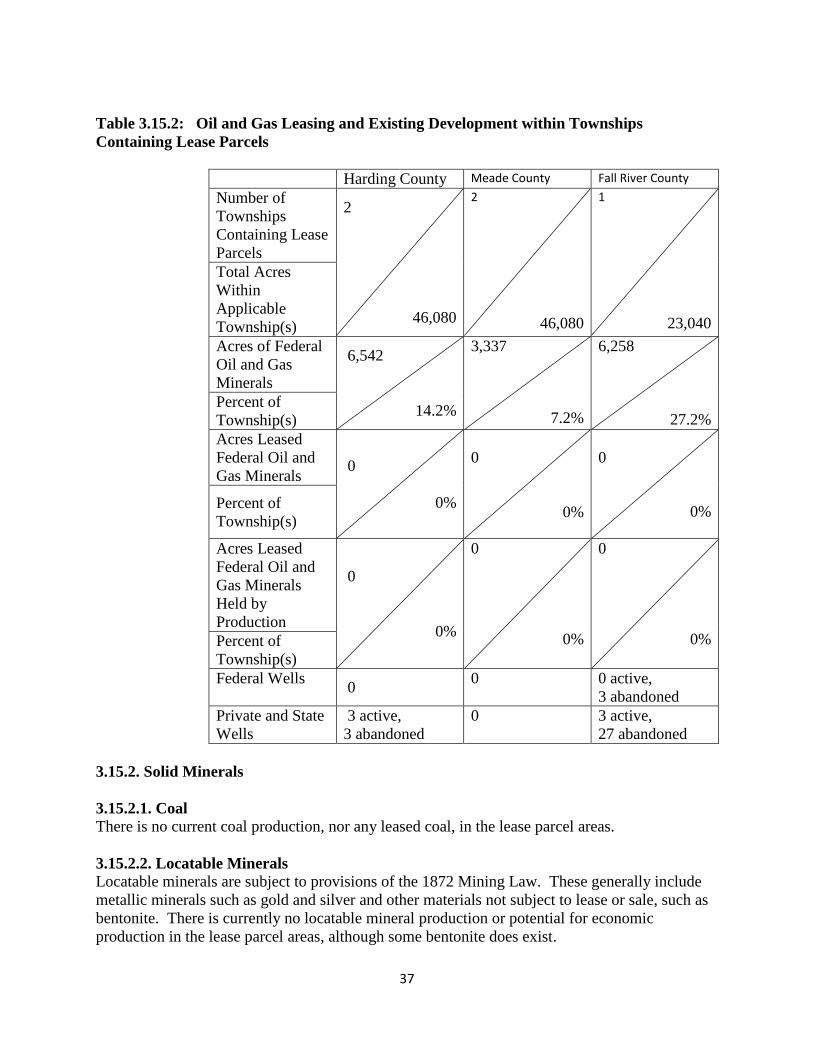
37
Table 3.15.2: Oil and Gas Leasing and Existing Development within Townships
Containing Lease Parcels
Harding County Meade County Fall River County
Number of
Townships
Containing Lease
Parcels
2
46,080
2
46,080
1
23,040
Total Acres
Within
Applicable
Township(s)
Acres of Federal
Oil and Gas
Minerals
6,542
14.2%
3,337
7.2%
6,258
27.2% Percent of
Township(s)
Acres Leased
Federal Oil and
Gas Minerals 0
0%
0
0%
0
0%
Percent of
Township(s)
Acres Leased
Federal Oil and
Gas Minerals
Held by
Production
0
0%
0
0%
0
0% Percent of
Township(s)
Federal Wells
0
0 0 active,
3 abandoned
Private and State
Wells
3 active,
3 abandoned
0 3 active,
27 abandoned
3.15.2. Solid Minerals
3.15.2.1. Coal
There is no current coal production, nor any leased coal, in the lease parcel areas.
3.15.2.2. Locatable Minerals
Locatable minerals are subject to provisions of the 1872 Mining Law. These generally include
metallic minerals such as gold and silver and other materials not subject to lease or sale, such as
bentonite. There is currently no locatable mineral production or potential for economic
production in the lease parcel areas, although some bentonite does exist.

38
3.15.2.3. Salable Minerals
Salable minerals (mineral materials) are those common varieties of sand, stone, gravel,
porcellanite, and clay that may be acquired under the Materials Act of 1947. Mineral materials
are disposed of by free-use and community/common-use permits granted to municipalities or
non-profit entities, respectively. Contracts for sale of mineral materials are offered to private
entities on both a competitive and non-competitive basis. Disposal of salable minerals is a
discretionary decision of the BLM authorized officer. Future potential resource development
conflicts would be avoidable either by not issuing sales contracts in oil and gas development
locations or conditioning the APD or salable mineral contracts in a manner to avoid conflicts
between operations.
None of the lease parcels proposed to be leased for oil and gas in the Project Area conflict with
current permits and contracts for salable minerals awarded on federal lands. Therefore, this
subject will not be discussed further in this document.
3.16 Special Designations
3.16.1 National Historic/Scenic Trails
None of the potential lease parcels are within or affect areas with National Historic or Scenic
Trails.
3.16.2 Areas of Critical Environmental Concern (ACECs)
None of the potential lease parcels are within or affect Areas of Critical Environmental Concern.
3.17 Social and Economic Conditions
3.17.1 Social and Environmental Justice
This section focuses on Harding County in the northwestern corner of South Dakota and directly
south of western North Dakota where extensive oil and gas exploration and development is
currently occurring. The 2010 population of Harding County was 1,255, which was a decline of
7% from the 2000 figure. In comparison, the state population increased 8% between 2000 and
2010. The 2010 population of Buffalo, the county seat of Harding County, was 188 in 2010.
The 2010 population density for Harding County was very low at 0.5 persons per square mile in
2010, compared to 10.7 for South Dakota as a whole. The areas in the vicinity of the leases are
home to large farms and ranches. There is some current oil and gas development in Harding
County but a very small amount of the acreage in these potential leases is near or adjacent to
existing oil fields. Most of the acreage is between five and fifteen miles from existing fields.
Approximately 12% of the acreage being considered is split-estate where BLM does not manage
the surface. Seventy-two % of the leases are solely subsurface leases.
In 2010, the percent American Indian was 1.5% in Harding County compared to 8.8% for the
state as a whole. Tribes in South Dakota, North Dakota, Montana and elsewhere have an interest

39
in lands in Harding County. XXX of the potential leases contain areas that need additional
cultural information from interested Tribes. The percent of the population living below the
poverty level in 2009 was 15.6% compared to a statewide figure of 14.2%.
3.17.2 Economics
There are three counties in South Dakota with parcels nominated for leasing; Fall River,
Harding, and Meade. In 210 these counties were reported to have 7,094, 1,255, and 25,434
residents and 3,200, 515, and 9,933 households respectively. Between 2000 and 2010 Meade
County experienced considerable population growth, gaining 1,181 new residents; while
populations declined in Fall River and Harding. Over the last decade populations declined by 4.8
and 7.2 percent, or by 359 and 98 residents, respectively in these counties (U.S. Department of
Commerce, 2012). Populations of these three counties are not very racially or ethnically diverse.
In 2010, 90 percent or more of residents in these counties identified themselves as being white
alone, and only 1-3 percent of residents reported having Hispanic ancestry. Although overall
diversity in the region remains low, South Dakota has historically had high concentrations of
Native American populations. Sioux and Shoshone tribe members currently live in Fall River,
Harding, and Meade counties and combined account for 1-3 percent of the population in these
counties (U.S. Department of Commerce, 2012).
Employment in the region is supported by a varying number of industrial sectors. In 2010 Meade
County, which had the most diversified economy, supported 16,750 jobs in 161 industries; while
Fall River supported 3,063 jobs in 118 industries, and Harding supported 915 jobs in 72
industries. The government sector supports a large share of employment in the three counties
with nominated parcels, accounting for 24.7 percent in Fall River, 15.9 percent in Harding, and
14.9 percent of employment in Meade. These counties were also highly specialized in
agricultural industries, which include grain farming and livestock production, when compared to
the overall U.S. economy (IMPLAN 2010).
Total personal income (TPI) in 2010 was estimated to be $254 million in Fall River, $42 million
in Harding, and $872 million in Meade County. This breaks down to an average household
income of $80,142, $92,575, and $94,991; and per capita of $35,248, $37,658, and $36,493
respectively (IMPLAN 20100). Total personal income includes labor and non-labor income,
including money earned on investments (interest, dividends, and rents) and transfer payments
relating to age (Medicare and Social Security payments) or poverty (Medicaid or welfare
assistance). In 2010 labor earnings (wages) accounted for 51 to 68 percent on TPI in these three
counties, while investment earnings accounted for 16 to 22 percent and income maintenance
(U.S. Department Commerce, 2012).
Nature of the Oil and Gas Industry in South Dakota:
While several South Dakota counties lease land for the development of minerals estates, Custer,
Fall River, and Harding are the only three counties with production. In 2010, there were 138
producing oil wells and 92 producing gas wells, with more than 98 percent of the state’s
production taking place in Harding County (IPAA, 2012). The average wellhead price for oil in
South Dakota was $60.04/bbl in 2010. While estimates for natural gas wellheads have been
unavailable in recent years, the average price in South Dakota was last reported as $7.94/ MCF

40
in 2008. Between 2008 and 2009 natural gas prices plummeted, in neighboring North Dakota
average wellhead prices fell from $8.55 to $3.74 in single year. Because of Harding County’s
close proximity to North Dakota, it is highly likely that South Dakota wellhead prices drastically
fell during this period as well. The cost of drilling and equipping wells in South Dakota is also
likely to have fallen in recent years. In 2009 the average cost of drilling and equipping a well
was $3,860,085 (oil), $2,071,750 (gas), and $1,939,751 (dry). While updated cost estimates for
oil and dry wells are unavailable for 2010, the cost of drilling and equipping a gas well fell by
nearly 84 percent to $340,438 (IPAA, 2011, 2012).
Local economic effects of leasing federal minerals for oil and gas exploration, development, and
production are influenced by the number of acres leased, the number of wells drilled, and the
estimated levels of production. These activities influence local employment, income, and public
revenues (indicators of economic impacts).
Leasing:
As of December 2012, there were 87,309 acres of federal mineral estates leased for oil and gas
exploration and development in South Dakota. Of these, More than 78,000 of these acres are
managed by the BLM in Fall River (1,960.09 acres) and Harding (76,315.71 acres) counties.
Annual lease rental is paid on the 41,795 acres that are not held by production. Estimated annual
average lease and rental revenue to the federal government was about$378,417. Lease rents
were not paid on 36,481 acres that were held by production. Instead, royalties are paid on oil
and gas production from these leases.
Federal oil and gas leases generate a one-time lease bid as well as annual rents. The minimum
lease bid is $2.00 per acre; but bonus bids averaged $39.00 per acre in South Dakota in 2011.
Lease rental is $1.50 per acre per year for the first five years and $2.00 per acre per year
thereafter. Typically, oil and gas leases expire after 10 years unless held by production. Annual
lease rentals continue until one or more wells are drilled that result in production and associated
royalties. Within the South Dakota Field Office, about 37 percent of the leased acres are held by
production.
All of the lease parcel acres being considered are public domain minerals. Forty-nine percent of
federal leasing revenues from public domain minerals are distributed to the state. For revenues
received from public domain lands, the state of South Dakota distributes the revenues to public
schools or other public educational institutions within the counties in which the minerals were
produced (SD statute 13-14-3.1). The federal government collects an estimated annual average
of about $378,417 in lease bids and rent; of which an estimated $185,424 are distributed to the
state/local governments.
Production:
Between 2005 and 2010, production from federal minerals in the South Dakota Field Office
averaged 176,444 barrels of oil and 206,353 MCF of natural gas (Office of Natural Resource
Revenue, 2010) per year. It is estimated that about 80 percent of all federal mineral production
comes from federal minerals for which BLM makes the land use and leasing decisions. Federal
oil and gas production in South Dakota is subject to production taxes or royalties. On public

41
domain lands, these federal oil and gas royalties generally equal 12.5 percent of the value of
production (43 CFR 3103.3.1). Forty-nine percent of these royalties are distributed to the state.
In South Dakota, all of the royalty revenues that the state receives are redistributed to the
counties of production to support public education. Estimated annual BLM-federal royalty
revenues were estimated to be $966,395; of which about $473,534were distributed to the state
and counties.
Local Economic Contribution:
Although only three South Dakota counties had land nominated for mineral leasing, additional
oil and gas development on these lands can stimulate economic activity throughout the region.
Since many of the companies drilling and servicing oil and gas wells operate out of nearby
counties, this analysis extended the impact area to include Butte, Custer, and Pennington.
Modeling all six of these counties as a regional economy will more accurately capture economic
contributions in the region by including business patterns between counties and accounting for
household spending by oil and gas workers who may live outside the three counties with
nominations. The economic contribution of oil and gas activities to a local economy is measured
by estimating the employment and labor income generated by 1) payments to counties associated
with the leasing, rent, and production of federal minerals, 2) local royalty payments associated
with production of federal oil and gas, and 3) economic activity generated from drilling and
associated activities. Activities related to oil and gas leasing, exploration, development, and
production form a basic industry that brings money into the state and region and creates jobs in
other sectors. Extraction of oil and natural gas (IMPLAN sector 20), drilling oil and gas wells
(IMPLAN sector 28), and support activities for oil and gas operations (IMPLAN sector 29)
supported an estimated 305 total jobs and $6.92 million in total employee compensation and
proprietor’s income in the local economy (IMP A , 2010).
Total federal revenues from BLM-federal oil and gas leasing, rents, and royalty payments are an
estimated $1.3 million annually. Federal revenues distributed to the state of South Dakota
average an estimated $659,000 per year. The state redistributes all of this to the public school
districts and other public educational institutions within the South Dakota counties with federal
leases and production (South Dakota statute13-14-3.1).
The estimated annual local economic contribution associated with BLM-federal leases, rents,
drilling, production, and royalty payments combined to support about 16 total local jobs and
$664,000 in local labor income, respectively (IMPLAN, 2010). This amounts to about 0.02
percent of the local employment and local labor and proprietor’s income. Table con. 1 shows
the current contributions of leasing federal oil and gas minerals and the associated exploration,
development, and production of federal oil and gas minerals to the local economy.

42
Table 3.17.2.1. Current Contributions of Federal Oil and Gas Leasing, Exploration,
Development, and Production to the Local Economy
Employment (jobs)
Labor Income (Thousands of
2010 dollars)
Industry Area Totals
BLM-
Related Area Totals BLM-Related
Agriculture 3,320 0 $79,458 $0
Mining 508 3 $21,216 $164
Utilities 395 0 $39,991 $2
Construction 6,658 1 $257,130 $39
Manufacturing 3,052 0 $149,194 $2
Wholesale Trade 2,472 0 $142,168 $11
Transportation &
Warehousing 2,501 0 $122,834 $7
Retail Trade 11,844 1 $312,273 $33
Information 1,141 0 $54,626 $3
Finance & Insurance 5,328 0 $234,219 $16
Real Estate & Rental &
Leasing 2,901 0 $37,264 $3
Prof, Scientific, & Tech
Services 3,871 0 $180,380 $11
Mngt of Companies 682 0 $55,900 $6
Admin, Waste Mngt & Rem
Serv 3,428 0 $67,320 $3
Educational Services 1,358 0 $53,378 $2
Health Care & Social
Assistance 11,280 1 $622,326 $37
Arts, Entertainment, and Rec 2,235 0 $38,687 $2
Accommodation & Food
Services 9,612 1 $151,673 $8
Other Services 5,615 0 $156,544 $11
Government 16,735 7 $1,024,223 $305
Total 94,937 16 3,800,803 664
BLM as Percent of Total --- 0.02% --- 0.02%
Source: IMPLAN, 2010
4.0 ENVIRONMENTAL IMPACTS

43
4.1 Assumptions and Reasonably Foreseeable Development Scenario Summary At this stage of the leasing process, the act of leasing parcels would not result in any activity that
might affect various resources. Even if lease parcels are leased, it remains unknown whether
development would actually occur, and if so, where specific wells would be drilled and where
facilities would be placed. This would not be determined until the BLM receives an APD in
which detailed information about proposed wells and facilities would be provided for particular
leases. Therefore, this EA discusses potential effects that could occur in the event of
development.
Upon receipt of an APD, the BLM would initiate a more site-specific NEPA analysis to more
fully analyze and disclose site-specific effects of specifically identified activities. In all potential
exploration and development scenarios, the BLM would require the use of BMPs documented in
“Surface Operating Standards and Guidelines for Oil and Gas xploration and Development”
(USDI and USDA 2007), also known as the “Gold Book.” The B M could also identify APD
COAs, based on site-specific analysis that could include moving the well location, restrict timing
of the project, or require other reasonable measures to minimize adverse impacts (43 CFR
3101.1-2 Surface use rights; Lease Form 3100-11, Section 6) to protect sensitive resources, and
to ensure compliance with laws, regulations, and land use plans.
Environmental consequences are discussed below by alternative to the extent possible at this
time for the resources described in Chapter 3. As per NEPA regulations at 40 CFR 1502.14(f),
40 CFR 1502.16(h), and 40 CFR 1508.20, mitigation measures to reduce, avoid, or minimize
potential impacts are identified by resource below.
The following assumptions are from the Reasonably Foreseeable Development RFD Scenario
developed for the South Dakota Field Office. The BLM administers approximately 1,471,000
acres (about 44 percent) of the federal oil and gas mineral lands available for leasing within the
South Dakota Field Office’s geographic area of responsibility. The South Dakota RFD forecasts
the following level of development in the planning area.
4.1.1 Reasonably Foreseeable Development Scenario Summary and Assumptions
The following assumptions are from the RFD developed for the South Dakota FO RMP
Revision. The RFD forecasts the following level of development in the South Dakota planning
area.
No alternative would affect the demographics, social trends, or social organization in the area.
The South Dakota RFD scenario analyzes the potential for oil and gas development in the field
office including both conventional oil and gas and CBNG. The potential is mapped in the RFD
scenario. For this planning area average drilling densities per township over the life of the plan
are as follows:
High potential – 10 to 29 wells per township;
Moderate potential – 2 to 10 wells per township;
Low potential – 1 to 2 wells per township;
Very low potential – less than 1 well per township;

44
No potential – areas of the Black Hills where igneous rocks are at or near the surface.
Conventional activity would center on reserve growth (further development of existing fields).
The projection of coal bed natural gas activity is unlikely; however it is part of the scenario of
activity that could occur within the forecast period of twenty years. Disturbance projections
from the RFD scenario follow (Tables 4.1.1 and 4.1.2).

45
Table 4.1.1: Disturbance Associated with New Drilled Wells and Existing Active Wells in
Planning Area (Short-Term Disturbance – Two Years).
Wells Acres of Surface Disturbance
Type Total BLM
Managed
Access Roads
and Flow
Lines
Well Pad Total BLM
Managed
New Exploratory and
Development Wells
CBNG (2010-2029)
74 4 0.6 0.5 83 4
New Exploratory and
Development Gas Wells
(2010-2029)
112 23 0.6 0.5 123 25
New Exploratory and
Development Oil Wells
(2010-2029)
337 71 2.9 4 2,325 490
Total New Exploratory
and Development Wells
(2010-2029)
524 98 2,531 520
Existing Active Gas
Wells (as of August
2008)
100 31 0.3 0.25 55 17
Projected New Gas
Wells (August 2008-
December 2009)
7 2 0.3 0.25 4 1
Existing Active Oil
Wells (as of August
2008)
308 30 1.5 1.75 1,001 98
Projected New Oil
Wells (August 2008-
December 2009)
21 2 1.5 1.75 68 7
Total Existing and
Projected Wells
(August 2008-
December 2009)
436 65 1,128 122
Total Wells 960 163
Total Short-
Term
Disturbance
3,659 642

46
Table 4.1.2: Disturbance Associated with New Drilled Wells and Existing Active Wells
(Long-Term Disturbance).
Wells Acres of Surface Disturbance
Type Total BLM
Managed
Access Roads
and Flow
Lines
Well Pad Total BLM
Managed
New Producing CBNG
Wells (2010-2029) 68 4 0.3 0.25 37 2
New Producing Gas
Wells (2010-2029)
67
14 0.3 0.25 37 8
New Producing Oil
Wells
(2010-2029)
202 43 1.5 1.75 657 140
Total New Producing
Wells
(2010-2029)
337 60 731 148
Existing Active Gas
Wells (as of August
2008) 1
25 9 0.3 0.25 14 5
Projected Producing
Gas Wells (August
2008-December 2009)
4 1 0.3 0.25 2 1
Existing Active Oil
Wells (as of August
2008) 1
271 25 1.5 1.75 881 81
Projected Producing Oil
Wells (August 2008-
December 2009)
13 1 1.5 1.75 41 4
Total Existing and
Projected Wells
(August 2008-
December 2009)
313 37 938 91
Total Wells 650 97
Total Long-
Term
Disturbance
1,669 239
1 - minus abandonments during August 2008-December 2009 period
The context of alternatives considered in this EA relative to these assumptions is described
below.
Alternative A (No Action Alternative)
Under the No Action Alternative, the 7 proposed parcels would not be leased. There would be
no new impacts from oil and gas production on the parcel lands. No additional natural gas or
crude oil would enter the public markets, and no royalties would accrue to the federal or state
treasuries. The No Action Alternative would result in the continuation of the current land and
resource uses on the parcels.
Unless specifically indicated by resource area, no further analysis of the No Action Alternative is
presented in the following sections.

47
Analysis Assumptions for Alternative B Under alternative B, the 7 proposed parcels would all be leased. By itself, the act of leasing the
parcels would have no impact on any natural resources in the area administered by the South
Dakota Field Office. Standard terms and conditions as well as special stipulations would apply
to the lease parcels. All impacts would be linked to the resource potential. These areas are in the
very low and moderate development areas as identified in the RFD. Moderate development
potential would result in up to 10 wells drilled per township, and very low development potential
would result in less than one well per township.
If the lease parcels are developed, short-term impacts would be stabilized or mitigated rapidly
(within two to five years). Long-term impacts are those that would substantially remain for more
than five years.
See Appendix A for stipulations which would be applied to the parcels, and where they would be
applied.
Analysis Assumptions for Alternative C By itself, the act of leasing the parcels in Alternative C would have no impact on any natural
resources in the area administered by the South Dakota Field Office. Standard terms and
conditions as well as special stipulations would apply to the lease parcels. All impacts would be
linked to the resource potential. These areas are in the very low and moderate development areas
as identified in the RFD. Moderate development potential would result in up to 10 wells drilled
per township, and low development potential would result in less than one well per township.
No parcels would be deferred.
The 7 parcels parcels are located in Harding County, Meade County, and Fall River County,
South Dakota. If the lease parcels are developed, short-term impacts would be stabilized or
mitigated rapidly (within two to five years). Long-term impacts are those that would
substantially remain for more than five years.
See Appendix A for stipulations which would be applied to the parcels, and where they would be
applied.
4.2 Alternative A (No Action Alternative)
4.2.1 Direct Effects Common to All Resources
Under Alternative A, the 7 parcels would not be offered for competitive oil and gas lease sale.
Under this alternative, the state and private minerals could still be leased in surrounding areas.
There would be no new impacts from oil and gas exploration or production activities on the
federal lease parcel lands. No additional natural gas or crude oil would enter the public markets,
and no royalties would accrue to the federal or state treasuries from the parcel lands. The No
Action Alternative would result in the continuation of the current land and resource uses on the
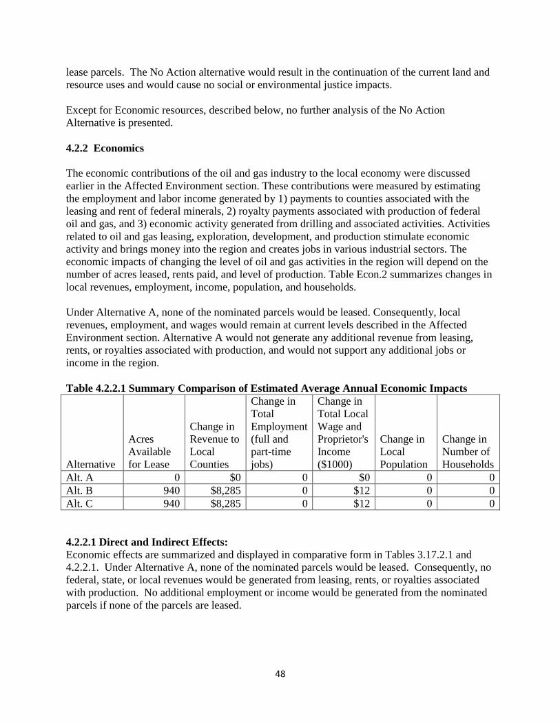
48
lease parcels. The No Action alternative would result in the continuation of the current land and
resource uses and would cause no social or environmental justice impacts.
Except for Economic resources, described below, no further analysis of the No Action
Alternative is presented.
4.2.2 Economics
The economic contributions of the oil and gas industry to the local economy were discussed
earlier in the Affected Environment section. These contributions were measured by estimating
the employment and labor income generated by 1) payments to counties associated with the
leasing and rent of federal minerals, 2) royalty payments associated with production of federal
oil and gas, and 3) economic activity generated from drilling and associated activities. Activities
related to oil and gas leasing, exploration, development, and production stimulate economic
activity and brings money into the region and creates jobs in various industrial sectors. The
economic impacts of changing the level of oil and gas activities in the region will depend on the
number of acres leased, rents paid, and level of production. Table Econ.2 summarizes changes in
local revenues, employment, income, population, and households.
Under Alternative A, none of the nominated parcels would be leased. Consequently, local
revenues, employment, and wages would remain at current levels described in the Affected
Environment section. Alternative A would not generate any additional revenue from leasing,
rents, or royalties associated with production, and would not support any additional jobs or
income in the region.
Table 4.2.2.1 Summary Comparison of Estimated Average Annual Economic Impacts
Alternative
Acres
Available
for Lease
Change in
Revenue to
Local
Counties
Change in
Total
Employment
(full and
part-time
jobs)
Change in
Total Local
Wage and
Proprietor's
Income
($1000)
Change in
Local
Population
Change in
Number of
Households
Alt. A 0 $0 0 $0 0 0
Alt. B 940 $8,285 0 $12 0 0
Alt. C 940 $8,285 0 $12 0 0
4.2.2.1 Direct and Indirect Effects:
Economic effects are summarized and displayed in comparative form in Tables 3.17.2.1 and
4.2.2.1. Under Alternative A, none of the nominated parcels would be leased. Consequently, no
federal, state, or local revenues would be generated from leasing, rents, or royalties associated
with production. No additional employment or income would be generated from the nominated
parcels if none of the parcels are leased.

49
4.3 Alternative B (Proposed Action)
Under Alternative B, 7 parcels, 939.58 federal mineral acres under (40 acres of federal surface
and 899.58 acres of private surface), would be offered for competitive oil and gas lease sale. No
parcels would be deferred.
4.3.1 Direct Effects Common to All Resources
The action of leasing the parcels in Alternative B would, in and of itself, have no direct impact
on resources. Any potential effects on resources from the sale of leases would occur during lease
exploration and development activities. At the time of this review it is unknown whether a
particular lease parcel would be sold and a lease issued.
4.3.2 Indirect Effects Common to All Resources
Oil and gas exploration and development activities such as construction, drilling, production,
infrastructure installation, vehicle traffic and reclamation are indirect effects from leasing the
parcels in Alternative B. It is unknown when, where, how, or if future surface disturbing
activities associated with oil and gas exploration and development such as well sites, roads,
facilities, and associated infrastructure would be proposed. It is also not known how many wells,
if any, would be drilled and/or completed, the types of technologies and equipment would be
used and the types of infrastructure needed for production of oil and gas. Thus, the types,
magnitude and duration of potential impacts cannot be precisely quantified at this time, and
would vary according to many factors. The potential impacts from exploration and development
activities would be analyzed after receipt of an APD or sundry notice.
Typical impacts to resources from oil and gas exploration and development activities such as
well sites, roads, facilities, and associated infrastructure are described in the Miles City District
Oil and Gas RMP/EIS Amendment 1994 Land Use Plan.
4.3.3 Air Resources
4.3.3.1 Direct and Indirect Effects
4.3.3.1.1 Air Quality
Leasing the parcels would have no direct impacts on air quality. Any potential effects on air
quality from sale of lease parcels would occur at the time the leases are developed.
Potential impacts of development could include increased airborne soil particles blown from new
well pads or roads; exhaust emissions from drilling equipment, compressors, vehicles, and
dehydration and separation facilities, as well as potential releases of GHGs and VOCs during
drilling or production activities. The amount of increased emissions cannot be precisely
quantified at this time since it is not known for certain how many wells might be drilled, the
types of equipment needed if a well were to be completed successfully (e.g., compressor,
separator, dehydrator), or what technologies may be employed by a given company for drilling
any new wells. The degree of impact would also vary according to the characteristics of the
geologic formations from which production occurs, as well as the scope of specific activities
proposed in an APD.

50
Current monitoring data show that the criteria pollutant concentrations are below applicable air
quality standards indicating good air quality. The potential level of development and mitigation
described below is expected to maintain this level of air quality by limiting emissions. In
addition, pollutants would be regulated through the use of state-issued air quality permits or air
quality registration processes developed to maintain air quality below applicable standards.
4.3.3.1.2 GHG Emissions at the SDFO and Project Scales
Sources of GHGs associated with development of lease parcels under Alternative B may include
construction activities, operations, and facility maintenance in the course of oil and gas
exploration, development, and production. Estimated GHG emissions are discussed for these
specific aspects of oil and gas activity because the BLM has direct involvement in these steps.
However, the current proposed activity is to offer parcels for lease. No specific development
activities are currently proposed or potentially being authorized for any parcels being considered
in this EA. Potential development activities would be analyzed if the BLM receives an APD on
any of the parcels considered here.
Anticipated GHG emissions presented in this section are taken from the Climate Change SIR,
2010. Data are derived from emissions calculators developed by air quality specialists at the
BLM National Operations Center in Denver, Colorado, based on methods described in the
Climate Change SIR (2010). Based on the assumptions summarized above for the SDFO RFD,
Table 4.3.3.1.2.1 discloses projected annual GHG source emissions from BLM-permitted
activities associated with the RFD.
Table 4.3.3.1.2.1: BLM projected annual emissions of GHGs associated with oil and gas
exploration and development activity in the SDFO.
Source BLM Long-Term GHG Emissions for RFD (tons/year)
Emissions
(metric tons/yr)
CO2 CH4 N2O CO2e CO2e
Conventional
Natural Gas 456 99 0.01 2,538 2,302
Coal Bed
Natural Gas 284 17 0.00 641 582
Oil 704,440 804 12.53 725,199 657,900
Total 705,180 920 12.54 728,378 660,784
To estimate GHG emissions associated with the action alternatives, the following approach was
used:
1. The proportion of each project level action alternative relative to the total RFD was
calculated based on total acreage of parcels under consideration for leasing relative to the
total acreage of federal mineral acreage available for leasing in the RFD.
2. This ratio was then used as a multiplier with the total estimated GHG emissions for the
entire RFD (with the highest year emission output used) to estimate GHG emissions for
that particular alternative.
Under Alternative B, approximately 940 acres of lease parcels with BLM managed federal
minerals would be leased. These acres constitute approximately 0.03 percent of the total federal

51
mineral estate of approximately 3,374,457 acres identified in the SDFO RFD. Applying this
percentage to total estimated GHG emissions would result in approximately 3,184 metric
tons/year CO2e (i.e., 0.57 percent of 660,784 metric tons/year) if the parcels within Alternative B
were to be developed.
4.3.3.1.3 Climate Change
The assessment of GHG emissions and climate change is in its formative phase. As summarized
in the Climate Change SIR, climate change impacts can be predicted with much more certainty
over global or continental scales. Existing models have difficulty reliably simulating and
attributing observed temperature changes at small scales. On smaller scales, natural climate
variability is relatively larger, making it harder to distinguish changes expected due to external
forcings (such as contributions from local activities to GHGs). Uncertainties in local forcings
and feedbacks also make it difficult to estimate the contribution of GHG increases to observed
small-scale temperature changes (Climate Change SIR 2010).
It is currently not possible to know with certainty the net impacts from developing lease parcels
on climate. The inconsistency in results of scientific models used to predict climate change at
the global scale coupled with the lack of scientific models designed to predict climate change on
regional or local scales, limits the ability to quantify potential future impacts of decisions made
at this level. It is therefore beyond the scope of existing science to relate a specific source of
GHG emission or sequestration with the creation or mitigation of any specific climate-related
environmental effects. Although the effects of GHG emissions in the global aggregate are well-
documented, it is currently impossible to determine what specific effect GHG emissions
resulting from a particular activity might have on the environment. For additional information
on environmental effects typically attributed to climate change, please refer to the cumulative
effects discussion below.
While it is not possible to predict effects on climate change of potential GHG emissions
discussed above in the event of lease parcel development for alternatives considered in this EA,
the act of leasing does not produce any GHG emissions in and of itself. Releases of GHGs
would occur at the exploration/development stage.
4.3.3.2 Mitigation
The BLM encourages industry to incorporate and implement BMPs to reduce impacts to air
quality and climate change by reducing emissions, surface disturbances, and dust from field
production and operations. Measures may also be required as COAs on permits by either the
BLM or the applicable state air quality regulatory agency. The BLM also manages venting and
flaring of gas from federal wells as described in the provisions of Notice to Lessees (NTL) 4A,
Royalty or Compensation for Oil and Gas Lost.
Some of the following measures could be imposed at the development stage:
flare or incinerate hydrocarbon gases at high temperatures to reduce emissions of
incomplete combustion;
install emission control equipment of a minimum 95 percent efficiency on all condensate
storage batteries;

52
install emission control equipment of a minimum 95 percent efficiency on dehydration
units, pneumatic pumps, produced water tanks;
operate vapor recovery systems where petroleum liquids are stored;
use Tier II or greater, natural gas or electric drill rig engines;
operate secondary controls on drill rig engines;
use no-bleed pneumatic controllers (most effective and cost effective technologies
available for reducing volatile organic compounds (VOCs));
operate gas or electric turbines rather than internal combustions engines for compressors;
use nitrogen oxides (NOx) emission controls for all new and replaced internal combustion
oil and gas field engines;
water dirt and gravel roads during periods of high use and control speed limits to reduce
fugitive dust emissions;
perform interim reclamation to re-vegetate areas of the pad not required for production
facilities and to reduce the amount of dust from the pads.
co-locate wells and production facilities to reduce new surface disturbance;
use directional drilling and horizontal completion technologies whereby one well
provides access to petroleum resources that would normally require the drilling of several
vertical wellbores;
operate gas-fired or electrified pump jack engines;
install velocity tubing strings;
use cleaner technologies on completion activities (i.e. green completions), and other
ancillary sources;
use centralized tank batteries and multi-phase gathering systems to reduce truck traffic;
forward looking infrared (FLIR) technology to detect fugitive emissions; and
perform air monitoring for NOx and ozone (O3).
Specifically with regard to reducing GHG emissions, Section 6.0 of the Climate Change SIR
identifies and describes in detail commonly used technologies to reduce methane emissions from
natural gas, coal bed natural gas, and oil production operations. Technologies discussed in the
Climate Change SIR and as summarized below in Table 4.3.3.2.1 (reproduced from Table 6-2 in
Climate Change SIR), display common methane emission technologies reported under the EPA
Natural Gas STAR Program and associated emission reduction, cost, maintenance and payback
data.

53
Table 4.3.3.2.1: Selected Methane Emission Reductions Reported Under the EPA
Natural Gas STAR Program 1
Source Type / Technology
Annual
Methane
Emission
Reduction 1
(Mcf/yr)
Capital Cost
Including
Installation
($)
Annual
Operating and
Maintenance
Cost
($)
Payback
(Years or
Months)
Payback
Gas Price
Basis
($/Mcf)
Wells
Reduced emission (green)
completion
7,000 2 $1K – $10K >$1,000 1 – 3 yr $3
Plunger lift systems 630 $2.6K – $10K NR 2 – 14 mo $7
Gas well smart automation
system
1,000 $1.2K $0.1K – $1K 1 – 3 yr $3
Gas well foaming 2,520 >$10K $0.1K – $1K 3 – 10 yr NR
Tanks
Vapor recovery units on crude
oil tanks
4,900 –
96,000
$35K – $104K $7K – $17K 3 – 19 mo $7
Consolidate crude oil
production and water storage
tanks
4,200 >$10K <$0.1K 1 – 3 yr NR
Glycol Dehydrators
Flash tank separators 237 – 10,643 $5K – $9.8K Negligible 4 – 51 mo $7
Reducing glycol circulation
rate
394 – 39,420 Negligible Negligible Immediate $7
Zero-emission dehydrators 31,400 >$10K >$1K 0 – 1 yr NR
Pneumatic Devices and
Controls
Replace high-bleed devices
with low-bleed devices
End-of-life replacement 50 – 200 $0.2K – $0.3K Negligible 3 – 8 mo $7
Early replacement 260 $1.9K Negligible 13 mo $7
Retrofit 230 $0.7K Negligible 6 mo $7
Maintenance 45 – 260 Negl. to $0.5K Negligible 0 – 4 mo $7
Convert to instrument air 20,000 (per
facility)
$60K Negligible 6 mo $7
Convert to mechanical control
systems
500 <$1K <$0.1K 0 – 1 yr NR
Valves
Test and repair pressure safety
valves
170 NR $0.1K – $1K 3 – 10 yr NR
Inspect and repair compressor
station blowdown valves
2,000 <$1K $0.1K – $1K 0 – 1 yr NR

54
Table 4.3.3.2.1: Selected Methane Emission Reductions Reported Under the EPA
Natural Gas STAR Program 1
Source Type / Technology
Annual
Methane
Emission
Reduction 1
(Mcf/yr)
Capital Cost
Including
Installation
($)
Annual
Operating and
Maintenance
Cost
($)
Payback
(Years or
Months)
Payback
Gas Price
Basis
($/Mcf)
Compressors
Install electric compressors 40 – 16,000 >$10K >$1K >10 yr NR
Replace centrifugal
compressor wet seals with dry
seals
45,120 $324K Negligible 10 mo $7
Flare Installation 2,000 >$10K >$1K None NR Source: Multiple EPA Natural Gas STAR Program documents. Individual documents are referenced in Climate Change
SIR (2010). 1 Unless otherwise noted, emission reductions are given on a per-device basis (e.g., per well, per dehydrator, per valve, etc). 2 Emission reduction is per completion, rather than per year.
K = 1,000
mo = months
Mcf = thousand cubic feet of methane
NR = not reported
yr = year
In the context of the oil sector, additional mitigation measures to reduce GHG emissions include
methane reinjection and CO2 injection, which may sequester GHGs. These measures are
discussed in more detail in Section 6.0 of the Climate Change SIR (2010).
In an effort to disclose potential future GHG emissions reductions that might be feasible in
individual field offices, the BLM estimated GHG emissions reductions based on the RFD for the
South Dakota FO. For analysis purposes, the South Dakota FO RFD was selected based on the
high potential development scenario. Similar emission reductions may be possible in the SDFO.
For emission sources subject to BLM (federal) jurisdiction, the estimated emission reduction
represents approximately 51 percent reduction in total GHG emissions compared to the estimated
South Dakota federal GHG emissions inventory (Climate Change SIR, as updated October 2010,
Section 6.5 and Table 6-3). The emission reduction technologies and practices are identified as
mitigation measures that could be imposed during development. (Note: except for the light-duty
vehicle GHG emission standards, no federal or state regulations mandate these GHG emissions
reductions However, EPA is expected to promulgate new regulations in April 2012 that will
require GHG emission reductions from certain types of oil and gas sources.).
4.3.4 Soil Resources
4.3.4.1 Direct and Indirect Effects
Leasing the parcels would have no direct impacts on soil resources. Any potential effects from
the sale of leases would occur at the time the leases are developed. Land uses associated with
oil and gas exploration and development could cause surface disturbances. Such acts reduce
ground cover (e.g., biological soil crust, vegetation, litter, and rock) exposing the soil resource to
accelerated erosion by wind and water. Along with this, soils have altered structure,
heterogeneity (variable characteristics), temperature regimes, nutrient cycling, biotic richness,
and diversity. Soils could be mixed, resulting in decreased bulk density, and altered porosity,
infiltration, air-water relationships, salt content, and pH (Perrow and Davy, 2003; Bainbridge

55
2007). Soil compaction could also occur, increasing bulk density, and reducing porosity,
infiltration, moisture, air, nutrient cycling, productivity, and biotic activity (Logan 2001; Perrow
and Davy, 2003; Bainbridge 2007). Altering such characteristics diminishes the soil system’s
ability to withstand future disturbances (e.g., wildland fire, drought, high precipitation events,
etc.). The probability and magnitude of these effects are dependent upon local site
characteristics, climatic events, and the specific mitigation applied to the project. Generally sites
would be revegetated and erosion would return to natural rates within 2 to 5 years. Exceptions
would be sites poorly suited to reclamation,
4.3.4.2 Mitigation
Measures would be taken to reduce, avoid or minimize potential impacts to soil resources from
exploration and development activities. Prior to authorization, proposed actions would be
evaluated on a case-by-case basis and would be subject to mitigation measures in order to
maintain the soil system. Mitigation could include avoiding areas poorly suited to reclamation,
limiting the total area of disturbance, rapid reclamation, erosion/sediment control, soil salvage,
decompaction, revegetation, weed control, slope stabilization, surface roughening, and fencing.
Development on steep slopes would have specially stipulated provisions to plan for the problems
of reclamation, while sensitive soils would have no stipulated provision to plan for the problems
of reclamation, since such reclamation stipulations have not been approved in a current land use
plan.
4.3.5 Water Resources
4.3.5.1 Direct and Indirect Effects
Leasing the parcels would have no direct impacts on water resources. Any potential effects on
water resources from sale of lease parcels would occur at the time the leases are developed.
The magnitude of the impacts to water resources would be dependent on the specific activity,
season, proximity to waterbodies, location in the watershed, upland and riparian vegetation
condition, effectiveness of mitigation, and the time until reclamation success. Surface
disturbance effects typically are localized, short-term, and occur from implementation through
vegetation reestablishment. As acres of surface-disturbance increase within a watershed, so
could the effects on water resources.
Oil and gas exploration and development of a lease parcel could cause the removal of vegetation,
soil compaction, and soil disturbance in uplands within the watershed, 100-year floodplains of
non-major streams, and non-riparian, ephemeral waterbodies. The potential effects from these
activities could be accelerated erosion, increased overland flow, decreased infiltration, increased
water temperature, channelization, and water quality degradation associated with increased
sedimentation, turbidity, nutrients, metals, and other pollutants. Erosion potential can be further
increased in the long term by soil compaction and low permeability surfacing (e.g. roads and
well pads) which increases the energy and amount of overland flow and decreases infiltration,
which in turn changes flow characteristics, reduces groundwater recharge, and increases
sedimentation and erosion (DEQ 2007).
Spills, drilling fluids, fracking fluids, or produced fluids could potentially impact surface and
ground water resources in the long term. Oil and gas exploration/development could
contaminate aquifers with salts, drilling fluids, fluids and gases from other formations,

56
detergents, solvents, hydrocarbons, metals, and nutrients; change vertical and horizontal aquifer
permeability; and increase hydrologic communication with adjacent aquifers (EPA 2004).
Groundwater removal would result in a depletion of flow in nearby streams and springs if the
aquifer is hydraulically connected to such features. Typically produced water from conventional
oil and gas wells is from a depth below useable aquifers or coal seams (FSEIS 2008).
4.3.5.2 Mitigation
Stipulations addressing steep slopes, waterbodies, streams, 100-year floodplains of major rivers,
riparian areas, and wetlands would minimize potential impacts and would be included with the
lease when necessary (refer to Appendix A). Stipulation NSO 11-2 Riparian Area/Floodplain
will be applied to four parcels. In the event of exploration or development, measures would be
taken to reduce, avoid, or minimize potential impacts to water resources including application of
appropriate mitigation. Mitigation measures that minimize the total area of disturbance, control
wind and water erosion, reduce soil compaction, maintain vegetative cover, control nonnative
species, and expedite rapid reclamation (including interim reclamation) would maintain water
resources. Methods to reduce erosion and sedimentation could include: reducing surface
disturbance acres; installing and maintaining adequate erosion control; proper road design, road
surfacing, and culvert design; road/infrastructure maintenance; use of low water crossings; and
use of isolated or bore crossing (HDD) methods for waterbodies and floodplains. In addition,
applying mitigation to maintain adequate, undisturbed, vegetated buffer zones around
waterbodies and floodplains could reduce sedimentation and maintain water quality.
Appropriate well completion, the use of Spill Prevention Plans, and Underground Injection
Control (UIC) regulations would mitigate groundwater impacts. Site-specific mitigation and
reclamation measures would be described in the COAs.
4.3.6 Vegetation Resources
At this stage (lease sale) there are no impacts. Impacts (both direct and indirect) would occur
when the lease is developed in the future. The potential impacts would be analyzed on a site
specific basis prior to oil and gas development and during the APD stage of development.
4.3.6.1 Direct and Indirect Effects
Impacts to vegetation would depend on the vegetation type/community, soil community and the
topography of the lease parcels. The lease parcels contain mainly grassland vegetation
communities with some sagebrush present within the grassland communities. Habitat
disturbance in grasslands generally can be mitigated with seeding to ensure re-establishment of
perennial vegetation occurs to limit soil erosion. Erosion potential of the soils can be a limiting
factor for vegetation re-establishment. The impacts associated with well pads and roads,
however, would be very site-specific. Roads increase the potential for invasive species and
create barriers for natural seed dispersal for some species causing fragmentation of habitats.
Disturbance to vegetation is of concern because protection of soil resources, maintenance of
water quality, conservation of wildlife habitat, and livestock production capabilities may be
diminished or lost over the long-term through direct loss of vegetation (including direct loss of
both plant communities and specific plant species).

57
Additionally, surface disturbing activities directly affect vegetation by churning soils, impacting
biological crusts, disrupting seedbanks, burying individual plants, and generating sites for
competitive non-native plants including weedy species. In addition, other vegetation impacts
could also be caused from soil erosion and result in loss of the supporting substrate for plants, or
from soil compaction resulting in reduced germination rates. Impacts to plants occurring after
seed germination but prior to seed set could be particularly harmful as both current and future
generations would be affected.
Other direct impacts, such as invasive species and noxious weed invasion could result in loss of
desirable vegetation. Invasive species and noxious weeds may also reduce livestock grazing
forage, wildlife habitat quality, and native species diversity. Cheatgrass is an invasive species
well known for replacing areas of native vegetation and changing fire regimes.
Rare plants are not known to be present within the affected area. Fugitive dust generated by
construction activities and travel along dirt roads can affect nearby plants by depressing
photosynthesis, disrupting pollination, and reducing reproductive success. Oil or other chemical
spills could contaminate soils as to render them temporarily unsuitable for plant growth until
cleanup measures were fully implemented. If cleanup measures were less successful, longer
term impacts could be expected.
4.3.6.2 Mitigation
Reclaimed land would be seeded to native vegetation. Nurse crops may be used to control
erosion and weed invasion. Grassland habitats may resemble their pre-project conditions in 2 to
5 years depending on soils and re-vegetation success.
Mitigation would be addressed at the site specific APD stage of exploration and development. If
needed, COAs would potentially include re-vegetation with desirable plant species, soil
enhancement practices, direct live haul of soil material for seed bank re-vegetation, reduction of
livestock grazing, fencing of reclaimed areas, and the use of seeding strategies consisting of
native grasses, forbs, and shrubs.
4.3.7 Riparian-Wetland Habitats
4.3.7.1 Direct and Indirect Effects Leasing the parcels would have no direct impacts on riparian-wetland habitats. Any potential
effects on riparian-wetland habitats from sale of lease parcels would occur at the time the leases
are developed. The exploration and development of oil and gas within uplands or adjacent to
riparian-wetland areas could reduce riparian/wetland functionality by changing native vegetative
species, composition, richness, and diversity; accelerating erosion; increasing sedimentation; and
changing hydrologic characteristics. Healthy and diverse riparian and wetland areas are
important for watershed functionality. Impacts that reduce the functioning condition of riparian
and wetland areas would impair the ability of riparian/wetland areas to reduce nonpoint source
pollution (MDEQ 2007) and provide other ecosystem benefits.

58
The magnitude of these effects would be dependent on the specific activity, season, proximity to
riparian-wetland areas, location in the watershed, upland and riparian-wetland vegetation
condition, mitigation applied, and the time until reclamation success. Erosion increases typically
are localized, short term, and occur from implementation through vegetation reestablishment. As
acres of surface-disturbance increase within a watershed, so would the effects on riparian-
wetland resources.
4.3.7.2 Mitigation Stipulations addressing steep slopes, water bodies, streams, 100-year floodplains of major rivers,
riparian areas, and wetlands would minimize potential impacts and would be included with the
lease when necessary (refer to Appendix A). In the event of exploration or development, site-
specific mitigation measures would be identified which would avoid or minimize potential
impacts to riparian-wetland areas at the APD stage. Mitigation measures that minimize the total
area of disturbance, control wind and water erosion, reduce soil compaction, maintain vegetative
cover, control nonnative species, maintain biodiversity, maintain vegetated buffer zones, and
expedite rapid reclamation (including interim reclamation) would maintain riparian/wetland
resources.
4.3.8 Wildlife
4.3.8.1 Direct and Indirect Effects
Leasing these parcels would have no direct or indirect impacts on wildlife. Impacts (both direct
and indirect) would occur when the lease is developed in the future. Any potential effects on
wildlife from sale of lease parcels would occur at the time the leases are developed. The potential
impacts would be analyzed on a site specific basis prior to oil and gas development and during
the APD stage of development. All impacts would be linked to the resource potential. These
areas are mainly in the low and moderate development areas as identified in the RFD. Moderate
development potential would result in up to ten wells drilled per township, and low development
potential would result in up to two wells per township.
The use of standard lease terms and stipulations on these lands (refer to Appendix A) would
minimize, but not preclude impacts to wildlife. Oil and gas development which results in surface
disturbance could directly and indirectly impact aquatic and terrestrial wildlife species. These
impacts could include loss or reduction in suitability of habitat, improved habitat for undesirable
(non-native) competitors, species or community shift to species or communities more tolerant of
disturbances, nest abandonment, mortalities resulting from collisions with vehicles and power
lines, electrocutions from power lines, barriers to species migration, habitat fragmentation,
increased predation, habitat avoidance, and displacement of wildlife species resulting from
human presence. The scale, location, and pace of development, combined with implementation
of mitigation measures and the specific tolerance of the species to human disturbance all
influence the severity of impacts to wildlife species and habitats, including Threatened,
Endangered, Candidate, Proposed, and other special status species.
4.3.8.1.1 Threatened, Endangered Proposed, and Candidate Species
Habitat within the lease parcels exists to support USFWS Threatened, Endangered, Proposed, or
Candidate species including the whooping crane, greater sage grouse, and Sprague’s pipit.

59
Birds
BLM has determined that the act of issuing leases within the whooping crane migration corridor
will not affect the whooping crane. However, impacts to whooping cranes are possible from
subsequent oil and gas development activities that would be permitted at the APD stage. At this
time, stipulations do not currently exist to protect any known whooping crane migration staging
areas. Line strikes, collisions with vehicles, habitat fragmentation, and other anthropogenic
activities can disturb, displace, or cause direct mortality of whooping cranes.
Therefore, if development of these leases is proposed, BLM would consult with the USFWS
pursuant to section 7(a)(2) of ESA. An outcome of the consultation process may be that
conditions of approval are attached to the permit or the permit may not be approved. Other
BMP’s would also be developed through consultation, including minimizing disturbance,
adherence to Avian Powerline Interaction Committee (APLIC) guidelines, and others as deemed
appropriate.
Sage grouse are offered species specific protections through stipulations. However, the proposed
lease parcels are located at distances greater than 2 miles from sage grouse leks, and specific
stipulations for sage grouse do not apply to these parcels. As stated in chapter 3, the parcels in
Harding County may provide only limited habitat for sage grouse due the lack of appropriate
sagebrush canopy cover. Although stipulations do not apply, a sage grouse Lease Notice (LN
14-11) will be attached to these parcels because of some potential for sage grouse to utilize
habitat within the parcels at least seasonally. The lease notice would require an operator to
implement specific measures to reduce impacts of oil and gas operations on sage grouse
populations and habitat quality. The application of this lease notice would be expected to
reduce, but not eliminate, impacts to sage grouse and habitats.
It has been shown that oil and gas development negatively impacts sage grouse. The
development of two to ten wells per township would be additive to the current well density.
There may be impacts to sage grouse when these leases are developed, from well densities that
exceed the threshold that affects sage grouse brood rearing and other possible utilization of
existing habitat.
Impacts to leks from energy development are most severe near the lek, and remained discernable
out to distances more than 6 km (3.6 miles) (Holloran 2005, Walker et al. 2007a), and have
resulted in the extirpation of leks within gas fields (Holloran 2005, Walker et al. 2007a).
Holloran (2005) shows that lek counts decreased with distance to the nearest active drilling rig,
producing well, or main haul road, and that development influence counts of displaying males to
a distance of between 4.7 and 6.2 km (2.9 and 3.9 miles). All well-supported models in Walker et
al. (2007a) indicate a strong effect of energy development, estimated as proportion of
development within either 0.8 km (0.5 miles) or 3.2 km (2 miles), on lek persistence. Buffer
sizes of 0.25 mi., 0.5 mi., 0.6 mi. and 1.0 mi. result in an estimated lek persistence of 5 percent,
11 percent, 14 percent, and 30 percent. Lek persistence in the absence of CBNG development
averages approximately 85 percent. Models with development at 6.4 km (4 miles) had
considerably less support, but the regression coefficient indicated that impacts were still apparent

60
out to 6.4 km (4 miles) (Walker et al. 2007a). Tack (2009) found impacts of energy development
on lek abundances (numbers of males per lek) out to 7.6 miles.
Noise has been shown to affect sage-grouse and associated sagebrush obligates. Sage-grouse are
known to select highly visible leks with good acoustic properties. Effects to sage-grouse would
be a decrease in numbers of males on leks and activity levels and lower nest initiation near oil
and gas development. Sage-grouse numbers on leks within 1.6 km (1 mile) of coal bed natural
gas compressor stations in Campbell County, Wyoming were shown to be consistently lower
than on leks not affected by this disturbance (Braun et al. 2002). Holloran (2005), Holloran et. al
(2005a, 2005b), and Anderson (2005) reported that lek activity by sage-grouse decreased
downwind of drilling activities, suggesting that noise had measurable “negative” impacts on
sage-grouse. The actual level of noise (measured in decibels) that would not affect greater sage-
grouse breeding and nesting activities is presently unknown.
Energy development (oil, gas, and wind) and associated roads and facilities increase the
fragmentation of grassland habitat. A number of studies have found that Sprague's pipits appear
to avoid non-grassland features in the landscape, including roads, trails, oil wells, croplands,
woody vegetation, and wetlands (Dale et al. 2009, pp. 194, 200; Koper et al. 2009, pp. 1287,
1293, 1294, 1296; Greer 2009, p. 65; Linnen 2008, pp. 1, 9-11, 15; Sutter et al. 2000, pp. 112-
114). Sprague's pipits avoid oil wells, staying up to 350 meters (m) (1148 feet (ft)) away
(Linnen 2008, pp. 1, 9-11), magnifying the effect of the well feature itself. Oil and gas wells,
especially at high densities, decrease the amount of habitat available for breeding territories.
(Federal Register: September 15, 2010 (Volume 75, Number 178)).
Sprague’s pipit is known to occur in Harding and Meade counties, but there is no detailed
information on the location of habitats in Harding or Meade counties. Therefore, inventories
would be conducted at the APD stage of development to determine the presence or absence of
Sprague’s pipits. The Sprague’s pipit lease notice, LN 14-15, is issued with those leases, six
parcels in total, and would be applied if Sprague’s pipits are found in the area. If Sprague’s
pipits are found, protective measures would be applied as conditions of approval to minimize
impacts to Sprague’s pipits and their habitat. In the event oil and gas development is proposed
within Sprague’s pipit habitat, at the APD stage BLM would conference with the USFWS
pursuant to section 7(a)(4) of SA, or if the Sprague’s pipit has been listed as threatened or
endangered, BLM would consult with the USFWS pursuant to section 7(a)(2).
Mammals
The potential occurrence of the black-footed ferret or the gray wolf is very low, so the habitat
disturbance impacts that may result from leasing these parcels would be negligible.
Fish
The potential for occurrence of the pallid sturgeon and the topeka shiner is extremely low, so the
habitat disturbance impacts that may result from leasing these parcels would be negligible.
Insects
The potential for occurrence of the American Burying Beetle, or the Dakota Skipper Butterfly is
low, so habitat disturbance that may result from leasing these parcels would be negligible.

61
4.3.8.1.2 Other Special Status Species
As noted, up to 44 wildlife species that B M has designated as “sensitive” have the potential to
occur within the parcel areas. Stipulations are not provided for all BLM sensitive species in the
current Resource Management Plans. For those species afforded some protections through
existing stipulations, impacts would be minimized, but not eliminated. Impacts to BLM sensitive
species would be similar to those described above, unless they are afforded protective measures
from other regulations such as the Migratory Bird Treaty Act (MBTA) (16 U.S.C. 703.) or the
Bald and Golden Eagle Protection Act (BGEPA) (16 U.S.C. 668-668c). BLM does not consult
with the USFWS on “sensitive” species and likewise would not receive terms and conditions
from USFWS requiring additional protections of those species.
Birds
Numerous species of birds were identified as inhabitants across the analysis area. With the
impacts associated with development, it is reasonable to assume there would be impacts to
nesting and migrating bird species. The primary impacts to these species would include
disturbance of preferred nesting habitats, improved habitat for undesirable competitors and/or a
species shift to disturbance associated species, and increased vehicle collisions.
Research in Sublette County, Wyoming on the effects of natural gas development on sagebrush
steppe passerines documented negative impacts to sagebrush obligates such as Brewer’s
sparrows, sage sparrows, and sage thrashers. (Ingelfinger, 2001) The impacts were reported
greatest along roads where traffic volumes are high and within 100 meters of these roads.
Sagebrush obligates were reduced within these areas by as much as 60%. Sagebrush obligate
density was reduced by 50% within 100 meters of a road even when traffic volumes were less
than 12 vehicles /day. It would be expected that similar population declines would occur to this
guild of species from similar development proposals within sagebrush habitats.
Stipulations do not exist specifically for the protection of BLM sensitive songbirds. The MBTA
prohibits the take, capture or kill of any migratory bird, any part, nest or eggs of any such bird
(16 U.S.C 703 (a)). NEPA analysis pursuant to Executive Order 13186 (January 2001) requires
BLM to ensure that MBTA compliance and the effects of Bureau actions and agency plans on
migratory birds are evaluated, should reduce take of migratory birds and contribute to their
conservation.
Effects to migratory birds from oil and gas development at the APD stage could include direct
loss of habitat from roads, well pads and other infrastructure, disturbance, powerline strikes and
accidental direct mortality, fragmentation of habitat, change in use of habitats, and potential
threats and competition from edge species. Field surveys for nesting birds at proposed
development sites would be conducted for activities planned between April 15 and July 15.
Mitigation measures would be assigned at the APD stage to ensure there would be no measurable
negative effect on migratory bird populations, in compliance with Executive Order 13186 and
MBTA. These mitigation measures would be required as Conditions of Approval. An NSO
stipulation for oil and gas surface disturbing activities in riparian and wetland areas would
prohibit any potential oil and gas development in those habitats unless approval was granted

62
through the “Waivers, xceptions, and Modifications” (W M) process. B M would coordinate
WEMs with USFWS to assure MBTA compliance.
All raptor species known to exist within the analysis area are considered migratory under
MBTA. Surveys for raptor nests have not occurred in or adjacent to the lease parcels. Take of
bald and golden eagles and any other migratory raptors is not anticipated through this action;
however, take may occur indirectly as a result of vehicle collisions and other related actions
associated with development. Field surveys for raptors at proposed development sites would be
conducted for activities planned between March 1 and August 1. Mitigation measures would be
assigned at the APD stage to ensure there would be no measurable negative effect on raptor
populations, including bald and golden eagles. These mitigation measures would be required as
Conditions of Approval. The application of stipulations and COA’s at the project level is
expected to comply with MBTA and BGEPA.
Mammals
The habitat disturbance that may result from leasing these parcels and the avoidance measures
would result in minor impacts to mammals at the site-specific scale and negligible at the
population and landscape scales. The impacts to mammals will be lessened by restrictions on
sagebrush habitat and riparian areas.
Reptiles and Amphibians
The habitat disturbance that may result from leasing these parcels and the avoidance measures
would result in minor impacts to reptiles and amphibians at the site-specific scale and negligible
at the population and landscape scales. The impacts to reptile and amphibians will be lessened
by restrictions on riparian areas.
Fish The habitat disturbance that may result from leasing these parcels and the avoidance measures
would result in minor impacts to fish at the site-specific scale and at the population and
landscape scales. The impacts to fish will be lessened by restriction on riparian areas, erosion
control, and floodplains.
4.3.8.1.3 Other Fish and Wildlife
The types and extent of impacts to wildlife species and habitats from development are similar to
those described above for other species. Impacts include loss of habitat from development
infrastructure, mortalities resulting from collisions with vehicles and power lines, electrocution
on power lines, and displacement of wildlife species from initial disturbance caused by human
presence. Indirect impacts would include habitat fragmentation and subsequent vehicle traffic,
human presence, and other continual development activities.
Based on the RFD scenarios, a wide range of direct habitat loss is possible. Initial disturbance
would change the occupation of those areas to disturbance-oriented species (i.e. horned larks), or
species with more tolerance for disturbances. These changes would also be expected to decrease
the diversity of wildlife. Although bladed corridors would be reclaimed after the facilities are
constructed, some changes in vegetation would occur along the reclaimed areas. The goal of
reclamation is to restore disturbed areas to pre-disturbed conditions. The outcome of
63
reclamation, unlike site restoration, will therefore not always mimic pre-disturbance conditions
and offer the same habitat values to wildlife species.
It is anticipated that some development may occur adjacent to existing disturbances of some
type. Depending on proximity and species tolerance, wildlife species within these areas would
either have acclimated to the surrounding conditions, previously been displaced by construction
activities, or may be caused to be displaced to other areas with or without preferred habitat.
Potential impacts to aquatic wildlife from development could include: overland oil spills,
underground spills from activities associated with horizontal drilling or other practices, spills
from drilling mud or other extraction and processing chemicals, and surface disturbance
activities that create a localized erosion zone. Oil spills and other pollutants from the oil
extraction process could harm the aquatic wildlife species in two different ways if the spill
substances enter the habitat. First, toxicological impacts from direct contact could have
immediate lethal effects to eggs, larvae, juveniles, and adults. Second, toxic effects to lower
food web levels (e.g. aquatic macro-invertebrates) would indirectly affect fish, amphibian, and
reptile species by degrading water quality and degrading or eliminating food resources.
Additional mitigation will occur as conditions of approval at the APD stage. These conditions
might include the placement of earthen berms and oil skimmers (in ephemeral drainages where
fish passage will not be blocked) which should help protect aquatic wildlife habitat in case of oil
spills.
Oil development is allowed within big game crucial winter range with a timing restriction from
December 1 to March 31. The proposed lease parcels H4 and KU have been identified as
providing big game winter range. This stipulation does not apply to operation and maintenance
of production facilities. The goal of this stipulation is to protect crucial big game habitats from
disturbance during the winter use season. This stipulation provides protection to big game winter
habitats and species only during that timeframe, and does not provide protection during the long-
term operation and maintenance periods. Development can occur outside of those dates and will
exist thereafter until reclamation, thus only delaying impacts until after that year of construction.
Mule deer would be impacted by this project from habitat fragmentation and disturbance. .
Development would affect mule deer use of winter range habitat in those areas. Studies
conducted in the Pinedale anticline of Wyoming found that mule deer avoided areas in close
proximity to well pads with no evidence of well-pad acclimation during 3 out of 4 years. During
year 4 of development habitat selection patterns were influenced more by road density, and not
proximity of well pads. The authors attributed this to an unusually severe winter, where
movement options and available habitat was limited. Densities of mule deer decreased by an
estimated 46% within the developed area over the four years, and indirect impacts were observed
out to 2.7-3.7 km of well sites. Mule deer distribution shifted toward less preferred and
presumably less suitable habitat. (Sawyer et al, 2005) Similar impacts would be expected from
development with this proposal.
Pronghorn would be impacted by this project from habitat fragmentation and disturbance.
Preliminary studies in the upper green river basin in Wyoming report that some pronghorn

64
exhibit movement patterns that suggest almost complete avoidance of gas field areas of intensive
development in the Jonah field during the winter, whereas pronghorn in the PAPA (Pinedale
Anticline Project Area) apparently have not been avoiding human activities. It is speculated that
the difference may exist due to different levels in well densities, as the Jonah field was reported
as 1 well/57 acres, and the PAPA at 1 well/124 acres. (Berger et al., 2007) Effects to winter
range within existing and future oil and gas development and exploration would be similar to
those referenced above and would depend on rate and location of development.
Although limited research exists that documents impacts to sharp-tailed grouse from
development activities, it is expected that sharp-tailed grouse would be impacted similarly to
sage grouse. Sharp-tailed grouse would be impacted by this project from habitat fragmentation
and disturbance. Vehicles and human activity during breeding and nesting seasons may reduce
breeding activity, displace nesting hens and reduce the suitability of habitat for brood-rearing.
Mortality may increase as a result of collisions with vehicles.
No known sharp-tailed grouse leks exist within the lease parcels. One sharp-tailed grouse lek
has been identified approximately 5.08 miles southeast of parcel H4, 6.6 miles from H5, and 7.4
miles from H3. It is unknown if any recent surveys have been conducted adjacent to the other
parcels. Surveys for sharp-tailed grouse leks would need to occur within 2 miles of those lease
parcels lacking sufficient inventory data in order to provide some protections through NSO and
timing stipulations for this species. Wild turkeys, pheasants, and hungarian partridge may also
be affected by disturbance and direct mortality through nest destruction and vehicle collisions
during the development stages. See the other special status species section above for impacts to
sage grouse.
4.3.8.2 Mitigation
Measures would be taken to prevent, minimize, or mitigate impacts to fish and wildlife animal
species from exploration and development activities. Prior to authorization, activities would be
evaluated on a case-by-case basis, and the project would be subject to mitigation measures.
Mitigation could include rapid revegetation, project relocation, or pre-disturbance wildlife
species surveying. If oil and gas development is proposed in suitable habitat for threatened or
endangered species, consultation with the USFWS would occur to determine if additional terms
and conditions would need to be applied. Lease stipulations to mitigate impacts on wildlife will
be placed on leases for crucial winter range (timing limitation), Sprague’s pipit (lease notice)
Sage grouse (lease notice), Endangered Species Act (Section 7 Consultation), and steep slopes
(controlled surface use) stipulations which will protect additional habitat.
4.3.9 Special Status Plant Species
4.3.9.1 Direct and Indirect Effects
Leasing the parcels would have no direct impacts on special status plant species. Any potential
effects from the sale of leases would occur at the time the leases are developed.
4.3.9.2 Mitigation Stipulations applied to wildlife resources, steep slopes, waterbodies, streams, 100-year
floodplains of major rivers, riparian areas, and wetlands would likely also provide protections for
special status plant species. Proposed development would be analyzed on a site-specific basis

65
prior to approval of oil and gas exploration or development activities at the APD stage.
Mitigation would also be addressed at the site-specific APD stage. Surveys to determine the
existence of any BLM Special Status Species would occur on BLM-administered surface or
minerals prior to approval of exploration and development activities at the APD stage.
4.3.10 Cultural Resources
4.3.10.1 Direct and Indirect Effects
Leasing a nominated parcel gives a basic right to the operator to develop the lease in accordance
with any stipulations incorporated into the terms of the lease for the protection of resource
values. However, it is during surface disturbing activities associated with the proposed
development of the lease that there is a potential for cultural resources to be affected by the
proposed action. It is only when the decision is made to develop the lease that drilling locations
are known and cultural resource investigations can be completed for the proposed development
and any other ancillary activities such as roads, transmission lines, and pipelines.
When the Application for a Permit to Drill (APD) is received, specific oil and gas development
actions are proposed, the site status number is assigned, the resulting area of potential effect
(APE) is defined, and then assessments of the impacts on cultural resources can be undertaken in
order to comply with Section 106 of the National Historic Preservation Act (NHPA). A Class III
cultural resource inventory will be necessary for those parcels where the proposed APE has not
been previously surveyed and/or for those parcels where the APE has been judged inadequately
surveyed in the past. Lease Notice LN 14-2 will apply to all parcels (Appendix A). In the event
that cultural resources are identified within the APE, an evaluation of National Register
eligibility will occur for each identified cultural property. Measures for the protection of cultural
resources determined to be eligible to the National Register of Historic Places (NRHP) will have
to be followed for those cultural resources directly and/or indirectly impacted by the proposed
development in accordance with Lease Notice 16-1 (Appendix B).
Direct and indirect impacts are not anticipated from leasing nominated parcels. It is at the APD
stage of development that specific impacts can be correctly assessed. Potential direct impacts to
cultural resources at the APD stage include damage to archaeological sites through construction
activities (e.g. pad construction, road building, well drilling, etc.). Other effects to cultural
resources from surface disturbance activities include the destruction, damage, or alteration to all
or part of the cultural resource and diminishing the property’s significant historic features as a
result of the introduction of visual, atmospheric, or audible elements. This could include altering
or diminishing the elements of a National Register eligible property and diminish an eligible
property’s eligibility status.
Potential indirect impacts from lease development may include increased erosion resulting from
surface disturbing activities, increased vandalism resulting from improved access to the area,
abrasive dust and vibrations from drilling equipment and damage to rock art sites from gas
emissions. Indirect effects from development activities have the potential to alter the
characteristics of a significant cultural or historic property by diminishing the integrity of the
property's location, design, setting, materials, workmanship, feeling, or association. Conversely,
cultural resource investigations associated with development potentially adds to our

66
understanding of the prehistory/history of the area under investigation and discovery of sites that
would otherwise remain undiscovered due to lack of inventory or investigation.
Climate change may have an effect on cultural resources by changing the frequency and severity
of natural events, such as heavy rain and wildfires (Agee 1993; Maslin 2004). Heavy rain
increases the likelihood of flooding and soil erosion which could impact an archaeological site
by exposing, removing, and displacing archaeological materials. Wildfires can affect the
morphology of artifacts through fracturing and discoloration which can reduce an artifact’s
ability to render information about the past (Winthrop 2004). Wildfires can also destroy organic
materials such as bone, wood, and pollen that provide information about past environments and
subsistence. Furthermore, fire suppression activities (e.g. fire retardant and fire line construction)
and increased artifact exposure from vegetation burn-off, can also have an adverse impact on
archaeological sites.
Alternative B—Proposed Action and Alternative C—Prefered Action
The Proposed Action Alternative would be to offer 7 parcels of federal minerals for oil and gas
leasing, covering 939.58 acres administered by the South Dakota Field Office.
Of the total acres proposed for lease none have been covered by adequate cultural resource
inventory surveys in the past. A small percentage of cultural resource inventories in the vicinity
of the lease parcels have documented five cultural resource sites related to prehistoric
occupations and a historic wagon trail in the one-mile radious of the proposed lease parcels. Of
these sites one occupation is considered not eligible but may have additional information to
offer; the remaining three occupation sites are unevaluated and the hisotoric trail is considered
eligible for nomination to the National Register of Historic Places. None of the historic
properties are located within or adjacent to the lease parcel. They will not be affected by any
future proposed development. Additionally, a known TCP is located 8-miles from lease parcels
in Harding County and will not be affected by any future development of these parcels.
4.3.10.2 Mitigation
Under Alternatives B and C, it is recommended that lease parcels SDM 97300-H3, SDM 97300-
H4, SDM 97300-H5, SDM 97300-JU, SDM 97300-JV, SDM 97300-JW, and SDM 97300-KU,),
be leased with cultural resource Lease Notice 14-2. See Appendix A for specific legal location
description and Appendix B for description of Lease Stipulations. In addition to specific Lease
Stipulations, such as the Cultural Resource Lease Stipulation 16-1, to protect known resource
values, additional site specific avoidance and/or mitigation measures, would have to be
determined after project specific development proposals are received and Level III/Class III
cultural resource inventories have been completed. In almost all situations, direct impacts to
cultural resources will be avoided by project redesign and/or relocating the surface disturbing
activities (e.g., roads, well pads and pipelines, etc.).
BLM has discretional control over mitigation stipulations measures imposed on a project.
Although a lessee has a right to develop a lease, BLM may require development activities to be
moved up to 200 meters in any direction. This should allow nearly all cultural properties to be
avoided. Should development uncover subsurface sites, the lessee is required to halt all work
until the site can be evaluated and proper mitigation measures can be implemented

67
The use of standard lease terms, and the cultural lease notice, protect significant cultural resource
values on these lease parcels (refer to Appendix B). The application of these requirements at the
leasing phase provide protection to cultural values or at least notification to the lessee that
potentially valuable cultural resource values are or are likely to be present on the lease parcels.
4.3.11 Native American Religious Concerns
4.3.11.1 Direct and Indirect Effects
Leasing the parcels would have no direct impacts on Native American religious concerns. Any
potential effects from the sale of leases would occur at the time the leases are developed.
The BLM WO IM-2005-003 notes that while a lease does not authorize specific on-the-ground
activities, and no ground disturbance can occur without further authorization from BLM and the
surface management agency, but unless proscribed by stipulation, lessees can expect to drill
somewhere on a lease, unless precluded by law. Leasing would not have an impact on TCPs
and/or areas of religious or cultural importance to tribes. A lease sale would not interfere with
the performance of traditional ceremonies and rituals pursuant to the American Indian Religious
Freedom Act (AIRFA) or EO 13007. It would not prevent tribes from visiting sacred sites or
prevent possession of sacred objects. Indirect effects from site specific development proposals
could have an impact to Native American religious practices and TCPs.
Alternative B—Proposed Action
The Proposed Action Alternative would be to offer 7 parcels of federal minerals for oil and gas
leasing, covering 939.58 acres administered by the South Dakota Field Office.
Information on TCPs and other culturally sensitive areas was researched in past documentation
and records for the area (Sundstrom 2009); and was sought from Native American Tribes with
request letters and a report of known previous cultural resource sites and projects (November
**and December **, 2012. Previous cooperative meetings have been held to collect culturally
sensitive information for areas in Harding County. The nearest previously known Traditional
Cultural Property is located 8-miles from the proposed lease parcels. There will be no direct or
indirect effect to this property from leasing.
Based on our assessment of affects for known cultural resource sites including: the 1 NRHP
eligible historic trail site, 4 potentially eligible prehistoric occupation sites, in the one-mile radius
and known TCPs in 8-miles from the lease parcels; we recommend leasing parcels SDM 97300-
H3, SDM 97300-H4, SDM 97300-AC, SDM 97300-H5, SDM 97300-JU, SDM 97300-JV, SDM
97300-JW, and SDM 97300-KU, with cultural resource Lease Notice 14-2 and Cultural
Resources Lease Stipulation 16-1 attached.
4.3.11.2 Mitigation
Cultural Resources Lease Stipulation 16-1 will apply to all 7 lease parcels proposed for leasing
(Appendix A). The application of Stipulation 16-1 to lease parcels ensures that B M’s
obligations under NHPA, American Indian Religious Freedom Act, Native American Graves
Protection and Repatriation Act, E.O. 13007, and other statutes as applicable will be met. At the

68
APD stage when specific oil and gas development actions are proposed, the area of potential
effect (APE) will be defined and the interested federally recognized tribes will be consulted
further. Additional stipulations may be necessary if TCPs or properties of religious and cultural
importance are identified at the APD stage.
4.3.12 Paleontology
4.3.12.1 Direct and Indirect Effects
Leasing the parcels would have no direct impacts on paleontological resources. Any potential
effects from the sale of leases would occur at the time the leases are developed.
The surface disturbances associated with oil and gas exploration and development activities
could have indirect effects to paleontological resources primarily in areas classified as Potential
Fossil Yield Classification (PFYC) 4 or 5 areas. Surface-disturbing activities could potentially
alter the characteristics of paleontological resources through damage, fossil destruction, or
disturbance of the stratigraphic context in which paleontological resources are located, resulting
in the loss of important scientific data. However, in most surface-disturbing situations,
paleontological resources would be avoided by project redesign or relocation before project
approval which would negate the need for the implementation of mitigation measures.
Conversely, surface-disturbing activities can also potentially lead to the discovery of
paleontological localities that would otherwise remain undiscovered due to burial or omission
during review inventories. The scientific study to retrieve and interpret important
paleontological resource information provides a better understanding of the nature and
distribution of those resources. The retrieval and interpretation of information is most successful
and meaningful when a site is left intact.
As a section of the Omnibus Public Lands Act (March 30, 2009), the Paleontological Resources
section of the Act (Title VI, Subtitle D) specifically addressed management of paleontological
resources on public lands. As a result of this act, a map of the planning area which shows the
area according to its potential fossil yield was developed to provide a tool for predicting the
potential management areas have for fossil locales. The BLM PFYC classification system
outlines B M’s approach to assessment and mitigation of paleontological resources. The PFYC
system uses five classes for geologic units: Class 1: Very Low; Class 2, Low; Class 3, Moderate
(3a), or Unknown (3b); Class 4, High; and Class 5, Very High. This classification approach is
meant to reflect the probability of impacting significant fossils. The intent of the classification
system is to eliminate or reduce adverse impacts to paleontological resources from authorized
actions.
Alternative B
Of the 7 nominated lease parcels, 6 parcels are in areas classified as high potential for significant
fossil finds (Class 4 or 5) according to the PFYC system map. The remaining parcel is located in
an area considered moderate or unknown for paleontological resources (Class 3). Presently,
there are no known localities or previous research areas for significant fossil or paleontological
resources inside or adjacent to the nominated parcels. The potential for direct, indirect and

69
cumulative affects to paleontological resources is moderate based on the formations the leases
are located in. To offer the best protection to the resource, Lease Stipulation CSU 12-20 would
be applied to all 7 lease notices that fall in the Class 3, 4, and 5.
4.3.12.2 Mitigation
The use of standard lease terms CSU 12-20 protect the paleontological resource values on these
lease parcels (refer to Appendix B). The application of these requirements at the leasing phase
provides protection to paleontological values. The paleontological lease notice would be applied
to those lease parcels that fall within the PFYC 3, 4 or 5 areas, requiring a field survey prior to
surface disturbance. These inventory requirements should result in the identification of
paleontological resources and avoidance or mitigation of significant localities before permit
approval and prior to surface disturbance. However, the application of standard lease terms only
allows the relocation of activities up to 200 meters, unless documented in the NEPA document,
and cannot result in moving the activity off lease.
Specific mitigation measures would include, but are not limited to, site avoidance or excavation.
These measures would be determined when site-specific development proposals are received.
For known highly significant paleontological resources, the act of leasing a nominated parcel
would not impact paleontological resources; however, subsequent development could have
impacts on those resources. For areas known to contain or have the potential to contain
paleontological resources, such as PFYC Class 3, 4, and 5, a survey would be conducted in areas
of specific development according to Lease Notice 14-12.
Based on the above analysis, in order to protect potential paleontological values all of the leases
proposed for leasing are recommended to have the Paleontological Lease Stipulation CSU 12-20
applied per guidance identified in Instructional Memorandums 2009-011 and 2008-009. This
includes no leases in Alternative A; 7 leases proposed in Alternative B, and the 7 leases proposed
in the preferred Alternative C.
4.3.13 Visual Resources
4.3.13.1 Direct and Indirect Effects
Leasing the parcels would have no direct impacts on visual resources. Any potential effects from
the sale of leases would occur at the time the leases are developed.
No Visual Resource Management (VRM) classes have been established in the project area by a
formal written decision document. The South Dakota RMP revision will formally address VRM
through a range of alternatives based on the VRI data, however in the interim, and as directed by
BLM Manual 8400 (Visual Resource Management), the affected environment is described using
the existing Visual Resource Inventory (VRI) classes. The BLM acres included in the lease
parcels are thereby assigned VRI class IV, allowing modification to the characteristic landscape.
VRI is only applied to federally managed surface acres; therefore the affected environment for
visual resources only consists of approximately 40 acres of the 939.58 acres in the proposed
action.
70
4.3.13.2 Mitigation
All new oil and gas development would implement, as appropriate for the site, BLM Best
Management Practices for VRM, regardless of the VRM class. This includes, but would not be
limited to, proper site selection, reduction of visibility, minimizing disturbance, selecting
color(s)/color schemes that blend with the background and reclaiming areas that are not in active
use. Repetition of form, line, color and texture when designing projects would reduce contrasts
between landscape and development. Wherever practical, no new development would be
allowed on ridges or mountain tops. Overall, the goal would be to not reduce the visual qualities
or scenic value that currently exists.
Specifically, visual impacts could be minimized in the Class II areas by the use of the lease
stipulation. The stipulation states “all surface-disturbing activities, semi-permanent and
permanent facilities in VRM Class II, areas may require special design, including location,
painting, and camouflage, to blend with the natural surroundings and meet the visual quality
objectives for the area.” In addition those modifications should follow the existing form, line,
color and texture of the current landscape. Measure would be taken to mitigate the visual
impacts within a Class III and Class IV area to protect the scenic value.
4.3.14 Livestock Grazing
4.3.14.1 Direct and Indirect Effects
Leasing the parcels would have no direct impacts on livestock grazing. Any potential effects
from the sale of leases would occur at the time the leases are developed.
Oil and gas development could result in a loss of vegetation for livestock grazing (e.g., direct
removal, introduction of unpalatable plant species, thus reducing animal unit months, etc.),
decrease the palatability of vegetation due to fugitive dust, disrupt livestock management
practices, involve vehicle collisions, and decrease grazing capacity. Direct losses of forage could
also result from construction of roads, well pads and associated infrastructure and would vary
depending on the extent of development. These impacts could vary from short-term impacts to
long-term impacts depending on the type of exploration or development, the success of
reclamation, and the type of vegetation removed for the oil and gas activities.
Oil and gas development activity would reduce B M’s ability to manage livestock grazing while
meeting or progressing towards meeting the Standards of Rangeland Health. Development and
associated disturbances would reduce available forage or alter livestock distribution which could
lead to overgrazing or other localized excess grazing impacts. Construction of roads, especially
in areas of rough topography can improve livestock distribution throughout an allotment.
4.3.14.2 Mitigation Measures would be taken to prevent, minimize, or mitigate impacts to livestock grazing from
exploration and development activities. Prior to authorization, activities would be evaluated on a
case-by-case basis, and the project would be subject to mitigation measures. Mitigation could
potentially include controlling livestock movement by maintaining fence line integrity, fencing
of facilities, revegetation of disturbed sites, and fugitive dust control.

71
4.3.15 Recreation and Travel Management
4.3.15.1 Direct and Indirect Effects Leasing the parcels would have no direct impacts on recreation and travel management. Any
potential effects from the sale of leases would occur at the time the leases are developed.
Recreation impacts may exist where oil and gas development and recreational user conflicts may
occur. In areas where a high level of oil and gas development is likely, there may be user
conflicts between motorized recreationists (OHV activities), hunting, target shooting, camping,
fishing, river use, picnicking, and winter activities such as snowmobiling and the oil and
gas/industrial activities. The intensity of these impacts is moderate and could exist in both the
short-term (exploration and construction phases of oil and gas development) and in the long-term
(producing wells, maintenance of facilities, etc.). Recreationists would lose some benefit
outcomes such as loss of important sense of place, solitude and possible increase of stress.
Where there are other land use activities occurring, including oil and gas development, in areas
frequented by recreationists, the public may perceive these areas as inaccessible or unavailable
because of the facilities or recreationists may use lease roads to access areas for recreational
activities. Potential public safety hazards/risks include: moving equipment, operator vehicles,
transport vehicles for oil and gas, oil and gas wells, etc. However, this will be addressed in more
detail at the development stage.
As oil and gas development occurs, new routes are created which often attract recreationists
seeking additional or new areas to explore for motorized recreational opportunities. Motorized
recreational opportunities could be enhanced through the additional opportunities to explore;
however, user conflicts and public safety issues could result from the use of the new travel
routes. The creation of routes from oil and gas activities could lead to a proliferation of user-
created motorized routes, resulting in adverse impacts to the scenic qualities of the area and
increased level of surface disturbance. These impacts would be isolated to BLM-administered
public lands and could be minimized and avoided through mitigation and reclamation of
industrial routes when no longer needed.
For those areas with isolated tracks of BLM public lands that generally do not have existing
public access, recreation opportunities that occur in these areas are limited to use with adjacent
land owner permission or hunting by an outfitter; therefore, oil and gas activities would have
little or no impact on recreational experiences in this area.
Foreseeable changes in recreation use levels include demand for recreational use of public land
to increase. Increases could be expected in, but not limited to, hunting, fishing, hiking, camping,
wildlife viewing, and dispersed recreational uses. This could increase the incidence of conflict
between recreationists involved in motorized activities and non-motorized activities.
4.3.15.2 Mitigation To reduce the threat of loss of important sense of place, solitude and possible increase of stress
developments, including roads and trails,shall be situated no closer than 200 meters to the
72
Cheyenne River. Ideally developments would be located out of sight from the river, however
topography may limit locations.
4.3.16 Lands and Realty
4.3.16.1 Direct and Indirect Effects
Leasing the parcels would have no direct impacts on lands and realty. Any potential effects from
the sale of leases would occur at the time the leases are developed.
Rights-of-way could be required across federal surface for “off-lease” or third party facilities
required for potential development of the parcel.
4.3.16.2 Mitigation
Measures would need to be taken to avoid disturbance to or impacting any existing rights-of-way
on federal surface in the event of any exploration and development activities on the leased
parcels. Any new “off-lease” or third party rights-of-way required across federal surface for
future exploration and/or development of the parcels would be subject to stipulations to protect
other resources as determined by environmental analyses which would be completed on a case-
by-case basis.
4.3.17 Minerals
4.3.17.1 Fluid Minerals
4.3.17.1.1 Direct and Indirect Effects
Leasing the parcels would have no direct impacts on fluid minerals. Any potential effects from
the sale of leases would occur at the time the leases are developed.
Issuing a lease provides opportunities to explore for and develop oil and gas. Additional natural
gas or crude oil produced from any or all of the 7 parcels would enter the public markets. The
production of oil and gas results in the irreversible and irretrievable loss of these resources.
Royalties and taxes would accrue to the federal and state treasuries from the lease parcel lands.
There would be a reduction in the known amount of oil and gas resources.
Stipulations applied to various areas with respect to occupancy, timing limitation, and control of
surface use could affect oil and gas exploration and development, both on and off the federal
parcel. Leases issued with major constraints (NSO stipulations) may decrease some lease values,
increase operating costs, and require relocation of well sites, and modification of field
development. Leases issued with moderate constraints (timing limitation and controlled surface
Use (CSU) stipulations) may result in similar but reduced impacts, and delays in operations and
uncertainty on the part of operators regarding restrictions.
Under Alternative B, all of the lease parcels would be offered for lease subject to major (NSO) or
moderate (CSU) constraints and/or standard lease terms and conditions.
4.3.17.2 Solid Minerals
73
4.3.17.2.1 Direct and Indirect Effects
Leasing the parcels would have no direct impacts solid minerals. As described in Chapter 3, none
of the parcels proposed to be leased for oil and gas in the analysis area conflict with currently
active or existing claims, patents, permits or leases for all solid materials issued on federal lands
within the analysis area.
4.3.18 Special Designations
4.3.18.1 Direct and Indirect Effects None of the parcels are on areas with special designations, including Wilderness Study Areas,
Special Recreation Management Areas (SRMA), or any other such categories.
4.3.18.2 Mitigation Mitigation measures would not apply.
4.3.19 Social and Economic Conditions
4.3.19.1 Social
4.3.19.1.1 Direct and Indirect Effects
While the act of leasing federal minerals itself would result in no social impacts, subsequent
development of a lease may generate impacts to people living near or using the area in the
vicinity of the lease. Oil and gas exploration, drilling, or production could create an
inconvenience to these people due to increased traffic and traffic delays, noise and visual
impacts. This could be especially noticeable in areas where oil and gas development has been
minimal. The amount of inconvenience would depend on the activity affected, traffic patterns
within the area, noise levels, length of time, and season these activities occurred, etc. Creation of
new access roads into an area could allow increased public access and exposure of private
property to vandalism. For leases where the surface is privately owned and the subsurface is
federally owned, surface owner agreements, standard lease stipulations, and BMPs could address
many of the concerns of private surface owners.
New revenues could benefit the residents of Harding, Meade, and Fall River counties. See
“Direct and Indirect ffect to conomic Conditions”.
There would be no disproportionate effects to low income or American Indian populations from
leasing. However, concerns about lease development were not received from interested Tribes
for this sale, and 4 out of 7 parcels are adjacent to culturally sensitive sites. There are low
income people in the counties, but they do not appear to be associated with any specific BLM
resources or activities.
4.3.19.2 Economics
4.3.19.2.1 Direct and Indirect Effects
Public Revenues related to leasing, rent, and production:
Leasing an additional 939.58 acres of federal minerals (Alternative B) would increase estimated
average annual oil and gas leasing and rent revenues to the federal government by an estimated

74
$5,309. Estimated average annual leasing and rent revenues that would be distributed to
state/local governments would increase by an estimated $2,601. Average annual federal oil and
gas royalties would increase by an estimated $11,600 with Alternative B. Average annual
royalties distributed to the state/counties would increase by an estimated $5,684.
Total average annual BLM federal revenues related to leasing 79,215 acres (78,276 acres
currently leased and 940 additional acres nominated and considered under Alternative B) of
federal minerals and associated annual rent and royalty revenues related to average annual
production of BLM federal minerals would amount to an estimated $977,996. This would be an
estimated average annual increase of about $11,600 compared to current management and
Alternative A. Total annual revenues distributed to the state and counties would be an estimated
$479,218 an estimated $5,684 more than with Alternative A.
Local Economic Contribution:
The estimated combined total annual employment and income supported by federal oil and gas
leasing, distributions of royalties to local governments, drilling wells, and production would
amount to about 5 total jobs and $676,000 within the local economy (IMPLAN, 2010). Table
Econ.2 shows that this would be an annual increase of about zero total jobs and $12,000 in labor
income over levels anticipated with Alternative A. There would also be a corresponding
increase in local population of about five people and the number of households would increase
by about two.
Conclusion: Total federal contribution of Alternative B (leasing an additional 940 acres of BLM
federal minerals and anticipated related exploration, development, and production of oil and gas)
would have almost no effect on local population, total local employment, number of households,
average income per household, and total personal income, e.g. the effects would be less than half
of one percent of current levels. The economic effects would continue to be spread unevenly
among the counties. Leasing the additional acres and anticipated exploration, development, and
production under alternative B would provide an estimated $8,285 per year of additional funds
for education in Harding and Fall River counties. Leasing the additional acres and anticipated
exploration, development, and production would not change local economic diversity (as
indicated by the number of economic sectors), economic dependency (where one or a few
industries dominate the economy), or economic stability (as indicated by seasonal
unemployment, sporadic population changes and fluctuating income rates).
4.3.20 Cumulative Impacts- Alternative B
Cumulative impacts are those impacts resulting from the incremental impact of an action when
added to other past, present, and reasonably foreseeable actions regardless of what agency or
person undertakes such other actions. This section describes cumulative impacts associated with
this project on resources. The ability to assess the potential cumulative impacts at the leasing
stage for this project is limited for many resources due to the lack of site-specific information for
potential future activities. Upon receipt of an APD for any of the lease parcels addressed in this
document, more site-specific planning would be conducted in which the ability to assess
contributions to cumulative impacts in a more detailed manner would be greater due to the
availability of more refined site-specific information about proposed activities. The average
75
current density of wells per township in the proposed lease areas are two to ten. The majority of
the leases are in the moderate development potential area, which is expected to host up to ten
wells per township. There could be small localized areas with drilling at rates higher than ten
wells per township. In the very low development potential area, less than one well might be
drilled per township.
4.3.20.1 Past, Present and Reasonably Foreseeable Future Actions Past, present, or reasonably foreseeable future actions that affect the same components of the
environment as the Proposed Action are: grazing, roads, wildfire and prescribed fire, range
improvement projects, and utility right-of-ways.
4.3.20.2 Cumulative Impacts by Resource
Cumulative effects for all resources in the South Dakota Field Office are described in the Land
Use Plans: Final South Dakota Resource Management Plan, approved in April 1986, and the
Miles City District Oil and Gas RMP/EIS Amendment (otherwise referred to as the MCDO
document), approved on February 2, 1994. Anticipated exploration and development activities
associated with the lease parcels considered in this EA are within the range of assumptions used
and effects described in this cumulative effects analysis for resources other than air, climate, and
socio-economics resources. This previous analysis is hereby incorporated by reference for
resources other than for air, climate, and socio-economics resources.
4.3.20.2.1 GHG Emissions and Cumulative Impacts on Climate Change
The cumulative effects analysis area is the SDFO, with additional discussion at statewide,
national, and global scales for GHG emissions and climate change.
This section incorporates an analysis of the contributions of the Proposed Action to GHG
emissions, followed by a general discussion of potential impacts to climate change. Potential
emissions relate to those derived from potential exploration and development of fluid minerals.
Additional emissions beyond the control of the BLM, and outside the scope of this analysis,
would also occur during any needed refining processes, as well as end uses of final products.
Projected GHG emissions for this project and the SDFO RFD are compared with recent available
inventory data at the state, national, and global scales. GHG emission inventories can vary
greatly in their scope and comprehensiveness. State, national, and global inventories are not
necessarily consistent in their methods or in the variety of GHG sources that are inventoried
(Climate Change SIR 2010). However, comparisons of emissions projected by the BLM for its
oil and gas production activities are made with those from inventories at other scales for the sake
of providing context for the potential contributions of GHGs associated with this project.
Table 4.3.20.2.1.1 displays projected GHG emissions from non-federal activities included in the
SDFO RFD. When non-federal and federal Alternative B potential GHG emissions are summed,
total Alternative B GHG emissions would be 197,824 metric tons/year CO2e. Potential federal
and non-federal cumulative GHG emissions under Alternative B would be approximately 23
percent of the estimated CO2e emissions of 855,085 for the entire RFD.

76
Table 4.3.20.2.1.1: Projected non-BLM GHG emissions associated with the SDFO
Reasonably Foreseeable Development Scenario for fluid mineral exploration and
development.
Source Non-BLM Long-Term GHG Emissions (tons/year)
Emissions (metric
tons/yr)
CO2 CH4 N2O CO2e CO2e
Conventional
Natural Gas
1,796 384 0.03 9,869 8,953
Coal Bed Natural
Gas
1,386 306 0.02 7,818 7,092
Oil 190,614 215 3.53 196,223 178,013
Total 193,796 905 3.58 213,910 194,058
South Dakota’s Contribution to U.S. and GHGs
South Dakota’s GHG inventory
http://www.wrapair.org/ClimateChange/SD_GHG_I&F_Report_WRAP_08-20-07.pdf, CCS
2007) shows that activities within the state contribute 0.5 percent of U.S and 0.074 percent of
global GHG emissions (based on 2004 global GHG emission data from the IPCC, summarized in
the Climate Change SIR 2010). Based on 2005 data in the state-wide inventory, the largest
source of South Dakota’s emissions is agriculture, which accounts for approximately 46 percent
of the state’s emissions. The next largest contributors are the electricity generation and
transportation sectors (each at approximately 19 percent).
GHG emissions from all major sectors in South Dakota in 2005 added up to a total of
approximately 36.5 million metric tons of CO2e (CCS 2007). Potential emissions from
development of Alternative B federal and non-federal lease parcels represent approximately 0.54
percent of the statewide total of GHG emissions based on the 2005 statewide inventory.
The EPA (EPA 2010, as summarized by the Climate Change SIR 2010) published an inventory
of U.S. GHG emissions, indicating gross U.S. emissions of 6,957 million metric tons, and net
emissions of 6,016 million metric tons (when CO2 sinks were considered) of CO2e in 2008.
Potential annual cumulative emissions under Alternative B of this project would amount to
approximately 0.003 percent of gross U.S. total emissions. Global GHG emissions for 2004
(IPCC 2007, summarized by the Climate Change SIR 2010) indicated approximately 49
gigatonnes (109 metric tons) of CO2e emitted. Potential annual emissions under Alternative B
would amount to approximately 0.0004 percent of this global total.
As indicated above, although the effects of GHG emissions in the global aggregate are well-
documented, it is currently not credibly possible to determine what specific effect GHG
emissions resulting from a particular activity might have on climate or the environment. If
exploration and development occur on the lease parcels considered under Alternative B, potential
GHG emissions described above would incrementally contribute to the total volume of GHGs
emitted to the atmosphere, and ultimately to climate change.
Mitigation measures identified in the Chapter 4 Air Quality section above may be in place at the
APD stage to reduce GHG emissions from potential oil and gas development on lease parcels
under Alternative B. This is likely because many operators working in Montana, South Dakota,

77
and North Dakota are currently EPA Natural Gas STAR Program Partners and future EPA
regulations may impose GHG emission controls for a variety of industries, including the oil and
gas industry (Climate Change SIR 2010).
4.3.20.2.2 Cumulative Impacts of Climate Change
As previously discussed in the Climate Change section of Chapter 4, it is difficult to impossible
to identify specific impacts of climate change on specific resources within the analysis area. As
summarized in the Climate Change SIR (2010), climate change impacts can be predicted with
much more certainty over global or continental scales. Existing models have difficulty reliably
simulating and attributing observed temperature changes at small scales. On smaller scales,
natural climate variability is relatively larger, making it harder to distinguish changes expected
due to external forcings (such as contributions from local activities to GHGs). Uncertainties in
local forcings and feedbacks also make it difficult to estimate the contribution of GHG increases
to observed small-scale temperature changes (IPCC 2007, as cited by the Climate Change SIR
2010). Effects of climate change on resources are described in Chapter 3 of this EA and in the
Climate Change SIR (2010).
4.3.20.3 Cumulative Impacts to Wildlife
Cumulative impacts are those impacts on the environment which result “from the incremental
impact of the action when added to other past, present, and reasonably foreseeable future actions
regardless of what agency or person undertakes such other actions.” (40 CFR 1508.7). In this
case, past and presently on-going actions and activities in the project vicinity include oil and gas
development, fire, farming, livestock grazing, traffic, and any other forms of human and natural
disturbances.
Construction of roads, production well pads, and other facilities would result in long term (>5
years) loss of habitat and forage in the analysis area. This would be in addition to acres
disturbed, or habitats fragmented from various other adjacent activities. As new development
occurs, direct and indirect impacts would continue to stress wildlife populations, most likely
displacing the larger, mobile animals into adjacent habitat, and increasing competition with
existing local populations. Non-mobile animals would be affected by increased habitat
fragmentation and interruptions to preferred nesting habitats.
Certain species are localized to some areas and rely on very key habitats during critical times of
the year. Disturbance or human activities that would occur in winter range for big game, nesting
and brood-rearing habitat for grouse and raptors could displace some or all of the species using a
particular area or disrupt the normal life cycles of species. Wildlife and habitat in and around the
project would be influenced to different degrees by various human activities. Some species
and/or a few individuals from a species group may be able to adapt to these human influences
over time.
With the addition of various forms of stipulations, mitigation, and terms and conditions applied
during the development stage, the assessed resources of concern are not expected to approach
conditions where additional stresses associated with the proposed action and, past, present and
future foreseeable actions will have consequential cumulative effects.
78
4.4 Alternative C (BLM Preferred)
4.4.1 Direct Effects Common to All Resources
Under Alternative C, 7 parcels (97300 – H3, H4, H5, JV, JW, JU, and KU), containing 939.58
surveyed federal mineral acres would be offered for competitive oil and gas lease sale. No
parcels would be deferred.
The action of leasing the lease parcels in Alternative C would, in and of itself, have no direct
impact on resources. Any potential effects on resources from the sale of leases would occur
during lease exploration and development activities. At the time of this review it is unknown
whether a particular lease parcel would be sold and a lease issued.
4.4.2 Indirect Effects Common to All Resources
Oil and gas exploration and development activities such as construction, drilling, production,
infrastructure installation, vehicle traffic and reclamation are indirect effects from leasing the
lease parcels in Alternative C. It is unknown when, where, how, or if future surface disturbing
activities associated with oil and gas exploration and development such as well sites, roads,
facilities, and associated infrastructure would be proposed. It is also not known how many wells,
if any, would be drilled and/or completed, the types of technologies and equipment would be
used and the types of infrastructure needed for production of oil and gas. Thus, the types,
magnitude and duration of potential impacts cannot be precisely quantified at this time, and
would vary according to many factors. The potential impacts from Alternative C would be
analyzed after receipt of an APD or sundry notice.
Typical impacts to resources from oil and gas exploration and development activities such as
well sites, roads, facilities, and associated infrastructure are described in the Land Use Plans:
Final South Dakota Resource Management Plan, approved in April 1986, and the Miles City
District Oil and Gas RMP/EIS Amendment (otherwise referred to as the MCDO document),
approved on February 2, 1994.
4.4.3 Air Resources
4.4.3.1 Air Quality
4.4.3.1.1 Direct and Indirect Effects Alternative C effects to air quality would be the same as those for Alternative B.
4.4.3.1.2 Mitigation
Mitigation would be the same as Alternative B.
4.4.3.2 GHG Emissions
4.4.3.2.1 Direct and Indirect Effects
Under Alternative C, the same number of acres of lease parcels with BLM managed federal
minerals could be leased as were discussed under Alternative B. Direct and indirect GHG
emissions would be the same under Alternative C as under Alternative B.

79
4.4.3.2.2 Mitigation
Mitigation would be the same as Alternative B.
4.4.3.3 Climate Change
4.4.3.3.1 Direct and Indirect Effects Effects to climate change could be the same as those for Alternative B.
4.4.3.3.2 Mitigation
Mitigation would be the same as Alternative B.
4.4.4 Soil Resources
4.4.4.1 Direct and Indirect Effects
Direct and indirect effects would be the same as Alternative B
4.4.4.2 Mitigation
Mitigation would be the same as Alternative B.
4.4.5 Water Resources
4.4.5.1 Direct and Indirect Effects
Direct and indirect impacts would be same as Alternative B; however the area potentially
impacted would be 120 acres due to lease parcels proposed.
4.4.5.2 Mitigation
Mitigation would be the same as Alternative B.
4.4.6 Vegetation Resources
4.4.6.1 Direct and Indirect Effects
Direct and indirect impacts would be same as Alternative B; however the area potentially
impacted would be 120 acres due to lease parcels proposed.
4.4.6.2 Mitigation
Mitigation would be the same as Alternative B.
4.4.7 Riparian-Wetland Habitats
4.4.7.1 Direct and Indirect Effects
Direct and indirect impacts would be same as Alternative B; however the area potentially
impacted would be 120 acres due to lease parcels proposed.
4.4.7.2 Mitigation
Mitigation would be the same as Alternative B.
4.4.8 Wildlife
4.4.8.1 Direct and Indirect Effects
Direct and indirect impacts would be same as Alternative B. No parcels are proposed for
deferral because of wildlife resource concerns.
80
Sage grouse habitat delineations have been developed for the sage grouse conservation
alternatives in the South Dakota RMP. None of the parcels are within the delineated polygons
that would result in deferrals for sage grouse.
4.4.8.2 Mitigation
Mitigation would be that same as Alternative B.
4.4.9 Special Status Plant Species
4.4.9.1 Direct and Indirect Effects
Direct and indirect impacts would be same as Alternative B.
4.4.9.2 Mitigation Mitigation would be that same as Alternative B.
4.4.10 Cultural
4.4.10.1 Direct and Indirect Effects
Under the BLM Preferred Alternative, all 7 of the lease parcels would be offered with Cultural
Resources Lease Stipulation CR 16-1 and/or lease notice MT-14-2 (Appendix A) for protection
of important culturally sensitive resources under the competitive oil and gas lease sale and lease
issuance.
Direct and indirect impacts would be same as Alternative B since there are no deferrals.
4.4.10.2 Mitigation Mitigation would be the same as Alternative B.
4.4.11 Native American Religious Concerns
4.4.11.1 Direct and Indirect Effects
Under the BLM Preferred Alternative, all 7 of the lease parcels would be offered with Cultural
Resources Lease Stipulation CR 16-1 and/or lease notice MT-14-2 (Appendix A) for protection
of important culturally sensitive resources under the competitive oil and gas lease sale and lease
issuance.
Direct and indirect impacts would be same as Alternative B since no parcels would be deferred.
4.4.11.2 Mitigation
Mitigation would be the same as Alternative B.
4.4.12 Paleontology
4.4.12.1 Direct and Indirect Effects
Of the 7 total nominated lease parcels, 6 parcels are in areas classified as high (Class 4 or 5)
according to the PFYC system map. The remaining parcel is located in an area considered
moderate or unknown for paleontological resources (Class 3). Presently, there are no known
localities or previous research areas for significant fossil or paleontological resources inside or
adjacent to the nominated parcels. The potential for direct, indirect and cumulative affects to
81
paleontological resources is moderate based on the formations the leases are located in. For the
7 lease parcels that are recommended for leasing, Lease Stipulation CSU 12-20 would be applied
to offer the best protection to paleontological resources that fall in the Class 3, 4, and 5.
Once a parcel is leased, the application of standard lease terms (movement of activities by 200
meters or delay of up to 60 days) would protect vulnerable significant paleontological resource
values on these lease parcels. In most instances this may be sufficient to provide the necessary
protection to paleontological values. However, the application of standard lease terms may not
always adequately protect paleontological values. In order to protect paleontological values,
paleontological resources management relies on the application of Lease Stipulation 12-20 at the
leasing phase to notify the lessee that potentially significant paleontological resources are or are
likely to be present on the lease parcels.
The paleontological lease stipulation 12-20 would be applied to those lease parcels that fall
within the PFYC 3, 4 or 5 areas, (or all 7 lease parcels), requiring a field survey prior to surface
disturbance. Paleontological resource surveys conducted prior to surface-disturbing activities
could locate additional paleontological resources and would result in a better understanding of
the nature and distribution of those resources.
Direct and indirect impacts would be same as Alternative B.
4.4.12.2 Mitigation
Mitigation would be the same as Alternative B.
4.4.13 Visual Resources
4.4.13.1 Direct and Indirect Effects
Direct and indirect impacts would be same as Alternative B
4.4.13.2 Mitigation
Mitigation would be the same as Alternative B.
4.4.14 Livestock Grazing
4.4.14.1 Direct and Indirect Effects
Direct and indirect effects to livestock grazing would be similar to those described under
Alternative B; however one grazing allotment would be affected due to approximately 320 acres
of lease parcels proposed.
4.4.14.2 Mitigation Mitigation would be the same as Alternative B.
4.4.15 Recreation and Travel Management
4.4.15.1 Direct and Indirect Effects Direct and indirect impacts would be same as Alternative B.
4.4.15.2 Mitigation
Mitigation would be the same as Alternative B.

82
4.4.16 Lands and Realty
4.4.16.1 Direct and Indirect Effects
Direct and indirect impacts would be same as Alternative B.
4.4.16.2 Mitigation
Mitigation would be the same as Alternative B.
4.4.17Minerals
4.4.17.1 Fluid Minerals
4.4.17.1.1 Direct and Indirect Effects
Direct and indirect impacts would be same as Alternative B.
4.4.18 Special Designations
4.4.18.1 Direct and Indirect Effects None of the parcels are on areas with special designations, including Wilderness Study Areas,
Special Recreation Management Areas (SRMA), or any other such categories.
4.4.18.2 Mitigation
Mitigation measures would not apply.
4.4.19 Social and Economic Conditions
4.4.19.1 Social
The social effects would be the same as for Alternative B.
There would be no disproportionate effects to American Indians from leasing or development.
There are low income people in the counties, but they do not appear to be associated with any
specific BLM resources or activities.
4.4.19.1.1Direct and Indirect Effects
Direct and indirect impacts would be same as Alternative B.
4.4.19.2 Economics
4.4.19.2.1 Direct and Indirect Impacts
Public Revenues related to leasing, rent, and production:
Total federal contribution of Alternative C would be the same as Alternative B. The economic
effects would continue to be spread unevenly among the counties.
4.4.20 Cumulative Impacts- Alternative C
Cumulative impacts are those impacts resulting from the incremental impact of an action when
added to other past, present, and reasonably foreseeable actions regardless of what agency or
person undertakes such other actions. This section describes cumulative impacts associated with
this project on resources. The ability to assess the potential cumulative impacts at the leasing
stage for this project is limited for many resources due to the lack of site-specific information for
potential future activities. Upon receipt of an APD for any of the lease parcels addressed in this

83
document, more site-specific planning would be conducted in which the ability to assess
contributions to cumulative impacts in a more detailed manner would be greater due to the
availability of more refined site-specific information about proposed activities.
4.4.20.1 Past, Present and Reasonably Foreseeable Future Actions Past, present, or reasonably foreseeable future actions that affect the same components of the
environment as the Proposed Action are: grazing, roads, wildfire and prescribed fire, range
improvement projects, and utility right-of-ways.
4.4.20.2 Cumulative Impacts by Resource
Cumulative effects for all resources in the SDFO are described in the Land Use Plans: Final
South Dakota Resource Management Plan, approved in April 1986, and the Miles City District
Oil and Gas RMP/EIS Amendment approved on February 2, 1994. Anticipated exploration and
development activity associated with the lease parcels considered in this EA are within the range
of assumptions used and effects described in this cumulative effects analysis for resources other
than air, climate, and socio-economics resources. This previous analysis is hereby incorporated
by reference for resources other than for air, climate, and socio-economics resources.
4.4.20.3 GHG Emissions and Cumulative Impacts on Climate Change
Alternative C GHG emissions and cumulative impacts on climate change would be the same as
those for Alternative B. GHG emissions from all major sectors in South Dakota in 2005 added
up to a total of approximately 36.5 million metric tons of CO2e (CCS 2007). Potential emissions
from development of federal and non-federal lease parcels under Alternative C have the potential
to represent less than 0.53 percent of the statewide total of GHG emissions based on the 2005
state-wide inventory (CCS 2007).
The EPA (EPA 2010, as summarized by the Climate Change SIR 2010) published an inventory
of U.S. GHG emissions, indicating gross U.S. emissions of 6,957 million metric tons, and net
emissions of 6,016 million metric tons (when CO2 sinks were considered) of CO2e in 2008.
Potential cumulative annual emissions under Alternative C would amount to approximately
0.0028 percent of gross U.S. total emissions. Global GHG emissions for 2004 (IPCC 2007,
summarized by the Climate Change SIR 2010) indicated approximately 49 gigatonnes (109
metric tons) of CO2e emitted. Potential annual emissions under Alternative C would amount to
approximately 0.00040 percent of this global total.
As indicated above, although the effects of GHG emissions in the global aggregate are well-
documented, it is currently not credibly possible to determine what specific effect GHG
emissions resulting from a particular activity might have on climate or the environment. If
exploration and development occur on the lease parcels considered under Alternative C, potential
GHG emissions described above would incrementally contribute to the total volume of GHGs
emitted to the atmosphere, and ultimately to climate change.
Mitigation measures identified in the Chapter 4 Air Quality section above may be in place at the
APD stage to reduce GHG emissions from potential oil and gas development on lease parcels
under Alternative C. This is likely because many operators in South Dakota are currently EPA

84
Natural Gas STAR Program Partners and future regulations may require GHG emission controls
for a variety of industries, including the oil and gas industry (Climate Change SIR 2010).
4.4.20.4 Cumulative Impacts of Climate Change
Cumulative impacts of climate change on resources would the same as those for Alternative B.
4.4.20.5 Cumulative Impacts to Wildlife
Cumulative impacts to wildlife under this alternative would be the same as those listed under
Alternative B.
4.21.2.6 Cumulative Impacts to Cultural Resources
Long term oil and gas exploration and extraction activities could compound the effects of
vandalism of archaeological and paleontological materials by increased visibility and providing
easier access to such localities.
Indirect and cumulative effects from oil and gas development and associated road construction
include potential erosion in areas of exposed surfaces. The removal of vegetation and cover
within these areas may promote a change in conditions that could lead to additional erosion from
natural elements.
Additional effects also include vehicular access to the historic properties, which could promote
future vandalism of cultural sites, and/or disturbance to contributing features and artifacts by
recreationists.
There will be no effect to cultural resources within this analysis area for the action alternatives
provided that all eligible and potentially eligible properties, Traditional Cultural Properties, and
culturally significant areas are avoided or have mitigation measures developed in consultation
with the SHPO, THPO’s and other interested parties.
5.0 CONSULTATION AND COORDINATION:
5.1 Persons, Agencies, and Organizations Consulted
BLM has coordinated with SDGFP and USFWS in the completion of this EA in order to prepare
analysis, identify protective measures, and apply stipulations associated with the 7 lease parcels
being analyzed.
The BLM consults Native Americans under a variety of laws, regulations, executive orders, and
manual guidance including: the National Environmental Policy Act and Section 106 of the
National Historic Preservation Act. BLM sent letters to tribes in Montana, North and South
Dakota informing them of the potential for the 7 parcels to be leased and inviting them to submit
issues and concerns BLM should consider in the environmental analysis.
BLM corresponded with THPOs and other cultural resource specialists from the Rosebud Sioux
Tribe, Sisseton Wapeton Oyate Tribe, Oglala Sioux Tribe, Crow Creek Sioux Tribe, Lower
Brule Sioux Tribe, Cheyenne River Sioux Tribes, Standing Rock Sioux Tribe, Fort Peck Sioux
Tribe; Mandan, Hidatsa, and Arikara Nation, and Northern Cheyenne Tribe of Montana. In a

85
summary report the BLM provided an overview of the federal oil and gas leases as well as
specific information on previous cultural resource surveys and recorded cultural resource sites
within and surrounding the 7 parcels nominated for the July 2013 competitive oil and gas lease
sale. This report was sent to the THPOs from each of the above listed tribes, then courtesy
copies of the cover letters asking for information or comments was sent to Tribal Chairmen or
Presidents for each of the tribes listed above.
Information on TCPs as well as concerns for other culturally sensitive areas was obtained
previously from interested consulting Native American Tribes. There is an area identified in
Harding County that is a known Traditional Cultural Property (TCP). It is located 8 miles from
the proposed lease parcels. No other correspondence regarding culturally sensitive areas was
received from the tribes at this time.
Coordination and consultation with interested Native American Indian Tribes resulted in a
finding that there are known or identified culturally sensitive properties of religious and cultural
importance to tribes within or adjacent to the proposed lease parcels. To ensure there will be no
direct, indirect, or cumulative effects; the cultural resource lease stipulation will be applied to all
7 proposed oil lease parcels in Harding, Meade, and Fall River counties. If further information is
received for culturally sensitive properties, then proper avoidance measures will be developed
during cooperative meetings with the interested Native American Tribes and the State Historic
Preservation Office.
5.2 Summary of Public Participation
Public scoping for this project was conducted through a 15-day scoping period advertised on the
BLM Montana State Office website and posting on the field office website NEPA notification
log. Scoping was initiated December 17, 2012; however, scoping comments were received
through January 2, 2013. Surface owner notification letters were also distributed briefly
explaining the oil and gas leasing process and planning process. The surface owner notification
letter requested written comments regarding any issues or concerns that should be addressed in
the environmental analysis.
A total of 6 surface owner notification letters, and 10 agency scoping letters were distributed for
the oil and gas leasing analysis process in the SDFO. The written and verbal communication
resulted in a total of no individual scoping comments pertaining to this EA.
The Environmental Assessment and associated Finding of No Significant Impact is being made
available to the public on February 11, 2013 with comments accepted until March 12, 2013.
Comments will be received from the public during this time frame.
Table 5.2.1: List of Preparers
Name Title Responsible for the Following
Section(s) of this Document Brenda Shierts Cultural Resource Specialist Cultural Resources, Paleontology
Bobby Baker Wildlife Biologist Wildlife, Sensitive Species,
Bitsy Stiller Recreation Planner Recreation, Visual Resource Management
Carmen Range Management Specialist Vegetation, Grazing, Soil, Water
86
Drieling
Gerald Moller Range Technician Invasive Species
Russell Pigors Physical Scientist Preparer, Minerals, Lands and Realty
Susan Bassett Air Resource Specialist Air Resources, Climate Change
Social Scientist Social Analysis
John Thompson Planning &Environmental Specialist Economic Analysis
Jennifer Dodd Economic Modeler; U.S. Forest Service
Enterprise Team
Economic Modeling
Jennifer Nagy Natural Resource Specialist (GIS) GIS Analyses and Maps
Terra Gusler Legal Land Examiner-Sale Lead Expressions of Interest/Lease Sale
In addition to the primary preparers listed above, the following individuals provided document
review:
Table 5.2.2: List of Reviewers
Name Title Reviewed the Following Section(s) of this Document John Carlson Wildlife Biologist Wildlife, Sensitive Species,
Wendy Velman Botanist Vegetation, Invasive Species
Susan Bassett Air Resource Specialist Air Quality, Climate Change Kim Prill Planner All
John Thompson Economist Economics
Casey Buechler Mineral Resource Specialist All
6.0 REFERENCES
50 CFR Part 17 [Docket No. FWS–R6–ES–2009–0081] [MO 92210-0-0008]
Agee, J. 1993. Fire Ecology of Pacific Northwest Forests. Island Press. Washington.
Albers, Patricia and William James 1984 A History of Joint Migrations, Water and Land-Use
By the Assiniboine, Cree, Chippewa And Metis In The Northern Plains From Prehistoric
Times to 1879. Consultant’s report prepared for the Billings Area Office, Bureau of
Indian Affairs.
All census data http://quickfacts, census.gov/qfd/index.html 7/13/2010
All census data: http://quickfacts.census.gov/qfd/index.html 10/20/2010
Arno, Stephen F. and George E. Gruell. 1983. Fire history at the forest grassland ecotone in
southwestern Montana. Journal of Range Management. 36(3): 332-336.
Bainbridge, DA. 2007. A Guide for Dryland Restoration: New Hope for Arid Lands. Island
Press. Washington, DC.
Bald Eagle Protection Act of 1940 (16 U.S.C. 668-668d, 54 Stat. 250) as amended -- Approved
June 8, 1940, and amended by P.L 86-70 (73 Stat. 143) June 25, 1959; P.L. 87-884 (76
Stat. 1346) October 24, 1962; P.L. 92-535 (86 Stat. 1064) October 23, 1972; and P.L. 95-
616 (92 Stat. 3114) November 8, 1978.

87
BLM Annual Report, 2008, Federal Oil and Gas Leases Issued in FY2008
BLM Annual Report, 2008, Federal Oil and Gas Leases Issued in FY2008
BLM Annual Report, 2008, Federal Total Reported Royalty Revenues
BLM Annual Report, 2008, Federal Total Reported Royalty Revenues
BLM Federal Land Status Records (LSR), 2010, South Dakota Master Title Plats (MTPs),
October 6, 2010.
BLM LR2000, 2011, Authorized Leases/Leases Held by Production, December, 2011
BLM LR2000, 2010, Authorized Rights-of-Way, October 6, 2010
Bramblett, R.G., T.R. Johnson, A.V. Zale, and D.G. Heggem. 2005. Development and evaluation
of a fish assemblage index of biotic integrity for Northwestern Great Plains streams.
Transactions of the American Fisheries Society. 134: 624-640.
Braun, C.E., O.O. Oedekoven, and C.L. Aldridge. 2002. Oil and gas development in western
North America: effects on sagebrush steppe avifauna with particular emphasis on sage
grouse. Transactions of the North American Wildlife and Natural Resources Conference
67:337-349.
Bureau of Land Management. 1998. Areas of Critical Environmental Concern Environmental
Assessment and Proposed Amendment of the Billings, Powder River and South Dakota
Resource Management Plans. August 1998. Bureau of Land Management, Miles City
Field Office. Miles City, MT.
Canadian Wildlife Service and U.S. Fish and Wildlife Service. 2007. International recovery plan
for the whooping crane. Ottawa: Recovery of Nationally Endangered Wildlife (RENEW),
andU.S. Fish and Wildlife Service, Albuquerque, New Mexico. 162 pp.
http://ecos.fws.gov/docs/recovery_plan/070604_v4.pdf
CCS. 2007. Montana Greenhouse Gas Inventory and Reference Case Projections 1990-2020.
Center for Climate Strategies (CCS) and Montana Department of Environmental Quality.
September 2007.
Clark, Lance R. and R. Neil Sampson. 1995. Forest Ecosystem Health in the Inland West: A
Science and Policy Reader. Forest Policy Center, American Forests.
Climate Change SIR. 2010. Climate Change Supplementary Information Report for Montana,
North Dakota, and South Dakota, Bureau of Land Management. Report on Greenhouse
Gas Emissions and Climate Change for Montana, North Dakota, and South Dakota.
Technical report prepared for the Montana/Dakotas Bureau of Land Management by
URS Corporation. URS Project 22241790.

88
DeMaillie, Raymond and David Miller 2001 Assiniboine. In: Plains, Raymond DeMallie
(Editor), Pp: 572-595, Handbook of North American Indians Volume 13. Smithsonian
Institution Press, Washington D.C
Division, Annual Review 2000-2008 County Drilling and Production Statistics
Dodds, W.K., K. Gido, M.R. Whiles, K.M. Fritz, and W.J. Matthews.
EPA. 2004. Study to Evaluate the Impacts to USDWs by Hydraulic Fracturing of Coalbed
Methane Reservoirs. http://www.epa.gov/safewater/uic/wells_coalbedmethanestudy.html
accessed 5/26/10.
EPA. 2008. Knowledge Building Series: Climate Change 101. EPA Climate Change
Information, US Environmental Protection Agency Region 8.
PA. 2010. Our ation’s Air: Status and Trends Through 2008. EPA-454/R-09-002. February.
EPA. 2012. AirData Air Quality Index Report [Website]. Environmental Protection Agency.
Accessed January 12, 2012. http://www.epa.gov/airquality/airdata/ad_rep_aqi.html
Eubanks, Ellen. 2004. Riparian Restoration. 0423 1201P. San Dimas, CA: U.S. Department of
Agriculture, Forest Service, San Dimas Technology and Development Center. 137 p.
http://www.fs.fed.us/t-d/php/library_card.php?p_num=0423%201201P
Friesen, Nathan. 2010. E-mail dated 10/06/2010 from Nathan Friesen of the Heritage Resources
Branch of Saskatchewan Tourism, Parks, Culture and Sport to Mark Sant, BLM
Montana State Office concerning Montana Oil and Gas lease near the Canadian Border.
Hamlin, K.L. 1978. Population ecology and habitat relationships of mule deer and white-tailed
deer in the prairie agricultural habitats of eastern Montana. Montana Deer Studies.
Montana Department of Fish, Wildlife and Parks, Project W-120-R-10, Job Progress
Report.
Hamlin, K.L. 1978. Population ecology and habitat relationships of mule deer and white-tailed
deer in the prairie agricultural habitats of eastern Montana. Montana Deer Studies.
Montana Department of Fish, Wildlife and Parks, Project W-120-R-10, Job Progress
Report.
Hanebury, L. 2010. Personal communication. Fish and Wildlife Biologist, USFWS, March 11,
2010.
Hansen, P.L., W. H. Thompson, J. G. Massey, and M. Thompson. 2008. Classification and
management of upland, riparian, and wetland sites of USDI Bureau of Land
Management’s Miles City Field Office, astern Montana, USA. Prepared for the Miles
City Field Office by Ecological Solutions Group, LLC. Stevensville, MT.

89
Holloran, M. J, and S. H. Anderson. 2005b. Spatial Distribution of Greater Sage-Grouse nests in
Relatively Contiguous Sagebrush Habitats. The Condor, 107:742–752.
Holloran, M.J. 2005. Greater Sage Grouse (Centrocercus urophasianus) population response to
natural gas field development in westernWyoming. Dissertation, University of Wyoming,
Laramie, USA.
Holloran, M.J. 2005. Greater Sage-Grouse (Centrocercus urophasianus) Population Response to
Natural Gas Development in Western Wyoming. December, 2005. (Doctoral
Dissertation, University of Wyoming). Laramie, WY. Available at:
http://www.uwyo.edu/wycoopunit/showthesis.asp?thesisid=182.
Holloran, M.J. and S.H. Anderson. 2005a. Greater sage-grouse population response to natural
gas development in western Wyoming: are regional populations affected by relatively
localized disturbances? In Wildlife Management Institute (Ed.), Transactions from the
70th North American Wildlife and Natural Resources Conference (March 16–19, 2005,
Arlington, VA). Wildlife Management Institute.
IMPLAN, 2010. Minnesota IMPLAN Group 2010
IMPROVE 2011. Spatial and Seasonal Patterns and Temporal Variability of Haze and its
Constituents in the United States, Report V. Interagency Monitoring of Protected Visual
Environments (IMPROVE).
http://vista.cira.colostate.edu/improve/publications/Reports/2011/PDF/IMPROVE_V_Ful
lReport.pdf. June 2011.
Independent Petroleum Association of America, The Oil and Gas Producing Industry in Your
State 2010-2011, SD, pg. 90-91.
Ingelfinger, F. 2001. The Effects of Natural Gas Development on Sagebrush Steppe Passerines in
Sublette County, Wyoming. Thesis. University of WY, Laramie, Wyoming.
IPCC. 2007. Intergovernmental Panel on Climate Change (IPCC) Fourth Assessment Report:
Climate Change 2007. http://www.ipcc.ch/publications
_and_data/ar4/syr/en/contents.html.
Jerde, Tom and Dennis Joyes 2009 Pots from the Hills: Prehistoric Ceramics from Northeastern
Montana. Archaeology in Montana 50(1): 33-68.
Levick, L., J. Fonseca, D. Goodrich, M. Hernandez, D. Semmens, J. Stromberg, R. Leidy, M.
Scianni, D. P. Guertin, M. Tluczek, and W. Kepner. 2008. The Ecological and
Hydrological Significance of Ephemeral and Intermittent Streams in the Arid and Semi-
arid American Southwest. U.S. Environmental Protection Agency and USDA/ARS
Southwest Watershed Research Center, EPA/600/R-08/134, ARS/233046, 116 pp.
http://azriparian.org/docs/arc/publications/EphemeralStreamsReport.pdf accessed
7/22/10.

90
Life on the edge: The ecology of Great Plains prairie streams. 2004. BioScience, 54(3): 205 –
216.
Maslin, Mark. 2004. Global Warming: A Very Short Introduction. Oxford University Press.
New York.
Migratory Bird Treaty Act of 1918 (16 U.S.C. 703-712; Ch. 128; July 13, 1918; 40 Stat. 755) as
amended by: Chapter 634; June 20, 1936; 49 Stat. 1556; P.L. 86-732; September 8, 1960;
74 Stat. 866; P.L. 90-578; October 17, 1968; 82 Stat. 1118; P.L. 91-135; December 5,
1969; 83 Stat. 282; P.L. 93-300; June 1, 1974; 88 Stat. 190; P.L. 95-616; November 8,
1978; 92 Stat. 3111; P.L. 99-645; November 10, 1986; 100 Stat. 3590 and P.L. 105-312;
October 30, 1998; 112 Stat. 2956.
Minerals Management Service, Stacey Browne, 2008
Office of Natural Resource Revenue Total Reported Federal Royalty Revenues, South Dakota,
2010
Perrow, MR and AJ Davy. 2003. Handbook of Ecological Restoration: Vol. 1 Principles of
Restoration. Cambridge University Press. New York, NY.
Peterson L. and S. Deaver. 2002. An Ethnographic Overview of Southeast Montana, February
2001. Prepared for the BLM State Office, Billings, MT.
Prichard, D., et al. 1993, Revised 1995. Riparian Area Management. Process for Assessing
Proper Functioning Condition. U.S. Department of the Interior Bureau of Land
Management. Technical Reference 1737-9. 51 pp.
ftp://ftp.blm.gov/pub/nstc/techrefs/Final%20TR%201737-7.pdf
Sawyer, H., R. Nielson, D. Strickland, and L. McDonald. 2005. Annual Report. Sublette Mule
Deer Study(Phase II): Long-term monitoring plan to assess potential impacts of energy
development on mule deer in the Pinedale Anticline Project Area. Western Ecosystems
Technology, Inc. Cheyenne, WY.
Smeins, F. E. and S. D. Fuhlendorf. 1997. Biology and ecology of Ashe juniper. In: Juniper
Symposium Proceedings. Texas A&M University, College Station, Texas, USA.
South Dakota Department of Education, Susan Woodmansey, 2010
Sundstrom, inea, 2009 “Class I South Dakota Cultural Landscape Overview (Selected
Archaeological Regions) and Resource Management Plan/Environmental Impact

91
Statement Overview of Affected Environment Cultural Resource”, Bureau of Land
Management, South Dakota Field Office, 310 Roundup Street, Belle Fourche, SD 57717.
Tack, J.D. 2010. Sage Grouse and the Human Footprint: Implications for Conservation of Small
and Declining Populations. Thesis. University of Montana, Missoula, MT. USA.
U.S. Department of Commerce. 2012. Bureau of Economic Analysis, Regional Economic
Information System, Washington, D.C. Table CA05N.
U. S. Fish and Wildlife Service. 2010. Black-footed ferret website
http://www.fws.gov/mountain-prairie/species/mammals/blackfootedferret/
U.S. Fish and Wildlife Service (USFWS) 2010. Classification of Wetlands and Deepwater
Habitats of the United States. U.S. Department of the Interior, Fish and Wildlife Service,
Washington, DC. FWS/OBS-79/31. http://www.fws.gov/wetlands/ USGS 2009.
National Hydrography Dataset (NHD). http://nhd.usgs.gov/ accessed 11/2009.
U.S. Fish and Wildlife Service (USFWS) 2010. Pallid Sturgeon species description and ESA
status and review. http://www.fws.gov/mountain-prairie/missouririver/moriver
_pallidsturgeon.htm
U.S. Fish and Wildlife Service. 1989. Black footed ferret survey guidelines for compliance with
the Endangered Species Act. 15 pgs.
U.S. Fish and Wildlife Service. 1989. Black footed ferret survey guidelines for compliance with
the Endangered Species Act. 15 pgs.
U.S. Fish and Wildlife Service. 2002. Endangered and Threatened Wildlife and
Plants;Designation of Critical Habitat for the Northern Great Plains Breeding Population
of the Piping Plover; Final Rule5 0 CFR Part 17. 57638 Federal Register / Vol. 67, No.
176. http://www.fws.gov/mountain-prairie/species/birds/pipingplover/.
U.S. Fish and Wildlife Service. 2010. Endangered and Threatened Wildlife and Plants; 12-Month
Finding on a Petition to ist Sprague’s Pipit as ndangered or Threatened throughout Its
Range.
USDA, NRCS. 2010. The PLANTS Database (http://plants.usda.gov, 9 November 2010).
National Plant Data Center, Baton Rouge, LA 70874-4490 USA.
USDI (United States Department of the Interior) and USDA (United States Department of
Agriculture). 2007. Surface Operating Standards and Guidelines for Oil and Gas
Exploration and Development. BLM/WO/ST-06/021+3071/REV 07. Bureau of Land
Management. Denver, Colorado. 84 pp.
USDI (United States Department of the Interior) and USDA (United States Department of
Agriculture). 2007. Surface Operating Standards and Guidelines for Oil and Gas

92
Exploration and Development. BLM/WO/ST-06/021+3071/REV 07. Bureau of Land
Management. Denver, Colorado. 84 pp.
USDI BLM. 2009. Instruction Memorandum No. MT-2009-039. 2009 Montana/Dakota’s
Special Status Species List.
USDI Bureau of Land Management. 1985 (signed 1986). South Dakota Resource Area Resource
Management Plan/ Environmental Impact Statement for the South Dakota Resource Area
of the Miles City District. Final. U.S. Department of the Interior, Bureau of Land
Management.
USDI Bureau of Land Management. 1992 (signed 1994). Final Oil and Gas RMP/EIS
Amendment for the Billings, Powder River and South Dakota Resource Areas. U.S.
Department of the Interior, Bureau of Land Management, Miles City District.
Walker, B. L., D, E. Naugle, K.E. Doherty. 2007. Greater Sage Grouse Population Response to
Energy Development and Habitat Loss. Journal of Wildlife Managment 71(8):2644-2654;
2007).
Winthrop, K. 2004. Bare Bones Guide to Fire Effects on Cultural Resources for Cultural
Resource Specialists. U.S. Department of the Interior, Bureau of Land Management, Denver,
Colorado.
WRI. 2012. Climate Analysis Indicators Tool (CAIT), Version 4.0. [Website]. World
Resources Institute (WRI). http://cait.wri.org/cait-us.php?page=yearly. Accessed
January 6, 2012.
Youmans, H.B. and Swenson, J.E. 1982. Winter distribution of habitat use by mule deer and
white-tailed deer in southeastern Montana. Appendix to Big Game Survey and Inventory
(Deer).
Zelt et al. 1999 Environmental Setting of the Yellowstone River Basin, Montana, North Dakota,
and Wyoming, Water-Resources Investigations Report 98-4269
http://pubs.usgs.gov/wri/wri984269/ accessed 7/15/10.

93
7.0 DEFINITIONS
NAICS: The North American Industry Classification System (NAICS) is the standard used by
Federal statistical agencies in classifying business establishments for the purpose of collecting,
analyzing, and publishing statistical data related to the U.S. business economy. NAICS was
developed under the auspices of the Office of Management and Budget (OMB), and adopted in
1997 to replace the Standard Industrial Classification (SIC) system and to allow for a high level
of comparability in business statistics among the South American countries.
IMPLAN: The IMPLAN Model is the most flexible, detailed and widely used input-output
impact model system in the U.S. It provides users with the ability to define industries, economic
relationships and projects to be analyzed. It can be customized for any county, region or state,
and used to assess "multiplier effects" caused by increasing or decreasing spending in various
parts of the economy. This can be used to assess the economic impacts of resource management
decisions, facilities, industries, or changes in their level of activity in a given area. The current
IMPLAN input-output database and model is maintained and sold by MIG, Inc. (Minnesota
IMPLAN Group). IMPLAN Version 3 and the 2010 IMPLAN data set was used in this analysis
is.

APPENDIX A
PARCEL
NUMBER
PARCEL
DESCRIPTION
PROPOSED FOR LEASING
ALTERNATIVE B
PROPOSED FOR LEASING IF
EA INCLUDES
ALTERNATIVE C
PROPOSED FOR DEFERRAL/
NO LEASING
SDM 97300-H3 T. 18 N, R. 5 E, BHM, SD
SEC. 1 E2SE;
HARDING COUNTY
80.00 AC
PD
CR 16-1 (ALL LANDS)
CSU 12-20 (ALL LANDS)
LN 14-2 (ALL LANDS)
LN 14-11 (ALL LANDS)
LN 14-15 (ALL LANDS)
TES 16-2 (ALL LANDS)
NONE
SDM 97300-H4 T. 18 N, R. 6 E, BHM, SD
SEC. 4 S2S2;
HARDING COUNTY
160.00 AC
PD
CR 16-1 (ALL LANDS)
CSU 12-20 (ALL LANDS)
LN 14-2 (ALL LANDS)
LN 14-11 (ALL LANDS)
LN 14-15 (ALL LANDS)
NSO 11-2
SEC. 4 S2SE;
TES 16-2 (ALL LANDS)
TL 13-1
SEC. 4 SESW, S2SE;
NONE
SDM 97300-H5 T. 18 N, R. 6 E, BHM, SD
SEC. 6 LOTS 4,5;
SEC. 6 SE;
HARDING COUNTY
236.29 AC
PD
CR 16-1 (ALL LANDS)
CSU 12-20 (ALL LANDS)
LN 14-2 (ALL LANDS)
LN 14-11 (ALL LANDS)
LN 14-15 (ALL LANDS)
TES 16-2 (ALL LANDS)
NONE
SDM 97300-JV T. 11 N, R. 10 E, BHM, SD
SEC. 1 N2SW;
SEC. 2 SESE;
SEC. 10 NWSE;
SEC. 11 W2NW,SESE;
MEADE COUNTY
280.00 AC
PD
CR 16-1 (ALL LANDS)
CSU 12-20 (ALL LANDS)
LN 14-2 (ALL LANDS)
LN 14-15 (ALL LANDS)
NSO 11-2
SEC. 2 SESE;
SEC. 11 NWNW, SESE;
TES 16-2 (ALL LANDS)
NONE
1South Dakota FO
July 16, 2013

APPENDIX A
PARCEL
NUMBER
PARCEL
DESCRIPTION
PROPOSED FOR LEASING
ALTERNATIVE B
PROPOSED FOR LEASING IF
EA INCLUDES
ALTERNATIVE C
PROPOSED FOR DEFERRAL/
NO LEASING
SDM 97300-JW T. 11 N, R. 10 E, BHM, SD
SEC. 17 SWNE,NWSW;
MEADE COUNTY
80.00 AC
PD
CR 16-1 (ALL LANDS)
CSU 12-20 (ALL LANDS)
LN 14-2 (ALL LANDS)
LN 14-15 (ALL LANDS)
TES 16-2 (ALL LANDS)
NONE
SDM 97300-JU T. 11 N, R. 11 E, BHM, SD
SEC. 6 LOTS 4,5;
MEADE COUNTY
63.29 AC
PD
CR 16-1 (ALL LANDS)
CSU 12-20 (ALL LANDS)
LN 14-2 (ALL LANDS)
LN 14-15 (ALL LANDS)
NSO 11-2
SEC. 6 LOT 4;
TES 16-2 (ALL LANDS)
NONE
SDM 97300-H9 T. 8 S, R. 1 E, BHM, SD
SEC. 13 NWNE;
FALL RIVER COUNTY
40.00 AC
ACQ
CR 16-1 (ALL LANDS)
CSU 12-20 (ALL LANDS)
LN 14-2 (ALL LANDS)
TES 16-2 (ALL LANDS)
TL 15-05 (ALL LANDS)
NGP CSU 16-06 (ALL LANDS)
NONE
SDM 97300-H8 T. 8 S, R. 1 E, BHM, SD
SEC. 13 SWNE,NW;
FALL RIVER COUNTY
200.00 AC
PD
CR 16-1 (ALL LANDS)
CSU 12-20 (ALL LANDS)
LN 14-2 (ALL LANDS)
NSO 14-08
SEC. 13 N2NW;
TES 16-2 (ALL LANDS)
TL 15-05 (ALL LANDS)
NSO 14-02
SEC. 13 S2NW;
NSO 14-01
SEC. 13 SENW;
NGP CSU 16-06 (ALL LANDS)
NONE
2South Dakota FO
July 16, 2013

APPENDIX A
PARCEL
NUMBER
PARCEL
DESCRIPTION
PROPOSED FOR LEASING
ALTERNATIVE B
PROPOSED FOR LEASING IF
EA INCLUDES
ALTERNATIVE C
PROPOSED FOR DEFERRAL/
NO LEASING
SDM 97300-JX T. 8 S, R. 1 E, BHM, SD
SEC. 14 NE;
FALL RIVER COUNTY
160.00 AC
PD
CR 16-1 (ALL LANDS)
CSU 12-20 (ALL LANDS)
LN 14-2 (ALL LANDS)
NSO 14-08
SEC. 14 NENE;
TL 15-05 (ALL LANDS)
NSO 14-02
SEC. 14 S2NE;
TES 16-2 (ALL LANDS)
NGP CSU 16-06 (ALL LANDS)
NONE
SDM 97300-KC T. 8 S, R. 1 E, BHM, SD
SEC. 25 NW;
FALL RIVER COUNTY
160.00 AC
ACQ
CR 16-1 (ALL LANDS)
CSU 12-20 (ALL LANDS)
LN 14-2 (ALL LANDS)
NSO 14-08
SEC. 25 E2NW, SWNW;
TL 15-05 (ALL LANDS)
TES 16-2 (ALL LANDS)
NGP CSU 16-06 (ALL LANDS)
NONE
SDM 97300-KD T. 8 S, R. 1 E, BHM, SD
SEC. 25 E2SW;
FALL RIVER COUNTY
80.00 AC
PD
CR 16-1 (ALL LANDS)
CSU 12-20 (ALL LANDS)
LN 14-2 (ALL LANDS)
NSO 14-08 (ALL LANDS)
TL 15-05 (ALL LANDS)
TES 16-2 (ALL LANDS)
NGP CSU 16-06 (ALL LANDS)
NONE
SDM 97300-LG T. 9 S, R. 1 E, BHM, SD
SEC. 4 SE EXCL 0.5 AC IN
NWSE DESC BY M&B;
SEC. 4 SENE;
FALL RIVER COUNTY
199.50 AC
ACQ
CR 16-1 (ALL LANDS)
CSU 12-20 (ALL LANDS)
LN 14-2 (ALL LANDS)
TL 15-06 (ALL LANDS)
TES 16-2 (ALL LANDS)
CSU 16-06 (ALL LANDS)
NONE
3South Dakota FO
July 16, 2013

APPENDIX A
PARCEL
NUMBER
PARCEL
DESCRIPTION
PROPOSED FOR LEASING
ALTERNATIVE B
PROPOSED FOR LEASING IF
EA INCLUDES
ALTERNATIVE C
PROPOSED FOR DEFERRAL/
NO LEASING
SDM 97300-LH T. 9 S, R. 1 E, BHM, SD
SEC. 8 S2NE,NW,N2SE;
FALL RIVER COUNTY
320.00 AC
PD
CR 16-1 (ALL LANDS)
CSU 12-20 (ALL LANDS)
LN 14-2 (ALL LANDS)
TES 16-2 (ALL LANDS)
NGP CSU 16-06 (ALL LANDS)
NONE
SDM 97300-LJ T. 9 S, R. 1 E, BHM, SD
SEC. 9 NENW;
FALL RIVER COUNTY
40.00 AC
PD
CR 16-1 (ALL LANDS)
CSU 12-20 (ALL LANDS)
LN 14-2 (ALL LANDS)
TES 16-2 (ALL LANDS)
NGP CSU 16-06 (ALL LANDS)
NONE
SDM 97300-HM T. 10 S, R. 1 E, BHM, SD
SEC. 1 POR SWSW INSIDE
BHAD FNC (25.00 AC);
SEC. 1 POR SESW INSIDE
BHAD FNC (34.00 AC);
SEC. 1 POR N2SE INSIDE
BHAD FNC (18.00 AC);
SEC. 1 S2SE;
SEC. 2 POR SESE INSIDE
BHAD FNC (15.00 AC);
FALL RIVER COUNTY
172.00 AC
ACQ
CR 16-1 (ALL LANDS)
CSU 12-20 (ALL LANDS)
LN 14-2 (ALL LANDS)
TL 15-05 (ALL LANDS)
TES 16-2 (ALL LANDS)
NGP CSU 16-06
SEC. 1 POR N2SE INSIDE BHAD
FNC (18.00 AC);
Defer (ALL LANDS) Cultural
Resources
SDM 97300-HD T. 10 S, R. 1 E, BHM, SD
SEC. 2 LOT 1;
FALL RIVER COUNTY
40.14 AC
ACQ
CR 16-1 (ALL LANDS)
CSU 12-20 (ALL LANDS)
LN 14-2 (ALL LANDS)
NSO 14-08 (ALL LANDS)
TL 15-05 (ALL LANDS)
TES 16-2 (ALL LANDS)
NGP CSU 16-06 (ALL LANDS)
NONE
4South Dakota FO
July 16, 2013

APPENDIX A
PARCEL
NUMBER
PARCEL
DESCRIPTION
PROPOSED FOR LEASING
ALTERNATIVE B
PROPOSED FOR LEASING IF
EA INCLUDES
ALTERNATIVE C
PROPOSED FOR DEFERRAL/
NO LEASING
SDM 97300-HG T. 10 S, R. 1 E, BHM, SD
SEC. 3 LOT 4;
SEC. 3 S2NW,S2;
SEC. 10 NENE;
FALL RIVER COUNTY
480.08 AC
PD
CR 16-1 (ALL LANDS)
CSU 12-20 (ALL LANDS)
LN 14-2 (ALL LANDS)
TES 16-2 (ALL LANDS)
NGP CSU 16-01
SEC. 3 LOT 4;
NONE
SDM 97300-HH T. 10 S, R. 1 E, BHM, SD
SEC. 4 LOTS 2-4;
SEC. 4 SWNE,S2NW,SW;
SEC. 5 LOTS 1-3;
SEC. 5 S2NE,N2SE;
FALL RIVER COUNTY
680.64 AC
ACQ
CR 16-1 (ALL LANDS)
CSU 12-20 (ALL LANDS)
LN 14-2 (ALL LANDS)
TES 16-2 (ALL LANDS)
NONE
SDM 97300-NN T. 10 S, R. 1 E, BHM, SD
SEC. 4 SWSE;
SEC. 9 E2;
SEC. 10 W2W2;
FALL RIVER COUNTY
520.00 AC
PD
CR 16-1 (ALL LANDS)
CSU 12-20 (ALL LANDS)
LN 14-2 (ALL LANDS)
TES 16-2 (ALL LANDS)
NGP CSU 16-01
SEC. 9 E2NE, NESE, S2SE;
NONE
SDM 97300-HJ T. 10 S, R. 1 E, BHM, SD
SEC. 5 LOT 4;
SEC. 5 S2NW,N2SW,S2S2;
FALL RIVER COUNTY
360.16 AC
PD
CR 16-1 (ALL LANDS)
CSU 12-20 (ALL LANDS)
LN 14-2 (ALL LANDS)
TES 16-2 (ALL LANDS)
NONE
SDM 97300-NR T. 10 S, R. 1 E, BHM, SD
SEC. 7 LOTS 3,4;
SEC. 7 E2SW,W2SE;
FALL RIVER COUNTY
221.00 AC
PD
CR 16-1 (ALL LANDS)
CSU 12-20 (ALL LANDS)
LN 14-2 (ALL LANDS)
TES 16-2 (ALL LANDS)
NONE
5South Dakota FO
July 16, 2013

APPENDIX A
PARCEL
NUMBER
PARCEL
DESCRIPTION
PROPOSED FOR LEASING
ALTERNATIVE B
PROPOSED FOR LEASING IF
EA INCLUDES
ALTERNATIVE C
PROPOSED FOR DEFERRAL/
NO LEASING
SDM 97300-NP T. 10 S, R. 1 E, BHM, SD
SEC. 9 NW,E2SW;
FALL RIVER COUNTY
240.00 AC
ACQ
CR 16-1 (ALL LANDS)
CSU 12-20 (ALL LANDS)
LN 14-2 (ALL LANDS)
TES 16-2 (ALL LANDS)
NGP CSU 16-01
SEC. 9 SESW;
NONE
SDM 97300-NQ T. 10 S, R. 1 E, BHM, SD
SEC. 10 W2E2,SENE,E2W2;
FALL RIVER COUNTY
360.00 AC
ACQ
CR 16-1 (ALL LANDS)
CSU 12-20 (ALL LANDS)
LN 14-2 (ALL LANDS)
TES 16-2 (ALL LANDS)
NONE
SDM 97300-NL T. 10 S, R. 1 E, BHM, SD
SEC. 11 NENE,S2NE,E2E2SW,SE;
FALL RIVER COUNTY
320.00 AC
ACQ
CR 16-1 (ALL LANDS)
CSU 12-20 (ALL LANDS)
LN 14-2 (ALL LANDS)
TES 16-2 (ALL LANDS)
TL 15-05
SEC. 11 NENE;
NGP CSU 16-01
SEC. 11 NENE, S2NE, N2SE,
SESE;
Defer (ALL LANDS) Cultural
Resources
SDM 97300-NM T. 10 S, R. 1 E, BHM, SD
SEC. 12 ALL;
FALL RIVER COUNTY
640.00 AC
ACQ
CR 16-1 (ALL LANDS)
CSU 12-20 (ALL LANDS)
LN 14-2 (ALL LANDS)
TES 16-2 (ALL LANDS)
TL 15-05
SEC. 12 NWNE, N2NW;
Defer (ALL LANDS) Cultural
Resources
SDM 97300-HP T. 10 S, R. 1 E, BHM, SD
SEC. 13 NE,N2NW,SENW,W2SW,
E2SE;
FALL RIVER COUNTY
440.00 AC
ACQ
CR 16-1 (ALL LANDS)
CSU 12-20 (ALL LANDS)
LN 14-2 (ALL LANDS)
TES 16-2 (ALL LANDS)
NGP CSU 16-01
SEC. 13 NWNW, W2SW;
Defer (ALL LANDS) Cultural
Resources
6South Dakota FO
July 16, 2013

APPENDIX A
PARCEL
NUMBER
PARCEL
DESCRIPTION
PROPOSED FOR LEASING
ALTERNATIVE B
PROPOSED FOR LEASING IF
EA INCLUDES
ALTERNATIVE C
PROPOSED FOR DEFERRAL/
NO LEASING
SDM 97300-HQ T. 10 S, R. 1 E, BHM, SD
SEC. 13 SWNW,E2SW,W2SE;
FALL RIVER COUNTY
200.00 AC
PD
CR 16-1 (ALL LANDS)
CSU 12-20 (ALL LANDS)
LN 14-2 (ALL LANDS)
TES 16-2 (ALL LANDS)
NGP CSU 16-01
SEC. 13 SWNW;
Defer (ALL LANDS) Cultural
Resources
SDM 97300-NT T. 10 S, R. 1 E, BHM, SD
SEC. 14 POR SENW INSIDE
BHAD FNC (18.00 AC);
SEC. 14 E2,E2NENW,E2E2SW;
FALL RIVER COUNTY
398.00 AC
ACQ
CR 16-1 (ALL LANDS)
CSU 12-20 (ALL LANDS)
LN 14-2 (ALL LANDS)
TES 16-2 (ALL LANDS)
NGP CSU 16-01
SEC. 14 NENE, NESE;
Defer (ALL LANDS) Cultural
Resources
SDM 97300-HR T. 10 S, R. 1 E, BHM, SD
SEC. 17 ALL;
FALL RIVER COUNTY
640.00 AC
PD
CR 16-1 (ALL LANDS)
CSU 12-20 (ALL LANDS)
LN 14-2 (ALL LANDS)
TES 16-2 (ALL LANDS)
NGP CSU 16-01
SEC. 17 N2NE;
NONE
SDM 97300-NW T. 10 S, R. 1 E, BHM, SD
SEC. 18 LOTS 1-4;
SEC. 18 E2,E2W2;
FALL RIVER COUNTY
601.24 AC
PD
CR 16-1 (ALL LANDS)
CSU 12-20 (ALL LANDS)
LN 14-2 (ALL LANDS)
TES 16-2 (ALL LANDS)
NONE
SDM 97300-HT T. 10 S, R. 1 E, BHM, SD
SEC. 19 LOTS 1-4;
SEC. 19 E2,E2W2;
FALL RIVER COUNTY
600.28 AC
PD
CR 16-1 (ALL LANDS)
CSU 12-20 (ALL LANDS)
LN 14-2 (ALL LANDS)
TES 16-2 (ALL LANDS)
NONE
7South Dakota FO
July 16, 2013

APPENDIX A
PARCEL
NUMBER
PARCEL
DESCRIPTION
PROPOSED FOR LEASING
ALTERNATIVE B
PROPOSED FOR LEASING IF
EA INCLUDES
ALTERNATIVE C
PROPOSED FOR DEFERRAL/
NO LEASING
SDM 97300-NX T. 10 S, R. 1 E, BHM, SD
SEC. 20 NWNE,S2NE,W2,SE;
FALL RIVER COUNTY
600.00 AC
PD
CR 16-1 (ALL LANDS)
CSU 12-20 (ALL LANDS)
LN 14-2 (ALL LANDS)
TES 16-2 (ALL LANDS)
NONE
SDM 97300-HU T. 10 S, R. 1 E, BHM, SD
SEC. 21 E2NE;
SEC. 22 N2NE,W2NW;
FALL RIVER COUNTY
240.00 AC
PD
CR 16-1 (ALL LANDS)
CSU 12-20 (ALL LANDS)
LN 14-2 (ALL LANDS)
TES 16-2 (ALL LANDS)
NONE
SDM 97300-HV T. 10 S, R. 1 E, BHM, SD
SEC. 23 POR NENW INSIDE
BHAD FNC;
FALL RIVER COUNTY
22.00 AC
PD
CR 16-1 (ALL LANDS)
CSU 12-20 (ALL LANDS)
LN 14-2 (ALL LANDS)
TES 16-2 (ALL LANDS)
NGP CSU 16-01 (ALL LANDS)
Defer (ALL LANDS) Cultural
Resources
SDM 97300-NV T. 10 S, R. 1 E, BHM, SD
SEC. 24 N2,SE;
FALL RIVER COUNTY
480.00 AC
ACQ
CR 16-1 (ALL LANDS)
CSU 12-20 (ALL LANDS)
LN 14-2 (ALL LANDS)
TES 16-2 (ALL LANDS)
NGP CSU 16-01
SEC. 24 NWNW;
Defer (ALL LANDS) Cultural
Resources
SDM 97300-NU T. 10 S, R. 1 E, BHM, SD
SEC. 23 POR SENW INSIDE
BHAD FNC (38.00 AC);
SEC. 23 E2,E2SW;
FALL RIVER COUNTY
438.00 AC
ACQ
CR 16-1 (ALL LANDS)
CSU 12-20 (ALL LANDS)
LN 14-2 (ALL LANDS)
TES 16-2 (ALL LANDS)
NGP CSU 16-01
SEC. 23 N2NE;
Defer (ALL LANDS) Cultural
Resources
8South Dakota FO
July 16, 2013

APPENDIX A
PARCEL
NUMBER
PARCEL
DESCRIPTION
PROPOSED FOR LEASING
ALTERNATIVE B
PROPOSED FOR LEASING IF
EA INCLUDES
ALTERNATIVE C
PROPOSED FOR DEFERRAL/
NO LEASING
SDM 97300-HW T. 10 S, R. 1 E, BHM, SD
SEC. 25 POR SESE INSIDE BHAD
FNC (36.10 AC);
SEC. 25 N2,SW,N2SE,SWSE;
FALL RIVER COUNTY
636.10 AC
ACQ
CR 16-1 (ALL LANDS)
CSU 12-20 (ALL LANDS)
LN 14-2 (ALL LANDS)
TES 16-2 (ALL LANDS)
Defer (ALL LANDS) Cultural
Resources
SDM 97300-N6 T. 10 S, R. 1 E, BHM, SD
SEC. 26 POR SENW INSIDE
BHAD FNC (38.00 AC);
SEC. 26 NE,NENW;
FALL RIVER COUNTY
238.00 AC
ACQ
CR 16-1 (ALL LANDS)
CSU 12-20 (ALL LANDS)
LN 14-2 (ALL LANDS)
TES 16-2 (ALL LANDS)
Defer (ALL LANDS) Cultural
Resources
SDM 97300-HX T. 10 S, R. 1 E, BHM, SD
SEC. 26 E2E2SW;
SEC. 35 POR NESW INSIDE
BHAD FNC (10.00 AC);
SEC. 35 NE,E2E2NW,N2N2SE;
FALL RIVER COUNTY
290.00 AC
PD
CR 16-1 (ALL LANDS)
CSU 12-20 (ALL LANDS)
LN 14-2 (ALL LANDS)
TES 16-2 (ALL LANDS)
Defer (ALL LANDS) Cultural
Resources
SDM 97300-NY T. 10 S, R. 1 E, BHM, SD
SEC. 27 NWSW,S2SW;
SEC. 34 E2,E2W2,W2NW;
FALL RIVER COUNTY
680.00 AC
PD
CR 16-1 (ALL LANDS)
CSU 12-20 (ALL LANDS)
LN 14-2 (ALL LANDS)
TES 16-2 (ALL LANDS)
NONE
SDM 97300-N3 T. 10 S, R. 1 E, BHM, SD
SEC. 28 NWNE,S2NE,E2NW,
S2SW,SE;
FALL RIVER COUNTY
440.00 AC
PD
CR 16-1 (ALL LANDS)
CSU 12-20 (ALL LANDS)
LN 14-2 (ALL LANDS)
TES 16-2 (ALL LANDS)
NONE
9South Dakota FO
July 16, 2013

APPENDIX A
PARCEL
NUMBER
PARCEL
DESCRIPTION
PROPOSED FOR LEASING
ALTERNATIVE B
PROPOSED FOR LEASING IF
EA INCLUDES
ALTERNATIVE C
PROPOSED FOR DEFERRAL/
NO LEASING
SDM 97300-HY T. 10 S, R. 1 E, BHM, SD
SEC. 29 N2NE,SWNE,NWSW,
S2SW,SE;
FALL RIVER COUNTY
400.00 AC
PD
CR 16-1 (ALL LANDS)
CSU 12-20 (ALL LANDS)
LN 14-2 (ALL LANDS)
TES 16-2 (ALL LANDS)
NGP CSU 16-01
SEC. 29 SESW,N2SE, SWSE;
NONE
SDM 97300-N9 T. 10 S, R. 1 E, BHM, SD
SEC. 30 LOTS 1-4;
SEC. 30 W2E2,E2W2,SESE;
FALL RIVER COUNTY
478.96 AC
PD
CR 16-1 (ALL LANDS)
CSU 12-20 (ALL LANDS)
LN 14-2 (ALL LANDS)
TES 16-2 (ALL LANDS)
NGP CSU 16-01
SEC. 30 SWNE, NWSE, S2SE;
NONE
SDM 97300-PA T. 10 S, R. 1 E, BHM, SD
SEC. 31 LOTS 1-4;
SEC. 31 E2,E2W2;
FALL RIVER COUNTY
598.44 AC
PD
CR 16-1 (ALL LANDS)
CSU 12-20 (ALL LANDS)
LN 14-2 (ALL LANDS)
TES 16-2 (ALL LANDS)
TL 15-05
SEC. 31 LOT 4, E2SW, W2SE,
SESE;
NGP CSU 16-01
SEC. 31 LOT 3, N2NE, SWNE,
NESW, NWSE;
NONE
SDM 97300-PB T. 10 S, R. 1 E, BHM, SD
SEC. 32 ALL;
FALL RIVER COUNTY
640.00 AC
PD
CR 16-1 (ALL LANDS)
CSU 12-20 (ALL LANDS)
LN 14-2 (ALL LANDS)
NSO 14-08
SEC. 32 SESE;
TES 16-2 (ALL LANDS)
TL 15-05
SEC. 32 E2, E2NW, SW;
NONE
10South Dakota FO
July 16, 2013

APPENDIX A
PARCEL
NUMBER
PARCEL
DESCRIPTION
PROPOSED FOR LEASING
ALTERNATIVE B
PROPOSED FOR LEASING IF
EA INCLUDES
ALTERNATIVE C
PROPOSED FOR DEFERRAL/
NO LEASING
SDM 97300-N4 T. 10 S, R. 1 E, BHM, SD
SEC. 33 NENE,W2E2,W2,SESE;
FALL RIVER COUNTY
560.00 AC
PD
CR 16-1 (ALL LANDS)
CSU 12-20 (ALL LANDS)
LN 14-2 (ALL LANDS)
NSO 14-08
SEC. 33 S2SW
TES 16-2 (ALL LANDS)
TL 15-05
SEC. 33 W2E2,W2,SESE;
NONE
SDM 97300-KR T. 8 S, R. 2 E, BHM, SD
SEC. 20 SWSW;
FALL RIVER COUNTY
40.00 AC
PD
CR 16-1 (ALL LANDS)
CSU 12-20 (ALL LANDS)
LN 14-2 (ALL LANDS)
TES 16-2 (ALL LANDS)
NGP CSU 16-06 (ALL LANDS)
NONE
SDM 97300-KT T. 8 S, R. 2 E, BHM, SD
SEC. 20 NWSE;
FALL RIVER COUNTY
40.00 AC
PD
CR 16-1 (ALL LANDS)
CSU 12-20 (ALL LANDS)
LN 14-2 (ALL LANDS)
TES 16-2 (ALL LANDS)
NGP CSU 16-06 (ALL LANDS)
NONE
SDM 97300-KU T. 8 S, R. 2 E, BHM, SD
SEC. 27 NENW;
FALL RIVER COUNTY
40.00 AC
PD
CR 16-1 (ALL LANDS)
CSU 12-20 (ALL LANDS)
LN 14-2 (ALL LANDS)
NSO 11-02 (ALL LANDS)
TES 16-2 (ALL LANDS)
TL 13-1 (ALL LANDS)
NONE
11South Dakota FO
July 16, 2013
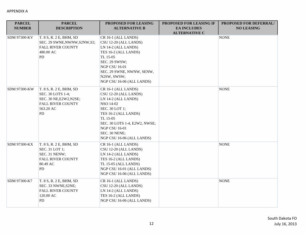
APPENDIX A
PARCEL
NUMBER
PARCEL
DESCRIPTION
PROPOSED FOR LEASING
ALTERNATIVE B
PROPOSED FOR LEASING IF
EA INCLUDES
ALTERNATIVE C
PROPOSED FOR DEFERRAL/
NO LEASING
SDM 97300-KV T. 8 S, R. 2 E, BHM, SD
SEC. 29 SWNE,NWNW,S2NW,S2;
FALL RIVER COUNTY
480.00 AC
PD
CR 16-1 (ALL LANDS)
CSU 12-20 (ALL LANDS)
LN 14-2 (ALL LANDS)
TES 16-2 (ALL LANDS)
TL 15-05
SEC. 29 SWSW;
NGP CSU 16-01
SEC. 29 SWNE, NWNW, SENW,
N2SW, SWSW;
NGP CSU 16-06 (ALL LANDS)
NONE
SDM 97300-KW T. 8 S, R. 2 E, BHM, SD
SEC. 30 LOTS 1-4;
SEC. 30 NE,E2W2,N2SE;
FALL RIVER COUNTY
563.20 AC
PD
CR 16-1 (ALL LANDS)
CSU 12-20 (ALL LANDS)
LN 14-2 (ALL LANDS)
NSO 14-02
SEC. 30 LOT 1;
TES 16-2 (ALL LANDS)
TL 15-05
SEC. 30 LOTS 1-4, E2W2, NWSE;
NGP CSU 16-01
SEC. 30 NENE;
NGP CSU 16-06 (ALL LANDS)
NONE
SDM 97300-KX T. 8 S, R. 2 E, BHM, SD
SEC. 31 LOT 1;
SEC. 31 NENW;
FALL RIVER COUNTY
80.49 AC
PD
CR 16-1 (ALL LANDS)
CSU 12-20 (ALL LANDS)
LN 14-2 (ALL LANDS)
TES 16-2 (ALL LANDS)
TL 15-05 (ALL LANDS)
NGP CSU 16-01 (ALL LANDS)
NGP CSU 16-06 (ALL LANDS)
NONE
SDM 97300-K7 T. 8 S, R. 2 E, BHM, SD
SEC. 33 NWNE,S2NE;
FALL RIVER COUNTY
120.00 AC
PD
CR 16-1 (ALL LANDS)
CSU 12-20 (ALL LANDS)
LN 14-2 (ALL LANDS)
TES 16-2 (ALL LANDS)
NGP CSU 16-06 (ALL LANDS)
NONE
12South Dakota FO
July 16, 2013

APPENDIX A
PARCEL
NUMBER
PARCEL
DESCRIPTION
PROPOSED FOR LEASING
ALTERNATIVE B
PROPOSED FOR LEASING IF
EA INCLUDES
ALTERNATIVE C
PROPOSED FOR DEFERRAL/
NO LEASING
SDM 97300-K8 T. 8 S, R. 2 E, BHM, SD
SEC. 33 SW;
FALL RIVER COUNTY
160.00 AC
PD
CR 16-1 (ALL LANDS)
CSU 12-20 (ALL LANDS)
LN 14-2 (ALL LANDS)
TES 16-2 (ALL LANDS)
NGP CSU 16-06 (ALL LANDS)
NONE
SDM 97300-MQ T. 9 S, R. 2 E, BHM, SD
SEC. 4 LOTS 3,4;
SEC. 4 S2N2;
FALL RIVER COUNTY
240.86 AC
PD
CR 16-1 (ALL LANDS)
CSU 12-20 (ALL LANDS)
LN 14-2 (ALL LANDS)
NSO 14-02
SEC. 4 LOT 4;
TES 16-2 (ALL LANDS)
NGP CSU 16-06 (ALL LANDS)
NONE
SDM 97300-MR T. 9 S, R. 2 E, BHM, SD
SEC. 4 SESE;
FALL RIVER COUNTY
40.00 AC
ACQ
CR 16-1 (ALL LANDS)
CSU 12-20 (ALL LANDS)
LN 14-2 (ALL LANDS)
TES 16-2 (ALL LANDS)
NGP CSU 16-06 (ALL LANDS)
NONE
SDM 97300-MT T. 9 S, R. 2 E, BHM, SD
SEC. 5 LOTS 1,2;
SEC. 5 S2NE;
FALL RIVER COUNTY
160.88 AC
PD
CR 16-1 (ALL LANDS)
CSU 12-20 (ALL LANDS)
LN 14-2 (ALL LANDS)
TES 16-2 (ALL LANDS)
TL 15-05
SEC. 5 LOT 2, SWNE;
NGP CSU 16-06 (ALL LANDS)
NONE
SDM 97300-M4 T. 9 S, R. 2 E, BHM, SD
SEC. 9 NW;
FALL RIVER COUNTY
160.00 AC
ACQ
CR 16-1 (ALL LANDS)
CSU 12-20 (ALL LANDS)
LN 14-2 (ALL LANDS)
TES 16-2 (ALL LANDS)
NGP CSU 16-06 (ALL LANDS)
NONE
13South Dakota FO
July 16, 2013

APPENDIX A
PARCEL
NUMBER
PARCEL
DESCRIPTION
PROPOSED FOR LEASING
ALTERNATIVE B
PROPOSED FOR LEASING IF
EA INCLUDES
ALTERNATIVE C
PROPOSED FOR DEFERRAL/
NO LEASING
SDM 97300-M8 T. 9 S, R. 2 E, BHM, SD
SEC. 10 S2NE;
FALL RIVER COUNTY
80.00 AC
PD
CR 16-1 (ALL LANDS)
CSU 12-20 (ALL LANDS)
LN 14-2 (ALL LANDS)
TES 16-2 (ALL LANDS)
NGP CSU 16-06 (ALL LANDS)
NONE
SDM 97300-ND T. 9 S, R. 2 E, BHM, SD
SEC. 17 SW,NWSE;
FALL RIVER COUNTY
200.00 AC
PD
CR 16-1 (ALL LANDS)
CSU 12-20 (ALL LANDS)
LN 14-2 (ALL LANDS)
NSO 14-02
SEC. 17 SWSW;
TES 16-2 (ALL LANDS)
TL 15-05
SEC. 17 NWSW;
NGP CSU 16-06 (ALL LANDS)
NONE
SDM 97300-NE T. 9 S, R. 2 E, BHM, SD
SEC. 18 SENE,E2SE;
FALL RIVER COUNTY
120.00 AC
PD
CR 16-1 (ALL LANDS)
CSU 12-20 (ALL LANDS)
LN 14-2 (ALL LANDS)
TES 16-2 (ALL LANDS)
TL 15-05
SEC. 18 SENE, NESE;
NGP CSU 16-06 (ALL LANDS)
NONE
SDM 97300-NF T. 9 S, R. 2 E, BHM, SD
SEC. 19 LOTS 3,4;
SEC. 19 E2SW,SE;
SEC. 20 SWSW;
FALL RIVER COUNTY
345.26 AC
PD
CR 16-1 (ALL LANDS)
CSU 12-20 (ALL LANDS)
LN 14-2 (ALL LANDS)
TES 16-2 (ALL LANDS)
NGP CSU 16-06 (ALL LANDS)
NONE
14South Dakota FO
July 16, 2013

APPENDIX A
PARCEL
NUMBER
PARCEL
DESCRIPTION
PROPOSED FOR LEASING
ALTERNATIVE B
PROPOSED FOR LEASING IF
EA INCLUDES
ALTERNATIVE C
PROPOSED FOR DEFERRAL/
NO LEASING
SDM 97300-NG T. 9 S, R. 2 E, BHM, SD
SEC. 21 NE;
FALL RIVER COUNTY
160.00 AC
PD
CR 16-1 (ALL LANDS)
CSU 12-20 (ALL LANDS)
LN 14-2 (ALL LANDS)
NSO 14-02
SEC. 21 N2NE;
TES 16-2 (ALL LANDS)
NGP CSU 16-06 (ALL LANDS)
NONE
SDM 97300-NH T. 9 S, R. 2 E, BHM, SD
SEC. 21 NWNW;
FALL RIVER COUNTY
40.00 AC
PD
CR 16-1 (ALL LANDS)
CSU 12-20 (ALL LANDS)
LN 14-2 (ALL LANDS)
NSO 14-02 (ALL LANDS)
TES 16-2 (ALL LANDS)
NGP CSU 16-06 (ALL LANDS)
NONE
SDM 97300-NK T. 9 S, R. 2 E, BHM, SD
SEC. 30 LOTS 1,2;
SEC. 30 N2NE,SWNE,E2NW;
FALL RIVER COUNTY
264.82 AC
PD
CR 16-1 (ALL LANDS)
CSU 12-20 (ALL LANDS)
LN 14-2 (ALL LANDS)
TES 16-2 (ALL LANDS)
NGP CSU 16-06 (ALL LANDS)
NONE
15South Dakota FO
July 16, 2013

1
Appendix B - Stipulations Applied
Appendix B is a table showing the stipulations applied to each parcel and used during the analysis.
Stipulations and Lease Notices applied to lease parcels in the July 16, 2013 Sale Stipulation # Stipulation Name Stipulation Reason
No Surface
Occupancy
NSO 11-2
flood plains No surface occupancy or use is allowed
within riparian areas, 100-year flood
plains of major rivers, and on water
bodies and streams.
To protect the unique
biological and
hydrological features
associated with riparian
areas, 100-year flood
plains of major rivers, and
water bodies and streams;
and to maintain
riparian/wetlands function
and water quality.
Any changes to this
stipulation will be made in
accordance with the land
use plan and/or the
regulatory provisions for
such changes.
Timing
Limitation
TL 13-1
winter range No surface use is allowed within crucial
winter range for wildlife for the
following time period:
December 1 to March 31
This stipulation does not apply to the
operation and maintenance of production
facilities.
Protect crucial white-
tailed deer, mule deer, elk,
antelope, moose, bighorn
sheep and sage grouse
winter range from
disturbance during the
winter use season, and to
facilitate long-term
maintenance of wildlife
populations.
Any changes to this
stipulation will be made in
accordance with the land
use plan and/or the
regulatory provisions for
such changes.
Lease Notice
LN 14-2
LEASE NOTICE
CULTURAL
RESOURCES
The Surface Management Agency is
responsible for assuring that the leased
lands are examined to determine if
cultural resources are present and to
specify mitigation measures.
This notice would be
consistent with the present
Montana State Office
guidance for cultural
resource protection related
to oil and gas operations
(NTL-MSO-85-1).
Lease Notice
LN 14-11
LEASE NOTICE
GREATER SAGE-
GROUSE HABITAT
The lease may, in part or in total, contain
important greater sage grouse habitats as
identified by the BLM, either currently
or prospectively. The operator may be
required to implement specific measures
-

2
to reduce impacts of oil and gas
operations on the greater sage grouse
populations and habitat quality. Such
measures shall be developed during the
application for permit to drill on-site and
environmental review process and will
be consistent with the lease rights
granted.
Controlled
Surface Use
CSU 12-20
PALEONTOLOGICAL
RESOURCES
Surface occupancy or use is subject to
the following special operating
constraint:
Prior to undertaking any surface-
disturbance activities on lands covered
by this lease, the lessee or operator,
unless notified by the contrary by the
BLM, shall:
1. Contact the BLM to determine
if a site specific vertebrate
paleontological inventory is required. If
it is required, the operator must engage
the services of a qualified paleontologist,
acceptable to the BLM, to conduct the
inventory. An acceptable inventory
report is to be submitted to the BLM for
review and approval at the time a
surface-disturbing plan of operation is
submitted.
2. Implement mitigation measures
required by the BLM to preserve, avoid
or recover vertebrate paleontological
resources. Mitigation may include
relocation of proposed facilities or other
protective measures. All cost associated
with the inventory and mitigation will be
borne by the lessee or operator.
3. The lessee or operator
shall immediately bring to the
attention of the BLM any
vertebrate paleontological
resources discovered as a result
of surface operations under this
lease and shall leave such
discoveries intact until directed
to proceed by the BLM.
To protect key
paleontological resources
from disturbance, or
mitigate the effects of
disturbance to conserve
scientific and interpretive
values, and the interests of
the surface owner.
Lease Notice
LN 14-15
LEASE NOTICE
SPRAGUE’S PIPIT
The lease area may contain habitat for
the federal candidate Sprague’s pipit.
The operator may be required to
implement specific measures to reduce
impacts of oil and gas operations on
Sprague’s pipits, their habitat and overall
population. Such measures would be
developed during the application for
-

3
permit to drill and environmental review
processes, consistent with lease rights.
If the U.S. Fish and Wildlife Service lists
the Sprague’s pipit as threatened or
endangered under the Endangered
Species Act, the BLM would enter into
formal consultation on proposed permits
that may affect the Sprague’s pipit and
its habitat. Restrictions, modifications,
or denial of permits could result from the
consultation process.
Cultural
Resources
Lease
Stipulation
CR 16-1
Cultural Resources Lease
Stipulation
This lease may be found to contain
historic properties and/or resources
protected under the National Historic
Preservation Act (NHPA), American
Indian Religious Freedom Act, Native
American Graves Protection and
Repatriation Act, E.O. 13007, or other
statutes and executive orders. The BLM
will not approve any ground disturbing
activities that may affect any such
properties or resources until it completes
its obligations under applicable
requirements of the NHPA and other
authorities. The BLM may require
modification to exploration or
development proposals to protect such
properties, or disapprove any activity
that is likely to result in adverse effects
that cannot be successfully avoided,
minimized or mitigated.
-
Endangered
Species Act
Section 7
Consultation
Stipulation
TES 16-2
Endangered Species Act
Section 7 Consultation
Stipulation
The lease area may now or hereafter
contain plants, animals, or their habitats
determined to be threatened, endangered,
or other special status species. The BLM
may recommend modifications to
exploration and development proposals
to further its conservation and
management objective to avoid BLM-
approved activity that will contribute to a
need to list such a species or their
habitat. The BLM may require
modifications to or disapprove proposed
activity that is likely to result in jeopardy
to the continued existence of a proposed
or listed threatened or endangered
species or result in the destruction or
adverse modification of a designated or
proposed critical habitat. The BLM will
not approve any ground-disturbing
activity that may affect any such species
or critical habitat until it completes its
obligations under applicable
-

4
requirements of the Endangered Species
Act as amended, 16 U.S.C. § 1531 et
seq., including completion of any
required procedure for conference or
consultation.

5
APPENDIX C: MAPS

6

7

8