unusual smog 2012
TRANSCRIPT
8/12/2019 Unusual Smog 2012
http://slidepdf.com/reader/full/unusual-smog-2012 1/6
1
About Haze/smog event over Delhi during 28 Oct-5 Nov 2012 which was Re-
intensified again on 4th
Nov 2012*
Description and Latest information of the event
The smoke/dust layer in association with some shallow to moderate fog particles which has kept covering Delhi airport since evening of 28 Oct 2012
though improved slightly by afternoon of 3 Nov 2012 due to some winds and
vertical mixing, it was re-intensified on yesterday of 4th
Nov. Such re-
intensification was mainly due to fresh inflow of dust/smog/pollutions from
agricultural burning from Punjab and Haryana from favourable northerly winds
at lower level at north of Delhi with local pollution highly added to such
formation in view of local atmosphere of same date, have shown more stability
compared to all other days of this spell since 28 Oct 2012. There was increasedof calmness of air on 4
th Nov which again raised upto 4000m compared to
3000m on 3rd
Nov and strengthening of inversion level. In view of such
combination of interstate transported smoke and local pollution from Delhi on
4th, it was the worst day when thick Haze/smog coverage kept covering over IGI
Palam and Safdarjung (SFD) city airport with visibility during last 36-hours
covering early morning of 4th till noon of 5 Nov when visibility was remaining
mostly below 800m with lowest of 250m and RVR at IGI as 550m.
Latest information shows an improvement of this haze/smog coverage
and associated surface visibility conditions from afternoon of today afternoon of
the 5th Nov with visibility crossing 1500m and 1000m at 1600IST at IGI Airport
and SFD Airport. This analysis has been confirmed from wind analysis of IMD
Model and NASA satellite pictures of 4th and 5th attached in the last of this
document (Figs 1 and 3).
Forecast till 7 Nov 2012
Latest wind, Temp and Humidity, their Model forecast analysis along with
trends from movement of such smog/haze coverage from various Satellite
products e.g. INSAT and NASA MODIS of 5th Nov shows such conditions
likely to improve slowly during by 48 hours i.e. by 7 Nov 2012 with setting and
strengthening of westerly wind conditions at lower levels.
Possible causes of this event
This spell of smog/haze coverage now has completed 7-days when all
most all parts of the day visibility both at SFD Airport and IGI airport did not

8/12/2019 Unusual Smog 2012
http://slidepdf.com/reader/full/unusual-smog-2012 2/6
2
cross 1000m with worst conditions on 2nd
Nov and 4th
Nov 2012, though
some respite was observed on afternoon of 3 Nov 2012 due to some winds
and vertical mixing. Such prolonged stagnation of haze/smoke cover for almost
a week has been attributed to accumulation local pollution from Delhi in
together with piling up, from interstate transported smoke raised from
agricultural brining over Punjab and Haryana as confirmed from various
smog/haze coverage data of satellite analysis. Such accumulation was supported
by longer period of presence of stronger subsidence of air at lower levels over
northwest(NW) India along with development of calm winds or “zone of
silence” over Delhi region upto 3000m-4000m above ground which was coming
out as outflow from at upper levels from strong vertical motion occurring upto
mid-troposphere at over adjoining southeast India in association with movement
and slow weakening of remnant of Cyclone “Nilam” which crossed Tamil
Nadu coast of southeast(SE) India
Whether such thick Haze/smoke cover over Delhi in association with
Cyclone crossing east coast of India is unusual ?
This is not unusual by this time of year when winter pattern has still not been set
in and atmosphere normally stable with no vertically mixing, calm winds and
atmosphere at lower levels have, inversion in temperature values with increased
of temperature with height. But when, it has been the aftermath of cyclone
crossing south-eastern coast of India with its remnant weakening takes longer
time, the subsidence conditions over NW India gets intensified and prevails for
very long period. This has been as per study carried out for past already
occurred major smog/haze cases over Delhi region which has also sustaining
life period of 7-14 days over NW India as per the same reason given before.
For this special study we used past IMD data and Satellite and MODIS NASA
pictures of 2000-2012. It shows there were similar prolonged thick smoke/fogconditions over Delhi and adjoining NW India reducing visibility upto 300-
500m in association with corresponding movement and crossing of cyclone
across coasts of SE India before, as were in Dec 1998, Nov, 2008 and Dec
2011.
It was Nov 2008 when there were nearly 21 days of prolonged high level of
Haze/smoke with three spells each of 5-11 days accompanied with pertinence
lower visibility over the region each in association with three cyclones(“Rashmi”
“Khi-Muk” “Nisha” which crossed coast over eastern India. Last season, it was
8/12/2019 Unusual Smog 2012
http://slidepdf.com/reader/full/unusual-smog-2012 3/6
3
also Cyclone “Thane” which crossed Tamil Nadu coast over southeast India
crated similar stable and “no wind” atmospheric conditions favouring large-
scale very thick fog/haze coverage over NW India including Delhi during last
week of Dec 2011, last year.
Aqua/MODIS
2012/309
11/04/2012
07:45 UTC
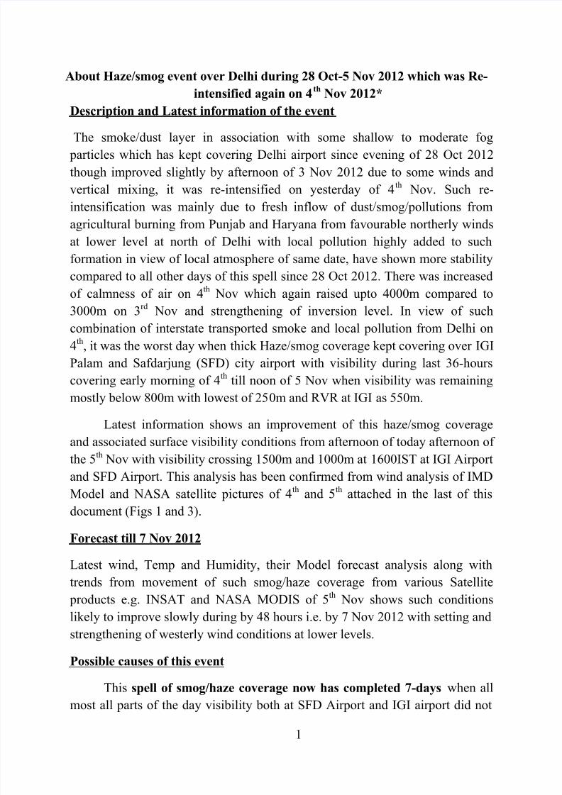
Fig. 1 NASA MODIS – AQUA satellite pictures of 1315 IST of 4th Nov 2012.
Aqua/MODIS
2008/312
11/07/2008
08:00 UTC
Inter-state transported
smoke raised from
agricultural brining
over Punjab and
Haryana.
Delhi’s prolonged
stagnation of haze/smoke
cover was attributed to
accumulation local
pollution from Delhi in
together with palling up,
from interstate transported
smoke raised from
agricultural brining over
Punjab and Haryana asconfirmed from various
smog/haze coverage data of
satellite analysis. It was
highly supported by
cyclone “Nilam” which
crossed coast of SE India
but slowly weakening of its
remnant during 29-5 Nov
2012
Inter-state transported
smoke raised from
agricultural brining
over Punjab and
Haryana
Thick haze/smoke converge
over Delhi of 3-13 Nov 2008
corresponding to cyclone
“Rashmi” 25-28 Oct 2011which crossed coast at
Ban ladesh
Cloud walls
still from
remnants of
Cylone
“Nilam”
aross
southeastIndia
8/12/2019 Unusual Smog 2012
http://slidepdf.com/reader/full/unusual-smog-2012 4/6
4
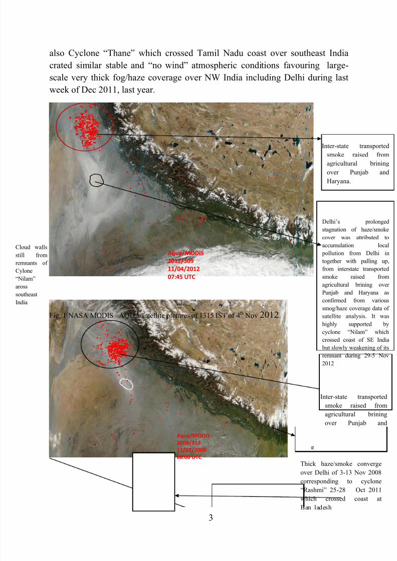
Fig.2. NASA MODIS – AQUA satellite pictures of 1315 IST of 7 Nov 2008.
Fig.3. NASA MODIS – AQUA satellite pictures of 1045 IST of 5 Nov 2012.
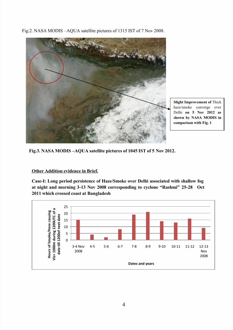
Other Addition evidence in Brief.
Case-I: Long period persistence of Haze/Smoke over Delhi associated with shallow fog
at night and morning 3-13 Nov 2008 corresponding to cyclone “Rashmi” 25-28 Oct
2011 which crossed coast at Bangladesh
0
5
10
15
20
25
3-4 Nov
2008
4-5 5-6 6-7 7-8 8-9 9-10 10-11 11-12 12-13
Nov
2008 H o u r s o f S m o k e / H a z e c a s u i n g
V i s < 1 0 0 0 m d u r i n g
1 2 0 0 U T C o f a
d a t e t i l l 1 2 0 0 o f
n e x t d a t e
Dates and years
Slight Improvement of Thick
haze/smoke converge over
Delhi on 5 Nov 2012 as
shown by NASA MODIS in
comparison with Fig. 1

8/12/2019 Unusual Smog 2012
http://slidepdf.com/reader/full/unusual-smog-2012 5/6
5
Cyclonic Storm “Rashmi”- October 25 – October 27 2008
Case-II: Long period persistence of Haze/Smoke over Delhi associated with shallow fog
at night and morning in 15-19 Nov 2008 corresponding to cyclone “Khi-Muk” 13-16
Nov 2011 which crossed coast at Andhra Pradesh
Cyclonic Storm Khi-Muk -Duration November 13 – November 16
Case-III: Long period persistence of Haze/Smoke over Delhi associated with shallow
fog at night and morning in 25-29 Nov 2008 corresponding to cyclone “Nisha” 25-29
Oct 2011 which crossed coast at TamilNadu coast.
0
5
10
15
15-16 16-17 17-18 18-19 19-20 20-21 H o u r s o f S m o k e / H a z e
c a s u i n g V i s < 1 0 0 0 m
d u r i n g 1 2 0 0 U T C o f a d a t e
t i l l 1 2 0 0 o f n e x t d a t e
Dates and years Nov 2008

8/12/2019 Unusual Smog 2012
http://slidepdf.com/reader/full/unusual-smog-2012 6/6
6
Cyclonic Storm Nisha -
Duration
November 25 – November 29
*Published as press report on 5th Nov 2012 with inputs from MET OFFICE IGI
AIRPORT PALAM and DDGM RMC NEWDELHI.
0
5
10
15
20
25-26 26-27 27-28 28-29 H o u r s o f S
m o k e / H a z e
c a s u i n g V i s <
1 0 0 0 m d u r i n g
1 2 0 0 U T C
o f a d a t e t i l l
1 2 0 0 o f
n e x t d a t e
Dates and years Nov 2008