vi. future traffic evaluation - town of...
TRANSCRIPT

(
(
PENFIELD, NY BAYTOWNE PLAZA TRAFFIC IMPACT STUDY
Field observations indicate that eastbound Route 404 traffic can reach the anchor store via Route 404 and Brandt Point Drive fas ter than traveling through the BayTowne Plaza parking lot via the ex isting BayTowne driveway. The parking lot is designed to keep speed down and Route 404 is an arterial with good progression because of synchronized traffic lights.
VI. Future Traffic Evaluation
A. 2009 No-Build Traffic
To project the 2009 no-build peak hour traffic or background traffic vo lumes, tbe ex isting peak hour vo lumes were increased by 2 %. The historic data supplied in the 2006 NYSDOT TOR was used to determine the annual growth rate of 2%. This increase is shown in Figure 10 Background Traffic Peak Hour Turning Movements. The NYSDOT 2004 TOR for New York State was utilized to researcb the historic growth of traffic in tbe study area on NYS Route 404. The overall study area growth per year was determined to be approx imately 2% which accommodates the same rate of area development tbat bas occurred since the late 1990' s. The vo lume of traffic entering or ex iting the Wegmans Plaza does not change for background traffic between 2007 and 2009 because there is no anticipated change to the Wegman Plaza.
Then projected traffic from approved area developments that are not yet bu ilt was added. From discussions with the Town of Penfield approved deve lopments in the area include a 3,700 SF convenience store with 2 gas islands (4 stations each) at 480 Plank Road, completion of the Spring Pines Office Park located on tbe east side of Route 404 about 1,000 feet north of Plank Road tbat includes three 7,000 SF office buildings and a development located at 1280 Creek Street north of Pen Web Park that includes a 3,000 SF bank and 5,300 SF retail building. The sum total of background development traffic is shown in Figure I I Background Developments Peak Hour Turning Movements.
Tbe 2009 no build traffi c is tbe sum 0[2009 background traffic grown at 2% per year plus tra ffi c fro m approved background developments tbat have not been built yet, The background deve lopments are located to the south on Route 404 and on Creek Street (see bullet 2 below). Appendix 0 sbows the analysi of background traffi c. Contents of Appendix 0 are:
I ) Table containing the tr ip generation for the background developments.
2) Map showing the locations of the background developments.
3) Table sbowing turning movements at subject intersections for 2009 background traffic (grown at 2% per year) and fo r each background deve lopment.
The projected 2009 no-build traffi c is shown in Figure 12. Figure 12 represents traffi c expected to use the subj ect intersections in 2009 without expansion of the plaza.
PAGE 22

-
Bay Road
(238) 122S} (IBS) 233 245 119
.J I L
(2611 383 --'
17981931 --
133132 t
f 4561 "6
L 61 (1031
--- 638 (607 I
f 184 119Bl
I I 46 323 243
('1411285) 1114J
L 50 (561
r- 129 11]11
'21 '01 0 0
'01
°
ear Wash Driveway
L 0 '21
--- 658 (6261
.J I L t 230 '2691
Route 404 (15) 4 ~ I t I
21O , 2<8 (849) 1019 --(2551 ( D) 12721
12631245 t
Bay Towne Plaza Driveway
, Bay Towne ~---- Plaza Driveway
LEGEND:
t l 557 139
14431 (151)
Creek Street
xxx - friday Plot Peak Hour kaffic 5 :00 - 6 :00 (XXX I- SatlXoo)' ~i(l-d<l)' PC(jo; HOIS Troffic 11 : 00 - 12 :00
r---.
Wegmans Driveway
((lOI16!) 66 un
.J L L 159 (1921 --- 964 (10261
81" 18591 t 45 <361
~
~
T errei Drive
(l41 1201 49 23 L 23 (D)
.J L --- 959 110081
11341161 --'
Route 404 1661 67 --'
Route 404
19141 1165 ---
(110211295 --
1481 10\ t I 53 53
(418) 132)
(10681 1281 ---
Brandt Point Drive
Bay Towne Plaza Traffic Impact Study
2009 Background with 2% Annual Growth Peak Hour Turning Movements
FIGOOE )\0.
10 rlBergmann nsocllst",

I f\ r---.. I
I~
Car Wash Wegmans Bay Road Driveway Driveway Terrel Drive
L 0 101 L ° <OJ
lSI 191 101 --- 22 [19)
101 101 101 --- 5,q (531 101 101 L 0101 --- 50 149)
[81 [01
L ° 101 • 8 ° ° ° ° ° ° 8 ° ~ I L t 32 1341 ~ I L t 0101 ~ L -- 54 (53) t o lOJ ~ L --- 42 (41)
Route 404
101 ° ---.J Route 404
181 12 -.J Route 404
'<II 1I ~ I t I 101 ° ---.J I t I {"51 69 --- I I 117143 --- ° 8 32 1491 75 --- ° ° ° 1491 15 --- '" ., 4 °
1311 57 ---101 181 (32 ) 101 {OJ 10J 141 101
1010 , 1010 ,
Bay Towne Brandt Point Plaza Driveway Drive
{<Ill L 0 101 4O
I t 0101
Bay Towne Plaza Driveway
t I 4O ° 1401 101
Creek Street Bay Towne Plaza Traffic Impact Study
Background Developments Peak Hour Turning Movements
LEGEND: XXX - Fr idoy PM Peak Hour Traff ic 5:00 - 6:00
IXU1- SalUl-doy Mi d-day Peak. HOlX" Jroffic 11 : 00 - 12 : 00
F1GlRE NO.
11

,~ (\ '~I
Bay Road
12-43112371 (ISS. 239 253 119
~ I L
L 61 (1031
66016261
r 216 (2321
121 0
~ Route 404
WI 0
I 101 0
ear Wash Driveway
L a 12)
--- 712 16791
L t 230 12691
(265 I 394 --' "I I I1S1 4 ~ I t I (8151 97.11 -- •• 331 215 18981 100<1 -- 210 1 248
(<l4) 12931 (ZOGI (255) 101 12121
nJl 32 t
( 4991 496
12631 245
50 1561
r- 129 11311
, Bay Towne ~---- Plaza Driveway
t 597 139
1483111511
Creek Street
LEGEND: xxx - Friday PU Peak Hour Traffic 5:00 - 6:00
IXXXI - SOh.rdoy Mid-doy Peak Hour Traffic 11 :00
Bay Towne Plaza Driveway
12 : 00
Wegmans Driveway
(78 J (IGl1 66 1(13
L
113<1 1161 -'
(1023) 1240 --
L 159 (192)
--- 868 191Z1
Route 404 (11411 1364 --
1521101 ,
-I I ~
Terrel Drive
___ 1014 (10751 16211201 51 23
t 45 £361
I 57 53
1521 1321
~ L 1704179 --'
111051 1338 ---
L 23 1131
_ 1001 11049)
Route 404
Brandt Point Drive
Bay Towne Plaza Traffic Impact Study
2009 No Build Peak Hour Turning Movements
F1GLJl£ NO. I SCAlE OATE
12/08 '" Bergmann associates 12 I No Scale

(
(
tntersection
B. 2009 No-Build Levels of Service
PENFIELD, NY BAYTOWNE PLAZA TRAFFIC IMPACT STUDY
The projected 2009 Synchro peak hour traffic operations at the subject intersections are similar to ex i ting operations, ranging from LOS A to F. Synchro level of service analysis results are provided in Table 7. Detailed Synchro results are contained in Appendix E.
The Terrel Drive approach to Route 404 is projected to operate at LOS F during the peak hours. Route 404 is free flow and is projected to operate at LOS A at Terrel Drive and at Brandt Point Drive. Left turns from Route 404 to these two side street are projected to operate at LOS B except the left turn to Brandt Point Drive during the Friday PM peak hour, which is projected to degrade to LOS C. Brandt Point Drive is projected to degrade to LOS F and LOS E during the Friday PM and Saturday Mid-day peak hours respective ly at Route 404.
The signalized intersection of Route 404 with the Wegmans driveway is projected to operate at LOS A during the Friday PM and Saturday Mid-day peak hours in 2009 without the BayTowne Plaza Expansion. The Wegmans driveway cons ists of two ex it left turn lanes; one exit right turn lane and two enter lanes. Route 404 is five lanes wide. Route 404 approaches are projected to operate at LOS A except the westbound approach is projected to operate at LOS B during the Saturday Mid-day peak hour. Left turns into Wegmans are projected to operate at LOS B during the Friday PM peak hour and LOS A during the Saturday Mid-day peak hour. The Wegmans driveway is projected to operate at LOS D and B overall during the Friday and Saturday peak hour respective ly.
TABLE 7 2009 NO BUILD SYNCHRO LEVEL OF SERVICE RESULTS
Approach 2007 Existing 2009 No Build
Frl PM Pea k Hour Sat Midday Pk Hr Fri PM fleak Hour Sat Midday flk Hr
Control Control Control Control LOS Deiay LOS Delay LOS Delay LOS Delay
(sec/yeh) (soelvoh) (sec/yeh) (sec/Yah)
Empire Boulevard Eastbound Left B 11 .3 B 11.4 B 12. 1 B 12.2 NYS Route 404 at Eastbound Through A 0.0 A 0.0 A 0.0 A 0.0 Terrel Drive Route 404 Eastbound Approach A 0.6 A 0.7 A 0.7 A 0.6
Route 404 Westbound TR A 0.0 A 0.0 A 0.0 A 0.0 Unsignalized Terrel Drive Southbound LR F 101.8 F 62.4 F 243.9 F 124.2
Empire Boulevard Route 404 Eastbound TR A 0.0 A 0.0 A 0.0 A 0.0 NYS ROute 404 at Westbound Left B 14.9 B 12.4 C 17.0 B 13.4 Brandt Point Drive Westbound Through A 0.0 A 0.0 A 0.0 A 0.0
Route 404 Westbound Approach A 0.7 A 0.4 A 0.7 A 0.4 Unslgnalized Brandt Point Northbound LR E 36.2 D 28.6 F 54.S E 37.3
LR: Shared Left and Right TR: Shared Tt1rough and Right L T: Shared Laft and Through L TR: Shared Left, Through, and Right
PAGE 26

(
(
(
Intersection
Empire Boulevard NVS Route 404 at Wegman. drlyeway
Signalized
Empire Boulevard NVS Route 404 at BayT owne driveway
Signalized
Empire Boulevard NVS Route 404 at
Creek Street and
Bay Road
Signalized
Creek Stroet at BayT owne dr iveway
Unslgnallzed
PENFIELD, NY BAYTDWNE PLAZA TRAFFIC IMPACT ST UDY
TABLE 7 Continued 2009 NO BUILD SYNCHRO LEVEL OF SERVICE RESULTS
Approach 2007 Existing 2009 No Build
Frl PM Peak Hour Sat Midday Pk Hr Frl PM Peak Hour Sat Midday Pk Hr
Control Control Control Control LOS Dolay LOS Delay LOS Delay LOS Delay
(sec/veh) (sec/veh) (sec/yoh) (sec/yeh)
Eastbound Left B 12.7 A 8.4 B 16.1 A 8.2 Eastbound Through A 2.0 A 4.3 A 2.2 A 4.4
Route 404 Eastbound Approach A 3.4 A 4.8 A 3.8 A 4.9 Route 404 Westbound TR A 8.0 B 12.4 A 8.8 B 12.8
Southbound Len 0 46.0 C 21.4 0 46.0 C 22.2 Southbound Right B 12.5 A 8.0 B 12.5 A 8.2
Wegmans Southbound Approach 0 37.1 B 17.0 0 37.1 B 17.6 Overall A 8.7 A 9.4 A 8.8 A 9.6 Eastbound Left A 9.8 B 15.8 A 9.0 B 15.4 Eastbound Through B 12.2 C 20.8 B 13.1 C 21.3 Eastbound Right A 1.1 A 3.8 A 1.1 A 3.6
Route 404 Eastbound Approach A 9.9 B 16.5 B 10.9 B 17.3 Westbound Left 0 38.2 B 18.9 0 43.9 C 23.5 Westbound TR A 7.1 A 7.8 A 6.7 A 7.9
Route 404 Westbound Approach B 15.5 B 11 .3 B 15.8 B 12.3 Northbound LT 0 49.8 C 34.7 0 53.6 0 36.7 Northbound Right B 18.4 B 10.4 C 20.2 B 12.0
BayTowne Northbound Approach C 32.8 C 22.1 0 35.5 C 24.0
Car Wash Southbound LTR A 0.0 A 0.0 A 0.0 A 0.0 Overall B 16.2 B 16.0 B 16.9 B 16.9
Eastbound Left 0 35.7 C 21.1 0 43.6 C 29.4 Eastbound T R C 23.7 C 23.5 C 25.8 C 29.3
Route 404 Eastbound Approach C 27.1 C 22.9 C 30.8 C 29.3 Westbound Left C 21.7 C 23.6 C 34.5 C 33.7 Westbound TR C 29.8 C 26.1 C 31.6 C 28.0
Route 404 Westbound Approach C 28.1 C 25.6 C 32.2 C 29.4
Northbound Left C 32.8 C 25.0 C 32.1 C 25.6
Northbound Through 0 52.8 C 33.7 0 52.9 0 38.9 Northbound Right B 16.6 A 9.3 C 20.5 B 11 .6
Creek Street Northbound Approach 0 36.9 C 24.5 0 37.8 C 27.5
Southbound Left C 29.2 C 25.6 C 33.0 C 28.6 Southbound Through C 26.8 B 18.0 C 27.6 B 18.4
Southbound Right A 8.0 A 5.9 A 8.4 A 6.6
Bay Road Southbound Approach B 20.0 B 15.7 C 21.2 B 16.9
Overall C 27.9 C 22.5 C 30.8 C 26.5
BayTowne Westbound LR F 69.8 0 30.3 F 168.3 F 52.4 Northbound Through A 0.0 A 0.0 A 0.0 A 0.0 Northbound Right A 0.0 A 0.0 A 0.0 A 0.0
Creek Street Northbound Approach A 0.0 A 0.0 A 0.0 A 0.0 Creek Street Southbound Through A 0.0 A 0.0 A 0.0 A 0.0
LR: Shared Left and Right TR: Shared Through and Right L T: Shared Left and Through LTR: Shared Left, Through, and Right
PAGE 27
(
(
(
PENFIELD, NY
BAYTOWNE PLAZA TRAFFIC IMPACT STUDY
The signalized intersection of Route 404 with the BayTowne Plaza driveway is projected to operate at LOS B during the peak hours. The BayTowne Plaza driveway consists of one exit lane for left turns and throughs, one exit lane exclusive ly for right turns and two enter lanes. Route 404 is five lanes wide with one exclusive left turn lane for each direction. Route 404 approaches are projected to operate at LOS B during the peak hours. Left turns into BayTowne Plaza are projected to operate at LOS D during the Friday PM peak hour and LOS C during the Saturday Mid-day peak hour. The BayTowne Plaza driveway is projected to operate at LOS D and LOS C overa ll during the Friday PM and Saturday Mid-day peak hours re pectively.
The signa lized intersection of Route 404 with Bay Road and Creek Street is projected to operate at LOS C during the peak hours according to Synchro. Route 404 approaches are projected to operate at LOS C during the peak hours. Eastbound left turns to Bay Road are projected to operate at LOS D during the Friday PM peak hour and LOS C during the Saturday Mid-day peak hour. Creek Street is projected to operate at LOS D during the Friday peak hour and LOS C during the Saturday peak hour. Bay Road is projected to operate at LOS C during the Friday peak hour and LOS B during the Saturday peak hour.
The BayTowne Plaza driveway approach to Creek Street is projected to degrade to LOS F during both peak hours. Creek Street is free flow with left turns into BayTowne Plaza prohibited and is projected to operate at LOS A at the BayTowne Plaza driveway.
c. 2009 Build Traffic
The total projected build traffic vo lumes are the sum of 2009 background traffic and the projected development traffic. Primary vehicle trips for the peak hours are shown in Figure 7, pass-by vehicle trips in Figure 8 and chained trips in Figure 9. Figure 13 depicts the projected diversion of existing BayTowne Plaza traffic due to the opening of a third access point on the north side of the development to Brandt Point Drive. The sum of background traffic, trip diversion and all new site-generated trips are shown in Figure 14. This condition represents traffic after full build out of the proposed development, the 2009 build condition.
D. Proposed Mitigation
Brandt Point at Empire Traffic Signal Justification
The property upon which the rezoning app lication is sought is the location of the proposed Discount Superstore. This property presently only has frontage acce s to Brandt Point Drive. The other parcels upon )'Ihicb the expansion of BayTowoe Plaza is contemplated also have existing frontage on Brandt Point Drive as well. Typically, the NYSDOT requires that side road access to development be utilized prior to requesting a new curb cut onto the state highway system. There are no otber direct means to accomplish access to the undeveloped parcels on Brandt Point Drive or Empire Blvd. The developer has no addit ional property available for access to Empire Blvd short of the Town exercising eminent domain.
PAGE 28

.--1'\ ~ I
~
car Wash Wegmans Bay Road Driveway Driveway Terrel Drive
L L ~ ~ L --- -60 1-701 L
~ I L , ~ I L , -60 HOI ~ L -- ~o 1- 701 t +60 1+701 ~ L ~ Route 404
~ Route 404
~ Route 404
~ "I t I ~ "I t I 1-701 -60 -- "I I - -60 ( -701 -60 -- t .. 0 1-101 (+10)
t t Bay Towne
Plaza Driveway 1+701 .. 0
~ I Bay Towne
L Plaza Driveway
IHOI +60 ~ I "I ,
Bay Towne t Plaza Driveway
t I Brandt Point
Drive
Creek Street Bay Towne Plaza Traffic Impact Study
Trip Diversion New Driveway Peak Hour Turning Movements
LEGEND: f[GtR£ NO" I SCALE ~ I OAl[ II B xxx - Fridoy PM Peak Hour Traffic 5 : 00 - 6 : 00 er mann UJ(X) - SotlYoo), Mid-day Peak Hour Traffic 11 ; 00 - 12 ; 00 13 No Scale 12108" g",.,; ... , ~

L
,r-
Bay Road
12431 (231) 12121 239 253 \31
I L
{2651 394 ~ 19 181 1043 ----
133' 32 t
[4991 .96
L 84 112S}
-- 724 (1111
t 216 12321
I t I 55 333 275
1551 (296) (lObi
L B3 192.
r- 176 (1991
12 • 10' 0 0
101 0
Car Wash Driveway
L 0 12.
-- 193 l7aG)
.J I L t 177 12101
Route 404
11514 --' I t I 210 I ,% (934) 1114 ---
125511011212>
(3511 312 t
Bay Towne Plaza Driveway
I , Bay Towne 1----- Plaza Driveway
LEGEND:
I 517 203
(459) (2'11)
Creek Street
xxx - Friday PN Peak Hour TraFfic 5:00 - 6 :00 (XXI() - Saturday t.4id- day Peak HOOf'" Traffic 11 : 00 - 12 : 00
"
Wegmans Driveway
(8911172) 73 191
.J L
1)441169 ---'
(10131 1220 ----
L 161 12021
889 (949)
Route 404 (1056) 1281 ---
11<441 112 t
129311831 220 146
.J Bay Towne _____ ---1
Plaza Driveway
1351 I 290 --'
113 1 1, .
- 928 (9751
t 19512321
I I 174 222
11971 12341
It 10 106
1131 180 1
~
~I
Terrel Drive
177) (201 L 23 1131 67 23
.J L --1055111301
186' 90 -'
Route 404
[118111396 ---
Brandt Point Drive
Bay Towne Plaza Traffic Impact Study
Build (2009) Peak Hour Turning Movements
14 No Scale 12/08 " Berg.m~p.,p' flCl.RE ~o. , SCALE , OATE ,
(
(
(
PENFIELD, NY BAYTOWNE PLAZA TRAFFIC IMPACT STUDY
By inspect ion o f the data, it is evident that should a ll traffic generated by the new development use Brandt Point Drive, that a traffic signal is justified for the intersect ion of Empire Blvd and Brandt Point Drive is appropriate.
The Town of Penfield has put fo rth the concept in their BEC FGEIS that cross connection of development is a preferred form of access management. The deve loper has therefore proposed a circulation pattern tbat integrates the property front ing on Brandt Po int Drive with that fro nting on Empire Boulevard. Once this geometry is employed, the opportunity ex ists for a slightly different traffic pattern than if there was no cross access.
Specifica lly, it i clear that the vast majority of retail space proposed in the expansion is the Discount Superstore. A Discount Superstore attracts shoppers from a 5 to 15 mile radius. Those customers coming long distances would natura lly gravitate to the driveway that offers the least internal circulat ion path by distance and convenience. Or in other words, full y uti lize the public highway until the last possible moment. Without internal cross access, that would place the fu ll burden of new tr ips unto Brandt Point Drive. This would force a ll traffic fro m the east to pass the BayTowne driveway and the Wegmans driveways before entering Brandt Point to get to the site.
With the cross access in place, Brandt Point will still, in our professional judgment, be the primary path to the Discount Superstore, but the question becomes to what degree. After having discussed thi matter with the Town Engi neering Consultant, Stantec, and the NYSDOT, the reasonable approach is to study the traffic pattern for the scenario with no signal at the Brandt Point Drive intersection. A sensitivity test was performed where 75% of the left turns onto Route 404 were diverted fro m Brandt Point Drive to the exi ting BayTowne signal at Route 404. Even with this unlikely unsigna lized scenario traffic signal warrants are met, as shown below under: Traffic Signal Warrant - 75% Exit Left Turns Diverted to Existing Signal. Appendix F shows the detailed results of the analysis fo r this scenario. The traffic signal warrant analys is with 75% traffi c diverted, hows that the remaining traffic using Brandt Point Drive justifies a signal insta llat ion.
The impacts on BayTowne Plaza and Brandt Po int Drive are dramatic based on the 75% diver ion and assum ing that Brandt Point is not signalized. Queues on the existing driveway to Route 404 will be excess ive w ithout a traffic signal at Brandt Point Drive. The space ava ilable fo r queued vehicles on the exist ing driveway is approximately 250 feet to tbe first internal inter ection. Synchro predicts >370' for the existing driveway based on intersection turns w ithout a traffic signal at Brandt Point for both peak hours. The ex isting driveway w ill experience excess ive queuing with no signal at Brandt Point. Without a traffic signal at Brandt Po int Drive, Synchro show LOS D or better at the ex isting BayTowne driveway signal and LOS F for Brandt Po int. This also shows the need for a traffi c signa l.
Conversely, w ith the traffic signal at Brandt Point, Synchro predicts 230'-240' long queues for the existing BayTowne driveway for both peak hours. The existing driveway w ill band Ie the queuing w ith a ignal in ta iled at Brandt Po int Drive/Empire intersect ion
A carefu l tudy of the options with and without a signal at Brandt Po int Drive bas been perfo rmed. A new signal on Route 404 at Brandt Point Drive is needed to accommodate the
PAGE 31

(
(
(
PENFIELD, NY BAYTOWNE PLAZA TRAFFIC IMPACT STUDY
projected volume of traffi c exiting the BayTowne Plaza even in the unlikely event that 75% of the new traffic turning left shifts to the existing BayTowne driveway. The analys is sbows that a new signal is the best option.
Figure 14 is the most accurate representation of new trips on Brandt Po int Drive given its proximity to the largest generator of new traffic, the new anchor tenant, and the marked need fo r a new signal. The new signal works with tbe Wegmans signal without a significant overall impact to the Route 404 corridor, as shown in the fo llowing sections of this report.
Traffic Signal Warrant - 75% Exit Left Turns Diverted to Existing Signal
A traffic signal is warranted on Route 404 at Brandt Point Drive because the projected traffic vo lumes meet the National Manual of Unifor m Traffic Contro l Devices (National MUTCD) and the New York State Supplement fo r the following warrants:
• Warrant I , Eight-Hour Vehicular Volume • Warrant 2, Four-Hour Vehicular Volume • Warrant 3, Peak Hour
Because the 85 percentile speed on NYS Route 404 is above 40 miles per bour, reduced warrants I, 2 and 3 are used here and described below. Also, tbe right turning veh icles turning fro m Brandt Point Drive are reduced by 50% to acco unt fo r vehicles that would turn right on red fo r the signali zed condition. Year 2009 hourly traffic vo lumes on NYS Route 404 were determined using the machine traffic counts obtained fro m the New York State Transportation Federation Traffic Data Viewer (TDY). Hourly traffic vo lumes projected to exit the proposed development in 2009 werc detennined using the projected peak hour volume shown in Figure 14, the diversion of 75% of left turns shown in Appendix F and hourly variation in exiting reta il type traffic published in Table 2 on page 1449 of ITE Trip Generation 7th edition. Dctailed re ult , broken down by bour, are located in Appendix F.
Reduced warrant I is met for 8 bours on a wcekday and is met fo r the Saturday peak hour. Reduced warrant I is the E ight-Hour Vehicular Volume warrant. Condition B, Interruption of Continuous Traffic, applies for this ca e because the traffi c vo lume on the major street is so beavy tbat traffic on Brandt Point Drive is projected to suffer excessive delay in entering the major street. For anyone hour to satisfy this reduced (70%) warrant the vo lume of traffic on the artery must exceed 630 vehiclcs and the volume of traffic on the side road approach must exceed 70 vehicles.
For each hour during the weekday time period between II :00 a.m. and 7:00 p.m. the vo lume on the Brandt Po int Drive approach is projected to be greater than 70 vehicles. This exceeds tbe threshold va lue. Tbe vo lume of traffic on Route 404 at Brandt Point Drive according to the 2003 hourly traffic count report from the NYS TDV is greater than 1700 vehicles for each hour during the time period between II :00 a. m. and 7:00 p.m. and exceeds thc threshold value of 630 vehicl es. Saturday peak hour volumes are projected to also exceed the threshold values.
Warrant 2, the Four-Hour Vehicular Volume warrant is a lso met. The lower (70% Factor) thresbo ld of80 vebicles per hour (vph) on the Brandt Po int Drive approacb applies here because
PAGE 32

(
(
(
PENFIELD, NY BAYTDWNE PLAZA TRAFFIC IMPACT STUDY
the operating speeds are greatcr than 40 mph on Route 404 and the traffic volume is 1700 vph or greater. Because the projected vo lume on Brandt Point Drive is greater than 70 vph during the II :00 a.m. to 7:00 p.m. weekday time period, warrant 2 is met for more than the minimum four hours.
Warrant 3, the Peak Hour warrant is met. The lower (70% Factor) threshold of 100 vehicles per hour (vph) on the Brandt Point Drive approach applies here because the operating speeds are greater than 40 mph on Route 404 and the tTaffic volume is greater than 1700 vph. Because the projected Brandt Point volume is greater than 100 vph, warrant 3 is met for more than the minimum one hour.
Table 8 contains the results for each of the three warrants for the intersection ofNYS Route 404 with Brandt Point Drive.
TABLE 8
2009 BUILD TRAFFIC SIGNAL WARRANT RESULTS Route 404 @ Brandt Point Drive
National MUTeD Warrant Hours
Warrant Met? Reaulred
Warrant 1 - Eight-Hour Vehicular Volum e 8 Yes
Warrant 2 - Four-Hour Vehicular Volume 4 Yes
Warrant 3 - Peak Hour 1 Yes
Installation ofa traffic signal is recommended at the intersection ofNYS Route 404 and Brandt Point Drive because warrants 1, 2 and 3 are satisfied under projected 2009 build conditions. A traffic signal is recommended becau e excessive vehicle delay projected for the unsignalized scenario. Unsafe driver behavior cou ld result from delays on tbe Brandt Point Drive approach with top sign control.
Terrel Drive Delay Study
Delay and queue data were obtained at the Terre l Drive stop sign to Route 404. The data is shown in Appendix G. There were 43 vehicles on the Terrel Drive approach to Route 404 during the one hour study from 5:00 to 6:00 pm; 14 left turns and 29 right turns. This is a decrease from the 2007 existing of22 left turns and 47 right turns. Delays ranged from I second to 58 seconds. The average delay was 19.9 seconds. The maximum queue length was 3 vebicles.
PAGE 33
(
(
(
Route 404 Gap Analysis
PENFIELD, NY BAYTOWNE PLAZA TRAFFIC IMPACT STUDY
A gap study was performed for Route 404 traffic near Terrel Drive and Brandt Point Drive on Friday November 21,2008 between 5:00 PM and 6:00 PM. The detailed data fo r the peak hour is shown in Appendix G and a summary is shown below.
Gap Study Eastbound Westbound Two-Way Traffic 5:00 to 6:00 PM Route 404 Route 404 Route 404
Number of Gaps > 25 1 277 159
4 second
Number of Gaps > 88 103 31
7 seconds
Average Gap Size 4-5 seconds 4-5 seconds 2-3 seconds
The cri tical gap for a left turn from a four lane major street is 4. 1 seconds according to the HCM. In the case of left turns onto Brandt Point Drive, there are 25 1 gaps in eastbound traffic of acceptable size to execute this tum. There are 195 left turns onto Brandt Point Drive projected for the build condition. It appears there are enough gaps to accommodate left turns from Route 404 onto Brandt Point Drive.
In the case ofleft turns onto Terrel Drive, there are 277 gaps in westbound traffic of acceptable size to execute the left turn. There are 90 left turns onto Terrel Drive projected for the build condition. It appears there are enough gaps to accommodate left turns from Route 404 onto Terrel Drive.
The critical gap for a left turn onto a four lane major street is 7.5 seconds according to the HCM. In the case of left turns from Brandt Point Drive, there are only 31 gaps in combined Route 404 traffic of acceptable size to execute this tum assuming no left turns onto Brandt Point Drive which have the right of way. There are 195 left turns onto Brandt Point Drive that will use most, if not aU of the 7 second gaps. Delays on Brandt Point Drive wi Jl be exce sive wit h no traffic signal. Too few acceptable gaps are availab le for left turns from Brandt Point Drive projected for the build condition even given, for argument sake, a 75% diversion of left turns to the existing BayTowne Plaza signal at Route 404.
PAGE 34
(
(
(
Arterial/Access Management
PENFIELD, NY BAYTOWNE PLAZA TRAFFIC IMPACT STUDY
Arterial! Acces Management is enhancing and/or preserving roadway functions to accommodate access to abutting properties and provide for safe and effic ient through traffic. The proposed access plan wi ll improve Route 404 access by providing cross access between tbe BayTowne Plaza and the businesses on the southeast side of Route 404 bctween Brandt Po int Drive and the BayTowne Plaza driveway.
The propo ed Brandt Point Drive traffic ignal optimization and coordination was performed using Synchro and SimTraffic. Coordination with the ignal at the Wegmans driveway wi ll improve traffic flow and provide safer travel fo r Brandt Point Drive traffic. The traffic lights will be timed to a llow groups of through traffi c (platoons) to pass through both inter ections without stopping for a red light. It is pre ferred that the Wegmans and a new signal at Brandt Point Drive be hard wired to the same cOlltrol device to maintain proper timing. Under the new phasing, traffic turning left into the signalized Wegmans dri veway will operate with a protected only left turn green arrow. The protected only left turn phase will provide sa fe entrance to the Wcgmans.
The proposcd traffic phases at the coordinated intersections on Route 404 at the Wegmans driveway and Brandt Point Drive are: I ) eastbound traffi c goes at the Wegmans driveway and at Brandt Po int Drive with protected only left turns into the Wegmans, 2) eastbound and westbound traffic goes at the two intersections with permitted left turns onto Brandt Point Drive and stopped left turns into the Wegmans, 3) westbound traffi c goes at the Wegmans driveway and at Brandt Point Drive with protected left turns onto Brandt Point Drive, 4) Wegmans driveway ex it traffi c goes and Brandt Point Drive ex it tra ffi c to Route 404 goes, 5) Wegmans driveway exit traffic continues to go and eastbound Route 404 traffic at Brandt Point Drive goes. Figure 15 depicts the proposed traffic phases for the Wegmans driveway and Brandt Point Drive intersections on Route 404.
PAGE 35

~
~ Wogmans 8 ~riveway
,J ~ ~
on
~ ~ ~
~ I--
I--r- ~ .L ~
~
" ::~I
0 ....
~,J~~ I ~~--
on ~ ~
~ J ~
~
~ Wegmans o Driveway
.J L- L-
f i1
J ~
~
~ I--
~
~
"
l I §
~~~~I
I--
:= ~ ~
::~I 0 ....
{'\ " ~ U ~,J~~ I
~~--
?i :; ~
J
~W_
CD Driveway
.J L- L-
?i ~ ~
J ~
~
LEGEND:
"
~ I--
~
~
~ - Protected left Turn
• - Permi tted left TLI'"n
J - Stopped left Turn
?i :; ~
~::I
I--I-- ?i .L ~
~
~~~~I
Bay Towne Plaza Traffic Impact Study
Phase Diagram for Coordinated Signals Wegmans and Brandt Point Drive
flGlR£ HO. SCALE I DATE
No Scale 12/08 I"Bergmann assocIates 15
------.J

(
(
E. 2009 Build Levels of Service
PENFIELD, NY BAYTOWNE PLAZA TRAFFIC IMPACT STUDY
The traffic operations during the peak hours at the subject intersections are projected to range from LOS A to F with full build out of the proposed development acco rding to Synchro. Projected Synchro 2009 build leve l o f service results with recommended mitigations are provided in Table 9 and described below. Detailed Synchro results are contained in Appendix H.
The Terrel Drive approach to Route 404 is projected to operate at LOS F during the peak hours according to Synchro. Route 404 is free flow and is projected to operate at LOS A at Terrel Drive. As shown in Appendix G, delays on Terrel Drive were fi eld measured duri ng tbe PM peak hour to average less than 20 seconds per vehicle. This is 1/51h the delay shown in the ex isting Synchro model. The delay on Terrel Drive is expected to be approximately 1/51h that shown in Table 9. Left turn volumes are low at this intersect ion: based on Figure 3 approximately one vehicle every 3 minutes turns left fro m Terrel Drive onto Route 404 and approximately one vehicle per minute turns left onto Terrel Drive.
lnstallation of a "Do Not Block Intersection" sign fo r westbound Route 404 traffi c at Terrel Drive is recommended. The "Do Not Block Intersection" sign should meet the standards of the National MUTCD Code RI O-? sign. The Town of Penfield installed traffic counters on Terrel Drive aftcr installation of a left turn arrow for Bay Road traffic to turn left onto Route 404 eastbound. The count shows that the traffic vo lume on Terrel Drive has declined by approximately 150 vpd. This demonstrates that motorists will seek out and choose alternative routes when their current route becomes di fficult or travel time increases. Current traffi c patterns suggest that the delay at Terrel will actually be less than currently predicted. Motorists have alternate means of accessing the neighborhood during the peak hour and cut througb traffic will find eas ier routes.
The signalized intersection of Route 404 with the Brandt Point Drive is projected to operate at LOS B during the peak hours with tbe BayTowne Plaza Expansion. The Brandt Point Drive approacb will consist of two left rum lanes and one right turn lanes. Route 404 is five lanes wide and will have a left tum lane that extends to Terrel Drive to accommodate left tums fro m westbound Route 404 onto Brandt Point Drive. The eastbound Route 404 approach is projected to operate at LOS A and the westbound approach is projected to operate at LOS C during the peak hours. Left rums onto Brandt Point Drive are projected to operate at LOS D and LOS C during the Friday PM peak hour and Saturday Mid-day peak hours respectively.
The signalized intersection of Route 404 with the Wegmans driveway is projected to operate at LOS B during the Friday PM and Saturday Mid-day peak hours in 2009 with the BayTowne Plaza Expansion. The Wegmans driveway consists of two exit left tum lanes; one exit right rum lanc and two enter lanes. Route 404 is five lanes wide. The eastbound Route 404 approach is projected to operate at LOS C and the westbound approach is projected to operate at LOS B during the peak hours. Left rums into Wegmans are projected to operate at LOS D during the Friday PM peak bour and the Saturday Mid-day peak hour. The Wegmans driveway is projected to operate at LOS C and B overall during the Friday and Saturday peak hour respectively.
PAGE 37

(
(
(
TABLE 9 2009 PEAK HOUR LEVEL OF SERVICE RESULTS
Intersoctlon Approach 2007 ElI:lstlng 2009 No Build
P!NPll!lO, NY BAYTOWNI! PLAZA TRAnlC IMPACT STUDY
2009 Build with MItigation (t'IIIlII' (ye l, I, "glhl r'I~ln,l;I)
I '.IPM P,,"o.. SM ' '''M P,,"o .. I s .. M'''" ""' I "IPM"''' "~. I 50"
Conlro! Control Control LOS D.,.y LOS O"IY LO. O"ly LOS
,nervlh) , •• ¢IV"', (uchlhl
, NVS RQ\oIt, 4~.,
~ T.rr., Dnve
I " .. ".",." , , I ~VS ROUII 404 . ,
8r.n.dt Po'1ll 0,1'1,
· I ""0""'" . , NYS !;out. 404 I I
a,,1Idl Point Drlv.
~ • SIgnaliZed ,
• " ,
I ~:S RClUCI 4Q.i "
P WelIm.n. dr'v,w,y
Slgn.llled
NYS Rout, 404 i t .hyTownt drlvlway
Ii , ,
Sign,lIzed
· , •
" NYS ROUIfI 41).4 I t iJ CrHk S'rll,.nd
B~ ROld
SigI'lIIIZI!d
, ,
~ ~
" , ,
LR: Sh.red Lift lind Rjght TR: Shand '1'hrough lind RJghC L T, Shllfl'd L.tt Rnd Thorough L TR. Shared Lin, "hrou~h,.nd RIgn! • • control delay I. gfHler 'hln 1I$I99.g leconda p. VlIhlcll
Control D"IY
!lIeJv.tl) LOO
Cont,ol
D"" !"eIY. ll)
,
LDS
, ~ ~
Ji f:
(
(
(
PENFIELD, NY BAYTOWNE PLAZA TRAFFIC IMPACT STUDY
In ordcr to improve flow and reduce queues between the Wegmans Driveway and Brandt Point Drive the signal phas ing at tbe Wegmans Driveway was change to that shown in Figure 15. A shown in the next section of this report and in Appendix I a reduction oflhe signal cyc le lengths on Route 404 from 100 to 90 seconds for the Friday PM peak hour is projected to improve LOS to C or better for all lane groups at the signalized Wegmans driveway intersection.
The signalized intersection of Route 404 with the BayTowne Plaza driveway is projected to operate at LOS B during the peak hours. The BayTowne Plaza driveway consists of one ex it lane for Icft turns and throughs, one ex it lane exc lusive ly for right turns and two enter lanes. Route 404 is fi ve lanes wide with one exclusive left turn lane for each direction. Route 404 approaches are projected to operate at LOS B or hetter during the peak hour . Left turns into BayTowne Plaza are projected to operate at LOS B during the Friday PM peak bour and the Saturday Midday peak hour. The BayTowne Plaza driveway is projected to operate at LOS D and LOS C overall during tbe Friday PM and Saturday Mid-day peak hours respectively.
The signalized intersection of Route 404 with Bay Road and Creek Street is projected to continue to operate at LOS C duri ng the peak hours according to Synchro. Route 404 approaches are projected to operate at LOS C during the pcak hours except that tbe westbound approach is projected to operate at LOS D (Jess than one whole letter grade degradation) . Eastbound Icft turns to Bay Road are projected to operate at LOS D during the Friday PM peak hour and LOS C during the Saturday Mid-day peak hour. Creek Street is projected to continue to operate at LOS D during the Friday peak hour and LOS C during the Saturday peak hour. Bay Road is projected to operatc at LOS C during the Friday peak hour and the Saturday peak hour.
The BayTownc Plaza driveway approach to Creek Street is projected to continue to operate at LOS F during both peak hours. Creek Street is free flow with left turns into BayTowne Plaza probibited and i projected to operate at LOS A at the BayTowne Plaza dr iveway. It has been shown that Syncbro often over predicts delay on stop sign controlled approaches as shown at Terrel Drive above. SimTraffi c generally shows a better prediction of delay.
Overall intersection impacts during the peak hour (differences between no build and build conditions) are projected to be small. The impact to intersection delay with mitigation in place is projected to be 3.seconds at the intersection of Route 404 with Bay Road and Creek Street and I I seconds at tbe intersection of Route 404 with tbe Wegmans driveway. The impact to vebicle delay on the Route 404 approaches to the BayTownc driveway is an improvement, meaning less delay. The reason for this improvement is the projected diversion of westbound left turns to the new signal at Brandt Point Drive. Impacts are expected to be small.
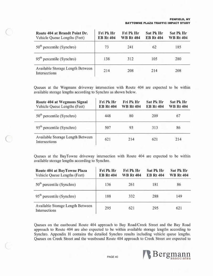
Synchro shows tbat the Route 404 vehicle queues will not exceed the torage available between the Wegmans driveway and Brandt Point Drive as shown below. Synchro uses a conservative distance per vehicle of25 feet (front bumper of lead vehicle to front bumper of trailing vehicle) for spac ing in a queue. Field observations on Route 404 revealed that tbis distance ranged fro m 21 feet to 25 feet, so the fo llowing queues fro m Synchro may be longer than actual. According to Synclu'o westbound queues will reach Terrel during peaks. It is expectcd that the small number of turns during the peak hours will become even less at thi s intersection because of the availability of otber traffic routes in the area (Bay Road, Route 404 and Midland Drive).
PAGE 39
(
(
PENFIELD, NY BAYTOWNE PLAZA TRAFFIC IMPACT STUDY
Route 404 at Brandt Point Dr. Fri Pk Hr Fri Pk Hr Sat Pk Hr Sat Pk Hr Vehicle Queue Lengths (Feet) EB Rt 404 WB Rt404 EB Rt404 WB Rt404
50th percentile (Synchro) 73 241 62 185
95th percentile (Synchro) 138 312 105 280
Avai lable Storage Length Between 214 208 214 208
Intersections
Queues at the Wegmans driveway inter ection with Route 404 are expected to be within available storage lengths according to Synchro as shown below.
Route 404 at Wegmans Signal Fri Pk Hr Fri PkHr Sat Pk Hr Sat PkHr Vehicle Queue Lengths (Feet) EB Rt404 WBRt404 EB Rt404 WB Rt 404
50th percentile (Synchro) 448 80 209 67
95th percentile (Synchro) 507 93 313 86
Avai lable Storage Length Between 621 2 14 62 1 214
Intersections
Queues at the BayTowne driveway intersection with Route 404 are expected to be within avai lab le storage lengths according to Synchro.
Route 404 at BayTowne Plaza Fri PkHr Fri Pk Hr Sat Pk Hr Sat PkHr Vehicle Queue Lengths (Feet) EB Rt 404 WB Rt 404 EB Rt 404 WB Rt404
50th percentile (Synchro) 136 26 1 181 86
95th percentile (Synchro) 188 332 288 149
Ava ilable Storage Length Between 295 621 295 621
Intersections
Queues on the eastbound Route 404 approach to Bay Road/Creek Street and the Bay Road approach to Route 404 are also expected to be witbin avai lable storage lengths according to Synchro. Appcndix H contains the detailed Synchro results including vehicle queue lengths. Queues on Creek Street and the westbound Route 404 approach to Creek Street are expected to
PAGE 40

(
(
(
PENFIELD, NY BAYTOWNE PLAZA TRAFFIC IMPACT STUDY
reach the BayTowne driveways during peaking of traffic a closer look at queuing is presented in the Simulation section of this report below.
F. Traffic Simulation and Vehicle Queues
Further study wa performed usiog SimTraffic to review the interaction of traffic between Brandt Point Drive and Wegmans signalized intersections. Detailed ana lysis results are shown in Appendix I.
A reduction of the coordinated 100 second cycle length during the Friday PM peak hour to 90 seconds was observed to improve vehicle queuing. The reduction to cyc le length, genera ll y reduced the length of queues across the study area.
The simulations show that area of Route 404 betweeo the Wegmaos Driveway and Brandt Point Drive can operate well during the peak hours. Traffic is projected to back up to the upstream signal only once during each peak hour. The SimTraffic results are summarized here :
Vehicle Queue Lengths Between Fri Pk Hr Fri PkHr Sat PkHr Sat PkHr Wegmans and Brandt Point (Fcct) EB Rt404 WBRt404 EB Rt404 WBRt404
Average (SimTraffic) 105 81 94 98
951h percentile (SimTraffic) 203 114 175 134
Maximum (SimTraffic) 225 116 225 143
Available Storage Length Between 225 225 225 225
Intersections
With mitigation in place the SimTraffic imulation hows that queuing on Route 404 will be contained in the storage space provided between the interscct ions at Brandt Point Drive and the Wegmans driveway. The maximum queue length of eastbound traffic 00 Route 404 between Brandt Point Drive and the Wegmaos driveway is projected to be 225 feet and the maximum queue length of westbound traffic is projected to be 143 feet. The average eastbound queue is projected to be 105 feet during the peak hour and the average westbound queue 98 feet. The distance along Route 404 between the centerline of the signal ized Wegman driveway and Brandt Point Drive is approximately 300 feet. The available vehicle storage area between the intersections is closer to 225 feet. Traffic flow is projected to be good with the coordinated signals and proposed signal phasing and timing.
Accord ing to the SimTraffic simulation a maximum of 246 feet of vehic le torage is needed in the westbound Route 404 left turn lane to Brandt Point Drive. The average veh icle storage required during the peak hour is projected to be 1 J 9 feet. The distance along Route 404 between
PAGE 41
(
(
(
PENFIELD, NY BAYTDWNE PLAZA TRAFFIC IMPACT STUDY
the centerline of Brandt Point Drive and the centerline of Terre l Drive is approximate ly 275 feet . The available vehicle storage area between the intersections is closer to 200 feel. Based on the size and spacing of the two intersections the projectcd vehicle storage needs will be met for the average cycle of the signa l during the peak hours and traffic will back up to Terrel Drive 9 times during tbe peak hour (Saturday Mid-day peak hour). SimTraffic results arc shown at the end of Appendix I.
G. Creek Street Access
A study of alternative access optiolls was performed for the BayTowne Plaza access at Creek Street. The ana lysis was initiated to determine if cross access through property south of BayTowne Plaza would decrease the delay for ex iting traffic turning left and heading south on Creek Street.
The exiting Creek Street access to BayTowne Plaza is approximate ly 275 feet to Route 404 intersection (centerline to centerline). Due to the skew of the Route 404 intcrsection the storage area between the two intersections is approximately 175 feet long. The BayTowne Plaza acce s point to Creek Street is at the southern limit of where the BayTowne property fronts Creek Street. The Town of Penfield and Monroe County DOT asked what might happen if some or all left turning traffic utilized Sovran Drive. An analysis of access options to Sovran Drive was undeltaken. Sovran Drive intersects Creek Street approximately 500 feet south of the BayTowne Plaza driveway but extends up to the southern property line of BayTowne Plaza behind the Blockbuster.
The first option analyzed was to eliminate the left turn onto Creek Street from the BayTowne Plaza driveway and divert 100% of those left turns to Sovran Drive (previously known as Self Storage Way) . Synchro showed LOS C or better on the BayTowne Plaza driveway and SimTraffic showed LOS E or better. The Sovran Drive approach to Creek Street i degraded to extremely poor LOS F (peak delay of 14 minutes in Synchro and 9.5 minutes in SimTraffic). Detailed quantitative analysis results are shown in Appendix J.
The second option was to retain the same operation and lane geometry at the Creek Street intersection with the BayTowne Plaza drivcway and to assume a 50% diversion of exiting left turns to Sovran Drive. Synchro results for this analysis were LOS E or better for the BayTowne driveway and poor LOS F (4.4 minutes of delay) for Sovran Drive.
A third option was studied to strike a balance between the BayTowne Plaza driveway and Sovran Drive. A 25% diversion of exit left turns reveals a more balanced condition when comparing delay with 128 seconds of delay on the BayTowne Plaza driveway and 108 second of delay on Sovran Drive.
With limited access to Sovran Drive a balance can be struck for delay experienced by traffic turning left onto Creek Street. When motorists see that an alternative route to ex it the plaza is avai lable via Sovran Drive, traffic exiting at the ex isting driveway will be reduced . This improvement to access wi ll help to reduce the potential for accidents near the ex i ting access point to Creek Street. It is proposed that the connection to Sovran Drive be done through signing
PAGE 42

(
(
(
PENFIELD, NY BAYTOWNE PLAZA TRAFFIC IMPACT STUDY
so as not to promote most of the ex iting traffic to use Sovran Drive. The signage wi ll notify drivers ahead of the decision point for the alternative path and allow a balancing to occur over time. Motorists will test each route and over ti me a relative balance will be reached where the Creek Street driveway will function effic iently with Sovran Drive.
H. Pedestrian Accommodations
Proposed traffic impact mitigation for the redevelopment is subject to NYSDOT Engineering Instruction (El) 04-J I "Procedural Requiremcnts for Pedestrian Accommodation". The NYSDOT Pedestrian Generator Check list (PGC) required by this EI is contained in Appendix K. The PGC aid in the determination of need for pedestrian accommodation.
Sidewalks, crosswalks, pedestrian signals and push buttons are provided on all fou r legs at the intersection of Route 404 with Bay Road and Creek Street. The sidewalk extends to Terrel Drive on the north side of Route 404 and to the Wegmans signalized driveway on the south side of Route 404. The majority of this sidewalk i concrete with short segments where the sidewalk is asphalt. The concrete sidewalk on the south side of Route 404 does cont inue, starting on the east corner of the Brandt Point Drive intersection and continuing northeast past Terrel Drive. Crosswalks are provided on the BayTowne Plaza driveway and the two Wegmans driveways.
Pedestrian push buttons and a crosswalk are provided to cross Route 404 on the northeast side of the BayTownc Plaza driveway. Pedestrian push buttons are provided to cross Route 404 on the southwest side of the signalized Wegmans driveway.
The PGC indicates a need for pedestrian acco mmodations. Pedestrian accommodat ions are recommended for tbe proposed redesign of the Route 404 intersection with Brandt Point Drive. For crossing Route 404 and Brandt Po int Drive proposed accommodations include cross-walks and pedestrian signals with push button actuation.
VII. Summary and Conclusions
A. Existing Conditions
Study area intersections include NYS Route 404 with Terrel Drive, NYS Route 404 with Brandt Point Drive, NYS Route 404 with the signal ized Wegmans driveway, NYS Route 404 with BayTowne Plaza driveway, NYS Route 404 with Bay Road I Creek Street and Creek Street with BayTowne Plaza driveway. The Friday PM and Saturday mid-day peak hours were determined to be 5:00 PM to 6:00 PM and II :00 AM to 12:00 PM respectively.
The Terrel Drive approach to Route 404 operates at LOS F during the peak hours. Route 404 is free flow and operates at LOS A at Terrel Drive and Brandt Point Drive. Left turns from Route 404 to tbe e two side streets operate at LOS B. Brandt Point Drive operates at LOS E and LOS D during the Friday PM and Saturday Mid-day peak hours respectively at Route 404.
PAGE 43

(
(
(
PENFIELD, NY BAYTOWNE PLAZA TRAFFIC IMPACT STUDY
The signalized intersection of Route 404 with the Wegmans driveway currently operates at LOS A during the Friday PM and Saturday Mid-day peak hours. Route 404 approaches operate at LOS B or better. Left turns into Wegmans operate at LOS B or better. The Wegmans driveway operates at LOS D and B overall during the Friday and Saturday peak hour respective ly.
The signalized intersection of Route 404 with the BayTowne Plaza driveway currently operates at LOS B during the peak hours. Ro ute 404 approaches operate at LOS B or better during the peak hours. Left turns into BayTowne Plaza operate at LOS D during the Friday PM peak hour and LOS B during the Saturday Mid-day peak hour. The BayTowne Plaza driveway operates at LOS C overall during the peak bours.
Tbe signalized intersection of Route 404 with Bay Road and Creek Street currently operates at LOS C during the peak hour according to Synchro. Route 404 approaches operate at LOS C during the peak hours. Eastbound left turns to Bay Road operate at LOS D during the Friday PM peak bour and LOS C during the Saturday Mid-day peak hour. Creek Street operates at LOS D during the Friday peak hour and LOS C dur ing tbe Saturday peak hour. Bay Road operates at LOS B during the peak hours.
An accident analysis was performed fo r the BaylEmpire/Creek Draft Generi c Environmental Impact Statement (BEC DGEIS). All the study area intersections were included in the accident analysis. Table 2 contains a summary of the acc ident rates detelm ined in the study. The Route 404 intersection acc ident rates are all less than the statewide acc ident rate except at the intersection of Route 404 with Bay Road and Creek Street. There were a total of 33 accidents at this intersection during the three year study period. No clear accident pattern was identifi ed at the intersection of Routc 404 with Bay Road and Creek Street that would warrant geometric changes.
There were a total of 9 accidents that occurred at the intersection of Route 404 with the BayTowne Plaza driveway. The BEC DGEIS study determined that no consistent accident patterns were evident and that the accidents appeared random in nature. No mitigation measures were proposed. One pedestrian fa tality occurred near this intersection in 2004, but the cause is unknown.
The tudy revea led that the intersection of Creek Street with the BayTowne Plaza driveway exhibited an acc ident rate slightly lower than the countyw ide average. There were a total of 12 acc idents in the three year study period. Modifications to the median on Creek Street at thi s intersection, re-striping the lanes to provide clear indication o f through and turn lanes and additional modifications to triping on Creek Street between the BayTowne Plaza driveway and Empire Boulevard have ev idently improved safety. T he accident hi story between December 1, 2002 and May 31 , 2004 consists of one accident, clearly a significant improvement.
B. 2009 No Build Conditions
Growth of background traffic between 2007 and 2009 is expected to impact levels of service and vehicle delay mostly on Terrel Drive, Brandt Point Drive and the BayTowne Plaza driveway to
PAGE 44

(
(
(
PENFIELD, NY BAYTDWNE PLAZA TRAFFIC IMPACT STUDY
Creek Street. LOS on these stop sign controlled approaches are projected to be LOS E or F during the peak hours according to Synehro.
C. 2009 Build Conditions
The BayTowlle Plaza expansion is projected to generate 4 15 and 583 new vehicle trips distributed amongst three separate driveways during the Friday PM and Saturday mid-day peak hours respectively, as shown in Table 6.
The peak impact to overall peak hour inter ection veh icle delay with mitigation in place is projected to be 3.2 seconds at the intersection of Route 404 with Bay Road and Creek StTeet and 10.7 seconds at the intersection of Route 404 with the Wegmans driveway. The impact to vehicle delay on the Route 404 approaches to the BayTowlle driveway is an improvement, meaning less delay. The reason for this improvement is the projected diversion of westbound left turns to the new signal at Brandt Point Drive.
Installation of a traffic signal is recommended at the intersection of NYS Route 404 and Brandt Point Drive because warrants I, 2 and 3 are satisfied under projected 2009 build conditions even if 75% of left turning traffic exited at the existing BayTowne signal. A traffic signal is recommended at Brandt Point Drive because excessive vehicle delay projected for the unsignalized scenario. Unsafe driver behavior could result from delays 011 the Brandt Point Drive approach with stop sign control.
Thc proposed access plan will improve Route 404 access by providing cross access between tbe BayTowne Plaza and the businesses on the southeast side of Route 404 between Brandt Point Drive and the BayTowne Plaza driveway.
The proposed Brandt Point Drive traffic signal optimization and coordination wa performed using Synchro and SimTraffic. Coordinat ion with the signals to the southwest on Route 404 will improve traffic flow and provide safer travel for Brandt Point Drive traffic. The traffic lights will be timed to allow groups of through traffic (platoons) to pass through both intersections without stopping for a red light.
The proposed improvements to BayTowne Plaza will only help to reduce the potential for vehic le accidents on Route 404. The plan for installation of a three co lor traffic signa l at Brandt Point Drive with a left turn arrow will allow traffic destined for BayTowne Plaza to enter the site in advance of the multiple driveways on Route 404 between Terrel Drive and Creek Street thus reducing potential conflicts. In addition, ill line with the Towo of Penfield' s goa l of better access management along Route 404, the internal circulation will allow for the Route 404 frontage properties to have connection to the BayTowne internal road thereby allowing their customers the opportunity to make left turns onto Route 404 via the BayTowne Plaza traffic signals.
PAGE 45
(
(
(
VIII. Recommendations
PENFIELD, NY BAYTOWNE PLAZA TRAFFIC IMPACT STUDY
• Install a multi-phase traffic signal at the intersection of Route 404 and Brandt Point Drive with pedestrian accommodations, Coordinate the signal with signals to the southwest on Route 404 to improve traffic flow and provide safer travel for Brandt Point Drive traffic, Construct a second left tum lane on the Brandt Point Drive approach to Route 404,
• Provide a hard wired connection and common contro ller between the Wegmans and Brandt Point traffic signals,
• Provide protected only operation for the left turns from Empire Boulevard to the signalized Wegmans driveway,
• Provide cross access between the BayTowne Plaza and the frontage businesses on the southeast side of Route 404 between Brandt Point Drive and the BayTowne Plaza driveway,
• Provide a westbound left turn lane on Route 404 at Brandt Point Drive to include the availab le space between tbe Brandt Point Drive and Terrel Drive intersections,
• Realign Brandt Point Drive to connect to tbe new !lOlth-soutb internal site roadway as shown on the concept plan on the next page, Allow traffic traveling between the northsouth roadway and the segment of Brandt Point Drive that accesses Route 404 to be freeflow, Control traffic approaching the new free- flow road with a stop sign on the leg of Brandt Point Drive that provide access to the residential area,
• Install a "Do Not Block Intersection" sign for westbound Route 404 traffic at Terrel Drive, Eva luate box-out striping in front of Terrel to identify area not to block, The boxout pavement markings cou ld include the words "Do Not Block", per the 2007 Notice of Proposed Amendments to the MUTCD developed for !TE.
• COImection to Sovran Drive that does not promote all or most of the exiting traffic to use Sovran Drive because of the extreme delay predicted for such a scenario, It is proposed that the connect ion to Sovran Drive be signed to notify drivers of an alternative route to provide some relief for left turning traffic unto Creek Street.
PAGE 46

\ (
. -
( ~
~,~ Ii !
(
'~
I I 11.' , t'
.. t
- a. ~ c o U
Q)
.~ .... o - "0
C
~
CO