barwon (through geelong) management plan · the project team would like to thank the project ......
TRANSCRIPT

BARWON (THROUGH GEELONG)MANAGEMENT PLAN
FINAL REPORT
Thompson Berrill Landscape Design Pty Ltd
DECEMBER 2007
in association with Ecology Partners P/L


FINAL REPORT BARWON (through Geelong) MANAGEMENT PLAN PREPARED BY TBLD P/L FOR THE CCMA DECEMBER 2007 Table of Contents
TABLE OF CONTENTSPage #
Foreword
Acknowledgements
Executive Summary
1.0 INTRODUCTION 11.1 Project scope 11.2 Overall vision and key objectives 11.3 Project methodology 2
2.0 EXISTING CONDITIONS 32.1 Land ownership 32.2 Environment 32.3 Cultural heritage 92.4 Recreation 102.5 Community involvement 112.6 Signage 122.7 Maintenance 12
3.0 MANAGEMENT ZONES 132.1 Zones 132.2 Management intents for the zones 132.3 Priority timing 14
4.0 ZONE DESCRIPTIONS 17
4.1 Zone 1: Stan Lewis Walk
Queens Park Road to Shannon Avenue (west bank) 17
4.2 Zone 2: Fyans Park
Queens Park Road to Shannon Avenue (east bank) 24
4.3 Zone 3: Rowing Mile North
Shannon Avenue to Swanston Street (Landy Field - north bank) 32
4.4 Zone 4: Rowing Mile South
Shannon Avenue to Belmont Common (Boat Ramp - south bank) 43
4.5 Zone 5: Belmont Common
Boat Ramp to Breakwater Road (south bank) 54
4.6 Zone 6: Wal Whiteside Walk
Swanston Street (Landy Field) to Breakwater Road (north bank) 59
4.7 Zone 7: Sewer Aqueduct Bridge
Breakwater Road to Boundary Road (north bank) 64
4.8 Zone 8: Rural Zone
Boundary Road to lower breakwater (Reedy Lake - south bank) 68
5.0 OVERALL MANAGEMENT 73
5.1 Overall management responsibilities 73
5.2 Environmental management 75
5.3 Cultural heritage 78
5.4 Vehicle access 79
5.5 Recreational infrastructure 80
5.6 Maintenance 85
5.7 Adjoining land use 86
6.0 IMPLEMENTATION 87
REFERENCES 88

FINAL REPORT BARWON (through Geelong) MANAGEMENT PLAN PREPARED BY TBLD P/L FOR THE CCMA DECEMBER 2007 Table of Contents
INDEX OF DRAWINGS AND FIGURES
DWG # Drawing Name Page #
Barwon through Geelong Management Plan Works Plan Exec. Sum. x
BTG-01 Existing Conditions 4
BTG-02 Existing Land Management 5
BTG-03 Existing Vegetation Communities 6
BTG-04 Management Zones 15
BTG-05 Proposed Works Plan 16
Figure 1 West Fyans Boat Ramp Car Park Access 31
Figure 2 Alternate Path Access at Rowing Sheds 42
Figure 3 Barwon Valley Park Rowing Mile South Car Park Access 51
Figure 4 Riverside Car Park 52
Figure 5 Belmont Common Boat Ramp Access 53
APPENDICES
Appendix A Vegetation Assessment
Prepared by Ecology Partners P/L July 2006
Appendix B Background Document Review
Appendix C Community Consultation

FINAL REPORT BARWON (through Geelong) MANAGEMENT PLAN PREPARED BY TBLD P/L FOR THE CCMA DECEMBER 2007 Acknowledgements
The project team would like to thank the Project Working Group who have attended meetings and contributed to thedevelopment of the Management Plan including:
Mark Schirmer CCMA Contract Manager - Barwon through Geelong
Greg Peters CCMA River Health Co-ordinator
Bernie Cotter Manager Environmental Unit, City of Greater Geelong
Ned Turcinov Environment Officer, City of Greater Geelong
Vicky Skelton Road and Drainage Infrastructure Engineering Services, City of Greater Geelong
Ashley Pittard Recreation and Open Space Planner, City of Greater Geelong
David Tornier Wathaurong Aboriginal Co-operative
Rachel Cairns Department of Primary Industries
Mark Trengove Former Chair, Water Statutory Functions Committee, CCMA
Richard Boekel Department of Sustainability and Environment
Steve Toohey Parks Victoria
David Sutherland Natural Resources Services, Barwon Water
The project team would like to thank the members of the Barwon River Users Group and other members of the communitywho attended the meeting and/ or contributed to the development of the Management Plan by filling out and returningquestionnaires including:
Bob Carraill Chair, Barwon River Users Group, CCMA
Valda Dedman Geelong Field Naturalists
Tony Alsop Geelong Cross Country Club
Frank Covill Geelong Rowing Association
Stephen Coleman Geelong & District Angling Clubs Association
Karen Ward Barwon Valley Waterski Club
Glenn Sheldon Geelong Waterski Club
Trevor Pescott Geelong Field Naturalists
Tony Woolford Geelong Environment Council
Bill Johnsen Barwon Regional Bicycle Council
Terry Poole Geelong Canoe Club
The project team would like to thank the Corangamite CMA Water Statutory Functions Committee who oversaw the processfor development of the plan.
Susan Salter Board member (Chair)
Kaye Rodden Board Member
Julie Hansen Board Member
John MacDonald member (River Health Portfolio Group)
ACKNOWLEDGEMENTS


FINAL REPORT BARWON (through Geelong) MANAGEMENT PLAN PREPARED BY TBLD P/L FOR THE CCMA DECEMBER 2007 Foreword
The Barwon River in the Corangamite region is our largest river system with its headwaters rising across threecatchments - the Otway Ranges at Forrest, the Yarrowee (then Leigh) River north of Ballarat and the MooraboolRiver to the east of Ballarat joining the Barwon River at Inverleigh and Fyansford respectively.
In addition to providing the venue to the diversity of passive and active recreational pursuits in Geelong, the river alsoprovides the majority of water for urban and rural use in the Ballarat and Geelong region.
The Barwon River in Geelong is one of our greatest natural assets, being a key to the city’s early development and anintegral part of community life. Sections of the Barwon River in Geelong still retain many of the natural habitat values in thestreamside and channel zones ofthe river, supporting a diversearray of terrestrial and aquaticnative flora and fauna. Over therecent past an environment hasbeen created for communityactivities, including rowing, waterskiing, canoeing and fishing,whilst the network of access trailsattracts many cyclists, walkersand joggers. The manypicturesque and well-servicedpicnic locations are enjoyed byGeelong and district residents andvisitors alike. The plan alsoforms an important componentof Parks Victoria’s BarwonRiver Parklands project, tocreate a continuous link alongthe Barwon River from BuckleyFalls to Barwon Heads.
The Corangamite Catchment Management Authority (CMA) is responsible for managing a 20-kilometre stretch of the riverthrough Geelong, including various river reserves, from Queens Park bridge at the upstream end, through to the lowerbreakwater (just upstream of Lake Connewarre). This includes the maintenance and enhancement of the river banks andvarious adjacent reserves, and providing associated services and facilities.
The health of the Barwon River and its ability to continue to service the diversity of community needs in Geelong and thebroader region is reliant on our rural and urban population actively playing a role in its protection through more efficient urbanand rural water use, control of stock access to the river, improvements to streamside vegetation, waste management andother important activities.
The Barwon through Geelong Management Plan is an important step in the process to improve the condition of the river inGeelong so that it can play its role in supporting our recreational activities and providing a healthy environment for manyspecies of native flora and fauna.
FOREWORD
Susan SalterChair Water StatutoryFunctions Committee
• A bird’s eye view of the Barwon River through Geelong
FOREWORD

FINAL REPORT BARWON (through Geelong) MANAGEMENT PLAN PREPARED BY TBLD P/L FOR THE CCMA DECEMBER 2007 Foreword
On behalf of the Corangamite CMA I would like to thank community members and groups who attended the communitymeeting and provided comment on the draft Management Plan and invite you to continue to be actively involved in theprotection of the Barwon River in our region.
Susan SalterChair Water Statutory Functions Committee

FINAL REPORT BARWON (through Geelong) MANAGEMENT PLAN PREPARED BY TBLD P/L FOR THE CCMA DECEMBER 2007 Executive Summary i
PROJECT INTENTThe public open space along the Barwon River between Queens Park Bridge and the lower breakwater is managed byCorangamite CMA. The area has many popular recreation facilities including paths, bridges, car parks, fishing platforms,boat ramps and picnic areas. There are sites of Aboriginal cultural and archaeological significance as well as other culturalheritage values associated with the early settlement and industrial development of Geelong, and recreational use of the riverfor rowing. The Barwon River is also a critical habitat link and the land along the river has areas of significant indigenousremnant vegetation and extensive revegetation has been undertaken with the assistance of many community groups andvolunteers.
In 2002 the Corangamite CMA, in conjunction with the City of Greater Geelong, developed the Barwon River Land Use andOpen Space Corridor Plan which provided strategic recommendations for the entire waterway corridor, and adjoining openspace through Geelong and surrounds. An updated risk assessment has also been completed for the area. The intent of thisManagement Plan is to guide implementation of the recommendations arising from the overall Strategic Plan as well as therisk assessment for land directly managed by the Corangamite CMA (CCMA) along the Barwon River from Queens ParkBridge to the lower breakwater. This Management Plan will then replace the existing Land Management Plan prepared in1996 for Barwon Water and will guide ongoing management and priorities for works over the next 10-15 years.
PROJECT PROCESSThe project has been guided by a Project Working Group comprising of agency representatives with a management rolealong the river including City of Greater Geelong, Parks Victoria, Department of Sustainability and Environment, Departmentof Primary Industries, Wathaurong Aboriginal Co-Operative and Barwon Water. The Project Working Group met throughoutthe project to guide and provide input to development of the plan.
Consultation with key community stakeholders was completed using the existing Barwon River Users Group (BRUG) at boththe Site Analysis and Draft Management Plan phases of the project. The BRUG includes, Geelong Environment Council,Geelong Field Naturalists, Geelong Cross Country Club, Geelong Rowing Association, Geelong & District Angling ClubsAssociation, Barwon Valley Waterski Club, Barwon Regional Bicycle Council and Geelong Canoe Club. Geelong WaterskiClub and several community members representatives were included for the purposes of the project.
Community Consultation completed at the Draft Management Plan stage included an information leaflet/questionnaire andcommunity information night. Community feedback received during the consultation period was reviewed by the CorangamiteCMA and Project Working Group to inform finalisation of the Management Plan.
OVERALL VISION AND KEY OBJECTIVESDevelop and maintain a well connected, diverse and sustainable waterway parkland. Maintain the balance betweenrecreation use and conservation principles while protecting and enhancing understanding of the significant environmentaland cultural heritage values of the Barwon River through Geelong. Protect existing habitat, landscape and environmentaldiversity along the river and continue to build upon community use, support and pride in the area.
Key objectives include:
• Recognise, protect and restore environmental values along the Barwon River
• Reduce the visual and physical encroachment of urban development and infrastructure on the floodplainfunction and natural character of the waterway corridor
• Recognise, protect and enhance the Indigenous and European cultural heritage values of the BarwonRiver
• Improve walking and cycling opportunities along the waterway open space corridor
• Manage adjoining open space to maintain balance between recreational facilities and waterway corridorvalues
• Support continued water-based recreational use on the Barwon River at a level that is compatible withthe environmental and land based passive recreational uses
EXECUTIVE SUMMARY

FINAL REPORT BARWON (through Geelong) MANAGEMENT PLAN PREPARED BY TBLD P/L FOR THE CCMA DECEMBER 2007 Executive Summary ii
SUMMARY OF KEY RECOMMENDATIONS AND PRIORITIES
The area has been divided into a number of different zones that have been defined by common management aims. Thefollowing is a summary of the key recommendations for works in each section. Each recommendation has been allocated apriority relative to its overall priority in the scope of this plan, however, these may change subject to funding availability and insome instances integration of works with other authorities. The following codes have been used to identify the priority foreach of the recommendations in the report.
High Years 1-3Moderate Years 4-6Low Years 7-10Ongoing Part of ongoing programs, maintenance or works
Zone 1: Stan Lewis WalkQueens Park Road to Shannon Avenue (west bank)
(H) Centre line mark path and install 'code of conduct' regulatory signage. Longer term, when path requiresreplacement, widen to a minimum of 2.5m
(H) Maintain and enhance existing picnic areas at Yollinko Park and south of Queens Park bridge and provide
additional seats at key viewing points to the river along the path.
(H) Protect significant remnant indigenous vegetation along the river and remove weed species including Ash, Willows,
Poplars, Peppercorns and Blackberry.
(H) Liaise with CoGG to undertake at source litter control on major stormwater outfalls
M) Undertake staged upgrade/replacement of existing steep timber entry stairs from Barwon Boulevard
(L) Close and revegetate the car park south of Queens Park Bridge to improve links to existing car park and toilets on
the north side of the bridge.
(O) Protect existing sites of cultural significance at Yollinko Park and maintain sites in close consultation with the
Wathaurong Aboriginal Co operative Ltd.
Zone 2: Fyans Park/Newtown ParkQueens Park Road to Shannon Avenue (east bank)
(H) Centre line mark path and install 'code of conduct' regulatory signage. Longer term, when path requires
replacement, widen to min. 2.5m prioritising areas where the trail is confined by steep topography.
(H) Realign trail and car parking at the West Fyans Street boat ramp to minimise conflict between vehicles and trail
users. Provide integrated water quality treatment system and improve landscape amenity and interface to the river.
(H) Improve all ability path access from picnic area to existing CoGG toilet facilities at Fyans Park.
(H) Short term, retain established avenue of Ash trees and establish additional indigenous trees in between to retain
landscape character when, in the longer term, their health declines and they require removal.
(M) Liaise with adjoining landholders to improve management and maintenance of steep escarpment areas adjoining
the river including erosion control, removal of weeds and revegetation with indigenous species.
(O) Protect significant remnant indigenous floodplain vegetation continuing weed and rabbit control programs.
Zone 3: Rowing Mile NorthShannon Avenue to Swanston Street (Landy Field - north bank)
(H) Liaise with Barwon Water (Fernleigh Street) and CoGG (Pakington Street) to improve steep access and integrateddirectional/regulatory signage in these areas.
(H) Confirm land ownership and upgrade vehicle control along the path west of Latrobe Terrace. Remove obstructionsfrom the path including barriers and fencing and establish an avenue of indigenous overstorey trees along the river.
Retain existing Poplars until new vegetation becomes established.
(H) Remove redundant timber platforms from along the river.
(M) Investigate opportunities to provide stormwater treatment on the open drain at Bridge Street including potential
reuse of water in the adjoining golf course.
(M) Commence removal of weeds at Pakington Street retaining mature exotic specimen trees where they areassociated with adjoining heritage properties at Sladen House and Barwon Grange. Investigate opportunities toestablish a large water quality treatment wetland and restore natural indigenous floodplain vegetation to improvehabitat values.
(M) Upgrade picnic facilities at Richardson Reserve (Bob and Gerry's).
(M) Develop an alternative path route behind the boat sheds to retain all year round continuous public access and to
assist in management of major events.
FINAL REPORT BARWON (through Geelong) MANAGEMENT PLAN PREPARED BY TBLD P/L FOR THE CCMA DECEMBER 2007 Executive Summary iii
(L) Develop interpretive signage regarding the rich history of industrial development and rowing.
(O) Maintain existing environmental focus for the north bank continuing to improve existing natural landscape and
habitat values. Retain areas east of Latrobe Terrace for major event use and recreational facilities.
Zone 4: Rowing Mile SouthShannon Avenue to Belmont Common (Boat Ramp - south bank)
(H) Improve safety between Barwon Valley Park and Belmont Common by closing the public road access along theriver and retaining pedestrian-cyclist access only. Provide a new path between Moorabool Street bridge and theboat ramp. Upgrade the existing path between MacIntyre bridge and Latrobe Terrace.
(H) Retain vehicle access to existing river front car parking at the playground area and near the Macintyre bridge.
(H) Retain vehicle access to the Belmont Common boat ramp via Barwon Heads Road and liaise with CoGG toimprove road surface.
(H) Liaise with CoGG to improve pedestrian access and safety when crossing Barrabool Road at the Macintyrefootbridge.
(H) Establish avenue of River Red Gums along the river complementing the formal landscape character of the rowingmile and improving habitat values. Retain clear and open views to the river.
(M) Continue staged removal of Elms along the river at Frederick Moreton Reserve and revegetation indigenous
species. Maintain and protect historic planting away from the edge of the river.
(O) South bank is to continue to be the focus of passive recreation activities through the main length of the rowing milewith existing CoGG managed facilities at Barwon Valley Park (playground, picnic areas, toilets and lake) and the
Corangamite CMA managed picnic facilities at the Belmont Common boat ramp.
Zone 5: Belmont CommonBoat Ramp to Breakwater Road (south bank)
(H) Liaise with CoGG and Golf Club to confirm land ownership boundaries and review fencing and alignment of someholes to improve safety for trail users.
(H) Upgrade directional and regulatory signage at key entries.
(H) Liaise with VicRoads and CoGG during planning for replacement of the low level bridge at Breakwater Road toensure impact on the river is minimised and opportunities for long term environmental improvement at the Geelong
Motorcross site are maximised.
(M) Undertake Willow removal and revegetate with indigenous species to restore a more natural continuous Floodplain
Riparian Woodland along the river.
(L) Retain existing planted 'Australian Natives' on the western side of the path away from the river. Establish patchesof indigenous revegetation focusing on drainage lines with connections to the river to improve habitat links to
wetland areas in the golf course and Jerringhot Sanctuary.
(M) Remove Willows and restrict vehicle access south of Breakwater Road. Retain walking access for fishing.
(O) Retain the 'wilderness' feel of this area minimising built infrastructure aside from ongoing maintenance and
improvement of existing picnic areas at the boat ramp and fishing platforms near Breakwater Road.
Zone 6: Wal Whiteside WalkSwanston Street (Landy Field) to Breakwater Road (north bank)
(H) Remove planted exotic trees from the reserve and remove remaining sections of Willows along the river.
(H) Liaise with the EPA to monitor water quality in the Steel Street drainage channel and liaise with CoGG to
investigate opportunities for a linear water quality treatment system in the unmade road reserve.
(H) Provide additional seats at key viewing points along the path, however, minimise built infrastructure focusing on
maintenance of existing picnic areas at Swanston Street entry only.
(M) Maintain, and in the longer term, upgrade the timber boat tie up platform near Swanston Street.
(M) Continue existing program of revegetation using indigenous species of local provenance. Longer term, review
existing 'native' planting and undertake selective removal to increase groundlayer diversity.
(L) Upgrade direction signage at all entries and develop interpretive signage regarding both the rich industrial heritage
and improving environmental values.
(O) Retain the existing path as unsealed (subject to confirmation of preferred shared trail routes as part of the ParksVictoria Barwon River Parklands Project) maintaining required clearance to vegetation for sightlines andundertaking periodic grooming to maintain a quality walking track consistent with the improving environmentalvalues of the area.

FINAL REPORT BARWON (through Geelong) MANAGEMENT PLAN PREPARED BY TBLD P/L FOR THE CCMA DECEMBER 2007 Executive Summary iv
Zone 7: Sewer Aqueduct BridgeBreakwater Road to Boundary Road (north bank)
The Sewer Aqueduct Bridge and surrounding land are owned and managed by Barwon Water. The CCMAmanage the river and frontage only in this area.
(H) Liaise with Barwon Water to prepare a Vegetation Management Plan for protection of significant remnantindigenous floodplain vegetation communities. Issues include public access, rabbits and impacts of stormwater
discharges from adjoining industrial development in Leather Street.
(H) Barwon Water and Heritage Victoria to confirm long-term future of the heritage listed Sewer Aqueduct Bridge.Short term, support investigation of opportunities for restoration of restricted public access forcanoeists/pedestrians along the river under the bridge on the north bank potentially using a canopy structure to
protect users from falling debris.
Zone 8: Rural ZoneBoundary Road to lower breakwater (Reedy Lake - south bank)
(H) Liaise with adjoining private landholders to investigate partnerships as part of existing funding programs forremoval of weed species, fencing, offline stock watering points and riparian revegetation along the river to improve
environmental values and minimise erosion.
(H) Upgrade the existing lower breakwater and fish race. Install permanent canoe landing and warning signage.
(H) Liaise with Southern Rural Water and landholders to review existing water allocation and permits for structures
along the river.
(L) Review existing grazing leases of Corangamite CMA land along the river and commence active revegetation of
public land to improve environmental links and minimise erosion.
(O) Maintain existing levels of water skiing use and monitor ongoing environmental impacts.

FINAL REPORT BARWON (through Geelong) MANAGEMENT PLAN PREPARED BY TBLD P/L FOR THE CCMA DECEMBER 2007 Executive Summary x
Insert Summary Works Plan


FINAL REPORT BARWON (through Geelong) MANAGEMENT PLAN PREPARED BY TBLD P/L FOR THE CCMA DECEMBER 2007 1
1.1 Project scope
The intent of the project is to prepare a Management Plan for the Corangamite CMA (CCMA) managed landalong the Barwon River from Queens Park Bridge to the lower breakwater. In 2002, the Corangamite CMA,in conjunction with the City of Greater Geelong, developed the Barwon River Land Use and Open SpaceCorridor Plan which provided strategic recommendations for the entire waterway corridor, and adjoining openspace through Geelong and surrounds. This current project has developed out of this overall Strategic Planand the need to update the existing Land Management Plan prepared in 1996. It provides detailed onground management recommendations and priorities to guide ongoing management of the Barwon throughGeelong area by the Corangamite CMA.
The objectives outlined in the brief were as follows:
• Undertake an existing conditions assessment and analysis of the Corangamite CMA recreationalinfrastructure including paths, fishing platforms, boat ramps, benches, signage, etc;
• Undertake assessment and analysis of existing vegetation including community assessment andsignificance rating;
• Undertake assessment and analysis of landscape character;
• Review relevant Corangamite CMA and other Agency strategic documents and management contractsand develop an implementation program for recommendations; and
• Develop a Management Plan with priority works program, costed recommendations for works andupdated management guidelines and direction.
Note the scope of the project is confined to 'on land' Corangamite CMA management only. Existing 'onwater' based recreation use through the study area has been previously addressed and confirmed throughthe Barwon River Land Use and Open Space Study 2002 and is not proposed to be further detailed as part ofthis plan.
The public land along the river upstream of Queens Park bridge is managed by the City of Greater Geelong.The recommendations in this plan are to be consistent with the recently prepared Barwon and MooraboolRiver Reserves Plan 2005.
Adjoining Council managed open space areas and links while outside the study area will also be consideredin development of recommendations including opportunities for improved integration and management.
1.2 Overall Vision and Key Objectives
Develop and maintain a well connected, diverse and sustainable waterway parkland. Maintain the balancebetween recreation use and conservation principles while protecting and enhancing understanding of thesignificant environmental and cultural heritage values of the Barwon River through Geelong. Protect existinghabitat, landscape and environmental diversity along the river and continue to build upon community use,support and pride in the area.
• Recognise, protect and restore environmental values along the Barwon River
• Reduce the visual and physical encroachment of urban development and infrastructureon the floodplain function and natural character of the waterway corridor
• Recognise, protect and enhance the Indigenous and European cultural heritage values ofthe Barwon River
• Improve walking and cycling opportunities along the waterway open space corridor
• Manage adjoining open space to maintain balance between recreational facilities andwaterway corridor values
1.0 INTRODUCTION

FINAL REPORT BARWON (through Geelong) MANAGEMENT PLAN PREPARED BY TBLD P/L FOR THE CCMA DECEMBER 2007 2
• Support continued water-based recreational use on the Barwon River at a level that iscompatible with the environmental and land based passive recreational uses
1.3 Project methodology
The project has been guided by a Project Working Group comprising of agency representatives with amanagement role along the river including City of Greater Geelong, Parks Victoria, Department ofSustainability and Environment, Department of Primary Industries, Wathaurong Aboriginal Co-Operative andBarwon Water. The Project Working Group met throughout the project to guide and provide input todevelopment of the plan.
Consultation with key community stakeholders was completed using the existing Barwon River Users Group(BRUG) at both the Site Analysis and Draft Management Plan phases of the project. The BRUG includesGeelong Environment Council, Geelong Field Naturalists, Geelong Cross Country Club, Geelong RowingAssociation, Geelong & District Angling Clubs Association, Barwon Valley Waterski Club, Barwon RegionalBicycle Council and Geelong Canoe Club. Geelong Waterski Club and several community membersrepresentatives were included in the first stakeholder meeting and will continue to be involved in the project.
BACKGROUND RESEARCHSITE ASSESSMENT
AND ANALYSIS PHASE
ANALYSIS AND KEY ISSUEAND OPPORTUNITY
IDENTIFICATION PHASE
COMMUNITYCONSULTATION ON THE
DRAFT PLAN
DRAFTMANAGEMENT PLAN
DRAFTISSUES PAPER V1
� Project Working Group Meeting #2
� Community consultation via informationleaflet/questionnaire, site displays and communityinformation night.
FINALMANAGEMENT PLAN
� Project Working Group Meeting #1� Stakeholder Meeting #1
� Project Working Group Meeting #3� Stakeholder Meeting #2� Water Statutory Functions Committee Review
� Outcomes of community consultation reviewed.� Recommendations for amendments to the Final
Management Plan presented to the CCMA forconsideration.
� Final Management Plan endorsed by the CCMA� Community respondents to information leaflet and
attendees at information night advised in writing offinal changes to the Management Plan in response totheir comments.

FINAL REPORT BARWON (through Geelong) MANAGEMENT PLAN PREPARED BY TBLD P/L FOR THE CCMA DECEMBER 2007 3
2.0 EXISTING CONDITIONS
2.1 Land ownership
The land in the study area is Crown land managed by the Corangamite CMA. City of Greater Geelongmanage adjoining public open space reserves at King Lloyd Reserve, Balyang Sanctuary, Barwon ValleyPark and Belmont Common. The Marnockvale Site is Crown land managed directly by DSE. This land alongthe river may be transferred to Corangamite CMA management in the near future. Barwon Water own andmanage the sewer pumping stations on the north bank of the rowing mile which are located below WynfieldDrive and the Sewer Aqueduct and Macintyre Bridges. Parks Victoria manage land north and around thelower breakwater at Reedy Lake. Corangamite CMA manage land along the southern bank upstream of thelower breakwater which is leased for grazing.
Refer to Dwg BTG-05 Land Ownership Plan based on information as developed for the Barwon River LandUse and Open Space Corridor Study 2002.
2.2 Environment
2.2.1 Geology & GeomorphologyUp to 40 million years ago there was an expansive sea and streams extending from the Otways and flowingnorth into the sea. A major uplift caused the sea to retreat, followed by volcanic activity and uplifts that hasgiven the Barwon River the energy and cutting power to create the gorge sections in the vicinity of BuckleyFalls. As recently as two million years ago the lava flows north of Inverleigh displaced the Barwon River tothe south adjacent to the Barrabool Hills, flowing down the river valley filling deep holes, one being BuckleyFalls. A second flow backed up the Moorabool River to Chaumont causing a deep deposit to form atFyansford. The river banked up behind the lava flow at Queens Park forming a lake, but eventually brokethrough and followed the western and southern edge of the lava flow to the sea at its present mouth atBarwon Heads. (From Buckleys to the Break).
The lava forms the bed of the river at Buckleys Falls and basalt has been quarried from the area for buildingmaterial (bluestone). The Barrabool fault line runs along the northern edge of the Barrabool Hills fromPollocksford. Periodically, this fault line has been up-thrown to the south exposing ancient Palezoic rocksbeneath which are visible upstream of Buckley Falls. Downstream of the Barwon Bridge, the river flowsthrough a broader flood plain built up of alluvium that has deposited as it flows more slowly through this area.The river flows through the fresh and saltwater lakes of Reedy Lake and Lake Connewarre and winds its wayto the ocean at Barwon Heads.
2.2.2 FaunaOriginally there would have been a wide range of native mammals along the river, however, many of thesehave disappeared in the urban reaches. Eastern Water-rat has adapted to the urban environment and ispresent in the urban reaches, however, although found extensively upstream of Buckley Falls platypus areless common. The Brush-tailed Phasocale is a tree dweller and may still be present, along with the Fat-taileddunnart whose habitat is the rocky grasslands. Black Wallaby have been sighted as far down as ShannonAvenue and Brush-tailed Possums are common while Ring-tailed Possums are not quite as plentiful, alongwith the occasional Koala. Two species of flying fox have been found along the river but they are not regularvisitors.
There are a variety of bird species along the urban reaches of the Barwon River, with an extensive range ofwater-birds including those of international significance in the Reedy Lake - Connewarre system. In theurban reaches, birds include Galahs and Rainbow Lorikeets. The swamps and wetlands attract Egrets,Spoonbills, Herons, Ibis, Ducks and Moorhens. Crakes and rails can be found in the Tangled Lignum alongthe river margins.


FINAL REPORT BARWON (through Geelong) MANAGEMENT PLAN PREPARED BY TBLD P/L FOR THE CCMA DECEMBER 2007 4
INSERT DRAWING # BTG-01 EXISTING CONDITIONS

FINAL REPORT BARWON (through Geelong) MANAGEMENT PLAN PREPARED BY TBLD P/L FOR THE CCMA DECEMBER 2007 5
INSERT DRAWING # BTG-02 EXISTING LAND MANAGEMENT

FINAL REPORT BARWON (through Geelong) MANAGEMENT PLAN PREPARED BY TBLD P/L FOR THE CCMA DECEMBER 2007 6
INSERT DRAWING # BTG-03 EXISTING VEGETATION COMMUNITIES


FINAL REPORT BARWON (through Geelong) MANAGEMENT PLAN PREPARED BY TBLD P/L FOR THE CCMA DECEMBER 2007 7
Fish ladders have been constructed at the Lower Breakwater and at Buckley Falls to allow fish to migrateupstream from Lake Connewarre. In the estuarine reach, species including Estuarine Perch, Yellow-eyedand Sea Mullets and several species of Gobies are found. Macquarie Perch used to be found in the largepool downstream of Queens Park Bridge but it may no longer be there. The Short-headed Lamprey spawnin the headwaters of the Barwon and migrate out to sea. Other species include the Short-finned Eel andCommon Galaxias. The Barwon River also contains a very significant spawning population of AustralianGrayling (likely to be one of only two river reaches in western Victoria where Grayling spawn and consideredvulnerable. Recent research on Grayling in this reach of the Barwon River suggests spawning is triggered byan increase in discharge in late Autumn/early Winter and that flow regulation may inhibit spawning in additionto the introduction of trout and the clearing of land in coastal catchments (Corangamite River Health Strategy2006).
The Barwon River provides ideal habitat for a number of species of frogs including the Spotted Marsh Frog,Banjo Frog, Green and Golden Bell Frog and the Brown Tree Frog. Reptiles including the Long -neckedTortoises can also be found along with skinks and snakes.
2.2.3 Indigenous FloraThe Flora Assessment completed by Ecology Partners P/L confirmed there are 6 Separate EcologicalVegetation Classes found through the study area.
2.2.3.1 Queens Park Bridge and Breakwater RdThere are three modified communities including:
FLOODPLAIN RIPARIAN WOODLAND - EVC 56 Formerly, this community would have been widespreadthrough the study area consisting of an open eucalypt canopy with a moderately dense shrub layer andrelatively dense ground cover. It now exists as a modified vegetation community restricted to a narrow band(2 - 5m) located along the immediate bank of the river with some areas extending onto periodically inundatedalluvial terraces between Queens Park Bridge and Shannon Ave. It consists of dense patches of aquaticand semi-aquatic herbs, sedges and grasses in the ground layer, including Common Reed Phragmitesaustralis, Tangled Lignum Muehlenbeckia florulenta, Cumbungi Typha spp. and Water Ribbons Triglochinprocerum, with scattered mature River Red-gums Eucalyptus camaldulensis and small to medium shrubs.Significance: Medium to High - Due to modification, the majority of this community is of medium significance,but the Alluvial terraces and mature River Red-gums are of high significance.
RIPARIAN WOODLAND - EVC 641 is located in a narrow band (up to ~10 m) along the steeper banks of theriver downstream of Queens Park Bridge. This modified vegetation community now consists of scatteredyoung to semi-mature River Red-gums and small to medium shrubs, including Hedge Wattle, Golden Wattle,Lightwood Acacia implexa and Sweet Bursaria, with a dense ground layer of semi-aquatic herbs, sedges andgrasses, including Common Reed, Tangled Lignum, Cumbungi, Water Ribbons and Common Tussock-grass.Medium significance due to modification, but any mature River Red-gums are of high significance.
AQUATIC HERBLAND - EVC 653 is found in two permanent to semi-permanent pools of water within theterrace along the alluvial terraces near King Lloyd Reserve and upstream of Breakwater Rd near the railwayline at Wal Whiteside Walk. This community consists of a range of aquatic herbs and sedges, including SaltClub-sedge Bolboschoenus caldwellii, Small Spike-sedge Eleocharis acuta, Slender Knotweed Persicariadecipiens, Common Reed and Water Ribbons. Significance of these intact communities is high givenclearance that has occurred across the State.
2.2.3.2 Sewer Aqueduct BridgeThe natural floodplain contains four communities all rated as of high significance due to relative intactness atthese sites and clearance that has occurred across the State. They include:
BRACKISH LIGNUM SWAMP - EVC 947 is an extensive low-lying vegetation community with relatively openshrubland vegetation dominated by Tangled Lignum, with a small range of semi-aquatic herbs, grasses andsedges in gaps, including Small Spike-sedge, Australian Salt-grass Distichlis distichophylla, Common Blown-grass Lachnagrostis filiformis, Common Reed and Lance-leaf Groundsel Senecio pinnatifolius var. 3.Significance is high due to the relative intactness of the site, restricted distribution of community andclearance that has occurred across the State.

FINAL REPORT BARWON (through Geelong) MANAGEMENT PLAN PREPARED BY TBLD P/L FOR THE CCMA DECEMBER 2007 8
BRACKISH WETLAND - EVC 656 is confined to a small low-lying area east of the Sewer Aqueduct Bridgewhich is dominated by a variety of semi-aquatic and aquatic herbs, grasses and sedges, including SmallSpike-sedge, Australian Salt-grass, Common Blown-grass, Common Reed, Water Ribbons, StreakedArrowgrass Triglochin striatum and Lance-leaf Groundsel
BRACKISH HERBLAND - EVC 538 is confined to a couple of areas at the end of Tucker St and upstream ofBoundary Rd which is dominated by a range of small semi-aquatic and aquatic herbs, grasses and sedges,including Small Spike-sedge, Australian Salt-grass, Common Blown-grass, Common Reed, Water Ribbons,Streaked Arrowgrass Triglochin striatum and Lance-leaf Groundsel. Location: Smaller low-lying areasadjacent to the northern bank of the Barwon River to the east and west of the Ovoid Sewer Aqueduct.
There is also a natural fringe of FLOODPLAIN RIPARIAN WOODLAND - EVC 56 along the edge of the river.
2.2.4 WeedsThere is a broad palette of introduced woody weed species found through the length of the study areaincluding Willows, Ash, Peppercorns, Poplars, Elms and African Box-thorn which are found in various areasalong the banks of the river. For more detail refer to Attachment 1.
There are also extensive areas of groundlayer weeds including Kikuyu Pennisetum clandestinum, GalenaGalena pubescens, Toowoomba Canary-grass Phalaris aquatica, Rice Millet Piptatherum milliaceum, andSoursob Oxalis pes-caprae in the areas of indigenous vegetation along the river between Queens ParkBridge and Breakwater Rd and species including Aster-weed Aster subulatus and Water Couch are invadingthe Aquatic Herbland areas.
Around the Sewer Aqueduct bridge introduced species including, Prairie Brome, Aster-weed, Fennel, ryegrass Lolium spp., Couch Cynodon dactylon, Brown-top Bent Agrostis capillaries, Toowoomba Canary-grass,Sharp Rush Juncus acutus and Hastate Orache Atriplex prostrata are prominent.
Existing Corangamite CMA weed control programs are in accordance with the principles of the Interimguidelines and procedures for managing the environmental impacts of weeds on public land in Victoria, DSE2006. This includes implementation of programs to control the source of weed invasion preventing, wherepossible, the migration of woody weeds such as Ash, Willow, Elm, Poplar and Peppercorn to environmentallysensitive downstream areas in rural reaches and the Reedy Lake/Lake Connewarre system. Later control inthese hard to access areas would be difficult, expensive and may contribute to further disturbance/loss ofhabitat during/after works. Current control programs for groundlayer weeds are limited. Following woodyweed control, increasing resources are to be allocated to ongoing control of groundlayer weeds in highervalue conservation areas and new revegetation works. For weed list refer to Attachment 1.
2.2.5 Exotic Specimen PlantingThere are several areas of mature exotic specimen planting which was undertaken as part of the earlydevelopment along the river. They include but are not limited to Ash at Fyans Park, Elms and Cypress atFrederick Moreton Reserve, Elms between Latrobe Tce and Moorabool St, Cypress, Poplars and Figs nearBarwon Grange and Sladen House and Palms at Richardson Reserve. This planting provides a significantcontribution to the landscape character of reserves and to the historical development along the river. Inmany areas, however, this exotic planting is now often associated with large areas of weed invasion both inthe local area and downstream.
2.2.6 RevegetationOver the past 15-20 years, there has been extensive revegetation works undertaken along the river. Many ofthese projects have been undertaken with assistance from local community and school groups. Much of theearly planting has been undertaken using Australian Natives. This planting now well established provides asignificant contribution to the landscape character of reserves along the river.
The set out of revegetation areas has focused on reducing maintenance of areas in terms of mowing andherbicide. This has included:
• Plantings of a size which will reduce the mowing regime e.g. not too small.
• Plantings to be of a shape that allows for flowing movement of mowing equipment.
• Plantings to be of a density that will compete effectively with weed regrowth.

FINAL REPORT BARWON (through Geelong) MANAGEMENT PLAN PREPARED BY TBLD P/L FOR THE CCMA DECEMBER 2007 9
• Close groupings of established trees to be considered for incorporation in garden beds to reducemowing requirements.
• Undertake planting on areas with steep slopes where mowing is difficult or unsafe.
• Planting design to not only reduce maintenance, but also attempt to recreate the original flora of thearea.
More recent planting has focused on use of indigenous species of local provenance which has increased thevalue of revegetation works undertaken.
2.3 Cultural Heritage
Originally, the area was occupied by the Wathaurong. The extensive areas of swamps, lakes and freshwatermeant the Barwon River was an important source of food along with marking tribal boundaries. TheWathaurong are thought to have moved among the established camping sites along the river staying brieflyor for periods of up to two or three months, depending on availability of foods. A number of place names arebased on the Aboriginal words that give an indication of the original landscape character of these placesincluding: Balliang being place of bullrushes, Jerringot (Belmont Common) being place of billabongs, whileBangi Balla (Reedy Lake) described as a place of placid water.
Whilst it is known that the entire area was occupied by the Wathaurong, some specific locations have beennoted as favoured camping places. These include: Queens Park which was a sheltered camping place; themound or fishing stage set back from the river bank at Balyang Sanctuary; and the Aboriginal living station atYollinko Park which was a major winter camping place that has been dated for archaeological evidence to atleast 5,000 years of occupation (Roberts, 1993).
The Barwon River is part of the mythology of the Wathaurong including the creature the Barwon Bunyip. Thelast survivor of the Barrabool tribe of the Wathaurong was named Waurn Bunyip by his father who is reportedto have sighted a bunyip on the day of his son's birth. Waurn Bunyip was also known as King Billy and diedin 1885 (Roberts, 1993).
In the 1830's, when early European settlers arrived in Geelong, they confirmed the Barwon River wasbrackish, and subject to the influence of tides, and unfit for drinking downstream of what is now calledBuckley Falls. It was noted that the Moorabool River was also brackish up to Fyansford. To establish a townin the Geelong region it was essential to have a permanent fresh water supply. Using convict labour, workbegan on the breakwater in 1839 and was completed in 1841 to prevent the tidal salt flow from continuingupstream.
As the township of Geelong established water was being obtained from the river in buckets. Around 1852,the Town Council discussed proposals to build a dam above Buckley Falls Mill and a pumping system forwater supply, however, this was not funded and an alternative scheme to divert water from Stoney Creek inthe Brisbane Ranges was approved. The first service pipes were connected to properties in Malop Street inJanuary 1874. This did not solve all the water supply problems for Geelong and there were water shortagesduring the 1890's. In 1927, the Geelong Waterworks and Sewerage Trust built a weir across the BarwonRiver at Buckley Falls and diverted water to the Montpellier Service Basins and to the City by centrifugalpumps. The aqueduct was constructed in 1919/1920 at Queens Park to carry a water main between LovelyBanks and Montpellier and still exists today.
Prior to the construction of formal bridge crossings over the Barwon River, residents of Geelong relied onboats and punts to cross the river at various points from Queens Park to the lower breakwater. The earliestbridges were timber but quickly washed away in floods, and eventually a more permanent bridge (which wasalso damaged in floods) was constructed at Queens Park (in its current location) and Prince Albert Bridgenear the location of the current bridge at Shannon Ave. Barwon Bridge opened in 1926 to replace the 1859iron bridge built after the original timber bridge in 1848 was destroyed by floods. Later bridge crossingsincluded the McIntyre footbridge (constructed as a sewerage aqueduct in 1968) and the James HarrisonBridge which opened in 1990.

FINAL REPORT BARWON (through Geelong) MANAGEMENT PLAN PREPARED BY TBLD P/L FOR THE CCMA DECEMBER 2007 10
During the late 19th Century, as industry developed along the Barwon River, a number of investigations wereundertaken to make the river navigable to transport agricultural produce and other supplies along the river.Water provided power to two mills, Highetts Flour mill built in 1854 and Barwon Paper Mill built in 1878.
Downstream through the Rowing Mile precinct, other industries used the water in their processes includingthe Victorian Woollen Mill built in 1867. Downstream of the breakwater, more noxious industries werelocated including the 'wool-washing, hide/curing and tanning and sheep boiling' works located near the riverbanks. These mills and factories were damaged by severe floods. Other uses included orchards in thefloodplain, along with Chinese gardens and grazing.
The Barwon Ovoid Sewer Aqueduct was constructed as part of the first Geelong sewerage scheme in 1913-1915, and carried sewerage across the Barwon River and its floodplain to the ocean outfall at Black Rock foralmost 80 years. It was decommissioned in 1992 due to its under capacity and concern regarding structuralintegrity.
Whilst the natural landscape character of the region may not have been heavily forested, it appears there arerecords that a large number of the existing trees were cleared in the first ten years of settlement and in themid 1800's there was concern expressed about the lack of trees. In response to this, Queens Park wasestablished as a botanical garden (originally reserved in 1850) and planting began in 1860, assisted byFerdinand Von Mueller. In the 1920's, major effort was made to plant trees along the River and the FrederickMoreton Reserve on the south side of the river commemorates Dr Moretons tree planting during this era.Chinese market gardens were established on the flats on the northern bank between Marnock Rd and RockyPoint. Rocky Point is noted as a dramatic landscape feature and where James Harrison had a cave/shedlocated which contributed towards the development of refrigeration and ice-making in the 1850's. FromRocky Point to LaTrobe Terrace is an area of major historical and architectural significance with variousindustrial buildings, along with substantial homes of wealthy citizens. Houses such as Barwon Grange,Barwon Bank, Sladen House and Rosebank were all built in the 1850's.
This section of the River has been used for rowing, originally established with the first short lived BarwonBoating Club in 1864, followed by the more successful Barwon Rowing Club in 1870, and the first boat racewas held in 1876. Geelong College established a boatshed on this stretch of the river at Marnock Vale in thelate 1880's, however, due to regular floods, the boat sheds moved to their current location below BarwonTce.
2.4 Recreation
The Barwon River and associated open space corridor through Geelong is used for a variety of land andwater-based recreational activities. There are organised sporting events along with informal casual use of thewaterway and associated land.
2.4.1 Water-based RecreationThe Barwon River has been used for Rowing since the late 1800's and is an integral part of the BarwonRiver's history. Today the Head of the School Girls Regatta, Victorian Rowing Association All SchoolsRegatta and on-off events including the Australian Masters Championships are held there. In addition torowing, the river is also used for kayaking and canoeing and informal boating use. Clubs include:
• Geelong Canoe Club
• Geelong Outrigger Club
• Corio Bay Rowing Club
• Geelong Rowing Club
• Geelong Grammar Rowing Club
• Barwon Rowing Club
Water skiing is an established use on the river, principally downstream of the Rowing Mile with regular use ofthe Rowing mile for water skiing on Sundays by the Barwon Valley Water Ski Club. The Geelong Water SkiClub is located downstream of the Ovoid Sewer Aqueduct in the vicinity of Wilsons Road. Land allocationsvia leases are made to clubs for rowing sheds and other buildings and infrastructure as required to supportthe on water recreation activities. The Rowing Club leases are 25 year 7D leases which are held directly withthe Department of Sustainability and Environment. This commences in 2007 and expires in 2032. The

FINAL REPORT BARWON (through Geelong) MANAGEMENT PLAN PREPARED BY TBLD P/L FOR THE CCMA DECEMBER 2007 11
Canoe and Outrigger Club are on standard commercial leases with Corangamite CMA and are reviewed onan ongoing basis.
Fishing is primarily a land based activity through the study area, with numerous fishing platforms locatedalong both banks.
2.4.2 Land-based RecreationThere is an extensive network of existing trails along the Barwon River which are regularly used for walkingand cycling. Other activities include fishing, bird watching, picnicking, visiting playgrounds, and activesporting use in the existing facilities adjoining the study area include field sports and golf.
During the community consultation phase of the Barwon River Land Use and Open Space Corridor Project2002, walking was identified as the most popular activity along the river which is consistent with broadertrends in open space use.
The Barwon River Parklands Project currently being run by Parks Victoria is also looking at potentialimprovements to recreational access along the river.
2.4.3 Major EventsA number of major events are held on the river or through the study area including:
• Rowing events including Barwon Regatta, School Girls Head of the River
• Canoeing events including Red Cross Marathon, Bridge to Bridge and Mars Challenge
• Heartbeat Geelong Otway Cycling Challenge
• Barwon Banks Fun Run and Geelong Half Marathon
• Barwon Grange punt on the river
• Numerous water skiing events both Barwon Valley Water Ski Club and Geelong Water Ski Club
2.5 Community Involvement
Over the past 15 years, a significant proportion of works along the river have been developed through theestablishment of many successful partnerships with the general community and community based groups.These partnerships have, in many cases, provided a cost effective source/solution to completion of works aswell as providing the community with training in job skills and environmental education.
Previous major partnerships as noted in the Landscape Management Plan 1996 included:
• Local schools; planting and maintenance of the Wal Whiteside Walk.
• Service clubs; planting and maintenance of the Yollinko Wetland.
• Land Environment Action Programs (LEAP); the construction of the Yollinko Wetland Boardwalk.
• Australian Trust for Conservation volunteers; weed control and planting.
• Office of Correctional Services; maintenance and landscaping works.
• Corilong (Adults with mental disabilities); tree planting.
• Landowners with properties adjoining the Barwon; streamside revegetation and erosion control.
• Environmental groups
• Waterwatch and other education programs.
In the past few years, levels of community group involvement have slowed slightly as the development ofprevious revegetation works and building projects are now at a stage where a more co-ordinated approach toplanting and maintenance are required.

FINAL REPORT BARWON (through Geelong) MANAGEMENT PLAN PREPARED BY TBLD P/L FOR THE CCMA DECEMBER 2007 12
2.6 Signage
Existing signage along the river consists of a mix of blue Barwon River Corridor signs and green bollards withpictograms outlining regulatory information. Most of this signage predates the handover of management tothe Corangamite CMA and refers to Barwon Water.
The more recently installed Corangamite CMA signage boards have regulatory information, however, ingeneral terms, signage has become inconsistent across the set of reserves and is in need ofupgrade/rationalisation.
There is extensive interpretive signage at Yollinko Park and at Yollinko Wetland, however, there is very littleinterpretive signage through the reserves about the industrial or recreational development of Geelong alongthe river.
2.7 Maintenance
The Barwon River Waterway Management district was transferred from Barwon Water to the CorangamiteCMA in July 1999. Barwon Water was subsequently engaged by the Corangamite CMA as the contractormanaging the Barwon on behalf of the Corangamite CMA. This contract was again renewed with BarwonWater in 2004.
Current maintenance works undertaken by Barwon Water include but are not limited to:
• Shared path maintenance
• Revegetation works
• Construction of new boardwalks and picnic shelters
• Fencing works
• Bird surveys
• River users surveys
• Grass mowing
• Litter control
In general terms, the maintenance requirements of reserves are described throughout this document as low,medium or high as outlined in the previous Landscape Plan 1996/1999. This rating refers to the frequency ofmaintenance services:
Immediate 2 weeksHigh 1 monthMedium 2 monthsLow 6 months

FINAL REPORT BARWON (through Geelong) MANAGEMENT PLAN PREPARED BY TBLD P/L FOR THE CCMA DECEMBER 2007 13
3.1 Zones
The study area has been divided into a number of different zones that have been defined by commonmanagement aims. This section describes existing conditions and recommendations for each of the zones inthe study area. The Management Zones and the recommendations are included in the Management Zonedescriptions included in Section 4 and Management Zones are located on Drawing No. BRM-04. Overallrecommendations, which are common to the entire study area, are described in Section 5. The ProposedWorks Plan BRM-05 spatially locates recommended changes and actions.
In summary the Management Zones described further in this section of the report are:
Zone 1: Stan Lewis WalkQueens Park Road to Shannon Avenue (west bank)
Zone 2: Fyans Park/Newtown ParkQueens Park Road to Shannon Avenue (east bank)
Zone 3: Rowing Mile NorthShannon Avenue to Swanston Street (Landy Field - north bank)
Zone 4: Rowing Mile SouthShannon Avenue to Belmont Common (Boat Ramp - south bank)
Zone 5: Belmont CommonBoat Ramp to Breakwater Road (south bank)
Zone 6: Wal Whiteside WalkSwanston Street (Landy Field) to Breakwater Road (north bank)
Zone 7: Sewer Aqueduct BridgeBreakwater Road to Boundary Road (north bank)
Zone 8: Rural ZoneBoundary Road to lower breakwater (Reedy Lake - south bank)
3.2 Management Intents for the zones
The Management Zones have been grouped into three overarching management intents. Refer Dwg BTG-04 Management Zones.
3.1.1 RECREATION PARKLANDLand with existing recreational use and disturbed or degraded vegetation values. Land to be managedprimarily for recreation with open mown grass areas, clean boled overstorey trees and limited mid storeyplanting. Facilities may include car parking, picnic areas, lighting and playgrounds.
3.1.2 CONSERVATION PARKLANDLand with existing recreational use (primarily trails) which has retained remnant or been revegetated withindigenous vegetation and/or is located adjacent to river or significant bushland areas. Land is to bemanaged to improve existing environmental values while retaining low impact recreational use such as trailsand seating areas.
3.0 MANAGEMENT ZONES

FINAL REPORT BARWON (through Geelong) MANAGEMENT PLAN PREPARED BY TBLD P/L FOR THE CCMA DECEMBER 2007 14
3.1.3 CONSERVATION ZONELand with significant existing environmental and/or cultural values. Land is to be managed to protect andimprove existing values limiting recreational access to more sensitive areas.
3.1.4 LEASE AREASLand which is leased to sporting clubs for built facilities or adjoining rural landholders for grazing.
3.3 Priority timing
Each recommendation is assigned a priority which represents the following indicative timeframe:
Very High 1-2 years
High 2 - 5 years
Moderate 6 - 10 years
Low 11 + years
Ongoing
These priorities are subject to availability of capital and operational budgets to undertake the tasks and insome instances, availability of other agency budgets and works and other funding sources e.g.Commonwealth and State government grants. Refer to Section 6 Implementation.

FINAL REPORT BARWON (through Geelong) MANAGEMENT PLAN PREPARED BY TBLD P/L FOR THE CCMA DECEMBER 2007 15
INSERT DRAWING # BRM-04 MANAGEMENT ZONES

FINAL REPORT BARWON (through Geelong) MANAGEMENT PLAN PREPARED BY TBLD P/L FOR THE CCMA DECEMBER 2007 16
INSERT DRAWING # BRM-05 WORKS PLAN
FINAL REPORT BARWON (through Geelong) MANAGEMENT PLAN PREPARED BY TBLD P/L FOR THE CCMA DECEMBER 2007 17
Photo : Views to residentialdevelopment on west bank
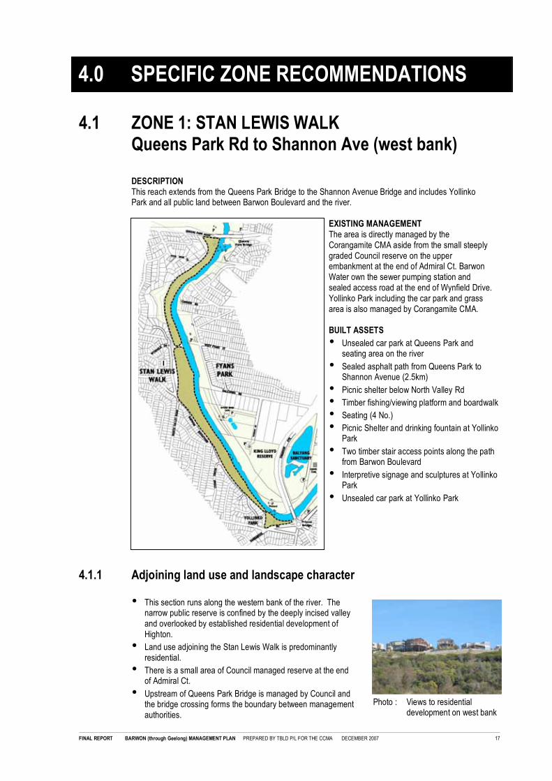
4.1 ZONE 1: STAN LEWIS WALKQueens Park Rd to Shannon Ave (west bank)
DESCRIPTIONThis reach extends from the Queens Park Bridge to the Shannon Avenue Bridge and includes YollinkoPark and all public land between Barwon Boulevard and the river.
EXISTING MANAGEMENTThe area is directly managed by theCorangamite CMA aside from the small steeplygraded Council reserve on the upperembankment at the end of Admiral Ct. BarwonWater own the sewer pumping station andsealed access road at the end of Wynfield Drive.Yollinko Park including the car park and grassarea is also managed by Corangamite CMA.
BUILT ASSETS
• Unsealed car park at Queens Park andseating area on the river
• Sealed asphalt path from Queens Park toShannon Avenue (2.5km)
• Picnic shelter below North Valley Rd
• Timber fishing/viewing platform and boardwalk
• Seating (4 No.)
• Picnic Shelter and drinking fountain at YollinkoPark
• Two timber stair access points along the pathfrom Barwon Boulevard
• Interpretive signage and sculptures at YollinkoPark
• Unsealed car park at Yollinko Park
4.1.1 Adjoining land use and landscape character
• This section runs along the western bank of the river. Thenarrow public reserve is confined by the deeply incised valleyand overlooked by established residential development ofHighton.
• Land use adjoining the Stan Lewis Walk is predominantlyresidential.
• There is a small area of Council managed reserve at the endof Admiral Ct.
• Upstream of Queens Park Bridge is managed by Council andthe bridge crossing forms the boundary between managementauthorities.
4.0 SPECIFIC ZONE RECOMMENDATIONS

FINAL REPORT BARWON (through Geelong) MANAGEMENT PLAN PREPARED BY TBLD P/L FOR THE CCMA DECEMBER 2007 18
Photo : Steep access paths
4.1.2 Community use and recreation
• Sealed asphalt shared trail runs continuously through fromQueens Park under the bridge and along the toe of the steepembankment to Shannon Ave. This walk and thecorresponding loop on the east bank are the most popularwalking tracks along the river.
• There are 3 access points down the steep escarpment to thetrail including stairs from Barwon Boulevard and a steep vehicleaccess ramp at Wynfield Dr.
• There are several well integrated timber fishing/viewingplatforms providing access to the river and a picnic shelter.Many of these facilities and planting have been completed withassistance from local community groups and residents.
• Unsealed car parks at Queens Park Bridge and Yollinko Parkare well used and this area provides a popular circuit for walkers starting from either point.
• Local Community Groups have been extensively involved in the historical development of planting andbuilt works through this zone including:� Initial planting and weed control - Office of Correctional Services, Australian Trust for Conservation
Volunteers and local community planting days� Boardwalk Construction - L.E.A.P and Geelong Adult Training and Education� Seating, Picnic Shelter and viewing area - Highton Kardinia Rotary Club� Revegetation - Friends of Watersedge Tce, Geelong Rape Crisis Centre and local community
4.1.3 Environment• A steep escarpment encloses the Stan Lewis Walk. There has been extensive revegetation through this
area over the past 15 years. Remnant vegetation is primarily confined to the river side of the path. Thevegetation assessment (refer to Attachment 1) noted that the rivers side of the trail downstream ofQueens Park contains a modified Riparian Woodland Vegetation Community consisting of scatteredyoung to semi mature River Red Gums, small to medium shrubs and a dense groundlayer of semiaquatic herbs, sedges and grasses.
• Downstream from Wynfield Drive on the river side of the trail, there are broad alluvial terraces extendingfrom the path to the river that feature a modified Floodplain Riparian Woodland Community. There aresome remaining mature Red Gums and dense patches of aquatic and semi aquatic herbs, sedges andgrasses.
• On the steep escarpment west of the path, there has been extensive revegetation with indigenousspecies. Vegetation consists of primarily Wattles with some Eucalyptus and scattered exotics includingPeppercorns.
• In general, the natural remnant vegetation on the river side of the path contains less weed invasion and ahigher quality and diversity of indigenous species than the revegetation undertaken on the up slope sideof the path.
Photo : Floodplain Riparian Woodland community invaded by groundlayer weeds

FINAL REPORT BARWON (through Geelong) MANAGEMENT PLAN PREPARED BY TBLD P/L FOR THE CCMA DECEMBER 2007 19
Photo : Stormwater outfall atYollinko Park
Photo : Car park and picnic shelter at Yollinko Pk
• There are several large Council stormwater outfalls connectingto the river through this zone that contribute to areas of poorwater quality, litter and weed invasion.
• Private properties at southern end of Barwon Boulevard frontdirectly onto the trail and narrow riparian reserve. Agapanthusand other invasive garden planting directly adjoining or in thewaterway corridor is a source of potential downstream weedinvasion.
4.1.4 Cultural values
• Yollinko Park is of cultural significance tothe Wathaurong. The park containsextensive interpretative information aboutcultural values.
4.1.5 ZONE 1: STAN LEWIS WALKOverall Objectives
• Upgrade and widen the sealed shared path to 2.5m retaining clearance to vegetation for sightlines andproviding additional seats at key viewing points.
• Maintain and enhance existing picnic areas at Yollinko Park and south of Queens Park bridge which haveexisting car parking and are easily accessible providing important set out points for trail users completingthe trail loop across to the eastern bank.
• Undertake staged upgrade of steep timber entry stairs from Barwon Boulevard to meet contemporarybuilding standards however minimise provision of additional built recreational infrastructure along theriver away from existing all ability access areas at Yollinko Park and Queens Park to enable continuedimprovement of environmental values.
• Protect and enhance existing remnant indigenous vegetation including Floodplain Riparian Woodlandand Riparian Woodland Communities. Undertake staged weed control program to promote activeregeneration of Floodplain Riparian Woodland communities on the river side of the existing path. Usethe path as a management boundary to minimise reinvasion of ground layer weeds from the steep upperescarpment.
• Maintain steep escarpments as a modified vegetation community removing invasive woody weeds suchas Peppercorn and Ash and establishing additional long lived indigenous overstorey trees to retainsustainable vegetation cover as short lived species become senescent. Limit ground layer weed controlto the path area only.
• Stormwater treatment opportunities are limited by the steep topography and developed catchment.Liaise with Council to target at source litter control and promote education about the impacts ofstormwater on the river.
• Protect existing sites of cultural significance at Yollinko Park and maintain the Koorie garden andinterpretive information in close consultation with the Wathaurong Aboriginal Co operative Ltd.
Photo : Interpretative signageat Yollinko Park

FINAL REPORT BARWON (through Geelong) MANAGEMENT PLAN PREPARED BY TBLD P/L FOR THE CCMA DECEMBER 2007 20
4.1.6 Zone 1 Management Recommendations
4.1.6.1 ZONE 1 ENVIRONMENT
No Issue Recommendation Agency Priority
E1/1 Patches of woody weeds includingAsh, Willow, Poplar, Peppercornand African Boxthorn are impacting
on remnant indigenous vegetationalong the riverside of the path.
Undertake targeted removal of woody weeds from theriparian corridor and actively revegetate withindigenous overstorey trees. Where away from the
path include dense mid storey indigenous shrubs toprovide additional small bird habitat.
CCMA High
E2/1 There are large areas of remnantindigenous vegetation along the
broad alluvial terraces on theriverside of the path. These areasare under increasing threat fromKikuyu and Galena invasion.
Undertake staged control of Kikuyu on the alluvialfloodplain terraces along the trail in conjunction with
active revegetation works and drain outfall works asoutlined at E1/1 and E7/1 to encourage naturalregeneration of remnant Floodplain RiparianWoodland.
CCMA Moderate
E3/1 Grass areas (predominantlyKikuyu) along the narrow 2.0m
wide shared path provide importantadditional off path space given theconstrained topography and highlevels of use by cyclists and dogwalkers. These areas are
however contributing to weedinvasion of indigenous vegetationcommunities along the river.
• Maintain the sealed path as a managementbarrier protecting the higher quality vegetation on
the riverside of the path from ground layer weedinvasion from the steep escarpment andadjoining residential areas with active herbicidecontrol to remove grass on the river side of the
path.
• Overtime, reduce Kikuyu and other ground layerweeds along the path establishing a minimum
0.5m wide gravel verge to both sides rather thangrass retaining an effective path width ofminimum 3.0m. Refer R1/1
• Actively revegetate with indigenous groundlayer
species to the riverside of the path extending toregenerating natural Floodplain RiparianWoodland areas along the river.
CCMA
CCMA
CCMA
Moderate
Moderate
Low
E4/1 The steep escarpment on thewestern side of the path has beenextensively planted with Wattles
that provide a significantcontribution to landscape characterand enabled initial colonisation ofthe steep bank. These short-lived
species are senescing in manyareas and there is extensivegroundlayer weed infestation.
• Undertake staged removal of senescent Wattlesin patches as part of exotic weed removal (referE5/1) and revegetate with a mix of indigenous
overstorey and dense mid storey species toimprove long term sustainability of vegetationcover.
• Stage 1 works to focus on areas of woody weedremoval on the embankment - Refer E51/1 andwhen upgrading access stairs - Refer R8/1
CCMA Low
E5/1 Peppercorns and other exoticinvasive woody weeds maycontribute to bird habitat values in
areas with limited indigenousoverstorey vegetation. Location ofthese trees on the embankmentwill make removal a complex task.
Undertake staged removal of exotic weeds from thesteep escarpment using specialist contractors. Liaisewith Geelong Field Naturalists to confirm habitat
values and timing for removal of trees and groups ofvegetation on an individual case-by-case basis.Coordinate removal works with renewal of areas ofsenescent wattles. Refer E4/1
CCMA
(Geelong FieldNaturalists)
Low
E6/1 Steep grades on the escarpmentrestrict maintenance access andlimit opportunities for weed control
and revegetation.
Utilise specialist contractors for any works undertakenon the steep escarpment (Refer E5/1 and ensure anycommunity planting programs are undertaken on more
accessible areas along the river.
CCMA Ongoing
E7/1 Council stormwater drains fromadjoining residential areas are
untreated contributing to sedimentload, litter and exotic weedinvasion of significant areas ofnatural floodplain vegetation. Due
to topography and developednature of the catchment waterquality treatment opportunities arelimited.
• Review outfalls and undertake ongoing weedcontrol to reduce invasion of significant areas of
indigenous vegetation.
• Investigate establishment of sediment traps toenable removal of sediment and improved
ongoing weed control. Where possible, utilisenatural alluvial terraces to improve water qualitytreatment while minimising impacts on significantareas or remnant vegetation.
• Liaise with Council to undertake at source controlof litter and promote education in thepredominantly residential catchment regarding
the impacts of garden weeds and illegalstormwater discharges on the river.
CCMA
CoGG
CCMA
CoGG
CoGG
CCMA
High
Moderate
High

FINAL REPORT BARWON (through Geelong) MANAGEMENT PLAN PREPARED BY TBLD P/L FOR THE CCMA DECEMBER 2007 21
No Issue Recommendation Agency Priority
E8/1 Large untreated stormwater drainat Yollinko Park is highly visible.Timber grille structure is easilyaccessed and may not meet
structural span requirements.
• Undertake structural assessment of the timbergrille on the Yollinko drain.
• Establish dense indigenous screen vegetation on
the western bank to discourage access.
CoGG
CoGG
CCMA
High
High
4.1.6.2 ZONE 1 RECREATION
No Issue Recommendation Agency Priority
R1/1 High use shared trail is only 2.0m
wide and confined by the steeptopography and vegetation in manyareas. This contributes to conflicts
between cyclists, pedestrians anddog walkers.
• Undertake central line marking to improve
separation between traffic flows.
• Install 'code of conduct' and upgraded regulatory
signage.
• Short term, retain the existing 2.0m wide pathand widen the available verge areas to minimum
0.5m either side increasing the path userenvelope to a minimum of 3.0m. Use graniticgravel to replace grass areas limiting weedinvasion of regenerating indigenous vegetation
where possible. Refer E3/1.
• Long term, when existing path requiresreplacement, upgrade width to min. 2.5m and
retain path run out areas.
CCMA
(WACL)
CCMA
(WACL)
CCMA
(WACL)
CCMA
(WACL)
Very High
Very High
Moderate
Low
R2/1 Poor sightlines on southernapproach to Queens Park Bridge.
Undertake removal of dense Poplars from around thebridge and realign the path to improve sightlines.
Revegetate with scattered indigenous overstorey andgroundlayer/sedges to retain sightlines in proximity tothe path. Refer E1/1
CCMA
CoGG
High
R3/1 There is car parking on both sidesof Queens Park Bridge. TheCouncil car park and small reserveon the north side of the bridge also
includes existing toilet facilities andan open grass area with off roadpath connection to the Stan LewisWalk.
• Upgrade warning signage as outlined in the RiskManagement Report 2006 and integrate withmajor entry signage as outlined in LU1/1.
• Review sightlines in car park as part of proposedremoval of Poplars and establishment ofrevegetation (Refer E2/1). Retain the small
picnic area south of Queens Park and maintainviews to the river.
• Council car parking, picnic facilities and toiletfacilities on the north side of the bridge are to be
retained and upgraded as recommended in theBarwon and Moorabool River ReservesMasterplan. Long term, investigate removal andrevegetation of this car park area to improve
environmental and habitat values while retainingmaintenance and pedestrian access to theviewing area which is to be retained.
CCMA
CCMA
CCMA
Very High
Moderate
Low
R4/1 There is extensive timberrecreational infrastructure in themiddle of this section of the river
including a fishing/viewing platformand picnic shelter constructed aspart of community based projects.Despite well integrated designs the
steep topography and locationaway from parking and otherrecreation facilities limits optimaluse of these facilities.
• Implement recommendations of the RiskManagement Report 2006 including review ofdesign in accordance with Australian Standards,
provision of life-boys and upgraded warningsignage. Refer 5.5.5.2.
• As environmental values increase along the river,
focus improvements on recreational facilities atthe key entry/access points south of QueensPark Bridge and at Yollinko Park and limit newworks to additional bench seats along the path.
• If existing picnic shelter and timberboardwalk/platform are damaged during floodevents or require major repairs to meet
contemporary standards remove and do notreplace them. If this occurs, liaise with relevantcommunity groups to involve them in theirdevelopment and investigate opportunities to
include them in development of other newprojects in designated recreation improvementareas.
CCMA
CCMA
CCMA
High
Ongoing
Ongoing

FINAL REPORT BARWON (through Geelong) MANAGEMENT PLAN PREPARED BY TBLD P/L FOR THE CCMA DECEMBER 2007 22
No Issue Recommendation Agency Priority
R5/1 There is limited seating along theexisting path. Existing seats are inpoor condition or do not addresskey views to the river.
Install new seats along the path addressing key viewsto the river. Refer 5.5.3.2.
CCMA Moderate
R6/1 Vegetation obscures views to theriver from the existing picnicshelter below Cedar Gve.
Review and trim vegetation to retain key views to theriver from the existing picnic shelter. Refer R4/1.
CCMA Ongoing
R7/1 Overland flow through fromCouncil land near the end of
Admiral Ct is contributing toerosion of the embankment anddistributing sediment over the path.
Liaise with Council to confirm source of stormwaterdischarge e.g. broken pipe or blocked pit to minimise
further erosion and build up of sediment on the path.
CoGG
CCMA
High
R8/1 Steep escarpment limits all ability
access to the trail from BarwonBoulevard. Timber stairs are inpoor condition and do not meetcontemporary building code.
• Implement recommendations of the Risk
Management Report 2006 including review ofdesign in accordance with Australian Standardsand installation of upgraded warning signage.Refer 5.5.5.3.
• Undertake staged replacement of local accessstair systems off Barwon Boulevard to meetcontemporary building codes. Refer 5.5.5.4.
• Install signage directing visitors to designated allability access points at Queens Park Rd andYollinko Park.
CCMA
CCMA
(WACL)
CCMA
High
Moderate
Moderate
R9/1 Yollinko Park has well integratedpicnic facilities and interpretive
signage, however, the largeunsealed car park is visuallyintrusive when viewed fromBarrabool Rd and there is no
treatment of stormwater runoffprior to discharge to the river.
• Upgrade warning signage as outlined in the RiskManagement Report 2006 integrate with new
major entry signage.
• Establish indigenous overstorey trees alongBarrabool Rd to provide shade and improve
landscape character while retaining views intothe car park from the road for security.
• Investigate establishment of small vegetated bio
retention basins (rain gardens) in the existing carparking areas to improve landscape character,habitat values and provide treatment ofstormwater prior to discharge to the river.
CCMA
(WACL)
High
High
High
R10/1 Lack of rubbish bins. Install 240 litre rubbish and recycling bins at machineaccessible entry points and remove all other binslocated in the reserve. This will include:
• Queens Park car park and Yollinko Park car park
• Stair access points along Barwon Boulevard and
at Wynfield Drive.
CCMA
CoGG
Very High
Very High
4.1.6.3 ZONE 1 ADJOINING LAND USE AND MANAGEMENT
No Issue Recommendation Agency Priority
LU1/1 City of Greater Geelong manages
open space along the river atQueens Park north of the bridge.
Install new major entry signage highlighting the
change of management from CoGG to the CCMA atQueens Park Bridge and integrating upgraded warningsignage. Refer 5.5.7.1.
CCMA High
LU2/1 Steel structure downstream ofQueens Park Bridge was
historically used as a take off pointfor pumping water from the river upto the Montpellier Service Basins.
Liaise with Barwon Water to confirm if structure isoperational and required for future use. If not,
following review of any potential heritage values,remove to improve views at the small picnic area andinvestigate development of interpretive signageregarding this former use.
BW
CCMA
Moderate
LU3/1 Recent residential developmentdownstream of Queens Park Roadalong the upper escarpment on
both sides of the river is visuallyintrusive when viewed from thewaterway and open space corridor.
Liaise with CoGG Planning to develop a SignificantLandscape Overlay or other suitable planningmechanism as recommended in the BRLUP to reduce
further visual encroachment of residential developmenton both sides of the Barwon River south of QueensPark.
CoGG High

FINAL REPORT BARWON (through Geelong) MANAGEMENT PLAN PREPARED BY TBLD P/L FOR THE CCMA DECEMBER 2007 23
No Issue Recommendation Agency Priority
LU4/1 Rear boundary of properties
downstream along WatersedgeTce are in close proximity to trailand river. These properties are
currently only screened by short-lived Wattle species and willbecome visually intrusive whenthey become senescent.
Undertake selective removal of some Wattles and
revegetation with indigenous overstorey trees toestablish a more sustainable layer of screeningvegetation.
CCMA High
LU5/1 Future Barwon Water seweragepipe replacement or upgradeworks may impact on existing
vegetation or recreational assetssuch as paths.
Liaise with Barwon Water during planning phase forany future sewerage line or pumping stationreplacement or upgrade works to ensure protection of
environmental and opens space values.
BW
CCMA
Ongoing
LU6/1 Private properties at southern endof Barwon Boulevard front directly
onto the trail and narrow riparianreserve. Agapanthus and otherinvasive garden planting directlyadjoining or in the waterway
corridor is a source of downstreamweed invasion.
Liaise with landholders to remove all invasive plantedweed species from the open space corridor and
encourage replacement with indigenous species ingardens directly adjoining the waterway. (Noteconsider provision of plants for this purpose).
CCMA
(landholder)
High
4.1.6.4 ZONE 1 CULTURAL HERITAGE
No Issue Recommendation Agency Priority
H1/1 Yollinko Park is of culturalsignificance to the Wathaurong
and contains extensive interpretivesignage regarding the history anduse of the Barwon River andsurrounds by indigenous people.
Continue to liaise with the Wathaurong to confirmongoing management of the reserve including cultural
sites, interpretive signage, sculptures and planting.
CCMA
WACL
Ongoing
H2/1 The entire Barwon River is ofcultural significance to the
Wathaurong.
Liaise with Wathaurong during planning for anyproposed works that may impact on cultural heritage
values.
CCMA
WACL
Ongoing
4.1.6.5 ZONE 1 GENERAL MAINTENANCE
No Issue Recommendation Agency Priority
M1/1 Stan Lewis Walk
Existing maintenance level priorityis low and consists of occasionalmowing of path edges.
• Implement general recommendations for path
and car park maintenance and inspection ofstructures. Refer 5.9.2.
• Implement specific management
recommendations for reduction in grass alongthe path as outlined in E3/1 focusing on weedcontrol rather than mowing to reduce spread of
Kikuyu.
• Develop a specific weed control program forbushland areas along the riverside of the path
including stormwater drain outfalls, spot woodyweed control and groundlayer herbicide areas.
• Develop a weed management program for steepescarpment areas focusing on limiting migration
of weeds across the path and into the high valueconservation areas along the river.
CCMA High
Moderate
Moderate
Low
M1/2 Yollinko Park
Existing maintenance level priorityis high and includes mowing and
maintenance of garden beds andpicnic infrastructure.
• Implement general recommendations for path
and car park maintenance and inspection ofstructures. Refer 5.9.2.
• Maintain high levels of grass mowing andmaintenance of garden beds.
CCMA High
High


FINAL REPORT BARWON (through Geelong) MANAGEMENT PLAN PREPARED BY TBLD P/L FOR THE CCMA DECEMBER 2007 24
4.2 ZONE 2: FYANS PARKQueens Park Rd to Shannon Ave (east bank)
DESCRIPTIONThis reach extends from the Queens Park Bridge to the Shannon Avenue Bridge and includes all public openspace along the river as far as King Lloyd reserve, including Newtown Park, Fyans Park – Queens ParkBridge to Balcombe Rd and the Yollinko Wetland area covering land on the river side of the main trail fromBalcombe Rd to Shannon Ave including the constructed wetlands. City of Greater Geelong managessporting grounds at King Lloyd Reserve.
EXISTING MANAGEMENTThe area along the river is directly managed bythe Corangamite CMA. Council manageupstream of Queens Park Bridge at ZillahCrawcour Park, sporting fields at King LloydReserve. Council manage toilet facilities atFyans Park.
BUILT ASSETS
• Timber boardwalk system downstream ofQueens Park Bridge
• Sealed asphalt path from Queens Park toShannon Avenue (2.5km)
• Public toilets at Fyans Park
• Picnic shelter and drinking fountain
• Boat ramp and unsealed car park at WestFyans St
• Timber fishing/viewing platform, boardwalkand bird hide at Yollinko Wetlands
• Interpretive signage at Yollinko Wetland
4.2.1 Adjoining land use and landscape character
• This section runs along the east bank of the river. Downstream of Queens Park Road the public reserveis confined by the deeply incised valley and overlooked by established residential development atNewtown. Downstream of Fyans Park, the landscape flattens out and the public reserve becomes widerwith adjoining playing fields of King Lloyd Reserve connected as part of the broader floodplain upstreamof Shannon Ave.
• Land use adjoining the eastern bank downstream of Queens Pde is predominantly residential.
• There has been recent new development at Balcombe Rd that has included a new cafe which fronts theCorangamite CMA managed open space reserve.
FIGURE 1

FINAL REPORT BARWON (through Geelong) MANAGEMENT PLAN PREPARED BY TBLD P/L FOR THE CCMA DECEMBER 2007 25
Photo : Riparian zone at new Barwon Edge Cafe
Photo : Yollinko Wetland
Photo : Constrained path
• Downstream of Balcombe Rd, there are two playing fields (cricket) at King Lloyd Reserve managed bythe City of Greater Geelong. This area is covered by a Land Subject to Inundation Overlay (LSI0) and ispart of the floodplain.
4.2.2 Community use and recreation
• Sealed shared trail runs continuously from Queens Park Bridge along the highly constrained toe of thesteep embankment, adjacent to the river to Fyans Park. South of Fyans Park the trail moves away fromthe edge of the river passing the new Rivers Edge Cafe and the playing fields at King Lloyd Reservebefore connecting under the Shannon Ave Bridge to Balyang Sanctuary.
• Picnic area downstream of Queens Park Rd is popular for informal water access with a series ofboardwalks along the lower terrace of the river.
• Fyans Park is a popular recreational destination withboat ramp, picnic shelter, public toilets and flat opengrass areas for informal recreation.
• Rivers Edge Cafe has increased use of this area andthe circuit walk between Queens Park Rd andShannon Ave that includes Stan Lewis Walk.
• Yollinko Wetland contains viewing platforms,boardwalks and a bird hide in addition to interpretativeinformation about environmental values.
Photo : Fyans Park boat ramp and former watersupply bridge pylons

FINAL REPORT BARWON (through Geelong) MANAGEMENT PLAN PREPARED BY TBLD P/L FOR THE CCMA DECEMBER 2007 26
Photo : Formal avenue of Ash at Fyans Park
Photo : Remnant Red Gum at YollinkoWetland
4.2.3 Environmental
• The flat area immediately downstream of Queens Park Bridge contains areas of Floodplain RiparianWoodland. The recent Corangamite CMA woody weed removal works will enable further restoration ofthis community.
• In the steep areas confined by the escarpment, there are scattered Red Gums, however, the RiparianWoodland Community is confined to a very narrow steep bank along the river.
• There is fringing Floodplain Riparian Woodland atFyans Park, however, the established formalavenue of Ash and open mown grass areas confinethis zone to a narrow fringe along the river.
• Downstream of Balcombe Rd, the broad riverterrace contains an intact section of regeneratingFloodplain Riparian Woodland featuring extensivestands of Tangled Lignum and semi aquatic herbs,sedges and grasses. Where there are remnant RedGums, these communities are rated as highsignificance. There are also two permanent poolsthat have been classified as Aquatic Herbland ofhigh significance due to their intact nature anddepletion of this community across the state.
• There has been extensive works undertaken toestablish Yollinko Wetland upstream of ShannonAve. This wetland provides stormwater treatmentand revegetation works have combined with naturalregeneration to improve water quality, biodiversityand habitat values. The access to this site providesan important educational facility.
4.2.4 Cultural values
• There are no known sites of significance or cultural value through this zone.
• The established formal avenue of Ash at Newtown Park may be of local significance given their age andformal arrangement. This may impact on any proposals for removal/replacement.

FINAL REPORT BARWON (through Geelong) MANAGEMENT PLAN PREPARED BY TBLD P/L FOR THE CCMA DECEMBER 2007 27
4.2.5 ZONE 2: FYANS PARKQueens Park Rd to Shannon Ave (east bank)
Overall Objectives
• Upgrade and widen the sealed shared path to 2.5m prioritising areas where the trail is confined by steeptopography and retaining clearance to vegetation for sightlines.
• Maintain and enhance existing picnic areas south of Queens Park bridge and at Fyans Park boat rampwhich have existing car parking and are easily accessible providing important set out points for trail userscompleting the trail loop across to the western bank.
• Realign trail and car parking at the boat ramp to minimise conflict between vehicles and trail users.
• Maintain areas of mown grass for passive recreation adjoining key picnic areas south of Queens ParkBridge and at Fyans Park boat ramp.
• Protect and enhance existing remnant indigenous Floodplain Riparian Woodland and Riparian WoodlandCommunities.
• Liaise with adjoining landholders to improve management and maintenance of steep escarpment areasadjoining the river and open space including erosion control, removal of invasive woody weeds andrevegetation with indigenous species.
• Establish additional indigenous overstorey to allow for longer term removal of Ash avenue in Newtownpark when their health declines. Implement interim measures to control seed dispersal prior to removal.
4.2.6 Zone 2 Management Recommendations
4.2.6.1 ZONE 2 ENVIRONMENT
No Issue Recommendation Agency Priority
E1/2 There is extensive groundlayerweed infestation following recent
woody weed removal worksdownstream of Queens Parkbridge.
Undertake follow up groundlayer weed control andindigenous revegetation.
CCMA Ongoing
E2/2 Existing timber boardwalk structuredownstream of Queens Park
bridge was built around Willowswhich have been recentlyremoved.
Review structure and water access point in
conjunction with indigenous revegetation works. ReferR2/2.
CCMA Moderate
E3/2 Steep narrow riparian reserve and
proximity of path to top of banklimits opportunities forrevegetation.
Establish scattered indigenous overstorey retaining
required clearances to path. Revegetate steep bankswith modified palette of predominantly indigenoussedges and rushes to establish sustainable
groundlayer cover on the steep dry banks preventingfurther erosion.
CCMA Moderate
E4/2 Uncontrolled pedestrian access
and rabbit infestation throughregenerating Floodplain RiparianWoodland Community downstreamof Balcombe Rd threatens
significant environmental values.
• Install interpretive signage discouraging public
and dog access and highlighting theenvironmental values of this area.
• Undertake rabbit control focusing on warren
destruction and monitor rabbit migration fromupstream.
• If human, dog and pest access continue to
impact on vegetation values, investigate optionsfor fencing.
CCMA
DPI
CCMA
WACL
CCMA
High
High
Low
E5/2 Relatively low floristic diversity
among remnant FloodplainRiparian Woodland Communityupstream of Shannon Ave.
Undertake spot weed control and revegetation of
areas degraded by rabbits, human access or weeds.Review revegetation species list to complement andincrease biodiversity of the naturally regenerating
Floodplain Riparian Woodland Community whenreplanting these areas.
CCMA Moderate
E6/2 Vegetation assessment identified a
semi permanent pools with AquaticHerbland Communities rated ofhigh significance.
Monitor and protect significant Aquatic Herbland
Communities near Balcombe Rd. Refer E4/2 andE5/2.
CCMA Ongoing

FINAL REPORT BARWON (through Geelong) MANAGEMENT PLAN PREPARED BY TBLD P/L FOR THE CCMA DECEMBER 2007 28
4.2.6.2 ZONE 2 RECREATION
No Issue Recommendation Agency Priority
R1/2 Path between Queens Park andShannon Ave (including the loop
via the Stan Lewis Walk (westbank) is one of the most popularwalks in Geelong. Narrow 2.0mwide shared path is highly
constrained by the escarpment andsteep riverbank.
• Undertake central line marking to improveseparation between traffic flows along the entire
length.
• Install 'code of conduct' and upgraded regulatorysignage. Refer LU1/2
• Widen the shared trail to minimum 2.5m in theconfined section between Queens Park Bridgeand Cambden Rd.
• Widen remaining sections of less confinedshared path through Fyans Park and down toShannon Avenue to minimum 2.5m only when
condition of existing path requires replacement.
CCMA High
High
Moderate
Low
R2/2 Timber boardwalk structure along
the river downstream of QueensPark bridge has been constructedaround several large Willows.Removal of these Willows may
require removal of the boardwalkstructures and will impact on shortterm landscape amenity and use ofthis popular water access point.
• Implement recommendations of the Risk
Management Report 2006 including review ofdesign in accordance with Australian Standards,provision of life-boys and upgraded warningsignage. Refer 5.5.5.2.
• Redesign new water access point in conjunctionwith indigenous revegetation works. Refer5.5.5.4.
CCMA
CCMA
High
Moderate
R3/2 Lack of all ability access to existingtoilet facilities at Fyans Park onGairloch Gve
Upgrade path access providing new ramp from theFyans Park Picnic area to the existing toilet facilities tomeet AS1428 Access and Mobility Standards.
CCMA
CoGG
High
R4/2 Conflicts between vehicles and
pedestrians/cyclists where theshared path passes through theboat ramp car park at Fyans Park.
River bank is also subject tosignificant erosion around the boatramp.
• Upgrade warning signage as outlined in the Risk
Management Report 2006 integrate with newmajor entry signage.
• Develop and implement a concept plan forrealignment of the trail and reset of car parkingand vehicle control at the boat ramp to minimiseconflict between vehicles and trail users and
improve vegetation management along the river.Refer Schematic Concept Plan Figure 1.
CCMA
CCMA
Very High
High
R5/2 Ownership and management of the
two pylons (refer Photo on Page28) is unknown. There have beenprevious suggestions raised bysections of the community for a
new bridge crossing between theeast and west bank at NewtownPark considering use of theremnant pylons near the boat
ramp.
• Liaise with Barwon Water to confirm ownership
of the two pylons and review and confirmstructural stability and heritage values.
• BRLUP confirmed the existing provision of
pedestrian bridges along the river and no newcrossings were proposed in this area. Conditionof pylons appears unsuited to potential reuse aspart of a new pedestrian bridge crossing.
CCMA
BW
CCMA
CoGG
High
N/A
R6/2 Local Council stormwater drains
may surcharge over path atBalcombe Rd.
Monitor frequency of discharge and impacts on path
maintenance.
CoGG
CCMA
Ongoing
R7/2 Steep approach ramps to thepopular Rivers Edge Café from the
shared path may limit all abilityaccess.
Investigate upgrading steep path on one side to RiversEdge Café from the shared trail to meet AS1428
Access and Mobility Standards.
CoGG
Leaseholder
High
R8/2 Proximity of the shared path tosouthern cricket field may present
risk issues.
Review clearance from pitch to shared trail and extentof existing protective fencing.
CoGG
CCMA
High
R9/2 There is limited seating along the
existing path.
Install new seats along the path addressing key views
to the river. Refer 5.5.3.2.
CCMA Moderate
R10/2 Lack of rubbish bins. • Install 240 litre rubbish and recycling bins atmachine accessible entry points and remove
remaining bins through the reserve. This willinclude boat ramp car park and adjoiningsporting fields at King Lloyd Reserve.
• Review provision of bins at Rivers Edge Café.
CCMA
CoGG
Very High
Very High

FINAL REPORT BARWON (through Geelong) MANAGEMENT PLAN PREPARED BY TBLD P/L FOR THE CCMA DECEMBER 2007 29
4.2.6.3 ZONE 2 ADJOINING LAND USE AND MANAGEMENT
No Issue Recommendation Agency Priority
LU1/2 Council manages open spacealong the river at Queens Park
north of the bridge.
Install new major entry signage highlighting thechange of management from CoGG to the CCMA at
Queens Park Bridge and integrating upgraded warningsignage as outlined in Risk Management Report 2006.
CCMA High
LU2/2 Residential properties downstream
of Queens Park Rd on the upperescarpment are visually intrusive.Poor land management practices
on steep rear yard of privateproperty directly adjoining the openspace and river impact on visualamenity and are contributing to
weed invasion.
Liaise with adjoining landholders to improve
management and maintenance of steep escarpmentareas adjoining the river and open space includingerosion control, removal of invasive woody weeds and
revegetation with indigenous species.
CCMA High
LU3/2 Uncontrolled stormwater dischargefrom private properties at Jackson
Rd.
Refer LU2/2 CCMA
CoGG
High
LU4/2 Council manage the existing toilet
facility at Fyans Park, however,there is no lease agreement forthis facility on CCMA managed
land.
Develop licence agreement covering maintenance and
future long term works at this facility.
CCMA
CoGG
High
LU5/2 Embankment to new residentialdevelopment at Balcombe Rdconstrains the path and is visuallyintrusive.
Confirm land management boundaries in this area andinvestigate revegetation of the embankment toimprove landscape amenity and environmental values.
CCMA
CoGG
Moderate
LU6/2 Commercial development (RiversEdge Café) at Balcombe Rd hasincreased use of the area. Original
proposals included possibility offuture access to the river for boathire.
Any access to this river in this area may impact on thesignificant habitat and floristic values of the riparianzone and conflict with shared trail use (crossing point)
in this area and is not recommended. Any newcommercial recreational use on the river accessingfrom another less environmentally sensitive locationmust be reviewed to ensure there is no impact on
existing recreational use of the river.
CoGG
CCMA
Ongoing
4.2.6.4 ZONE 2 CULTURAL HERITAGE
No Issue Recommendation Agency Priority
H1/2 Formal planting of established Ashat Fyans Park are highly invasivein waterway environments
particularly Yollinko Wetlands andwill eventually require removal.The planting may be of heritagesignificance given their age and
formal arrangement. This mayimpact on any proposals forremoval/replacement.
• Liaise with Council Heritage Officer to confirmany potential heritage values.
• Short term, retain Ash and establish a newformal row of indigenous overstorey using semiadvanced trees matching the spacing of the Ashon the path side.
• When replacement row becomes established toa minimum height of 4.0m, providing anequivalent contribution to landscape character,
remove Ash.
CCMA
CoGG
CCMA
CCMA
High
High
Low
H2/2 The entire Barwon River is of
cultural significance to theWathaurong.
Liaise with Wathaurong during planning for any
proposed works that may impact on cultural heritagevalues.
CCMA
WACL
Ongoing

FINAL REPORT BARWON (through Geelong) MANAGEMENT PLAN PREPARED BY TBLD P/L FOR THE CCMA DECEMBER 2007 30
4.2.6.5 ZONE 2 MAINTENANCE
No Issue Recommendation Agency Priority
M1/2 Fyans Park - Queens Park Rd toBalcombe Rd
Existing maintenance level priorityis medium and includes mowing oflarge open lawn areas and
maintenance of picnic facilitiesaround the boat ramp.
• Implement general recommendations for pathand car park maintenance and inspection of
structures. Refer 5.9.2.
• Maintain high levels of maintenance for grassmowing around picnic areas and along the path.
• Monitor the potential spread of Ash from theexisting established formal avenue to be retainedat Newtown Park including raking and removing
seedpods in spring prior to mowing and spotherbicide control along the river.
• Review herbicide control along grass edge to
regenerating indigenous riparian fringevegetation to encourage natural regenerationand extension of this zone.
CCMA High
High
High
Low
M2/2 Yollinko Wetland - Balcombe Rdto Shannon Ave
Existing maintenance level priority
is low and includes occasionalmowing to edge of path only.
• Implement general recommendations for pathmaintenance and inspection of structures. Refer5.9.2.
• Investigate application of an environmentally safefire retardant to existing timber boardwalk andbirdhide structures at Yollinko wetland which may
be subject to vandalism in this remote location.
• Develop a specific weed control program forbushland areas along the riverside of the path
including rabbit control, closure/revegetation ofinformal paths, spot woody weed control andgroundlayer herbicide areas along the path.
CCMA
CCMA
CCMA
High
High
High


FINAL REPORT BARWON (through Geelong) MANAGEMENT PLAN PREPARED BY TBLD P/L FOR THE CCMA DECEMBER 2007 32
4.3 ZONE 3: ROWING MILE NORTHShannon Ave to Swanston St (Landy Field - northbank)
DESCRIPTIONThis reach extends from the Shannon Avenue Bridge to Swanston Street and John Landy Athletics Fieldincluding the rowing mile north bank, the firetrack area between Latrobe Tce and Moorabool St, the rowingboat sheds and Richardson Reserve (Bob and Gerry's).
EXISTING MANAGEMENTCity of Greater Geelong manages Balyang Sanctuary and Landy Athletics Field however the CorangamiteCMA manage the direct frontage to the riverside of the path. The short timber bridge over the Packington Stdrain outfall to the river and the timber boardwalk at the base of the escarpment west of Packington St areoutside Corangamite CMA managed land. Management of these structures is to be confirmed. Toiletfacilities at Moorabool St are managed by Council as is the Pakington St access ramp located in the roadreserve. DSE directly manage the heritage listed Marnockvale site aside from the river frontage that ismanaged by the Corangamite CMA (note this long standing informal management arrangement is currentlybeing formalised). Barwon Water directly manages access at Fernleigh St including the Bowler SewerPumping Station and MacIntyre footbridge (which also carries the trunk sewer). The Geelong Canoe Cluband the Outrigger Club lease their land from the Corangamite CMA and both parcels of land could be subjectto a separate masterplan. The Rowing Clubs have 25 year lease agreements for their boat sheds directlywith DSE. These agreements extend to 2032.
Rowing Sheds and Richardson Reserve
• Peter Brooks Boat Shed
• War Memorial
• Timber boat landing area
• Unsealed car parking area west of Landy Field
• Major event fencing
BUILT ASSETS
• 2.2km of sealed asphalt shared trail
Balyang Sanctuary -Marnockvale
• 2 canoe landing ramps
• Rowing Mile Start Line (5 posts)
• Timber bridge across Bridge St drain
• Unsealed car park at Riversdale Rd
• Canoe Club Rowing
North bank rowing mile
• 2 small timber platforms on the river
• CFA sealed fire track and automatic irrigationsystem
• Sculptural steel 'rowing' fencing
• Major event fencing
• Drinking fountain
• Timber viewing terraces
• Finishing line and posts for marker buoys
FIGURE 2

FINAL REPORT BARWON (through Geelong) MANAGEMENT PLAN PREPARED BY TBLD P/L FOR THE CCMA DECEMBER 2007 33
Photo : Rowing events at MacIntyrefootbridge
Photo : View from MacIntyre footbridge
4.3.1 Adjoining land use and landscape character
The rowing mile north includes the older established area of Newtown. The high visibility and historic valuesof adjoining residential and industrial development contribute to the landscape character. A strategicmasterplan was prepared for the area between Marnock Rd and Moorabool St as part of the BRLUP.Recommendations from this plan will be used to inform management direction for this area.
• Balyang Sanctuary is a popular picnic area with ornamental lake bridges and picnic areas managed byCity of Greater Geelong.
• The historic Marnockvale site (former Pheonix Woolscour) is heritage listed and managed directly byDSE. This site has a separate masterplan prepared in the late 1990's by Green and Dale P/L.
• Pakington Street is a popular strip shopping area that connects into the northern edge of the site.
• There are expansive views over the site from the 3 bridge crossings at MacIntyre footbridge, JamesHarrison Bridge (Latrobe Tce) and Barwon Bridge (Moorabool St).
• Barwon Water own and manage the Bowler Sewer pumping station and vent adjacent to the MacIntyrefootbridge (which also carries the trunk sewer) and is an essential part of the sewerage infrastructure forGeelong.
• James Harrison and Barwon Bridge are managed by Vic Roads. Views from these bridges providevisitors to Geelong and the Great Ocean Road with key views of the Barwon River which are integral tothe character of the city.
4.3.2 Community use and recreation
• The shared trail runs continuously from Shannon Ave toSwanston St along the river. The shared trail and aninformal track closer to the river are used by rowingcoaches during training.
• There are links through to the main trail at Bridge St,Pakington St and Fernleigh St as well as through openspace along Barwon Tce and Balyang Sanctuary.
• This area is used for major water based recreation events.When these events occur, activities are focused on thearea between Latrobe Tce and the rowing sheds belowBarwon Tce which can accommodate large crowds.
• There are public toilets at Moorabool St managed by Cityof Greater Geelong.
• Richardson Reserve (Bob and Gerry's) and areas aroundthe rowing sheds are popular lunchtime picnic areas.
• Landy Athletics Field managed by City of Greater Geelonghosts local and regional athletic events.

FINAL REPORT BARWON (through Geelong) MANAGEMENT PLAN PREPARED BY TBLD P/L FOR THE CCMA DECEMBER 2007 34
4.3.3 Environmental
4.3.3.2 Existing Conditions
• The Barwon River through this section has been modified to accommodate water based recreation. Thisincluded dredging to establish an even depth for rowing and provision of platforms and bank treatmentsto provide access to water.
• There is limited overstorey vegetation along the bank, however, the narrow bank of regeneratingFloodplain Riparian Woodland where present improves bank stability and habitat links. Through therowing mile, reeds are periodically harvested to retain views to the rowing course for training and majorevents.
• There has been active revegetation works undertaken away from the river upstream of MacIntyrefootbridge, however, there are still large areas of woody and groundlayer weeds through this section.
• Downstream of Latrobe Tce, the landscape around the finish to the rowing course, rowing sheds andLandy Field is more formal with established exotic specimen plantings and large areas of open mowngrass to cater for major events.
• There are several large untreated stormwater outfalls that connect in from established urban areas atNewtown. These contribute significant rubbish and degrade water quality as outlined in the City ofGreater Geelong Stormwater Management Plan.
Photo : Rowing sheds Photo : Constrained access at Landy Field
Photo : Formal Elm planting and firetrack downstream of Latrobe Tce

FINAL REPORT BARWON (through Geelong) MANAGEMENT PLAN PREPARED BY TBLD P/L FOR THE CCMA DECEMBER 2007 35
Photo : Rowing sheds
4.3.4 Cultural values
• The historic industrial buildings and land use in this section contribute to the history and character of theearly European settlement of Geelong.
• There are a number of historical precincts in this area including Rocky Point and the Woollen MillsHeritage precinct.
• There are several heritage listed residences including Barwon Grange, Barwon Bank and Sladen Housedirectly adjoining the river.
• The long history of rowing on the river and development of the boat sheds also has historic value.
4.3.5 ZONE 3: ROWING MILE NORTH BANKShannon Ave to Latrobe St (Landy Field - north bank)
Overall Objectives
• Maintain existing environmental focus for the north bank of the rowing mile between Shannon Avenueand Latrobe St continuing to improve existing natural landscape and habitat values. Promote the southbank and areas east of Latrobe Tce as the main areas for major event use and recreational facilities.
• Protect and maintain existing revegetation along the river frontage at Balyang Sanctuary andMarnockvale while retaining clear sightlines to vegetation on the path.
• Investigate stormwater treatment opportunities at Bridge St and upstream of Packington St in addition tothe existing Gross Pollutant Trap. Where existing infrastructure or development limits opportunitiesliaise with Council to improve at source litter control and promote eduction in the catchment regardingthe impacts of stormwater discharges on the river.
• Commence woody weed removal at Pakington St retaining mature specimen trees where they areassociated with adjoining heritage properties at Sladen House and Barwon Grange. The boardwalk atthe base of the escarpment does not meet contemporary building standards and is to be removed.
• Liaise with Barwon Water (Fernleigh St) and City of Greater Geelong (Pakington St) to improve accessand integrated directional/regulatory signage in these areas.
• Confirm land ownership titles and upgrade vehicle control at the river frontage and along the pathupstream of Latrobe Tce (Geelong College of the Arts). Remove obstructions from the path includingbarriers and fencing and establish an avenue of indigenous overstorey trees along the river as part ofincreasing vegetation along the rowing mile. Retain views to the river from the path. Retain existingpoplars until new vegetation becomes established.
• Retain formal character, existing mature exotic trees, large areas of open grass and other facilitiesassociated with major event use between Latrobe Tce and the Boat Sheds. Monitor structural conditionof trees, undertake ongoing maintenance to minimise downstream weed invasion and establish carefully

FINAL REPORT BARWON (through Geelong) MANAGEMENT PLAN PREPARED BY TBLD P/L FOR THE CCMA DECEMBER 2007 36
placed semi advanced indigenous species to retain landscape character when they eventually requireremoval.
• Develop an alternative path route behind the boat sheds to retain all year round continuous publicaccess and to assist in management of major events. Review permanent major event fencing andinvestigate removal of short sections directly adjoining the path (within 2m) to improve landscapeamenity and path safety. Replace with temporary facilities for major event days only.
• Upgrade picnic facilities at Richardson Reserve.
• Develop interpretive signage regarding the rich history of industrial development and rowing.
4.3.6 Zone 3 Management Recommendations
4.3.6.1 ZONE 3 ENVIRONMENT
No Issue Recommendation Agency Priority
E1/3 There is limited indigenous
overstorey vegetation along theriver through the rowing mile.
Continue active revegetation along the northern bank
of the rowing mile establishing additional indigenousoverstorey trees in an avenue (20-30m spacing) alongthe river to improve habitat and landscape valueswhile maintaining views to the river from the shared
trail.
CCMA Moderate
E2/3 Regenerating sedges and semiaquatic species require active
harvesting to maintain views to therowing course.
Continue ongoing harvesting of reeds along the river
to retain views to the water for major events.
CCMA Ongoing
E3/3 Large open stormwater drain
running along Bridge St has apredominantly industrial catchmentand contributes to poor waterthrough the rowing mile.
Investigate opportunities to provide integrated water
quality treatment and reuse of stormwater in theexisting Balyang Par 3 Golf Course lake system.
CCMA
CoGG
Moderate
E4/3 The low lying wetland area belowPakington St is infested with woodyweeds and stormwater inputs fromthe Newtown area contribute to
litter and poor water quality in therowing mile.
Undertake removal of woody weeds and investigateresetting the existing stormwater connections toestablish improved water quality treatment function inaddition to the existing Gross Pollutant Trap and to
enhance biodiversity and habitat values.
CCMA
CoGG
High
E5/3 The only remnant vegetation in thissection is a Drooping She oak
located below Pakington St whichwas noted in the Landscape Plan1996 as one of the oldest inGeelong.
Ensure protection of this tree in removal of woodyweeds as outlined in E4/3.
CCMA Ongoing
E6/3 Revegetation through the northbank of the rowing mile hasfocused on development of largeindigenous planting beds with
mixed areas of trees and shrubs.
• Review existing garden bed planting betweenRocky Point and Macintyre Bridge continuingrevegetation consistent with a Floodplain
Riparian Woodland Community. Reset plantingbeds on the riverside of the path to focus ongroundlayer and overstorey trees selectivelyremoving midstorey shrubs to retain views to the
river and sightlines for safety in proximity to thepath.
• Continue ongoing revegetation of the steep
escarpments retaining a mix of overstorey andmidstorey to maximize habitat values andscreening of adjoining industrial properties.
CCMA Low
Low
E7/3 Old established Elms in more
formal landscape areas betweenLatrobe Tce and the boat shedcontribute to the landscapecharacter and amenity of the area.
They may become structurallyunsound and contribute todownstream weed invasion.
• Retain mature Elms in this area and undertake
annual ongoing arboricultural inspection toensure public safety during major rowing events.Implement specific control program to limit seed
dispersal including hand raking before mowingand ongoing spot control of surrounding area.
• Continue establishment of additional carefully
placed semi advanced clean boled indigenoustrees to allow for long term replacement as thehealth of the Elms declines.
• Remove Elm suckers and weeds from theembankment above the firetrack and undertakeindigenous revegetation to screen adjoining caryards.
CCMA
CCMA
CCMA
Ongoing
High
Moderate

FINAL REPORT BARWON (through Geelong) MANAGEMENT PLAN PREPARED BY TBLD P/L FOR THE CCMA DECEMBER 2007 37
No Issue Recommendation Agency Priority
E8/3 Large untreated Councilstormwater drains upstream anddownstream of Latrobe Tce arehighly visible and contribute to litter
and poor water quality in therowing mile.
There are limited water quality treatment opportunitiesin the developed catchment. Council to undertake atsource control of litter and ongoing education oflandowners in the industrial and residential catchment
regarding the impacts of stormwater discharges on theriver.
CoGG High
E9/3 There are Willows and Ash along
the river at Landy Field. Thisoutside bend radius is constrainedby the path and location of fencing
to the southern side of the athleticsfield.
Remove woody weeds and undertake bank
stabilisation works to ensure long term sustainabilityof the path. Ensure revegetation retains sightlines forsafety on this confined section of path using a
modified palette of overstorey and groundlayer only.
CCMA High
E10/3 Existing poplars at the Geelong Art
Centre are the only trees along theriver in this area, however, theymay contribute to potentialdownstream weed invasion.
Following review of land ownership and upgrade
vehicle control (refer R8/3), establish new indigenousoverstorey trees and remove Poplars to minimisepotential downstream weed invasion.
CCMA Moderate
4.3.6.2 ZONE 3 RECREATION
No Issue Recommendation Agency Priority
R1/3 There is a lack of directional andregulatory signage through the
rowing mile from Shannon Ave toSwanston St.
Upgrade existing and/or install new entry signage
highlighting the change of management from CoGG tothe CCMA including integrating upgraded warningsignage as outlined in Risk Management Report 2006including:
• Major sign at Balyang Sanctuary including linksto Shannon Ave Bridge and integrateddirectional signage to Yollinko Wetland and Stan
Lewis Walk
• Minor signage at Riversdale Rd (Bridge St carpark)
• Minor signage at Latrobe Tce and Moorabool Stentries
• Minor signage at Eastern approach to the boat
sheds
• Major signage at Richardson Reserve Car parkwest of Landy Field
Liaise with Council and Barwon Water to install similarintegrated signage with direction, regulatory andwarning information at major entries under their
management including:
• Major sign at Pakington St
• Minor signage at Fernleigh St
• Major signage at the MacIntyre Bridge
CCMA
CoGG
BW
High
High
R2/3 Timber canoe landing platform atBalyang Sanctuary is in poorcondition and may be structurallyunsound.
• Review the use of this platform which appears toonly be used occasionally and consider, as aninterim measure, removal of the slumpingwestern end. Longer term, remove remaining
sections of the platform and liaise with theCanoe Club and Geelong Rowing Association toconfirm design and cost of any replacementstructure.
• Continue to maintain existing launching facilitiesat the club building frontage only.
CCMA
Canoe Club
GeelongRowing
Association
High
R3/3 The sealed shared trail divergesaway from the river upstream ofMcIntyre footbridge and there is awell worn informal path along the
river which is used by rowingcoaches to maintain visual contactwith crews on the river.
• Retain this access for informal use only andcontinue to improve environmental values alongthe north bank. Formal recreational access and
sealed trail is to be upgraded on the south bankwhere existing environmental values are lower.Refer R3/4
• Investigate formalising this section of trail whenexisting path requires replacement.
CCMA Ongoing

FINAL REPORT BARWON (through Geelong) MANAGEMENT PLAN PREPARED BY TBLD P/L FOR THE CCMA DECEMBER 2007 38
No Issue Recommendation Agency Priority
R4/3 Short timber crossing of PakingtonSt open drain outfall at edge ofriver retains informal access forrowing coaches and walkers along
the river. Refer 3/3.
• Review design in accordance with AustralianStandards and upgraded warning signage. Refer5.5.5.3.
• Review outfall as part of future water qualitytreatment system project upstream of PakingtonSt. Refer E4/3.
CCMA High
Moderate
R5/3 Ramp access at the Pakington Stentry is steep and infested withexotic woody weeds which obscure
views to the river from the picnictable at the top of the ramp.
• Install new entry signage highlighting the changeof management from CoGG to the CCMAincluding integrating upgraded warning signage
as outlined in Risk Management Report 2006
• Upgrade handrail and widen the ramp to improveaccess at this popular entry from Pakington St.
Note due to topographical constraints this accessis unlikely to be able meet AS1428 standard. Allability access will continue to be focused on theexisting Bridge St and Barwon Tce entry points.
• Remove exotic woody weeds to open views tothe river from the existing picnic table. ReferE4/3.
CoGG
CCMA
CoGG
CoGG
CCMA
High
High
High
R6/3 The timber boardwalk accessalong the base of the escarpment
upstream of Pakington St is in poorcondition and does not meetcontemporary building standards.
• Confirm land ownership and remove thisplatform. Refer LU1/3.
• Investigate establishment of a new boardwalkand access through the wetland area as part ofproposed improvements to water quality
treatment function. Refer E4/3.
CoGG
CCMA
Very high
Low
R7/3 There is a lack of directionalsignage at the Fernleigh St entry
and access onto the Macintyrebridge is unclear.
Upgrade direction and warning signage at the bridgeand car park. Refer R1/1.
BW High
R8/3 Uncontrolled vehicle access to the
shared path at the frontage to theGeelong College of the Artsupstream of Latrobe Tce. The
existing barrier across the pathmay also present some risk to trailusers.
• Survey and confirm land ownership in this
area.
• Upgrade vehicle control to restrict access to
the shared trail and remove existing barrieracross the path.
• Undertake revegetation along the river with an
avenue of indigenous overstorey trees toimprove landscape amenity in this high profilelocation and remove Poplars. Refer E1/3.
CCMA
CCMA
CCMA
Very high
Very high
High
R9/3 Fencing and vehicle barriers in thearea around Latrobe Tce which areused for major events restrictsaccess along the path and may
present a significant hazard toshared trail users.
• Review fencing requirements for major eventsand consider larger sections of temporaryfencing to reduce all year round visual impact
and safety in proximity to the shared trail.
• Remove and reset vehicle control and majorevent fencing where it obstructs the trail and may
present a hazard to shared trail users.
CCMA
CCMA
High
Very high
R10/3 Public access along the sharedpath through the boat shed area is
closed during major events andtransport of rowing boats acrossthe shared path presents risk tocyclists and pedestrians.
• Maintain existing warning signage regardingboats crossing on either side of the shared trail
access through this area.
• Investigate establishment of a new signedunsealed off road route around the back of the
boat sheds and connecting up to Barwon Tceretaining all year round public access throughthis area. Refer to Figure 2.
CCMA
CCMA
CoGG
High
High
R11/3 Timber rowing platform on the riverdoes not have any signageregarding river use zones and
controls and can become slipperywhen wet.
• Review design in accordance with AustralianStandards and install life bouys and upgradedwarning signage. Refer 5.5.5.2.
• Install integrated signage (as per the boat ramp)illustrating on river management restrictions andaccess zones for rowers and power boats.
Include directions to lanes, requirements of useand use of appropriate boat lights in winter.
CCMA
GeelongRowing
Association
Barwon ValleyWaterski Club
High
R12/3 Lack of all ability access to existing
toilet facilities upstream ofMoorabool St.
• Install new path access from the firemans track
to existing public toilet facilities to meet AS1428Access and Mobility Standards.
• Include directional signage to these toilets at
CCMA
CoGG
High

FINAL REPORT BARWON (through Geelong) MANAGEMENT PLAN PREPARED BY TBLD P/L FOR THE CCMA DECEMBER 2007 39
No Issue Recommendation Agency Priority
picnic areas and access points at RichardsonReserve and at Fernleigh St as part of proposedsignage upgrade. Refer R1/1.
CCMA High
R13/3 The sealed firetrack between
Latrobe Tce and Moorabool Stprovides an important all weathersurface for major rowing events.
Short term retain the track. Longer term as the
condition of the surface begins to deteriorate removeand liaise with rowing clubs, CFA and other majorevent users of the site to confirm specialised allweather surface requirements.
CCMA
CFA
Geelong
RowingAssociation
Low
R14/3 Richardson Reserve (Bob andGerry's) is a popular lunchtimedestination.
Develop additional seating areas adjoining the carparking areas utilising existing exotic non-invasivespecimen planting for shade and building on the formal
19th century character of the area. Continueindigenous revegetation works along the riverside ofthe path retaining views to the water from seatingareas.
CCMA Moderate
R15/3 Landy Field is in close proximity tothe river limiting opportunities forexpansion of spectator and
athletics facilities along thesouthern (river) side. The sharedtrail is highly constrained betweenthe fence and river.
The location on the outside bend radius at the end ofthe artificially straightened rowing mile is subject toerosive flows during flood events and boardwalk
treatment as proposed in the Landy Field Masterplanmay not be sustainable. Investigate bank stablisationfollowing Willow removal works to ensure sustainabilityof trail access. Refer E9/3.
CCMA High
R16/3 There are limited distance markersalong the rowing course.
Install permanent distance markers along the southernbank of the rowing mile. Markers are to be visible from
the river and bank (Refer R10/4).
CCMA
Geelong
RowingAssociation
Moderate
R17/3 Stability of timber retaining wall
terraces at Moorabool St.
Undertake structural engineering review of existing
timber retaining wall terraces at Moorabool St.
VicRoads High
R18/3 Lack of rubbish bins. Install 240 litre rubbish and recycling bins at machineaccessible entry points and remove remaining binsthrough the reserve. This will include:
• Balyang Sancturary and Pakington St entries
• Fernleigh St entry
• Marnockvale car park, boat sheds (2),Richardson Reserve car park and picnic areaand removal of all other bins through the reserve.
CoGG
BW
CCMA
Very High
Very High
Very High
R19/3 Existing two small timber platform
are in poor condition and do notappear to be well used.
Remove platforms and regrade and revegetate bank
using indigenous species. Liaise with GeelongRowing Association to confirm appropriate alternatelocation for static rescue during major rowing events.
CCMA
(GeelongRowing
Association)
High
R20/3 Lack of drinking fountains. Investigate installation of a new drinking fountain at ornear the judge's box.
CCMA Moderate
R21/3 The lane markings on theMacIntyre, Moorabool and JamesHarrison bridges do not align with
the current rowing course.
MacIntyre bridge is managed by Barwon Water.James Harrison and Moorabool Street bridges aremanaged by VicRoads. Liaise with relevant authorities
to realign the existing lane numbers on the bridge.
BW
VicRoads
GeelongRowing
Association
High
4.3.6.3 ZONE 3 ADJOINING LAND USE AND MANAGEMENT
No Issue Recommendation Agency Priority
LU1/3 The heritage listed Marnockvalesite is contaminated from previous
use as a wool scour. The site isdirectly managed by DSE. A wasLandscape Masterplan preparedfor the site in the late 1990’s by
Green and Dale P/L whichindicated potential redevelopmentof the site as an interpretivecentre. CCMA currently manage
the river frontage of the site butthis arrangement has not beenformalised.
• Formalise CCMA as committee of management
for the riverside frontage of the site (excludingcontaminated areas).
• Liaise with DSE to confirm status and proposed
implementation of the existing LandscapeMasterplan.
DSE
CCMA
DSE
High
Ongoing

FINAL REPORT BARWON (through Geelong) MANAGEMENT PLAN PREPARED BY TBLD P/L FOR THE CCMA DECEMBER 2007 40
No Issue Recommendation Agency Priority
LU2/3 The ownership of the boardwalksand land along the base of theescarpment west of Pakington Stis unknown. City of Greater
Geelong has two PublicAcquisition Overlays (PAO) onland at the end of Pakington Stadjoining the existing open space.
Confirm extent of Public Acquisition Overlays andownership of this structure and undertake immediateremoval or restriction of access. Refer R6/3.
CoGG
(land owner)
High
LU3/3 Despite recent planting theBarwon Water sewer pumpingstation and vent adjacent to the
MacIntyre bridge are visuallyintrusive when viewed from theriver and public open space.
Review the current requirements for existing fencingand vehicle access and investigate opportunities forfurther screen planting to reduce the visual impact of
these facilities.
BW High
LU4/3 Car yards and commercial
properties along Barwon Tce arehighly visible from the waterwaycorridor.
Undertake indigenous screen planting. Refer E7/3. CCMA High
LU5/3 Lack of clear managementboundaries between the CCMA
and VicRoads at key bridgecrossings and embankments.
Liaise with VicRoads to confirm ongroundmanagement agreements for roadside embankments
and structures along the river and underneathVicRoads road reserves.
CCMA
VicRoads
High
LU6/3 Canoe Club and Outrigger Clubcompound lease areas are due for
renewal.
Liaise with Clubs to prepare an integrated conceptplan for the site as part of renewal of existing lease
agreements.
CCMA
Canoe Club
Outrigger Club
High
4.3.6.4 ZONE 3 CULTURAL HERITAGE
No Issue Recommendation Agency Priority
H1/3 The north bank of the rowing milehas long been associated with the
early history and development ofGeelong including the historicalNewtown Industrial precinct thatcontains numerous buildings that
are of heritage significance anduse of the river for rowing. Thesesites are best viewed from theshared path along the river,
however, there is limitedinterpretive information.
Investigate development of a series of interpretivesigns highlighting the early history of Geelong and its
relationship to the Barwon River through the rowingmile.
CCMA
CoGG
HV
WACL
GeelongRowing
Association
Moderate
H2/3 The heritage listed Marnockvale
site (former Pheonix Woolscour)has been subject to a separateinvestigation and masterplanidentifying potential interpretative
information centre/museum.
This was supported in the BRLUP Strategic
Masterplan. The current status of this site is unknown,however, the potential reuse of existing heritagebuildings for interpretative or recreational use issupported. Subject to amelioration of contamination
issue. Refer LU1/3 and H1/3.
DSE
CCMA
Ongoing
H3/3 There is a plaque at Rocky Pointacknowledging the work of James
Harrison.
Protect and maintain existing plaque. Ensure
incorporation as part of any future heritage traildeveloped in conjunction with Council on the historicaldevelopment of Geelong. Refer H1/3.
CCMA
CoGG
Low
H4/2 Heritage listed properties at
Barwon Grange, Barwon Bankand Sladen House have historicalconnections to the river. Earlyexotic planting may also have
some association with WilliamRoadknight.
• Review and confirm historic exotic planting
associated with the early development of theseproperties prior to commencement of anyproposed weed removals. Refer E4/3.
• Incorporate reference to these properties as partof future interpretive trail. Refer H1/3.
CCMA
CoGG
HV
High
H5/3 There is a lack of interpretiveinformation on the long history ofrowing on the river.
Liaise with the rowing clubs and Geelong RowingAssociation to investigate development of interpretivesignage regarding the history of rowing in Geelong.
Refer C1/3.
CCMA
Rowing Clubs& Association
Moderate
H6/3 The Peter Brookes Memorial BoatShed is in poor condition and does
not provide enough effectivestorage to warrant major repairs.
Liaise with the Brookes family to investigatedevelopment of an appropriate memorial and remove
the existing boat shed.
CCMA Low

FINAL REPORT BARWON (through Geelong) MANAGEMENT PLAN PREPARED BY TBLD P/L FOR THE CCMA DECEMBER 2007 41
No Issue Recommendation Agency Priority
H7/3 Richardson Reserve containsexotic plantings associated withthe early settlement of Geelongincluding the row of mature Palm
trees and isolated specimenplanting.
Protect the heritage character of the reserve retainingexotic specimen planting and mown grass whilecontinuing to improve environmental values along theriverside of the path with indigenous revegetation.
Exotic species on the river side of path to be removed.Stage removal of other invasive exotic species subjectto establishment of equivalent indigenous species.Refer H1/3 and R14/3.
CCMA Moderate
H8/3 The entire Barwon River is ofcultural significance to the
Wathaurong.
Liaise with Wathaurong during planning for anyproposed works that may impact on cultural heritage
values and ensure acknowledgement of theWathaurong in development of any interpretiveinformation for this section of the river. Refer H1/3.
CCMA
WACL
Ongoing
4.3.6.4 ZONE 3 GENERAL MAINTENANCE
No Issue Recommendation Agency Priority
M1/3 Balyang Sanctuary andMarnockvale
Existing maintenance level priorityis high due to high levels orrecreational use of mown grassareas. Revegetation areas are well
established and require littlemaintenance.
• Review management around Outrigger andCanoe Clubs as part of lease renewal. Refer
LU6/3.
• Implement general recommendations for car parkand path maintenance and inspection ofstructures. Refer 5.9.2.
• Maintain high levels of maintenance for grassmowing around canoe launching areas and alongthe path. Monitor path and surrounds for broken
glass and other sharps given high levels ofbarefoot use.
• Continue revegetation program to reduce
mowing requirements in other areas.
CCMA
CCMA
CoGG
High
High
High
Ongoing
M2/3 Rowing Mile North- Bridge St toLatrobe Tce
Existing maintenance level is lowlimited to mowing around theinformal track used by rowingcoaches and walkers along the
river.
• Implement general recommendations for pathmaintenance and inspection of structures. Refer
5.9.2
• Maintain low level maintenance subject to futureweed removal and stormwater treatment works
at Pakington St.
CCMA High
Low
M3/3 Firetrack - Latrobe Tce toMoorabool St
Existing maintenance level is highcoinciding with major events.
• Implement general recommendations for path
maintenance and inspection of structures. Refer5.9.2.
• Maintain high level grass maintenance for major
events. Undertake repair and reseeding of grassto repair pedestrian and vehicle damage duringoff season.
• Implement specific control program for mature
Elms including annual aboricultural inspectionand spot control prior to mowing to minimiseseed dispersal.
CCMA High
Ongoing
High
M4/3 Rowing Sheds
Existing maintenance level is high
due to continuous high levels ofuse by rowers.
• Implement general recommendations for pathmaintenance and inspection of structures. Refer5.9.2.
• Maintain high level maintenance of grass areasand monitor path and surrounds for broken glassand other sharps given high levels of barefoot
use.
CCMA High
High
M5/3 Richardson Reserve (Bob and
Gerry's)
Existing maintenance level is lowlimited to mowing open grassareas.
• Implement general recommendations for car park
and path maintenance. Refer 5.9.2.
• Maintain medium level maintenance increasingto high during spring summer when there are
higher levels of passive recreational uses.
• Monitor litter in the car park due to the high levelsof lunchtime use.
• Implement specific control program for matureexotic species including spot control to minimiseseed dispersal.
CCMA High
Moderate
High
High


FINAL REPORT BARWON (through Geelong) MANAGEMENT PLAN PREPARED BY TBLD P/L FOR THE CCMA DECEMBER 2007 43
4.4 ZONE 4: ROWING MILE SOUTHShannon Ave to Belmont Common (Boat Ramp -south bank)
DESCRIPTIONThis reach extends from the Shannon Avenue Bridge to the boat ramp at Belmont Common downstream ofMoorabool Street, and includes Frederick Moreton Reserve.
EXISTING MANAGEMENTCorangamite CMA directly manage the frontage to the river at Barwon Valley Park from immediately south ofthe existing road and including the unsealed car parking areas. Council manage Barwon Valley Park,Seaview Park and the area between Latrobe Terrace and Moorabool St away from the river.
4.4.1 Adjoining land use and landscape character
• The rowing mile south is enclosed by the adjoining residential development at Belmont. These areas arewell set back from the river and buffered by broad areas of public open space at Barwon Valley Park andBelmont Common.
• Barwon Valley Park is part of the river floodplain and features a large playground and open grass areasand picnic facilities. There is an ornamental lake and planting is a mix of exotic and native tree species.
BUILT ASSETS
Frederick Moreton Reserve
• 0.6km sealed asphalt path
• Unsealed car park
Barwon Valley Park
• 1km sealed two way road along the river
• 4 unsealed car parks
• 2 timber platforms
Belmont Common Boat Ramp
• 0.5km sealed asphalt road Latrobe Tce to boatramp
• Sealed car park
• Public Boat Ramp
• 3 Picnic Shelters
• Timber landing area
FIGURE 4
FIGURE 3
FIGURE 5

FINAL REPORT BARWON (through Geelong) MANAGEMENT PLAN PREPARED BY TBLD P/L FOR THE CCMA DECEMBER 2007 44
Photo : Rowing Mile South
Photo : Picnic areas at Belmont Common boat ramp
• Barrabool Rd is managed by Council, however, the river frontage and narrow sealed road running directlyalong the river between MacIntyre Footbridge and James Harrison Bridge is managed by theCorangamite CMA.
• The caravan parks and lodges along Barnabool Rd opposite Barwon Valley Park provide additionalvisitors to the area.
4.4.2 Community use and recreation
• The sealed shared trail runs from Shannon Avethrough Frederick Moreton Reserve to BarwonValley Park. Along the south bank of the rowingmile, there is no shared trail and pedestriansand cyclists use the access road through toBarnabool Rd.
• There is a narrow sealed off road link along theriver between MacIntyre footbridge and LatrobeTce. There is no off road link further east toBelmont Common and again cyclists andpedestrians use the access road through to theBelmont Common boat ramp.
• There is a large playground and picnic facilitiesin Barwon Valley Park currently managed by City of Greater Geelong.
• There are two timber fishing platforms.
• Road along the river provides access to 3 unsealed car parks which view directly onto the river. Throughaccess is currently controlled by gates at the western end of Barwon Valley Park.
• The public boat ramp at Belmont Common is the only access point for powered craft in this section of theriver.
• There have been recent works to establish new picnic shelters and a boardwalk along the river at theboat ramp.
• There are Council managed public toilets at the site between Latrobe Tce and Moorabool St located onCouncil land.
4.4.3 Environmental
• The Barwon River through this section like the northern bank has been highly modified to accommodatewater based recreation. There is limited overstorey vegetation and the narrow bank of regeneratingreeds is harvested to retain views to the rowing mile.
• At Frederick Moreton Reserve downstream of Shannon Ave, the river frontage is infested with Elms.These Elms limit opportunities for revegetation with indigenous species and contribute to downstreaminfestation. Given the lack of indigenous vegetation, these mature Elms provide habitat includingnesting/perching sites for significant bird species including Darters.

FINAL REPORT BARWON (through Geelong) MANAGEMENT PLAN PREPARED BY TBLD P/L FOR THE CCMA DECEMBER 2007 45
Photo : Recent Elm removal works at Frederick Moreton Reserve
Photo : Red Gum on Rowing MileSouth
4.4.4 Cultural values
• There is limited information on indigenous culturalheritage values through this section.
• Dr. Frederick Moreton was associated with extensivehistoric planting in this area in the 1920's.
4.4.5 ZONE 4: ROWING MILE SOUTH BANKShannon Ave to Belmont Common
Overall Management Objectives
• South bank is to continue to be the focus of passive recreation activities through the main length of therowing mile building on existing facilities at Barwon Valley Park (playground, picnic areas, ornamentallake managed by Council) and the existing picnic facilities at the public boat ramp.
• Establish continuous 2.5m wide shared trail access from Frederick Moreton Reserve through to theBelmont Common boat ramp improving safety at shared vehicle access areas.
• Improve connection of public open space and pedestrian cyclist safety between Barwon Valley Park andthe river by closing continuous public road access. Retain access and upgrade existing riverfront carparking at the playground and car parking closest to the toilets while removing and revegetating theunsealed two car parks in the middle.
• Improve stormwater management and investigate opportunities for water quality treatment of runoff fromlarge areas of car parking and roadway along the river.
• Establish avenue of River Red Gums along the riverside of the existing road (and future trail link)complementing the formal landscape character of the rowing mile while improving habitat values andshade. Retain clear and open views to the river.
• Continue staged removal of Elms along the river at Frederick Moreton Reserve establishing indigenousrevegetation to maintain and improve habitat values. Maintain and protect historic planting away from theedge of the river where potential for downstream weed invasion is lower.
Photo : Existing Elms downstream of Shannon Ave

FINAL REPORT BARWON (through Geelong) MANAGEMENT PLAN PREPARED BY TBLD P/L FOR THE CCMA DECEMBER 2007 46
4.4.6 Zone 4 Management Recommendations
4.4.6.1 ZONE 4 ENVIRONMENT
No Issue Recommendation Agency Priority
E1/4 Severe Elm infestation along theriver at Fredrick Moreton Reserve
contributes to downstream weedinvasion and reduces overallhabitat values and links along theriver. First stage Elm removal and
revegetation works havecommenced at the eastern endhowever these works need to bemonitored to minimise disturbance
and impact on significant Darterroosting and nesting sites giventhe absence of equivalent habitatin the area.
• Liaise with GFN to monitor the progress ofindigenous revegetation works in providing new
roosting and nesting sites prior to commencingsecond stage removals.
• Undertake Stage 2 removals retaining a section
of mature Elms immediately downstream ofShannon Avenue as a habitat buffer to allowadditional time for development of revegetationworks undertaken as part of Stage 1.
• Liaise and confirm habitat value of Stage 1 andStage 2 revegetation sites prior to final removalof all Elms. Note if preferred roosting sites have
still not had time to develop in revegetation areasstructural measures may need to be consideredto augment revegetation areas to allow for finalremoval of Elms.
CCMA
GFN
CCMA
GFN
CCMA
GFN
Ongoing
Moderate
Low
E2/4 There are several large Cypresstrees associated with the early
development of Frederick MoretonReserve located adjacent to theshared path.
Retain and protect these trees where they are awayfrom the river. Monitor structural stability of trees
where they overhang the path.
CCMA Ongoing
E3/4 There are several scattered areasof remnant indigenous grasses in
between the scattered planting ofAustralian Natives at FrederickMoreton Reserve.
• Retain and protect remnant grassland areas
retaining the open character of the reserve andfocusing on protection of groundlayer diversity.Refer M1/4.
• Undertake selective removals of Australian
natives to enable further indigenousrevegetation/regeneration to complement theremnant grassland areas.
CCMA Ongoing
Low
E4/4 There is limited overstoreyvegetation along the entire southbank of the rowing mile aside from
a pair of semi mature Willowswhich will eventually requireremoval. Regenerating indigenousreeds along the river are harvested
to retain views to the rowing mile.
• Continue ongoing harvesting of reeds along theriver to retain views to the rowing mile.
• Establish an avenue of Red Gums at approx 25mspacing (following the distance markers of therowing course) on the river side of the existingroad to improve shade and habitat links while
complementing the formal character of therowing mile and retaining views to the water fromthe road/path. When these Red Gums becomeestablished, remove Willows.
CCMA Ongoing
High
E5/4 Timber fishing platform at BarwonValley Park has been constructed
around the only remaining matureRed Gum along the river in thissection and there is another newerplatform right beside it.
• Carefully remove the fishing platform minimisingdisturbance to the tree.
• Retain the other fishing platform and implementrecommendations of the Risk ManagementReport 2006 including review of design in
accordance with Australian Standards,installation of life buoys and upgraded warningsignage.
CCMA High
High
E6/4 Planting at Barwon Valley Parkalong the river includes exoticspecies some of which areinvasive in waterway
environments.
Liaise with CoGG to investigate staged removal of Ashand other invasive species and replacement withindigenous overstorey where planting adjoins the river.
CoGG
CCMA
Moderate
E7/4 Stormwater runoff from unsealedcar parking areas is dischargeddirectly into the river without prior
treatment.
Investigate establishment of small vegetated bioretention basins (rain gardens) in the existing carparking areas to improve landscape character, habitat
values and provide treatment of stormwater prior todischarge to the river. Refer R4/4.
CCMA Moderate

FINAL REPORT BARWON (through Geelong) MANAGEMENT PLAN PREPARED BY TBLD P/L FOR THE CCMA DECEMBER 2007 47
4.4.6.2 ZONE 4 RECREATION
No Issue Recommendation Agency Priority
R1/4 Links to Shannon Ave road bridgecrossing are unclear from the
shared path and there are poorsightlines on approach to theunderpass.
• Install new entry signage including integratingupgraded warning signage as outlined in Risk
Management Report 2006 and liaise with Councilto install directional signage for the shared pathon Shannon Ave. Refer 5.5.7.1.
• Investigate realignment of the access path fromShannon Ave to reduce grades and improvesightlines.
CCMA
CoGG
High
Moderate
R2/4 Existing car parking at FrederickMoreton Reserve is not well used
as there is sufficient parking closerto the river at Barwon Valley Parkand Yollinko.
Investigate closure and revegetation of this carpark
retaining maintenance access only.
CCMA Low
R3/4 There is no off road shared trail
connection along the south bank ofthe rowing mile. The existingsealed two way road has no speedcontrol and although signed as
20km/h and closed to throughtraffic at Frederic MoretonReserve, it is unsuitable for currentlevels of shared use given vehicle
speed.
• As a short term measure investigate line marking
to establish a dedicated 2.5m wide two waycycle/pedestrian lane on the river side of theexisting sealed roadway connecting from the
existing path at Frederick Moreton Reserve tothe existing path west of the Macintyre bridge.Retain a road width of min 4.0m for negotiatedtwo-way traffic.
• Upgrade signage as outlined in RiskManagement Report 2006 emphasising thepriority of cyclists and pedestrians over vehicles.
• Review of requirements for continuous vehicleaccess and speed control along the river. ReferR4/4 and Figures 3, 4 and 5.
CCMA High
R4/4 Road access from Barrabool Rdnear MacIntyre bridge providescontinuous vehicle access to thefour existing unsealed car parks
along the river. These car parksare popular at lunchtime with directviews to the river however the mostpopular car park is at the far end
adjoining the playground whichcontributes to unnecessarily highlevels of traffic along the roadwhich is also the shared trail. The
road and traffic access along theriver disconnects large areas ofopen space at Barwon Valley Parkfrom the river and impacts on
pedestrian and cyclist safety.
Close the existing road along the river to reducethrough traffic and improve pedestrian cyclist safetyalong the shared path and connection of Barwon
Valley Park to the river. Retain road for maintenanceand major event access only. Retain access topopular car parking areas over looking the riverincluding:
• Reset vehicle control at the Frederick Moreton(playground end) to provide access to theexisting riverside car park from the playground
entry road. Separate vehicles from shared trailaccess along the former road. Upgrade this carpark by improving surface, providing additionalindigenous overstorey shade trees and
integrated water quality treatment system. ReferE7/4 and Figure 4.
• Close existing gates at Barrabool Rd and
establish a new short section of path to retaincontinuous off road cyclist and pedestrianaccess. Reset vehicle control to retain 3 informalcar parking spaces overlooking the river east of
the existing gate.
• Close and regrass the central unsealed car parksinstalling additional scattered overstorey trees.
• Liaise with Council to upgrade picnic facilities atthe retained car parking areas to complementexisting facilities in Barwon Valley Park.
CCMA
CCMA
CCMA
CCMA
CCMA
CoGG
High
High
High
Moderate
Ongoing
R5/4 Connection from the MacIntyrebridge to the shared trail is unclearand involves crossing BarraboolRd.
• Investigate improvement to pedestrian andcyclist safety at Barrabool Rd crossing byinstalling outstands to both sides to improve
connection to the shared trail from the bridge.
• Upgrade existing CCMA signage to providedirectional information to key facilities along the
river.
CoGG
BW
CCMA
High
High
R6/4 Narrow unsealed path link betweenMacIntyre footbridge and Latrobe
Tce (James Harrison bridge) is inpoor condition.
Liaise with Council to confirm land management and
widen the existing narrow sealed path to 2.5m widealong the existing alignment. Refer LU1/4.
CoGG Moderate

FINAL REPORT BARWON (through Geelong) MANAGEMENT PLAN PREPARED BY TBLD P/L FOR THE CCMA DECEMBER 2007 48
No Issue Recommendation Agency Priority
R7/4 There is no off road shared trailconnection from Latrobe Tce to theexisting Belmont Common sharedpath. Currently pedestrians and
cyclists informally use the existingtwo way sealed road connectingBarrabool Rd to the boat rampalong the river. This road has no
speed control and high levels ofboat trailer access on weekendsmake it unsuitable for shared trailuse.
Provide continous off road shared trail link along theriver (refer Figure 5) including:
• Establish a new 2.5m wide sealed shared trail
link to the grassed riverside edge of the existingroad providing off road connection from LatrobeTce to the Belmont Common trail at the boatramp and improved links from the boat ramp
picnic area to existing toilet facilities. Establish aformal pedestrian priority crossing of the accessroad on the western side of the boat ramp carpark connecting through to Council managed
land before completing the link to the existingtrail at Belmont Common.
• Liaise with Council to investigate improvements
to the existing unsealed Belmont Commonaccess road to enable complete closure of theroad along the river and use exclusively forcyclists/pedestrians and major events access
only. Refer R8/4.
• Support potential installation of traffic lights atBelmont Plaza by Council.
• Install directional signage to the nearest Councilmanaged toilets west of Moorabool St brige.
CCMA
CoGG
High
R8/4 Uncontrolled vehicle accessthrough the Council reservebetween Latrobe Tce and
Moorabool St contributes to afterhours use of the public toilet facilityand impacts on pedestrian andcyclist safety on the existing link
through to the boat ramp andBelmont Common.
Liaise with Council to upgrade vehicle control torestrict vehicle access through to the reserve to theriver. Refer R7/4. Retain and upgrade access to the
boat ramp via Belmont Common closing other accessroads over time to improve pedestrian and cyclistsafety and amenity along the river.
CoGG
CCMA
High
R9/4 New picnic shelters andboardwalks at the boat ramp are
popular with water skiers andgeneral picnic groups enjoying theriver.
• Review design in accordance with Australian
Standards and install life buoys and upgradedwarning signage. Refer 5.5.5.2
• Retain and improve unsealed surface under
picnic shelters and tables. Consider use ofartificial grass to improve use by people in barefeet. (Note concrete is not preferred in this areaas it could contribute to increased incidence of
broken glass).
• No new toilet facilities are proposed in this area,however, path connections to existing facilities
upstream of Moorabool St (within 300m) are tobe improved and keys provided to River HealthOfficers to increase opening hours at peakperiods. Refer R7/4
CCMA High
Moderate
High
R10/4 There are limited distance markersalong the rowing course.
Install additional 100m distance markers along thesouthern bank of the rowing mile. Ensure markers are
visible from the river and bank (Refer R16/3).
CCMA
Geelong
RowingAssociation
Moderate
R11/4 Existing open top bins contribute to
litter problem and there are norecycling bins.
Install 240 litre rubbish and recycling bins at machine
accessible entry points and remove other bins throughthe reserve. This will include:
• Frederick Moreton Reserve car park
• Barwon Valley Park car parks (2 only, refer R4/4)
• Boat ramp picnic area (2)
CCMA High
R12/4 There is no lighting along the southbank of the rowing mile.
Subject to funding, investigate installation of solarlights along the south bank between the Belmont
Common boat ramp and Barwon Valley ParkPlayground. This would increase use and safety inthis area and visually highlight the river from theJames Harrison and Moorabool Street bridges at night.
CCMA Low

FINAL REPORT BARWON (through Geelong) MANAGEMENT PLAN PREPARED BY TBLD P/L FOR THE CCMA DECEMBER 2007 49
4.4.6.3 ZONE 4 ADJOINING LAND USE AND MANAGEMENT
No Issue Recommendation Agency Priority
LU1/4 Land ownership and managementalong the river/road reserve at
between Macintyre bridge andJames Harrison Bridge is unclear.
Liaise with Council and confirm land ownership andmanagement as part of upgrade of the existing
unsealed path along the river. Refer R4/4.
CCMA
CoGG
High
LU2/4 Future shared trail link from
Latrobe Tce to the boat ramp willneed to cross over onto Councilmanaged land at Belmont
Common to pass around theexisting boat ramp car park.
During development of the future trail link, confirm land
ownership and develop new on ground managementboundaries incorporating the trail and surrounds intoCCMA management zone to ensure continuity of
management along the trail. Refer R4/4 and Figure 5.
CCMA
CoGG
High
LU3/4 There are no toilet facilities at the
boat ramp car park and picnicarea. No new toilet facilities areproposed in this area due to floodlevels and potential future
management issues for such aremote site.
Liaise with Council to ensure opening hours and
operational requirements for the closest existing toiletsupstream of Moorabool St are consistent with theexisting and future use of the boat ramp and picnicarea.
CoGG
CCMA
High
4.4.6.4 ZONE 4 CULTURAL HERITAGE
No Issue Recommendation Agency Priority
H1/4 There is no interpretive signageacknowledging the historical role
of Frederick Moreton and the earlybridges and punt crossings of theriver.
Investigate development of interpretive signageregarding Frederick Moreton and protect the heritage
character of the reserve retaining exotic specimenplanting and mown grass while continuing to improveenvironmental values along the riverside of the pathwith indigenous revegetation. Refer H1/3 and R14/3.
CCMA Low
H2/4 The entire Barwon River is ofcultural significance to the
Wathaurong.
Liaise with Wathaurong during planning for anyproposed works that may impact on cultural heritage
values and ensure acknowledgement of theWathaurong in development of any interpretiveinformation for this section of the river. Refer H1/4.
CCMA
WACL
Ongoing
4.4.6.5 ZONE 4 GENERAL MAINTENANCE
No Issue Recommendation Agency Priority
M1/4 Frederick Moreton Reserve
Existing maintenance level priority
is medium and is primarily focusedalong the path.
• Implement general recommendations for car parkand path maintenance. Refer 5.9.2.
• Maintain high levels of maintenance for grassmowing along the path and seating areas.
• Reduce mowing levels in Frederick Moreton
Reserve to occasional slashing to promoteregeneration of indigenous grasses.
• Undertake periodic spot weed control to prevent
reestablishment of Elm suckers in newrevegetation areas.
CCMA High
High
Low
Ongoing
M2/4 Rowing Mile South - BarwonValley Park
Existing maintenance level is highfor the narrow strip of grass on theriverside of the access road.
• Implement general recommendations for car parkand path maintenance and inspection of
structures. Refer 5.9.2
• Maintain high level maintenance includingharvesting of reeds to retain views to the river
from the shared path.
• Monitor litter in the car parks due to the highlevels of lunchtime and weekend use.
CCMA High
High
Ongoing
M3/4 Latrobe Tce to Moorabool St
Existing maintenance level is
medium coinciding with majorevents.
• Implement general recommendations for pathmaintenance. Refer 5.9.2.
• Maintain high level grass maintenance for majorevents. Undertake repair and reseeding of grassto repair pedestrian and vehicle damage during
off season.
CCMA High
Ongoing

FINAL REPORT BARWON (through Geelong) MANAGEMENT PLAN PREPARED BY TBLD P/L FOR THE CCMA DECEMBER 2007 50
No Issue Recommendation Agency Priority
M4/4 Boat Ramp
Existing maintenance level is highfor grass and picnic areas along
the river.
• Implement general recommendations for car parkand path maintenance and inspection ofstructures. Refer 5.9.2.
• Maintain high level grass maintenance on therivers side of the car park and access road.Undertake regular sweeps for broken glass and
other sharps around picnic shelters and boatramp boardwalk given high levels of barefootuse.
• Monitor litter in the car park due to the high levels
of lunchtime and weekend use.
CCMA High
High
High


FINAL REPORT BARWON (through Geelong) MANAGEMENT PLAN PREPARED BY TBLD P/L FOR THE CCMA DECEMBER 2007 54
4.5 ZONE 5: BELMONT COMMONBoat Ramp to Breakwater Rd (south bank)
DESCRIPTIONThis reach extends from the boat rampcar park downstream of MooraboolStreet along the river to BreakwaterRoad and includes the small reservesouth of the road around the railwaybridge.
EXISTING MANAGEMENTThe area along the river is directlymanaged by the Corangamite CMAincluding the informal car parking areaalong the river at the railway bridgesouth of Breakwater Rd. Councilmanage the majority of BelmontCommon including the playing fieldsand Jerringot Sanctuary. BarwonValley Golf Club and the GeelongMotorcross Club are lease managedby Council.
BUILT ASSETS
• Public boat ramp
• Sealed public car park accessiblefrom Belmont Common andBarrabool Rd
• Picnic Shelters and timberboardwalk along the river east ofthe boat ramp
• Sealed trail from the boat ramp carpark through to the unsealed carpark at Breakwater Road. (2.0km)
• Timber viewing fishing platformsupstream of Breakwater Rd (2)
• Unsealed public car park atBreakwater Rd
4.5.1 Adjoining land use and landscape character
4.5.1.1 Existing Conditions
• Belmont Common is covered by a flood overlay and is an integral part of the Barwon River floodplain.
• Corangamite CMA manage only the river frontage through Belmont Common. The remaining areas ofpredominantly public open space are managed by Council including Baseball Fields, Barwon Valley GolfClub, Jerringot Sanctuary, the Geelong Motorcross Club and the Council Depot.
• A strategic masterplan was prepared for Belmont Common as part of the BRLUP. Recommendationsfrom this plan will be used to inform management direction for this section.
• Vic Roads is planning a new higher level bridge crossing upstream of Breakwater Rd. Initial planningindicates a connection via Fellmongers Rd and through the Geelong Motorcross Club.
FIGURE 5
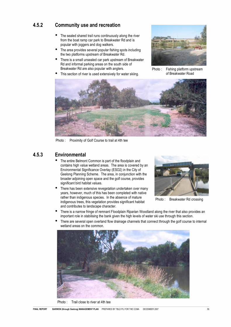
FINAL REPORT BARWON (through Geelong) MANAGEMENT PLAN PREPARED BY TBLD P/L FOR THE CCMA DECEMBER 2007 55
Photo : Proximity of Golf Course to trail at 4th tee
Photo : Fishing platform upstreamof Breakwater Road
Photo : Breakwater Rd crossing
4.5.2 Community use and recreation
• The sealed shared trail runs continuously along the riverfrom the boat ramp car park to Breakwater Rd and ispopular with joggers and dog walkers.
• The area provides several popular fishing spots includingthe two platforms upstream of Breakwater Rd.
• There is a small unsealed car park upstream of BreakwaterRd and informal parking areas on the south side ofBreakwater Rd are also popular with anglers.
• This section of river is used extensively for water skiing.
4.5.3 Environmental• The entire Belmont Common is part of the floodplain and
contains high value wetland areas. The area is covered by anEnvironmental Significance Overlay (ESO2) in the City ofGeelong Planning Scheme. The area, in conjunction with thebroader adjoining open space and the golf course, providessignificant bird habitat values.
• There has been extensive revegetation undertaken over manyyears, however, much of this has been completed with nativerather than indigenous species. In the absence of matureindigenous trees, this vegetation provides significant habitatand contributes to landscape character.
• There is a narrow fringe of remnant Floodplain Riparian Woodland along the river that also provides animportant role in stabilising the bank given the high levels of water ski use through this section.
• There are several open overland flow drainage channels that connect through the golf course to internalwetland areas on the common.
Photo : Trail close to river at 4th tee

FINAL REPORT BARWON (through Geelong) MANAGEMENT PLAN PREPARED BY TBLD P/L FOR THE CCMA DECEMBER 2007 56
4.5.4 Cultural values
• There is a heritage overlay in the City of Greater Geelong Planning Scheme that covers most of BelmontCommon (HO 1756) relating to use of the site for early aviation. This does not cover the CorangamiteCMA managed land along the river.
4.5.5 ZONE 5: BELMONT COMMONBoat Ramp to Breakwater Rd
Overall Management Objectives
• Liaise with Council to review safety of the shared trail in proximity to the golf course. Confirm landownership boundaries and review fencing and alignment of some holes to improve safety for trail users.
• Retain the 'wilderness' feel of this area by minimising built infrastructure aside from ongoing maintenanceand improvement of existing picnic areas at the boat ramp and fishing platforms near Breakwater Rd.
• Undertake staged removal of planted 'Australian Natives' on the river side of the path revegetating withindigenous species to restore a more natural continuous Floodplain Riparian Woodland community alongthe river.
• Retain existing planted 'Australian Natives' on the western side of the path away from the river. Establishpatches of indigenous revegetation focusing on drainage lines with connections to the river to improvehabitat links to wetland areas in the golf course and Jerringhot Sanctuary.
• Upgrade directional and regulatory signage at key entries.
• Liaise with Council and VicRoads during the planning process for replacement of the low level bridge atBreakwater Rd to ensure impact on the river is minimised and opportunities for environmentalimprovement at the Geelong Motorcross site are maximised.
4.5.6 Zone 5 Management Recommendations
4.5.6.1 ZONE 5 ENVIRONMENT
No Issue Recommendation Agency Priority
E1/5 Trail is in close proximity to the
river in many areas and may limitopportunities for futurerevegetation and improvement ofhabitat values.
Investigate re-alignment of the trail away from the river
where possible. Subject to confirmation oflandownership and resolution of fencing and safetyissues associated with the golf course. Refer R1/5 andLU1/5.
CCMA
CoGG
High
E2/5 There are small patches of
Willows along the river.
Remove and undertake revegetation works.
Investigate co-ordination with first stage removals ofAustralian Natives along the river. Refer E3/5.
CCMA Moderate
E3/5 Large areas of planted nativesprovide an important contributionto landscape character and habitat
values but limit opportunities fornatural regeneration of indigenousvegetation communities.
• Undertake staged removal of Australian Nativeson the riverside of the path revegetating withindigenous species to restore a more natural
continuous Floodplain Riparian Woodlandcommunity along the river.
• Undertake staged removal of planted 'Australian
Natives' on the western side of the path awayfrom the river and revegetation with indigenousspecies. Commence works on drainage lineswith connections to the river to improve habitat
links to wetland areas in the golf course andJerringhot Sanctuary.
CCMA
CCMA
Moderate
Low
E4/5 Golf club and sporting fields
restrict connection between highvalue wetland areas at JerringhotSanctuary and the river.
Liaise with Council and Friends of Jerringet Wetlands
to investigate opportunities for improvement ofvegetation and hydraulic conditions to improve habitatlinks between internal wetland areas and the river.
CCMA
CoGG
GFN
Low

FINAL REPORT BARWON (through Geelong) MANAGEMENT PLAN PREPARED BY TBLD P/L FOR THE CCMA DECEMBER 2007 57
4.5.6.2 ZONE 5 RECREATION
No Issue Recommendation Agency Priority
R1/5 Golf Course is in close proximity tothe shared path in several areas
and protective fencing does notappear to provide adequateprotection for trail users. Keyareas include 4th tee, 4th green,
5th green, 6th green and 12thgreen. Refer LU1/5.
Liaise with Council and the golf course to reviewexisting land ownership (refer LU1/6) and undertake a
review of existing protective fencing and potentialrealignment of some holes to improve safety for trailusers. Refer R1/5 and LU1/5.
CCMA
CoGG
Barwon ValleyGolf Club
Very High
R2/5 Overhanging vegetation along theshared path (especially non
indigenous planted She oaks) iscontributing to high levels of debrison the path.
Review proximity of trees to the path. Refer E3/5 andin the short term increase levels of maintenance to
reduce debris hazards for path users.
CCMA Ongoing
R3/5 Future new bridge crossing at
Fellmongers Rd may provideopportunities for improvedconnection across the river,including links to the Bellarine Rail
Trail.
Refer LU4/5 VicRoads
CoGG
CCMA
High
R4/5 Lack of directional, regulatory andwarning signage at key entry
points.
• Install new entry signage at Boat ramp car park
and Breakwater Rd car park including integratingupgraded warning signage. Refer 5.5.7.1.
• Install minor directional signage entry to Council
owned path along the southern edge of the golfcourse
CCMA
CCMA
High
Low
R5/5 Timber platforms on the river
upstream of Breakwater Rdprovide access at this popularfishing location.
• Implement recommendations of the Risk
Management Report 2006 including review ofdesign in accordance with Australian Standards,installation of life buoys and upgraded warningsignage. Refer 5.5.5.2.
CCMA High
R6/5 Lack of rubbish bins. Install 240 litre rubbish and recycling bins at machineaccessible entry points and remove other bins through
the reserve. This will include:
• Boat ramp car park
• Breakwater Rd car park
CCMA High
R7/5 Uncontrolled vehicle access southof Breakwater Road is contributing
to bank erosion and rubbishdumping along the river andgenerally undesirable after hoursactivity.
Restrict vehicle access to this area and undertakeWillow removal and revegetation works as outlined at
E2/5. Retain unsealed walking path access for fishingwith small parking area away from the river and visiblefrom Breakwater Rd for security.
CCMA Moderate
4.5.6.3 ZONE 5 ADJOINING LAND USE AND MANAGEMENT
No Issue Recommendation Agency Priority
LU1/5 Barwon Valley Golf Club is in closeproximity to the river and sharedtrail in several areas (refer R1/5)and some holes (4th tee) may be
on CCMA land.
• Undertake survey to confirm land ownershipalong the golf course frontage.
• Liaise with Council and Golf Club to review
fencing and alignment of some holes as outlinedin R1/5 and opportunities to realign the path forimprovement of environmental values along the
river as outlined in E1/5.
• Monitor any potential impact of herbicide andfertiliser use by the Golf Club on the river.
CCMA
CoGG
Barwon ValleyGolf Club
Very High
LU2/5 Recent complaints to Policeregarding after hours use have ledto closure of toilet facilities and
removal of some dense vegetationby Council near the boat ramp carpark. Toilet facilities have alsobeen closed between Latrobe Tce
and Moorabool St.
Liaise with Council and Police to monitor complaintsregarding after hours use of areas surrounding theboat ramp car park and co-ordinate vegetation
management with Council as required.
CCMA
CoGG
Vic Police
Ongoing

FINAL REPORT BARWON (through Geelong) MANAGEMENT PLAN PREPARED BY TBLD P/L FOR THE CCMA DECEMBER 2007 58
No Issue Recommendation Agency Priority
LU3/5 Existing Geelong Motorcross Clubwith large areas of dumped fill andunsealed tracks is a potentialsource of weed invasion and an
inappropriate long term use in anarea subject to frequent flooding.Planning for the future bridgecrossing at Fellmongers Rd may
provide an opportunity to improveland use in this area.
Liaise with VicRoads and Council as part of planningprocess for new bridge to confirm integration of thenew bridge and any proposed site remediation worksproposed along the river.
VicRoads
CoGG
CCMA
High
LU4/5 There is no available information
on the proposed upgrade of theexisting low bridge crossing atBreakwater Rd.
Refer LU4/5 CCMA
CoGG
VicRoads
High
4.5.6.4 ZONE 5 CULTURAL HERITAGE
No Issue Recommendation Agency Priority
H1/5 The entire Barwon River is of
cultural significance to theWathaurong. There is limitedinformation on aboriginal culturalvalues through this section of the
river.
Liaise with Wathaurong during planning for any
proposed works that may impact on cultural heritagevalues.
CCMA
WACL
Ongoing
4.5.6.5 ZONE 5 GENERAL MAINTENANCE
No Issue Recommendation Agency Priority
M1/5 Belmont Common
Existing maintenance level priority
is low as there is very little grassthrough this section. Drainage linesunder path from Belmont Commonare subject to frequent blockage
and there is a high level of debrison path due to overhanging trees.
• Implement general recommendations for car parkand path maintenance and inspection ofstructures. Refer 5.9.2.
• Retain low levels of mowing undertakingoccasional slashing only.
• Undertake mechanised sweep of the path toremove high levels of debris from overhangingtrees.
• Undertake review and ongoing clearance ofdrainage lines under path from Belmont Commonto reduce localized flooding and build up ofdebris on the path.
CCMA High
Low
High
High


FINAL REPORT BARWON (through Geelong) MANAGEMENT PLAN PREPARED BY TBLD P/L FOR THE CCMA DECEMBER 2007 59
Photo : Adjoining industrial properties
4.6 ZONE 6: WAL WHITESIDE WALKSwanston St (Landy Field) to Breakwater Rd (northbank)
DESCRIPTIONThis reach extends fromSwanston Street and JohnLandy Athletics Field along theeast bank of the river toBreakwater Road. The area wasnamed after R.W. (Wal)Whiteside former Chairpersonfor Barwon Water.
EXISTING MANAGEMENTThe area along the river isdirectly managed by theCorangamite CMA.
BUILT ASSETS
• Unsealed car park atBreakwater Road
• Sealed asphalt path fromSwanston St (Landy Field) toFactories Rd (0.2km)
• Granitic gravel path fromFactories Road toBreakwater Rd (1.6km)
• Timber boat landing adjacentto Factories Rd
• Drinking fountain
• Seating (6 No.)
• Carved logs naming the WalWhiteside Walk with BarwonWater logo.
4.6.1 Adjoining land use and landscape character
• Corangamite CMA manage all public open spacealong the Wal Whiteside Walk from Swanston St toBreakwater Rd.
• Adjoining land use in South Geelong is heavyindustrial including the historic Godfrey HirstPrecinct at Swanston St and extending to newindustrial estates being developed south of WoodSt.
• The DSE managed former landfill site adjoins thesouthern end of the site.
• The Wal Whiteside Walk has been heavilyrevegetated and in most areas is screened fromadjoining industrial areas.

FINAL REPORT BARWON (through Geelong) MANAGEMENT PLAN PREPARED BY TBLD P/L FOR THE CCMA DECEMBER 2007 60
4.6.2 Community use and recreation
• Wal Whiteside Walk is sealed from Swanston St downstream to Factories Rd. It then runs as anunsealed path down to the car park at Breakwater Rd.
• The small picnic area at the end of Swanston St provides views to the river and accessible parking. It ispopular with local workers and people accessing the area by car.
• There is a large timber platform between Swanston St and Factories Rd providing an important boat tieup on busy weekends.
• Potential future links to the Bellarine Rail Trail were identified at Steel St in the BRLUP.
• Establishment of plantings through the area has included successful partnerships with community groupsincluding Tate St Primary School, Matthew Finders Secondary College, Corilong and the Office ofCorrectional Services.
4.6.3 Environmental
• There has been extensive revegetation undertaken along the Wal Whiteside Walk over the past 15 yearsand the majority of existing vegetation has been planted as part of reclamation of former industrial landand landfill sites.
• Early plantings appear to have focused on 'beautification' of the area and included a significant proportionof exotic plantings many of which are weed species in waterway environments. There has also beenextensive planting of Australian Natives including Melaleuca and Casurina sp. Recent plantings havefocused on indigenous revegetation although the provenance of this planting is unknown.
• There is remnant Floodplain Riparian Woodland Community in a narrow strip along the bank and asignificant Aquatic Herbland of significance in a semi permanent pool beside the railway line.
• There is an open drain connection to the river at Steel St. The water quality in this channel appears poordue to the industrial catchment and surrounding unsealed roads.
Photo : Potential Bellarine Rail Trail link atSteel St
Photo : Unsealed Wal Whiteside Walk
Photo : Planted exotic trees Photo : Narrow band of Floodplain RiparianWoodland

FINAL REPORT BARWON (through Geelong) MANAGEMENT PLAN PREPARED BY TBLD P/L FOR THE CCMA DECEMBER 2007 61
4.6.4 ZONE 6: WAL WHITESIDE WALKLatrobe St (Landy Athletics Field) to Breakwater Rd (north bank)
Overall Management Objectives
• Retain the existing unsealed shared path retaining clearance to vegetation for sightlines and undertakingperiodic grooming to maintain a quality walking track consistent with the improving environmental valuesof the area. This path may be sealed at a later date subject to potential increased use as part of theBarwon Valley Parklands Project.
• Provide additional seats at key viewing points along the path, however, minimise built infrastructurefocusing on maintenance of existing picnic areas at Swanston St entry only.
• Maintain, and in the longer term, upgrade the timber boat tie up platform including regulatory signageregarding boat use on this section of river.
• Remove planted exotic trees from the reserve and undertake woody weed control along the river toremove remaining sections of Willows to promote continued natural regeneration of Floodplain RiparianWoodland communities.
• Continue existing program of revegetation using indigenous species of local provenance. Longer term,review existing 'native' planting and undertake selective removal to increase groundlayer diversitytargeting area of predominantly indigenous species.
• Liaise with Barwon Water staff who are associated with historical revegetation programs in the reserve todocument and record the provenance of indigenous revegetation planting undertaken throughout thisarea which is often used for seed collection.
• Liaise with the EPA to monitor water quality in the Steel St drainage channel and liaise with Council toinvestigate treatment opportunities for a linear treatment system in the unmade road reserve.
• Upgrade direction signage at all entries and develop interpretive signage regarding both the richindustrial heritage and improving environmental values.
4.6.5 Zone 6 Management Recommendations
4.6.5.1 ZONE 6 ENVIRONMENT
No Issue Recommendation Agency Priority
E1/6 Patches of woody weeds along theriver including Willows andextensive groundlayer weeds limit
opportunities for naturalregeneration of fringing FloodplainRiparian Woodland vegetation.
Undertake woody weed removal works followed byactive indigenous revegetation of disturbed areas tominimise erosion of bank areas during peak water
skiing season.
CCMA High
E2/6 Planted exotic trees are relatively
young and should be removedbefore they contribute further todownstream weed invasion andbecome a landscape feature.
Undertake immediate removal of all planted exotic
trees and replacement with indigenous overstorey.
CCMA High
E3/6 Non-indigenous nativerevegetation while important in theearly establishment of planting in
the reserve has established amodified landscape that limitsopportunities for long termimprovement of environmental
values.
Review existing 'native' planting and undertakeselective removal to increase ground layer diversitytargeting area of predominantly indigenous species
and restoring them to more natural Floodplain RiparianWoodland Community. Refer E5/6.
CCMA Moderate
E4/6 Provenance of indigenous planting
through this area is largelyunknown and may be used forseed collection.
Engage Barwon Water staff associated with the early
development of the reserve to document theprovenance and history of both historical and recentrevegetation works. (Refer also E3/6 and E5/6).
CCMA
BW
High
E5/6 Currently, this is a lowmaintenance zone with slashing ofopen grass areas that have beensubstantially reduced overtime as
revegetation areas have beenextended. Increasinglymaintenance works will focus onmanagement of revegetation
areas.
Develop a specific vegetation management plan forthis area to guide future revegetation works.Following removal of targeted weeds as outlined inE1/6 and E2/6, plan is to focus on improvement and
development of sustainable weed managementstrategies for existing weeds and remediation ofnative planting areas as outlined in E3/6 prior toundertaking further works in this area.
CCMA
BW
High

FINAL REPORT BARWON (through Geelong) MANAGEMENT PLAN PREPARED BY TBLD P/L FOR THE CCMA DECEMBER 2007 62
No Issue Recommendation Agency Priority
E6/6 There is a large open drainconnecting to the river at Steel St.The water quality in this drainappears poor and there is
significant risk of contaminationgiven adjoining industrial use inSouth Geelong.
• Liaise with EPA to undertake monitoring of waterquality in the drain and review need for riskwarning signage as outlined in the Risk
Management Report 2006.
• Liaise with Council to investigate establishmentof a linear water quality treatment system in the
Council owned unmade road reserve.
EPA
CoGG
CCMA
High
Moderate
E7/6 Future bridge crossing upstream of
Breakwater Rd at Fellmongers Rdmay impact on hydrologicalprocesses important to the
significant Aquatic HerbfieldCommunity located near therailway crossing.
Liaise with VicRoads during the development and
planning for any future bridge crossing at FellmongersRd to minimise impact on hydraulic processes requiredto sustain the significant Aquatic Herbfield community.
CCMA
VicRoads
High
4.6.5.2 ZONE 6 RECREATION
No Issue Recommendation Agency Priority
R1/6 Existing trail is predominantlyunsealed.
Retain existing unsealed trail consistent with lower
levels of walking use and improving environmentalvalues. Note: If use increases as part of linksdeveloped through the Barwon River ParklandsProject, liaise with Parks Victoria and Council to
consider sealing this access then.
CCMA Ongoing
R2/6 Potential future connection to theBellarine Rail Trail at Steel St may
increase use of the Wal WhitesideWalk.
Following future connection of the Bellarine Rail Trailto the Wal Whiteside walk at Steel St. upgrade and
seal the section of unsealed path between FactoriesRd and Steel St to accommodate expected higherlevels of use.
CCMA Low
R3/6 Lack of directional and regulatorysignage at key entry points.
• Install new entry signage at Swanston St and
Breakwater Rd car park including integratingupgraded warning signage as outlined in RiskManagement Report 2006.
• Upgrade to major entry signage at Swanston Stand access from car park at Breakwater Rd.
• Install minor directional signage at Steel St
CCMA
CCMA
High
Low
R4/6 Timber platform betweenSwanston St and Factories Rd
provides a popular boat tie up onbusy weekends.
Implement recommendations of the Risk ManagementReport 2006 including review of design in accordance
with Australian Standards, installation of life buoys andupgraded warning and regulatory signage regardingconditions for boating use on the river.
CCMA High
R5/6 Lack of seating along the riverbetween Steel St and Breakwater
Rd.
Install additional bench seats facing key views to theriver. Refer 5.5.3.2.
CCMA Low
R6/6 Lack of rubbish bins. Install 240 litre rubbish and recycling bins at machine
accessible entry points and remove other bins throughthe reserve. This will include:
• Swanson St entry
• Breakwater Rd car park
CCMA High
4.6.5.3 ZONE 6 ADJOINING LAND USE AND MANAGEMENT
No Issue Recommendation Agency Priority
LU1/6 Rear of industrial properties
directly adjoins the trail in someareas with limited room for buffervegetation or screening. Draft RiskManagement
Report 2006 also identifiedpotential risk to path users fromchemical or other hazardousmaterial storage or work practices
in these areas.
• Liaise with adjoining landholders to review
chemical storage and works practices inproximity to the path as outlined in the RiskManagement Report 2006.
• Maintain existing dense screening vegetation tothe rear boundary fences.
• Liaise with adjoining industrial landholders to
investigate complementary planting opportunitieswithin private property adjoining the river and
CCMA
Landholders
CCMA
CCMA
Landholders
High
Ongoing
Moderate

FINAL REPORT BARWON (through Geelong) MANAGEMENT PLAN PREPARED BY TBLD P/L FOR THE CCMA DECEMBER 2007 63
No Issue Recommendation Agency Priority
open space corridor to improve landscape andenvironmental values.
LU2/6 Path may be used by vehicles to
access rear boundary yards ofsome properties in areas south ofFactories Rd.
Secure vehicle control fencing and gates to prevent
unauthorised access to the public reserve. If privateaccess is required ensure development andimplementation of required OHS Protocol includingwritten permit and conditions to maintain safety for trail
users and workers in accordance with therecommendations of the Risk Management Report2006.
CCMA
Landholders
High
4.6.5.4 ZONE 6 HERITAGE
No Issue Recommendation Agency Priority
H1/6 Lack of interpretative information
on the trail regarding industrialheritage values.
Liaise with adjoining industrial users including Godfrey
Hirst to investigate development of interpretivesignage highlighting the long and continuing history ofindustrial land use in this area of Geelong.
CCMA
Landholders
Moderate
H2/6 The entire Barwon River is of
cultural significance to theWathaurong. There is limitedinformation on Aboriginal cultural
values through this section of theriver.
Liaise with Wathaurong during planning for any
proposed works that may impact on cultural heritagevalues.
CCMA
WACL
Ongoing
4.6.5.5 ZONE 6 MAINTENANCE
No Issue Recommendation Agency Priority
M1/4 Wal Whiteside Walk
Existing maintenance level priorityis low, however, there areextensive areas of grass andrevegetation areas.
• Implement general recommendations for car parkand path maintenance and inspection of
structures. Refer 5.9.2.
• Maintain grass areas within 1.0m of the path to ahigh standard to minimise risk from snakes.
• Maintain grass to a high standard at Swanston Stand around the boat tie up platform. Monitorarea for broken glass and other sharps given
high levels of barefoot use.
• Retain low levels of mowing undertakingoccasional slashing only in areas away from the
path.
• Most revegetation areas are well established anddo not require high levels of maintenance subject
to review as part of capital worksrecommendations.
CCMA High
High
High
Low
Low


FINAL REPORT BARWON (through Geelong) MANAGEMENT PLAN PREPARED BY TBLD P/L FOR THE CCMA DECEMBER 2007 64
Photo : Ovoid Sewer Aqueduct Bridge
4.7 ZONE 7: SEWER AQUEDUCT BRIDGEBreakwater Rd to Boundary Rd (north bank)
DESCRIPTIONThis zone extends from Breakwater Road along the north bank to Boundary Road. There is no public openspace along the river immediately downstream of Breakwater Rd.
EXISTING MANAGEMENTCorangamite CMA directly manage the river frontage from Tucker Street to Boundary Road. Barwon Waterowns the Sewer Aqueduct Bridge and manages the adjoining floodplain area and Goat Island.
BUILT ASSETS
• Temporary canoe landing platforms enabling portage of canoes around the Sewer Aqueduct Bridge viathe south bank.
4.7.1 Adjoining land use and landscape character
• The area surrounding the Sewer AqueductBridge is part of the floodplain and zoned PublicConservation Resource Zone (PCRZ).
• The heritage listed Sewer Aqueduct Bridge isowned by Barwon Water. The bridge is aspectacular landscape feature across the gentlyundulating floodplain.
• Adjoining land use is industrial and there arelimited views into the site from Leather St.Land use on the southern bank is currentlyrural.

FINAL REPORT BARWON (through Geelong) MANAGEMENT PLAN PREPARED BY TBLD P/L FOR THE CCMA DECEMBER 2007 65
Photo : Temporary canoe access landing onsouth bank
Photo : Access under the Sewer Aqueduct Bridgeis prevented by buoys.
4.7.2 Community use and recreation
• There is no formal recreational use in this zone andthe Sewer Aqueduct Bridge is fenced off to preventaccess on or under it due to structural safetyconcerns. There is no boat use permitted along theriver under the bridge and access is fenced off withfloating buoys maintained by Barwon Water.
• The area is used informally for fishing and walkingand there are numerous tracks through thevegetation to and along the river.
• The land downstream of Breakwater Rd is privatelyowned and there is no link to this area from theexisting trail network.
4.7.3 Environmental
• The area around the Sewer Aqueduct Bridge supportssignificant remnant vegetation communities includingFloodplain Riparian Woodland, Brackish LignumSwamp, Brackish Wetland and Brackish Herbland thathave been largely degraded in other areas due tograzing or urban development.
• There are still some saline influences as evidence bythe significant Brackish Lignum Swamp, BrackishWetland and Brackish Herbland Communitiesidentified during assessment of the Corangamite CMAmanaged river frontage. Refer Attachment #1.
• This area including Goat Island provides significanthabitat values and provides an important link to ReedyLake.
4.7.4 Cultural values
• The Sewer Aqueduct Bridge is listed on the National Estate Register and Victoria Heritage Register.Heritage Victoria has previously undertaken tests for restoration of the bridge using a technique fromFrance. If successful, they will apply for funding to restore the bridge.
4.7.5 ZONE 7: SEWER AQUEDUCT BRIDGEBreakwater Rd to Boundary Rd
Overall Management Objectives
• Liaise with Barwon Water to prepare a Vegetation Management Plan for protection of significant remnantindigenous floodplain vegetation communities around the Sewer Aqueduct Bridge addressing issuesincluding public access, rabbits and impacts on hydraulic processes from adjoining industrialdevelopment.
• Liaise with Barwon Water and Heritage Victoria to confirm long term future for the Sewer AqueductBridge. Short term, investigate restoration of restricted public access for canoeists along the river underthe bridge using a structure to protect users from falling debris.

FINAL REPORT BARWON (through Geelong) MANAGEMENT PLAN PREPARED BY TBLD P/L FOR THE CCMA DECEMBER 2007 66
4.7.6 Zone 7 Management Recommendations
4.7.6.1 ZONE 7 ENVIRONMENT
No Issue Recommendation Agency Priority
E1/7 Informal public access through the
site for walkers, trail bikes andfishing is contributing to weedinvasion and degradation of flora
and fauna values.
Liaise with Barwon Water to prepare a Vegetation
Management Plan for protection of significant remnantindigenous floodplain vegetation communities aroundthe Sewer Aqueduct Bridge addressing issues
including public access, rabbits and impacts onhydraulic processes from adjoining recent industrialdevelopment.
BW
CCMA
High
E2/7 Restriction on access under theSewer Aqueduct Bridge meanswater ski boats turn around southof the bridge and wash iscontributing to bank erosion.
Investigate revegetation and rock stabilisation toaddress back erosion issues at boat turn around area.
BW
CCMA
Geelong Water
Ski Club
Low
E3/7 Lack of access to Goat Islandmaximises habitat value, however,there is a lack of maintenance toremove woody weeds including
Willows that may contribute todownstream invasion along theriver.
Undertake weed removal and revegetation on GoatIsland to improve habitat values and reduce potentialspread of invasive weeds.
BW Moderate
E4/7 Rabbits are uncontrolled through
the site and are contributing todegradation of significantvegetation values across the
floodplain.
Liaise with Barwon Water and adjoining private
landholders on Leather St and Boundary Rd toaddress rabbits as part of preparation of a VegetationManagement Plan.
BW
CCMA
Landholders
DPI
High
E5/7 Stormwater input from existing andnew development along Leather Sthas potential to impact on existing
significant brackish vegetationcommunities through additionalflow of fresh water.
Liaise with Council and Barwon Water to reviewstormwater connections from recent industrialdevelopment along Leather St and monitor any
changes in vegetation communities.
CoGG
CCMA
BW
Very high
4.7.6.2 ZONE 7 RECREATION
No Issue Recommendation Agency Priority
R1/7 Structural condition of the Sewer
Aqueduct Bridge presents risk topublic access with large chunks ofdebris frequently falling into theriver and adjoining public reserve.
There is no access under thebridge and canoeists currentlyhave to carry their boats aroundthe structure. .
• Short term, investigate establishing narrow
restricted public access along the river under thebridge on the north bank adjacent to the water.Use a construction cage or similar reinforced
steel structure to protect canoeists and otherriver users from falling debris and enablerestoration of access along the river (subject todetailed investigation).
• Long term, confirm potential for futurerestoration of the bridge.
BW
HeritageVictoria
High
R2/7 There have been temporarylandings installed on the southbank for major canoe eventshowever these do not appear
sustainable long term and maypresent significant public risk.
• Remove existing temporary platforms.
• Investigate establishment of permanent landing
platforms for both fishing and canoe portagearound Sewer Aqueduct Bridge. Refer R1/7.
CCMA
BW
GCC
GAC
Very high
High
R3/7 There is no trail link to connect
this large area of public openspace to the main trail andresidential areas. Existinginformal and uncontrolled access
by walkers, dog walkers, trailbikes and fishing is impacting onenvironmental values.
Review recommendations of the BRLUP as part of
development of the proposed Vegetation ManagementPlan. Refer E1/7. BRLUP recommendations to beinvestigated as part of a site plan included:
• Protection and restoration of wetland and
floodplain values.
• Establishment of a signed on road link from theWal Whiteside Walk across Breakwater Rd
along Tucker St and into the reserve connectingthrough to Boundary Rd.
• Development of appropriate passive recreation
facilities including the shared trail, a secondarywalking loop, seating/viewing areas andinterpretative signage regarding both the bridgeand environmental values
CCMA
CoGG
Moderate

FINAL REPORT BARWON (through Geelong) MANAGEMENT PLAN PREPARED BY TBLD P/L FOR THE CCMA DECEMBER 2007 67
4.7.6.3 ZONE 7 ADJOINING LAND USE AND MANAGEMENT
No Issue Recommendation Agency Priority
LU1/7 There is no public access alongthe river from Breakwater Rd to the
site.
If private land along the eastern bank downstream ofBreakwater Rd is redeveloped negotiate increased
setback from the river to establish public access andallow for environmental improvements along the river.
CoGG Ongoing
LU2/7 Industrial development along
Leather St is visually intrusive andstormwater discharge may beimpacting on significant vegetation
communities. Refer E5/7.
Liaise with Council, Barwon Water and adjoining
landholders as part of preparation of a VegetationManagement Plan for the site including minimisingstormwater impacts on the site and opportunities to
improve buffer planting. Refer E1/7.
CoGG
BW
CCMA
Landholders
High
LU3/7 Rural land on the southern bank iszoned industrial and may be
subject to future development.
Implement recommendations of the BRLUP forapplication of an Environmental Significance Overlay
and Significant Landscape Overlay to minimise visualand environmental impact on the waterway corridor.
CoGG High
4.7.6.4 ZONE 7 CULTURAL HERITAGE
No Issue Recommendation Agency Priority
H1/7 Current status of options forrepair/restoration of the seweraqueduct bridge are unknown.
The BRLUP supported restorationof the bridge (subject to theoutcomes of the tests) for itspotential to provide a viewing point
and potentially longer term acrossing point if land along thesouthern bank is redeveloped.
Barwon Water and Heritage Victoria to confirm currentstatus of proposals for the bridge.
BW
HV
Ongoing
H2/7 The entire Barwon River is ofcultural significance to theWathaurong. There is limited
information on Aboriginal culturalvalues through this section of theriver.
Liaise with Wathaurong during development ofproposed Vegetation Management Plan to furtherinvestigate cultural heritage and archaeological values.
Refer E1/7.
CCMA
BW
WACL
High
4.7.6.5 ZONE 7 MAINTENANCE
No Issue Recommendation Agency Priority
M1/6 There is currently no active
maintenance on the site.
Liaise with Barwon Water to confirm vehicle control
around the site to limit trail bike access. (Note: Furtherintegrated management outcomes to be confirmed aspart of development of the recommended VegetationManagement Plan. Refer E1/7)
BW
CCMA
High

FINAL REPORT BARWON (through Geelong) MANAGEMENT PLAN PREPARED BY TBLD P/L FOR THE CCMA DECEMBER 2007 68
4.8 ZONE 8: RURAL ZONEBoundary Rd to lower breakwater (Reedy Lake -south bank)
DESCRIPTIONThis zone covers the rural reach from Boundary Road to the lower breakwater.
EXISTING MANAGEMENTThe majority of this land is privately owned rural grazing land with Geelong Water Ski Club owning frontageat Wilsons Road. Corangamite CMA manage an area of river frontage along the south bank of the riverupstream of the lower breakwater that is leased back to the adjoining landholder as grazing land. ParksVictoria manage Reedy Lake and Lake Connewarre downstream of the lower breakwater and along thenorthern bank upstream.
BUILT ASSETS
• Lower breakwater and fish way
• Temporary canoe landing platforms enabling portage of canoes around the breakwater via the southbank

FINAL REPORT BARWON (through Geelong) MANAGEMENT PLAN PREPARED BY TBLD P/L FOR THE CCMA DECEMBER 2007 69
Photo : Cropping of CCMA lease land along the riverPhoto : Ski jump
Photo : Lower breakwater
4.8.1 Adjoining land use and landscape character
• Downstream of Boundary Rd to the lower breakwater and Reedy Lake the land use is rural. TheCorangamite CMA manage a small section of Crown frontage on the southern bank upstream of thelower breakwater however this land is leased to the adjoining landholder for grazing.
• There is limited indigenous overstorey planting and the bank is frequently grazed right down to the river.
• Downstream of the lower breakwater and along the northern bank at Reedy Lake the land is managed byParks Victoria and there is an extensive bank of reeds that limits views from the river.
4.8.2 Community use and recreation
• Geelong Water Ski Club uses this section of the river. The club have several semi permanentstructures/jumps in the river and their boat launching area is at Wilsons Rd.
• The area is popular for canoeing and temporary landings have been established upstream anddownstream at the lower breakwater to enable canoes to pass.
4.8.3 Environmental
• There are scattered remnant Red Gums and some areas of regenerating fringing vegetation however themajority of this reach is subject to grazing right to the river.
• There is a fish way at the lower breakwater.
Photo : Stock access to fish way at lowerbreakwater

FINAL REPORT BARWON (through Geelong) MANAGEMENT PLAN PREPARED BY TBLD P/L FOR THE CCMA DECEMBER 2007 70
Photo : Remnant River Red Gums Photo : Stock access causing erosion
Photo : Private structures on bank
4.8.4 Cultural values
• There is limited information on cultural heritage values through this section.
4.8.5 ZONE 8: RURAL ZONEBoundary Rd to the lower Breakwater (Reedy Lake)
Overall Management Objectives
• Liaise with adjoining private landholders to improve land management practices and environmentalvalues along the river.
• Maintain existing levels of water skiing use and monitor ongoing environmental impacts.
• Commence active revegetation and regeneration of public land along the river to improve environmentallinks along the river to Reedy Lake and Lake Connewarre.
4.8.6 Zone 8 Management Recommendations
4.8.6.1 ZONE 8 ENVIRONMENT
No Issue Recommendation Agency Priority
E1/2 There is limited indigenous
overstorey vegetation through thisreach and overgrazing, croppingand stock access right to the riverin addition to water ski access that
is contributing to bank erosion andreducing opportunities for naturalregeneration of FloodplainRiparian Woodland Communities.
Liaise with adjoining landholders to investigate fencing
and revegetation along the river to improve habitatvalues and reduce erosion. Refer LU1/8.
CCMA
Geelong WaterSki Club
Landholders
High
Photo : Online take offs to private dams

FINAL REPORT BARWON (through Geelong) MANAGEMENT PLAN PREPARED BY TBLD P/L FOR THE CCMA DECEMBER 2007 71
No Issue Recommendation Agency Priority
E2/8 Willows, Elms and Ash in severalareas on private land may impacton high value vegetation areas atReedy Lake and Lake
Connewarre.
Liaise with private landholders to remove invasiveweed species along the river. Refer LU1/8.
CCMA
Landholders
High
E3/8 Stock access to the fish way hasreduced its effectiveness and thelower breakwater may be again a
barrier to fish passage.
Review the design and construction of the fish way atthe lower breakwater.
CCMA Very High
4.8.6.2 ZONE 8 RECREATION
No Issue Recommendation Agency Priority
R1/8 Wash from ski boats is contributingto bank erosion especially wheregrazing has removed vegetation
from the bank and at turnaroundareas.
Liaise with adjoining private landholder to activelystabilise banks at boat turn around areas.
CCMA
Geelong WaterSki Club
Landholders
Ongoing
R2/8 Temporary landings for canoeists
at the lower breakwater may not besustainable long term.
Remove temporary platforms and install permanent
landings and signage as part of proposed upgrade ofthe lower breakwater and fish way. Refer E3/8
CCMA
PV
GCC
High
R3/8 There is no CCMA warning andregulatory signage at the Geelong
Water Ski Club boat ramp. Thereis no approach signage on the riverwarning of the lower breakwater.
• Upgrade warning signage on approach to thelower breakwater.
• Liaise with Geelong Water Ski Club to installregulatory and warning signage at the boat rampoutlining conditions for boating use on the river
CCMA Very high
High
4.8.6.3 ZONE 3 ADJOINING LAND USE AND MANAGEMENT
No Issue Recommendation Agency Priority
LU1/8 CCMA leased land along the river
is currently being cropped. Thiscould lead to substantial erosion ina flood event and is an
inappropriate land use along theriver floodplain.
• Remove cropping and grazing from leased land
along the river frontage.
• Investigate provision of offline stock watering
points to reduce bank erosion.
• Commence revegetation with establishment ofscattered overstorey and review opportunities to
encourage natural regeneration of indigenousfloodplain vegetation along the river.
CCMA
CCMA
Very High
High
LU2/8 There is limited indigenous riparian
vegetation on private landadjoining the river and stockovergrazing and accessing the
river banks is contributing toaccelerated erosion in some areas.
• Liaise with landholders to investigate
partnerships for establishment of fencing andrevegetation to improve environmental valuesalong the river as part of the Healthy Rivers
Support Fund and Urban Stream RestorationsFund.
• Investigate provision of offline stock watering
points to reduce bank erosion.
CCMA
Landholder
Ongoing
LU3/8 There are several online channeltake offs diverting water from the
river to private dams.
Liaise with landholders and review existing permitsand conditions for water allocation along the river.
SRW
CCMA
Landholder
High
LU4/8 There are several privatestructures along the river that
appear in poor condition and maynot have current permits.
Liaise with landholders and review existing structureson private land along the river and confirm permit
requirements.
SRW
CCMA
Landholder
High
LU5/8 Title and future management of thelevee banks built by the HarbourTrust in the 1900's to protect
Sparrowvale and adjoining forms isunknown.
Liaise with CoGG and landholders to confirm leveetitle and management.
CoGG
CCMA
Landholder
Moderate

FINAL REPORT BARWON (through Geelong) MANAGEMENT PLAN PREPARED BY TBLD P/L FOR THE CCMA DECEMBER 2007 72
4.8.6.4 ZONE 8 MAINTENANCE
No Issue Recommendation Agency Priority
M1/8 There is currently no activemaintenance on the river through
this reach.
Undertake annual inspection of the fish way at thelower breakwater to confirm operation of this critical
link for fish migration.
CCMA Ongoing
M2/8 Geelong Water Ski Club maintains
several jumps and structures alongthis section of the river.
Monitor the location and operation of these structures
to ensure public safety and permit requirements aremet at all times.
CCMA
Geelong WaterSki Club
Ongoing
M3/8 Management of the lowerbreakwater has been undertakenon a voluntary basis for over 35
years.
Review management requirements as part ofproposed lower breakwater upgrade works.
CCMA
Landholders
High


FINAL REPORT BARWON (through Geelong) MANAGEMENT PLAN PREPARED BY TBLD P/L FOR THE CCMA DECEMBER 2007 73
5.1 Overall management responsibilities
The following issues and management recommendations relate or impact on the whole study area. Furtherdetail for specific management zones is contained in section 4.0.
5.1.1 Management responsibilities
No. Issue Recommendation Agency Priority
5.1.1.1 There are no formal lease or
management agreements for existingCouncil facilities such as toilet blocks onCCMA owned land.
Liaise with Council Assets Dept. to confirm
formal licence agreements for toilet facilitiesincluding operating hours, maintenance andlong term upgrade renovation/requirements.
CoGG
CCMA
Moderate
5.1.1.2 Potential procedural risk managementissues identified in the Draft BarwonRiver Risk Management Assessment
Report completed by Earthtech P/l 2006including but not limited to emergencyplanning, hazard identification andmanagement of third party service
providers, clubs, etc.
Implement the recommendations of the DraftBarwon River Risk ManagementAssessment Report completed by Earthtech
P/L 2006.
CCMA High
5.1.1.3 Lack of event management plans formajor sporting and community based
events along the river.
Liaise with the relevant sporting bodies andcommunity groups to develop and implement
specific event management plans for majorevents including:
� Emergency planning and issues as
outlined in the Draft Risk ManagementReport 2006
� Service provisions, power, water,toilets, rubbish collection, etc.
� Public access management includingfencing and crowd control
� Minimising the area and length of timethat general community access will berestricted to open space and the river.
CCMA
Eventorgansiers
High
5.1.1.4 Private functions and events in openspace along the river.
Applications for holding a private function orevent along the river should be assessed tomeet all of the following criteria:
� are alternative areas of open space forthe community to use in vicinity of riverwhere the event is proposed;
� will the event allow for continued
community use and access along theriver during the event;
� the event and associated
infrastructure will not unduly restrict orimpact on the use and enjoyment ofriver and open space by community;
� the event and associatedinfrastructure will not impact on theriver or reserve grounds, vegetation orfacilities;
� demonstrate the impact of noisegenerated from the event isacceptable and meets with Council'srequirements in relation to amplified
noise;
� that building approval is received forerection of any structure in the
reserve;
� demonstrate all waste will beadequately dealt with; and
� comply with Council's liquorconsumption guidelines.
CCMA Ongoing
5.0 OVERALL MANAGEMENT

FINAL REPORT BARWON (through Geelong) MANAGEMENT PLAN PREPARED BY TBLD P/L FOR THE CCMA DECEMBER 2007 74
No. Issue Recommendation Agency Priority
5.1.1.5 New or changes in commercial use ofbuildings or facilities along the river orreserves.
Applications would need to demonstrate thefollowing for consideration of this use:
� that proposed use or development
does not impact on existingenvironmental values;
� that proposed use or development
does not impact on existingestablished recreational use of theriver and reserves;
� that proposed use or development
complements and enhances thecommunity use of the river andreserve;
� that visual and physical access to theriver and reserves will not be reduced;
� there is a demonstrated community
need for the proposal;
� the proposal meets all relevantCouncil and State Governmentguidelines, policies and controls; and
� quality of the business plan putforward with the application.
If the development meets the criteria above,consultation with the community would needto be undertaken prior to confirming any use.
CCMA Ongoing
5.1.2 Funding
No. Issue Recommendation Agency Priority
5.1.2.1 Funding the works included in the plan. � Liaise with key management agencies
and community groups to coordinatefunding proposals to integrate worksduring implementation of on groundworks.
� Support community groups in fundingproposals for minor works inaccordance with the priorities set outin the management plan.
� Where appropriate, investigatecontributions towards open spacemanagement as part of major events
held on the site. Refer 5.1.1.3, 5.1.1.4and 5.1.1.5.
COGG
CCMA
(PV)
(WACL)
(BRUG)
On-going
5.1.3 Community consultation
No Issue Recommendation Agency Priority
5.1.3.1 During implementation of themanagement plan recommendations
further community consultation will berequired.
� CCMA to continue to liaise regularlywith established community groups as
part of Barwon River Users Group.
� Investigate establishment of acommunity notice board on each side
of the river to update general parkusers about upcoming works andevents. Consider use of RichardsonReserve(boat sheds) and Yollinko
Park (Stan Lewis Walk)
CCMA
(BRUG)
(WACL)
Ongoing
High
5.1.3.2 Built facilities developed in conjunctionwith local community groups may require
modification or removal as part of longterm maintenance or recommendationscontained in the plan.
� Where built facilities require majormodification or are recommended for
removal (non-replacement) liaise withthe relevant Community Groupinvolved in its development prior toremoval. Where possible, involve
them in replacement works or othernew programs in the area.
CCMA Ongoing

FINAL REPORT BARWON (through Geelong) MANAGEMENT PLAN PREPARED BY TBLD P/L FOR THE CCMA DECEMBER 2007 75
5.2 Environmental Management
5.2.1 Vegetation
No Issue Recommendation Agency Priority
5.2.1.1 Protection and enhancement of highvalue conservation areas.
Significant conservation areas have beenidentified at Stan Lewis Walk (riverside of the
path), Balcombe Rd to Shannon Ave(riverside of the path), small area upstreamof the rail bridge at Wal Whiteside Walk andthe Sewer Aqueduct Bridge. Vegetation
management in these areas is to focus onprotection and restoration of the prevailingEcological Vegetation Classes (EVCs) asoutlined in Appendix 1.
This includes:
� General focus on targeted weed
control and natural regeneration ratherthan active revegetation. Works to beundertaken by qualified bushlandpersonel rather than community
groups or general parks contractors toensure protection of existing values.
� Minimise recreational access such aspaths to maximise habitat values.
� Priority pest control to reduce impactsfrom rabbits, foxes and domesticanimals.
CCMA Ongoing
5.2.1.2 Large areas of historical revegetationalong the river have been completed
using Australian Natives that, whileproviding a significant contribution tolandscape character, may limitopportunities for restoration of naturalindigenous vegetation communities.
� Ensure all future revegetation worksalong the river are completed using
indigenous species of localprovenance consistent with thenominated EVC's for that area. Notesome areas, due to recreation use orother constraints a modified species
palette, may need to be applied withinthe overall framework of the EVC.
� In conservation areas where extensive
revegetation works have improvedenvironmental values including WalWhiteside Walk and BelmontCommon, commence a program to
undertake staged replacement ofnatives focusing in areas with remnantvalues along the riverside of the path.
� In recreational areas including FyansPark/Newtown Park, north and southbanks of the rowing mile with highlevels of recreational use, retain
existing native planting and manageas a modified landscape.
CCMA Ongoing
5.2.1.3 There is limited information on the
provenance of indigenous species usedin historical revegetation areas some ofwhich may now be being used for seedcollection.
� Liaise with BW staff involved in
historical revegetation projects to mapand confirm provenance of speciesused in revegetation projects along theriver. These works should focus on
areas at Wal Whiteside, Marnockvaleand Stan Lewis walk whererevegetation has become wellestablished.
� Limit seed harvesting to areas ofconfirmed local provenanceindigenous planting.
BW
CCMA
High
5.2.1.4 Removal of invasive woody weeds maycontribute to a short term decline inhabitat values and landscape character
where there is limited existing indigenousvegetation.
� In sites with extensive areas ofinvasive woody weeds where there islimited existing indigenous vegetation,
undertake assessment and review toconfirm habitat values and impacts ofremoval prior to commencement ofworks. In areas with existing habitat
values, consider staged removal toallow time for indigenous revegetationto become established to maintainhabitat values.
CCMA
GFN
Ongoing

FINAL REPORT BARWON (through Geelong) MANAGEMENT PLAN PREPARED BY TBLD P/L FOR THE CCMA DECEMBER 2007 76
No Issue Recommendation Agency Priority
5.2.1.5 Heritage values associated with exoticplanting some of which are highlyinvasive in waterway environments.
� Confirm heritage values associatedwith mature exotic trees in closeproximity to historic sites includingconfirmed sites of heritage
significance at Barwon Grange,Sladen House and Barwon Bank andplanting in areas that may be of localsignificant such as Richardson
Reserve (Palms), Newton Park/FyansPark (Ash) and Frederick MoretonReserve (Cypress/Elms).
� If exotic planting is confirmed as ofheritage significance, retain the parenttree(s) and remove suckers andsmaller re growth increasing
maintenance such as mowing or spotherbicide control to limit downstreamimpacts.
� Long term, where trees are in closeproximity to the waterway investigateuse of an equivalent indigenous tree ifpossible in similar formal arrangement
when mature exotic trees die orbecome structurally unstable. Note norow planting of exotic species isrecommended in the reserves.
CCMA
HV
CoGG
High
5.2.1.6 Vegetation in proximity to shared trailmay obscure sightlines and impact onpersonal security.
� Review existing vegetation in proximityto the main shared trail to retainsightlines and viewsheds in
accordance with the AustroadsStandards for shared paths.
� Minimise use of dense mid storey in
proximity to the trail to retain sightlinesin future works.
CCMA On-going
5.2.1.7 Existing regenerating indigenous riparian
vegetation through the rowing mileobscures sightlines to rowing crewsduring training and major events.
� The rowing mile is a highly modified
landscape and regeneratingindigenous reeds along the river are tobe harvested as required to retainviews to rowing crews for major
events.
� New revegetation works in the rowingmile on the river side of the path are to
focus on indigenous overstorey treeswith no mid storey improving habitatand landscape character whileretaining views to the water from the
path.
CCMA Ongoing
High
5.2.1.8 Ensuring sustainable vegetationoutcomes from community volunteer and
school planting programs.
� Do not undertake community plantingon difficult access sites or in areas
with significant conservation values.
� Undertake on ground set out and coordinate distribution of species for
planting according to their ecologicalniche to establish sustainablevegetation communities.
� Undertake community plantingprograms in modified landscape areassuch as Wal Whiteside Walk, BelmontCommon and the rowing mile.
CCMA Ongoing

FINAL REPORT BARWON (through Geelong) MANAGEMENT PLAN PREPARED BY TBLD P/L FOR THE CCMA DECEMBER 2007 77
5.2.2 Introduced animals
No Issue Recommendation Agency Priority
5.2.2.1 Dogs off-lead on shared trail impact oncyclist and pedestrian safety and
amenity. Dogs off-lead impact onenvironmental values in conservationareas including disturbance to wildlifeand in some locations erosion of river
banks.
� Confirm that dogs are to be on a leadat all times in CCMA managed land
along the river.
� Upgrade signage at all locations toreflect dog on-lead policy.
� Liaise with Council By-laws toundertake on ground enforcement oflocal laws.
� Review enforcement policies includingfines and penalties to ensureintegration with the recommendationsarising from the City of Greater
Geelong Urban Animal ManagementStrategy currently in preparation.
CCMA
COGG
High
5.2.2.2 Provision of dog bag dispensers is
inconsistent through the reserves. Bagdispensers can contribute to litter in theriver and dog owners relying on the
availability of bags are reluctant to pickup after their dog if bags run out.
� Remove existing dog bag dispensers
and encourage dog owners to carryand use their own plastic bags for dogwaste collection. Install rubbish bins
at all major entries - refer 5.9.2.6 toallow for disposal.
CCMA High
5.2.2.3 Rabbits are impacting on vegetation in
high value conservation areas betweenBalcombe Rd and Shannon Ave. BlackWallabies have been sighted as far downShannon Ave which may limit
opportunities for baiting.
� Undertake field survey to confirm
presence of wallabies and impacts ofresuming baiting program.
� Short term management is to focus on
burrow destruction and fumigation.
CCMA High
5.2.2.4 Rabbits are impacting on vegetation in
the high value conservation area aroundthe Sewer Aqueduct Bridge. Effectiverabbit control is limited by the large areas
of adjoining rural and undevelopedindustrial land.
Liaise with Barwon Water and adjoining rural
and industrial landholders to develop andimplement a rabbit control program for thearea.
BW
CCMA
Land-
holders
DPI
High
5.2.2.5 Foxes in the reserves are extremelydifficult to control in urban areas and
impact on habitat values.
Monitor fox numbers and investigateappropriate control measures for urban
areas.
CCMA
CoGG
DPI
On-going
5.2.3 Water quality
No Issue Recommendation Agency Priority
5.2.3.1 Litter and untreated stormwater fromCouncil drains is contributing to poor
water quality along the river.
� Implement recommendations from theCity of Greater Geelong Stormwater
Management Plan.
� Investigate opportunities to developstormwater treatment systems on
existing Council drains at Bridge St,Pakington St and Steel St .
� Where drains have limitedopportunities for water quality
treatment including Yollinko Park andLatrobe Tce, liaise with Council tosupport at source litter control andeducation programs to improve
awareness of discharge impacts in theriver.
COGG
CCMA
COGG
COGG
On-going
High
High
5.2.3.2 Potential risk management issues
identified in the Draft Barwon River RiskManagement Assessment Reportcompleted by Earthtech P/l 2006
including but not limited to algal blooms,illegal discharge via stormwater drains,swimming and water based recreationaluse of the river.
Implement the recommendations of the Draft
Barwon River Risk ManagementAssessment Report completed by EarthtechP/l 2006.
CCMA High
5.2.3.3 Lack of integrated stormwater treatmentof runoff from CCMA managed sealedand unsealed car parking areas along
the river.
� Investigate opportunities to improvestormwater management in carparking areas adjoining the river
including use of vegetated swales andrain gardens.
CCMA High

FINAL REPORT BARWON (through Geelong) MANAGEMENT PLAN PREPARED BY TBLD P/L FOR THE CCMA DECEMBER 2007 78
No Issue Recommendation Agency Priority
� Promote education and communityawareness of stormwater issuesthrough demonstration sites andsignage in these areas.
Moderate
5.2.3.4 Integration of storm water treatmentsystems into new development areasadjoining the river.
� Liaise with Council to ensure newdevelopments achieve best practicestorm water quality treatment targets
prior to discharge to the river.
COGG
CCMA
Developers
On-going
5.3 Cultural Heritage
5.3.1 Indigenous cultural values
No Issue Recommendation Agency Priority
5.3.1.1 The entire study area has been identifiedas being of Aboriginal CulturalSignificance and CCMA have developed
a Memorandum of Understanding withthe Wathaurong Aboriginal Co operative.
� Implement the core principles of thememorandum. Refer 2.3.16
� Support continued involvement of the
WACL in onground management ofYollinko Park.
� Liaise with WACL in development of
new interpretive signage regarding thehistorical development of the river.
� Ensure all procedures adhere to the
recently updated Aboriginal HeritageAct 2006 which replaces theAboriginal and Torres Strait IslanderAct 1994, and Archaeological and
Aboriginal Relics Preservation Act1972.
WACL
CCMA
Ongoing
5.3.2 Non-indigenous cultural heritage values
No Issue Recommendation Agency Priority
5.3.2.1 The rich industrial and recreationalhistory of the study area lacks
interpretation.
Prepare an integrated interpretation strategyfor the area, taking into account cultural
heritage features on private and public land.The outcomes are anticipated to includesensitive interpretive signage incorporatingvalues including but not limited to:
� The works of James Harrison
� Industrial sites along the river atMarnockvale, Newtown, Sunnyside
and Godfrey Hirst P/L
� Heritage listed residential properties atBarwon Bank, Barwon Grange andSladen House
� Rowing and water based recreation onthe river
� Ovoid Sewer Aqueduct Bridge
� Open space areas at Fyans Park,Frederick Moreton Reserve andRichardson Reserve
CCMA
CoGG
HV
High

FINAL REPORT BARWON (through Geelong) MANAGEMENT PLAN PREPARED BY TBLD P/L FOR THE CCMA DECEMBER 2007 79
5.4 Vehicle access
5.4.1 Visitor vehicle access
No Issue Recommendation Agency Priority
5.4.1.1 Conflicts between vehicles and sharedtrail use in areas where vehicles access
the shared trail, there is no off roadshared trail link and where the sharedtrail passes through existing car parks orroad areas.
Implement the recommendations of the DraftBarwon River Risk Management
Assessment Report completed by EarthtechP/l 2006. Review existing vehicle controland access to improve safety for shared trailaccess including:
� Fyans park boat ramp car park
� Upstream of Latrobe Tce at Geelong
College of the Arts
� Barwon Valley Park
� Latrobe Tce to Belmont Common boat
ramp
� South side of MacIntyre Footbridge
CCMA Very High
5.4.1.2 Vehicle barriers, maintenance gates andbollards directly obstructing the sharedtrail.
Implement the recommendations of the DraftBarwon River Risk ManagementAssessment Report completed by EarthtechP/l 2006. Review existing vehicle control and
maintenance access removing unnecessarygates located away from entry areas andupgrading lighting/reflectors and warningsignage where gates/barriers are required.
CCMA Very High
5.4.1.2 Car parks in proximity to the river impacton environmental values and there are
reports of undesirable activity after hoursin remote locations.
Existing and future car park design is to takeinto account the following criteria:
� Maximise visibility of car parks fromadjoining roads.
� Where possible, relocate car parking
away from high value conservationareas to minimize impacts ofstormwater runoff, noise and litter.
� Remove shrub vegetation and trimlower branches to open up views intocar parks from adjoining roads frosecurity.
� Future planting in and around carparks to utilise indigenous groundlayerand overstorey species minimising midstorey to retain sightlines into the area
from adjoining roads.
� Review design of existing car parks toimprove vehicle control, minimize
turnaround space to reduce speed andimprove pedestrian safety.
� Investigate design for retrofittingintregrated stormwater treatment
systems to existing unsealed andsealed car parks along the river toimprove water quality.
� Install required regulatory and warningsignage as required to meet AustralianStandards.
CCMA High

FINAL REPORT BARWON (through Geelong) MANAGEMENT PLAN PREPARED BY TBLD P/L FOR THE CCMA DECEMBER 2007 80
5.5 Recreational Infrastructure
5.5.1 Paths
No Issue Recommendation Agency Priority
5.5.1.1 There are ongoing conflicts between
different recreational users of theexisting path network includingpedestrians, cyclists and dog walkers.
� Implement the recommendations of
the Draft Barwon River RiskManagement Assessment Reportcompleted by Earthtech P/l 2006.
� Increase width of existing designated
shared trails to min 2.5m wide andretain min 0.5m wide trafficable area toeither side to allow users to get off thetrail where possible.
CCMA High
� Undertake central line marking toexisting and new sections of trail to
improve separation between trafficflows and update warning signage.
CCMA High
� Enforce dog on-lead controls for allstreamside trails especially focusing
on confined high use sections of trailat Stan Lewis Walk and south ofQueens Park Rd where existingconflicts have been previously noted.
COGG High
� Co ordinate with Council to investigateand implement code of conduct,
signage and education campaign forcyclists using shared trails.
CCMA
COGG
BarwonRegionalBicycle
Council
High
5.5.1.2 There are gaps in the existing sharedtrail network and opportunities for future
links.
� Close existing access road along theriver through Barwon Valley Park and
provide shared trail link along the riverusing the existing sealed road.
� Upgrade and widen the narrow
existing sealed path betweenMacIntyre Bridge and James HarrisonBridge.
� Establish a new off road path link fromJames Harrison Bridge to BelmontCommon boat ramp and the existingtrail.
� Provide an unsealed bypass trackbehind the boat sheds to retaincontinuous public access along theriver during major rowing events.
� Investigate on and off roadconnections from Wal Whiteside Walkto the Sewer Aqueduct Bridge.
CCMA
CoGG
CCMA
CCMA
CoGG
CCMA
CCMA
CoGG
BW
High
High
High
Moderate
Low
5.5.1.4 All ability access is limited in some
locations by the naturally steeptopography.
� Ensure all ability access at either end
of all sections of trail and at all majorentry points.
� Where all ability access cannot beprovided due to topographical,environmental or land ownershipconstraints install directional signage
to the nearest all ability access entrypoint.
CCMA
CCMA
High
High
5.5.1.5 Some sections of the existing shared trail
are subject to flooding. Debris on thepath after a flood event can present riskto the public.
� Following flood events review path
and install temporary warning signagewhere required.
� Undertake clean up of sediment and
debris from path as soon as possiblewith the context of addressing otherpossible flood damage across the city.
� Review and improve local drainagewithin the vicinity of the shared trail.
CCMA On-going

FINAL REPORT BARWON (through Geelong) MANAGEMENT PLAN PREPARED BY TBLD P/L FOR THE CCMA DECEMBER 2007 81
5.5.2 Toilet facilities
No Issue Recommendation Agency Priority
5.5.2.1 The existing toilet facilities at Moorabool
St and Fyans Park do not have all abilityaccess.
Review and upgrade existing steps to ramps
in accordance with AS1428 Access andMobility Standards.
CCMA
CoGG
Moderate
5.5.2.2 Toilet infrastructure in the reserves. There are no new toilet facilities proposed in
the reserve. The following guidelines are toassist assessment of future needs or whenexisting facilities reach a point where theyneed replacement or major upgrade:
� Toilets are required only where otherregional recreation and visitor facilitiesare provided e.g. regional playground,
picnic area with BBQ's and shelter.
� Toilets should be designed to meet all-ability access.
� Toilets to be located nearby to otherregional facilities and be open andvisible so as to maximise safety.
� Demonstrate the facility will notnegatively impact on the significantview sheds.
� Materials and design to reflect andcomplement the natural and culturalvalues of the reserve.
CCMA Ongoing
5.5.2.3 Existing toilets managed by Council arefrequently locked.
� Liaise with Council to maximizeopening hours for public toilets alongthe river.
� Issue keys to River Health Officersand key club representatives toincrease access at key toilet facilitiesalong the river.
CoGG
CCMA
High
5.5.3 Picnic facilities and seating
No Issue Recommendation Agency Priority
5.5.3.1 Future siting, design and management of
upgrades for existing and new picnicfacilities in the study area.
Siting and design of picnic facilities should
be in accordance with the following designcriteria:
� Locate in close proximity to the shared
trail, and close to existing or proposedcar parking areas.
� Minimise use of concrete/sealed
surfaces under tables and seats toreduce incidents of broken glass.
� Locate in a position that offers good
views over the river or adjoiningreserve and other nearby facilities.
� Include BBQ's only in locations whereregional visitation is anticipated and
existing public toilets are available andaccessible.
� Where shelter structures are included,
ensure design responds to:
• environmental, historical and
contemporary landscapecharacter of the reserve
• the shelter retains adequate light
and visual access to ensuresafety and minimise damage
• incorporates all-ability access
• reflect the unique landscape
character of its setting
CCMA
(WACL)
Ongoing
5.5.3.2 Future siting of new seats and seating
areas.
Siting of new seats is to consider the
following guidelines:
� Where located in close proximity to theshared trail, preferably install seat withtrail to the front retaining views to
people on the trail for security.
� Minimise use of concrete/sealed
CCMA
(WACL)
Ongoing

FINAL REPORT BARWON (through Geelong) MANAGEMENT PLAN PREPARED BY TBLD P/L FOR THE CCMA DECEMBER 2007 82
No Issue Recommendation Agency Priority
surfaces under tables and seats toreduce incidents of broken glass.
� Locate in positions that offerinteresting views over the river,
adjoining reserves and other nearbyfacilities or places of interest.
� Locate seats in a mix of sunny and
shaded positions.
� Where located in proximity to maturetrees review existing branch stability
and located away from species proneto limb shedding like Red Gums.
� Provide all ability access to all newseating areas using a mix of seats with
and without backs.
� Provide a mix of single seats andgroups of seats.
5.5.5 Bridges and Boardwalks/Fishing Platforms
No Issue Recommendation Agency Priority
5.5.5.1 Bridge crossings over the waterways. The Barwon River Open Space Corridor
Plan (TBLD, 2002) identified suitablelocations for future bridge crossings over theBarwon River. There are no new bridge
crossings proposed in this section of theriver aside from proposed replacement ofBreakwater Rd by VicRoads.
CCMA Ongoing
5.5.5.2 There are a range of timber boardwalksand fishing platforms along the river.Some of these do not meetcontemporary building standards and
codes and may present risk to the public.
Implement the recommendations of the DraftBarwon River Risk ManagementAssessment Report completed by EarthtechP/l 2006 including:
� Review of design and provision ofongoing annual condition reports inaccordance with Australian Standards
� Installation of approved life buoys
� Installation of standard warningsignage for water safety.
CCMA High
5.5.5.3 There are a range of stair access pointsand other built infrastructure along the
river. Some of these do not meetcontemporary building standards andcodes and may present risk to the public.
Implement the recommendations of the DraftBarwon River Risk Management
Assessment Report completed by EarthtechP/l 2006 including
� Review of design and provision of
ongoing annual condition reports inaccordance with Australian Standards
� Installation of standard warningsignage.
CCMA High
5.5.5.4 Future siting, design and management offjishing platforms, stair access,
boardwalks and other recreationalinfrastructure along the river.
The undulating topography, cultural heritagesignificance, flood impacts and
environmental values means that theinfrastructure needs to be well integrated intothe site. The following guidelines to considerin future upgrade, siting and design of new
infrastructure:
� Use appropriately qualified designersto undertake site analysis, conceptdesign and documentation for facilities
including appropriate structuralcertification etc. to ensure longevityand safety of the structure inaccordance with the relevant
Australian Standards.
� Minimise visual prominence in keyview sheds.
� Utilise ecologically sustainablematerials and principles.
� Incorporate all ability access principles
where possible.
� Adequately address risk managementissues as outlined in the Draft Barwon
River Risk Management AssessmentReport completed by Earthtech P/l
CCMA
WACL
High
FINAL REPORT BARWON (through Geelong) MANAGEMENT PLAN PREPARED BY TBLD P/L FOR THE CCMA DECEMBER 2007 83
No Issue Recommendation Agency Priority
2006.
� Ensure consultation with all keyagency stakeholders in the designprocess to ensure all environmental,
recreational and cultural heritageissues are addressed.
� If construction is completed with
assistance of community organsationsensure all works are overseen byqualified staff and obtain independentstructural certification of all works prior
to opening for public access.
5.5.6 Signage
No Issue Recommendation Agency Priority
5.5.6.1 Lack of directional, educative andinterpretive signage in the study area.
Draft Barwon River Risk ManagementAssessment Report completed byEarthtech P/l 2006 also identified specifichazards and included
receommendations relevant to upgradingexisting risk warning signage.
Prepare an integrated signage strategy forthis system of reserves in conjunction with
upstream Council managed sections of theBarwon and Moorabool Rivers. This willinclude a suite of signs that address thefollowing:
� Directional signs for regional visitors.
� Distance information to key facilitiesand destinations.
� Information regarding facilitiesthroughout the study area, includinginformation on access for dogs, fishing
etc., and safety for park users.
� Interpretation of the unique culturalheritage and environmental values inthe reserve.
� Regulatory information regardingpermitted and non-permittedactivities/uses.
The sign designs will need to meet thefollowing:
� Complement the natural setting.
� Appropriately sized and located to beof use to first time visitors, yet besubtle and unobtrusive for regular park
users.
� Minimise the number of signs, andwhere possible integrate the
directional, regulatory and interpretivesignage.
CCMACoGG
BW
HVWACL
FOBF
High
5.5.7 Water-based recreation
No Issue Recommendation Agency Priority
5.5.7.1 Potential conflicts between water basedrecreational use of the river betweenpowered and non-powered craft and the
impact of powerboats on the instreamand adjoining habitat values of adjoiningopen space areas.
Implement the recommendations of theBarwon River Land use and Open spaceStrategy 2002 including:
� Upstream of Queens Park Rd, non-powered craft only are supported
� Retain the area from Queens ParkRoad downstream to the Rowing
Clubs primarily for rowing and non-powered craft (with the exception ofthe powered craft used for rowingcoaching, and existing agreed regular
water-ski use and events). Informalrecreational use is to give priority torowing and agreed water-ski usethrough this section.
� Support the retention of the RowingMile in the River and the proposedupgrade for the Rowing Mile inaccordance with the Victorian State
Watersports Strategy (May 2001),including the development of an
CCMA Ongoing

FINAL REPORT BARWON (through Geelong) MANAGEMENT PLAN PREPARED BY TBLD P/L FOR THE CCMA DECEMBER 2007 84
No Issue Recommendation Agency Priority
environmental management plan,dredging of the course to achieve aconsistent depth of 2m andconstruction of new landing platforms
at the start and finish areas.� Water skiing to be retained
downstream of the Rowing Clubs toBreakwater Road and in the vicinity of
the Geelong Water Ski Club fromBoundary Rd to downstream toCoppards Rd. Regular monitoring ofenvironmental impacts is to be
undertaken and the continued intensityof use reviewed in accordance withthe outcomes of this regular review.
5.5.7.2 There are three existing boat ramps
along the river at Fyans Park, BelmontCommon and a private facility at WilsonsRd managed by the Geelong Water ski
club.
� Implement the recommendations of
the Draft Barwon River RiskManagement Assessment Reportcompleted by Earthtech P/l 2006 for
management of all boat launchingfacilities.
� Maintain Belmont Common boat rampas the only public powered boat
launching facility
� Maintain Geelong Water ski club boatramp as the only licensed private
powered boat launching facility
� Investigate redesign and replacementof the existing boat ramp at FyansPark developing a dedicated canoe
launching platform for unpoweredwater craft.
CCMA
CCMA
CCMA
CCMA
High
Ongoing
Ongoing
Moderate
5.5.7.3 Canoeing is popular along the Barwon
River. There are no formal canoelaunching platforms downstream ofBreakwater Rd including major
blockages around the Sewer AqueductBridge and at the lower breakwater thatrestrict access for major long distanceevents. Temporary landings installed in
these locations do not meetcontemporary building standards and willbe removed.
Investigate establishment of permanent
canoe landing platforms at the SewerAqueduct Bridge and the lower breakwater inaccordance with the detailed
recommendations in Section 4.
CCMA Moderate
5.5.7.4 Swimming in the river is potentiallydangerous due to poor water quality,existing structures, changing depths,hidden snags and use by powered
watercraft.
Implement the recommendations of the DraftBarwon River Risk ManagementAssessment Report completed by EarthtechP/l 2006.
CCMA High
5.5.7.5 There are many popular fishing pointsalong river however increasing useincluding access, local bait collection and
removal of riparian vegetation iscontributing to bank erosion and loss ofenvironmental values in some areas.Some existing platforms do not meet
contemporary building standards.
� Implement the recommendations ofthe Draft Barwon River RiskManagement Assessment Report
completed by Earthtech P/l 2006.
� Retain appropriate fishingaccesses/platforms at popular
accessible fishing locations along theriver as outlined in Section 4.
� Install appropriate regulatory andinformation signs (developed as part
of the integrated signage strategy in5.5.6.1).
CCMA High
5.5.7.6 Feeding of birds at popular picnic spots
along the river can increase numbers ofexotic pest species.
Monitor numbers of exotic bird pest species
and install signage if required at popularpicnic spots, as outlined in existing Councillocal laws policy and undertake control as
required.
CCMA Low
5.5.7.7 Potential future bank start to the rowingand canoe course will impact onextensive areas of indigenous
revegetation.
The Strategic plan prepared for North Bankof the Rowing Mile as part of the BRLUP2002 identified potential location for a bank
start. These works are noted as subject toState Government and peak body supportand preparation of an Environmental ImpactAssessment and detailed design
investigation. There is no current proposalunder consideration.
CCMA Low

FINAL REPORT BARWON (through Geelong) MANAGEMENT PLAN PREPARED BY TBLD P/L FOR THE CCMA DECEMBER 2007 85
5.6 Maintenance
5.6.1 General
No Issue Recommendation Agency Priority
5.6.1.1 Recent risk assessment reviewhighlighted area of potential concern in
regard to existing maintenanceprocedures.
Implement the recommendations of the DraftBarwon River Risk Management
Assessment Report completed by EarthtechP/l 2006 this applies to all maintenancecategories outlined.
CCMA High
5.6.1.2 Council and Barwon Water management
significant areas of open space adjoiningthe CCMA managed land along the river.
� Monitor existing maintenance
arrangement to ensure continuity ofmanagement outcomes along theriver.
� Liaise and coordinate during planning
for any new facilties to minimizeduplication and maximiseopportunities for development ofintegrated facilities.
CCMA
CoGG
BW
Ongoing
5.6.2 Built Infrastructure
No Issue Recommendation Agency Priority
5.6.2.1 Sealed shared paths � Undertake regular inspection of the
shared trail to identify hazards.
� Maintain minimum 30m line of sight
and minimum 0.5m clearance tovegetation in all areas.
� Undertake mechanized sweep of allpaths to remove build up of debris
including additional sweeps asrequired after flood events or heavyrainfall.
� Maintain all grass areas within 1.0m ofpath to a high standard.
CCMA Monthly
Annual
Quarterly
As
required
5.6.2.2 Unsealed paths � Undertake regular inspection of the
shared trail to identify hazards.
� Groom and top dress surface of allunsealed paths.
� Review and trim adjoining vegetationto maintain minimum 30m line of sightand minimum 0.5m clearance to
vegetation in all areas.
CCMA Monthly
3-5 years
Annual
5.6.2.3 Structures including boardwalks, stairs,bridges, retaining walls and picnic
shelters.
� Undertake structural inspection andcondition report.
� Undertake structural inspection andreport after major flood events orreported vandalism.
CCMA
CCMA
Annual
Asrequired
5.6.2.4 Car parks � Undertake regular inspection of the
car park areas to identify hazards.
� Groom and top dress surface ofunsealed car park areas
� Review and trim adjoining vegetationto maintain clear sightlines fromadjoining roads
CCMA Monthly
3-5 years
Annual
5.6.2.5 Signage Review provision and condition of allregulatory and warning signage
CCMA Annual
5.6.2.6 Rubbish bins � Review provision of all rubbish binsand undertake replacement with 240
litre rubbish and recycling binsaccessible from vehicle access pointsas outlined in Section 4.
� Following completion of works reviewservice provision contract
CCMA High

FINAL REPORT BARWON (through Geelong) MANAGEMENT PLAN PREPARED BY TBLD P/L FOR THE CCMA DECEMBER 2007 86
5.7 Adjoining Land Use
5.7.1 Open Space
No Issue Recommendation Agency Priority
5.7.1.1 Council and Barwon Water managesignificant areas of open space adjoining
the CCMA managed land along the river.
� Monitor existing maintenancearrangement to ensure continuity of
management outcomes along theriver.
� Liaise and coordinate during planningfor any new facilties to minimize
duplication and maximiseopportunities for development ofintegrated facilities.
CCMA
CoGG
BW
Ongoing
5.7.2 Existing developed areas
No Issue Recommendation Agency Priority
5.7.2.1 Existing residential development is in
close proximity to high valueconservation areas and in some areas isvisually intrusive from within the reserve.
� Continue to improve overstorey tree
planting to create a visual buffer toadjoining residents for safety.
� Support the development of SignificantLandscape Overlays or other planningmechanisms by Council to mimimisethe visual impact of future
development adjoining the river asoutlined in the Section 3.2.2.4 'BarwonRiver Land Use and Open SpaceStrategy 2002'.
CCMA
COGG
High
5.7.2.2 Garden escapees from adjoiningresidential areas may be contributing toweed invasion.
Liaise with adjoining residents to inform themof impacts of common garden weeds andencourage use of indigenous species.
CCMA
CoGG
High

FINAL REPORT BARWON (through Geelong) MANAGEMENT PLAN PREPARED BY TBLD P/L FOR THE CCMA DECEMBER 2007 87
The recommendations contained in the Report require different types of work to be undertaken in order toachieve the long-term vision for the Barwon through Geelong. These include:-
� Preparation of detailed design and documentation of works prior to their implementation on the ground.
� On-ground works that can proceed without further investigation or design.
� Liaison with other agencies, stakeholders and community.
� Co-ordination between different areas of council and agencies to achieve integrated outcomes.
Each recommendation has been allocated a priority relative to its overall priority in the scope of this plan. Theremay be other external influences that arise that would change this priority.
The Priority categories have an indicative timeframe allocated to each. The following codes have been used toidentify the priority for each of the recommendations in the report.
High Years 1-3
Moderate Years 4-6
Low Years 7-10
Ongoing part of ongoing maintenance or works
The preliminary opinion of probable cost has been prepared based on the 1:5000 scale maps completed as partof the works. Note all estimates are provisional sums only for planning purposes subject to further investigationand detailed design.
DRAFT PRELIMINARY OPINION OF PROBABLE COST BY MANAGEMENT ZONE AND PRIORITY
6.0 IMPLEMENTATION
Very High High Moderate Low Total
$8,750 $76,900 $168,500 $390,000 $644,150
$2,500 $97,650 $96,000 $8,000 $204,150
$17,000 $303,500 $157,000 $107,000 $584,500
$2,500 $147,250 $123,500 $116,500 $389,750
$2,500 $50,000 $10,000 $45,500 $108,000
$0 $41,000 $137,500 $47,750 $226,250
$500 $25,000 $20,000 $20,000 $65,500
$500 $95,500 $0 $25,000 $121,000
$34,250 $836,800 $712,500 $759,750
$2,343,300
Zone 7 SEWER AQUEDUCT BRIDGE
Breakwater Road to Boundary Road
Zone 8 RURAL ZONE
Boundary Road to lower breakwater (Reedy Lake)
TOTAL BARWON RIVER MANAGEMENT PLAN WORKS
SUBTOTAL BY PRIORITY
Zone 4 ROWING MILE SOUTH
Shannon Avenue to Belmont Common (Boat Ramp)
Zone 5 BELMONT COMMON
Boat Ramp to Breakwater Road
Zone 6 WAL WHITESIDE WALK
Swanston Street (Landy Field) to Breakwater Road
Code
Zone 1 STAN LEWIS WALK
Queens Park to Shannon Avenue (west bank)
Zone 2 FYANS PARK
Queens Park to Shannon Avenue (east bank)
Zone 3 ROWING MILE NORTH
Shannon Avenue to Swanston Street (Landy Field)


FINAL REPORT BARWON (through Geelong) MANAGEMENT PLAN PREPARED BY TBLD P/L FOR THE CCMA DECEMBER 2007 88
Barwon Water and Corangamite Catchment Management Authority, Barwon River Landscape Management Plan, 1996and updated in 1999
City of Greater Geelong, Biodiversity Strategy 2003
City of Greater Geelong, Environmental Management Strategy, Local Agenda 21, Geelong's Pathway to EnvironmentalSustainability February 1999
City of Greater Geelong, Walking More: Walking Safely Final Report Prepared for City of Greater Geelong, May 2004
Corangamite Catchment Management Authority, Corangamite Native Vegetation Plan Prepared for Public Consultation,August 2000
Corangamite Catchment Management Authority, Corangamite Rabbit Action Plan 2001-2006
Corangamite Catchment Management Authority, Corangamite Regional Catchment Strategy 2003-2008
Corangamite Catchment Management Authority, Corangamite River Health Strategy Prepared for Public Consultation,September 2004.
Corangamite Catchment Management Authority, Corangamite Weed Action Plan 2001-2004
Corangamite Catchment Management Authority, Floodplan Management Strategy, 2002
DSE, Interim guidelines and procedures for managing the environmental impacts of weeds on public land in Victoria, 2006
Earthtech P/l, Draft Barwon Water Risk Assessment, 2006
Geelong Field Naturalists Club From Buckleys to the Break - A history of the Barwon River through Geelong 1987
Green & Dale Associates Marnockvale: Landscape, Conservation & Management Plan Prepared for City of GreaterGeelong, Dept of Natural Resources and Environment and Barwon Water, 1996
Memorandum of Understanding between the Corangamite CMA and the Aboriginal Community Organisations, 2006
Roberts, B, The Cultural Heritage of the Barwon River, Prepared for Barwon Water 1993
Stratcorp Consulting State Watersports Facility Strategy - Executive Summary Prepared for Sport and RecreationVictoria May 2001
Thompson Berrill Landscape Design Pty Ltd in association with Environment & Land Management Pty Ltd, Barwon RiverLand Use & Open Space Corridor Plan, Final Report Prepared for City of Greater Geelong, February 2003
Thompson Berrill Landscape Design Pty Ltd, Barwon and Moorabool River Reserves Masterplan and Management Plan,Final Report Prepared for City of Greater Geelong, May 2006
Threlfall, K Fairplay and Hard Rowing A history of the Barwon Rowing Club 19870-1990 1993
Tract Consultants Pty Ltd and H. M. Leisure Planning, Study of Open Space Networks, Report No. 300125L/R 01/07Prepared for the City of Greater Geelong and Parks Victoria, September 2001
REFERENCES
