central bedfordshire bus service information – area...
TRANSCRIPT
Appendix 3
1
CENTRAL BEDFORDSHIRE BUS SERVICE
INFORMATION – AREA 3: ARLESEY, SHEFFORD &
CLOPHILL DISTRICTS This section describes a survey of bus stop infrastructure in that part of Central Bedfordshire shown
above and presents an evidence-based analysis to inform responsible authorities, operators and
other interested parties.
The study area was bordered in the north by Haynes, in the east by Langford, Henlow and Stotfold,
in the south by Gravenhurst and Shillington and by Clophill in the west. It therefore covers the
parishes of Arlesey (town), Campton & Chicksands, Clifton, Clophill, Gravenhurst, Haynes, Henlow,
Langford, Meppershall, Shefford (town), Shillington, Southill (with Broom and Stanford), Stondon
and Stotfold (town). The survey was concerned only with bus stops; it did not consider the
configuration of routes, or the operation and performance of services and vehicles. The aim of the
survey was to assess the level of passenger friendliness of bus stops; as such it is both factually
based and unashamedly subjective in its observations. (In line with one of the principal aims of
BABUS).
The survey area is served by the commercial routes Stagecoach M1 and M2 and by local-authority
funded (wholly or in part) routes 79, 82, 89, 90, 97/97A, 200, 391, E7 and M2 (evenings and
Sundays/Bank Holidays). The survey did not consider the 197 (Tuesdays only) route or services
operated by community buses. It did not consider services that impinge on the study area but not
enter into it, such as S1 and X44. For summary of routes see appendix.
Identification and location of bus stops
Stops were located and identified using the Short Message Service (SMS) codes provided on the
Traveline-South-east website at
http://www.travelinesoutheast.org.uk/se/XSLT_STOPFINDER_REQUEST?language=en&itdLPxx_link
=smslookup
Each bus stop has been allocated a unique 8 alpha-character SMS code. The purpose of this code is
to receive bus timings for a defined stop using SMS texting on a mobile phone. It is clear that a
great deal of work has been undertaken in coding stops in Central Bedfordshire but there may be
active stops that have not been coded as well as codes allocated to stops that probably do not
exist. Some of the locational descriptions tied to SMS codes provided to Traveline are unhelpful. It
is suggested that the relevant authority (presumably now Central Bedfordshire Council) should
undertake a quality audit of the database as a matter of urgency.
A total of 254 bus stop sites were surveyed across the study area; 251 with SMS codes. The aim was
to acquire a 100% sample. It is thought that there are at least three stops (Stotfold Cooperative
Store, Arlesey Railway Station and Henlow Camp Bird-in-Hand N-bound) that do not appear to have
been coded. SMS codes were also found for stops that may not exist. These included:
ahlawada Clophill The Green W-bound 2
ahlapwad Clifton Broad Street, S-E-bound
ahlaptwt Clifton Broad Street, N-W-bound

Appendix 3
2
ahlagptg Henlow Camp Bedford Road (S-bound)
ahlagptd Henlow Camp Bedford Road (N-bound)
ahlawamt Henlow Newtown (E-bound)
ahlawama Henlow Park Lane adj
ahlawamd Henlow Park Lane opp
ahlawgdg Stotfold Regent Court NE-bound
Each stop site was visited and, where physical evidence existed, was assessed and photographed.
Some stop locational descriptions are misleading. For example, stop ahlagtja in Stotfold is sited in
Arlesey Road, outside the Methodist Chapel, a large and prominent building. Yet this stop is
described as ‘Upperstone Close adj’. Upperstone Close is a cul-de-sac off Church Road and some
distance away from ahlagtia; Church Road does not have a bus service. How have such fundamental
errors arisen? Some of the location descriptions border on the bizarre – Henlow Camp Main Gate
stop is identified as Henlow Camp Borton Avenue!
For each bus stop the following information was noted and recorded:
SMS code
Town or village
Location name
Flag
Timetable/s
Raised kerb
Layby
Shelter
Gritting route
Siting of bus stops
[Bus stops should be sensibly situated, ideally in well-lit, safe areas – Bus Users UK Code of Good
Practice.]
In a small number of cases the published information on the siting of stops is unhelpful or
misleading and some stops are not conveniently located for intending passengers. On the 200 route
the bus does not stop at Campton, Rectory Road opp because it is making a right turn at that point.
The western terminal point of service 90 is Henlow, The Crown o/s. In fact the bus turns and waits
in Arlesey Road which location is out of view of the designated bus stop. These local anomalies are
not helpful for occasional users or passengers who may be unfamiliar with such deviations. A
particularly badly sited stop is in Henlow – Clifton (sic), Manor Road opp, where the stop is located
in front of a motor vehicle repair workshop – see Figure 1.
This is obviously such a poorly sited stop that the question must be asked – why has it not been
relocated to a safer position?

Appendix 3
3
Figure 1 – stop ahlagmwt
Flags
[Bus stops should carry information both on the bus stop flag (service numbers, information
telephone number). Bus stops should carry a reference that allows passengers on the ground and on
the bus to recognise exactly where they are – Bus Users UK Code of Good Practice.]
A flag is the most obvious statement of the existence of a bus stop that may be noted by an
intending (sighted) passenger. Flags may identify the principal or only operator on that route, may
indicate direction of travel, may detail a telephone number for enquiries and may carry service
numbers for the buses operating that route. In an increasing number of areas flags now display the
relevant SMS code; these codes are totally absent in Central Bedfordshire. Flags may be attached to
a dedicated pole, a shelter, a lamp-post or other support.
In Central Bedfordshire it is not clear who ‘owns’ bus stop flags or who is responsible for their
installation and upkeep. The general picture is unsatisfactory with many bus stops unidentified or
with flags that carry incorrect information and exhibiting years of neglect. If the local authority at
district or county level has a role in this matter it is clearly one that has been given little or no
priority in recent times. Figure 2 below, shows the Stagecoach flag at stop ahlagmjg Clophill The

Appendix 3
4
Green adj(S-side). Clear and informative and (very rarely) referring to a non-Stagecoach service –
Grant Palmer 200.
Figure 2 – stop ahlagmjg
Figure 3 below – an all-too familiar example of neglect. The flag at stop ahlajapw Broom The
Woodlands adj. This is on route 200 operated by Grant Palmer. The well-camouflaged flag carries
only the numbers 179 and 180, services withdrawn long ago.

Appendix 3
5
Figure 3 – stop ahlajapw
Figure 4, below, shows the flag at Stotfold Larksfield Surgery o/s where ‘ownership’ would not
appear to be in doubt. A patient leaving the Surgery and waiting for a 191 or 256 bus would have to
be – patient. Very patient!
Figure 4 – stop ahlagtgw

Appendix 3
6
Figure 5, below, shows a (decapitated) flag which is demonstrably Stagecoach property on a route
not currently operated by that company. (This stop is located not a million miles away from the
offices of Central Bedfordshire Council.)
Figure 6, below, shows the proportion of bus stops with flags for each parish.
Figure 6
0 10 20 30 40 50 60 70 80 90 100
Gravenhurst
Shillington
Meppershall
Southill
Clophill
Stondon
Langford
Clif ton
Haynes
Stotfold
Henlow
Arlesey
Campton & Chicksands
Shefford
Percentage of f lagged stops for each parish
Appendix 3
7
Flag ‘ownership’
There were 141 flags noted across the study area and they were identified as:
Stagecoach - 105
Arriva - 17
Unknown - 11
Bedfordshire County Council - 6
Hertfordshire County Council - 2
Of the 105 Stagecoach flags, 21 were on routes where they do not currently operate buses, as in
Figure 5, above.
Timetables
[All bus stops should carry timetable cases with clear and up-to-date information, ideally including
fares – Bus Users UK Code of Good Practice]
Timetable cases are normally fixed to flag poles. Where a stop does not have a flag pole or a shelter
that makes it difficult to mount a timetable case. The overall picture is, again, unsatisfactory with
widespread neglect in evidence. It is encouraging that Stagecoach in Bedford has recently
undertaken a programme of installation of new cases with well-designed timetables at many stops
on the M1/M2 ‘corridor’. It was also found that many stops on Arriva route 97/97A show current
timetables.
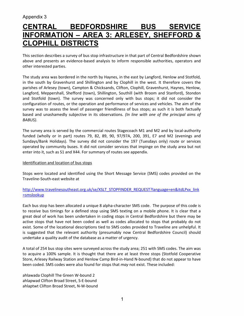
Figure 7, below, shows the proportion, as percentage, of stops with a current, legible, timetable for
each service across the study area
Figure 7
0 10 20 30 40 50 60 70 80
200
391
90
89
E7
82
79
M2
M1
97/97A
Percentage of timetables displayed per route
It may be seen that the performance of Arriva and Stagecoach on routes 97/97A and M1/M2,
respectively, is markedly superior to the routes operated wholly under local authority contract.
Grant Palmer route 200, given its strategic cross-area service, is truly abysmal. These results should
give the local authority funders of these services cause for concern? None of the timetables
displayed fares information.
Appendix 3
8
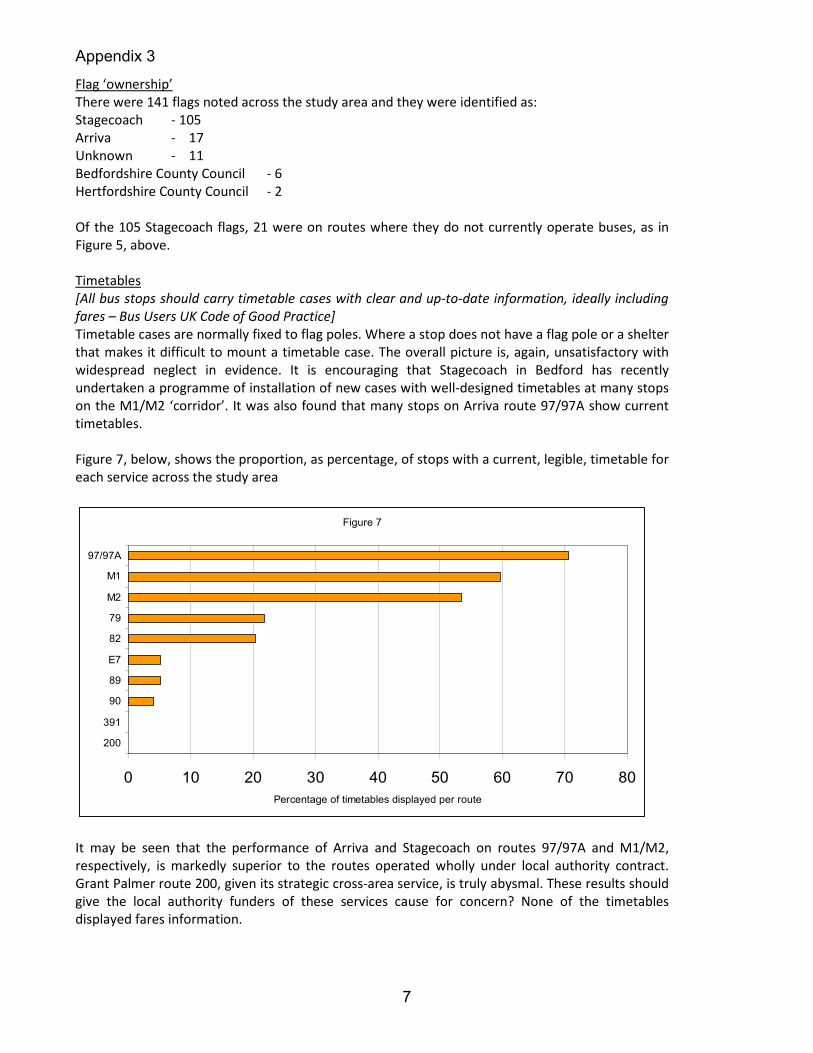
[Bus stop information should be updated at the time of every service change – Bus Users UK Code of
Good practice]
Figure 8, below. The timetable case mounted on the wall of the Greyhound Public House in Haynes.
The adjacent unflagged bus stop is served by the M1 service; the timetable details services 181 and
182 which were withdrawn and replaced by M1 and M2 some years ago.

Appendix 3
9
Figure 9, below. The Stagecoach timetable case located at Arlesey Community Centre opp, showing
user-friendly M2 summary times to Bedford and with a clear route map. There is no reference to
services 90 and E7 which also serve this route. If Stagecoach provide and maintain the case should
they be expected to incorporate timetable information for overlapping and competing (?) services
provided by other operators receiving support from public funds?
Raised kerbs
Recently the kerbing edges at some bus stops have been modified by raising them and providing
tactile surfaces to accommodate newer ‘kneeling’ buses and facilitate use by disabled passengers
and parents with buggies. Most of the work has been concentrated on the M1/M2 ‘corridor’ which
is operated by the new, low-floor Mars buses.
Figure 10, below shows the proportion of stops with raised kerbs for each route.

Appendix 3
10
0 10 20 30 40 50 60 70 80
89
97/97A
391
82
79
200
E7
M1
90
M2
Percentage raised kerbs by route
Laybys
Figure 11, below, shows the proportion of stops with laybys for each parish. It is not clear what
criteria are used in the provision and design of a layby for a bus stop. The provision of a layby must
be a benefit for bus and for other drivers, especially where a bus turns and stands at the end of a
route.
Figure 11
0 10 20 30 40 50 60
Clophill
Henlow
Shefford
Southill
Gravenhurst
Shillington
Clifton
Meppershall
Langford
Arlesey
Stotfold
Stondon
Haynes
Campton & Chicksands
Bus stops with laybys - percentage for each parish
Figure 12, below, shows the end of Route 97 with a bus standing in the layby at Regent Court opp,
Stotfold, a predominantly residential area with moderate traffic flows.

Appendix 3
11
Figure 13, below, shows a particularly perverse example of road layout where adjacent laybys are
provided for parked cars in Shefford High Street whilst buses are forced to block the carriageway in
front of the traffic lights at a very busy junction. This layout did not happen by accident so the
question is asked – what considerations were applied by the highways engineer when the Shefford
High Street improvement scheme was implemented!

Appendix 3
12
Shelters
The responsibility for installing and maintaining bus shelters does not lie with the operator or with
the district council or county council. In the first instance, bus shelters are the responsibility of the
individual Parish/Town Council. Figure 14, below, shows the proportion of bus stops provided with
shelters for each parish in the study area.
It may be seen that the different councils clearly have differing attitudes to the discharge of their
responsibilities when it comes to the provision of shelters. Again it is not clear what criteria are
used in deciding which bus stops justify the installation of a shelter. Recently a new shelter has
been erected outside Samuel Whitbread School (in Clifton Parish) at the stop (ahlagmwa) for buses
travelling towards Shefford. This stop is used by alighting passengers but rarely by intending
passengers wishing to board a bus. Alighting passengers do not need a bus shelter! By comparison,
the stop at Shefford Ivel Road opp (ahlagmtd) is used by relatively larger numbers of passengers
who have visited the nearby Health Centre, yet no shelter is provided. It would be interesting to
know what footfall figures for boarding passengers are used in deciding where and where not to
provide shelters.
Figure 14
0 5 10 15 20 25 30 35 40 45 50
Campton & Chicksands
Meppershall
Southill
Langford
Gravenhurst
Clophill
Stotfold
Haynes
Clifton
Shillington
Stondon
Henlow
Shefford
Arlesey
Shelter provision by parish as percentage
Gritting routes
Clearly, adverse weather conditions can have a major impact on the ability of bus drivers and
operators to provide a service. It is probable that safety and reliability of bus operation on gritted
roads will be superior to that on untreated roads in wintry conditions. These issues have been
highlighted in the winters of 2008/09 and 2009/10.
Figure 15, below, shows the proportion of stops located on treated routes for each parish. It is not
just rural routes that are affected in bad weather (eg service M1 on Northwood End Road, Haynes)
but some urban routes are not covered by the Central Bedfordshire Gritting Plan (eg 97/97A and

Appendix 3
13
other services in Regent Street, Stotfold). It is suggested that all bus routes are given priority for
coverage in the annual gritting plan. If this cannot be done then reasons should be provided by the
highway authority and the relevant bus operators and parish councils consulted.
Figure 15
0 20 40 60 80 100 120
Southill
Langford
Haynes
Stotfold
Stondon
Clifton
Meppershall
Arlesey
Campton & Chicksands
Clophill
Gravenhurst
Henlow
Shefford
Shillington
Bus stops on gritted routes for each parish
Conclusions
A recent (March 2010) report on bus services standards by Passenger Focus
(http://www.passengerfocus.org.uk/news-and-publications/document-
search/document.asp?dsid=3822) reports that:
83% of bus stops had shelters;
94% of stops with shelters had a legible timetable;
73% of stops with no shelter had a legible timetable
In the light of the evidence presented here bus users and council tax payers in Central Bedfordshire
can only marvel at this wonderful state of affairs. The evidence here indicates pretty low standards
of service. But it does not have to be so.
Figures 15 and 16 show two consecutive stops on the same route. The first image shows stop
ahlagtgp on route M2 with a Stagecoach flag. This is the last stop in Central Bedfordshire on the
Arlesey-Ickleford road.

Appendix 3
14
Figure 15 - ahlagtgp
Figure 16 – hrtgjawm

Appendix 3
15
The second image, Figure 16, above, shows the next stop on the same M2 route southbound from
Arlesey towards Hitchin. This stop is located at Cadwell Green, just inside the Hertfordshire county
boundary. The pole is vertical (unlike its drunken neighbour) and carries an Intalink flag and
timetable case. The flag carries the name of the stop – ‘The Green’ – a practice found on virtually all
Hertfordshire bus stop flags but conspicuously absent across Bedfordshire.
The timetable case (below, in close-up) is, like the pole and flag, owned by Intalink, and contains
information on M2 and E7 services. The timetables are produced by Intalink, the Hertfordshire
public transport partnership, to a common standard and not by the individual operators. It also
contains an advertisement detailing the NextBuses.mobi service which delivers live bus times to an
internet-enabled mobile phone. The contrast between this rural and fairly isolated stop with the
general, poor, standard across Central Bedfordshire could not be greater.

Appendix 3
16
Appendix
Stagecoach route M1 – Bedford-Haynes-Shefford-Henlow Camp-Hitchin
Stagecoach route M2 – Bedford-Shefford-Arlesey-Hitchin
Centrebus route 79 – Meppershall-Shefford-Gravenhurst-Shillington-Luton
Centrebus route 82 – Biggleswade-Henlow-Hitchin
Centrebus route 89 – Henlow Camp-Meppershall-Shillington-Hitchin
AGS route 90 – Henlow-Arlesey-Stotfold
Arriva route 97/97A – Stotfold-Fairfield Park-Letchworth-Hitchin
Grant Palmer route 200 – Biggleswade-Southill-Clifton-Shefford-Chicksands-Clophill-Ampthill-
Flitwick
J & D Travel route E7 – Biggleswade-Shefford-Henlow-Arlesey-Stotfold-Letchworth
Cozy Travel route 391 – Stotfold-Baldock-Stevenage
© BABUS 2010