department of the army permit - los angeles … of the army permit permittee: this regional general...
TRANSCRIPT

• LOS ANGELES DISTRICT
U.S. ARMY CORPS OF ENGINEERS
DEPARTMENT OF THE ARMY PERMIT
Permittee: This Regional General Permit applies to:
(1) the Los Angeles County Department of Public Works (LACDPW) at their 161 sediment entrapment facilities (see Figure 1 and Table 1); and
(2) other applicants within Los Angeles County and additional LACDPW projects. With additional requirements, the U. S. Army Corps of Engineers, Los Angeles District Regulatory Branch (Corps) will also consider requests for maintenance and sediment removal, at other sediment entrapment sites and by other applicants within Los Angeles County (see Special Condition A).
Permit Number: SPL-2003-00411-KW
Issuing Office: Los Angeles District
Note: The term "you" and its derivatives, as used in this permit, means the permittee or any future transferee. The term "this office" refers to the appropriate district or division office of the Corps of Engineers having jurisdiction over the permitted activity or the appropriate official acting under the authority of the commanding officer.
Project Description
The District Engineer, Los Angeles District U.S. Army Corps of Engineers hereby reissues Regional General Permit (RGP) No. 45.
This regional general permit (RGP) authorizes sediment removal and maintenance of soft bottomed sediment entrapment basins, access roads, and other appurtenances such as, but not limited to the following: inlet chutes, trash racks, facing slabs, gage boards, slow and down drains, outlet towers, and a small channel and area around the outlet tower as described below.
(1) This RGP authorizes sediment removal under the following two situations:
(A) when the quantity of sediment in a sediment entrapment basin has reached 25% capacity or more, as identified in the permit application.
(B) when a sediment entrapment basin has reached 5% or more of the basin's capacity and more than 20% of the watershed of the sediment entrapment basin has burned within the previous 5 years.
Maintenance of these facilities usually involves excavation, fill, and land clearing activity. Occasionally, such removal may involve non-mechanical means such as hand clearing. But, in almost all cases, the work is performed within existing and defined right-of-way easements. The sediment/debris removal operation at anyone basin may occur infrequently (once every few years), several times during a storm season, or several times durfug and following a single storm event, depending upon the size of the sediment control facility, amount or intensity of the rains, and amount of sediment/debris produced by the watershed.
(2) This RGP authorizes maintenance (including reconstruction) of existing access roads to sediment basins covered by the RGP provided that the footprint does not change and the width and length of the road are the minimum necessary to access the sediment removal. Reconstruction and maintenance of fences and other appurtenances are also authorized.
(3) This RGP also authorizes maintenance, for basins covered by the RGP, of a small (no more than 10 feet wide) entrainment channel and a 15 foot wide area immediately around outlet towers to prevent clogging and direct the low flow discharge to the outlet tower.
(4) The RGP authorizes the removal of vegetation on the upstream and downstream jurisdictional faces of the sediment retention dam and abutments as necessary to comply with dam safety requirements of the California Department of Water Resources, Division of Safety of Dams or to ensure the integrity of the embankment.
(5) This RGP authorizes weed control that is consistent with the terms and conditions of Regional General Permit No. 41, with no further review by the Corps of Engineers, and normal weed removal above the 25%-capacity area for fire control.
DEFINITIONS AND ACRONYMS FOR PURPOSES OF THIS RGP
Definitions: .
Sediment Entrapment (debris) Basin - Sediment entrapment basin is a more accurate term than debris basin, but both are used synonymously in this document. A sediment entrapment basin is an engineered structure designed to capture sediments (i.e. mud, silt, sand, soil, rock, and dislodged vegetation), eroded from the steep hillside watershed above, before they can enter and block the downstream flood control systems. These basins are located at or near the canyon mouth. For example, in Los Angeles County the vast majority of the basins are located along the foothill areas at the base of the San Gabriel Mountains and Verdugo Hills. For the purposes of this RGP, a sediment entrapment basin is assumed to have a "soft bottom", i.e., a natural bottom as opposed to a concrete bottom (Maintenance of existing concrete bottom basins is exempt from regulation. ).
Capital Flood - Capital flood designations within Los Angeles County are made according to County of Los Angeles Department of Public Works standards. In layman terms, for a
2

mountain watershed, a capital flood is the runoff from a SO-year rainfall storm event falling on a saturated watershed.
2S%- and 100%-Capacity Areas and Lines - The current LACDPW design capacity for a basin is equal to the volume of sediment produced by a capital flood. The amount of sediment expected from a capital flood depends on the characteristics of the watershed above and rainfall data for the area. (LACDPW is currently in the process of bringing their existing sediment entrapment basins to "design" standards.) The area occupied by the sediment expected from a capital flood is determined by the basin topography.
Design Capacity - The total volume of sediment expected to be contained by a sediment entrapment basin when it is full.
2S% Capacity - One fourth of the design capacity.
2S%-Capacity Area - The area occupied by the entrapped sediment and debris when the basin is one-fourth full.
2S%-Capacity Line - The outline (on the surrounding hillside or side slopes) of the area estimated to be inundated with water, sediment and debris when the basin is 2S% full.
100% Capacity - Same as design capacity.
lOO%-Capacity Area - The area occupied by the entrapped sediment and debris when the basin is full.
lOO%-Capacity Line - The outline (on the surrounding hillside or side slopes) of the area expected to be inundated with water, sediment and debris when the basin is full.
Perennial Stream - For the purposes of this RGP, a perennial stream is a stream in which water on the surface of the basin flows year round from the upstream side of the basin or canyon mouth to water/sediment control structure (usually a dam).
Acronyms
CDFG - California Department of Fish and Game Corps - U. S. Army Corps of Engineers, Los Angeles District Regulatory Division FWS - U. S. Fish and Wildlife Service ACNE - Implementation Without Conditions Notification LACDPW - Los Angeles County Department of Public Works RGP - Regional General Permit RWQCB - Regional Water Quality Control Board SPS - Sediment Placement Site
3
PERMIT CONDITIONS:
General Conditions:
1. The time limit for completing the authorized activity ends on October 15, 2014. If you find that you need more time to complete the authorized activity, submit your request for a time extension to this office for consideration at least one month before the above date is reached.
2. You must maintain the activity authorized by this permit in good condition and in conformance with the terms and conditions of this permit. You are not relieved of this requirement if you abandon the permitted activity, although you may make a good faith transfer to a third party in compliance with General Condition 4 below. Should you wish to cease to maintain the authorized activity or should you desire to abandon it without a good faith transfer, you must obtain a modification from this permit from this office, which may require restoration of the area.
3. If you discover any previously unknown historic or archeological remains while accomplishing the activity authorized by this permit, you must immediately notify this office of what you have found. We will initiate the Federal and state coordination required to determine if the remains warrant a recovery effort or if the site is eligible for listing in the National Register of Historic Places.
4. If you sell the property associated with this permit, you must obtain the signature of the new owner in the space provided and forward a copy of the permit to this office to validate the transfer of this authorization.
5. The Los Angeles Regional Water Quality Control Board (RWQCB) has issued a 401 Certification (02-144) for the LACDPW projects which is valid until October 23, 2013. LACDPW shall comply with the conditions specified in the 401 Certification.
6. You must allow representatives from this office to inspect the authorized activity at any time deemed necessary to ensure it is being or has been accomplished according to the terms and conditions of your permit.
Special Conditions
A. Prospective permittees for projects other than those listed in Table 1-Applicants/prospective permittees for projects other than those listed in Table 1 or for enlarging sites in Table 1 shall initially submit a "complete notification package" to the Corps that includes the following information:
1. Name, address, and telephone number of the applicant/prospective permittee;
2. Location of the proposed project, including a vicinity map;
3. Project purpose such as sediment removaL road maintenance, entrainment channel maintenance,· etc. or all of the above;
4

4. Citation of this RGP;
5. Other information: a) a brief description of the proposed project, b) the extent of work being proposed, c) latitude and longitude, d) a copy of the US Geological Survey 71/2 minute quadrangle map showing the watershed of the proposed sediment entrapment basin, e) a plan view or drawing of the sediment entrapment facility with the 25%- and 100%- full capacity contour clearly demarcated, £) names of the drainages from the basin to the drainage which enters the Pacific Ocean, g) whether the drainage at the sediment entrapment basin is ephemeral, intermittent, or perennial; h) acreage and volumes of the 25%- and 100%-capacity areas, i) a discussion of the 5%-capacity area; (Note: 25% and 100%-lines may be approximate.)
6. A copy of a letter to the State Historic Preservation Office (SHPO) inquiring about the presence or absence of listed and/or eligible sites for listing in the National Historic Register in the proposed project area that may be affected by the proposed activity;
7. A copy of a letter to the U.S. Fish and Wildlife Service (FWS) inquiring about the presence or absence of any federally listed endangered or threatened species or designated critical habitat in the proposed project area that may be affected by the proposed activity;
8. A migratory bird and endangered species survey. If initial construction work for a proposed sediment entrapment facility must occur between March 15 and August 15, a migratory bird and endangered species survey must be initiated during the appropriate season and be submitted to the Corps and FWS. Survey personnel, timing, and protocol shall be coordinated and approved by the Corps in consultation with FWS prior to initiation of the regulated activity to insure appropriate survey results;
9. A 401 Water Quality Certification, WDR's, or waiver from the Regional Water Quality Control Board (RWQCB). A complete application for the proposed activity should be submitted simultaneously to the RWQCB. The 401 Water Quality Certification, WDR's, or waiver from the RWQCB shall be obtained and submitted to the Corps prior to final project verification by the Corps under this RGP; .
10. The standard individual permit application form (Form ENG 4345) may be used as the notification but must clearly indicate that it is a RGP notification, and must include all of the information mentioned above. Work may not commence until verification of compliance with this RGP is received from the Corps, or forty-five days have passed since the Corps received a complete notification package;
11. Once an applicant receives verification that maintenance/cleanout of their sediment entrapment facility meets the requirements for this RGP, the applicant may thereafter follow the . conditions listed under Special Condition B below for verified RGP holders.
B. Maintenance Operations for Sediment Retention Basins for which the Corps has Verified Use of this RGP (Table 1).
1. The permittee shall maximize avoidance of any natural areas above the 25% capacity area including areas within the 25%- to 100%-capacity area, slopes, and areas in uplands. The 25%- to
r
5

100%- capacity area shall not be disturbed by any means unless approved exotic species removal is occurring or sediment deposition has occurred in that area such that sediment must be removed to restore capacity. Within the 25%-to 100%-capacity area, willows, oaks, and sycamores shall not be disturbed unless 90% of their height has been inundated by sediment. To the maximum extent practicable, with the exception of small entrainment channels and outlet tower clearing, native riparian vegetation shall be avoided in all areas while still maintaining basin capacities.· Except during rainfall events, until such time as a training program is developed and implemented (see special condition No. 8), flagging will be installed around the outside perimeter of the work area prior to initiation of work. (Standard herbaceous weed control activities for fire prevention outside of the 25%-capacity area are exempted from the flagging requirement. )
2. Sediment removal in all sediment entrapment basins will occur between August 16 and March 15 of any given storm season unless prior approval is received from the Corps, in consultation with the FWS. Work in progress on March 15th will continue uninterrupted for two weeks or until completed, whichever is shorter.
In sediment entrapment basins where the 25%-capacity area is greater than 3 acres in size, precleanout migratory bird and endangered species surveys must be completed semi-annually by a Corps approved biologist(s) during appropriate seasons for potential species of concern. Depending on the status of the habitat the Corps of Engineers may waive the requirement. Alternatively, the Corps of Engineers may require additional protocol surveys for specific federally endangered or threatened species if submitted biological surveys indicate the possibility of the presence of such species. The completed report must be submitted to the Corps and FWS for approval prior to cleanout.
3. No activity is authorized under this RGP which is likely to jeopardize the continued existence of a threatened or endangered species or species proposed for such designation, as identified under the Federal Endangered Species Act. Nor is activity authorized which is likely to destroy or adversely modify the critical habitat of such species. Federal Agencies should follow their own procedures for complying with the Endangered Species Act. Non-federal permittees shall notify the District Engineer if any listed species or critical habitat might be affected or is in the vicinity of the project. The permittee shall not begin work on the activity until notified by the District Engineer that the requirements of the Endangered Species Act have been satisfied and that the activity is authorized. Information on the location of threatened and endangered species and their critical habitat can be obtained from the U.S. Fish and Wildlife Service and National Marine Fisheries Service.
4. No activity is authorized which may adversely affect historic properties listed, or eligible for listing,·in the National Register of Historic Places until the District Engineer has complied with the provisions of 33 CFR 325, Appendix C. The prospective permittee must notify the District Engineer if the authorized activity may affect any historic properties listed, determined to be eligible, or which the prospective permittee has reason to believe may be eligible for listing on the National Register of Historic Places. The prospective permittee shall not begin the activity until notified by the District Engineer that the requirements of the National Historic Preservation Act have been satisfied and that the activity is authorized. Information on the location and existence of historic resources can be obtained from the State Historic Preservation Office and the National Register of Historic Places (see 33 CFR330.4(g)). Federal permittees should follow their own
6
procedures for compliance with the requirements of the National Historic Preservation Act and other Federal historic preservation laws.
5. No mechanized equipment, rubber-tired or track vehicles, or other materials shall be stored in waters of the United States including wetlands, or within the 100%-capacity line or.adjacent native habitat. Equipment shall be stored in previously disturbed areas.
6. All appropriate Best Management Practices must be used to preclude increased turbidity and to ensure that road construction does not restrict or impede the passage of normal or expected high flows.
7. This RGP cannot be usedwhere herbicides have been used on native species within the 100%capacity line or adjacent native habitat.
8. The permittee operating under this RGP shall maintain copies of the terms and conditions of this RGP on each site and will provide training to all personnel doing work on a site to insure that the conditions are implemented.
9. The permittee operating under this RGP shall develop a training program for field personnel performing activities regulated under this RGP and their managers, planning personnel, and other appropriate managers and staff. The training program shall cover Best Management Practices including management oriented for water quality, management oriented for wildlife, native flora and fauna expected on the site and mechanisms for avoidance, a discussions of nesting season, native plants vs. invasive weeds, and endangered species protocol. The training program shall be developed in coordination with the Corps, EPA, RWQCB, FWS, and CDFG (California Department of Fish and Game) and be approved by the Corps. Appropriate personnel (see above) shall receive training prior to September 15, 1998. Certification that said training has been completed shall be transmitted to Corps Regulatory prior to September 1, 1998. Invasive weeds to be considered are those listed in RGP 41; i.e. giant reed, salt cedar, tree tobacco, castor bean, Russian thistle, star thistle, artichoke thistle, thistle, pampas grass, fountain grass, or cocklebur. Smaller weeds that might be considered for sensitive removal to control fire are mustards, introduced annual grasses, sweet clover, and some composites such as ox tongue.
10. This condition is a result of site inspections of specific LACDPW basins. Mention of basins in this condition does not eliminate any Proposed General Condition or Special Condition for the Table 1 basins or any other basins.
Big Dalton - LACDPW shall a) clean between August 15th and November 15th; and b) leave major trees where at all possible, even when cleaning within the 25%-100% area.
Englewild - same as Big Dalton
Hook East - LACDPW shall avoid habitat on side slopes.
Sawpit - LACDPW shall avoid tributaries entering the debris basin unless they are inuridated with sediment.
7

-
Santa Anita - LACDPW shall a) clean between August 15th and November 15th, andb) avoid existing large willows near the dam on both sides of the basin. Willows on the upstream dam face may be removed for dam safety purposes.
Mullally - An exception will be made for Mullally Debris Basin. Mullally may be cleaned when at 5% capacity regardless of the condition of the upstream watershed. This exception is due to the fact that Mullally is significantly undersized at this time. Should the facility be redesigned, LACDPW shall consult with the Corps on the proposed capacity in order to allow area for riparian vegetation to develop. This special condition will be void if the basin is redesigned and built.
11. 'The permittee shall dispose of all excavated sediment and debris at a legal disposal point. Disposal of sediment on adjacent native habitat areas, State or federal"waters" is prohibited.
12. If the permittee proposes to remove any native vegetation beyond those areas cited above, the permittee shall submit a request to the Corps with an accompanying letter from Dam Safety stating the need and reasons for the additional vegetation removaL 'The permittee shall not initiate any removal of native vegetation beyond those areas cited above unless the Corps of Engineers has provided written approval for the additional vegetation removal.
C. Emergency Sediment Removal without Condition(s) - Emergency situations are those situations where a basin has filled more rapidly than expected and must be cleared in response to a public safety need. In the event that any emergency sediment removal is to be implemented without use of any of the Special Conditions above:
1. 'The permittee must notify, in advance, the Regulatory Division, Los Angeles Section Chief, or the Senior Project Manager for Los Angeles County by telephone or voice mail, (213-452-3414, 213-452-3290, respectively) of the project, location, the condition(s) that will not be implemented, and the reason for the action without conditions;
2. 'The permittee must submit an Implementation Without Conditions Notice (ACNE) to the Corps withiIl three working days to obtain approval of the work, or to obtain remediation measures for the work. 'The ACNE shall be submitted on pink paper and include a brief summary of activities that occurred including the location, the condition that was not implemented, and justification for implementation without condition. If the corps and permittee disagree on whether and emergency existed, the Corps will confer with the permittee prior to making a final decision.
D. Non-emergency sediment removal without Condition(s) - In the event that any nonemergency sediment removal is proposed to be implemented without any of the Special Conditions in B above, the permittee shall notify the Corps and receive prior approval.
This RGP does not preclude the use of other Nationwide Permits (33 CFR Part 330 Appendix A) provided that the project meets the terms and conditions for the Nationwide Permits, including a 401 water quality certification and Coastal Commission consistency determination, if appropriate.
Further Information:
8

1. Congressional Authorities. You have been authorized to undertake the activity described above pursuant to:
() Section 10 of the River and Harbor Act of 1899 (33 U.S.C 403).
(X) Section 404 of the Clean Water Act (33 U.S.C 1344).
() Section 103 of the Marine Protection, Research and Sanctuaries Act of 1972 (33 U.S.C 1413).
2. Limits of this authorization.
a. This permit does not obviate the need to obtain other Federal, state, or local authorizations required by law.
b. This permit does not grant any property rights or exclusive privileges.
c. This permit does not authorize any injury to the property or rights of others.
d. This permit does not authorize interference with any existing or proposed Federal project.
3. Limits of Federal Liability. In issuing this permit, the Federal Government does not assume any liability for the following:
a. Damages to the permitted project or uses thereof as a result of other permitted or unpermitted activities or from natural causes.
b. Damages to the permitted project or uses thereof as a result of current or future activities undertaken by or on behalf of the United States in the public interest.
c. Damages to persons, property, or to other permitted or unpermitted activities or structures caused by the activity authorized by this permit.
d. Design or con~truction deficiencies associated with the permitted work.
e. Damage claims associated with any future modification, suspension, or revocation of this permit.
4. Reliance on Applicant's Data. The determination of this office that issuance of this permit is not contrary to the public interest was made in reliance on the information you provided.
5. Reevaluation of Permit Decision. This office may reevaluate its decisio:p. on this permit at any time the circumstances warrant. Circumstances that could require a reevaluation include, but are not limited to, the following:
a. You fail to comply with the terms and conditions of this permit.
9

b. The inform~tion provided by you in support of your permit application proves to have been false, incomplete, or inaccurate (See 4 above).
c .. Significant new information surfaces which this office did not consider in reaching the original public interest decision.
Such a reevaluation may result in a determination that it is appropriate to use the suspension, modification, and reyocation procedures contained in 33 CFR 325.7 or enforcement procedures such as those contained in 33 CFR 326.4 and 326.5. The referenced enforcement procedures provide for the issuance of an administrative order requiring you to comply with the terms and conditions of your permit and for the initiation of legal action where appropriate. You will be required to pay for any corrective measure ordered by this office, and if you fail to comply with such directive, this office may in certain situations (such as those specified in 33 CFR 209.170) accomplish the corrective measures by contractor otherwise and bill you for the cost.
6. Extensions. General condition 1 establishes a time limit for the completion of the activity _authorized by this permit. Unless there are circumstances requiring either a prompt completion of the authorized activity or a reevaluation of the public interest decision, the Corps will normally give you favorable consideration to a request for an extension of this time limit.
10
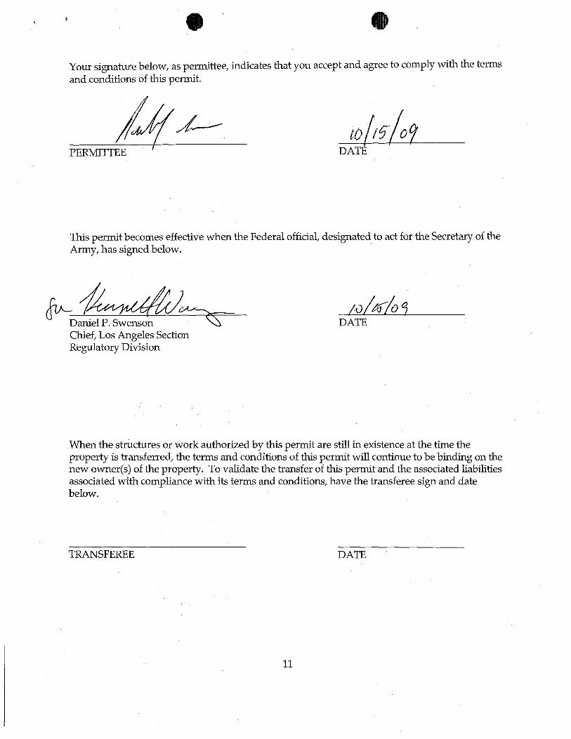
Your signature below, as permittee, :indicates that you accept and agree to comply with the terms and conditions of this permit.
DATE
This permit becomes effective when the Federal official, designated to act for the Secretary of the Army, has signed below.
Chief, Los Angeles Section Regulatory Division
DATE
When the structures or work authorized by this permit are still :in existence at the time the property is transferred, the terms and conditions of this permit will continue to be b:ind:ing on the new owner(s) of the property. To validate the transfer of this permit and the associated liabilities associated with compliance with its terms and conditions, have the transferee sign and date below.
TRANSFEREE DATE
11
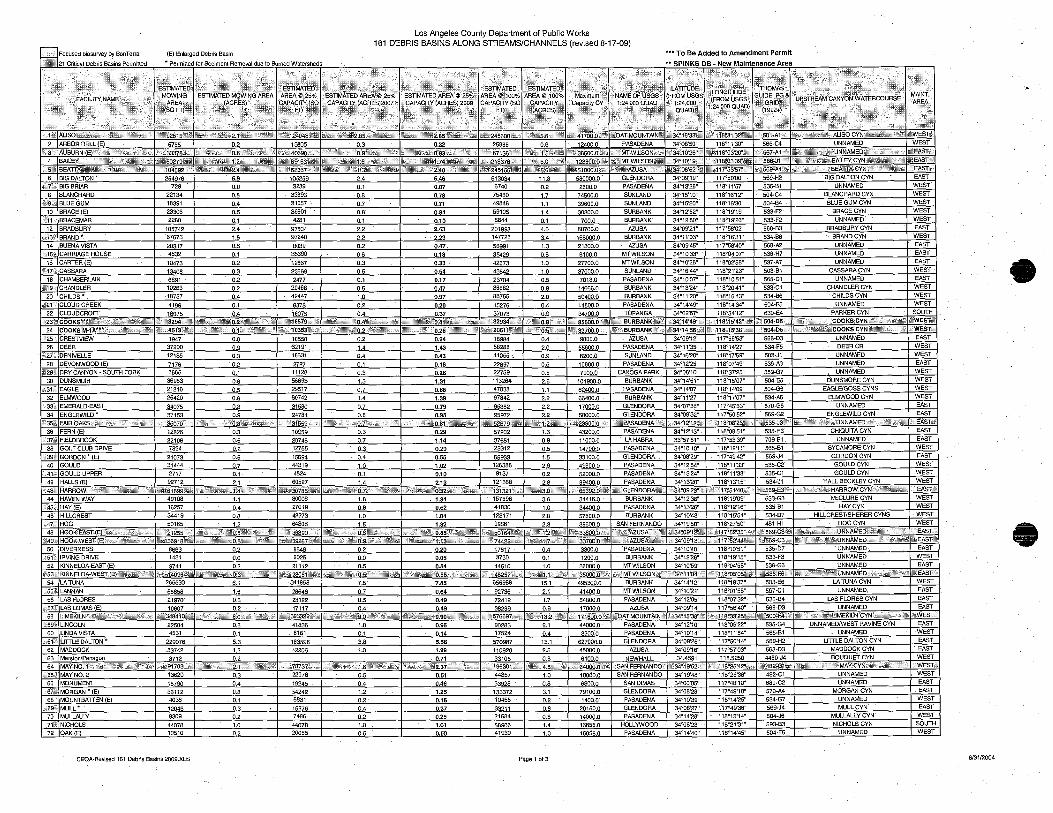
Los Angeles County Department of public Works 161 DEBRIS BASINS ALONG STREAMS/CHANNELS (revised 8-17-09)
!:lFocused biosurvey by BonTerra (E) Enlarged Debris Basin *** To Be Added to Amendment Permit
~21 Critical Debris Basins Permitted * Permitted for Sediment Removal due to Bumed Watersheds """ SPINKS DB ~ New Maintenance Area
~ .:' ESTIMATED ": '<""> . ":~ . MOWING l
--FACILITY NAM~, •• : •• ,. AREA
>,·\(S,Q~I
2 ARBOR DELL (E) AUBURN (E
4 BAILEY}iP"',,:
l0tiV92815\:1i,~;
6755
h,,'~'5b279\
6 IBIG DALTON * 254976
BIG BRIAR 1729 I 8 IBLANCHARD 22134 ~9~,t BLUE GUM 18391
10 BRACE (E) 23306 1~J1.>': BRACEMAR 2280
12 BRADBURY 105742
r~RAND * 67673 14BUENA VISTA 20317
,\*15~ CARRIAGE HOUSE 4832 16 CARTER (E) 10473
CASSARA 13408 18 CHAMBERLAIN 6891
CHANDLER 10263 20 CHILDS * 18757
~~'21\ CLOUD CREEK 22 CLOUDCROFT
f0t'23-~: COOKSI!"~??,;:&<'i ""<,,,,;\,:;,-24 C'oOKS M-1A~~* ')",>uC;;;;:::"
025 ,; CRESTVIEW 26 IDEER
;,27; DENIVELLE 28 DEVONWOOD (E)
* 29:\' DRY CANYON - SOUTH FORK 30 DUNSMUIR
1947 37200 12135
7176 566s 3a9a3
0.2
§& 0.0
Q2. 0.4
Q:§, .QJ.. 2.4
.1& 0.5
Q:l .Q& 0.3
.Q& Q£ OA
Q1 0.4
0.0
.Q&.
.Qd
.Q&
.!bl 0.8
" 315:, EAGLE 0.5 32 ELMWOOD 0.6 33~ EMERALD·EAST 0.8
0.9
36 FERN (E) 12826 0.3 37<%, FIELDBROOK 0.5 38 GOLF CLUB DRIVE 0.2
039, IGORDON * (El 21073 0.5 40 GOULD 31444 0.7
-41, jGOULD UPPER 2717 0.1 42 HALLS (E) 92712 2.1
''.:43\, ;, q,:,,~,:~ I· '.i:;-i 61899:",,",
·~*\124043.~\\W
13B05 0.3
I \R~vh58367;&\\i 105259 2.4 3239
~ 31057
~ ~ 97504
~ 8039
~ J1§§I 23669 2477
20488 42447
8873
.9.:.1 Q& 0.7
Q&' 0.1 2.2 g 0.2
Q& Qd 0.5
.9.:.1 0.5
.!:Q.
.Q& 0.4
0.2 62191 1.4 18631 0.4 2727 0.1 11128 0.3 56893 1.3 29517 0.7 60742 1.4
31580 0.7
24781 I 0.1 '~<Si31559 '(.;: ~;.b,\~+';:
10959 0.3 28745 0.7 12755 0.3 15694 0.4 44319 1.0 4524 0.1
60527 1.4
44 HAVENWAV 49108 1.1 80008 1.8
,,'ii?l\ i45600'\::~:: I k:l:-$;':~;'>5.6~0t\'t.fl~r41'iaOll~1t I ",OATJ"iOUNTA'N&I~~34°16'33~.b%L~~\ 116~31 '32:~W Cy~,*%~ 1;_)::',\~·;" I,'\WEST; 0.32 25886 0.6 12400.0' PASADENA 34°08'50" 118°11'30" 565-C4 UNNAMED WEST
I :+f~~;1 ',,:;;-#*~ ~138500.b'~:kt, ->i±)iMTWILSON~~', \i~34~~0'26'.':k hzg118~03'20'~.\ ,.0:(567:A1&L% ¥f!EAST,:;:' '&.(\;\'28800.0;Mk,I~,k::'?MTWILS( :i~-34~,JO:,19"$t:; :'{ss118°03'39"'iiJ" ;>i\+566:.J1\'~ 1t;'EAST\,~ &;if~'51000:0~~ ,&.(34°08'52~~.\;;z .117?53'57:_ %"ili569-A4~~' ±liEASL'"
6.46 513034 11.8 580000.0 GLENDORA 34°09'19" 117°50'00" 569-H2 BIG DALTON CYN EAST 0.07 6740 0.2 2600.0 PASADENA 34°13'26" 118<>11'57" 535-81 UNNAMED WEST 0.78 BLANCHARD CYN WEST 0.71 BLUE GUM CYN WEST 0.84 BRACE CYN WEST 0.10 UNNAMED WEST 2.43 BRADBURY CYN EAST 2.23 BRAND CYN WEST 0.47 , UNNAMED EAST 0.18' UNNAMED EAST 0.33 UNNAMED EAST 0.54 CASSARA CVN WEST 0.17 UNNAMED EAST 0.47 'CHAN DLER CVN WEST 0.97 CHILDS CYN WEST
0.20 15276 0.4 14800.0 I PASADENA 34°14'49" 118°14'34" 504-F5 UNNAMED I WEST 0.37 37073 0.9 34700.0 TOPANGA 34°02'5r 118°34'12" 630-E4 PARKER CYN SOlJT}l
~ "'1,;,32934, ~t~,:h:,;;:'," 0.8:'0« '~?:;'S85600.0 %;;~ ::>\]:BURBANK\'~" ~J<'34~14'49af.\ 3,,::::::118°15'42~ . ...;} _~,~504·05~·~ «<\;)>1'\ :::0.':;";> COOKS CYN;z,£,. ,,):" ~,WEST:::' ~ \>,;~20611~d,\~ :tt, ·33700.0 ~-:. .:;.:; ~ BURBANK ;>t ~~34"14'56".t" :::~,'118~15'38~, ,,\\,/504-05:\:;,' .K.\)j,:; ;-i1~?\~ :,;i\COOKS.CYNw<:::(" ·,,::::::'S)(. x:·WEST\'
0.24 18984 0.4 9000.0 1 AZUSA 34°09'12" 11r56'53" 568-D3 UNNAMED 1 EAST 1.43 88288 2.0 55600.0 PASADENA 34"11'35" 118"14'27" 534-F5 DEERCR -r WEST 0.43 41055 -. 0.9 8200.0 SUNLAND 34<>16'20u 118°17'59" 503-J1 UNNAMED WEST 0.18 22897 0.5 10800.0 PASADENA 34<>12'25" 118"07'49" 536-A3 UNNAMED EAST 0.26 22759 0.5 7900.0 CANOGA PARK 34°08'10" 118°37'25" 559-G7 UNNAMED WEST 1.31 113264 2.6 101900.0 BURBANK 34°14'51" 118°15'07" 504-E5 DUNSMORECYN . 1 WEST 0.68 EAGLE/GOSS CYNS WEST 1.39 ELMWOOD CYN WEST 0.79 UNNAMED EAST 0.95 95972 ENGLEWILD CYN EAST
0.29 1.14 0.29 0.55 1.02 0.10 2.13
1.84 0.62
,f0~;:\'~UNNAMED,*&! ,',<vELY,,' "" ,'-~,EAST.,' 57202 1.3 43200.0 PASADENA I 34°12'13" I 118°08'51" 1 535-H3 I. CH1QUITACYN I EAST
37651 23312 65933 i26s8s 9137
121368 A>&'13132Hb};r
157596
0.9
Q2.
1.& 2.9
.Q& ~8
11000.0 14700;0
~ 49600.0
gQQQ& 89400.0
LA HABRA
PAsADENA GLENDORA PASADENA
~ PASADENA
33°57'51" ~ 34°08'29" ~ 34°13'24" 34"13'20"
117°53'39" 118°12'11"
~ 118<>11'33~'
118°11'33" ~
~ 565-81 569.J4 535-C2 535-C1
~
~ SYCAMORE CYN
~N GOULDCYN GOULDCYN
HALL BECKLEY CYN
EAST WEST EAST
WEST
~ WEST
¥, :65392:'0)011 ,%.,§~Gi.ENDORAL,,> J~34"09'23'h~h~:·117,,051 '4O~~'\:8 1'~~569-E3)::H ,,,+.,t--'&+.', '0~*,HARROW:cYN,:'~: !,*t;\'0~ ",,~.I .1.EAST1> 34416.0 BURBANK I 34°12'38" I 118°19'09" I 533-G3 I McCLURECYN I WEST
34°13'26" ,\,4~h: HAY (E) 16257 0.4 27019 0.6 46 HILLCREST 34419 0.8 42273 1.0 1 1.04
41830 123171
~ .!:Q. g& 2.3
~ 57800.0 39600.0
PASADENA BURBANK
SAN FERNANDO ~ ~
~ 118°15'54"
~ 534·07 481-H1
HAVCYN HILLCREST/SHERER CYNS ~
WEST
WEST WEST t:47iJi HOG 50165 1.2 64308 1.5 1.32
48 HOOK:EASY,(E);;::,-::::;; ~~~(;:'~vtt;: 5.:-<3:1>\\,,("$:::-;+):, iili<WF 0t49 dHOu .... vVCu
50 INVERNESS 8663 0.2 U:i!U
~51~ lAVING DRIVE 1431 0.0 0.0 0.05 52 KINNELOA-EAST (E) 9741 0.2 0.5 0.54
-::'53~ KINNELOA-WEST,(E)_,~:bl'i1~it'4~ 54 LA TUNA
,#552: LANNAN 56 LAS FLORES
\ 57:4 LAS LOMAS (E)
58 0;59:\: LINCOLN
60 LINDA VISTA t61;; LITTLE DALTON * 62 MADDOCK 63 j±
;4'65 ' MAV NO.2 66 MONUMENT
'67,;~
68 -:69' MULL * 70 MULLALLY 71: NICHOLS 72 OAK(E)
~ 68858
....illZQ 10607
22504 4531
~ 53742 8712
"~'N'91703,;;'110 13620 18790
§ill 4036
~ 9309
.11QI§. 10510
CEQA-Revlsed 161 Debris Basins 2009.XLS
6.1 341858
1.6 28646 0.5 23122
.Q& 0.1
.§d ---1.:.2
O.
.M 0.4
Q& 0.1 .Qd 0.2
l:Q. 0.2
41836 6161
~ 42206
.. ' :";\~:;78737':,,};\« 22078
19245 54242 6831
!.§lli. 7486
~ 20055
1& Q1. 'Q:§, 0.4
.1:Q. 0.1
~ 1.0
0.5
.Q& 1.2
.Q& 0.4
.Q1. 1.0 0.5
7.85 0.64
~ 0.49
0.96 0.14
~ ~
0.71
0.51 0.46 1.25 0.16 0.37 0_25 1.01 0.50
998a1
17617
~ 44"10
656988
2m§. .zmg ~
;;t:kt576697.'* 90283 17524
~ ...1.1.Q2gQ
44857
33928 133372 10455 33211 21584
58906 41930
.Qd.
.9.:.1 1.0
ill II
....1:L 0.9
E.:1 0.4
~ ...1:§..
1.0
Q& 3.1
.Q& 0.8 .Q2. 1.4
1.0
Page 1 of3
r<%'8\33800J
~ 1200.0
36000.0
PASADENA BURBANK
MTWiLsON
34°10'40" 34"12'26" ~
118"27'50"
118°19'15" 118°04'58"
533·F3 536-G6
@~i'{35060·.b~~'k~)l{,MTt,WILSON'2'·~'I>i%:34~11 '04'~'n:l*w1 i8~05'05~\,~~ 1 :~~%536-F6i® 495300.0 503-E6 41400.0 567-C1
54800.0 PASADENA 34°12'05" 118°07'32" 536-B4
UNNAMED UNNAMED UNNAMED
LATUNACYN --uNNAMED
LAS FLORES CVN
EAST WEST EAsT
\t;EAST,:· WEST EAST EAsT
UNNAMED EAST .:500-F4'N~ .l%": ,;.Sij~ LIMEKILN CYN \t~;\, F •• 0i;WESTz¥:
44000.0 UNNAMEDIWEST RAVINE CYN EAST 3200.0 UNNAMED WEST
627000.0 GLENDORA 34"09'25" 117"50'14" 569-H2 LITTLE DALTON CYN EAST 45000.0 AZUSA 34°09'16" 117°57'03" 568-03 MADDOCK CYN . EAST 6100.0 NEWHALL 34.4591 118.5250 4460-J4 BOUQUETCYN WEST
,';;~;64000.0*Y*, £iSAN FERNANDO, ~34':19'52~.;0; ~,0,~~118°25'42't*,---';). ",,~482,C11t-0 '",WEST'+; 10000.0 SAN FERNANDO 34°19'48" 118°25'38" 482-C1 UNNAMED WEST 6800.0 SAN DIMAS 34°00'05" 11r48'10" 680-C2 UNNAMED EAST 79100.0 MORGAN CYN EAST 1400.0 UNNAMED WEST
20150.0
llQQQ.Q 16856.0 16856.0
GLENDORA PASADENA
HOLLYWOOD PASADENA
34"08'27" 34°14'28" ~ 34°14'40"
117"49'36" 118°13'14" 118°21'31" 118"14'45"
569-J4 504-J6 593-B3 504-F5
MULLCYN MULLALLY CVN
~N UNNAMED
EAST WEsT SOUTH WEsT
e
4;
8/3112004
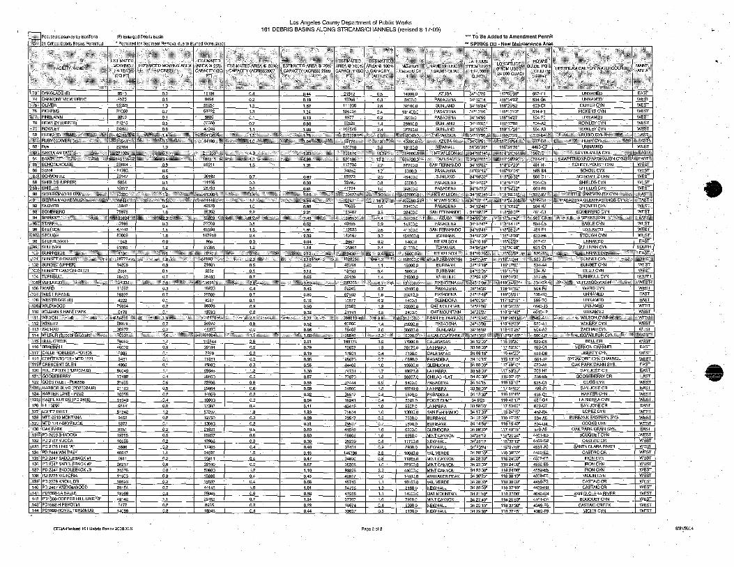
Los Angeles County Department of Public Works
~ Focused biosurvey by BanTerra (E) En!arged Debris Basin
~21 Grit!cal Debris Basins Pennitled * Permitted for Sediment Removal due to Burned Watersheds ** SPINKS DB - New Maintenance Area
161 DEBRIS BASINS ALONG STREAMS/CHANNELS (revised 8-17-09)
I;'~~,,? . '. 1"!~;,',!;:i<:;J." ;,;{!;'£l~ ·······I\~~:~DI;\;[j ····'·.··.····I-{}~·I~~~~~~IIJ~~~~·~':;~ f:4'?~1l '·"r.:·\;:' 1\·' .' ~ I.~;;;.:i·~: I;;:';; ~b","i~ ~~~1"""'~1~,:;:,:;:.1:/1"1~~~:.J1~;' ~;;;.~\§.j~&;""~.:''''~I:::i i"; (SQCI1 I,. I:AP~~·l~~~~-- .. \. l~j~~~~CY:I;,;{~; J., -.1~t ;~!1;~~tl .. :,. ::;~~'~;iC~:\I\ ,', "' ~,.::~[,\,; ..•••. ." 1'.;r~I'::::", .ii~;'l':C~l}f;<,.t.:~~~ 1~~~ll~~5~~:I~1!.~h:!!!;;;:;,:. .'.;;;, ;%~;W~~~f~ ,.I;.§i
"
74 OAKMONT VIEW DRIVE 4575 0.1 809~ 0.2 0.19 15056 0.3 3400.0 PASADENA 34°12'14" 118°14'23" 534-G4 UNNAMED WEST "75~ OLIVER 56325 1.3 58251 1.3 1.57 111935 2.6 32100.0 SUNlAND 34°16'34" 118020'52" 503-C1 OLiVERCYN WEST 76 PICKENS 31058 0.7 58222 1.3 1.34 104934 2.4 131400.0 PASADENA 34°13'16" 118°13'43" 534-H1 PICKENS CYN WEST
S277:{\ PINELAWN 3399 0.1 5630 0.1 0.13 8977 0.2 3200.0 PASADENA 34°14'50" 118°14'27" 504-F5 UNNAMED WEST 78 ROWLEY(UPPER 21215' 0.5 30660 0.7 0.60 62525 1.4 28800.0 SUNLAND 34°16'05" 118°17'08" 504-A2 ROWLEYCYN WEST
1:79'§; ROWLEY 34690 0.8 47049 1.1 1.08 102545 2.- 37700.0 SUNLAND 34°15'50" 118°17'26" 504-A3 ROWLEYCYN WEST
80, ~ _ ~r.:LWIL:.S~~.¥:aJ;' g536;B4).~'\ \;g'0k;s'\.~'wd;k:YRUBIO'CYN~~;}l;;~£¥4i!:~ ~~EAST~ ~81i% ~",dlt1!"'" ~\~'!AZUSAk~;<\ r,059'54.'S4>i,~ ~567-G2c t%FEASTJ;\::,
82 Rye 82764 1.9 150718 3.5 19100.0 NEWHALL 34°26'26" 118°34'36" 4460-C7 UNNAMED WEST 4\83%: 1~;;221925~~~, f~":::394600.ci\i\::- m~;MTW1LSON,§,.flZ. ii34"10~14'\;l- ~#t,118~01:'16~S~0 "~i"567-E1<iij;; St'S. ~;;~, :zsr;SANTAAN1TACYN; ";:{~~,,~:ht:;f?t ~i;EAST,~,
84 ;:> 149136\,0; ~~*63570b:0,>r:: ;ilve'AzUSA~':Si~;;~~ j!,34?,10'05~~; 1~\£:117°59'29H:~" i:j~ 561·Hft:+: '~£SAWPITIMONROV1AlSPAN1SH CYNS\~~ 0:::~EAST:\ ~85:~' SCHOOLHOUSE 36894 0.8 56911 1.3 ~ 1.31 111705 2.7 67700.0 SAN FERNANDO 34°19'32" 1180 27'29" 481·H1 SCHOOLHOUSE CYN WEST
86 Scholl 21780 0.5 74052 1.7 9300.0 PASADENA 34°09'12~ 118Q12'03" 565·84 SCHOlLCYN WEST ~;87l SCHWAHlZ 20167 0.5 30162 0.7 0.69 87872 2.0 45400.0 SUNlAND 34°16'32" 1180 20'32" 503·01 SCHWARlZ C¥N WEST
88 SHIELDS (UPPER) 5834 0.1 '14465 0.3 0.33 33760 0.8 5600.0 PASADENA 34°14'52" 118°14'15" 504·G5 SHIELDS CYN WEST ~f89'';' SHIELDS 16677 0., 26783 0.6 _0.61 41724 1.0 34800.0 PASADENA 34°14'23" 118°14'22" 504·F6 SH1ELDSCYN WEST
90 .. SIERRA'MADREDAM?&l,*z~:a~~ 1:4~"~~ ~ ~~118~OZ3l~0~~' i:"&S537,:B7~~; ~~~is,\",\LITTLE SANTA'ANrrACYN~~~i.~IS5ZEAST~ ~;91'~ ~ 471: ;;1",,",'h118C04'36'\t(.t _566~G1"'$-~' *PASADENA GLEN/HASTINGS CYN~;,I~_!2:
92 SNOVER 16942 0.4 42878 1.0 0.98 70588 1.6 23400.0 PASADENA 34°13'48" 118°13'22" 504·H7 SNOVERCYN WEST -\093:S SOMBRERO 78676 1.8 96352 2.2 '2.21 153487 3.1 23400.0 SAN FERNANDO ,34°19'52" 118°28'07" 481-G1 SOMBRERO CYN WEST 94 SPINKS~4.;~~':;'i~~'~~+thlr~~'S ,.ibi:li;24\~ ','~t%F53928~'%1?; .n8>gs"90~~~,;4 :Bt\~AZUSAa" ¥&34°09'06u,~ 00-f56a;'C3~:;S: .~"cijh~ft#,"+SPINKS:C'YN+S:s};+1\$ .. h:@ ffiEAST,~
\~95';;; STARFALL 15165 0.3 22560 0.5 0.52. 40386 0.9 14900.0 PASADENA 34°14'47" 1~-14'11"_ 504·G5 EAGLECYN WEST 96 STETSON 47446 1".1 65588 1.5 1.51 112533 2.6 41300.0 SAN FERNANDO 34°19'41" 118°28'27" 481·F1 UNNAMED WEST
:"97!\ STOUGH 80009 1.8 103919 2.4 2.39 140167 3.2 181200.0 BURBANK 34°12'00" 118°18'09~ 533-H4 STOUGH CYN WEST· 98 STURTEVANT 1943 0.0 965 0.0 0.04 9657 0'.2 1400.0 MTWILSON 34°10'18" 118°02'22" 567-C1 UNNAMED EAST
i<99,\: SULLIVAN ....§j085 1.2 ~5 l£ 1.18 105902 2., 51000., TOPANGA 34°04'24" 118°30'26" 631·C1 SULLIVAN CYN SOUTH 100 ",p' 0.'4_"0~ ~ '·,'''~MT'WIl.:.SON~8.f <34°,10'26~~ "i'i,,,118~03'52'~~\' ~i& 536:.17.. +t:.%ii~~;$,,':>~~,\UNNAMEDi:~?~\_~',~*:tt:'h« ,SrEAST,"'
,,101<; iUNSET .oWER)";,;<\\ii~'''»\ii~i!j i\,*:-.,68772~3>i 31~·U\:H- ctii"$;~,! 'h'" "$;ii"82325*,~" I<+'\l_~"; t2'f.:;;,,*~q ,;it;, 160600.0'£-'* c",:h:BURBANK'~\\ :",,34°11:45'~~ lilt ;:1,18°17'44';{;~' ~\533·J5~;: r,,+k1&0~' ,*,,\:¥~SUNSEr,CYN,';'*G,,~,'~+~m,~l sZWEST,? 102 SUNSET (UPPER) 14306 0.3 21801 0.5 0.50 48018 1.1 15900.0 BURBANK 34°12'18" 118°17'03u 534·A4 SUNSETCYN WEST
">103> SUNSET CANYON-DEER 2861 0.1 5326 0.1 0.12 18693 0.4 5000.0 BURBANK 34°12'05" 118°17'10" 534-A4 DEERCYN WEST 104 TURNBULL 28433 0.7 28433 0.7 0.65 59126 1.4 21600.0 WHITIIER 33°59'15" 118°01'35" .677·E5 TURNBULLCYN SOIJTH
\\105$ VERDUGO~~\~\:%{',",<\,,;, %\'~~~'}v~', '\':::<,'24332~'t1 ;\t~!1-.~~t:· 2.9'~:-+;<; h~»< ".-'~%i~,'5688Hi'0* ,Cki',:r;:;;j@\ ",' " 293566 +~ ,~13'1000.0,1"\ iiCiPASADENAt-.~i iit;34:,12'06':~" ;;'_'18°,14'09'~' :~,t ~534~G4;;" a':,' > ;t~¥5;VERDUGO,WASH . <;0.~Vi.\<:;: A>WESTz. 106 WARD 11382 0.3 18233 0.4 0.42 32049 0.7 12400.0 PASADENA 34"14'39" 118°14'52" 504·F5 WARD'CYN WEST 107, WESTRAVINE 28392 0.7 28509 0.7 0.80 67692 1.6 39212.0 PASADENA 34"12118" 118°08'51" 535-H3 UNNAMED EAST 108 WESTRIDGE (E) 4222 0.1 6287 0.1 0.16 10517 0.2 1400.0 GLENDORA 34°09'01" 117<>52'15'" 569-03 UNNAMED EAST ~109 WILDWOOD 29884 0.7 .39386 0.9 0.90 56563 1.3 22500.0 OAT MOUNTAIN 34"22'06" 118°31'56" 4640·J3 UNNAMED WEST 110 WILLIAMS HART PARK 6178 0.1 13783 0.3 0.32 21191 l.5 2400.0 OAT MOUNTAIN 34°22'27" 118°31'42u 464O..J2 UNNAMED WEST 111~ WILSON' :?i'>'\~843560~\" 8'f::i0118470"~~!~ -4(\k:;:'t:/~, s.'+<;~386819q\~ :~~313100.0,\" "SAN'FERNAND01 't~34~19'46::i<~ '~;~118°26'41:~+\'\ 0fuk482-AlR0--:i ·f,;;.\\.iy 'i~~:'WILSON CYNas:S ,,\:"S~ ,~wWESTit 112 WINERY 28878 0.7 34070 0.8 0.82 60260 1.4 29200.0 PASADENA 34°13'30" 118°12'33" 535·A1 WINERYCYN WEST
:-113\ ZACHAU 30972 0.7 41335 0.9 0.95 86408 2.0 ·38600.0 SUNLAND 34°16'02" 118°17'25" 504-A2 ZACHAU CYN WEST 114 WILBUR SoecfarStructure 'i!U~*,,~iA\; 0-,y*7033F::~~ 6'0'- - 0:;(':'%~ 81864%~''f ~>i:i-98546 <%" ~,"< !\:;CANOGA PARK,\, Ci34~13'55",€ i&if118°32'45:'0-.%: 1~-0, 500~G7\A"' A'd;'&t%F'K"ALlSOIWILBUR CYN,'9ACi,:Z"tdKGt ~~WEST'
,115' BELL CREEK 76060 1.7 113844 2.6 2.61 168174 3.9 17000.0 CALABASAS 3412'00" 11839'20" 529·05 BELL CR WEST 116 BRAMHALL 40002 0.9 39184 0.9 0.79 80878 1.9 20170.0 LA HABRA 3358'00" 11752'30" 709·C1 VERNON CHANNEL EAST
<,117;' CALLE ROBLEDA ·PD1505 6335 0.1 7978 0.2 0.15 17891 0.4 7100.0 CALABASAS 34 08'15" 11844'20" 558-06 L1BERlY CYN WEST 118 CONTENTODB-MT01221 6431 0.1 11351 0.3 0.26 '28676 0.7 6890.0 PASADENA 3410'15" 11813'15" 564..J2 SYCAMORECYNCHANNEL WEST
~:1191 CRESCENT GLEN 4905 0.1 15092 0.3 0.35 44408 1.0 19500.0 GLENDORA 3408'30" 11749'15" 570-A5 OAKPARKDRAINSYS. EAST 120 FULLERTON (PD2202-U2) 50049 1.1 55588 1.3 1.30 74731 1.7 18676.0 LA HABRA 3358'00" 117 53'30" 70a-H1 SAN JOSE CR EAST
f·121ft· GOOSEBERRY 17492 0.4 20460 0.5 0.57 77070 1.8 33857.0 CHILAO FLAT 34 20'30" 11807'15" 536-B5 GOOSEBERRY CR EAST 122 GOSSINLET-PD655B 21565 0.5 23996 0.6 0.55 37444 0.9 5400.0 PASADENA 3414'15" 11813'15" 535-C1 GOSSCYN WEST • ,t12S;: HARI;IOR BLVD (PD2202-U2) 21123 0.5 25664 0.6 0.59 54560 1.3 10749.0 LA HABRA 3358'00" 11754'00" 708..J1 SAN JOSE CR EAST 124 HARTER LANE- PD22 10355 0.2 14059 0.3 0.32 36517 0.8 9600.0 PASADENA 3413'30" 11811'45u 535·C1 HARTER CYN WEST
'\:125':. HAZEL NUT DB (PO 2488) 15343 0.4 10803 0.2 0.94 18241 0.4 5621.0 POINT DUME 346'25" 11847'17" 587·G4 LA SIERRA CYN - WEST 126 HILLMAN 9814 0.2 17385 0.4 0.41 43419 1.0 9652.0 LA HABRA 3358'30" 11753'00" 679·C7 SAN JOSE CR EAST
,;,127; LOPEZ INLET 51342 1.2 57297 1.3 1.29 70514 1.6 13000.0 SAN FERNANDO 3417'30" 11824'15" 482·E4 LOPEZCYN WEST 128 MTD0510 MONTANA 9452 0.2 12790 0.3 0.29 23517 0.5 7600.0 BURBANK 3412'00" 11817'25" 534-A5 BURBANK EASTERN SYS. WEST
~:129': MTD 1317-SKYRIDGE 6372 0.1 13663 0.3 0.31 29597 0.7 9800.0 BURBANK 3414'50" 11815'40" 504-04 COOKS CYN WEST 130 OAK PARK 8651 0.2 21625 0.5 0.50 41549 1.0 6200.0 GLENDORA 3408'30h 11749'15" 570-AS OAK.PARK DRAIN SYS. EAST
013'1'; .. PD 2099 SHADOW 19755 0.5 28257 0.6 0.60 68805 1.6 6980.0 MINT CANYON 34~8'12" 118°29'24" 4461-E3 BOUQUETCYN WEST 132 PD2157YUCCA 10588 0.2 12968 0.3 0.30 35239 0.8 11790.0 NEWHALL 34~8'12" 118°37'12" 4459·G2 CASTAICCR WEST
~133" PD2176 LINE "A" 8686 0.2 17408 0.4 0.40 37431 0.9 8930.0 NEWHALL 34°23'24" 118"31'48" 4551·A6 SANTA CLARA RIVER WEST 134 PO 2444 WHITNEY 48917 1.1 64070 1.5 0.45 145739 3.3 10049.0 VAL VERDE 3428'30". 11838'30" 4459-E2 CASTAICCR WEST
\135';. PO 2247 SADDLEBACK#l 9611 0.2 16611 0.4 0.47 34690 0.8 11865.0 MINT CANYON 3423'30" 11824'00" 4552-E5 IRONCYN WEST 136 PD2247SADDLEBACK#2 26217 0.6 38100 0.9 0.87 68308 1.6 22900.0 MINT CANYON 3423'30" 11824'00" 4552·E5 lRONCYN WEST
:,37" PD2247SADDLEBACK#3 34576 0.8 50883 ,1.2 1.10 93828 2.2 44000.0 MINT CANYON 3423'30" 11824'00" 4552·E5 IRONCYN WEST 138 PO 2275 VICTORIA 11503 0.3 18888 0.4 0.43 42817 1.0 14500.0 WHITAKER PEAK 34 30'20" 11838'10" 4369·E5 VIOLIN CYN WEST
~:139" PO 2279 KNOLL DB 10593 0.2 19337 0.4 0.58 45745 1.1 10160.0 VAL VERDE 3428'30" 11838'00" 4459-F2 CASTAIC CR WEST 140 PO 2467 WEDGEWOOD 29154 0.7 44148 1.0 1.ll1 84796 1.9 8188.0 NEWHALL 3428'00" 11837'10" 4459-H3 CASTAIC CR WEST
\.\141$ PD1358·LASALLE 18998 0.4 25066 0.6 0.58 47968 1.1 14900.0 OAT MOUNTAIN 3421'40" 11833'00" 4640-G4 SANTA CLARA RIVER WEST 142 PD1386·COPPER HILL LINE "B" 49142 1.1 28765 0.7 1.24 67707 1.6 7900.0 MINT CANYON 3427'40" 11829'50" 4461·C4 BOUQUETCYN WEST
,143 PD1683-HIPSHOT#1 8477 0.2 8965 0.2 0.22 18974 0.4 5300.0 NEWHALL 3429'10" 11837'30" 4369-F6 CASTAIC CREEK WEST 144 PD1920·ROYAL TERMINUS 14099 0.3 19248 0.4 0.44 33637 0.8 6190.0 NEWHALL 3429'30" 11837'45" 4369·F6 VIOLINCYN WEST
CEQA·Revised 161 Debris Basins 2009.XLS Page 2 of 3 8/31/2004
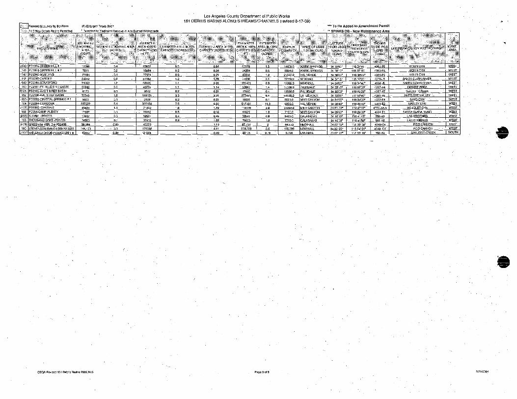
Los Angeles County Department of Public Works 161 DEBRIS BASINS ALONG STREAMS/CHANNELS (revised 8-17-09)
~:ocused biosUlvey by BonTerm (E) Enlarged Debris Basin "u To Be Added to Amendment Permit
21 Critical'Debris Basins Pennitted " Pennltted for Sediment Removal due to Burned Watersheds .. SPINKS DB - New Maintenance Area
.\ <'3 ..... '~~~~~:~' I· ....•.. ;"X> 1···.···\;.1. .<\: _~~~~'s:' iSf' .'
.;2"',.
I~ I,;·; .•.•• <~~
I~f~~ I:~~:~~ [~~ I~;~~~; .:..... ,'.i,·,· .
•...... I.ES~I\~~' lAR"" .':.~M~;r.':b.· IE~~~;,~~~~~\~:/o .. c2c c% ~~~o~ :,:ESTIMAlED
I,~; . Sp~+:~,,;,;, ; ",,2 i~
MOWING t:p":~~;~ ICAPACrr:.(A~~;S) ~OO. AREA'@'100%
IGi;~~£~; . .. -,~\AREA ,:.~
1>~,.··.·.·~I~~R~)~ilC.' •. CAPACITY (sa
>', li\~ •... .'~~O~- 1-, .v."" ~(saf"li< i~_~;2"'" I.:;." .~\/A;.:ri2~07.~ I·>' .·;·i~~·;·\.~ C:i~~.,~·· ;·::;·,··.··\.· .. ;· .... ·· .. · .. · ...... ;5 ' .. / .··.·f .•.•• ' ..•.• {.,;:,'::,:>,< I :';.X ',;'\;:;' , ... ; .... ,
'",
ri4s, PD1974-GREEN H1LL# 1 19398 D •• 23033 O.S 0.64 63678 l.S 14400.0 WARM SPRINGS 3430'00" 11837'45" 4369-F5 VIOLIN CYN WEST
146 PD1974-GREEN HILL #. 2 7531 0.2 10584 0.2 0.24 3430. 0.8 8054.0 WARM SPRINGS 3430'10" 11837' 50" 4369-F5. VIOLIN CYN' WEST :,,147 PD2049-MUSTANG 15484 0.4 27981 0.6 I 0.71 45696 1.0 21807.0 VAL VERDE 3430'00" 11838'00" 4369-F5 VIOLIN CYN WEST 148 PD2097-CARDIFF 34312 0.8 51162 1.2 1~76 91630 2.1 15880.0 . NEWHALL 3424'15" 11837'30" 4550-J5 SANTA CLARA RIVER WEST
'-;'1491' PD2097-STRATFORD 74053 1.7 60180 1.' 2.01 125471 2 .• 13985.0 NEWHALL . 34 24'00" 11837'40" 4550-J5 SANTA CLARA RIVER WEST
1S0 PD2101-Ff. TEJON RD BASIN 36832 0.8 49778 1.1 1.14 59869 1.4 19036.0 PALMDALE 3433'15" 11802'30" 4287-M DESERT AREA WEST ,,151: PD2103-AVE T-8 RET BASIN 6170 0.1 9512 0.2 0.21 17093 0.' 11600.0 PALMDALE 3432'00" 11802'25" 4287-A7 WALNUT CREEK WEST
1S2 PD2136-AVE S RET BASIN 78549 1.8 144121 3.3 3.31 277481 6.4 54530.0 LITTLE ROCK 34 33'25" 11757'40" 4288-A3 ANTELOPE VALLEY - WEST l~153 PD2223-CRYSTAL SPRINGS it 1 5022 0.1 9196 0.2 0.21 16556 0.4 5521.0 MINT CANYON 3424'25" 11824'30" 4552-E4 SANDCYN WEST
1S. PD2284-CORDOBA 237222 5.4 325154 7.5 0.37 518007 11.9 5366.0 VAL VERDE 3428'40" 11838'40" 4459-E2 I:IASLEYCYN WEST 1551 PD2389- OAKDALE 48635 1.1 71452 1.6 1.72 114470 2.6 26298.0 MINT CANYON 3423' 52" 11827'17" 4551-J-56 BouaUETCYN WEST
156 PD354-CAMP PLENlY 15102 0.3 20105 0.5 0:46 41672 1.0 7100.0 MINT CANYON 3425'50" 11828'30" 4551-F1 SANTA CLARA RIVER WEST
~i57? SLOAN - PD1726 13897 0.3 18937 0.4 0.45 33585 0.8 6420.0 CALABASAS 3410'10" 1'1841'45" 558-A3 LAS VIRGENES WEST
158 THOUSAND OAKS -PD1726 32553 0.7 37938 0 .• 1.02 78663 1.8 7720.0 CALABASAS 3410'00" 11841'50" 559-A3 LAS VIRGENES WEST ';:159" GREENSBRIER DB·PD2495 36284 0.83 49223 1.13 87726 2 44530 NEWHALL 34 22' 12" 11835' 38" 4640-C4 PICO CANYON WEST
160 STEVENSON RANCH DB-PO 2528 144123 3.3 179032 4.11 239303 5.S 165000 NEWHALL 3422' 56" 11834'51" 4640-C1 . PICOCANYON WEST
;%161.'; WELLINGTON DB·PD2202-lliIT 8 1§.552· - ~8 - ?J~4 .- - .- - 0.49 - 31105 1._ 0.76 6.700 LAHABRA 3357' 27" 117 55' 10" 708-H2 -- SAN JOSE CREEK SOUTH -
.-
CEQA-Revised 161 Debris Basins 2009.XLS Page30f3 8/31/2004