emerson east–eken park–yahara neighborhood plan · public review draft emerson east‐eken...
TRANSCRIPT

Public Review Draft Emerson East–Eken Park–Yahara
Neighborhood Plan a project of the Emerson East, Eken Park and Yahara Neighborhood areas and the City of Madison
Plan adopted by City of Madison Common Council on x date by Resolution No. x, Enactment No. RES‐x


Emerson East‐Eken Park‐Yahara Neighborhood Plan Adopted by the City of Madison Common Council on x by Resolution No. x, Enactment No. x
City of Madison Mayor, Officials and Administrators
Paul Soglin, Mayor
Larry Palm, District 12 Alderperson
Ledell Zellers, District 2 Alderperson
Steve Cover, Former Director, Department of Planning & Community & Economic Development
Katherine Cornwell, Director, Planning Division
William A. Fruhling, Principal Planner, Planning Division
Project Staff City of Madison Planning Division
Linda Horvath, Urban Planner
Jule Stroick, Neighborhood Planner
Ryan Jonely, Planning Technician
Sheri Milleville, Former Planning Technician
Milena Bernardinello and Angela Puerta ‐ Interns
Neighborhood Plan Steering Committee Leaders
Aaron Onsrud, Chair, Resident of Yahara Area, Briarwood Apartments
Art Hackett, Vice‐Chair, Co‐Chair of Eken Park Neighborhood Association
David Albino, Former Co‐Chair, Resident of Emerson East Neighborhood
Regular Members
Amy Klusmeier, Resident of Eken Park Neighborhood
Dan Grubb, Employee of Webcrafters
Douglas Buege, Resident of Yahara Area, Sherman Terrace Condominiums
Adrienne Sella, Resident, Emerson East Neighborhood
Anne Gassere, Co‐Chair, Emerson East Neighborhood Association
Community Organizations and Centers of Worship
Emerson East Neighborhood Association
Eken Park Neighborhood Association
Sherman Terrace Condominium Association
Sherman Neighborhood Association
Bashford United Methodist Church
James Reeb Unitarian Universalist Congregation
Emerson Parent Teacher Organization
Dane County Employment Center
Goodman Community Center
City of Madison Staff
Anne Monks, Mayoral Aide
Ed Ruckriegel, Fire Marshall
Christy Bachmann, Professional Engineer
Tony Fernandez, Professional Engineer
Kay Rutledge, Parks Division Planning and Development Manager
Sarah Lerner, Parks Division Landscape Architect
Mike Miller, Community Development Division Grant Administrator
June Garvin, East Site ‐ Housing Manager
Agustin Olvera, Housing Operations Division Director
John Hausbeck, Environmental Health Services Supervisor
George Hank, Building Inspection Division Director
Scott Langer, Assistant Traffic Engineer
Michael Waidelich, Former Principal Planner
Kenn Finn, City Assessor
Jim O’Keefe, Community Development Division Director
Matt Mikolajewski, Office of Business Resources Manager
Peggy Yessa, Office of Business Resources, Economic Development Coordinator
Tim Parks, Planner
Dan Rolfs, Community Development Project Manager
Tim Sobota, Metro Transit Planner
Photo Credits
Linda Horvath, Ryan Jonely and Angela Puerta

i
TABLE OF CONTENTS Executive Summary………………………………………………………………………………………………………………………………………….. 1 Chapter 1: Introduction…………………………………………………………………………………………………………………………………….5 Chapter 2: Neighborhood Profile……………………………………………………………………………………………………………………. 9 Chapter 3: Land Use, Housing and Urban Design…………………………………………………………………………………………… 11
Focus Area Land Use, Urban Design and Housing Goals and Recommendations Chapter 4: Local Economic Development and Employment Opportunities………………………………………………….. 37
Economic Development and Employment Goals and Recommendations Chapter 5: Transportation Safety and Efficiency………………………………………………………………………………………….. 40
Transportation Goals and Recommendations Chapter 6: Parks, Recreation and Open Space……………………………………………………………………………………………… 46
Parks, Recreation and Open Space Goals and Recommendations Chapter 7: Community Health and Wellness……………………………………………………………………………………………….. 53 Community Health and Wellness Goals and Recommendations Chapter 8: Adoption and Implementation……………………………………………………………………………………………………. 58

ii
FIGURES Figure 1: Conceptual Sketch E. Johnson/E. Washington Gateway Corridor………………………………………………… 17Figure 2: Branding/Identity Ideas………………………………………………………………………………………………………………. 18Figure 3: Focus Area Two Conceptual Plan………………………………………………………………………………………………… 19Figure 4: Focus Area Two 3D Perspectives…………………………………………………………………………………………………. 20Figure 5: Focus Area Four Conceptual Plan 1……………………………………………………………………………………………… 23 Figure 6: Focus Area Four Conceptual Plan 2……………………………………………………………………………………………… 23 Figure 7: Focus Area Four 3D Perspectives Views 1 & 2 …………………………………………………………………………….. 24 Figure 8: Focus Area Four 3D Perspectives Views 3 & 4……………………………………………………………………………… 25 Figure 9: Focus Area Five Conceptual Plan ………………………………………………………………………………………………… 27 Figure 10: Focus Area Five 3D Perspectives Views 1 & 2………………………………………………………………………………. 28 Figure 11: Corridor Branding and Public Art Examples…………………………………………………………………………………. 29 Figure 12: Examples of Beautification and Branding…………………………………………………………………………………….. 30 Figure 13: Emerson Elementary School Playground and Neighborhood Gathering Area………………………………. 32 MAPS Map 1: EEEPY Plan Study Area…………………………………………………………………………………………………………………… 6 Map 2: Urban Design Districts…………………………………………………………………………………………………………………. 13 Map 3: Focus Areas ………………………………………………………………………………………………………………………………… 14 Map 4: Proposed Long‐Term Road Connections……………………………………………………………………………………….45

iii
TABLES Table 1: Community Development Block Grant Fund Priorities……………………………………………………………. 4Table 2: Demographics………………………………………………………………………………………………………………………… 9Table 3: Socio‐Economic Profile………………………………………………………………………………………………………….. 10Table 4: Land Use, Housing, Urban Design………………………………………………………………………………………….. 33Table 5: Local Economic Development and Employment Opportunities………………………………………………39Table 6: Transportation Safety and Efficiency………………………………………………………………………………………42Table 7: Parks, Recreation, and Open Space……………………………………………………………………………………….. 49 Table 8: Community Health and Wellness………………………………………………………………………………………….. 55 Table 9: Community Development Block Grant Priorities…………………………………………………………………… 59 APPENDICES Appendix I: Background Maps…………………………………………………………………………………………………………………. 62Appendix II: Community Support Organizations, Educational Institutions and Centers of Worship…………...71

Public Review Draft EMERSON EAST‐EKEN PARK‐YAHARA NEIGHBORHOOD PLAN June 2015 1
View of planning area from Lake Mendota and Tenney Park
EXECUTIVE SUMMARY
The Emerson East‐Eken Park‐Yahara Neighborhood planning process began with a Public Open House on September 18, 2013. The planning process concluded with the City of Madison Common Council adopting the plan as a supplement to the Comprehensive Plan on x, 2015 (Resolution No. x, Enactment No. x). Implementation is underway and will continue to take place over the next 10 to 15 years. The planning process included opportunities for input from residents, the business community, and locally‐based community organizations. There were two Public Open Houses, each scheduled for a key point in the planning process. There were also interviews with community groups, centers of worship, agencies from the City of Madison, Village of Maple Bluff, Town of Madison and Dane County, and business roundtable discussions. Other education and input opportunities included discussions with neighborhood associations, the Emerson Elementary School principal, East High School principal, Sherman Middle School principal and other stakeholders, an interactive webpage where members of the public could submit written comments, and announcements about the plan in area newsletters and webpages. The Emerson East‐Eken Park‐Yahara (EEEPY) Neighborhood Plan is consistent with the goals, objectives and policies of the Comprehensive Plan. The EEEPY Plan addresses all nine Comprehensive Plan elements, using its own unique structure. The EEEPY Plan also addresses the elements of what makes a great neighborhood:
A mix of uses, services, and amenities that serve residents and attract newcomers to live in the neighborhood.
Local businesses such as grocery stores, restaurants, coffee shops, financial
institutions, hair salons, and other businesses all within walking distance.
A strong business climate that includes commercial, industrial and office spaces and relationships that help people find jobs and start new businesses.
A variety of housing choices for people in different stages of life and with various income levels.
Walkability and connectivity to neighborhood serving places, such as shopping districts, community centers, employment centers, schools, and recreational areas.
Programmed activities for people of all ages to enjoy.
Community connectedness and cohesion between people of different ethnic and cultural backgrounds.
Placemaking to provide gathering spots for community, educational, recreational, and social enjoyment.
Attractive public and private realm, in terms of housing, businesses, and open space, which makes a statement that the neighborhood is well‐kept.
Safe, healthy and sustainable environments, in residential and business districts, alike.

Public Review Draft EMERSON EAST‐EKEN PARK‐YAHARA NEIGHBORHOOD PLAN June 2015 2
Madison East High School
The Emerson East‐Eken Park‐Yahara Neighborhood Plan is an advisory document for initiating, directing and managing change. The plan begins with an overall vision and goals for the study area, which were composed by the Steering Committee with stakeholder and community input. Each of the subsequent chapters covers a theme that includes background information, goals and recommendations, implementation steps and estimated costs. The conclusion includes the projects identified for implementation using Community Development Block Grant funds set aside for this planning process. Neighborhood Vision and Goals The Emerson East‐ Eken Park‐Yahara Neighborhood area is an inviting and vibrant place to live, work, play and learn. Families and individuals of many different backgrounds are attracted to the quiet residential streets, affordable well‐kept housing, and high quality schools. Local business districts feature unique dining, shopping, and gathering places amidst colorful streetscapes that reflect the area’s ethnic and cultural diversity. A healthy mix of industries provides a large base of jobs that employ people from the neighborhood, City and larger region. Urban parks, Lake Mendota and the Yahara River offer beautiful and engaging venues for recreational activities, community events, family picnics and more. Sustainable building and site design are incorporated into existing and new development, and nutritious, affordable food is plentiful in community gardens, public orchards, groceries and farmers markets. People can safely and conveniently travel around the area, and to other parts of the City and beyond, using the extensive public transit system, pedestrian paths, bike paths, waterways, the airport and the freeway.
Towards this vision, the EEEPY neighborhoods will:
Ensure residents of all ages and incomes are able to flourish via improved community relationships and connections;
Maintain and enhance continued participation of children and families in schools and other educational centers;
Celebrate diverse cultures by supporting and encouraging community wide turnout to cultural events;
Ensure all residents have access to fresh, delicious, and affordable food;
Create a unique neighborhood identity reflected in attractive gateways, business districts, streetscapes, open spaces and other venues;
Encourage thriving, iconic business districts that offer residents cultural, community and commercial amenities;
Enable businesses and employers to prosper and to employ area residents;
Maintain and enhance industrial areas while protecting the natural and built environment;

Public Review Draft EMERSON EAST‐EKEN PARK‐YAHARA NEIGHBORHOOD PLAN June 2015 3
Preserve the quiet enjoyment of homes, parks and neighborhoods;
Employ universal design concepts to enhance accessibility and mobility for all residents;
Improve the safety of pedestrian and bike transportation within the area and to adjoining neighborhoods;
Preserve and restore the natural beauty of the river, lake and open spaces; making them accessible to all and encouraging their active use;
Expand and promote accessible recreational options for a wide variety of individual and community recreational activities.
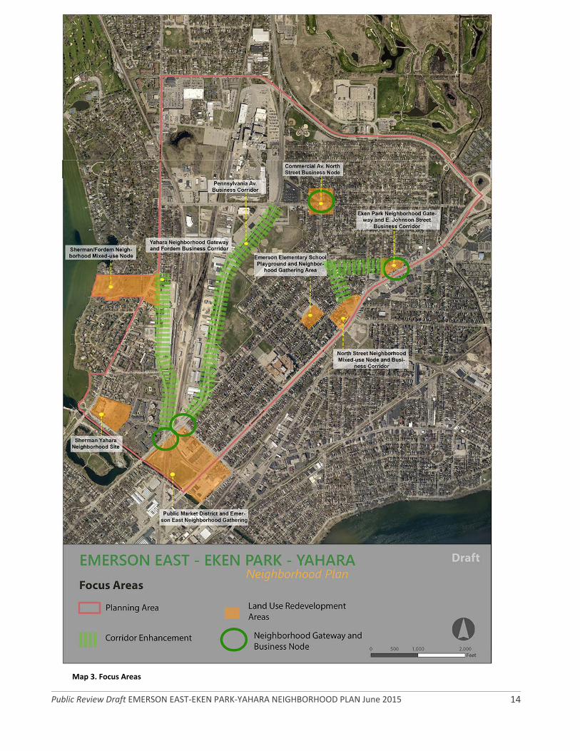
To realize the neighborhood vision and goals, the neighborhood plan includes recommendations, strategies and implementation steps that are categorized into five themes: Theme 1: Revitalize Focus Areas and Guide New Development; Theme 2: Strengthen Local Economic Development and Employment; Theme 3: Improve Safety and Efficiency of Transportation; Theme 4: Enhance Parks, Recreation and Open Space; Theme 5: Enhance Community Health and Wellness. These five themes are described on the following pages. Theme 1 – Revitalize Focus Areas and Guide New Development Recommendations and concept designs are included for nine focus areas (Figure 1), some of which the planning process identified as having redevelopment and development potential, and others which need revitalization: 1) Eken Park Neighborhood Gateway and East Johnson Street Commercial Corridor; 2) North Street Neighborhood Mixed‐Use Node and Commercial Corridor; 3) Public Market District and Emerson East Neighborhood Gateway; 4) Sherman/Yahara Neighborhood Area; 5) Sherman/Fordem Avenue Neighborhood Mixed‐Use Node; 6) Yahara Neighborhood Gateway and Fordem Avenue Commercial Corridor; 7) Pennsylvania Avenue Commercial Corridor; 8) Commercial Avenue/North Street Commercial Node; and 9) Emerson Elementary School Playground and Neighborhood Gathering Area.
Recommendations focus on enhancing neighborhood identity and improving local business success, and contributing to a more environmentally‐friendly community by establishing neighborhood mixed‐use nodes and beautifying and branding gateways. This includes encouraging mixed‐use, multi‐story buildings with retail/commercial first levels and residential above, utilizing architectural and landscape design elements that embody the character of the neighborhoods, and incorporating high quality materials and environmentally‐sound building practices. Housing recommendations include broadening the variety of housing types, preserving single‐family housing character, preserving housing affordability, exploring options to encourage quality management and to improve screening processes, promoting and improving access and information for home buyers, and providing property owners with green building/rehabilitation alternatives education and information. Theme 2 ‐ Strengthen Local Economic Development and Employment
Recommendations include improving marketing of the study area to retain existing businesses and attract new businesses, improving and expanding economic development opportunities, coordinating with economic development of the larger east and north sides, improving the appearance of major corridors, business areas and commercial areas, and strengthening partnerships and creating initiatives with community groups, educational institutions and businesses to enhance and expand job training and employment opportunities for the local workforce. Theme 3 ‐ Improve Safety and Efficiency of Transportation Recommendations focus on improving safety and efficiency for pedestrians, bicyclists and public transit riders, while also improving movement and safety of motor vehicles. Intersections of focus include: 1st St./E. Washington Ave., 1st St./E. Johnson St., Fordem Ave./E. Johnson St., McGuire/Fordem Ave., Sherman Ave./Fordem Ave.; corridors of focus include E. Washington Ave. and

Public Review Draft EMERSON EAST‐EKEN PARK‐YAHARA NEIGHBORHOOD PLAN June 2015 4
Fordem Ave.; and bike/ped corridors of focus include the Yahara River Path and connections to it through Burr Jones Park and north to/through Demetral Park, and general bike and pedestrian connectivity on area roads and beyond. Theme 4 ‐ Enhance Parks, Recreation and Open Space
Recommendations focus on diversifying park activities with equipment for all ages, preserving and enhancing native habitats, improving connections between the neighborhoods and parks and open spaces, and facilitating an increase in positive activities at parks to help deter negative behaviors that sometimes occur. Theme 5 ‐ Improve Community Health and
Wellness
Recommendations focus on improving community safety of study area, enhancing and expanding programming for children and youth, establishing a neighborhood‐based network to assemble and disseminate community information, improving residents’ access to healthy, affordable food, cultivating more engagement across diverse cultural and ethnic groups, and exploring options to improve community support resources and social services. Community Development Block Grant Fund Expenditures The Community Development Block Grant (CDBG) Committee allocated $145,880 of CDBG funds for implementation of eligible plan recommendations. Using input from steering committee meetings, Public Open Houses, neighborhood association meetings, and city staff meetings, the steering committee identified the projects below to help implement the neighborhood plan’s priority recommendations using CDBG funds. Detailed implementation projects are being finalized by city staff in coordination with lead implementers.
Community Development Block Grant Implementation Funds
Priority Area Facilities CDBG $
1. Emerson East Neighborhood
Emerson Elementary School Playground and Neighborhood Gathering Area – enhance playground as a multi‐use place for school and neighborhood park‐type uses
$ 45,000.00 (if other City
resources become
available for this site by September 2015, these funds will be allocated to
Item #4)
2. Emerson East Neighborhood
Tiny Houses – Occupy Madison – funds for addition to permanent building, bathroom improvements, other
$ 5,000.00
3. Eken Park Neighborhood
Washington Manor Park – park shelter for 4 to 6 picnic tables and electricity
$ 60,000.00 (in the event that a park
shelter is not feasible for this location based on City
agency review, these funds will be allocated to
Item #5)
4. Emerson, Eken, Sherman, Yahara Neighborhood Areas
Branding/Identity ‐ commercial corridors and intersections
$ 15,888.00
5. Eken Park Neighborhood
Eken Park – gathering place with interpretive sign telling history of neighborhood, park benches and plantings
$ 20,000.00
Total: $145,880 (any unused CDBG funds to be allocated to Item #2)

Public Review Draft EMERSON EAST‐EKEN PARK‐YAHARA NEIGHBORHOOD PLAN June 2015 5
CHAPTER ONE Introduction
Emerson East‐Eken Park‐Yahara Study Area In 2013, the City of Madison Community Development Block Grant Commission (CDBG) selected the Emerson East‐Eken Park‐Yahara study area to receive planning services. The study area (Map 1) includes portions of the City of Madison and Town of Madison, and it features the Emerson East, Eken Park and Yahara neighborhood areas, Emerson Elementary School, Madison East High School, Sherman Middle School, Demetral Park, Burrows Park, Eken Park, Graaskamp Park, Washington Manor Park, McCormick Community Garden, the Starkweather Creek, and the Yahara River. The Emerson East Neighborhood and Eken Park Neighborhood include mostly single‐family homes, with small pockets of apartment buildings and multi‐family homes. The Yahara neighborhood area is primarily multi‐family housing in apartment buildings and townhomes, along with some condominiums. Commercial development is clustered in the North Street Commercial District, E. Johnson St./E. Washington Ave. Commercial District, First St./E. Washington Ave. intersection, along E. Washington Ave., and along Fordem Ave. Light industrial and commercial development is primarily clustered along Pennsylvania Ave. The CDBG Commission chose the EEEPY study area to receive planning services for a number of reasons including that there are a higher percentage of low and moderate‐income households compared to the City as a whole; the most recent neighborhood plan for the study area was completed 16 years ago, in 1998.

Public Review Draft EMERSON EAST‐EKEN PARK‐YAHARA NEIGHBORHOOD PLAN June 2015 6
Map 1. Emerson East‐Eken Park‐Yahara Neighborhood Plan Study Area

Public Review Draft EMERSON EAST‐EKEN PARK‐YAHARA NEIGHBORHOOD PLAN June 2015 7
Planning Process
The neighborhood planning process was led by Project staff in the Planning Division and guided by the Emerson East‐Eken Park‐Yahara Neighborhood Plan Steering Committee. Project staff and neighborhoods kicked off the planning process with a Public Open House on September 18, 2013 and the first steering committee meeting was January 23, 2014. Project staff, city staff representing many different agencies, and the steering committee devised plan recommendations and strategies and reviewed plan drafts. The steering committee and project staff put a high priority on input from residents, business owners, landlords and property managers, and community service professionals. Project staff hosted two Public Open House events at key points during the planning process and attended group meetings and other activities to present plan drafts and to ask for input. Interpretation and translation was available to accommodate non‐English speakers. The project staff and stakeholders held the second and final Public Open House on June 9, 2015. Members of the public, city staff and stakeholders reviewed the Public Review Draft Plan and provided input. The project staff reviewed and considered input for inclusion in the Final Draft Neighborhood Plan. The project staff distributed the Final Draft to the public for review and comment, and neighborhood leaders presented the Final Draft Plan to City of Madison Committees, Boards and Commissions for review and adoption. The City of Madison Common Council adopted the plan as a supplement to the Madison Comprehensive Plan on x 2015 by Resolution No. x, Enactment No. x. The land use and design recommendations in this plan are consistent with, and fit within the larger context of the Comprehensive Plan. In this way, the neighborhood plan provides the more detailed recommendations needed to effectively implement the Comprehensive Plan.
Plan Implementation Plan implementation will take place over the next 10 to 15 years and will include city agencies allocating funds in their budgets to carryout plan strategies and recommendations, businesses taking leadership in sponsoring implementation, and neighborhood and community organizations joining together to contribute time and expertise toward implementation. Upcoming plan chapters include matrices of recommendations by topic area and corresponding implementation steps and estimated costs.
Neighborhood and Community Fabric
Neighborhoods, community organizations, faith‐based organizations, and other stakeholders are critical to plan implementation. The Emerson East and Eken Park Neighborhood Associations and the Sherman Terrace Condominium Association are organized neighborhood groups that help residents stay connected with each other and help organize and encourage participation in neighborhood building events and activities.
According to the Emerson East Neighborhood Association webpage, the association covers the area of the east isthmus bounded by East Washington Avenue, the Yahara River, Fordem Avenue, Packers Avenue, Commercial Avenue, and North Street (Appendix I – Background Maps).
This area was originally developed in the 1920’s, after Madison’s Central Marsh was drained and land became available for houses for workers in nearby factories, including Oscar Mayer and the French Battery Company. Housing includes a mix of owner‐occupied and rental housing. The area includes about 2,100 people in about 1,000 houses and apartment units. Housing is still affordable in the Emerson East neighborhood, and the neighborhood is safe, friendly, and diversified. A listing of area community, faith, non‐profit and other related organizations can be found in Appendix II.

Public Review Draft EMERSON EAST‐EKEN PARK‐YAHARA NEIGHBORHOOD PLAN June 2015 8
The Eken Park Neighborhood is on the west branch of Starkweather Creek and includes Eken Park, Washington Manor Park, East Madison Little League, McCormick Community Garden, and the McCormick Greenway and Dog Park. The Eken Park Neighborhood is bound by Aberg Avenue, Packers Avenue, Commercial Avenue, North Street and E. Washington Avenue. Commercial nodes include Commercial Avenue/North Street and E. Johnson/E. Washington Avenue, North Street/E. Johnson Street and North Street/E. Washington Avenue (Map 3, page 14). Any person, household or business located within this boundary may join the Eken Park Neighborhood Association. This organization provides a forum for improving the neighborhood through democratic citizen participation and involvement. Sherman Terrace resident leaders describe their community as a forward thinking condominium community located off Sherman Avenue one block from Lake Mendota and Tenney Park. Easy access to the University and Capitol, bike trails, and bus lines make Sherman Terrace an attractive neighborhood for those looking for a quiet, safe and affordable home minutes by bike, car or bus from downtown. The condominium association consists of 37 buildings with 217 residential units, the majority of which are two bedroom and one bath, and one commercial property. The sturdy buildings are constructed of brick and feature modern layouts with creative use of space. The complex offers many amenities including indoor bike storage, on‐site laundry, storage units, picnic area, easy access to the beach, and a vibrant community.

Public Review Draft EMERSON EAST‐EKEN PARK‐YAHARA NEIGHBORHOOD PLAN June 2015 9
CHAPTER TWO Neighborhood Profile
People Who Live in the Neighborhood
There were 6,803 people living in the planning study area in 2010. The study area population decreased by 309 people, or by 4.5 percent from 2000 to 2010. During this same time period, the City of Madison grew by 25,155 people, or 10.8 percent. The racial and ethnic composition of the planning study area population is nearly identical to the City as a whole (Table 2. Demographics). The Emerson Elementary School attendance area covers most of the planning study area, and a small portion is covered by Lapham Elementary School. Sherman Middle School and East High School attendance areas completely encompass the study area (Appendix I – Background Maps). In the 2014‐15 school year, 64 percent of Emerson Elementary School students qualified for free and reduced lunch, followed by 44 percent at Lapham Elementary School, 77 percent at Sherman Middle School and 54 percent at East High School. Socioeconomic Characteristics
Socioeconomic data is of critical importance to planners who collaborate with social workers, community development specialists and others to determine what services and associated physical improvements are needed to improve residents’ lives. The socioeconomic data available for this plan is from the City of Madison Department of Planning & Community & Economic Development and the U.S. Census (Table 3, next page).
Table 2. Demographics
People and Planning Area
Planning Study
Area
(Totals)
City of Madison
Total Population 6,803 100.0% 233,209 100.0%
Median Age 33.6 ‐‐ 30.9 ‐‐
Gender (%F ) (Total 3,300
F – 3,503 M) 49% ‐‐ 54%
Planning Area (ppl/sq.
mile) 1.35 100.0% 77.8 ‐‐
Population Density
(ppl/sq. mile) 5,043.0 ‐‐ 3,000 ‐‐
Planning Area (acres) 863.6 100.0% 49,764 ‐‐
Population Density
(ppl/acre) 8 ‐‐ 4.69 ‐‐
Pop Density of Inhabited
area (#ppl/total inhabited
acres)
11 ‐‐ na ‐‐
Preschool (0‐5y.) 433 6.4% 13,561 5.8%
School Age Population (5‐
17 y.) 587 8.6% 27,177 11.7%
Young & Adult Population
(18‐34 y.) 2,619 38.5% 91,181 39.1%
Adults (35‐64 y.) 2,787 41.0% 78,907 33.8%
Seniors 65 & Over 377 5.5% 22,383 9.6%
Population Change Since
2000 Census ‐309 ‐4.5% 25,155 10.8%
Race (Non‐Hispanic
Latinos) 6,330 93.0% 217,261 93.2%
White 5,253 77.2% 176,463 75.7%
Black or African
American 591 8.7% 16,507 7.1%
American Indian and
Alaska Native 31 0.5% 763 0.3%
Asian 235 3.5% 17,126 7.3%
Native Hawaiian &
Other Pacific Islander 1 0.0% 67 0.0%
Some Other Race 14 0.2% 374 0.2%
Two or More Races 205 3.0% 5,961 2.6%
Hispanic or Latino 473 7.0% 15,948 6.8%
Source: City of Madison Department of Planning & Community & Economic
Development 2014 and U.S. Census 2010 SF1

Public Review Draft EMERSON EAST‐EKEN PARK‐YAHARA NEIGHBORHOOD PLAN June 2015 10
Table 3. Socio‐Economic Profile
People and Planning Area Planning Study Area (Totals)
City of Madison
Educational Attainment ‐ People 25 y. and Older 4,932 72.5% 142,866 61.3%
w/ Bachelor's degree or higher* 2,275 46.1% 75,634 52.9%
Total Households 3,554 100.0% 102,516 100.0%
Households size & type
1‐person 1,580 44.5% 37,149 36.2%
2‐person 1,210 34.0% 35,720 34.8%
More than 2‐person 764 21.5% 29,647 28.9%
% Single Mothers w/own children under 18y. 209 5.9% 5,408 5.3%
Male 65y.+ living alone 63 1.8% 1,907 1.9%
Female 65y.+ living alone 123 3.5% 5,707 5.6%
Total Housing Units (HU) 3,901 100.0% 108,843 100.0%
Occupied HU 3,608 92.5% 102,516 94.2%
Owner‐occupied HU* 1,713 47.5% 50,555 49.3%
Renter‐occupied HU 1,895 52.5% 51,961 50.7%
Average Household Size ‐ Owner‐Occupied HU 2.1 n.a. 2.4 n.a.
Average Household Size ‐ Renter Occupied HU 1.8 n.a. 2.0 n.a.
Average SF Value Assessed 2012 $149,400 n.a. $229,533
Range SF Assessed value 2012 $ 52,000 ‐$1,100,000
n.a. $25,400 ‐$2,816,000
Median Value of Owner‐occupied houses $161,900
Median Year Structure Built 1952 1973
Housing Burden Estimate (% of Occupied HU(s) that cost HH 30% or more of their income)
1,522 42%
Owner Occupied HUs [35% of the EEEPY Tot 1,713 'OwOcc‐HU' hosts HH facing housing burden]
606 17% 15%
Renter Occupied HUs [48% of the EEEPY Tot 1,895 'RentOcc‐HU' hosts HH facing housing burden]
917 25% 25%
Affordable Housing ‐ public housing / private project‐Sec.8 and Sec.42 ‐ excluded Sec.8 voucher holders
163 4.2% 4,756 4.4%
for People with Special Needs or Disabilities 50 1.3% 290 0.3%
for Family 113 2.9% 2,462 2.3%
for Elderly 0 0% 2,004 1.8%
Sources: Madison Department of Planning & Community & Economic Development *U.S. Census ‐ American Community Survey 5‐Year Data 2007‐2011

Public Review Draft EMERSON EAST‐EKEN PARK‐YAHARA NEIGHBORHOOD PLAN June 2015 11
CHAPTER THREE Land Use, Housing and Urban Design There are approximately 658.0 acres of land in the study area, including 258.2 acres of residential, 95.3 acres of commercial, 182.0 acres of industrial, 34.0 acres of institutional, 81.9 acres of parks and open space, and 6.3 acres of agricultural or vacant land (Appendix I – Background Maps). Housing construction began in the study area in the 1960’s and continued into the early 1990’s. (Appendix I – Background Maps). The Emerson East and Eken Park Neighborhoods include mostly single‐family homes, with small pockets of apartment buildings and multi‐family homes. Washington Manor Park, McCormick Park, McCormick Community Garden, Eken Park and the Starkweather Creek are in the Eken Park Neighborhood; and Graaskamp Park, Burr Jones Park, the Yahara River Parkway and Demetral Park are in the Emerson East Neighborhood. The Yahara neighborhood area is primarily comprised of multi‐family housing in apartment buildings and townhomes, along with some condominiums. The Yahara River Parkway, Burrows Park, Filene Park and the Lake Mendota shore are in the Yahara Neighborhood area. There are business nodes and pockets along E. Washington Avenue, E. Johnson Street, Fordem Avenue, North Street and Commercial Avenue and there is some industrial development along Pennsylvania Avenue. The City of Madison completed rewriting its Zoning Code in 2012. Appendix I shows current zoning districts for the study area. These zoning districts are consistent with the city’s Comprehensive Plan adopted in 2006 and with this neighborhood plan’s land use recommendations. Urban design districts are overlays in the zoning code that help facilitate a high quality site, building and landscape design along prominent urban corridors. The planning study area includes portions of Urban Design Districts 4, 5 and 8 (Map 2, page
13). Urban Design District 4 extends along First Street and Pennsylvania Avenue from First Street to International Lane; Urban Design District 5 extends along E. Washington Avenue from N. 6th Street almost to I‐90/94; and Urban Design District 8 extends along E. Washington Avenue from Blair Street to First Street. The provisions in the Urban Design Districts of the planning study area were used to develop the land use and urban design recommendations in this plan. Focus Areas Through discussion at steering committee meetings, city staff analysis, and public input, project staff identified nine focus‐areas (Map 3, page 14), some of which the planning process identified as having redevelopment and development potential, and others which are in need of revitalization: 1) Eken Park Neighborhood Gateway and East Johnson Street Commercial Corridor; 2) North Street Neighborhood Mixed‐Use Node and Commercial Corridor; 3) Public Market District and Emerson East Neighborhood Gateway; 4) Sherman/Yahara Neighborhood Area; 5) Sherman/Fordem Avenue Neighborhood Mixed‐Use Node; 6) Yahara Neighborhood Gateway and Fordem Avenue Commercial Corridor; 7) Pennsylvania Avenue Commercial Corridor; 8) Commercial Avenue/North Street Commercial Node; and 9) Emerson Elementary School Playground and Neighborhood Gathering Area. Recommendations focus on enhancing neighborhood identity, improving local business success and contributing to a more environmentally‐friendly community by establishing neighborhood mixed‐use nodes and beautifying and branding gateways. This includes encouraging mixed‐use, multi‐story buildings with retail/commercial first levels and residential above, utilizing architectural and landscape design elements that embody the character of the neighborhoods, and incorporating high quality materials and environmentally‐sound building practices.

Public Review Draft EMERSON EAST‐EKEN PARK‐YAHARA NEIGHBORHOOD PLAN June 2015 12
Housing recommendations include broadening the variety of housing types, preserving single‐family housing character, preserving housing affordability, exploring options to encourage quality management and to improve screening processes, promoting and improving access and information for home buyers, and providing property owners with green building/rehabilitation alternatives education and information.

Public Review Draft EMERSON EAST‐EKEN PARK‐YAHARA NEIGHBORHOOD PLAN June 2015 13
Map 2. Urban Design Districts
Public Review Draft EMERSON EAST‐EKEN PARK‐YAHARA NEIGHBORHOOD PLAN June 2015 14
Map 3. Focus Areas

Public Review Draft EMERSON EAST‐EKEN PARK‐YAHARA NEIGHBORHOOD PLAN June 2015 15
Focus areas were selected due to potential for land use change; underutilized land; access to and visibility from major thoroughfares; emerging issues such as crime and safety; and potential for stabilization through landlord education and training. Through additional research and analysis of focus area characteristics, interviews with property owners, public input and further discussions, project staff created land use goals, concepts, design elements, and recommendations for the focus areas. Existing and potential property owners are encouraged to use the goals, concepts, and recommendations as a guide when considering future development and redevelopment. Land Use, Urban Design and Housing Goals
Strengthen neighborhood identity and create a greater sense of place.
Establish and promote identities of commercial and employment corridors to improve marketing and economic development.
Improve stability and cohesiveness of residential areas.
Encourage the preservation of existing single‐family and owner‐occupied areas to promote housing and neighborhood stability, and encourage maintenance and rehabilitation of housing throughout the planning study area.
Ensure that new infill single‐family, multi‐family and mixed‐use development remain compatible with, and sensitive to, the existing form of the neighborhood as a whole with exception to areas designated for compact, higher density developments.
Ensure that new infill mixed‐use or commercial development along and/or adjacent to the major transportation corridors incorporate traditional neighborhood design elements, especially with regard to pedestrian‐oriented features.
Promote and assist redevelopment of sites that will revitalize the Pennsylvania Avenue, North Street and Fordem Avenue corridors into places to live, work, and enjoy.
Support the redevelopment of underutilized sites to improve the economic vitality and appearance of the major transportation corridors.
Create redevelopment concepts for identified mixed‐use or commercial nodes. New internal circulation (e.g. streets and sidewalks systems) should connect to existing street network.
Encourage green building and compact site design that minimizes resource consumption and environmental impacts.
Promote environmentally friendly features that protect and enhance Madison’s natural resources.
Add passive and active green space whenever possible to redevelopment concepts.

Public Review Draft EMERSON EAST‐EKEN PARK‐YAHARA NEIGHBORHOOD PLAN June 2015 16
Focus Area One: Eken Park Neighborhood Gateway and East Johnson Street Commercial Corridor Located at the intersection of E. Washington Avenue and E. Johnson Street, this gateway to the Eken Park Neighborhood and commercial corridor is currently marked with a neighborhood welcome sign and a diversity of businesses including a bakery, clothes store, second‐hand clothing store for kids, store specializing in African American products, barber shop and more. The Madison East Shopping Center is across the street along with individual businesses including a bank, liquor store and gas station. Concept
Figure 1 on the following page includes a conceptual sketch, and Table 4, page 33 includes recommendations for enhancements and improvements that would bring neighborhood and commercial corridor branding to the intersection, helping to draw customers to the businesses and providing a greater sense of neighborhood identity and pride. Additionally, there are a couple of multi‐story buildings included to show how the corner properties could redevelop over time. Design elements are described below.
Definition and Identity: Gateway and corridor branding that includes iconic design elements of the neighborhoods incorporated in neighborhood welcome signs and commercial corridor signs, seating, lighting, public art and landscaping, to bring a more cohesive and readily identifiable look and feel to this neighborhood gateway and commercial district. Connectivity: Safety improvements to pedestrian and bike facilities at intersections and crossings to make the area more easily navigable without a vehicle. Community Interaction: Small, flexible public and private gathering spaces (pocket greenspace, sidewalk seating, square, plaza, etc.); incorporate Crime Prevention through Environmental Design, programmed
recreational and entertainment activities, public art, landscaping and other enhancements.

Public Review Draft EMERSON EAST‐EKEN PARK‐YAHARA NEIGHBORHOOD PLAN June 2015 17
Figure 1. Conceptual Sketch: E. Johnson St./E. Washington Ave. Gateway Corridor
Bus shelter is representative only; the current bus shelter
design will be maintained along E. Washington Ave.

Public Review Draft EMERSON EAST‐EKEN PARK‐YAHARA NEIGHBORHOOD PLAN June 2015 18
Focus Area Two: North Street Neighborhood Mixed‐Use Node and Commercial Corridor Located at the intersection of Milwaukee Street, North Street and E. Washington Avenue, this gateway marks the entrance to the North Street Commercial District. North Street is the boundary between the Emerson East and Eken Park Neighborhoods, and it is one of only a few through streets linking the City’s east and north sides. There is no neighborhood or commercial corridor branding at this intersection, leaving it somewhat non‐descript, and uninviting. There appears to be little reason for anyone to travel down North Street, unless they already know what is located there, are heading to the City’s north side or beyond, or are traveling to the airport. Once on North Street, there are pedestrian streetlights installed as part of the 1998 neighborhood planning process, helping to define the commercial district. Concept
The conceptual plan and 3‐D perspectives shown on pages 19 through 20 include design and layout elements that would help property owners redevelop, through parcel aggregation, new multi‐story, mixed‐use buildings, additional landscaping and other features. The square footage of residential and commercial/retail space may change depending on the market at the time of redevelopment. The images in Figure 2 include enhancements and improvements that would better define and brand this gateway to the neighborhoods and the commercial corridor. Design elements are included below, and the recommendations, strategies, and implementation information is shown in Table 4, starting on page 33.
Definition and Identity: Gateway and corridor branding that includes iconic design elements of the neighborhoods incorporated in neighborhood welcome signs and commercial corridor signs, seating, lighting, public art and landscaping, to bring a more cohesive and readily identifiable look and feel to this neighborhood gateway and commercial district. Connectivity: New linkages that improve access and circulation to and through redevelopment sites
and the surrounding neighborhood; and safety improvements to pedestrian and bike facilities at intersections and crossings to make the area more easily navigable without a vehicle. Community Interaction: Small, flexible public and private gathering spaces (pocket greenspace, sidewalk seating, square, plaza, etc.); incorporate Crime Prevention through Environmental Design, programmed recreational and entertainment activities, public art, landscaping and other enhancements.
Metal banners such as those on State St.
Bus Shelter Artwork such as on the Northside (not on E.
Washington Ave. shelters as these are part of a Federal
reconstruction project)
Figure 2. Branding/Identity Ideas

Public Review Draft EMERSON EAST‐EKEN PARK‐YAHARA NEIGHBORHOOD PLAN June 2015 19
Figure 3. Focus Area Two Conceptual plan

Public Review Draft EMERSON EAST‐EKEN PARK‐YAHARA NEIGHBORHOOD PLAN June 2015 20
Figure 4. Focus Area Two 3D Perspectives – Views 3 and 4
Bus shelter is representative only; the current bus shelter
design will be maintained along E. Washington Ave.
Public Review Draft EMERSON EAST‐EKEN PARK‐YAHARA NEIGHBORHOOD PLAN June 2015 21
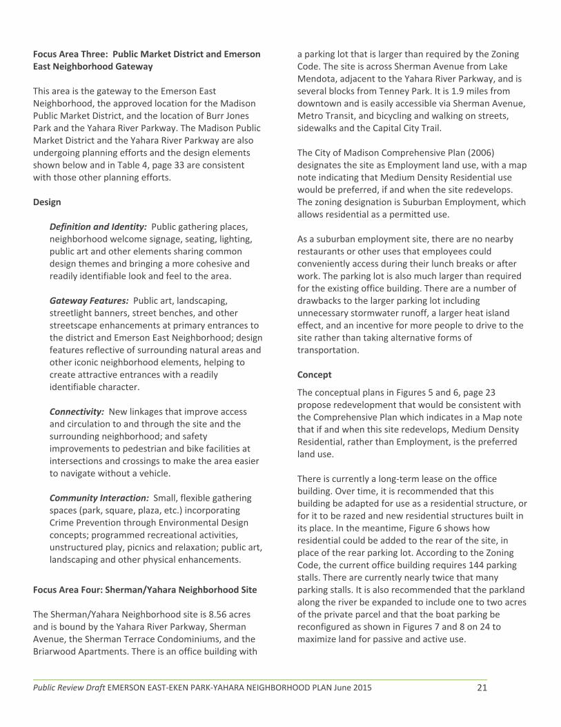
Focus Area Three: Public Market District and Emerson East Neighborhood Gateway This area is the gateway to the Emerson East Neighborhood, the approved location for the Madison Public Market District, and the location of Burr Jones Park and the Yahara River Parkway. The Madison Public Market District and the Yahara River Parkway are also undergoing planning efforts and the design elements shown below and in Table 4, page 33 are consistent with those other planning efforts. Design
Definition and Identity: Public gathering places, neighborhood welcome signage, seating, lighting, public art and other elements sharing common design themes and bringing a more cohesive and readily identifiable look and feel to the area. Gateway Features: Public art, landscaping, streetlight banners, street benches, and other streetscape enhancements at primary entrances to the district and Emerson East Neighborhood; design features reflective of surrounding natural areas and other iconic neighborhood elements, helping to create attractive entrances with a readily identifiable character. Connectivity: New linkages that improve access and circulation to and through the site and the surrounding neighborhood; and safety improvements to pedestrian and bike facilities at intersections and crossings to make the area easier to navigate without a vehicle. Community Interaction: Small, flexible gathering spaces (park, square, plaza, etc.) incorporating Crime Prevention through Environmental Design concepts; programmed recreational activities, unstructured play, picnics and relaxation; public art, landscaping and other physical enhancements.
Focus Area Four: Sherman/Yahara Neighborhood Site The Sherman/Yahara Neighborhood site is 8.56 acres and is bound by the Yahara River Parkway, Sherman Avenue, the Sherman Terrace Condominiums, and the Briarwood Apartments. There is an office building with
a parking lot that is larger than required by the Zoning Code. The site is across Sherman Avenue from Lake Mendota, adjacent to the Yahara River Parkway, and is several blocks from Tenney Park. It is 1.9 miles from downtown and is easily accessible via Sherman Avenue, Metro Transit, and bicycling and walking on streets, sidewalks and the Capital City Trail. The City of Madison Comprehensive Plan (2006) designates the site as Employment land use, with a map note indicating that Medium Density Residential use would be preferred, if and when the site redevelops. The zoning designation is Suburban Employment, which allows residential as a permitted use. As a suburban employment site, there are no nearby restaurants or other uses that employees could conveniently access during their lunch breaks or after work. The parking lot is also much larger than required for the existing office building. There are a number of drawbacks to the larger parking lot including unnecessary stormwater runoff, a larger heat island effect, and an incentive for more people to drive to the site rather than taking alternative forms of transportation.
Concept
The conceptual plans in Figures 5 and 6, page 23 propose redevelopment that would be consistent with the Comprehensive Plan which indicates in a Map note that if and when this site redevelops, Medium Density Residential, rather than Employment, is the preferred land use. There is currently a long‐term lease on the office building. Over time, it is recommended that this building be adapted for use as a residential structure, or for it to be razed and new residential structures built in its place. In the meantime, Figure 6 shows how residential could be added to the rear of the site, in place of the rear parking lot. According to the Zoning Code, the current office building requires 144 parking stalls. There are currently nearly twice that many parking stalls. It is also recommended that the parkland along the river be expanded to include one to two acres of the private parcel and that the boat parking be reconfigured as shown in Figures 7 and 8 on 24 to maximize land for passive and active use.

Public Review Draft EMERSON EAST‐EKEN PARK‐YAHARA NEIGHBORHOOD PLAN June 2015 22
The design elements are included below and shown in the 3D perspective drawings on pages 24 and 25, and the recommendations, strategies, and implementation information is shown in Table 4, starting on page 33.
Definition and Identity: Residential streetscape defined with 4‐5 story residential buildings in a classic design with some modern elements; parking areas with innovative stormwater management features; ped/bike path defining boundary between site and adjoining Sherman Terrace Condominiums and through the site to the Yahara River Parkway; environmentally‐friendly buildings with innovative stormwater management to protect the Yahara River Watershed and native plantings, renewable energy use for heating and cooling, green roofs, living driveways with porous pavers, and more; cooperative living elements such as community gardens and co‐housing. Gateway Features: Public art, landscaping, street benches, and other streetscape enhancements; design features reflective of surrounding natural areas and other iconic neighborhood elements. Connectivity: Ped/bike corridors through the site connecting to adjoining residential areas and the Yahara River Parkway; public street grid pattern to improve access and circulation through the site and to the surrounding neighborhood; inclusion of the Yahara River Parkway Master Plan design concept that includes a revised parking area and pedestrian path connecting underneath E. Washington Avenue, on the north side of the Yahara River; woodland conservation and potential park expansion into the south east corner of the site with pathways that directly connect to the Yahara River Parkway. Community Interaction: Gathering spaces (community garden, greenspace, play areas) incorporating Crime Prevention through Environmental Design concepts, and including recreational and entertainment uses, public art, landscaping and other physical enhancements.

Public Review Draft EMERSON EAST‐EKEN PARK‐YAHARA NEIGHBORHOOD PLAN June 2015 23
Figure 5. Focus Area Four Conceptual plan 1
Figure 6. Focus Area Four Conceptual plan 2

Public Review Draft EMERSON EAST‐EKEN PARK‐YAHARA NEIGHBORHOOD PLAN June 2015 24
Figure 7: Focus Area Four 3D Perspective Views 1 and 2

Public Review Draft EMERSON EAST‐EKEN PARK‐YAHARA NEIGHBORHOOD PLAN June 2015 25
Figure 8: Focus Area Four 3D Perspective Views 3 and 4

Public Review Draft EMERSON EAST‐EKEN PARK‐YAHARA NEIGHBORHOOD PLAN June 2015 26
Focus Area Five: Sherman/Fordem Gateway and Neighborhood Mixed‐Use Node The Sherman/Fordem Gateway and Neighborhood Mixed‐Use Node includes a collection of seven properties bounded by Sherman Avenue, Fordem Avenue and McGuire Street. Burrows Park is located along the western edge and Webcrafters is along the east side. There are currently office uses, industrial uses and a retail use there. The Comprehensive Plan designates the area as Neighborhood Mixed‐Use and the zoning is also Neighborhood Mixed‐Use. This focus area is close to Burrows Park and Lake Mendota, and is readily accessible to downtown on major thoroughfares, Metro Transit, and bike facilities. There are some contamination concerns due to former industrial uses on at least one of the properties, and there is a lack of nearby full service restaurants. Design Concept
The conceptual plan and 3‐D perspective drawings on pages 27 and 28 include enhancements and improvements for the focus area. Design elements are included below and in Figure 10, and the recommendations, strategies, implementers and cost estimates are shown in Table 4, starting on page 33. After multiple discussions, public input and staff input, the Steering Committee determined this to be their preferred conceptual plan.
Definition and Identity: Visual and physical connection to the park, lake and Fordem Avenue with environmentally friendly walkways and building orientation, lighting, public art and other elements sharing common design themes and bringing a more cohesive and readily identifiable look and feel to the area. Gateway Features: Public art, landscaping, streetlight banners, street benches, and other streetscape enhancements; design features reflective of surrounding natural areas and other iconic neighborhood elements, helping to create an attractive entrance with a readily identifiable character.
Connectivity: Enhance pedestrian and bike connections from Fordem and Sherman Avenues and surrounding residential areas with new pedestrian walkways, replacement of Warner Drive through Burrows Park with a bike path that leads north into Maple Bluff and east to connect to Fordem Avenue; elimination of the dangerous intersection at Sherman/Fordem Avenues by redirecting Sherman Avenue to Fordem Avenue at a 90 degree angle, but in the current location of McGuire Street – move existing bus stops and other Metro Transit amenities to Fordem Avenue and design the new intersection to continue to accommodate bus traffic and other larger vehicles, while also accommodating pedestrians and bicyclists safely. Community Interaction: Small, flexible gathering spaces (square, plaza, etc.) incorporating Crime Prevention through Environmental Design concepts; recreational and entertainment activities; public art, landscaping and other physical enhancements.
Harvard Square photo courtesy Project for Public Spaces
California Academy of Sciences Plaza

Public Review Draft EMERSON EAST‐EKEN PARK‐YAHARA NEIGHBORHOOD PLAN June 2015 27
Figure 9. Focus Area Five Conceptual Plan

Public Review Draft EMERSON EAST‐EKEN PARK‐YAHARA NEIGHBORHOOD PLAN June 2015 28
Figure 10. Focus Area Five 3D Perspective Views 1 and 2
Note: Figure 9 reflects the current conceptual
plan. The image below is a placeholder that has
not yet been revised to reflect Figure 9.
Note: Figure 9 reflects the current conceptual
plan. The image below is a placeholder that has
not yet been revised to reflect Figure 9.
Public Review Draft EMERSON EAST‐EKEN PARK‐YAHARA NEIGHBORHOOD PLAN June 2015 29
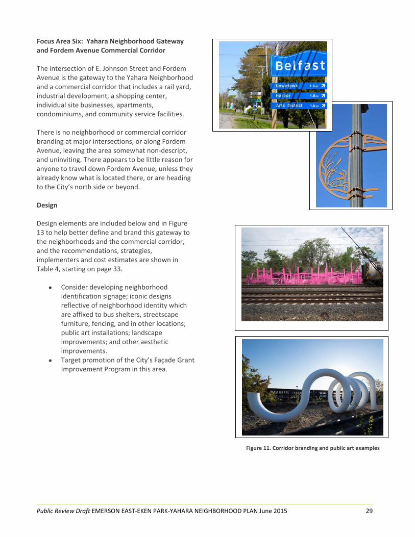
Focus Area Six: Yahara Neighborhood Gateway and Fordem Avenue Commercial Corridor The intersection of E. Johnson Street and Fordem Avenue is the gateway to the Yahara Neighborhood and a commercial corridor that includes a rail yard, industrial development, a shopping center, individual site businesses, apartments, condominiums, and community service facilities. There is no neighborhood or commercial corridor branding at major intersections, or along Fordem Avenue, leaving the area somewhat non‐descript, and uninviting. There appears to be little reason for anyone to travel down Fordem Avenue, unless they already know what is located there, or are heading to the City’s north side or beyond. Design
Design elements are included below and in Figure 13 to help better define and brand this gateway to the neighborhoods and the commercial corridor, and the recommendations, strategies, implementers and cost estimates are shown in Table 4, starting on page 33.
Consider developing neighborhood identification signage; iconic designs reflective of neighborhood identity which are affixed to bus shelters, streetscape furniture, fencing, and in other locations; public art installations; landscape improvements; and other aesthetic improvements.
Target promotion of the City’s Façade Grant Improvement Program in this area.
Figure 11. Corridor branding and public art examples

Public Review Draft EMERSON EAST‐EKEN PARK‐YAHARA NEIGHBORHOOD PLAN June 2015 30
Focus Area Seven: Pennsylvania Avenue Commercial Corridor The Pennsylvania Avenue Commercial Corridor extends from First Street to Commercial Avenue. It is a major gateway to the City from the airport and City’s north side. It is primarily an industrial corridor with some retail and service businesses. The west side of the corridor is primarily fronted with businesses while the east side is fronted almost entirely by Demetral Park, and a few small businesses. In 2012, the City reconstructed Pennsylvania Avenue and installed landscape improvements. Additional beautification and branding improvements could help better define the corridor and welcome people into the City. There are also some pedestrian and bike improvement needs that have been identified. Table 4 starting on page 33 includes recommendations, strategies, implementers and cost estimates to further improve the corridor for businesses, neighborhoods and the City. Focus Area Eight: Commercial Avenue/North Street Commercial Node The Commercial Avenue/North Street Commercial Node includes commercial uses at the Eken Park and Emerson East Neighborhood entrances. There is a restaurant/bar, along with a barber shop, research lab, and vacant building. One corner is greenspace, owned by the condominiums. There are also some small businesses and a gas station further west along Commercial Avenue. The City reconstructed Commercial Avenue from Packers Avenue to North Street in 2014, including pedestrian and bike improvements. This neighborhood entrance could benefit from some beautification and branding enhancements that would help define the neighborhoods and improve the corner’s business appeal. Over time, as property owners redevelop, some of the commercial uses along the south side of Commercial Avenue could become residential uses, such as new single family, townhomes or condominiums
Table 4 starting on page 33 includes recommendations, strategies, implementers and cost estimates to further improve the corner for businesses, neighborhoods and the City. Figure 14 includes images of the type of physical enhancements that could be incorporated at this commercial node.
Figure 12. Examples of beautification and branding

Public Review Draft EMERSON EAST‐EKEN PARK‐YAHARA NEIGHBORHOOD PLAN June 2015 31
Focus Area Nine: Emerson Elementary School Playground and Neighborhood Gathering Area The Emerson Elementary School is located at 2421 E. Johnson Street. The playground can be accessed from N. 7th Street and S. 6th Street. Many area families have been using the playground as a neighborhood park. It is safe and convenient to access, particularly for those living in the Emerson East Neighborhood, and it is the only city green space that these neighborhood residents can access without crossing major roads. In contrast, accessing Demetral Park requires crossing E. Johnson Street, with an average of 5,850 to 7,100 of vehicles daily, vehicles that commonly exceed the 25 mile per hour speed limit. Additionally, some residents report that the park shelter can be a gathering place for nuisance type behaviors such as drinking alcohol and harassing others, and illegal activities like doing drugs or selling drugs. While the school playground is a great asset, there are issues with relying on it as a neighborhood park including that the play equipment is only appropriate for elementary age children, the playground is surrounded by a tall chain link fence with two gates that are unwelcoming to the public, people often do not know that they can use the school playground outside of school hours, and the grassy area floods regularly because before the school was built, the portion of E. Dayton Street underneath it was never removed, leading to drainage issues. Design Concept
The conceptual plan on the following page in Figure 13 includes enhancements and improvements for the playground area. Design elements are included below, and the recommendations, strategies, implementers, and cost estimates are shown in Table 4, on page 37.
Definition and Identity: Visual connection to the surrounding residential area with fence gate entrances that are oriented to both the school and neighborhood; signage that welcomes the community and clearly articulates when the public can use the playground; landscaping, benches, public art and other enhancements with design features reflecting iconic school and
neighborhood elements, creating attractive entrances with a readily identifiable character; playground lighting, public art and other features sharing common design themes for a more cohesive and readily identifiable look and feel. Connectivity: Pathways built with environmentally friendly materials that improve access and circulation through the site and to the surrounding residential area. School and Community Interaction: Accessible play equipment for children with mobility limitations; small, flexible gathering spaces for school and neighborhood activities (gazebo, stage, picnic tables, life‐size Mancala and chess boards, etc.); use of Crime Prevention through Environmental Design concepts; programmed recreational activities, unstructured play, picnics and other activities.

Public Review Draft EMERSON EAST‐EKEN PARK‐YAHARA NEIGHBORHOOD PLAN June 2015 32
Figure 13. Emerson Elementary School Playground and Neighborhood Gathering Area

Public Review Draft EMERSON EAST‐EKEN PARK‐YAHARA NEIGHBORHOOD PLAN June 2015 33
Table 4: Land Use, Housing and Urban Design
Recommendations and Strategies Lead Implementers and Partners / Estimated Cost and Timeframe
1. Develop Theme / Branding Bring together artists, neighbors, educators, business owners, and other stakeholders for theme/branding focus groups. Create Request for Proposals (RFP) for artists to develop streetscape design elements for focus areas;
Develop uniform designs for each focus area that feature iconic neighborhood images and other decorative elements. Consider including multi‐cultural aspects in the designs.
Incorporate designs into landscaping, way‐finding, interpretive signage, streetscape furniture, bus shelters, business district welcome banners, trash screening, and public art installations.
1. Lead: Madison Arts Administrator; Partners: Metro Transit, Parks Division, neighborhood associations, East Isthmus Neighborhoods Planning Council, Northside Planning Council, and business owners; Estimated cost and timeframe: Costs to be determined; three to 5 years.
2. Enhance the aesthetic quality of the Pennsylvania Avenue and Fordem Avenue corridors: Survey existing tree canopies and plant additional trees in areas found to be deficient.
Remove the degraded chain link fence bordering Demetral Park. Develop and implement a landscape plan in coordination with a sidewalk or other path development along Pennsylvania Avenue.
Target promotion of City’s Façade Grant Improvement Program to area businesses.
Create public art installations for the Fordem Avenue right‐of‐way.
2. Lead: Office of Business Resources and Parks Division‐Forestry; Partners: Neighborhood associations, landscape architect, Madison Arts Administrator, local artists; Estimated cost and timeframe: Costs to be determined; two to three years.
3. As new market‐rate and mixed‐use residential developments are proposed, work with developers in the early stages to determine the feasibility of targeting some of these units as affordable for lower‐income households by providing financial incentives through federal, state or city programs.
3. Lead: Planning Division; Partners: Community Development Block Grant Division; Estimated cost and timeframe: Costs to be determined; ongoing.
4. Target promotion of the City’s homebuyer assistance and home rehabilitation loans in the planning study area.
4. Lead: Community Development Division; Partners: Community Development Block Grant Division Estimated cost and timeframe: City staff time; ongoing.
5. Support efforts to house the homeless, such as Occupy Madison Tiny Houses. 5. Lead: Community Development Division; Partners: Community Development Block Grant Division; Estimated cost and timeframe: City staff time and grant dollars to be determined; ongoing.
6. Increase owner‐occupancy of housing throughout the planning area: Promote incentives for people who would like to purchase and owner‐occupy two to three unit multi‐family residences;
Provide information and education about programs such as Section 8 Homeownership Program and City of Madison Office of Economic Revitalization’s American Dream Downpayment Initiative and Home Buy programs;
Establish home buyer classes by working with such organizations as Greenpath/Home Buyers Roundtable.
Establish financial literacy classes through such providers as banks, Literacy Network, Financial Education Center at the Village on Park, etc.
6. Lead: City of Madison Office of Economic Revitalization Partners: Greenpath, Home Buyers Roundtable, area banks, Dane County Housing Authority, Urban League of Greater Madison, Literacy Network, Financial Education Center at the Village on Park Setup financial literacy classes and homebuyers education classes in the planning area.
Neighborhoods and community

Public Review Draft EMERSON EAST‐EKEN PARK‐YAHARA NEIGHBORHOOD PLAN June 2015 34
organizations promote classes through neighborhood association and other community organization newsletters, listservs and membership meetings.
Estimated cost and timeframe: $1,000 per Greenpath/Home Buyers Roundtable class; City staff time and cost for City of Madison homebuyer program presentations; Variable cost depending on financial literacy classes that are selected; 6 months and semi‐annual schedule.
7. Encourage rehabilitation and energy efficiency improvements to housing. 7. Lead: City of Madison Office of Economic Revitalization Partners: City of Madison Community Development Block Grant, South Madison Housing Providers Group, Apartment Association of South Central Wisconsin Target promotion of existing loan/grant program modeled after the existing Rental Rehab and Small Cap TIF programs.
Market program to area property owners.
Estimated cost and timeframe: City staff time; timeframe to be determined.
8. Survey residential areas for historic interest and significance; work with residents to determine if they would like to preserve and enhance the historic character and integrity of their areas through potential tools such as neighborhood conservation and historic district designation.
8. Lead: Planning Division; Partners: Property Owners; Estimated cost and timeframe: To be determined.
9. Host landlord training workshop at area schools, apartment community meeting rooms, and/or other appropriate location(s); consider hosting every other year.
9. Lead: Apartment Association of South Central Wisconsin (AASCW) Partners: South Madison Housing Providers, City of Madison North Police District, Neighborhood Associations; Estimated cost and timeframe: Two and a half hour landlord training workshop; consider conducting this workshop every other year; $150‐$200 per workshop.

Public Review Draft EMERSON EAST‐EKEN PARK‐YAHARA NEIGHBORHOOD PLAN June 2015 35
10. Focus Area One: Eken Park Neighborhood Gateway and East Johnson Street Commercial Node Beautify and brand neighborhood gateway and business node and build community and collaboration among E. Johnson St. businesses. See recommendation #1 above. Consider developing business association for E. Washington Ave./E. Johnson St./North St. business corridors; invite Capitol East Business Association and neighborhood associations to participate.
Celebrate multi‐cultural businesses and residents with sidewalk sales, festivals and other events and activities that foster relationships while promoting area businesses and building a greater sense of place and connectedness.
Encourage property owners at the corner of E. Johnson St./E. Washington Ave. to landscape and to work with beautification and branding efforts to bring greater identity and a welcoming atmosphere to this corner.
10. Leads: Madison Arts Administrator, business owners; Partners: Office of Business Resources, Greater Madison Chamber of Commerce‐Neighborhood Business Association Committee; Capitol East Area Business Association, Eken Park and Emerson Neighborhood Associations; Estimated cost and timeframe: Costs to be determined; two to three years.
11. Focus Area Two: North Street Neighborhood Mixed‐Use Node and Commercial Corridor At such time that the property owners decide to make changes to Area Two, encourage consideration of the preferred conceptual plan, 3‐D perspective views, and recommendations starting on page 18. Recommendations include enhancements and improvements to brand the neighborhood and business corridor and resources for property owners to redevelop, through parcel aggregation, new multi‐story buildings, additional landscaping and other features. For Commercial Corridor recommendations, see #1 in this table.
11. Lead: Private property owners; Partners: City of Madison Office of Business Resources, neighborhood associations and artists; Estimated cost and timeframe: To be determined.
12. Focus Area Three: Public Market District and Emerson East Neighborhood Gateway Coordinate EEEPY planning process with Public Market District and Yahara River planning processes. Consider incorporating the following features: A Public Market building with vendor spaces, food‐business incubator, fresh food production such as raised garden beds, commercial kitchen.
Multi‐story mixed‐use buildings with residential, office and commercial uses and views of the river and ped/bike connections to it.
Develop railroad track crossing; consider pedestrian overpass from any new multi‐story building.
Add bus stops and bike stations in coordination with Public Market entrances. Create public gathering places within the Public Market District, Burr Jones Park and along the river.
Incorporate connections from the Public Market to Burr Jones Park and the river and to surrounding residential areas.
Host safety watch walks along river pathways to help deter nuisance behaviors and create a safer and more pleasant environment.
12. Leads: Private property owners, Office of Business Resources; Partners: Planning, Parks, and Engineering Divisions; Engineering Division; Metro Transit; Madison Metropolitan Planning Organization (MPO); neighborhood associations and artists; Estimated cost and timeframe: To be determined.
13. Focus Area Four: Sherman/Yahara Neighborhood Site At such time that the property owner decides to make changes to Area Four, encourage consideration of the conceptual plan, 3‐D perspective views, and recommendations on pages 23, 24 and 25. Recommendations include changing the existing employment land use to residential use. This is consistent with the Comprehensive Plan which indicates in a Map note that if and when this site redevelops, residential is the preferred land use.
13. Lead: Private property owner; Partners: Office of Business Resources; Estimated cost and timeframe: To be determined.

Public Review Draft EMERSON EAST‐EKEN PARK‐YAHARA NEIGHBORHOOD PLAN June 2015 36
14. Focus Area Five: Sherman/Fordem Gateway and Neighborhood Mixed‐Use Node At such time that the property owners decide to make changes to Area Five, encourage consideration of the conceptual plan, 3‐D perspective views and recommendations starting on page 26. Recommendations include parcel aggregation, road reconfiguration to improve safety, new multi‐story mixed‐use buildings with green building features, underground parking, additional landscaping, enhancements and improvements to brand the neighborhood and business corridor, pedestrian and bike safety and efficiency enhancements, views into Burrows Park and direct connections to it, and other features.
14. Lead: Private property owners; Partners: Office of Business Resources; Estimated cost and timeframe: To be determined.
15. Focus Area Nine: Emerson Elementary School Playground and Neighborhood Gathering Place Coordinate with Emerson Elementary Parent‐Teacher Organization efforts to improve the playground and make it more of a neighborhood gathering place that is welcoming and accessible to surrounding neighbors of all ages outside of school hours: Create welcoming gateways at the 6th and 7th Street entrances to the playground using archways or other entryway features that are adorned with artistically designed elements; consider working with school art teacher, kids and area neighbors to design and fabricate these features.
Install a gazebo that could be used by students as well as area residents for performances, picnics and other activities.
Install features that would attract people of all ages such as life‐size chess and mancala boards, lawn bowling, picnic benches, and other features.
15. Leads: Neighborhoods and Planning Division; Partners: Emerson Elementary School, Emerson Parent‐Teacher Organization, and Madison Metropolitan School District; Estimated cost and timeframe: $2‐5,000 for design planning process and $40‐50,000 for construction; three to 5 years.
16. Focus Area Six: Yahara Neighborhood Gateway and Fordem Avenue Commercial Corridor Develop Theme/Branding ‐ see Recommendation #1 above.
17. Focus Area Seven: Pennsylvania Avenue Commercial Corridor Develop Theme/Branding ‐ see Recommendation #1 above.
18. Focus Area Eight: Commercial/North Street Commercial Node Develop Theme/Branding ‐ see Recommendation #1 above.

Public Review Draft EMERSON EAST‐EKEN PARK‐YAHARA NEIGHBORHOOD PLAN June 2015 37
CHAPTER FOUR Local Economic Development and Employment Opportunities The study area has a diverse economic base anchored by the manufacturing, administration and support, and educational services industries. There are approximately 2,871 employees working in a wide variety of jobs. The skilled trades are particularly well represented and include such positions as steamfitters, plumbers, sheet metal and foundry workers, print press operators, and book binders. There are also quite a few education related jobs such as public administrators, K‐12 teachers, pre‐school teachers and college instructors. The four largest employers include Madison East High School, Webcrafters, Clean Power Services, Inc. and Union Cab. Industrial and commercial development is primarily clustered along major corridors including E. Washington, Pennsylvania, Aberg, Sherman and Fordem Avenues. The planning study area is directly accessible via the major thoroughfares and there is convenient access to the Dane County Airport, State Highway 30, State Highway 151 and I‐94. Thousands of vehicles travel the areas major thoroughfares daily, transporting commuters, customers, and goods and services. The planning area and greater north and east sides offer employment training and education at the Dane County Job Center, Madison College Commercial Avenue Education Center and Truax Campus, and the Hawthorne Branch Library. Unemployment is x percent compared to the City of Madison at x percent. Major thoroughfares provide excellent access for people driving vehicles. Additionally, bus riders providing input through this planning process indicated that Madison Metro serves the area well. However, bicyclists and pedestrians often find that the major thoroughfares are barriers to safe and convenient travel. E. Washington Avenue reconstruction completed in 2011 made this major road a much safer place for bicyclists and pedestrians with bike lanes, new pedestrian islands,
high visibility crosswalks and other amenities. Further improvements could include review of potential bumpouts, additional crossing lights, and completion of off‐road paved bike path connections. The need to strengthen local economic development and expand employment opportunities came up during city staff and SC discussions. Needs identified include development of an identity/brand for the community, enhancement and expansion of business attraction and retention, improvement and expansion of outreach and programming for education and work skills development, creating opportunities for new businesses such as incubators and other new business space, and coordinating it all with some sort of organization or group of partners. Physical improvements to major corridors also came up as being important ways to help attract public and private investment including new employers, facade and landscape improvements, and new infrastructure such as sidewalks, bike lanes and paths, curb and gutter, and roads. Visual and functional improvements can promote a greater sense of community pride inspiring residents and visitors to enjoy the area’s recreation, shopping, and business opportunities. Economic Development Goals
Residents are interested in continued economic vitality of their neighborhood and its connection with the larger regional market. The area welcomes the continuation of businesses, expansion of businesses, and new start‐up of businesses.
Develop an identity/branding/marketing plan for the EEEPY Neighborhoods.
Develop business strategies to attract and retain small‐ to medium‐scale retailers, whose products are unique to the local market.
Promote opportunities for business start‐up, skills training, and job placement.
Five major themes for reshaping the economy of the EEEPY planning area emerged during the planning process:

Public Review Draft EMERSON EAST‐EKEN PARK‐YAHARA NEIGHBORHOOD PLAN June 2015 38
1. Reinvest in Public and Private Places o Revitalize highway commercial
frontage over time to consolidate the number of driveways onto major thoroughfares with shared driveways into properties, and incorporate existing and new businesses into multi‐story structures with ped/bike and vehicular connections to adjoining residential areas.
o Incorporate placemaking strategies in the Public Market District, in and around the Camelot Square Shopping Center, area parks, the Yahara River Parkway and Starkweather Creek Streambank, and other visible pockets to improve the attractiveness and increase activity at the street level.
o Transform transportation corridors to have multi‐dimensional purposes: attractive, placemaking destinations as much as facilitators of movement.
2. Build Market Share by Recapturing and
Redirecting Consumer Spending o Redirect the flow of consumer
spending back into neighborhood businesses and services by improving identity and branding of key commercial areas and promoting area businesses to residents, local employers, and commuters.
o Improve ambience, increase activity levels, and renew the desire for consumers from the planning area and greater Madison to patronize local establishments day or night.
3. Grow New Businesses
o As the City of Madison grows new basic sector employment, including
green collar jobs, promote the workforce and location of the EEEPY Neighborhoods.
o Support existing home‐based businesses by working with them to determine the appropriate resources/support that is needed to grow their businesses.
o Encourage businesses that support sustainability such as green building, urban agriculture, etc.
o Reuse existing commercial, office, and industrial spaces by reconfiguring space for single or multiple users.
o Forge alliances with public and private sectors to attract new investment, market share, and training.
4. Reinvest in People
o Connect potential entrepreneurs with appropriate resources.
o Connect social service agencies/resources to individuals seeking/entering labor force to provide employment skill training, career counseling, and job placement.
o Support opportunities for the low‐income population to build asset wealth and secure career ladder jobs.
o Produce high performing schools with strong curriculum and modernized facilities.
5. Improve Access to Jobs
o Improve multimodal connections to places of employment.
o Incorporate affordable, quality housing into new development that is close to employment centers.

Public Review Draft EMERSON EAST‐EKEN PARK‐YAHARA NEIGHBORHOOD PLAN June 2015 39
Table 5: Local Economic Development and Employment Opportunities
Recommendations and Strategies Lead Implementers and Partners / Estimated Cost and Timeframe
1. Create a centralized information source to promote job services; include transportation information for Metro Transit, biking and walking; distribute information through job provider outreach organizations, listservs, webpages and at area businesses, libraries, and other places frequented by residents.
1. Lead: Community Development Block Grant Division; Partners: Area neighborhoods, Madison College, Workforce Development Board of South Central Wisconsin, South‐Central Federation of Labor, Hawthorne Branch Library, area businesses, Urban League of Greater Madison, Children’s Service Society/Joining Forces for Families, Goodman Community Center, faith community Estimated cost and timeframe: Cost to be determined; one year.
2. Encourage new businesses to locate in study area such as: affordable daycare/childcare, locally owned and operated restaurants, fresh produce vendors, farmers market, and hardware store, bike shop, shipping and copying services, hotels, bars/dance clubs, and dry cleaners. Compile a neighborhood profile with demographic and other background information for potential new businesses.
Support development of the Public Market District and partner with it to encourage new businesses to locate in this area.
Conduct a market study to determine what businesses are declining, growing and missing.
Seek assistance with business recruitment through such support organizations as Wisconsin Women’s Business Initiative Corporation (WWBIC).
2. Lead: Office of Business Resources; Partners: Town of Madison, WWBIC, Greater Madison Chamber of Commerce, area neighborhoods, and other community organizations Estimated cost and timeframe: $30,000‐50,000 for market study; two to three years.
3. Enhance the aesthetics of industrial areas such as Pennsylvania and Fordem Avenues. Plant a more extensive street tree canopies. Promote use of City’s Façade Grant Improvement Program where applicable and encourage.
Encourage such improvements as trash screening, fence upgrades, landscaping, painting, and other aesthetic upgrades.
3. Leads: Business owners, Office of Business Resources and Parks Division‐Forestry; Estimated cost and timeframe: Cost and timeframe to be determined.
4. Ensure that existing available commercial property databases (such as Property Drive and Locate In Wisconsin) are populated with information about vacant land/buildings in the commercial corridors and market these properties. If there is a high volume of vacancies, encourage commercial brokerage open house.
Meet with individual brokers to learn more about the available properties.
4. Lead: Office of Business Resources; Partners: Greater Madison Chamber of Commerce; Estimated cost and timeframe: Cost to be determined; two to three years.
5. Consider starting a coordinated communication and information sharing system for businesses along E. Washington Ave., North St., and E. Johnson St.; consider starting a business association, online network, or other system.
5. Lead: Business owners; Partners: Office of Business Resources, Capital East Business Association, Madison North District Police, Greater Madison Chamber of Commerce‐Neighborhood Business Association Committee Estimated cost and timeframe: Cost to be determined; two to three years.

Public Review Draft EMERSON EAST‐EKEN PARK‐YAHARA NEIGHBORHOOD PLAN June 2015 40
CHAPTER FIVE Transportation Safety and Efficiency The planning study area is a near‐eastside community that is conveniently located several miles from downtown. It is well‐connected to other parts of the city and beyond via major thoroughfares including E. Washington Avenue, N. Sherman Avenue, Pennsylvania Avenue and Aberg Avenue. The Dane County Airport is just to the north, and State Highway 30 and I‐94 are nearby. There are a number of off‐road paved bike paths connecting the area to other parts of the city, bike lanes, and sidewalks along most local streets and major thoroughfares. There are also many local bus routes serving the area (Appendix I – Background Maps). Transportation Issues
Fordem Avenue/E. Johnson Street/1st Street o Traffic safety is a problem at the
intersection of Fordem Avenue/E. Johnson Street.
o There is no sidewalk along the east side of Fordem Avenue, north of E. Johnson Street
o E. Johnson Street pavement is in poor condition making it particularly unsafe for bicyclists, mopeds and other smaller vehicles.
o Motorists are often surprised by bikes traveling both directions on E. Johnson at 1st Street, leading to accidents.
o Traffic/pedestrian/bike safety is an issue at 1st/E. Dayton Street.
E. Washington Avenue o Walking across the street is unsafe –
especially for people with strollers, children and people with mobility impairments.
o Too many cars run the red light at 1st Street going east, shortening the crossing time and stranding pedestrians on the median.
o There are frequent conflicts on the sidewalks along E. Washington Avenue between pedestrians and bicyclists.
Significant internal and exterior circulation barriers exist (e.g. E. Washington Ave., railroad, Maple Bluff).
Lighting at night is not sufficient for walking and biking with particular issues on Hoard Street, Myrtle Street, Moland Avenue and Coolidge Street.
Pedestrian and bike infrastructure is lacking, particularly for traveling to the north side, along Fordem and Sherman Avenues, and along Demetral Park/Pennsylvania Avenue where there is no sidewalk or bike path.
There is a lack of well‐lit places to lock bikes ‐‐ make sure that they are functional and not just attractive.
Speeding is a problem, mostly on E. Washington Avenue but also North Street, Hoard Street, and E. Johnson Street.
Bus service is good on the Isthmus, to the University and to the near south, east and west sides. However, bus service overall is not frequent enough on evenings and weekends, it is not sufficient to the far east side (e.g. for people working at Amercian Family Center, in Sun Prairie, and other north and east locations) and even small reductions in service create big problems, such as moving all Route 28 buses to Fordem rather than Sherman Avenue. Note: Metro Transit began new daily, frequent bus service to American Center neighborhood at the end of May 2015. The City of Sun Prairie does not provide funding to Metro Transit for bus service connections to their community. However, the City does fund a limited number of weekday trips using Sun Prairie taxi shuttle van to and from East Towne Mall.
The bus stop (east bound) under the E. Washington Avenue ped/bike bridge at Marquette Street is heavily used. The bridge has openings in it so when it rains, water collects and eventually dumps onto people waiting for the bus; also, the large bridge columns create a major wind tunnel effect.

Public Review Draft EMERSON EAST‐EKEN PARK‐YAHARA NEIGHBORHOOD PLAN June 2015 41
Transportation Goals
Improve circulation through the planning area for motorists, pedestrians and bicyclists with particular emphasis on east‐west connections.
Improve roads, off‐road bike paths, sidewalks, and public transit, so that all members of the community have access to safe and efficient transportation options throughout the planning area.
Promote a system of safe pedestrian and bike connections linking key activity areas and destinations, such as community service providers, open spaces, schools, and shopping areas.
Develop strategies to improve pedestrian crossings at major intersections while implementing traffic calming features to address safety issues on local streets.
Improve and/or complete links to the existing system of off‐road bike paths, bike lanes, and sidewalks that provide access to community centers, schools, and other public facilities.
Provide convenient public transit service to major employment, education, and shopping destinations; develop and clarify future transit route options to guide long‐term and future land use decisions.
Promote compact, higher density development along and around transit corridors/stops.
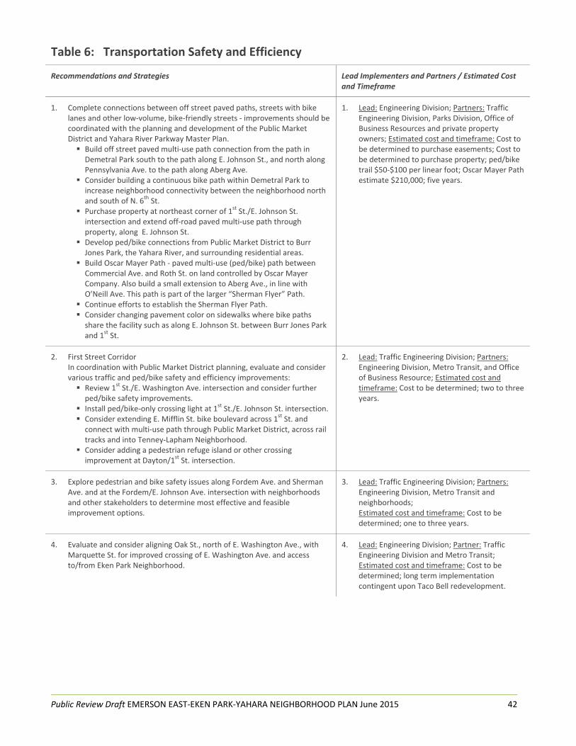
Public Review Draft EMERSON EAST‐EKEN PARK‐YAHARA NEIGHBORHOOD PLAN June 2015 42
Table 6: Transportation Safety and Efficiency
Recommendations and Strategies Lead Implementers and Partners / Estimated Cost and Timeframe
1. Complete connections between off street paved paths, streets with bike lanes and other low‐volume, bike‐friendly streets ‐ improvements should be coordinated with the planning and development of the Public Market District and Yahara River Parkway Master Plan. Build off street paved multi‐use path connection from the path in Demetral Park south to the path along E. Johnson St., and north along Pennsylvania Ave. to the path along Aberg Ave.
Consider building a continuous bike path within Demetral Park to increase neighborhood connectivity between the neighborhood north and south of N. 6th St.
Purchase property at northeast corner of 1st St./E. Johnson St. intersection and extend off‐road paved multi‐use path through property, along E. Johnson St.
Develop ped/bike connections from Public Market District to Burr Jones Park, the Yahara River, and surrounding residential areas.
Build Oscar Mayer Path ‐ paved multi‐use (ped/bike) path between Commercial Ave. and Roth St. on land controlled by Oscar Mayer Company. Also build a small extension to Aberg Ave., in line with O’Neill Ave. This path is part of the larger “Sherman Flyer” Path.
Continue efforts to establish the Sherman Flyer Path. Consider changing pavement color on sidewalks where bike paths share the facility such as along E. Johnson St. between Burr Jones Park and 1
st St.
1. Lead: Engineering Division; Partners: Traffic Engineering Division, Parks Division, Office of Business Resources and private property owners; Estimated cost and timeframe: Cost to be determined to purchase easements; Cost to be determined to purchase property; ped/bike trail $50‐$100 per linear foot; Oscar Mayer Path estimate $210,000; five years.
2. First Street Corridor In coordination with Public Market District planning, evaluate and consider various traffic and ped/bike safety and efficiency improvements: Review 1st St./E. Washington Ave. intersection and consider further ped/bike safety improvements.
Install ped/bike‐only crossing light at 1st St./E. Johnson St. intersection. Consider extending E. Mifflin St. bike boulevard across 1st St. and connect with multi‐use path through Public Market District, across rail tracks and into Tenney‐Lapham Neighborhood.
Consider adding a pedestrian refuge island or other crossing improvement at Dayton/1
st St. intersection.
2. Lead: Traffic Engineering Division; Partners: Engineering Division, Metro Transit, and Office of Business Resource; Estimated cost and timeframe: Cost to be determined; two to three years.
3. Explore pedestrian and bike safety issues along Fordem Ave. and Sherman Ave. and at the Fordem/E. Johnson Ave. intersection with neighborhoods and other stakeholders to determine most effective and feasible improvement options.
3. Lead: Traffic Engineering Division; Partners: Engineering Division, Metro Transit and neighborhoods; Estimated cost and timeframe: Cost to be determined; one to three years.
4. Evaluate and consider aligning Oak St., north of E. Washington Ave., with Marquette St. for improved crossing of E. Washington Ave. and access to/from Eken Park Neighborhood.
4. Lead: Engineering Division; Partner: Traffic Engineering Division and Metro Transit; Estimated cost and timeframe: Cost to be determined; long term implementation contingent upon Taco Bell redevelopment.

Public Review Draft EMERSON EAST‐EKEN PARK‐YAHARA NEIGHBORHOOD PLAN June 2015 43
5. Assess E. Washington Ave. bus stop on south side of street for wind and rain exposure; consider installing an overhang to divert water from waiting passengers, and a wind shield or a bus shelter to protect passengers from wind and cold.
5. Lead: Engineering Division; Partners: Metro Transit and neighborhoods; Estimated cost and timeframe: Engineering cost to be determined and $10,000 for bus shelter; one to three years.
6. Evaluate turning movements at the E. Washington Ave./Milwaukee St./North St. intersection and consider measures to improve pedestrian safety.
6. Lead: Traffic Engineering Division; Partner: Engineering Division; Estimated cost and timeframe: Staff time if solutions possible; one to two years.
7. Evaluate and consider adding pedestrian bump‐outs at E. Washington Ave./2
nd St. intersection and expanding the median at this crossing to improve ped/bike connection from planning study area to and from Winnebago Ave. and Atwood Ave. areas.
7. Lead: Traffic Engineering Division; Partners: Engineering Division and Metro Transit; Estimated cost and timeframe: Cost and timeframe to be determined.
8. Review 2nd St. through 7th St. intersections with E. Washington Ave. and consider measures to improve visibility for vehicles turning onto E. Washington Ave., such as removing parking spaces on either side of intersection.
8. Lead: Traffic Engineering Division; Partners: Engineering Division and neighborhoods; Estimated cost and timeframe: $3000; one to two years.
9. Review East High School related traffic safety issues along 4th, 5th and 6th Sts. and consider traffic calming solutions including creating a one‐way pair with 4
th and 5th Sts., speed humps, etc.
9. Lead: Traffic Engineering Division; Partners: Engineering Division, neighborhoods, high school, students, and school district; Estimated cost and timeframe: $20,000; 5 Years depending on Traffic Calming fund availability.
10. Review ped/bike safety issues at N. 2nd St./E. Mifflin St. intersection and consider adding traffic calming facilities such as a stop sign, speed humps, traffic circle, etc.
10. Lead: Traffic Engineering Division; Partner: Engineering Division; Estimated cost and timeframe: $7,000; Depends on Traffic Calming funds availability.
11. Evaluate light levels along public streets and consider tree trimming and adding lights; at a minimum include evaluation of Hoard St., Moland Ave. and Coolidge St.
11. Lead: Traffic Engineering Division; Partners: Police departments, neighborhoods, property owners; Estimated cost and timeframe: City staff and partner time; $5,000 to $7,000 per streetlight (fully assessable to property owner).
12. Evaluate traffic issues and develop targeted police enforcement and neighborhood speed board efforts; start with Hoard Street, Johnson St. where speeding is observed frequently.
12. Lead: Traffic Engineering Division; Partners: Police departments and neighborhoods; Estimated cost and timeframe: City staff and partner time; ongoing.

Public Review Draft EMERSON EAST‐EKEN PARK‐YAHARA NEIGHBORHOOD PLAN June 2015 44
13. Review North St. speeding issues from Commercial Avenue to East Madison Little League fields. Consider traffic calming measures such as increasing speed enforcement, pedestrian refuge islands, bumpouts and other approaches.
13. Lead: Traffic Engineering Division; Partners Neighborhoods, property owners, Engineering Division and Madison Police; Estimated cost and timeframe: $30,000 Depends on availability of Traffic Calming Funds.
14. Develop pedestrian path along north side of Yahara River. 14. Lead: Engineering Division; Partners: Traffic Engineering, Planning, Real Estate Services and Parks Divisions; Estimated cost and timeframe: Cost to be determined; three to four years.
15. Establish public grid street pattern through 1601 and 1611 N. Sherman Ave. properties if/when property owner redevelops; connect with streets extending through surrounding properties if/when they redevelop.
15. Lead: Private property owners; Partners: Engineering and Traffic Engineering Divisions; Estimated cost and timeframe: Cost to be determined; five to ten years.
16. Over the long‐term, as properties redevelop, consider creating additional east‐west road and ped/bike connections (Map 4, following page). Connect N. 6th St. across Pennsylvania Ave., through industrial properties, rail yard, and lakes street residential area, and connect to Lakewood Blvd.
Consider installing a stoplight at N. 6th St. and Pennsylvania Ave. Consider building a ped/bike bridge at N. 6th St./Pennsylvania Ave. over the rail yard to Sherman Ave./Burrows Park area.
Connect N. 3rd St. across Pennsylvania and Fordem Aves., and connect to Lakewood Gardens Ln. and Sherman Ave.
Between Lakewood Gardens Ln. and the Yahara River, build additional street and ped/bike connections from Fordem to Sherman Ave.
16. Lead: Private property owners; Partners: Engineering and Traffic Engineering Divisions, Office of Business Resources; Estimated cost and timeframe: Cost to be determined; long‐term proposed connections dependent on sale of private properties and future City budget.

Public Review Draft EMERSON EAST‐EKEN PARK‐YAHARA NEIGHBORHOOD PLAN June 2015 45
Map 4. Proposed Long‐Term Road Connections

Public Review Draft EMERSON EAST‐EKEN PARK‐YAHARA NEIGHBORHOOD PLAN June 2015 46
CHAPTER SIX Parks, Recreation and Open Space
There is 78.82 acres of publicly owned parkland in the planning study area (non‐park open space acreage forthcoming). There are also two private parks, an ice arena, and three schools with recreational facilities that allow some public access. Lake Mendota borders the west side of the study area, the Yahara River borders the south side, and Starkweather Creek runs through the northeast corner (Appendix I – Existing Parks and Open Space). There were a number of issues identified through the planning process regarding the area’s park, recreation and open space resources. The issues are included below, the goals are on page 48 and recommendations are in Table 7, beginning on page 49. Demetral Park Demetral Park, located at 601 N. 6th Street, is the largest park in the planning study area at 49.18 acres. It includes a full‐size basketball court, dog on‐leash and off‐leash areas, 8 open space/recreation fields, two volleyball courts, a play area for 5‐12 year olds, and a park shelter with a rest room. In 2015, playground improvements will provide a play area for 2‐5 year olds. Issues
The park is centrally located and conveniently accessible by car from Pennsylvania Avenue, Commercial Avenue, and 6th Street. It is also safely and conveniently accessible for pedestrians and other non‐motorized traffic for those living between the park and E. Johnson Street. Unfortunately, people living in most other portions of the study area must cross major roads to access the park. This is primarily problematic for children and people with mobility limitations.
Demetral Park athletic fields are reserved almost continuously from April to October on weekday evenings, with over 80 reservations per year. However, some residents feel that
other parts of the park are underutilized and the shelter, which had 34 reservations in 2014, does not have as many reservations as other reservable shelters in the park system.
Some residents have expressed that the park border along Pennsylvania Avenue is not as attractive as it could be.
The bike path off 6th Street is not identified with signage and it’s also unclear that the bike path continues through the parking lot.
Some residents have expressed concerns about the existing shelter, suggesting that it is uninviting, unattractive and dark as it is designed.
Burr Jones Park Burr Jones Park is a 4.68 acre park located at 1820 E. Washington Avenue. There are two basketball courts, an open field, the Yahara River shoreline, fishing access, and the Yahara Bike Path along the north side of the park leading to N. Thornton Avenue (south) and E. Johnson Street (north). Issues
Canoe and kayak access is not very good.
Some residents have expressed that they feel intimidated by some of the people that use the park.
Washington Manor Park Washington Manor Park is a 2.47 acre park located at 801 N. Oak Street. The Starkweather Creek runs along the park’s eastern edge. The park includes fishing access, a playground, paved walking paths, and a basketball court. Issues Some people have indicated that they think
the park is underutilized. It is difficult to get from the park to the
McCormick Community Garden on the east side of Starkweather Creek.
McCormick Park McCormick Park is a 0.38 acre greenway located at 702 McCormick Avenue. The Starkweather Creek

Public Review Draft EMERSON EAST‐EKEN PARK‐YAHARA NEIGHBORHOOD PLAN June 2015 47
and bike path border the west edge of the park. Washington Manor Park is immediately north, on the west edge of the creek and path. There is an off‐leash dog exercise area at the park, along with a community garden. Issues The park is disconnected from Washington
Manor Park due to Starkweather Creek. Filene Park Filene Park is a 1.82 acre mini‐park located at 1610 Sherman Avenue on the shore of Lake Mendota and the Yahara River. There is a circular drive to get to the park and lake, and fishing access. Burrows Park Located at 25 Burrows Road, Burrows Park is a 10.56 acre park on the shore of Lake Mendota. There is a rustic stone park shelter with a restroom, picnic tables, a fireplace and lake views. There is also a playground, open playfield and a historic Native American Burial mound. The park is used by a local sailing club to store and launch their boats. Issues There is no defined pedestrian connection
through the park to the lake from Warner Drive and Fordem Avenue.
A small triangle of the park is disconnected from the rest of the park (situated between Warner Drive and Sherman Avenue).
The park is not very visible from Fordem Avenue which is seen as a positive and negative to some people.
Eken Park Located at 2407 Coolidge Street, Eken Park is a 2.07 acre park with a shelter, concrete gathering area, playground, basketball court, and open play field. Issues The park shelter accommodates only one
picnic table therefore it is not large enough to host larger events and activities.
Emerson East Elementary Playground Emerson Elementary School is located at 2421 E. Johnson Street. The school playground located along 7th Street is often used by area children outside of school hours. Issues The playground regularly floods as there is a
remnant concrete section of E. Dayton Street underneath it.
There is a population of students with mobility limitations but no accessible playground equipment.
Many people are unaware that the playground can be used by the public during certain non‐school hours.
The playground is a conveniently accessible open space for Emerson East neighbors (no major roads to cross to access it), but it is designed for children so there are not features for older kids or adults.
Yahara River Parkway The Yahara River Parkway extends from Lake Mendota to E. Washington Avenue in the planning study area. The Parkway is listed on the National Register of Historic Places and it is a local Landmark. Because of its historic status, any improvements to the Parkway must be reviewed and approved by the Wisconsin Trust for Historic Preservation and the City of Madison Landmarks Commission. Additionally, since the Yahara River Master Plan is underway, and the neighborhood planning process must be coordinated with it. From Sherman Avenue to E. Washington Avenue, the parkway includes a bike path along the south side of the river. The Yahara River Bike Path runs along the south side of the river from Lake Mendota to S. Thornton Avenue where it meets the Capital City Trail. There are several bike crossings to the north side of the Yahara River including a crossing at Burr Jones Field, E. Washington Avenue, E. main Street, and at the close intersection to the Capital City Trail.

Public Review Draft EMERSON EAST‐EKEN PARK‐YAHARA NEIGHBORHOOD PLAN June 2015 48
Issues There is no pedestrian connection along the
north side of the river from Lake Mendota to E. Washington Avenue.
Formal canoe/kayak access does not exist in Burr Jones Park.
There are minimal formalized connections along the north side of the river to adjacent properties.
Parks, Recreation and Open Space Goals
Explore opportunities to collaborate with other public and private entities to expand recreational options, including seasonal activities such as boat rental and cross country skiing, and explore establishing other opportunities for activities like bocce ball, life‐size chess, mancala and others.
Welcome neighborhood type uses such as group picnics, celebrations, music events and activities, community group and club gatherings, and other related uses.
Support and encourage sustainability in parks and open spaces including preserving, enhancing and expanding habitat for native flora and fauna, and utilizing environmentally sensitive practices and materials to protect parks and open spaces from surrounding development and when developing park features.
Develop connections between area parks, greenways, and trails within and beyond the study area.
Explore opportunities to collaborate with other public and private entities to enhance open space for public use, and provide linkages among these spaces to public parks for active and passive recreational purposes.
Beautify parks and park edges, particularly along major transportation corridors.
Support and encourage sustainability in community improvement efforts to minimize environmental impacts and resource consumption and help ensure all may enjoy the area’s natural resources, green space, and recreational opportunities.

Public Review Draft EMERSON EAST‐EKEN PARK‐YAHARA NEIGHBORHOOD PLAN June 2015 49
Table 7: Parks, Recreation and Open Space
Recommendations and Strategies Lead Implementers and Partners / Estimated Cost and Timeframe
1. Demetral Park a. Consider building a continuous bike path within the park.
b. Consider building a ped/bike path or sidewalk along Pennsylvania Avenue between the fence and road.
c. Continue to maintain and enhance the berm and native plantings, including establishment of a monarch station; and explore new partnerships with park user groups, schools, area businesses and other park stakeholders for volunteer time, in‐kind services, planting donations, funds and other assistance.
d. Beautify the park border along Pennsylvania Avenue; consider public art, pollinator pathway establishment, and other enhancements.
e. Consider enhancing lighting at park shelter.
f. Consider adding solar lights along bike path and in other locations.
g. Design and install park identification signage at 6th Street entrance and way finding signage to direct bicyclists through parking lot to connect north to the rest of the bike path.
h. Consider adding bocce ball, life‐size chess and Mancala boards, outdoor exercise equipment, skate board park, slack‐lining, official astronomy viewing site immediately north of East High baseball field, and other facilities.
a. Lead: Parks Division; Partners: Engineering Division; Estimated cost and timeframe: Cost to be determined; one year.
b. Lead: Engineering Division; Partners: Traffic Engineering and Parks Divisions; Estimated cost and timeframe: Cost to be determined; five or more years.
c. Lead: Emerson East Neighborhood
Association; Partners: City of Madison Parks Division, park user groups, area schools and other stakeholders; Estimated cost and timeframe: Volunteer time and cost of plantings and maintenance equipment; annually.
d. Leads: Emerson East and Eken Park
Neighborhood Associations; Partners: Madison Arts Commission, landscape consultant, Parks Division, park user groups, area schools and other stakeholders; Estimated cost and timeframe: Design consultant fees, plantings and maintenance equipment; three to 5 years.
e. Lead: Parks Division; Partners:
Neighborhoods; Estimated cost and timeframe: Cost to be determined; one to two years.
f. Lead: Traffic Engineering Division; Partners: Neighborhoods; Estimated cost and timeframe: Cost to be determined; three to five years.
g. Lead: Parks Division; Partners: Engineering Division and Emerson East Neighborhood Association; Estimated cost and timeframe: Cost to be determined; one to two years.
h. Lead: Neighborhoods and Planning Division; Partners: Parks Division, MSCR, Madison Senior Center, Goodman Community Center and other park user groups; Estimated cost and timeframe: Facility costs to be determined; 5 to 15 years.

Public Review Draft EMERSON EAST‐EKEN PARK‐YAHARA NEIGHBORHOOD PLAN June 2015 50
i. Program a greater diversity of activities and events at park for all ages and ability levels.
i. Leads: Emerson East and Eken Park Neighborhood Associations, East Isthmus Neighborhoods Planning Council, area schools, and other stakeholders; Partners: Parks Division, MSCR; Estimated cost and timeframe: Event and activities cost to be determined; three to 5 years.
2. Emerson Elementary School Playground and Neighborhood Gathering Place. See recommendation 15 on page 36
3. Burr Jones Park ‐ park improvements should be coordinated with the planning and development of the Public Market District and Yahara River Parkway Master Plan. a. Establish connections from the park to the Public Market District, the
river and surrounding residential areas; extend the Mifflin Street bike boulevard north with a connection to the existing Yahara Bike Path, across the railroad tracks and into Emerson East Neighborhood (Work with Wisconsin and Southern Railroad to obtain easement and/or rights to build a crossing of the rail tracks, and establish a pedestrian/bike connection through the park to adjoining properties).
b. Establish a pedestrian path along north side of Yahara River and extend it under E. Johnson St., continuing to Lake Mendota.
c. Establish canoe/kayak launch and storage along river.
d. Create gathering places within the park and along the river incorporating seating, public art and native plantings.
e. Establish a native fruits of Wisconsin orchard along a promenade such as along the pedestrian path from the parking area to the river.
f. Establish native habitats and corridors along the river and woodlot to provide homes and food for such species as birds, bees, butterflies, bats, woodchucks, turtles, frogs and other invertebrates.
g. Host safety watch walks along river pathways to help deter nuisance behaviors and create a safer and more pleasant environment.
a. Lead: Engineering; Partners: Planning, Parks
and Real Estate Divisions, and Wisconsin and Southern Railroad; Estimated cost and timeframe: Cost to be determined; 5 to 10 years.
b. Lead: Parks Division; Partners: Engineering
Division; Estimated cost and timeframe: Cost to be determined; 5 to 10 years.
c. Lead: Parks Division; Partners: Engineering Division; Estimated cost and timeframe: Cost to be determined; three to 5 years.
d. Leads: Neighborhoods and Planning Division; Partner: Private stakeholders and Parks Division; Estimated cost and timeframe: Cost to be determined; three to 5 years.
e. Lead: Parks Division; Partners: Madison Area Permaculture Guild, Permaculture Guild of Wisconsin, Planning Division, Neighborhoods; Estimated cost and timeframe: Cost to be determined; three to 5 years.
f. Lead: Parks Division (already leading this effort); Partners: Planning Division, Neighborhoods, Friends of Yahara River Parkway, and other stakeholders; Estimated cost and timeframe: Ongoing.
g. Lead: Neighborhoods; Partners: Madison
Police, Parks Division; Estimated cost and timeframe: Cost to be determined; one to two years.

Public Review Draft EMERSON EAST‐EKEN PARK‐YAHARA NEIGHBORHOOD PLAN June 2015 51
4. Yahara River Parkway – proposed park improvements in this plan must be coordinated with the ongoing Yahara River Master Plan process. Further, since the parkway is listed on the National Register of Historic Places and it is a local historic Landmark, improvements must be approved by the Wisconsin Trust for Historic Preservation and the City of Madison Landmarks Commission. a. Improve the access road along the north side of the Yahara River,
leading from Sherman Ave. to the Madison School & Community Recreation (MSCR) pontoon boat parking area: re‐surface angled boat and trailer parking with permeable surface material; add trees to canoe/kayak parking bay and other appropriate locations.
b. Explore expanding Tenney Park along north side of the Yahara River by acquiring one to two acres of woodland on the adjacent property.
c. Explore building a pedestrian bridge over the Yahara River to connect the canoe/kayak/MSCR parking and activity areas to Tenney Park.
d. Establish pedestrian walkways to connect the park to the adjoining property, 1601 Sherman Ave.
e. Establish pedestrian walkway along northside of Yahara River from Sherman Ave. to E. Washington Ave.; foster a natural edge along the river removing non‐native invasive vegetation and establishing native flora and fanua through plantings and other measures.
f. Establish canoe/kayak launch and storage along river in Burr Jones Park.
a. Leads: Parks Division; Partners: Engineering Division, MSCR. Estimated cost and timeframe: Cost to be determined; five or more years.
b. Leads: Property owner and Parks Division;
Partners: Real Estate Services Division. Estimated cost and timeframe: Costs to be determined; five or more years.
c. Leads: Parks and Engineering Divisions; Partner: MSCR. Estimated cost and timeframe: Cost to be determined; five or more years.
d. Leads: Parks Division; Partners: Engineering Division. Estimated cost and timeframe: Cost to be determined; five or more years.
e. Leads: Parks Division; Partners: Engineering Division. Estimated cost and timeframe: Cost to be determined; five or more years.
f. Leads: Parks Division; Partners: Engineering Division. Estimated cost and timeframe: Cost to be determined; five or more years.
5. Washington Manor Park a. Explore building a park shelter.
a. Lead: Parks Division; Partners: Eken Park
Neighborhood Association; Estimated cost and timeframe: $60,000; two to three years.
6. Explore expanding McCormick Community Garden by establishing garden plots in the southeast corner of park, along the bike path.
6. Lead: McCormick Community Garden; Partners: Community Groundworks and Engineering and Real Estate Services Divisions; Estimated cost and timeframe: $2,000; one to two years.
7. Explore building pedestrian/bike bridge over Starkweather Creek to connect the McCormick Community Garden to Washington Manor Park.
7. Lead: Engineering Division; Partners: Zoning Division; Estimated cost and timeframe: $200,000; four years.
8. Explore establishing programming for middle and high school age children; consider East High School, Emerson East Elementary School, Sherman Middle School, Shabazz High School, and other places such as Demetral Park, Tenney Park and Eken Park, and apartment community spaces.
8. Lead: MSCR; Partners: Planning area neighborhoods, schools, apartment management, and Parks Division Estimated cost and timeframe: Cost to be determined; two to three years.

Public Review Draft EMERSON EAST‐EKEN PARK‐YAHARA NEIGHBORHOOD PLAN June 2015 52
9. Eken Park Create a park gathering place celebrating the history of the Eken Park Neighborhood with a plaque describing establishment of the neighborhood and park, and a seating area with landscaping.
Explore replacing the park shelter with a larger shelter that accommodates multiple picnic tables.
9. Leads: Planning and Parks Divisions; Partners: Eken Park Neighborhood Estimated cost and timeframe: $10,000 to $50,000 for historic gathering place, five or more years; $60,000 for park shelter, five to ten years.
10. Burrows Park a. Create a contiguous parcel of parkland from the lake to the
commercial parcels along Fordem Ave.
b. Close Warner Dr. to motor vehicles between Burrows Rd. and Harbort Dr. using concrete bollards or other method; retain parking spaces along Warner Dr. for the park and a corridor for bikes and pedestrians.
c. Improve pedestrian connectivity to the lake and along it and create a gathering area with seating and plantings near lakeshore; refurbish walking path along shore.
d. Create a pedestrian pathway from any redevelopment along Fordem Ave. leading into the park.
a. Lead: Parks and Engineering Divisions;
Partners: Private property owners and Traffic Engineering Division; Estimated cost and timeframe: Cost to be determined; two to five years.
b. Lead: Parks and Engineering Divisions; Partners: Traffic Engineering Division; Estimated cost and timeframe: Costs to be determined; two to five years.
c. Lead: Parks and Engineering Divisions; Partners: Engineering Division; Estimated cost and timeframe: $50,000 ‐ $100,000; more than five years.
d. Lead: Engineering Division; Partners: Private property owners and Traffic Engineering Division; Estimated cost and timeframe: To be determined.

Public Review Draft EMERSON EAST‐EKEN PARK‐YAHARA NEIGHBORHOOD PLAN June 2015 53
CHAPTER SEVEN Community Health and Wellness
The EEEPY planning area includes many of the elements and characteristics of a vibrant and healthy community. There are people of all ages from different racial, ethnic and socio‐economic backgrounds living and working in the area. Most residences and businesses appear to be well maintained, and there are strong employment and commercial areas. There is also a wealth of parks and open space in and around the planning area. There are seven city parks and convenient access to Lake Mendota, Lake Monona, and the Yahara River. Off‐road paved bike paths are easy to access, linking people throughout the city and beyond, and there is an extensive bus system providing a convenient and sustainable alternative to driving. This area is also well‐served by quality institutions such as centers of worship, community service organizations, a variety of schools for pre‐school through grade 12, and there is convenient access to Madison College and U.W. Madison (see Appendix II for a more complete listing of community organizations and centers of worship). While the EEEPY planning area is largely a wonderful place to be, there are a number of issues that could be addressed to further improve upon community health and wellness. Community Health and Wellness Issues
o There is minimal access to fresh food, including limited access to open, sunny land to garden, and lack of a larger scale farmers market.
o It is difficult to find viable land to locate community gardens due to industrial residue in the soils and landfills that cover a good portion of the area’s park and open space.
o Nearby grocery stores are relatively expensive and difficult to access.
o There are not enough places for kids to buy healthy, affordable snacks, especially near the schools.
o Homelessness is a problem both within the planning area and citywide, and teen homelessness is increasing. There is a lack of homeless shelters There is a lack of services to treat mental
health and other needs of the homeless There is a lack of cooperation among Dane
County communities to address homelessness.
o Noise from the Dane County Airport, Oscar Mayer plant, and rail corridor decreases the quality of life in the planning area.
o Emissions from area industries can be an issue.
o Large areas of standing water are mosquito havens.
o There is a high volume of litter generated by East High students.
o There is a prevalence of petty theft and break‐ins which can greatly impair feelings of security.
o Drug activity persists in pockets such on Dahle Street and at Sherman Terrace.
o Homeless people who sleep in area parks sometimes hang around in the neighborhood and disturb residents.
o It is difficult to be active in the winter as there is a lack of indoor exercise facilities in and around the planning area.
o Many of the students attending area schools lack adequate medical care; schools are trying to expand offerings but it would help if there were facilities in the planning area that serve uninsured and low‐income clients.
o The area needs more indoor and outdoor community gathering places; Goodman Community Center is several miles east, and E. Washington Avenue is a major barrier for children, the elderly and others with mobility limitations.
o Demand for services/programs is growing at Goodman Community Center and capacity for expansion is limited.

Public Review Draft EMERSON EAST‐EKEN PARK‐YAHARA NEIGHBORHOOD PLAN June 2015 54
Community Health and Wellness Goals o Ensure a happier, healthier neighborhood
environment. o Improve neighborhood access to fresh food. o Encourage location of an affordable, quality
grocery in or near the planning area. o Work with area schools and school district to
provide fresher, nutritious food options in and around the schools.
o Work with area schools to educate kids about local, nutritious food production and distribution.
o Increase medical services in planning area for underinsured and uninsured elementary and high school students attending area schools.
o Increase indoor and outdoor community gathering space.
o Improve environmental health. o Improve the safety and overall feeling of
security for residents. o Promote existing indoor health and wellness
programming and develop new opportunities for indoor and outdoor exercise.
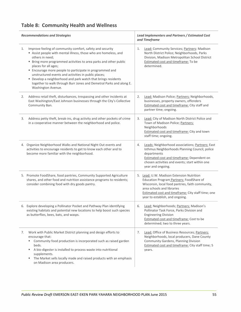
Public Review Draft EMERSON EAST‐EKEN PARK‐YAHARA NEIGHBORHOOD PLAN June 2015 55
Table 8: Community Health and Wellness
Recommendations and Strategies Lead Implementers and Partners / Estimated Cost and Timeframe
1. Improve feeling of community comfort, safety and security Assist people with mental illness, those who are homeless, and others in need;
Bring more programmed activities to area parks and other public places for all ages;
Encourage more people to participate in programmed and unstructured events and activities in public places;
Develop a neighborhood and park watch that brings residents together to walk through Burr Jones and Demetral Parks and along E. Washington Avenue.
1. Lead: Community Services; Partners: Madison North District Police; Neighborhoods, Parks Division, Madison Metropolitan School District Estimated cost and timeframe: To be determined.
2. Address retail theft, disturbances, trespassing and other incidents at East Washington/East Johnson businesses through the City’s Collective Community Ban.
2. Lead: Madison Police; Partners: Neighborhoods, businesses, property owners, offenders Estimated cost and timeframe: City staff and partner time; ongoing.
3. Address petty theft, break‐ins, drug activity and other pockets of crime in a cooperative manner between the neighborhood and police.
3. Lead: City of Madison North District Police and Town of Madison Police; Partners: Neighborhoods Estimated cost and timeframe: City and town staff time; ongoing.
4. Organize Neighborhood Walks and National Night Out events and activities to encourage residents to get to know each other and to become more familiar with the neighborhood.
4. Leads: Neighborhood associations; Partners: East Isthmus Neighborhoods Planning Council, police departments Estimated cost and timeframe: Dependent on chosen activities and events; start within one year and ongoing.
5. Promote FoodShare, food pantries, Community Supported Agriculture shares, and other food and nutrition assistance programs to residents; consider combining food with dry goods pantry.
5. Lead: U.W. Madison Extension Nutrition Education Program Partners: FoodShare of Wisconsin, local food pantries, faith community, area schools and libraries Estimated cost and timeframe: City staff time; one year to establish, and ongoing.
6. Explore developing a Pollinator Pocket and Pathway Plan identifying existing habitats and potential new locations to help boost such species as butterflies, bees, bats, and wasps.
6. Lead: Neighborhoods; Partners: Madison’s Pollinator Task Force, Parks Division and Engineering Division Estimated cost and timeframe: Cost to be determined; two to three years.
7. Work with Public Market District planning and design efforts to encourage that: Community food production is incorporated such as raised garden
beds. A bio‐digester is installed to process waste into nutritional
supplements. The Market sells locally made and raised products with an emphasis
on Madison area producers.
7. Lead: Office of Business Resources; Partners: Neighborhoods, local producers, Dane County Community Gardens, Planning Division Estimated cost and timeframe: City staff time; 5 years.

Public Review Draft EMERSON EAST‐EKEN PARK‐YAHARA NEIGHBORHOOD PLAN June 2015 56
8. Assist in establishing more robust local food production and marketing in planning study area; for example honey from pollinator habitats; herbs for food, health and beauty products; fruits and vegetables to supply area restaurants; and more.
8. Lead: Office of Business Resources; Partners: Madison Food Policy Network, Madison Community Development Division and Dane County Department of Planning and Development Estimated cost and timeframe: City staff time; three to five years.
9. Explore establishing fresh produce vendors in study area: the Yumm cart model from Philadelphia where tricycles carrying refrigerated boxes of small bags of fruits and vegetables are sold at affordable prices; and the Stockbox model from Seattle entrepreneurs where shipping containers are placed in ‘food desert’ areas and stocked with fresh produce and other staples.
9. Lead: Neighborhood Associations; Partners: Mayor’s Office, Office of Business Resources Estimated cost and timeframe: City staff time; one to two years to establish, and ongoing.
10. Explore expanding McCormick Community Garden in the McCormick Greenway.
10. Leads: McCormick Community Garden; Partners: Community Groundworks, Engineering and Real Estate Services Divisions Estimated cost and timeframe: $2,000, one to two years.
11. Help service providers identify and get necessary assistance to people of all ages with mental illness; watch for people in danger or otherwise in need during neighborhood safety walks.
11. Lead: Community Development Division; Partners: Neighborhoods, Dane County Health and Human Services, other service providers, Goodman Community Center, area schools Estimated cost and timeframe: Ongoing.
12. Create an inventory of existing health and wellness programs and activities offered in and around the planning area and share this information through neighborhoods, libraries, schools and other venues.
12. Lead: Community Services; Partners: Neighborhoods, Dane County Health and Human Services, MSCR, Goodman Community Center, area schools, Hawthorne Branch Library Estimated cost and timeframe: City staff time; two to three years.
13. Explore hosting community service and health fairs at such locations as East High School, Goodman Community Center, or Dane County Job Center.
13. Lead: Public Health Madison/Dane County; Partners: East High School, Goodman Community Center, Dane County Job Center Estimated cost and timeframe: $2,000‐$5,000 per fair; one to two years to establish, and develop regular schedule such as bi‐annually.
14. Develop more community gathering places and programming in planning area.
14. Lead: Community Resources Division; Partners: Neighborhoods, area schools, Hawthorne Library Branch, Goodman Community Center Estimated cost and timeframe: City staff time; two to three years.

Public Review Draft EMERSON EAST‐EKEN PARK‐YAHARA NEIGHBORHOOD PLAN June 2015 57
15. Increase programming for children and youth within the neighborhood. Expand and create after and before school programs for school age children, and provide positive youth development activities, academic support and recreation for middle school and high school age youth, and strive to supplement existing youth programs. Replicate or grow successful programs in areas with unmet needs.
15. Lead: Community Resources Division Partners: MSCR, area schools, Goodman Community Center, other community recreation and education organizations, neighborhood associations; Estimated cost and timeframe: Cost depends on types of programming; two to three years.
16. Survey affordable childcare needs in the study area and develop options such as childcare co‐ops within apartment communities and at other locations.
16. Lead: Community Resources Division; Partners: Neighborhoods, Dane County Health and Human Services, MSCR, Goodman Community Center; Estimated cost and timeframe: City staff time; two to three years.
17. Help promote Goodman Community Center parenting program with a targeted promotion plan including advertising in neighborhood publications, websites, listservs, church bulletins, local businesses, libraries, schools and other venues.
17. Lead: Goodman Community Center; Partners: Neighborhoods, Dane County Health and Human Services, MSCR; Estimated cost and timeframe: Advertising cost and staff time; ongoing.

Public Review Draft EMERSON EAST‐EKEN PARK‐YAHARA NEIGHBORHOOD PLAN June 2015 58
CHAPTER EIGHT Adoption and Implementation
The EEEPY Neighborhood Plan was introduced to the Madison Common Council on July x, 2015 and adopted on x, 2015 by Resolution No. x (page x). The plan is now a supplement to the City’s Comprehensive Plan. It is a framework for lead implementation agencies and organizations to improve the EEEPY planning area. Lead implementers will incorporate neighborhood improvement projects in capital or operating budgets and work plans, and project staff will work with the City’s Community Development Block Grant Office to finalize expenditure of CDBG funds targeted for use by the EEEPY Neighborhood Plan. Other implementation tools may also be used such as the City’s Tax Incremental Finance program, and public and private grant monies. Inclusion of Projects in City of Madison Operating and Capital Budgets
The EEEPY Neighborhood Plan recommendations provide direction for proposed improvements and the implementation strategies provide action steps. Implementation includes the lead implementers and partners, estimated costs, critical steps for City, neighborhood, and other groups, and a general timeline for completion. Plan implementation of neighborhood projects and programs is contingent upon available resources. Policy makers are responsible for the allocation of resources for the entire City and thus funding for EEEPY Neighborhood Plan recommendations will be weighed against other worthy projects citywide. Because of scarce resources, it will be important to understand that City/public funding of proposed improvements is, and will be, in competition with existing projects, and in many cases, will require special earmarking of funding to undertake projects as well as ongoing maintenance costs. Securing funding from outside sources, leveraging funding with other available funding, or dovetailing proposed new projects with planned projects will help in implementing the desired activities and projects.
Project staff worked with the EEEPY Ad‐hoc Neighborhood Steering Committee and city agencies to develop plan recommendations that address the issues and opportunities of the planning area. The group drafted and redrafted the recommendations, then circulated drafts for City agency and public input. Project staff and the EEEPY Steering Committee reviewed and carefully considered all input, then made edits to the recommendations and identified the top recommendations within each plan topic, and across the plan (Executive Summary). The prioritization process provides policymakers, lead implementers and city staff with the relative importance of the recommendations. Allocation of Community Development Block Grant Funding to Eligible Projects The Community Development Block Grant (CDBG) Committee allocated $145,880 of CDBG funds for implementation of eligible plan recommendations. Using input from Steering Committee meetings, Public Open Houses, neighborhood association meetings, and city staff meetings, the Steering Committee identified the projects in the table on the next page to help implement the neighborhood plan’s recommendations using CDBG funds. Detailed implementation projects are being finalized by city staff in coordination with lead implementers.

Public Review Draft EMERSON EAST‐EKEN PARK‐YAHARA NEIGHBORHOOD PLAN June 2015 59
Community Development Block Grant Implementation Funds
Priority Area Facilities CDBG $
1. Emerson East Neighborhood
Emerson Elementary School Playground and Neighborhood Gathering Area – enhance playground as a multi‐use place for school and neighborhood park‐type uses
$ 45,000.00 (if other City resources become available for this site by
September 2015, these funds will be allocated to Item #4)
2. Emerson East Neighborhood
Tiny Houses – Occupy Madison – funds for addition to permanent building, bathroom improvements, other
$ 5,000.00
3. Eken Park Neighborhood
Washington Manor Park – park shelter for 4 to 6 picnic tables and electricity
$ 60,000.00 (in the event that a park shelter is not feasible for this location based on City agency
review, these funds will be allocated to Item #5)
4. Emerson, Eken, Sherman, Yahara Neighborhood Areas
Branding/Identity ‐ commercial corridors and intersections
$ 15,888.00
5. Eken Park Neighborhood
Eken Park – gathering place with interpretive sign telling history of neighborhood, park benches and plantings
$ 20,000.00
Total: $145,880 (any unused CDBG funds to be allocated to Item #2)
Table 9. Community Development Block Grant Priorities

Public Review Draft EMERSON EAST‐EKEN PARK‐YAHARA NEIGHBORHOOD PLAN June 2015 60
Adopting Resolution No. 30378

Public Review Draft EMERSON EAST‐EKEN PARK‐YAHARA NEIGHBORHOOD PLAN June 2015 61
APPENDICES

Public Review Draft EMERSON EAST‐EKEN PARK‐YAHARA NEIGHBORHOOD PLAN June 2015 62
Appendix I – Background Maps

Public Review Draft EMERSON EAST‐EKEN PARK‐YAHARA NEIGHBORHOOD PLAN June 2015 63

Public Review Draft EMERSON EAST‐EKEN PARK‐YAHARA NEIGHBORHOOD PLAN June 2015 64

Public Review Draft EMERSON EAST‐EKEN PARK‐YAHARA NEIGHBORHOOD PLAN June 2015 65

Public Review Draft EMERSON EAST‐EKEN PARK‐YAHARA NEIGHBORHOOD PLAN June 2015 66

Public Review Draft EMERSON EAST‐EKEN PARK‐YAHARA NEIGHBORHOOD PLAN June 2015 67

Public Review Draft EMERSON EAST‐EKEN PARK‐YAHARA NEIGHBORHOOD PLAN June 2015 68

Public Review Draft EMERSON EAST‐EKEN PARK‐YAHARA NEIGHBORHOOD PLAN June 2015 69

Public Review Draft EMERSON EAST‐EKEN PARK‐YAHARA NEIGHBORHOOD PLAN June 2015 70

Public Review Draft EMERSON EAST‐EKEN PARK‐YAHARA NEIGHBORHOOD PLAN June 2015 71
Appendix II – Community Support Organizations, Educational
Institutions and Centers of Worship Community Support Organizations
Care Wisconsin
Center for Families, Inc.
Children’s Service Society – Wisconsin
Community Care Systems, Inc.
Dane County Human Services Department
Dane County Job Center
Domestic Abuse Intervention Services
Eken Park Neighborhood Association
Emerson East Neighborhood Association
Goodman Community Center
Hawthorne Branch Library
Madison’s Eastside Planning Council
Public Health Madison & Dane County
Occupy Madison, Inc.
Salvation Army
Sherman Neighborhood Association
Sherman Terrace Condominium Association
Educational Institutions and Other Organizations
Emerson Elementary School
Friends of Yahara River Parkway
Friends of Starkweather Creek
Isthmus Montessori Academy
Lapham Elementary
Madison College
Madison East High School
Shabazz High School
Sherman Middle School
Centers of Worship
Assumption Greek Orthodox Church
Bashford United Methodist Church
Bethany Evangelical Free Church
Holy Cross Lutheran Church and School
James Reeb Unitarian Universalist Congregation
Trinity Lutheran Church
Zion Lutheran Church