fort chaffee dioxin investigation - home -...
TRANSCRIPT
FORT CHAFFEE MANEUVER TRAINING CENTER
TACTICAL GRADE HERBICIDE SITE INVESTIGATION
DEFOLIANT SPRAY AREA 1
DRAFT REPORT NO. 37-MA-0B7D-08
FORT SMITH, AR
APRIL 2009
Prepared by
U.S. Army Center for Health Promotion and Preventive Medicine
Aberdeen Proving Ground, MD 21010-5403
Distribution limited to U.S. Government agencies only; protection of privileged information evaluating
another command, November 2007. Requests for this document must be referred to the U.S. Army
Environmental Command, Aberdeen Proving Ground, Maryland.

This page intentionally left blank

DEPARTMENT OF THE ARMY US ARMY CENTER FOR HEALTH PROMOTION AND PREVENTIVE MEDICINE
5158 BLACKHAWK ROAD
ABERDEEN PROVING GROUND MD 21010-5403
Readiness thru Health
Printed on Recycled Paper
MCHB-TS-EHM
FORT CHAFFEE MANEUVER TRAINING CENTER
TACTICAL GRADE HERBICIDE SITE INVESTIGATION
DEFOLIANT SPRAY AREA 1
DRAFT REPORT NO. 37-MA-0B7D-08
FORT SMITH, AR
APRIL 2009
1.0 PURPOSE.
This report was prepared by the U.S. Army Center for Health Promotion and Preventive
Medicine (USACHPPM) for the U.S. Army Environmental Command (USAEC) and the
Arkansas Army National Guard (ARARNG) to provide site investigation results concerning
dioxin and dioxin-like compounds within an area identified as defoliant spray area 1 (DSA 1) on
Fort Chaffee resulting from the historic application of tactical grade herbicides to test defoliant
efficiency. The site field investigation was conducted 17 – 20 February 2009.
2.0 CONCLUSIONS.
Trace levels of dioxin and dioxin-like compounds were detected in soil, sediment, and surface
water samples collected in both the DSA 1 study area and the background sample location.
However, no samples contained dioxin or dioxin–like compounds above Federal or State human
health risk screening criteria. Trace concentrations of 2,3,7,8-tetrachlorodibenzo-p-dioxin
(TCDD), considered the most toxic of the dioxin compounds, were detected in one surface water,
one sediment, and three surface soil samples collected in the DSA 1 study area. A subsequent
review of laboratory control sample data found that the trace TCDD concentrations detected in
the soil samples may be false positives as dioxins of comparable concentrations were detected in
the laboratory method blank sample associated with the soil samples. Additionally, the trace
TCDD concentrations detected in the surface water and sediment sample were below the
laboratory estimated detection limit (EDL) and were reported as estimated values.
Though laboratory data review suggested that the dioxin concentrations reported may be biased
high compared to the true value, the maximum concentration of TCDD reported was compared
to the corresponding Federal and State health screening criterion to provide a conservative
determination of whether additional study is warranted.

EXSUM, Draft Report No. 37- MA-0B7D-08, Fort Chaffee MTC Dioxin Site Investigation
Fort Smith, Arkansas Draft April 2009
ES-2
2.1 Soil Sample Results.
Ten surface soil samples, each consisting of a 5-point composite sample, were collected
throughout the DSA 1 study area using a systematic random sampling design. Trace
concentrations of TCDD were detected in three surface soil samples and the laboratory method
blank sample. The maximum concentration TCDD reported (0.46 pg/g) was two orders of
magnitude below the U.S. EPA Region 6 Human Health Medium Specific Screening Level
(HHMSSL) for industrial soils of 18 pg/g (ppt) (and one order of magnitude below the
residential soil HHMSSL of 4.5 pg/g).
2.2 Sediment Sample Results.
Thirteen surface sediment and four subsurface sediment samples were collected for this site
investigation. Trace TCDD was detected in one surface sediment sample collected from Stream
1 within the DSA 1 study area. Though an estimated value, the reported concentration was
compared to the human health risk screening level to provide a conservative determination of
whether additional study is warranted. The reported value (0.11 pg/g) was two orders of
magnitude below the U.S. EPA Region 6 HHMSSL of 18 pg/g for industrial soils (and one order
of magnitude below the U.S. EPA Region 6 HHMSSL for residential soils).
2.3 Surface Water Sample Results.
Thirteen surface water samples were collected for this site investigation. TCDD was detected in
one water sample collected from Stream 1 within the DSA 1 study area (SW-S1-2). Though an
estimated value, the reported concentration was compared to the surface water screening level of
1.0 pg/L to provide a conservative determination of whether additional study is warranted. The
reported estimated value of 0.53 pg/L (ppq) was below the Arkansas Department of
Environmental Quality (ADEQ) water quality human health criteria of 1 pg/L.
2.4 Dioxin-like Compound Results.
The dioxin-like compound, octachlorodibenzo-p-dioxin (OCDD), was found at the highest
frequency and concentrations in both DSA 1 study area and background samples. This is
consistent with other studies involving this compound (U.S. EPA, 2007). Frequent and elevated
concentrations of OCDD may be attributed to herbicide use to control weeds and, to some
degree, may occur naturally. The highest concentration of OCDD detected (1,153 pg/g) was two
orders of magnitude below its HHMSSL of 61,000 pg/g. Trace concentrations of the remaining
dioxin-like compounds were detected in the majority of soil and sediment samples. However,
the reported concentrations were at least two orders of magnitude below their respective
screening criteria. Based on the concentrations of dioxin that were observed, dioxin-like
compounds within the DSA 1 were not found to occur at a greater frequency or magnitude than
the background sites chosen for this study.
EXSUM, Draft Report No. 37- MA-0B7D-08, Fort Chaffee MTC Dioxin Site Investigation
Fort Smith, Arkansas Draft April 2009
ES-3
It is not possible to discern the source of trace dioxin and dioxin-like compounds detected in soil,
sediment, and surface water samples collected in the western most portion of the DSA 1 study
area. Potential sources of these compounds may be attributed to the application of herbicides to
control weed growth along roads that access the DSA 1 training area, residuals from the historic
application of tactical grade herbicides, or result of natural forest fires or controlled burns.
Independent of the source, the concentrations of dioxin and dioxin-like compounds detected in
the DSA 1 study area did not exceed Federal or State human health screening criteria.
3.0 RECOMMENDATIONS.
A human health risk assessment is not warranted as the concentrations of dioxin and dioxin-like
compounds detected in DSA 1 were below Federal and State human health risk screening
criteria. Based on these findings, the USACHPPM recommends no further action with respect to
dioxin and dioxin-like compounds within DSA 1.
Draft Report No. 37-MA-0B7D-08, Fort Chaffee MTC Dioxin Site Investigation
Fort Smith, Arkansas Draft April 2009
i
TABLE OF CONTENTS
1.0 INTRODUCTION................................................................................................................... 1
1.1 References. ........................................................................................................................... 1
1.2 Authority. ............................................................................................................................. 1
1.3 Purpose. ................................................................................................................................ 1
1.4 Background. ......................................................................................................................... 2
2.0 PROPERTY DESCRIPTION. ............................................................................................... 3
2.1 Property Location and Description. ..................................................................................... 3
2.2 Property History. .................................................................................................................. 3
3.0 PROJECT ROLES AND RESPONSIBILITIES. ................................................................ 4
4.0 HUMAN HEALTH RISK SCREENING CRITERIA. ....................................................... 4
4.1 U.S. EPA Region 6 Standards. ............................................................................................. 4
4.2 State Regulatory Standards. ................................................................................................. 5
4.3 Background/Reference Site Data Comparison..................................................................... 5
5.0 SAMPLING RATIONALE METHODS AND PROCEDURES. ....................................... 7
5.1 Sampling and Analysis Plan (SAP) and Site Safety and Health Plan (SSHP). ................... 7
5.2 Surface Soil Sampling Rationale. ........................................................................................ 7
5.2.1 Soil Sample Collection. ................................................................................................ 8
5.3 Surface Water and Sediment Sampling Rationale. .............................................................. 8
5.3.1 Sediment Sampling. ..................................................................................................... 9
5.3.2 Surface Water Sampling. ............................................................................................ 10
5.4 Background Sample Collection. ........................................................................................ 10
5.4.1 Surface Soil Background Samples. ............................................................................ 10
5.4.2 Surface Water and Sediment Background Samples. .................................................. 10
5.5 Field Quality Assurance/Quality Control (QA/QC) Samples. ........................................... 11
5.6 Decontamination and Sample Integrity. ............................................................................. 11
5.7 Sample Labeling, Preservation, Packing, and Chain-of-Custody Procedures. .................. 11
5.7.1 Sample Labeling. ........................................................................................................ 11
5.7.2 Sample Preservation. .................................................................................................. 12
5.7.3 Sample Packing and Chain of Custody Procedures. .................................................. 12
5.7.4 Log Book. ................................................................................................................... 12
6.0 ANALYTICAL METHODS. ............................................................................................... 12
6.1 Laboratory Accreditation and QA/QC Information. .......................................................... 12
6.1.1 Accreditation. ............................................................................................................. 12
6.1.2 Laboratory QA/QC Procedures. ................................................................................. 13

Draft Report No. 37-MA-0B7D-08, Fort Chaffee MTC Dioxin Site Investigation
Fort Smith, Arkansas Draft April 2009
ii
7.0 SAMPLE RESULTS. ............................................................................................................ 13
7.1 Surface Soil Results. .......................................................................................................... 13
7.2 Surface and Subsurface Sediment Results. ........................................................................ 14
7.3 Surface Water Results. ....................................................................................................... 14
8.0 DATA QUALITY EVALUATION AND ASSESSMENT. ............................................... 16
8.1 Data Quality Evaluation. .................................................................................................... 16
8.2 Data Quality Assessment. .................................................................................................. 17
9.0 CONCLUSIONS. .................................................................................................................. 17
9.1 Soil Sample Results. .......................................................................................................... 18
9.2 Sediment Sample Results. .................................................................................................. 18
9.3 Surface Water Sample Results. .......................................................................................... 18
9.4 Dioxin-like Compound Results. ......................................................................................... 18
10.0 RECOMMENDATIONS. ................................................................................................... 19
11.0 POINTS OF CONTACT. ................................................................................................... 19
APPENDICES
A – References ................................................................................................................................... A-1
B – Sample Location Maps and WGS 84 UTM Sample Coordinates ............................................... B-1
C – Sample and Analysis Plan and Site Specific Safety and Health Plan ......................................... C-1
D – Laboratory Results and Chain of Custody Forms ....................................................................... D-1
TABLES
Table 1: Analytical Parameter List .................................................................................................6
Table 2: Sample Collection Summary ............................................................................................7
Table 3: Analytical Methods .........................................................................................................13
Table 4: Surface Water and Sediment Sample Locations and Sample ID Numbers ....................15
Draft Report No. 37- MA-0B7D -08, Fort Chaffee MTC Dioxin Site Investigation
Fort Smith, Arkansas Draft April 2009
Readiness thru Health
Printed on Recycled Paper
FORT CHAFFEE MANEUVER TRAINING CENTER
TACTICAL GRADE HERBICIDE SITE INVESTIGATION
DEFOLIANT SPRAY AREA 1
DRAFT REPORT NO. 37-MA-0B7D-08
FORT SMITH, AR
APRIL 2009
1.0 INTRODUCTION.
This report was prepared by the U.S. Army Center for Health Promotion and Preventive
Medicine (USACHPPM) for the U.S. Army Environmental Command (USAEC) and the
Arkansas Army National Guard (ARARNG) to provide site investigation results concerning
dioxin and dioxin-like compounds within an area identified as defoliant spray area 1 (DSA 1) on
Fort Chaffee resulting from the historic application of tactical grade herbicides to test defoliant
efficiency. The site field investigation was conducted 17 – 20 February 2009.
1.1 References.
A list of references is presented in Appendix A.
1.2 Authority.
Statement of Work between USACHPPM and the U.S. Army Environmental Command
(USAEC) dated 13 November 2008. Subject: Preliminary Characterization of Defoliant Spray
Area 1 Fort Chaffee Arkansas.
1.3 Purpose.
This site investigation was conducted to determine whether dioxin and dioxin–like compounds
were present in soil, surface water, and sediment resulting from the historic application of
tactical grade herbicides to test defoliant efficiency within the DSA 1 training area. A
comparison of sample data collected from the DSA 1 was made to health screening criteria and
background levels to determine whether additional study is required to assess potential human
health risks to individuals accessing this area.
Draft Report No. 37-MA-0B7D-08, Fort Chaffee MTC Dioxin Site Investigation
Fort Smith, Arkansas Draft April 2009
2
1.4 Background.
A 1995 Environmental Baseline Survey (EBS) uncovered documentation indicating that tactical
grade herbicides were applied within the Fort Chaffee installation boundary between 1967 and
1968 in an effort to test herbicide defoliant efficiency. Historic documents indicate that a
mixture of tactical grade herbicides, labeled Herbicide Orange, Herbicide White, and Herbicide
Blue, were reportedly applied to six areas within the Fort Chaffee installation. These documents
indicated that a 5 pound mixture, predominantly consisting of Herbicide Orange (commonly
referred to as Agent Orange), was applied, via aerial spraying, over an area identified as DSA 1.
According to the Decision Document prepared by the contractor ECC for the U.S. Army
Environmental Center (USAEC)1 addressing the Fort Chaffee Site 41 Defoliant Spray Areas
(FTCH-41), a 1963 historical map was uncovered during the 1995 EBS that depicted the six
areas that had potentially been used as defoliant spray test locations (See Appendix B Figure 1)
(EEC, 2006). The six DSAs were identified as areas of concern requiring a response under the
Comprehensive Environmental Response, Compensation, and Liability Act (CERCLA). No
further action recommendations were accepted for the two DSAs located in the BRAC Excess
Area by the U.S. Environmental Protection Agency (EPA) in 2000 as discussed in the Record of
Decision for Five No Further Action Group III-D Environmental Sites, Fort Chaffee, Arkansas
(Fort Chaffee, 2000). Based on results of a soil investigation conducted as part of the
Preliminary Assessment/Site Investigation (PA/SI) in 2002, the Decision Document determined
that the four remaining DSAs, located within the ARARNG Enclave Area (maneuver training
area) require no further action for the protection of human health and environment. However,
the PA/SI soil investigation analyzed soil samples for chlorinated herbicides using EPA Method
8150 which did not include soil analysis for the chemical compound 2,3,7,8-tetrachlorodibenzo-
p-dioxin, a by-product of Herbicide Orange.
Herbicide Orange was made up of an equal mixture of the two chemicals 2,4–D (2,4-
dichlorophenoxyl acetic acid) and 2,4,5–T (2,4,5-trichlorophenoxy acetic acid). Various
formulations of 2,4,5-T have been used extensively for weed control on crops and range lands,
and along roadways throughout the world and by the U.S. military during the Vietnam War. The
by-product of this manufacturing process, 2,3,7,8-tetrachlorodibenzo-p-dioxin (TCDD), is a
halogenated organic compound that has been shown to bioaccumulate in the fatty tissues of
humans and wildlife due to its lipophilic properties and is not easily metabolized or excreted.
TCDD, referred to simply as dioxin, belongs to a family of chemicals that all share a similar
chemical structure and a common mechanism of toxic action. The most toxic of these chemicals,
referred to collectively as dioxin and dioxin-like compounds (or congeners), include the seven
polychlorinated dibenzo dioxins (PCDDs) and 10 polychlorinated dibenzo furans (PCDFs)
analyzed for this site investigation. TCDD, the most studied of these chemicals, is considered to
1 Presently U.S. Army Environmental Command
Draft Report No. 37-MA-0B7D-08, Fort Chaffee MTC Dioxin Site Investigation
Fort Smith, Arkansas Draft April 2009
3
have the highest toxicity and has been classified as a Group 1 carcinogen by the International
Agency for Research on Cancer (IARC) and as a probable human carcinogen by the EPA. Other
polychlorinated chemicals, like pentachlorophenol (PCP), used to preserve wood, contain some
of the more highly chlorinated dioxin compounds (such as octachlorodibenzo-p-dioxin
(OCDD)); TCDD is not usually found with PCP contaminants. Current studies indicate that the
toxicity of PCDDs and PCDFs decrease with the increase in the number of chlorine atoms
attached to the chemical structure of these compounds. A complete analyte list is provided in
Table 1.
2.0 PROPERTY DESCRIPTION.
2.1 Property Location and Description.
The Fort Chaffee MTC lies within Sebastian and Franklin Counties in northwest Arkansas and is
located approximately five miles southeast of the city of Fort Smith, Arkansas. The Fort Chaffee
MTC encompasses approximately 65,000 acres south of the Arkansas River between the Ozark
Mountain Region and the Ouachita Mountain Region within the Arkansas Valley and Ridge
physiographic province. This physiographic province consists of Pennsylvanian-age
sedimentary rocks that have been compressed into well-developed, east-west trending open folds
(anticlines and synclines) and faults split by the wide alluvial bottomlands of the Arkansas River.
The DSA 1 study area lies in the middle of the installation within the central hills region located
just south of the Arkansas River floodplain region. The central hills region consists of 10-45
percent slopes and comprises approximately half of the Fort Chaffee MTC land area. The area
identified as DSA 1 consists of 720-acres situated east of Highway 96, south of Fort Smith
Boulevard, and north of Carnis Auburn Road. This site lies just north of the area known as the
Pear Orchard. Appendix B Figure 2 provides an overview of the areas sampled to this site
investigation.
2.2 Property History.
Fort Chaffee, initially Camp Chaffee, was established in 1941 to train U.S. soldiers during
WWII. Prior to military acquisition, the property land-use was primarily agricultural. Fort
Chaffee served as the Joint Readiness Training Center (JRTC) for light combat forces until the
JRTC was moved to Fort Polk , Louisiana in 1993. In 1995 the Defense Base Realignment and
Closure (BRAC) Commission recommended the permanent closure of Fort Chaffee, AR. The
recommendation was approved with the condition that minimum essential ranges, facilities and
training areas are maintained as a Reserve Component Training enclave. In late 1995, the
federal government declared approximately 6,000 of Fort Chaffee's 72,000 acres to be surplus
and the remaining 66,000 acres were turned over to the ARARNG. In September 1997, the
installation passed from the U.S. Army to the ARARNG and the installation officially became
the Fort Chaffee Maneuver Training Center. The Fort Chaffee MTC is currently utilized by the

Draft Report No. 37-MA-0B7D-08, Fort Chaffee MTC Dioxin Site Investigation
Fort Smith, Arkansas Draft April 2009
4
ARARNG and the Arkansas Air National Guard to train approximately 50,000 Arkansas
National Guardsmen each year. Use and redevelopment of the 6,000 surplus acres was
transferred to the local community redevelopment authority and is left to the discretion of local
community citizens and leaders. The DSA 1 study area currently serves as a troop maneuver
training area.
3.0 PROJECT ROLES AND RESPONSIBILITIES.
3.1.1 Project Officer. Ms. Barbara Vichot, USACHPPM Hazardous and Medical
Waste Program, was responsible for developing and implementing the project work plan,
performing data assessment, and providing the report of findings for this site investigation.
3.1.2 Project Technical Support. Mr. Mark Farro and Ms. Tracy Merchel,
USACHPPM Ground Water and Solid Waste Program, provided additional technical
support and assisted in the field sample collection efforts for this site investigation.
3.1.3 Project Site Coordinator. Mr. Gerald Francis, ARARNG Fort Chaffee MTC
served as the on-site project coordinator for this site investigation.
3.1.4 Technical Point of Contact. The technical point of contact for this site
investigation is Mr. Scott Weber, U.S. Army Environmental Command.
4.0 HUMAN HEALTH RISK SCREENING CRITERIA.
The following human health risk screening criteria were utilized as comparison criteria to
determine whether dioxin and dioxin-like compounds detected within the DSA 1 study area
require additional study to assess potential unacceptable human health risks.
4.1 U.S. EPA Region 6 Standards.
The U.S. Environmental Protection Agency (EPA) Region 6 has established Human Health
Medium-Specific Screening Levels (HHMSSL) for dioxin and dioxin-like compounds in surface
soil to address common human health exposure pathways. These HHMSSLs do not represent
action levels or cleanup levels but rather are used to determine if potentially significant levels of
contamination are present to warrant further investigation. The Fort Chaffee MTC is designated
as military/industrial land-use; therefore, the EPA Region 6 HHMSSL of 1.8E-05 mg/kg (18
pg/g) for TCDD in industrial soils is the most appropriate value for comparison to soils and
sediment data collected for this site investigation. However, site data was also compared to the
HHMSSL for residential soils (i.e., 4.5 pg/g) for a more conservative comparison. A list of the
available EPA Region 6 HHMSSL comparison values for dioxins in soil and sediment is
provided in Table 1.
Draft Report No. 37-MA-0B7D-08, Fort Chaffee MTC Dioxin Site Investigation
Fort Smith, Arkansas Draft April 2009
5
4.2 State Regulatory Standards.
The State of Arkansas has primacy for implementation of the EPA National Pollutant Discharge
Elimination System (NPDES) requirements. The Arkansas Pollution Control and Ecology
Commission is responsible for establishing and updating surface water quality standards while
the Arkansas Department of Environmental Quality (ADEQ) is responsible for implementing
these standards. Water quality standards for all surface waters, interstate and intrastate, of the
State of Arkansas are contained in Regulation No. 2: Regulation Establishing Water Quality
Standards for Surface Waters of the State of Arkansas (October 2007). The Toxic Substances
Section (Reg.2.508) of this regulation identifies a dioxin human health criterion of 0.001 ng/L
for all waterbodies; this human health criterion is based on a lifetime risk factor of 10-5. TCDD
concentrations in surface water sample data collected for this site investigation were compared to
the ADEQ water quality human health criterion of 0.001 ng/L, or1 pg/L.
4.3 Background/Reference Site Data Comparison.
In addition to Federal and State screening criteria, sample data was collected from a background
location for comparison to data collected from the DSA 1 study area given the potential for
dioxin to be present from sources unrelated to defoliant testing or other U.S. Army activities (i.e.,
natural or industrial contaminant sources such as forest fires or manufacturing processes). The
background sample location chosen for this site investigation was an area within the Fort Chaffee
property boundary that was not impacted by the defoliant testing. Background sample collection
and comparison is further discussed in Section 5.4.
Draft Report No. 37-MA-0B7D-08, Fort Chaffee MTC Dioxin Site Investigation
Fort Smith, Arkansas Draft April 2009
6
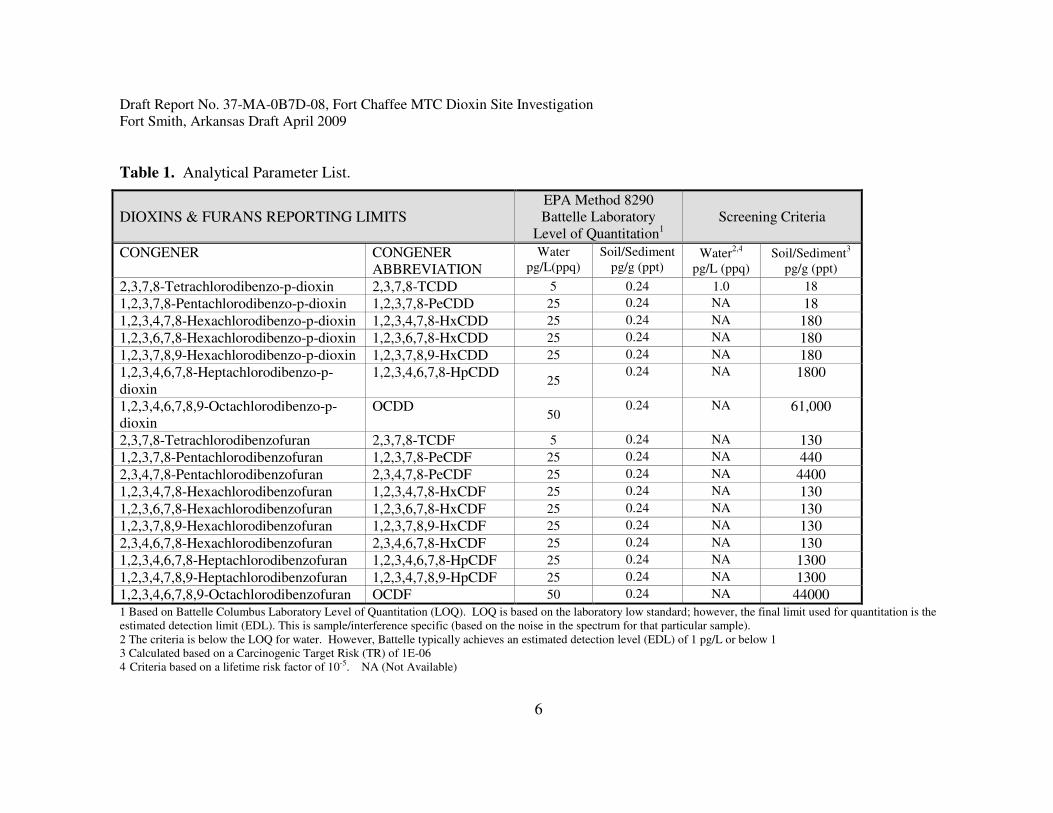
Table 1. Analytical Parameter List.
DIOXINS & FURANS REPORTING LIMITS EPA Method 8290
Battelle Laboratory
Level of Quantitation1
Screening Criteria
CONGENER
CONGENER
ABBREVIATION
Water
pg/L(ppq)
Soil/Sediment
pg/g (ppt) Water
2,4
pg/L (ppq)
Soil/Sediment3
pg/g (ppt)
2,3,7,8-Tetrachlorodibenzo-p-dioxin 2,3,7,8-TCDD 5 0.24 1.0 18
1,2,3,7,8-Pentachlorodibenzo-p-dioxin 1,2,3,7,8-PeCDD 25 0.24 NA 18
1,2,3,4,7,8-Hexachlorodibenzo-p-dioxin 1,2,3,4,7,8-HxCDD 25 0.24 NA 180
1,2,3,6,7,8-Hexachlorodibenzo-p-dioxin 1,2,3,6,7,8-HxCDD 25 0.24 NA 180
1,2,3,7,8,9-Hexachlorodibenzo-p-dioxin 1,2,3,7,8,9-HxCDD 25 0.24 NA 180
1,2,3,4,6,7,8-Heptachlorodibenzo-p-
dioxin
1,2,3,4,6,7,8-HpCDD 25
0.24 NA 1800
1,2,3,4,6,7,8,9-Octachlorodibenzo-p-
dioxin
OCDD 50
0.24 NA 61,000
2,3,7,8-Tetrachlorodibenzofuran 2,3,7,8-TCDF 5 0.24 NA 130
1,2,3,7,8-Pentachlorodibenzofuran 1,2,3,7,8-PeCDF 25 0.24 NA 440
2,3,4,7,8-Pentachlorodibenzofuran 2,3,4,7,8-PeCDF 25 0.24 NA 4400
1,2,3,4,7,8-Hexachlorodibenzofuran 1,2,3,4,7,8-HxCDF 25 0.24 NA 130
1,2,3,6,7,8-Hexachlorodibenzofuran 1,2,3,6,7,8-HxCDF 25 0.24 NA 130
1,2,3,7,8,9-Hexachlorodibenzofuran 1,2,3,7,8,9-HxCDF 25 0.24 NA 130
2,3,4,6,7,8-Hexachlorodibenzofuran 2,3,4,6,7,8-HxCDF 25 0.24 NA 130
1,2,3,4,6,7,8-Heptachlorodibenzofuran 1,2,3,4,6,7,8-HpCDF 25 0.24 NA 1300
1,2,3,4,7,8,9-Heptachlorodibenzofuran 1,2,3,4,7,8,9-HpCDF 25 0.24 NA 1300
1,2,3,4,6,7,8,9-Octachlorodibenzofuran OCDF 50 0.24 NA 44000 1 Based on Battelle Columbus Laboratory Level of Quantitation (LOQ). LOQ is based on the laboratory low standard; however, the final limit used for quantitation is the
estimated detection limit (EDL). This is sample/interference specific (based on the noise in the spectrum for that particular sample).
2 The criteria is below the LOQ for water. However, Battelle typically achieves an estimated detection level (EDL) of 1 pg/L or below 1
3 Calculated based on a Carcinogenic Target Risk (TR) of 1E-06
4 Criteria based on a lifetime risk factor of 10-5. NA (Not Available)

Draft Report No. 37-MA-0B7D-08, Fort Chaffee MTC Dioxin Site Investigation
Fort Smith, Arkansas Draft April 2009
7
5.0 SAMPLING RATIONALE, METHODS AND PROCEDURES.
5.1 Sampling and Analysis Plan (SAP) and Site Safety and Health Plan (SSHP).
The USACHPPM prepared a SAP and a SSHP for this sampling event and maintained a copy at
the site at all times. The SAP and SSHP for this site investigation is provided in Appendix C.
Table 2 provides a summary of the type and number of samples collected for this site
investigation.
Table 2. Sample Collection Summary.
Media Number of
Samples
Background/
Upstream
Samples
QA/QC
Samples
Composite/Discrete
Samples
Analytical
Parameters1
Surface soil 10 4 2 5 point Composite 17 dioxin
compounds
Surface Sediment 132 3 1 10 point Composite
17 dioxin
compounds
Subsurface
Sediment 4
2 1 1 5 point Composite
17 dioxin
compounds
Surface water 132 3 1 Discrete
17 dioxin
compounds
Total Number of Analytical
Samples 49
1 See Table 1 for a list of the 17 dioxin compounds.
2 Number of surface water and sediment samples listed includes background/upstream samples.
Quality Assurance/Quality Control (QA/QC) Samples.
5.2 Surface Soil Sampling Rationale.
Sixteen surface soil samples were collected for this site investigation. Ten surface soil samples
(plus two field quality assurance/quality control samples (QA/QC)) were collected throughout
the DSA 1 study area. In addition, four surface soil samples were collected from a background
sample location for comparison to DSA 1study area sample data. Surface soil sample locations
were determined using a systematic random sample design. The ArcView GIS 9.3 software was
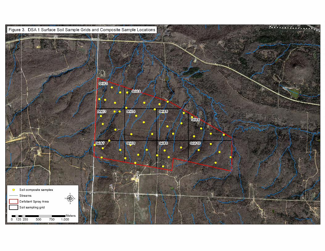
used to develop 10 grids of equal dimension to overlie the entire DSA 1 study area. Since the
method of herbicide application (i.e., via aerial spraying) would likely have resulted in
contaminants being dispersed throughout the site, a composite sampling approach was thought to
be the most effective means to assess site conditions.
One surface soil sample, consisting of a 5-point composite sample (5 subsamples), was collected
from each of the 10 sample grids overlying the DSA 1 study area. Prior to conducting field
activities, the Universal Transverse Mercator (UTM) coordinates for each of the 5 subsamples
located within each grid was randomly generated using the ArcView GIS software. To coincide

Draft Report No. 37-MA-0B7D-08, Fort Chaffee MTC Dioxin Site Investigation
Fort Smith, Arkansas Draft April 2009
8
with installation maps provided by the Fort Chaffee MTC, the UTM coordinates for each sample
location generated for this site investigation are based on the WGS 84 datum. Appendix B
Figure 3 depicts the 10 sample grids and surface soil sample locations identified for this site
investigation. A table containing the UTM coordinates for all sample locations is also provided
in Appendix B.
5.2.1 Soil Sample Collection.
Sample personnel used a handheld GPS unit to navigate to the UTM coordinates (easting and
northing) for each of the 5 subsamples located within each grid. At each of the 5 subsample
locations, one scoop of soil was collected from the top 0 to 6 inches of soil using a disposable
plastic scoop and placed in aluminum foil. Once collected, soil from the 5 subsample locations
within each sample grid was placed in a stainless steel mixing bowl, thoroughly mixed and
placed in the sample jar designated that grid. Surface soil sample identification numbers were
based on the following nomenclature: SL-G1 indicates a surface soil collected from Grid 1;
SL-G2-D indicates a field duplicate surface soil sample collected from Grid 2; SL-BG1 indicates
a surface soil sample collected from the area indentified as background location 1.
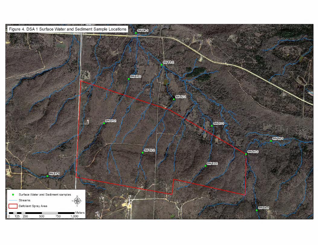
5.3 Surface Water and Sediment Sampling Rationale.
Surface water and sediment samples were collected from four streams and two creeks to assess
dioxin and dioxin-like compound concentrations upstream, downstream and within the DSA 1
study area. Surface water and sediment samples were collected from two streams that originate
upstream of the DSA 1 study area and two streams that originate within the DSA 1 study area.
For this site investigation these unnamed streams were identified as Stream1, Stream 2, Stream
3, and Stream 4. Streams 1 and 4 originated upstream of the DSA 1 study area. Stream 1 is
located along the western boundary of the DSA 1 study area while Stream 4 is located along the
eastern most boundary. Since upstream sample locations are not believed to have been impacted
by herbicide testing activities, upstream samples provide background or reference data for
comparison to data collected within and downstream of DSA 1 study area. For Streams 2 and 3,
no upstream samples were available as both streams originated within the DSA 1 study area.
Samples from these two streams were collected to assess dioxin and dioxin-like compounds
within and downstream of the central portion of the DSA 1 study area. Surface water and
sediment samples were collected from Vache Grasse Creek, located upstream of the DSA 1
study area to serve as a background comparison sample location. Table 4 provides a summary of
surface water and sediment sample locations along with the nomenclature used for sample
identification. Appendix B Figure 4 depicts the surface water and sediment sample locations
identified for this site investigation.
Since up-gradient rocky-bottom streams such as those within the DSA 1 study area primarily
transport particulate matter in suspended load to downstream locations, two additional sample
locations were selected downstream of the DSA 1 study area to assess transport and deposition

Draft Report No. 37-MA-0B7D-08, Fort Chaffee MTC Dioxin Site Investigation
Fort Smith, Arkansas Draft April 2009
9
of contaminants downstream of the DSA 1. A surface water, surface sediment and subsurface
sediment sample was collected from the downstream sample locations identified as Flat Rock
Creek 1 and Flat Rock Creek 2. Flat Rock Creek, located directly north of the DSA 1 study area,
flows east to west and drains to Vache Grasse Creek which empties into the Arkansas River.
5.3.1 Sediment Sampling.
Thirteen surface (0 – 4 inches) sediment and four subsurface (4 – 8 inches) sediment samples
were collected for this site investigation. Surface sediment samples were collected upstream
(three samples), within (four samples), and downstream (six samples) of the DSA 1 study area.
The majority of the sediment sample locations were downstream of the DSA 1 study area due to
the potential for historically applied contaminants to be transported and deposited to downstream
locations over time. Subsurface sediment samples were collected to assess the deposition of
contaminants transported downstream overtime. Surface and subsurface sediment samples were
collected using the following procedures.
5.3.1.1 Surface Sediment Sample Collection.
Beginning with the most downstream location and moving upstream, 10 subsamples of sediment
were scooped from areas having sufficient sediment deposition at various points within 100 feet
of the initial sample UTM coordinate location. Surface sediment was collected using a single-
use disposable plastic scoop and carefully placed in aluminum foil or in an aluminum foil lined
mixing bowl, ensuring that the fines were not lost in the scooping process. Once sufficient
sample volume was collected, each sediment sample was thoroughly mixed, removing organic
debris and large pebbles. The sediment sample was then placed in the appropriately labeled
sample container.
5.3.1.2 Subsurface Sediment Sample Collection.
Six subsurface sediment samples were planned for this site investigation. However, only four
subsurface sediment samples were collected due to the lack of sediment associated with
upstream streams. Subsurface sediment samples were not collected from upstream or
downstream sample locations within Stream 1 and Stream 4 due to the lack of sediment depth
associated with rocky bottom streambeds. The inability to collect subsurface sediment samples
at these locations does not affect the results of this site investigation since subsurface sediment
samples were collected further downstream where sediment deposition is most likely to have
taken place over time (i.e., two Flat Rock Creek sample locations).
A hand auger was used to collect subsurface sediment samples. A 8 inch sediment core was
extracted from each subsurface sediment sample location. Each subsurface sediment sample
consisted of a 5-point composite sample (or subsample) collected at approximately 10 to 15 foot
intervals over a 100 linear foot area. At each of the five subsample locations, the bottom 4 - 8

Draft Report No. 37-MA-0B7D-08, Fort Chaffee MTC Dioxin Site Investigation
Fort Smith, Arkansas Draft April 2009
10
inches of soil was removed from the hand auger and placed in a aluminum lined stainless steel
mixing bowl. Once sediment from each subsample location was place in the mixing bowl, the
sediment was thoroughly mixed and placed in the appropriately labeled sample container.
5.3.2 Surface Water Sampling.
Thirteen surface water samples (plus one QA/QC sample) were collected for this site
investigation. Four surface water samples were collected from stream sample locations
identified within the DSA 1 study area. One surface water sample was collected from each of
the following upstream sample locations: Stream 1, Stream 4 and Vache Grass Creek. Six
surface water samples were collected from sample locations downstream of the DSA 1 study
area.
5.3.2.1 Surface Water Collection.
Two liters of water were collected at each sample location by inverting the sample container and
immersing it to mid-depth in the middle of the stream, then filling and capping. The sample
container used to collect surface water samples for dioxin analysis was a new, clean, one liter
glass jar with a Teflon-lined cap. Samples were preserved immediately after collection by
placing on ice. The surface water sample was collected before the sediment sample at each
sample location to prevent contamination from the disturbance and resuspension of sediment.
Samples collected along a stream reach were collected starting from the farthest point
downstream working up to the most upstream sample location to minimize sediment disturbance.
5.4 Background Sample Collection.
5.4.1 Surface Soil Background Samples.
Four surface soil samples were collected in an area that was determined not to have been
impacted by the historic defoliant spray activities. The soil types found within this area are
consistent with those found within the DSA 1 study area. The soil background sample area is
located to the west of the DSA 1 study area and due west of the area identified as the Drop Zone.
Appendix B Figure 5 depicts the surface soil background sample location and the Vache Grasse
Creek surface water and sediment background sample location.
5.4.2 Surface Water and Sediment Background Samples.
Three surface water and four sediment samples (including one subsurface sediment sample) were
collected from stream locations upstream of the DSA 1 study area that were determined not to be
impacted by defoliant spray testing. One surface water and one surface sediment sample was
collected from the upstream sample location identified within Stream 1 and Stream 4.
Subsurface sediment samples were not available at these sample locations due to the lack of
sediment depth. One surface water sample and one sediment core sample (consisting of a

Draft Report No. 37-MA-0B7D-08, Fort Chaffee MTC Dioxin Site Investigation
Fort Smith, Arkansas Draft April 2009
11
surface and subsurface sediment sample) was collected from an area along Vache Grasse Creek
upstream of the DSA 1 study area. The Vache Grasse Creek sample location was adjacent to a
bridge and track vehicle crossing.
5.5 Field Quality Assurance/Quality Control (QA/QC) Samples.
One field duplicate and one field split sample were collected from both surface soil and sediment
sample locations for this site investigation. A field duplicate soil sample was collected from
sample Grid 9 (sample identification number SL-G9D). The duplicate soil sample was collected
approximately one foot from each of the 5-subsamples within Grid 9 using the same sampling
technique used to collect the original sample. A split soil sample was collected from Grid 4
(sample identification number SL-G4S). The split soil sample was collected by placing soil
collected and homogenized from this sample location into separate sample containers until each
container held an adequate sample volume. A field duplicate sediment sample was collected
from the subsurface sediment at the Flat Rock Creek 2 sample location (sample identification
number SD-FR2-SSD). Additionally, a split sample was collected from the surface sediment
sample collected at this location (sample identification number SD-FR2-SUF2). The field
duplicate and field split sediment samples were collected using the same procedures as the
original sediment samples. A surface water field duplicate sample was also collected at this
location (sample identification number SW-FR2-D).
5.6 Decontamination and Sample Integrity.
Only the subsurface sediment sampling equipment required decontamination. Decontamination
of the hand auger used to collect subsurface sediment samples was performed by removing
sediment debris for the sample equipment, washing with a Alconox detergent solution and
rinsing with distilled water. Surface soil and surface water equipment did not require
decontaminations as single-use, disposable plastic scoops and an aluminum lined stainless steel
mixing bowl were used to collect surface soil samples and surface water samples were collected
directly in their designated sample container. Field personnel wore latex gloves whenever
contacting sampling equipment or supplies and donned new gloves for each sample location. All
clean, unused sample equipment was placed in clean plastic zip-lock bags or wrapped in
aluminum foil to prevent contamination prior to use.
5.7 Sample Labeling, Preservation, Packing, and Chain-of-Custody Procedures.
5.7.1 Sample Labeling.
Sample labels were affixed to each sample container with the appropriate sample number,
sample date and time, analyses to be performed, preservative (if required), and sampler’s initials.
All information regarding sample collection, including, but not limited to, date and time of
collection, name(s) of sampling personnel, sample matrix, sample location, description of

Draft Report No. 37-MA-0B7D-08, Fort Chaffee MTC Dioxin Site Investigation
Fort Smith, Arkansas Draft April 2009
12
material sampled (including odors or stains), depth of sample, preservatives used, and sampling
procedure/equipment used, was recorded in the field log book.
5.7.2 Sample Preservation.
All samples were preserved in accordance with the analytical method and laboratory standard
operating procedures requirements. All samples were secured in zip-lock bags, placed in
coolers, and cooled to 4 degrees centigrade (4o
C) plus or minus 2o
C.
5.7.3 Sample Packing and Chain of Custody Procedures.
Samples containers were placed in a structurally sound cardboard box and placed into a cooler.
Samples were delivered to the analytical laboratory within appropriate holding times for all
samples.
The project officer completed chain-of-custody forms and a copy was included with each sample
shipment. The project officer signed, dated, and placed chain-of-custody seals on all coolers
when coolers were not within direct control of the project officer or laboratory personnel. The
project officers recorded all data regarding shipping and chain-of-custody procedures in the log
books. Chain-of-custody procedures followed ASTM D 4840-99 (2004) (ASTM, 2004b).
5.7.4 Log Book.
The project officer maintained a field log book documenting all sampling activities at the site.
The field log book and all entries conform to ASTM D 6089-97 (ASTM, reapproved 2003).
6.0 ANALYTICAL METHODS.
Table 3 contains a list of analyses performed and methods used. Laboratory data results are
provided in Appendix D.
6.1 Laboratory Accreditation and QA/QC Information.
6.1.1 Accreditation.
All samples were delivered to the USACHPPM Directorate of Laboratory Sciences (DLS),
located at Aberdeen Proving Ground, Maryland. Once received, the USACHPPM DLS logged
the samples using proper sample management procedures and then submitted samples to the
Battelle-Columbus Laboratory for analysis using EPA-approved methodologies. The Battelle
Laboratory is accredited by the New Jersey Office of Quality Assurance to perform dioxin
analyses. EPA Method 8290 was used for dioxin analysis for each media. All analytical method
SOPs are available upon request. The USACHPPM DLS maintains a variety of
accreditation/certifications to include the National Environmental Laboratory Accreditation

Draft Report No. 37-MA-0B7D-08, Fort Chaffee MTC Dioxin Site Investigation
Fort Smith, Arkansas Draft April 2009
13
Conference (NELAC), now called The NELAC Institute (TNI), the American Association for
Laboratory Accreditation (A2LA), and the DOD Clinical Laboratory Improvement Program
(CLIP) certification, among other laboratory accreditations and certifications. It should be noted
that the Arkansas Department of Environmental Quality requires laboratory certification specific
to Arkansas Code Annotated 8-2-201. An ADEQ certified laboratory should be used if
additional site investigation is required based on these sample results.
6.1.2 Laboratory QA/QC Procedures.
QA/QC procedures used during sample analysis included laboratory reagent/method blanks,
matrix spikes, matrix spike duplicates, laboratory control samples, method detection limit (MDL)
samples, instrument performance check samples, and initial calibration and continuing
calibration verification checks.
Table 3. Analytical Methods
Parameter Media Method Holding Time* Container Type Preservative
Dioxin/Furan Soil,
Sediment
EPA Method
8290
30 days extraction
45 days analysis
Glass container
with TeflonTM
lined lid
Cool to 4 + 2oC
Dioxin/Furan Surface
Water
EPA Method
8290
30 days extraction
45 days analysis
(2) 1 L Glass
container with
TeflonTM
lined lid
Cool to 4 + 2oC
7.0 SAMPLE RESULTS.
7.1 Surface Soil Results.
Fourteen surface soil samples were collected for this site investigation. Ten surface soil samples
were collected within the DSA 1 study area (plus two QA/QC samples) and four surface soil
samples were collected from a background location to serve as comparison samples. Trace
concentrations of the dioxin TCDD were detected in three soil samples collected from the DSA 1
study area (collected from Grid 1 (0.25 pg/g), Grid 3 (0.13 pg/g), and Grid 7 (0.46 pg/g)).
However, TCDD was also detected in the laboratory method blank sample (0.22 pg/g) that was
processed with the soil samples. According to EPA guidelines, sample results reported as less
than five times the blank contamination must be flagged as qualified data. Though the blank
contamination indicates that data results may be biased high (or false positives), the maximum
concentration of TCDD reported (0.46 pg/g) was compared to the human health risk screening
level to provide a conservative determination of whether additional study is warranted. The
maximum concentration TCDD reported was two orders of magnitude below the EPA Region 6
HHMSSL of 18 pg/g (ppt) for industrial soils (one order of magnitude below the EPA Region 6
HHMSSL for residential soils of 4.5 pg/g.
Draft Report No. 37-MA-0B7D-08, Fort Chaffee MTC Dioxin Site Investigation
Fort Smith, Arkansas Draft April 2009
14
The dioxin-like compound, octachlorodibenzo-p-dioxin (OCDD), was found at the highest
frequency and concentrations in the soil samples. This is consistent with other studies involving
this compound (U.S. EPA, 2007). Frequent and elevated concentrations of OCDD may be
attributed to herbicide use to control weeds and, to some degree, may occur naturally. The
highest concentration of OCDD detected was at least two orders of magnitude less than its
screening criterion. Trace concentrations of the remaining dioxin-like compounds were detected
in the majority of the soil samples. However, they were all detected at least two orders of
magnitude below their respective screening criteria.
7.2 Surface and Subsurface Sediment Results.
Thirteen surface sediment samples and 4 subsurface sediment samples were collected for this site
investigation (plus two QA/QC samples). Trace TCDD was detected in the surface sediment
sample collected from Stream 1 within the DSA 1 study area (SD-S1-2SUF). However, the
concentration reported was below the laboratory EDL and was flagged as an estimated value.
Though an estimated value, the reported maximum concentration was compared to the human
health risk screening level to provide a conservative determination of whether additional study is
warranted. The reported value (0.11 pg/g) was two orders of magnitude below the EPA Region
6 HHMSSL of 18 pg/g (ppt) for industrial soils (one order of magnitude below the EPA Region
6 HHMSSL for residential soils).
Consistent with soil sample results, OCDD was found at the highest frequency and
concentrations within the sediment samples. The highest concentration of OCDD was found in
the upstream (background) surface sediment sample collected from Vache Grasse Creek. The
higher OCDD concentration in the surface and surface sediment samples collected at this
location may be due to the PCP treated wood used in the construction of a nearby bridge. The
highest concentration of OCDD detected (1,153 pg/g) was more than an order of magnitude less
than the EPA Region 6 HHMSSL of 61,000 pg/g. All other dioxin-like compounds were at least
two orders of magnitude below their respective screening levels.
7.3 Surface Water Results.
Thirteen surface water samples were collected for this site investigation. TCDD was detected in
one water sample which was collected from Stream 1 within the DSA 1 study area
(SW-S1-2). However, the concentration detected was below the laboratory EDL and was
reported as an estimated value. Though an estimated value, the reported concentration was
compared to the surface water screening level of 1.0 pg/L to provide a conservative
determination of whether additional study is warranted. The reported estimated value of
0.53 pg/L (ppq) was below the ADEQ water quality human health criteria of 1 pg/L.
OCDD and 1,2,3,4,6,7,8-HPCDD were the only dioxin-like compounds detected in surface water
samples. With the exception sample SW-S4-2, OCDD and HPCDD concentrations detected in

Draft Report No. 37-MA-0B7D-08, Fort Chaffee MTC Dioxin Site Investigation
Fort Smith, Arkansas Draft April 2009
15
water samples were determined to be nondetects as similar concentrations were detected in the
laboratory method blank sample processed with the water samples. The elevated concentrations
of these compounds detected in surface water sample SW-S4-2 were determined to be outliers.
The ADEQ did not have water quality standards for these compounds available for comparison.
Table 4. Surface Water and Sediment Sample Locations and Sample ID Numbers.
Sample Location Upstream Within DSA 1 Downstream QA/QC
Samples
Stream 1
SW-S1-1
SD-S1-1S
SW-S1-2
SD-S1-2S
SW-S1-3
SD-S1-3S -
Stream 2 - SW-S2-2
SD-S2-2S
SW-S2-3
SD-S2-3S; SD-S2-3SS1
-
Stream 3 - SW-S3-2
SD-S3-2S
SW-S2-3
SD-S2-3 -
Stream 4
SW-S4-1
SD-S4-1S;
SW-S4-2
SD-S4-2S
SW-S4-3
SD-S4-3S -
Flat Rock Creek - -
SW-FR1; SW-FR2
SD-FR1-S; SD-FR1-SS
SD-FR2-S; SD-FR2-SS
SD-FR2-SSD
SD-FR2-SUF2
SW-FR2-D
Vache Grasse Creek
SW-VGC
SD- VGC -S;
SD- VGC -SS
- - -
Flat Rock Creek = FR; Vache Grasse Creek = VGC; Surface water = SW; Sediment = SD; Surface sediment = S;
Subsurface sediment = SS; Duplicate = D
SD-FR1-SUF2 was a surface sediment split sample collected the Flat Rock Creek 1 sample location

Draft Report No. 37-MA-0B7D-08, Fort Chaffee MTC Dioxin Site Investigation
Fort Smith, Arkansas Draft April 2009
16
8.0 DATA QUALITY EVALUATION AND ASSESSMENT.
8.1 Data Quality Evaluation.
The accompanying laboratory narrative (Appendix D) contains a complete listing of all analytes,
MDLs, Reporting Limits, and analyses performed
A data quality evaluation was performed on the Fort Chaffee MTC laboratory data to determine
data quality and usability. The data quality indicators precision, accuracy, representativeness,
completeness, and comparability (PARCC) parameters were assessed to determine data usability.
Precision, accuracy and completeness are measured quantitatively. Representativeness and
comparability are measured qualitatively.
• Precision is the degree of agreement between individual measurements. Precision is
measured by the relative percent difference (RPD) between individual measurements
with the same characteristic. Field duplicate samples were used to assess laboratory
precision. The RPD set for this project was less than 30%. The RPD between original
and field duplicate samples for each media were all less than 30%.
• Accuracy is the degree of agreement between the measured value and the true value.
Accuracy may be assessed by the use of a standard reference material or laboratory
matrix spike samples. Accuracy is expressed as a percentage of the ratio of measured
value to true value. The laboratory precision limits for analytical method matrix spike
sample recovery was used to assess accuracy. Analytical method matrix spike recoveries
were met for soil, sediment and surface water samples.
• Representativeness reflects the degree to which sample data accurately and precisely
portrays the environmental conditions being studied. Representativeness is primarily
addressed through designing a sampling plan that will provide data that is most
characteristic of site conditions to include ensuring that the number of samples collected
and sample locations are sufficient to provide data that is characteristic of site conditions.
Sample data was determined to be representative of site conditions.
• Completeness is the amount of data obtained for a measurement compared to the
expected amount of data required for the measurement. All of the samples planned for
this site investigation were collected and analyzed with the exception of four subsurface
sediment samples. Subsurface sediment samples were not collected from upstream and
downstream sediment sample locations within Stream 1 and Stream 4 due to the lack of
sediment depth associated with rocky bottom streams. Prior to sampling collection
efforts, it was determined that subsurface samples may not be available from these
streams; therefore two alternate sample locations were included to assess contaminant
movement downstream (i.e., Flat Rock Creek 1 and Flat Rock Creek 2). The inability to
Draft Report No. 37-MA-0B7D-08, Fort Chaffee MTC Dioxin Site Investigation
Fort Smith, Arkansas Draft April 2009
17
collect subsurface sediment samples from upstream and downstream sample locations in
Stream 1 and Stream 4 did not affect data usability as subsurface sediment samples were
collected from the alternate sample locations identified within Vache Grasse Creek
(upstream) and Flat Rock Creek 1 and Flat Rock Creek 2 (downstream).
• Comparability is a qualitative parameter expressing the confidence with which one data
set can be compared with another. The degree of comparability is directly related to the
precision, accuracy, and representativeness of the data in each set. For this project,
comparability was measured through the use of standard field sampling procedures and
laboratory analytical methods and by ensuring that the concentration units reported for
site data (i.e. pg/L, pg/g) were compared to the appropriate health screening criteria
concentration units.
8.2 Data Assessment.
Laboratory data review and validation determined that the data reported for this site investigation
was of sufficient quality and quantity for use in the decision-making process. The trace
concentrations of TCDD detected in one surface water and one surface sediment sample were
below the sample specific estimated detection limit (EDL) and were reported as estimated values
or J-qualified data. The J-qualified data does not affect quality or usability of the sample data.
Trace concentrations of TCDD and dioxin-like compounds were detected in the laboratory
method blank sample processed with the soil samples. However, the levels detected were less
than the method detection level and significantly less than the screening criteria. Laboratory
method blank contamination does not affect the quality or usability of data collected for this site
investigation.
Due to the large number of nondetects, the maximum concentration of dioxin and dioxin-like
compounds reported for each media was qualitatively compared to the corresponding human
health risk screening criteria.
9.0 CONCLUSIONS.
Trace levels of dioxin and dioxin-like compounds were detected in soil, sediment, and surface
water samples collected in both the DSA 1 study area and the background sample location.
However, no samples contained dioxin or dioxin–like compounds above Federal or State human
health risk screening criteria. Trace concentrations of 2,3,7,8-tetrachlorodibenzo-p-dioxin
(TCDD), considered the most toxic of the dioxin compounds, were detected in one surface water,
one sediment, and three surface soil samples collected in the DSA 1 study area. A subsequent
review of laboratory control sample data found that the trace TCDD concentrations detected in
the soil samples may be false positives as dioxins of comparable concentrations were detected in
the laboratory method blank sample associated with the soil samples. Additionally, the trace
Draft Report No. 37-MA-0B7D-08, Fort Chaffee MTC Dioxin Site Investigation
Fort Smith, Arkansas Draft April 2009
18
TCDD concentrations detected in the surface water and sediment sample were below the
laboratory estimated detection limit (EDL) and were reported as estimated values.
Though laboratory data review suggested that the dioxin concentrations reported may be biased
high compared to the true value, the maximum concentration of TCDD reported was compared
to the corresponding Federal and State health screening criterion to provide a conservative
determination of whether additional study is warranted.
9.1 Soil Sample Results.
Ten surface soil samples, each consisting of a 5-point composite sample, were collected
throughout the DSA 1 study area using a systematic random sampling design. Trace
concentrations of TCDD were detected in three surface soil samples and the laboratory method
blank sample. The maximum concentration TCDD reported (0.46 pg/g) was two orders of
magnitude below the U.S. EPA Region 6 HHMSSL for industrial soils of 18 pg/g (and one order
of magnitude below the residential soil HHMSSL of 4.5 pg/g).
9.2 Sediment Sample Results.
Thirteen surface sediment and four subsurface sediment samples were collected for this site
investigation. Trace TCDD was detected in one surface sediment sample collected from
Stream 1 within the DSA 1 study area. Though an estimated value, the reported concentration
was compared to the human health risk screening level to provide a conservative determination
of whether additional study is warranted. The reported value (0.11 pg/g) was two orders of
magnitude below the U.S. EPA Region 6 HHMSSL of 18 pg/g for industrial soils (and one order
of magnitude below the U.S. EPA Region 6 HHMSSL for residential soils).
9.3 Surface Water Sample Results.
Thirteen surface water samples were collected for this site investigation. TCDD was detected in
one water sample collected from Stream 1 within the DSA 1 study area (SW-S1-2). Though an
estimated value, the reported concentration was compared to the surface water screening level to
provide a conservative determination of whether additional study is warranted. The reported
estimated value of 0.53 pg/L (ppq) was below the ADEQ water quality human health criteria of 1
pg/L.
9.4 Dioxin-like Compound Results.
The dioxin-like compound, octachlorodibenzo-p-dioxin (OCDD), was found at the highest
frequency and concentrations in both DSA 1 study area and background samples. This is
consistent with other studies involving this compound (U.S. EPA, 2007). Frequent and elevated
concentrations of OCDD may be attributed to herbicide use to control weeds and, to some
degree, may occur naturally. The highest concentration of OCDD detected (1,153 pg/g) was two

Draft Report No. 37-MA-0B7D-08, Fort Chaffee MTC Dioxin Site Investigation
Fort Smith, Arkansas Draft April 2009
19
orders of magnitude below its HHMSSL of 61,000 pg/g. Trace concentrations of the remaining
dioxin-like compounds were detected in the majority of soil and sediment samples. However,
the reported concentrations were at least two orders of magnitude below their respective
screening criteria. Based on the concentrations of dioxin that were observed, dioxin-like
compounds within the DSA 1 were not found to occur at a greater frequency or magnitude than
the background sites chosen for this study.
It is not possible to discern the source of trace dioxin and dioxin-like compounds detected in soil,
sediment, and surface water samples collected in the western most portion of the DSA 1 study
area. Potential sources of these compounds may be attributed to the application of herbicides to
control weed growth along roads that access the DSA 1 training area, residuals from the historic
application of tactical grade herbicides, or result of natural forest fires or controlled burns.
Independent of the source, the concentrations of dioxin and dioxin-like compounds detected in
the DSA 1 study area did not exceed Federal or State human health screening criteria.
10.0 RECOMMENDATIONS.
A human health risk assessment is not warranted as the concentrations of dioxin and dioxin-like
compounds detected in DSA 1 were below Federal and State human health risk screening
criteria. Based on these findings, the USACHPPM recommends no further action with respect to
dioxin and dioxin-like compounds within DSA 1.
11.0 POINTS OF CONTACT.
For questions or comments regarding this site investigation, please contact Ms. Barbara Vichot at
(410) 436-8555 (DSN 584-8555), office (410) 436-3651 or by email at
BARBARA VICHOT Physical Scientist, Special Studies and Technology Team
Hazardous and Medical Waste Program
REVIEWED:
KENNETH A. MIODUSKI
Section Chief, Special Studies and Technology Team
Hazardous and Medical Waste Program
Draft Report No. 37-MA-0B7D-08, Fort Chaffee MTC Dioxin Site Investigation
Fort Smith, Arkansas Draft April 2009
20
APPROVED:
LINDA L. BAETZ
Program Manager
Hazardous and Medical Waste Program

This page intentionally left blank

Draft Report No. 37- MA0B7D -08, Fort Chaffee MTC Dioxin Site Investigation
Fort Smith, Arkansas Draft April 2009
A-1
APPENDIX A
REFERENCES
ADEQ, October 2007. Regulation No. 2: Regulation Establishing Water Quality Standards for
Surface Waters of the State of Arkansas (October 2007).
Young, Alvin L. December 2006. The History of the US Department of Defense Programs for
the Testing, Evaluation, and Storage of Tactical Herbicides. Prepared for the Office of the Under
Secretary of Defense, Arlington, Virginia. Contract No. DAAD19-02-D-0001. (December,
2006).
ATSDR, November 2008. Toxicological Profile for Chlorinated Dibenzo-p-Dioxins. US
Department of Health and Human Services, Agency for Toxic Substances and Disease Registry,
Atlanta, GA. Replaces Appendix B in the Toxicological Profile for Chlorinated Dibenzo-p-
dioxins (CDDs) (December, 1998).
CH2MHill, July 1999. Draft Final Enhanced Preliminary Assessment / Site Investigation.
Prepared for Fort Chaffee Maneuver Training Center.
Burns & McDonnell and ECC, June 2006. Decision Document FTCH-41 Defoliant Spray Areas.
Prepared for the U.A. Army Environmental Center, Aberdeen Proving Ground, Maryland.
ACSIM IDIQ Contract Number W91ZLK-05-D-0009, Task Order No. 2.
U.S. EPA, April 2007. Pilot Survey of Levels of Polychlorinated Dibenzo-P-Dioxins
(PCDDs), Polychlorinated Dibenzofurans (PCDFs), Polychlorinated Biphenyls (PCB) and
Mercury in Rural Soils of the U.S. U.S. Environmental Protection Agency, Washington, DC,
EPA/600/R-05/043F, 2007.
ERM Program Management Company, October 1996. Final Fort Chaffee Environmental
Baseline Survey at Army Base Realignment and Closure (BRAC) 95 Installations: EBS Report
with CERFA Report ELIN A013. Prepared for the U.A. Army Environmental Center, Aberdeen
Proving Ground, Maryland.
Fort Chaffee, February 2000. Record of Decision for Five No Further Action Group III-D
Environmental Sites, Fort Chaffee, Arkansas. Prepared by the United States Army Fort Chaffee
Base Transition Team.
Parsons, May 2003. Draft Final, Preliminary Assessment/Site Inspection, Fort Chaffee
Maneuver Training Center, Fort Chaffee Arkansas. Prepared for the Arkansas National Guard,
Military Department of Arkansas, Camp Robinson, Arkansas.

Draft Report No. 37- MA0B7D -08, Fort Chaffee MTC Dioxin Site Investigation
Fort Smith, Arkansas Draft April 2009
A-2
USAEC, 1996. Final Fort Chaffee, Arkansas Environmental Baseline Survey at Army Base
Realignment and Closure (BRAC) 95 Installations. Prepared by ERM Program Management
Company. October 199.

Draft Report No. 37- MA0B7D -08, Fort Chaffee MTC Dioxin Site Investigation
Fort Smith, Arkansas Draft April 2009
B-1
APPENDIX B
SAMPLE LOCATION MAPS
AND
UTM SAMPLE COORDINATES
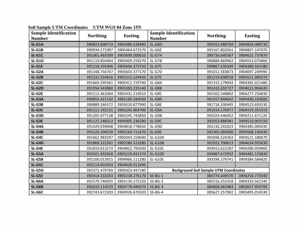
Soil Sample UTM Coordinates UTM WGS 84 Zone 15N
Sample Identification
Number Northing Easting
Sample Identification
Number Northing Easting
SL-G1A 390823.608719 3905480.528490 SL-G6D 392922.488769 3904826.088730
SL-G1B 390934.571997 3905464.672570 SL-G6E 393167.802041 3904807.147070
SL-G1C 391061.463399 3905699.500610 SL-G7A 390736.640367 3904615.737870
SL-G1D 391119.850464 3905409.259270 SL-G7B 390889.869963 3904553.075860
SL-G1E 391218.335446 3905606.373750 SL-G7C 390867.630349 3904380.563180
SL-G2A 391348.756767 3905603.377170 SL-G7D 391011.583873 3904697.249990
SL-G2B 391332.554816 3905315.524420 SL-G7E 391219.838918 3904521.985070
SL-G2C 391669.295561 3905411.729740 SL-G8A 391315.279043 3904365.021480
SL-G2D 391956.543860 3905383.235140 SL-G8B 391410.202727 3904615.904630
SL-G2E 392112.461064 3905431.219010 SL-G8C 391502.548802 3904277.256830
SL-G3A 390855.421142 3905160.184030 SL-G8D 391557.844042 3904430.193600
SL-G3B 390889.246572 3905010.877990 SL-G8E 391716.330445 3904523.693530
SL-G3C 391111.192131 3905245.004700 SL-G9A 391914.176977 3904419.355310
SL-G3D 391205.977138 3905245.743850 SL-G9B 392024.446452 3904211.671120
SL-G3E 391127.248312 3904905.236290 SL-G9C 392053.888381 3904510.903150
SL-G4A 391429.039048 3904818.778650 SL-G9D 392132.241023 3904385.000430
SL-G4B 391520.104539 3905164.711670 SL-G9E 392365.005600 3904568.146430
SL-G4C 391662.983597 3905043.159040 SL-G10A 392696.524263 3904521.180670
SL-G4D 391868.322361 3905286.513280 SL-G10B 392922.700613 3904634.935630
SL-G4E 391819.013274 3904822.795030 SL-G10C 393013.622187 3904280.059960
SL-G5A 392021.932828 3905229.832270 SL-G10D 393087.672932 3904482.133830
SL-G5B 392106.013915 3904966.111280 SL-G10E 393296.279741 3904384.584820
SL-G5C 392214.655054 3904828.911690
SL-G5D 392371.479769 3905023.447180 Background Soil Sample UTM Coordinates
SL-G5E 392414.310253 3905218.276170 SS-BG-1 384774.649570 3904254.770340
SL-G6A 392570.746955 3905139.272220 SS-BG-2 385516.252318 3904333.561540
SL-G6B 392610.114229 3904778.496070 SS-BG-3 384608.682883 3903657.959700
SL-G6C 392743.672303 3904926.670320 SS-BG-4 385627.257902 3903495.014530

Surface Water and Sediment Sample UTM Coordinates UTM WGS 84 Zone 15N
Sample Identification
Number
Stream Northing Easting
SW-S1-1 Stream 1 390283.459413 3904414.509710
SW-S1-2 Stream 1 391148.400107 3905224.514600
SW-S1-3 Stream 1 391528.278618 3905902.976800
SW-S2-2 Stream 2 391740.916773 3904773.336600
SW-S2-3 Stream 2 392217.577209 3905593.085340
SW-S3-2 Stream 3 392702.218437 3904569.558360
SW-S3-3 Stream 3 392800.356637 3905183.221220
SW-S4-1 Stream 4 393487.088028 3903890.284640
SW-S4-2 Stream 4 393323.674142 3904750.443070
SW-S4-3 Stream 4 393705.750245 3904953.251240
SW-FR-1 Flat Rock Creek 391637.897251 3906607.421600
SW-FR-2 Flat Rock Creek 392029.892222 3906120.622930
VGC-1 Vache Grasse Creek 381952.066638 3903364.554710


Figure 1
LOCATIONS OF FTCH-41 DEFOLIANT SPRAY AREAS
Fort Chaffee, Arkansas From PA/SI, Parsons, 2003


This page intentionally left blank

Draft Report No. 37- MA0B7D -08, Fort Chaffee MTC Dioxin Site Investigation
Fort Smith, Arkansas Draft April 2009
C-1
APPENDIX C
SAMPLE AND ANALYSIS PLAN
AND
SITESAFETY AND HEALTH PLAN
The Sample and Analysis Plan and Site Safety and Health Plan are provided on the enclosed CD-
ROM

This page intentionally left blank

Draft Report No. 37- MA0B7D -08, Fort Chaffee MTC Dioxin Site Investigation
Fort Smith, Arkansas Draft April 2009
D-1
APPENDIX D
LABORATORY DATA AND CHAIN-OF-CUSTODY FORMS
Laboratory Data and Chain-of-Custody Forms for the Fort Chaffee MTC DSA 1 Site
Investigation are provided on the enclosed CD-ROM

This page intentionally left blank