nmhss role in facilitating climate change...
TRANSCRIPT

NMHSs Role in facilitating Climate Change adaptation at National Levels
(A Case Study of Pakistan)
Dr. Qamar-uz-Zaman ChaudhryDirector General
Pakistan Meteorological DepartmentREP. OF WMO
PMD
Seismology Meteorology Hydrology
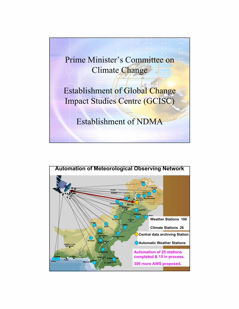
Prime Minister’s Committee onClimate Change
Establishment of Global Change Impact Studies Centre (GCISC)
Establishment of NDMA
Khuzdar
Zhob
Astore
ChhorJiwani
Larkana
Nawabshah
Sibbi
D.I.Khan
BannuParachinar
Balakot Muzaffarabad
Automation of Meteorological Observing Network
Central data archiving Station
Automatic Weather Stations
Automation of 25 stations completed & 15 in process.
300 more AWS proposed.
Weather Stations 100
Climate Stations 26
National Tsunami Early
WarningCentre (TWC),
Karachi
Turbat
Khuzdar
Zhob
Chitral
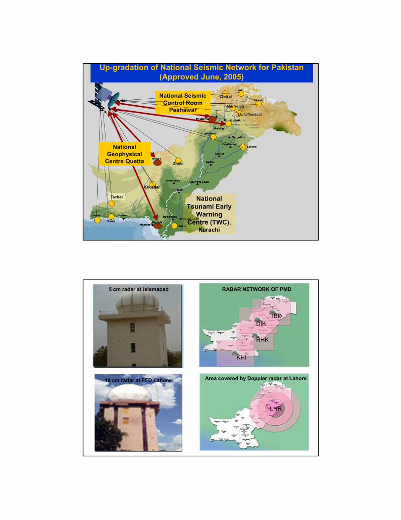
National Geophysical
Centre Quetta
National Seismic Control Room
Peshawar
Up-gradation of National Seismic Network for Pakistan(Approved June, 2005)
Muzaffarabad
Mansehra
RADAR NETWORK OF PMD5 cm radar at Islamabad
10 cm radar at FFD Lahore Area covered by Doppler radar at Lahore
DIKIBD
RHK
KHI
LHR
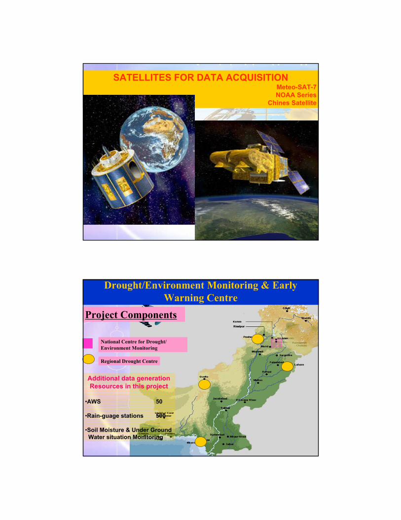
SATELLITES FOR DATA ACQUISITIONMeteo-SAT-7NOAA Series
Chines Satellite
Drought/Environment Monitoring & Early Warning Centre
Additional data generation Resources in this project
•AWS 50
•Rain-guage stations 500
•Soil Moisture & Under GroundWater situation Monitoring
Regional Drought Centre
National Centre for Drought/ Environment Monitoring
Project Components
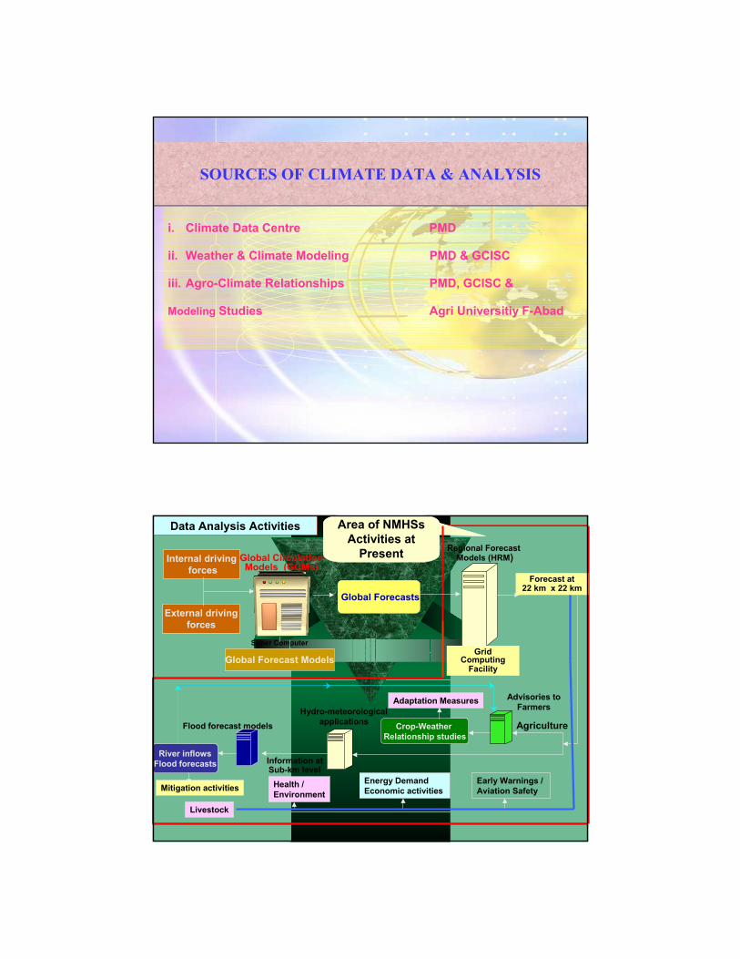
SOURCES OF CLIMATE DATA & ANALYSISSOURCES OF CLIMATE DATA & ANALYSIS
i. Climate Data Centre PMD
ii. Weather & Climate Modeling PMD & GCISC
iii. Agro-Climate Relationships PMD, GCISC &
Modeling Studies Agri Universitiy F-Abad
Global Forecast Models
Internal drivingforces
External drivingforces
Regional ForecastModels (HRM)
Crop-Weather Relationship studies
Advisories to FarmersHydro-meteorological
applicationsFlood forecast models
River inflowsFlood forecasts Information at
Sub-km level
Mitigation activities
Adaptation Measures
Health /Environment
Energy DemandEconomic activities
Early Warnings / Aviation Safety
Area of NMHSsActivities at
Present
Agriculture
Global Circulation Models (GCMs)
Super Computer
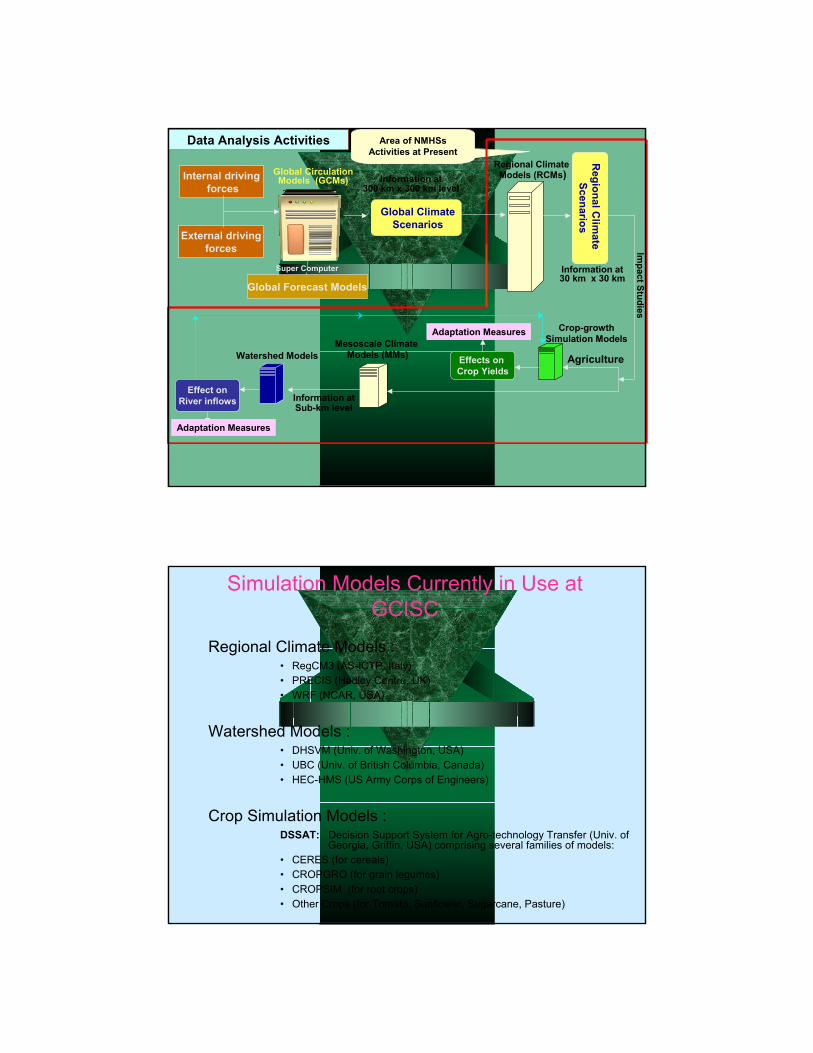
Data Analysis Activities
Global Forecasts
Forecast at 22 km x 22 km
Livestock
Grid Computing
Facility
Global Forecast Models
Internal drivingforces
External drivingforces
Global ClimateScenarios
Regional ClimateModels (RCMs)
Regional C
limate
Scenarios
Effects on Crop Yields
Crop-growth Simulation ModelsMesoscale Climate
Models (MMs)Watershed Models
Effect onRiver inflows
Impact Studies
Information at 300 km x 300 km level
Information at 30 km x 30 km
Information at Sub-km level
Adaptation Measures
Adaptation Measures
Area of NMHSsActivities at Present
Agriculture
Global Circulation Models (GCMs)
Super Computer
Data Analysis Activities
Simulation Models Currently in Use at GCISC
Regional Climate Models :• RegCM3 (AS-ICTP, Italy) • PRECIS (Hadley Centre, UK)• WRF (NCAR, USA)
Watershed Models :• DHSVM (Univ. of Washington, USA)• UBC (Univ. of British Columbia, Canada)• HEC-HMS (US Army Corps of Engineers)
Crop Simulation Models :DSSAT: Decision Support System for Agro-technology Transfer (Univ. of
Georgia, Griffin, USA) comprising several families of models:• CERES (for cereals)• CROPGRO (for grain legumes)• CROPSIM (for root crops)• Other Crops (for Tomato, Sunflower, Sugarcane, Pasture)
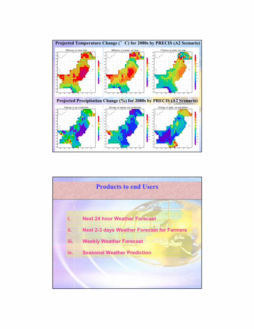
Projected Temperature Change (°C) for 2080s by PRECIS (A2 Scenario)
Projected Precipitation Change (%) for 2080s by PRECIS (A2 Scenario)
Products to end UsersProducts to end Users
i. Next 24 hour Weather Forecast
ii. Next 2-3 days Weather Forecast for Farmers
iii. Weekly Weather Forecast
iv. Seasonal Weather Prediction
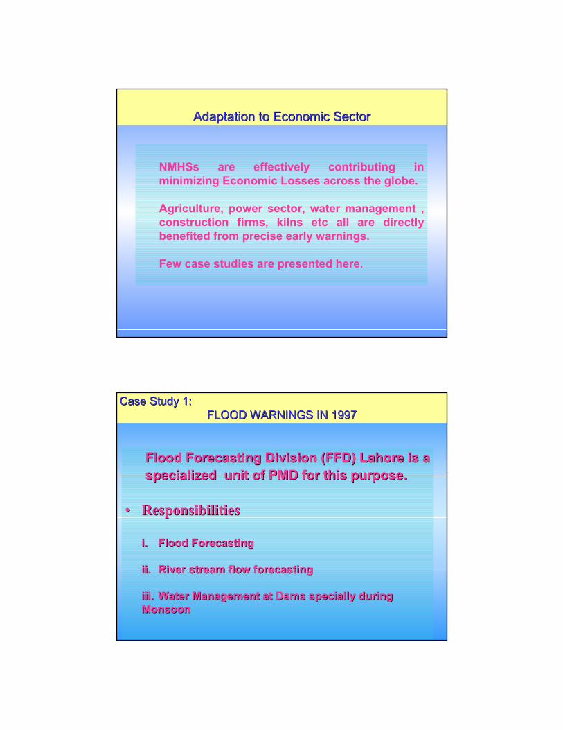
NMHSs are effectively contributing in minimizing Economic Losses across the globe.
Agriculture, power sector, water management , construction firms, kilns etc all are directly benefited from precise early warnings.
Few case studies are presented here.
Adaptation to Economic SectorAdaptation to Economic Sector
Flood Forecasting Division (FFD) Lahore is a Flood Forecasting Division (FFD) Lahore is a specialized unit of PMD for this purposespecialized unit of PMD for this purpose..
•• ResponsibilitiesResponsibilities
i.i. Flood ForecastingFlood Forecasting
ii.ii. River stream flow forecastingRiver stream flow forecasting
iii.iii. Water Management at Dams specially during Water Management at Dams specially during MonsoonMonsoon
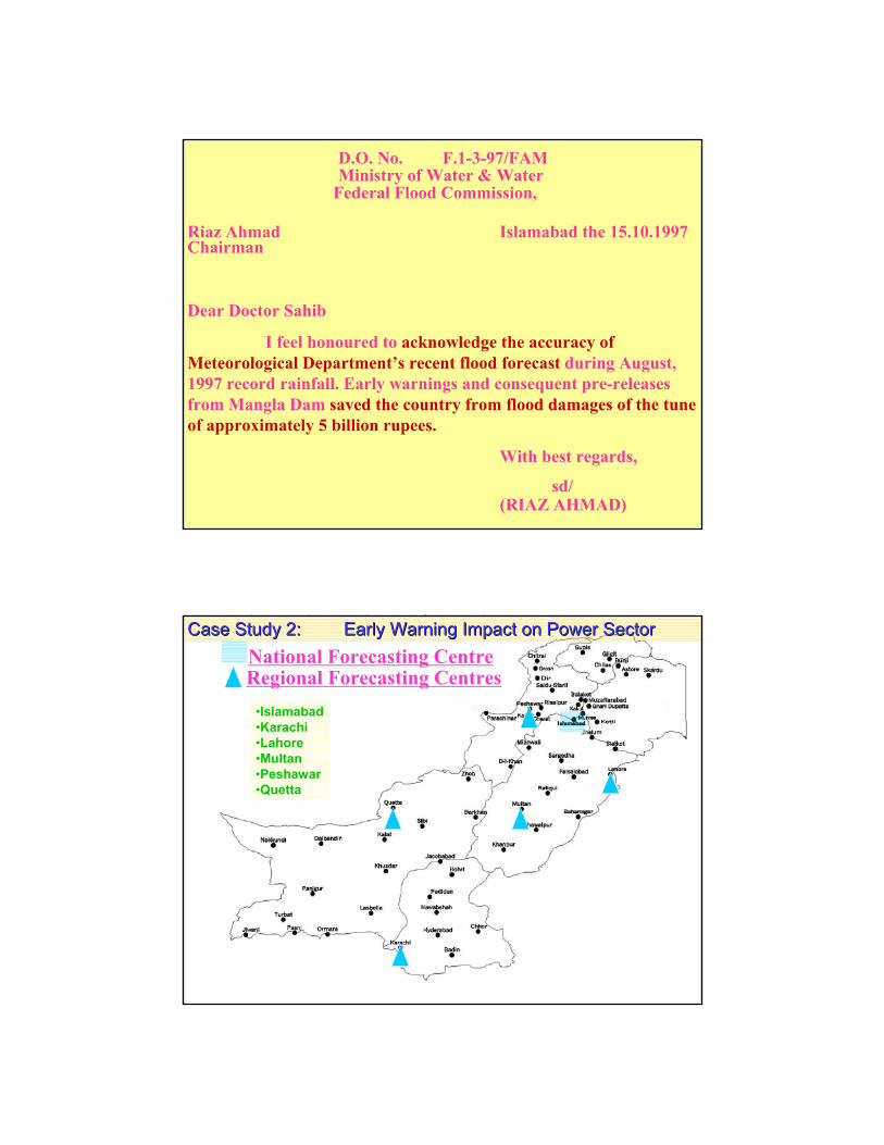
Case Study 1: Case Study 1: FLOOD WARNINGS IN 1997FLOOD WARNINGS IN 1997

Pakistan Meteorological Department
Pakistan Meteorological Department
D.O. No. F.1-3-97/FAMMinistry of Water & Water
Federal Flood Commission,
Riaz Ahmad Islamabad the 15.10.1997Chairman
Dear Doctor Sahib
I feel honoured to acknowledge the accuracy of Meteorological Department’s recent flood forecast during August, 1997 record rainfall. Early warnings and consequent pre-releases from Mangla Dam saved the country from flood damages of the tune of approximately 5 billion rupees.
With best regards,
sd/(RIAZ AHMAD)
•Islamabad•Karachi•Lahore•Multan•Peshawar•Quetta
Regional Forecasting CentresNational Forecasting Centre
Case Study 2: Case Study 2: Early Warning Impact on Power SectorEarly Warning Impact on Power Sector
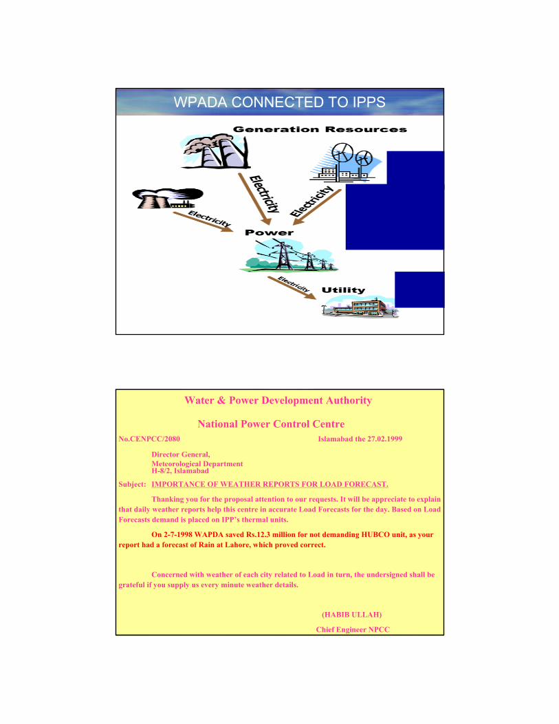
WPADA CONNECTED TO IPPS
Water & Power Development Authority
National Power Control CentreNo.CENPCC/2080 Islamabad the 27.02.1999
Director General,Meteorological DepartmentH-8/2, Islamabad
Subject: IMPORTANCE OF WEATHER REPORTS FOR LOAD FORECAST.
Thanking you for the proposal attention to our requests. It will be appreciate to explain that daily weather reports help this centre in accurate Load Forecasts for the day. Based on Load Forecasts demand is placed on IPP’s thermal units.
On 2-7-1998 WAPDA saved Rs.12.3 million for not demanding HUBCO unit, as your report had a forecast of Rain at Lahore, which proved correct.
Concerned with weather of each city related to Load in turn, the undersigned shall be grateful if you supply us every minute weather details.
(HABIB ULLAH)
Chief Engineer NPCC

i. i. Rain Predictions Rain Predictions
ii. ii. Frost PredictionsFrost Predictions
iii. iii. Soil Moisture InformationSoil Moisture Information
iv. iv. Time of Crop Sowing/HarvestingTime of Crop Sowing/Harvesting
v. v. Spraying of Pesticides on CropsSpraying of Pesticides on Crops
vi. vi. Water Requirement of CropsWater Requirement of Crops
vii. vii. Heat Wave and Cold Wave ForecastHeat Wave and Cold Wave Forecast
viii.viii. Special Weather Advisories for FarmersSpecial Weather Advisories for Farmers
ix.ix. MonthlyMonthly AgrometAgromet Bulletin of PakistanBulletin of Pakistan
ix.ix. Research on Regional Basis in Collaboration Research on Regional Basis in Collaboration
with Agriculture Research Institutions.with Agriculture Research Institutions.
Case Study 3: Case Study 3: Impact on AgricultureImpact on Agriculture
Met. Observing Network in PakistanMet. Observing Network in Pakistan
Regional Agromet Centres•Rawalpindi•Faisalabad•TandoJam•Quetta•Usta Muhammad Agromet Observatories
Punjab•Murree•Kamra•Jhelum•Lahore•Multan•Khanpur •SargodhaSindh•Rohri•Larkana•HyderabadBalochistan•Uthal•Khuzdar•KalatNWFP•DIKhan•Peshawar
AGROMET NETWORK
Usta Muhammad
National Agromet Centre
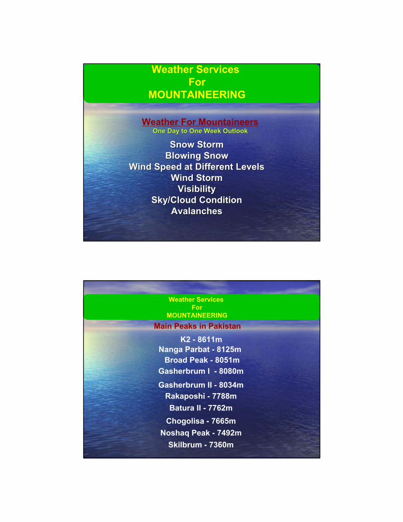
Weather For MountaineersOne Day to One Week OutlookOne Day to One Week Outlook
Snow StormSnow StormBlowing SnowBlowing Snow
Wind Speed at Different LevelsWind Speed at Different LevelsWind StormWind Storm
VisibilityVisibilitySky/Cloud ConditionSky/Cloud Condition
AvalanchesAvalanches
Weather Services For
MOUNTAINEERING
K2 - 8611m Nanga Parbat - 8125m
Broad Peak - 8051mGasherbrum l - 8080m
Gasherbrum II - 8034m Rakaposhi - 7788m Batura II - 7762m
Chogolisa - 7665m Noshaq Peak - 7492m
Skilbrum - 7360m
Main Peaks in Pakistan
Weather Services For
MOUNTAINEERING

Weather Services For
MOUNTAINEERING
Response to National IssuesResponse to National IssuesWIND MAPPING SURVEY ALONG COASTAL AREASWIND MAPPING SURVEY ALONG COASTAL AREAS

Potential area for wind power generation is around 9700 sq.km
(Total power potential 11000 MW)
Response to National IssuesResponse to National Issues
i. i. Heavy Rainfall in Islamabad in 2001Heavy Rainfall in Islamabad in 2001
ii. ii. Tropical Cyclone in southwest of Pakistan in Tropical Cyclone in southwest of Pakistan in
20072007
iii. iii. Extended cold wave in Feb. 2008 Extended cold wave in Feb. 2008
iv. iv. Extended drought in 2000 Extended drought in 2000 –– 2002 in southwest 2002 in southwest
PakistanPakistan
Extreme EventsExtreme Events

Response to National IssuesResponse to National IssuesFlash Floods Warning & Dissemination SystemFlash Floods Warning & Dissemination System
PMD
Real timeRainfall/Water Level
Observation
Judgement: 10 minutes
Minimal warning activity
TMA
Flood Forecasting
Required evacuationtime: 1 to 2 hours
Good enough time toevacuate: 1 to 2 hours
by flood prediction
Flood prediction time: 1 to 2 hours before flood
Integrated warning for evacuation
To shorter required evacuation time by adequate evacuation plan
Risky time zonecauses loss of life
To reacha specifiedwater levelfor warning
To startriver overflow
To startwarning forevacuation
• Capacity Building
• Acquisition to new tools & Technologies for speedy utilization of data
• Outreach to end users
• Effective dissemination System
• Maintaining Data Quality
ShortfallsShortfalls

Low technological and scientific base;
Limited access to knowledge;
Weak institutional mechanism;
Low financial resources.
Weakness of Pakistan in Confronting Climate Change Challenge
Regional Centres
SAARC Regional Meteorological ResearchCentre
Regional Climate Centre China
Regional Drought Centre Iran
World Data Centre for Green houses gasesJapan
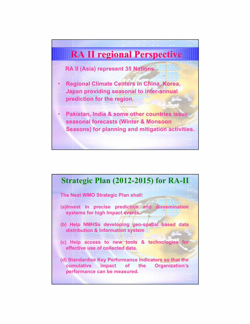
RA II (Asia) represent 35 Nations.
• Regional Climate Centers in China, Korea, Japan providing seasonal to inter-annual prediction for the region.
• Pakistan, India & some other countries issue seasonal forecasts (Winter & Monsoon Seasons) for planning and mitigation activities.
RA II regional Perspective RA II regional Perspective
The Next WMO Strategic Plan shall:
(a)Invest in precise prediction and dissemination systems for high Impact events.
(b) Help NMHSs developing geo-spatial based data distribution & Information system
(c) Help access to new tools & technologies for effective use of collected data.
(d) Standardize Key Performance Indicators so that the cumulative impact of the Organization’s performance can be measured.
Strategic Plan (2012-2015) for RA-II
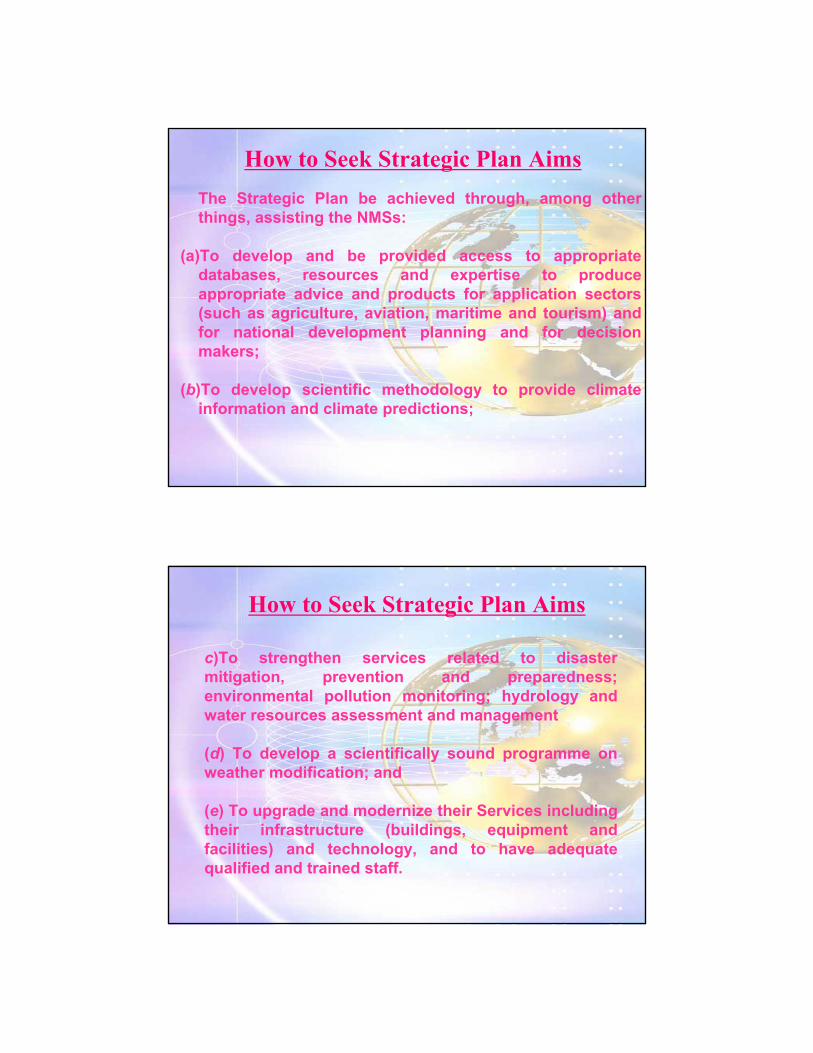
How to Seek Strategic Plan AimsThe Strategic Plan be achieved through, among other things, assisting the NMSs:
(a)To develop and be provided access to appropriate databases, resources and expertise to produce appropriate advice and products for application sectors (such as agriculture, aviation, maritime and tourism) and for national development planning and for decision makers;
(b)To develop scientific methodology to provide climate information and climate predictions;
How to Seek Strategic Plan Aims
c)To strengthen services related to disaster mitigation, prevention and preparedness; environmental pollution monitoring; hydrology and water resources assessment and management
(d) To develop a scientifically sound programme on weather modification; and
(e) To upgrade and modernize their Services including their infrastructure (buildings, equipment and facilities) and technology, and to have adequate qualified and trained staff.