nowra bridge project – princes highway upgrade · nowra bridge project – princes highway...
TRANSCRIPT
Nowra Bridge Project – Princes Highway upgradeEnvironmental assessment overview August 2018

Contents
Nowra Bridge Project – Princes Highway upgrade overview 2
Environmental assessment documents on display 2
Overview 3
Scope 3
Nowra Bridge Project overview 4
What we’ve done so far 4
What you told us 4
Key benefits 4
Survey results 5
Topics raised by the community – general 6
Topics raised by the community – prioritising a new bridge at this location over a bypass 9
Nowra Bridge Project key features 12
Design features 12
Construction 14
Construction hours 14
Out-of-hours work 14
Information for local residents 14
Information for road and river users 15
Site compounds and ancillary facilities 15
Assessment of key issues 16
Traffic and transport 16
Noise 18
Heritage 19
Landscape character and visual impacts 20
Hydrology and flooding 20
Socio-economic 21
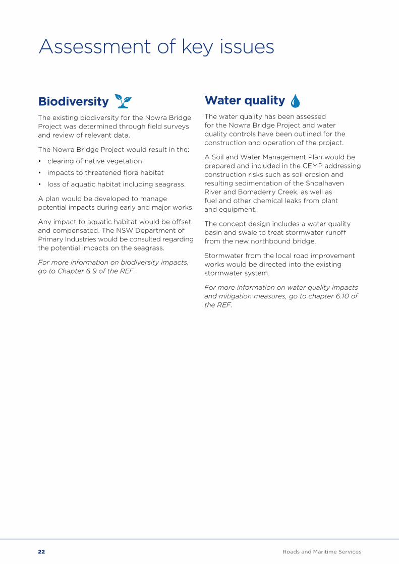
Biodiversity 22
Water quality 22
Next steps 23
Assessment of key issues 23
Next steps 23
Have your say 24
Meet the project team 24
Display locations 24
1Roads and Maritime Services
Nowra Bridge Project – Princes Highway upgrade overviewEnvironmental assessment documents on display Roads and Maritime Services has carried out an environmental assessment on the proposed Nowra Bridge Project to determine the potential environmental and social impacts of the project.
A review of environmental factors (REF) has been prepared to assess the potential impacts for the Nowra Bridge project. This overview outlines the following key issues for the proposal:
• Traffic and transport
• Noise
• Heritage
• Landscape character and visual impacts.
• Hydrology and flooding
• Socio-economic
• Biodiversity
• Water quality
All submissions must be received by Roads and Maritime by Friday 28 September.
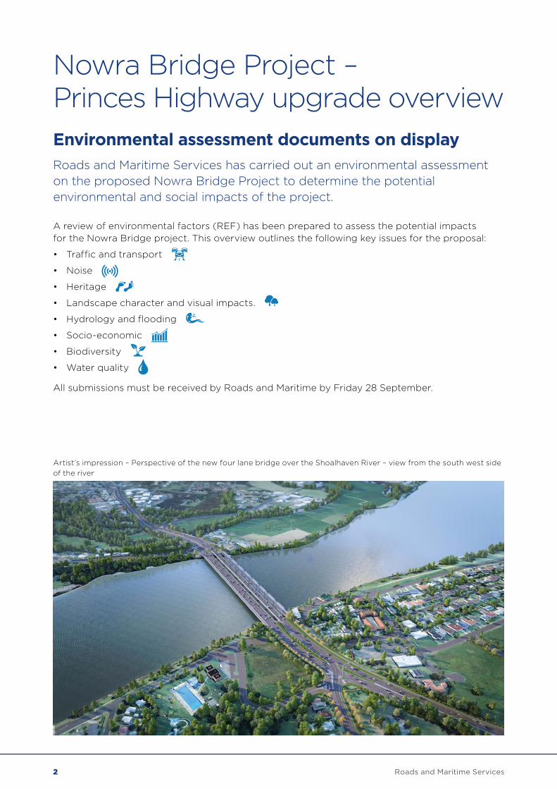
Artist’s impression – Perspective of the new four lane bridge over the Shoalhaven River – view from the south west side of the river
2 Roads and Maritime Services
OverviewThe Princes Highway is the main coastal transport link between Sydney and Wollongong and the NSW South Coast and north-eastern Victoria. The highway is an important freight, bus and tourist route, particularly beyond Bomaderry where the existing rail service terminates.
The area north of the Shoalhaven River is primarily residential, with a golf course to the west and a restaurant and agricultural land to the east. The area immediately to the south of the river provides community and tourism amenity. Nowra town centre is on the southern side of the Shoalhaven River and contains local and regional facilities and services including supermarkets, retail, financial and medical services.
The Shoalhaven River crossing comprises two bridges: the two-lane southbound bridge that was built in 1881 and the three-lane northbound bridge that was built in 1980. The southbound bridge has heritage values that relate to it being the only intact American pin-jointed ‘Whipple’ truss bridge in NSW that has historically been used for road traffic.
Issues with the southbound bridge include increasing maintenance costs due to its age, and restrictions on use by vehicles over 4.6 metres in height and certain types of heavy vehicles.
ScopeRoads and Maritime is proposing to construct a new four-lane bridge over the Shoalhaven River at Nowra and to carry out local road upgrades to improve the efficiency of traffic movements along a 1.6km stretch of the Princes Highway. The new bridge would carry northbound traffic. The existing northbound bridge would be reconfigured to carry southbound traffic. The existing southbound bridge would be repurposed as a shared pedestrian and cycle path and is being investigated separately.
Planning for the Nowra Bridge Project has included a detailed investigation and assessment of a wide range of options including a bypass. About 85 percent of journeys have their start and end point in the Nowra Bomaderry area, and require use of this section of the highway and connecting local roads.
The Nowra Bridge Project would support future growth in the Nowra Bomaderry area, provide southbound access for overheight vehicles and all types of heavy vehicles across the Shoalhaven River, ease future congestion on this section of the highway, reduce queuing on the Princes Highway between Bolong Road and Bridge Road, reduce crash rates, and allow safe and efficient maintenance activities on the existing southbound bridge without causing extended delays to the road network.
Roads and Maritime will continue to work closely with property owners affected by the project.
3Roads and Maritime Services
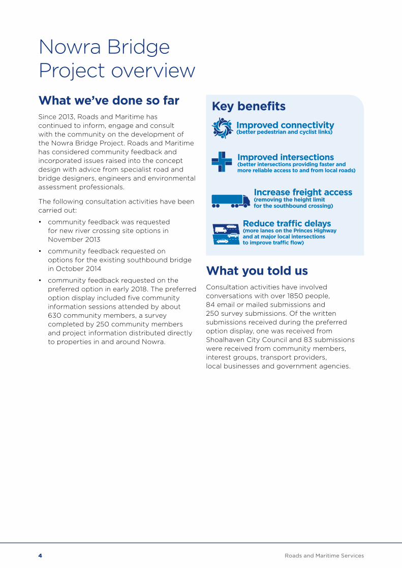
Nowra Bridge Project overviewWhat we’ve done so farSince 2013, Roads and Maritime has continued to inform, engage and consult with the community on the development of the Nowra Bridge Project. Roads and Maritime has considered community feedback and incorporated issues raised into the concept design with advice from specialist road and bridge designers, engineers and environmental assessment professionals.
The following consultation activities have been carried out:
• community feedback was requested for new river crossing site options in November 2013
• community feedback requested on options for the existing southbound bridge in October 2014
• community feedback requested on the preferred option in early 2018. The preferred option display included five community information sessions attended by about 630 community members, a survey completed by 250 community members and project information distributed directly to properties in and around Nowra.
Key benefits
What you told usConsultation activities have involved conversations with over 1850 people, 84 email or mailed submissions and 250 survey submissions. Of the written submissions received during the preferred option display, one was received from Shoalhaven City Council and 83 submissions were received from community members, interest groups, transport providers, local businesses and government agencies.
Improved connectivity(better pedestrian and cyclist links)
Improved intersections (better intersections providing faster and more reliable access to and from local roads)
Increase freight access (removing the height limit for the southbound crossing)
Reduce tra�c delays(more lanes on the Princes Highway and at major local intersections to improve tra�c flow)
4 Roads and Maritime Services
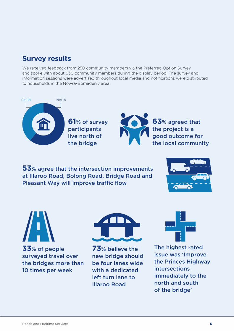
53% agree that the intersection improvements at Illaroo Road, Bolong Road, Bridge Road and Pleasant Way will improve traffic flow
63% agreed that the project is a good outcome for the local community
The highest rated issue was ‘Improve the Princes Highway intersections immediately to the north and south of the bridge’
73% believe the new bridge should be four lanes wide with a dedicated left turn lane to Illaroo Road
33% of people surveyed travel over the bridges more than 10 times per week
61% of survey participants live north of the bridge
South North
Survey results We received feedback from 250 community members via the Preferred Option Survey and spoke with about 630 community members during the display period. The survey and information sessions were advertised throughout local media and notifications were distributed to households in the Nowra-Bomaderry area.
5Roads and Maritime Services

Topics raised by the community – general The table below outlines the most frequent topics raised by the community during the Preferred Option consultation period and our response. All comments received during this period will help to refine the project. If you would like further information, a comprehensive Consultation Summary is available at www.rms.nsw.gov.au/NowraBridge.
Topic Roads and Maritime response
Provide a dedicated left turn from Illaroo Road on to Princes Highway
Following community consultation and further analysis of traffic, a dedicated left turn lane from Illaroo Road onto Princes Highway has been proposed in the concept design.
Include a slip lane on Illaroo Road for the left turn from the Princes Highway
Following community consultation and further analysis of traffic, a slip lane from Illaroo Road onto Princes Highway has been proposed in the concept design.
The new intersection and traffic lights to replace Pleasant Way will increase congestion
The current Pleasant Way and Princes Highway intersection will be closed to improve traffic flow at this section of the highway. A new local road further south will connect Princes Highway to Lyrebird Drive. Following community consultation and further traffic analysis, the new intersection will have a left in-left out arrangement and traffic lights are no longer proposed.
Build a bypass This issue is addressed separately in the next section. Please go to page 9.
Nowra Bridge Project overview
Roads and Maritime held five information sessions to understand community concerns during the display of the preferred option in early 2018. Responses are available in the Consultation Summary at rms.nsw.gov.au/NowraBridge.
6 Roads and Maritime Services
Topic Roads and Maritime response
Include grade separation (flyover or underpass) at Illaroo Road and/or Bridge Road
Flyovers and underpasses were investigated when developing the project. Investigations showed that a flyover or underpass at major intersections would provide minimal additional benefit to traffic flow at intersections and would have much greater impacts to project cost, nearby properties and the environment. A flyover at Illaroo Road would introduce road safety issues as motorists would be required to weave across a number of lanes of traffic. At Bridge Road there would be challenges providing safe access for uninterrupted traffic flow into Nowra’s town centre.
Reduce the number of traffic lights on the Princes Highway
About 85 percent of motorists have their start and end points in Nowra-Bomaderry and require use of this section of the highway and connecting local roads. This means that traffic lights are the most efficient way to provide fair access to the Princes Highway from local roads. The additional lane on the Princes Highway from north of Bolong Road to Moss Street in both directions will improve traffic flow by increasing the number of vehicles which pass through intersections on the green light. The new local road connecting Princes Highway and Lyrebird Drive will be a left in-left out arrangement and no traffic lights will be required at this new intersection.
All traffic lights will be coordinated and optimised in the project area and further south through Nowra.
Topics raised by the community included congestion issues at the Princes Highway and Illaroo Road intersection.
7Roads and Maritime Services
Topic Roads and Maritime response
Three lanes on the Princes Highway merging into two will cause congestion
The location where the three lanes will merge to two lanes is north of Bolong Road and away from the intersection. This is unlikely to have an impact on congestion. About one third of northbound traffic has left the highway at this location, turning off to Illaroo Road or Bolong Road.
The traffic modelling has identified that the upgrades to the Illaroo Road and Bolong Road intersections would provide an improvement in the efficiency of vehicle movements through these intersections.
The proposal will not ease congestion, especially during peak holiday seasons
We recognise the community is interested in peak holiday season traffic volumes. Overall, the additional lanes on the highway, on local roads, improved intersections and optimised traffic light network would improve the capacity for traffic and reduce congestion on the highway and throughout the local road network.
The project has been designed based on typical driving conditions on a weekday during peak hour. During peak hour, the project will reduce journey times from Illaroo Road to south of the bridge by 75 percent and along the section of Princes Highway by about 20 percent. This is based on future 2036 traffic figures of the proposed design versus a ‘do nothing’ option.
Construction impacts, especially at Illaroo Road
Roads and Maritime aims to provide the current number of lanes open in all directions during construction. Illaroo Road will remain open during construction.
Nowra Bridge Project overview
8 Roads and Maritime Services
Topics raised by the community – prioritising a new bridge at this location over a bypassAn additional four-lane bridge on the Princes Highway over the Shoalhaven River, additional lanes on the highway and upgraded local intersections have been determined as the most effective way to improve traffic efficiency and reduce traffic delays on the Princes Highway between Nowra and Bomaderry.
About 85 percent of motorists currently travelling over the river have their start and end point in Nowra Bomaderry and would still require use of this section of the highway. The existing southbound bridge is in poor condition, has restrictions on heavy vehicles, has substantial maintenance costs and can only carry highway traffic for a limited time. An additional crossing at this location is needed to address this structure’s issues and deliver for the planned traffic growth of the Nowra Bomaderry area.
All options were examined during the project’s early investigations, including a bypass and flyovers. A bypass is not currently prioritised as it would take only up to 15 percent of traffic off this section of the highway and not address the need for a new crossing at this location. Flyovers and underpasses at major intersections were also considered at early stages but would provide minimal additional benefit to traffic flow and would have greater impacts to nearby properties and the environment.
Roads and Maritime continues to identify ways to improve traffic efficiency on the Princes Highway between Nowra and Bomaderry. In August 2016, the NSW Government published the Princes Highway Corridor Strategy, which sets out a 20 year plan to manage the future development of the highway. The strategy assessed traffic forecasts and was prepared by Transport for NSW and Roads and Maritime Services.
The full report can be viewed on the Roads and Maritime website: www.rms.nsw.gov.au/projects/south-coast/corridor-strategies.
A new bridge at the preferred location would ease growing congestion at a major section of the Princes Highway.
Motorists would see the following journey time benefits, when their journey is compared to the future highway network if this project wasn’t delivered.
9Roads and Maritime Services
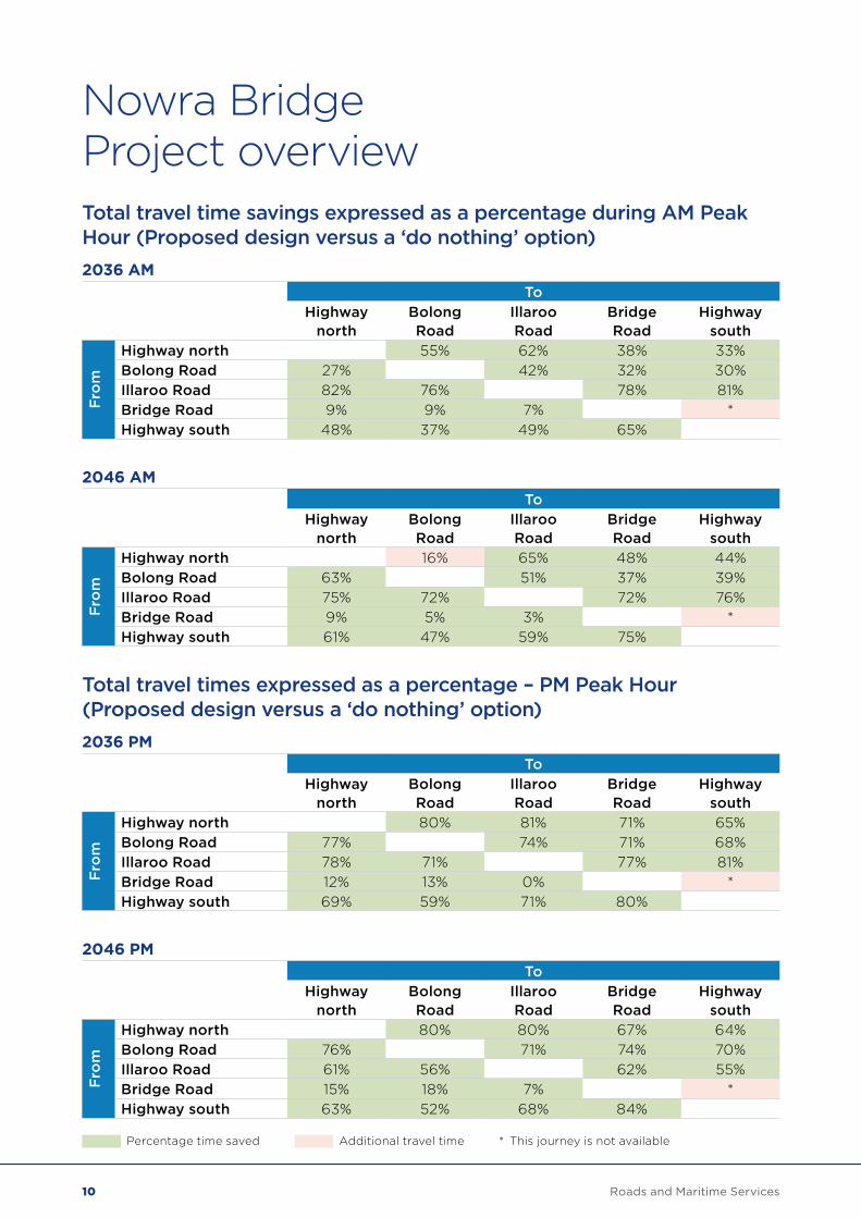
Nowra Bridge Project overviewTotal travel time savings expressed as a percentage during AM Peak Hour (Proposed design versus a ‘do nothing’ option)2036 AM
ToHighway
northBolong Road
Illaroo Road
Bridge Road
Highway south
Fro
m
Highway north 55% 62% 38% 33%Bolong Road 27% 42% 32% 30%Illaroo Road 82% 76% 78% 81%Bridge Road 9% 9% 7% *Highway south 48% 37% 49% 65%
2046 AMTo
Highway north
Bolong Road
Illaroo Road
Bridge Road
Highway south
Fro
m
Highway north 16% 65% 48% 44%Bolong Road 63% 51% 37% 39%Illaroo Road 75% 72% 72% 76%Bridge Road 9% 5% 3% *Highway south 61% 47% 59% 75%
Total travel times expressed as a percentage – PM Peak Hour (Proposed design versus a ‘do nothing’ option)2036 PM
ToHighway
northBolong Road
Illaroo Road
Bridge Road
Highway south
Fro
m
Highway north 80% 81% 71% 65%Bolong Road 77% 74% 71% 68%Illaroo Road 78% 71% 77% 81%Bridge Road 12% 13% 0% *Highway south 69% 59% 71% 80%
2046 PMTo
Highway north
Bolong Road
Illaroo Road
Bridge Road
Highway south
Fro
m
Highway north 80% 80% 67% 64%Bolong Road 76% 71% 74% 70%Illaroo Road 61% 56% 62% 55%Bridge Road 15% 18% 7% *Highway south 63% 52% 68% 84%
Percentage time saved Additional travel time * This journey is not available
10 Roads and Maritime Services
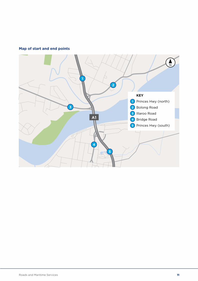
Map of start and end points
A1
1
1
3
2
4
5
Princes Hwy (north)
2 Bolong Road
3 Illaroo Road
4 Bridge Road
5 Princes Hwy (south)
KEY
11Roads and Maritime Services
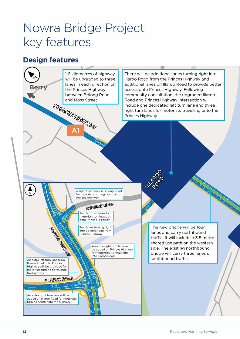
Nowra Bridge Project key featuresDesign features
A1
ILLA
ROO
ROAD
PRINCES HIGHWAY
BRIDGE ROAD
PLEASANT
WAY
Ulladulla andSouth Coast
Berry
PRINCES HIGHWAY
1.6 kilometres of highway will be upgraded to three lanes in each direction on the Princes Highway between Bolong Road and Moss Street
The new bridge will be four lanes and carry northbound traffic. It will include a 3.5 metre shared use path on the western side. The existing northbound bridge will carry three lanes of southbound traffic.
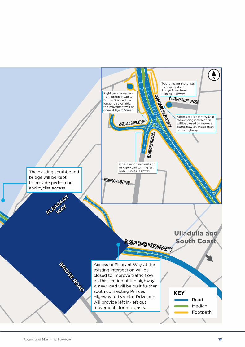
The existing southbound bridge will be kept to provide pedestrian and cyclist access.
Access to Pleasant Way at the existing intersection will be closed to improve traffic flow on this section of the highway. A new road will be built further south connecting Princes Highway to Lyrebird Drive and will provide left in-left out movements for motorists.
There will be additional lanes turning right into Illaroo Road from the Princes Highway and additional lanes on Illaroo Road to provide better access onto Princes Highway. Following community consultation, the upgraded Illaroo Road and Princes Highway intersection will include one dedicated left turn lane and three right turn lanes for motorists travelling onto the Princes Highway.
KEYRoadMedianFootpath
BOLONG ROAD
PRINCES HIG
HWAY
ILLAROO ROAD
Two left turn lanes for motorists turning south onto Princes Highway
Two lanes turning right into Bolong Road from Princes Highway
An extra left turn lane from Illaroo Road onto Princes Highway will be provided for motorists turning north onto the highway
An extra right turn lane will be added on Princes Highway for motorists turning right into Illaroo Road
An extra right turn lane will be added on Illaroo Road for motorists turning south onto the highway
A right turn lane on Bolong Road for motorists turning north onto Princes Highway
12 Roads and Maritime Services
A1
ILLA
ROO
ROAD
PRINCES HIGHWAY
BRIDGE ROAD
PLEASANT
WAY
Ulladulla andSouth Coast
Berry
PRINCES HIGHWAY
1.6 kilometres of highway will be upgraded to three lanes in each direction on the Princes Highway between Bolong Road and Moss Street
The new bridge will be four lanes and carry northbound traffic. It will include a 3.5 metre shared use path on the western side. The existing northbound bridge will carry three lanes of southbound traffic.
The existing southbound bridge will be kept to provide pedestrian and cyclist access.
Access to Pleasant Way at the existing intersection will be closed to improve traffic flow on this section of the highway. A new road will be built further south connecting Princes Highway to Lyrebird Drive and will provide left in-left out movements for motorists.
There will be additional lanes turning right into Illaroo Road from the Princes Highway and additional lanes on Illaroo Road to provide better access onto Princes Highway. Following community consultation, the upgraded Illaroo Road and Princes Highway intersection will include one dedicated left turn lane and three right turn lanes for motorists travelling onto the Princes Highway.
KEYRoadMedianFootpath
PRIN
CES H
IGH
WAY
BR
IDG
E R
OA
D
SCENIC DRIVE
HYAM STREET
PLEASANT WAY
Two lanes for motorists turning right into Bridge Road from Princes Highway
One lane for motorists on Bridge Road turning left onto Princes Highway
Right turn movement from Bridge Road to Scenic Drive will no longer be available. this movement will be done at Hyam Street
Access to Pleasant Way at the existing intersection will be closed to improve traffic flow on this section of the highway
13Roads and Maritime Services
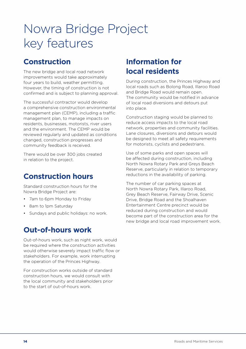
Nowra Bridge Project key featuresConstructionThe new bridge and local road network improvements would take approximately four years to build, weather permitting. However, the timing of construction is not confirmed and is subject to planning approval.
The successful contractor would develop a comprehensive construction environmental management plan (CEMP), including a traffic management plan, to manage impacts on residents, businesses, motorists, river users and the environment. The CEMP would be reviewed regularly and updated as conditions changed, construction progresses and community feedback is received.
There would be over 300 jobs created in relation to the project.
Construction hoursStandard construction hours for the Nowra Bridge Project are:
• 7am to 6pm Monday to Friday
• 8am to 1pm Saturday
• Sundays and public holidays: no work.
Out-of-hours workOut-of-hours work, such as night work, would be required where the construction activities would otherwise severely impact traffic flow or stakeholders. For example, work interrupting the operation of the Princes Highway.
For construction works outside of standard construction hours, we would consult with the local community and stakeholders prior to the start of out-of-hours work.
Information for local residentsDuring construction, the Princes Highway and local roads such as Bolong Road, Illaroo Road and Bridge Road would remain open. The community would be notified in advance of local road diversions and detours put into place.
Construction staging would be planned to reduce access impacts to the local road network, properties and community facilities. Lane closures, diversions and detours would be designed to meet all safety requirements for motorists, cyclists and pedestrians.
Use of some parks and open spaces will be affected during construction, including North Nowra Rotary Park and Greys Beach Reserve, particularly in relation to temporary reductions in the availability of parking.
The number of car parking spaces at North Nowra Rotary Park, Illaroo Road, Grey Beach Reserve, Fairway Drive, Scenic Drive, Bridge Road and the Shoalhaven Entertainment Centre precinct would be reduced during construction and would become part of the construction area for the new bridge and local road improvement work.
14 Roads and Maritime Services
Information for road and river usersChanged traffic conditions including impacts to journey times are expected during the construction period and motorists, cyclists and pedestrians would need to pay attention to construction signage.
Watercraft access on the Shoalhaven River would be maintained where possible during construction. An increase in marine traffic would be expected as additional boats and barges would be required to carry out the construction of the new bridge.
Recreational water activities such as fishing or water sports directly adjacent to the new bridge construction would be restricted for the duration of the construction activities.
Site compounds and ancillary facilitiesSite compounds and ancillary facilities would be required for construction of the project. Locations have been identified as potential site compounds and ancillary facilities in the concept design. Roads and Maritime would keep local residents and stakeholders informed when the locations are confirmed. Site compounds and ancillary facilities would be used for:
• offices and community display area
• bridge construction
• materials production, handling and storage
• equipment storage and maintenance.
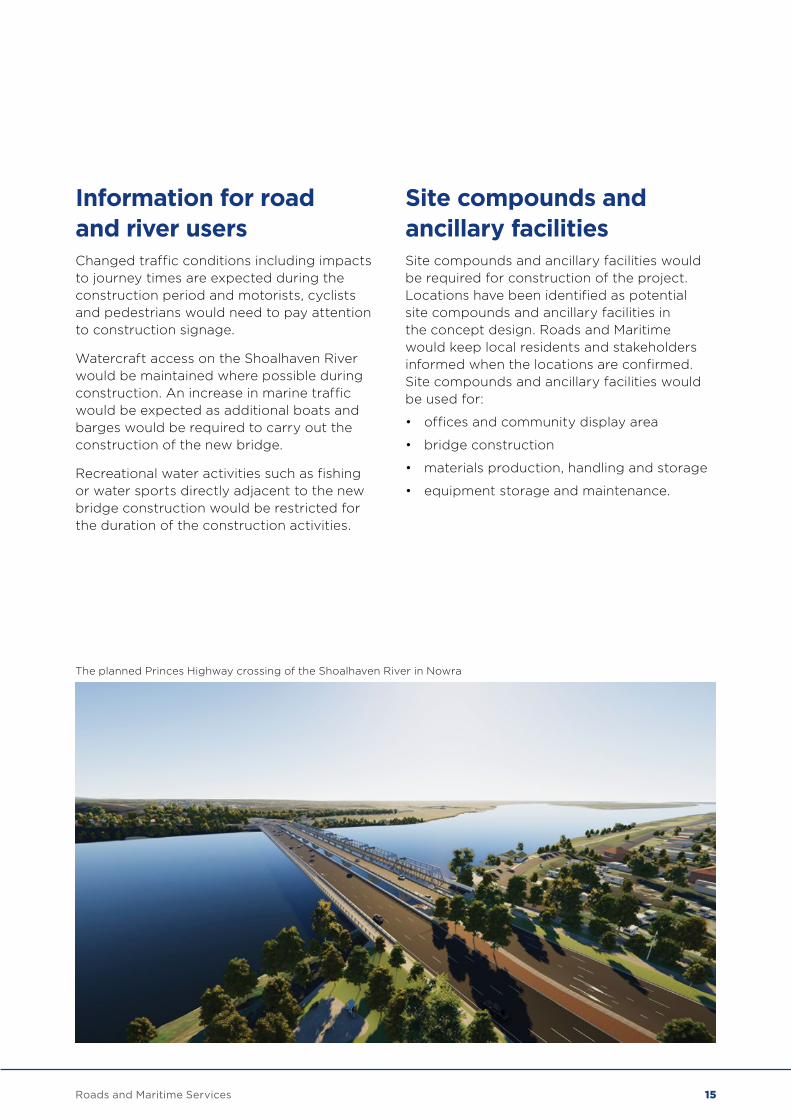
The planned Princes Highway crossing of the Shoalhaven River in Nowra
15Roads and Maritime Services
Traffic and transport The Princes Highway across the Shoalhaven River has an existing average daily traffic flow of more than 51,000 vehicle movements. During peak holiday periods, there is a substantial increase in traffic volumes crossing the bridge causing congestion along the Princes Highway and local road connections.
The project would improve travel times for vehicles travelling in all directions, remove restrictions for overheight and higher mass limit (HML) freight vehicles, reduce crashes and improve pedestrian and cyclist safety.
Local road changes There would be changes to the local road network at the intersections of the Princes Highway with Bolong Road, Illaroo Road, Bridge Road, Pleasant Way and a new local road connecting Lyrebird Drive to the Princes Highway. The changes include:
• additional lanes on Illaroo Road to provide three dedicated right turn lanes and one dedicated left turn lane to the Princes Highway
• the closure of access to Pleasant Way and construction of a new local road connection between Lyrebird Drive and Princes Highway
• vehicles would not be able to turn right into Scenic Drive from Bridge Road and will instead use Hyam Street
• increases in traffic volumes on Moss Street, Hyam Street, Lyrebird Drive and Hawthorn Avenue due to changes to the local road network
• the project will improve traffic flow and reduce congestion on this section of the highway and local connecting roads
• during peak hour travel, the project will reduce journey times from Illaroo Road to south of the bridge by 75 per cent and along the Princes Highway by about 20 per cent. This is based on future 2036 traffic figures of the proposed design versus a ‘do nothing’ option.
Marine traffic The Nowra Bridge Project would not impact navigation for watercraft once the project is completed. The configuration of the new bridge would generally match that of the existing northbound bridge.
Pedestrians and cyclists A three and half metre wide shared use path on the western side of the new northbound bridge would connect to shared paths at Illaroo Road and Bridge Road intersections. There may be some changes to pedestrian and cyclist journeys during construction, however access across the river and connection to the existing pedestrian network will be maintained.
The project improves east-west connections across the Princes Highway for pedestrians and cyclists by providing an additional controlled crossing at Bolong Road as well as pedestrian underpasses at the northern and southern foreshore. The existing southbound bridge would be retained for adaptive reuse such as a shared pedestrian and cyclist path. The rehabilitation and repurposing of the existing southbound bridge for reuse would be subject to a separate consultation and assessment process.
Assessment of key issues
16 Roads and Maritime Services
Temporary changes during construction Potential impacts on road and river traffic during construction would include:
• temporary increases to travel times for vehicles, cyclists and pedestrians due to temporary speed limit restrictions, diversions around areas of work and increases in the number of construction vehicles
• temporary increases in travel times for watercraft due to speed limit restrictions
• temporary increases in construction watercraft such as boats, barges and structures in the water, resulting in additional navigation marks and signs
• temporary changes to property access
• temporary loss of parking.
Alternative property access and parking would be determined following consultation with property owners and Shoalhaven City Council.
For more information on these changes go to Chapter 6.1 in the REF.
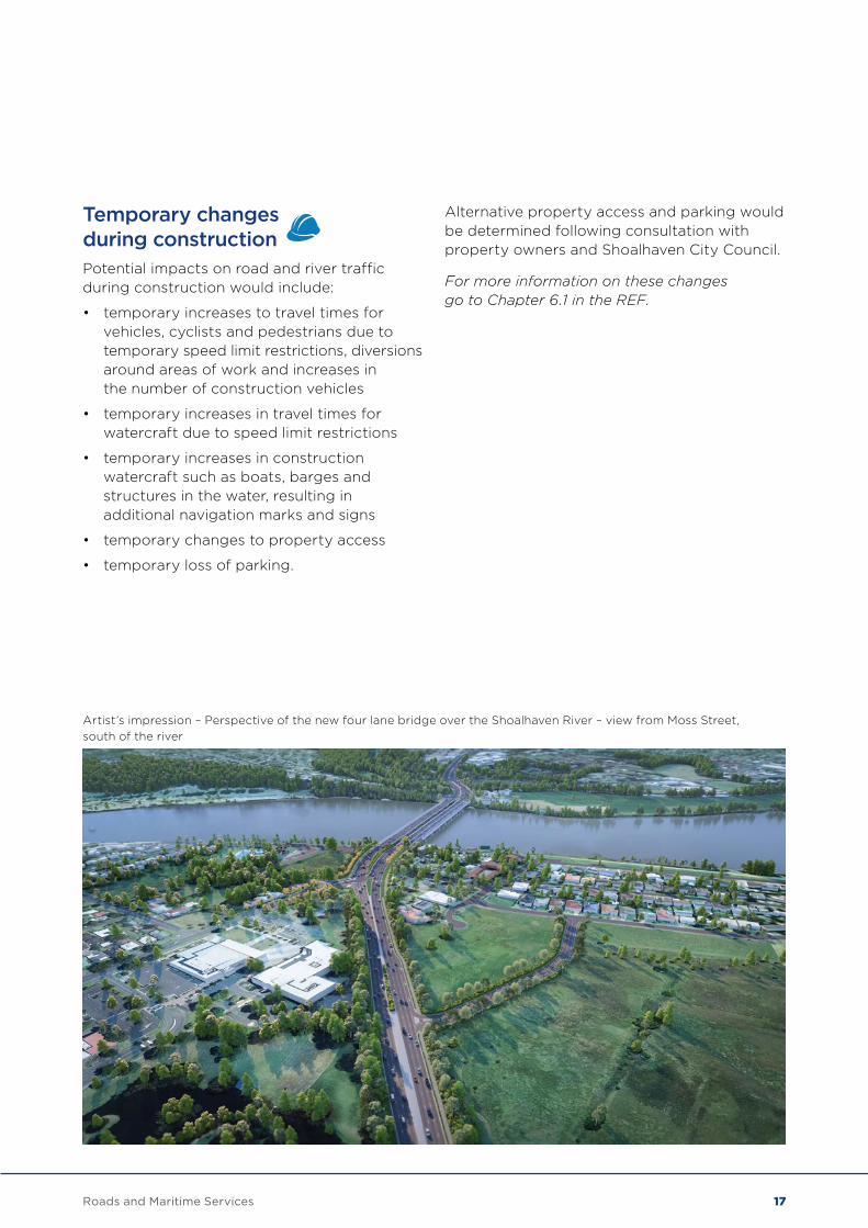
Artist’s impression – Perspective of the new four lane bridge over the Shoalhaven River – view from Moss Street, south of the river
17Roads and Maritime Services
Noise Vehicle engines, exhausts, tyres and brakes can create traffic noise for people working and living near roads.
A noise and vibration assessment was carried out to determine the potential noise impacts during construction and when the project is completed. The assessment also considered future traffic volumes and residential development areas.
The assessment found that the relocation of the existing southbound and northbound bridges, additional lanes and upgraded intersections would increase noise impacts in some areas.
The project would also create noise from construction equipment and vehicles used on site. These noise impacts would change when the bridge opens to traffic.
Roads and Maritime will work with impacted properties eligible for noise mitigation treatments during the project’s development.
Managing noise during construction The following steps would be used to minimise noise during construction:
• scheduling works to consider less sensitive time periods
• operate and maintain plant and equipment in an efficient and proper manner
• choosing lower noise construction techniques
• choosing lower noise plant and equipment
• site awareness and being considerate on work sites, such as avoiding dropping or dragging equipment and materials.
A Noise and Vibration Management Plan would be prepared as a part of the CEMP. This would include:
• noise and vibration monitoring and reporting
• arrangements for consultation
• construction scheduling to minimise noise impacts
• identification of controls to be adopted during construction
• contingency measures to be put in place in the event of unexpected noise issues during construction.
Managing noise when the bridge is open to traffic An additional noise and vibration assessment will be done once the project is completed to confirm the accuracy of earlier noise forecasts. We would work with any stakeholders or property eligible for noise mitigation treatment following the final assessment.
For more information on the noise assessment, go to Chapter 6.2.
Assessment of key issues
18 Roads and Maritime Services
Heritage Aboriginal and Non-Aboriginal heritage assessments have been undertaken to determine the impact of the project.
The assessments included:
• field surveys
• research and analysis of relevant databases and reports
• consultation
• identification of impacts
• identification of management measures.
The project would have the following impacts:
• directly impact up to seven known Aboriginal sites
• a minor physical impact to State heritage listed Graham Lodge. This item has Aboriginal and non-Aboriginal heritage values
• a major physical and visual impact to the locally listed Captain Cook Bicentennial Memorial
• a moderate physical and visual impact to the locally listed ‘Lynburn’ and ‘Ilowra’
• a minor overall impact to the existing southbound bridge listed on Roads and Maritime Conservation and Heritage Register
• removing highway traffic from the existing southbound bridge would result in an indirect impact to the heritage values of this item. The rehabilitation and repurposing of the existing southbound bridge for reuse would be subject to a separate consultation and assessment process.
The proposal would be undertaken in accordance with an Aboriginal Heritage Management Plan prepared and implemented as part of the CEMP.
An Aboriginal Heritage Impact Permit application would be lodged for the Nowra Bridge Project and a targeted archaeological surface collection and salvage would be required for sites assessed as demonstrating moderate and high archaeological significance.
A Non-Aboriginal Heritage Management Plan (NAHMP) would be prepared and implemented as part of the project. It would provide specific guidance on measures and controls to be implemented to avoid and mitigate impacts to Non-Aboriginal heritage.
For more information on heritage impacts and mitigation measures, go to Chapter 6.3 and Chapter 6.4 of the REF.
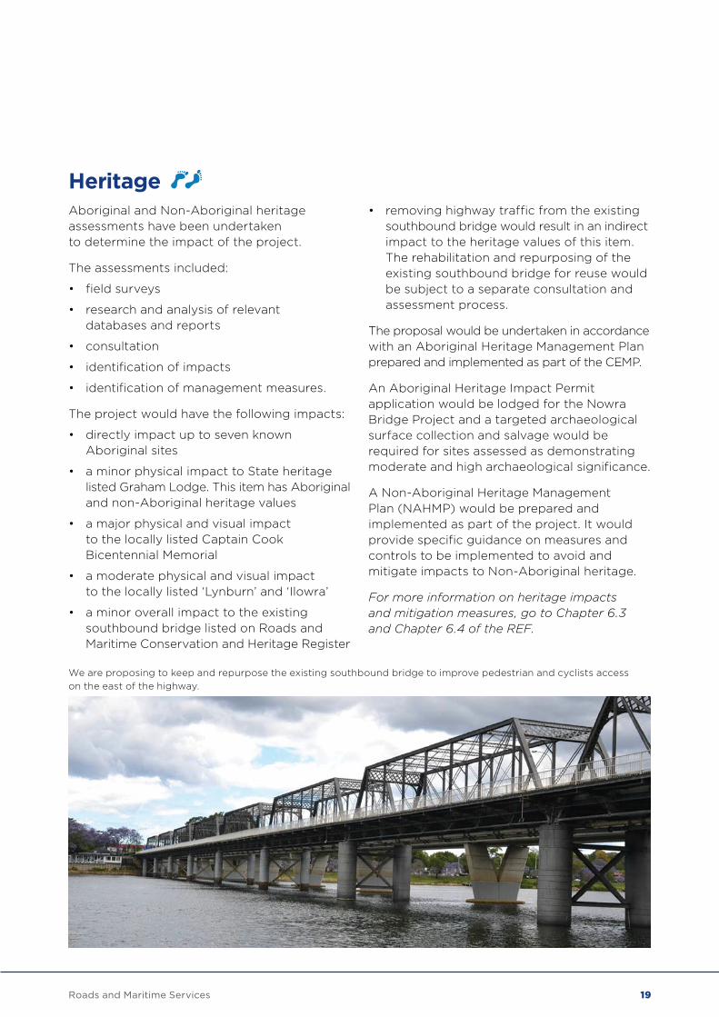
We are proposing to keep and repurpose the existing southbound bridge to improve pedestrian and cyclists access on the east of the highway.
19Roads and Maritime Services
Landscape character and visual impacts An assessment of the landscape character and visual impact of the Nowra Bridge Project was undertaken. The new northbound bridge and local road improvement works would result in landscape visual impacts that include:
• high impact to the area surrounding the Illaroo Road widening
• high to moderate impact to the area surrounding the Bomaderry Creek bridge widening
• high to moderate impact for the Shoalhaven River and foreshores
• high to moderate impact to the Nowra town centre.
There will be a moderate to high impact to viewpoints in the area. An Urban Design and Landscape Plan will be prepared to inform the detailed design and will form part of the CEMP.
For more information on landscape character and visual impacts, go to Chapter 6.5 of the REF.
Hydrology and flooding Flood modelling has been completed to determine the existing flood behaviour of the Shoalhaven River and Bomaderry Creek and whether any flood impacts would be caused by the design of the new bridge and local road improvements.
The assessment found that flood levels upstream of the new bridge would increase in the order of 0.1 to 0.2 metres. This would result in inundation of the Moorhouse Park locality across to Mandalay Avenue and Hyam Street. There are a number of properties on Scenic Drive that are currently flood affected, and may experience an increase in flood depth of about 0.2 metres.
For more information on flooding and mitigation measures, go to Chapter 6.6 of the REF.
Assessment of key issues
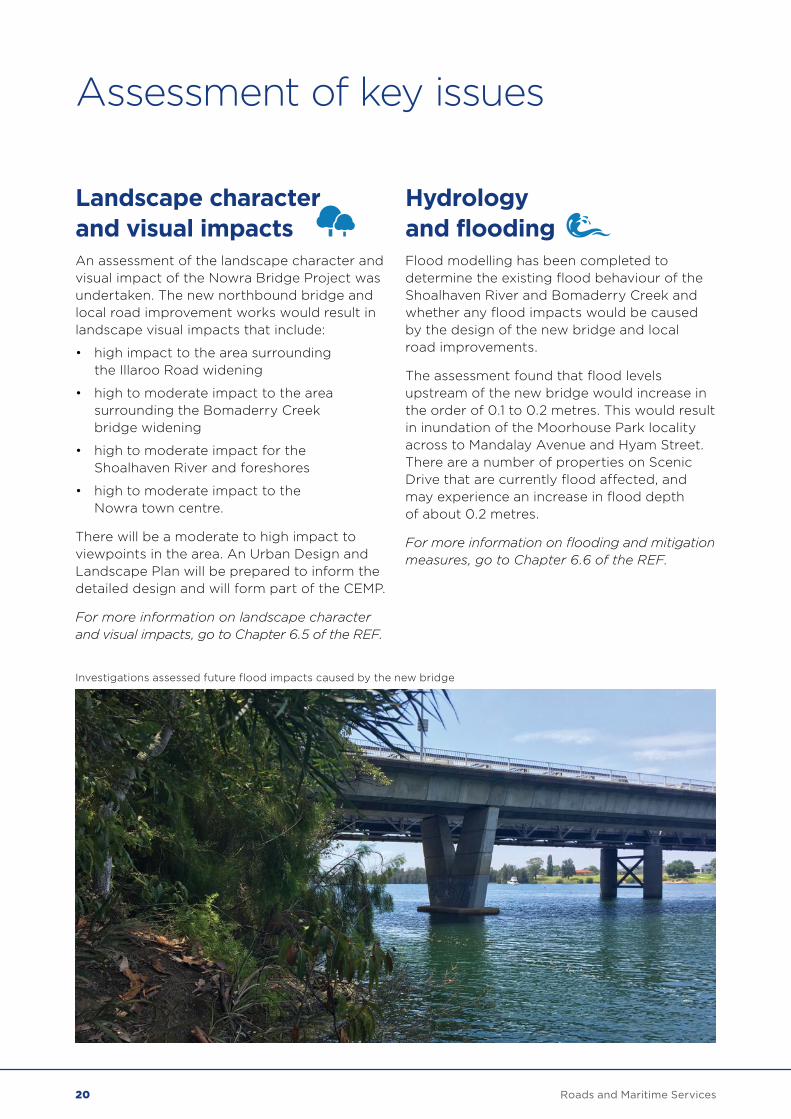
Investigations assessed future flood impacts caused by the new bridge
20 Roads and Maritime Services

Socio-economic The Nowra Bridge Project is expected to have a positive impact on social infrastructure in the local area and the wider community through improved traffic flows and accessibility along the Princes Highway and the adjacent intersections.
The socio-economic assessment looked at:
• demographics, community infrastructure, key industries, businesses and recreational areas
• stakeholder issues
• potential impacts the project would have during construction and when in use, such as property impacts, land use changes, access and connectivity, and impacts on business, industry, tourism, amenity and community
• identifying ways to reduce and manage these impacts.
The socio-economic assessment found that the project would:
• improve traffic flows and accessibility along the Princes Highway and adjacent intersections
• improve pedestrian connections provided to the river foreshore areas from the shared paths on the bridges
• improved freight efficiency with the removal of existing constraints on higher mass limit (HML) vehicles. Due to the removal of height restrictions there may be an increase in overheight vehicles using the corridor.
For more information on the socio-economic assessment, go to Chapter 6.8 in the REF.
21Roads and Maritime Services
Biodiversity The existing biodiversity for the Nowra Bridge Project was determined through field surveys and review of relevant data.
The Nowra Bridge Project would result in the:
• clearing of native vegetation
• impacts to threatened flora habitat
• loss of aquatic habitat including seagrass.
A plan would be developed to manage potential impacts during early and major works.
Any impact to aquatic habitat would be offset and compensated. The NSW Department of Primary Industries would be consulted regarding the potential impacts on the seagrass.
For more information on biodiversity impacts, go to Chapter 6.9 of the REF.
Water quality The water quality has been assessed for the Nowra Bridge Project and water quality controls have been outlined for the construction and operation of the project.
A Soil and Water Management Plan would be prepared and included in the CEMP addressing construction risks such as soil erosion and resulting sedimentation of the Shoalhaven River and Bomaderry Creek, as well as fuel and other chemical leaks from plant and equipment.
The concept design includes a water quality basin and swale to treat stormwater runoff from the new northbound bridge.
Stormwater from the local road improvement works would be directed into the existing stormwater system.
For more information on water quality impacts and mitigation measures, go to chapter 6.10 of the REF.
Assessment of key issues
22 Roads and Maritime Services
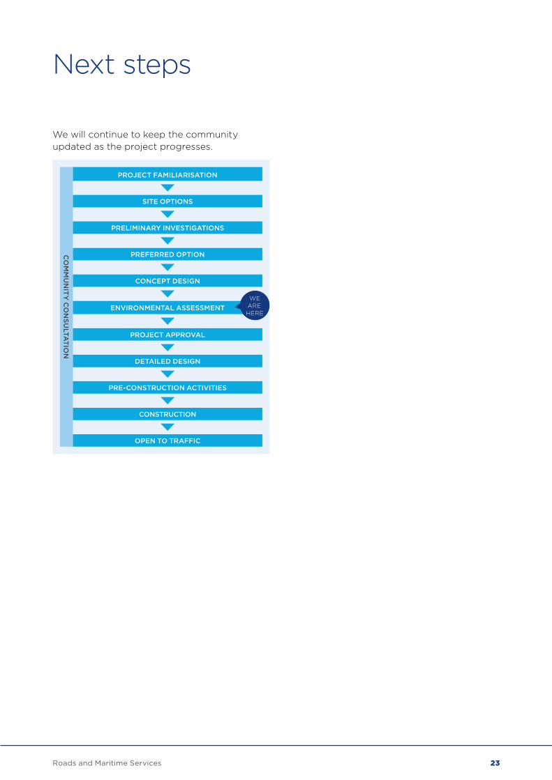
Next steps
We will continue to keep the community updated as the project progresses.
CO
MM
UN
ITY
CO
NS
ULTA
TION
PROJECT FAMILIARISATION
SITE OPTIONS
PRELIMINARY INVESTIGATIONS
PREFERRED OPTION
CONCEPT DESIGN
ENVIRONMENTAL ASSESSMENT
PROJECT APPROVAL
DETAILED DESIGN
PRE-CONSTRUCTION ACTIVITIES
CONSTRUCTION
OPEN TO TRAFFIC
WE ARE HERE
23Roads and Maritime Services
We are seeking feedback on the environmental assessment document until Friday 28 September. All submissions made during the display period will be addressed and responded to in a submissions report and will be used to further develop the project.
Review of Environmental FactorsThe review of environmental factors assesses the potential environmental impacts of the project and identifies ways to manage them.
Written submissions should be sent to Roads and Maritime and can be emailed to: [email protected]
Meet the project team The project team will be at the following locations during the environmental assessment and concept design display period:
Nowra School Of Arts Berry Street, Nowra Saturday 1 September, 11am – 3pm; Thursday 6 September, 4 – 8pm
Stocklands Nowra 60 East Street, Nowra Thursday 13 September, 4 – 8pm
North Nowra Shops 1–13 McMahons Road, North Nowra Saturday 8 September, 11am – 3pm; Wednesday 12 September, 11am – 3pm
Display locationsThe REF for Nowra Bridge project will be on display until Friday 28 September 2018 at the following locations:
Shoalhaven City Council 36 Bridge Road, Nowra 9.15am – 4.30pm Monday to Friday
Nowra Library 10 Berry Street, Nowra 9.30am – 7pm Monday to Friday, 9.30am – 3pm Saturday
TAFE NSW Nowra 60 Belinda Street, Bomaderry 9am – 4pm Monday to Friday
Have your say
24 Roads and Maritime Services


August 2018RMS 18.945ISBN: 978-1-925797-59-6For more information, visit www.rms.nsw.gov.au/NowraBridge